OFFICIAL COMMUNITY PLAN BYLAW NO. 864, 2007
124
OFFICIAL COMMUNITY PLAN BYLAW NO. 864, 2007 (CONSOLIDATED) Record of Amendments to Official Community Plan Bylaw No. 864, 2007 Amending Bylaw No. Type of Amendment Summary of Amendment Date of Adoption Text Schedule 893 x Lakeshore Special Planning Area – Village Centre Area amendment November 17, 2008 920 x Lakeshore Special Planning Area – Objectives August 10, 2009 930 Schedule 1 – E (Pine Ave Neighbourhood Plan) February 1, 2010 935 x Schedule A – Village Center Area Development Density May 3, 2010 937 x Goals – Greenhouse Gas Emissions May 3, 2010 955 x Schedule 1B – Tourist Commercial to Low Density Residential December 6, 2010 957 x Schedule 1- E (Neighbourhood Plan – Pine Avenue) December 6, 2010 961 x Schedule 1- F (Neighbourhood Plan – Echo Avenue and Eagle Street) May 9, 2011 977 x x Future Land Designations – Medium Density Residential August 13, 2012 988 x Schedule 1 replacement - E Neighbourhood Plan – Pine Ave Schedule 1 - F Neighbourhood Plan Echo Ave and Eagle Street November 30, 2011 1027 x x Resource land designations/Low Density Residential May 6, 2013 1035 x Lakeshore Marine Tourist Commercial September 9, 2013 1080 x Resort Residential Use Heading February 6, 2017 1113 x Tourist Commercial Development Permit Area January 5, 2018 CONSOLIDATED TO: January 5, 2018
Transcript of OFFICIAL COMMUNITY PLAN BYLAW NO. 864, 2007
OFFICIAL COMMUNITY PLAN BYLAW NO. 864, 2007
(CONSOLIDATED)
Record of Amendments to Official Community Plan Bylaw No. 864, 2007
Amending Bylaw No.
Type of Amendment Summary of Amendment Date of Adoption
Text Schedule
893 x Lakeshore Special Planning Area – Village Centre Area
amendment November 17, 2008
920 x Lakeshore Special Planning Area – Objectives August 10, 2009
930 Schedule 1 – E (Pine Ave Neighbourhood Plan) February 1, 2010
935 x Schedule A – Village Center Area Development Density May 3, 2010
937 x Goals – Greenhouse Gas Emissions May 3, 2010
955 x Schedule 1B – Tourist Commercial to Low Density Residential December 6, 2010
957 x Schedule 1- E (Neighbourhood Plan – Pine Avenue) December 6, 2010
961 x Schedule 1- F (Neighbourhood Plan – Echo Avenue and Eagle
Street) May 9, 2011
977 x x Future Land Designations – Medium Density Residential August 13, 2012
988 x Schedule 1 replacement - E Neighbourhood Plan – Pine Ave
Schedule 1 - F Neighbourhood Plan Echo Ave and Eagle Street November 30, 2011
1027 x x Resource land designations/Low Density Residential May 6, 2013
1035 x Lakeshore Marine Tourist Commercial September 9, 2013
1080 x Resort Residential Use Heading February 6, 2017
1113 x Tourist Commercial Development Permit Area January 5, 2018
CONSOLIDATED TO: January 5, 2018

VILLAGE OF HARRISON HOT SPRINGS OFFICIAL COMMUNITY PLAN BYLAW NO. 864 A Bylaw to adopt Harrison Hot Springs Official Community Plan Bylaw No. 864.
WHEREAS the Council wishes to adopt a new Official Community Plan pursuant to Section 882 of the Local Government Act;
AND WHEREAS the Council in its consideration of this Bylaw had due regard to the requirements of Section 890 of the Local Government Act;
NOW THEREFORE the Council of the Village of Harrison Hot Springs in open meeting assembled HEREBY ENACTS AS FOLLOWS:
1. This Bylaw shall be cited as the "Village of Harrison Hot Springs Official Community Plan Bylaw No. 864".
2. The following schedules attached hereto are hereby made part of this Bylaw and adopted as the Official Community Plan for Harrison Hot Springs:
i. Schedule 1-A - Text ii. Schedule 1-B - Land Use Map
iii. Schedule 1-C - Development Permit Areas iv. Schedule 1-D - Design Guidelines v. Schedule 1-E - Neighbourhood Plan – Pine Avenue
vi. Schedule 1-F - Neighbourhood Plan – Echo Avenue and Eagle Street
3. All dimensions and other measurements in this Bylaw are expressed in the Metric system.
4. "The Corporation of the Village of Harrison Hot Springs Official Community Plan Bylaw No. 622, 1994" and all amendments thereto are hereby repealed.
5. If any section, subsection, sentence, clause or phrase of this Bylaw is for any reason held to be invalid by the decision of any court of competent jurisdiction, the invalid portion shall be severed and the decision that it is invalid shall not affect the validity of the remainder.
READINGS AND ADOPTION Official Community Plan No. 864 adopted on the 7th day of May, 2007 Amendment Bylaw No. 893 adopted on the 17th day of November, 2008 Amendment Bylaw No. 920 adopted on the 10th day of August, 2009 Amendment Bylaw No. 930 adopted on the 1st day of February, 2010 Amendment Bylaw No. 935 adopted on the 3rd day of May, 2010 Amendment Bylaw No. 937 adopted on the 3rd day of May, 2010 Amendment Bylaw No. 955 adopted on the 6th day of December, 2010 Amendment Bylaw No. 957 adopted on the 6th day of December, 2010 Amendment Bylaw No. 961 adopted on the 9th day of May, 2011 Amendment Bylaw No. 977 adopted on the 13th day of August, 2012 Amendment Bylaw No. 988 adopted on the 30th day of November, 2011 Amendment Bylaw No. 1027 adopted on the 6th day of May, 2013 Amendment Bylaw No. 1035 adopted on the 9th day of September, 2013 Amendment Bylaw No. 1080 adopted on the 6th day of February, 2017 Amendment Bylaw No. 1113 adopted on the 5th day of January, 2018
“Leo Facio” “Gerry van der Wolf”
Mayor Corporate Officer Leo Facio Gerry van der Wolf
(AB#937/AB#988)
(AB#961/AB#988)


VILLAGE OF HARRISON HOT SPRINGS OFFICIAL COMMUNITY PLAN BYLAW NO. 864 – May 7, 2007 i.
SUMMARY OF A PLAN
The Official Community Plan (OCP) is a legal policy document adopted by the Village Council under Part 26 of the
Local Government Act. It provides the broad framework for guiding future development and services in the
community. Various bylaws (e.g., zoning), and capital works are used to implement the policies adopted in the OCP.
All subsequent bylaws or amendments to bylaws must be consistent with an approved OCP. The OCP must also
conform with the Regional Growth Strategy of Fraser Valley Regional District. Community workshops undertaken
in 2005 and further discussions by the Advisory Planning Commission and the Village Council have led to the
preparation of a OCP which will proceed to a public review and public hearing.
The Plan presents a vision and a set of goals for Harrison Hot Springs based on “a residential and resort community
with an attractive and inviting Village core of shops and services. A strong commitment to maintaining the scenic
qualities, the environment, the quality of life and the vibrant recreational and cultural life combined with a high
standard of development.”
The future of Harrison Hot Springs is envisioned as a high quality resort destination and residential community with
a compact Village centre and an emphasis on the natural and cultural environment. The primary direction for future
development therefore is to focus on enhancing the quality of development and services, strengthening the
character and diversity of the Village centre, expanding the tourism opportunities, and protecting the natural
landscapes that support a viable tourism economy and high quality residential areas.
Future development decisions will be guided by the OCP Future Land Use Designation Map (Schedule 1‐B) which
identifies the permitted zones in each area (see Table 1). Development Permit Areas (Schedule 1‐C) are also
identified which regulate the form and character of development, or ensure protection from natural hazards, or
provide for protection of the natural environment within specific areas. It is proposed to amend the current Village
Centre Design Guidelines (Schedule 1‐D) with a more detailed design plan which will be used to encourage
coordinated re‐development of commercial and residential land uses in the centre.
The Village population was 1,585 residents in 2005. This is estimated to grow to about 1,900 persons in the next
five years and housing units could increase by 120 residential units over this period. A Growth Management policy
is presented that involves increasing residential densities in the Village centre subject to completion of a detailed
design plan, and Council’s consideration of potential proposals for townhouse development at the east end of
Lillooet Avenue, and for potential additional low-density residential uses in the Pine Avenue area. These
development opportunities will be discussed with residents and owners.
Development within the Village Centre under a comprehensive design theme is a high priority in the Plan, along
with protecting views of the lake. A Village Centre Design Plan will be prepared to provide the detailed concept for
future development. A View Protection policy is presented which recognizes the natural vistas of Harrison Lake as
an important asset to the community. Future redevelopment at key locations on Esplanade Avenue and Lillooet
Avenue will be required to take account of the need to maximize views of the lake from street level in the
development of future buildings and landscaping. Careful improvements to the lakeshore to enhance facilities for
residents and tourists are also proposed in the Plan.
ii.
The Plan strives to develop a prosperous tourism economy that is in harmony with the residential community and
the natural environment. Along with redevelopment of the ‘village centre’, the plan sets out policies for the
‘waterfront commercial’, ‘marine tourism’ and ‘lakeshore residential’ areas adjacent to and near the lake, maintains
a predominantly ‘low-density residential’ area in south Harrison and a ‘tourist commercial’ designation for certain
areas along Hot Springs Road. Ensuring that expansion of infrastructure and services – water supply, wastewater
management, fire protection, etc., are equitably funded by future development through updated development cost
charges is a key priority in the Plan.
The Plan further proposes to initiate discussions with the Ministry of Transportation on parking and other
changes to Highway 9 through the Village, including future improvements to sidewalks and bicycle paths
and measures to enhance pedestrian safety along Hot Springs Road consistent with the Regional Growth Strategy.
The Plan also supports the development of the tourism sector in Harrison Hot Springs in shifting toward a more
sophisticated market which caters to diverse visitor activities and higher‐value experiences. It recognizes the need
for an updated framework for tourism growth in conjunction with revitalization of the Village Centre and
improvements to the entrance corridor into the community along Hot Springs Road (Highway 9). The Plan also
provides for small‐scale marina inns catering to the boating tourist and supports developing a lakeshore boardwalk
to increase public use, boating and day use tourism in the east end of the lakeshore.
A Parks and Trails Master Plan and development program are proposed, as is an environmental inventory and a
drainage plan. The Plan proposes extension of the Public Use designation on Crown lands east of McCombs Drive
for mostly park purposes, and application for future public works yard on a portion of these lands in a manner
consistent with the Regional Growth Strategy.
VILLAGE OF HARRISON HOT SPRINGS OFFICIAL COMMUNITY PLAN BYLAW NO. 864
SCHEDULE 1-A: TABLE OF CONTENTS
SCHEDULE 1-A: TABLE OF CONTENTS .......................................................................................................................... 3
1. INTRODUCTION .................................................................................................................................................. 1
1.1 Purpose of the Official Community Plan ................................................................................................................. 1
1.2 Structure of the Plan ............................................................................................................................................... 2
1.3 Plan Implementation Process ................................................................................................................................. 2
1.4 Implementation Actions and Priorities ................................................................................................................... 2
1.5 Plan Amendment Policy .......................................................................................................................................... 5
1.6 Criteria for Area Re‐designation ............................................................................................................................. 7
2. COMMUNITY VISION .......................................................................................................................................... 8
2.1 Population Growth and Development .................................................................................................................... 8
2.2 The Challenges for Harrison Hot Springs ................................................................................................................ 9
2.3 A Long Term Vision for Harrison Hot Springs ........................................................................................................ 10
2.4 Goals of the Official Community Plan ................................................................................................................... 10
Goal 1: Provide efficient, equitable and affordable public services. ........................................................................... 10
Goal 2: Establish a distinct, pedestrian‐oriented Village centre with a range of commercial services. ..................... 11
Goal 3: Develop tourism and recreation features and activities for the benefit of residents and visitors. ............... 11
Goal 4: Protect views of the lake and the surrounding mountains. ............................................................................ 11
Goal 5: Protect and maintain air and water quality and biodiversity. ......................................................................... 11
Goal 6: Promote compatible residential and tourism development and community relationships ........................... 11
Goal 7: Manage traffic and parking and promote transportation alternatives. .......................................................... 11
Goal 8: Provide for a mix of housing types for all ages and incomes. ......................................................................... 11
Goal 9: Restore and protect Miami River and related aquatic systems. ..................................................................... 11
Goal 10: Reduce community greenhouse gas emissions. ....................................................................................... 12
2.5 Regional Context Statement ................................................................................................................................. 12
1. Increase Transportation Choice and Efficiency ............................................................................................... 12
2. Support and Enhance the Agriculture Sector .................................................................................................. 12
3. Manage Urban Land Responsibly .................................................................................................................... 13
4. Develop a Network of Sustainable Communities ............................................................................................ 13
5. Protect the Natural Environment and Promote Environmental Stewardship ................................................ 13
6. Protect and Manage Rural and Recreational Lands ........................................................................................ 13
7. Achieve Sustainable Economic Growth ........................................................................................................... 14
8. Manage Water, Energy Resources and Waste Responsibly ............................................................................ 14
3. DEVELOPMENT FRAMEWORK .......................................................................................................................... 15
3.1 Overall Development Concept .............................................................................................................................. 15
3.2 Growth Management Strategy ............................................................................................................................. 15
Figure 1: Neighbourhood Planning Areas ................................................................................................................. 17
3.3 View Preservation Strategy ................................................................................................................................... 18
Figure 2: View Preservation Strategy ........................................................................................................................ 19
3.4 Future Land Use Designations .............................................................................................................................. 19
3.5 Development Permit Areas ................................................................................................................................... 19
3.5.1 Development Permit Requirements ................................................................................................................... 20
3.5.2 Conditions Where Development Permits Are Not Required .............................................................................. 20
TABLE 1: FUTURE LAND USE DESIGNATIONS .............................................................................................................. 20
3.6 Greenhouse Gas Emission Reduction Policies and Actions .................................................................................. 21
4. LAKESHORE SPECIAL PLANNING AREA .............................................................................................................. 23
4.1 Background ........................................................................................................................................................... 23
4.2 Objectives .............................................................................................................................................................. 23
4.3 Policies .................................................................................................................................................................. 24
4.3.1 Lakeshore Beach and Public Use Area ................................................................................................................. 25
4.3.2 Village Centre Area .......................................................................................................................................... 25
4.3.3 Waterfront Commercial Area .............................................................................................................................. 27
4.3.4 Lakeshore Marine Tourist Commercial Area....................................................................................................... 28
4.3.5 Lakeshore Residential Area ................................................................................................................................. 29
4.3.6 Parking and Traffic in the Lakeshore Area ......................................................................................................... 30
4.3.7 The Hot Springs .................................................................................................................................................. 30
4.4 Lakeshore Development Permit Area 1 ................................................................................................................ 30
4.4.1 Category ........................................................................................................................................................... 30
4.4.2 Area .................................................................................................................................................................. 31
4.4.3 Justification ...................................................................................................................................................... 31
4.4.4 Guidelines ........................................................................................................................................................ 31
5. COMMERCIAL DEVELOPMENT .......................................................................................................................... 32
5.1 Background ........................................................................................................................................................... 32
5.2 Objectives .............................................................................................................................................................. 32
5.3 Policies .................................................................................................................................................................. 33
5.3.1 Tourism Development Strategy .......................................................................................................................... 33
5.3.2 Commercial Uses in the Lakeshore Special Planning Area .................................................................................. 34
5.3.3 Tourist Commercial Area ..................................................................................................................................... 34
5.4 Tourist Commercial Development Permit Area 2 ................................................................................................. 35
5.4.1 Category ........................................................................................................................................................... 35
5.4.4 Guidelines ........................................................................................................................................................ 35
6. RESIDENTIAL DEVELOPMENT ............................................................................................................................ 37
6.1 Background ........................................................................................................................................................... 37
6.2 Objectives .............................................................................................................................................................. 37
6.3 Policies .................................................................................................................................................................. 38
6.3.1 Multi‐Family Residential Development ........................................................................................................... 38
6.3.2 Low Density Residential Area .......................................................................................................................... 38
6.3.2.1 Resort Residential Use .................................................................................................................................. 39
6.3.3 Affordable, Rental and Special Needs Housing ............................................................................................... 39
6.3.4 Seniors Housing Facilities ................................................................................................................................ 39
6.3.5 Parking and Traffic in Residential Areas .......................................................................................................... 39
6.4 Multi‐Family Residential Development Permit Area 3 ......................................................................................... 39
6.4.1 Category ........................................................................................................................................................... 39
6.4.2 Area .................................................................................................................................................................. 40
7. EAST SECTOR SPECIAL PLANNING AREA ............................................................................................................. 41
7.1 Background ........................................................................................................................................................... 41
7.2 Objectives .............................................................................................................................................................. 42
7.3 Policies .................................................................................................................................................................. 42
8. RESOURCE LANDS ............................................................................................................................................. 44
8.1 Background ........................................................................................................................................................... 44
8.2 Objectives .............................................................................................................................................................. 44
8.3 Policies .................................................................................................................................................................. 44
9. AREAS SUBJECT TO HAZARDOUS CONDITIONS ................................................................................................... 46
9.1 Background ........................................................................................................................................................... 46
9.2 Objectives .............................................................................................................................................................. 46
9.3 Policies .................................................................................................................................................................. 46
9.3.1 Steeply Sloped Areas ....................................................................................................................................... 46
9.3.2 Areas Subject to Flooding ................................................................................................................................ 46
9.3.1 Areas Exposed to Interface Fire Potential ....................................................................................................... 47
9.4 Geotechnical Hazard Development Permit Area 4 ............................................................................................... 47
9.4.1 Category ............................................................................................................................................................ 47
9.4.2 Area ................................................................................................................................................................... 47
9.4.3 Justification ....................................................................................................................................................... 47
9.4.4 Guidelines .......................................................................................................................................................... 48
Figure 3: Geotechnical Hazard Zones ........................................................................................................................ 50
Figure 4: Estimated Slope Hazards Safeline ............................................................................................................... 52
9.5 Tree Protection Areas ................................................................................................................................................. 53
10. INFRASTRUCTURE ............................................................................................................................................ 54
10.1 Background ........................................................................................................................................................... 54
10.2 Objectives .............................................................................................................................................................. 55
10.3 Policies .................................................................................................................................................................. 55
10.3.1 Transportation .................................................................................................................................................. 55
10.3.2 Signage Policy .................................................................................................................................................... 55
10.3.3 Sanitary Sewer ................................................................................................................................................... 56
10.3.4 Water Systems .................................................................................................................................................. 56
10.3.5 Drainage ............................................................................................................................................................ 56
10.3.6 Solid Waste ........................................................................................................................................................ 57
10.3.7 Energy and Climate Change .............................................................................................................................. 57
11. PUBLIC FACILITIES ............................................................................................................................................ 58
11.1 Background ............................................................................................................................................................. 58
11.2 Objectives .............................................................................................................................................................. 58
11.3 Policies .................................................................................................................................................................. 59
12. RECREATION AND CULTURAL SERVICES ............................................................................................................ 60
12.1 Background ........................................................................................................................................................... 60
12.2 Objectives .............................................................................................................................................................. 60
12.3 Policies .................................................................................................................................................................. 61
13. PARKS AND OPEN SPACE .................................................................................................................................. 62
13.1 Background ........................................................................................................................................................... 62
13.2 Objectives .............................................................................................................................................................. 63
13.3 Policies .................................................................................................................................................................. 63
Figure 5: Parks and Trails Concept Map ................................................................................................................... 64
14. ENVIRONMENTALLY SENSITIVE AREAS .............................................................................................................. 66
14.1 Background ........................................................................................................................................................... 66
14.2 Objectives .............................................................................................................................................................. 66
14.3 Policies .................................................................................................................................................................. 67
14.4 Miami River Development Permit Area 5 ............................................................................................................. 67
14.4.1 Category ............................................................................................................................................................. 67
14.4.2 Area ................................................................................................................................................................... 67
14.4.3 Justification ....................................................................................................................................................... 68
14.4.4 Guidelines .......................................................................................................................................................... 69
SCHEDULE 1-B: FUTURE LAND USE DESIGNATION MAP ............................................................................................ 70
SCHEDULE 1-C: DEVELOPMENT PERMIT AREA MAP ................................................................................................... 73
SCHEDULE 1-D: DESIGN GUIDELINES ......................................................................................................................... 72
Table of Contents .............................................................................................................................................................. 73
Section 1 - Background and Intent .................................................................................................................................... 74
1.1 Background ........................................................................................................................................................... 74
1.2 Intent ..................................................................................................................................................................... 75
1.3 The Guideline Package .......................................................................................................................................... 75
Section 2 - Vision & Objectives ......................................................................................................................................... 76
2.1 A Vision for Harrison Hot Springs .......................................................................................................................... 76
2.2 Objectives .............................................................................................................................................................. 76
Section 3 – Design Guidelines ........................................................................................................................................... 77
3.1 Development Permit Area 1 – Lakeshore Special Planning Area.......................................................................... 77
3.1.1 Design Principles .............................................................................................................................................. 77
3.1.2 Design Guidelines ............................................................................................................................................ 77
3.2 Development Permit Area 2 – Multi-family Residential ....................................................................................... 89
3.3 Development Permit Area 3 – Commercial .......................................................................................................... 93
SCHEDULE 1-E: NEIGHBOURHOOD PLAN – PINE AVENUE ......................................................................................... 100
A. POLICY FRAMEWORK .............................................................................................................................................. 100
1. Land Use Concept ................................................................................................................................................... 100
2. Land Use and Density .............................................................................................................................................. 100
3. Building Design and Landscaping ............................................................................................................................ 101
4. Transportation and Access ...................................................................................................................................... 101
5. Parks and Trails ....................................................................................................................................................... 102
6. Infrastructure .......................................................................................................................................................... 102
7. Environment ............................................................................................................................................................ 102
APPENDIX A: LAND USE CONCEPT .......................................................................................................................... 103
SCHEDULE 1-F: NEIGHBOURHOOD PLAN – ECHO AVENUE AND EAGLE STREET ......................................................... 104
A. Background and Purpose ........................................................................................................................................ 104
B. Planning Area Statistics ........................................................................................................................................... 104
C. Planning Context and Issues ................................................................................................................................... 104
D. Planning Principles .................................................................................................................................................. 105
E. Land Use Concept ................................................................................................................................................... 106
F. Policy Framework .................................................................................................................................................... 106
1. Land Use and Density .................................................................................................................................... 106
2. Building Design and Landscaping ................................................................................................................... 107
3. Transportation and Access ............................................................................................................................ 108
4. Parks and Trails .............................................................................................................................................. 108
5. Infrastructure ................................................................................................................................................. 108
6. Environment and Hazard Land ...................................................................................................................... 109
G. Conclusion ............................................................................................................................................................... 109
APPENDIX A: LAND USE CONCEPT .......................................................................................................................... 110
APPENDIX B: MULTI FAMILY RESIDENTIAL DEVELOPMENT PERMIT AREA ................................................................ 111
SCHEDULE 1-B: FUTURE LAND USE DESIGNATION MAP ...................................................................................................... 70
SCHEDULE 1-C: DEVELOPMENT PERMIT AREA MAP ............................................................................................................. 73
SCHEDULE 1-D: DESIGN GUIDELINES .................................................................................................................................... 72
SCHEDULE 1-E: NEIGHBOURHOOD PLAN – PINE AVENUE .................................................................................................. 100
SCHEDULE 1-F: NEIGHBOURHOOD PLAN – ECHO AVENUE AND EAGLE STREET ................................................................ 104
Table 1: Future Land Use Designations .................................................................................................................................. 20
Figure 1: Neighbourhood Planning Areas ............................................................................................................................ 17
Figure 2: View Preservation Strategy .................................................................................................................................... 19
Figure 3: Geotechnical Hazard Zones ................................................................................................................................... 50
Figure 4: Estimated Slope Hazards Safeline .......................................................................................................................... 52
Figure 5: Parks and Trails Concept Map ............................................................................................................................. 64
(AB#937/AB#988)
(AB#961/AB#988)
Tables
Figures
Section 1 -Introduction - 1
Consolidated to: January 5, 2018
1. INTRODUCTION
1.1 Purpose of the Official Community Plan
An Official Community Plan (OCP), as defined in the Local Government Act, is a statement of objectives and policies
to guide decisions on planning and land use management. The Harrison Hot Springs OCP sets out the vision and
framework for future development of the community. This Plan provides the policy framework for development
and infrastructure decisions by the Village Council. It may be updated periodically to ensure that it continues to
reflect the long‐range community Vision and the Goals of the Plan.
The Official Community Plan is intended to provide a degree of certainty to the Village Council, residents, businesses
and land owners by establishing objectives and policies concerning the form and character of future development
and land uses in the community. The OCP is a legal framework for decision making. It serves to guide the Council
in decisions about development, zoning and servicing necessary to accommodate and manage growth and to
maintain environmental quality.
In accordance with Section 884 of the Local Government Act, an OCP does not commit or authorize the Council to
make specific expenditures or to proceed with any project specified in the Plan. However, all bylaws enacted or
works undertaken by Council must be consistent with the Plan.
The OCP was prepared based on input from citizens and property owners, including the following public meetings and workshops:
▪ Public information meeting: Discussion of the OCP, May 2004 ▪ Community workshop: Village Centre and Lakeshore, March 2, 2005 ▪ Community workshop: South Harrison Area, March 5, 2005 ▪ Community workshop: Environment, Parks & Recreation, March 9, 2005 ▪ Open House evening, September 28, 2006 ▪ Public Hearings, January 24, 2007 and XXXXX.
Further public input was generated through consultations and discussions of the
Advisory Planning Commission.
In accordance with Section 890 of the Local Government Act, a Public Hearing, was held on January 24, 2007 and
XXXXXXX.
Section 1 -Introduction - 2
Consolidated to: January 5, 2018
1.2 Structure of the Plan
The OCP forms Schedule 1 of Bylaw 864 and consists of three components:
Schedule 1‐A: OCP Text Schedule 1‐B: Future Land Use Designation Map Schedule 1‐C: Development Permit Areas Map Schedule 1‐D: Design Guidelines
(AB#930, AB#988) Schedule 1-E: Neighbourhood Plan – Pine Avenue (AB#961, AB#988) Schedule 1-F: Neighbourhood Plan – Echo Avenue and Eagle Street
Appendix 1 of the OCP contains the Geotechnical Hazard Reports that will be used to guide development permits in Development Permit Areas 4 and 5, as described in Section 9 of this Plan. The Plan is divided into 14 sections. The legal directives established by the OCP are primarily contained in sections prefaced by the statement: “It is the Policy of Council” and in Schedules 1‐B, 1‐C and 1‐D.
1.3 Plan Implementation Process
The OCP is implemented by the Village Council through the regulation of land use and development (approvals,
permits), through guidelines and design plans for redevelopment and public improvements, through expenditures
on public works and services (annual budgets), and through coordination with other government agencies and
jurisdictions, partnerships with business, and support for community initiatives.
Council is required to:
• Conform with the OCP objectives and policies in subsequent decisions on new bylaws and public works;
• Regulate subdivision, development and parkland dedication in a manner consistent with the OCP; and
The OCP provides overall direction for development of the community for a minimum five year period within a
longer term planning horizon. Schedule 1‐B, Future Land Use Designation Map guides the long term land use
intent. The OCP does not change the current zoning of any property. Permitted land uses are regulated by the
zoning and other bylaws. Existing, legally established land uses are not altered by this Plan. However, where there
is a proposal to change the zoning, these changes must be consistent with the Official Community Plan.
The implementation of proposed community infrastructure and public works, parks and trails, environmental
improvements and other initiatives outlined in the OCP will depend upon availability of funding and subsequent
approval of financing arrangements.
1.4 Implementation Actions and Priorities
The OCP identifies various actions that Council propose to undertake during the five year span of the Plan subject
to funding and other implementation requirements. These are summarized for convenience purposes in the
following table, with reference to the relevant sections of the Plan. They do not bind Council or constrain other
activities that Council may initiate from time to time.
Section 1 -Introduction - 3
Consolidated to: January 5, 2018
Section reference
Proposed Activities to be undertaken by the Village Council
Comments on implementation
Very High Priorities:
10.2.1 10.2.2
Wastewater Continue to upgrade the sewage treatment plant and related facilities and ensure that discharge water quality objectives are being met. Part of the Capital Works Plan.
• this work has commenced and
will be subject to available
funding.
10.2.1 10.3.4
Water Continue to upgrade the community water supply system to provide for fire protection water supply to all of the community. Part of the Capital Works Plan.
• current service exists to around
Alder Street and McCombs Drive,
and is proposed to be extended
southward.
4.3.7 Hot Springs Source Site Finalize a site development plan for the hot springs source that facilitates extension of the public walkway along the lake shore.
• this plan will provide the basis for
a partnership with the resort and
promote the heritage aspects of
the community; see the policy
statements in Section 4.3.7.
4.2.2 4.2.7 4.3.2
Village Centre Design Prepare a detailed design plan for the Village Centre, to
replace the existing Design Guidelines within the
Lakeshore Development Permit Area.
• the design plan will provide a
comprehensive scheme for
architectural and landscaping
treatments and streetscape
improvements.
• Complete in conjunction with Traffic and Parking Study.
4.3.2 4.3.3 4.3.4
Zoning Bylaw Update the Zoning Bylaw consistent with the OCP, including C1, C2, C3 zones and appropriate revisions to appropriate densities and density bonuses for conservation or provision of amenities, etc. Include ‘marina accommodation’ in the C6 zone, intended to
encourage marine‐oriented tourism. Review ‘artisan
craft workshop use’ on appropriate Land use zones along Hot Springs Road.
▪ undertake an update of the bylaw
in consultation with the Fraser
Valley Regional District Planning
Department.

Section 1 -Introduction - 4
Consolidated to: January 5, 2018
High Priorities:
11.3.2 Public Works Yard Assess potential to relocate the Village works yard to an appropriate site in the East Sector, subject to approved application to the Agricultural Land Commission and Regional Growth Strategy (RGS) amendment.
▪ consult with the Agricultural
Land Commission, Ministry of
Agriculture and Lands and submit
a request for Crown land for
public purposes
11.3.3 Memorial Hall Initiate community consultation on the future of the Memorial Hall and community hall development options.
▪ consult with the community on
redevelopment options for a
community hall
4.3.1 Lakeshore Management Plan Prepare management guidelines for commercial activities and public facilities in the lakeshore and beach area.
▪ consult with the community on appropriate land uses and commercial activities at the lakeshore and beach
4.3.2 4.3.6 10.3.2
Hot Springs Road Acquisition Initiate application for Hot Springs Road between Lillooet and Esplanade Avenue to become a local road and for redesign of parking and streetscape along adjacent areas of Lillooet Avenue.
▪ requires an agreement in
principle with Ministry of
Transportation, followed by a
detailed design plan for changes
in use of the road right-of-way
10.3.6 Drainage Plan Prepare a stormwater drainage management plan, focusing on drainage issues and drainage management standards within the existing areas of development within the community.
▪ consult with property owners on
specific drainage problems and
consider inter‐relationships
between Miami River restoration
and drainage management
13.2.1 13.3.2
Parks and Trails Prepare a Parks and Trails Master Plan that provides a long term guide for development of an integrated network of green spaces, in conjunction with a Tourism Development Strategy.
▪ the plan should include all lands
within the Village and
connections to District of Kent
trails and bicycle paths
14.3.1 ESA Study Prepare an inventory of environmentally sensitive areas throughout the Village in conjunction with the RGS ESA policy.
▪ ideally completed in conjunction
with the East Sector studies and
the Parks and Trails Master Plan
Medium Priorities:
4.3.2 Hot Springs Road Design Initiate discussions for a Hot Springs Road Improvement Plan that will provide a phased program for enhancing the visual and pedestrian/bicycling corridor into the community.
▪ consult with Ministry of
Transportation on the
development of a plan that meet
provincial standards and
supports tourism/community
development
4.3.1 5.3.1
Lakeshore Promenade Extend the lakeshore walkway from the hot springs site to the marinas.
▪ develop design plan in
conjunction with the Parks and
Trails Master Plan
10.3.2 Bus Service Encourage the provision of direct bus services from the long distance terminal in Chilliwack.
▪ consult with District of Kent and
City of Chilliwack
Section 1 -Introduction - 5
Consolidated to: January 5, 2018
Low Priorities
5.3.1 Tourism Development Strategy Initiate a comprehensive Tourism Development Strategy for Harrison Hot Springs that will provide a guide for long term development of the tourism destination and marketing aspects in coordination with community development.
▪ consult with the business
community, Tourism BC and the
Provincial government on the
process and funding
10.3.2 Signage System Develop a standard signage system, in conjunction with the design plans and tourism development strategy discussed above.
▪ coordinate signage policy with the Village Centre Design Plan and the Hot Springs Road Improvement Plan
10.3.6 Waste Composting Investigate the feasibility of establishing a municipal composting program
▪ consult with District of Kent
11.3.5 Boat Launching and Mooring Enhance boat launching and boat holding capacity near Rendall Park and address the parking congestion problem
▪ assess boat launching/moorage
and parking issues in context
with the Green Point facilities
12.3.2 Recreation Programs Investigate the recreational programming options, including a potential service agreement with District off Kent.
▪ re‐assess the issues associated
with the Draft Recreation Master
Plan that was not adopted.
12.2.3 Public Pool
Undertake long term planning of re‐development of
the hot springs public pool.
▪ initiate consultation with the
Provincial government and the
licence holder
1.5 Plan Amendment Policy
Amendments to the OCP may be undertaken in accordance with the Local Government Act to re‐consider certain
policies or designations in the Plan. These amendments will require significant public review.
1.5.1 It is the policy of Council that, except for public use purposes or consequential implementation of policies
specified in the Plan, Council will not amend the OCP without a formal application and a thorough review
of existing objectives and policies related to the proposed amendments and the basis for revising these
objectives and policies.

Section 1 -Introduction - 6
Consolidated to: January 5, 2018
1.5.2 It is the policy of Council that applications for amending the OCP, with the exception of incidental updates,
will be considered in light of the following factors:
a. Contributions towards or impacts on achieving the Goals of the OCP and the effects on the
relevant OCP objectives and policies;
b. Criteria for area land use re‐designation as set out in Section 1.6 below;
c. Availability of water and sewer services, and evaluation of the impact on overall community
systems;
d. Environmental impact including effects on environmentally sensitive areas and mitigative
measures to deal with any impacts;
e. Potentially hazardous conditions, such as floods or unstable soils;
f. Traffic volumes and patterns and road system capacity and evaluation of the impact on the
overall road system;
g. Impact on existing land uses and neighbourhood character;
h. Standards of design and landscaping of proposed developments;
i. Adequate handling of drainage and storm water runoff, taking into account both
quantity/volumes of water to be handled, and quality of run‐ off in consideration of the
sensitivity and high fisheries habitat values of the receiving body of water‐ Harrison Lake;
j. Effect on municipal finances;
k. Comments of the Advisory Planning Commission and the community; and
l. Recognize the importance of Agricultural Land Reserve, and those lands suited for future
agricultural uses.

Section 1 -Introduction - 7
Consolidated to: January 5, 2018
1.6 Criteria for Area Re‐designation
An ʹarea designationʹ refers to the general category of land use shown on Schedule 1‐B, Future Land Use
Designation Map.
It is the policy of Council that, the following criteria will be used to review applications for changes in the land use
designations on Schedule 1‐B:
a. Potential effect of changing the designation on the overall development concept for the Village. Would
the re‐designation complement or adversely affect the long term strategy for development envisioned
for the Village?
b. Physical suitability of the lands for the proposed uses. Are the lands proposed for re‐designation
technically capable of accommodating the uses permitted under the new designation and meeting the
required site development, road capacity and access standards for such uses?
c. Potential effect on the Village’s development services plan and finances. Would the re‐designation affect
the capacity, phasing or operation of the water system, wastewater systems and other services and their
financing plans?
d. Potential effect on adjacent land uses and neighbours. Would the proposed uses conflict with or
complement adjacent land uses (existing and potential) and are there buffering (fencing, landscaping,
etc.) or setback measures capable of enhancing compatibility?
e. Availability of land and demand for the proposed land uses. Is there sufficient land already available in
the Village for the intended uses, and would the re‐designation displace land supply needed for another
use?

Section 2 - Community Vision - 8
Consolidated to: January 5, 2018
2. COMMUNITY VISION
2.1 Population Growth and Development
Harrison Hot Springs had an estimated 1,585
residents in 2005.1 During 2000‐2005, the
population grew by an average 3.7% per year,
well above the 1.6% annual growth rate of the
Fraser Valley Regional District and 1.0% rate of
the province for the same period. In the ten years
between the 1991 and 2001 Census, population
more than doubled from 655 to 1,343.2 The Village
has been gaining 50‐60 new residents every year,
but future growth depends on available land and
market demand.
The population structure is also gradually shifting to older age categories. Between 1991-2001, the
population structure of residents over 40 years age increased from 47% to 56%, while those in the 20-39
age group dropped from 31% to 22% (1991 and 2001 Census). Over one-quarter of the population is
greater than 64 years of age. No increase is occurring or projected in the elementary school population.
Assuming an annual growth rate of three percent, the village population is estimated to grow to about
1,900 persons in the next five years.
Housing has expanded rapidly in Harrison Hot Springs, with 30‐40 new dwellings per year in the past
decade.3 The 1991 and 2001 Census data show an increase in dwellings from 275 to 605, or 33 per year.
The proportion of single‐ detached houses has not changed nor has average household size (2.2).
According to the Census, 27% of dwellings are rented. In 2004, 508 of an estimated 700 households got
the homeowner grant (39% were >65 years claimants).4
On the basis of a population growth rate of three percent, the Village housing demand could increase by
260 residential units in the next ten years, depending on land supply and OCP policies. The supply of large
vacant properties is diminishing. This will lead to redevelopment of older parts of Harrison Hot Springs
where appropriate opportunities exist for higher density development and where services are available.
1 Stats BC, BC Regional District and Municipal Population Estimates, March 2006. 2 Statistic Canada, 2001 and 1991 Census. 3 New dwelling building permits: 13 in 2005, 30 in 2004, 36 in 2003 and 33 in 2002 4 Ministry of Community Services, 705 Analysis of Home Owner Grants for 2004, and Section 3.2 below.
Section 2 - Community Vision - 9
Consolidated to: January 5, 2018
2.2 The Challenges for Harrison Hot Springs
The first community plan for Harrison Hot Springs was prepared in 1964. It promoted the separation of
commercial development from residential land uses, and retail businesses from tourist accommodation,
and limited the density of land uses. It also proposed a series of improvements to the tourism facilities
and features of the Village. A formal OCP was prepared fifteen years later in 1979 and subsequently
amended in 1985 and 1995. The dominant theme in all of these plans has been to support the tourism
economy, to protect the natural assets that provide an attractive environment for both residents and
visitors, and to provide for protection from environmental hazards and the development of essential
services that meet appropriate standards. These concerns remain a primary focus of the community
planning today.
Significant residential growth has occurred in Harrison Hot Springs in recent years and there are concerns
about the quality of development and the effects on the lakeshore scenery and on the small Village
character. Increased apartment development along the lakeshore has not led to significant redevelopment
of the Village centre or expansion of commercial services. The design guidelines and view preservation
strategy have not been particularly effective to date in promoting the quality of planning and development
that many residents expected. The physical limitations to expansion of single family residential growth
and the need to carefully integrate new development with the natural setting are increasingly apparent
to the community.
Unlike the residential sector, tourism growth has been limited in recent years, although tourism expansion
opportunities exist. Market demands indicate a shift toward higher quality and more diverse tourism
opportunities. The role of Harrison in responding to these opportunities remains to be determined. The
availability of recreation facilities and features, the form and character of Village development and
streetscapes, and the identity, image and marketing of the community all affect these economic prospects.
Infrastructure is also an issue. To accommodate growth and to ensure acceptable engineering and
environmental standards, there is a need to upgrade wastewater management facilities and to expand
water systems, and to equitably share the costs of these improvements. For example, water supply for
fire protection in the southern areas of the Village is still lacking. Expanding services to meet increasing
demands will be a major challenge.
Residents are also concerned about the lands east of McCombs Drive and the potential effects of future
development on parks and environmentally sensitive areas and traffic volumes in residential areas. Miami
River is a major physical feature that has declined due to sedimentation and urban development, and
earlier plans to restore the waterway have not been implemented.
Development policies within Harrison Hot Springs are confronted by the need to improve the
infrastructure, streetscapes, trails and parks and other public amenities in order to assist the economic
transition in the local tourism economy and to pay for these improvements within a limited tax base. The
policies are expected to accommodate balanced growth that meets the quality standards desired by
residents and respects the natural environment and setting. Increased development and densities within
a careful growth management strategy will be one means of recovering the costs of community
improvements.

Section 2 - Community Vision - 10
Consolidated to: January 5, 2018
The long‐term vision for the community and the future role of tourism and resort development alongside
a growing residential population are the key questions that affect the future of Harrison. This issue needs
to be directly addressed by the OCP – finding an appropriate relationship between tourism and residential
development. A clear vision and a commitment to implementation are needed.
2.3 A Long Term Vision for Harrison Hot Springs
A residential and resort community with an attractive and inviting Village core of shops and
services. A strong commitment to maintaining the scenic qualities, the environment, the
quality of life and the vibrant and cultural life combined with a high standard of
development.
Harrison Hot Springs is a community situated on lowlands that have limited development capacity,
significant environmental constraints and exceptional scenery. The long‐term vision for development must
be based on a careful balancing of various land uses while maintaining the natural features and small
Village atmosphere that attract many people to the community.
The future of Harrison Hot Springs is envisioned as a high quality resort destination and residential
community with a compact Village centre and an emphasis on the natural and cultural environment. The
primary direction for future development therefore is to focus on enhancing the quality of development
and services, strengthening the character and diversity of the Village centre, expanding the tourism
opportunities, and protecting the natural landscapes that support a viable tourism economy and high
quality residential areas.
The OCP will endeavour to develop a vibrant Village centre that has a coordinated design theme and that
offers a range of services and accommodation. It will aim to maintain quality residential neighbourhoods
and to minimize conflicting land uses. It will protect views of the lake wherever possible, sustainability
manage its environmental responsibilities, and encourage a wide array of recreation and tourism
opportunities in the community. In summary, the development policies will strive to develop a prosperous
tourism economy that is in harmony with the residential community and the natural environment.
2.4 Goals of the Official Community Plan
Goal 1: Provide efficient, equitable and affordable public services.
The strategy to achieve this goal is to ensure that water supply, wastewater treatment and other
services meet acceptable standards throughout the Village, that they are coordinated with long‐
term development growth and that they are equitably financed. New development is expected
to pay its fair share of infrastructure and public services expansion costs.
Section 2 - Community Vision - 11
Consolidated to: January 5, 2018
Goal 2: Establish a distinct, pedestrian‐oriented Village centre with a range of commercial services.
The strategy to achieve this goal is to encourage Village centre development for a variety of
commercial and tourism uses and to provide public works and traffic and parking management
that facilitate a pedestrian‐friendly environment. The Design Guidelines provide a framework
for downtown lakeshore revitalization of private and public spaces in an integrated manner.
Goal 3: Develop tourism and recreation features and activities for the benefit of residents and visitors.
The strategy to achieve this goal is to support development of a public hot springs feature on
the lakeshore, expand the parks, trails and pathway system, enhance the image and identity of
the Village, and encourage high quality development in the lakeshore and tourist commercial
areas. The aim is to expand the destination resort qualities and recreational opportunities.
Goal 4: Protect views of the lake and the surrounding mountains.
The strategy to achieve this goal will focus on protecting and enhancing the views to the lake
from key sites on Lillooet Avenue and encouraging future lakeshore development that takes
account of the need to protect views of the mountains and lake. It will also support measures
to prevent adverse effects of logging on scenic values.
Goal 5: Protect and maintain air and water quality and biodiversity.
The strategy to achieve this goal involves upgrading wastewater management systems,
managing stormwater drainage and runoff, limiting campfires and protecting important natural
habitats and ecosystem functions. The development of a substantial park and trail system and
conservation and restoration of the Miami River will also assist in this goal.
Goal 6: Promote compatible residential and tourism development and community relationships.
The strategy to achieve this goal is to protect residential neighbourhood quality, manage traffic
impacts and encourage community collaboration in addressing visitor‐resident issues. A major
challenge is to provide for increased residential and tourism growth and a coordinated approach
to land use and transportation issues that serves the needs of both sectors. This includes
wherever possible, separating incompatible land uses and controlling traffic and parking.
Goal 7: Manage traffic and parking and promote transportation alternatives.
The strategy to achieve this goal is to manage traffic flows and parking so as to minimize
congestion and disturbance of residential areas, and to provide a bicycle and walking path
network. Visitor parking is a key issue. The livability and attractiveness of the community will
depend upon the ability to manage summer traffic volumes.
Goal 8: Provide for a mix of housing types for all ages and incomes.
The strategy to achieve this goal is to designate lands for a variety of housing types and to
provide density bonus incentives for affordable and special needs housing. A diverse supply of
housing, including seniors housing is important to the future character of the community.
Goal 9: Restore and protect Miami River and related aquatic systems.
The strategy to achieve this goal is to support a community‐based program with federal and
provincial agencies to restore natural flows, improve water quality and protect riparian and
watershed functions. Miami River is a key feature in managing drainage and flooding, enhancing
Section 2 - Community Vision - 12
Consolidated to: January 5, 2018
the quality of the environment and implementing the tourism development strategy of the
Village.
Goal 10: Reduce community greenhouse gas emissions.
Recognizing the importance of long term emission reductions and the significance of the
Provincial government’s targets, the Village of Harrison Hot Springs will strive to reduce
community greenhouse gas emissions 16% below 2007 levels by 2020. The strategy to achieve
this goal is to encourage a compact and complete Village centre, facilitate and re-design
transportation infrastructure and services that increase alternative transportation and reduce
private vehicle use, encourage more energy-efficient buildings and renewable, low-carbon
energy sources, and reduce waste generation and landfill disposal.
2.5 Regional Context Statement
It is the policy of Council: To support the Regional Growth Strategy of the Fraser Valley Regional District (FVRD), and the vision of
ʺvibrant, distinct and sustainable communities that accept responsibly managed growth while being
committed to protecting the land resource and the natural environment to ensure that a high -quality of
life is accessible to all.ʺ
The FVRD Choices for our Future, Regional Growth Strategy for the Fraser Valley Regional District, sets
out a framework to guide member communities, jointly and individually, in pursuing the vision described
above. The Regional Growth Strategy (RGS) identifies eight goals and the Harrison Hot Springs OCP
proposes to address these goals in the following manner:
1. Increase Transportation Choice and Efficiency
The RGS Regional Transportation Improvement Priorities identify Hot Springs Road as a medium to long
term priority for upgrading to accommodate increased population growth in Harrison Hot Springs. The
RGS also promotes settlement patterns that minimize the use of automobiles and encourage walking,
bicycling, and the efficient use of public transit, where practical. The relevant OCP policies are to:
▪ Concentrate higher density residential land uses within and near the Village Centre,
reducing the need for local car dependency (policy 3.2.2, 4.3.2).
▪ Develop an integrated parks and trail system for the community and a pedestrian‐
bicycle path along Hot Springs Road (policy 10.3.1, 13.2.1).
▪ Promote direct bus service from Chilliwack (policy 10.3.1).
▪ Work with Ministry of Transportation in addressing parking shortages and traffic
congestion in the lakeshore area and coordinating Village Centre and Highway 9
improvements (policies 4.3.6, 10.3.1).
2. Support and Enhance the Agriculture Sector
The RGS encourages the development of a long‐term strategy that will balance the need for stable,
long‐term Agricultural Land Reserve boundaries with the need for additional land to support
employment growth in all sectors, including agriculture, and the need for contiguous urban
development. Portions of the East Sector are recognized as under negotiation with the Provincial
Agricultural Land Commission. The relevant OCP policies are to:
(AB#937)
Section 2 - Community Vision - 13
Consolidated to: January 5, 2018
• Accommodate residential growth through infill and higher densities in the developed area
and maintain Resource and Public Use designations on ALR lands (policy 3.2.2/.3).
• Consult with the Agricultural Land Commission on the long‐term use of the ALR lands
(policy 7.3.5).
3. Manage Urban Land Responsibly
The RGS supports Official Community Plans policies that encourage infill, redevelopment, densification
and mixed use as a means of creating more compact development patterns. The relevant OCP policies
are to:
• Manage growth within the Fraser Valley Regional District’s Urban Growth Boundary by
directing it toward existing developed areas and by increasing residential densities
(section 3.2, 3.2.2, 3.2.5).
• Increase density and mixed uses in the Village Centre for a more compact urban structure
(policy 3.2.1, 7.3.4).
• Promote commercial services in the Village Centre in support of a more complete
community (policy 4.3.2).
• Avoid urban development into the lake and within the geotechnical hazard areas
(policy 3.3.1 and 9.3).
4. Develop a Network of Sustainable Communities
The RGS supports official community plans and other plans that incorporate sustainable planning
principles as a means to becoming more sustainable and self-sufficient. The relevant OCP policies are
to:
• Increase the range of services and amenities available within the Village Centre (policy
3.2.1).
• Provide incentives for affordable housing (policy 4.3.2, 4.3.3).
• Upgrade wastewater treatment facilities to protect water quality (policy 10.3.3).
• Upgrade water supply infrastructure and management to improve the efficiency and
effectiveness of water systems (policy 10.3.4).
• Promote waste reduction and recycling (policy 10.3.6).
5. Protect the Natural Environment and Promote Environmental Stewardship
The RGS aims to protect air quality, water quality and natural environment, and proposes various
regional initiatives for environmental stewardship. The relevant OCP policies are to:
• Protect environmental values through development permit areas that achieve specific
environmental objectives (policy 9.3, 14.4).
• Promote Miami River protection and rehabilitation (policy 14.2.4, 14.3.2).
• Undertake environmental sensitive areas inventory (policy 7.3.1, 14.2.2, 14.3.1).
• Upgrade wastewater treatment facilities to protect water quality (policy 10.3.3).
• Promote the ʺreduce, reuse and recycleʺ approach to waste management (10.1, policy 10.3.6).
• Reduce the use of pesticides in the community (policy 14.2.5).
6. Protect and Manage Rural and Recreational Lands
The RGS supports the development of a regional park system in context with federal, provincial,
Section 2 - Community Vision - 14
Consolidated to: January 5, 2018
municipal and GVRD park systems and greenway initiatives, and encourages the development and
coordination of municipal and rural walking and bicycle path plans, and seeks cooperation on the
management of land use on Crown Lands. The relevant OCP policies are to:
• Implement geotechnical hazard lands protection through development permits (policy 9.3).
• Protect forest cover on resource lands (policy 3.3.4).
• Develop a parks and trails master plan (policy 13.2.1, 13.3.2).
• Develop a lakeshore management plan to guide public and commercial uses on the beach
and lakeshore (policy 4.3.1).
7. Achieve Sustainable Economic Growth
The RGS encourages the development of a strong employment base and a favourable investment
climate that will support economic growth and diversity. Tourism is the primary economic driver for
Harrison Hot Springs. The relevant OCP policies are to:
• Facilitate economic change in the evolution of the tourism economy toward high‐value,
more diverse tourism opportunities (policy 5.3.1).
• Prepare a Tourism Development Strategy that is linked to an attractive, visitor‐friendly
Village Centre and development of a park and trails system (policy 5.3.1).
• Provide for artisan workshops on large lots adjacent to Hot Springs Road (policy 5.2.7).
8. Manage Water, Energy Resources and Waste Responsibly
The RGS highlights the challenge to ensure that future development takes place only where adequate
infrastructure and community facilities exist or can be provided in a timely, economic, and
environmentally sound manner. Harrison Lake is identified as a potential future water source for the
region. The relevant OCP policies are to:
• Develop a drainage plan to manage flooding risks (policy 10.3.5).
• Upgrade the waste management systems in conjunction with regional plans (policy 10.3.6).
• Promote energy conservation, transportation efficiency, public transit and other energy
and climate change measures (policy 10.3.7).
Section 3 - Development Framework - 15
Consolidated to: January 5, 2018
3. DEVELOPMENT FRAMEWORK
3.1 Overall Development Concept
The overall development concept is a broad summary of the general land use priorities for the future of Harrison Hot Springs, consistent with the Goals of the OCP. The elements of this concept are as follows:
• Village Centre ‐ development of a compact, pedestrian‐oriented town centre with mixed use commercial and residential development, a range of services and a comprehensive design theme for buildings and streetscape; to be guided by a detailed Village Centre Design Plan.
• Lakeshore Development – enhancement and extension of the lakeshore park and walkway from the hot springs source site on the west to the marinas on the east, protection of the views of the lake, development of the hot springs source site, and review of parking and road system.
• Residential Development – expansion of multi‐family residential uses in the Village Centre, townhouse development near Lillooet Avenue east, and low density residential development in central/south Harrison, with appropriate traffic management to protect residential quality.
• Tourism Development – increased economic opportunities for tourism growth and outdoor recreation activities compatible with adjacent residential land uses; to be guided by a long‐term Tourism Development Strategy that focuses on the future of tourism in Harrison Hot Springs.
• Hot Springs Road Enhancement – a new entrance, streetscape and pedestrian‐bikeway corridor leading to the town centre and Harrison Lake esplanade and a redeveloped focal point at the terminus of Hot Springs Road; guided by a detailed Hot Springs Road Improvement Plan
• Park and Trail System Development – an integrated system of parks and trails that expands the outdoor recreation and tourism activities, linking Hot Springs Road, Miami River, the East Sector, the lakeshore, the Harrison River and other features; guided by a Parks and Trails Master Plan.
The community has expressed support for managed growth that emphasizes protection of the natural environment and scenic values, development of the Village Centre, and improved streetscapes and features that support a high quality tourism destination and community.
3.2 Growth Management Strategy
Future growth of Harrison Hot Springs is constrained by the physical features and the availability of
water, sewer, drainage and other infrastructure to accommodate new development. It will also depend
on the type and density of residential and commercial development that is compatible with maintaining
the natural qualities of the setting that are so highly valued by residents.
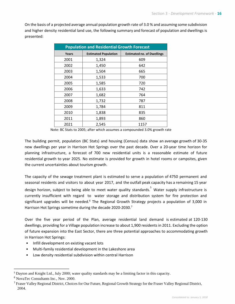
Section 3 - Development Framework - 16
Consolidated to: January 5, 2018
On the basis of a projected average annual population growth rate of 3.0 % and assuming some subdivision
and higher density residential land use, the following summary and forecast of population and dwellings is
presented:
Population and Residential Growth Forecast
Years Estimated Population Estimated no. of Dwellings
2001 1,324 609
2002 1,450 642
2003 1,504 665
2004 1,533 700
2005 1,585 720
2006 1,633 742
2007 1,682 764
2008 1,732 787
2009 1,784 811
2010 1,838 835
2011 1,893 860
2021 2,545 1157 Note: BC Stats to 2005; after which assumes a compounded 3.0% growth rate
The building permit, population (BC Stats) and housing (Census) data show an average growth of 30‐35
new dwellings per year in Harrison Hot Springs over the past decade. Over a 20‐year time horizon for
planning infrastructure, a forecast of 700 new residential units is a reasonable estimate of future
residential growth to year 2025. No estimate is provided for growth in hotel rooms or campsites, given
the current uncertainties about tourism growth.
The capacity of the sewage treatment plant is estimated to serve a population of 4750 permanent and
seasonal residents and visitors to about year 2017, and the outfall peak capacity has a remaining 15 year
design horizon, subject to being able to meet water quality standards.5 Water supply infrastructure is
currently insufficient with regard to water storage and distribution system for fire protection and
significant upgrades will be needed.6 The Regional Growth Strategy projects a population of 3,000 in
Harrison Hot Springs sometime during the decade 2020‐2030.7
Over the five year period of the Plan, average residential land demand is estimated at 120‐130
dwellings, providing for a Village population increase to about 1,900 residents in 2011. Excluding the option
of future expansion into the East Sector, there are three potential approaches to accommodating growth
in Harrison Hot Springs:
• Infill development on existing vacant lots
• Multi‐family residential development in the Lakeshore area
• Low density residential subdivision within central Harrison
5 Dayton and Knight Ltd., July 2000; water quality standards may be a limiting factor in this capacity. 6 NovaTec Consultants Inc., Nov. 2000. 7 Fraser Valley Regional District, Choices for Our Future, Regional Growth Strategy for the Fraser Valley Regional District,
2004.
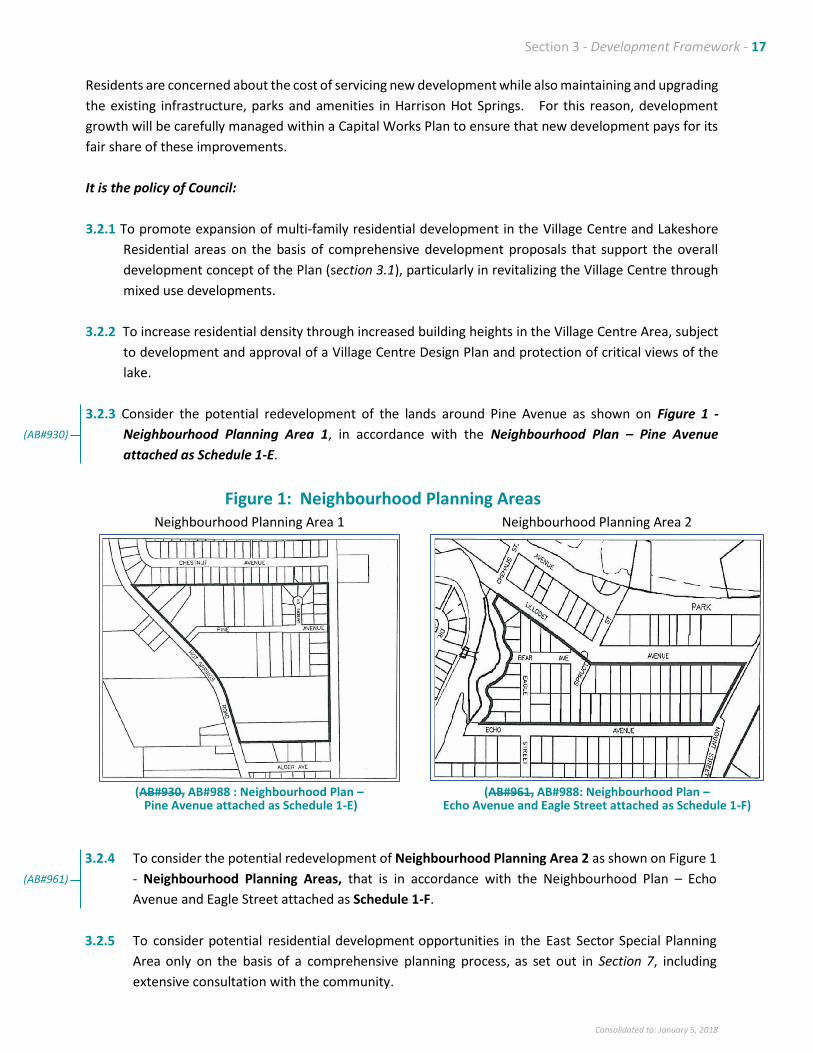
Section 3 - Development Framework - 17
Consolidated to: January 5, 2018
Residents are concerned about the cost of servicing new development while also maintaining and upgrading
the existing infrastructure, parks and amenities in Harrison Hot Springs. For this reason, development
growth will be carefully managed within a Capital Works Plan to ensure that new development pays for its
fair share of these improvements.
It is the policy of Council:
3.2.1 To promote expansion of multi‐family residential development in the Village Centre and Lakeshore
Residential areas on the basis of comprehensive development proposals that support the overall
development concept of the Plan (section 3.1), particularly in revitalizing the Village Centre through
mixed use developments.
3.2.2 To increase residential density through increased building heights in the Village Centre Area, subject
to development and approval of a Village Centre Design Plan and protection of critical views of the
lake.
3.2.3 Consider the potential redevelopment of the lands around Pine Avenue as shown on Figure 1 -
Neighbourhood Planning Area 1, in accordance with the Neighbourhood Plan – Pine Avenue
attached as Schedule 1-E.
Figure 1: Neighbourhood Planning Areas Neighbourhood Planning Area 1 Neighbourhood Planning Area 2
(AB#930, AB#988 : Neighbourhood Plan –
Pine Avenue attached as Schedule 1-E) (AB#961, AB#988: Neighbourhood Plan –
Echo Avenue and Eagle Street attached as Schedule 1-F)
3.2.4 To consider the potential redevelopment of Neighbourhood Planning Area 2 as shown on Figure 1
- Neighbourhood Planning Areas, that is in accordance with the Neighbourhood Plan – Echo
Avenue and Eagle Street attached as Schedule 1-F.
3.2.5 To consider potential residential development opportunities in the East Sector Special Planning
Area only on the basis of a comprehensive planning process, as set out in Section 7, including
extensive consultation with the community.
(AB#930)
(AB#961)
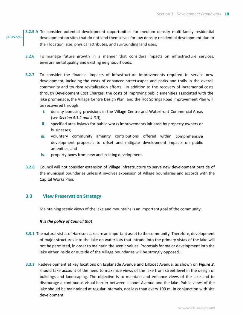
Section 3 - Development Framework - 18
Consolidated to: January 5, 2018
3.2.5.A To consider potential development opportunities for medium density multi-family residential
development on sites that do not lend themselves for low density residential development due to
their location, size, physical attributes, and surrounding land uses.
3.2.6 To manage future growth in a manner that considers impacts on infrastructure services,
environmental quality and existing neighbourhoods.
3.2.7 To consider the financial impacts of infrastructure improvements required to service new
development, including the costs of enhanced streetscapes and parks and trails in the overall
community and tourism revitalization efforts. In addition to the recovery of incremental costs
through Development Cost Charges, the costs of improving public amenities associated with the
lake promenade, the Village Centre Design Plan, and the Hot Springs Road Improvement Plan will
be recovered through:
i. density bonusing provisions in the Village Centre and Waterfront Commercial Areas
(see Section 4.3.2 and 4.3.3);
ii. specified area bylaws for public works improvements initiated by property owners or
businesses;
iii. voluntary community amenity contributions offered within comprehensive
development proposals to offset and mitigate development impacts on public
amenities; and
iv. property taxes from new and existing development.
3.2.8 Council will not consider extension of Village infrastructure to serve new development outside of
the municipal boundaries unless it involves expansion of Village boundaries and accords with the
Capital Works Plan.
3.3 View Preservation Strategy
Maintaining scenic views of the lake and mountains is an important goal of the community.
It is the policy of Council that:
3.3.1 The natural vistas of Harrison Lake are an important asset to the community. Therefore, development
of major structures into the lake on water lots that intrude into the primary vistas of the lake will
not be permitted, in order to maintain the scenic values. Proposals for major development into the
lake either inside or outside of the Village boundaries will be strongly opposed.
3.3.2 Redevelopment at key locations on Esplanade Avenue and Lillooet Avenue, as shown on Figure 2,
should take account of the need to maximize views of the lake from street level in the design of
buildings and landscaping. The objective is to maintain and enhance views of the lake and to
discourage a continuous visual barrier between Lillooet Avenue and the lake. Public views of the
lake should be maintained at regular intervals, not less than every 100 m, in conjunction with site
development.
(AB#977)
Section 3 - Development Framework - 19
Consolidated to: January 5, 2018
3.3.3 Redevelopment in the Lakeshore Special Planning Area identified on Schedule 1‐B will endeavour to
complement views of the lake through the application of the Design Guidelines in Schedule 1‐D and
issuance of development permits;
3.3.4 Forest cover on private lands designated as Resource on Schedule 1‐B will be protected by a tree
protection bylaw and development permit area; and
3.3.5 Land use and forest management on Crown and private lands, including Echo Island and other lands
outside of the Village, should recognize and address the need to maintain scenic values associated
with Harrison Lake.
Figure 2: View Preservation Strategy
Major sightlines - key intersections where building design and setbacks will complement viewscapes. Minor sightlines - approximate locations of view protection sightlines towards the lake.
3.4 Future Land Use Designations
It is the policy of Council that the future use and development of land within the Village of Harrison Hot Springs shall be consistent with the overall pattern of land use depicted on Schedule B – Future Land Use Designation Map. The general form and character of development in each future land use designation is explained in subsequent sections of this Plan. A brief summary of the designations is presented on Table 1. The Official Community Plan provides overall direction for long‐term growth of the community. The Zoning Bylaw, on the other hand, is a tool for regulating land use. It identifies permitted land uses, minimum parcel sizes and other applicable regulations. In some cases, the designated future land use on the Future Land Use Designation Map differs from the existing zoning. This difference does not mean that the zoning will change, as the Plan does not change the current zoning of any property. Where there is a proposal to make changes to the Zoning Bylaw, those changes must be consistent with the OCP.
3.5 Development Permit Areas
It is the policy of Council:
Section 3 - Development Framework - 20
Consolidated to: January 5, 2018
3.5.1 Development Permit Requirements
Development Permit Areas will be established under Section 919.1 of the Local Government Act and as described in Sections 4, 5, 6, 9 and 14 of this Plan. The purpose of these areas is to provide flexibility to accommodate development while meeting certain specified development, hazard protection or environmental objectives on the site. Development permits may vary aspects of a regulatory bylaw, excluding the permitted land use and density (except in situations related to health, safety or protection of property from damage).
3.5.2 Conditions Where Development Permits Are Not Required
Development Permits are not required within the specified development permit areas under the following conditions:
• for an internal alteration which does not affect the outer appearance of the building;
• excluding development within the Lakeshore Development Permit Area, for the replacement, upgrading or repair of the external covering of existing buildings (i.e. roofing or siding) with similar materials;
• for new auxiliary buildings in the rear yard or interior side yards that meet the setback requirements in the Zoning Bylaw provided the land use fronts on only one street; and
• within the Miami River Development Permit Area as per the Fish Protection Act, reconstruction or repair of a permanent structure as described in Section 911 (8) of the Local Government Act and provided the structure remains on its existing foundations, and other exemptions as specified in section 14.4 Miami River Development Permit Area.
TABLE 1: FUTURE LAND USE DESIGNATIONS
Purpose Rationale Future Land Uses Permitted
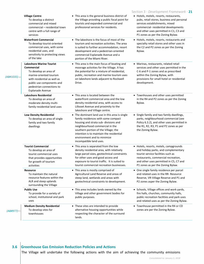
Section 3 - Development Framework - 21
Consolidated to: January 5, 2018
Village Centre
To develop a distinct
commercial and mixed
commercial – residential town
centre with a full range of
services
• This area is the general business district of
the Village providing a public focal point for
tourists and expanded commercial and
professional services for residents.
• Hotels, motels, resorts, restaurants,
pubs, retail stores, business and personal
services establishments, mixed
commercial- residential developments
and other uses permitted in C1, C3 and
P1 zones as per the Zoning Bylaw.
Waterfront Commercial
To develop tourist-oriented commercial uses, with some residential uses, and sensitivity to protecting views of the lake
• The lakeshore is the focus of most of the
tourism and recreation activities. The area
is suited to further accommodation, resort
development and a pedestrian-oriented
commercial Esplanade Avenue and a
portion of the Miami River.
• Hotels, motels, resorts, restaurants and
specialty retail stores and other uses in
the C2 and P2 zones as per the Zoning
Bylaw.
Lakeshore Marine Tourist Commercial
To develop an area of
marine-oriented tourism
with residential as well as
public use components and
pedestrian connections to
Esplanade Avenue
• This area is the main focus of boating and
moorage activities for the Village. It has
the potential for a mixture of residential,
public, recreation and marine tourism uses
on lakeshore lands adjacent to Rockwell
Drive.
• Marinas, restaurants, related retail
services and other uses permitted in the
C-6 and P-1 zones and as prescribed
within the Zoning Bylaw, with
provisions for small hotel or residential
development.
Lakeshore Residential
To develop an area of
moderate density multi-
family residential land uses
• This area is located between the
waterfront commercial area and the low
density residential area, with access to
Lillooet Avenue and proximity to the
lakeshore and Village centre.
• Townhouses and other uses permitted
in the R4 and P2 zones as per the Zoning
Bylaw.
Low Density Residential
To develop an area of single
family and two family
dwellings
• The dominant land use in this area is single
family residences with some compact
housing and strata sub- divisions and
neighbourhood commercial in the
southern portion of the Village; the
intention is to maintain the residential
environment and to minimize
incompatible land uses.
• Single family and two family dwellings,
parks, neighbourhood commercial (see
Policy 6.3.2), and other uses permitted in
the R1, R2, R3, P1 and P2 zones as per
the Zoning Bylaw.
Tourist Commercial
To develop an area of
tourist commercial uses
that provides opportunities
for growth of tourism
activities
• This area is separated from the low
density residential area, with relatively
large parcel sizes, geotechnical constraints
for other uses and good access and
exposure to tourist traffic. It is suited to
tourist commercial recreation businesses.
• Hotels, resorts, motels, campgrounds
and holiday parks, and complementary
tourist service facilities such as
restaurants, commercial recreation,
and other uses permitted in C5, C7 and
P1 zones as per the Zoning Bylaw.
Resource
To maintain the natural resource features within the ALR and steep uplands surrounding the Village
• This area is mostly comprised of
Agricultural Land Reserve and areas of
steep land, wetlands and areas with
geotechnical constraints to development.
• One single family residence per parcel
and related uses in the RR- Resource
Reserve, VR-Village Reserve and P1 and
P2 zones asper the Zoning Bylaw.
Public Use
To provide for a variety of school, institutional and park uses
• This area includes lands owned by the
Village and other government bodies for
public purposes.
• Schools, Village offices and work yards,
fire halls, churches, community halls,
public recreation facilities and park uses
and related uses as per the Zoning Bylaw.
Medium Density Residential
To develop sites for
townhouses
• These sites are intended to provide
alternative housing opportunities while
respecting the character of the surround
lands.
• Townhouse permitted in the R4 or CD
zones are per the Zoning Bylaw.
3.6 Greenhouse Gas Emission Reduction Policies and Actions
The Village will undertake the following actions with the aim of achieving the community emissions
(AB#1035)
(AB#977)
Section 3 - Development Framework - 22
Consolidated to: January 5, 2018
reduction target. In many cases, these actions will build upon actions already planned, commenced or
undertaken by the Village.
Cross-Cutting, Strategic Actions
i. Monitor community greenhouse gas emissions through the Provincial CEEI reports (and potentially
other means), monitor the status and success of emissions reduction actions and policies, and review
and revise the emissions reduction target within the next five years.
ii. Continue to participate in regional discussions and plans relating to energy, climate change and
sustainability, and continue to work with other jurisdictions to learn from their experience.
Land Use Actions
i. Continue the process of updating the zoning bylaw to incorporate provisions that encourage
compact, complete community development.
ii. Explore density incentives where appropriate – for example, density for cash contributions to off-site
parking.
iii. Continue to identify opportunities for tourism tax-funded infrastructure improvements that support
emissions reductions and tourism, such as walkability.
iv. Continue to encourage the development of local services such as grocery stores, that can service
many of the day-to-day needs of residents and visitors; consider the accessibility of regional services
in this work.
Transportation Actions
i. Update the Traffic and Parking Study/undertake a new transportation and parking study, to include
consideration of connectivity within and between neighbourhoods, strategic offsite parking for the
Village Centre, and provisions for electric vehicles, all aimed at reducing fossil fuel consumption for
transportation.
a. Continue to advocate and work with partners to develop transit solutions to/from Harrison Hot
Springs and major destinations, also aimed at reducing fossil fuel consumption.
Buildings Actions
i. Develop a green building/energy efficiency standard or checklist that is applied for rezoning, and is
goal/performance oriented.
ii. Develop and promote incentives aimed at improving energy efficiency and utilizing renewable energy
in new construction and existing buildings.
Energy Supply Actions
i. Pursue utilization of alternative, low carbon energy sources and systems including geothermal/waste
heat and district energy for the Village Centre, and engage community partners in this process.
Waste and Resource Management Actions
i. Continue to pursue expansion and/or enhancement of services that will reduce waste disposal and
landfilling, particularly organic food waste that contributes to landfill gas emissions.
ii. Expand waste reduction education efforts in schools and more widely in the Village and use this as
an avenue for broader greenhouse gas emissions reduction education.
(AB#937)
Section 4 – Lakeshore Special Planning Area - 23
Consolidated to: January 5, 2018
4. LAKESHORE SPECIAL PLANNING AREA
4.1 Background
The lakeshore is a critical area of Harrison Hot Springs with a high potential for major new development
and redevelopment. This area is part of the Villageʹs commercial and tourism focus and requires special
attention. Its development must be managed carefully to ensure the ʺsmall Villageʺ character of Harrison
is maintained while building on the opportunities that this area provides. The Design Guidelines in
Schedule 1‐D will be a key aspect of the development planning for this area. It is proposed that these be
updated with a Village Centre Design Plan.
Specific policies and future land use designations that apply only to the Lakeshore Area have been
developed. These are aimed at optimizing the potential of this area for the shared benefit of present
and future Village residents, property owners and visitors.
4.2 Objectives
Councilʹs objectives are to:
4.2.1 Encourage private investment in a range of tourist accommodation facilities and other
complementary tourist‐oriented facilities to take full advantage of the natural features of this
area, including proximity to the beach and lake, recreation opportunities and scenic views, in a
manner that contributes to the quality of the built environment.
4.2.2 Apply the Design Guidelines in Schedule 1‐D, as updated by a Village Centre Design Plan, to
create commercial streetscapes within the Village Centre Area which will be appealing and
inviting to tourists and residents by virtue of:
• a wide‐range of commercial businesses at ground level, fronting directly on to the street;
• a ʺpedestrian friendly ʺ street featuring wide sidewalks, attractive street furniture,
landscaping, signage and lighting;
• an overall image and appearance characteristic of a high quality lakeside resort community.
4.2.3 Promote development in the lakeshore area which recognizes the need to sensitively and
skilfully achieve a balance of:
• taking full advantage of the magnificent views of Harrison Lake and the mountains without
blocking these views for the enjoyment of others;
• capitalizing on the areaʹs high development potential without compromising the small
Village character and charm of the community.
4.2.4 Improve the visual and physical connection between Harrison Lake (including the beach),
and development area south of the dyke (i.e. Esplanade Avenue, Lillooet Avenue areas).
Section 4 – Lakeshore Special Planning Area - 24
Consolidated to: January 5, 2018
4.2.5 Protect the natural scenery and vistas of Harrison Lake by avoiding major physical structures
within the lake.
4.2.6 Provide for some condominium‐type residential development, but not at the expense of using
up developable land suitable for tourist accommodation and other tourist commercial
development.
4.2.7 Through the use of appropriate mechanisms, and assisted by a proposed Village Centre
Design Plan, ensure that the form and character (e.g . building mass, siting and landscaping)
of new development is consistent with the broad goals of:
• preserving views of the lake and mountains;
• compatibility with existing development and the ʺVillage characterʺ of the community; and
• eliminating the ʺrear yardʺ syndrome where a parcel has front and rear parcel lines on
separate streets.
4.2.8 Permit interim temporary uses of commercially designated lands within the Lakeshore Special
Planning Area when;
• current market or other issues limit development potential; and
• when interim development would be considered to be of benefit or positive influence to
investment or amenity issues within the Village
by designating these lands as eligible for Temporary Commercial Permits per Section 921 of the
Local Government Act.
4.3 Policies
It is the policy of Council:
Within the Lakeshore Special Planning Area, provide for a variety of uses in locations designated
on the Future Land Use Map, Schedule B, as follows:
▪ Lakeshore Beach and Public Use
▪ Village Centre
▪ Waterfront Commercial
▪ Lakeshore Marine Tourist Commercial
▪ Lakeshore Residential
Policies for each of these designations are set forth below.
(AB#920)
Section 4 – Lakeshore Special Planning Area - 25
Consolidated to: January 5, 2018
4.3.1 Lakeshore Beach and Public Use Area
Within this area, including the entire beach front and foreshore area along Harrison Lake:
• Subject to preparation of a lakeshore management plan, Council intends to pursue the
following initiatives aimed at improving the beach and foreshore area for the use and
enjoyment of residents and visitors, subject to technical feasibility, securing of necessary
approvals from government authorities and availability of funding. They are not set out in
order of priority:
▪ a beach promenade, extending along the entire foreshore area from the
source of the hot springs to the marinas;
▪ development of the hot springs source as a tourist attraction, including
provision of better signage to the springs along the promenade;
▪ measures to improve the visual and physical connection between Harrison
Lake, the beach area, and the areas south of the dyke; and
▪ provision of better pedestrian linkages from the beach promenade to the
Miami River Greenway Trail.
Council will consider making provision for a limited number of tourism commercial activities on
and adjacent to the beach, such as recreation activities, sports equipment rentals and
refreshment vendors. In the process of evaluating proposals and issuing permits, the Village will
take into account the following criteria:
• noise levels must be low;
• contribution to the image of Harrison Hot Springs as a tourism community;
• compatibility with the character of the Lakeshore Area and the adjacent residential and
commercial areas; and
• no interference with the publicʹs access, use and enjoyment of the beach
4.3.2 Village Centre Area
Within this area, a range of commercial, residential and public uses are promoted, with emphasis
on encouraging commercial facilities and mixed commercial – residential developments that
maintain public views of the lake at key locations. A diverse range of uses will be supported,
including personal service establishments, banks, business and professional offices, as well as retail
and grocery stores that support a complete community.
On streets within the Village Centre Area (Esplanade Avenue, Lillooet Avenue Hot Springs Road,
Maple Street, St. Alice Street and Cedar Avenue), Council will work toward establishing an
attractive and appealing streetscape by means of:
• developing a Village Centre Design Plan which provides detailed architectural and landscape
treatments;
• encouraging, on private properties:
▪ a broad variety of business establishments side by side to create an interesting
and stimulating shopping experience;
▪ storefronts located and designed to facilitate easy pedestrian access irregular
setbacks to create interest and visual appeal;
▪ small scale open spaces within developments to facilitate pedestrian movement
and take advantage of sun, views, protection from wind and so forth;
Section 4 – Lakeshore Special Planning Area - 26
Consolidated to: January 5, 2018
▪ the use of permanent materials and a permanent standard of development
(discourage temporary or minimum investment seasonal structures);
▪ site development using landscaping elements such as bricks or textured concrete,
thereby avoiding large uninterrupted areas of asphalt surface; and
▪ attractive canopies to provide protection from rain and snow and to add visual
appeal, with a view to facilitate shopping during inclement weather.
• carrying out, on the public portion of the streets, streetscape improvements such as wider
sidewalks, street furniture, tree planting, power pole removal and ornamental street lighting
to enhance the image, visual appeal and pedestrian convenience of the area
• skillfully integrating the private and public components of the overall commercial streetscape
to create an overall harmonious image, through a variety of techniques such as canopies,
awnings, window displays, signage, outdoor display of merchandise and outdoor extensions of
restaurants (e.g. mini‐sidewalk cafes) on to the widened sidewalk.
• re‐designing the terminus of Hot Springs Road, in collaboration with the Ministry of
Transportation, and in conjunction with a Village Centre Design Plan.
Within the Village Centre Area, the following land use policies will apply:
a. Only commercial developments or developments with a strong commercial focus will be
supported on properties fronting Esplanade Avenue and Lillooet Avenue between St. Alice
Street and Maple Street.
b. Multi‐family residential developments and mixed use developments ‐ commercial use in
combination with residential use, will be encouraged on properties fronting Cedar Avenue and
the south end of Maple Street.
Development Density
The density of development will generally be governed by a maximum floor space to parcel
area ratio of 1.5 to 1. With density bonusing provisions to be incorporated into the Zoning Bylaw,
this ratio may be increased to a maximum of 2.0 to 1, in consideration of the owner meeting
certain requirements such as provision and enhancement of amenities for the use and
enjoyment of the public
and occupants of the development. The basis for a density bonus must be clearly defined by
applicants and must contribute to:
• View Preservation Strategy implementation
• Village Centre Design Plan implementation and/or
• Dwelling units catering to the disabled and affordable dwelling units, as specified in the
Zoning Bylaw.
For the residential component of mixed‐use developments, the maximum number of residential
units is 150 units per hectare provided that this can be accomplished within the overall density
requirements expressed above in terms of floor space to parcel area ratios. The above allowable
densities may be revised following completion of the Village Centre Design Plan, consistent with
policy 3.2.2.
(AB#893)
Section 4 – Lakeshore Special Planning Area - 27
Consolidated to: January 5, 2018
Notwithstanding the maximum residential density limit of 150 units per hectare for buildings
established within the Village Center Area, the residential density may be increased up to 173 units
per hectare for Lot B, Section 13, TWP 4, Rge 29, NWD, Plan BCP 27775 provided that the overall
Floor Space Ratio for the building is reduced from 2.0 to 1.85.
Development Design
Council proposes to adopt a Village Centre Design Plan, in conjunction with updating of
Schedule 1‐C of the OCP that will serve to guide the redevelopment of buildings and
streetscapes in accordance with the long‐term Vision for Harrison Hot Springs.
The Village Centre area is located within Development Permit Area Number 1 (Section 4.4).
Developments within this area are therefore subject to first obtaining a development permit in
accordance with the Development Guidelines set out in Section 4.4 of this Plan. For each
development, the development permit will regulate the form and character of structures (eg.
Building height, massing, shape, sitting on the lot, etc.) as well as the development of the site
(open/ space and landscaping,
parking, pedestrian orientation to the abutting street, vehicle access, provision of view corridors,
and provision of improvements to the sidewalk and landscaping of the boulevard on the street
abutting the development). The proposed Design Plan, which will serve as Development Permit
Area Guidelines, will be prepared in conjunction with an update of the Traffic and Parking Study.
Entry Feature to the Lakeshore Area
To foster a sense of arrival and to create a positive first impression of the community with
tourists, Council intends to investigate, in consultation with Ministry of Transportation, the
feasibility of developing an entry feature at an appropriate point along Hot Springs Road.
Considerations to be addressed in the investigation will include:
• identification of options, for example, a new bridge across the Miami River on Hot
Springs Road;
• project elements and design features to be presented in an overall Hot Springs Road
Improvement Plan;
• potential linkage to other initiatives such as streetscape improvementsunder a Village
Centre Design Plan and the Miami River Greenway; and
• identification of responsibilities and source(s) of funding e.g. Ministry of
Transportation and Highways.
4.3.3 Waterfront Commercial Area
Within this area, the preferred form of development is tourist‐oriented commercial
uses such as hotels, motels, resorts, restaurants and specialty retail stores. As illustrated on
Schedule 1‐B: Future Land Use Designation Map, Council encourages hotel resort development
at the east end of Esplanade Avenue, and along the Miami River. New multi‐unit residential
development may be permitted, but only if the development includes a commercial component,
again with preference given to tourist‐oriented commercial uses.
The commercial component of a mixed use development is to be at ground level and oriented to
(AB#935)
Section 4 – Lakeshore Special Planning Area - 28
Consolidated to: January 5, 2018
the abutting street in such a manner as to accommodate safe and convenient pedestrian access.
In such developments, the habitable spaces are to be located above the flood plain elevation as
defined in Section 9.
Development Density
The density of development will generally be governed by a maximum floor space to parcel area
ratio of 1.25 to 1. With density bonusing provisions to be incorporated into the Zoning Bylaw, this
ratio may be increased to a maximum of 1.75 to 1, in consideration of the owner meeting certain
requirements such as the provision and enhancement of amenities for the use and enjoyment of
the public as well as occupants of the development. The basis for a density bonus must be clearly
defined by applicants and must contribute to:
• View Preservation Strategy implementation;
• Parking and streetscape improvements in the area;
• Improvements to the Miami River, and public access to/from the Village Centre and the
development;
• Enhancement of the beach promenade, extending along the entire lakeshore from
the hot springs source to the marinas; and/or
• Dwelling units catering to the disabled and affordable dwelling units, as specified in the
Zoning Bylaw.
For the residential component, the maximum number of residential units is 150 units per hectare
provided this can be accomplished within the overall density requirements expressed above in
terms of floor space to parcel ratio.
The Waterfront Commercial area is located within Development Permit Area Number 1, and the
policy set out above for development permits in Section 4.4 for the Village Centre Area also applies
in the Waterfront Commercial area.
4.3.4 Lakeshore Marine Tourist Commercial Area
Within this area, a range of marine-oriented tourism uses such as marinas, restaurants, retail services, small hotels or residential developments are permitted. This development provides for ‘marina accommodation’ that caters to the boating tourist, boating residential tourist, and recreational development. Hotels or residential developments integrated with marina operations may be considered. Public community space and a public community facility are to be encouraged within this area. The Lakeshore Marine Tourist Commercial area is located within Development Permit Area Number 1. In addition to consideration of the Development Permit guidelines set out in 4.4, special attention in Development Permits for this area will be applied to pedestrian accessibility to the lakefront area and connection to the pedestrian promenade along the remainder of the lakefront as described in Section 4.3.1 above.
Developments within this area are required to consult, and obtain all applicable approvals, with appropriate Provincial and Federal Government Agencies.
(AB#1035)
Section 4 – Lakeshore Special Planning Area - 29
Consolidated to: January 5, 2018
Re-designation Criteria Proposals for redesignation of the Lakeshore Marine Tourist Commercial area to Waterfront Commercial by application for Plan amendment will be considered by Council on the basis of the following: a. A study by a qualified geotechnical engineer confirms acceptability of the proposed
commercial development within the area proposed for re-designation with regard to natural hazards;
b. A study by a qualified traffic engineer confirms suitability of the site for the proposed
estimated traffic volumes and parking requirements and provides a conceptual design with regard to safe access and egress from Highway 9;
c. The Ministry of Highways endorses in principle the proposed re-designation with regard to effects on Highway 9;
d. A study by a qualified professional biologist confirms that the proposed commercial development will have no significant adverse impact on fish habitat and such uses are acceptable in principle to the Department of Fisheries and Oceans and the B.C. Ministry of Environment;
e. Conceptual design of proposed development outlining building siting, form and character and landscaping and the manner in which the development will be consistent with the objectives of the Lakeshore Development Permit Area 1;
f. A study by a qualified engineer assessing the implications of re-designation for upgrading
sewer and water services to serve the proposed commercial land use;
g. Proponents of the re-designation consult with property owners in the Waterfront Commercial Area and with the District of Kent and provide a report to Council on the views of those consulted; and
h. Consideration of submissions to a public hearing on the proposed amendment of the Official
Community Plan.
4.3.5 Lakeshore Residential Area
Within this area, medium density multifamily residential uses will be permitted to a maximum
density of 35 units per hectare.
The Lakeshore Residential area is located within Development Permit Area Number 1. For each
Development Permit, special emphasis will be placed on ensuring compatibility with nearby low
density residential uses, including consideration of building height, massing and orientation, site
landscaping, on‐ site parking, vehicle access, and visual screening from adjacent properties.
(AB#1035)
Section 4 – Lakeshore Special Planning Area - 30
Consolidated to: January 5, 2018
4.3.6 Parking and Traffic in the Lakeshore Area
Council intends to address the issue of parking shortages and traffic congestion in the Lakeshore
area during peak demand periods, including special events and the peak tourism period. Subject
to availability of funding, Council intends to review and update its Traffic and Parking Study for
the Village in conjunction with preparation of a Village Centre Design Plan. This will include a
needs assessment, identification and evaluation of optional solutions, and a recommended
course of action for implementing selected solutions.
4.3.7 The Hot Springs
Residents of Harrison Hot Springs want to further develop and strengthen the hot springs identity
of the community, an important aspect that was discussed at length in the community workshops.
The primary opportunity for doing this in the short term is through improvements to the hot
springs source site as part of the lakeshore public promenade.
It is the policy of Council to:
a. work in partnership with the Harrison Hot Springs Resort in developing the hot springs site as
a key public feature within the lakeshore promenade and the Villageʹs Park and Trail Master
Plan;
b. encourage development of opportunities to utilize hot springs water in a manner that
strengthens the public identify of the hot springs character of the community and that
balances private and public interest in hot springs use and development;
c. promote the heritage and natural history interpretative aspects of then hot springs as an
element within the Tourism Development Strategy of the Village; and
d. explore options for upgrading or acquiring the hot springs swimming pool in the Village Centre
to make it more significant as a tourism attraction on a year round basis.
4.4 Lakeshore Development Permit Area 1
4.4.1 Category
The Lakeshore Area is designated a Development Permit Area under Section 919.1 of the Local
Government Act to establish objectives and guidelines for the form and character of commercial
and multi‐family residential development.
Section 4 – Lakeshore Special Planning Area - 31
Consolidated to: January 5, 2018
4.4.2 Area
The Lakeshore Development Permit Area is shown as DPA 1 on Schedule 1‐C.
4.4.3 Justification
Commercial and multi‐family residential development in the Lakeshore Area is designated within
a Development Permit Area in response to the following objectives:
• Recognize the Lakeshore Area as a critical area due, in part, to its high potential for major new
development and redevelopment.
• Ensure a high quality of both tourist‐oriented commercial development and new residential
development.
• Encourage uses, building design and landscaping which build on the unique opportunities
presented by Harrison Lake, the beach and the surrounding area.
• Establish design guidelines for development within the Lakeshore Area to maintain the Village
character, promote compatibility and architectural integrity with existing development, and
preserve views.
4.4.4 Guidelines
Development Permits issued in this area shall be in accordance with the Village of Harrison Hot
Springs Design Guidelines, forming Schedule 1‐D of this plan. The design principles include:
a. Architecture responsive to the medium density mixed‐use context, and integrated with
neighbouring buildings of various ages.
b. Site planning based on creating continuous street‐oriented edges and intensifying pedestrian
activity within the Lakeshore Special Planning Area.
c. Protection of view corridors within the Village towards Harrison Lake and the surrounding
mountains.
d. Respect for the natural setting which should continue to dominate along the lakeshore.
e. Variation on themes to result in a balance between continuity and a healthy diversity, both
within a commercial, residential or mixed‐use development and throughout the Village.

Section 5 - Commercial Development- 32
Consolidated to: January 5, 2018
5. COMMERCIAL DEVELOPMENT
5.1 Background
The issues related to commercial development are primarily associated with developing an attractive and
distinct tourist destination, and expanding the range of commercial services available for a growing
residential population.
Tourism is the economic base of the community, supporting most of these businesses and local
employment. The number of overnight visitors to Harrison has fluctuated with global and regional tourism
trends, while the number of local day visitors has likely increased with population growth in the Fraser
Valley and local festival activities. The tourism market is shifting towards destinations with a wider array
of outdoor activities and night life, and higher quality facilities and experiences. The objectives and
policies of the OCP support new investment and commitment to growth of the tourism industry. The
focus is on developing a tourism destination of regional and international significance.
The emphasis in the plan is on re‐developing the Village Centre to establish a more complete
community for residents (with shopping, banking and some professional services), as well as to
enhance the identity and tourism marketability of the Village.
5.2 Objectives
Councilʹs objectives are to:
5.2.1 Encourage the development of a distinct Village Centre with a full range of commercial services
and a form and character that accords with the Design Guidelines in Schedule 1‐D.
5.2.2 Encourage the development of year‐round tourism facilities and activities compatible with the
natural setting and environment of the community and surrounding area, including development
of a parks and trail system.
5.2.3 Encourage the development of year‐round tourism commercial development in Harrison Hot
Springs as a key element of the Villageʹs strategy for maintaining and strengthening the economic
base of the community.
5.2.4 Ensure sufficient land for various forms of tourism commercial development suitably located in the
community, recognizing the changing nature of tourism demand.
5.2.5 Ensure a high standard of commercial development, emphasizing compatibility with existing land
uses nearby and the overall character of the community.
5.2.6 Encourage the development of boating and fishing activities and related moorage and launching
facilities.
Section 5 - Commercial Development- 33
Consolidated to: January 5, 2018
5.2.7 Encourage artisan, craft and culturally‐oriented accessory uses in appropriate land
use zones with a focus on Hot Springs Road.
5.3 Policies
5.3.1 Tourism Development Strategy
Tourism in Harrison Hot Springs, like many other communities, is shifting toward a more
sophisticated product, one which caters to more diverse visitor activities and higher‐value
experiences. The tourism industry is the economic base of the Village and a central component of
the future of the community. Development of year‐round tourism and compatible relationships
with residential uses are major priorities.
It is the policy of Council:
• To support the preparation of an international quality Tourism Development Strategy that
integrates product development, services, marketing, training and other aspects in a coordinated
effort to establish the long term framework for the future of tourism in Harrison.
• Develop an attractive, visitor‐friendly Village Centre that provides a wide range of accommodation
and services. In this regard, Council will discourage a strip of service commercial developments along
Hot Springs Road in order to strengthen the prospects for Village Centre redevelopment. It will
prepare a Village Centre Design Plan to complement or update the Design Guidelines in Schedule
1‐D.
• Work toward the beautification of the entrance corridor into Harrison Hot Springs through the
preparation and implementation of a Hot Springs Road Improvement Plan.
• Develop a comprehensive and integrated system of green spaces and pedestrian and bicycles routes
through the preparation and implementation of a Parks and Trails Master Plan.
• Take steps to enhance and encourage investment in and upgrading of tourist commercial
facilities, in conjunction with policy 4.3.1, through:
o designating sufficient areas on the Future Land Use Map to accommodate significant
investment in new tourist commercial facilities, particularly in the Village Centre and Tourist
Commercial Areas;
o promoting private and public Village Centre revitalization initiatives to develop a distinct,
pedestrian‐oriented small Village atmosphere;
o developing the hot springs source site as a key public attraction on the lakefront;
o encouraging development of a tourist hotel resort at the east end of Esplanade Avenue;
o encouraging artisan workshops and related culturally‐oriented accessory uses along Hot
Springs Road south of Emerald to McPherson Avenue.
Section 5 - Commercial Development- 34
Consolidated to: January 5, 2018
o providing for small‐scale marina inns catering to the boating tourist and developing a
marina area boardwalk to increase public use, boating and day use tourism in the east end
of the lakeshore;
o working in partnership with the business community in Harrison Hot Springs, the District of
Kent and tourism associations on a variety of community initiatives to enhance the year
round appeal of Harrison Hot Springs to tourists, and to attract, over the long term, new
investment in tourist commercial facilities.
5.3.2 Commercial Uses in the Lakeshore Special Planning Area
The principal focus of commercial development in Harrison Hot Springs will continue to be within
the Lakeshore Special Planning Area as shown on the Future Land Use Designation Map. Policies
respecting specific type of commercial development in this area are set out in Section 4 of the Plan.
5.3.3 Tourist Commercial Area
Within the Tourist Commercial area designated on the Future Land Use Designation Map ‐
Schedule B, and situated along Hot Springs Road south of the Lakeshore area, Councilʹs policies are
set out below.
The range of tourist commercial uses include:
• ƒ tourist accommodation, such as:
▪ hotels
▪ resorts
▪ motels and motor hotels
▪ campground and holiday parks
• complementary tourist service facilities, such as:
▪ restaurants
▪ commercial recreation
▪ convenience stores
▪ specialty shops
The Tourist Commercial area is located within Development Permit Area 2. Developments in this
area are therefore subject to obtaining a Development Permit in accordance with the
Development Guidelines set out in Section 5.4 of this Plan. For each development, the
Development Permit will specify detailed standards respecting the form and character of
structures (building height, etc.), as well as site development. Emphasis will be placed on ensuring
safe access from Hot Springs Road, as well as landscaping and signage to ensure an aesthetically
attractive view of the development from Hot Springs Road.
Section 5 - Commercial Development- 35
Consolidated to: January 5, 2018
Re‐designation Criteria
Proposals for re‐designation of Tourist Commercial Area lands to residential land use by application
for Plan amendment will be considered by Council on the basis of the following:
a. A study by a qualified geotechnical engineer confirms acceptability of the proposed
residential land use within the area currently designated Tourist Commercial and located
within the Geotechnical Hazard Development Permit Area 4;
b. Ministry of Highways endorses in principle the proposed re‐designation with regard to access
and egress from Highway 9;
c. A study by a qualified engineer assessing the implications of re‐designation for
upgrading sewer and water services to serve the proposed residential land uses;
d. Conceptual design details of the manner in which proposed residential development will
contribute to the Hot Springs Road Improvement Plan;
e. Proponents of the re‐designation consult with property owners along the west side of Hot
Springs Road and provide a report to Council on the views of the owners consulted; and
f. Consideration of submissions to a public hearing on the proposed amendment to
the Official Community Plan.
5.4 Tourist Commercial Development Permit Area 2
5.4.1 Category
Commercial development is designated a Development Permit Area under Section 919.1 of the
Local Government Act to establish the objectives and guidelines for the form and character of
commercial development.
5.4.2 Area
The Commercial Development Permit Area is shown as DPA 2 on Schedule 1‐C.
5.4.3 Justification
Commercial development is designated within a Development Permit Area in response to the
following objectives:
• design tourist commercial and other commercial uses in a manner that complements the visual
character of the Hot Springs Road corridor and avoids conflicts with adjacent land uses.
5.4.4 Guidelines
Development Permits issued in this area shall be in accordance with the Village of Harrison Hot
Springs Design Guidelines, forming Schedule 1‐D of this plan. The design guidelines also include
the following:

Section 5 - Commercial Development- 36
Consolidated to: January 5, 2018
a. Creation of a ʺcommercial stripʺ image shall be avoided by encouraging:
• innovative building design and configuration;
• siting of buildings near the front of a parcels with landscaped areas rather than paved
parking areas between the building and the adjacent roadway;
• adequate on‐site parking at the rear, side or within buildings rather than the
front; and
• significant landscaping adjacent to public rights‐of‐way and integrated within the
site.
b. All developments shall maximize sun penetration to pedestrian levels. Important view
corridors must be preserved.
c. Building and site design should strive to reduce the apparent mass of structures and to
integrate the development within its site and local;
d. Context, Variety, continuity and pedestrian interest should be expressed in the design of
buildings, especially at ground level.
e. Notwithstanding the landscape screening provisions of the Zoning Bylaw, landscape
screening requirements should be supplemented to separate parking clusters and to mask
storage and service areas from adjacent residential uses and pedestrian view.
f. Where the rear yard of one development is adjacent to the front yard of the adjoining
development, care should be taken to mask storage and service areas.
g. Commercial uses should be sited to afford maximum privacy to adjacent residential
uses.
h. Natural landscape and significant tree stands should be retained and incorporated into site
development plans when feasible.
Section 6 - Residential Development - 37
Consolidated to: January 5, 2018
6. RESIDENTIAL DEVELOPMENT
6.1 Background
The significant growth in residential development has led to increased interest in maintaining the quality
of the residential environment. Older and large lot residences are being replaced by more compact
subdivisions. The general pattern that has emerged is multi‐family residential in the lakeshore area and
single‐ family residential in the remainder of the Village. Some of the residential development in the
southern areas has inadequate community water supply and future subdivisions will need to be
coordinated with investments in development services.
There is currently about 730 residential units in the community. The OCP provides for future expansion
of residential land use, in accordance with the Growth Management Strategy presented in Section 3.2 of
this Plan.
The general concept for residential development is to focus high‐density residential units in the Village
Centre and Waterfront Commercial areas, medium‐ density multi‐family residential in the eastern
Lillooet Avenue area and low‐ density residential in the areas to the south and east of Hot Springs Road.
There is also an interest in; providing land for various forms of housing for the elderly where it is
compatible with adjacent residential uses, and a local commercial use in the southern portion of the
municipality.
6.2 Objectives
Councilʹs objectives are to:
6.2.1 Protect and promote high quality residential neighbourhoods.
6.2.2 Encourage provision of an adequate supply of affordable housing, rental housing and special needs
housing, with emphasis on meeting the needs of seniors and special needs groups.
6.2.3 Promote compatibility of new residential development with existing developments and with the
overall character of Harrison Hot Springs;
6.2.4 Ensure a high quality, appropriate scale and massing of multi‐family residential developments; and
6.2.5 Provide for appropriate setbacks and protection of aquatic habitat and other environmentally
sensitive areas;
6.2.6 Consider carefully designed neighbourhood commercial development in the southern portion of
the municipality, which provides for daily and occasional shopping needs for the adjacent area.

Section 6 - Residential Development - 38
Consolidated to: January 5, 2018
6.3 Policies
It is the policy of Council:
6.3.1 Multi‐Family Residential Development
• High density residential development will be permitted in the Village Centre Commercial Area
and Waterfront Commercial Area, as shown on Schedule 1‐ B, and in accordance with the policies
described in Sections 4.3.2 and 4.3.3.
• Medium density residential development – townhouses and multiple unit attached housing, will
be permitted in the Lakeshore Residential Area in accordance with the policies described in
Section 4.3.5. Emphasis will be placed on ensuring compatibility of new developments with
existing residential developments nearby and the overall character of the community. Medium
density residential development will be required to have good access to Lillooet Avenue and
appropriate setbacks from the geotechnical hazard area. Therefore, comprehensive townhouse
or row housing developments are encouraged on parcels greater than 0.4 ha (1 acre).
• Future residential expansion of multi‐family development will accord with the Growth
Management Strategy presented in Section 3.2.
• Medium density residential development (townhouses) will be considered for sites that have
good proximity to the Village’s amenities, are well services with water, sewer, and roads, and are
compatible with surrounding lands. Such sites will require an amendment to Schedule 1 – B
(Land Use Designation Map) to the Medium Density Residential land designation and to
Schedule 1 – C (Development Permit Areas Map) to Multi Family Residential DPA. Rezoning will
also be required. The maximum density shall be 18 units per ha. (7 units per acre).
6.3.2 Low Density Residential Area
• Single family and two‐family (duplex) residential development will be permitted in the Low
Density Residential Area as shown on Schedule 1‐B. The Low Density Residential designation
provides for the continuation of existing multi‐family residential and commercial uses existing at
the date of adoption of this bylaw.
• Existing commercial zoned parcels south of Ramona Place may be considered for neighbourhood
commercial type uses, provided the proposed development can demonstrate compatibility with
surrounding residential areas, and does not encourage strip commercial development along Hot
Springs Road.
• Within Low Density Residential Area designation, the maximum density permitted is 20 units per
hectare (8 units per acre).
• The configuration and density of future development will take account of the capacity of the
(AB#977)
Section 6 - Residential Development - 39
Consolidated to: January 5, 2018
road system and the available services and encourage compatibility with existing low density
residential land uses.
• Future expansion of low density residential development will accord with the Growth
Management Strategy presented in Section 3.2.
6.3.2.1 Resort Residential Use
6.3.3 Affordable, Rental and Special Needs Housing
• Council will encourage provision of affordable, rental and special needs housing as part of new
housing developments by the private sector, non‐profit societies, or any agency of the Provincial
or Federal governments, with emphasis on providing housing oriented to the special needs of
senior citizens.
• The Zoning Bylaw will provide for the use of density bonusing in as a means of encouraging the
development industry to incorporate the provision of affordable or special needs housing in their
residential developments.
6.3.4 Seniors Housing Facilities
Council will actively consider proposals for seniors housing near the Village Centre and lakeshore
area where such facilities would be clearly compatible with adjacent land uses and where
appropriate access is provided.
6.3.5 Parking and Traffic in Residential Areas
Councilʹs policy is to discourage non‐residential through traffic from the Low Density Residential
area and avoid parking of heavy equipment and large commercial vehicles in order to protect
the quality of the residential environment. Appropriate sites for large vehicle/equipment parking
may be designated in specified Public Use Areas.
6.4 Multi‐Family Residential Development Permit Area 3
6.4.1 Category
(AB#1080)
Section 6 - Residential Development - 40
Consolidated to: January 5, 2018
The area designated as Lakeshore Residential on the Future Land Use Designation Map,
Schedule 1‐B, is designated a Development Permit Area under Section 919.1 of the Local
Government Act to establish objectives and guidelines for the form and character of multi‐family
residential development.
6.4.2 Area
The Multi‐Family Residential Development Permit Area is shown as Development Permit Area 3
on Schedule 1‐C.
6.4.3 Justification
Multi‐family residential development in the Lakeshore Residential Area is designated within a
Development Permit Area in response to the following objectives:
• Promote compatibility of new residential development with existing developments and with
the overall character of Harrison Hot Springs.
• Develop design guidelines to ensure a high quality of development, appropriate scale and
massing of development, and protection of scenic views.
6.4.4 Guidelines
Development Permits issued in this area shall be in accordance with the Village of Harrison Hot
Springs Design Guidelines, forming Schedule 1‐D of this plan. The design principles include:
a. Architecture responsive to the small‐scale residential context, and integrated with the site
in terms of building form and massing, rooflines and orientation and relationships to
streetscape.
b. Site planning based on comprehensive planned developments and strengthening a sense of
neighbourhood.
c. Emphasis on the natural scenic setting, and the need to complement the scenic and
environmental values important to the community.
d. Variation on themes to result in a balance between continuity and a healthy diversity, both
within multi‐family residential and other development.
e. Sensitivity to the pedestrian experience.
Section 7 - East Sector Special Planning Area - 41
Consolidated to: January 5, 2018
7. EAST SECTOR SPECIAL PLANNING AREA
7.1 Background
The East Sector Special Planning Area consists of about 162 hectares of land east of McCombs Drive,
including the western slopes of Bear Mountain, as outlined on Schedule 1‐B. The area is undeveloped
and heavily wooded, and much of it lies within the Agricultural Land Reserve. A portion of the area is held
by the Village for park (32 ha) and for public works (2 ha). The majority of the land is owned privately (29
ha) and by the Crown provincial (99 ha).
The East Sector contains a major section of the Miami River and its eastern tributaries, Hot Springs
Slough, and various remnant wetlands and bogs. Complex drainage patterns exist in the area and
affect the lowland water management and flood protection of the residential areas. The majority of the
area is covered by mixed coniferous/ deciduous forest. Portions of the area are inundated with water
during certain periods.
Several designated rare and endangered species and threatened species of plants and animals occur in
the East Sector (including the extremely rare Pacific water shrew). Future planning of the area should
particularly consider protection of:
• two rare plant communities (black cottonwood/red‐osier dogwood and black cottonwood/sitka
willow) associated with wetland and lowland habitat on the northern portion of the East Sector;
• a sphagnum bog on private lands containing locally rare vegetation and an adjacent trembling
aspen stand;
• various stands of mature Douglas fir and big leaf maple found throughout western portions of the
East Sector that have significant wildlife trees; and
• the aquatic and riparian habitats of the Miami River watershed.
A Special Planning Area was established for the East Sector in the early 1990s in conjunction with a
comprehensive proposal for golf course development. The intention was to prepare a development plan
in partnership with the Provincial government, aimed at strengthening the Villageʹs tourist‐based
economy. This initiative was never completed and the efforts to develop the tourist economy have shifted
to revitalization of the Village Centre and the lakeshore.
The primary community interest lies in protecting the important ecological values in this area, managing
the drainage regime, providing for recreation/nature trails linked to the overall trail system for the Village,
and ensuring any future development is coordinated with the phased expansion of services. Future
planning will consider the environmental, hazard protection and drainage management requirements,
along with the conservation and recreation opportunities in the area. The focus of future planning
is to determine the capacity of the area to accommodate residential and other development in a manner
that is compatible with the goals of the OCP, and as set out in Section 7.

Section 7 - East Sector Special Planning Area - 42
Consolidated to: January 5, 2018
7.2 Objectives
Councilʹs objectives are to:
7.2.1 Provide clear direction for the ecological protection and future use of the East Sector in a manner
consistent with the Goals of this OCP and based on thorough knowledge of the physical and
natural resource features of the area ‐ both opportunities and constraints, and on thorough
consultation with the community, the Agricultural Land Commission and the Ministry of
Agriculture and Lands.
7.2.2 Ensure that public amenity values in this area, such as the Miami River corridor and trail systems,
are preserved and enhanced for the future use and enjoyment of the entire community, and that
the area is integrated into a proposed Parks and Trails Master Plan for the Village.
7.2.3 Establish a public works yard and associated small Village‐owned storage/light industrial park that
can accommodate large vehicle parking and other limited uses not compatible with the residential
areas of the community, subject to consultation with the Agricultural Land Commission.
7.3 Policies
It is the policy of Council:
7.3.1 In recognition of the importance of the East Sector to the community and the environmental and
drainage concerns, no development, including park facilities, will be considered in this area until:
Issue Explanatory Comments
1. Parks and Trails Master Plan has been prepared for the entire Village;
• The East Sector Special Planning Area has been identified as a key component in developing the parks and trails system in the Village for recreation and tourism purposes, including implementation of the Miami River Greenway.
• Development proposals will need to consider the contribution to and impact on the overall park and trail system in the Village.
2. An updated environmental management and restoration strategy has been adopted for the Miami River drainage system;
3. A drainage management study and plan have been completed for the Village; and
• The Miami River and the lowlands of Harrison Hot Springs are subject to flooding risks and complex lake level – river flow management is necessary to reduce such risk, including the upland drainage controls provided by natural vegetation in the East Sector Special Planning Area. Drainage plans will need to take account of rainfall runoff conditions during all periods of the year and the potential downstream impacts on surface and groundwater.
Issue Explanatory Comments
4. An environmentally sensitive • The ecological features of the East Sector Special
Section 7 - East Sector Special Planning Area - 43
Consolidated to: January 5, 2018
areas (ESA) study has been completed for the East Sector;
Planning Area have been documented in a preliminary manner, including occurrence of certain rare, endangered or threatened species of flora and fauna. Protection of these values will need to be assured through more detailed site assessments and planning.
5. An assessment has been completed of the costs and financing of development infrastructure required to service any potential development.
• The infrastructure needs identified in Section 10 of this plan have important implications for the financial capacity of the Village to fund upgraded and expanded services. The impact of development proposals on this capacity needs to be carefully considered. Development proposals will need to demonstrate how necessary improvements to the Village infrastructure will be provided.
6. An application has been approved by the Agricultural Land Commission.
7.3.2 To examine possible future residential land uses in the East Sector, provided a development plan
is completed which addresses the principals identified throughout Section 7 of the Official
Community Plan.
7.3.3 Council will work expeditiously with the Crown and the private land owner to complete a planning
process in a timely manner.
7.3.4 Subject to approval of the Agricultural Land Commission and Ministry of Agriculture and Lands,
and environmental assessment and other commitments outlined in policy 7.3.1, Council intends
to re‐locate the Village works yard to southern portions of the East Sector, including an area for
storage of equipment and large vehicles.
7.3.5 Subject to consultation with Ministry of Agriculture and Lands and the Agriculture Land
Commission, Council may seek the use of Crown land in southern portions of the East Sector for
temporary public works use prior to completing the activities described in policy 7.3.1.
7.3.6 Future planning for this area will include a thorough consultation program, including:
• the public of Harrison Hot Springs ‐ residents, business people and property owners;
• affected Provincial and Federal agencies, including the Agricultural Land Commission; and
• District of Kent
7.3.7 Future planning for the area will include measures for implementation of the proposed Miami
River Greenway.
Section 8 - Resource Lands - 44
Consolidated to: January 5, 2018
8. RESOURCE LANDS
8.1 Background
The areas designated as Resource on Future Land Use Designation Map ‐ Schedule B encompass
major areas on the east and west sides of the Village. They consist of the bulk of undeveloped land in
Harrison Hot Springs. Council is designating these areas as Resource with the intention of maintaining
these lands in a substantially natural state by limiting permitted uses to private and public recreation,
public use and agriculture.
On the western side of the Village, the Resource Area includes the area between the westernmost
boundary of subdivided land and the west boundary of the Village. The majority of the western land
consists of mountainous terrain which is heavily forested and lies entirely within the areas subject to
hazardous conditions identified as Development Permit Areas on Schedule C.
On the eastern side of the Village, the Resource Area includes the potentially unstable mountain slopes
along the edge of the East Sector and relatively flat valley bottom land between the base of Bear Mountain
and McCombs Drive. These lands are partially within an area subject to hazardous conditions as shown on
Schedule C. The flat valley bottom lands are bisected by the Miami River, and the majority of the flat
valley bottom land is within the Agricultural Land Reserve. This area forms part of the East Sector
Special Planning Area and will be subject to further study and planning, as described in Section 7.
There are no known aggregate resources in the Village.
8.2 Objectives
Councilʹs objectives are to:
8.2.1 Recognize the jurisdiction of the Agricultural Land Commission over the ALR lands, as well as the
interests of the private and public owners;
8.2.2 Maintain the lands designated as Resource in a substantially natural state in order to minimize
natural hazards and to protect environmental values.
8.2.3 Recognize inherent constraints to development which may exist in certain Resource areas and the
need to direct development elsewhere toward more suitable lands.
8.3 Policies
Section 8 - Resource Lands - 45
Consolidated to: January 5, 2018
It is the policy of Council:
8.3.1 Areas which are physically difficult to develop will be designated as Resource on the Future Land
Use Map on Schedule 1‐B;
8.3.2 Council recognizes that land within the Agricultural Land Reserve is limited to the specific uses set
out in the Agricultural Land Commission Act ‐ in general, those uses include agricultural uses,
irrigation works, natural‐state parks, and some non‐agricultural land uses permitted on approved
application to the Agricultural Land Commission.
8.3.3 Permitted uses on lands within the Resource designation include parks and public facilities,
recreation facilities (private and public) agriculture, and one single family dwelling per parcel.
8.3.4 Permitted uses on lands within the Resource designation and the East Sector Special Planning Area
shall accord with the policies set out in Section 7 of this plan.
8.3.5 Discourage timber harvesting within the Resource Areas, except for fire protection purposes, and
maintain the scenic values of the forested landscapes.
8.3.6 Resource land designations will be reviewed and amended to respond to current information or
changing condition.
(AB#1027)
Section 9 - Areas Subject to Hazardous Conditions - 46
Consolidated to: January 5, 2018
9. AREAS SUBJECT TO HAZARDOUS CONDITIONS
9.1 Background
The Village contains some known areas that are subject to hazardous conditions. These areas include the
steep slopes at both the eastern and western boundaries of the Village. Significant portions of the Village
are located within the floodplain, and new development is subject to flood proofing requirements. Details
of the geotechnical and flooding hazard assessment are provided in Thurber Engineering Ltd. in the
October 11, 1988 letter report entitled: ‘Slope Hazard Evaluation ‐ Harrison Hot Springs’ and later
supplemented by the Thurber Engineering Ltd. April 23, 1992 letter report entitled, ‘Hazard Lands ‐
Secondary Study’. Other hazards include the potential for interface fires in the forested areas on the east
and west sides of the Village.
9.2 Objectives
Councilʹs objectives are to:
9.2.1 Identify known areas that are subject to hazardous conditions.
9.2.2 Control development in areas that are subject to hazardous conditions, and ensure that measures
have been taken to address the hazards.
9.2.3 Set out the requirements or standards for developments within these areas subject to hazardous
conditions, primarily through floodplain designation and Development Permit Areas.
9.3 Policies
It is the policy of Council:
9.3.1 Steeply Sloped Areas
To protect development on or near steeply sloping lands, the areas delineated Development
Permit Areas 4 and 5 are designated as ʺAreas subject to Hazardous Conditionsʺ. New
developments within these areas will require a Development Permit in accordance with the
provisions of Section 9.4 of this OCP, including the Development Permit Guidelines.
9.3.2 Areas Subject to Flooding
To protect development from flooding, the areas within the Village below 14.55 metres elevation
above sea level are designated as ʺfloodplainʺ, as shown in the Zoning Bylaw map. Pursuant to
Section 910 of the Local Government Act, the Village sets out flood protection requirements for
new development.
Section 9 - Areas Subject to Hazardous Conditions - 47
Consolidated to: January 5, 2018
9.3.1 Areas Exposed to Interface Fire Potential
To promote fire‐ smart practices in residential and commercial areas adjacent to forested areas,
Council will:
• encourage
a. fire prevention through clearing and thinning trees and brushes within 30m of structures,
and
b. regular clean up and removal of logs, needles, twigs and shrubs that encourage the spread
of fire on the ground, and fuel wood free zones of 10m around structures; and
• upgrade fire protection water supply for all of the community.
9.4 Geotechnical Hazard Development Permit Area 4
9.4.1 Category
The Geotechnical Hazard Development Permit Area is designated under Section 919.1 of the Local Government Act for protection of development from hazardous conditions.
9.4.2 Area
The Geotechnical Hazard Development Permit Area is shown as DP Area 4 on Schedule 1‐C.
9.4.3 Justification
Research and analysis supporting the identification of the Geotechnical Hazard Development
Permit Area as a hazardous area is set out by Thurber Engineering Ltd. in the October 11, 1988
letter report entitled: ‘Slope Hazard Evaluation ‐ Harrison Hot Springs’ and later supplemented by
the Thurber Engineering Ltd. April 23, 1992 letter report entitled, ‘Hazard Lands ‐ Secondary
Study’.
The 1988 report notes that ̋ current guidelines for geotechnical practice suggest that a 1/500 year
probability of occurrence for landsliding should be the basis for evaluating the acceptability of
landslide hazards on residential properties.ʺ The report identifies areas where this 1/500 year
probability of occurrence of combined slope hazards (rockfalls, debris, avalanches, debris
torrents) may be exceeded.
The 1992 report provides a more precise delineation of the general hazard zones west of Hot
Springs Road. It analyzed the potential runout distance of large falling rock fragments. Based on
this analysis, the report established three hazard zones and recommended that these be
recognized in land use decisions concerning thestudy area. These zones are:
Hazard Zone A: Steepland Zone
Hazard Zone B: Rockfall Runout Zone
Hazard Zone C: Negligible Hazard Zone
Section 9 - Areas Subject to Hazardous Conditions - 48
Consolidated to: January 5, 2018
The report notes that ʺareas within Zone A should be considered subject to rockfall and
debris avalanche hazard of moderate probability, meaning that a significant damage incident
should be expected within the design life of a house. Zone B should be considered subject to
rockfall and debris avalanche of moderate to low probability meaning that, although not very
likely, a damage incident can still occur within the design life of a house.ʺ Zone C ʺis considered to
have negligible exposure to geotechnical hazard.ʺ
It is the objective of this Development Permit Area (DPA) to protect development from the
geotechnical hazards noted above. Within Development Permit Area No. 4, a site specific
inspection by a qualified surveyor will be required wherever the correct definition of the hazard
zone boundaries is in doubt.
9.4.4 Guidelines
Development Permits issued in these areas shall be in accordance with the following guidelines:
a. Within the Geotechnical Hazard DPA on the east side of the Village, subdivisions and building
permits for dwellings and other structures shall require a site specific Geotechnical Report,
prepared by a certified professional engineer with experience in geotechnical engineering.
The report which the Village will use to determine the conditions and requirements of the
Development Permit should certify that the land may be used safely for the use intended.
b. Within the Geotechnical Hazard DPA on the west side of the Village, subdivisions and building
permits for dwellings and other structures shall require a site specific inspection by a qualified
surveyor to determine whether the development falls within Hazard Zone A or Hazard Zone
B, as illustrated on Figure 3 and described below:
Hazard Zone A: Steepland Zone
This zone covers the mountain slope, including cliffs and benches, wherever the ground
surface inclination exceeds 3H:1V (18 degrees). Excluded from Zone A are low benches whose
surface slopes at less than 18 degrees over the width of at least 10 m, and lies less than 10 m
above the general elevation of the adjacent Miami River floodplain. Areas within Zone A
should be considered subject to rockfall and debris avalanche hazard of moderate possibility,
meaning that a significant damage incident should be expected within the design life of a
house.
Hazard Zone B: Rockfall Runout Zone
The rockfall runout zone is a band 20 m wide, measures from the east (downslope) boundary
of Zone A, as defined above, towards the east. The 20 m width should be measured only flat‐
lying surface, not including the widths of any terraces, steps or bench fronts steeper than
3H:1V (see examples b) and c) in Figure 3).
Section 9 - Areas Subject to Hazardous Conditions - 49
Consolidated to: January 5, 2018
c. Notwithstanding the uses permitted in the Zoning Bylaw, within Hazard Zones A or B, as
illustrated on Figure 3, no dwellings, structures or other uses shall be permitted which involve
overnight accommodation or the assembly of people on, or the attraction of people to the
site.
d. The Hazard Zone restrictions may be relaxed based on a detailed inspection and with the use
of protective measures prescribed by a certified professional engineer with experience in
geotechnical engineering. A Geotechnical Report is required. The items required in the report
should be in sufficient detail and clarity to permit their inclusion in a Section 219 Covenant
as required by the Land Title Act. At a minimum, the report should include the following types
of analysis and information:
i. A topographic and geomorphic description of the site and a statement as to which type
of natural hazards may affect it.
ii. A review of pervious geotechnical studies affecting the site and/or of engineering work
in the vicinity.
iii. An assessment of the nature, extent, frequency (probability) and potential effect of the
hazard including a description of the scientific methodology used to define these
parameters. The methodology should be described in sufficient detail to facilitate a
professional review of the study if necessary.
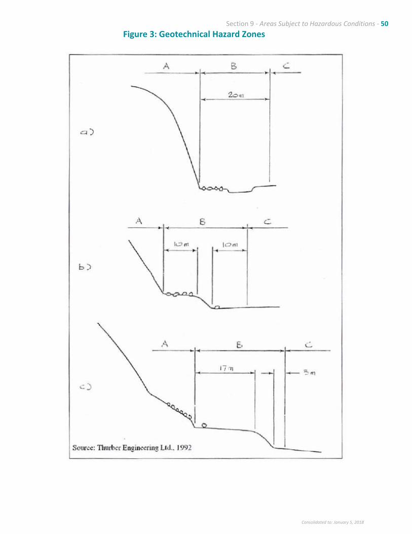
Section 9 - Areas Subject to Hazardous Conditions - 50
Consolidated to: January 5, 2018
Figure 3: Geotechnical Hazard Zones
Section 9 - Areas Subject to Hazardous Conditions - 51
Consolidated to: January 5, 2018
iv. Proposed mitigative works (if any, including construction and maintenance programs
for such works) and/or actions designed to prevent hazardous occurrences.
Certificates of approval are required on all constructed works for which the engineer
is responsible.
v. An assessment of the effect of the mitigative work in terms of its ability to reduce the
potential impact of the hazard.
vi. A certification that the land may be used safely for the use intended.
vii. Any other recommendations which the engineer believes appropriate.
viii. The signature and seal of a B.C. registered P.Eng . or P.Geo. with experience in the
specialized field appropriate to the study.
e. Notwithstanding the uses permitted in the Zoning Bylaw, where a Geotechnical Report referred
to in these Guidelines identifies a hazard which may be a threat to life, no uses shall be permitted
which involve overnight accommodation or the assembly of people on, or the attraction of people
to the site
f. On the basis of the site‐specific Geotechnical Report referred to in these Guidelines, conditions
may be imposed restricting the uses and densities permitted in the Zoning Bylaw, the sequence
and timing of construction, areas to remain free of development, vegetation or trees to be planted
or retained, natural drainage to be maintained or enhanced or other matters as specified in
sections 920 (7) of the Local Government Act.
g. Where the Zoning Bylaw permits residential use and where the site‐specific inspection or the
Geotechnical Report identifies safe building sites, all new lots created shall include suitable
building sites in areas not subject to hazard. lustering of lots away from the hazard area is
preferred and the regulations respecting the minimum size of parcels of land that may be created
by subdivision may be varied to facilitate the optimum uses of the land.
h. Land uses may be restricted in areas of geological hazard and landowners may be required to
ensure that the land can be safely used for the use intended and that appropriate mitigative and
protective conditions will be implemented. The areas of geologic hazard are the areas outside of
the “safeline” and towards the toe of the slope, identified in the Thurber Engineering 1988 report
(Dwg. 14‐75‐0‐1), portions of which are illustrated on Figure 4, which estimates the 1/500 year
probability of combined slope hazards.
i. No alterations to the natural drainage, and no construction or excavation shall be permitted which
might cause or contribute to hazardous conditions on the site or on adjacent lands.
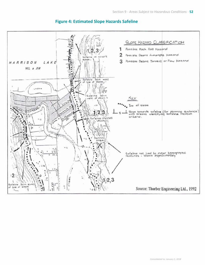
Section 9 - Areas Subject to Hazardous Conditions - 52
Consolidated to: January 5, 2018
Figure 4: Estimated Slope Hazards Safeline
Section 9 - Areas Subject to Hazardous Conditions - 53
Consolidated to: January 5, 2018
9.5 Tree Protection Areas
It is the policy of Council: 9.5.1 A tree protection area is established covering the areas identified as Geotechnical DPA 4 on
Schedule 1‐C for the purposes of preventing tree cutting, except where required for authorized
wildfire control, right‐of‐way maintenance or safety issues.
9.5.2 Tree protection will be regulated by tree cutting permits and by development permits.

Section 10 - Infrastructure - 54
Consolidated to: January 5, 2018
10. INFRASTRUCTURE
10.1 Background
The physical infrastructure of Harrison Hot Springs ‐ roads, sidewalks, street lighting, sanitary sewer,
storm sewer/drainage controls, water systems and solid waste, will require ongoing improvements to
accommodate a growing community. A Capital Works Plan will be prepared to guide investment in
development services.
The existing waste treatment plant has sufficient capacity to about 2017, based on estimates of
population and tourism use.8 It is generally assumed that seasonal residences, tourist and commercial
accommodation and holiday park occupancy in the summer months result in a population equal to the
permanent population. The current load on the sewer system and plant is therefore about 3200
permanent and seasonal population, while the design capacity of the plant is for a maximum population
of 4750.
The infrastructure needs over the next five years can be generally described as follows:
▪ Water Supply – proposed expansion of the reservoir capacity and extension of the intake pipe, and
extension of fire protection water supply to the southern areas of the Village.
▪ Wastewater Management – significant upgrading of the treatment plant to meet community demand
and environmental standards, improvement of collection system, and long‐term planning of a new
plant or connection to a regional wastewater treatment facility.
▪ Stormwater Management – development of a Drainage Plan, in conjunction with Miami River
restoration and East Sector planning process that will improve flood protection, reduce and manage
runoff, and encourage groundwater infiltration.
▪ Solid Waste Management – promotion of the ʺreduce, reuse and recycleʺ approach to waste
management.
▪ Road System – replacement of the culvert with a new bridge across Miami River on Hot Springs Road,
expanded parking on Lillooet Avenue and development of a trail and bike path network.
▪ Hot Springs Road Improvements – preparation of a plan in conjunction with Ministry of
Transportation, for improving the pedestrian/bicycle safety and aesthetic character of the entrance
corridor into the community.
8 Dayton and Knight, 2000; assumes a 3.6% annual growth rate; tourism growth rates however, may be uncertain.
Section 10 - Infrastructure - 55
Consolidated to: January 5, 2018
10.2 Objectives
Councilʹs objectives are to:
10.2.1. Provide development services such as water, sewer, roads and drainage as required to
accommodate new development and to remedy existing deficiencies, particularly related to fire
protection water supply, while recognizing the limited tax base to pay for additional services.
10.2.2. Meet or exceed all Provincial and Federal drinking water and ambient water quality standards.
10.2.3. Ensure that new development pays for the cost of extending or expanding infrastructure
required to accommodate growth through development cost charges.
10.3 Policies
It is the policy of Council to:
10.3.1 Transportation
• Designate the Major Roads shown on the Future Land Use Designation Map ‐ Schedule B. Roads
are primarily intended to provide for the safe and efficient movement of traffic with minimal
direct access to fronting properties.
• Minimize through traffic on roads in residential neighbourhoods.
• Develop a parking plan for Esplanade Avenue and Lillooet Avenue in conjunction with the
proposed Village Centre Design Plan.
• In collaboration with Ministry of Transportation, apply for conversion of Hot Springs Road
between Lillooet Avenue and Esplanade Avenue from Provincial Highway to local road.
• Improve sidewalks and bicycle paths in the Village, including measures to enhance pedestrian
safety along Hot Springs Road and preparation of a Hot Springs Road Improvement Plan in
consultation with the Ministry of Transportation that will balance the Provincial highways
standards and the local objectives.
• Work with representatives from the Ministry of Air, Water and Land Protection to improve
signage to the Provincial Park, and to minimize traffic impacts on the Village of visitors to the
Provincial Park.
• Encourage the initiation of direct bus service from the long‐distance bus terminal in Chilliwack
to Harrison Hot Springs.
• Update Development Cost Charges to help finance the capital costs of providing roads to service
new development.
10.3.2 Signage Policy

Section 10 - Infrastructure - 56
Consolidated to: January 5, 2018
Council will work toward developing a standard sign system with a distinct resort character
to be used throughout the community, with emphasis on key locations such as the entry to the
Village, the entry to Village Centre (at Miami River crossing), within the Lakeshore Special Planning
Area, as well as the beach area. Portable and temporary signs will be discouraged.
10.3.3 Sanitary Sewer
• Upgrade and expand the Villageʹs sewage system in accordance with engineering studies and
planned residential and tourist commercial land uses in the Village, taking into account visitor
forecasts under a proposed Tourism Development Strategy.
• Review engineering and financing options and prepare plans for expanding the sewage
treatment plant to serve long term population growth and tourism expansion in the community
and to protect ambient water quality.
• Require that all new development connect to the community system at the developersʹ expense,
and that the offsite incremental costs of wastewater system upgrading are funded by
Development Cost Charges.
• Coordinate long‐term wastewater management for Harrison Hot Springs with development
services to the east shore of Harrison Lake in the District of Kent.
10.3.4 Water Systems
• Upgrade and expand the Villageʹs water system in accordance with engineering studies and
planned residential and tourist commercial land uses in the Village, taking into account visitor
forecasts under a proposed Tourism Development Strategy.
• Ensure that the storage and supply components of the water system are developed to keep pace
with community growth.
• Require that all new major development connect to the community system at the developersʹ
expense and that the offsite incremental costs of system upgrading are funded by Development
Cost Charges.
• Ensure that existing and potential well sites are identified and protected.
• Monitor proposals to withdraw water from Harrison Lake for GVRD residents and ensure
consultation with Village residents.
10.3.5 Drainage
• Prepare an overall Drainage Plan for the Vi1lage which addresses:
▪ the current variation in drainage standards and the existing deficiencies in the system;
▪ on‐site detention and groundwater infiltration potential to reduce peak flows; and
▪ the potential for a complete urban standard drainage system, with runoff detention,
integrated stormwater management, concrete curb and gutter and storm drainage systems.
▪ the relationship between the flood protection infrastructure, Harrison Lake , the Miami
River, and the Village of Harrison Hot Springs/District of Kent drainage infrastructure.
Section 10 - Infrastructure - 57
Consolidated to: January 5, 2018
• Investigate funding available from the Provincial and Federal governments to assist the Village
in financing the drainage study and the upgrading measures required to manage drainage.
• Ensure that the Drainage Plan recognizes environmental considerations, particularly the impact
of runoff to the Miami River and to Harrison Lake, and promote integrated stormwater
management in new subdivisions and developments.
• Establish Development Cost Charges to help finance the capital costs of drainage works to
service new development.
10.3.6 Solid Waste
• Continue the existing system of public collection of residential solid waste and private collection
of commercial solid waste.
• Work with the Fraser Valley Regional District on the implementation of the Regional Solid Waste
Plan.
• Examine the rates levied for collection of residential solid waste with a view to the imposition of
limits of refuse at a flat rate and the imposition of a surcharge for waste amounts in excess of
the minimum.
• Continue to work with all levels of government and local interest groups in the promotion of
waste reduction and recycling programs.
• Investigate the feasibility of establishing a municipal composting program, perhaps in
conjunction with the District of Kent.
10.3.7 Energy and Climate Change
• Promote energy conservation, transportation efficiency and public transit in public
infrastructure investments and development planning.
• Encourage the Provincial government to expand local government infrastructure planning
grants in support of local actions to address climate change (Action 13, Weather, Climate and
the Future: BCʹs Plan, Dec 2004).
• Encourage energy conservation and efficiency and other green building measures in proposals
for new tourist accommodation facilities and major public facilities, including future
redevelopment of the Memorial Hall.

Section 11 - Public Facilities - 58
Consolidated to: January 5, 2018
11. PUBLIC FACILITIES
11.1 Background
The Village has the following public facilities: ▪ Harrison Hot Springs Elementary School
▪ Village Works Yard
▪ Village Public Works ‐ sewage treatment, wells, etc.
▪ Fire Hall
▪ Chamber of Commerce/Tourism B. C. /Business Information Centre
▪ Memorial (Community) Hall
▪ Art Gallery/Cultural Centre
▪ Beach/Parks/Trails
▪ Boat Launch
▪ Float Plane Dock
▪ Post Once
▪ Church
These facilities may require upgrading or expansion to accommodate the additional population and visitors
projected in this Officia1 Community Plan. The elementary school serves students from kindergarten
through grade 6. Students from grades 7 through 12 attend a high school in Agassiz. Policing (R.C.M.P.)
and Ambulance services are also provided out of Agassiz.
Harrison contracts its building permitting and inspection function to the Fraser Valley Regional District.
The Village participates in economic development planning through the Regional District with assistance
from the Chamber of Commerce. The land use planning and engineering functions are carried out
predominantly by consultants, with some contracted assistance from the Regional District.
11.2 Objectives
Councilʹs objectives are to:
11.2.1 Ensure that public uses are located where they will best serve the needs of both area residents
and visitors. In this regard, a ʹcommunity services precinctʹ will be developed in the area of the
Village offices.
11.2.2 Work with other government and private agencies to ensure community services are available
at a level appropriate to the needs of local residents and their ability to pay.
Section 11 - Public Facilities - 59
Consolidated to: January 5, 2018
11.3 Policies
It is the policy of Council to:
11.3.1 Undertake further community consultation, through the Advisory Planning Commission, in
preparation for a feasibility study on the construction of a new community hall on the existing
site or at alternative locations.
11.3.2 Initiate a process to relocate the Village works yard to a larger site on Crown land east of
McCombs Drive;
11.3.3 Encourage the School District to consult with Council regarding the need to maintain and, as
required, to expand school facilities, at the elementary, junior and secondary school levels within
the community;
11.3.4 Recognize existing public, institutional and utility uses, and direct such uses to locations where
they can best serve the community; and
11.3.5 In consultation with neighbouring property owners, enhance the boat launching facilities and
boat holding capacity near Rendall Park; and address the parking congestion problem in the area.

Section 12 – Recreation and Cultural Services - 60
Consolidated to: January 5, 2018
12. RECREATION AND CULTURAL SERVICES
12.1 Background
The community workshops indicated that parks, recreation and festivals are an important part of the
community and the local economy. Many of the tourism businesses depend on recreational
opportunities. Harrison has also been successful in establishing itself as a centre for the arts and cultural
activities.
Several themes emerged from the public consultation:
▪ The need to expand the outdoor recreation opportunities, particularly a trail and bike system
throughout the Village;
▪ The need to support boating and fishing recreation and to manage the related parking pressures
around the boat launch site;
▪ The need to provide increased recreation programming and facilities for youth;
▪ The need to consider the future of the public hot springs pool in context with Village Centre
development, along with enhancing the hot springs profile of the Village;
▪ The need to implement the Harrison‐Agassiz bicycle route; and
▪ The need to continue to support the arts and cultural festivals.
12.2 Objectives
Councilʹs objectives are to:
12.2.1 Expand the range of recreational facilities and opportunities for residents, particularly
youth and for visitors.
12.2.2 Encourage the promotion of Harrison as a centre for cultural events including fine and
performing arts, and as a destination with opportunities for day trips to surrounding
attractions and cultural and natural history.
12.2.3 Encourage a wider variety of public uses for the hot springs water that will promote a
year round tourist attraction.
Section 12 – Recreation and Cultural Services - 61
Consolidated to: January 5, 2018
12.3 Policies
It is the policy of Council to:
Recreation
12.3.1 Encourage the provision of additional recreational facilities in the community by the
private sector, including commercial facilities catering both to tourists and residents, as
well as recreation facilities in conjunction with new residential developments.
12.3.2 Work with the District of Kent in sharing recreational facilities and programs, and in
development of the proposed bike path.
12.3.3 Work toward the goal of making the water from the hot springs more widely available,
both as a year round tourist attraction and for the use and enjoyment of residents,
including assessing the potential for a Village‐ owned public pool.
Cultural
12.3.4 Work with the arts community to encourage cultural opportunities and to promote
Harrison as a base for cultural events such as fine arts and performing arts festivals; and
12.3.5 Work with the cultural community toward strengthening heritage conservation and
public awareness of the history of the community.
12.3.6 Include cultural activities as an integral component of recreation programs
Section 13 – Parks and Open Space - 62
Consolidated to: January 5, 2018
13. PARKS AND OPEN SPACE
13.1 Background
The parks and open space issues include:
▪ Concern about the park lands in the East Sector;
▪ Development of a system of inter‐connected trails and bike paths;
▪ Protection of views of the lake and Mt. Cheam;
▪ Extension of the lakeshore promenade; and
▪ Development of a Miami River ‘greenway’ that reflects the ecological sensitivity of the riparian
corridor and the need for careful planning of trails.
The participants at the public workshops noted that Harrison’s natural setting was a very important
attribute of the community. They were strongly in favour of preserving existing trees and greenspace
throughout the Village, and ensuring enough park land would be set aside to meet the requirements of
the additional population and the expansion of tourism.
The Village currently owns about 50 ha of park land and holds a park reserve covering 32 ha on Crown land.
These include:
East Sector Park 32.00 ha Fire Hall 1.10 ha Lakefront Beach Area 12.00 ha Miami River Greenway Trail 2.70 km Park at Driftwood & Cottonwood 1.00 ha Peace Park 0.06 ha Rendall Park 1.10 ha Reservoir Park off Hot Springs Road 0.60 ha S‐W landlocked park land 1.00 ha Spring Park 1.00 ha
The majority of the accessible and developed parks are within the northern portion of the Village.
There are no neighbourhood parks in the Village’s southern portion.
Neighbourhood Parks are used by residents of a neighbourhood, usually within a 500 ‐800 metre radius,
and primarily for active play. Neighbourhood Parks may contain a Tot lot which is a small area,
approximately the size of a residential lot, containing play equipment and other facilities for children. In
addition, the OCP has sought to establish a linear park or ‘greenway’ along the Miami River. A preliminary
concept for potential park and trail system components to be addressed in the Parks and Trails Master Plan
is shown on Figure 5.
Section 13 – Parks and Open Space - 63
Consolidated to: January 5, 2018
13.2 Objectives
Councilʹs objectives are to:
13.2.1 Develop a system of parks, open space and trails that will meet the need residents as well
as visitors, to be guided by a Parks and Trails Master Plan.
13.2.2 Protect views of Harrison Lake to the extent possible through the View Preservation
Strategy (Section 3.3).
13.2.3 Establish a significant nature park in the East Sector that will serve as a legacy for future
generations.
13.2.4 Ensure subdivision parkland dedication as per the Local Government Act, and other park
acquisition in a manner consistent with a Parks and Trails Master Plan.
13.3 Policies
It is the policy of Council:
13.3.1 Public lands used as parks and open space, both developed and undeveloped are
designated as Park on the Future Land Use Designation Map ‐ Schedule 1‐B. Further
designation of park land in the East Sector may occur following the area planning process
outlined in Section 7 of this Plan, and Council will actively consider acquiring additional
Crown land for park purposes.
13.3.2 Council intends to prepare a Parks and Trails Master Plan to provide long‐ term direction
for developing the overall parks and trail system for the use and enjoyment of residents
and tourists. The Parks and Trails Master Plan will address and provide direction on many
issues, including:
• Determining the most appropriate locations for future park land acquisitions.
• Further development and directions on the Miami River Greenway Trail, including:
o Assisting river restoration ‐ consideration of environmental values, aesthetics
and so forth, as recommended in the Klohn Leonoff report;
o Further acquisition and development of a linear strip along the
o entire length of Miami River for development of a greenway linear park;
o Recognizing the sensitivity of a public trail adjacent to residences and the need
for careful planning and mitigation wherever possible;
o Ensuring that the proposed trail system is compatible with conservation of
riparian ecosystems and sensitive to the privacy concerns of adjacent private
properties; and
o Inclusion of the Miami Slough area along Hot Springs Road and other sections
of the river within the overall Miami River ‘greenway’ system.
• Preservation and enhancement of the network of trails throughout the community
for the benefit of walkers and cyclists, including the implementation of a Hot
Springs Road Improvement Plan (Section 10).
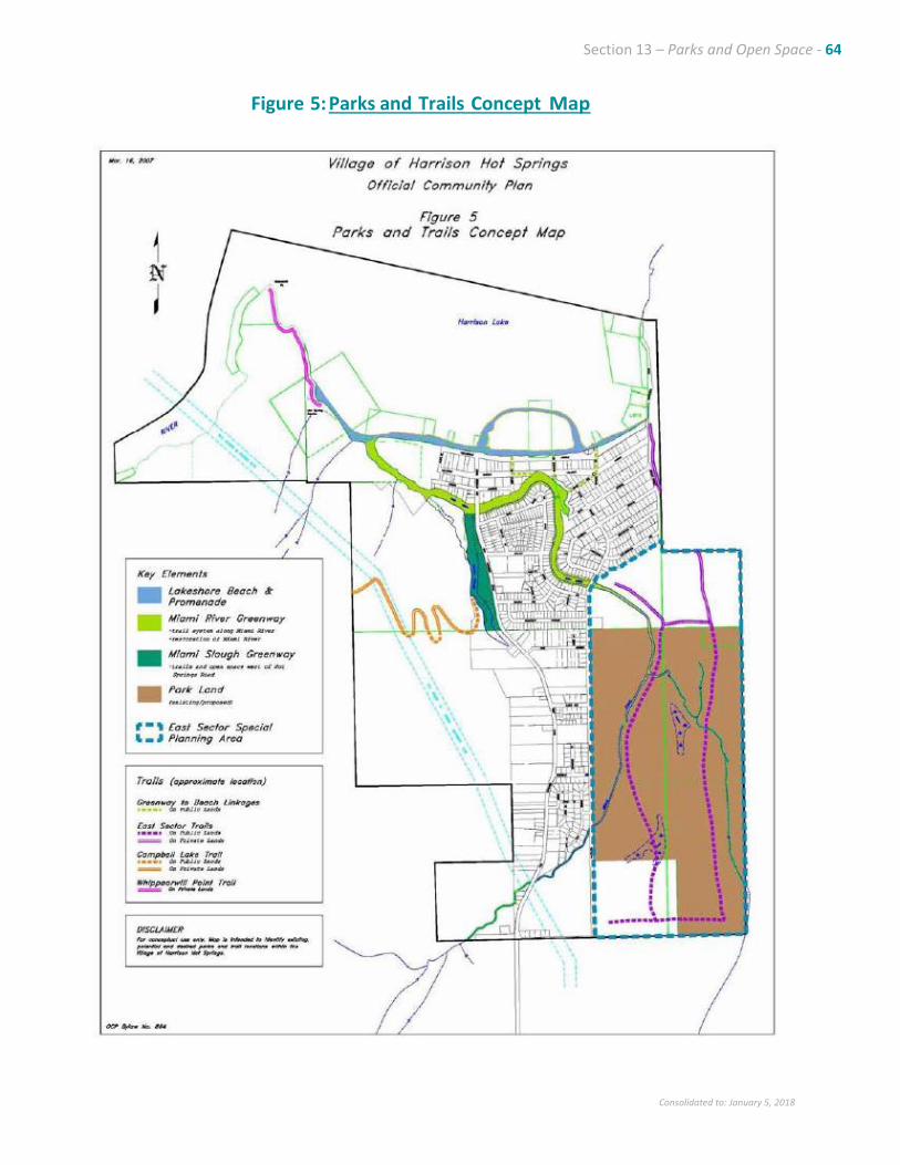
Section 13 – Parks and Open Space - 64
Consolidated to: January 5, 2018
Figure 5: Parks and Trails Concept Map
Section 13 – Parks and Open Space - 65
Consolidated to: January 5, 2018
13.3.3 Council may request cash in lieu of land dedication during subdivision. New development
will contribute toward the acquisition of parkland in relation to the following priorities:
• Expansion and development of the Miami River greenway linear park;
• Development of a neighbourhood park in south Harrison;
• Development of a linear pedestrian/bicycle path along Hot Springs Road;
• Acquisition of park land in the vicinity of Miami River slough; and
• Other priorities specified in a proposed Parks and Trails Master Plan.
13.3.4 Council intends to work co‐operatively with the District of Kent and the Fraser Valley
Regional District on a number of initiatives of mutual benefit, such as:
• development of a bicycle path between Agassiz and Kent; and
• location, acquisition and development of a regional park in the area.
Section 14 - Environmentally Sensitive Areas - 66
Consolidated to: January 5, 2018
14. ENVIRONMENTALLY SENSITIVE AREAS
14.1 Background
Protection of the natural environment is one of the major priorities expressed by residents at the
community workshops. Environmentally sensitive areas are special natural areas in Harrison Hot Springs
that have particular ecological values or functions and that are generally sensitive to the impacts of
development. This includes the Miami River and Miami Slough and their watersheds, the various natural
habitats in the East Sector, and other natural resource values associated with the steep slopes and with
Harrison River.
The primary environmental concerns include:
• protecting air quality and maintaining controls on campfires;
• protecting water quality in the lakeshore area of Harrison Lake;
• inventorying and protecting the ecological values in the East Sector;
• protecting and rehabilitating the Miami River; and
• managing wildlife in the lakeshore park area.
14.2 Objectives
Councilʹs objectives are to:
14.2.1 Protect the natural beauty and environmental integrity of the community paying particular
attention to the forested areas, Miami River, Miami Slough, Harrison Lake, Harrison River
and the hot springs.
14.2.2 Identify the environmentally sensitive areas of the community through a comprehensive
inventory of important natural areas and features, including natural areas that affect the
drainage and ecological functions of the Miami River.
14.2.3 Ensure environmentally sensitive areas identified in the inventory are protected through
development controls (Development Permit Area and Parks and Trails Master Plan).
14.2.4 Encourage the protection and rehabilitation of Miami River through community initiatives
and drainage management.
14.2.5 Introduce measures to reduce the use of pesticides in the community.

Section 14 - Environmentally Sensitive Areas - 67
Consolidated to: January 5, 2018
14.3 Policies
It is the policy of Council:
14.3.1 To develop an inventory of environmentally sensitive areas in the community and to
identify conservation requirements for important natural areas and features.
14.3.2 To actively support the community efforts to protect and rehabilitate the Miami River,
and to implement the provincial and federal governments’ requirements for streamside
protection.
14.3.3 To designate environmentally sensitive areas as Development Permit Areas that recognize
the special natural features that require appropriate protection and enhancement
measures.
14.4 Miami River Development Permit Area 5
It is the policy of Council:
Miami River Development Permit Area will be designated under Section 919.1 of the Local Government
Act for the purposes of protecting and restoring the hydrological and ecological attributes of the river.
The designation will serve to implement the provincial Fish Protection Act and its accompanying
regulations and to comply with the federal Fisheries Act.
14.4.1 Category
The Miami River Development Permit Area is designated under Section 919.1 of the Local
Government Act for protection of the natural environment.
14.4.2 Area
The Miami River Development Permit Area is shown as Development Permit Area 5 on
Schedule 1‐C (including Miami Slough), and involves a ʹstreamside protection and
enhancement areaʹ with the following boundaries:
a. 30 metres wide measured perpendicularly away from the top of the bank for those
portions of Miami River west of McCombs Drive; and
b. 50 metres wide measured perpendicularly away from the top of the bank for those
portions of Miami River east of McCombs Drive
Section 14 - Environmentally Sensitive Areas - 68
Consolidated to: January 5, 2018
14.4.3 Justification
The Miami River is an important wildlife and fish bearing stream with various tributaries
and sloughs that provide a key role in drainage management and environmental quality in
Harrison Hot Springs. A Development Permit Area (DPA) is established in order to protect,
maintain and restore the ecological values of the Miami River, in accordance with federal
and provincial legislation. This DPA is intended to complement other community efforts
to rehabilitate the Miami River.
All permits issued and public works undertaken by the Village will be subject to the DPA
Guideline specified in Section 14.4.4 below, including:
a. removal, alteration, disruption or destruction of vegetation;
b. disturbance of soils;
c. construction or erection of buildings and structures;
d. creation of nonstructural impervious or semi‐impervious surfaces;
e. flood protection works;
f. construction of roads, trails, docks, wharves and bridges;
g. provision and maintenance of sewer and water services;
h. development of drainage systems;
i. development of utility corridors;
j. subdivision as defined in section 872 of the Local Government Act.
The requirements do not apply to a development permit or development variance permit
issued only for the purpose of enabling reconstruction or repair of a permanent structure
described in Section 911 (8) of the Local Government Act if the structure remains on its
existing foundation.
The requirements do not apply to small structures of less than 9 square meters dimension
that have no permanent foundation and are not used for habitation, and are not located
within 5 metres of the high water mark of the Miami River west of McCombs Drive.
The requirements do not apply to park trails and vegetation management that are
implemented in accordance with an approved Parks and Trails Master Plan that has been
prepared with the assistance of a Qualified Environmental Professional and that takes into
account the riparian protection requirements under the Riparian Areas Regulation of the
Fish Protection Act.
The Development Permit Area Guidelines distinguish between the existing urbanized area
west of McCombs Drive and the undeveloped areas east of McCombs Drive.
Section 14 - Environmentally Sensitive Areas - 69
Consolidated to: January 5, 2018
14.4.4 Guidelines
a. All new development west of McCombs Drive within 30 m of the top of the bank of
Miami River, and all new development east of McCombs Drive within 50 m of the top of
the bank of the Miami River, except as specifically exempted, will be required to obtain
a development permit and to comply with the assessment requirements and riparian
protection measures to be specified by a Qualified Environmental Professional in
accordance with the Riparian Areas Regulation of the Fish Protection Act.
b. The development permit application will specify the measures to be undertaken
to:
i. maintain, restore or enhance contiguous natural riparian vegetation
within the stream protection and enhancement area recommended by a
Qualified Environmental Professional as defined by the Riparian Areas
Regulation;
ii. control drainage through landscaping, land shaping and other measures such
that stormwater runoff from the development site does not increase nutrient
and sediment loading to the Miami River; and
iii. prevent soil erosion and sediment runoff to Miami River during construction
and after development.
c. Works within the wetted area of the Miami River and aquatic habitat will require written
approval of the relevant federal and provincial agencies.
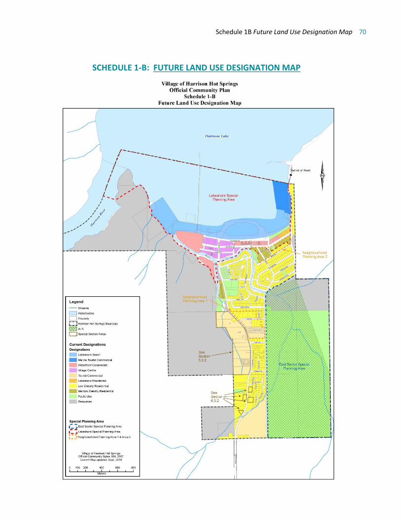
Schedule 1B Future Land Use Designation Map 70
SCHEDULE 1-B: FUTURE LAND USE DESIGNATION MAP
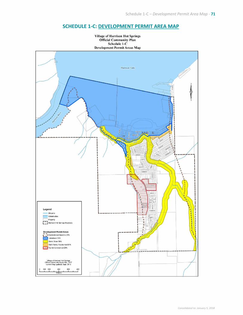
Schedule 1-C – Development Permit Area Map - 71
Consolidated to: January 5, 2018
SCHEDULE 1-C: DEVELOPMENT PERMIT AREA MAP
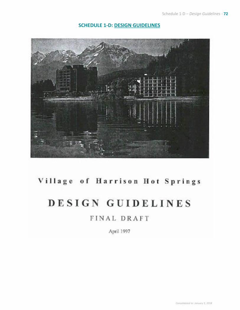
Schedule 1-D – Design Guidelines - 72
Consolidated to: January 5, 2018
SCHEDULE 1-D: DESIGN GUIDELINES
Schedule 1-D – Design Guidelines - 73
Consolidated to: January 5, 2018
Table of Contents
SECTION PAGE
Section 1 – Background & Intent
1.1 Background ............................................................................................................................................... 1
1.2 Intent ........................................................................................................................................................ 2
1.3 The Guideline Package ............................................................................................................................. 2
Section 2 - Vision & Objectives
2.1 A Vision for Harrison Hot Springs ............................................................................................................. 3
2.2 Objectives ................................................................................................................................................. 3
Section 3 – Framework for the Guidelines
3.1 Development Permit Area 1 – Lakeshore Special Planning Area
3.1.1 Design Principles ............................................................................................................................. 4
3.1.2 Design Guidelines
5
.................................................................................................................................................................. 5
3.2 Development Permit Area 2 – Multi-Family Residential
3.2.1 Design Principles ........................................................................................................................... 20
3.2.2 Design Guidelines .......................................................................................................................... 21
3.3 Development Permit Area 3 - Commercial
3.3.1 Design Principles ........................................................................................................................... 25
3.3.2 Design Guidelines .......................................................................................................................... 26
LIST OF ATTACHMENTS Attachment 1 View Preservation Strategy Attachment 2 Development Permit Review Checklist

Schedule 1-D – Design Guidelines - 74
Consolidated to: January 5, 2018

Schedule 1-D – Design Guidelines – Section 1 - 74
Consolidated to: January 5, 2018
Section 1 - Background and Intent
1.1 Background
Policy Framework and Issues
Official Community Plan
The Village’s Official Community Plan Bylaw No. 622 (OCP) provides general policy direction for land use
and development in the Village. The OCP seta out the land use designations and the areas where
Development Permits are required for new development. Development Permit Areas in the OCP include
the Lakeshore Special Planning Area, Commercial and Hazardous Areas. General guidelines for the form
and character of new development are provided in the OCP for the Development Permit review process.
The OCP identified the need to provide more detailed design guidelines to maintain the quality of new
development in accordance with the vision defined in the plan. The detailed design guidelines contained
in this document are incorporated into the OCP and form part of the implementation of the Village OCP
policy directions.
Zoning Bylaw
The Village’s Zoning Bylaw No. 672, 1996 includes regulations for land use and sets out zoning categories
for parcels. The Zoning Bylaw, like the design guidelines, is used to implement the broad directions of
the OCP. The Zoning Bylaw regulations may be further refined through application of the design
guidelines to the Development Review process.
Overview of the Guideline Preparation Process
Preparation of Draft Guidelines
Draft guidelines reflected the project terms of references, input from the Village Council, study`s of
Harrison`s existing character, and reference to the Official Community Plan.
Public Open House
Panels were prepared to summarize guideline principles for discussion at the public open house held on
March 5, 1997. Approximately 40 people attended and provide input.
Guideline Refinement
Guidelines were refined based on the open house and further direction from Council.
OCP Amendment
The guideline package is made available for public review prior to its formal adoption.
Schedule 1-D – Design Guidelines – Section 1 - 75
Consolidated to: January 5, 2018
1.2 Intent
The primary intent of these design guidelines is to ensure that development in Harrison Hot Springs
contributes positively to the character of the Village. There is need to define a set of standards that can
be referred to by all parties involved in development, including:
• Village staff
• Business owners or residents interested in renovating existing buildings
• Prospective developers
• Design professionals
• The general public as stakeholders in their community`s development
It is hoped that the availability of a common basis for planning and design decisions will take the
guesswork out of both proposal preparation and review.
Most importantly, it is intended that these guidelines will contribute to a coherence and integrity in
the form, character and detailing of the Village's public face.
1.3 The Guideline Package
The guidelines provide detailed design direction in the following areas:
ARCHITECTURE
• Building Height, Form & Massing
• Rooflines and Roofs
• Orientation & Relationship to Streetscape
• Entrances
• Materials
• Detailing
SITE PLANNING
• Building Setbacks
• Streetscape I Landscape
• Parking
SIGNAGE
• Size & Mounting Options-
• Materials
• Graphics & Style
To assist with evaluation of development proposals, a review checklist is provided as Attachment 1.
Guidelines need to be consulted for detailed evaluation of proposals, but the checklist provides a clear,
useful summary of guidelines and review comments to forward to applicants.
Schedule 1-D – Design Guidelines – Section 2 - 76
Consolidated to: January 5, 2018
Section 2 - Vision & Objectives
2.1 A Vision for Harrison Hot Springs
Harrison Hot Springs seeks to retain a “small Village” character within its specular natural setting, while
welcoming and managing high quality development. Development must reinforce the community’s
balanced identity as both a lakefront resort to visitors and a place that residents can call home.
2.2 Objectives
• To provide clear descriptions and illustrated examples that will direct the form, character and quality
of future development in Harrison Hot Springs;
• To protect and enhance visual connections between the Village and Harrison Lake.
• To define development requirement, in terms of both process and physical form, to maintain and
strength functional linkage between the Village and its lakefront.
• To describe means of establishing or improving the relationship between buildings and streetscapes;
• To determine a set of preferred architectural and site design treatments for new retrofit development,
reflecting in particular the sensitive, high quality character of the Harrison Hot Springs Hotel as well
as aspects of other successful architecture in the Village;
• To enrich the pedestrian realm through supportive building edges and furnishings as well as
landscaping and other streetscapes detailing;
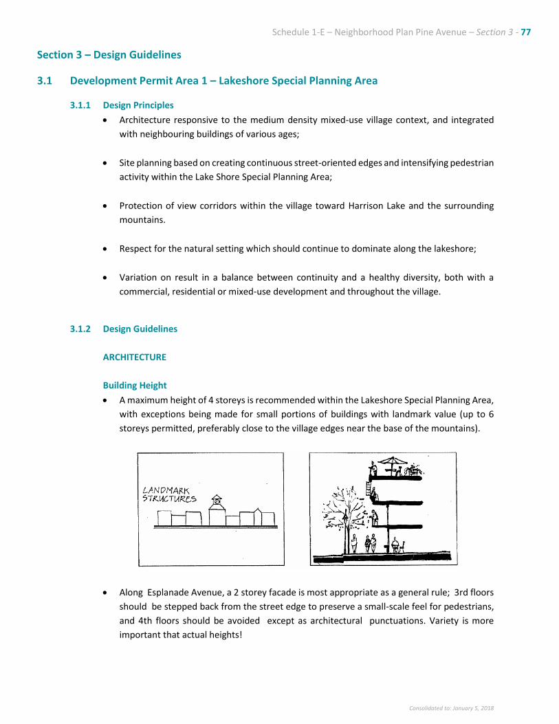
Schedule 1-E – Neighborhood Plan Pine Avenue – Section 3 - 77
Consolidated to: January 5, 2018
Section 3 – Design Guidelines
3.1 Development Permit Area 1 – Lakeshore Special Planning Area
3.1.1 Design Principles
• Architecture responsive to the medium density mixed-use village context, and integrated
with neighbouring buildings of various ages;
• Site planning based on creating continuous street-oriented edges and intensifying pedestrian
activity within the Lake Shore Special Planning Area;
• Protection of view corridors within the village toward Harrison Lake and the surrounding
mountains.
• Respect for the natural setting which should continue to dominate along the lakeshore;
• Variation on result in a balance between continuity and a healthy diversity, both with a
commercial, residential or mixed-use development and throughout the village.
3.1.2 Design Guidelines
ARCHITECTURE
Building Height
• A maximum height of 4 storeys is recommended within the Lakeshore Special Planning Area,
with exceptions being made for small portions of buildings with landmark value (up to 6
storeys permitted, preferably close to the village edges near the base of the mountains).
• Along Esplanade Avenue, a 2 storey facade is most appropriate as a general rule; 3rd floors
should be stepped back from the street edge to preserve a small-scale feel for pedestrians,
and 4th floors should be avoided except as architectural punctuations. Variety is more
important that actual heights!
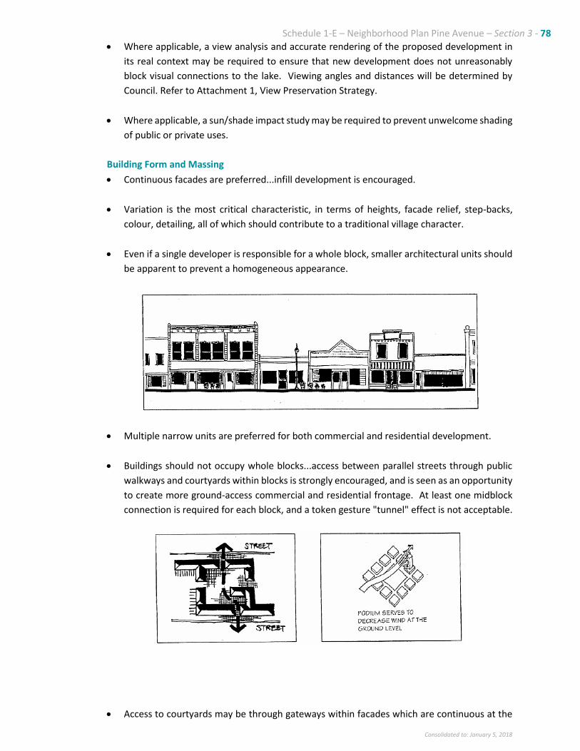
Schedule 1-E – Neighborhood Plan Pine Avenue – Section 3 - 78
Consolidated to: January 5, 2018
• Where applicable, a view analysis and accurate rendering of the proposed development in
its real context may be required to ensure that new development does not unreasonably
block visual connections to the lake. Viewing angles and distances will be determined by
Council. Refer to Attachment 1, View Preservation Strategy.
• Where applicable, a sun/shade impact study may be required to prevent unwelcome shading
of public or private uses.
Building Form and Massing
• Continuous facades are preferred...infill development is encouraged.
• Variation is the most critical characteristic, in terms of heights, facade relief, step-backs,
colour, detailing, all of which should contribute to a traditional village character.
• Even if a single developer is responsible for a whole block, smaller architectural units should
be apparent to prevent a homogeneous appearance.
• Multiple narrow units are preferred for both commercial and residential development.
• Buildings should not occupy whole blocks...access between parallel streets through public
walkways and courtyards within blocks is strongly encouraged, and is seen as an opportunity
to create more ground-access commercial and residential frontage. At least one midblock
connection is required for each block, and a token gesture "tunnel" effect is not acceptable.
• Access to courtyards may be through gateways within facades which are continuous at the
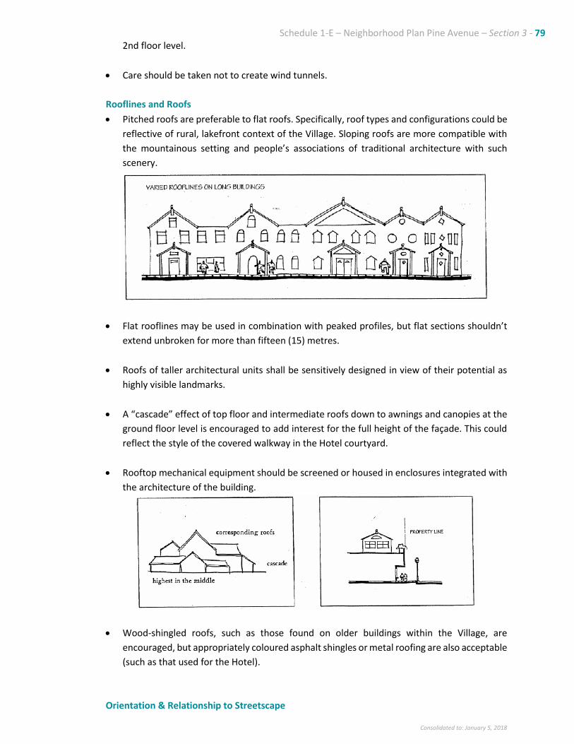
Schedule 1-E – Neighborhood Plan Pine Avenue – Section 3 - 79
Consolidated to: January 5, 2018
2nd floor level.
• Care should be taken not to create wind tunnels.
Rooflines and Roofs
• Pitched roofs are preferable to flat roofs. Specifically, roof types and configurations could be
reflective of rural, lakefront context of the Village. Sloping roofs are more compatible with
the mountainous setting and people’s associations of traditional architecture with such
scenery.
• Flat rooflines may be used in combination with peaked profiles, but flat sections shouldn’t
extend unbroken for more than fifteen (15) metres.
• Roofs of taller architectural units shall be sensitively designed in view of their potential as
highly visible landmarks.
• A “cascade” effect of top floor and intermediate roofs down to awnings and canopies at the
ground floor level is encouraged to add interest for the full height of the façade. This could
reflect the style of the covered walkway in the Hotel courtyard.
• Rooftop mechanical equipment should be screened or housed in enclosures integrated with
the architecture of the building.
• Wood-shingled roofs, such as those found on older buildings within the Village, are
encouraged, but appropriately coloured asphalt shingles or metal roofing are also acceptable
(such as that used for the Hotel).
Orientation & Relationship to Streetscape
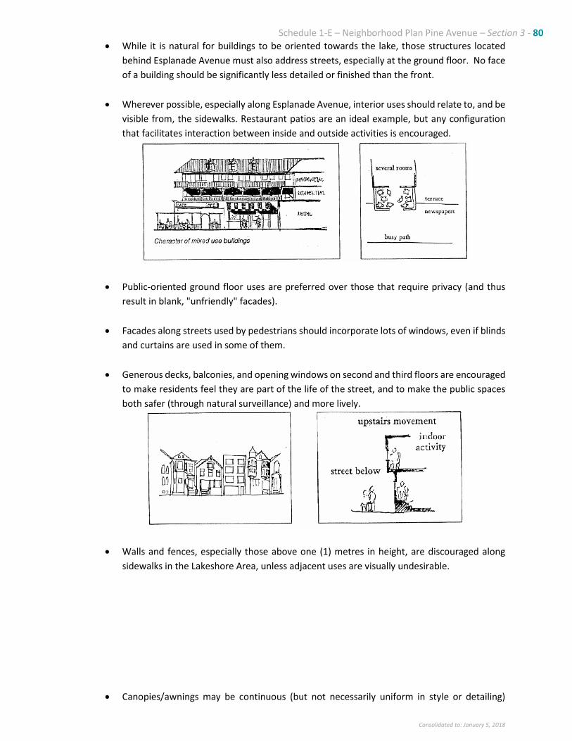
Schedule 1-E – Neighborhood Plan Pine Avenue – Section 3 - 80
Consolidated to: January 5, 2018
• While it is natural for buildings to be oriented towards the lake, those structures located
behind Esplanade Avenue must also address streets, especially at the ground floor. No face
of a building should be significantly less detailed or finished than the front.
• Wherever possible, especially along Esplanade Avenue, interior uses should relate to, and be
visible from, the sidewalks. Restaurant patios are an ideal example, but any configuration
that facilitates interaction between inside and outside activities is encouraged.
• Public-oriented ground floor uses are preferred over those that require privacy (and thus
result in blank, "unfriendly" facades).
• Facades along streets used by pedestrians should incorporate lots of windows, even if blinds
and curtains are used in some of them.
• Generous decks, balconies, and opening windows on second and third floors are encouraged
to make residents feel they are part of the life of the street, and to make the public spaces
both safer (through natural surveillance) and more lively.
• Walls and fences, especially those above one (1) metres in height, are discouraged along
sidewalks in the Lakeshore Area, unless adjacent uses are visually undesirable.
• Canopies/awnings may be continuous (but not necessarily uniform in style or detailing)
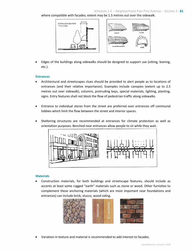
Schedule 1-E – Neighborhood Plan Pine Avenue – Section 3 - 81
Consolidated to: January 5, 2018
where compatible with facades; extent may be 1.5 metres out over the sidewalk.
• Edges of the buildings along sidewalks should be designed to support use (sitting, leaning,
etc.).
Entrances
• Architectural and streetscapes clues should be provided to alert people as to locations of
entrances (and their relative importance). Examples include canopies (extent up to 2.5
metres out over sidewalk), columns, protruding bays, special materials, lighting, planting,
signs. Entry features shall not block the flow of pedestrian traffic along sidewalks.
• Entrance to individual stores from the street are preferred over entrances off communal
lobbies which limit the flow between the street and interior spaces.
• Sheltering structures are recommended at entrances for climate protection as well as
orientation purposes. Benched near entrances allow people to sit while they wait.
Materials
• Construction materials, for both buildings and streetscape features, should include as
accents at least some rugged “earth” materials such as stone or wood. Other furnishes to
complement these anchoring materials (which are most important near foundations and
entrances) can include brick, stucco, wood siding.
• Variation in texture and material is recommended to add interest to facades.
Schedule 1-E – Neighborhood Plan Pine Avenue – Section 3 - 82
Consolidated to: January 5, 2018
Colour
• The following families of colours are recommended for use in architecture and site
furnishings. Again, variation on themes is preferred, so colours need not be matched exactly.
Detailing
• A balance should be achieved in detailing whereby it is neither overly nor simple to the point
of barren. Details should never appear arbitrary, but should reflect a function and an artistic
style consistent with the building’s architecture.
• Details should be consistent with traditional and tasteful village architecture, but can be
expressed with contemporary variations.
• Ideal opportunities to incorporate details include:
o Window frames, including soldier course caps, stone/brick sills, colour contrasts
o Small panes within large windows for at least some windows on a building (some picture
windows are acceptable, but could be bay-style with the side panels detailed)
o Shutters on windows (or beside them on facades)
o Window box planters
o Doors, including colour contrasts, feature material, window detailing
o Entrances, including canopies, columns, stairs and railings, mailboxes, integral benches,
planters
1 2 3

Schedule 1-E – Neighborhood Plan Pine Avenue – Section 3 - 83
Consolidated to: January 5, 2018
o Lighting (spotlights, bollard lights, overhead decorative lights)
o Paving patterns (flagstone, brick pavers, concrete detailing)
o Façade brickwork (e.g., diamond pattern from Hotel)
o Rooflines (soffits and fascias, exposed structural beams)
• In general, detailing should be integral with the structure and proportionally scaled.
• Exposure of structural architectural elements is encourage to give buildings a sense of
solidity and integrity, as well as to add interest and detail.
SITE PLANNING
Building Setbacks
• On Esplanade Avenue, both front lot and side lot setbacks are discouraged, unless the space
is used for an activity that contributes life to the street (such as a patio or plaza with seating).
The width of the street is such that wide sidewalks and street tree plantings can be provided
without requiring building setbacks from property lines. Wherever possible, building
frontage along the street should be continuous at ground level, with narrow facades and
frequent variation providing maximum interest for pedestrians. Surfacing in setbacks should
be predominantly hard (pavers, etc.).
• On Lillooet Avenue and Cedar Avenue, setbacks of 2.0 to 4.0 metres are encouraged to allow
room for street trees, benches and other site furnishings, and decorative lighting. This street
can have a different character than Esplanade Avenue, with more loosely spaced buildings
and more landscaping making for a slightly less urban feel. Surfacing in setbacks should be
mostly soft materials (grass and/or plantings).
• Corner setbacks are recommended to create areas of at least ten (10) square metres that
can be developed as plazas with seating and other pedestrian amenities.
Schedule 1-E – Neighborhood Plan Pine Avenue – Section 3 - 84
Consolidated to: January 5, 2018
• In general, new development should reflect existing setbacks.
Streetscape
• Streetscape development should reinforce architecture and bridge gaps in buildings through
continuity of treatment.
• High quality is critical in streetscape design and detailing. In general, a sturdy and rugged but
classy look is desirable in site furnishing… a style in keeping with stone and wood building
materials (possibly even incorporating these materials in streetscape items) and reflective of
the massive scale of the surrounding mountains.
• Developers may incorporate items chosen by the Village as “standard”, or furnishings that
are compatible with the style of the standard palette. Streetscape elements with potential
as “standard” items include the following:
Lighting
o overhead decorative lights - gooseneck fixtures from Hotel (Lumec Candela 5, colour
'Forest Green') throughout village centre streetscapes
o bollard lights - compatible with overhead decorative lights; black or green metal
accents on sturdy bollards

Schedule 1-E – Neighborhood Plan Pine Avenue – Section 3 - 85
Consolidated to: January 5, 2018
Benches
• wood (colour to match covered walkway in Hotel courtyard) with metal frame painted
green; rugged style rather than highly ornamental; for use throughout the village centre
• along Esplanade Avenue and the promenade, special benches could be constructed using
wood slats on stone bases; these could be funded through donations (Adopt-a bench,
memorials, sponsoring by service clubs, etc.) to result in a strong, consistent look for the
whole waterfront in the long term
• existing yellow benches could be painted green and have plaques mounted to recognize
donors
Garbage Cans
• companion model to benches; square shape with wood in metal frame
• in focal areas, round all-meat cans (green or black) could set a more refined tone
Paving
• while concrete is acceptable as a basic material throughout the Village Centre, it is
strongly recommended that details be incorporated with it, such as bands or sections of
concrete unit pavers, flagstone accents, texturing and/or coloured concrete
Schedule 1-E – Neighborhood Plan Pine Avenue – Section 3 - 86
Consolidated to: January 5, 2018
• along the lakeshore promenade, natural surfaces are encourage; in the long term, are-
specific treatments could be:
o section from the Hotel to Spruce Street: stone pavers replacing asphalts over time
o section from the hotel to Hot Springs source: compacted granular fines
o section from Spruce Street to Marina: a rugged wooden boardwalk at least 2 metres
wide
Tree Grates
• where tree planting is incorporated into sidewalks or plazas, wells should be large (1 x 2
metres) and surfaced one of two ways:
o with generously spaced flagstone pavers (ensure roughened non-slip surface)
o with steel tree grates, coated with dark green plastisol; supplied by Wabash Valley
(contact Rick Alsip@ 1-800-490-0501), who can assist with custom sizing and
designing a standard grate for Harrison
Planters
• natural materials are preferred
o along Esplanade Avenue, free-standing clay pots or stone-faced planter walls
o elsewhere in village centre, timber planters also acceptable
Landscape
• The intent of these recommendations is to create a situation where the village appears to be
fitting into the landscape as extended inward from the forested mountainsides. Once it is
established, proposed landscaping should not seem like an afterthought, but rather like a
part of the green fabric into which the village's buildings are integrated.
• Existing trees are to be preserved wherever possible (preservation plans may be required).
• Coniferous and broadleafed evergreens are encouraged as background or buffer plantings
where they do not create safety hazards by interfering with visibility of public spaces.

Schedule 1-E – Neighborhood Plan Pine Avenue – Section 3 - 87
Consolidated to: January 5, 2018
• Flowering deciduous trees are encouraged where falling fruit is not a maintenance problem.
• A combination of fast-growing and slow-growing plants is recommended for each
development to achieve both short-term and long-term effect.
• Pedestrian circulation routes should be generously dimensioned and desire lines should be
respected to minimize wear and tear on areas not meant to be walked on. Shrubs and
groundcovers (a mix of coniferous, broadleafed evergreen and deciduous shrubs) should be
used as appropriate to define circulation routes and balance hard-surfaced areas.
Parking
• Whenever possible, off-street parking should be at the side or rear of buildings (internal to
the block) rather than between the front of the buildings and the sidewalk. Vehicular access
should be from secondary roads or rear lanes if practical, while frequent pedestrian access
should be provided to sidewalks. It may be desirable to extend a short edge of parking lots
to a sidewalk frontage for safety through improved visibility.
• Where parking lots abut sidewalks, a 1.5 metre buffer strip is required, including tree
planting, shrubs (less than 1.0 m in height to leave "window" for casual surveillance) and low
wood or metal fencing in high-profile areas (Esplanade Avenue, especially near the Hotel).
• Access points to parking should be clearly identified with signage, lighting and breaks in
landscaping. Provision should be made for pedestrians to walk around to the front of
buildings on curbed sidewalks so they don't feel squeezed into the realm of the car.
• On-street angle or parallel parking is acceptable provided that sidewalks are wide enough
that pedestrians do not feel hemmed in by the parked cars (minimum sidewalk width 2
metres).
• Permanent parking lots shall be broken up by planting islands separated by 15 stalls or less.
Tree species that don't drop fruit, seeds or branches shall be used in this situation.
Schedule 1-E – Neighborhood Plan Pine Avenue – Section 3 - 88
Consolidated to: January 5, 2018
• In general, design of parking access should minimize pedestrian I vehicle conflicts.
SIGNAGE
Note: Signage design must reflect Village of Harrison Hot Springs Signage Bylaw No. 479 for
aspects not covered by these guidelines.
Size & Mounting Options
• The size of signs shall be in proportion with the building façade and scale of the streetscape.
o Pedestrian situations (Esplanade Avenue, Lillooet Avenue, Cedar Avenue)
▪ Façade mounted signs should be located above ground floor windows or beside
entrance at eye level (maximum height to top of sign to be 4 metres)
▪ Signs hung perpendicular to facades at 2.5 to 3.0 metres clearance are
encouraged (maximum size 40x150 cm); mounting arms can be metal (green or
black) or wood to match façade and sign style
▪ Awnings can serve as both signage and shelter, and are encourages
▪ High quality sandwich boards are permitted, provided they don’t block
sidewalks
Vehicular situation (Hot Springs Road)
• Signs may be larger (up to 6.0 metres in height), but should be integrated with
landscaping and/or buildings to avoid the dominating billboard effect.
• Free-standing signs are permitted provided that they relate to the context and
contribute to the overall streetscape.
• Sturdy bases are preferred with associated landscaping (area>area of sign face).
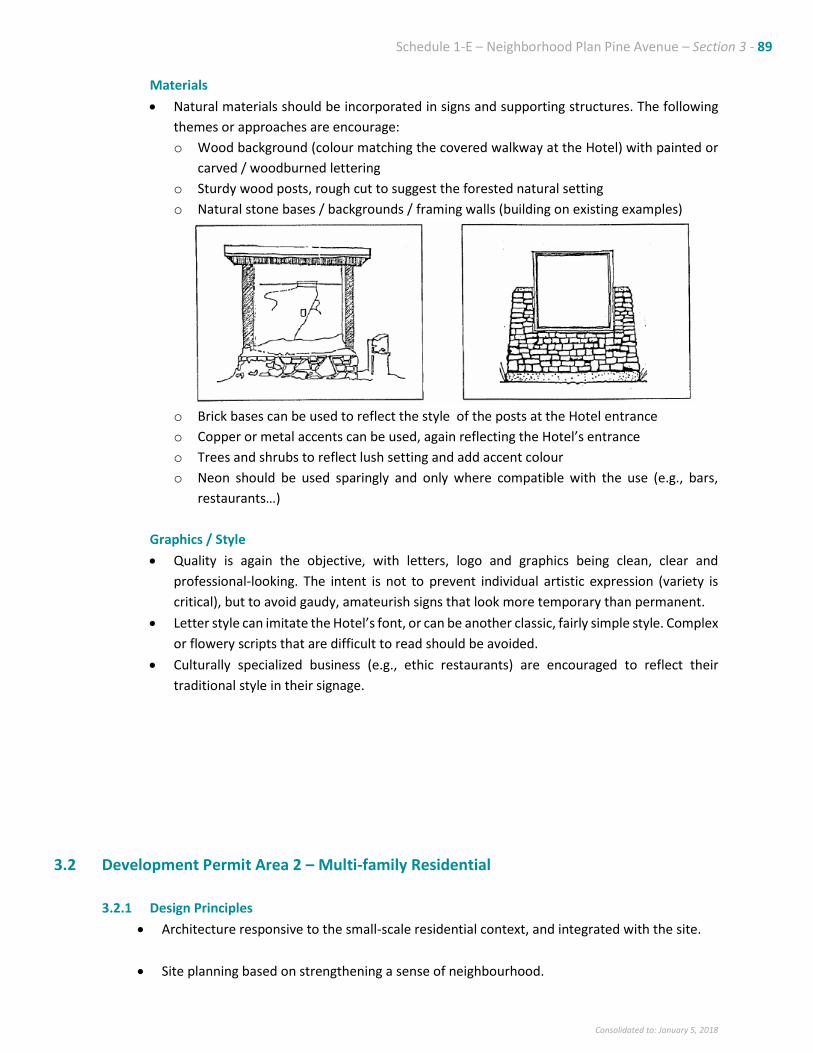
Schedule 1-E – Neighborhood Plan Pine Avenue – Section 3 - 89
Consolidated to: January 5, 2018
Materials
• Natural materials should be incorporated in signs and supporting structures. The following
themes or approaches are encourage:
o Wood background (colour matching the covered walkway at the Hotel) with painted or
carved / woodburned lettering
o Sturdy wood posts, rough cut to suggest the forested natural setting
o Natural stone bases / backgrounds / framing walls (building on existing examples)
o Brick bases can be used to reflect the style of the posts at the Hotel entrance
o Copper or metal accents can be used, again reflecting the Hotel’s entrance
o Trees and shrubs to reflect lush setting and add accent colour
o Neon should be used sparingly and only where compatible with the use (e.g., bars,
restaurants…)
Graphics / Style
• Quality is again the objective, with letters, logo and graphics being clean, clear and
professional-looking. The intent is not to prevent individual artistic expression (variety is
critical), but to avoid gaudy, amateurish signs that look more temporary than permanent.
• Letter style can imitate the Hotel’s font, or can be another classic, fairly simple style. Complex
or flowery scripts that are difficult to read should be avoided.
• Culturally specialized business (e.g., ethic restaurants) are encouraged to reflect their
traditional style in their signage.
3.2 Development Permit Area 2 – Multi-family Residential
3.2.1 Design Principles
• Architecture responsive to the small-scale residential context, and integrated with the site.
• Site planning based on strengthening a sense of neighbourhood.
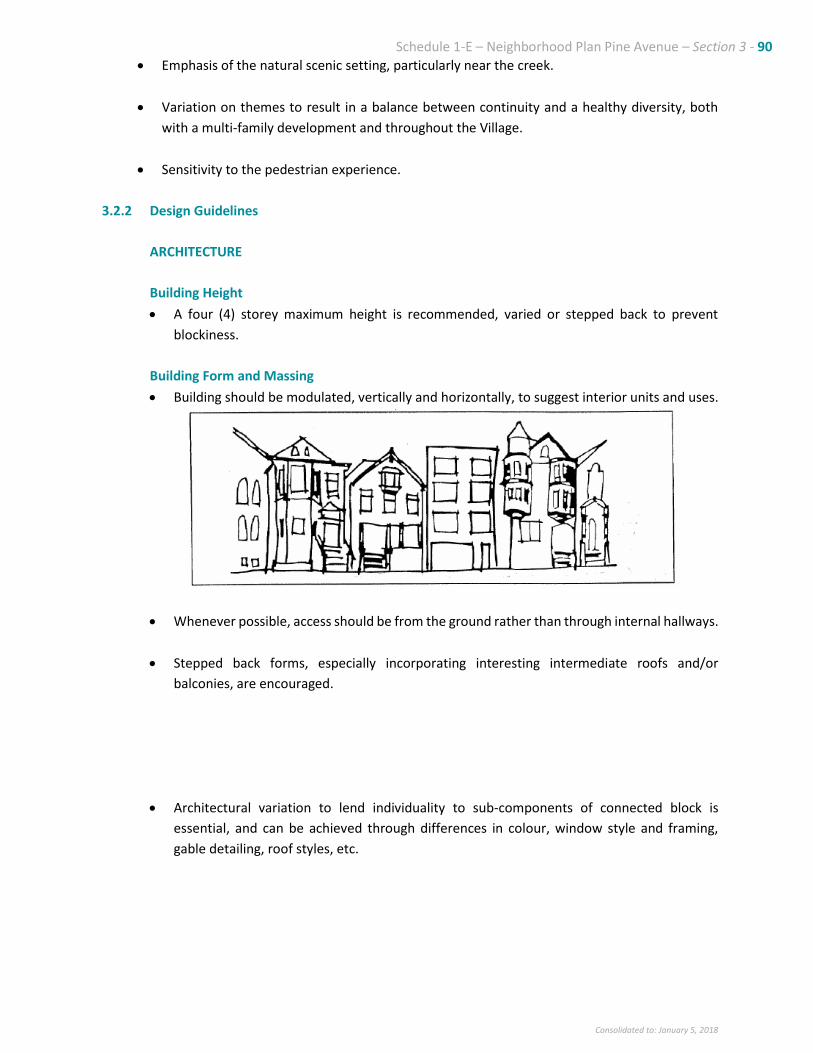
Schedule 1-E – Neighborhood Plan Pine Avenue – Section 3 - 90
Consolidated to: January 5, 2018
• Emphasis of the natural scenic setting, particularly near the creek.
• Variation on themes to result in a balance between continuity and a healthy diversity, both
with a multi-family development and throughout the Village.
• Sensitivity to the pedestrian experience.
3.2.2 Design Guidelines
ARCHITECTURE
Building Height
• A four (4) storey maximum height is recommended, varied or stepped back to prevent
blockiness.
Building Form and Massing
• Building should be modulated, vertically and horizontally, to suggest interior units and uses.
• Whenever possible, access should be from the ground rather than through internal hallways.
• Stepped back forms, especially incorporating interesting intermediate roofs and/or
balconies, are encouraged.
• Architectural variation to lend individuality to sub-components of connected block is
essential, and can be achieved through differences in colour, window style and framing,
gable detailing, roof styles, etc.
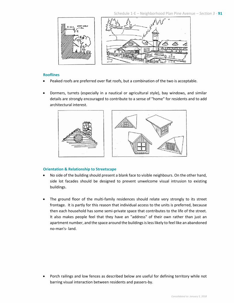
Schedule 1-E – Neighborhood Plan Pine Avenue – Section 3 - 91
Consolidated to: January 5, 2018
Rooflines
• Peaked roofs are preferred over flat roofs, but a combination of the two is acceptable.
• Dormers, turrets (especially in a nautical or agricultural style), bay windows, and similar
details are strongly encouraged to contribute to a sense of "home" for residents and to add
architectural interest.
Orientation & Relationship to Streetscape
• No side of the building should present a blank face to visible neighbours. On the other hand,
side lot facades should be designed to prevent unwelcome visual intrusion to existing
buildings.
• The ground floor of the multi-family residences should relate very strongly to its street
frontage. It is partly for this reason that individual access to the units is preferred, because
then each household has some semi-private space that contributes to the life of the street.
It also makes people feel that they have an "address" of their own rather than just an
apartment number, and the space around the buildings is less likely to feel like an abandoned
no-man's land.
• Porch railings and low fences as described below are useful for defining territory while not
barring visual interaction between residents and passers-by.
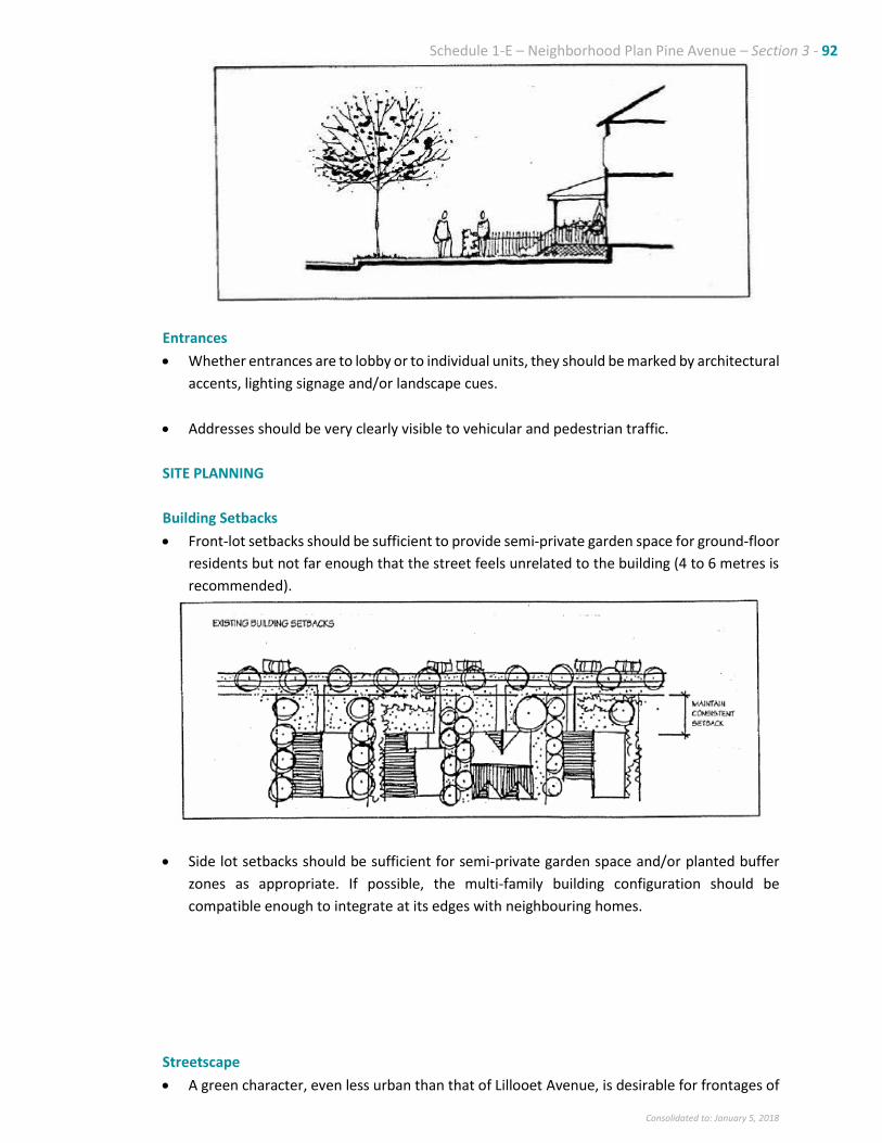
Schedule 1-E – Neighborhood Plan Pine Avenue – Section 3 - 92
Consolidated to: January 5, 2018
Entrances
• Whether entrances are to lobby or to individual units, they should be marked by architectural
accents, lighting signage and/or landscape cues.
• Addresses should be very clearly visible to vehicular and pedestrian traffic.
SITE PLANNING
Building Setbacks
• Front-lot setbacks should be sufficient to provide semi-private garden space for ground-floor
residents but not far enough that the street feels unrelated to the building (4 to 6 metres is
recommended).
• Side lot setbacks should be sufficient for semi-private garden space and/or planted buffer
zones as appropriate. If possible, the multi-family building configuration should be
compatible enough to integrate at its edges with neighbouring homes.
Streetscape
• A green character, even less urban than that of Lillooet Avenue, is desirable for frontages of
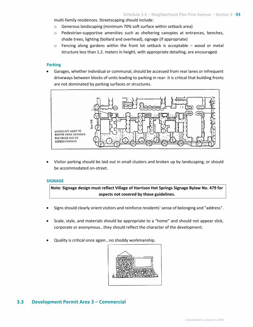
Schedule 1-E – Neighborhood Plan Pine Avenue – Section 3 - 93
Consolidated to: January 5, 2018
multi-family residences. Streetscaping should include:
o Generous landscaping (minimum 70% soft surface within setback area)
o Pedestrian-supportive amenities such as sheltering canopies at entrances, benches,
shade trees, lighting (bollard and overhead), signage (if appropriate)
o Fencing along gardens within the front lot setback is acceptable – wood or metal
structure less than 1.2. meters in height, with appropriate detailing, are encouraged.
Parking
• Garages, whether individual or communal, should be accessed from rear lanes or infrequent
driveways between blocks of units leading to parking in rear- it is critical that building fronts
are not dominated by parking surfaces or structures.
• Visitor parking should be laid out in small clusters and broken up by landscaping, or should
be accommodated on-street.
SIGNAGE
Note: Signage design must reflect Village of Harrison Hot Springs Signage Bylaw No. 479 for
aspects not covered by these guidelines.
• Signs should clearly orient visitors and reinforce residents' sense of belonging and "address".
• Scale, style, and materials should be appropriate to a "home" and should not appear slick,
corporate or anonymous...they should reflect the character of the development.
• Quality is critical once again...no shoddy workmanship.
3.3 Development Permit Area 3 – Commercial
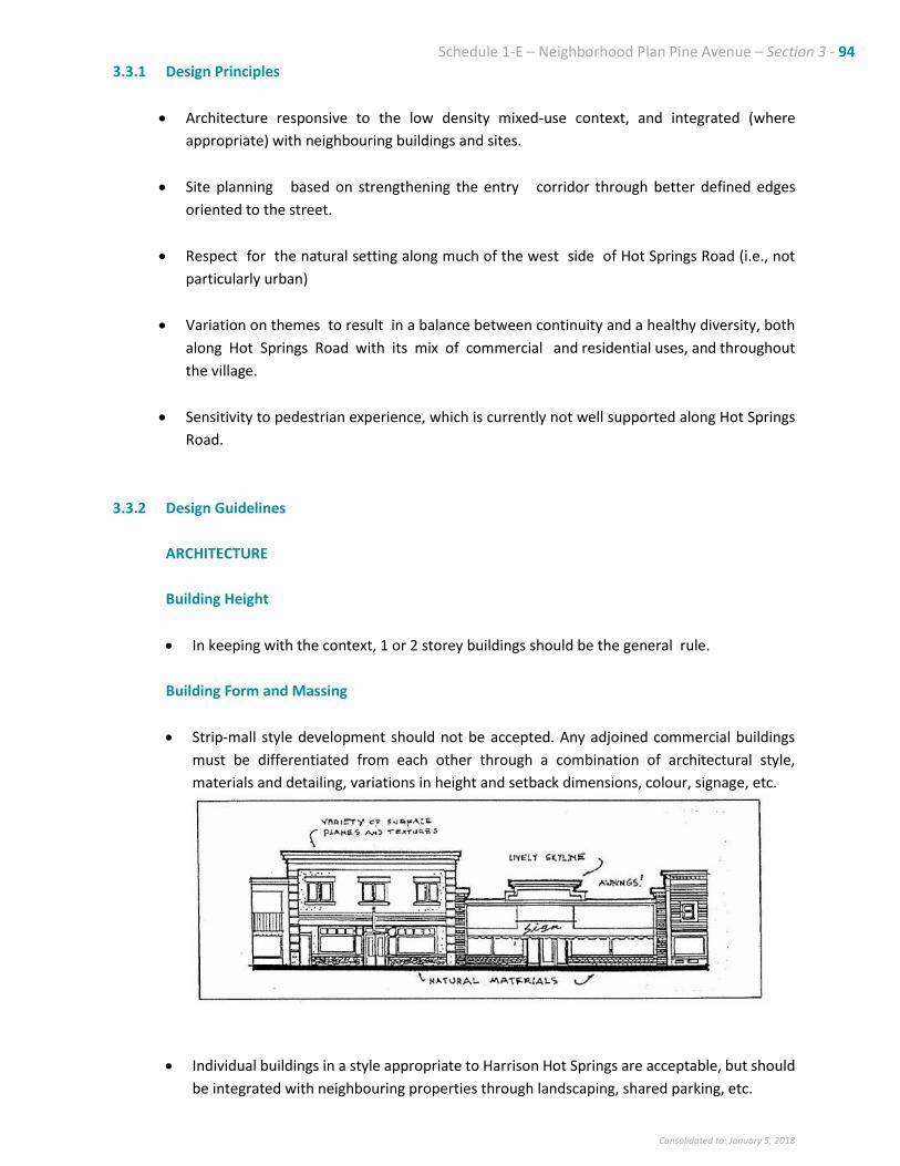
Schedule 1-E – Neighborhood Plan Pine Avenue – Section 3 - 94
Consolidated to: January 5, 2018
3.3.1 Design Principles
• Architecture responsive to the low density mixed-use context, and integrated (where
appropriate) with neighbouring buildings and sites.
• Site planning based on strengthening the entry corridor through better defined edges
oriented to the street.
• Respect for the natural setting along much of the west side of Hot Springs Road (i.e., not
particularly urban)
• Variation on themes to result in a balance between continuity and a healthy diversity, both
along Hot Springs Road with its mix of commercial and residential uses, and throughout
the village.
• Sensitivity to pedestrian experience, which is currently not well supported along Hot Springs
Road.
3.3.2 Design Guidelines
ARCHITECTURE
Building Height
• In keeping with the context, 1 or 2 storey buildings should be the general rule.
Building Form and Massing
• Strip-mall style development should not be accepted. Any adjoined commercial buildings
must be differentiated from each other through a combination of architectural style,
materials and detailing, variations in height and setback dimensions, colour, signage, etc.
• Individual buildings in a style appropriate to Harrison Hot Springs are acceptable, but should
be integrated with neighbouring properties through landscaping, shared parking, etc.

Schedule 1-E – Neighborhood Plan Pine Avenue – Section 3 - 95
Consolidated to: January 5, 2018
• Buildings can be oriented perpendicular to Hot Springs Road as long as access is provided to
the narrow end from the sidewalk, and that the street front facade, is detailed to a high
standard consistent with neighbouring front facades.
Rooflines
• Peaked roofs are preferable - flat roofs are very typical of strip malls and should be avoided.
• False facades above the height of a building, to suggest upper floor uses, screen mechanical
equipment and add architectural interest, may be acceptable as long as they do not appear
flimsy.
Orientation & Relationship to Streetscape
• Buildings will naturally be oriented to primarily address the street. If rear facades of
commercial buildings are visible from residential areas, they must be sufficiently detailed
and interesting to prevent a neglected, “back turned” impression.
• Ground floor commercial uses should be transparent to the sidewalks, contributing life to
them and drawing life from the activity along the street.
Entrances
• Whether entrances are to a lobby or to individual commercial units, they should be marked
by architectural accents, lighting signage and/or landscape cues.
• Addresses should be very clearly visible to vehicular and pedestrian traffic.
SITE PLANNING
Building Setbacks
• Setbacks should range as follows:
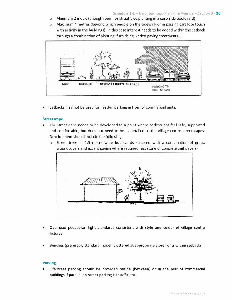
Schedule 1-E – Neighborhood Plan Pine Avenue – Section 3 - 96
Consolidated to: January 5, 2018
o Minimum 2 metre (enough room for street tree planting in a curb-side boulevard)
o Maximum 4 metres (beyond which people on the sidewalk or in passing cars lose touch
with activity in the buildings); in this case interest needs to be added within the setback
through a combination of planting, furnishing, varied paving treatments…
• Setbacks may not be used for head-in parking in front of commercial units.
Streetscape
• The streetscape needs to be developed to a point where pedestrians feel safe, supported
and comfortable, but does not need to be as detailed as the village centre streetscapes.
Development should include the following:
o Street trees in 1.5 metre wide boulevards surfaced with a combination of grass,
groundcovers and accent paving where required (eg. stone or concrete unit pavers)
• Overhead pedestrian light standards consistent with style and colour of village centre
fixtures
• Benches (preferably standard model) clustered at appropriate storefronts within setbacks
Parking
• Off-street parking should be provided beside (between) or in the rear of commercial
buildings if parallel on-street parking is insufficient.
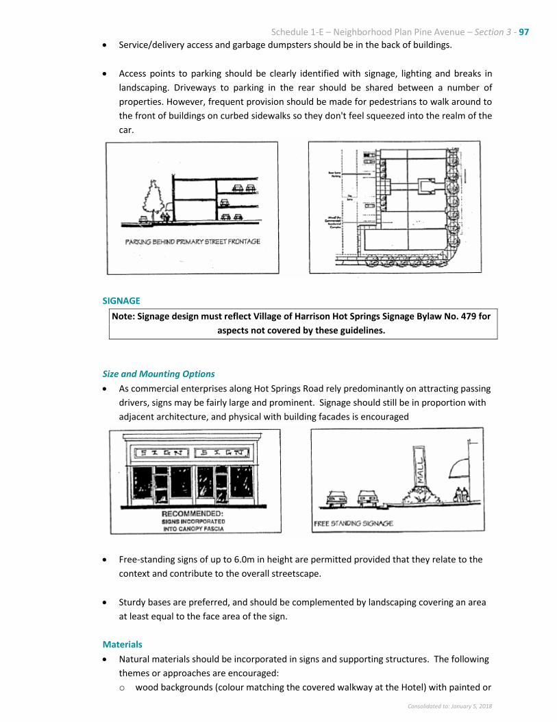
Schedule 1-E – Neighborhood Plan Pine Avenue – Section 3 - 97
Consolidated to: January 5, 2018
• Service/delivery access and garbage dumpsters should be in the back of buildings.
• Access points to parking should be clearly identified with signage, lighting and breaks in
landscaping. Driveways to parking in the rear should be shared between a number of
properties. However, frequent provision should be made for pedestrians to walk around to
the front of buildings on curbed sidewalks so they don't feel squeezed into the realm of the
car.
SIGNAGE
Note: Signage design must reflect Village of Harrison Hot Springs Signage Bylaw No. 479 for
aspects not covered by these guidelines.
Size and Mounting Options
• As commercial enterprises along Hot Springs Road rely predominantly on attracting passing
drivers, signs may be fairly large and prominent. Signage should still be in proportion with
adjacent architecture, and physical with building facades is encouraged
• Free-standing signs of up to 6.0m in height are permitted provided that they relate to the
context and contribute to the overall streetscape.
• Sturdy bases are preferred, and should be complemented by landscaping covering an area
at least equal to the face area of the sign.
Materials
• Natural materials should be incorporated in signs and supporting structures. The following
themes or approaches are encouraged:
o wood backgrounds (colour matching the covered walkway at the Hotel) with painted or
Schedule 1-E – Neighborhood Plan Pine Avenue – Section 3 - 98
Consolidated to: January 5, 2018
carved I wood burned lettering
o sturdy wood posts, rough cut to suggest the forested natural setting
o natural stone bases I backgrounds I framing walls (building on existing examples)
o brick bases can be used to reflect the style of the posts at the Hotel entrance copper or
metal accents can be used, again reflecting the Hotel's entrance trees and shrubs to
reflect lush setting and add accent colour
o neon should be used sparingly and only where compatible with the use (e.g., bars,
restaurants...)
Graphics / Style
• Quality is again the objective, with letters, logos and graphics being clean, clear and
professional-looking. The intent is not to prevent individual artistic expression (variety
is critical), but to avoid gaudy, amateurish signs that look more temporary than
permanent.
• Letter style can imitate the Hotel's font, or can be another classic, fairly simple style.
Complex or flowery scripts that are difficult to read should be avoided.
• Culturally specialized businesses (e.g., ethnic restaurants) are encouraged to reflect
their traditional style in their signage.

Schedule 1-E – Neighborhood Plan Pine Avenue – Section 3 - 99
Consolidated to: January 5, 2018
Schedule 1-E – Neighborhood Plan Pine Avenue (AB#988) - 100
Consolidated to: January 5, 2018
SCHEDULE 1-E: NEIGHBOURHOOD PLAN – PINE AVENUE (AB#930, AB#988)
A. POLICY FRAMEWORK
Council will utilize the following policies in guiding the development of land within the planning area:
1. Land Use Concept
A number of land use options were considered in the preparation of the Neighbourhood Plan –
Pine Avenue. They differed with respect to the amount and location of small (400 square
meters) and conventional lots (697 square meters), and low density multi family dwellings
(townhouses). Only residential uses were considered.
The land use concept for the Neighbourhood Plan – Pine Avenue as outlined in Appendix A. All
land fronting Hot Springs Road has been designated for small lot or multi-family residential
development. New development on land fronting McCombs Drive can remain designated for
conventional single family lots or alternatively be designated for small lot single family residential
housing.
Based upon an average density of 35 units per hectare (14 units per acre), it is estimated that
the maximum number of new dwelling units should not exceed 250 units.
2. Land Use and Density
a. The land within the Neighbourhood Plan – Pine Avenue shall be developed as a residential
neighbourhood.
b. Within the Neighbourhood Plan – Pine Avenue, a mix of singlefamily and multi family forms
of residential development may be accommodated based upon the following maximum
density limits:
i. Small residential lot – 400 sq. m. (4306 sq. ft.)
ii. Conventional residential lot – 697 sq. m. (7500 sq. ft.)
iii. Low density multi family residential – 35 units / ha (14 units / acre).
The maximum density limit of 35 units per ha. for the low density multi family residential
development is equivalent to the density of a small residential lot subdivision.
c. Small lot single family developments and low density multi family housing should be
concentrated along Hot Springs Road and near the centre of the neighbourhood.

Schedule 1-E – Neighborhood Plan Pine Avenue (AB#988) - 101
Consolidated to: January 5, 2018
d. To facilitate the efficient redevelopment of the lands, assembly of existing single family lots
is the preferred approach; however redevelopment options for individual lots shall be
considered.
e. To avoid piecemeal development, rezoning applications shall only be considered for small
lot residential subdivision or multi family development on sites greater than 0.4 ha (1 acre).
f. Individual rezoning applications shall demonstrate the manner in which the proposed
development will tie into adjacent lands or proposed development and to the
neighbourhood as a whole.
g. Rezoning applications for new development that would result in affordable housing
opportunities for seniors or young families and that would be constructed to a higher than
normal standard with green building technology shall be favourably considered.
h. Secondary suites may be accommodated within houses on conventional single family lots
subject to an amendment to the Zoning Bylaw.
3. Building Design and Landscaping
a. Upon rezoning, multi family residential development shall be included within Multi
Family Residential Development Permit Area No 3 and shall be subject to the applicable
guidelines.
b. Landscaping elements shall be incorporated along Hot Springs Road that will create a
pleasing gateway into the Village.
c. Buffers will be required in the form of landscaping along the interface with the surrounding
neighborhoods to the north, east and south.
4. Transportation and Access
a. Pine Avenue will continue to function as an east – west road within the neighbourhood.
b. A new public east – west road connecting Hot Springs Road and McCombs Drive may be
considered for ease of mobility.
c. New internal public road(s) off Pine Avenue connecting back to Hot Springs Road or
McCombs Drive may be considered.
d. Individual driveway access onto Hot Springs Road shall be minimized and eliminated where
possible.

Schedule 1-E – Neighborhood Plan Pine Avenue (AB#988) - 102
Consolidated to: January 5, 2018
5. Parks and Trails
a. 0.2 ha (0.5 acre) of land, equivalent to 5% of the developable area of the neighbourhood, or
payment equivalent in lieu.
b. The neighbourhood park should be located in the central portion of the neighbourhood and
should be connected to the new residential areas with trails where possible.
c. The exact location of the proposed neighbourhood park shall be considered at the time of
the subdivision or first rezoning application, however the ultimate decision shall depend
upon the amount of land and location that is the subject of the first application.
d. Both north - south and east - west pedestrian and cycling linkages shall be secured within
the neighbourhood providing neighbourhood residents with connections to Hot Springs
Road, McCombs Drive, and local amenities.
6. Infrastructure
a. Although Village services are adequate for new development in the planning area, the
adequacy of the existing infrastructure to service any new development shall be determined
prior to rezoning the lands.
b. All on site works and upgrading of existing road frontages shall be the responsibility of the
developer and shall be secured at the time of rezoning or subdivision.
c. A comprehensive storm water management plan shall be prepared at time of rezoning or
subdivision.
7. Environment
a. Although there are no significant environmental features within the area, the Village shall
encourage developers to retain mature trees where possible subject to the
preparation of an arborist report.
b. Clustering of development and smaller building footprints are encouraged to minimize the
creation of impermeable surfaces.
c. All development shall conform to applicable flood protection requirements.

Schedule 1-E – Neighborhood Plan Pine Avenue (AB#988) - 103
Consolidated to: January 5, 2018
APPENDIX A: LAND USE CONCEPT

Schedule 1-F – Neighborhood Plan – Echo Avenue and Eagle Street Area (AB#988) - 104
Consolidated to: January 5, 2018
SCHEDULE 1-F: NEIGHBOURHOOD PLAN – ECHO AVENUE AND EAGLE STREET (AB#961, AB#988)
A. Background and Purpose
The Village’s Official Community Plan (OCP) designates the area bounded by Lillooet Avenue to the north,
Mount Street to the east, Echo Avenue to the south, and Miami Creek to the west as Neighbourhood
Planning Area 2.Section 3.2.4 of the OCP speaks to Neighbourhood Planning Area 2 by indicating that
the area has the potential to accommodate medium density multi family development by extending the
Lakeshore Residential area designation southward provided that the redesignation takes place on the
basis of a comprehensive development proposal that addresses the overall area.
B. Planning Area Statistics
The following general information is provided for the planning area:
i. Size of Area: 5.5 ha (13.5 acres)
ii. Number of Existing Lots: 46
iii. Current Zoning: Primarily R-2 (Two Family Residential)
lots: R-4 (Multi Family Residential - Medium Density)
lots: P-1 (Community Institutional)
iv. Existing Municipal Services: Municipal water and sewer
C. Planning Context and Issues
Neighbourhood Planning Area 2 has been identified in the Official Community Plan as an area that could
transition from a predominantly single family area with smaller older homes to an area with a series of
medium density multi-family residential buildings. This neighbourhood is in close proximity to the
Village’s primary commercial area and Harrison Lake. Consistent with current sustainability principles,
the increase in density of this neighbourhood is seen as an opportunity to promote a more walkable
community enabling more people to live close to the beach and community’s major amenities. The
challenge for the Village in planning for the redevelopment of an existing established residential
neighbourhood is the consideration of the following issues:
i. is the infrastructure capable of accommodating an increase in development?;
ii. what can be done to mitigate the impacts of a neighbourhood in transition?;
iii. will people be displaced if older housing is replaced with new housing?;
iv. can the older homes co-exist with new development?;
Schedule 1-F – Neighborhood Plan – Echo Avenue and Eagle Street Area (AB#988) - 105
Consolidated to: January 5, 2018
v. will the densities be high enough to enable a developer to purchase land at a price that will be
acceptable to the existing property owner?;
vi. what are the important design features for the new housing?; and
vii. what features can be integrated in the design of the area that would promote sustainability?
D. Planning Principles
In an attempt to address the above noted issues, the redevelopment of Neighbourhood Planning Area
2 shall respect the following planning principles:
i. The change of use and density of the neighbourhood shall respect the character of the single
family neighbourhood on the south side of Echo Avenue.
ii. To facilitate the efficient redevelopment of properties, the assembly of existing single family
lots is the preferred approach; however redevelopment options for individual lots shall be provided
where possible.
iii. Density of development shall decrease as the distance from the lake increases.
iv. New development shall be designed to cater to full time residents as opposed to part time
residents.
v. Development proposals shall identify the manner in which existing residents who may be displaced
will be housed elsewhere.
vi. If necessary, new zones will be created to accommodate innovative development proposals.
vii. Density bonuses will be considered for development projects that provide:
a. rental housing or have some units owned and operated by a housing society;
b. community amenities either within the neighbourhood or
c. elsewhere within the Village;
d. green building elements that promote energy and water conservation; and
e. tangible opportunities for promoting alternative modes of transportation.
viii. Infrastructure upgrades shall be the responsibility of the developer.

Schedule 1-F – Neighborhood Plan – Echo Avenue and Eagle Street Area (AB#988) - 106
Consolidated to: January 5, 2018
E. Land Use Concept
A number of land use options were considered in the preparation of the Neighbourhood Plan. They
differed with respect to the amount and location of small (400 square meters) and conventional lots (557
- 697 square meters), and multi family dwellings (townhouses and low rise apartments). The land use
concept for the Neighbourhood Plan is outlined in Appendix A, the highlights of which are as follows:
▪ the land fronting Lillooet Avenue and Eagle Street is designated for multi-family residential
development;
▪ the land on the north side of Echo between Eagle and Mount is intended toremain single family in
character accommodating smaller lots and / or a second smaller dwelling such as a cottage or coach
house;
▪ the church on the south side of Lillooet would remain as part of the neighbourhood;
▪ Bear Avenue between Eagle and Spruce could be closed;
▪ the park along the Miami River would be linked to a new park at the intersection of Spruce and
Lillooet that would serve the local park needs of the neighbourhood.
▪ the land designated as multi family outlined in Appendix B is subject to a Development
Permit.
Based upon an average density of 30 units per hectare (12 units per acre), it is estimated that the
maximum number of new dwelling units would be in the 120 - 150 unit range.
F. Policy Framework
Council will utilize the following policies in guiding the development of land within the planning area:
1. Land Use and Density
a. The land within the Neighbourhood Plan shall be developed primarily as a residential
neighbourhood. Commercial development as part of a mixed commercial / residential project
will be accommodated on a small section of the south side of Lillooet Avenue between the Miami
River park and Eagle Street. The church on the south side of Lillooet Avenue shall be retained
adding diversity to the neighbourhood.
Schedule 1-F – Neighborhood Plan – Echo Avenue and Eagle Street Area (AB#988) - 107
Consolidated to: January 5, 2018
b. Within the Neighbourhood Plan, a mix of single family and multi family forms of residential
development may be accommodated based upon the following maximum density limits:
i. Small residential lot – 400 sq. m. (4306 sq. ft.) minimum lot size with a 12 meter wide
frontage except for panhandle lots;
ii. Conventional residential lot – 557 sq. m. (6000 sq. ft.) minimum lot size
iii. Low density multi family residential (townhouse –maximum 35 units / ha. (14 units / acre)
iv. Medium density multi family residential (low rise apartment – maximum 74 units / ha.
(30 units / acre).
c. The multi family site designated at the east end of Echo Avenue along Mount Road shall be
developed in such a manner that vehicular access shall be arranged off of Lillooet Avenue and
not Echo.
d. For the lots on the north side of Echo Avenue designated Single Family, new zoning
regulations shall be considered that will accommodate small cottages or guest houses in the
rear portion of a lot, their size and siting to respect the single family character of the street.
e. The Village will consider innovative zoning regulations to retain the character house at the
north-west corner of Echo and Eagle.
f. Secondary suites shall be accommodated within houses on conventional single family lots
subject to an amendment to the Zoning Bylaw.
g. To facilitate the efficient redevelopment of the lands for multi family housing, assembly of
existing single family lots is the preferred approach; however redevelopment options for
individual lots shall be provided where possible.
h. Individual rezoning applications shall demonstrate the manner in which the proposed
development will tie into adjacent lands or proposed development and to the neighbourhood
as a whole.
i. Rezoning applications for new development that would result in affordable housing
opportunities for seniors or young families and that would be constructed to a higher than
normal standard with green building technology will be favourably considered.
2. Building Design and Landscaping
a. Multi family residential development shall be included within Multi Family Residential
Development Permit Area No. 3 and shall be subject to the applicable guidelines.
Schedule 1-F – Neighborhood Plan – Echo Avenue and Eagle Street Area (AB#988) - 108
Consolidated to: January 5, 2018
b. Upon rezoning, small lot residential subdivision shall be the subject of development permit
guidelines which shall be prepared in conjunction with the rezoning application.
3. Transportation and Access
a. No new public roads shall be developed within the neighbourhood.
b. The east end of Echo Road shall continue as a cul de sac and Mount Road between Lillooet and
Echo will not be developed as a connecting road.
c. Bear Avenue may be closed and disposed of to the adjoining properties when redevelopment
takes place, but a trail link shall be maintained between the Miami River trail and the new park
at Spruce Street.
d. Spruce Street may be closed and converted into a neighbourhood park. That portion of Spruce
Street that connects to Echo could be sold off as a single family lot, but in no way will any existing
houses lose their driveway accesses.
4. Parks and Trails
a. A new neighbourhood park utilizing the Spruce Street and Bear Avenue rights of way should be
created and connected to the residential areas with trails where possible.
b. As a condition of rezoning, developers will be requested to make a financial contribution towards
the development of the Spruce Street Park or another community Park.
c. The trails along the east side of the Miami River and within the Mount Street road
allowance shall continue to provide important north – south trail linkages.
5. Infrastructure
a. Although the Village wide water, sewer, and road systems are considered adequate for new
development in the planning area, the adequacy of the existing on-site infrastructure to service
new development shall be determined prior to rezoning the lands.
b. Any required off-site, on-site, or upgrading of existing road frontages shall be the responsibility
of the developer and shall be secured at the time of rezoning or subdivision as the case may be.
Schedule 1-F – Neighborhood Plan – Echo Avenue and Eagle Street Area (AB#988) - 109
Consolidated to: January 5, 2018
6. Environment and Hazard Land
a. Although there are no significant environmental features within the area, the Village shall
encourage developers to retain mature trees where possible subject to the preparation of an
arborist report.
b. Clustering of development and smaller building footprints are encouraged to minimize the
creation of impermeable surfaces.
c. All development shall conform to applicable flood protection requirements.
d. Redevelopment of the sites at the far east end of the Neighbourhood Plan area shall be subject
to the applicable guidelines within the Geotechnical Hazards Development Permit Area No 4.
G. Conclusion
The Neighbourhood Plan has been devised in accordance with a series of planning principles that are
consistent with best management practices related to sustainability. The density and housing form that
has been established will enable the neighbourhood to provide a gradual transition from the higher
density area along the lake to the single family neighbourhood to the south. It is anticipated that the
changes to the neighbourhood will take place over time.
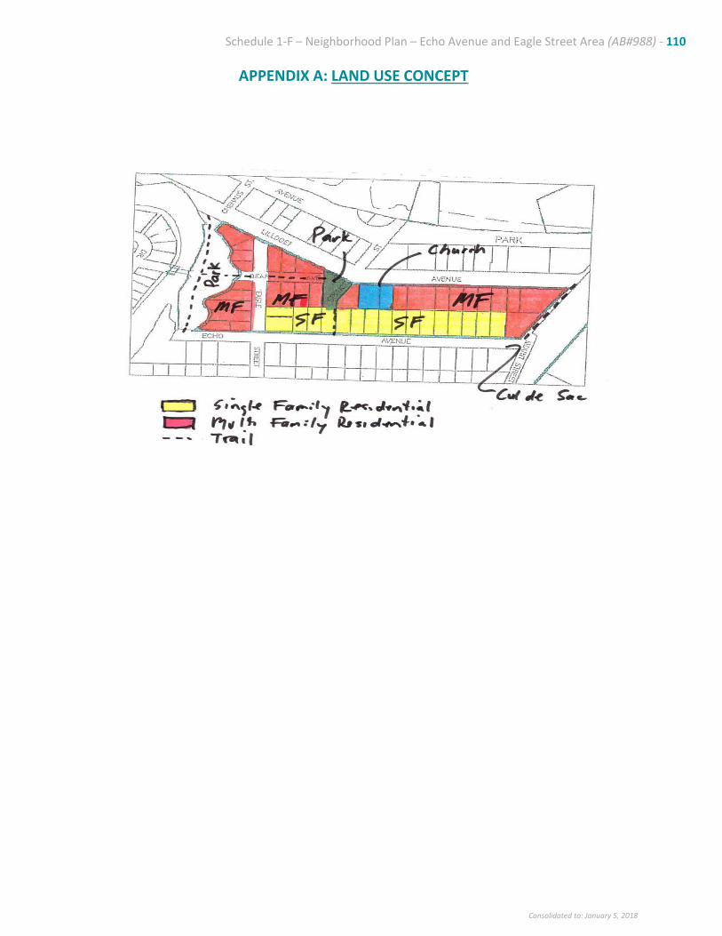
Schedule 1-F – Neighborhood Plan – Echo Avenue and Eagle Street Area (AB#988) - 110
Consolidated to: January 5, 2018
APPENDIX A: LAND USE CONCEPT
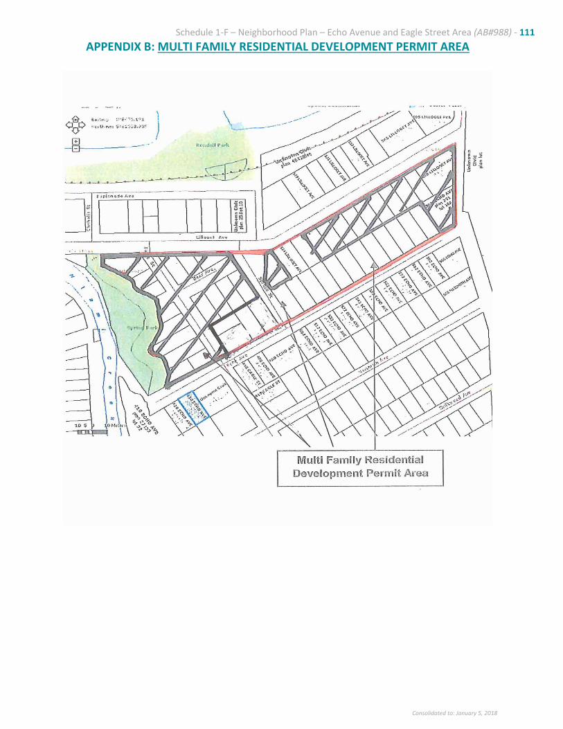
Schedule 1-F – Neighborhood Plan – Echo Avenue and Eagle Street Area (AB#988) - 111
Consolidated to: January 5, 2018
APPENDIX B: MULTI FAMILY RESIDENTIAL DEVELOPMENT PERMIT AREA


![REGIONAL DISTRICT OF NORTH OKANAGAN BYLAW No ...RDNO Electoral Area “F” Official Community Plan Bylaw No. 2702, 2016 [Schedule “A”] Page 7 Table 2 shows the median age of the](https://static.fdocuments.net/doc/165x107/602657925d7fa721982d491f/regional-district-of-north-okanagan-bylaw-no-rdno-electoral-area-aoefa-official.jpg)