OFFICIAL BIKING GUIDE biking guide.pdf · our outstanding natural resources, charming towns and...
84
OFFICIAL BIKING GUIDE EIGHTH EDITION
Transcript of OFFICIAL BIKING GUIDE biking guide.pdf · our outstanding natural resources, charming towns and...

OFFICIALBIKINGGUIDE
EIGHTH EDITION

As Governor, it’s my pleasure to invite you to exploreour outstanding natural resources, charming townsand exciting cities on two wheels. Wisconsin is aleader in bicycling, offering a world class combinationof linear and mountain bike trails and lightly-traveledrural paved roads. In fact, Wisconsin is home to thenation’s first rails to trails program, which has nowconverted 80 former rail beds into recreational trailsthat crisscross the state. From picturesque rolling country hills in
southwestern Wisconsin to the premier CAMBAmountain biking trails in northern Wisconsin toexceptional touring trails in every corner of the state,Wisconsin offers an outstanding ride for all levels ofbiking enthusiasts. It’s a great way to explore ournatural beauty and rich heritage, and no matter whereyou are, there are plenty of friendly people ready towelcome you. Use this guide as your starting point to plan your
next biking adventure in Wisconsin. We look forwardto welcoming you.
Sincerely,
Scott WalkerGovernor
Welcome

CONTENTSUsing the Guide/Map Legend ................... 3Northwest................................................. 4
Linear Bike Trails.............................. 5Mountain Biking Trails ..................... 8Road Biking Tours ............................ 12
Northeast ................................................. 14Linear Bike Trails.............................. 15Mountain Biking Trails ..................... 18Road Biking Tour .............................. 22
East Central ............................................. 24Linear Bike Trails.............................. 25Mountain Biking Trails ..................... 30Road Biking Tours ............................ 32
Central ..................................................... 34Linear Bike Trails.............................. 35Mountain Biking Trails ..................... 38Road Biking Tours ............................ 42
Southwest................................................. 44Linear Bike Trails.............................. 45Mountain Biking Trails ..................... 50Road Biking Tours ............................ 52
South Central ........................................... 54Linear Bike Trails.............................. 55Mountain Biking Trails ..................... 60Road Biking Tours ............................ 62
Southeast ................................................. 64Linear Bike Trails.............................. 65Mountain Biking Trails ..................... 68Road Biking Tours ............................ 72
Wisconsin Biking Events.......................... 74Alphabetical Index ................................... 80
This publication is produced by theWisconsin Department of Tourism, StephanieKlett, Secretary, with the support andcooperation of the Wisconsin Department ofNatural Resources, the WisconsinDepartment of Transportation, the WisconsinDepartment of Health Services, theWisconsin Economic DevelopmentCorporation and the Wisconsin BikeFederation.
Published May, 2014
Wisconsin Department of Tourism201 W. Washington AvenueP.O. Box 8690Madison, WI 53707-8690800/432-8747, 608/266-2161www.travelwisconsin.com
1
Encourage sustainabilityTo underscore the Wisconsin Department of Tourism’scontinuing commitment to stronger recyclingmarkets in Wisconsin and a healthier world, thispublication is printed on a paper stock with a 10%post-consumer recycled content. The paper used isForest Stewardship CouncilTM certified, a mark ofresponsible forestry.
Mixed SourcesProduct group from well-managedforests, controlled sources andrecycled wood or fibrewww.fsc.org Cert no. SW-COC-002880©1996 Forest Stewardship Council
WISCONSIN BIKE FED
ROBB FISCHERGLENN SANDERSON
NICK COLLURA
2 Find more fun at travelwisconsin.com or call 1-800/432-8747.
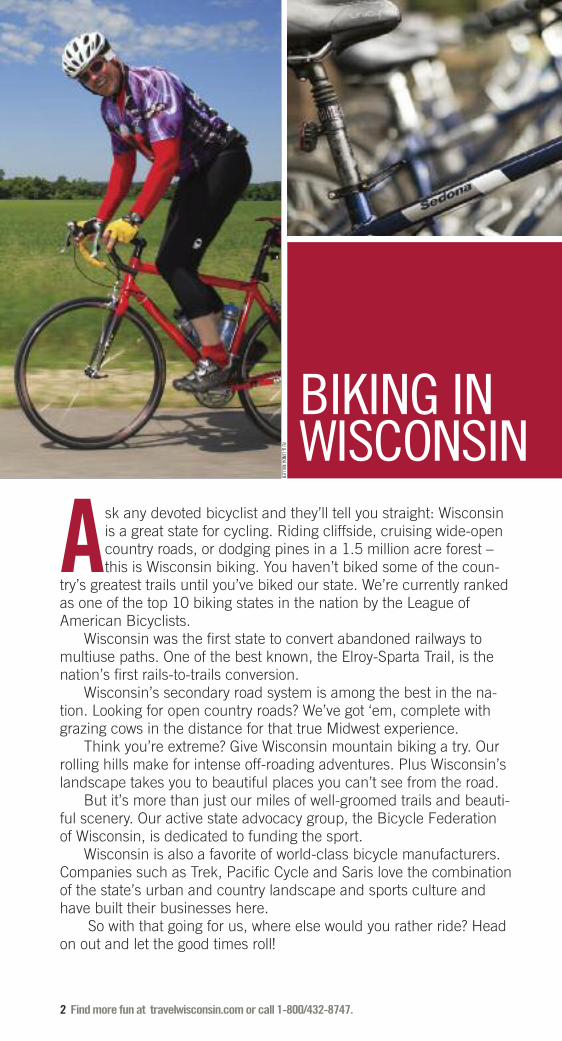
Ask any devoted bicyclist and they’ll tell you straight: Wisconsinis a great state for cycling. Riding cliffside, cruising wide-opencountry roads, or dodging pines in a 1.5 million acre forest –this is Wisconsin biking. You haven’t biked some of the coun-
try’s greatest trails until you’ve biked our state. We’re currently rankedas one of the top 10 biking states in the nation by the League of American Bicyclists.
Wisconsin was the first state to convert abandoned railways tomultiuse paths. One of the best known, the Elroy-Sparta Trail, is thenation’s first rails-to-trails conversion.
Wisconsin’s secondary road system is among the best in the na-tion. Looking for open country roads? We’ve got ‘em, complete withgrazing cows in the distance for that true Midwest experience.
Think you’re extreme? Give Wisconsin mountain biking a try. Ourrolling hills make for intense off-roading adventures. Plus Wisconsin’slandscape takes you to beautiful places you can’t see from the road.
But it’s more than just our miles of well-groomed trails and beauti-ful scenery. Our active state advocacy group, the Bicycle Federation of Wisconsin, is dedicated to funding the sport.
Wisconsin is also a favorite of world-class bicycle manufacturers.Companies such as Trek, Pacific Cycle and Saris love the combinationof the state’s urban and country landscape and sports culture andhave built their businesses here.
So with that going for us, where else would you rather ride? Headon out and let the good times roll!
BIKING INWISCONSINRJ & LINDA M
ILLER

Find more fun at travelwisconsin.com or call 1-800/432-8747. 3
2.9
Interstate Highway
US Highway
State Highway
County Highway
Town Road (Paved)
Town Road (Gravel)
Bike Route on State Highways
Bike Route on County Highways
Bike Route on Town Roads (Paved)
Bike Route on Town Roads (Gravel)
Linear Bike Trail (Paved)
Linear Bike Trail (Unpaved)
Purpose-Built Mountain Bike Trail
Hiking Trail/Other Trail
County Lines
Railroad
Park Boundary
Parking Lot
Mileage Indicators
Trailhead
Trailhead with Parking Lot
Trailhead with On-Street Parking
Parking Lot
All Services
Some Services
Tavern
Bicycle Service
Shelter
Point of Interest
Unincorporated Town
Incorporated Town
Telephone
Lodging
Public Campground
Private Campground
Food Service
Grocery
Showers
Water
Flush Toilet
Pit Toilet
Hiking Only Trail
Park/Picnic Area
Playground
Historical Marker or Museum
Swimming
Underpass
State Park
County Park
Travel Wisconsin Welcome Center
68
94
51
G
USING THE GUIDEThis edition of the Wisconsin BikingGuide is a sampling of some of thewonderful biking experiences Wiscon-sin has to offer. While the guide is byno means a comprehensive list of allthe biking opportunities within thestate, it offers an excellent startingpoint for planning your Wisconsin bik-ing adventure. We’ve divided the stateinto seven geographic regions, andwithin each of those regions, therides are divided into three cate-gories: linear bike trails, mountainbike trails and road biking tours. The location of each trail or route
is indicated on the region map at thebeginning of each section. The color-coded numbers correspond to thenumbers before each trail or route.The featured maps and road biking
tours in each region have been se-lected from previous editions of theWisconsin Biking Guides and repre-sent a cross section of the many bik-ing opportunities within each region.The key to the right refers to the sym-bols used in the maps.Each region features a “Worth a
Stop” sidebar highlighting some ofthe various tourist attractions you’llfind in that region. We’ve also sprin-kled in other interesting biking facts,information and safety tips. To round things out, we’ve com-
piled a list of biking events through-out the state as well as additionalbiking resources.
MAP LEGEND
SAFETY FIRSTWhen riding, always act in the best interest ofyourself and your companions. Be sure to:� Obey specific bicycle and general traffic
regulations.� Show courtesy to all road or trail users.� Wear appropriate gear, including a well-
adjusted helmet.� Maintain your bicycle in excellent operating
condition.� Choose routes within the ability of you and
your companions.� Carry sufficient food, drink, first aid
supplies, and tools.

7070
6464
29
72
85
93
65
46
27
4840
35
35
35
29
73
73
73
13
13
77
77
27
7713
13
13
8
8
2
2
63
63
63
63
63
2
51
51
51
51
61
61
70
35
61
53
53
53
10
10
10
12
10
94
94
39
39
35
35
35
94
13
4
6 11
1
12
10
14
9
5
7
23
82
1
1
32
4 65
7
8
9
Wausau
Minocqua
Hayward
Superior
Bayfield
Cornucopia
St. Paul
Minneapolis
Eau Claire
MaidenRock
Red Wing
Bay City
Prescott
Durand
River Falls
EllsworthDownsville
Menomonie
Hudson
Somerset Stillwater
New Richmond
Osceola
St. CroixFalls
Amery
TurtleLake
KnappBaldwin
Fairchild
Augusta
Luck
Dresser
BalsamLake
GrantsburgSiren
Webster
Danbury
CumberlandRiceLake
Chetek
Barron
ShellLake
Spooner
Trego
Minong
Gordon
Solon Springs
BruleIron River
La Pointe
RedCliff
Port Wing
Drummond
Cable
OdanahAshland
BloomerCornell Gilman Medford
Manitowish
Mercer
Hurley IronwoodMontreal
Mellen
GliddenClamLake
Butternut
Fifield
ParkFalls
Winter
Birchwood
Radisson
StoneLakeHertel
Holcombe
Cadott
Ladysmith
JumpRiver
Prentice
Ogema
Phillips
Bruce
Duluth
St. C
roi
x River
Apostle Islands
Madeline Island
Washburn
M I N N E S O T A
ChippewaFalls
Lake Superior
WOOD
Northwest
4 Find more fun at travelwisconsin.com or call 1-800/432-8747.
� = Linear Bike Trails
� = Mountain Bike Trails
� = Road Biking Tours
WISCONSIN STATE PARKS

Find more fun at travelwisconsin.com or call 1-800/432-8747. 5
Cattail State Trail
The Cattail State Trail travels 18 miles on aformer rail corridor between the communi-ties of Amery and Almena. Forests, farm-lands, prairies, hills and various wildlifehabitats surround the trail, which alsopasses through the Village of Turtle Lake.The trail is maintained and managed byPolk and Barron counties.� For more information call 715/485-9271(Polk County) or 715/537-6295 (BarronCounty) or visit dnr.wi.gov
Chippewa River State Trail
This 30-mile trail extends from PhoenixPark in downtown Eau Claire and travelssouth along the Chippewa River throughriver bottoms, prairies, sandstone bluffsand wetlands. The trail joins the Red CedarState Trail in the Dunnville Wildlife Areaand ends at the town of Durand. The trail ispart of the Chippewa Valley Trail System.When completed, the trail system will fea-ture an 80-mile network of trails stretchingfrom Cornell, through Chippewa Falls andEau Claire to Durand and Menomonie. Adaily or annual State Trail Pass is requiredfor riders 16 and older. � For more information call 888/523-3866or visit www.visiteauclaire.com
Eau Claire City Trails
Two city parks anchor this route offeringscenery, history, entertainment and recre-ation. An impressive stressed iron railroadbridge connects to the west shore. In thefuture, the trail will extend east toChippewa Falls and the Old Abe State Trail.At the southwest corner of the trail loop,the trail crosses the Chippewa River on an-other impressive iron bridge. It continuessouth another mile to join up with theChippewa River State Trail that heads westto Durand and connects to the Red CedarState Trail.� For more information call 888/523-3866or visit www.visiteauclaire.com
Gandy Dancer State Trail
This 98-mile recreation trail follows anabandoned railroad grade from St. CroixFalls to Superior. The south trail segmentextends 47 miles from St. Croix Falls toDanbury, paralleling Hwy 35 most of theway. A daily or annual State Trail Pass is
required for riders 16 and older on thesouth segment. A 1.5-mile blacktopped in-terlink trail begins at the Polk County In-formation Center. The northern segmentoffers a wilder, more remote trail experi-ence and travels 51 miles from Danburyinto eastern Minnesota and on to Superior.A highlight is the 520-foot bridge over thescenic St. Croix River near Danbury. Notrail pass is needed on this section. � For more information call 800/222-7655or 715-483-1410 (south section) or715/636-4121 (north section) or visitdnr.wi.gov
Old Abe State Trail
The Old Abe State Trail is a paved 19.5-mile trail connecting Lake Wissota StatePark near Chippewa Falls and Brunet Is-land State Park in Cornell. A newly pavedsection of trail runs from Jim Falls to Cor-nell. A future link with the Chippewa Riverand Red Cedar Trails will make this a 70-mile trail system. A daily or annual StateTrail Pass is required for riders 16 andolder.� For more information call 715/723-0331or visit dnr.wi.gov
Osaugie Trail
This 5-mile asphalt-paved trail is a greatway to sample the sights of the City of Su-perior and one of the busiest harbors onthe Great Lakes. Huge oceangoing shipscome through the ship channel at Wiscon-sin Point. The trail passes under the im-mense Burlington Ore Dock. � For more information call 800/942-5313or visit www.superiorchamber.org
Pine Line Recreation Trail
This 26.2-mile trail follows a former rail-road bed from Medford to Prentice innorth-central Wisconsin. The trail is sur-faced with limestone and crushed gravel.Camping is available at Pioneer Park andCampground in Ogema located one blockoff the trail.� For more information call 715/748-4729or visit www.medfordwis.com
Linear Bike Trails1
2
3
4
5
6
7
continued...
Bike trails may bring a number of differentusers to the trail at the same time. Alwaysuse good trail etiquette to ensure theenjoyment and safety of all trail users.

6 Find more fun at travelwisconsin.com or call 1-800/432-8747.
Red Cedar State Trail
See trail description below.
Saunders State Trail
This 8-mile county-operated trail links withthe Gandy Dancer State Trail south of thecity of Superior in Douglas County. Beaware that all-terrain vehicles (ATVs) areallowed on the trail year-round. � For more information call 800/942-5313or visit www.superiorchamber.org
Stower Seven Lakes State Trail
This 14-mile trail begins in Amery andends about one mile from Dresser. Alongthe way, the trail passes through maple andoak forests, wetlands, prairies and farm-lands, and past several picturesque lakes.A daily or annual State Trail Pass is re-quired for riders 16 and older.� For more information call 715/485-9294or visit dnr.wi.gov
Tri-County Corridor Trail
This multi-use trail joins the Osaugie Trailat the eastern edge of the city of Superior.The trail is also used by ATVs and othermotorized trail uses. It runs a total of 60-miles, past scenic Amnicon Falls StatePark to the city of Ashland.� For more information call 800/942-5313or visit www.superiorchamber.org orwww.visitashland.com
Tuscobia State Trail
This 74-mile multi-use trail connects thetowns of Rice Lake and Park Falls and trav-erses the rugged Blue Hills, the FlambeauState Forest and the Chequamegon-NicoletNational Forest. The trail is open to ATVsand other motorized uses, with the excep-tion of the 12-mile section from Birchwoodto Rice Lake. A daily or annual State TrailPass is required for riders 16 and older. � For more information call 800/269-4505or 715/266-7032 or visit dnr.wi.gov
LINEAR BIKE TRAILS, CONTINUED
25
25
2929
72
12
P
J
J
Y
D
Y
Y
Y
C
C
Z
0 .5 1 1.5 2 Miles
3.0
4.8
7.0
Downsville
Menomonie
To Chip
pewa R
iver
State T
rail
Red C
edar River
Creek
Elk
Little
Chippewa
Rive
r
51
0TH
ST
LakeMenomin
Irvington
N O R T H W E S T
FEATURED TRAILRED CEDAR STATE TRAIL
This 14.5-mile trail shadows the steepwalls of the Red Cedar Valley fromMenomonie to its connection with theChippewa River State Trail. The trailpasses by prairies, marshland bottoms,forests and farmlands, including sand-stone bluffs and other unique rock forma-tions. In the Dunnville Wildlife Area, theRed Cedar trail connects to the ChippewaRiver State Trail. The Red Cedar StateTrail is part of the Chippewa Valley TrailSystem. When completed, the trail sys-tem will feature an 80-mile network oftrail stretching from Cornell, throughChippewa Falls and Eau Claire to Durandand Menomonie.
Distance: 14.5 milesSurface type: Crushed limestoneFees: A State Trail Pass is required forriders 16 and older.Caution: Hikers also use the trail. Alwaysyield to pedestrians.For more information:Red Cedar State Trail715/232-1242dnr.wi.gov/topic/parks/name/redcedarGreater Menomonie Area Chamber of Commerce & Visitor Center715/235-9087www.menomoniechamber.org
8
9
10
11
12

WORTH A STOPExhibits at the Fairlawn Mansion in Supe-rior recall the mansion’s Victorian days andits 42 years as a children’s home. TheRichard I Bong Veterans HistoricalCenter honors the WWII “Ace of Aces” andMedal of Honor recipient Major RichardBong, a native of Poplar, Wisconsin. Exhibitsthere include his restored P-38 Lightning.
In Ashland, the Mural Walk is a seriesof ten giant murals painted on downtownbuildings depicting the city’s history. TheNorthern Great Lakes Visitor Center in-cludes an observation tower, 100-seat the-ater, visitor information, trip planning, andinterpretive and historic exhibits.
Bayfield is the gateway to the 22 islandsof the Apostle Islands NationalLakeshore. The islands offer camping,boating, kayaking, sailing and lighthousetours. Big Top Chautauqua features asummer season of 70 shows - historical mu-sicals, variety shows, top national entertain-ers – all under the “Big Top.” North of RedCliff, Frog Bay Tribal Park is an incredi-ble, undeveloped 89-acre property wherebeautiful sandy beaches meet boreal forests.It is the first tribal national park in the country.
The Freshwater Fishing Hall ofFame in Hayward displays trophy mountsand photos of record setting fish, plus a 4-story building shaped like a musky.
In Phillips, Wisconsin Concrete Parkis an outdoor folk-art museum that featuresconcrete sculptures festooned with bits ofbroken glass, ceramics and stones, all thework of the late Fred Smith, a retired lumber-jack and self-taught artist.
In St. Croix Falls, the Chateau St. CroixWinery is crafted in the image of a Europeanestate, complete with an art gallery, vineyard,a carriage house, stables, gardens and a fish-ing pond. The Jacob Leinenkugel Brew-ing Company in Chippewa Falls offers freetours of the fifth oldest working brewery inthe United States.
The Paul Bunyan Logging Camp Mu-seum in Eau Claire diplays an authentic re-production of an 1890s logging camp.
For information on even more great regional attractions call 800/432-8747 or visit travelwisconsin.com.
Find more fun at travelwisconsin.com or call 1-800/432-8747. 7
KEVIN REVOLINSKI
Frog Bay Tribal Park.
Wild Rivers State Trail
This 104-mile trail stretches through Dou-glas, Washburn and Barron counties. Thearea surrounding the trail is rich in naturalresources and wildlife habitat. It crossesnumerous rivers and streams, includingthe Namakagon River, a federally desig-nated river and part of the St. Croix Na-tional Scenic Riverway. � For more information call 715/635-4490(Washburn County), 715/537-6296 (BarronCounty), 715/378-2219 (Douglas County) orvisit dnr.wi.gov
Wildwood Trail
The Wildwood Trail is a seven-mile off-road biking, hiking and snowmobile trail.In 1970, St. Croix County purchased theformer railroad line from the St. Paul, Min-neapolis and Omaha Railway. It runs fromthe Village of Woodville south to the St.Croix/Pierce County line. Motorized usesare allowed on this trail.� For more information call 715/531-1923or visit www.co.saint-croix.wi.us
NORTHWESTURBAN BIKING OPTIONSThe following communities offer terrificurban bicycling opportunities. Most arehard-surfaced, family-friendly, and gen-erally traverse a given city’s most sce-nic areas. Many are recognized by theLeague of American Bicyclist as an Offi-cial Bicycle Friendly Community.
ASHLANDwww.visitashland.com
MENOMONIEwww.menomoniechamber.org
RIVER FALLS����
www.rfchamber.com www.co.saint-croix.wi.us
CHIPPEWA FALLSchippewacounty.com
EAU CLAIRE����
www.eauclairewi.gov
SUPERIORwww.ci.superior.wi.us
���� = Official Bicycle Friendly Community*
MORERESOURCESWISCONSIN’S LAKE SUPERIOR BYWAY This 70-mile route follows the southernshoreline of Lake Superior and featuresbreathtaking views of Lake Superior and theApostle Islands National Lakeshore. For more information visit: www.lakesuperiorbyway.org
13
14
* See page 77.

8 Find more fun at travelwisconsin.com or call 1-800/432-8747.
N O R T H W E S T
CAMBA Single Track Trails
The Chequamegon Area Mountain BikeAssociation (CAMBA) hasn’t been contentwith the popular 300-mile, signed andmapped mountain bike trail system they’vecreated in Bayfield and Sawyer Counties.Recently, they’ve begun constructing somevery technical singletrack trails to give rid-ers even more challenging options. If youlike tight trails that demand real bike han-dling skill, then singletrack is for you. Thedeep forest and glacial moraine of south-ern Bayfield County is ideal for mountainbiking. You’ll use all of your gears on thisseldom-level terrain. There’s some won-derful Northwoods riding along the way.You can ride the Ojibwe Trail out and back;or take roads, cross-country ski trails, orone of the three other CAMBA trails backto the trailheads. Excellent signage, a de-tailed CAMBA map, and periodic “you arehere” signs are the ticket to finding yourway around. For a very challenging riding,
try the Telemark Terrain Park. This single-track snakes through the woods on theslopes of the Mount Telemark ski hill. � For more information call 800/533-7454or visit www.cambatrails.org
Hickory Ridge Trail
There are approximately 11 miles of exist-ing single track trails on this trail in theChippewa County Forest. Construction isunderway by the Chippewa Off-Road BikeAssociation to expand their offerings. Thetrails wind through scenic and hardwoodforests and around glacial lakes offering avery technical experience over rocky ter-rain and through steep hills and valleys. � For more information visitchippewaoffroad.org
High Point Trail
Located near Timm’s Hill, Wisconsin’shighest geographical point, these ninemiles of non-motorized trails traversesome of the hilliest terrain in the state. Thelandscape viewed from the top of the ob-servation tower on Timm’s Hill is one notto be missed. Forests of hardwood andhemlock border the full length of the trail.This is one of the finest trail systemsaround. Most of the trail is hard-packeddirt with the exception of the portion be-tween the pavilion and the observationtower which is gravel. � For more information call 800/269-4505or visit www.pricecountywi.net
Mountain Bike TrailsSee region map on page 4 for trail locations.
The following is a list of “constructed”or “purpose built” mountain bike trails.These trails are more challenging, spe-cially-constructed, narrow-width trailsbuilt to the trail standards of the Inter-national Mountain Bicycling Association(IMBA). They are designed to present asingletrack mountain biking experience.If you’re looking for a less technicalride, check out the list of less challeng-ing off-road trails on page 10.
3
CABLE CHAMBER OF COM
MERCE
CAMBA Trails.
1
2
Find more fun at travelwisconsin.com or call 1-800/432-8747. 9
Lowes Creek Trail
Lowes Creek County Park is a 250 acrepark located just south of Eau Claire off S.Lowes Creek Road in the town of Wash-ington. Lowes Creek, a trout stream whichflows through the park, is spanned with abridge giving hiking, skiing and mountainbiking access to both sides of the creek.The biking trails offer a variety of differentlevels perfect for everyone from the begin-ner to the more advanced. Five miles oftrails also serve as double-track crosscountry ski trails. Six miles are more chal-lenging, narrow singletrack trails windingthrough the forests and across creek bedsreaching all corners of the park. Daily/an-nual vehicle entrance passes are required. � For more information visitchippewaoffroad.org
Northwest Park
In 2008, the city of Eau Claire approvedplans for a new community park on thenorthwest side of town. Park developersasked the Chippewa Off-Road Bike Associ-ation to develop a system of mountain biketrails at this 120-acre site near the NorthCrossing and the Chippewa River. Throughnumerous volunteer hours, the trails atNorthwest Park (NWP) have become anawesome reality. NWP has quickly becomea favorite destination for winter fat-bikersas well as mountain bikers looking for achallenging and fun course to hone theirskills on. The majority of trail building hasbeen completed as of 2012 resulting in ap-proximately six miles of bike trails withmore planned. � For more information visitchippewaoffroad.org/trails/northwest-park
CAMBAMOUNTAIN BIKETRAIL SYSTEM
The CAMBA Mountain BikeTrails are an off-road moun-tain biker’s dream and rap-idly becoming a Mecca for
singletrack riding in the Midwest.CAMBA’s Rock Lake Trail (page 11)is recognized by the InternationalMountain Bike Association (IMBA)as an Epic ride. Only a select fewtrails carry this designation.
The CAMBA system (whichstands for the Chequamegon AreaMountain Bike Association) con-sists of more than 300 miles ofmarked and mapped routes through-out Chequamegon-Nicolet NationalForest. The trail system is a greatway to sample the pristine beauty ofthe Northwoods along with peacefullakes and abundant wildlife.
The CAMBA system is dividedinto six “clusters” of 25 to 60 mileslocated in the communities of Bayfield, Cable, Delta, Drummond,Hayward, Namakagon and Seeley.The routes follow a variety of pathsincluding logging roads, fire lanes,snowmobile and ski trails, double-track and extensive singletracktrails. The recent completion of afinal two-mile segment now con-nects the communities of Hayward,Seeley and Cable for a total of 44miles of interconnected singletracktrails.
The terrain lends itself to ridersof all abilities, from beginners toseasoned fat tire experts. Riderslooking for an adrenaline rushshould not miss the fun gravity fea-tures known as Gravity Cavity and38 Special in the Seeley Cluster orWall Street on the Rock Lake Trail.
Every September the Cable-Hayward area hosts theChequamegon Fat Tire Festival – thelargest mountain bike race in thecountry with over 3,000 partici-pants.
CAMBA is a volunteer, non-profitorganization that is funded throughmemberships, sponsorships, adver-tising, grants, donations and spe-cial fund raising initiatives. Formore information on the CAMBAsystem visit www.cambatrails.org.�
4
5
continued...
CABLE CHAMBER OF COM
MERCE
CAMBA Trails.

10 Find more fun at travelwisconsin.com or call 1-800/432-8747.
Otter Creek Park
Located in Altoona, these trails have beendeveloped thanks to a partnership betweenthe City of Altoona and the Chippewa OffRoad Bike Association (CORBA) – a non-profit committed to developing trail-basedopportunities in the Chippewa Valley. OtterCreek Park offers trails suited for every skilllevel with the majority of trails rated as eithereasy or intermediate, but some stretches ofthe trail for the advanced rider. The trails areopen year-round for non-motorized recre-ational use including mountain biking, hik-ing, snowshoeing and running.� For more information visitchippewaoffroad.org/trails/otter-creek-park
Pokegama Trail
Built to present a technically challengingfour-mile ride, this tight and twisting sin-gletrack trail will constantly surprise youwith sudden drops down to narrow foot-and-a-half wide boardwalks followed byshort, steep climbs. The singletrack windsthrough beautiful stands of white pine,cedars and paper birch. It’s a shock whenyou pop out of the woods at the abandonedroad and all your gear shifting and bikehandling skills are no longer needed. Youcan choose to backtrack on the singletrackto the trailhead or just cruise on the flatroad. � For more information call 800/942-5313or visit www.superiorchamber.org
MOUNTAIN BIKE TRAILS, CONTINUED
LOOKING FOR A MILDER RIDE?BRULE RIVER STATE FOREST715/372-5678dnr.wi.gov
COPPER FALLS STATE PARK715/274-5123visit dnr.wi.gov
FLAMBEAU HILLS TRAIL800/269-4505, 715/339-4505www.pricecountywi.net
FLAMBEAU RIVER STATE FOREST715/332-5271visit dnr.wi.gov
HOLY CROSS TRAIL800/269-4505, 715/339-4505www.pricecountywi.net
LAKE WISSOTA STATE PARK 888-947-2757, 715-382-4574visit dnr.wi.gov
NAMEKAGON TRAIL715/634-4821www.cambatrails.org
NEWMAN SPRINGS TRAIL800/269-4505, 715/762-2461www.pricecountywi.net
PINES & MINES TRAIL715/561-4334ironcountywi.com
TIMM’S HILL TRAIL800/269-4505www.pricecountywi.net
TOTAGATIC TRAILwashburncounty.com
N O R T H W E S T
7
MOUNTAIN BIKING TIPS: Always wear a hel-met and eye protection. Control your bike;don’t ride beyond your skill level. Ride onlyon open trails; others may be illegal, andnever intentionally spook animals.
Namekagon Trail.
6 Rock Lake CAMBA Trail
See trail description on facing page.
White Tail Ridge
Whitetail Ridge Trail is located in RiverFalls and is a mix of wooded singletrackand open field sections. Originally built bylocal running coach Rick Cleary, thesetrails have a lot to offer: tight twisty single-track, rock sections, steep climbs, fastdown hills, and new technical features in-cluding bridges, teeters, and a coolwooden berm. Races are held on Thursdaynights in the summer.� For more information check outwww.kinnioffroad.com/trails.html
CAMBA
8
9
Find more fun at travelwisconsin.com or call 1-800/432-8747. 11
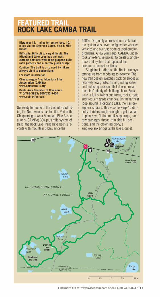
Distance: 12.1 miles for entire loop, 10.1miles via the Emerson Cutoff, also 5 MileCutoff.Difficulty: Difficult to very difficult. TheHildebrand Lake Loop has the mostextreme sections with some purpose-builtrock gardens and a narrow plank bridge.Caution: The trail is also used by hikers;always yield to pedestrians.For more information:Chequamegon Area Mountain BikeAssociation (CAMBA)www.cambatrails.orgCable Area Chamber of Commerce715/798-3833; 800/533-7454www.cable4fun.com
M
M
CHEQUAMEGON-NICOLET
NATIONAL FOREST
Hidden Lake
Namekagon Lake
Spring Lake
Patsy Lake
Rock Lake
Hildebrand Lake
Emerson Lake
LakewoodsResort
BAYFIELD CO
SAWYER CO
Hildebrand Lake Loop
EmersonLake
Cutoff
5 MileCutoff
Forest LodgeNature Trails
0 .25 .5 Mile.75 1
GAR MIS
CHRD
ROCK
FR 2
06
LAKE
RD
Get ready for some of the best off-road rid-ing the Northwoods has to offer. Part of theChequamegon Area Mountain Bike Associ-ation’s (CAMBA) 300-plus mile system oftrails, the Rock Lake Trails have been a fa-vorite with mountain bikers since the
1980s. Originally a cross-country ski trail,the system was never designed for wheeledvehicles and overuse soon caused erosionproblems. A few years ago, CAMBA under-took an extensive project to create a single-track trail system that replaced theerosion-prone ski sections.
Singletrack riding on the Rock Lake sys-tem varies from moderate to extreme. Thenew trail design switches back on slopes atrelatively low grades making riding easierand reducing erosion. That doesn’t meanthere isn’t plenty of challenge here. RockLake is full of twists and turns, rocks, rootsand frequent grade changes. On the farthestloop around Hildebrand Lake, the trail de-signers chose to throw some warp-10 diffi-culty at riders tough enough to get that far.In places you’ll find multi-step drops, nar-row passages, thread-thin side hill sec-tions, and the crowning glory, asingle-plank bridge at the lake’s outlet.
FEATURED TRAILROCK LAKE CAMBA TRAIL
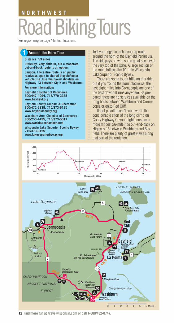
Distance: 53 milesDifficulty: Very difficult, but a moderateout-and-back route is an option.Caution: The entire route is on publicroadways open to shared bicycle/motorvehicle use. Use the paved shoulder onHighway 13 between Cty K and Washburn. For more information:Bayfield Chamber of Commerce800/447-4094, 715/779-3335www.bayfield.orgBayfield County Tourism & Recreation800/472-6338, 715/373-6125www.bayfieldcounty.orgWashburn Area Chamber of Commerce800/253-4495, 715/373-5017www.washburnchamber.comWisconsin Lake Superior Scenic Byway715/373-6125www.lakesuperiorbyway.org
12 Find more fun at travelwisconsin.com or call 1-800/432-8747.
21.3
12.9
20.0
0 21 3 Miles4 5 6
13
13
13
Lake Superior
LittleSand Bay
Washburn
Bayfield
La Pointe
CornucopiaRedCliff
C
J
H
K
Siskwit Lake
Chequamegon Bay
Mt. AshwabayBig Top Chautauqua
ValhallaRecreation Area
Madeline IslandHistorical Museum
Frog Bay TribalNational Park
BayfieldMaritimeMuseum
WashburnHistoricalMuseum
Siskiwit Falls
Lost CreekFalls
Houghton Falls
MeyersBeach
Orchards &Fruit Farms
Thompson’s West End Park
Ferry
APOSTLE ISLANDS
NATIONAL LAKESHORE
CHEQUAMEGON -
NICOLET NATIONAL
FOREST
SKI HILL RD
1,400
1,200
1,000
800
600
0 10 20 30 40 50
Distance in Miles
Washburn
Bayfield
Ele
va
tio
n in
Fe
et
Cornucopia
Washburn
Around the Horn Tour Test your legs on a challenging routearound the horn of the Bayfield Peninsula.The ride pays off with some great scenery atthe very top of the state. A large section ofthe route follows the 70-mile WisconsinLake Superior Scenic Byway.
There are some tough hills on this ride,but if you ‘round the horn’ clockwise, thelast eight miles into Cornucopia are one ofthe best downhill runs anywhere. Be pre-pared, there are no services available on thelong hauls between Washburn and Cornu-copia or on to Red Cliff.
If that payoff doesn’t seem worth theconsiderable effort of the long climb onCouty Highway C, you might consider amore modest 26-mile ride out-and-back onHighway 13 between Washburn and Bay-field. There are plenty of great views alongthat part of the route too.
Road BikingToursN O R T H W E S T
1
See region map on page 4 for tour locations.

Find more fun at travelwisconsin.com or call 1-800/432-8747. 13
There’s some wonderful rural Wisconsinbiking country wedged between the scenicKinnickinnic and St. Croix Rivers south ofHudson. River Falls, makes an interestingstarting point for this mostly easy ridethrough rolling farmland and hilltop forests.
Bicycling is always a pleasure on thewide, well-paved, quiet roads you’ll travelon this tour. From the trailhead parking lotat Centennial Park in downtown River Falls,head west out of town on Division Street
and Cty M. The route turns south on 1090thSt.; then west on 840th Ave. to wind alongthe edge of the Kinnickinnic River valley;then north on 1160th St. back to Cty. M. Ifyou’re wondering, the roads south of Cty. Mare numbered because they’re in Pierce Co.;north of Cty. M you’re in St. Croix Countywhere the road names are more traditional.
Jogging north, you soon reachTownsvalley Road and the only significanthill on the tour, a 120-foot climb and de-scent. The road is part of the course for thepopular locally organized Autumn Trek bikeride. In the fall, hilltops radiant with colormake a scenic background for the pictur-esque farms along the route.
As you turn east on Cty. FF, watch for in-creased traffic. Riding south along NorthGlover Road, you can take a break at pleas-ant Glover Town Park. A bit past the park,you arrive at a three-way intersection whereevery road is a Glover: North Glover, SouthGlover, and just plain Glover. South GloverRoad is your return ticket. After winding be-tween several hills you are soon back onCounty MM and the outskirts of River Falls.
Distance: 21 milesDifficulty: Easy with a few moderate hills.Caution: The entire route is on publicroadways open to shared bicycle/motorvehicle use. Be sure to ride on the pavedshoulder where available on CountyHighway M. Expect significant traffic onCounty Highway FF.For more information: Hudson Area Chamber of Commerce &Tourism Bureau715/386-8411, 800/657-6775www.hudsonwi.orgRiver Falls Area Chamber of Commerce715/425-2533www.rfchamber.com
PIERCE CO
ST. CROIX CO
St.
Cro
ix
Riv
er
RiverFalls
Hudson
MM
F
F
River
65
65
35
35
35
35
29
65
GloverTown Park
Hoffman Park
4.1 4.7
1.7
KINNICKINNICSTATE PARK
9494
1212
35
MM
MM
MM
FF
FF
FF
S GLO
VER R
D
N GLOVER RD TOWNS VALLEY RD
DIVISION ST
CLARK ST
CA
RLS
ON
LN
16
0TH
ST
TOW
NS
VALLE
Y RD
RA
DIO
RD
10
90
TH S
T
840TH AVE
RED BRICK RD
.8
4.6
2.1
2.2
0 1 2 3 Miles
MI
NN
ES
OT
A
APOLLO RD
Kinnickinnic
River Falls Tour2

2
1
34
68
11
79
510
1
2
1 2
7
39
4
8
5 670
64
6464
80
29
13
54
49
49
66
22
73
13
70
70
42
35
57
57
54
42
29
147
55 57
47
29
32
32
17
17
17
55
47
161
8
8
8
8
2
2
2
51
51
51
51
51
10
10
10
10
4
41
41
4145
45
45
141
141
45
39
39
39
43
SturgeonBay
Manitowoc
Appleton
Green Bay
Stevens Point
Wausau
Rhinelander
Minocqua
EagleRiver
Denmark
EllisonBay
EphraimFish Creek
Egg Harbor
Sister Bay
Brussels
De Pere
Waupaca
Pulaski
Antigo
Wisconsin Rapids
Marshfield
Kewaunee
AlgomaDyckesville
Jacksonport
BaileysHarbor
GillsRock
Merrill PolarWhiteLake
Lily
Langlade
SummitLake
Elcho
PelicanLake
Monico
ThreeLakes
ConoverPhelps
LandO’ Lakes
Woodruff
Lac duFlambeau
Manitowish Waters Boulder
Junction
Presque Isle
Mercer
Hurley
Tomahawk
HeaffordJunction
Mountain
LakewoodTownsend
Wabeno
Carter
Laona
CavourGoodman
Pembine
Wausaukee
Crivitz
Pound Peshtigo Marinette
OcontoOconto
Falls
Gillett
Shawano
EscanabaNiagara
IronMountain
Florence
Crandon
Hiles
Arbor Vitae St. Germain
M I C H I G A N
Gree
n Bay
Lake
Mic
higa
n
14 Find more fun at travelwisconsin.com or call 1-800/432-8747.
Northeast
WISCONSIN BIKE FED
� = Linear Bike Trails
� = Mountain Bike Trails
� = Road Biking Tours

Find more fun at travelwisconsin.com or call 1-800/432-8747. 15
Linear Bike TrailsAhnapee State Trail
See trail description on page 17.
Bearskin State Trail
The 18-mile Bearskin State Trail travelsthrough a variety of habitats – northernhardwoods, bogs, marshes, springs andtrout streams. Numerous trestles andboardwalks provide ample viewing stops.A daily or annual State Trail Pass is re-quired for riders 16 and older.� For more information call 715/536-8773or dnr.wi.gov
Devil’s River State Trail
See East Central region.
Fox River State Trail
The Fox River State Trail winds along theFox River before extending another 25miles. The trail has a rich history, begin-ning with the Native Americans who usedfootpaths to travel between their villageslocated along the river. Early French ex-plorers, missionaries and traders built theirposts and missions along these trails. Adaily or annual State Trail Pass is requiredfor riders 16 and older.� For more information call 920/448-4466(Brown County), 920/439-1008 (CalumetCounty) or visit dnr.wi.gov
Heart of Vilas County Trail
The Heart of Vilas County Trail System fea-tures 40 miles of easy riding paved trailsthrough the heart of some of the most pris-tine scenery the Northwoods has to offer.The trail system connects the communitiesof Manitowish Waters, Boulder Junction,Sayner, Star Lake and St. Germain.� For more information call 800/466-8759or visit www.vilas.org
Mountain-Bay State Trail
See Central region.
Nicolet State Trail
This county-operated trail meanders formore than 89 miles through the NicoletNational Forest in northeastern Wisconsin.The trail follows the same corridor built byrailroad companies in the late 19th centuryto open up Wisconsin’s pine and hard-wood forests for the timber industry. TheNicolet State Trail runs through severalsmall communities from Gillett in OcontoCounty to the Michigan state line.� For more information call 715/528-5377(Florence County), 715/478-3475) ForestCounty), 920/834-6995 (Oconto County) orvisit dnr.wi.gov
GLENN SANDERSON
Fox River State Trail.
1
2
3
4
5
6
continued...
7

16 Find more fun at travelwisconsin.com or call 1-800/432-8747.
N O R T H E A S TLINEAR BIKE TRAILS, CONTINUED
Oconto River State Trail
This 8-mile trail passes through the forestsand farms of Oconto County between thecommunities of Oconto and Stiles Junc-tion. Outside of Oconto, the trail parallelsthe Oconto River. The river has a long his-tory of human activity, dating back 6000years to the early Native Americans wholived along the river, to the fur trading andlogging operations of the last few cen-turies, to present-day recreation activitiessuch as canoeing and kayaking.� For more information call 920/834-6995or visit dnr.wi.gov
Three Eagle Trail
This is 12.2-mile crushed limestone trailfollows the old C&NW railbed through thebeautiful countryside of the Northwoods.The trail is open and groomed for cross-country skiing in the winter. Access onHwy 32/45 is temporarily located on thesouth driveway for the new ClearwaterLake development.� For more information call 715/546-8032or visit www.3eagletrail.com
Wilderness Lakes Trail
When complete, the Wilderness Lakes Trailwill offer a 40-mile, multiuse loop, whichwill traverse the Wisconsin-Michigan bor-der and encircle the 18,000-acre SylvaniaWilderness area. The existing paved LandO’ Lakes Bike and Pedestrian Trail runs 8.5miles west from Land O’ Lakes and passesthrough a landscape dotted with postcard-perfect lakes and stands of ancient hem-lock and white pine. The recentlycompleted 3.2-mile Forest Lake Trail ex-tends the total trail length to 11.7 miles. � For more information call 715/547-3432or visit www.landolakes-wi.org
Wolf River State Trail
The Wolf River State Trail is open 19.7-miles from State Highway 55 in Lily toCrandon. The trail is currently under devel-opment in Langlade County from Highway55 south. Once complete, the Wolf RiverState Trail in Langlade County will run for23.4 miles from the Menominee/Langladecounty line north into Forest County for atotal of 37 miles. The trail runs adjacent tothe Nicolet National Forest where camping,hunting, fishing, hiking, and cross-countryskiing opportunities are available. � For more information call 888/526-4523or visit dnr.wi.gov
NORTHEASTURBAN BIKING OPTIONSThe following communities offer terrificurban bicycling opportunities. Most arehard surfaced, family friendly, and gen-erally traverse a given city’s most sce-nic areas. Many are recognized by theLeague of American Bicyclists as an Of-ficial Bicycle Friendly Community.
GREEN BAYwww.foxrivertrail.com
ONEIDA NATION www.oneidanation.org
STURGEON BAY����
www.sturgeonbay.net
���� = Official Bicycle Friendly Community*
9
10
118
MORERESOURCESDOOR COUNTY COASTAL BYWAY Door County’s Coastal Byway stretches over66 miles of the beautiful Door Peninsula. For more information: www.doorcountycoastalbyway.org
GLENN SANDERSON
Three Eagle Trail.
* See page 77.
Find more fun at travelwisconsin.com or call 1-800/432-8747. 17
54
54
A
B
C
F
F
N
N
42
57
57
42
57
42
42
42
29
K
A
C
S
S
MPC
X
J
X
D
Y
XC
AB
AB
U
J
O
H
M
T
HH
C
C
C
K
Forestville
S
POTAWATOMI STATE PARK
2.6
6.9
9.5
4.7
4.5
6.157
42
CascoLuxemburg
Algoma
Kewaunee
SturgeonBay
Rio Creek
MapelwoodBrussels
Green
Bay
KEWAUNEE CODOOR CO
Lak
e M
ichig
an
0 4 521 3 6 Miles
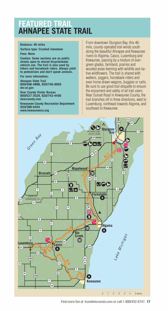
FEATURED TRAILAHNAPEE STATE TRAIL
From downtown Sturgeon Bay, this 46-mile, county-operated trail winds southalong the beautiful Ahnapee and Kewauneerivers to Algoma, Casco, Luxemburg andKewaunee, passing by a mixture of ever-green glades, farmland, prairies andwooded areas teeming with wildlife and na-tive wildflowers. The trail is shared withwalkers, joggers, horseback-riders andeven horse drawn wagons, buggies or carts.Be sure to use good trail etiquette to ensurethe enjoyment and safety of all trail users.Near Sunset Road in Kewaunee County, thetrail branches off in three directions, west toLuxemburg, northeast towards Algoma, andsoutheast to Kewaunee.
Distance: 46 miles Surface type: Crushed limestone Fees: NoneCaution: Some sections are on publicstreets open to shared bicycle/motorvehicle use. The trail is also used byhikers and horseback riders. Always yieldto pedestrians and don’t spook animals.For more information:Ahnapee State Trail800/498-4888, 920/746-9959dnr.wi.govDoor County Visitor Bureau800/527-3529, 920/743-4456doorcounty.comKewaunee County Recreation Department920/388-0444www.kewauneeco.org

18 Find more fun at travelwisconsin.com or call 1-800/432-8747.
N O R T H E A S T
Baird Creek Trail
Baird Creek Trail is divided into three areasand offers a variety of terrains from doubletrack (hikers and bikers), singletrack andhighly technical sections including rocks,roots and occasional creek crossings forthe more adventurous rider. The west sec-tion has the main parking lot and the dou-ble track for the family rides or thebeginner. A web of trails (intermediate &advanced riders) breaks off and follows thecreek. Occasionally, these trails disappearor lead riders into a creek crossing. A con-tinuous flowing ride is hard to achieve, butif you like to play, this is the spot.� For more information call 920/448-3365or visit www.greenbaywi.gov
Kewaunee County Trails
Their club name, KRANKS (Kewaunee Rid-ers Absolutely Nuts for Killer Singletrack),says it all. These trails draw riders fromnear and far to test their skills on real, nocompromise singletrack. More than 1,000volunteer hours went into building this trailsystem that takes full advantage of everyinch of the 110 feet of elevation. If you rideeach of the four color-coded loops you’llneed at least 1,000 feet of climbing in yourlegs. The elevation was created by glacialmelt water that sliced through the thickmoraine creating the bed of the KewauneeRiver. Near the trails, Bruemmer CountyPark augments the riding experience nicelywith shaded picnic areas and a chance tosoak your feet in the cool water of the river.� For more information call 800/666-8214,920/388-4822 or visit www.kewaunee.org
Mountain Bike TrailsMud Lake Trail
Mud Lake Trail offers 10 miles of steep up-hill climbs, ravines and a log bridge overwater. Part of this course is used every yearfor the WORS (Wisconsin Off Road Series).Enjoy beautiful scenery on this challengingcourse where advanced riders can honetheir skills and newer riders can choosefrom some of the easier trail segments andmix that with some of the gravel and log-ging roads. � For more information call 800/236-4386,715/365-7464 or visitwww.oneidacountywi.com
Nicolet Roche Trail
See description on facing page.
The following is a list of “constructed”or “purpose built” mountain bike trails.These trails are more challenging, spe-cially-constructed, narrow-width trailsbuilt to the trail standards of the Inter-national Mountain Bicycling Association(IMBA). They are designed to present asingletrack mountain biking experience.If you’re looking for a less technicalride, check out the list of less challeng-ing off-road trails on page 21.
1
2
3
4
See region map on page 14 for trail locations.
continued...
Nicolet Roche Trail.
HANSI JOHNSON
MOUNTAIN BIKING TIPS: Always wear a hel-met and eye protection. Control your bike;don’t ride beyond your skill level. Ride onlyon open trails; others may be illegal, andnever intentionally spook animals.

The rocks you’ll find on the Nicolet RocheTrail are not just any rocks. These mega-liths dot the forest floor and offer a highskill challenge. But, if you’re not up totackling these monsters, there are obviousbypasses available.
Beyond the boulders you’ll find shortsteep sections traversing 20 to 50 feet ofelevation. The riding here is a bit easier,even though the trail sections have nameslike Beast, Gravity Cavity and Psycho Path.The 1.5-mile Boulder Lake CampgroundTrail is great for beginners or just an easywarm-up.
0 .5 Mile1
CA
MP
GR
OU
ND
RD
FR 2
11
6
WWW
N I C O L E T
N A T I O N A L
F O R E S T
Wolf
Branch
Oconto
River
South
River
BoulderLake
Spring Lake
55
64
MARKTON RD
EASY
ST
VAN ALSTINE RD
OC
ON
TO C
O
LAN
GLA
DE
CO
Bear PawResort
Distance: 14 miles total with 13 miles ofsingletrack.Difficulty: Moderate to very difficult.Caution: The trails are two-way. Whenextreme obstacles are encounteredobvious bypasses exist. Hikers may alsouse the trails; always yield to pedestriansand don’t spook animals.For more information: Langlade County Economic DevelopmentCorporation715/623-2085langladecounty.org
Find more fun at travelwisconsin.com or call 1-800/432-8747. 19
FEATURED TRAILNICOLET ROCHE TRAIL

20 Find more fun at travelwisconsin.com or call 1-800/432-8747.
MOUNTAIN BIKE TRAILS, CONTINUED
NHAL State Forest
Over 900 lakes dot the surface of theNorthern Highland-American Legion StateForest. Within the 222,000 acre forest,you’ll find almost 40 miles of designatedbike trails and many more miles of old for-est roads that are also open to mountainbicycling. Remote and challenging trailsawait you in the Northern Highland-Ameri-can Legion State Forest and the amount ofwildlife in this is remarkable. A number ofsites along the Great Wisconsin Birdingand Nature Trails can be found within theNorthern Highland-American Legion StateForest. The forest is also famous for someof the largest trees in the Northwoods, pro-viding the necessary habitat for an excep-tionally large population of bald eagles. � For more information call 715/542-3923or visit dnr.wi.gov
Raven Trail
Located within the Northern Highland-American Legion State Forest, Raven Trailoffers a mix of intermediate and expertloops that wind through the woods andnear Inkpot and Clear Lakes. There are acouple of steep hills along the way. Loopsvary from 1.5, 2.5, 3.5 and 5 miles. � For more information call 715/542-3923or visit dnr.gov
N O R T H E A S T
Reforestation Camp Trails
The Brown County Reforestation Campmay have the only mountain bike trails inthe state where you can hear a lion growl.On a still day when the wind isn’t rustlingin the pines you could hear that and thesounds of other wild beasts. But they aren’tyour signal to shift to a higher gear andpedal faster. It’s just background noisefrom the Northeastern Wisconsin Zoo(NEW Zoo) that occupies a portion of the1,600-acre forest you’re riding in. Whilethe Camp is home to some unusualwildlife, the terrain is pretty ordinary. Thehills here carry only about 30 feet of eleva-tion. Still, the forest has long been popularwith local mountain bikers. Some, seekingmore challenge, strayed from the widecross-country ski trails where riding wasallowed. Making one’s own trail wasstrictly forbidden until dedicated riders andforest management worked out a plan for anew system of singletrack mountain biketrails. Now, riders have the choice of ped-aling the ski trails where they can rollalong and watch the scenery, or they cantake on more challenge on the narrow sin-gletrack. Either way it makes for a memo-rable ride.� For more information call 920/448-6242or visit www.co.brown.wi.us
6
75
Washburn Lake Trails.
JORDAN SCHOTZ
Find more fun at travelwisconsin.com or call 1-800/432-8747. 21
LOOKING FOR A MILDER RIDE?ANVIL NATIONAL RECREATION TRAIL715/479-2827www.fs.usda.gov
DISCOVERY CENTER TRAILS888/626-9877, 715/543-8488www.discoverycenter.net
ED’S LAKE TRAIL800/334-3387, 715/478-3450www.visitforestcounty.com
NEWPORT STATE PARK 888/947-2757, 920/854-2500visit dnr.wi.gov
PENINSULA STATE PARK TRAILS888/947-2757, 920/868-3258visit dnr.wi.gov
POTAWATOMI STATE PARK TRAILS888/947-2757, 920/746-2890dnr.wi.gov
RAZORBACK RIDGES TRAILS800/236-3649www.vilas.org
TOMAHAWK LAKE TRAIL715/795-1782www.barnes-wi.com
WORTH A STOPWa-Swa-Goning in Lac du Flambeau is are-created Ojibwe village with birchbarklodges and canoes. In Woodruff, Scheer’sLumberjack Shows features log rolling,chopping, sawing and climbing exhibitions.The Snowmobile Hall of Fame in St.Germain displays historic racing snowmo-biles, uniforms, trophies, videos and biogra-phies of its inductees.
You can view the world’s largest mechani-cal globe planetarium in Rhinelander. At 22-feet in diameter, the Kovac Planetariumdisplays all the stars in the northern hemi-sphere visible to the unaided eye.
At the Lumberjack Special SteamTrain & Camp Five Museum Complexin Laona, you can hop on a steam train andjourney back in time to an authentic 1902logging camp.
The Wild Rivers Interpretive Centerin Florence features dioramas, murals andinteractive exhibits that tell the story of thewild rivers and natural areas of FlorenceCounty.
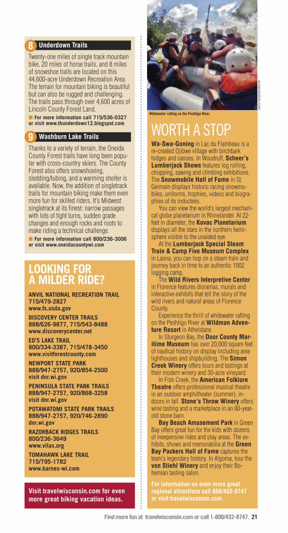
Experience the thrill of whitewater raftingon the Peshtigo River at Wildman Adven-ture Resort in Athelstane.
In Sturgeon Bay, the Door County Mar-itime Museum has over 20,000 square feetof nautical history on display including arealighthouses and shipbuilding. The SimonCreek Winery offers tours and tastings attheir modern winery and 30-acre vineyard.
In Fish Creek, the American FolkloreTheatre offers professional musical theatrein an outdoor amphitheater (summer), in-doors in fall. Stone’s Throw Winery offerswine tasting and a marketplace in an 80-year-old stone barn.
Bay Beach Amusement Park in GreenBay offers great fun for the kids with dozensof inexpensive rides and play areas. The ex-hibits, shows and memorabilia at the GreenBay Packers Hall of Fame captures theteam’s legendary history. In Algoma, tour thevon Stiehl Winery and enjoy their Bo-hemian tasting salon.
For information on even more great regional attractions call 800/432-8747 or visit travelwisconsin.com.
WILDM
AN ADVENTURE RESORT
Whitewater rafting on the Peshtigo River.
Underdown Trails
Twenty-one miles of single track mountainbike, 20 miles of horse trails, and 8 milesof snowshoe trails are located on this44,600-acre Underdown Recreation Area.The terrain for mountain biking is beautifulbut can also be rugged and challenging.The trails pass through over 4,600 acres ofLincoln County Forest Land. � For more information call 715/536-0327or visit www.thunderdown12.blogspot.com
Washburn Lake Trails
Thanks to a variety of terrain, the OneidaCounty Forest trails have long been popu-lar with cross-country skiers. The CountyForest also offers snowshoeing,sledding/tubing, and a warming shelter isavailable. Now, the addition of singletracktrails for mountain biking make them evenmore fun for skilled riders. It’s Midwestsingletrack at its finest: narrow passageswith lots of tight turns, sudden gradechanges and enough rocks and roots tomake riding a technical challenge.� For more information call 800/236-3006or visit www.oneidacountywi.com
8
9
Visit travelwisconsin.com for evenmore great biking vacation ideas.
22 Find more fun at travelwisconsin.com or call 1-800/432-8747.
0 1 2 3 Miles
RANCH RD
Twin Bridge Park
PARKWAY RD
Veteran's Falls
Paust's Woods Lake Resort
W
W
CALDRON FALLS RD
Thunder Mountain Park
THU
NDER MOUNTAIN RD
High Falls Reservoir
PAR
KW
AY RD
5.2
4.2
7.0
2.6
2.5 2.8
V
Road BikingTours
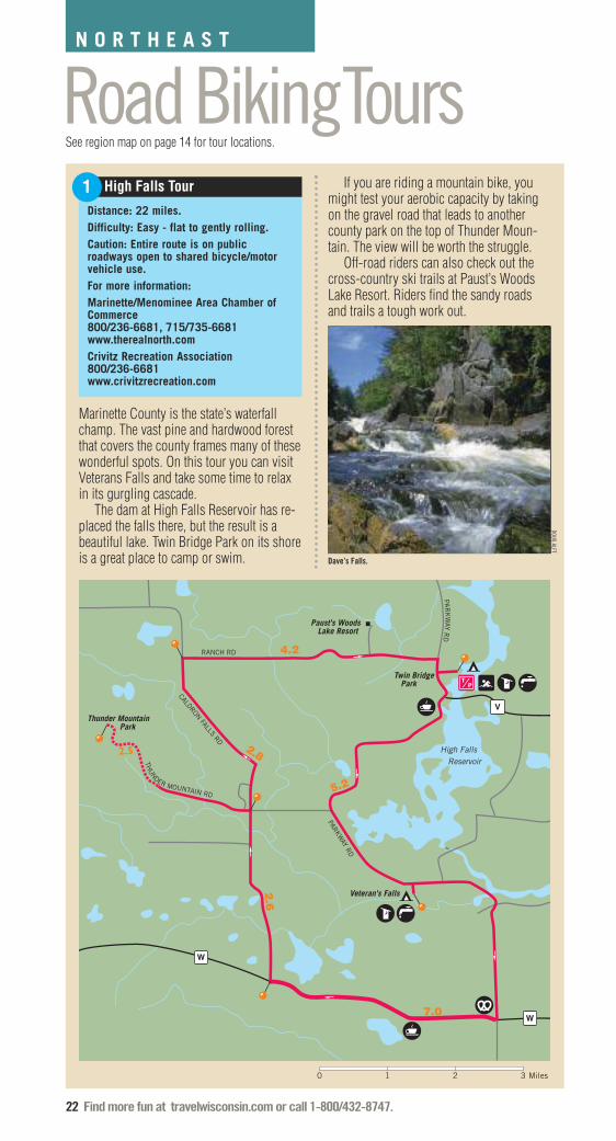
Marinette County is the state’s waterfallchamp. The vast pine and hardwood forestthat covers the county frames many of thesewonderful spots. On this tour you can visitVeterans Falls and take some time to relaxin its gurgling cascade.
The dam at High Falls Reservoir has re-placed the falls there, but the result is abeautiful lake. Twin Bridge Park on its shoreis a great place to camp or swim.
Distance: 22 miles.Difficulty: Easy - flat to gently rolling.Caution: Entire route is on publicroadways open to shared bicycle/motorvehicle use.For more information:Marinette/Menominee Area Chamber ofCommerce800/236-6681, 715/735-6681www.therealnorth.comCrivitz Recreation Association800/236-6681www.crivitzrecreation.com
High Falls Tour If you are riding a mountain bike, youmight test your aerobic capacity by takingon the gravel road that leads to anothercounty park on the top of Thunder Moun-tain. The view will be worth the struggle.
Off-road riders can also check out the cross-country ski trails at Paust’s WoodsLake Resort. Riders find the sandy roadsand trails a tough work out.
1
N O R T H E A S T
See region map on page 14 for tour locations.
DOUG ALFT
Dave’s Falls.

KangarooLake
CH
ER
RY
RD
EphraimSisterBay
Q
Fish Creek
BaileysHarborPeninsula
Center
CO
TTAG
E D
R
OR
CH
AR
D L
N
GIBRALTAR BLUFF RD
Gre
en B
ay
EE
ZZ
EE
E
A
A
F
F
F
F
Q
E
57
57
57
42
42
42
LITTLE
PENINSULA PLAYERS RD
MA
RS
H R
D
MA
PLE
RD
ME
AD
OW
RD
MEADOW RD
TOW
NLIN
E R
D
BLUFF RD
GUY ST
NORWAY RD
SH
OR
E R
D
0 1 2 3 Miles
MAIN ST
SUM
MACH
RD
BLUFF RD
GERMAN RD PENNINSULA
STATE PARK
PeninsulaPlayersTheater
Eagle BluffLighthouse Lookout
Tower6
.46.7
4.5
3.4
4.0
7.1
Find more fun at travelwisconsin.com or call 1-800/432-8747. 23
Distance: 29 miles for the outer loop; 21miles for the north loop; 15 miles for thesouth loop. All loops are on paved roads.Difficulty: Mostly easy with several steepgrades near the Green Bay shore.Caution: The entire route is on publicroadways open to shared bicycle/motorvehicle use. Be sure to use the pavedshoulder on State Highway 42 betweenPeninsula State Park and Ephraim.For more information:Door County Chamber of Commerce800/527-3529, 920/743-4456www.doorcounty.com
Shore to Shore Tour2
With 275 miles of Great Lakes shoreline,the Door County peninsula is a picturepostcard of coastal ambiance: spectacularsunsets, whitewashed lighthouses that riseabove quiet fishing villages, and thunderingwaves that wet rocky shores. There’s evenan east and west coast on the Door Countypeninsula. On a sunny afternoon you canpedal shore-to-shore; a mini-transconti-nental.
On the Lake Michigan side of the penin-sula, the landscape is harder, the windbrisker and the water bluer. Leaving thetrailhead at Baileys Harbor, you’ll cross the
northern tip of Kangaroo Lake on CountyHighway E, then jog north to PeninsulaPlayers Road for a final 3-mile roll due westto the Green Bay shore. With the first tenmiles of the tour behind you, you’ve alreadycrossed the Door County peninsula.
Rolling north along Cottage Drive, thefriendly village of Fish Creek is the south-ern gateway to 3,800-acre Peninsula StatePark. Riding the massive wooded bluffs ofShore and Bluff Roads, you’ll understandwhy the park is one of Wisconsin’s mostpopular. Along the way, Eagle Bluff Light-house north of Tennyson Bay is a greatphoto opportunity. Then, for a spectacularview of Eagle Harbor, you can stop andclimb a 100-foot observation tower.
Rolling along Eagle Harbor, the village ofEphraim looks as though it belongs onCape Cod. Here, you can stop for a roundof golf, an ice cream cone, or a sailboat tourof the harbor. Leaving the waters of GreenBay behind, you’ll continue south followingTownline Road, Meadow Road and CountyHighway F on your return trip to BaileysHarbor.
There are many reasons, on and off thebike, to slow down and relax in DoorCounty.

24 Find more fun at travelwisconsin.com or call 1-800/432-8747.
East Central
3
4
8
5
91
7
11
2
6
6
10
1
21
2
3
4
54
23
49
21
22
57
73
26
57
54
42
29
55
57
47
32
29
151
5
151
151
1
10
10
10
41
41
4
45
45
45
45
43
43
Manitowoc
Sheboygan
Fond du Lac
Appleton
Green Bay
Oshkosh
Port Washington
Waupun
WestBend
Campbellsport
ElkhartLake
KohlerPlymouthGreenbush
Kiel New
Holstien
Chilton
Brillion
Kaukauna
Denmark
Ripon
Berlin
Menasha
Neenah
Waupaca New London
Seymour
Omro
Two Rivers
Mishicot
Kewaunee
BeaverDam
Lake
Mic
h iga
n
Lake
W
inne
bago
� = Linear Bike Trails
� = Mountain Bike Trails
� = Road Biking Tours
GLENN SANDERSON

Find more fun at travelwisconsin.com or call 1-800/432-8747. 25
Linear Bike TrailsDevil’s River State Trail
This scenic rail trail in Brown and Mani-towoc counties travels through four smallcommunities while passing by a wide vari-ety of scenery including farmlands,prairies, rivers and wetlands. The trail fea-tures two dramatic railroad trestles cross-ing the Devil’s River and tributaries. Twosegments of the trail are now open – thetwo-mile segment in Brown County fromDenmark to the county line (CooperstownRoad) and a six-mile segment in Mani-towoc County from Greenstreet Road toRockwood Road.� For more information call 920/448-4466,920/683-4189 or visit dnr.wi.gov
Eisenbahn State Trail
This 25-mile, county-operated trail extendsfrom the historic city of West Bend into thescenic countryside of eastern Wisconsinpast the glacial landscape of the KettleMoraine State Forest. Built on a former railcorridor, the history of the trail is remem-bered in the title “Eisenbahn,” a Germanword for railroad. The trail passes throughthe communities of West Bend, Kewaskumand Campbellsport, ending at the villagepark in Eden. The trail is managed byWashington and Fond du Lac Counties.� For more information call 920/929-3135or visit dnr.wi.gov
Fox River State Trail
See Northeast region.
Friendship State Trail
The four-mile Friendship State Trail passesthrough woods and scenic farmland whiletraveling between the communities of For-est Junction and Brillion. The trail con-nects to the Fox River State Trail in ForestJunction.� For more information call 920/439-1008or visit dnr.wi.gov
WASHINGTON COUNTY
Eisenbahn State Trail.
continued...
1
2
3
4
Fox River State Trail.
GLENN SANDERSON

26 Find more fun at travelwisconsin.com or call 1-800/432-8747.
E A S T C E N T R A LLINEAR BIKE TRAILS, CONTINUED
Enjoy six-miles of paved lakeshore trail thatjoins the cities of Manitowoc and TwoRivers. This trail is designed for bicyclists,walkers, joggers and roller bladers and in-cludes gardens, sculptures, telescopes,parking turn outs, restroom facilities, picnicareas, and the Flora and Fauna of thelakeshore. Along the way you can visitlighthouses, restaurants, motels and giftshops. At the north end, the trail connectswith the six-mile Rawley Point Trail atNeshotah Beach in Two Rivers. The RawleyPoint trail heads north through Two Riversand into Point Beach State Forest. Thisseven-mile section utilizes city streets,limestone surfaces, and a five-mile sectionthrough the State Forest.
FEATURED TRAILMARINERS TRAILDistance: 5.5 miles Surface type: Paved asphalt. Fees: No biking fee is requiredCaution: Sections connecting theMariners Trail and the Rawley Point Trailin Two Rivers are on public streets opento shared bicycle/motor vehicle use.Hikers and in-line skaters also use thetrails; always yield to pedestrians. For more information:Manitowoc Area Visitor & ConventionBureau800/627-4896, 920/686-3070www.manitowoc.infoFriends of Mariners Trail920/684-0828www.marinerstrail.net
River
River
Twin
Twin
Little
River
East
West
Lake M
ichiga
n
310
5.5
1.1
1.5
4.3
B
B
O
V
V
VV
VV
Two Rivers
Mishicot
Shoto
Manitowoc
147
42
10
10
151
42
42
Wisconsin Maritime Museum
Manitowoc North Breakwater Light
RawleyPointLighthouse
POINT BEACHSTATE FOREST
Rawley PointTrail
Chamber of Commerce
Wayside
Mariners TrailOverlook
ManitowocMarina
Manitowoc North Breakwater Light
NeshotahPark
0 21 3 4 Miles

Find more fun at travelwisconsin.com or call 1-800/432-8747. 27
Mariners Trail
See trail description on facing page.
Mascoutin Valley State Trail
See trail description on page 28.
Newton-Blackmour State Trail
Nine miles of this new trail in northeastWisconsin are open. When completed, thetrail will run for 23 miles in OutagamieCounty. The trail name is derived from thefour communities the trail passes through:New London, Shiocton, Black Creek andSeymour. In Seymour, the Newton Black-mour State Trail connects to the DuckCreek Trail which travels east towardsGreen Bay.� For more information call 920/832-4790or visit dnr.wi.gov
EAST CENTRALURBAN BIKING OPTIONSThe following communities offer terrificurban bicycling opportunities. Most arehard surfaced, family friendly, and gen-erally traverse a given city’s most sce-nic areas. Many are recognized by theLeague of American Bicyclists as an Of-ficial Bicycle Friendly Community.
APPLETON����
www.appletonparkandrec.org
OSHKOSHwww.co.winnebago.wi.us
SHEBOYGAN COUNTY����
www.visitsheboygan.comwww.nomosheboygancounty.com
���� = Official Bicycle Friendly Community*
WORTH A STOPIn Manitowoc, the Wisconsin MaritimeMuseum features huge dioramas, a modelship gallery and a WWII submarine, the USSCobia. Cross Lake Michigan from Manitowocto Ludington aboard the Lake MichiganCarferry Service/SS Badger. The carferryruns daily late-May thru mid-October.
The Hamilton Wood Type & PrintingMuseum in Two Rivers displays 1.5 millionpieces of wooden type and type-makingequipment.
In Appleton, the History Museum atthe Castle features a large collection ofHarry Houdini memorabilia, as well as ex-hibits on local industry and history. The FoxRiver Mall is the largest shopping mall inWisconsin with 180 stores.
The Bergstrom-Mahler Museum inNeenah houses a spectacular collection ofglass paperweights and Germanic glass.
In Oshkosh, the EAA AirVenture Mu-seum features more than 80 full-size his-toric civilian and military aircraft on display,plus plane rides aboard a 1929 Ford Tri-Motor. The Paine Art Center and Gar-dens features period rooms and traveling artexhibits in a Tudor Revival mansion with sea-sonal gardens.
At the Children’s Museum of Fonddu Lac, kids can explore a world of wonderand play through imagination, climbing,building, sliding, creating and performing.
The Ledge View Nature Center inChilton is a 100-acre preserve with a naturecenter, trails, observation tower, and cavetours offered from late May-November.
In Kohler, the John Michael KohlerArts Center is nationally recognized for itscollections of folk and vernacular art. TheKohler Design Center displays their de-signer bath products displayed in imagina-tive settings.
Unwind at Aspira Spa in Elkhart Lakewhere services include specialized bodytreatments, chromatherapy and Vichy showertreatments, specialty facials, massages andother salon services.
For information on even more great regional attractions call 800/432-8747 or visit travelwisconsin.com.
KOHLER COMPANY
Kohler Design Center.
continued...
5
6
7
GLENN SANDERSON
Mariners Trail.
* See page 77.

28 Find more fun at travelwisconsin.com or call 1-800/432-8747.
E A S T C E N T R A LLINEAR BIKE TRAILS, CONTINUED
FEATURED TRAILMASCOUTIN VALLEY STATE TRAIL
Formerly Known as the Rush Lake Trail orthe Ripon to Berlin Trail, the Mascoutin Val-ley State Trail is divided into two sections,each about 10 miles. The western section(shown in the map below) travels betweenBerlin and Ripon, and the eastern sectiontravels between Rosendale and Fond duLac. The gap in the two sections, betweenRipon and Rosendale, is privately owned.The trail travels past farms, prairies andwetlands in scenic Green Lake, Winnebagoand Fond du Lac counties. Great wildlifeviewing opportunities are available in theEldorado Marsh Wildlife Area in Fond duLac County and the Rush Lake Marsh areain Winnebago County. There is even a localwinery located along the trail.
49
49
49
49
49
4923 23 23
23
44
91
91
V
V
A
V
F
F
J
A
F
V
E
E
E
AA
AA
PP
PP
FF
VV
2.5
5.3
2.6
Vines & RushesWinery
Berlin
Rush Lake
Ripon
GR
EE
N L
AK
E C
OG
RE
EN
LA
KE
CO
Rush Lake
Green Lake
WINNEBAGO CO
FOND DU LAC CO
LAKE RD
CORK ST
LOCUST RD
GRAMS RD
MEADOW BROOK RD
KO
RO
R
D
WIL
LAR
D R
D
0 21 3 Miles
Distance: 20 miles Surface type: Crushed limestone. Fees: No biking fee is required.Caution: The trail may bring a number ofdifferent users to the trail at the sametime; always yield to pedestrians. For more information:Mascoutin Valley State Traildnr.wi.gov/topic/parks/name/mascoutinFond du Lac County Parks920/929-3135www.fdlco.wi.govGreen Lake County920/294-4032www.co.green-lake.wi.usWinnebago County Parks920/232-1960www.co.winnebago.wi.us
Find more fun at travelwisconsin.com or call 1-800/432-8747. 29
Old Plank Road Trail
The Old Plank Road Trail runs west fromSheboygan roughly 17 miles to the town ofGreenbush. The terrain varies from flat togently rolling with one large climb just eastof Greenbush. Future plans will extend thetrail to the Fond du Lac County line. � For more information call 920/459-3060or visit www.sheboygancounty.com
Rawley Point Recreational Trail
The Rawley Point Recreational Trail con-nects Mariners Trail in Two Rivers withPoint Beach State Forest. The six-mile trailplunges into the cedars, hemlock, pinesand birches of the 2,900-acre Point BeachState Forest. The trail ends near the RawleyPoint Lighthouse. � For more information call 920/793-5564 orvisit www.tworiverseconomicdevelopment.org
Wild Goose State Trail
See South Central region.
Wiouwash State Trail South
Named for the four counties it passesthrough, Winnebago, Outagamie, Waupacaand Shawano, the Wiouwash State Trailconsists of two complete sections. Thenorthern segment of the trail travels 19miles between Birnamwood and SplitRock. The southern segment of the trailruns 22 miles from Hortonville toOshkosh. The southern segment hooks upwith the Friendship Trail and extends to thecity of Menasha. � For more information call 920/232-1960(Winnebago County), 920/832-4791(Outagamie County), 715/524-5165(Shawano County) or visit dnr.wi.gov
BIKINGETIQUETTEWhen riding the beautiful statetrails of Wisconsin, please be con-siderate of all trail users and followbicyclist etiquette.
� Ride single file. You can ride twoor more abreast if you will notblock other traffic. On curving orhilly trails, ride single file.
� Stay right, except to pass. Passon the left and clearly alert oth-ers.
� Always look before changing po-sitions on the trail.
� Know and respect all trail uses.
� Don’t ride on muddy trails.
� Obey traffic (and other) laws andsigns.
� Pack it in, pack it out. Pick uplitter.
8
9
10
11
LAUREEN RENAUD
Mascoutin Valley State Trail.
NICK COLLURA

30 Find more fun at travelwisconsin.com or call 1-800/432-8747.
MountainBike TrailsSee region map on page 24 for trail locations.
Calumet Park Trails
There’s some tough mountain biking onthe edge of Lake Winnebago. But you’llfind some easy riding as well in this com-pact trail package within Calumet CountyPark. It just depends on whether you’re rid-ing north/south or east/west. The trailsrunning parallel to the lake trace the easyshoreline or flat bluff top. Ride east to westand you’ll attack the steep 150-foot highNiagara Escarpment. The dictionary saysan escarpment is “a long, precipitous cliff-like ridge,” an apt description of the east-ern shore of Lake Winnebago. Formountain bikers, the meaning of escarp-ment is simple: steep climbs on grades ofbetween 10 and 20 percent. It’s easy to seewhy the park is the site of the popularCalumet Sun Run mountain bike race. � For more information call 920/849-1493or visit www.travelcalumet.com
Evergreen Park
The Evergreen Park Trail is mostly single-track and can be ridden in many differentways. Each October, it is made into a five-mile loop for the Bud Light Challenge. Thetrail on the quarry side can be wet in thespring and summer. The trail offers a nicemix of climbing and descending. The upkeepon the trail is done by the Fat Kats bike club.
Greenbush Trail
See facing page for trail description.
New Fane Trails
The New Fane Trails offer two trail systemswithin the Kettle Moraine State Forest.There are four loops of moderately-chal-lenging mountain bike trails totaling 5.5miles, interwoven with four loops of hikingtrails totaling 7.7 miles. Hikers and off-road mountain bikers share this multiple-use trail system. For safety reasons, thesetrails are use-specific: hiking is not al-lowed on the bike trails, and biking is notallowed on the hiking trails. � For more information call 262/626-2116or visit dnr.wi.gov
LOOKING FOR A MILDER RIDE?GLACIAL BLUE HILLS COUNTY PARK262/335-5080www.ci.west-bend.wi.us
HIGH CLIFF STATE PARK920/989-1106dnr.wi.gov
KOHLER ANDRAE STATE PARK888/947-2757, 920/451-4080dnr.wi.gov
POINT BEACH STATE FOREST888/947-2757, 920/794-7480dnr.wi.gov
E A S T C E N T R A L
The following is a list of “constructed”or “purpose built” mountain bike trails.These trails are more challenging, spe-cially-constructed, narrow-width trailsbuilt to the trail standards of the Inter-national Mountain Bicycling Association(IMBA). They are designed to present asingletrack mountain biking experience.If you’re looking for a less technicalride, check out the list of less challeng-ing off-road trails below.
1
2
3
4
MOUNTAIN BIKING TIPS: Always wear a hel-met and eye protection. Control your bike;don’t ride beyond your skill level. Ride onlyon open trails; others may be illegal, andnever intentionally spook animals.
PHIL VAN VALKENBERG
Kettle Moraine State Forest.

Find more fun at travelwisconsin.com or call 1-800/432-8747. 31
The Northern Unit of Wisconsin’s KettleMoraine State Forest has everything amountain biker could want – exciting ter-rain, plenty of room to expand, and a beau-tiful forest setting. All that was lacking wasa first-rate, purpose-built trail system. Nowyou’ll find that here too.
When off-road riding boomed in themid-’80s there were no restrictions; youcould ride almost anywhere on publiclands. But conflicts with other trail userssoon changed that. Bikers were restricted toonly those trails explicitly designated.Cross-country ski trails seemed to be ideal.But that concentrated throngs of riders onrelatively few miles of trail never designedto handle the impact.
IMBA (International Mountain BicyclingAssociation) guidelines were used to solvethe erosion issues with demanding designstandards and with new trail building tech-niques. In the Kettle Moraine, scores of vol-unteers and dedicated Wisconsin DNR staffpitched in. Now you can enjoy exciting,challenging riding on sustainable single-track trails without harming the environ-ment. The trails take full advantage of therelief of the famous steep-sided “kettles”that range from 20 to 70 feet deep.
Distance: 9 miles of singletrack, 4 loops.Difficulty: Easy to very difficult.Trailhead locations: On weekends, youcan use the parking area at the groupcampground shelter 2.5 miles south ofGreenbush via Cty T & Kettle MoraineDrive; or use the picnic area 0.5 milefurther at anytime.Fees: Daily or annual State Trail Pass isrequired for riders 16 and older. Self-paystations are located at trailhead parkinglots.Note: Riding on the existing 8 miles ofcross country ski trails is prohibited.Caution: The trail loops are intended forone-way travel. They cross the Ice AgeTrail used by hikers, and a horse trail.Always yield to pedestrians and don’tspook animals.For more information: Sheboygan County Convention & VisitorsBureau920/457-9495www.sheboygan.orgKettle Moraine State Forest, Northern Unit262/626-2116www.wiparks.net
U 67
K E T T L E M O R A I N E S T A T E F O R E S T
HILLTOP LANE
LittleRoundLake
Cudworth’sLake
Bear Lake Marsh
BearLake
GreenbushKettle
OpenKettle
KETT
LEM
OR
AIN
ED
R
SUMMIT RD
FOREST DR
KE
TTLE
MO
RA
INE
DR
GroupCampground
Loop 1
Loop 2
Ice
Ice
Age
Age
Trail
Trai
l
Loop 3
Loop 4
0 .25 .5 .75 1 Miles
FEATURED TRAILGREENBUSH TRAIL

32 Find more fun at travelwisconsin.com or call 1-800/432-8747.
Road BikingToursDistance: 28 milesDifficulty: ModerateCaution: Entire route is on publicroadways open to shared bicycle/motorvehicle use. Be sure to use the pavedshoulder on State Highways 32/57.For more information:Elkhart Lake Tourism Commission877/355-4278, 920/876-2385 www.elkhartlake.comManitowoc Area Visitor & ConventionBureau800/627-4896, 920/683-4388, www.manitowoc.orgSheboygan County Chamber of Commerce800/457-9497www.sheboygan.org
Elkhart Lake to Kiel Tour
Rural Wisconsin doesn’t get any prettierthan around Kiel and Elkhart Lake. A huge180-degree bend in the Sheboygan River,the vast Sheboygan Marsh and rolling Ket-tle Moraine hills are backdrops for thearea’s many prosperous dairy farms.
The cafes and parks in Kiel and ElkhartLake are attractions in their own right. Theyoffer a small town hospitality that makesthem perfect stopping places for bicyclists.The state’s tallest wooden observation towercan be found at Sheboygan Marsh Park,which also serves as a great place to startthis wonderful bike tour.
Native Americans lived on the edge ofthe Sheboygan Marsh for ten thousandyears. Their spear points and artifacts havebeen plowed-up by area farmers for genera-tions. The Henschel home farm has been inthe family for 150 years. Their fascinationwith Native American culture has endured,creating Henschel’s Indian Museum.
Your pedal through the countryside willbe a roller coaster ride over moderatelysteep hills, each just high enough for a fineview and speedy run down. Near Kiel, anold road has been turned into a bike andpedestrian trail with great views of the She-boygan River.
4.8
2.7
3.3
4.5
3.6
3.5
5.0
MM
FF
MM
EH
AA
XX
MC
NR
SR
67
5732
67
57
57
32
149
H
J
J
P
A
E
Q
ElkhartLake
RhineCenter
Kiel
Millhome
Rockville
MANITOWOC CO
SHEBOYGAN CO SHEBOYGAN COCALUMET CO COUNTY LINE RD
CLARK RD
HO
LSTE
IN R
D
SEXTON RD
SN
AK
E R
D
PLYMOU
TH TR
FOUNDRY RD
Sheboygan CountyMarsh Park
RIVER RDCITY VIEW RD
Henschel'sIndianMuseum
SHEBOYGANMARSH
KIEL MARSHSTATE WILDLIFE AREA
ElkhartLake
HIG
HVI
EW
RD
LAX CHAPEL RD
KEYSTONE RD
ROCKVILLE RD
S
heb
oyga
n L
ake
0 21 3 Miles
E A S T C E N T R A L
1
See region map on page 24 for tour locations.

Find more fun at travelwisconsin.com or call 1-800/432-8747. 33
Distance: 28 milesDifficulty: EasyCaution: The entire route is on publicroadways open to shared bicycle/motorvehicle use. For more information: Manitowoc Area Visitor & ConventionBureau800/627-4896www.manitowoc.infoThe Chamber of Manitowoc County866/727-5575, 920/684-5575www.chambermanitowoccounty.com
Two Rivers Tour
Great bicycling, lots of attractions and a ter-rific shoreline make a trip to the TwoRivers/Manitowoc area a biker’s delight.
The vast expanse of Lake Michigan isthe star attraction at Point Beach State For-est. Five miles of sandy beach and wind-blown dunes follow the curve of the point.Head south from the Point Beach trailheadon County Highway O – a true back roadgem. Indeed, the first five miles of CountyHighway O have been designated as Rustic
Road R-16. The paved Mariners RecreationTrail connects Point Beach with Two Rivers.On the south side of town, the trail followsthe beach nearly all the way to Manitowoc.
Two Rivers and Manitowoc are treasuretroves of services and attractions. You’llleave Two Rivers via Riverview Drive wherehomes line the steep bank of the East TwinRiver. On County VV there’s a great view ofa sharp river bend before you scoot cross-country to a rendezvous with the West TwinRiver at the little village of Shoto.
Five miles to the north, an easy roll overgentle farm terrain brings you to Mishicot.Leaving Mishicot, the hilliest part of thetour lies ahead. The hard work is short-lived though; after crossing the valley of theEast Twin River you’re back in easy ridingfarm country. Turning east, the steel-bluehorizon of Lake Michigan comes into view.To complete the tour, swing south onLakeshore Road past the Rahr MemorialForest and back to the trailhead at PointBeach.
River
River
Twin
Twin
Little
River
River
East
West
Manitowoc
310
R
R
B
O
V
V
VV
VV
RIVERVIEW DR
5.7
4.8
7.3
2.3
1.3
6.6
Two Rivers
Mishicot
Shoto
Manitowoc
163
147
147
42
43
43
43
43
10
10
10
10
151
151
42
42
42
42
Wisconsin Maritime Museum
Mishicot Historical Museum
Manitowoc North Breakwater Light
RawleyPointLighthouse
JACKSON ST
RANDOLPH ST
NUCLEAR RD LAKESH
ORE
RD
POINT BEACHSTATE FOREST
RahrMemorial Forest
MarinersTrail
MarinersTrail
MarinersTrail
Lake
Mic
higa
n
0 1 2 3 Miles
2

34 Find more fun at travelwisconsin.com or call 1-800/432-8747.
Central
64
64
64
54
8054
6
8056 58
82
82
27
29
73
73
73
13
54
23
49
49
66
21 21
22
22
2333
16
16
73
73
33
33
26
13
13
55
57
47
32
29
32
32
17
55
47
161
8
51
51
151
151
1
1
14
14
51
12
12
12
10
10
10
41
41
4
45
45
45
45
141
1
45
90
90
39
39
39
94
94
7
3
4
1
26
85
2
1
1
2
5
6
3
4
Win
neba
go
La
ke
WisconsinDells
Fond du Lac
Appleton
Oshkosh
GreenBay
Stevens Point
Wausau
Elroy
Viroqua
PortageWaupun
Montello
Westfield Princeton
Marquette
Ripon
Green Lake
Berlin
WautomaColoma
RomeWild Rose
Redgranite
Plainfield
Weyauwega Fremont
Waupaca
AmherstIola
PloverNew London
ClintonvilleMarionRosholt
Pulaski
Bonduel
SchofieldWeston
RothschildMosinee
ElderonWittenberg
Bowler KeshenaBirnamwood
Aniwa
Antigo
BabcockWisconsin Rapids
Nekoosa
Pittsville
Marshfield
SpencerLoyal
Unity
Abbotsford
Colby
OwenThorp Withee
Sparta Tomah
BlackRiver Falls
Neillsville
BarabooReedsburg
UnionCenter
HillsboroWonewoc
NewLisbon
CampDouglas
Mauston
AdamsFriendship
ArkdaleNecedah
Merrill
Shawano
Wisc
onsin
River
BeaverDam
� = Linear Bike Trails
� = Mountain Bike Trails
� = Road Biking Tours
WISCONSIN BIKE FED

Find more fun at travelwisconsin.com or call 1-800/432-8747. 35
LinearBike Trails1. 400 State Trail
The entire 22 miles of the 400 State Trailfollows the Baraboo River valley from Elroyto Reedsburg. The trail is named for theChicago-Northwestern passenger train thatonce operated on this grade. The train trav-eled the 400 miles between Chicago andMinneapolis/St. Paul in 400 minutes. Therenovated Reedsburg Depot is the trailheadquarters and the office for the Reeds-burg Chamber of Commerce. The traillinks to the Elroy-Sparta State Trail at ElroyCommons on the west end and to theHillsboro State Trail in Union Center. Adaily or annual State Trail Pass is requiredfor riders 16 and older.� For more information call 800/844-3507or visit dnr.wi.gov
Elroy-Sparta State Trail
See Southwest region.
Green Circle State Trail
Encircling the city of Stevens Point, thistrail meanders along the scenic Wisconsinand Plover rivers recalling the history ofthe lumber-making and pioneer settle-ments of the area while connecting se-cluded natural and wildlife areas, theSchmeeckle Reserve and many city parks.The trail, including all spurs, is 31 mileslong and features river scenery, forests,wetlands, prairies, boardwalks and quietneighborhoods. A one-way spur in Ploverconnects to the Tomorrow River State Trail.� For more information call 715/346-4992or visit www.greencircletrail.org
WORTH A STOPIn Waupaca, take a lake cruise aboard asternwheeler or motor launch “Lady of theLakes” at Clear Water Harbor/ChiefWaupaca.
You can enjoy the latest high-tech slotmachines and more than 500 slot games atHo-Chunk Gaming in Wittenberg, or tryyour luck at blackjack, slots and bingo atMohican North Star Casino & Bingo inBowler.
The Menominee Logging Museum inKeshena has the largest collection of loggingartifacts in the world.
Wausau’s Leigh Yawkey Woodson ArtMuseum exhibits its collections of art of thenatural world, with an emphasis on birds.The 1,172-acre Rib Mountain State Parkoffers hiking, picnicking and spectacular sce-nic overlooks.
The Stevens Point Brewery offerstours and tastings at the nation’s 5th oldest,continuously operated brewery.
In Marshfield, Jurustic Park features awhimsical array of junkyard creatures andjewelry shop.
The Rudolph Grotto Gardens & Won-der Cave features floral walkways and gar-dens, as well as folk-art memorials, shrinesand a museum.
In Neillsville, the 146-acre HighgroundVeterans Memorial Park honors veteransand their families. The park includes fourmiles of hiking trails, picnic areas and shel-ters and overlooks 500,000 woodland acres.
The 44,000-acre Necedah NationalWildlife Refuge is home to sandhillcranes, migrating waterfowl, wild turkeys, ea-gles, shorebirds and songbirds as well as theworld’s largest population of endangeredKarner blue butterflies.
At Escapade Lake Cruises in GreenLake, you can tour the lake aboard a 60-footcatamaran-style vessel.
Take a tour of the Wild Rose FishHatchery. The cold-water hatchery pro-duces trout, salmon, northern pike, lake stur-geon and musky.
For information on even more great regional attractions call 800/432-8747 or visit travelwisconsin.com.
STEVENS POINT BREWERY
Stevens Point Brewery.
continued...
1
2
3
WISCONSIN STATE PARKS
The 400 State Trail.

36 Find more fun at travelwisconsin.com or call 1-800/432-8747.
C E N T R A LBIKE TRAILS, CONTINUED
N
N
D
D
Y
J
D
X
X
JJ
39
39
153
153153
29
29
49
49
66
49
29
110
51
51
Schofield
Wausau
Ringle HatleyNorrie
Eland
Elderon
Galloway
Bevent
Shepley
Tigerton
Mario
Clin
BigFalls
Birnamwood
Lyndhur
Neopit
Wis
cons
in
Rive
r
6.54.5
3.52.8
6.0 5.8 8.4
45
45
10
10
Q
Q
Q D
J
J
A
D
G
M
Q
M
M
J
P
C C
G
E
Museum of theMohican Nation
STOCKBRIDGE INDIAN RESER
C
Y
J
J
I
C
Bowler
WiouwashTrail
Rib MountainState Park
PORTAGE CO
MARATHON CO
WAUPACA CO
SHAWANO CO
MENOMINEE CO
Rosholt
Wittenberg
FEATURED TRAILMOUNTAIN BAY STATE TRAILDistance: 83 miles Surface type: Crushed limestone with ashort asphalt paved section in Shawano.Fees: A daily or annual State Trail Pass isrequired for ages 16 and over.Caution: Make a complete stop at all roadcrossings. Hikers also use the trail.Always yield to pedestrians. For more information:Wisconsin State Parks System920/448-4466dnr.wi.govBrown County Parks Department920/448-4466www.co.brown.wi.usShawano County Parks Department715/526-5216 www.co.shawano.wi.usMarathon County Parks, Recreation andForestry715/261-1550www.co.marathon.wi.us
The Mountain-Bay State Trail is one of thelongest rail-trails in Wisconsin. The trailtravels for 83 miles between the two geo-logic features it is named for; Rib Mountainand Green Bay. On the western end, the trailends in Weston, just east of Wausau. On theeastern end, the trail ends at Howard Me-morial Park near the city of Green Bay.
There is a short gap in the trail in the city ofShawano near the Wolf River, where localroads are utilized.
The trail is operated and maintained byMarathon, Shawano and Brown counties. Itpasses through several small communitiesand a wide variety of landscapes includingfarmlands, forests and wetlands, and fea-tures numerous bridge crossings overrivers and streams. In Eland, the Mountain-Bay State Trail connects to the northernsegment of the Wiouwash State Trail. Adaily or annual State Trail Pass is requiredfor riders 16 and older.
RJ & LINDA MILLER
Mountain Bay State Trail.

Find more fun at travelwisconsin.com or call 1-800/432-8747. 37
29
29
29
2932
22
22
22
32
47
47
47
117
55
156
156
187
156
55
47
47
55
55
22on
Embarrass
ntonville
rstGresham
Shawano
Keshena
t
10.9
1.9
Wol
fR
iver
GR
V
KG
B
A
H
A
M
U
MD
Legend Lake
VATION
MENOMINEEINDIAN
RESERVATION
4341
41
41
141
141
141
ShawanoLake
47
OUTAGAMIE CO OUTAGAMIE CO
WAUPACA CO
SHAWANO CO
BROWN CO
OCONTO CO
32
Anston
Pulaski
ZachowBonduel
CecilThornton
Gillett
Lena
Oconto Falls
H
VV
E
C
C
C
F
S
E
D
S
I
B
M
U
Howard
Green Bay
Gre
en B
ay
60 2 Miles84 10
CENTRALURBAN BIKING OPTIONSThe following communities offer terrificurban bicycling opportunities. Most arehard surfaced, family friendly, and gen-erally traverse a given city’s most sce-nic areas. Many are recognized by theLeague of American Bicyclists as an Of-ficial Bicycle Friendly Community.
GREEN LAKE visitgreenlake.com
STEVENS POINT����
www.stevenspointarea.com
WAUSAUwww.bicyclewausau.org
���� = Official Bicycle Friendly Community*
Mascoutin Valley State Trail
See East Central region.
Mountain-Bay State Trail
See trail description on facing page.
Omaha Trail
This 13-mile trail runs south from CampDouglas to Elroy. At nearby Mill Bluff StatePark you’ll have the opportunity to get upclose and personal with the park’s signa-ture towering sandstone bluffs. The trailruns south to Elroy where it joins theElroy-Sparta and “400” State Trails. On theway, you’ll visit the quaint village of Hus-tler, then roll through a short tunnel, theonly other trail tunnel in the state besidesthose on the Elroy-Sparta and Badger StateTrails. � For more information call 608/847-9389or visit www.trailsfromrails.com
Tomorrow River State Trail
This 29-mile rail trail travels through sce-nic glacial terrain and farm country fromPlover in Portage County to just outsidethe village of Manawa in Waupaca County.The western end of the trail connects to theGreen Circle State Trail in Plover. There isa short one-mile gap in the trail in AmherstJunction, and trail users will need to use
local roads as the trail route. The easternterminus of the trail in Waupaca Countyends at Wolf Road. Users will need to uselocal roads for about .5 miles between thetrail and the village of Manawa. A daily orannual State Trail Pass is required for rid-ers 16 and older.� For more information call 715/346-1433(Portage County), 715/258-6243 (WaupacaCounty) or visit dnr.wi.gov
11 Wiouwash State Trail
See East Central region.
6
7
8
4
5
* See page 77.

38 Find more fun at travelwisconsin.com or call 1-800/432-8747.
Mountain Bike TrailsSee region map on page 34 for trail locations.
Big Eau Pleine Park
There over ten miles of winding singletracktrails available at this expansive, 2,050acre park. The trails are all granite basedand shared with hikers and horses. Thepark is located just 15 minutes southwestof Mosinee. A large parking lot is availableacross from the park manager’s office andserves as the trailhead. Frequent wildlifesightings can be found on the trails thatmeander through hardwoods along withscenic views of the Big Eau PleineFlowage. The trails are maintained by thelocal IMBA chapter, Central Wisconsin OffRoad Cycling Coalition.� For more information call 715/261-1550or visit www.co.marathon.wi.us
Hartman Creek State Park
There are currently six miles of fully-benched, IMBA approved singletrack trailsat Hartman Creek State Park. The trails in-clude a beginner and intermediate loop.The green loop is the easiest of the loopswith smaller hills and lower grades, butstill offers plenty of twists and turns to mixthings up. The blue and black loops areaccessible from the green and a bit morechallenging, with longer climbs and fasterdownhill sections. There are two new tech-nical man-made features on the black loop,a double teeter totter and dragon’s back, aroller coaster bridge. Both features offerbypasses. The blue and black loops featurea number of log jumps. There are also an-other six miles of doubletrack if you care totack on a few extra miles of riding. Thetrails are maintained by state park person-nel. Bikers age 16 and older must have adaily or annual state trail pass to use trailswithin the park.� For more information call 715/258-2372or visit dnr.wi.gov
Levis Mound Trails
See trail description on facing page.
C E N T R A L
The following is a list of “constructed”or “purpose built” mountain biketrails. These trails are more challeng-ing, specially-constructed, narrow-width trails built to the trail standardsof the International Mountain Bicy-cling Association (IMBA). They are designed to present a singletrackmountain biking experience.
1
2
3
DAVE SCHLABOWSKE
Levis Trow Trails.

Find more fun at travelwisconsin.com or call 1-800/432-8747. 39
FEATURED TRAILLEVIS MOUND TRAILS
Whether you circle Levis and Trow moundsor go over them, you’re in for some terrificoff-road riding and gorgeous scenery onthe 9.4 miles of singletrack trails. Themounds are called nunataks – islands ris-ing above a sea of glacial ice. The 200-footsandstone crags jut up from the rolling for-est floor. On the extreme singletrack, youride right under them in places. With trail
Distance: 10 miles of doubletrack cross-country ski trails, 16 miles of singletrack.Difficulty: Easy to extreme; difficultsections can be avoided.Surface type: Grassy cross-country skitrails with frequent sandy sections andsome steep rocky stretches. Hardpack orsandy forest floor with rocks and roots onthe singletrack.Fees: Daily or annual trail pass isrequired.Caution: Hikers may also use the trails;always yield to pedestrians and don’tspook animals.For more information: Clark County Forestry & Parks715/743-5140 www.co.clark.wi.us
names like Select Cut, Dead Turkey and PileDriver, you can expect some pretty intenseriding. Toad Road is a favorite. It is de-manding, but incredibly beautiful as itwinds along the face of a sandstone cliff.It’s the perfect place to snap a photo thatwill make your friends ask, “You really rodethat?” For a tough combination, link ToadRoad, Pile Driver and Switchback into aloop. If you’ve got the appetite for a secondlap, you’re really in super shape. For someeasier singletrack riding, head for the lowland between the two mounds.The side-hillsingletrack is usually soft with manyswitchbacks. Keep track of how often youhave to put a foot down if you can countthat high.
ROUSE RD
TRO
W R
DFIS
HE
R A
VE
95
J
Warm Up
EastLevis
CoyoteCutoff
Moundbounder
TROWMOUNDS
LEV ISMOUNDS
Moundbounder
Moundbounder
Secret Trail
YellowJacket
UpperHermosa
LowerHermosa
YellowJacket
YellowJacket
Flatlander
Loppet
RGSTrail
OakIsland
WestLevis
Select Cut
TrowTrail
JackrabbitDraw
TestTrack
PineRun
PineRun
Lucy’sLoop
LowerGlen
SwampCut
BadBear
BadBear
TheRock
B
A
0
1000
1100
1200
1400
1300
1000
1100
1200
1400
1300
0.25 0.5 0.75 1 1.25 1.5
Distance in Miles
EXTREME SINGLE TRACK
Ele
va
tio
n in
Fe
et
A
B

40 Find more fun at travelwisconsin.com or call 1-800/432-8747.
MOUNTAIN BIKE TRAILS, CONTINUED
Nine Mile Forest Trail
See trail description on facing page.
Nordic Mountain
Nordic Mountain has eight miles of moun-tain bike trails covering almost every inchof their 104 acres. In some spots, the trailsare very technical, while other sections aresuper fast. The climbs can be tough, butoverall, the trails provide a nice mix of rid-ing. From a world-class cross countrycourse to numerous downhill and freeridelines, Nordic Mountain is fast becoming afavorite mountain biking destination. Thebest part is, the trails are free and alwaysopen. For the past few years, NordicMountain has hosted the Subaru Cup ProXCT. The course they use is technical andvery challenging, but everyone has the op-portunity to ride the very same track thatOlympic level riders compete on.� For more information call 800/253-7266,920/787-3324 or visitwww.nordicmountain.com
Standing Rocks Trail
The trails at this Portage County park haveattracted cross-country and downhillskiers to its slopes and trails for years. Thestanding rocks are huge glacial erratics,granite boulders rolled here by the conti-nental ice sheet. You’ll find enough of theirsmaller brothers in the trail’s surface tomake for a challenging ride in places. Ap-proximately 10 miles of cross-country skitrails are open for mountain biking, and in2003, over 13 miles of well-marked single-track was added. The trails are seldom thesame grade for more than a few yards.There are plenty of climbs, roots, androcks that wind throughout the park thatwill keep you shifting and anticipating thenext steep climb or downhill. There is a lotof moderate riding here, but the periodicsteep stuff is unforgettable. Two long 100-foot climbs are tests of aerobic capacityand willpower. Your effort will take you ona roller coaster ride through a beautiful for-est of red pine, aspen and oak. The view ofBear Lake from the top of the ski hill isthrilling. The trails are open daily fromMay 1 to November 16. � For more information call 715/346-1433or visit www.co.portage.wi.us
C E N T R A L
6
4
5
MOUNTAIN BIKING TIPS: Always wear a hel-met and eye protection. Control your bike;don’t ride beyond your skill level. Ride onlyon open trails; others may be illegal, andnever intentionally spook animals.
WINTER FAT BIKING
Exploring the state on twowheels is a great way to see the distinct beauty ofWisconsin’s four seasons.
In the winter months, the appear-ance of snow doesn’t slow the bik-ing fun, but rather adds to it! Notonly are bikes ridden as year roundtransportation by many in citiessuch as Madison and Milwaukee,but biking is also a growing recre-ational sport during Wisconsin’swinter months.
Plowed city streets are not theonly place for bicyclists to ridewhen snow covers the state. “Fatbiking” as it is called, or riding bi-cycles with wider tires on ap-proved snow-covered trails forrecreation is a growingly popularsport in Wisconsin. Whether ridingprofessionally groomed trails,frozen lakes, or less packed downpowder, fat bikes have extendedthe biking season for enthusiastsand added a whole new twist forthose who enjoy Wisconsin’s ex-pansive offerings of biking trailsand routes.
Out of this newly popular sporthas spawned a number of newclubs, events and races in Wiscon-sin for those wishing to get in-volved with others who share theirpassion. For more informationabout where to get started, checkout wisfatbikeracing.com, greatlakesfatbikeseries.com, fatbikebirkie.com, and fat-bike.com/tag/wisconsin forcomprehensive information aboutthe sport. Please check with thelocal biking sources to make surethat you are riding on approvedtrails.
WISCONSIN BIKE FED

Find more fun at travelwisconsin.com or call 1-800/432-8747. 41
Distance: 19.6 miles of cross-country skitrails, and 11.6 miles of singletracktrails.Difficulty: Easy to extreme.Fees: $2 daily donation. Use the self-paystation at the trailhead.Caution: Hikers also use the trails.Hunting is allowed in season, so portionsof the trail system may be closed. NineMile is a managed forest; you mayencounter active logging in places.Always yield to pedestrians and don’tspook animals.For more information: Wausau-Central Wisconsin CVB888/948-4748www.visitwausau.com
Nine MileSwamp
RE
D B
UD
RD
NINE MILE FOREST
RECREATION AREA
WhiteKnuckle
Outbound
K-Bypass
Ho-Chi Minh
ChainSmoker
Root Canal
Up Nort
IckyThump
ThePines
Yang
StoneSoup
Yin
Flower
Super G BearBones
Stinger
South Loop
West Loop
East Loop
The trails at Nine Mile Forest have been fa-vorites of cross-country skiers for decades.Mountain bikers love this easy-to-get-totrail system too; great riding smack in themiddle of the state and just a few miles offI-39. Over the years, local enthusiasts havelaid out nearly a dozen miles of singletracktrail adding even more fun. Eleven loops ofsingletrack offer riding from mild to wild.
The wide cross-country ski trails are greatfor high speed cruising, sight seeing, or atough aerobic workout. Singletrack trailsaren’t for bird watching, but the skill andconcentration they require make them funand challenging. The farther south you go,the steeper the slopes become. There theski trails and singletrack snake over thesides of a steep, 140-foot-high ridge;enough elevation to get anyone’s heartpumping. If you haven’t tried singletrackriding, Trail 4 is a good place to start. Twist-ing through the deep pine, oak and birchforest, the trail keeps your speed low. It’schallenging, but not too hard. If you ventureonto connecting Trail 5, you’ll begin to ex-perience some of Nine Mile’s signature ob-stacles; low berms and log piles to test yourbike handling skill. Riding the higher-num-bered trails, you’ll find greater elevationchanges, narrower passages between trees,and rocks and roots on the trail.
FEATURED TRAILNINE MILE FOREST TRAIL

42 Find more fun at travelwisconsin.com or call 1-800/432-8747.
Road BikingToursDistance: 24 miles for the outer loop, 14miles for the east loop, and 18 miles forthe west loop.Difficulty: Easy to moderate – some steephills on the west loop.Caution: The entire route is on publicroadways open to shared bicycle/motorvehicle use. Be sure to use the pavedshoulder on County Highway QQ.For more information: Waupaca Area Chamber of Commerce888/417-4040, 715/258-7343www.waupacamemories.comHartman Creek State Park715/258-2372dnr.wi.gov/topic/parks/name/hartman
Chain O’ Lakes Tour
PO
RTA
GE
CO
WA
UP
AC
A C
O
HARTMAN CREEKSTATE PARK
WHISPE
RIN
G P
IN
ES
Chai
n
O’
Lakes
54
10
D
DK
22
D
Q
K
Q
TT
2.3
2.0
3.0
3.8
2.5
0.7
1.3
1.3
1.8
2.5
0.61.4
STRATTON LAKE RD
GOLKE RDEDMINSTER RD
RU
RAL R
D
RURAL RD
SMITH RD
RUSTIC ROAD #24
RUSTIC ROAD #23
HARTM
AN R
D
BADGER DR
D
EMMONS CREEK RD
FOUNTAIN LAKE RD
OAKDALE DR King
Rural
GRANDVIEW RD
16
TH R
D Parfreyville
0 2 3 Miles1
This central Wisconsin road tour is a de-lightful roll through Waupaca’s popularChain O’ Lakes area on a pair of rusticroads, designated roads that are protectedfrom development. You’ll be glad they arewhen riding Rural Road (R-23) and Em-mons Creek Road (R-24).
Leaving the Hartman Creek parking lot,head east or right onto Windfeldt lane (theroad adjacent to this lot) until you reach thebeach parking lot. Continue until you re-connect with the bike trail. This trail willlead you back out to Rural Road. Continuesoutheast and you’ll cross the meanderingCrystal River twice on quaint stone bridgesbefore turning northeast on WhisperingPines Road. Here the wind whistles in the
tall pines as the route winds along the northshore of the Chain O’ Lakes. Follow Grand-view Road along the Chain’s south shore toKing, a pleasant little village with a realtourism flavor. You’ll enjoy a string of bou-tique gift shops, as well as several goodrestaurants.
You’ll roll south from King on CountyHighway QQ and Smith Road to sleepy Par-freyville. Turning west, simple Greek Re-vival and Italianate Victorian homes mixwith woods and fields along Rural Road.You’ll pass the Village of Rural, an historiccrossroads town with several 1840s homesand the picturesque Crystal River Inn Bed &Breakfast.
Rolling west, you can stay on Rural Roadto complete the short loop, or you can optto extend your ride by taking the tour’s sec-ond rustic road, Emmons Creek Road (R-24). Here, the route plunges into a forestcanopy adjacent to a wildlife preserve. Coolfragrant air from the dense pine and hard-wood forest flows over the road. You’llcross a babbling trout steam along the way.Keep in mind that the westernmost mile hasa gravel surface.
At Stratton Lake Road, you’ll segue toFountain Lake Road, a favorite for its twist-ing downhill run through the woods. Turn-ing north on County Highway TT, then easton Edminster Road brings you back to Hart-man Creek State Park. The Hartman Lakebeach is a great place to end your ride.
C E N T R A L
1
See region map on page 34 for tour locations.

Find more fun at travelwisconsin.com or call 1-800/432-8747. 43
Distance: 30 milesDifficulty: EasyCaution: The entire route is on publicroadways open to shared bicycle/motorvehicle use.For more information:Waushara Area Chamber of Commerce920/787-3488www.wausharachamber.com
With it’s scenic, easy riding on quiet backroads, the Covered Bridge Tour is whatWaushara County is all about. There areonly a handful of unpaved roads in the en-tire county, so riding anywhere is fine. Thepicturesque village of Wild Rose with itscafes and Roberts Park on the scenicmillpond makes a great trailhead.
Covering gently rolling terrain and well-paved roads, the Covered Bridge Tour paysseveral visits to the Pine River, the area’sClass A trout stream. The stretch along 19thDrive is particularly lovely. Any of the roadsare great places for spotting pheasants,deer, fox and a myriad of songbirds.
As you approach Saxeville, you’ll pedalthrough the romantic light and shadow of acovered bridge over the Pine River. Whenthe old bridge needed rebuilding, publicfunds would only provide a nondescript re-placement. So local people volunteeredtheir time, skills and money to build thismore appropriate reminder of the past.
The tiny village of Saxeville is a popularstop for pie at the local café or supplies atits country store that looks little differentthan it did 100 years ago. Just outside Sax-eville, you’ll pedal along quiet 26th Road,(Rustic Road 48), that brushes the PineRiver and curves around the rolling hills ofthe area’s ground moraine.
10.3
8.4
4.7
6.9
0 1.5 1.5 Miles2
A
A
H
W
W
W
W
W
H
H
G
G
O
WW
MM
EE
TT
K
P
K
K
K
Pine
River
18TH
RD
19
TH22
22
WildRose
GilbertLake
LongLake
PineLake
AA
RobertsPark
MAIN
STRIVER
AVE
BADGER AVE
BEECHNUT RD BEECHNUT AVE
26TH RD
RUSTIC RD
24TH
LN
PORTAGE RD
APACHE AVE
ANIWA RD
23
RD
RD
25TH
RD
19
TH D
R
21
ST AV
20
TH AV
GILBERT
CTALP
ALPRD
LAKE RD
BADGER
22ND
AVE
BADGER AVE
ARCHER LN
21
ST
DR
CT
SaxevilleCoveredBridge
Kusel Lake County Park
Mt. Morris County Park
RJ & LINDA MILLER
Saxeville Covered Bridge.
In the middle of this 30-mile loop isKusel County Park, a nice side trip on a hotday when a relaxing dip in a clean lake is awelcome break from pedaling. Nearby Mt.Morris County Park offers a grand overviewof the area’s lakes, forests and farms. Youcan hike to the top of this 250-foot remnantof Magnesian limestone that the great con-tinental glacier could not subdue.
That’s the same glacier that made therest of Waushara County such wonderfulriding terrain.
Wild Rose Covered Bridge Tour2

44 Find more fun at travelwisconsin.com or call 1-800/432-8747.
Southwest
35
4
1
2
72
85
93
54
8054
35
35
56
27
81
80
80
8056 58
82
82
11
8
35
35
73
73
95
13
21
23
23
33
71
16
6
73
60
7823
69
13
63
51
51
151
1
18
18
18
18
61
61
61
151
1
14
14
14
14
61 53
63
63
20
63
52
52
52
61
61
10
10
10
12
12
12
10
90
90
39
39
94
94
90
Monroe
Prairiedu Chien
WisconsinDells
Stevens Point
Eau Claire
Dubuque
Cuba City
HazelGreen
Dickeyville
Belmont
Mineral Point
Cassville Potosi
LancasterBeetown
PlattevilleDarlington
Dodgeville
Fennimore
Boscobel
Bridgeport
MuscodaWauzeka
De SotoReadstown
LaFargeViola
Elroy
RocktonGenoaStoddard
Viroqua
Westby
CoonValley
Richland Center
SpringGreen
LoneRock
R
Wisconsin Rapids
Marshfield
OnalaskaWestSalem
Galesville
Sparta Tomah
Warrens
BlackRiver Falls
Hixton
Merrillan
Blair
Osseo
Winona
FountainCity
Alma
Trempealeau
Independence
Arcadia
Whitehall
La Crescent
NelsonPepinStockholmRed Wing
Wabasha
Prescott
Durand
MondoviEleva
Fairchild
Neillsville
Reedsburg
Hillsboro
Ontario
WiltonCashton
Mauston
Waterloo
Rochester
M I N N E S O T A
I O W A
River
Wisconsin
Mississippi
River
PORT
MA
1
47
6
8
5
1
2
Gotham
La Crosse
2
3
� = Linear Bike Trails
� = Mountain Bike Trails
� = Road Biking Tours
WISCONSIN BIKE FED

Great River State Trail
The 24-mile Great River State Trail travelsthrough the prairies and backwaters of theupper Mississippi River valley. Built on anabandoned Chicago-Northwestern railroadline, the trail has a finely crushed lime-stone surface suitable for walking and bi-cycling for much of the year andsnowmobiling, cross-country skiing andsnowshoeing in winter. The Great Rivertrail is within a larger area called the Mis-sissippi Flyway and passes through twoNational Wildlife Refuges. The trail is inWisconsin’s scenic Coulee Region, part ofthe Driftless Area that was untouched byglaciers during the last Ice Age. Visitors tothe Great River trail will enjoy the changingwetlands of the Mississippi River backwa-ters, 500-foot bluffs, hardwood forests,unique sand prairies and oak savannahs.The Great River Trail Prairie and the Mid-way Railroad Prairie are state natural areaswith direct access from the trail. The traillinks to the La Crosse River State Trail viaa short road route in the city of La Crosse.A daily or annual State Trail Pass is re-quired for riders 16 and older.� For more information call 608/534-6409or visit dnr.wi.gov
Find more fun at travelwisconsin.com or call 1-800/432-8747. 45
Linear Bike TrailsBuffalo River State Trail
This trail in west-central Wisconsin followsthe scenic Buffalo River valley for 36 milesbetween Mondovi and Fairchild. EarlyFrench explorers called the river Riviere deBeeufs for the many bison that once inhab-ited the area. The trail is built on a formerrailroad corridor and passes by farmlands,woods, hills and wetlands. A daily or an-nual State Trail Pass is required for riders16 and older.� For more information call 608/534-6409or visit dnr.wi.gov
2 Chippewa River State Trail
See Northwest region.
Coon Prairie Trail
The new Coon Prairie Trail is a five-mile,multiuse path that was part of a recentfour-lane highway expansion project. Theasphalt-paved path connects the commu-nities of Viroqua and Westby. WaysidePark is located about halfway between thetwo communities.� For more information call 608/637-5485or visit www.vernoncounty.org
Elroy-Sparta State Trail
See trail description on page 46.
1
2
3
5
RJ & LINDA MILLER
Great River State Trail.
continued...
4

46 Find more fun at travelwisconsin.com or call 1-800/432-8747.
S O U T H W E S TLINEAR BIKE TRAILS, CONTINUED
5.4
13.0T
TAA
A
P
90
Z
M
Z
V
U
M
Norwalk
Wilton
Sparta
Tunnel No. 3
FORT MCCOY
MILITARY
Tunnel No. 2
Tunnel TrailCampground
SpartaDepot
IGLOO RD
River
Riv
er
Kickapoo
La Crosse
27
16
21
27
71
MM
131
131
16
RESERVATION
X
X
F
U
U
U
Melvina
Cashton
33
33
F T
P
Ontario
131
XU
FEATURED TRAILELROY-SPARTA STATE TRAILDistance: 32.5 miles one-way betweenElroy Commons and the Sparta Depot.Surface type: Crushed limestone.Fees: A daily or annual State Trail Pass isrequired for ages 16 and older.Caution: Dismount and walk bikes throughthe tunnels. The tunnels are always cooland sometimes wet; windbreakers,flashlights and caps are recommended. Ashort section near Sparta is open toshared bicycle/motor vehicle use. Hikersalso use the trail; always yield topedestrians.For more information: Wisconsin State Parks System 608/463-7109 dnr.wi.gov/topic/parks/name/elroyspartaSparta Area Chamber of Commerce800/354-2453, 608/269-4123bikesparta.org/elroy/elroy-sparta-trailCity of Elroy608/462-2410www.elroywi.comElroy-Sparta National Trail, Inc.608/463-7109www.elroy-sparta-trail.com
Considered the first rail-to-trail in theUnited States, the Elroy-Sparta State Trailremains one of the most popular trails inthe country. With three rock tunnels and fivetowns along its 32.5-mile route, the trail isa favorite Wisconsin biking destination. Be-tween Sparta and Elroy the trail passes bywetlands, prairies, farmland and un-glaciated areas. Three century-old railroadtunnels highlight the trail. The tunnels nearKendall and Wilton are each about a quar-ter-mile long. The tunnel between Norwalkand Sparta is three-quarter-mile long. Thetunnels are dark and cool, even on thebrightest days, and flashlights are a neces-sity. The Elroy-Sparta State Trail links totwo other state trails. A bridge over Inter-state 90 in Sparta connects the La CrosseRiver State Trail to the Elroy-Sparta StateTrail on the west end, and the 400 StateTrail connects to the trail at Elroy Commonson the east end. There is also a connectionat Elroy Commons to the 13-mile OmahaTrail. A daily or annual State Trail Pass isrequired for riders 16 and older.
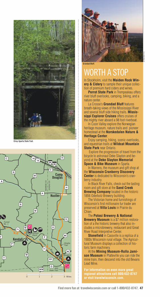
Find more fun at travelwisconsin.com or call 1-800/432-8747. 47
9.0
6.4
P
P
H
S
O
W
W
W
9094
A
H
C
H
N
N
A
C
W
V
V
Kendall
Hustler
CampDouglas
Elroy
Tunnel No. 1
KendallDepot
OmahaTrail
400State Trail
Baraboo
River
CEDAR ST
WW
71
71
82
80
3 Miles0 1 2
PP
MO
NR
OE
CO
JUN
EA
U C
O
1216
WORTH A STOPIn Stockholm, visit the Maiden Rock Win-ery & Cidery to sample their unique collec-tion of premium hard ciders and wines.
Perrot State Park in Trempealeau offersriver bluff overlooks, camping, biking, and anature center.
La Crosse’s Grandad Bluff featuresbreath-taking views of the Mississippi Riverand several bluff side hiking trails. Missis-sippi Explorer Cruises offers cruises ofthe mighty river aboard a 98 foot riverboat.
In Coon Valley explore the Norwegianheritage museum, nature trails and pioneerhomestead at the Norskedalen Nature &Heritage Center.
Enjoy camping, hiking, scenic overlooks,and equestrian trails at Wildcat MountainState Park near Ontario.
Explore the progression of travel from thebicycle to astronaut Deke Slayton and be-yond at the Deke Slayton MemorialSpace & Bike Museum in Sparta.
In Warrens, the museum and gift shop atthe Wisconsin Cranberry DiscoveryCenter is dedicated to Wisconsin’s cran-berry industry.
In Black River Falls, check out the tastingroom and gift store at the Sand CreekBrewing Company located in the historic1856 Oderbolz Brewery building.
The Victorian home and furnishings ofWisconsin’s first millionaire fur trader arepreserved at Villa Louis in Prairie duChien.
The Potosi Brewery & NationalBrewery Museum is a $7 million restora-tion of a the historic brewery that also in-cludes a microbrewery, restaurant and GreatRiver Road Interpretive Center.
Stonefield in Cassville is a replica of a1900s Wisconsin rural village. The Agricul-tural Museum displays a collection of his-toric farm machinery.
At the Mining Museum-Rollo Jami-son Museum in Platteville you can ride themine train, then descend into the old BevansLead Mine.
For information on even more great regional attractions call 800/432-8747 or visit travelwisconsin.com.
RJ & LINDA MILLER
Grandad Bluff.
Elroy-Sparta State Trail.
RJ & LINDA MILLER

48 Find more fun at travelwisconsin.com or call 1-800/432-8747.
S O U T H W E S TLINEAR BIKE TRAILS, CONTINUED
FEATURED TRAILLA CROSSE RIVER STATE TRAIL
Ro
Bangor
WestSalem
Onalaska
La Crosse
Neshonoc Lake
108
162
162
35
157
16
90
53
53
M
C
E
S
U
B
M
B
Great River TrailVisitor Center
Village Park
DE
Great RiverState Trail
Mississippi R
iver
La Crosse
Riv
er
1.9
6.8
4.4 3.6
The 24-mile La Crosse River State Trail hasbeen developed from the abandonedChicago and Northwestern Railroad be-tween Sparta and La Crosse. Packed-lime-stone screenings provide a smooth surfacefor bicycling. The trail lies in the La CrosseRiver valley and parallels an active rail lineto the north. Prairie remnants, farmland,trout streams, hardwood forests and wet-lands can be found along the trail. The trailpasses through the communities of LaCrosse, West Salem, Bangor, Rockland andSparta. It directly links to two other statetrails, the Elroy-Sparta State Trail on theeast end, and the Great River State Trail onthe west end. A daily or annual State TrailPass is required for riders 16 and older.
Distance: 24 milesSurface type: Crushed limestone.Fees: A daily or annual State Trail Pass isrequired for ages 16 and older.Caution: The trail parallels an active railline to the north.For more information: Wisconsin State Parks Systemdnr.wi.gov/topic/parks/name/lacrosserivSparta Area Chamber of Commerce800/540-8434, 608/269-4123bikesparta.orgLa Crosse Convention & Visitor Bureau800/658-9424, 608/782-2366www.explorelacrosse.comLa Crosse River State Trailwww.lacrosseriverstatetrail.org
THE BIKE FED
Biking Grant County.

Find more fun at travelwisconsin.com or call 1-800/432-8747. 49
LA C
RO
SS
E C
O.
MO
NR
OE
CO
.
Sparta
ockland
27
21
27
16
B
J
Y
90
SpartaDepot
CYPRESS AVE
J
La CrosseRiver
5.8
0 1 2 3 4 Miles
Hillsboro State Trail
This four-mile trail connects the communi-ties of Hillsboro and Union Center whilecrossing woods, farmland, windingstreams and the beautiful Baraboo River.The Hillsboro State Trail connects to the400 State Trail in Union Center. The 400State Trail connects to the Elroy-SpartaState Trail in Elroy. A daily or annual StateTrail Pass is required for riders 16 andolder.For more information call 608/489-2521(Vernon County), 608/847-9389 (JuneauCounty) or visit dnr.wi.gov
La Crosse River State Trail
See trail description on facing page.
Pine River Recreation Trail
Richland County’s incredible river bluffcountry can be hard on a bicyclist’s legs.On the Pine River Trail you can take a lazyride up a lazy river and enjoy bluff scenerywithout having to ride over it. Along theway you’ll cross 15 bridges that span themeandering Pine and its tributaries. Onebridge is a whopping 241 feet long. Be-tween Richland Center and Lone Rockyou’ll enjoy views of green-forested bluffslining the broad valleys of the Pine andWisconsin Rivers. The river backwaters arehavens for great blue herons, egrets, andother wildlife. Town Parks in Gotham andLone Rock offer pleasant rest stops. � For more information call 608/647-2100,or visit www.rclrs.net
8
SOUTHWESTURBAN BIKING OPTIONSThe following communities offer terrificurban bicycling opportunities. Most arehard surfaced, family friendly, and gen-erally traverse a given city’s most sce-nic areas. Many are recognized by theLeague of American Bicyclists as an Of-ficial Bicycle Friendly Community.
LA CROSSE����
www.bicyclelacrosse.com
ONALASKA����
www.discoveronalaska.com
���� = Official Bicycle Friendly Community*
MORERESOURCESLOWER WISCONSIN RIVERWAY SCENIC BYWAY – HIGHWAY 60 Wisconsin’s 100-mile Scenic Byway 60 fol-lows the graceful curves of the Lower Wis-consin River.For more information: www.scenic60.com
GREAT RIVER ROAD SCENIC BYWAYThe Wisconsin Great River Road parallels theMississippi River for 250 miles of the mostincredible scenery in the Midwest.For more information:wigreatriverroad.org
CYCLE SOUTHWEST WISCONSIN 28 pre-designed bike tours that take you ona picturesque journey through southwestWisconsin’s “Driftless Area.”For more information:www.cyclesouthwestwisconsin.com
6
7
WISCONSIN BIKE FED
Fall trail riding near La Crosse.
* See page 77.

50 Find more fun at travelwisconsin.com or call 1-800/432-8747.
Mountain Bike TrailsSee region map on page 44 for trail locations.
S O U T H W E S T
The following is a list of “constructed”or “purpose built” mountain bike trails.These trails are more challenging, spe-cially-constructed, narrow-width trailsbuilt to the trail standards of the Inter-national Mountain Bicycling Association(IMBA). They are designed to present asingletrack mountain biking experience.If you’re looking for a less technicalride, check out the list of less challeng-ing off-road trails below.
Ash Creek Community Forest
The mountain bike trails in the 350-acreAsh Creek Community Forest feature aboutseven miles of single and doubletrackmountain bike trails. The singletrack has anice mix of fast runs, switchbacks, steepclimbs and bone-rattling decents. Thetrails are not marked but are easy to follow. � For more information call 608/647-2100or visit www.rclrs.net/parkcommission
Human Powered Trails
See description on facing page.
Kickapoo Valley Reserve Trail
The Kickapoo Valley Reserve offers ap-proximately 24-miles of designated moun-tain bike trails that run the entire length ofthe 8,600 acre property. Although not sin-gletrack, the trails present many challengesfor serious off-road bikers. You’ll en-counter steep uphill climbs, hairpin turns,and rapid descents as you travel throughhardwood forests and open meadows withbreathtaking overlooks along the way.Mountain biking allows access to some ofthe more remote areas of the Reserve sel-dom visited by others. However, there areplaces where the bike trail may accompanyequestrian trails; and hikers may be en-countered at any point on the system. TheKickapoo Valley Reserve also offers fivemiles of family-friendly blacktop riding onthe Old 131 trail.� For more information call 608/625-2960or visit www.kvr.state.wi.us
Mound View Park
The Mound View Park (MVP) trail is thefirst official singletrack trail built in the citylimits of Platteville. It serves as the basefor future expansion through the valley.MVP is designed for riders of all abilitiesand traverses both pine and deciduouswoods. The trail also follows along a self-producing trout stream. MVP is managedand maintained by Platteville Human Pow-ered Trails. The one-mile loop also con-nects to the city’s gravel trail adding morefun to the ride.� For more information call 608/348-9741(Ext. 1) or visit www.plattevilletrails.org orwww.platteville.org
Sidie Hollow County Park
The mountain bike trails at Sidie HollowCounty Park have been a collaborative ef-fort between Vernon Trails – the localmountain bike club – and the VernonCounty Parks Department. Since 2006,over 200 volunteers have built 4.5 miles ofshared use singletrack trails. This new trailnetwork, along with the 2.5 miles of exist-ing doubletrack, combines to create overseven miles of mountain biking trails. Thelower loop is a two-mile doubletrack thatmeanders around the lake, ideal for begin-ners or as a perfect warm-up. The othertrails climb 300 vertical feet up and downthe bluffs. On these lung-busting climbsyou’ll find plenty of rocks, roots, log piles,switchbacks, and a perfectly designedbenchcut.� For more information call 608/637-5485or visit www.vernoncounty.org
LOOKING FOR A MILDER RIDE?BLACK RIVER STATE FOREST715/284-4103dnr.wi.gov
PERROT STATE PARK608/534-6409dnr.wi.gov
PERRY CREEK TRAIL800/404-4008, 715/284-1400www.blackrivercountry.net
WYALUSING STATE PARK888/947-2757, 608/996-2261dnr.wi.gov
1
2
3
4
5
MOUNTAIN BIKING TIPS: Always wear a hel-met and eye protection. Control your bike;don’t ride beyond your skill level. Ride onlyon open trails; others may be illegal, andnever intentionally spook animals.

Find more fun at travelwisconsin.com or call 1-800/432-8747. 51
Distance: 11 miles of trails including theTNT connector trail to the Hixon Foresttrailhead.Difficulty: Easy to very difficult.Fees: Donations encouraged at maintrailhead or on website.Note: No riding on hiking trails in theHixon Forest. Caution: Obstacles and narrow passageon the advanced trails require hightechnical riding ability. The TNT and easytrails are two-way. Horses may beencountered on the easy trails. All trailsare open to hikers and runners. Be carefulnot to spook animals and always yield topedestrians.For more information: La Crosse Area Convention & VisitorsBureau800/658-9424, 608/782/4082www.explorelacrosse.comOutdoor Recreation Alliancewww.naturesplacetoplay.com
GRANDAD
QUARRY
MILS
ON
CT
BLISSRD
BLUFF RD
RD
RDRIMOF THE CITY
F
FA
FA
16
La Crosse
GrandadBluff
TNT Trail
HIXON FORESTPARK
MAIN ST
LOS
EY
BLV
D
BLUFF PASS RD
To I-
90
0 .75 Miles.25 .5
When La Crosse area mountain bikers werelooking for a place to ride back in 2000,they managed to convince the city fathers toturn them loose on public land on the city’sfar east side. They created a trail system forriders, runners and hikers. It even offershorseback riding by permit on the easiertrails.
The purpose-built mountain bike trailsystem that resulted is remarkable. The trailmet the local demand and also attracted rid-ers from the surrounding states of Min-nesota and Iowa. The trails wereconstructed using IMBA design standardsto minimize erosion, a common problem onmany popular trails. In 2007, La Crossewas deluged with heavy rains. Despite therain and steep terrain, the impact on theHPT Trails was hardly noticeable.
The advanced trails on the Human Pow-ered Trails are not for the faint of heart how-ever. They feature some tough obstacleslike log and rock piles and tight switch-backs. The switchbacks are located onsome steep terrain; take a turn too wide andyou’ll end up careening down a woodedhillside. Due to that steep terrain, when thetrail is wet, riding can be extremely chal-lenging. The tamer intermediate trails offerplenty of hills as well as some great vistasoverlooking the Mississippi River.
An alternate route to the trail is the two-way TNT Trail from the Hixon Forest trail-head at the bottom of the bluff, but be readyfor a very tough climb of 500 plus feet.
FEATURED TRAILHUMAN POWERED TRAILS

52 Find more fun at travelwisconsin.com or call 1-800/432-8747.
Road BikingToursDistance: 23 miles Difficulty: Very difficult, but easy out-and-back riding is possible north and south ofPrairie du Chien.Caution: Almost the entire route is onpublic roads open to shared bicycle/motorvehicle use. Be sure to use the bike pathon the south side of Highways 18/35 andthe paved shoulder to the east. Someslopes are long and steep; take care tocontrol your downhill speed.For more information: Prairie du Chien Area Chamber ofCommerce800/732-1673www.prairieduchien.org
Prairie du Chien Tour
Long before the invention of bicycles, trainsor automobiles, Prairie du Chien was acrossroads of travel in the heart of the con-tinent. Located at the confluence of the Mis-sissippi and Wisconsin Rivers, Prairie duChien was a popular trading or rendezvous
6.0
7.9
9.2
18
18
0 21 3 Miles
Prairie du Chien
Mississippi
Wisconsin
River
River
LIMERY RD WACHUTARD
IRISH
VIN
EYAR
D
BO
US
KA
WARD
RD
RD
SOUTH
RD
RD
DR
GRAE
GRAE
GRAN
GRAN
RD
RD
35
76
340
35
60
27
27K
K
LIMERY
IRISH
RIDGE
RIDGE
St. FerioleIsland
Villa Louis
Fort CrawfordMedical Museum
WASHINGTON ST
BLACKHAWK AVE
MAIN
ST
RIDGE
CR
AW
FOR
D C
O
GRANT COCRAWFORD CO
MIN
NESO
TAW
ISCO
NSIN
1,200
1,000
800
600
0 4 8 12 16 20
Distance in Miles
Ele
va
tio
n in
Fe
et
Limery RidgeIrish Ridge
spot for the Native Americans who used therivers as canoe highways. Several effigymounds from the area’s pre-European eraare preserved in Wyalusing State Park lo-cated just south of the city across the Wis-consin River.
Riding east from Prairie du Chien youcan take advantage of the paved bike pathon the south side of Hwy 18/35 before veer-ing up a side valley of the Wisconsin Riveron Bouska Road. At the top of the climbyou’ll have a fantastic view of the river val-ley to the southeast. You’ll plunge off theridge into the deep, narrow valley of GranGrae Creek before an even steeper climbback up to the bluff-top farmland onWachuta Road. The short unpaved stretchon Wachuta Road is nearly dead flat andshould pose no riding problem for any typeof bike.
Riding around historic Prairie du Chienis not only fun and scenic, it’s great exer-cise too.
S O U T H W E S T
1
See region map on page 44 for tour locations.

Find more fun at travelwisconsin.com or call 1-800/432-8747. 53
1,200
1,100
1,000
900
800
700
50 10 15 20
Distance in Miles
Cty N & D
Whitehall
Ele
va
tio
n in
Fe
et
Independence
Whitehall
4.0
0 1 Miles2 3
93 River
Creek
Plum
RDRIVER
KURTH
JACKSON
CAR
STO
N
NELSON RD
SQUARE
SQUARE
BLU
FF
BLU
FFRD
RD
RD
RD
VALLEY
RD
SquareBluff
7.0
7.9
4.5X
Q
Q
Q
D
DN
N
QIndepenence
WhitehallHUGHES RD
NORTH
BugleLake Trempealeau
93
121
121
12153
53
95
Distance: 23 milesDifficulty: Very difficult, but a moderateout-and-back route is an option.Caution: The entire route is on publicroadways open to shared bicycle/motorvehicle use. Be sure to use the pavedshoulder on State Highway 121. Someslopes are long and steep; take care tocontrol your downhill speed.For more information:Trempealeau Chamber of Commerce608/534-6780www.trempealeau.netTrempealeau County Tourism Councilwww.ruralexperiences.com
Top of the World Tour
You’ll feel like you’re on top of the worldwhen you pedal this high-flyin’ route in oneof the most bicycling-friendly parts of thestate. The route is part of the course for an
annual event of the same name held eachAugust and part of the welcome mat Trem-pealeau County rolls out for bicyclists.
While a quick glance at this course’sprofile makes it clear that it’s not an easyride, you can lower the bar a bit by ridingout-and-back between Whitehall and Inde-pendence. That 14-mile round trip is apleasant roll through the flat bottomland ofthe Trempealeau River valley.
Following the loop south of Independ-ence, it’s up, up and away as you climbnearly 400 feet to County Highway N & D.The four miles you ride atop Square Bluffbring some of the best views anywhere. Ofcourse, the descents are plenty of fun too.
2

54 Find more fun at travelwisconsin.com or call 1-800/432-8747.
SouthCentral
1
2
5
62
10
34
1 11
9
1
3
24
7
881
80
80
8056 58
2
11
81
11
6
23
22
23
23
33
71
60 60
16
73
33
33
26
26
8920
26
60
78
23
69
51
14
14
151
151
151
1
61
61
151
1
14
5220
12
12
12
18
1
41 45
45
90
90
90
90
39
39
94
94
94
90
39
43
Monroe
WisconsinDells
Fond du Lac
Madison
Rockford
Dubuque
Cuba City
GratiotShullsburg
ArgyleBelmont
Mineral Point
PlattevilleDarlington
Dodgeville
Cobb
Highland
Muscoda
Elroy
Richland Center
SpringGreen
Black Earth
Mazomanie
Prairie du Sac
BlueMounds
Mount HorebBarneveld Verona
Belleville
Oregon
EdgertonNewGlarus
MonticelloEvansville
Stoughton
Fitchburg
MiddletonSunPrairie
DeForestWaunakeeSauk City
Lodi
PoynetteMerrimac
Columbus
Brodhead
Janesville
Beloit
Fort Atkinson
CambridgeJefferson
LakeMills
Lake Geneva
Waukesha
WyocenaRio
Pardeeville
PortageRandolph
FoxLake
Waupun
Horicon
Juneau
Mayville
BarabooReedsburg
NorthFreedon
La ValleHillsboro
Wonewoc
Mauston
Watertown
Mississippi
BeaverDam
I L L I N O I S
Wisconsin
River
SARIS CYCLING GROUP
� = Linear Bike Trails
� = Mountain Bike Trails
� = Road Biking Tours

Find more fun at travelwisconsin.com or call 1-800/432-8747. 55
Linear Bike Trails
400 State Trail
See Central region.
Badger State Trail
The Badger State Trail travels 40 miles be-tween Madison and the Wisconsin-Illinoisborder while traversing farmlands, woods,rolling hills, scenic meadows, remnantprairies, ravines, glacial topography andseveral small communities. Highlightingthe trail is the 1,200-foot long Stewart Tun-nel. Due to the fact that it is built on acurve, you will not be able to see the otherend when you first enter the tunnel. Flash-lights and jackets are recommended, as thetunnel is dark and cool, and water fromsprings above can trickle onto the trail.Bikers should walk bikes through the tun-nel. The Badger Trail connects to the Capi-tal City, Military Ridge and Sugar RiverState Trails and the Madison bikeway sys-tem. In Madison, the Badger State Trailcorridor continues into the city along theSouthwest Path. At the Illinois border, theBadger State Trail connects to the Jane Ad-dams Trail, which continues on toFreeport, Illinois. A daily or annual StateTrail Pass is required for riders 16 andolder.� For more information call 608/527-2335or visit dnr.wi.gov
Cannonball Path
The Cannonball Path is a paved multiusetrail constructed on the abandoned UnionPacific Railroad corridor that runs from theBeltline to McKee Road near the intersec-tion of Verona Road. Recent constructionof a bicycle overpass of the Beltline High-way (US Highways 12, 18, 14, and 151)will make for easy crossing of the highwayand access to the city of Madison trails.The next phase of expansion will crossCounty Highway PD and connect with theMilitary Ridge State Trail. � For more information call 608/288-8284or visit www.fitchburgchamber.com
1
2
3
MADISONB-CYCLE
From the hottest days of sum-mer to the snowiest days ofwinter, bicyclists can be seengetting around the city on two
wheels. In such a bike friendlycommunity with numerous bikepaths as well as a commitment tosafely sharing roads between mo-torists and bicyclists, it makessense that B-cycle saw an opportu-nity in Madison.
In 2010, B-cycle launched thefirst large-scale smart-technologybicycle sharing system in theUnited States in Denver. The Madi-son B-cycle program began a yearlater with six stations and about 60bikes. In just two years, the pro-gram has grown to 350 bikes and35 stations. The program is the re-sult of a partnership between theCity of Madison and Trek BicycleCorporation headquartered innearby Waterloo, Wisconsin.
Urban bike sharing provides aneconomical, convenient and envi-ronmentally friendly way to usebikes for trips that are too far towalk but too short to drive. Here’show it works. B-cycle membershipsmay be purchased online or at anyB-station. Members may check outa bike at any B-cycle station andride to the B-station nearest theirdestination. To start a new trip, theysimply check out another B-cycle.The system is designed to encour-age shorter trips, therefore, tripslonger than 30 minutes incur addi-tional fees.
B-cycle currently has systemsoperating in more than 25 U.S.cities. In addition to Madison andDenver, B-cycle can be found inBoulder, San Antonio, Fort Worth,Houston, Salt Lake City, Charlotte,Nashville and Broward County. In2014, Milwaukee unveils its veryown B-Cycle.
For more information on MadisonB-cycle visit madison.bcycle.com.
NICK COLLURA
continued...
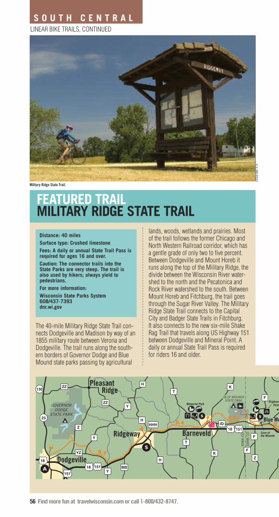
56 Find more fun at travelwisconsin.com or call 1-800/432-8747.
LINEAR BIKE TRAILS, CONTINUED
S O U T H C E N T R A L
4.05.3
5.4
9.7
Ridgeway
IOW
A C
O
DA
NE
CO
BLUE MOUNDSSTATE PARK
GOVERNORDODGE
STATE PARK
BrighamPark
Cave of the Mounds
Memorial Park
18 151
Y
Z
Y
YZ
BB
Y
H
H
H
HHH
F
F
F
K
ID
T
T
KZ
Blue Mo
1818
151151
23
130
ZZ
ZZ Pleasant Ridge
Dodgeville
Barneveld
FEATURED TRAILMILITARY RIDGE STATE TRAIL
Distance: 40 milesSurface type: Crushed limestoneFees: A daily or annual State Trail Pass isrequired for ages 16 and over.Caution: The connector trails into theState Parks are very steep. The trail isalso used by hikers; always yield topedestrians.For more information:Wisconsin State Parks System608/437-7393 dnr.wi.gov
The 40-mile Military Ridge State Trail con-nects Dodgeville and Madison by way of an1855 military route between Verona andDodgeville. The trail runs along the south-ern borders of Governor Dodge and BlueMound state parks passing by agricultural
lands, woods, wetlands and prairies. Mostof the trail follows the former Chicago andNorth Western Railroad corridor, which hasa gentle grade of only two to five percent.Between Dodgeville and Mount Horeb itruns along the top of the Military Ridge, thedivide between the Wisconsin River water-shed to the north and the Pecatonica andRock River watershed to the south. BetweenMount Horeb and Fitchburg, the trail goesthrough the Sugar River Valley. The MilitaryRidge State Trail connects to the CapitalCity and Badger State Trails in Fitchburg. It also connects to the new six-mile ShakeRag Trail that travels along US Highway 151between Dodgeville and Mineral Point. Adaily or annual State Trail Pass is requiredfor riders 16 and older.
RJ & LINDA MILLER
Military Ridge State Trail.

Find more fun at travelwisconsin.com or call 1-800/432-8747. 57
3.62.5
6.0
1.1 2.4
3
Mount Horeb
Riley
Verona
Madison
Fitchburg
PineBluff
Stewart Park
Little Norway
18151 18 151
18151
18
12 14
151PD
PD
PB
PD
92
78
78
69
S
E
JJ
J
JGJG
IDP
J
G
M
M
M
PS
S
ounds
MINERAL POINT RD
MC KEE RD
RAYMOND RDMID-TOWN RD
LACY RD
WHALEN RD
NAKOMA RD
Capital City State Trail
SW CommuterTrail
Badger State Trail
Klevenville
0 1 2 3 4 Miles
Capital City State Trail
The Capital City State Trail is the linkaround and through Madison between theMilitary Ridge State Trail and eventuallythe Glacial Drumlin State Trail. Nine milesof the trail go through the scenic CapitalSprings State Recreation Area (DaneCounty E-way) south of Madison. In thecity, the trail follows seven miles of citybikeways past the Monona Terrace Con-vention Center and through the city’s eastside. The trail also connects to Madison’sSouthwest Path and the Badger State Trail,which runs all the way to the Illinois stateline. A daily or annual State Trail Pass isrequired for riders 16 and older.� For more information call 608/224-3730or visit dnr.wi.gov
4
continued...
Glacial Drumlin State Trail West
Running between Wisconsin’s two largesturban areas, the Glacial Drumlin State Trailstretches for 52 miles through farmlands,glacial topography and several small townsfrom Cottage Grove to Waukesha. Thewestern portion of the trail is the drumlinside. Here the trail winds among teardrop-shaped hills that were formed under thegreat continental ice sheet. Streams andrivers poke their way around the hills aswell. The trail crosses the meanderingKoshkonong Creek five times. The largerCrawfish and Rock Rivers are crossed onimpressive, stressed iron bridges. A 1.5-mile section northeast of Jefferson betweenState Highway 26 and County Highway Yuses public roads as the trail route. A dailyor annual State Trail Pass is required forriders 16 and older.� For more information call 920/648-8774or visit dnr.wi.gov
5
WISCONSIN STATE PARKS
Capital City State Trail.
Bike trails may bring a number of differentusers to the trail at the same time. Alwaysuse good trail etiquette to ensure theenjoyment and safety of all trail users.

58 Find more fun at travelwisconsin.com or call 1-800/432-8747.
LINEAR BIKE TRAILS, CONTINUED
S O U T H C E N T R A L
WORTH A STOPIn Wisconsin Dells, take a one-hour guidedtour of the Lower Dells aboard an authenticWWII era amphibious vehicle at Dells ArmyDuck Tours. Everything is under one roof atthe African-themed Kalahari Resort, hometo Wisconsin's largest indoor waterpark.BigFoot Zipline Tours features six lineswith over 4,300 feet of fun.
In Baraboo, Circus World features cir-cus memorabilia, miniature circus layouts,the world’s largest collection of circus wag-ons, and big top performances. You can seeall fifteen of the world’s crane species at the International Crane Foundation.
Tour the state’s oldest winery and samplethe wines at Wollersheim Winery inPrairie Du Sac.
House On The Rock in Spring Green isWisconsin’s most popular single attractionand a treat for the imagination. AmericanPlayers Theatre offers eight plays in rotat-ing repertory in the outdoor amphitheater Upthe Hill and in the indoor Touchstone The-atre.
At Pendarvis in Mineral Point, cos-tumed interpreters guide you through pre-served miners’ homes from the 1840s.
Explore Cave of the Mounds in BlueMounds, a registered National Natural Land-mark that is often referred to as the “jewelbox” of America’s major caves.
Take a relaxing stroll through Janesville’sRotary Gardens, an exquisite 15-acre, in-ternationally themed botanical garden.
In Madison, the Madison Museum ofContemporary Art features changing ex-hibits of contemporary and modern art. TheHenry Vilas Zoo is one of the state’s finestzoos and there is no admission fee! One ofthe largest farmer’s market in the country, theDane County Farmers Market, is heldevery Saturday from April to November onthe Capitol Square.
The Horicon National WildlifeRefuge near Mayville is home to one of thewidest arrays of plants, animals and birds inthe Midwest.
For information on even more great regional attractions call 800/432-8747 or visit travelwisconsin.com.
JIM BROZEK
Madison Museum of Contemporary Art.
Glacial River Trail
The Glacial River Trail is an 8.6-mile for-mer rail bed trail running south fromdowntown Fort Atkinson to theJefferson/Rock County line. The northernmost portion of the trail is asphalt, with thebalance being crushed limestone. Thisspectacular recreational attraction featuresan archway, bronze sculptures, rest areasand fountains. It makes for a relaxing andscenic ride through Fort Atkinson.� For more information call 920/563-7781or visit www.fortparksandrec.com
Military Ridge State Trail
See trail description on page 56.
Pecatonica State Trail
Running 10 miles through the picturesqueBonner Branch Valley, this county-oper-ated trail links Belmont with the 47-mileCheese Country Trail in Calamine. The trailfollows the old Milwaukee Road railroadcorridor that at one time hauled leadthrough this valley, reminiscent of the min-ing era which once dominated this regionof Wisconsin. The western terminus of thetrail ends in Belmont but eventually willcontinue to the city of Platteville. A daily orannual State Trail Pass is required for rid-ers 16 and older.� For more information call 608/776-5706or visit dnr.wi.gov
Pelishek-Tiffany Nature Trail
The Pelishek-Tiffany Nature Trail is a six-mile, abandoned railroad bed trail that of-fers snowmobiling in the winter andhiking, bicycling, horseback riding, andbird watching in the summer. The trailstarts in the Rock County community ofClinton. � For more information visitwww.co.rock.wi.us
MORERESOURCESGLACIAL HERITAGE AREA – JEFFERSON COUNTYA network of Jefferson County parks, wildlifeand natural areas, historic and cultural sitesconnected by trails and waterways.For more information:www.glacialheritagearea.org
TREK FACTORY TOURSWant to see where the best bikes in theworld go from an idea to reality? Visit theTREK world headquarters in Waterloo, WI.For more information:www.trekbikes.com
6
8
7
9

Find more fun at travelwisconsin.com or call 1-800/432-8747. 59
SOUTH CENTRALURBAN BIKING OPTIONSThe following communities offer terrificurban bicycling opportunities. Most arehard surfaced, family friendly, and gen-erally traverse a given city’s most sce-nic areas. Many are recognized by theLeague of American Bicyclists as an Official Bicycle Friendly Community.
JANESVILLEwww.ci.janesville.wi.us
MADISON����
www.cityofmadison.com
FITCHBURG����
www.fitchburgchamber.com
MIDDLETONvisitmiddleton.com
SUN PRAIRIEwww.cityofsunprairie.com
���� = Official Bicycle Friendly Community*
Sugar River State Trail
The Sugar River State Trail travels 24 milesfrom New Glarus to Brodhead. A short ac-cess trail connects the trail to New GlarusWoods State Park. Fourteen trestle bridgescross over the Sugar River and its tributar-ies, while the trail passes by farmlands,woods, rolling hills, and scenic meadows.North of Brodhead, the trail goes over areplica covered bridge. The trail headquar-ters is located in the restored 1887 railroaddepot in New Glarus. The trail connectswith the Badger State Trail just south of theMonticello trailhead. A daily or annualState Trail Pass is required for riders 16and older.� For more information call 608/527-2334or visit dnr.wi.gov
Wild Goose State Trail
This 34-mile rail trail skirts the westernedge of the vast Horicon Marsh from Fonddu Lac to Clyman Junction. The HoriconMarsh, a National Wildlife Refuge andState Wildlife Area, is home to over 250bird species and is world-famous for itsnumerous migrant waterfowl and endlessV-shaped formations of Canada geese.Wildflowers, woodlots, wildlife, prairieremnants and fertile farm fields are com-mon sites along the trail. The trail wasWisconsin’s first “cooperative” state trailand is maintained and operated by Dodgeand Fond du Lac counties.� For more information call 920/929-3135(Fond du Lac County), 920/386-3700 (DodgeCounty) or visit dnr.wi.gov
10
11
MADE INWISCONSIN
With miles of bike trails,charming towns, and pic-turesque scenery, Wis-consin is a great place to
travel on two wheels. Some of thenation’s top biking terrain is locatedhere, and those who seek leadingequipment for the sport don’t need toleave the state to gear up for theirrides. In fact, Wisconsin has thelargest domestic concentration ofbike industry companies, headquar-ters and related manufacturing in thenation. Leading bicycle brands, TrekCorporation and Waterford PrecisionCycles, are both manufactured inWisconsin.
Headquartered in Waterloo, Wis-consin, Trek began making bikes in1976 and has since evolved into abrand known all over the world. Fromrecreational riding to bicycles builtfor year-round commutes, Trek iscommitted to transforming the waythey build and deliver their bikeshoping their practices and commit-ment to people will transform theway people think about the role ofbiking in their lives.
Not too far from Trek Headquar-ters in Waterloo, you will find Water-ford Precision Cycles in Waterford,Wisconsin. Founded in 1993, Water-ford was formed out of the SchwinnParamount Factory. Waterford is acustom frame builder trusted by rid-ers who count on their bicycles toperform – whatever their preferredriding style.
Manufacturing in Wisconsin doesnot stop at the bikes themselves. Avariety of other biking parts and ac-cessories are also made right herein Wisconsin. Some of these includeSaris Cycling Group producing bicy-cle racks and bicycle-related fitnessequipment, bike racks by MadRaxand Rudy Rac, bicycle brakes byHayes Disc Brake and a variety of bi-cycle clothing by Mt. Borah Designs.Pacific Cycle, North America’slargest bicycle company is head-quartered in Madison.
ROB FISCHER
* See page 77.

60 Find more fun at travelwisconsin.com or call 1-800/432-8747.
Mountain Bike TrailsSee region map on page 54 for trail locations.
Bluemound State Park Trails
Bluemound State Park offers 15.5 miles ofchallenging off-road, singletrack bicycletrails. At 1,719 feet of elevation, the top ofBlue Mound is the highest point in south-ern Wisconsin. The vast overview from theobservation towers make the climb worththe effort. On the north side, new techni-cally challenging singletrack trails anddoubletrack cross-country ski trail connec-tors take you on an odyssey through thedeep fragrant hardwood forest that cloaksthe steep slopes. On the milder side, thePleasure Valley Trail circuits an openprairie to the east. A steep connector trailaccesses the Military Ridge State Trailwhere riders can roll on a near-level rail-road grade. If you’re looking for some aer-obically challenging terrain, you’ll find ithere. Working with the park staff, local vol-unteers have added miles of twisting sin-gletrack trails that completely encircle themound and take advantage of its elevation,rocks, roots and terrain. If you ride thetrails and climb the paved road to the topyou’ll have 500 feet of elevation to playwith. A daily or annual State Trail Pass isrequired for riders 16 and older.� For more information call 608/437-5711or visit dnr.wi.gov
Cam-Rock Trails
See trail description on facing page.
Devil’s Head Ski Area
In the winter months, Devil’s Head Ski Re-sort attracts skiers and snowboarders of allskill levels to its 500 vertical feet of skislopes. In the warmer months, those sameslopes become challenging singletrackmountain biking trails that provide some ofthe most exhilarating mountain biking inthe Midwest. As you may expect being that
these are ski hills, you’ll encounter plentyof ups and downs, plus a lot of challengingfeatures for riders of all abilities. Fastdownhills and technical singletrack makethis one of the best mountain bike destina-tions in the state. � For more information call 608/493-2251or visit www.devils-head.com
Quarry Ridge Recreation Area
Just minutes from downtown Madison, theQuarry Ridge Recreation Area features anetwork of singletrack trails for beginner toexpert riders. The trail consists of a one-mile main loop as well as several downhilllines of varying difficulty. The singletrackon the main loop is fast with only onetechnical section that might trip up begin-ners. More advanced riders can challengethemselves to power through the steepclimb and slice through the long downhillwith as little brakes as possible. New trailshave been added making the trail systemmuch more family friendly. The trails arefree and open year round. The FitchburgParks Department partners with CapitalOff-Road Pathfinders (CORP) to developand maintain the trails.� For more information call 608/270-4288or visit www.city.fitchburg.wi.us
S O U T H C E N T R A L
The following is a list of “constructed”or “purpose built” mountain bike trails.These trails are more challenging, spe-cially-constructed, narrow-width trailsbuilt to the trail standards of the Inter-national Mountain Bicycling Association(IMBA). They are designed to present asingletrack mountain biking experience.If you’re looking for a less technicalride, check out the list of less challeng-ing off-road trails below.
LOOKING FOR A MILDER RIDE?BADGER PRAIRIE COUNTY PARK608/224-3730www.countyofdane.com
DEVILS LAKE STATE PARK608/356-8301dnr.wi.gov
GOVERNOR DODGE STATE PARK888/947-2757, 608/935-2315dnr.wi.gov
MIRROR LAKE STATE PARK888/947-2757, 608/254-2333dnr.wi.gov
PLEASANT VIEW MOUNTAIN BIKETRAILS - MIDDLETON800/688-5694visitmiddleton.com/trails
YELLOWSTONE STATE PARK888/947-2757, 608/523-4427dnr.wi.gov
1
2
3
4

Find more fun at travelwisconsin.com or call 1-800/432-8747. 61
Distance: 1.8 miles at Cam-Rock 2; 2.6miles at Cam-Rock 3; and 2.3 miles forCam-Rock 1 and the connector to Cam-Rock 3.Difficulty: Easy to very difficult.Fees: A daily or annual Dane County Parkstrail fee is required. Self-pay stations arelocated at the trailheads.Caution: singletrack trails at Cam-Rock 2and the trails at Cam-Rock 3 are one-way.The connector trail at Cam-Rock1 is two-way. The trails are also used by walkersand hikers, particularly Cam-Rock 1.For more information: Cambridge Chamber of Commerce608/423-3780www.cambridgewi.com
B
.8
1.2
181812
12
12
Rockdale
Cambridge
LakeRipley
PAR
K R
D
SP
RIN
G S
T
WATER ST
JEFFERSON ST
OAKLAND RD
MAIN ST
HIG
HLA
ND
DR
B
B
B
Cam-RockArea 2
Cam-RockArea 1
Cam-RockArea 3
PQ
DA
NE
CO
JEFF
ER
SO
N C
O
Kosh
kono
ng C
reek
134
Westside Park RipleyPark
0 1.5 Miles.75.25
There’s something for everybody at Cam-RockCounty Park, from an easy riding railbed trailat the north end to loop systems on moderatecross-country ski trails at Cam-Rock 2 to ex-treme singletrack at Cam-Rock 3. The trails atCam-Rock 2 present riders with a few shortsteep slopes that are great for novices.
Things really get interesting at Cam-Rock 3where trail builders had more than 100 feet of relief to work with. Singletrack always chal-lenges riding ability, but here the trail design-ers had rock outcroppings, gullies and otherobstacles as well. On the newest and north-ernmost loop, riders will find an extreme six-foot drop and totally wacko spin cycle.
FEATURED TRAILCAM-ROCK TRAILS

62 Find more fun at travelwisconsin.com or call 1-800/432-8747.
Road BikingTours
0 1 2 3 Miles
130
130
6060
I
NN
C
T
C
C
23
23
23
23
14
1414
PERCUSSION ROCK
RD
SNEED CREEK
RD
Spring Green
Lone Rock
Clyde
Percussion Rock
Wyoming ValleySchool
LIMMEX HILL RD
LAK
EVI
EW
RD
RUSH CREEK RD
River
Wisconsin
UPPER
HILLS
IDE
RD
WYOM
ING RD
CLYD
E RD
GlobalView
House onthe Rock
House on the RockResort
American PlayersTheatre
Frank LloydWright Visitor
Center
Taliesin
LOSTHILL
Hillside School5.5
7.0
3.1
4.5
2.4
Tower HillState Park
0
500
750
1000
1500
1250
500
750
1000
1500
1250
1 2 3 4 5 6 7 8 9 10 11 12 13 14 15 16 17 18 19 20
Rush CreekLowery Creek
Sneed Creek
Clyde
Distance in Miles
Ele
va
tio
n in
Fe
et
Sneed Creek
Lost Hill
Frank Lloyd Wright was the most produc-tive architect in world history. For nearlyfifty years he lived and taught at Taliesin(Tally-es-in) near Spring Green. Wrightdrew inspiration from nature’s beauty, creat-ing a unique American architecture that in-fluences the way we live today. From thepicture window to the kitchen island, Wrightspent his life designing from a human per-spective.
Distance: 20 miles for the long route onpaved and gravel roads. The 10 mile shortloop is entirely on paved roads.Difficulty: Difficult or moderate. The longroute has five steep hills. The short routehas two.For more information:Spring Green Area Chamber of Commerce800/588-2042, 608/588-2054www.springgreen.comFrank Lloyd Wright Visitor Center608/588-7900www.taliesinpreservation.org
Frank Lloyd Wright Tour1 Thanks to recent preservation efforts youcan tour the Wright complex including Tal-iesin, Hillside School, and Midway Farms.Or, you can skirt Taliesin on a new bikepath, then hit the road into the hills and val-leys Wright loved. The Spring Green area isloaded with attractions from the eclectic bo-nanza that is House on the Rock to classicstage plays performed beneath the sky atAmerican Players Theatre. You’ll love ridingwhere points of interest meet lines of ad-venture.
S O U T H C E N T R A L
See region map on page 54 for tour locations.
PHIL VAN VALKENBERG

12
12
12
12
3.4
1.3
3.7
7.5
7.9
6.3
6.1
6.9
113
113
113
113
33
159
123
136
188
188
188
33
33
78
60
60
60
60
78
78
78
Devil'sLake
DL
DLDL
DEVIL'S LAKESTATE PARK
Baraboo
Prairiedu Sac
Sauk City
Merrimac
Lodi
Circus WorldMuseum
Lake W
isconsin
Wiscon
sin
Rive
r
Barabo
o River
Merrimac Ferry
GibralterRock
Devil'sHead
JJ
Z
C
W
J
W
W
JJ
VV
W HARMON RD
O' CONNER RD
VAN ESS RD
MARSH RD
BLU
FF RD
DANE CO
CO
ULU
MB
IA C
O
SA
UK
CO
COLUMBIA CO
SOUTH LAKE RD
SO
UTH
NEUMAN
TOWER RD
BLUFF
RD
RD
SHO
RE
RD
78
78
WA
LNU
T ST EFFINGER RD
MANCHESTER RDOLDLAKE RD
KESSLER RD
WATER ST
B A R A B O O
R A N G E
CEMETERY ST
CHRISLER RDSAUK ST
RDREYNOLDS
94
94
94
90
90
90
39
39
39
PF
0 2 51 4 Miles3
600
800
1,000
1,200
1,400
1,600
0 4 8 12 16 20 24
Distance in Miles
North Loop
BarabooMerrimac
Merrimac
Devil's Lake Tower Road
Find more fun at travelwisconsin.com or call 1-800/432-8747. 63
Distance: 45 miles total; 26 for the northloop, 19 for the south loop.Difficulty: Moderate to difficult. Thenorthern loop has long, steep climbs.Caution: The entire route is on publicstreets and roads open to sharedbicycle/motor vehicle use. Riding theseparate bike trail along Hwy. 123 southof Baraboo is advised.For more information:Baraboo Area Chamber of Commerce800/227-2266, 608/356-8333www.baraboo.comLodi Chamber of Commerce608/592-4412www.lodiwisconsin.com
Merrimac Ferry Tour2
Take on the tough cycling terrain of thistour and you’ll be rewarded with some ofthe most outstanding scenery in Wisconsin.Ride all 45 miles and you’ll pedal up a totalof 2,944 vertical feet. The 26-mile northernloop has the lion’s share. That’s where
you’ll cross the Baraboo Range - the rem-nant core of an ancient mountain - twice.Blessedly, one of the crossings will bethrough the gap at Devil’s Lake State Parkwhere you’ll enjoy some of the best sceneryeast of the Rockies.
The southern loop is a bit easier, butthere’s not much flat road until you near thetown of Lodi. Along the way you’ll have agreat view of Gibraltar Rock, a sandstonemonolith popular with area climbers.
You’ll cross the Wisconsin River aboardthe Merrimac Ferry. The ride is free.
The real nasty grades are on the northernloop. If you ride it clockwise, you’ll face ahalf-mile climb as you leave Devil’s Lake ona twisting 8% slope. Circling the other di-rection you’ll pedal up for 2.5 miles andclimb 650 feet at an average grade of morethan 5%. The first half-mile from the en-trance to Devil’s Head Resort is a whopping10% pitch. These are the sorts of gradesyou’d find in the Alps.

64 Find more fun at travelwisconsin.com or call 1-800/432-8747.
2
2
9
1 4 7
6
58
2
3
54 83
761
10
11
12
1
81
11
6
57
60 60
16
33
32
26
89
20
26
41
5
14
1
151
151
1
12
12
45
90
94
90
39
43
43
94
94
39
Milwaukee
Racine
Kenosha
Rockford Chicago
Columbus
CottageGrove
Janesville
Beloit
Whitewater
Walworth
DelavanElkhorn
LakeGenevaFontana
GenoaCity
Bristol Pleasant Prairie
Union GroveBurlingtonWaterford
Sturdevant
MukwonagoMuskego
Eagle
WaukeshaDelafield Brookfield
Wauwatosa
Oak Creek
Brown DeerGermantown
MequonCedarburg
WestAllis
GraftonPort Washington
HartfordHubertus
Slinger
WestBend
BelgiumKewaskum
Oconomowoc
MenomoneeFalls
Watertown
Jefferson
Saukville
I L L I N O I S
Lake
Mic
higa
n
ROCK
Southeast
� = Linear Bike Trails
� = Mountain Bike Trails
� = Road Biking Tours
WISCONSIN BIKE FED

Find more fun at travelwisconsin.com or call 1-800/432-8747. 65
Linear Bike TrailsBugline Trail
The Bugline Bike Trail owes its existence tothe quarries near Lannon. Trains oncehauled famed Lannon Stone from the deeplimestone pits which still operate today. Alook down into the quarries from the trail isan impressive sight. Further along, per-haps you’ll be able to spot homes builtfrom the Lannon Stone. Dense woodsclose to the trail often hide the fact much ofyour ride is through suburbs. You canmake your trail ride a tour of comfortablearea parks; three line the trail. At the westend of the trail is the tiny village of Merton.The old mill there still operates, and theadjacent mill house is an architecturalgem.� For more information call 262/548-7801or visit www.waukeshacounty.gov
Eisenbahn State Trail
See East Central region.
Fox River Trail – Waukesha
The six-mile Fox River Trail runs throughthe city of Waukesha along the Fox Riverstarting on the north end of Frame Parkand continuing south along the east side ofthe river to Fox River Park. The trail surfaceis mainly asphalt with a few brick sectionsdowntown. Water and restroom facilitiescan be found at several parks along thetrail system.� For more information visitwww.midwestroads.com
Glacial Drumlin State Trail East
See trail description on page 66.
Hank Aaron State Trail
Named in honor of baseball legend HankAaron, this 14-mile trail traverses Milwau-kee County from Lake Michigan throughthe Historic Third Ward and theMenomonee Valley to the Milwaukee/Waukesha County Line. The trail passesnumerous places of interest such asLakeshore State Park, Discovery World, theMilwaukee Art Museum, Summerfest, theHarley-Davidson Museum, Miller Park, theUrban Ecology Center, and State Fair Park.Interpretive signage and artwork along theroute will focus on the rich cultural/historicvalue of the area, the natural resourcesalong the route and interesting facts aboutits namesake. � For more information call 414/263-8559or visit dnr.wi.gov
Lake Country Recreation Trail
Located on the former Milwaukee - Water-town Interurban Railway. This eight-milerecreation trail stretches between theLandsberg Center trailhead (just north ofInterstate 94 on Golf Road, west of CountyHighway T) and Cushing Park in the Cityof Delafield.� For more information call 262/548-7801or visit www.waukeshacounty.gov
Lakefront Oak Leaf Trail
Variety is what cities are all about, andyou’ll find plenty along this nearly 100-mile route. From Juneau Park, a rail bedtrail follows the river to the KilbourntownHouse historic site. Stately mansions lineNewberry Boulevard, Wahl, and TerraceAvenues. The lake parks have their owntreasures: the white lighthouse, soaringGothic water tower, and streamlinedMcKinley Park Beach House are priceless. � For more information call 414/257-6100or visit www.waukeshacounty.gov
New Berlin Recreation Trail
The New Berlin Recreation Trail is a seven-mile multiuse trail located that extendsfrom South 124th Street just south ofGreenfield Avenue (State Highway 59) atthe Milwaukee/Waukesha County Line toSpringdale Road in Waukesha.� For more information call 262/548-7801or visit www.county.milwaukee.gov
continued...
1
3
2
4
5
6
7
8
MARY LANGENFELD
Glacial Drumlin State Trail.

Running between Wisconsin’s two largesturban areas, the Glacial Drumlin State Trailstretches for 52 miles through farmlands,glacial topography and several small townsfrom Cottage Grove to Waukesha. It’s theeasiest trail through the Kettle Moraine
FEATURED TRAILGLACIAL DRUMLIN STATE TRAIL
66 Find more fun at travelwisconsin.com or call 1-800/432-8747.
S O U T H E A S TLINEAR BIKE TRAILS, CONTINUED
Distance: 52 miles Surface: 39 miles of crushed limestoneand 13 miles of paved asphalt.Fees: A daily or annual State Trail Pass isrequired for ages 16 and over. For more information:Glacial Drumlin State Trail – West920/648-8774dnr.wi.gov/topic/parks/name/glacialdrumlinGlacial Drumlin State Trail – East262/646-3025dnr.wi.gov
Lake Mills
London
134
94
12
S
90
18
18
12
1889
8926
26
89
73
N
N
A
B
W
A
Q
Q
JG W
NY
X
D
Y
BB BB
6.7
3.2
5.8 2.1
3.5 2.110.2
YDeerfieldCottageGrove
Helenville
Johnson CreekAztalan State
Park
AztalanRock Lake
Lake Ripley
Red Cedar Lake
Sandhill StationState Campground JUNCTION RD
DA
NE
CO
JEFF
ER
SO
N C
O Jefferson
Roc
kR
iver
River
Crawfish
Cambridge
WISCONSIN STATE PARKS
Hank Aaron State Trail.
you’ll ever take – guaranteed. The railroadferreted out a level route through the jum-bled glacial legacy of hills and valleys. Youget to enjoy all of the famous Kettle scenerywithout the usual effort. The rail bed trailcovers another hard to bike natural featureas well; between Dousman and Sullivan thegrade crosses a vast marsh that is home toabundant wildlife. On the east end, Wauke-sha’s downtown is an architectural gem,and the street plan has a definite Europeanfeel. In the country, friendly small townsalong the route are pleasant spots to take abreak The trail is on an abandoned rail cor-ridor, except for a 1.5-mile section north-east of Jefferson which currently usespublic roads as the trail route. An off-roadconnection is in the works.

9 Ozaukee Interurban Trail
The 30-mile paved Ozaukee InterurbanTrail runs north from the MilwaukeeCounty line through Thiensville/Mequon,Cedarburg, Grafton, Port Washington andBelgium to the Sheboygan County line.The trail includes biking, walking,rollerblading and cross-country skiing.� For more information call 800/403-9898,262/284-9288 or visitwww.interurbantrail.us
Pike Bike Trail
The scenic 10.2-mile Pike Bike Trail runsthrough Kenosha County near severalpoints of interest including three NationalRegister Historic Districts, Lake Michigan,two historic lighthouses, recreational op-portunities and Poerio Nature Center.� For more information call 262/653-4080or visit www.kenosha.org
Seven Waters Trail
This scenic trail stretches more than 17miles between Burlington and MuskegoLake and into Waukesha County. Three ex-isting trails, Burlington, Waterford-WindLake and Norway, were stitched together toform Racine County’s system of bike paths.� For more information visitpublicworks.racineco.com/biking
White River State Trail
This 12-mile trail follows a former rail cor-ridor as it travels between Elkhorn andBurlington, passing numerous bridges,scenic vistas, quaint towns, farmlands andwetlands. The trail is operated by WalworthCounty and is within five miles of LakeGeneva and Big Foot Beach State Park. Thewestern end of the trail begins at CountyHighway H near Elkhorn. The eastern end
Find more fun at travelwisconsin.com or call 1-800/432-8747. 67
of the trail is at Spring Valley Road nearthe Walworth-Racine county line, just westof Burlington. A daily or annual State TrailPass is required for riders 16 and older.� For more information call 262/741-3114or visit dnr.wi.gov
9494
94
18 1818
67
67
83
8359
59
16
1616 164
DP
P
DR
E
F
F
ZF
F
D
P
D
D
D
Y
D
F
E
B C
BB
5.8 5.4TT
DE
Sullivan
Rome
WA
UK
ES
HA
CO
JEFF
ER
SO
N C
O
Oconomowoc
Delafield
HartlandPewaukee
Pewaukee Lake
GoldenLake
Rome Pond
SilverLake
OconomowocLake Nagawicka
Lake
Wales
WA
TER
VIL
LE R
D
7.5
LAPHAM PEAK UNITKETTLE MORAINE STATE FOREST
Dousman
WatervilleWaukesha
0 1 2 4 6 Miles
SOUTHEASTURBAN BIKING OPTIONSThe following communities offer terrificurban bicycling opportunities. Most arehard surfaced, family friendly, and gen-erally traverse a given city’s most sce-nic areas. Many are recognized by theLeague of American Bicyclists as an Of-ficial Bicycle Friendly Community.
KENOSHAwww.visitkenosha.com
MILWAUKEE����
city.milwaukee.gov/Parks
RACINEwww.cityofracine.org
SHOREWOOD����
www.villageofshorewood.org
WAUKESHAbikewaukesha.org
���� = Official Bicycle Friendly Community*
9
10
11
12
White River State Trail.
WISCONSIN STATE PARKS
* See page 77.
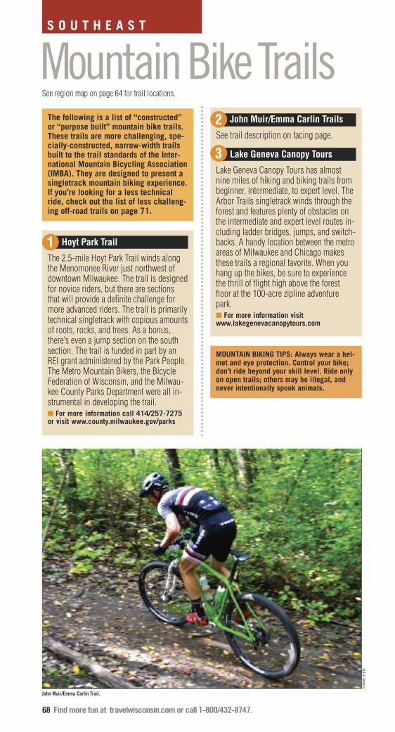
68 Find more fun at travelwisconsin.com or call 1-800/432-8747.
Mountain Bike TrailsS O U T H E A S T
The following is a list of “constructed”or “purpose built” mountain bike trails.These trails are more challenging, spe-cially-constructed, narrow-width trailsbuilt to the trail standards of the Inter-national Mountain Bicycling Association(IMBA). They are designed to present asingletrack mountain biking experience.If you’re looking for a less technicalride, check out the list of less challeng-ing off-road trails on page 71.
Hoyt Park Trail
The 2.5-mile Hoyt Park Trail winds alongthe Menomonee River just northwest ofdowntown Milwaukee. The trail is designedfor novice riders, but there are sectionsthat will provide a definite challenge formore advanced riders. The trail is primarilytechnical singletrack with copious amountsof roots, rocks, and trees. As a bonus,there’s even a jump section on the southsection. The trail is funded in part by anREI grant administered by the Park People.The Metro Mountain Bikers, the BicycleFederation of Wisconsin, and the Milwau-kee County Parks Department were all in-strumental in developing the trail. � For more information call 414/257-7275or visit www.county.milwaukee.gov/parks
John Muir/Emma Carlin Trails
See trail description on facing page.
Lake Geneva Canopy Tours
Lake Geneva Canopy Tours has almostnine miles of hiking and biking trails frombeginner, intermediate, to expert level. TheArbor Trails singletrack winds through theforest and features plenty of obstacles onthe intermediate and expert level routes in-cluding ladder bridges, jumps, and switch-backs. A handy location between the metroareas of Milwaukee and Chicago makesthese trails a regional favorite. When youhang up the bikes, be sure to experiencethe thrill of flight high above the forestfloor at the 100-acre zipline adventurepark. � For more information visitwww.lakegenevacanopytours.com
1
2
3
See region map on page 64 for trail locations.
PETER TAMAYO
John Muir/Emma Carlin Trail.
MOUNTAIN BIKING TIPS: Always wear a hel-met and eye protection. Control your bike;don’t ride beyond your skill level. Ride onlyon open trails; others may be illegal, andnever intentionally spook animals.

Find more fun at travelwisconsin.com or call 1-800/432-8747. 69
Distance: 25 miles for the outer circuit ofboth trail systems and the connector trail. Difficulty: Mostly moderate to difficultwith some extreme sections. Fees: Daily or annual State Park VehicleAdmission required, plus a daily or annualState Trail Pass. Caution: There is two-way bike trafficnear the parking lots and on theConnector Trail. A short on-road sectionopen to motor vehicles is used to join theJohn Muir Trails to the Connector Trail.The trails are also used by hikers; alwaysyield to pedestrians.For more information:Kettle Moraine State Forest, Southern Unit262/594-6200dnr.wi.gov
12
12
TAM
AR
AC
K R
D
TOW
ER
RD
PALM
YRA
RD
YOUNG RD
BLUFF RD
La Grange
Palmyra
BlueLoop
OrangeLoop
BrownLoop Kid’s
LoopWhiteLoop
RainyDewPass
GreenLoop
Conn
ecto
r
Trai
l
DU
FFIN
RD
John MuirTrails
GreenLoop
BrownLoop
Orange Loop
Emma CarlinTrails
GREENING RD
KETTLE MORAINE
STATE FOREST
Spring Lake
WALWORTH CO
JEFFERSON CO
LITTLE
PRAIRIER
D
WA
UK
ES
HA
CO
.50 1 1.5 Miles
59
67
67
20
59
106
H
E
Z
Close proximity to both Madison and Mil-waukee make these trails two of the mostpopular mountain biking destinations in thestate.
Over the years, the Muir and Carlin trailshave been continually improved to copewith the intense use that fills their parkinglots on any good riding weekend. A big partof the attraction is mostly one-way trails inthe challenging terrain of the beautiful Ket-tle Moraine State Forest.
The rugged terrain, hills and kettle-like depressions make for some tough ridingand may not be for everyone. But for riders looking for challenging, technical riding – this is the place.
FEATURED TRAILJOHN MUIR/EMMA CARLIN TRAILS

70 Find more fun at travelwisconsin.com or call 1-800/432-8747.
MOUNTAIN BIKE TRAILS, CONTINUED
S O U T H E A S T
Milwaukee Alpha Trail
Milwaukee mountain bikers are blessed tohave high-quality singletrack riding rightin the metro area. The trails here are the re-sult of the tenacity and energy of the MetroMountain Bikers. They’ve worked to makelegal, compatible and sustainable moun-tain bike riding a reality in the MilwaukeeCounty Parks system. You’ll find two dis-tinct terrain characteristics here. Flat ridingin the bottomland of the Root River offersnarrow passages, tight turns and occa-sional rocks and roots. There are somenice views of the river if you can take youreyes off the trail long enough to look. Incontrast, the Crystal Ridge ski slope makesyou climb up a 200-foot, steep, double-track road to the top where a variety oftricky trails await. As the highest spot inthe county, the ski hill is worth the climbjust for the views. When you ride the AlphaTrail you’re right next to two of MilwaukeeCounty’s showpiece attractions, theBoerner Botanical Gardens and the 625-acre Whitnall Park.� For more information call 414/273-7222or visit www.county.milwaukee.gov/parks.
Minooka County Park
Waukesha County has partnered with theWaukesha Bicycle Alliance (WBA) in thedesign, construction and maintenance ofmountain bike trails at Minooka Park. Thetrail system is the first trail designated foroff-road bicycle only use in the countyparks system. The Minooka Park Trails in-
clude singletrack trails as well as a multi-use trailhead. The trails are designed for arange of skill levels, from beginner to ad-vanced, encompassing a variety of terrain.The trails are open sunrise to 10pm, April1st to November 31st. A daily or annualpark pass is required.� For more information call 262/548-7803or visit www.waukeshacountyparks.com orwww.bikewaukesha.org
Pleasant Valley Park
The Ozaukee County Mountain Bikers andTown of Cedarburg recently celebrated thegrand opening of new mountain bike trailsat Pleasant Valley Park. Additional workcontinues on the new trail network with abeginner loop, intermediate loop and athree to eight mile advanced loop. � For more information call 262/377-4509or visit www.town.cedarburg.wi.us
Ray’s Indoor Mountain Biking
Rays’ Indoor Mountain Bike Park is justwhat it says – an indoor mountain bikepark run by guys who love to ride. Thepark was created as a way to give mountainbikers a place to ride during the inclementwinter months. The course offers sectionsfor all skill levels including beginner,novice, sport and expert. Ray’s is openfrom early October to late April, althoughthe jumps, foam pit, and street park may beopen on select summer weekends.� For more information call 414/355-7433or visit www.raysmtb.com
5
6
4
7
PHIL VAN VALKENBERG
Milwaukee Alpha Trail.

Find more fun at travelwisconsin.com or call 1-800/432-8747. 71
LOOKING FOR A MILDER RIDE?HARRINGTON BEACH STATE PARK262/285-3015dnr.wi.gov
KETTLE MORAINE STATE FOREST -LAPHAM PEAK262/646-3025dnr.wi.gov
MILWAUKEE OAK HILL TRAIL metromountainbikers.com414/257-7275
RICHARD BONG STATE RECREATION AREA262/878-5600dnr.wi.gov
The Rock Recreational Complex in Franklin.
THE ROCK RECREATIONAL COMPLEX
WORTH A STOPAs you might expect, there’s no shortage ofthings to do in the state’s largest city. Mil-waukee’s Discovery World at Pier Wis-consin is a hands-on, interactive exploratoryfor families connecting technology and theGreat Lakes. It includes the tall ship S/VDenis Sullivan, a 137-foot, three-mastedGreat Lakes schooner. At the Harley-David-son Museum the Harley-Davidson story istold through photos, videos, exhibits, ap-parel, rare documents and other fascinatingartifacts. Visit the spectacular Santiago Cala-trava-designed Quadracci Pavilion and BurkeBrise Soleil at the Milwaukee Art Mu-seum. You’ll find high-stakes bingo, slotmachines, and a fabulous performing artscenter at Potawatomi Bingo & Casino.
Browse through 30 shops, galleries and awinery in a restored 1864 woolen mill atCedarburg’s Cedar Creek Settlement orsample award winning Wisconsin wines atthe Cedar Creek Winery.
Only the works of Wisconsin artists arefeatured in the exhibitions and collections ofthe Museum of Wisconsin Art in WestBend.
At Old World Wisconsin in Eagle youcan take in an outstanding collection of 60historic buildings, organized in several ethni-cally themed pioneer villages.
Tour Ten Chimneys in Genesee Depot,the eclectic retreat of Broadway legends Alfred Lunt and Lynn Fontanne.
The Sharon Lynne Wilson Center forThe Arts in Brookfield spotlights perform-ance and visual arts.
Kenosha’s lakefront museum campus in-cludes the Kenosha Public Museum, Dinosaur Discovery Museum, KenoshaHistory Center, and the Civil War Mu-seum.
Kenosha’s HarborPark is a breathtakinglakefront development that blends beautifullywith the adjacent historic downtown featuringshops, galleries, an outdoor market, andeateries – all linked by a vintage electricstreetcar system.
For information on even more great regional attractions call 800/432-8747 or visit travelwisconsin.com.
HARLEY-DAVIDSON MUSEUM
The Harley-Davidson Museum.
The Rock Sports Complex
Designed by Gravity Logic, the numberone bike park designers in the world, TheRock is the first downhill bike park in theMidwest. The Rock has a total of 13 trailsand three skills areas, giving trail riders ofall skill levels over seven miles of amazingdownhill and cross-country trails to ride.The Rock Bike Park also offers group andprivate lessons by professionally trainedinstructors that will take you from beginnerto pro in no time.� For more information call 414/529-7676or visit www.rockcomplex.com/bike-parks
8
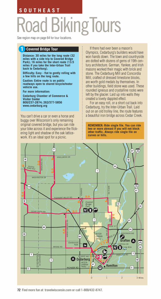
72 Find more fun at travelwisconsin.com or call 1-800/432-8747.
Road BikingToursDistance: 30 miles for the long route (32miles with a side trip to Covered BridgePark); 16 miles for the short route (13.5miles if you take the Inter-Urban Trailback to Cedarburg).Difficulty: Easy - flat to gently rolling witha few hills on the long route.Caution: Entire route is on publicroadways open to shared bicycle/motorvehicle use.For more information:Cedarburg Chamber of Commerce &Visitor Center800/237-2874; 262/377-5856www.cedarburg.org
Covered Bridge Tour
4.2
1.7
57 43
C
57
43
32
43
32
57
57
181
143
6060
C
Y
Y
M
M
T T
I
I
O
W
W
3.5
2.0
5.3
3.6
6.4
2.1
4.8
33
M
WA
SA
UK
EE
RD
WASHINGTON DR
KNOLLWOOD DR
CEDAR CREEK RD
HO
RN
S C
OR
NE
RS
RD
BRIDGE RD
PLEASANT VALLEY RD
CO
VER
ED
BR
IDG
E R
D
MA
PLE
RD
5TH
AVE
HAMILTON RD
PORTLAND RD
COLUMBIA RD
1S
T AVE
WASH
INGTON
AVE
ROSE ST
Cedarburg
Grafton
HILBERT AVE
GREE
N B
AY R
D
CentennialPark
Hamilton
WISCONSIN AVE
MAPLE ST
CHATEAU DR
PIONEER RD
INTER-URBANTRAIL
INTER-URBANTRAIL
Covered BridgePark
RUSTICROAD R52
OZA
UK
EE
CO
WA
SH
ING
TON
CO
Lime Kiln Park
0 1 2 3 Miles
You can’t drive a car or even a horse andbuggy over Wisconsin’s only remainingoriginal covered bridge, but you can rideyour bike across it and experience the flick-ering light and shadow of the oak lattice-work. It’s an ideal spot for a picnic.
If there had ever been a mason’sOlympics, Cedarburg’s builders would havewon hands down. The town and countrysideare dotted with dozens of gems of 19th cen-tury architecture. German, Yankee, and Irishmasons worked their magic with brick andstone. The Cedarburg Mill and ConcordiaMill, crafted of dressed limestone blocks,are worth gold medals by themselves. Inother buildings, field stone was used. Theserounded igneous and crystalline rocks wereleft by the glacier. Laid up into walls theycreated a lovely dappled effect.
For an easy roll, or a short cut back intoCedarburg, try the Inter-Urban Trail. Laidout on an old trolley line, the route featuresa beautiful iron bridge across Cedar Creek.
S O U T H E A S T
1
See region map on page 64 for tour locations.
REMEMBER: Ride single file. You can ridetwo or more abreast if you will not blockother traffic. Always ride single file oncurves or hills.

Find more fun at travelwisconsin.com or call 1-800/432-8747. 73
4.5
4.2 2.3
3.0
8.0
2.0
Fontana
Sharon
67
67
67
67
14
14
C
C
K
B
BRICK CHURCH RD
STATE LINE RD
GRACE ST
ILLINOIS
WALWORTH CO
BELOIT RDTOWN HALL RD
PR
AIR
IE V
IEW
RD
SIX
CO
RN
ER
S R
D
DEVIL'S LANE RD
BR
ICK
SC
HO
OL
RD
LAKE SHORE RD
PE
TER
S R
D
BO
LLING
ER
RD
KO
CH
RD
VOLL
ER
RD
Lake Geneva
SH
ABB
ON
A D
R
R
IDG
E R
D
OLD FACTORY RD
Walworth
0 .5 1 1.5 2 Miles
It is amazing to find such quiet rural farm-land so near one of Wisconsin’s most pop-ular tourism destinations. But the landbetween the tiny border town of Sharon andthe blue waters of Lake Geneva is just that.
Sharon has a picture perfect block-longdowntown. Beautiful nineteenth centurycream brick buildings are dressed with col-orful window box flowers. The town’s cafésand antique shops are pre-ride or post-rideattractions.
Riding through the countryside you’llcover gently rolling terrain punctuated withpretty farms, churches and roadside mapletrees. Nearing Fontana, the terrain rises toform the bowl that cradles Lake Geneva. InFontana, the route skirts the lake wherepleasant town parks and beaches invite youto rest.
Leaving the lake basin you face thesteepest climb of the ride on ShabbonaDrive. The twisting ascent leads to what ap-pears to be a castle gate. Once through, youcan jump on a paved off-road bike trail for ashort distance. Back in the countryside,Ridge Road offers fine overviews of the sur-rounding farmland.
Distance: 24 milesDifficulty: ModerateCaution: Nearly all of the route is onpublic roadways open to sharedbicycle/motor vehicle use. Railroad trackscross Brick Church Rd at a sharp angle.Use the paved shoulder on Hwy. 67.For more information:Lake Geneva Convention and VisitorsBureau800/345-1020www.lakegenevawi.comWalworth County Visitors Bureau 800/395-8687, 262/728-6000www.visitwalworthcounty.com
Sharon to Fontana Tour2
BRIAN MALLOY
Fall ride through the scenic Kettle Moraine.

74 Find more fun at travelwisconsin.com or call 1-800/432-8747.
ONGOINGWisconsin Endurance Mountain Bike Series
Wisconsin Off Road Series
MARCHFat Bike Birkie, Cable
APRILAdventure Triathlon, Grantsburg
Classic Mammoth Gravel Bike Race, St. CroixFalls
Wheel & Sprocket Bike Expo, West Allis
WISPORT Friendly Metric Century or Less BikeRide & Bicycling Clinic, Willard
MAYBike for Habitat, New Glarus
Birky Challenge, Fond du Lac
Cable Area Off-Road Classic, Cable
Chippewa Valley Century Ride, Chippewa Falls
Chocolate Fest, Hortonville
Dar’s Midwest Time Trial Championship(Festival of the Wheel), Willard
Hip Breaker Bike Tour, Trempealeau
Mt. Borah Epic, Cable
Opening of State Bike Trails, Sparta
The Opener, Cable
West Salem Classic Bike Tour, West Salem
Woolly Mountain Bike Race, St. Croix Falls
JUNEAurora BayCare High Cliff Triathlon, Sherwood
Badger State Games Aspirus YMCA Duathlon,Weston
Battle of CamRock, Cambridge
Carl Zach Cycling Classic, Waukesha
Commonwealth Classic Bike Race, Fond duLac
Frederic Lion's Classic Bike Race, Frederic
“Got Energy” YMCA Touchstone EnergyTriathalon, West Salem
GRABAAWR, Madison
Horribly Hilly Hundred, Blue Mounds
Introduction to Road Touring, West Bend
Menominee River Century Bicycle Ride,Marinette
Minds in Motion Bike Tour, Onalaska
Northwoods Bicycle Retreat, ManitowishWaters
Ride the Drive, Madison
Pie Ride, Janesville
Pleasant Prairie Triathlon, Pleasant Prairie
Ridges Ride for Nature, Baileys Harbor
Stower Seven Lakes State Trail
Superior Vistas Bike Tour, Washburn
Tour of America’s Dairyland
Triathlon@Soo Line Park, Amery
UPAF Ride for the Arts, sponsored by MillerLite, Milwaukee
WORS Red Eye Rendevous Mountain BikeRace, Wausau
JULYBest Friends Gourmet Bike Tour, Neenah
Bike Northwoods Tour, Madison
Cambridge Lake Ripley Ride, Cambridge
Chequamegon Bay Sprint Triathlon, Ashland
Flavors of Wisconsin Bicycle Tour, Fitchburg
Highground Bicycle Tour, Neillsville
Lactic Edge Triathlon, Stevens Point
Pedal for Paws, New Glarus
Pewaukee Multisport Weekend, Pewaukee
Phillips Chain of Lakes Tri, Phillips
Scenic Shore 150 Bike Tour, Mequon
Trempealeau Lions Catfish Days, Trempealeau
AUGUSTAnnual Lakes and Leaves Ride, Summit Lake
Bike Unite Duathlon, Stevens Point
Changing Colors Ride & Oktoberfest, Amery
Colorama Bike Tour, Merrill
CORP Fest with 12 Hours of Pitch Black SingleTrack, Rockdale
Escarpment Bicycle Tour, Chilton
Flambeau 40, Park Falls
Kiwanis Ride to Read, Portage
R E S O U R C E S
Wisconsin Biking EventsJESSE KRUIT
Wausau 24.

Find more fun at travelwisconsin.com or call 1-800/432-8747. 75
Midwest Recumbent Rally, Stevens Point
Northern Woods & Waters Bicycle Tour, ThreeLakes
Race the Lake, Fond du Lac
SAGBRAW, Madison
Seeley Lions Club Pre-Fat Bike Race, Hayward
Silver Lake Triathlon, Portage
Wausau 24
SEPTEMBERBike the Barn Quilts, Shawano
CAMBA Fat Tire Tour, Seeley
Chequamegon Fat Tire Festival Weekend,Cable
Colorama “Try-athlon,” Phelps
Deer Fly Chase Mountain Bike Race, NewAuburn
Door County Century Ride, Sturgeon Bay
Fat Tire Memorial Tour of Geneva Lake, LakeGeneva
Girls Just Want 2 Have Fun Bike Ride, Hudson
Hayward Fall Festival, Hayward
Hayward Library Fall Century Tour, Hayward
Irish Fest Central Wisconsin, Weston
La Crosse Area Labor Day Weekend BicycleFestival, La Crosse
Maywood Earth Ride, Sheboygan
Pedal the Kettle, Waukesha
Peninsula Century Ride, Sister Bay
Taste of Cross Plains, Cross Plains
The Autumn Trek Ride, River Falls
OCTOBERSt. Croix Falls AutumnFest, St Croix Falls
Tour de Cheese, Monroe
Tyranena Oktoberfest Bike Ride, Lake Mills
WISCONSIN’SBICYCLE FRIENDLYCOMMUNITIES
In 2013, Wisconsin ranked 8thin the country with ten commu-nities, 29 businesses and oneuniversity receiving a Bicycle
Friendly America certification. Theten communities are Appleton,Fitchburg, La Crosse, Madison,Milwaukee, Onalaska, SheboyganCounty, Shorewood, Stevens Pointand Sturgeon Bay.
The program, run by the Leagueof American Bicyclists, is an effec-tive tool to make bicycling a realtransportation and recreation op-tion for everyone. The BicycleFriendly America program providesa roadmap, hands-on assistance,and recognition for states, commu-nities, universities and businesses.Each year, the League assesses all50 states, and all applicants getcustomized feedback on their ap-plication and access to technicalassistance.
Bicycle Friendly America ismore than a rewards program. It ismaking biking better and safer forcyclists across the country by set-ting standards for what constitutesa real bicycling culture and envi-ronment. It affects decisions onhow communities, businesses, uni-versities and states grow. It in-spires action, involvement andcoordination among people whowant to improve conditions for bi-cyclists and acts as a roadmap forwhat steps communities, busi-nesses, universities and states cantake.
For more information on the Bicycle Friendly America programvisit www.bikeleague.org/bfa.
THE BIKE FED
DAVE SCHLABOWSKE
Chequamegon Fat Tire Festival Weekend, Cable.

76 Find more fun at travelwisconsin.com or call 1-800/432-8747.
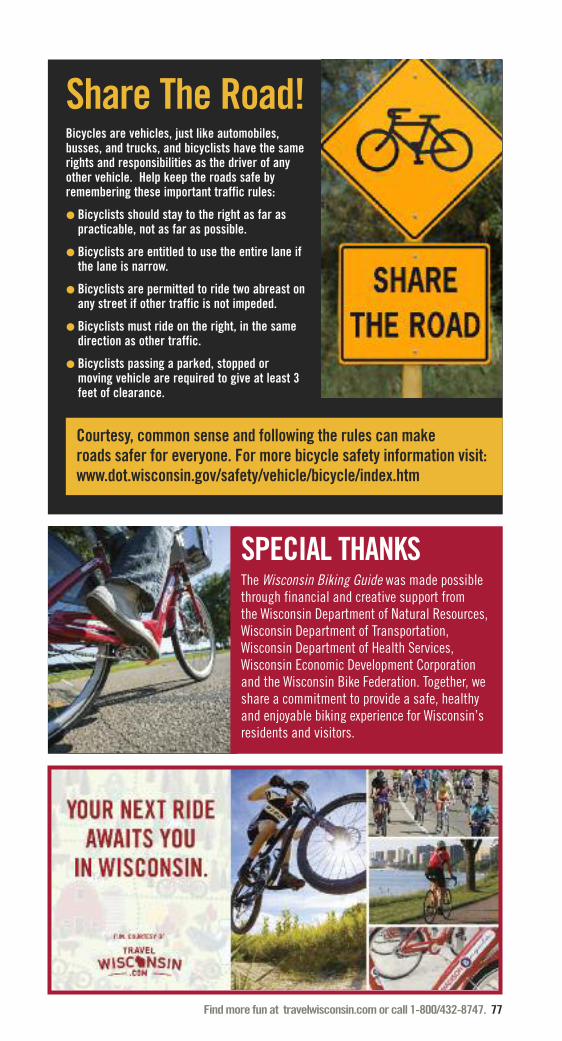
Find more fun at travelwisconsin.com or call 1-800/432-8747. 77
Share The Road!Bicycles are vehicles, just like automobiles,busses, and trucks, and bicyclists have the samerights and responsibilities as the driver of anyother vehicle. Help keep the roads safe byremembering these important traffic rules:
� Bicyclists should stay to the right as far aspracticable, not as far as possible.
� Bicyclists are entitled to use the entire lane ifthe lane is narrow.
� Bicyclists are permitted to ride two abreast onany street if other traffic is not impeded.
� Bicyclists must ride on the right, in the samedirection as other traffic.
� Bicyclists passing a parked, stopped ormoving vehicle are required to give at least 3feet of clearance.
Courtesy, common sense and following the rules can make roads safer for everyone. For more bicycle safety information visit:www.dot.wisconsin.gov/safety/vehicle/bicycle/index.htm
SPECIAL THANKSThe Wisconsin Biking Guide was made possiblethrough financial and creative support from the Wisconsin Department of Natural Resources,Wisconsin Department of Transportation,Wisconsin Department of Health Services,Wisconsin Economic Development Corporationand the Wisconsin Bike Federation. Together, weshare a commitment to provide a safe, healthyand enjoyable biking experience for Wisconsin’sresidents and visitors.

78 Find more fun at travelwisconsin.com or call 1-800/432-8747.
WISCONSIN STATE BIKE MAPWisconsin is a premier state for bicy-cling. The Wisconsin State Bike Maphelps bicyclists get from one locationin the state to another, the map classi-fies state and county roads throughoutthe state in terms of bicycling condi-tions, identifies recreational bicycletrails and mountain bike facilities,provides contacts for local bicycleroute information. Wisconsin Depart-ment of Transportation (WisDOT) alsohas Urban Area Bike maps for Wis-consin municipalities with popula-tions greater than 25,000. Thesemaps complement the state bike map
and provide information about traffic volume of major urbanstreets and various bicycle facilities such as wide outsidelanes, designated bike lanes, signed bike routes and paths.
www.dot.wisconsin.gov/travel/bike-foot/bikemaps.htm

Explore the amazingly bikeable Badger state.The Bike Fed has teamed up with Shine United to bring you an amazingnew website. Find trails, rides, events or submit your own. Connect withother cyclists, browse the classifieds for a bike, and even find the nearestbike shop – all in one beautiful, easy to use location... rideonwisconsin.com
Find more fun at travelwisconsin.com or call 1-800/432-8747. 79
Biking allows visitors andresidents the opportunity toexperience Wisconsin’s greatoutdoors and exciting urbandestinations. It’s also a FUN way to stay fit and active! Visit the Department of HealthServices website to learn moreabout nutrition, staying active,and living a healthy lifestyle.
WisconsinDepartment ofHealth Services
www.dhs.wisconsin.gov/physical-activity

80 Find more fun at travelwisconsin.com or call 1-800/432-8747.
I N D E XLINEAR BIKE TRAILS PAGE400 State Trail......................................................... 35Ahnapee State Trail ................................................. 15Badger State Trail ................................................... 55Bearskin State Trail ................................................. 15Bugline Trail ........................................................... 65Buffalo River State Trail........................................... 45Cannonball Path ..................................................... 55Capital City State Trail ............................................ 57Cattail State Trail..................................................... 5Chippewa River State Trail ..................................... 5Coon Point Trail...................................................... 45Devil’s River State Trail ........................................... 25Eau Claire City Trails .............................................. 5Eisenbahn State Trail .............................................. 25Elroy-Sparta State Trail ........................................... 45Fox River State Trail................................................ 15Fox River Trail - Waukesha ..................................... 65Friendship State Trail.............................................. 25Gandy Dancer State Trail......................................... 5Glacial Drumlin State Trail East............................... 65Glacial Drumlin State Trail West ............................. 57Glacial River Trail.................................................... 58Great River State Trail ............................................ 45Green Circle State Trail ........................................... 35Hank Aaron State Trail ............................................ 65Heart of Vilas County Trail ...................................... 15Hillsboro State Trail ................................................ 49La Crosse River State Trail...................................... 49Lake Country Recreation Trail ................................. 65Lakefront Oak Leaf Trail .......................................... 65Mariners Trail ......................................................... 27Mascoutin Valley State Trail.................................... 27Military Ridge State Trail ........................................ 57Mountain Bay State Trail......................................... 37New Berlin Recreation Trail..................................... 65Newton-Blackmour State Trail................................. 27Nicolet State Trail.................................................... 15Oconto River State Trail .......................................... 16Old Abe State Trail .................................................. 5Old Plank Road Trail ............................................... 29Omaha State Trail.................................................... 37Osaugie Trail........................................................... 5Ozaukee Interurban Trail ......................................... 67Pecatonica State Trail.............................................. 57Pelishek-Tiffany Nature Trail ................................... 58Pike Bike Trail......................................................... 67Pine Line Recreation Trail ....................................... 5Pine River Recreation Trail...................................... 49Rawley Point Recreational Trail............................... 29Red Cedar State Trail .............................................. 6Saunders State Trail................................................ 6Seven Waters Trail .................................................. 67Stower Seven Lakes State Trail ............................... 6Sugar River State Trail ............................................ 59Three Eagle Trail ..................................................... 16Tomorrow River State Trail ...................................... 37Tri-County Corridor Trail ........................................ 6Tuscobia State Trail................................................. 6White River State Trail............................................. 67Wilderness Lakes Trail............................................ 16Wild Goose State Trail ............................................ 59Wild Rivers State Trail............................................. 7Wildwood Trail........................................................ 7Wiouwash State Trail .............................................. 29Wolf River State Trail .............................................. 16
MOUNTAIN BIKE TRAILS PAGEAsh Creek Community Forest ................................. 50Baird Creek Trail ..................................................... 18Big Eau Pleine Park ................................................ 38Bluemound State Park Trails................................... 60Calumet Park Trails................................................. 30CAMBA Single Track Trails ..................................... 8Cam-Rock Trails ..................................................... 60Devil’s Head Ski Area.............................................. 60Evergreen Park ....................................................... 30Greenbush Trail ...................................................... 30Hartman Creek State Park ....................................... 38Hickory Ridge Trail ................................................. 8High Point Trail....................................................... 8Hoyt Park Trail ........................................................ 68Human Powered Trails............................................ 50John/Muir Emma Carlin Trails................................ 68Kewaunee County Trails.......................................... 18Kickapoo Valley Reserve Trail ................................. 50Lake Geneva Canopy Tours..................................... 68Levis Mound Trails ................................................. 38Lowes Creek Trail ................................................... 9Maribel Caves County Park .................................... 30Milwaukee Alpha Trail............................................. 70Minooka County Park ............................................. 70Mound View Park ................................................... 50Mud Lake Trail........................................................ 18New Fane Trails ...................................................... 30Nicolet Roche Trail.................................................. 18Nine Mile Forest Trail ............................................. 40Nordic Mountain .................................................... 40Northern Highland American Legion State Forest ... 20Northwest Park ....................................................... 9Otter Creek Park ..................................................... 10Pleasant Valley Park ............................................... 70Pokegama Trail ....................................................... 10Quarry Ridge Recreation Area................................. 60Raven Trail.............................................................. 20Ray’s Indoor Mountain Biking................................. 70Reforestation Camp Trails....................................... 20Rock Lake CAMBA Trail.......................................... 10Sidie Hollow County Park....................................... 50Standing Rocks Trail............................................... 40The Rock Sports Complex ...................................... 71Underdown Trails.................................................... 21Washburn Lake Trails ............................................. 21White Tail Ridge...................................................... 10
ROAD BIKING TOURS PAGEAround the Horn Tour ............................................ 12Chain O’ Lakes Tour................................................ 42Covered Bridge Tour............................................... 72Elkhart Lake to Kiel Tour ......................................... 32Frank Lloyd Wright Tour ......................................... 62High Falls Tour ...................................................... 22Merrimac Ferry Tour ............................................... 63Prairie du Chien Tour.............................................. 52River Falls Tour ...................................................... 13Sharon to Fontana Tour .......................................... 73Shore to Shore Tour................................................ 23Top of the World Tour ............................................. 53Two Rivers Tour ...................................................... 33Wild Rose Covered Bridge Tour.............................. 43

April 22, 1970. The first Earth Day.Founded by Senator Gaylord Nelsonof Wisconsin to raise environmentalconsciousness.
Wisconsinites continue to dig in tothe Earth Day tenets of preserving the environment and enhancing our quality of life.
That brings us to the notion of aneco-friendly vacation, a concept theWisconsin Department of Tourismpioneered when it launched TravelGreen Wisconsin™ in 2006. TravelGreen was the first certificationprogram in the country that wentbeyond accommodations to includetourism businesses of all sorts –events, attractions, restaurants, and everything in between.
So if leaving a lighter footprint isimportant to you, then considerpatronizing the hundreds of TravelGreen Wisconsin™ certifiedbusinesses when visiting. Visittravelwisconsin.com for a listing.
To summarize: Go green. Have fun. Rest easy.
resteasyLET YOUR (ECO) CONSCIENCE
IN WISCONSIN

Fall Color ReportA weekly report on fall color conditionsaround the state. Available in Septemberand October.
Snow Conditions ReportA weekly report on conditions fordownhill skiing, cross country skiingand snowmobiling around the state.
Wisconsin TravelerEssential information for the Wisconsintraveler. A twice-monthly newsletterthat brings you the latest in Wiscon-sin getaway ideas, events, packages &deals and more!
Social MediaLike us on Facebook, follow us onTwitter, pin us on Pinterest or watch uson YouTube.
Travel Wisconsin AppsFind the fun faster while you’re on-the-road in Wisconsin with the Travel Wis-consin™ iPhone® and AndroidTM apps.
Trip PlannerExplore. Save. Share. Create a new tripor edit existing trips, then print detailsof your trip and share your trip withfriends on your favorite social networkor via email.
Official Wisconsin Travel GuideA full-color, 80 page guide to over 500Wisconsin attractions – a perfect tool toplan your next getaway.
Wisconsin Activity GuideA full-color, 80-page guide to recreationalopportunities on the land, on the water, andon the snow.
Wisconsin Event GuidesFull-color, 40 page guide to some ofWisconsin’s top events. Two editions peryear – spring/summer and fall/winter.
Wisconsin Lodging DirectoryA comprehensive directory describing morethan 1,100 Wisconsin hotels, motels,resorts and B&Bs. Provided by theWisconsin Innkeepers Association.
Wisconsin Bed & Breakfast DirectoryLists 220 charming Wisconsin B&Bs in ahandy, pocket-sized brochure. Provided bythe Wisconsin Bed & Breakfast Association.
Wisconsin Art & Craft Fairs DirectoryA 64-page guide to nearly 200 art and craftfairs held throughout Wisconsin.
Native WisconsinA full-color guide showcasing theattractions, events and history ofWisconsin’s Indian people. Provided byNative American Tourism of Wisconsin.
Wisconsin Campground DirectoryA 66-page guide to the privatecampgrounds of Wisconsin, listed byregion. Provided by the WisconsinAssociation of Campground Owners.
Wisconsin State Parks Visitor GuideA 24-page full-color booklet detailing therecreational facilities offered atWisconsin’s state parks, forests and trails.
Wineries of WisconsinIncludes a list of wineries, maps andcomplete information for planning your tourof Wisconsin’s five wine regions. Providedby the Wisconsin Winery Association.
To order more free Wisconsin travel guides visit travelwisconsin.com or calltoll-free 1-800-432-8747
Get connected andstay connected attravelwisconsin.com