Office of Historic Preservation Incentives
170
Protects the historical, cultural, architectural, and archeological resources that make San Antonio unique
-
Upload
becentro-bedowntown -
Category
Business
-
view
1.307 -
download
7
description
Incentives Policy for Downtown Infill Development for the Office of Historic Preservation.
Transcript of Office of Historic Preservation Incentives

Protects the historical, cultural, architectural, and archeological resources that make San Antonio unique

Overview of Incentives
Substantial Rehabilitation Tax CreditNew Historic District Tax CreditSan Antonio Conservation Society GrantsFederal Tax Credits
Presenter�
Presentation Notes�
The following are some of the incentives we use�
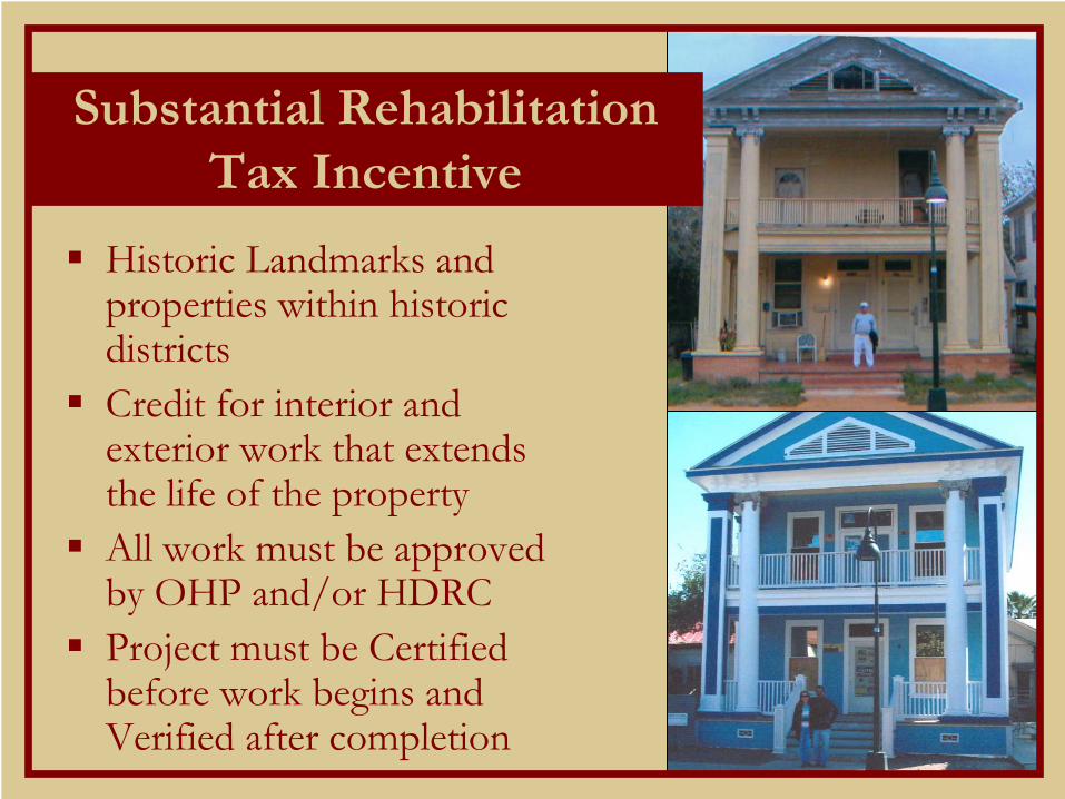
Historic Landmarks and properties within historic districtsCredit for interior and exterior work that extends the life of the propertyAll work must be approved by OHP and/or HDRCProject must be Certified before work begins and Verified after completion
Substantial Rehabilitation Tax Incentive
Substantial Rehabilitation Tax Incentive
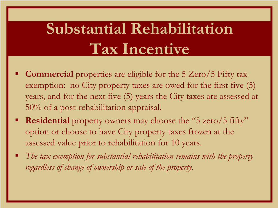
Commercial properties are eligible for the 5 Zero/5 Fifty tax exemption: no City property taxes are owed for the first five (5) years, and for the next five (5) years the City taxes are assessed at 50% of a post-rehabilitation appraisal.Residential property owners may choose the “5 zero/5 fifty”option or choose to have City property taxes frozen at the assessed value prior to rehabilitation for 10 years.The tax exemption for substantial rehabilitation remains with the property regardless of change of ownership or sale of the property.

Revolving FundsHistoric Owner-Occupied Rehabilitation Loan Program
Low to Moderate IncomeAids in restoration and preservation efforts within historic districts
Acquisition/Rehabilitation/Resale Revolving Fund
Partnering with SACS & Merced
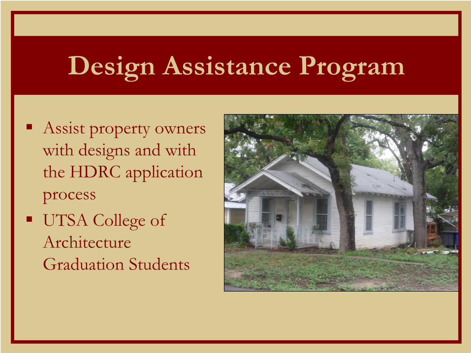
Design Assistance Program
Assist property owners with designs and with the HDRC application processUTSA College of Architecture Graduation Students

Jurisdiction
27 Local Historic Districts
Over 1300 Individual Local Landmarks
6 River Improvement Overlay (RIO) Districts –stretching for 13 miles along the San Antonio River
All public facilities including fire stations, libraries, community centers, public ROW, etc.
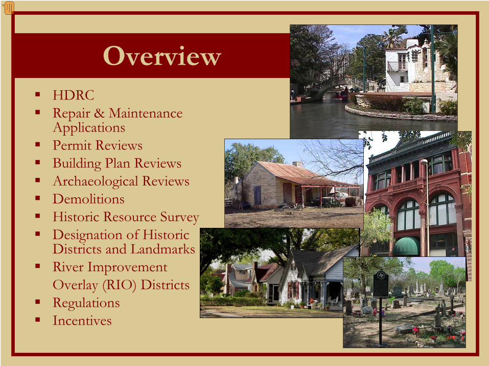
OverviewHDRC Repair & Maintenance ApplicationsPermit ReviewsBuilding Plan ReviewsArchaeological ReviewsDemolitionsHistoric Resource SurveyDesignation of Historic Districts and LandmarksRiver Improvement Overlay (RIO) DistrictsRegulationsIncentives
Presenter�
Presentation Notes�
�

11 members appointed by City Council (includes architects, planners, archaeologists, etc.)Advisory to City Manager and relevant departmentsMeetings held the first and third Wednesdays of each monthCommittees: Design Review Committee; Designation and Demolition Committee
Historic & Design Review Commission (HDRC)
Presenter�
Presentation Notes�
The Historic Design and Review Commission assists the City in the enforcement of our guidelines. They are 15 members appointed by City Council Advisory to the Directors of Planning, Parks and Recreation, Code Compliance, Public Works, Arts and Cultural Affairs, and Development Services And Department of Planning is staff support �

Replacement/repair with in-kind materialsFoundation, sidewalk, driveway, & patio repair LandscapingPaint color that is consistent with the district on previously painted surfaces Replacement or new fencing for the side and backyard with appropriate material and in conformance with the UDC Minor alterations of non-contributing elements
Administrative Certificate of Appropriateness

Establish design standardsProvide a framework to support economic developmentProtect the public investment in the San Antonio River improvementsPromote good urban design, highlighting River’s cultural and historic resourcesAmended March 2011
River Improvement Overlay District (RIO)
Presenter�
Presentation Notes�
Another District designation that helps San Antonio Preserve its historic and cultural resources is the River Improvement Overlay District or RIO. Our River Improvement Overlay ordinance, referred to RIO which is “river” is Spanish, won an award from the APA for its innovative adaptive zones which address the ever changing use along the San Antonio River, not just “The Riverwalk”. All the details can be found on our websites. �

River Improvement Overlay District (RIO)
Landscape DesignPlant MaterialsPaving Materials
Site Walls and FencesStreet FurnishingsLighting
Presenter�
Presentation Notes�
River Improvement Overlay Districts provide guidelines for the following Landscape Design Plant Materials Paving Materials Site Walls and Fences Street Furnishings Lighting �
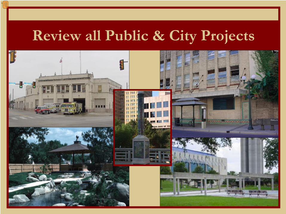
Review all Public & City Projects
Presenter�
Presentation Notes�
Every public project is reviewed by our the Historic Design and Review Commission. This includes public art, publicly owned buildings such as libraries, fire stations, parks, bus stops, lighting and of course the Riverwalk. �

Disclaimer: The Office of Historic Preservation staff has assembled sections of the Unified Development Code as a courtesy reference only. This is not the official version of the UDC and should not be relied upon. The City of San Antonio and Office of Historic Preservation do not guarantee the accuracy, adequacy, completeness or usefulness of any information. Viewers/users are strongly encouraged to verify any information contained in this reference with an official ordinance or version of the UDC, or to contact the Historic Preservation Office before taking any action based on the information contained herein. City of San Antonio Texas Unified Development Code
Article VI Historic Preservation and Urban Design

City of San Antonio Texas Unified Development Code Historic Preservation and Urban Design Division 1 General………………………………………………………………………..2 35-601 Purpose…………………………………………………………………....2 35-602 Administration………………………………………………………….....2 Division 2 Historic Preservation……………………………………………………….....4 35-605 Designation Process for Historic Districts…………………………….......4 35-606 Designation Process for Historic Landmarks…………………………......6 35-607 Designation Criteria for Historic Districts and Landmarks……………...10 35-608 Certificate of Appropriateness and Conceptual Approval – Generally….12 35-609 Criteria for Certificate of Appropriateness – New Construction………...12
35-610 Certificate of Appropriateness – Alteration, Restoration, and Rehabilitation………………………………………………………………….....16 35-611 Certificate of Appropriateness – Administrative Approval……………...17 35-612 Signs and Billboards…………………………………………………......20 35-613 Relocation of a Landmark or Property Located in a Historic District.......32 35-614 Demolition……...…………………………………………...…………...32 35-615 Prevention of Demolition by Neglect……………………………….…...37 35-616 Treatment of Site Following Demolition………………………………...39 35-617 Public Safety Hazards and Emergency Securing Measures……………..40 35-618 Tax Exemption Qualifications…………………………………………...40 35-619 Non – Contributing Structures...................................................................44
Division 3 Archaeological Sites and Cemeteries.............................................................45 35-630 Designated Archaeological Sites...............................................................45 35-631 Inventoried Archaeological Sites...............................................................45 35-632 Unidentified Archaeological Sites.............................................................46 35-633 Miscellaneous Provisions..........................................................................47 35-634 Cemeteries.................................................................................................48 Division 4 Public Property................................................................................................48 35-640 Public Property and Rights-of-Way..........................................................48
35-641 Design Considerations for Historic and Design Review Commission Recommendations..................................................................................................49 35-642 New Construction of Buildings and Facilities...........................................49 35-643 Alteration, Restoration and Rehabilitation................................................51 35-644 Certificate of Appropriateness – Administrative Approval.......................52 35-645 Signs and Billboards on Public Property or Right-of-Way.......................52 35-646 Construction in Public Rights-of-Way......................................................55
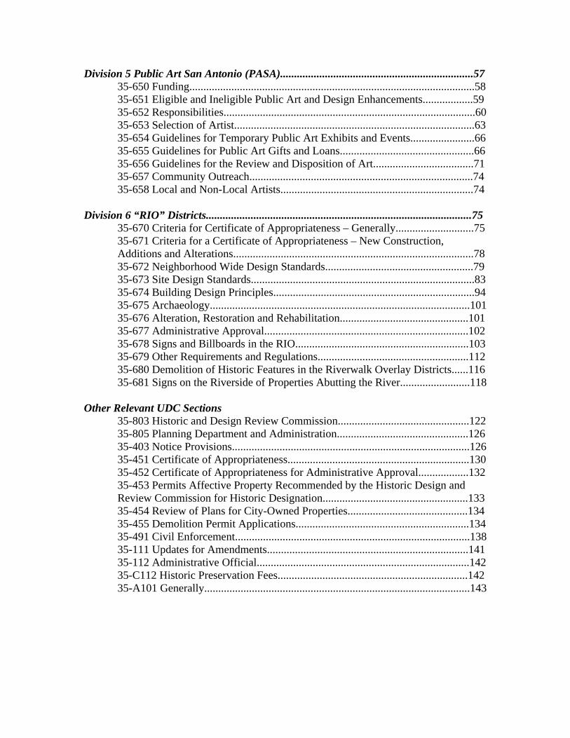
Division 5 Public Art San Antonio (PASA).....................................................................57 35-650 Funding......................................................................................................58 35-651 Eligible and Ineligible Public Art and Design Enhancements..................59 35-652 Responsibilities..........................................................................................60 35-653 Selection of Artist......................................................................................63 35-654 Guidelines for Temporary Public Art Exhibits and Events.......................66 35-655 Guidelines for Public Art Gifts and Loans................................................66 35-656 Guidelines for the Review and Disposition of Art....................................71 35-657 Community Outreach................................................................................74 35-658 Local and Non-Local Artists.....................................................................74 Division 6 “RIO” Districts...............................................................................................75 35-670 Criteria for Certificate of Appropriateness – Generally............................75
35-671 Criteria for a Certificate of Appropriateness – New Construction, Additions and Alterations......................................................................................78 35-672 Neighborhood Wide Design Standards.....................................................79 35-673 Site Design Standards................................................................................83 35-674 Building Design Principles........................................................................94 35-675 Archaeology.............................................................................................101 35-676 Alteration, Restoration and Rehabilitation..............................................101 35-677 Administrative Approval.........................................................................102 35-678 Signs and Billboards in the RIO..............................................................103 35-679 Other Requirements and Regulations......................................................112 35-680 Demolition of Historic Features in the Riverwalk Overlay Districts......116 35-681 Signs on the Riverside of Properties Abutting the River.........................118
Other Relevant UDC Sections 35-803 Historic and Design Review Commission...............................................122 35-805 Planning Department and Administration...............................................126 35-403 Notice Provisions.....................................................................................126 35-451 Certificate of Appropriateness.................................................................130 35-452 Certificate of Appropriateness for Administrative Approval..................132
35-453 Permits Affective Property Recommended by the Historic Design and Review Commission for Historic Designation....................................................133 35-454 Review of Plans for City-Owned Properties...........................................134 35-455 Demolition Permit Applications..............................................................134 35-491 Civil Enforcement....................................................................................138 35-111 Updates for Amendments........................................................................141 35-112 Administrative Official............................................................................142 35-C112 Historic Preservation Fees....................................................................142 35-A101 Generally...............................................................................................143
ARTICLE VI. HISTORIC PRESERVATION AND URBAN DESIGN
STATEMENT OF PURPOSE
The city council hereby recognizes that the City of San Antonio is internationally known for its beauty, friendliness, and historical significance. It is a noteworthy example of the confluence of diverse cultures in the new world. San Antonio is also uniquely blessed by its winding, meandering river. The river lends an incomparable quaintness and romantic charm especially to the central business district, a fact that has long made it one of our city's principal tourist attractions. San Antonio's unique qualities have proven increasingly attractive to residents, business interests, and tourists.
As a matter of public policy the council aims to preserve, enhance, and perpetuate those aspects of the city and the San Antonio River having historical, cultural, architectural and archaeological merit. Such preservation promotes and protects the health, safety, prosperity, education, comfort, and general welfare of the people living in and visiting San Antonio. More specifically, this article is designed to achieve the following goals:
•To preserve, protect, and enhance historically, culturally, architecturally, and archaeologically significant sites and structures which impart a distinct aspect to the city and serve as visible reminders of the city's culture and heritage; •To promote the economic prosperity and welfare of the community by conserving the value of historic districts, landmark buildings, the Riverwalk, plus property and art owned by the City of San Antonio by encouraging the most appropriate use of such property within the city; •To recognize and protect the unique and distinctive character and qualities of the San Antonio River, as well as the sedate and vibrant atmosphere of the river and Riverwalk area, and its integral relationship to the City of San Antonio; •To preserve the ecoclimate of the San Antonio River and the Riverwalk, ensuring that existing and indigenous plant life is protected from unnecessary stress through shading by inappropriate construction, noise, excess water and drainage run-off, or other forms of pollution; •To strengthen civic pride through neighborhood preservation; •To recognize, protect and strengthen the unique design character of individual historic districts and individual areas of the city; •To provide a review process for the appropriate preservation and development of important historical, architectural, archaeological, and cultural resources; •To ensure the harmonious, orderly, and efficient growth and development of the city;
1

•To maintain a generally compatible outward appearance of both historic and modern structures through complementary scale, form, color, proportion, texture, and material; •To establish the highest urban design standards for public property including public buildings and public spaces so that the evident public commitment to quality design encourages and inspires by example a corresponding commitment by the private sector; and •To adopt criteria and procedures for data investigation and identification of resources as set forth in the City of San Antonio's significant resources survey report, adopted by city council on April 14, 1983.
(Ord. No. 98697 § 6) DIVISION 1. - GENERAL DIVISION 2. - HISTORIC PRESERVATION DIVISION 3. - ARCHAEOLOGICAL SITES AND CEMETERIES DIVISION 4. - PUBLIC PROPERTY DIVISION 5. - PUBLIC ART SAN ANTONIO (PASA) DIVISION 6. - "RIO" DISTRICTS DIVISION 1. - GENERAL Sec. 35-601. - Purpose. Sec. 35-602. - Administration. Secs. 35-603 to 35-604. - Reserved. Sec. 35-601. Purpose.
The purpose of this article is to provide the standards and criteria for protection of historic, cultural, archaeological and artistic resources.
(Ord. No. 2006-06-15-0718, § 2, 6-15-06) Sec. 35-602. City Historic Preservation Officer.
The city historic preservation officer, through the office of historic preservation, shall administer this article and shall advise the historic and design review commission on each application that shall come before the commission. This person shall have expertise in archaeology, history, architectural history, historic preservation, or a closely related field. The city historic preservation officer shall have the following powers and duties:
(a) To approve, deny or approve with conditions, applications submitted to the office of historic preservation when acting as the City Manager designee.
2

(b) To coordinate with the department of CIMS who shall administer the public art and design enhancement program under division 5 of article VI.
(c) To coordinate the city's preservation and urban design activities with those of local, state and federal agencies and with local, state, and national preservation and urban design organizations in the private sector.
(d) To recommend to the commission buildings, objects, sites, structures, and districts for designation as landmarks or historic districts in accordance with the criteria established by this chapter.
(e) To recommend to the commission buildings, objects, sites, structures, and districts for nomination to the National Register of Historic Places. Such recommendations shall be guided by the criteria established in the National Historic Preservation Act of 1966, as amended.
(f) To maintain and hold open for public inspection all records pertaining to the provisions of historic and design regulations as provided for in article VI and article III, and to keep a copy available for public viewing all historic district specific guidelines, Secretary of the Interior Standards, Guidelines for Archeology and Historic Preservation, and any other guidelines which are referenced in Article VI. Public viewing may include available office of historic preservation websites.
(g) To review, approve or deny applications for building and demolition permits required by section 35-108.
(h) To review plans for proposed development to assure that all necessary permits have been obtained from these federal, state or local government agencies from which prior approval is required as provided in this chapter for historic and design review.
(i) To administratively review office of historic preservation applications and forms for completeness.
(j) To approve administrative certificates of appropriateness. (k) To convene meetings of the design review committee of the
historic and design review commission. (l) To designate objects, buildings and structures submitted for review
as contributing or noncontributing to a historic landmark or historic district.
(Ord. No. 98697 § 6)
Secs. 35-603 to 35-604. - Reserved.
3

DIVISION 2. - HISTORIC PRESERVATION
STATEMENT OF PURPOSE This division implements the following provisions of the master plan: •Preserve and enhance the city's historic resources (Urban design, Goal 2). •Promote the development of major public and private facilities which support the downtown neighborhood and historic resources (Neighborhoods, policy 5c). •Create and adopt urban design guidelines and standards that will enhance the quality of life in San Antonio, and which specifically encourage preservation and enhancement of the city's important historic and cultural characteristics, including architectural styles and historic districts. Sec. 35-605. - Designation of Historic Districts. Sec. 35-606. - Designation of Historic Landmarks. Sec. 35-607. - Designation Criteria for Historic Districts and Landmarks. Sec. 35-608. - Criteria for Certificate of Appropriateness - Generally. Sec. 35-609. - Criteria for Certificate of Appropriateness - New construction. Sec. 35-610. - Alteration, Restoration, and Rehabilitation. Sec. 35-611. - Ordinary Repair and Maintenance. Sec. 35-612. - Signs and Billboards. Sec. 35-613. - Relocation of a Landmark or Property Located in a Historic District. Sec. 35-614. - Demolition. Sec. 35-615. - Prevention of Demolition by Neglect. Sec. 35-616. - Treatment of Site Following Demolition. Sec. 35-617. - Public Safety Hazards and Emergency Securing Measures. Sec. 35-618. - Tax Exemption Qualifications. Secs. 35-619 to 35-629. - Reserved. Sec. 35-605. - Designation Process for Historic Districts. (a) Authority. The city council may designate by zoning ordinance certain areas in
the City of San Antonio as historic districts and certain places, buildings, objects, sites, structures, or clusters as historic landmarks. Such districts shall bear the word "historic" (H) in their zoning designation; such landmarks shall bear the words “historic, landmark (HL) in their zoning designation.” The procedure for designation shall be subject to notice as prescribed in article IV of this chapter for a zoning amendment, and shall conform to the federal and state constitution.
(b) Processing Applications for Designation of Historic Districts. (1) Initiation. Any person owning property within the proposed area, the
historic preservation officer, the historic and design review commission, the zoning commission or the city council may initiate a historic district designation by filing an application with the historic preservation officer. Requests for designation shall be made on a form obtained from the city historic preservation officer through the office of historic preservation. Completed request forms shall be returned to the office of historic preservation for processing. Requests for historic district designation shall not be processed by the office of historic preservation if fifty-one (51)
4

percent of the property owners located within the boundaries of the proposed historic district oppose the designation in writing and present such opposition to the historic preservation officer unless a request for historic district designation is authorized by the city council. To the extent that this paragraph conflicts with any other provisions of this chapter, this paragraph shall control except for buildings, objects, sites, structures, or clusters heretofore designated as local landmarks or districts, National Register landmarks or districts, state historic landmarks or sites, or state archaeological landmarks or sites. In addition to any other conditions established by section 35-605, applications for historic designation shall meet the following criteria: A. Submittal Deadline and Notice. Provided that the historic
preservation officer agrees that the proposed area indicated in the application is appropriate for designation, the office of historic preservation staff shall hold at least one public meeting to announce the effort to obtain historical designation. Prior to the required public meeting, the historic preservation officer shall send notice of the initiation of an application by mail to the owner or owners of affected property stating the purpose, date, time and place of the public meeting. This notice shall be in addition to notice given prior to public hearing as set forth under the city's zoning code. The historic preservation officer shall also send notice of the public meeting to any registered neighborhood associations located within the proposed district boundary.
B. Owners may submit with the application a written description and photographs or other visual material of any buildings or structures that they would like for the historic preservation officer to consider for designation as non-contributing to the historic district. Such submission shall be treated in accordance with Section 35-619.
(2) Completeness Review. See section 35-402 of this chapter. For purposes of this section and subsection 35-402(c), the historic preservation officer is the administrative official with original jurisdiction to review applications and submitted written opposition for completeness.
(3) Decision. Provided that at least 90 days have passed since the public meeting and the historic preservation officer has not received written opposition from at least 51% of the property owners in the proposed designated area, the historic preservation officer shall forward the application to the historic and design review commission for a hearing and recommendation. The historic preservation officer shall notify all property owners within a proposed historic district boundary of the date, time, place and purpose of the historic and design review commission hearing prior to the historic and design review commission hearing on the historic district designation. The historic and design review commission shall make its recommendation for either approval or denial within thirty (30) days from the date of submittal of the designation request by the historic preservation officer. Upon recommendation of the historic and design review
5
commission, the proposed historic district designation shall be submitted to the zoning commission with the historic and design review commission recommendation. The zoning commission and the city council shall process the application as prescribed in section 35-421 of this chapter and this section. The zoning commission shall schedule a hearing on the historic and design review commission's recommendation to be held within forty-five (45) days of receipt of the historic and design review commission's recommendation and shall forward its recommendation for either approval or denial to the city council. The city council shall schedule a hearing to be held within forty-five (45) days of its receipt of the zoning commission's recommendation. The city council shall review and shall approve or deny the proposed historic district. Upon passage of any ordinance designating as historic, or removing the designation of historic, the city clerk shall send notice of the fact by mail to the owner or owners of affected property.
(d) Historic District Guidelines. The city council may, from time to time, designate specific guidelines for particular historic districts. The designation shall include the formal name of the district, a legal description of the boundaries of the district, and a cross-reference to the design guidelines.
(Ord. No. 98697 § 1, 4, 6 and 7; Ord. No. 2007-04-12-0409, §§ 1, 2, 4-12-07) (Ord. No. 2009-01-15-0001, § 2, 1-15-09) Sec. 35-606. - Designation Process for Historic Landmarks.
(a) Authority. Requests for landmark designation may only be made by or with the
concurrence of the property owner. In instances where a property owner does not consent to the landmark designation, the historic preservation officer shall request a resolution from city council to proceed with the designation process prior to any zoning commission hearing. Notwithstanding the foregoing, a request for landmark designation may be made and approved by the city council. To the extent that this subsection conflicts with any other provisions of this chapter, this paragraph shall control except for buildings, objects, sites, structures, or clusters heretofore designated as local landmarks or districts, National Register landmarks or districts, state historic landmarks or sites, or state archaeological landmarks or sites. Additionally, requests for designation shall be made on a form obtained from the city historic preservation officer through the office of historic preservation. Completed request forms shall be returned to the office of historic preservation for processing. All buildings, objects, sites, structures, or clusters heretofore designated by the city council as historic landmarks under any pre-existing ordinance of the City of San Antonio shall be accorded the protection of properties designated historic landmarks under this chapter and shall continue to bear the words "historic, exceptional" (HE) or "historic, significant" (HS) in their zoning designation.
6
(b)Designation of Historic Landmarks.
(1) Initiation. Any person, the historic and design review commission, zoning commission, the historic preservation officer, or the city council may initiate a historic landmark designation by filing an application with the historic preservation officer. Requests for designation shall be made on a form obtained from the city historic preservation officer. Completed request forms shall be returned to the office of historic preservation for processing. Owner consent for historic landmark designation shall be required unless a City Council resolution to proceed with the designation has been approved. Additionally, owners may submit with the application a written description and photographs or other visual material of any buildings or structures that they wish to be considered for designation as non-contributing to the historic landmark.
(2) Completeness Review. See section 35-402 of this chapter. For purposes of this section and subsection 35-402(c), the historic preservation officer is the administrative official with original jurisdiction to review an application for completeness.
(3) Decision. The historic preservation officer shall refer a completed application for historic landmark designation to the historic and design review commission. Property owners of proposed historic landmarks shall be notified of the historic and design review commission hearing by the historic preservation officer by mail prior to a historic and design review commission hearing for historic landmark designation. Notice to property owners shall state the place, date, time and purpose of the historic and design review commission hearing. The historic preservation officer shall also send notice of the meeting to any registered neighborhood associations located within the proposed district boundary. The historic and design review commission shall make and forward its recommendation to the zoning commission within forty-five (45) days from the date of submittal of the designation request by the historic preservation officer. Upon submittal of the historic and design review commission's recommendation, the proposed historic district or landmark designation shall be submitted to the zoning commission for its review recommendations along with its finding of historic significance. The zoning commission and the city council shall process the application as prescribed in section 35-421 of this chapter and this section. The zoning commission shall schedule a hearing on the historic and design review commission recommendation to be held within sixty (60) days of receipt of such recommendation and shall forward its recommendation to city council which shall schedule a hearing to be held within sixty (60) days of council's receipt of such recommendation. Upon passage of any ordinance designating a historic landmark, or removing or upgrading the designation of historic, the city clerk shall send notice of the fact by mail to the owner or owners of affected property.
7
(4) Criteria. Designations of exceptional and significant historic landmarks shall be made considering criteria enumerated in section 35-607 of this division.
(5) Recordation. Upon designation of a building, object, site, structure, or cluster as an exceptional or significant historic landmark, the city council shall cause this designation to be recorded in the official public records of real property of Bexar County, the tax records of the City of San Antonio and the Bexar Appraisal District, the house numbering section of the City of San Antonio's department of development services, and on the City of San Antonio's official zoning maps. Still further, for purposes of clarity in the zoning designation of property, all zoning maps shall reflect exceptional and significant historic landmarks or property in historic districts by inclusion of the words "historic, exceptional" (HE) or "historic, significant" (HS) as a prefix to its use designation as specified in accordance with the general zoning ordinance of the City of San Antonio.
(c) Resources Not Designated by Initial Ordinance. (1) Previously Inventoried Resources. Resources previously inventoried by
the historic and design review commission but not rated due to age, shall be reviewed upon reaching twenty-five (25) years of age by the commission applying criteria set forth in section 35-607 to determine significance, if any. When a resource is found to meet criteria for an exceptional or significant rating, the historic and design review commission at that time shall recommend through the zoning commission to city council the designation of such resources following the procedures set forth in subsection (a) of this section. Resources listed on federal, state or city inventories, but unrated by the historic and design review commission shall be identified in city records.
(2) Uninventoried Resources. As required under the Certified Local Government (CLG) Program of the National Park Service and the Texas Historical Commission, the Office of Historic Preservation on an ongoing basis shall conduct an inventory of buildings, objects, sites, structures and clusters throughout the city to determine cultural, architectural, historical, or archaeological significance, applying the criteria of section 35-607. For such inventories, the Office of Historic Preservation shall rate the resources based on integrity and/or significance. Those buildings, objects, sites or structures found by the board to meet the criteria for historic landmarks shall be recommended for designation following the procedures in subsection (a) of this section. The city, including the Office of Historic Preservation, shall require an inventory of resources in the extraterritorial jurisdiction as part of the master development plan process and the subdivision letter of certification process within the area subject to the MDP or subdivision application unless the Office of Historic Preservation determines, after an initial review, that such an inventory is not required.
(3) Resources. If any building, object, site, structure or cluster is thought to be of historical, architectural, or cultural significance, the historic preservation officer, following an initial investigation of the resource,
8

shall refer the matter to the historic and design review commission for a detailed study, review, and official recommendation of the historical, architectural, or cultural status of the building, object, site, structure, or cluster in accordance with the criteria and procedures established in this chapter.
(d) Historic Landmarks Previously Designated by City Council. All buildings, objects, sites, structures, or clusters heretofore designated by the city council as historic landmarks under any pre-existing ordinance of the City of San Antonio shall be accorded the protection of properties designated exceptional historic landmarks under this chapter and shall continue to bear the word (historic) "H" in their zoning designation.
(e) Other Landmarks and Districts Previously Designated. All National Register districts or landmarks, state historic landmarks or sites, or state archaeological landmarks and sites shall be accorded the protection of properties designated exceptional historic landmarks and districts.
(f) Use of Property Designated Historic. Nothing contained in this article or in the designation of property as being a historic landmark or in a historic district shall affect the present legal use of property. Use classifications as to all such property shall continue to be governed by the general zoning ordinance of the City of San Antonio and the procedures therein established. In no case, however, shall any use be permitted which requires the demolition, relocation, or alteration of historic landmarks or of any buildings or structures in a historic district so as to adversely affect the character of the district or historic landmark, except upon compliance with the terms of this article. No provision herein shall be construed as prohibiting a property owner from continuing to use property for a nonconforming use.
(g) Removal of Designation. Upon recommendation of the historic and design review commission based upon new and compelling evidence and negative evaluation according to the same criteria and following the same procedures set forth herein for designation, a designation made under subsection (a) of this section may be removed by city council following recommendation by the historic and design review commission. (h) Changes in Evaluation. The historic and design review commission may reconsider a previous evaluation of a resource if additional data is provided and a new evaluation is made using the criteria set forth herein. When such a resource meets the criteria for historic designation based on all documentation provided, the historic and design review commission may recommend a change in designation. Following the same procedures set forth herein in subsection (a) of this section for designation, the city council may change a designation upon recommendation of the historic and design review commission. (Ord. No. 98697 § 1, 4 and 6) (Ord. No 2006-06-15-0718, § 2, 6-15-06) (Ord. No. 2009-01-15-0001, § 2, 1-15-09)
9
Sec. 35-607. - Designation Criteria for Historic Districts and Landmarks.
(a) Process for Considering Designation of Historic Districts and Landmarks. Historic districts and landmarks shall be evaluated for designation using the criteria listed in subsection b and the criteria applied to evaluate properties for inclusion in the National Register. In order to be eligible for historic landmark designation, properties shall meet at least 3 of the criteria listed. Historic districts shall consist of at least two or more structures within a legally defined boundary that meet at least 3 of criteria. Additionally, all designated landmarks and districts shall demonstrate clear delineation of the legal boundaries of such designated resources.
(b) Criteria For Evaluation.
1. Its value as a visible or archeological reminder of the cultural heritage of the community, or national event;
2. Its location as a site of a significant local, county, state, or national event;
3. Its identification with a person or persons who significantly contributed to the development of the community, county, state, or nation;
4. Its identification as the work of a master builder, designer, architect, or landscape architect whose individual work has influenced the development of the community, county, state, or nation;
5. Its embodiment of distinguishing characteristics of an architectural style valuable for the study of a period, type, method of construction, or use of indigenous materials;
6. Its historical, architectural or cultural character as a particularly fine or unique example of a utilitarian structure, including, but not limited to, bridges, acequias, gas stations, transportation shelters, or other commercial structures;
7. Its unique location or singular physical characteristics that make it an established or familiar visual feature;
8. Its historical, architectural, or cultural integrity of location, design, materials, and workmanship;
9. Its character as a geographically definable area possessing a significant concentration, linkage, or continuity of historically, architecturally or culturally significant sites, buildings, objects or structures united by past events or aesthetically by plan or physical development;
10. Its character as an established and geographically definable neighborhood, united by culture, architectural style or physical plan and development.
11. It is distinctive in character, interest or value; strongly exemplifies the cultural, economic, social, ethnic or historical heritage of San Antonio, Texas or the United States;
12. It is an important example of a particular architectural type or specimen;
10

13. It bears an important and significant relationship to other distinctive structures, sites, or areas, either as an important collection of properties or architectural style or craftsmanship with few intrusions, or by contributing to the overall character of the area according to the plan based on architectural, historic or cultural motif;
14. It possesses significant archeological value that has produced or is likely to produce data affecting theories of historic or prehistoric interest;
15. It represents a resource, whether natural or man-made, which greatly contributes to the character or image of a defined neighborhood or community area; or
16. It is designated as a Recorded Texas Historic Landmark or State Archeological Landmark, or is included on the National Register of Historic Places.
Properties Eligible for Designation include those listed below:
1. Buildings or places which have come to represent a part of San Antonio's cultural heritage for at least twenty-five (25) years;
2. Architectural curiosities, one-of-a-kind buildings and notable examples of architectural styles and periods or methods of construction, particularly local or regional types and buildings by internationally known architects or master builders and important works by minor ones;
3. Properties that are part of a cluster which provide a specific representation of an architectural or historic era or event;
4. Parks, plazas, bridges, streets, walkways, acequias, vistas and objects that have special cultural, historic or architectural significance, including studios of artists, writers or musicians during years of significant activity;
5. Institutions that provide evidence of the cultural history of San Antonio (churches, universities, art centers, theaters and entertainment halls) as well as stores, businesses and other properties that provide a physical record of the experience of particular ethnic groups;
6. Markets and commercial structures or blocks which are important to the cultural life of San Antonio and groups of buildings, structures and/or sites representative of, or associated with particular social, ethnic or economic groups during a particular period;
7. Archaeological sites of cultural importance to local people or social or ethnic groups, such as locations of important events in their history, historic or prehistoric cemeteries, battlefields or shrines;
8. Buildings that physically and spatially comprise a specific historical or architectural environment or clusters of historically, architecturally, or culturally related buildings that represent the standards and tastes of a specific segment of a community or neighborhood;
11

9. Unrelated structures that represent a historical or cultural progression or various styles and functions, or cohesive townscapes or streetscapes that possess an identity of place;
10. Objects such as fountains, clocks, markers, sculpture, bridges, and acequias which are important to the historical and cultural life of the city and related to a specific location; or
11. Walkways, setbacks, open grass or landscaped areas along the San Antonio River, including special vistas associated throughout city development patterns in and near plazas, parks and riverbanks.
(Ord. No. 98697 § 6) Sec. 35-608. - Certificate of Appropriateness and Conceptual Approval - Generally.
(a) In reviewing an application for a certificate of appropriateness, the historic and
design review commission shall consider the current needs of the property owner. The historic and design review commission shall also consider whether the plans will be reasonable for the property owner to carry out. Where city council has adopted specific design guidelines for the district, no application shall be recommended for approval, or approved, unless the proposed application is consistent with the design guidelines. Proposed developments shall comply with the design guidelines in addition to the criteria set forth throughout this chapter; provided, however, to the extent that there is any inconsistency between a provision of section 35-608 to 35-613 and a design guideline, the design guidelines shall control. If no design guidelines have been adopted for a historic district, the proposed development shall conform to the criteria set forth in sections 35-608 to 35-613 of this chapter.
(b) Conceptual approval is the review of general design ideas and principles (such as scale and setback). Specific design details reviewed at this stage are not binding and may only be approved through a certificate of appropriateness for final approval.
Sec. 35-609. - Criteria for Certificate of Appropriateness - New construction.
In considering whether to recommend approval or disapproval of an application
for a certificate for new construction, the historic and design review commission shall be guided by the National Park Service (NPS) Guidelines, by the compatibility standards set forth below, and any district specific guidelines adopted pursuant to the Unified Development Code and this article. In making recommendations affecting new buildings or structures which will have more than one (1) important facade, such as those which will face both a street and the San Antonio River, the historic and design review commission shall consider the visual compatibility standards below with respect to each façade as well as the visual impact on nearby historic resources.
(a) Site and Setting. Where a historic resource is intended to be used as any part of a development, the developer shall consider the
12
context of the resource's original site and the importance of the setting in the new development. In some instances, a resource will occupy the full site and limit development opportunities to rehabilitation, renovation or restoration for adaptive reuse. In instances where a resource occupies less than a full site, greater flexibility will be available for new development that incorporates the resource into the project.
(b) Building Height and Massing. The purpose of the following standards are to ensure that: (1) Height at street level is visually compatible with adjacent
buildings; (2) The apparent physical size, scale and height relates to
existing resources without overwhelming them; (3) New buildings reflect contemporary design standards while
using elements that relate to the existing structures that surround the new structure; and
(4) Building height, width, mass and proportion affect the degree of compatibility between the old and the new.
(c) Massing. New buildings shall conform in building height and massing to surrounding structures, as follows:
(d) Street Level Floor Areas. The purpose of this subsection is to ensure that the width and height of windows, doors, and entries are visually compatible with buildings, structures, public ways, and places in the surrounding area.
(1) Applicability. The provisions of this subsection shall apply only to commercial properties.
(2) Blank Walls. No facade shall exceed forty (40) feet which is not penetrated by windows or entryways; provided, however, that facades may exceed forty (40) feet without windows or entryways if they are divided into smaller bays which are compatible with the rhythm and scale of the facades adjoining the lot on the same side and opposite sides of the block. Said bays shall be considered "compatible" with the rhythm and scale of surrounding buildings if it does not exceed by more than thirty (30) percent the average frontage of lots on the same side or opposite side of the block.
(3) Street Access. Street-level floor areas shall have direct access to the street or an arcade opening to the street;
(4) Fenestration. The building wall facing the street shall have at least fifty (50) percent of the street-level facade area devoted to display windows/and or windows affording views into the interior areas.
13

Windows shall be in similar proportion (height to width ratio) to adjacent contributing buildings, or with established patterns in the adjoining block faces. The windows shall have kick-plates below the display windows and transoms above the windows if that is the established pattern on the block face.
(e) Relationship of Solids to Voids. In order to ensure that the relationship of solid spaces (i.e., walls) to voids (i.e., windows/doors) in the front facade of a building or structure shall be visually compatible with buildings, structures, and public ways in the environment surrounding the building, the following criteria shall apply:
(1) The horizontal elements of new buildings, including window sills, moldings and midblock cornices, shall align with similar elements on adjoining buildings.
(2) Windows shall maintain a similar proportion of width to height as windows on surrounding buildings. Elements of adjoining buildings or windows shall be considered "similar" if they vary not more than three (3) feet in the vertical direction.
(f) Relationship of Materials, Texture, and Color. The relationship of materials, texture and color of the facade of a building or structure shall conform to the predominant materials used in existing buildings or structures on the same block.
(g) Roof Shapes. The roof shape of a building or structure is a major distinguishing visual element. The structure shall incorporate a simple roof similar in form and type as those in the adjacent structures.
(h) Streetwalls/Urban Edge. (1) The purpose of this subsection is to ensure that
appurtenances of a building or structure such as walls, fences, and landscape masses should, when it is the nature of the environment, form streetwalls, or cohesive walls of enclosure along a street, to insure visual compatibility with the buildings, structures, public ways, and places to which such elements are visually related.
(2) In order to establish patterns of spacing within the immediate block face, the spacing between primary facades within an existing block face shall be similar. If few enough buildings exist to establish a pattern in the immediate block face, the block face pattern shall be established from the adjoining block faces. Block faces adjacent or immediately across the public right-of-way
14

(street, plaza or river) shall be considered "adjoining." The spacing shall be considered "similar" if the spacing does not vary more than thirty (30) percent of the average distance between existing facades along the same block face or adjoining block faces.
(i) Signage. Signs shall conform to chapter 28 of the City Code and section 31-612 of this chapter. Materials shall conform to those used for signs during the period of the building's construction, such as wood, wrought iron, steel, aluminum, and metal grill work. Newer materials such as plastic shall not be used. Signs shall be restricted to the following types, as defined in chapter 28 of the City Code: temporary signs, wall signs, window signs, projecting signs, awning signs, canopy signs, or marquee signs. Pole signs and billboards shall not be erected in a historic district. Signs shall not be erected above the cornice line or uppermost portion of a facade wall. Signs shall not disfigure or conceal architectural details.
(j) Awnings and Canopies. The primary purpose of an awning shall be to provide shade and weather protection to pedestrians. (1) Size and Shape. Awnings shall be proportionate in shape
and size to the scale of the building facade to which it will be attached. On historic landmarks or on elder buildings, awnings shall be historically appropriate in design and materials.
(2) Materials and Lettering. Permitted materials for fabric awnings are fire resistant canvas or metal canopies. Lettering on fabric awnings shall be permitted on the front flap only of the awning in a manner proportional to the awning size, but not to exceed one-half (½) the area of the front flap. Symbols or logos may be allowed on the top of the awning not to exceed one-sixth (1/6) of the square footage of the top of the awning. No internally illuminated awnings that glow are permitted provided, however, that illumination may be concealed in the awning to provide directional light to illuminate sidewalks or storefronts.
(k) Accessory Uses. Accessory uses shall not be permitted in the front yard. The site should take into account the compatibility of landscaping, parking facilities, utility and service areas, walkways and appurtenances. These should be designed with the overall environment in mind and should be in visual keeping with related buildings, structures and places.
(Ord. No. 2009-01-15-0001, § 2, 1-15-09)
15
Sec. 35-610. - Certificate of Appropriateness - Alteration, Restoration, and Rehabilitation.
In considering whether to recommend approval or disapproval of an application for a certificate to alter, restore, rehabilitate, or add to a building, object, site or structure designated a historic landmark or located in a historic district, the historic and design review commission shall be guided by the Secretary of the Interior's Standards and Guidelines for Archeology and Historic Preservation in addition to any specific design guidelines adopted pursuant to the unified development code and this article. Non-public interior spaces are exempt from the authority of this Section. The only interior spaces to be considered for review and therefore not exempt, are those publicly owned spaces that are, or were, accessible to the public (lobbies, corridors, rotundas, meeting halls, courtrooms), and those spaces, both public and privately owned, that are individually designated and are important to the public because of any significant historical, architectural, cultural or ceremonial value.
(a) Every reasonable effort shall be made to adapt the property in a manner
which requires minimal alteration of the building, structure, object, or site and its environment.
(b) The distinguishing original qualities or character of a building, structure, object, or site and its environment, shall not be destroyed. The removal or alteration of any historic material or distinctive architectural features shall be avoided when possible.
(c) All buildings, structures, objects, and sites shall be recognized as products of their own time. Alterations that have no historical basis and which seek to create an earlier appearance are prohibited.
(d) Changes which may have taken place in the course of time are evidence of the history and development of a building, structure, object, or site and its environment. These changes may have acquired significance in their own right, and this significance shall be recognized and respected.
(e) Distinctive stylistic features or examples of skilled craftsmanship which characterize a building, structure, object, or site shall be kept where possible.
(f) Deteriorated architectural features shall be repaired rather than replaced, wherever possible. In the event replacement is necessary, the new material should reflect the material being replaced in composition, design, color, texture, and other visual qualities. Repair or replacement of missing architectural features should be based on accurate duplications of features, substantiated by historical, physical, or pictorial evidence rather than on conjectural designs or the availability of different architectural elements from other buildings or structures.
(g) The surface cleaning of structures shall be undertaken with the gentlest means possible. Sandblasting and other cleaning methods that will damage the historic buildings materials shall not be undertaken.
16

(h) Every reasonable effort shall be made to protect and preserve archaeological resources affected by, or adjacent to, any project.
(i) Contemporary design for alterations and additions to existing properties shall not be discouraged when such alterations and additions do not destroy significant historical, architectural or cultural material, and such design is compatible with the size, scale, color, material, and character of the property, neighborhood or environment.
(j) Wherever possible, new additions or alterations to buildings, structures, objects, or sites shall be done in such a manner that if such additions or alterations were to be removed in the future, the essential form and integrity of the building, structure, object, or site would be unimpaired.
(Ord. No. 2009-01-15-0001, § 2, 1-15-09)
Sec. 35-611. - Certificate of Appropriateness - Administrative Approval.
Applications for certain minor alterations, additions, ordinary repairs or maintenance may be reviewed and approved administratively by the historic preservation officer without review by the historic and design review commission. Those activities which constitute minor alterations, additions, repairs or maintenance include but are not limited to:
Ordinary Repair and Maintenance a) repair using the same material and design as the original and does
not require structural modifications b) repainting, using the same color c) reroofing, using the same type and color of material d) repair of sidewalks and driveways using the same type and color of
materials Exterior Alterations Doors/Entrances a) from non-historic to one in keeping with the character and era in
which the home was built b) removal of burglar bars c) repair or slight modification to exterior steps or stairways using in-
kind material d) reopening of porch with proper photo documentation or physical
evidence Windows a) removal of non-historic windows to replace with windows that
match the original windows as closely as possible in material and design
b) restoring original window openings with documentation c) removal of residential metal awnings
17

d) repairing window framing e) removing inappropriate exterior shutters that are not of historic age f) louvers and venting in which the vents or louvers are placed in an
existing opening, in which there is no change in the configuration of the fenestration and the only modification to the building is the removal of glazing panels
g) removal of burglar bars Siding a) removing non-historic siding in order to unencapsulate historic
siding materials
Roofing a) removal of composite roof shingles and replacing with clay tiles with
documentation b) removal of composite roof shingles and replacing with metal roofing
material with documentation and specifications c) changing color of composite roofing material d) changing color of existing metal roof with appropriate specifications
and details Additions a) any rear addition under 200 Sq. Ft. using same (Non-Historic)
material as existing structure as well as existing roof ridgeline for non-contributing structures; must include plans with specification
Painting a) reasonable changes to paint colors on previously painted surfaces
which are consistent with the district or landmark characteristics. b) c) paint removal/pressure water washing/graffiti removal Landscaping a) replacing paved areas with sod or other landscaping b) 50% or less square feet of front yard replacement c) sprinkler system with site map d) back yard landscaping e) removal of existing landscaping or sod areas and replacing with
xeriscaping where not removing character defining landscaping elements
f) new plantings in keeping with the character of neighborhood Hardscaping with site map and specifications a) parking pads under 144 square feet b) sidewalks residential/commercial with contextually appropriate
placement (such as a traditional planting strip)
18

c) driveway construction if less than 12 feet in width and consistent with guidelines
d) parking with appropriate landscaping (non-historic properties) Fencing a) removal of chain, link, plywood, or vinyl and replacing with wood,
wrought iron, garden loop, or masonry b) replacing or recreating any fence or handrail with historic document c) installing or constructing a fence, railing, or wall where none exists
(sides and rear only behind front façade plane of historic structure) with appropriate materials
Signage a) changes in content or configuration (re-facing) that do no involve
changes in sign location, dimensions, lighting or total sign area b) signs that are consistent with HDRC approved master signage plans c) temporary banners or signs where allowed by this Article d) signs that comply with UDC Sections 35-678, 35-612, 35-681 or 35-
645, and have a square footage equal to or less than the requirements outlined. Signage applications above the allowable square footage shall be forwarded to the historic and design review commission for their recommendation.
New Construction a) rear ADA ramps b) rear porch c) rear deck d) swimming pools, fountains in back yard Demolition a) non-historic accessory structure that is made of non-historic
materials b) non-historic additions that are made of non-historic materials c) reopen enclosed porch d) carports that are made of non-historic materials e) non-contributing structures located in historic district that are made
of non-historic materials Miscellaneous a) reasonable changes in color to awning fabric that are consistent with
the district or landmark characteristics b) renewal of expired Certificates of Appropriateness c) removal of any prohibited element described in City Code d) minor changes to existing Certificates of Appropriateness e) emergency installation of temporary features to protect a historic
resource or to weatherize or stabilize
19

f) foundation g) mechanical units h) exterior electrical i) exterior plumbing j) exterior electrical fixtures k) antennas l) glass replacement m) dumpsters with screening n) lighting o) rooftop HVAC, mechanical or communication equipment that is not
visible from the public right-of-way and results in no modifications to the visible facades of the building
A clear photograph of the building, object, or structure to be repaired, a brief description of the intended work, and samples of replacement materials or paint for comparison with the existing building, object, or structure must be furnished with the application. Site plan and specifications may be required as needed for adequate administrative review as determined by the historic preservation officer.
Sec. 35-612. - Signs and Billboards.
The intent of this section is to regulate all exterior signs and permanent interior window signs placed for exterior observance; to establish limitations on signs to ensure that they are appropriate to the neighborhood, building or use to which they are appurtenant and are adequate, but not excessive, for their intended purpose as a means of communication without adverse impact on the visual character of the area; to ensure that signs are compatible with their surroundings; to maintain and enhance the aesthetic environment of the City of San Antonio; to improve pedestrian and traffic safety; to minimize the possible adverse affect of signs on nearby public and private property; to avoid visual clutter that is potentially harmful to traffic and pedestrian safety, property values, and community appearance; and to enable the fair and consistent enforcement of these sign regulations. In an effort to promote both historic preservation and environmental awareness, applicants are encouraged to submit ideas to the office of historic preservation regarding environmentally friendly options that relate to signage proposals.
(a) General Provisions. (1) All signage within a historic district or on a designated historic
landmark shall conform to all city codes and must have approval of the historic preservation officer prior to installation. Permits must be obtained following issuance of a certificate of appropriateness. No sign shall be painted, constructed, erected, remodeled, refaced, relocated, expanded or otherwise altered until it has been approved and a permit has been obtained from the development services
20
department in accordance with the provisions of this chapter and Chapter 28.
(2) Signs should respect and respond to the historic character and period being preserved.
(3) All signage within a RIO district shall conform to the requirements of section 35-678 and 35-681 as applicable.
(4) For signs with changeable message panels, the changeable message area of the sign shall not exceed 25 percent of the total sign area, except for gasoline price signs which shall not exceed 75 percent of the total sign area. Electronic changeable message boards shall be prohibited.
(5) The name of a business, or information pertaining to a business, may be changed through the administrative approval process if the sign conforms to the provisions of this section, and if the color, size, and style of lettering, and illumination of the sign remain the same.
(6) Provisions under this section shall comply with Chapter 28 of the City Code of San Antonio, Texas. In cases where provisions under this section are stricter, or a sign is designated as a contributing structure, then this section shall control.
(7) Special consideration should be given to the character of the sign itself proposed in the application, and whether the proposed sign has inherently historic characteristics which may fall outside of the guidelines presented below but which would contribute to the historic district, landmark or area for which it is being proposed. Additionally, when reviewing applications for signage the historic preservation officer and the historic and design review commission shall consider the visual impact on nearby historic resources.
(8) Memorials, markers, naming rights of public property and recognition of charitable donations given to the City of San Antonio shall be additionally governed by any formal action passed by City Council.
(b) Sign Definitions. (1) Sign means any object, device, display, structure, description,
figure, painting, drawing, message, plaque, placard, poster, or thing or any part thereof, situated outdoors or indoors, that is designed or used to advertise, inform, identify, display, direct, or attract attention to anything by any means, including words, letters, figures, design, symbols, fixtures, colors, illumination or projected images. The foregoing enumeration of signs shall not be considered to be exclusive. The term "sign" shall include all other devices or structures as may reasonably be included under it; whether attached or unattached. The following types of signs are more specifically defined:
21

A. Banner sign means a sign made of fabric or any non rigid material with no enclosing framework.
B. Building-mounted sign means a sign attached to, painted on, inscribed upon or deriving its major support from a building, including a wall sign, a projecting sign or an awning sign. For the purposes of this chapter, a sign attached to or painted on a gasoline pump island canopy shall be considered a building-mounted sign. For the purposes of this chapter, permanent signs painted on windows or doors, attached to windows or doors, or hung behind and within three feet of the windows or doors, either illuminated or non-illuminated, shall be considered a building mounted sign subject to the sign area regulations contained in this chapter.
C. Directory sign means a subsidiary sign listing the names, uses and/or location of various businesses conducted within a building or group of buildings.
D. Freestanding sign means a sign, supported by one or more columns, uprights or braces, in or upon the ground, but not attached to any building. A sign attached to a flat surface not a part of the building, such as a fence or wall, shall be considered a freestanding sign. A monument sign, as defined below, shall also be considered a freestanding sign. For the purposes of this chapter, a freestanding sign listing two or more businesses located on a property or in a shopping center, and which is designed as one sign, shall be considered one freestanding sign.
E. Monument sign means a ground mounted sign mounted on a contiguous base having at least 90 percent of the sign width and its supporting structure, and not attached to any building. For the purposes of this chapter, a monument sign listing two or more businesses located on a property or in a shopping center, and which is designed as one sign, shall be considered one monument sign.
F. Portable sign means any sign designed or constructed to be easily moved from one location to another, including signs mounted upon or designed to be mounted on a trailer, wheeled carrier, or other non-motorized mobile structure. A portable sign which has its wheels removed shall still be considered a portable sign. The term "nonelectric portable sign" shall mean any portable sign which does not have any electrical components. Non-vehicular signs of this type may also be referred to as "A-frame signs."
G. Projecting sign means a sign mounted perpendiculalry to a building, column, or sign standard (may also be referred to
22
as a projecting arm sign). Freestanding projecting signs may be no more than 6 feet in height.
H. Temporary sign means a sign, banner, pennant, poster, or advertising display constructed of cloth, plastic sheet, cardboard, wallboard, or other like materials, not for display for a period longer than 90 days and not permanently attached to a building or the ground.
I. Wall sign means a building mounted sign attached to, painted on, inscribed upon, or deriving its major support from a wall, and which projects less than 12 inches from the wall.
J. Sandwich board means a sign of A-frame construction designed for placement on the sidewalk near or in front of the place of business being advertised, and which shall be no larger than two feet wide, and 3 feet tall when extended.
K. Real estate sign means a sign intended to advertise the financing, development, sale, transfer, lease, exchange, or rental of real property on which the property is located.
L. Window Sign means any sign, picture, symbol, or combination thereof, designed to communicate information about an activity, business, commodity, event, sale, or service, that is placed inside a window or upon the window panes or glass and is visible from the exterior of the window. A window sign does not include merchandise or models of products or services incorporated in window display.
M. Interior Signage means a sign hung within ten (10) feet of an exterior fenestration, or a sign intended to be read by exterior patrons outside of a building.
(2) General maintenance means as it regards on-premises signs, shall be defined as repair or replacement or existing parts with like items, such as lamps, lamp sockets, neon tubing, ballasts, motors, pulleys, bearings, plastic faces, refacing, painting, and miscellaneous bolts, screws or rivets. However, it shall not include any rebuilding, reconstructing or any reconfiguration of the existing sign cabinet.
(c) Standards for Sign Design and Placement. In considering whether to recommend approval or disapproval of an application for a permit to construct or alter signage on a building, object, site, or structure designated a historic landmark or located in a historic district, review shall be guided by the following standards in addition to any specific design guidelines approved by city council.
(1) Primary sign design considerations shall be identification and legibility. Size, scale, height, color and location of signs shall be harmonious with, and properly related to, the overall historic characteristic of the district and structure.
23

(2) Signs which describe, point, or direct the reader to a specific place or along a specific course, such as "entrance," "exit," and "handicap access" signs, as well as government signs, shall be reviewed by the historic and design review commission but shall not be included in total allowable signage area. Emergency signs shall be exempt from historic and design review commission approval.
(3) All graphic elements shall reinforce the architectural integrity of any building. Signs should not disfigure, damage, mar, alter, or conceal architectural features or details and should be limited to sizes that are in scale with the architecture and the streetscape. Emblems and symbols of identification used as principal structural or architectural design elements on a facade shall not be included in the total allowable signage per facade per structure when approved by the historic and design review commission. The historic and design review commission shall be guided by the building's proportion and scale when such elements are incorporated.
(4) Graphics and signage may be illuminated by indirect, internal, or bare-bulb sources, providing that glare is not produced; by indirect light sources concealed by a hood or diffuser; by internal illumination with standard opal glass or other translucent material or with an equal or smaller light transmission factor. All illumination shall be steady and stationary. Neon lighting may be permitted when used as an integral architectural element or artwork appropriate to the site. For purposes of this subsection, "glare" shall mean an illumination level of at least six (6) Lux at the property boundary. If internal illumination is used, it should be designed to be subordinate to the overall building composition.
(d) Proportion of Signs. For all signage, width and height must be in proportion to the facade, respecting the size, scale and mass of the facade, building height, and rhythms and sizes of window and door openings. The building facade shall be considered as part of an overall sign program but the sign shall be subordinate to the overall building composition. Additionally, signs should respect and respond to the character and/or period of the area in which they are being placed. (e) Number and Size of Signs.
(1) Number and Size. The historic and design review commission shall be guided in its decisions by the total number of businesses or services per building and the percentage of floor space occupied by each business or service. Applicants may apply for up to three signs total, with total signage per façade no bigger than 20 percent of the proposed façade it will be placed upon. Total signage for all applicants shall not exceed fifty (50) square feet unless the historic and design review commission recommends additional signs and/or total footage. Notwithstanding the above, signs may not
24

exceed the maximum size and height limitation for signage contained in Chapter 28, Article 9. The applicant is strongly advised to coordinate his signage plan with signage plans of other building tenants. It is also recommended that the building owner or their agent develop a master signage plan or signage guidelines for the total building or property. If a property has an approved master signage plan on file with the office of historic preservation, applications for signage may be approved administratively at the discretion of the historic preservation officer provided that they comply with such master signage plan. This provision does not apply to districts and landmarks in River Improvement Overlay (RIO) districts, which shall be guided by 35-678 and 35-681 respectively.
(2) Sign Area. The sign area shall be determined in the following manner: A. Sign Areas. The area of a sign shall be computed on the
actual area of the sign. Sign area shall be calculated as the area within a parallelogram, triangle, circle, semicircle or other regular geometric figure including all letters, figures, graphics or other elements of the sign, together with the framework or background of the sign. The supporting framework of the sign shall not be included in determining sign area unless such supporting framework forms an integral part of the sign display, as determined by the historic preservation officer. If the sign is located on a decorative fence or wall, when such fence or wall otherwise meets these or other ordinances or regulations and is clearly incidental to the display itself, the fence or wall shall not be included in the computation of the sign area. In the cases of signs with more than one (1) sign face, including but not restricted to double-faced signs, back-to-back signs, overhanging signs, and projecting signs, each side of the sign shall be included in total allowable signage area.
B. Channel Letter Signs. For channel letter signs, the sign area shall be the smallest rectangle that will encompass the limits of the writing, including spaces between the letters. Each advertising message shall be considered separately.
(3) Building Identification Signs. An additional building identification sign may be placed on a building with multiple tenants, if the building name is not the same as the business(s) housed within and such sign is approved as provided for in this section. This type of sign is to identify a building as a destination and shall not be included in the total allowable signage area.
(f) Allowable Signs Not Included in the Total Signage Area. (1) Parking lot signs identifying entrances and exits to a parking lot or
driveway, but only when there is one way traffic flow. No more
25

than one sign shall be permitted for each driveway entrance or exit, and no corporate or business logos shall be permitted. Additionally, parking lot signs to identify divisions of the parking lot into sections and to control vehicular traffic and pedestrian traffic within the lot provided that no corporate or business logos shall be permitted. Signs approved under this category shall not be included in the total allowable signage per structure.
(2) Dates of erection, monumental citations, commemorative tablets, insignia of local, state or federal government, and like when carved into stone, concrete or similar material or made of bronze, aluminum or other permanent type construction and made an integral part of the structure. The maximum size of such sign shall be 32 square feet. Signs approved under this category shall not be included in the total allowable signage per structure.
(3) Information signs of a public or quasi-public nature identifying or locating a hospital, public building, college, parking area, historic area or district, major tourist attraction or similar public or quasi-public activity; and also including signs identifying restrooms or other facilities relating to such places or activities. Signs approved under this category shall not be included in the total allowable signage per structure.
(4) Incidental signs, including signs designating business hours, decals, street numbers, credit card acceptance and the like provided that the signs are not freestanding, the total of all such signs shall not exceed four square feet for each business, and the signs are non-illuminated. Incidental signs shall not be included in the total allowable signage per structure.
(5) Real Estate signs, advertising the sale, rental or lease of the premises or part of the premises on which the signs are displayed. The maximum sign area shall be eight (8) square feet.
(g) Pedestrian Menu Boards and Sandwich Boards. Pedestrian menu boards shall not exceed two square feet. Notwithstanding provisions of Chapter 28-17, sandwich boards are permitted in historic districts, River Improvement Overlay Districts, and historic landmarks as on premise signs provided permitting requirements of Chapter 28, section 28-17 are met. Permanently displayed menus may be properly installed inside the business' window or in an approved wall-mounted or freestanding display case adjacent to the business entrance. The name of the establishment may not be displayed on the menu board if the business has other signage installed on the premises. It is permissible for the name of the restaurant to be placed on the actual menu. The established logo of a business is considered a sign. All items listed on a menu board must be placed within the border of the menu board or within the display case. There may be no more than one pedestrian menu board per establishment unless there are two primary entrances to a building on different facades, in which case a pedestrian menu board for each entrance may be approved.
26

(h) Noncommercial Speech Signs. Noncommercial speech signs including but not limited to public service announcements may be erected in historic districts following approval provided all regulations in this article are met. The maximum size of a noncommercial speech sign shall be 8 square feet, and it shall not be illuminated.
(i) Allowable Temporary Signs. If approved, the area of temporary signs shall not be included in the general allowable area for the specified property. Temporary signs may be approved administratively, shall be non-illuminated, and limited to the following types:
(1) Construction signs, including those which identify the architects,
engineers, contractors and other individuals or firms involved with the construction. Such signs shall be removed upon issuance of a certificate of occupancy. The maximum area of such signs shall be 32 square feet, and no more than one sign shall be permitted for each street frontage.
(2) Political campaign signs announcing the candidates seeking public political office and other information pertinent thereto. Political campaign signs shall be removed within 30 days after the election day for which they are erected or posted.
(3) Signs advertising only the name, time, and place of any fair, festival, bazaar, education seminar or similar event, when conducted by a public agency or for the benefit of any civic, fraternal, religious or charitable cause provided that all such signs shall be removed within 24 hours after the last day of the event to which they pertain. The maximum sign area shall be 32 square feet.
(4) Grand opening signs shall be permitted provided that such signs shall not be displayed for more than 10 days and the maximum size shall not exceed 32 square feet unless more is authorized.
(5) Seasonal decorations displayed between November 20 and January 4th, and during the official designated Fiesta time period. Such decorations shall not display the name of a business or shopping center, nor the words “open”, “”sale”, “vacancy” or other similar words or phrases related to the business activity on the premises.
(6) Change of business name banners/hoods/covers over existing building mounted and freestanding signs while new signs are being manufactured, provided that such sign or signs shall not be displayed for more than eight weeks and shall not exceed the sign area that they are replacing or covering.
(7) Yard sale signs in a residential district provided that such signs shall be displayed only on the day of the event and on the property holding the event. The maximum sign area shall be eight square feet.
(8) Special exhibition signs for museums and art galleries provided that the signs are limited to one sign for each façade of a building
27

used primarily as a museum or art gallery. The sign shall be placed on the building no earlier than seven days before and removed within 24 hours after the last day of the exhibition to which it pertains. Additionally, the maximum signage area per building shall be 200 square feet unless additional square footage is approved. Notwithstanding the above, signs may not exceed the maximum size and height limitation for signage contained in Chapter 28, Article 9.
(9) Promotional signs not exceeding six (6) square feet advertising special events or promotions provided that the signs are properly placed on the property or on the inside of windows and such signs are removed within 24 hours after the promoted event is over. Promotional signs may be approved for up to five events per calendar year, with no more than 30 days a year total approved for all qualifying signs or events per property.
(10) Any special purpose sign not covered above provided that it is removed within 30 days from the date of approval unless otherwise specified. If within the specified period the applicant feels there is a continued need for the special purpose sign, the applicant may file a new application to request additional display time. Non-governmental banners and flags, excluding flags included as elements of an overall streetscape or design plan, are considered special purpose signs under the provisions of this section and are appropriate for advertising and decoration only during special events or celebrations. No permanent advertising may be handled in this way.
(j) Prohibited Signs. (1) Billboards, junior billboards, portable signs, and advertising
benches shall not be permitted within historic districts or on historic landmarks;
(2) Any sign placed upon a building, object, site, or structure in any manner so as to disfigure, damage, or conceal any window opening, door, or significant architectural feature or detail of any building;
(3) Any sign which advertises commercial off-premises businesses, products, activities, services, or events unless otherwise allowed in this article;
(4) Any sign which does not identify a business or service within the historic district or historic landmark unless otherwise allowed in this article;
(5) Any non-contributing sign which is abandoned or damaged beyond fifty (50) percent of its replacement value, including parts of old or unused signs. All remnants such as supports, brackets and braces must also be removed;
28
(6) Any attachment to an already affixed sign which does not meet the provisions of the City Code;
(7) Roof mounted signs, except in the case of a contributing sign. Contributing roof mounted signs may be resurfaced with an approved certificate of appropriateness. The square footage of roof mounted signs shall be included in the total allowable signage for the building;
(8) Pole signs, (9) Revolving signs or signs with a kinetic component;. (10) Any sandwich board which conflicts with the Americans with
Disabilities Act, or which disrupts or interferes with pedestrian or other traffic; and.
(11) Digital and/or LED lighted signs, not to include LED light sources that do not meet the definition of a sign, with or without rotating, flashing lettering, icons or images, Except as provided below: A. A public transportation agency may incorporate transit
information signage into transit shelters, utilizing LED or digital technology, provided the signage is contained within or under the transit shelter, and is limited to five (5) square feet of signage area, and one (1) sign per thirty (30) linear feet of pedestrian shelter.
B. A public transportation agency may incorporate transit information signage into a monument sign at transit stops, utilizing LED or digital technology, provided it is limited to five (5) square feet of signage area.
C. A public transportation agency may incorporate transit information signage into a monument sign at transit facilities (other than transit stops), utilizing LED or digital technology, provided it is limited to seven (7) square feet of signage area.
D. The historic preservation officer may impose additional restrictions on illumination to ensure that the character of signs are harmonious with the character of the structures on which they are to be placed and designated landmarks or districts in the area, provided that such restrictions are reasonably related to other conforming signs and conforming structures in the area, do not unreasonably restrict the amount of signage allowed by this section, and are in keeping with the intent of this section. Among other things, consideration shall be given to the location and illumination of the sign in relation to the surrounding buildings, the use of appropriate materials, the size and style of lettering and graphics, and the type of lighting source proposed. Notwithstanding the above, signs may
29
not exceed illumination restrictions contained in Chapter 28.
(12) Any sign that obscures a sign display by a public authority for the purpose of giving instructions or directions or other public information.
(13) Any sign which consists of pennants, ribbons, spinners or other similar moving devices.
(14) Any sign, except official notices and advertisements, which is nailed, tacked, posted or in any other manner attached to any utility pole or structure or supporting wire, cable, or pipe; or to any tree on any street or sidewalk or to public property of any description.
(15) Moored balloons or other floating signs that are tethered to the ground or to a structure.
(16) Any permanent or temporary sign affixed to, painted on, or placed in or upon any parked vehicle, parked trailer or other parked device capable of being towed, which is parked so as to advertize the business to the passing motorist or pedestrian; and whose primary purpose is to provide additional on-site signage or is to serve the function of an outdoor advertising sign. Excluded from this are vehicles or equipment that are in operating condition, currently registered and licensed to operate on public streets with a valid inspection sticker, and actively used in the daily function of the business to which such signs relate; vehicles/equipment engaged in active construction projects; vehicles or equipment offered for rent to the general public and stored on-premises and otherwise allowed.
Notwithstanding the above, signs designated as a contributing sign or structure by the Historic Preservation Officer shall not be prohibited unless or until such designation is revoked.
(k) Installation. Signs, posters, decals or advertisements may not be affixed,
tacked, nailed, pasted, or taped to any portion of a building, object, site or structure in a manner that will cause irreversible damage or loss, or is considered inappropriate under any applicable guidelines utilized by the office of historic preservation.
(l) Hardship Cases. (1) Whenever the location, topography or configuration of any lot is
such as will cause a hardship by the limitations placed on the signs permitted by this article due to sight distances, existing vegetation, location of buildings on adjacent lots, and/or the topography of the parcel, approval may be granted to either allow additional signage, or to increase the amount of building mounted sign area by not more than 25 percent.
(2) No additional signage shall be approved unless it is found that approval of the proposed application will not be of substantial
30
detriment to adjacent property and that the character of the area will not be changed by the granting of additional signage.
(3) Any additional signage approval shall be limited to the applicant only, and shall not apply to any future tenant or business.
(m) Nonconforming Status. Any legally erected sign which, by reason of revisions to this chapter, no longer complies with its provisions shall be awarded nonconforming status upon review by all necessary city departments.
(n) Violations. In those instances where a sign is erected or maintained in violation of the aforementioned restrictions, the historic preservation officer, or the department of development services, shall notify the sign's owner, agent, operator, or lessee. If the owner, agent, operator, or lessee of the sign fails to remove the sign within three (3) days after notification, the department of development services, or historic preservation officer may file an action in municipal court as outlined in section 28-15. In addition, nothing herein shall prevent the city attorney from seeking civil remedies. (1) Dilapidated Signs – Signs shall be maintained in good working
condition so as to present a neat and orderly appearance. Signs and components thereof shall be maintained in good repair, free of rust, peeling, flaking, fading, broken or cracked panels, and broken or missing letters. All signs, components, supports and their surroundings shall be kept free of all sign materials, weeds, debris, trash, and other refuse. The historic preservation officer, the code compliance department, the development services department, or the park police may give written notice to remove or repair, within 30 days, any sign which shows gross neglect or which is dilapidated. Failure to comply shall be considered a violation of this chapter. Additionally, whether the sign has been designated a contributing structure shall be taken into account when evaluating the condition of the sign.
(2) Abandoned Signs – A sign, including its supporting structure or brackets, shall be removed by the owner or lessee of the premises upon which the sign is located when the business which it advertises is no longer on the premises and such sign has been determined to be abandoned under the provisions of Chapter 28. Such sign, if not removed within 30 days from the determination of abandonment by such business, shall be considered to be in violation of this chapter, and shall be removed at the owner’s expense. This does not include signs that are currently approved as contributing structures.
(Ord. No. 98697 § 4 and 6) (Ord. No. 101816, § 2, 12-15-05) (Ord. No. 2009-01-15-0001, § 2, 1-15-09
31
Sec. 35-613. - Relocation of a Landmark or Property Located in a Historic District.
(a) In considering whether to recommend approval or disapproval of a certificate application to relocate a building, object or structure designated a historic landmark or located in a historic district, the historic and design review commission shall be guided by the following considerations:
(1) The historic character and aesthetic interest the building, structure or
object contributes to its present setting; (2) Whether there are definite plans for the area to be vacated and what the
effect of those plans on the character of the surrounding area will be; (3) Whether the building, structure, or object can be moved without
significant damage to its physical integrity; (4) Whether the proposed relocation area is compatible with the historical and
architectural character of the building, object, or structure. (5) Balancing the contribution of the property to the character of the historic
district with the special merit of the application.
(b) Should an application to relocate a building, object or structure be approved, the historic preservation officer shall ensure that the new location is already zoned historic or shall review whether such location should be designated.
(c) The historic preservation officer may approve applications for relocation for properties deemed noncontributing to the historic character of a Historic District.
Sec. 35-614. - Demolition.
Demolition of a historic landmark constitutes an irreplaceable loss to the quality and character of the City of San Antonio. Accordingly, these procedures provide criteria to prevent unnecessary damage to the quality and character of the city's historic districts and character while, at the same time, balancing these interests against the property rights of landowners.
(a) Applicability. The provisions of this section apply to any application for
demolition of a historic landmark (including those previously designated as Historic Exceptional or Historic Significant) or a historic district. (1) Historic Landmark. No certificate shall be issued for demolition
of a historic landmark unless the applicant demonstrates clear and convincing evidence supporting an unreasonable economic hardship on the applicant. In the case of a historic landmark, if an applicant fails to prove unreasonable economic hardship, the applicant may provide to the historic and design review commission additional information regarding loss of significance as provided is subsection (c) (3) in order to receive a historic and design review commission recommendation for a certificate for demolition.
32
(2) Entire Historic District. If the applicant wishes to demolish an entire designated historic district, he has to provide clear and convincing evidence of economic hardship on the applicant if the application for a certificate is to be approved.
(3) Property Located in Historic District and Contributing to District Although Not Designated a Landmark. No certificate shall be issued for property located in a historic district and contributing to the district although not designated a landmark unless the applicant demonstrates clear and convincing evidence supporting an unreasonable economic hardship on the applicant if the application for a certificate is disapproved. When an applicant fails to prove unreasonable economic hardship in such cases, the applicant may provide additional information regarding loss of significance as provided is subsection (c) (3) in order to receive a certificate for demolition of the property.
(b) Unreasonable Economic Hardship. (1) Generally. The historic and design review commission shall be
guided in its decision by balancing the historic, architectural, cultural and/or archaeological value of the particular landmark or eligible landmark against the special merit of the proposed replacement project. The historic and design review commission shall not consider or be persuaded to find unreasonable economic hardship based on the presentation of circumstances or items that are not unique to the property in question (i.e. the current economic climate).
(2) Burden of Proof. The historic and design review commission shall not consider or be persuaded to find unreasonable economic hardship based on the presentation of circumstances or items that are not unique to the property in question (i.e. the current economic climate). When a claim of unreasonable economic hardship is made, the owner must prove by a preponderance of the evidence that: A. The owner cannot make reasonable beneficial use of or
realize a reasonable rate of return on a structure or site, regardless of whether that return represents the most profitable return possible, unless the highly significant endangered, historic and cultural landmark, historic and cultural landmarks district or demolition delay designation, as applicable, is removed or the proposed demolition or relocation is allowed;
B. The structure and property cannot be reasonably adapted for any other feasible use, whether by the current owner or by a purchaser, which would result in a reasonable rate of return; and
C. The owner has failed to find a purchaser or tenant for the property during the previous two years, despite having
33
made substantial ongoing efforts during that period to do so. The evidence of unreasonable economic hardship introduced by the owner may, where applicable, include proof that the owner's affirmative obligations to maintain the structure or property make it impossible for the owner to realize a reasonable rate of return on the structure or property.
(3) Criteria. The public benefits obtained from retaining the cultural resource must be analyzed and duly considered by the historic and design review commission.
As evidence that an unreasonable economic hardship exists, the owner may submit the following information to the historic and design review commission by affidavit:
A. For all structures and property: i. The past and current use of the structures and
property; ii. The name and legal status (e.g., partnership,
corporation) of the owners; iii. The original purchase price of the structures
and property; iv. The assessed value of the structures and
property according to the two most recent tax assessments;
v. The amount of real estate taxes on the structures and property for the previous two years;
vi. The date of purchase or other acquisition of the structures and property;
vii. Principal balance and interest rate on current mortgage and the annual debt service on the structures and property, if any, for the previous two years;
viii. All appraisals obtained by the owner or applicant within the previous two years in connection with the owner's purchase, financing or ownership of the structures and property;
ix. Any listing of the structures and property for sale or rent, price asked and offers received;
x. Any consideration given by the owner to profitable adaptive uses for the structures and property;
xi. Any replacement construction plans for proposed improvements on the site;
34

xii. Financial proof of the owner's ability to complete any replacement project on the site, which may include but not be limited to a performance bond, a letter of credit, a trust for completion of improvements, or a letter of commitment from a financial institution; and
xiii. The current fair market value of the structure and property as determined by a qualified appraiser.
xiv. Any property tax exemptions claimed in the past five years.
B. For income producing structures and property: i. Annual gross income from the structure and
property for the previous two years; ii. Itemized operating and maintenance
expenses for the previous two years; and iii. Annual cash flow, if any, for the previous
two years. C. In the event that the historic and design review
commission determines that any additional information described above is necessary in order to evaluate whether an unreasonable economic hardship exists, the historic and design review commission shall notify the owner. Failure by the owner to submit such information to the historic and design review commission within 15 days after receipt of such notice, which time may be extended by the historic and design review commission, may be grounds for denial of the owner's claim of unreasonable economic hardship.
When a low-income resident homeowner is unable to meet the requirements set forth in this section, then the historic and design review commission, at its own discretion, may waive some or all of the requested information and/or request substitute information that an indigent resident homeowner may obtain without incurring any costs. If the historic and design review commission cannot make a determination based on information submitted and an appraisal has not been provided, then the historic and design review commission may request that an appraisal be made by the city.
(c) Loss of Significance. When an applicant fails to prove unreasonable
economic hardship the applicant may provide to the historic and design review commission additional information which may show a loss of
35

significance in regards to the subject of the application in order to receive historic and design review commission recommendation of approval of the demolition. If, based on the evidence presented, the historic and design review commission finds that the structure or property is no longer historically, culturally, architecturally or archeologically significant it may make a recommendation for approval of the demolition. In making this determination, the historic and design review commission must find that the owner has established by a preponderance of the evidence that the structure or property has undergone significant and irreversible changes which have caused it to lose the historic, cultural, architectural or archeological significance, qualities or features which qualified the structure or property for such designation. Additionally, the historic and design review commission must find that such changes were not caused either directly or indirectly by the owner, and were not due to intentional or negligent destruction or a lack of maintenance rising to the level of a demolition by neglect. The historic and design review commission shall not consider or be persuaded to find loss of significance based on the presentation of circumstances or items that are not unique to the property in question (i.e. the current economic climate). For property located within a historic district, the historic and design review commission shall be guided in its decision by balancing the contribution of the property to the character of the historic district with the special merit of the proposed replacement project.
(d) Documentation and Strategy. (1) Applicants that have received a recommendation for a certificate
shall document buildings, objects, sites or structures which are intended to be demolished with 35mm slides or prints, preferably in black and white, and supply a set of slides or prints to the historic preservation officer.
(2) Applicants shall also prepare for the historic preservation officer a salvage strategy for reuse of building materials deemed valuable by the historic preservation officer for other preservation and restoration activities.
(3) Applicants that have received an approval of a certificate regarding demolition shall be permitted to receive a demolition permit without additional commission action on demolition, following the commission's recommendation of a certificate for new construction. Permits for demolition and construction shall be issued simultaneously if requirements of section 35-609, new construction, are met, and the property owner provides financial proof of his ability to complete the project.
36

(4) When the commission recommends approval of a certificate for buildings, objects, sites, or structures designated as landmarks, or structures in historic districts, permits shall not be issued until all plans for the site have received approval from all appropriate city boards, commissions, departments and agencies. Permits for parking lots shall not be issued, nor shall an applicant be allowed to operate a parking lot on such property, unless such parking lot plan was approved as a replacement element for the demolished object or structure.
(e) Issuance of Permit. When the commission recommends approval of a certificate regarding demolition of buildings, objects, sites, or structures in historic districts or historic landmarks, permits shall not be issued until all plans for the site have received approval from all appropriate city boards, commissions, departments and agencies. Once the replacement plans are approved a fee shall be assessed for the demolition based on the approved replacement plan square footage. The fee must be paid in full prior to issuance of any permits and shall be deposited into an account as directed by the historic preservation officer for the benefit, rehabilitation or acquisition of local historic resources. Fees shall be as follows and are in addition to any fees charged by Planning and Development Services:
0 – 2500 square feet = $2000.00 2501 – 10,000 square feet = $5000.00 10,001 – 25,000 square feet = $10,000.00 25,001 – 50,000 square feet = $20,000.00 Over 50,000 square feet = $30,000.00
(f) The historic preservation officer may approve applications for demolition permits for non-contributing minor outbuildings within a Historic District such as carports, detached garages, sheds, and greenhouses determined by the historic preservation officer to not possess historical or architectural significance either as a stand-alone building or structure, or as part of a complex of buildings or structures on the site.
(Ord. No. 98697 § 6) Sec. 35-615. - Prevention of Demolition by Neglect. (a) Applicability. In keeping with the city's minimum housing standards, the owner,
or other person having legal custody and control of a designated historic landmark or structure in a local historic district shall preserve the historic landmark or structure against decay and deterioration and shall keep it free from any of the following defects:
(1) Parts which are improperly or inadequately attached so that they may fall
and injure persons or property; (2) Deteriorated or inadequate foundation;
37
(3) Defective or deteriorated floor supports or floor supports that are insufficient to carry the loads imposed safely;
(4) Walls, partitions, or other vertical supports that split, lean, list, or buckle due to defect or deterioration or are insufficient to carry the loads imposed safely;
(5) Ceilings, roofs, ceiling or roof supports, or other horizontal members which sag, split, or buckle due to defect or deterioration or are insufficient to support the loads imposed safely;
(6) Fireplaces and chimneys which list, bulge, or settle due to defect or deterioration or are of insufficient size or strength to carry the loads imposed safely;
(7) Deteriorated, crumbling, or loose exterior stucco or mortar, rock, brick, or siding;
(8) Broken, missing, or rotted roofing materials or roof components, window glass, sashes, or frames, or exterior doors or door frames; or
(9) Any fault, defect, or condition in the structure which renders it structurally unsafe or not properly watertight.
(b) Compliance. The owner or other person having legal custody and control of a designated historic landmark or structure in a local historic district shall, in keeping with the city's minimum housing standards, repair the landmark or structure if it is found to have any of the defects listed in Subsection (a) of this section. In addition, the owner or other person having legal custody and control of a historic landmark or a building, object, site, or structure located in a historic district shall keep all property, including vacant property, clear of all weeds, fallen trees or limbs, debris, abandoned vehicles, and all other refuse as specified under the city's minimum housing codes and ordinances.
(c) Enforcement. (1) The historic preservation officer and the historic and design review
commission are authorized to work with a property owner to encourage maintenance and stabilization of the structure and identify resources available before taking enforcement action under this section.
(2) The historic and design review commission, on its own initiative, or the historic preservation officer may file a petition with code compliance requesting that the city proceed under the public safety and housing ordinance to require correction of defects or repairs to any structure covered by subsection (a) above so that such structure shall be preserved and protected in accordance with the purposes of this article and the public safety and housing ordinance.
(3) Penalties. (i) A person may not violate a requirement of this article. Pursuant to
Section 214.0015 (Additional Authority Regarding Substandard Buildings) of the Texas Local Government Code, a person who violates a requirement of this article commits a civil offense, and is civilly liable to the city of San Antonio in an amount not to exceed $1,000 per day for each violation or an amount not to exceed $10 per day for each violation if the property is the owner's lawful
38
homestead. The city of San Antonio may by order assess and recover any such civil penalties against a property owner at the time of an administrative hearing regarding the violations provided the property owner was notified of the requirements of the ordinance and the owner’s need to comply with the requirements and, after notification, the property owner committed an act in violation of the ordinance or failed to take an action necessary for compliance with the ordinance. The city clerk shall file with the district clerk of Bexar County a certified copy of any order issued under this subsection stating the amount and duration of the penalty. Any monies collected shall be deposited into an account as directed by the historic preservation officer for the benefit, rehabilitation or acquisition of local historic resources.
(ii) A person who violates this article commits an offense. An offense
under this article is a Class C misdemeanor punishable as provided in the municipal ordinances of San Antonio.
(iii) An action to enforce the requirements of this article may include injunctive relief and may be joined with enforcement of all applicable city codes.
(iv) If any building, object, site or structure covered by this subdivision shall have to be demolished as a public safety hazard and the owner thereof shall have received two (2) or more notices from the director of code compliance of building neglect in violation of this and other city ordinances, no application for a permit for a project on the property may be considered for a period of five (5) years from the date of demolition of the structure. Additionally, no permit for a curb cut needed for the operation of surface parking lot shall be granted by a city office during this period, nor shall a parking lot for vehicles be operated whether for remuneration or not on the site for a period of five (5) years from and after the date of such demolition.
(Ord. No. 98697 § 6) Sec. 35-616. - Treatment of Site Following Demolition.
Following the demolition or removal of a historic landmark, a building, object or structure found eligible for landmark designation, or a building, object, or structure located in a historic district, the owner or other person having legal custody and control thereof shall (1) remove all traces of previous construction, including foundation, (2) grade, level, sod and seed the lot to prevent erosion and improve drainage, and (3) repair at his own expense any damage to public rights-of-way, including sidewalks, curbs and streets, that may have occurred in the course of removing the building, object, or structure and its appurtenances.
39

Sec. 35-617. Public Safety Hazards and Emergency Securing Measures. (a) No structure designated a landmark or located within a historic district may be
demolished in whole or in part as a hazard to public safety until the historic preservation officer has been notified by the appropriate municipal official that an order for such demolition is being prepared, and the historic preservation officer has had an opportunity to discuss with city officials the feasibility of emergency measures to secure the structure in such a manner as to preclude the possibility of injury to the public.
(b) If emergency measures are undertaken, the city historic preservation officer shall
meet with the municipal officials wishing to issue the order for demolition to review the condition of the structure and the development of plans for its rehabilitation. If after one (1) month no feasible scheme for the further protection of the structure has been developed, the historic and design review commission shall make a recommendation for an order for demolition. When applicable, a recommendation about the feasibility of rehabilitation shall be made by the historic and design review commission based upon a report from the city historic preservation officer and after consultation with the city attorney's office.
Sec. 35-618. -Tax Exemption Qualifications. (a) Assessed Valuation. In accordance with the provisions of this article, a building,
site, or structure which meets the definition of a historically significant site in need of tax relief to encourage preservation and which is substantially rehabilitated and/or restored as certified by the historic and design review commission and approved by the city tax assessor-collector, shall have an assessed value for ad valorem taxation as follows regardless of ownership during the granted time period: (1) A residential property shall have the assessed value for ad valorem
taxation for a period of ten (10) tax years equal to the assessed value prior to preservation.
(2) A commercial property shall have no assessed value for ad valorem taxation for a period of five (5) tax years after verification. Thereafter, the exempt property shall be reappraised at current market value and assessed at a fifty (50) percent rate for an additional consecutive five-year period.
(3) A commercial property converted to a residential property shall have the assessed value for ad valorem taxation for a period of ten (10) tax years equal to the assessed value prior to preservation.
(b) Applicability. This exemption shall begin on the first day of the first tax year after verification of completion of the preservation required for certification; provided the building shall comply with the applicable zoning regulations for its use and location.
(c) Application. Application for a historic structure preservation tax exemption pursuant to this division is to be filed with the Office of Historic Preservation. The historic preservation officer shall be the agent of the city for the purposes of
40

administering this division provided that the historic preservation officer request a recommendation from the historic and design review commission. Each application shall be signed and sworn to by the owner of the property and shall: (1) State the legal description of the property proposed for certification; (2) Include an affidavit by the owner describing the historic significance of
the structure in need of tax relief; (3) Include a final complete set of plans for the historic structure's restoration
or rehabilitation; (4) Include a statement of costs for the restoration or rehabilitation work; (5) Include a projection of the estimated construction, time and predicted
completion date of the historic restoration or rehabilitation; (6) Authorize the members of the historic and design review commission, the
city tax assessor-collector and city officials to visit and inspect the property proposed for certification and the records and books of the owners as necessary to certify that the property in question is in substantial need of restoration or rehabilitation;
(7) Include a detailed statement of the proposed use for the property; and (8) Provide any additional information to the historic and design review
commission which the owner deems relevant or useful such as the history of the structure or access to the structure by the public.
Each application shall contain sufficient documentation confirming or supporting the information submitted therein.
(d) Certification. (1) Historic and Design Review Commission Certification. Upon receipt of
the owner's sworn application the historic and design review commission shall make an investigation of the property and shall certify the facts to the city tax assessor-collector within thirty (30) days along with the historic and design review commission's documentation for recommendation of either approval or disapproval of the application for exemption.
(2) Tax Assessor-Collector Approval. Upon receipt of the certified application for tax exemption as well as the recommendation of the historic and design review commission, the city's tax assessor-collector shall within thirty (30) days approve or disapprove eligibility of the property for tax relief pursuant to this division. In determining eligibility, the tax assessor-collector shall first determine that all the requirements of this division have been complied with and that only the historic structure and the land reasonably necessary for access and use thereof is to be provided favorable tax relief.
(e) Verification of Completion. Upon completion of the restoration and rehabilitation, together with a fee as specified in Appendix "C" of this chapter, the owner, who may not be the same as at the time of application, shall submit a sworn statement of completion acknowledging that the historically significant site in need of tax relief to encourage preservation has been substantially rehabilitated or restored as certified by the historic and design review commission. The historic and design review commission, upon receipt of the sworn statement of completion, but no later than thirty (30) days thereafter, shall make an
41
investigation of the property and shall recommend either approval or disapproval of the fact that the property has been substantially completed as required for certification. If the historic and design review commission recommends that it has not been substantially completed as so required, then the certified applicant may be required by the historic preservation officer to complete the restoration or rehabilitation in order to secure the tax exemption provided herein. If the verification of completion is favorable, the historic and design review commission shall recommend approval and the Historic Preservation Office may notify the tax assessor-collector in writing of compliance. Thereafter, the tax assessor-collector shall provide the property with the historic tax exemption.
(f) Historic Preservation Tax Exemptions. (1) Historic Preservation Tax Exemption for Residences in Need of
Substantial Repair. In accordance with the provisions of this chapter, a historically significant residential building, which meets both the definitions of a historically significant site in need of tax relief to encourage preservation and of a residential property in Appendix "A" of this chapter, and is either individually designated or is located within the boundaries of a locally designated historic district which is substantially rehabilitated and is approved by the chief appraiser of the Bexar County Appraisal District, shall have an assessed value for ad valorem taxation as follows: A. A residential property shall have no assessed value for ad valorem
taxation for a period of five (5) tax years after verification, as defined in Appendix "A" to this chapter. Thereafter, the exempt property shall be reappraised at current market value and assessed at a fifty (50) percent rate for an additional consecutive five-year period.
B. This exemption shall begin on the first day of the first tax year after verification of completion of the substantial rehabilitation by the historic and design review commission, provided compliance with subsection (b) of this section.
(2) Historic Preservation Tax Exemption for New Historic Districts. A. Homeowners in New Historic Districts. For properties located
within a historic district designated by the city council after October 1, 2000, all residential properties occupied by the property owner will qualify for an ad valorem tax credit amounting to twenty (20) percent of the assessed City of San Antonio ad valorem property tax. This tax exemption shall begin on the first day of the first tax year after designation of the historic district and will extend for a total of ten (10) tax years. This tax exemption does not apply to properties within a historic district designated by the city council prior to October 1, 2000 or to properties located within the San Antonio commercial business district (CBD).
B. Long-Time Resident Extension. For owners of residential properties located within a local historic district designated by the city council after October 1, 2000 who can show proof of
42

continuous permanent residence, as defined in this article, ten (10) tax years after designation, at a residence within the district for the period beginning on the day of official designation for the district through the same date ten (10) years later, the property owner will qualify for an additional five-year use of the property tax exemption that allows for a twenty (20) percent tax exemption. Therefore, the tax exemption will apply for a total of fifteen (15) tax years from the date of designation. If the property owner moves to a different residence during the life of the credit, even to one (1) located within the historic district, then the exemption is automatically terminated.
(3) Historic Preservation Tax Exemption for Substantially Rehabilitated Rental Properties. Owners of a substantially rehabilitated designated historic landmark, either individually designated or by location within a local historic district, that lease forty (40) percent or greater of all rental units to low-income tenants, as defined by the United States Housing and Urban Development (HUD) requirements for the San Antonio Metropolitan Statistical Area,1 can qualify for an additional tax exemption. Gross annual rent for the affordable rental units cannot exceed thirty (30) percent of the corresponding HUD income limit established for the number of family members/tenants seeking to reside in a particular rental unit. The low-income parameters shall be verified/adjusted using the HUD standard on an annual basis. A. If the above criteria are fully observed then the property will
qualify to receive tax relief in the form of zero assessed ad valorem taxes for the property for ten (10) years, effective on the first day of the year following verification of completion of the rehabilitation by the historic and design review commission, regardless of when the historic district in which the property is located was officially designated.
B. The tax exemption will be terminated if the affordable rental rates are increased to exceed the specified rental limits for greater than sixty (60) percent of the number of rental units.
C. However, the exemption can be reinstated the following year if the affordable requirements of this subsection are again met, upon which the exemption is then available for the balance of the original ten-year life of the exemption.
D. This tax exemption shall be available only in the period defined in subsection (1) above, regardless of termination or reinstatement periods. Assessed taxes after the ten-year tax-free period will be based upon the appraised value for that current year.
(g) Eligibility. (1) The tax exemption options outlined in subsection (f), above, will remain in
effect unless terminated by designation status being removed pursuant to subsection 35-606(g) of this article.
43

(2) An owner of a substantially rehabilitated historic residential property can choose between utilizing the three (3) tax exemptions outlined in subsections (a)(1), (f)(1), and (f)(3) (if after rehabilitation the property still qualifies as "residential" under the definition in Appendix "A" of this chapter) but can qualify for only one (1) of the three (3) rehabilitation tax exemptions for each substantial rehabilitation.
(3) The tax exemption established in subsection (f)(2) of this section is still effective even if the property is receiving one (1) of the four (4) residential or commercial rehabilitation tax exemptions (subsections (a)(1), (a)(2), (f)(1), or (f)(3) of this section). Applicants may lose any tax exemptions granted in association with the property if any unauthorized demolitions, alterations, or relocation of the structure occurs without a proper certificate of appropriateness being issued beforehand, or if work fails to conform to the original scope of work submitted to the Office of Historic Preservation and approved during the certification process.
(h) Application. An application for historic preservation tax exemption options is established in subsection (f)(1) or (f)(4) of this section pursuant to subsection (c) of this section.
(Ord. No. 98697 § 6) (Ord. No. 2009-01-15-0001, § 2, 1-15-09) 1This forty (40) percent requirement for affordable units is consistent with a federal tax incentive to promote the development of affordable housing. The HUD income limits for low-income tenants is a sliding scale, ranging from twenty-four thousand one hundred fifty dollars ($24,150.00) for one (1) person to forty-five thousand five hundred dollars ($45,500.00) for eight (8) people. Therefore, thirty (30) percent of the appropriate income limits amount is the allowed annual gross rent.
Sec. 35-619. - Non-Contributing Structures.
Requests for determination of whether an object, building, structure or sign are contributing or non-contributing to a historic landmark or historic district shall be made on an application obtained from the historic preservation officer through the office of historic preservation. The historic preservation officer shall review the application for completeness and shall make a determination whether the subject of the application is contributing or non-contributing within 30 days of deeming the application complete. The historic preservation officer may, at his or her discretion, present the form to the historic and design commission for their recommendation. Secs. 35-620 to 35-629. - Reserved
44

DIVISION 3. ARCHAEOLOGICAL SITES AND CEMETERIES
STATEMENT OF PURPOSE For purposes of this division, the historic preservation officer may consult with the City Archaeologist when evaluating or reviewing under any of the sections below. Sec. 35-630. - Designated Archaeological Sites. Sec. 35-631. - Inventoried Archaeological Sites. Sec. 35-632. - Unidentified Archaeological Sites. Sec. 35-633. - Miscellaneous Provisions. Sec. 35-634. - Cemeteries. Secs. 35-635 to 35-639. - Reserved. Sec. 35-630. - Designated Archaeological Sites. (a) Designated archaeological sites shall be treated as any other exceptional or
significant resource and shall be reviewed by the Historic Preservation Office, in consultation with the City Archaeologist and the historic and design review commission following the procedures set forth in sections 35-608 to 35-613 of this article.
(b) Owners of property containing designated archaeological sites are encouraged to educate the citizens of San Antonio regarding archaeological components of the site and shall coordinate any efforts with the Office of Historic Preservation.
Sec. 35-631. - Inventoried Archaeological Sites.
Identified archeological sites will be reviewed by the historic preservation officer according to the procedures established in this section. Prior to the start or continuance of any activities that would disturb any previously identified archeological site within the city, including either a designated or inventoried site:
(a) A study of the effect of the proposed activity on the site must be
performed by a qualified professional archeologist engaged by the party proposing the activity.
(b) Upon completion of the study, a written report of the results of the study must be provided to the historic preservation officer, who will have thirty (30) days from date of receipt of the report to issue written comments regarding the effect of the proposed activity on the site.
(c) If, in the judgment of the historic preservation officer, the proposed activity will have no effect on the site, the historic preservation officer will issue a written order indicating same and the proposed activity may thenceforth proceed immediately.
(d) If, in the judgment of the historic preservation officer, as expressed in written comments on the report, the proposed activity will have an effect or an adverse effect on the site, a treatment plan for the site must be
45

developed by a qualified professional archeologist engaged by the party proposing the activity. If requested by that party, the historic preservation officer may, at the historic preservation officer's option, collaborate with the archeologist to produce the plan.
(e) Upon completion the plan must be submitted in writing to the historic preservation officer and/or the HDRC, and the proposed activity may proceed as soon as a written order of approval of the plan is issued by the historic preservation officer or as soon as the HDRC approves the plan and a certificate of appropriateness indicating approval is issued by the historic preservation officer.
(f) Upon completion of a survey, owners of property containing inventoried archaeological sites are encouraged to educate the citizens of San Antonio regarding archaeological components of the site and shall coordinate any efforts with the Office of Historic Preservation.
(Ord. No. 98697 § 6) Sec. 35-632. - Unidentified Archaeological Sites. (a) When a previously unidentified archaeological site is discovered in the course of
construction, the property owner immediately shall notify the city's historic preservation officer for assistance on consulting with a qualified archaeologist. The historic preservation officer, with concurrence from the archaeologist, as soon as possible shall evaluate on-site the significance of the archaeological finding. When the historic preservation officer and the archaeologist concur that no adverse effect on the archaeological site will take place, the project may proceed immediately. Where an adverse effect on the archaeological site will take place, the project shall be referred to the historic and design review commission at the historic and design review commission's next regular meeting or a called meeting for review following the same procedure set forth for identified archaeological sites.
(b) Unidentified archeological sites will, upon discovery, be treated as inventoried archeological site and will be reviewed by the historic preservation officer according to the following procedures: (1) Regarding the discovery of any previously unidentified archaeological site
within the city, including sites discovered within the area of any proposed or approved development project for which any items have been submitted to any city department for review, including preliminary review, or for which any permit applications have been submitted, or for which any permit has been issued:
A. Upon the occurrence of such a discovery, all activities in the vicinity of the site, whether proposed or in progress, will be immediately suspended and will not proceed or resume for thirty (30) days until a written order is issued by the historic preservation officer indicating that activities in that vicinity may proceed or resume;
46

B. The party making the discovery, the property owner, and/or the sponsor of any proposed or suspended activities in the vicinity of the site will immediately notify the historic preservation officer of the discovery.
(2) Within five (5) working days after being notified of the discovery, the historic preservation officer will examine the site, and will either:
A. Issue a written order indicating that no archeological work at the site is necessary, in which case any proposed or suspended activities in the vicinity of the site may thenceforth immediately proceed or resume; or
B. Notify the sponsor of any proposed or suspended activities in the vicinity of the site and/or the property owner that, before any proposed or suspended activities in the vicinity of the site can proceed or resume or the site is otherwise disturbed, the procedure outlined in subsection 35-631(a)(1)—(5) must be followed, in which case the site will not be disturbed until the procedure is completed.
(c) When a previously unidentified archaeological site is discovered in the course of construction in the city's extraterritorial jurisdiction, the property owner immediately shall notify and shall be required to provide an inventory of resources to the city's historic preservation officer.
(Ord. No. 98697 § 6) (Ord. No. 2006-06-15-0718, § 2, 6-15-06) Sec. 35-633. - Miscellaneous Provisions. (a) In evaluating archeological studies and treatment plans for archeological sites, the
historic preservation officer and the HDRC: (1) Will apply the criteria for effect to, and significance of, archeological sites
in the Antiquities Code of Texas and in the regulations of the National Advisory Council on Historic Preservation, treatment of archeological properties under authority of the executive director of the Advisory Council, National Historic Preservation Act, and Executive Order 11593, and
(2) Will also apply the review criteria set forth in section 35-608 of this chapter.
(b) During the historic preservation officer and HDRC review of archaeological sites, as otherwise described herein: (1) Development or other activities may proceed wherever sites have not been
identified or discovered; and, (2) Any party proposing or engaged in any activity that would have an effect
on or otherwise disturb an archeological site may at any time forego or suspend the activity and thereby suspend the historic preservation officer and/or HDRC review process for that activity at that time. In that event, the archeological sites concerned will not be disturbed unless and until the
47

historic preservation officer and/or the HDRC review process, as described herein, is completed.
(Ord. No. 101816, § 2, 12-15-05) Sec. 35-634. - Cemeteries.
All applicants for permits, excluding burial permits, affecting cemeteries shall be referred to the city historic preservation officer for the purpose of determining whether or not the cemetery is historically, culturally, architecturally, or archaeologically exceptional or significant. If the cemetery is determined by the city historic preservation officer to be exceptional or significant, any proposed change, excluding burials, must be presented to the historic and design review commission for approval of planned work. If a court of competent jurisdiction has granted permission for cancellation or destruction of such cemetery, any plans for new construction must be approved thereafter by the historic and design review commission before construction commences. The historic and design review commission shall be governed in its recommendations by regulations set forth in Texas state law for cemeteries excluding burial permits. (Ord. No. 98697 § 6) Secs. 35-635 to 35-639. - Reserved. DIVISION 4. - PUBLIC PROPERTY Sec. 35-640. - Public Property and Rights-of-Way. Sec. 35-641. - Design Considerations for Historic and Design Review Commission Recommendations. Sec. 35-642. - New Construction of Buildings and Facilities. Sec. 35-643. - Alteration, Restoration and Rehabilitation. Sec. 35-644. - Ordinary Repair and Maintenance. Sec. 35-645. - Signs and Billboards. Sec. 35-646. - Construction in Public Rights-of-Way. Secs. 35-647 to 35-649. - Reserved. Sec. 35-640. Public Property and Rights-of-Way. (a) Public Property. Generally, the historic and design review commission will
consider applications for actions affecting the exterior of public properties except in the case of building interiors that are the sites of major public assemblies or public lobbies. The historic and design review commission will also consider applications for actions affecting public properties such as city parks, open spaces, plazas, parking lots, signs and appurtenances.
48

(b) Public Rights-of-Way. Generally, the historic and design review commission will consider applications for actions affecting public rights-of-way whose construction or reconstruction exceeds in quality of design or materials standards of the design manual of the public works department.
(Ord. No. 98697 § 6) Sec. 35-641. - Design Considerations for Historic and Design Review Commission Recommendations.
In reviewing an application, the historic and design review commission shall be aware of the importance of attempting to find a way to meet the current needs of the City of San Antonio, lessee or licensee of public property. The historic and design review commission shall also recognize the importance of recommending approval of plans that will be reasonable to implement. The best urban design standards possible can and should be employed with public property including buildings and facilities, parks and open spaces, and the public right-of-way. Design and construction on public property should employ such standards because the use of public monies for design and construction is a public trust. Public commitment to quality design should encourage better design by the private sector. Finally, using such design standards for public property improves the identity and the quality of life of the surrounding neighborhoods. Sec. 35-642. New Construction of Buildings and Facilities.
In considering whether to recommend approval or disapproval of a certificate, the historic and design review commission shall be guided by the following design considerations. These are not intended to restrict imagination, innovation or variety, but rather to assist in focusing on design principles, which can result in creative solutions that will enhance the city and its neighborhoods. Good and original design solutions that meet the individual requirements of a specific site or neighborhood are encouraged and welcomed.
(a) Site and Setting. (1) Building sites should be planned to take into consideration existing
natural climatic and topographical features. The intrusive leveling of the site should be avoided. Climatic factors such as sun, wind, and temperature should become an integral part of the design to encourage design of site-specific facilities which reinforces the individual identity of a neighborhood and promotes energy efficient facilities.
(2) Special consideration should be given to maintain existing urban design characteristics, such as setbacks, building heights, streetscapes, pedestrian movement, and traffic flow. Building placement should enhance or create focal points and views. Continuity of scale and orientation shall be emphasized.
(3) Accessibility from streets should be designed to accommodate safe pedestrian movement as well as vehicular traffic. Where possible,
49

parking areas should be screened from view from the public right-of-way by attractive fences, berms, plantings or other means.
(4) Historically significant aspects of the site shall be identified and if possible incorporated into the site design. Historic relationships between buildings, such as plazas or open spaces, boulevards or axial relationships should be maintained.
(b) Building Design. (1) Buildings for the public should maintain the highest quality
standards of design integrity. They should elicit a pride of ownership for all citizens. Public buildings should reflect the unique and diverse character of San Antonio and should be responsive to the time and place in which they were constructed.
(2) Buildings shall be in scale with their adjoining surroundings and shall be in harmonious conformance to the identifying quality and characteristics of the neighborhood. They shall be compatible in design, style and materials. Reproductions of styles and designs from a different time period are not encouraged, consistent with the secretary of the interior's standards. Major horizontal and vertical elements in adjoining sites should be respected.
(3) Materials shall be suitable to the type of building and design in which they are used. They shall be durable and easily maintained. Materials and designs at pedestrian level shall be at human scale, that is they shall be designed to be understood and appreciated by someone on foot. Materials should be selected that respect the historic character of the surrounding area in texture, size and color.
(4) Building components such as doors, windows, overhangs, awnings, roof shapes and decorative elements shall all be designed to contribute to the proportions and scale of their surrounding context. Established mass/void relationships shall be maintained. Patterns and rhythms in the streetscape shall be continued.
(5) Colors shall be harmonious with the surrounding environment, but should not be dull. Choice of color should reflect the local and regional character. Nearby historic colors shall be respected.
(6) Mechanical equipment or other utility hardware should be screened from public view with materials compatible with the building design. Where possible, rooftop mechanical equipment should be screened, even from above. Where feasible, overhead utilities should also be underground or attractively screened. Exterior lighting shall be an integral part of the design. Interior lighting shall be controlled so that the spillover lighting onto public walkways is not annoying to pedestrians.
(7) Signs which are out of keeping with the character of the environment in question should not be used. Excessive size and inappropriate placement on buildings results in visual clutter. Signs should be designed to relate harmoniously to exterior building
50

materials and colors. Signs should express a simple clear message with wording kept to a minimum.
(8) Auxiliary design. The site should take into account the compatibility of landscaping, parking facilities, utility and service areas, walkways and appurtenances. These should be designed with the overall environment in mind and should be in visual keeping with related buildings, structures and places.
(c) Multiple Facades. In making recommendations affecting new buildings or structures which will have more than one (1) important facade, such as those which will face two (2) streets or a street and the San Antonio River, the historic and design review commission shall consider the above visual compatibility standards with respect to each important facade.
(Ord. No. 98697 § 6) Sec. 35-643. - Alteration, Restoration and Rehabilitation.
In considering an application for a certificate to alter, restore, rehabilitate, or add to a building, object, site or structure the historic and design review commission shall be guided by the following general standards of the Secretary of the Interior's Standards for Rehabilitation in addition to any specific design guidelines included in this article:
(a) Every reasonable effort shall be made to adapt the property in a manner which requires minimal alteration of the building, structure, object, or site and its environment.
(b) The distinguishing original qualities or character of a building, structure, object, or site and its environment, shall not be destroyed. The removal or alteration of any historic material or distinctive architectural features should be avoided when possible.
(c) All buildings, structures, objects, and sites shall be recognized as products of their own time. Alterations that have no historical basis and which seek to create an earlier appearance shall be discouraged.
(d) Changes which may have taken place in the course of time are evidence of the history and development of a building, structure, object, or site and its environment. These changes may have acquired significance in their own right, and this significance shall be recognized and respected.
(e) Distinctive stylistic features or examples of skilled craftsmanship which characterize a building, structure, object, or site shall be kept where possible.
(f) Deteriorated architectural features shall be repaired rather than replaced, wherever possible. In the event replacement is necessary, the new material should reflect the material being replaced in composition, design, color, texture, and other visual qualities. Repair or replacement of missing architectural features should be based on accurate duplications of features, substantiated by historical, physical, or pictorial evidence rather than on conjectural designs or the availability of different architectural elements from other buildings or structures.
51
(g) The surface cleaning of structures shall be undertaken with the gentlest means possible. Sandblasting, high pressure washes and other cleaning methods that will damage the historic building's materials shall not be undertaken.
(h) Every reasonable effort shall be made to protect and preserve archaeological resources affected by, or adjacent to, any project.
(i) Contemporary design for alterations and additions to existing properties shall not be discouraged when such alterations and additions do not destroy significant historical, architectural or cultural material, and such design is compatible with the size, scale, color, material, and character of the property, neighborhood or environment.
(j) Wherever possible, new additions or alterations to buildings, structures, objects, or sites shall be done in such a manner that if such additions or alterations were to be removed in the future, the essential form and integrity of the building, structure, object, or site would be unimpaired.
Sec. 35-644. - Certificate of Appropriateness – Administrative Approval.
Applications for certain minor alterations, additions, ordinary repairs or maintenance may be reviewed and approved administratively by the historic preservation officer without review by the historic and design review commission. Those activities which constitute minor alterations, additions, repairs or maintenance include but are not limited to those listed in Section 35-611.
A clear photograph of the building, object, or structure to be repaired, a brief
description of the intended work, and samples of replacement materials or paint for comparison with the existing building, object, or structure must be furnished with the application. Sec. 35-645. - Signs and Billboards On Public Property or Right of Way.
(a) General Provisions. All non-regulatory signage on public property, on the public right-of-way, or overhanging the public right-of-way shall conform to all city codes and must be approved by the historic preservation officer prior to installation. Permits must be obtained following approval of the application. The historic preservation officer may submit an application under this section to the historic and design review commission for their recommendation prior to approving, denying, or approving with conditions the application. Memorials, markers, naming rights of public property, and recognition of charitable donations given to the City of San Antonio shall be additionally governed by existing policies for memorials and markers and/or any formal action passed by city council.
(b) Sign definitions. For signage definitions, refer to section 35-612 (b) and Chapter 28 of the city code.
(c) Proportion of Signs. Signage width and height must be in proportion to the facade, respecting the size, scale and mass of the facade, building height, and
52

rhythms and sizes of window and door openings. The building facade shall be considered as part of an overall sign program but the sign shall be subordinate to the overall building composition. Additionally, signs should respect and respond to the character and/or period of the area in which they are being placed.
(d) Standards for Sign Design and Placement. In considering whether to recommend approval or disapproval of an application for a certificate to construct or alter signage on a building, object, site, or structure, the historic and design review commission shall be guided by the following standards in addition to any specific design guidelines adopted by city council: (1) Primary sign design considerations shall be identification and legibility.
Size, scale, height, color and location of signs shall be harmonious with, and properly related to, the overall design of the building or structure and the surrounding area.
(2) The number of signs on each building shall be kept to a minimum to prevent unsightly clutter and confusion.
(3) Signs which describe, point, or direct the reader to a specific place or along a specific course, such as "entrance," "exit," and "handicap access" shall be reviewed.
(4) All graphic elements shall reinforce the architectural integrity of any building. Signs should not disfigure, damage, mar, alter, or conceal architectural features or details and should be limited to sizes which are in scale with the architecture and the streetscape. The historic and design review commission shall be guided by the building's proportion and scale when such elements are incorporated.
(5) Additionally, when reviewing applications for signage the historic preservation officer and the historic and design review commission shall consider the visual impact on nearby historic resources and established neighborhood character.
(e) Special Purpose Signs. All special purpose signs may be approved by the historic preservation officer and shall be removed within thirty (30) days from the date of approval unless otherwise specified. If within the specified period the applicant feels there is a continued need for the special purpose sign, promotional sign or temporary sign, the applicant may file a new application to request additional display time. Non-governmental banners, pennants and flags, excluding flags included as elements of an overall streetscape or design plan, are considered special purpose signs under the provisions of this chapter and are appropriate for advertising the event and for decoration only during special events or celebrations. No permanent advertising may be regulated in this way.
(f) Prohibited Signs. Signs which shall not be permitted include: (1) Any sign placed upon a building, object, site, or structure in any manner
so as to disfigure, damage, interrupt, or conceal any window opening, door, or significant architectural feature or detail of any building;
(2) Roof mounted signs, except in the cases of (i) integral design with the building; (ii) a contributing sign; (iii) or otherwise allowed in this article;
53

(3) Digital and/or LED lighted signs, not to include LED light sources that do not meet the definition of a sign, with or without rotating, flashing lettering, icons or images. Except as provided below: A. A public transportation agency may incorporate transit information
signage into transit shelters, utilizing LED or digital technology, provided the signage is contained within or under the transit shelter, and is limited to five (5) square feet of signage area, and one (1) sign per thirty (30) linear feet of pedestrian shelter.
B. A public transportation agency may incorporate transit information signage into a monument sign at transit stops, utilizing LED or digital technology, provided it is limited to five (5) square feet of signage area.
C. A public transportation agency may incorporate transit information signage into a monument sign at transit facilities (other than transit stops), utilizing LED or digital technology, provided it is limited to seven (7) square feet of signage area.
D. The historic preservation officer may impose additional restrictions on illumination to ensure that the character of signs are harmonious with the character of the structures on which they are to be placed and any designated landmarks or districts in the area, provided that such restrictions are reasonably related to other conforming signs and conforming structures in the area, do not unreasonably restrict the amount of signage allowed by this section, and are in keeping with the intent of this section. Among other things, consideration shall be given to the location and illumination of the sign in relation to the surrounding buildings, the use of appropriate materials, the size and style of lettering and graphics, and the type of lighting proposed. Notwithstanding the above, applicants may not exceed illumination restrictions contained in Chapter 28.
(g) Violations. In those instances where a sign is erected or maintained in violation of the aforementioned restrictions, the historic preservation officer, the development services department or park police shall notify the sign's owner, agent, operator or lessee. If the owner, agent, operator or lessee fails to remove the sign within three (3) days after notification, the department of development services or the historic preservation officer may file an action in municipal court as outlined in section 28-15 City Code of San Antonio, Texas. In addition, nothing herein shall prevent the city attorney from seeking civil remedies. (1) Dilapidated Signs – All signs shall be maintained in good working
condition so as to present a neat and orderly appearance. Signs and components thereof shall be maintained in good repair, free of rust, peeling, flaking, fading, broken or cracked panels, and broken or missing letters. All signs, components, supports and their surroundings shall be kept free of all sign materials, weeds, debris, trash, and other refuse. The historic preservation officer, the code compliance department, the development services department or the park police may give written notice to remove or repair, within 30 days, any sign which shows gross
54
neglect or which is dilapidated. Failure to comply shall be considered a violation of this chapter, and the sign shall be removed at the owner’s expense. Additionally, whether the sign has been designated a contributing structure shall be taken into account when evaluating the condition of the sign.
(2) Abandoned Signs – A sign, including its supporting structure or brackets, shall be removed by the owner or lessee of the premises upon which the sign is located when the business which it advertises is no longer on the premises and such sign has been determined to be abandoned under the provisions of Chapter 28. Such sign, if not removed within 30 days from the determination of abandonment by such business, shall be considered to be in violation of this chapter, and shall be removed at the owner’s expense. This does not include signs that are approved as contributing structures.
(Ord. No. 98697 § 1 and 6) (Ord. No. 2009-01-15-0001, § 2, 1-15-09) Sec. 35-646. - Construction in Public Rights-of-Way. (a) General Provisions. All construction in the public right-of-way shall conform to
all city codes. In considering an application, the historic and design review commission shall be guided by the following: (1) Sidewalk Zones. Pedestrian movement should be pleasant, allowing for
store browsing, comfortable transit waiting and easy accessibility for disabled people. Where possible, sidewalks should at least five (5) feet in width. Existing sidewalks should not be narrowed when replaced.
(2) Sidewalk Paving and Surfaces. Materials should complement stylistic differences of individual buildings, particularly when related to historic buildings.
A. Materials. Materials should be chosen for beauty, strength, longevity, easy maintenance and traction when dry or wet.
B. Color and Texture. To ensure the safety of pedestrians, all changes in surfaces should be defined by contrasting color, texture or materials.
(3) Street Features and Arrangements. Historic districts and the downtown, as well as other distinct areas of the city have diverse character and any street furniture selected for these areas should complement these differences. In addition, the clustering of street furniture in one (1) place is recommended. Trash receptacles, seating, telephones and other street furniture should be grouped together.
A. Circulation. A clear path-of-travel of thirty-six (36) inches wide shall be maintained in and around street features and arrangement.
55

B. Seating. Seating should be physically comfortable and inviting, durable and attractive. Plaza and open space seating should also be socially comfortable by offering a variety of choices such as in the sun or shade, near traffic and activity or not, and alone or in groups.
C. Drinking Fountains. Placing drinking fountains in new development is encouraged. Fountains should be placed within general areas of pedestrian traffic and located on accessible surfaces.
D. Trash Receptacles. Trash receptacles should blend visually with their surroundings and their design and location should make use as convenient as possible.
E. Vending Machines. Vending machines will not dispense items other than newspapers and periodicals. Vending machines shall be clustered together and away from intersection corners.
F. Vending Carts and Kiosks. Vending carts and kiosks are encouraged in locations that do not impede normal pedestrian traffic.
G. Outdoor Dining. Lease of public right-of-way for outdoor dining is encouraged in appropriate locations. Lease of sidewalk space for outdoor dining shall be managed through the department of parks and recreation and shall comply with all city codes. It is recommended that at least eight (8) feet of sidewalk be retained between the curb and the leased or licensed space to provide an uninterrupted public walkway.
H. Street Objects. Utility boxes, vending machines and so on should not be located in sidewalk zones. Their design and color should be compatible with character of their surroundings.
(4) Streetscape Landscaping. Landscaping, particularly streets trees, are an important addition to the streetscape because of the hot Texas climate. Appropriate application along sidewalks strengthens the visual quality of public streets. Careful selection of plant materials, using native and low-water use plants, is recommended.
(b) Skywalks and Underground Walkways. Skywalks and underground walkways between buildings but over (or under) public right-of-way shall be integral design elements of a total development, not merely passageways. (1) Skywalks. Skywalks should avoid impeding vistas and views, particularly
in the downtown, of historic landmarks, the river, and other important buildings. Construction shall be considered on an individual basis but shall not occur over the river. Skywalks shall facilitate interoffice communication and traffic rather than serve as a public walkway.
(2) Underground Walkway. Underground walkways or tunnels shall facilitate interoffice communication rather than serve as a public walkway.
56
Underground walkways should include light wells, skylights, landscaping, and fresh air ventilation.
(c) Awnings and Canopies. The primary purpose of an awning shall be to provide shade and weather protection to pedestrians. (1) Size and Shape. Awnings shall be proportionate in shape and size to the
scale of the building facade to which it will be attached. On historic landmarks or on older buildings, awnings shall be historically appropriate in design and materials.
(2) Materials and Lettering. Preferred materials for fabric awnings are fire resistant canvas. Metal canopies may also be appropriate. Lettering on fabric awnings shall be permitted on the front flap only of the awning in a manner proportional to the awning size, but not to exceed one-half (½) the area of the front flap. Symbols or logos may be allowed on the top of the awning not to exceed one-sixth (1/6) of the square footage of the top of the awning.
(Ord. No. 98697 § 6) Secs. 35-647 to 35-649. - Reserved. DIVISION 5. - PUBLIC ART SAN ANTONIO (PASA)
STATEMENT OF PURPOSE
The purpose of Public Art San Antonio (PASA) is to support a public process for incorporating artist services and artworks in the design of civic spaces and capital projects and to define the City of San Antonio's policies and guidelines for acquiring and commissioning art of the highest standards which shall enrich the quality of life for all residents and visitors of San Antonio.
The goals of Public Art San Antonio (PASA) are to create a better visual
environment for the residents and visitors of San Antonio, to integrate the design work of artists into the development of city eligible capital improvement projects, and to promote tourism and the economic vitality of the city through the enhancement of public spaces. Public Art San Antonio (PASA) serves the entire City of San Antonio as the public art program for all city departments, capital projects and public art initiatives, and is a division of the Capital Improvements Management Services Department (CIMS). Public Art San Antonio (PASA) specifically seeks:
•To encourage the selection of artists at the beginning stages of each project who
can work successfully as members of the project design team, and to encourage collaboration among all arts and building disciplines;
•To foster quality design and the creation of an array of artwork in all media, materials and disciplines that best respond to the distinctive characteristics of each project site and the community that it serves;
57
•To select experienced artists who represent the diverse cultural landscape of San Antonio;
•To encourage the selection of design enhancements that are accessible to the public and respect the historical resources and mobility of the citizenry;
•To encourage artists, design enhancements and programs for open spaces, parks, infrastructure and facilities that contribute to neighborhood revitalization and enhance the quality and pride of neighborhoods in the city;
•To encourage participation by citizens in the process of acquiring and commissioning of design enhancements;
•To encourage the role of public art and design enhancements in enhancing economic development and cultural tourism;
•To encourage the role of artists in the functional design of eligible capital improvement projects;
•To exhibit art in designated city facilities for the enjoyment of the public and to heighten awareness and appreciation for local artists; and
•To maintain and provide stewardship of the city art collection. (Ord. No. 2009-01-15-0001, § 2, 1-15-09) Sec. 35-650. - Funding. Sec. 35-651. - Eligible and Ineligible Public Art and Design Enhancements. Sec. 35-652. - Responsibilities. Sec. 35-653. - Selection of Artists. Sec. 35-654. - Guidelines for Temporary Public Art Exhibits and Events. Sec. 35-655. - Guidelines for Public Art Gifts and Loans. Sec. 35-656. - Guidelines for the Review and Disposition of Art. Sec. 35-657. - Community Outreach. Sec. 35-658. - Local and Non-Local Artists. Secs. 35-659 to 35-669. - Reserved. Sec. 35-650. - Funding. (a) Public Art and Design Enhancement Allowances. All public art and design
enhancement allowances will be developed with the coordination of PASA and shall be maintained within applicable city infrastructure and capital improvement budgets, including eligible bond and grant funded projects and adhere to established timelines. The allowances identified for public art and design enhancements may be used for artist design services, for the development of design concepts and models, for the construction and installation of the enhancements. Public art and design enhancements may be permanent, may be integral to the architecture or may be incorporated into the city eligible capital construction project. Integration of artist's design concepts into the project should be ensured, insofar as is feasible, by the concurrent selection of the artist(s) with the architect, landscape architect or engineer. The PASA should encompass the broadest possible range of expression, media and materials.
58
(b) Development of Annual Design Enhancement Public Art Plan. (1) PASA shall review with city departments all planned capital improvement
projects to determine if they are eligible for public art and/or design enhancement treatment. In general, capital improvement projects shall budget an amount of "up-to" one (1) percent of the total project cost and should be identified as early as possible.
(2) PASA will use the following criteria for identifying and recommending capital projects suitable for public art and/or design enhancement treatment: a) Available public art and or design enhancement opportunities, b) Size and scope of project, c) Community or neighborhood sensitivity and diversity of
communities served, and d) Opportunities for community participation and educational impact.
(3) PASA shall discuss each eligible project with the assigned departmental staff to develop a project description, allowance, and timeline.
(4) PASA shall review and present all eligible capital improvement projects to the city council as part of the capital improvements program. This plan may include the proposed public art and/or design enhancement projects, recommend the specific approach in each of the projects and define the artist selection processes.
(5) PASA may, from time to time during the course of the year, modify the Annual Public Art Plan.
(c) Gifts, Grants and Awards. Gifts, grants and awards of monies obtained hereunder may be accepted by the City of San Antonio upon city council approval, and said monies shall be credited to PASA. Any gifts, grants and awards received subject to a condition shall be expended strictly in accordance with such condition.
(Ord. No. 2009-01-15-0001, § 2, 1-15-09) Sec. 35-651. - Eligible and Ineligible Public Art and Design Enhancements. (a) Eligible Public Art and Design Enhancements. It is the policy of the City of
San Antonio that all public art and design enhancements commissioned or acquired through PASA be designed by an artist, craftsman or an artist or craftsman in collaboration with the project architect, landscape architect or engineer. Such artworks may include, but are not limited to the following: (1) The incremental costs of infrastructure elements, such as sound-walls,
utility structures, roadway elements and other items if designed by an artist or design team that includes an artist co-designer.
(2) Artistic or aesthetic elements of the overall architecture or landscape design if created by a professional artist or a design team that includes a professional visual artist.
(3) Earthworks, neon, glass, mosaics, photographs, prints, calligraphy, any combination of forms of media including sound, literary elements, film,
59

holographic images, and video systems; hybrids of any media and new genres.
(4) Murals or portable paintings in any material or variety of materials. (5) Sculpture: freestanding, wall supported, or suspended; kinetic and
electronic in any material or combination of materials. (6) Temporary artworks or installations, if such artworks serve the purpose of
providing community and educational outreach purposes. (7) Public art and/or design enhancements that are an integral part of
architecture, landscape architecture, and landscape design. (b) Ineligible Public Art and Design Enhancements. Public art and design
enhancements that are mass produced or of standard manufacture, such as playground equipment, fountains or statuary elements, unless incorporated into an artwork by a project artist, or reproductions, by mechanical or other means, of original artwork, except in the case of film, video, photography, printmaking or other media arts.
(c) Specifically excluded from this section is artwork in the museum collection of the San Antonio Museum of Art and the Witte Museum.
(Ord. No. 2009-01-15-0001, § 2, 1-15-09) Sec. 35-652. - Responsibilities. (a) PASA. PASA shall:
(1) Administer the public art and design enhancement allowances, artists registry, and the artist selection panels;
(2) Implement policies and procedures relative to applying for and accepting gifts and grants, and disposition, relocation, maintenance, repair, and alteration of the city art collection;
(3) Manage artist selection panels, the public art board, public art services of city departments, artists, design and building professionals and the public;
(4) Develop a public art and design enhancement plan linked to eligible city capital improvement projects;
(5) Coordinate and implement public art education and community outreach programs;
(6) Present to city council for acceptance all cash gifts given for the purpose of purchasing or commissioning artworks;
(7) Coordinate with all city departments and project designers the possibility of their acceptance and placement of a gift or loan of an artwork to the city at specific sites;
(8) Coordinate with city departments regarding eligible sites for the placement of a gift or loan of an artwork the cost of care and maintenance of said artwork; and
(9) Staff the seven (7) member at large public art board who shall be nominated by the mayor and confirmed by council for appointment,
60

advisory to city council, and serve as an adjunct public art review board to the historic and design review commission.
(b) Other City Departments. Other city departments shall: (1) Plan, develop and coordinate with PASA regarding existing and future
projects opportunities for the incorporation of artworks and artist services. (2) Develop and implement artwork projects at specific sites. (3) Assess information and coordinate with PASA on proposals for gifts or
loans of artworks and monies. (4) Inform PASA regarding any and all departmental activity related to the
development and implementation of artwork and artist services. (5) Assist PASA in allocating funds, monitoring project budgets and
educating the public. (6) Inform PASA on planning for targeted improvement areas which could
potentially incorporate an art project. (c) Public Art Board. The public art board shall be the sole public art review body
for the City of San Antonio and shall: (1) Be composed of a seven (7) member at-large council advisory board,
nominated by mayor and confirmed by city council, consisting of three (3) visual arts representatives (artist, professional, and patron), one (1) architect, landscape architect, or design professional, one (1) visual arts professor from local college or university, one (1) local art and architecture historian or conservationist, and one (1) community and/or neighborhoods representative. Public art board members shall be limited to one (1) three-year term, however of the initial appointments, four (4) members shall hold a term of two (2) years and three (3) members shall hold a term of (3) years.
(2) Have a chairperson and shall be initially selected by the mayor, and shall have a term of one (1) year. Subsequent chairpersons shall be elected by the public art board for one-year terms to manage the functions of the board.
(3) Develop and approve an annual public art plan. (4) Develop policies and goals for the selection, placement, and maintenance
of artwork in the city's collection. (5) Review and make recommendations on artist selection panelists, artist
selections, and all final public art and design enhancement projects and following the criteria set forth in section 35-653
(6) Review and make recommendations on all proposed public art gifts, loans and memorials following the criteria set forth in section 35-655
(7) Review and make recommendations on the disposition of artworks following the criteria set forth in section 35-656
(8) Review and make recommendations on the conservation, maintenance, repair, or alteration of artworks in the city art collection.
(9) Review and make recommendations on the inventory of artworks in the city art collection, which shall be periodically inspected.
(10) Develop, promote, educate and preserve aesthetic excellence in public spaces for San Antonio residents and visitors.
61
(11) The public art board shall not bind the City of San Antonio by contract or otherwise. In order to avoid conflicts of interest, no member of the public art committee shall vote or participate as a member in any matter that materially affects the property, income, or business interest of that member or in which the member holds a substantial interest. Such member shall give notice of abstention form voting prior to the taking of a vote.
(d) Artist Selection Panels. Artist selection panels shall: (1) Be composed of at least five (5) members including: one (1) project design
architect or engineer, one (1) department project manager or architect, one (1) community stakeholder, one (1) individual knowledgeable in public art and design enhancement, and one (1) public art board member.
(2) Make recommendations to PASA and the public art board on design, execution, and placement and of public art and design enhancement projects in connection with specific capital projects.
(3) Make recommendations to PASA on appropriate method(s) of artist selection, commissioning, placement and execution of artworks related to the design of each appropriate project.
(4) Review the artists registry, artist's applications and make final recommendations to PASA and on the artist(s) applying for the specific projects.
(5) Review and select artists taking into consideration the recommendations of the client and/or department and the criteria established by PASA.
(6) Cease to exist once the artist(s) is selected and approved. (7) Shall not bind the City of San Antonio by contract or otherwise. (8) Conflicts of Interest. No member of the artist selection panel shall vote or
participate as a member in any matter that materially affects the property, income, or business interest of that member or in which the member holds a substantial interest. Such member shall give notice of abstention form voting prior to the taking of a vote.
(e) Artist(s). The artist(s) shall: (1) Submit credentials, visuals, proposals and/or project materials as directed
for consideration by the artist selection panel. (2) Conduct necessary research, including attending project orientations and
touring project sites, when possible. (3) Design, execute, complete and transfer title of the artwork in a timely and
professional manner. (4) Work closely with the project manager and/or other design professionals
associated with the project. (5) Submit to PASA, city staff, the public art board and whenever applicable
to the historic and design review commission any significant changes in the scope of the project, color, material, or design of the approved artwork.
(6) Make public presentations, conduct community education workshops or a residency, as required by the contract with the City of San Antonio.
(7) Provide a maintenance plan that includes a list of materials, diagrams, names of fabricators describing processes used in fabricating the artwork,
62

and the descriptions and drawings of installations, specifications and details of connecting methods.
(Ord. No. 98697 § 6) (Ord. No. 101816, § 2, 12-15-05) (Ord. No. 2009-01-15-0001, § 2, 1-15-09) Sec. 35-653. - Selection of Artists. (a) Criteria. The artist selection process shall be managed by PASA and, whenever
possible, shall begin at the conceptual stage of the project so the artist(s) will be able to integrate art concepts and artworks with the design of the specific projects. Early participation also allows for dialogue between the artist(s), the community the project serves and architect or designer to discuss the design processes and the inclusion of specifications for the artwork's site preparation that are subject to zoning, design, and construction codes. The selection of artists or artworks must meet the following criteria: (1) The design capabilities of the artist(s) and the inherent quality of the
artworks. (2) All media forms of visual arts may be considered, subject to any
requirements set by the artist selection panel or PASA. (3) Public art and design enhancements of all schools, styles, and tastes
should be considered for the public art and design enhancement program. (4) Public art and design enhancements should be appropriate in scale,
materials, form and content for the immediate social and physical environments with which they relate.
(5) Consideration should be given to structural and surface integrity, permanence and protection of the artwork against theft, vandalism, weathering, excessive maintenance and repair costs.
(6) Consideration should be given to the fact that public art and design enhancement, as defined by the program, is a genre that is created in a public context and that must be judged by standards that embrace factors other than the aesthetic, including public participation, social and political attitudes, and functional considerations. Public art and design enhancement may also serve to establish focal points, terminate areas, modify, enhance or define specific spaces, establish identity, or address specific issues of urban design.
(7) Public art and design enhancements should be examined for unsafe conditions or factors that may bear on public liability.
(8) PASA should strive for diversity of style, scale and media , and will also strive for an equitable distribution of artworks throughout the city, subject to sources of project funding.
(9) Consideration should be given to budget suitability and/or constraints for each specific project.
(10) The artist selection process shall ensure that the interests of all concerned parties are represented, including the public, the art community and the city departments.
63

(b) Methods of Selecting Artists. (1) Design Team Selection. The design team of a project may directly select
an artist(s) following the criteria set forth in subsection 35-653(a). (2) Limited Competition. The artist selection panel may invite a limited
number of artists to submit credentials or proposal. (3) Open Competition. Any artist may submit qualifications or proposals
subject to any requirements established by the artist selection panel or PASA. Calls for entries for open competitions shall be sufficiently detailed to permit artists to determine whether their work is appropriate to the project under consideration.
(4) Direct Selection. The artist selection panel may directly select an artist(s). Generally, direct selection will not be employed except on those projects where an open or limited competition would be inappropriate or impractical, such as a very urgent project timeline or very specific project requirements.
(c) Limited Competition Selection Process. (1) PASA, in consultation with appropriate city departments, shall define the
scope of work, project criteria, budget, develop a community profile, assemble the artist selection panel and outline the selection process.
(2) PASA shall brief the artist selection panel on the project and make appropriate modifications according to the panel's recommendations.
(3) The artist selection panel shall review the artists registry or other sources recommended by PASA and select a predetermined number of finalists to be interviewed. Depending on the scope of work and timeline of the project, the selected finalists may be required to submit their qualifications or a project proposal to the panel. If the finalists are to submit a project proposal, PASA shall present finalists with information pertaining to the selection process and the project, including available background information. PASA may set a meeting with the artist to discuss the site and/or project.
(4) The artist selection panel shall interview the finalists and review the artists' qualifications or proposals, on a predetermined date. Qualifications may include a resume and samples of artist's past work. Proposals may include models, drawings, and a written statement. After all interviews and reviews have been concluded, discussion between panel members will begin based on the material presented, discussion with finalists, project scope of work and criteria. Final artist selection will be a majority vote. The artist selection panel's recommendation shall be presented to the public art board through PASA.
(5) PASA may request a formal proposal from the final artist(s) selected specifying the time frame for project development, payment schedule, ownership and copyrights. All materials related to the proposal including models, drawings etc. will be the property of the artist, but the city shall have the right to exhibit and use them for educational and promotional purposes.
64

(d) Final Recommendations. The public art board has the responsibility of reviewing and approving the aesthetic appropriateness of an artist's proposal or artwork for a project and making recommendations whenever necessary to the historic and design review commission. The historic and design review commission (HDRC) shall have the responsibility of reviewing and approving artworks that require a certificate of appropriateness in order to be placed within the city, including those that affect a designated historical landmark, property within a designated historic district, a state archaeological landmark, a recorded Texas historical landmark, property within a National Register Historic District, property listed on the National Register of Historic Places, a National Historic Landmark, or property within the river improvement overlay district.
(e) Contracts, Fabrication, Installation, Maintenance of Artworks, and Artists Registry. (1) Design teams selected for projects eligible for public art and design
enhancement treatment will be contracted to provide architects/engineering and unique public art and design enhancement features. The artist may be asked to prepare a budget that includes costs for fabrications, materials, labor, transportation, site preparation and installation, insurance, artist fee and a contingency fund. Contracts will require the artist to develop a maintenance plan for the artwork, which must be submitted to PASA and appropriate city departments before final acceptance of artwork by city is issued.
(2) Fabrication of the artwork will be by the artist or under the artist's direct supervision.
(3) Installations shall be coordinated between PASA and the appropriate representatives of each department having jurisdiction over the site and/or construction. Whenever possible, the installation of artworks will become part of the final project's construction contract, and will be executed by the contractor under the artist's supervision.
(4) Maintenance. All routine maintenance and repairs of permanent public art and design enhancements, including cleaning, shall be the responsibility of the city department housing the artwork, in consultation with PASA. Each department that houses the public art and/or design enhancements shall notify PASA whenever it believes an artwork requires attention. City departments may request from PASA guidance in maintenance, cleaning and curatorial services for the city art collection. When applicable, artwork that requires any maintenance shall follow the specific instructions and specifications listed under artist's maintenance plan.
(f) Documentation. PASA shall document the selection process and critical stages of specific projects such as fabrication and installation. The documentation will be used for the production of city promotional material and self-guided tour brochures. A video and still photography of each project may be part of the documentation. This documentation will be used as a promotional, educational and archival resource. All records relating to all projects such as contracts, correspondence, memoranda, proposals, models, and billings will be kept by PASA.
65

(g) Artists Registry. PASA will administer an artists registry accessible to all local, regional, national and international artists interested in applying. This will ensure that the largest numbers of artist(s) will be accessible to all public art and design enhancement projects and programs. The artists registry will be used as a resource by the artist selection panels for commissioning artists and art works. PASA will periodically post notice of the registry and application and will use other art organizations' mailing lists to maximize artist participation.
(Ord. No. 2009-01-15-0001, § 2, 1-15-09) Sec. 35-654. - Guidelines for Temporary Public Art Exhibits and Events.
PASA has the joint responsibility with other city departments in implementing and administering exhibitions of art in city facilities such as libraries, the airport, and city hall. PASA shall design appropriate selection processes and panels to review and select proposals. All final approvals of artworks and exhibitions will be the responsibility of PASA and the participating department exhibition space staff. Contracts will be negotiated between the representative of the proposed exhibition and/or event, PASA, and the participating department and/or agency. (Ord. No. 2009-01-15-0001, § 2, 1-15-09) Sec. 35-655. - Guidelines for Public Art Gifts and Loans. (a) Policy. These guidelines for public art gifts and loans outline the process PASA
follows in regard to donations of artwork gifts, extended artwork loans, and memorial artworks (including art monuments, art plaques, property for placement of artwork, and funds for the acquisition of artwork) that may be proposed for donation to the City of San Antonio for placement on city property. Due to limited funds for maintenance and conservation of public art and the limited number of suitable sites on city property for the placement of donated artwork, a review process has been established. The Guidelines for Public Art Gifts, Loans, and Memorials outline a procedure and criteria for the public art board to review proposed public art gifts, loans, and memorials. The intent of the guidelines is to ensure that the same standards of excellence applied to city's public art and design enhancements are also applied to public art gifts, loans, and memorials and to the placement of such on city property.
(b) Definitions and Responsibilities. PASA staff shall: (1) Serve as liaison between the donor and the city and its designated
authority, the public art board. (2) Convene and facilitate the public art board and its Public Art Gifts, Loans,
and Memorials Committee (GLMC, defined below) to review possible donations.
(3) Oversee the fabrication (when applicable), site preparation (including, but not limited to foundations and lighting), and the installation of all accepted artworks/memorials and related materials such as donor plaques.
66
(4) The public art board is an independent body operating within the city, facilitated by PASA staff and responsible for making recommendations on public art for the city, including matters relating to public art gifts or loan of art for public places as well as for public art memorials. The public art board shall: (A) Appoint a Public Art Gifts, Loans, and Memorials Committee
(GLMC). Committee members shall be appointed for a term of two (2) or three (3) years (staggered terms) and may serve a maximum of two (2) terms. Additional adjunct members will be appointed as needed for each proposal. Standing committee members, (five in total)will include three arts and/or design professionals — a curator, a or art maintenance and conservation specialist, an architect, a landscape architect, a graphic designer, etc., one of whom must be an artist; a historian familiar with the city; and a neighborhood representative who will be assigned depending on the proposal/s. A member of the public art board, who serves as a non-voting facilitator, will chair the GLMC. Other non-voting advisors to the review process may include representatives of the city departments of CIMS, risk management, development services, or legal, as deemed appropriate by the public art board. The GLMC shall convene once every six months on average or on an as-needed basis, as determined by the public art board and depending on the when a gift, loan, or memorial is offered.
(B) Serve as a board of appeals for any issues that arise in conjunction with the artwork/memorial donations.
(5) The Gifts, Loans, and Memorials Committee (GLMC) is a committee of the public art board, facilitated by PASA staff, and responsible for reviewing and making recommendations on proposed public artwork gifts, loans, or memorials to the public art board. GLMC shall follow the procedures for review of gifts, loans, and memorials (described below.)
(6) Works of public art are all forms of original creations of visual art or art services, including but not limited to: (A) Painting of all media, including both portable and permanently
affixed works such as murals. (B) Sculpture which may be in the round, bas-relief, high-relief,
mobile, fountain, kinetic, electronic, etc. in any material or combination of materials.
(C) Other visual media including, but not limited to prints, drawings, stained glass, calligraphy, mosaics, photography, clay, fiber, textiles, wood, metals, plastics, or other materials or combination of materials, or crafts or artifacts.
(D) Media-based artwork (i.e. electronic, video, Internet reliant). (E) Art that incorporates the use of sound. (F) Artist design services.
67

(7) Artist is a practitioner in the visual arts, generally recognized by critics and peers as a professional of serious intent and recognized ability who produces works of art.
(8) Public Art San Antonio Program Director is an employee of the city responsible for the operation of the public art program.
(9) San Antonio Public Art Collection refers to all works on the accession records/inventory of the city.
(10) Gift of art is a work of art donated free and clear to the city for inclusion in the city art collection.
(11) Loaned art, for these purposes, is a work of art given without charge for use over a period of time exceeding ninety (90) days, to be returned to the owner at the end of the use period; artworks loaned for less than one (1) year will be reviewed by the PASA program director and staff.
(12) Public art memorial is a work of art designed to artistically memorialize or create an artwork monument to an event, person, group, or other entity on public property. Public art memorials must conform to the criteria outlined within the City of San Antonio's policies regarding markers, memorials, and plaques.
(c) Procedures for Public Art Review of Public Art Gifts, Loans, and Memorials. All persons interested in donating or gifting works of art to the city will be required to submit the following information in writing to PASA at least six (6) months prior to the anticipated installation date of the project. (1) Donor. The name, address, phone, fax number and e-mail address of the
donor or donor's agent intent of donor for offering the artwork to the city. (2) Artist. Artist's name, resume, birthplace and date, current address if
known, gallery representation if any, and examples of artist's previous work.
(3) Artwork Gift, Loan, or Memorial. Title, medium, dimensions, weight if applicable, date created, signature/inscriptions.
(4) Current owner, statement of ownership, absence of liens, copy of bill of sale, current location.
(5) Current condition including conservation history or a conservator's report maintenance manual and schedule prepared by professional conservator, including an estimate of the annual cost of maintenance.
(6) Estimated value, as determined by a professional art appraiser (if the work is existing) photographs, drawings, models, or designs of proposed artwork/memorial, description and samples (if available) of materials and colors.
(7) Site. A site plan of the proposed location, if a particular site is preferred, including photographs of site and neighborhood, drawings of the site with the project to scale, electrical, plumbing, or other utility requirements.
(8) Cost. An estimate of any costs to the city arising from the donation of the artwork/memorial (including such items as cost of removal from and restoration of an existing site, relocation costs, and site preparation costs).
68
(9) Installation schedule. Contact information for who is installing the work and the manner in which the installation will be accomplished, including transportation of the artwork/memorial to the site.
(10) Proof of insurance sufficient to meet the requirements of the city, if applicable, building permits, if applicable.
(11) Any and all approvals as required by the City of San Antonio's policies regarding markers, memorials, and plaques.
(d) Design Review Process. PASA staff will convene the GLMC and present an agenda and schedule for the public art proposals to be considered. The donation information will have been sent to the GLMC for review prior to the meeting. Acceptance or rejection of proposals will be recommended by the GLMC based on the following criteria: (1) Artistic merit - The inherent quality and excellence of a proposed
artwork/memorial. Other artistic credentials to consider include training and critical or other professional recognition.
(2) Context - Public art memorial must be compatible in scale, material, form, and content with its surroundings. Consideration should also be given to the architectural, historical, geographical, and social/cultural context of the site or community, as well as the way people may interact with the artwork/memorial.
(3) Relevant experience of artist (if applicable) - Experience and professional record of artist/s should provide convincing evidence of ability to successfully complete the project as proposed.
(4) Permanence/maintenance - Due consideration will be given to the structural and surface soundness, operational costs and inherent resistance to theft, vandalism, weathering, and excessive maintenance.
(5) Technical feasibility and installation method. (6) Budget, if applicable, and cost for the City to accept and maintain the
artwork/memorial. (7) Diversity. (8) Other considerations include the following:
(A) Approval by other boards and commissions. When applicable, the donor is responsible for the review and approval by the historic and design review commission, parks board, and any other boards and commissions deemed necessary for final approval.
(B) Approval of city department. The city department in which the donated public art memorial will be located (e.g. Department of parks and recreation) must agree to the maintenance responsibilities, if applicable, as outlined in the donor's application.
(C) Associated costs. Donations of public art memorials that require the city to pay for costs such as installation, transportation, site preparation or repair are not encouraged. The public art board and its GLMC will evaluate such expenditures at the time the work is considered. Public art memorials requiring high or excessive maintenance may be declined or the donor may be required to
69
provide funds for installation and maintenance of the public art memorial.
(e) Eligibility/Criteria. (1) Public art memorials must conform to the criteria outlined within the city
of San Antonio's policies regarding markers, memorials, and plaques. (f) Placement/Site Considerations. If a donor has specified a site, the artwork
should significantly contribute to the setting, from a functional or design standpoint, and significantly enhance the chosen location in a way meaningful to the public. The following factors will be considered: (1) Visibility. (2) Traffic patterns (both interior and exterior). (3) Public safety. (4) Relationship to existing planned architectural and natural features. (5) Users of the site. (6) Future development plans for the area (if known). (7) Landscape design. (8) Existing artwork within the proposed site vicinity. (9) Environmental concerns. (10) Public accessibility to the work, including ADA requirements. (11) Social context (intended use of the work if any). (12) Significance to the proposed artwork. (13) Adherence to the City of San Antonio's policies regarding markers,
memorials, and plaques. (14) Adherence to existing master plans. Artwork/memorial should adhere to
any existing master plans of the proposed site. (g) Final Recommendations and Acceptance. Final recommendations and
approvals of donated public art memorial will be made by the public art board upon recommendation of its GLMC and acknowledged through a written statement to the donor or donor's agent. The public art board has the responsibility of reviewing and approving the aesthetic appropriateness of a public art memorial and making recommendations whenever necessary to the historic and design review commission. The historic and design review commission shall have the responsibility of reviewing and approving public art memorials requiring a certificate of appropriateness for their placement within the city, including those that affect a designated historical landmark, property within a designated historic district, a state archaeological landmark, a recorded Texas historical landmark, property within a National Register Historic District, property listed on the National Register of Historic Places, a National Historic Landmark, or property within the river improvement overlay district. Final acceptance will require an acceptance agreement approved by city council. (1) This agreement between the city and the donor will be prepared by the
CIMS department through PASA staff and authorized by city council. It will describe the terms and conditions under which the public art memorial is to be accepted, including responsibilities for installation, fabrication (if applicable), site preparation, insurance, ongoing maintenance, conservation, informational signage, etc. Included in the
70

agreement will be a statement that the city retains full rights of reproduction, removal, relocation, and de-accessioning, subject to PASA adopted guidelines, policies, and procedures and review by the public art board, of the public art memorial donation.
(2) PASA seeks to ensure the ongoing integrity of the public art memorial and the sites for which they were created, to the greatest extent feasible, in accordance with the artist's original intentions, and consistent with the rights afforded by the 1990 Visual Artists Rights Act.
(3) The following are also required for final acceptance: (A) Complete records of accession including, but not limited to, a
signed deed of gift, acknowledgment of receipt, and a copy donor's application.
(B) Verification that the work is unique and an edition of one (unless stated to the contrary in the agreement and accepted by the city).
(C) The establishment of an endowment fund if the city's existing maintenance budget is not sufficient or if the potential maintenance is deemed excessive. In general, public art memorials will be acquired without legal restrictions as to future use and disposition, except with respect to state or federal laws on preservation, copyright, and/or resale of works of art.
(Ord. No. 2009-01-15-0001, § 2, 1-15-09) Sec. 35-656. - Guidelines for the Review and Disposition of Art. (a) Policy. The PASA program director shall initiate a disposition review for a public
artwork placed on city property, upon the existence of one (1) or more of the following conditions: (1) The condition or security of the artwork cannot be ably guaranteed. (2) The artwork requires excessive maintenance or has faults of design or
workmanship and repair or remedy is impractical or unfeasible. (3) The artwork has been damaged and repair is impractical or unfeasible. (4) The artwork endangers public safety. (5) No suitable site is available, or significant changes in the use of character
or design of the site have occurred, which affect the integrity of the work. (6) Significant adverse public reaction over an extended period of time. (7) The quality of the artwork is called into question. (8) Written request from the artist has been received. (9) The public art board wishes to replace the artwork with a more appropriate
work by the same artist. (b) Review Procedures. The following steps are required:
(1) Review of the artist's contract and other agreements that may pertain. (2) Discussion with the artist of the circumstances prompting the review. (3) Gathering of opinions of more than one (1) independent professional
qualified to recommend on the concern prompting review (conservators, engineers, architects, critics, art historians, safety experts, etc.).
71
(4) Review of written correspondence, press and other evidence of public debate, if applicable.
(5) Review the artwork's historic significance or if placed within a city designated historic in accordance to historic design and review commission, if applicable.
(c) Recommendations. (1) A recommendation of reasonable measures is formulated to address the
concerns that prompted the review and forwarded to public art board by the PASA program director.
(2) The recommendation shall be reviewed at an open public meeting of the public art board and upon its acceptance by the public art board, the PASA program director shall take necessary steps to implement the recommended action, if short of "removal."
(3) If the recommendation is removal, or if public art board determines that reasonable efforts to resolve the concern(s) which prompted the review have been made but have failed to resolve the situation, then public art board shall appoint a mediating organization or consultant to designate a panel of impartial persons qualified to carry out steps in considering the removal of the artwork. The public art board shall consider the varying needs of the parties to the dispute in selecting the mediating organization or consultant.
(4) The mediating organization/consultant may draw panel members from groups such as preservationists, art historians, museum curators, artists, urban planners, arts or public interest lawyers, social psychologists, policy analysts, and community improvement activists. The panel shall: (A) Review the public art board's determination that reasonable efforts
to resolve the concern have been made, yet have failed to resolve it.
(B) The panel may recommend any specific measures to resolve the concern including relocation or removal. This recommendation shall provide a reasonable timeframe in which to carry out the recommended measures.
(C) Upon the panel's determination that the public art board's decision was correct, or that recommendations referred to in (1a) above have not resolved all concerns, the panel shall then consider the following, in the following order of priority: i. Relocation of public display (if the work was designed for a
specific site, best efforts should be made to relocate it to a new site consistent with the artist's intention. As a courtesy, the artist(s) should be consulted in this determination. In the event of death or incapacitation of the artist, best efforts should be made to consult and/or notify the executor of the artist's estate as to the proposed disposition of the work of art in question.)
ii. Removal from the collection by sale, extended loan, or gift. Three independent professional appraisals of the fair
72

market value of the work shall be secured on which to base decisions.
iii. If sale, trade, gift, extended loan, or relocation is not feasible, the work will be destroyed. • If feasible, the artist should be given first option on purchase. • Sale may be through auction, gallery resale, or direct bidding by individuals. • Trade may be through artist, gallery, museum, or other institutions. • Proceeds from the sale of the work of art shall be deposited into an account to be used for future public art projects. Any pre-existing contractual agreements between the artist and the (responsible agency) regarding resale shall be honored.
iv. Any of the options enumerated above require the prior approval by public art board, and may require review by historic design and review commission if artwork is deemed historic or located in a historic district.
(d) Project Files and Records. PASA shall maintain records on each project, which shall include, but not be limited to the following: (1) All materials in proposals submitted and other visual or written materials
relating to the artist's design or method of execution as submitted or become available.
(2) Conveyance of title enumerating any donor conditions. (3) Records of the public art board and city action bearing on the project. (4) Any agreements relating to the project. (5) Correspondence and memoranda relating to the project. (6) Records of all billings made in connection with the project.
(e) Exceptions. These guidelines shall not apply to: (1) Artwork loaned to the city for one (1) year or less. (2) Artwork loaned for inclusion in temporary exhibitions in city facilities and
city-owned and managed by the city. (3) Artwork loaned or donated to city employees or appointed city officials
for display in their personal offices. (4) Gifts of state presented to the city by other governmental entities
(municipal, state, national, foreign). (5) Artwork loaned or donated to the private collections of nonprofit
organizations that manage city entities, or included in temporary exhibitions at those facilities.
(Ord. No. 2009-01-15-0001, § 2, 1-15-09)
73
Sec. 35-657. - Community Outreach. (a) Purpose. Public participation is a key aspect of PASA. PASA will make
significant efforts to involve the public in community outreach and public education programs. These efforts can create a context in which citizens can better understand and appreciate the artworks and the design contributions of the artists.
(b) Policy. PASA will make significant community outreach and public education efforts on each public art and design enhancement project. Possible activities may include: (1) Efforts to raise the level of general awareness about public art and design
enhancement, such as slide lectures or presentations to various community groups and service organizations, a regular program of media coverage, and periodic "town hall" meetings in city council districts.
(2) Community involvement, including appropriate community meetings before the project is defined, community representation on the artist selection panels, community co-sponsorship of public art and design enhancement projects, and public "unveilings" or dedications.
(3) More formal public education programs, including design competitions and design awards, sponsorship of public art and design enhancement lectures by local museums and galleries, guided tours of public art and design enhancement in the city, and periodic symposia on public art and design enhancement.
(4) A program for school children that includes the development of curriculum guides for public art and design enhancement, sponsorship of artist residencies in the public schools, and a speaker's bureau on public art and design enhancement for the school system.
(5) Media relations efforts that target the local print and broadcast outlets, participation by the public art board and staff members on local media talk shows, and regular press development activities in the form of press releases and media packages.
(6) A publication program that includes catalogs and guides to the city art collection, a newsletter to interested citizens, and the creation of posters to accompany the unveiling of new artworks.
(Ord. No. 2009-01-15-0001, § 2, 1-15-09) Sec. 35-658. - Local and Non-Local Artists.
Policy. PASA shall seek a balance in the awarding of contracts for the public art and design enhancement projects among San Antonio-based, Texas, national and international artists. Factors such as the size of the project, the level of visibility, the availability of funding, and other conditions, all may influence the selection of artists. PASA shall seek special opportunities to help develop a growing pool of San Antonio-based artists with experience in public art and design enhancements.
74

(Ord. No. 2009-01-15-0001, § 2, 1-15-09) Secs. 35-659 to 35-669. - Reserved. DIVISION 6. - "RIO" DISTRICTS Sec. 35-670. - Criteria for Certificate of Appropriateness—Generally. Sec. 35-671. - Criteria for a Certificate of Appropriateness—New Construction, Additions and Alterations. Sec. 35-672. - Neighborhood Wide Design Standards. Sec. 35-673. - Site Design Standards. Sec. 35-674. - Building Design Principles. Sec. 35-675. - Archaeology Sec. 35-676. - Alteration, Restoration and Rehabilitation. Sec. 35-677. - Ordinary Repair and Maintenance. Sec. 35-678. - Signs and Billboards. Sec. 35-679. - Other Requirements and Regulations. Sec. 35-680. - Demolition of Historic Features in the River Improvement Overlay Districts. Sec. 35-681. – Signs on the Riverside of Properties abutting the River. Sec. 35-670. - Criteria for Certificate of Appropriateness—Generally.
STATEMENT OF PURPOSE
In reviewing an application for a certificate of appropriateness for properties in the six (6) river improvement overlay districts, the HDRC shall consider the character and design objectives for each river improvement overlay district, as well as the design standards set forth below. The commission also shall view the river and its improvements as one (1) precious natural, cultural, and historic resource from the northern boundary near Hildebrand to the most southern corporate limits of San Antonio. A building design or alteration shall recognize and acknowledge its relationship to the river in its entirety. Sensitivity in design and an overall harmonious blending cannot be overemphasized. (a) Policy Manuals Adopted. The San Antonio River improvements project concept
design guidelines, the Riverwalk policy guidelines, as amended, and the design guidelines for development of properties along the San Antonio River, prepared for the City of San Antonio, are hereby adopted as policy guides for use by the commission and property owners. Copies are available from the historic preservation office.
(b) Design Objectives for River Improvement Overlay Districts. (1) Enhance the pedestrian experience with high quality streetscape designs.
(2) Design buildings to relate to the pedestrian scale.
75
(3) Low Impact Development (LID) features such as engineered swales,
engineered infiltration storm sewer systems, bio-retention, and engineered wetlands are encouraged in all RIO districts. These features may be considered on-site detention features to the extent that they reduce the storm water runoff expected downstream as a result of such developments.
(4) Encourage neighborhood and cultural tourism uses as well as infill housing and rehabilitation of existing structures.
(A) Design Objectives for "RIO-1" River Improvement Overlay
District - 1. i. Maintain the character of existing residential neighborhoods and
redevelop commercial nodes. ii. Maintain two (2) separate contexts within its boundaries: 1)
residential areas and 2) newly revitalized commercial nodes. iii. Allow higher density, multi-family residential and mixed use
buildings. iv. Preserve existing neighborhoods. v. Encourage mixed-use redevelopment of urban character along
Broadway and Avenue B. vi. Allow for neighborhood-oriented business and redevelopment of
the area. vii. Redevelop Broadway and Avenue B as urban corridors with
consistent street edges. viii. Maintain scenic open space and the natural character of the river,
particularly through Brackenridge Park. ix. Maintain scenic open space and natural character of the river,
particularly through Brackenridge Park, so that it is in character with its nearby residential neighbors; residents should be able to easily access this open space while maintaining their sense of privacy.
(B) Design Objectives for "RIO-2" River Improvement Overlay
District-2.
i. Encourage high-density, mixed-use developments as extensions of the downtown core.
ii. Extend the urban character of downtown, as perceived from the river, throughout "RIO-2" so that it becomes a high density, mixed-use area.
iii. Create a positive pedestrian experience as perceived at the street edge.
iv. Encourage neighborhood and cultural tourism oriented uses as well as those that provide additional housing for downtown workers.
v. Enhance the pedestrian experience with high quality streetscape designs and links to the public Riverwalk.
76
vi. Emphasize the street edge to enhance the pedestrian experience through continuous building walls and well-designed streetscape.
vii. Link the public Riverwalk with street edges to maintain adequate pedestrian circulation and views of both the street and the river.
viii. Maximize usable open space to provide opportunities for passive recreation and community gathering.
ix. Enhance the pedestrian experience with high-quality building designs that include balconies facing the river and primary entrances facing the street.
x. Design buildings to maintain the human scale of the environment. xi. Ensure adequate solar access. xii. Use varied materials and forms, including balconies, to provide
visual interest. xiii. Orient primary building entrances toward the street, but buildings
should also have entrances facing the river, which are subordinate in character and scale to street entrances.
(C) Design Characteristics of "RIO-3" River Improvement
Overlay District - 3.
i. The historic work of Robert Hugman, CCC and WPAconstruction work, Ethel Harris tile work, and work of the National Youth Administration shall be respected and preserved in all construction efforts. Adherence to the intent and spirit of those plans is essential in all construction.
ii. Traditional, formal street level design precedents shall be respected, but at the river level, the more informal, handcrafted style shall be maintained.
iii. The integrity of historic properties shall be preserved as provided for in section 35-610. Historic differences between street level designs and river level designs shall be respected.
iv. The traditional design context of the area shall be respected at two (2) levels: the broader downtown context and the immediate block as it faces the river.
v. In new buildings that have more than one (1) facade, such as those that face the street and the river, the commission shall consider visual compatibility with respect to each important facade.
vi. The microclimate of the Riverwalk level shall be maintained and, during construction, shall be given extra protection. Downtown Operations River operations staff will be consulted to provide specific instructions for construction procedures.
vii. Over-crowding of plant life or altering levels of light and water along the river shall not be permitted.
viii. Enhance the pedestrian experience with high-quality building designs that include balconies facing the river and the primary entrance facing the street.
77
ix. Ensure adequate solar access on the Riverwalk. (D) Design Objectives for "RIO-4" River Improvement Overlay
District - 4. i. Encourage urban quality mixed-use developments ii. Preserve and enhance historic character as well as emphasiz street
scene. iii. Construct new development that complements nearby historic
King William area but does not mimic its style. iv. Encourage new development in clustered nodes. v. Development nodes should overlook the river, or be located at
major intersections.
(E) Design Objectives for "RIO-5" River Improvement Overlay District - 5.
i. Maintain the residential character of the area while encouraging
development of new mixed-use nodes that offer neighborhood shopping and services.
ii. Respect established neighborhoods in new top-of-bank riverscape designs, particularly recreational opportunities that require parking or transport of recreational equipment.
(F) Design Objectives for "RIO-6" River Improvement Overlay
District - 6. i. Maintain the historic rural Texas character while encouraging
development of new and mixed-use nodes. ii. Maintain the natural quality at the top of the riverbank using native
plants and minimizing formally landscaped areas. Maintain natural character of river.
(Ord. No. 95352 § 3 Attachment 2) Sec. 35-671. - Criteria for a Certificate of Appropriateness—New Construction, Additions and Alterations.
In considering whether to recommend approval or disapproval of an application for a certificate of appropriateness for new construction, additions or alterations in a river improvement overlay district, the historic and design review commission shall be guided by the compatibility standards set forth below. In making recommendations affecting new buildings or structures which will have more than one (1) important facade, such as those which will face both a street and the San Antonio River, the historic and design review commission shall consider the visual compatibility standards below with respect to each facade.
78
(Ord. No. 95352 § 3 Attachment 2) Sec. 35-672. - Neighborhood Wide Design Standards.
STATEMENT OF PURPOSE
This section focuses on the urban design concepts that connect individual properties and help knit them together into the fabric of the community. These concepts include the basic arrangement of streets and lots, view corridors and circulation patterns. The standards apply to all development in the six (6) river Improvement overlay districts.
(a) Pedestrian Circulation. Pedestrian access shall be provided among
properties to integrate neighborhoods. (1) Provide sidewalks that link with existing sidewalks on adjoining
properties If no sidewalk currently exists on an adjoining property, the applicant will have discretion in the placement of the sidewalk provided the following criteria are met: A. Provide a sidewalk connection from one (1) side of the
applicant's property to the other, parallel to the public right-of way, on the street sides of the property in all river improvement overlay districts
B. Provide a connection from the street level sidewalk to the Riverwalk at cross streets and bridges and other designated access points. This requirement may be waived if there is already a public connection from the street level to the Riverwalk.
C. In order to preserve the rural character of "RIO-6", the HPO, in coordination with the development services department, may waive the requirement of sidewalks.
• In "RIO-3", the width of the pathway along the river shall match those widths established in the historic Hugman drawings. If there are no sidewalks in the Hugman drawings, the path will not exceed eight (8) feet in width.
(2) Link the various functions and spaces on a site with sidewalks in a coordinated system. Provide pedestrian sidewalks between buildings, parking areas and built features such as outdoor plazas and courtyards. (see Figure 672-1)
(3) Paving materials. Paving materials for pedestrian pathways shall use visually and texturally different materials than those used for parking spaces and automobile traffic. A. Paving materials for pedestrian pathways shall be either:
i. Broom-finished, scored, sand-blasted or dyed concrete. ii. Rough or honed finished stone. iii. Brick or concrete pavers.
79

iv. Other materials that meet the performance standards of the above materials.
B. Asphalt is permitted for pedestrian pathways that also are designated as multi-use paths by the City of San Antonio. The public works department will maintain the designated multi-use path locations.
(4) Street Connections to River. Retain the interesting and unique situations where streets dead-end at the river, creating both visual and physical access to the river for the public.
(5) Pedestrian Access Along the Riverwalk Pathway Shall Not Be
Blocked. A. Queuing is prohibited on the Riverwalk pathway. B. Hostess stations shall be located away from the Riverwalk
pathway so as to not inhibit pedestrian flow on the Riverwalk pathway. That is, the hostess station shall not be located in such a manner to cause a patron who has stopped at the hostess stand to be standing on the Riverwalk pathway. Pedestrian flow shall be considered "inhibited" if a pedestrian walking along the pathway has to swerve, dodge, change direction or come to a complete stop to avoid a patron engaged at the hostess stand.
C. Tables and chairs shall be located a sufficient distance from the Riverwalk pathway so that normal dining and service shall not inhibit the flow of pedestrian traffic. See inhibited definition in subsection B. above.
(b) Automobile Access and Parking. Automobile circulation should be efficient, and conflicts with pedestrians minimized. Entry points for automobiles should be clearly defined and connections to auto circulation on adjoining properties are encouraged to facilitate access and reduce traffic on abutting public streets. (1) Curb Cuts.
A. Limit curb cuts to two (2) on parking areas or structures facing only one (1) street, and one (1) for each additional street face. The prohibition of additional curb cuts may be waived by the HDRC where the intent of the standards are clearly met and specific site circulation patterns require an additional curb cut, such as on long parcels or at nodes.
B. Curb cuts may be no larger than twenty five (25) feet zero (0) inches. Continuous curb cuts are prohibited.
C. Sharing curb cuts between adjacent properties, such as providing cross property access easements, is permitted.
(2) Location of Parking Areas. Automobile parking in new developments must be balanced with the requirements of active environments. Large expanses of surface parking lots have a negative impact on stree activity and the pedestrian experience.
80

New commercial and residential structures can accommodate parking needs and contribute to a pedestrian-friendly streetscape. A. Locate parking areas, that is any off-street, ground level
surface used to park cars or any parking structure, toward the interior of the site or to the side or rear of a building.
B. The extent of parking area that may be located along the street edge or riverside shall be limited to a percentage of the lot line as per Table 672-1 as measured in a lineal direction parallel to the lot line. All parking within a thirty-foot setback from the above mentioned lot line shall comply with the requirements of the table. Where parking is located on corner sites only one (1) lot line has to meet the requirements of the table.
C. Parking lots should be avoided as a primary land use. Parking lots as a primary use are prohibited in RIO 3 and for all properties that fall within 100 feet of the river right of way in all RIO districts.
Table 672-1
Description RIO-1 RIO-2 RIO-3 RIO-4 RIO-5 RIO-6 Max. % Coverage of Lot Line* 50% 40% N/A 40% 40% 30% Buffering Required? Yes Yes Yes Yes Yes Yes
* Maximum length of parking lot allowed along the property line at the street. If applicable, maximum length of parking lot allowed along the riverside edges.
(3) Screen or Buffer Parking Areas From View of Public Streets, the River or Adjacent Residential Uses. (see figure 672-2). Parking lots shall be screened with a landscape buffer as per the illustrations of bufferyards and Table 510-2 if the parking area meets one (1) of the following conditions: A. Within a fifty-foot setback from the edge of the river ROW
use, at a minimum, type E; or B. Within a twenty-foot setback from a property line adjacent
to a street use, at a minimum, type B; or C. Within a twenty-foot setback of commercial or industrial
property that abuts a residential property use, at a minimum, type C.
81
(4) Parking Structures Shall Be Compatible With Buildings in the Surrounding Area. Parking garages should have retail space on the ground floor of a parking structure provided the retail space has at least fifty (50) percent of its linear street frontage as display windows. Parking structures may be made visually appealing with a mural or public art component approved by the HDRC on the parking structure.
A parking garage will be considered compatible if: A. It does not vary in height by more than thirty (30) percent
from another building on the same block face; and B. It uses materials that can be found on other buildings within
the block face, or in the block face across the street. (5) Parking Structures Shall Provide Clearly Defined Pedestrian
Access. Pedestrian entrances and exits shall be accentuated with directional signage, lighting or architectural features so that pedestrians can readily discern the appropriate path of travel to avoid pedestrian/auto conflicts.
(6) Parking lots, structures, and hardscape shall not drain directly into the river without installation of appropriate water quality best management practices (WQ BMPs). Acequias shall not be used for any type of drainage.
(c) Views. The river's course (both natural and manmade), and San Antonio's street pattern, creates unique views of certain properties from the public ROW. These properties often occur at prominent curves in the river or where a street changes direction and a property appears to be a terminus at the end of a street. (1) Architectural Focal Point. When a property is situated in such a
manner as to appear to be the terminus at the end of the street or at a prominent curve in the river, the building shall incorporate into its design an architectural feature that will provide a focal point at the end of the view. (see Figure 672-3) An architectural feature will be considered to be a focal point through any of the following methods, but not limited to: A. Additional height. B. Creation of a tower. C. Variation in roof shape. D. Change of color or materials. E. Addition of a design enhancement feature such as:
i. Embellished entrance areas. ii. Articulated corners, especially when entrance is at corner,
rounded or chamfered corners ease the transitions form one street façade to the adjoining façade.
iii. Recessed or projecting balconies and entrances.
82

Billboards, advertising and signage are expressly prohibited as appropriate focal points.
(Ord. No. 95352 § 3 Attachment 2) Sec. 35-673. - Site Design Standards.
This section focuses on the design concepts for an individual site and helps create a cohesive design that recognizes the unique opportunities of developing a site near the river. These include building placement, orientation and setbacks, and the design of the outdoor space.
(a) Solar Access. The intent of providing and maintaining solar access to the
San Antonio River is to protect the river's specific ecoclimate. The river has a special microclimate of natural and planted vegetation that requires certain levels and balanced amounts of sunlight, space and water. Development must be designed to respect and protect those natural requirements, keeping them in balance and not crowding or altering them so that vegetation does not receive more or less space and water, but particularly sunlight, than is required for normal expected growth. (1) Building Massing to Provide Solar Access to the River.
Building massing shall be so designed as to provide direct sunlight to vegetation in the river channel as defined: A. The area to be measured for solar access shall be a thirty-
setback from the river's edge or from the river's edge to the building face, which ever is lesser, parallel to the river for the length of the property.
B. The solar calculations shall be measured exclusive to the applicant's property; that is, shades and shadows of other buildings shall not be included in the calculations. The solar calculations shall only measure the impact of new construction and additions. The shading impact of historic buildings on the site may be excluded from the calculations.
C. The defined area shall receive a minimum of 5.5 hours of direct sunlight, measured at the winter solstice, and 7.5 hours of direct sunlight, measured at the summer solstice.
D. Those properties located on the south side of the river (whose north face is adjacent to the river) shall only be required to measure the sunlight in the 30-foot setback on the opposite bank of the river.
E. Those properties within the river improvement overlay district not directly adjacent to the river are still subject to the provisions of this section. To determine the solar access effect of these buildings on the river the applicant must measure the nearest point to the river of an area defined by
83

a thirty-foot setback from the river's edge, parallel to the river for the length of their property that would be affected by their building. For those buildings on the south side of the river, the 30-foot setback shall be measured only on the opposite bank.
F. However, in those cases where the above conditions cannot be met due to the natural configuration of the river, existing street patterns, or existing buildings, the HDRC may approve a buildings mass and height as allowed by table 674-2.
G. If there is a conflict with this section and another section of this chapter this section shall prevail.
(2) Prohibition of Structures, Buildings, Roofs or Skywalks Over the River Channel. No structure, building, roof or skywalk may be constructed over the river channel, or by-pass channel with the exception of structures for flood control purposes, open air pedestrian bridges at ground or river level, and street bridges. The river channel is the natural course of the river as modified for flood control purposes and the Pershing-Catalpa ditch.
(b) Building Orientation. Buildings should be sited to help define active spaces for area users, provide pedestrian connections between sites, help animate the street scene and define street edges. Consideration to both the street and riverside should be given. The placement of a building on a site should therefore be considered within the context of the block, as well as how the structure will support the broader design goals for the area. (1) Two or More Buildings on a Site.
A. Cluster buildings to create active open spaces such as courtyards along the street and river edges. Site plazas and courtyards, if possible, so that they are shaded in the summer and are sunny in the winter.
(2) Primary and Secondary Entrances. (see Figure 673-1). A. Orient a building's primary entrance toward the street with
subordinate entrances located on the riverside and/or the interior of the property. On a major thoroughfare street it is acceptable to provide the primary entrance through a common courtyard and then to a street.
B. The primary entrance shall be distinguished by architectural features such as, but not limited to: an entry portal; change in material or color; change in scale of other openings; addition of columns, lintels or canopies.
C. Secondary entrances shall have architectural features that are subordinate to the primary entrance in scale and detail. For purposes of this division subordinate means that the entrance is smaller in height and width, and has fewer or simpler architectural elements.
84

(c) Topography and Drainage. The natural contours of occasional hillsides and riverbanks contribute to the distinct character of the San Antonio River and shall be considered in site designs for new development. Site plans shall minimize the need for cut and fill. It should be considered as an opportunity for positive enhancements through the creative use of terraces and retaining walls. (1) Visual Impacts of Cut and Fill. Divide a grade change of more
than ten (10) vertical feet into a series of benches and terraces. Terrace steep slopes following site contours. When creating site benches, using sloped "transitional areas" as part of the required landscaping is appropriate.
(2) Minimize the Potential for Erosion at the Riverbank. Grade slopes at a stable angle not to exceed 4:1 and provide plant material that will stabilize the soil such as vigorous ground covers, vines or turf planting that are native and noninvasive species as found on the permissible plant list maintained by the Parks and Recreation Department. Use of stabilizing materials such as geo-web or geo-grid is permitted as long as plant material is used to conceal the grid.
Use of terraced walls is permitted when there is a slope of more than four to one (4:1).
(3) Retaining Walls. Limit the height of a retaining wall to less than six (6) feet. If the retaining wall must exceed six (6) feet, a series of six-foot terrace walls is acceptable. Walls at dams and locks are excluded from this requirement. If in the opinion of the historic preservation officer a higher wall is consistent with the adopted conceptual plan of the river, a higher wall (not to exceed twelve (12) feet) is allowed. Materials used for the walls may include limestone, stucco, brick, clay, tile, timber, or textured concrete. (see Figure 673-2)
(4) Enhance or Incorporate Acequias Into The Landscape Design and Drainage Scheme of the Site. Where archeological evidence indicates a site contains or has contained a Spanish colonial acequia, incorporate the original path of the acequia as a natural drainageway or a landscape feature of the site by including it as part of the open space plan, and a feature of the landscape design.
(5) Design of Storm Water Management Facilities to be a Landscape Amenity. Where above ground storm water management facilities are required, such facilities shall be multi-purpose amenities. For example, water quality features can be included as part of the site landscaping and detention facilities can be included as part of a hardscape patio. Using an open concrete basin as a detention pond is prohibited. (see Figure 673-3)
85

(6) Walls and Fences at Detention Areas. A. When the topography of the site exceeds a four to one (4:1)
slope and it becomes necessary to use a masonry wall as part of the detention area, use a textured surface and incorporate plant material from the plant list maintained by the Parks Department that will drape over the edge to soften the appearance of the structure.
B. The use of solid board or chain link fence with or without slats is prohibited. Welded wire, tubular steel, wrought iron or garden loop is permitted.
(7) Roof Drainage into the River. A. All roof drainage and other run-off drainage shall conform
to public works department standards so that they drain into sewer and storm drains rather than the river. Drainage of this type shall not be piped into the river unless the outlet is below the normal waterline of the river at normal flow rates.
B. All downspouts or gutters draining water from roofs or parapets shall be extended underground under walks and patios to the San Antonio River's edge or stormwater detention facility so that such drainage will not erode or otherwise damage the Riverwalk, landscaping or river retaining walls.
C. All piping and air-conditioning wastewater systems shall be kept in good repair. Water to be drained purposely from these systems, after being tested and adjudged free from pollution, shall be drained in the same manner prescribed in subsection (7)A. above.
(d) Riverside Setbacks. Riverside setbacks for both buildings and accessory structures are established to reinforce the defined character of the specific river improvement overlay district and help to define an edge at the river pathway that is varied according to the relationship of the river and the street. In the more urban areas, buildings should align closer to the river edge, while in more rural areas the buildings should be set farther away. (1) Minimum setback requirements are per the following Table 673-1.
Table 673-1 Description RIO-1 RIO-2 RIO-3 RIO-4 RIO-5 RIO-6 Riverside Setback * 20 ft. 15 ft. 0 ft. 20 ft. 50 ft. 100 ft. * Along the riverside, the setback will be measured from the top-of-bank.
(2) Designation of a development node district provides for a minimum riverside setback of zero (0) feet.
86

(e) Landscape Design. Lush and varied landscapes are part of the tradition of the San Antonio River. These design standards apply to landscaping within an individual site. Additional standards follow that provide more specific standards for the public pathway along the river and street edges. (1) Provide Variety in Landscape Design. Provide variety in the
landscape experience along the river by varying landscape designs between properties. No more than seventy-five (75) percent of the landscape materials, including plants, shall be the same as those on adjacent properties. (see Figure 673-4)
(2) Planting Requirements in Open Space Abutting the River. On publicly-owned land leased by the adjoining property owner, if applicable, and/or within privately owned setbacks adjacent to the river, a minimum percentage of the open space, excluding building footprint, lease space under bridges and parking requirements, are required to be planted according to Table 673-2. A. Planting requirements in RIO-4, RIO-5, and RIO-6 should
continue the restoration landscape efforts along the River banks. Planting in these RIO districts is to be less formal so as to maintain the rural setting of the River.
Table 673-2
Description RIO-1 RIO-2 RIO-3 RIO-4 RIO-5 RIO-6 Required Planting 60% 50% 25% 60% 60% 70%
B. In "RIO-3", if existing conditions don't meet the standards
as set out in Table 673-2, the owner or lessee will not have to remove paving to add landscaping in order to meet the standards until there is a substantial remodeling of the outdoor area. Substantial remodeling will include replacement of seventy-five (75) percent of the paving materials, or replacement of balcony and stair structures.
(f) Plant Materials. A number of soil conditions converge in the San Antonio area to create unique vegetation ecosystems. Along the route of the San Antonio River, the soil conditions vary greatly from the northern boundary near Hildebrand to the city limits near Mission San Francisco de la Espada (Mission Espada) and therefore native and indigenous plants will vary accordingly. Landscaping should reflect the unique soil characteristics of the specific site. (1) Incorporate Existing Vegetation. Extend the use of landscape
materials, including plants, shrubs and trees that are used in the public areas of the river onto adjacent private areas to form a cohesive design.
(2) Use indigenous and noninvasive species characteristic of the specific site as found on the permissible plant list maintained
87
by the Parks and Recreation Department or the Unified development Code Plant List found in Appendix E. In "RIO-3", plantings of tropical and semi-tropical plants with perennial background is permitted.
(3) Install Trees to Provide Shade and to Separate Pedestrians From Automobile Traffic. Install street trees along the property line or in the ROW abutting all streets according to minimum requirement standards established in subsection 35-512(b), except where this conflicts with existing downtown Tri-Party improvements in "RIO-3". In "RIO-3" the owner has the option of placing trees at the property line, or along the street edge.
(g) Paving Materials. An important San Antonio landscape tradition is the use of decorative surfaces for paving and other landscape structures. Paving materials and patterns should be carefully chosen to preserve and enhance the pedestrian experience. (1) Vary Walkway, Patio and Courtyard Paving to Add Visual
Interest on the Riverside of Properties Abutting the river. Pervious paving is encouraged where feasible and appropriate to the site. A. A maximum of six hundred (600) square feet is allowed
for a single paving material before the paving material must be divided or separated with a paving material that is different in texture, pattern, color or material. A separation using a different material must be a minimum of twenty-four (24) inches wide, the full width of the pathway.
B. A maximum of one hundred (100) lineal feet is allowed in a walkway before the pattern must change in districts "RIO-2", "RIO-3", and "RIO-4". A maximum of five hundred twenty-eight (528) lineal feet is allowed before the pattern must change in districts "RIO-1", "RIO-5" and "RIO-6". The change of material at five hundred twenty-eight (528) lineal feet will define and delineate one-tenth-mile markers.
C. In "RIO-3", the Riverwalk pathway shall be delineated by using a separate material that is clearly distinguished from the adjacent patio paving materials. If the historic Hugman drawings indicate a sidewalk width and pattern on the site, that paving pattern and material shall be replicated.
(h) Site Walls and Fences. Site walls and fences are used to help divide spaces, screen unsightly objects and provide privacy. However, the character of the San Antonio River is such that walls shall not be erected in such a way as to block views of the river from public spaces. (1) Use of Site Walls to Define Outdoor Spaces.
A. Use of low scale walls (twenty-four (24) inches to forty-eight (48) inches) to divide space, create a variety in landscaping and define edges is permitted.
88

B. Solid walls (up to seventy-two (72) inches) are permitted to: screen mechanical equipment, garbage receptacles and other unsightly areas; and provide privacy at the back of lots up to the front building face.
(2) Site Wall and Fence Materials. A. On properties abutting the river, site walls and fence
materials may be constructed of: stone, block, tile, stucco, wrought iron, tubular steel, welded wire or a combination of masonry and metal, cedar posts and welded wire or garden loop or other materials having similar characteristics. All other properties, not abutting the river may use the above listed materials plus wood fencing.
B. All chain link fences are prohibited for properties abutting the river. For properties that do not abut the river chain link is only allowed in the rear yard if not readily visible for the Right of Way. Barbed wire, razor wire, and concertina are prohibited in all RIO districts.
(i) Street Furnishings. Street furnishings are exterior amenities, including but not limited to, tables, chairs, umbrellas, landscape pots, wait stations, valet stations, bicycle racks, planters, benches, bus shelters, kiosks, waste receptacles and similar items that help to define pedestrian use areas. Handcrafted street furnishings are particularly important in San Antonio, and therefore this tradition of craftsmanship and of providing street furniture is encouraged. (1) Prohibited Street Furnishings in Riverwalk Area. The
following street furnishings are prohibited within the publicly owned portion of the Riverwalk Area, whether or not the property is leased, and on the exterior of the riverside of buildings directly adjacent to the publicly owned portion of the river: A. Vending machines. B. Automatic teller machines. C. Pay phones. D. Photo booths. E. Automated machines such as, but not limited to, penny
crunching machines, blood pressure machines, fortune-telling machines, video games, animated characters and other machines that are internally illuminated, or have moving parts, or make noise, or have flashing lights.
F. Inanimate figures such as horses, kangaroos, bears, gorillas, mannequins or any such animal, cartoon or human figure. This section does not affect public art as defined in Appendix "A" of this chapter.
G. Monitors (i.e., Television Screens, Computer Screens). H. Speakers
89
(2) Street Furnishing Materials.
A. Street furnishings shall be made of wood, metal, stone, terra cotta, cast stone, hand-sculpted concrete, or solid surfacing material, such as Corian or Surell.
B. Inexpensive plastic resin furnishings are prohibited. (3) Advertising on Street Furnishings.
A. No commercial logos, trademarks, decals, product names whether specific or generic, or names of businesses and organizations shall be allowed on street furnishings.
B. Product or business advertising is prohibited on all street furnishings.
C. Notwithstanding the restrictions above, applications may be approved for purposes of donor or non-profit recognition.
(4) Street furnishings, such as tables and chairs may not be stored (other than overnight storage) in such a way as to be visible from the river pathway.
(j) Lighting. Site lighting should be considered an integral element of the landscape design of a property. It should help define activity areas and provide interest at night. At the same time, lighting should facilitate safe and convenient circulation for pedestrians, bicyclists and motorists. Overspill of light and light pollution should be avoided. (1) Site Lighting. Site lighting shall be shielded by permanent
attachments to light fixtures so that the light sources are not visible from a public way and any offsite glare is prevented. A. Site lighting shall include illumination of parking areas,
buildings, pedestrian routes, dining areas, design features and public ways.
B. Outdoor spaces adjoining and visible from the river right-of-way shall have average ambient light levels of between one (1) and three (3) foot-candles with a minimum of 0.5-foot candles and a maximum of six (6) foot-candles at any point measured on the ground plane. Interior spaces visible from the river right-of-way on the river level and ground floor level shall use light sources with no more than the equivalent lumens of a one hundred-watt incandescent bulb. Exterior balconies, porches and canopies adjoining and visible from the river right-of-way shall use light sources with the equivalent lumens of a sixty-watt incandescent bulb with average ambient light levels no greater than the lumen out put of a one hundred-watt incandescent light bulb as long as average foot candle standards are not exceeded. Accent lighting of landscape or building features including specimen plants, gates, entries, water features, art work, stairs, and ramps may exceed these standards by a multiple of 2.5. Recreational fields and
90
activity areas that require higher light levels shall be screened from the river hike and bike pathways with a landscape buffer.
C. Exterior light fixtures that use the equivalent of more than one hundred-watt incandescent bulbs shall not emit a significant amount of the fixture's total output above a vertical cut-off angle of ninety (90) degrees. Any structural part of the fixture providing this cut-off angle must be permanently affixed.
D. Lighting spillover to the publicly owned areas of the river or across property lines shall not exceed one-half (½) of one (1) foot-candle measured at any point ten (10) feet beyond the property line.
(2) Provide Lighting for Pedestrian Ways That is Low Scaled for Walking. A. The position of a lamp in a pedestrian-way light shall not
exceed fifteen (15) feet in height above the ground. (3) Light Temperature and Color.
A. Light temperature and color shall be between 2500˚ K and 3500˚ K with a color rendition index (CRI) of eighty (80) or higher respectively. This restriction is limited to all outdoor spaces adjoining and visible from the river right-of-way and from the interior spaces adjoining the river right-of-way on the river level and ground floor level. Levels shall be determined by product specifications.
(4) Minimize the Visual Impacts of Exterior Building Lighting. A. All security lighting shall be shielded so that the light
sources are not visible from a public way. B. Lighting (uplighting and downlighting) that is positioned to
highlight a building or outdoor artwork shall be aimed at the object to be illuminated, not pointed into the sky.
C. Fixtures shall not distract from, or obscure important architectural features of the building. Lighting fixtures shall be a subordinate feature on the building unless they are incorporated into the over-all design scheme of the building.
(5) Prohibited Lighting on the Riverside of Properties Abutting the River. A. Flashing lights. B. Rotating lights. C. Chaser lights. D. Exposed neon. E. Seasonal decorating lights such as festoon, string or rope
lights, except between November 20 and January 6. F. Flood Lamps
91

(6) Minimize the visual impacts of lighting in parking areas in order to enhance the perception of the nighttime sky and to prevent glare onto adjacent properties. Parking lot light poles are limited to 30 feet in height, shall have a 90 degree cutoff angle so as to not emit light above the horizontal plane.
(k) Curbs and Gutters. (1) Construct Curb and Gutter Along the Street Edge of a
Property. A. Install curbs and gutter along the street edge at the time of
improving a parcel. B. In order to preserve the rural character of RIO-5 and RIO-
6, the HPO in coordination with the public works and the development services department may waive the requirement of curbs and gutters.
(l) Access to Public Pathway Along the River. These requirements are specifically for those properties adjacent to the river to provide a connection to the publicly owned pathway along the river. The connections are to stimulate and enhance urban activity, provide path connections in an urban context, enliven street activity, and protect the ambiance and character of the river area. (1) A stair, ramp or elevator connecting the publicly owned pathway at
the river to private property along the river is allowed by right at the following locations: A. At all street and vehicular bridge crossings over the river. B. Where publicly owned streets dead end into the river. C. Where the pedistrian pathway in the Riverwalk area is
located at the top of bank and there is a two-foot or less grade change between the private property and the pathway.
(2) If there is a grade change greater than two (2) feet between the private property and the publicly owned pathway at the river then the following conditions apply: A. Access to the publicly owned pathway is limited to one (1)
connection per property, with the exception that connections are always allowed at street and vehicular bridge crossings. For example if one (1) property extends the entire block face from street crossing to street crossing the owner would be allowed three (3) access points if the distance requirements were met.
B. The minimum distance between access points shall be ninety-five (95) feet. Only street and vehicular bridge connections are exempted. Mid-block access points must meet this requirement.
C. Reciprocal access agreements between property owners are permitted.
92

(3) Clearly define a key pedestrian gateway into the site from the publicly owned pathway at the river with distinctive architectural or landscape elements. A. The primary gateway from a development to the publicly
owned pathway at the river shall be defined by an architectural or landscape element made of stone, brick, tile, metal, rough hewn cedar or hand-formed concrete or through the use of distinctive plantings or planting beds.
(m) Buffering and Screening. The manner in which screening and buffering elements are designed on a site greatly affects the character of the river districts. In general, service areas shall be screened or buffered. "Buffers" are considered to be landscaped berms, planters or planting beds; whereas, more solid "screens" include fences and walls. When site development creates an unavoidable negative visual impact on abutting properties or to the public right-of-way, it shall be mitigated with a landscape design that will buffer or screen it. (1) Landscape Buffers Shall be Used in the Following
Circumstances: To buffer the edges of a parking lot from pedestrian ways and outdoor use areas, (such as patios, and courtyards), and as an option to screening in order to buffer service areas, garbage disposal areas, mechanical equipment, storage areas, maintenance yards, equipment storage areas and other similar activities that by their nature create unsightly views from pedestrian ways, streets, public ROWs and adjoining property.
(2) Screening Elements Shall be Used in the Following Circumstances: To screen service areas, storage areas, or garbage areas from pedestrian ways.
(3) Exceptions for Site Constraints. Due to site constraints, in all RIOs and specifically for "RIO-3" where there is less than ten (10) feet to provide for the minimum landscape berm, a screen may be used in conjunction with plantings to meet the intent of these standards. For example a low site wall may be combined with plant materials to create a buffer with a lesser cross sectional width. (see Figure 673-8)
(4) Applicable Bufferyard Types. Table 510-2 establishes minimum plant materials required for each bufferyard type. For purposes of this section, type C shall be the acceptable minimum type.
(5) Applicable Screening Fence and Wall Types. Screening fences and walls shall be subject to conditions of subsection 35-673(h), Walls and Fences.
(n) Service Areas and Mechanical Equipment. Service areas and mechanical equipment should be visually unobtrusive and should be integrated with the design of the site and building. Noise generated from mechanical equipment shall not exceed city noise regulations. (1) Locate service entrances, waste disposal areas and other similar uses adjacent to service lanes and away from major streets and the river.
93

A. Position utility boxes so that they cannot be seen from the public Riverwalk path, or from major streets, by locating them on the sides of buildings and away from pedestrian and vehicular routes. Locating them within interior building corners, at building offsets or other similar locations where the building mass acts as a shield from public view is preferred.
B. Orient the door to a trash enclosure to face away from the street when feasible.
C. Air intake and exhaust systems, or other mechanical equipment that generates noise, smoke or odors, shall not be located at the pedestrian level.
(2) Screening of service entrance shall be compatible with the buildings on the block face. A. When it would be visible from a public way, a service area
shall be visually compatible with the buildings on the block face.
B. A wall will be considered compatible if it uses the same material as other buildings on the block, or is painted a neutral color such as beige, gray or dark green or if it is in keeping with the color scheme of the adjacent building.
(o) Bicycle Parking. On-site bicycle parking helps promote a long term sustainable strategy for development in RIO districts. Bicycle parking shall be placed in a well lit and accessible area. UDC bicycle parking requirements in UDC 35-526 can be met through indoor bicycle storage facilities in lieu of outdoor bike rack fixtures.
(Ord. No. 95352 § 3 Attachment 2) Sec. 35-674. - Building Design Principles.
This section provides policies and standards for the design of commercial, multi-family developments in excess of eight (8) units, and single-family developments in excess of five (5) units or five (5) acres, institutional developments, and industrial buildings within the river improvement overlay districts. In general, principles focus on promoting buildings that will be compatible in scale and appear to "fit" in the community by using materials and forms that are part of the San Antonio design traditions. The policies and standards also promote designs that enhance the streets in the area, as well as the Riverwalk, as places for pedestrians. As such, the policies and guidelines address only broad-scale topics and do not dictate specific design solutions, architectural styles, or details with the exception that the standards for "RIO-3" contain more specific requirements.
(a) Architectural Character. A basic objective for architectural design in the
river improvement overlay districts is to encourage the reuse of existing buildings and construction of new, innovative designs that enhance the
94

area, and help to establish distinct identities for each of the zone districts. At the same time, these new buildings should reinforce established building traditions and respect the contexts of neighborhoods. When a new building is constructed, it shall be designed in a manner that reinforces the basic character-defining features of the area. Such features include the way in which a building is located on its site, the manner in which it faces the street and its orientation to the river. When these design variables are arranged in a new building to be similar to those seen traditionally, visual compatibility results.
(b) Mass and Scale. A building shall appear to have a "human scale". In
general, this scale can be accomplished by using familiar forms and elements interpreted in human dimensions. Exterior wall designs shall help pedestrians establish a sense of scale with relation to each building. Articulating the number of floors in a building can help to establish a building's scale, for example, and prevent larger buildings from dwarfing the pedestrian. (1) Express facade components in ways that will help to establish
building scale. A. Treatment of architectural facades shall contain a
discernable pattern of mass to void, or windows and doors to solid mass. Openings shall appear in a regular pattern, or be clustered to form a cohesive design. Architectural elements such as columns, lintels, sills, canopies, windows and doors should align with other architectural features on the adjacent facades.
(2) Align horizontal building elements with others in the blockface to establish building scale. A. Align at least one (1) horizontal building element with
another horizontal building element on the same block face. It will be considered to be within alignment if it is within three (3) feet, measured vertically, of the existing architectural element.
(3) Express the distinction between upper and lower floors. A. Develop the first floor as primarily transparent. The
building facade facing a major street shall have at least fifty (50) percent of the street level facade area devoted to display windows and/or windows affording some view into the interior areas. Multi-family residential buildings with no retail or office space are exempt from this requirement.
(4) Where a building facade faces the street or river and exceeds the maximum facade length allowed in Table 674-1 divide the facade of building into modules that express traditional dimensions. A. The maximum length of an individual wall plane that faces
a street or the river shall be as shown in Table 674-1.
95
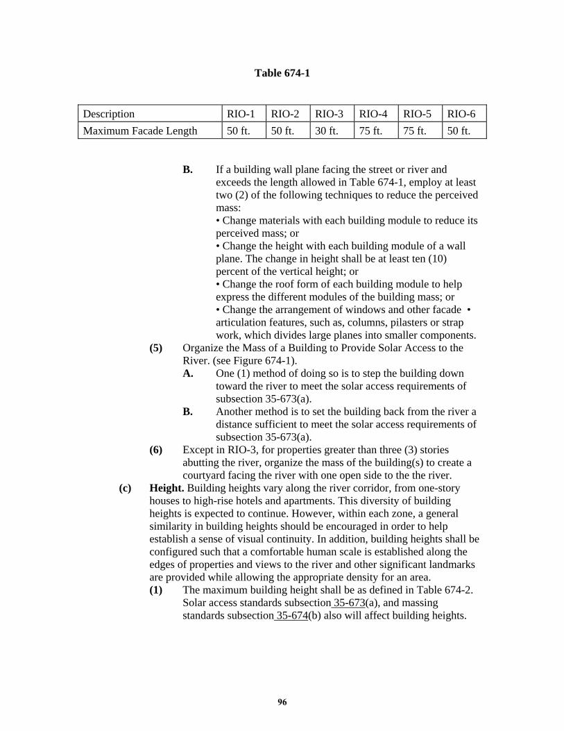
Table 674-1
Description RIO-1 RIO-2 RIO-3 RIO-4 RIO-5 RIO-6 Maximum Facade Length 50 ft. 50 ft. 30 ft. 75 ft. 75 ft. 50 ft.
B. If a building wall plane facing the street or river and
exceeds the length allowed in Table 674-1, employ at least two (2) of the following techniques to reduce the perceived mass: • Change materials with each building module to reduce its perceived mass; or • Change the height with each building module of a wall plane. The change in height shall be at least ten (10) percent of the vertical height; or • Change the roof form of each building module to help express the different modules of the building mass; or • Change the arrangement of windows and other facade • articulation features, such as, columns, pilasters or strap work, which divides large planes into smaller components.
(5) Organize the Mass of a Building to Provide Solar Access to the River. (see Figure 674-1). A. One (1) method of doing so is to step the building down
toward the river to meet the solar access requirements of subsection 35-673(a).
B. Another method is to set the building back from the river a distance sufficient to meet the solar access requirements of subsection 35-673(a).
(6) Except in RIO-3, for properties greater than three (3) stories abutting the river, organize the mass of the building(s) to create a courtyard facing the river with one open side to the the river.
(c) Height. Building heights vary along the river corridor, from one-story houses to high-rise hotels and apartments. This diversity of building heights is expected to continue. However, within each zone, a general similarity in building heights should be encouraged in order to help establish a sense of visual continuity. In addition, building heights shall be configured such that a comfortable human scale is established along the edges of properties and views to the river and other significant landmarks are provided while allowing the appropriate density for an area. (1) The maximum building height shall be as defined in Table 674-2.
Solar access standards subsection 35-673(a), and massing standards subsection 35-674(b) also will affect building heights.
96

Table 674-2
Description RIO-1 RIO-2 RIO-3 RIO-4 RIO-5 RIO-6 Maximum # of Stories 5 10 NONE 7 5 4 Maximum Height in Feet 60 ft. 120 ft. NONE 84 ft. 60 ft. 50 ft.
(2) Organize the mass of the building to step back from established
residential neighborhoods. Where a commercial, mixed-use residential, multi-family or industrial use abuts a single-family residential development, or is across the street from a single-family residentialdevelopment, the following standards shall apply:
The massing of the building shall not exceed twenty-five (25) feet
in height at the setback line. The building mass can continue upward within a forty-five-degree building envelope for a distance of fifty (50) feet measured horizontally from the building face, at which point the building massing may continue vertically to the height established in subsection 35-674(c).
(3) On the street-side, the building facade shall appear similar in height to those of other buildings found traditionally in the area. If fifty (50) percent of the building facades within a block face are predominantly lower than the maximum height allowed, the new building facade on the street-side shall align with the average height of those lower buildings within the block face, or with a particular building that falls within the fifty (50) percent range. However, the remainder of the building may obtain its maximum height by stepping back fifteen (15) feet from the building face.
(4) Designation of a development node provides for the ability to increase the building height by fifty (50) percent from the requirements set out in article VI.
(d) Materials and Finishes. Masonry materials are well established as primary features along the river corridor and their use should be continued. Stucco that is detailed to provide a texture and pattern, which conveys a human scale, is also part of the tradition. In general, materials and finishes that provide a sense of human scale, reduce the perceived mass of a building and appear to blend with the natural setting of the river shall be used, especially on major structures. (1) Use indigenous materials and traditional building materials for
primary wall surfaces. A minimum of seventy-five (75) percent of walls (excluding window fenestrations) shall be composed of the following: A. Modular masonry materials including brick, stone, and
rusticated masonry block, tile, terra-cotta, structural clay tile and cast stone. Concrete masonry units (CMU) are not allowed.
97
B. Other new materials that convey the texture, scale, and finish similar to traditional building materials.
C. Stucco and painted concrete when detailed to express visual interest and convey a sense of scale.
D. Painted or stained wood in a lap or shingle pattern. (2) The following materials are not permitted as primary building
materials and may be used as a secondary material only: A. Large expanses of high gloss or shiny metal panels. B. Mirror glass panels. Glass curtain wall buildings are
allowed in RIO-3 as long as the river and street levels comply with 35-674(d)(1) above.
(3) Paint or Finish Colors. A. Use natural colors of indigenous building materials for
properties that abut the Riverwalk area. B. Use matte finishes instead of high glossy finishes on wall
surfaces. Wood trim and metal trim may be painted with gloss enamel.
C. Bright colors may highlight entrances or architectural features.
(e) Facade Composition. Traditionally, many commercial and multi-family buildings in the core of San Antonio have had facade designs that are organized into three (3) distinct segments: First, a "base" exists, which establishes a scale at the street level; second a "mid-section", or shaft is used, which may include several floors. Finally a "cap" finishes the composition. The cap may take the form of an ornamental roof form or decorative molding and may also include the top floors of the building. This organization helps to give a sense of scale to a building and its use should be encouraged.
In order to maintain the sense of scale, buildings should have the same
setback as surrounding buildings so as to maintain the street-wall pattern, if clearly established. (1) Street Facade. Buildings that are taller than the street- wall (60
feet) shall be articulated at the stop of the street wall or stepped back in order to maintain the rhythm of the street wall. Buildings should be composed to include a base, a middle and a cap. A. High rise buildings, more than100 feet tall, shall terminate
with a distinctive top or cap. This can be accomplished by: i. reducing the bulk of the top 20% of the building by 10% ii. by stepping back the top 20% of the building iii. changing the material of the cap
B. Roof forms shall be used to conceal all mechanical equipment and to add architectural interest to the structure.
C. Roof surfaces should include strategies to reduce heat island effects such as use of green roofs, photo voltaic
98

panels, and/or the use of roof materials with high solar reflectivity.
(2) Fenestration. Windows help provide a human scale and so shall be proportioned accordingly. A. Windows shall be recessed at least 2” within solid walls
(not part of a curtain wall system). B. Windows should relate in design and scale to the spaces
behind them. C. Windows shall be used in hierarchy to articulate important
places on the façade and grouped to establish rhythms. D. Curtain wall systems shall be designed with modulating
features such as projecting horizontal and/or vertical mullions.
(3) Entrances. Entrances shall be easy to find, be a special feature of the building, and be appropriately scaled. A. Entrances shall be the most prominent on the street side
and less prominent on the river side. B. Entrances shall be placed so as to be highly visible C. The scale of the entrance is determined by the prominence
of the function and or the amount of use. D. Entrances shall have a change in material and/or wall plane. E. Entrances should not use excessive storefront systems.
(4) Riverside facade. The riverside facade of a building shall have
simpler detailing and composition than the street facade. A. Architectural details such as cornices, sills, lintels, door
surrounds, water tables and other similar details should use simple curves and handcrafted detailing.
B. Stone detailing shall be rough hewn, and chiseled faced. Smooth faced stone is not permitted as the primary building material, but can be used as accent pieces.
C. Facades on the riverside shall be asymmetrical, pedestrian scale, and give the appearance of the back of a building. That is, in traditional building along the river, the backs of building were designed with simpler details, and appear less formal than the street facades.
(f) Staircases.
(1) Staircases to the River Level Shall be Uniquely Designed. A. Stairs shall not replicate other stairs in a single project. B. Stairs shall be constructed of handcrafted materials. The
applicant shall use traditional building materials. C. Stairs shall not exceed ten (10) feet in width.
(g) Awnings, Canopies and Arcades. See Figure 674-2. The tradition of sheltering sidewalks with awnings, canopies and arcades on commercial and multi-family buildings is well established in San Antonio and is a
99

practice that should be continued. They offer shade from the hot summer sun and shelter from rainstorms, thereby facilitating pedestrian activity. They also establish a sense of scale for a building, especially at the ground level. Awnings and canopies are appropriate locations for signage. Awnings with signage shall comply with any master signage plan on file with the Historic Preservation Officer for the property. Awnings and canopies installed at street level within the public right of way require licensing with the City’s Capital Improvements Management Services (CIMS) department. Canopies, balconies and awnings installed at river level within the public right of way require licensing with the City’s Downtown Operations Department. (1) If awnings, arcades and canopies are to be used they should
accentuate the character-defining features of a building. A. The awning, arcade or canopy shall be located in
relationship to the openings of a building. That is, if there are a series of awnings or canopies, they shall be located at the window or door openings. However awnings, canopies and arcades may extend the length of building to provide shade at the first floor for the pedestrian.
B. Awnings, arcades and canopies shall be mounted to highlight architectural features such as moldings that may be found above the storefront.
C. They should match the shape of the opening. D. Simple shed shapes are appropriate for rectangular
openings. E. Odd shapes and bubble awnings are prohibited except
where the shape of an opening requires a bubble awning, or historic precedent shows they have been previously used on the building.
F. Canopies, awnings and arcades should not conflict with the building's proportions or with the shape of the openings that the awning or canopy covers.
G. Historic canopies shall be repaired or replaced with in-kind materials.
(2) Materials and Color. A. Awnings and canopies may be constructed of metal, wood
or fabric. Certain vinyl is allowed if it has the appearance of natural fiber as approved by the HDRC.
B. Awning color shall coordinate with the building. Natural and earth tone colors are encouraged. Fluorescent colors are not allowed. When used for signage it is appropriate to choose a dark color for the canopy and use light lettering for signage.
(3) Incorporating lighting into the design of a canopy is appropriate. A. Lights that illuminate the pedestrian way beneath the
awning are appropriate.
100

B. Lights that illuminate the storefront are appropriate. C. Internally illuminated awnings that glow are prohibited.
(Ord. No. 95352 § 3 Attachment 2) Sec. 35-675. – Archaeology When an HDRC application is submitted for commercial development projects within a River Improvement Overlay district the city archeologist shall review the project application to determine if there is potential of containing intact archaeological deposits utilizing the following documents/methods:
(1) The Texas Sites Atlas for known/recorded sites, site data in the files of the Texas Archeological Research Laboratory and the Texas Historical Commission; (2) USGS maps; (3) Soil Survey maps; (4) Distance to water; (5) Topographical data; (6) Predictive settlement patterns; (7) Archival research and Historic maps (8) Data on file at the Office of Historic Preservation. If after review the city archeologist determines there is potential of containing
intact archaeological deposits, an archaeological survey report shall be prepared and submitted. If, after review by the city archeologist, a determination is made that the site has little to no potential of containing intact archaeological deposits, the requirement for an archaeological survey report may be waived.
Upon completion of a survey, owners of property containing inventoried archaeological sites are encouraged to educate the public regarding archaeological components of the site and shall coordinate any efforts with the Office of Historic Preservation. (Ord. No. 95352 § 3 Attachment 2). Sec. 35-676. - Alteration, Restoration and Rehabilitation.
In considering whether to recommend approval or disapproval of an application for a certificate to alter, restore, rehabilitate, or add to a building, object, site or structure, the historic and design review commission shall be guided by the National Park Service Guidelines in addition to any specific design guidelines included in this subdivision.
(a) Every reasonable effort shall be made to adapt the property in a manner
which requires minimal alteration of the building, structure, object, or site and its environment.
101

(b) The distinguishing original qualities or character of a building, structure, object, or site and its environment, shall not be destroyed. The removal or alteration of any historic material or distinctive architectural features shall be avoided when possible.
(c) All buildings, structures, objects, and sites shall be recognized as products of their own time. Alterations that have no historical basis and which seek to create an earlier appearance are prohibited.
(d) Changes that may have taken place in the course of time are evidence of the history and development of a building, structure, object, or site and its environment. These changes may have acquired significance in their own right, and this significance shall be recognized and respected.
(e) Distinctive stylistic features or examples of skilled craftsmanship, which characterize a building, structure, object, or site, shall be kept where possible.
(f) Deteriorated architectural features shall be repaired rather than replaced, wherever possible. In the event replacement is necessary, the new material should reflect the material being replaced in composition, design, color, texture, and other visual qualities. Repair or replacement of missing architectural features should be based on accurate duplications of features, substantiated by historical, physical, or pictorial evidence rather than on conjectural designs or the availability of different architectural elements from other buildings or structures.
(g) The surface cleaning of structures shall be undertaken with the gentlest means possible. Sandblasting and other cleaning methods that will damage the historic building's materials shall not be permitted.
(h) Every reasonable effort shall be made to protect and preserve archaeological resources affected by, or adjacent to, any project.
(i) Contemporary design for alterations and additions to existing properties shall not be discouraged when such alterations and additions do not destroy significant historical, architectural or cultural material, and such design is compatible with the size, scale, color, material, and character of the property, neighborhood or environment.
(j) Wherever possible, new additions or alterations to buildings, structures, objects, or sites shall be done in such a manner that if such additions or alterations were to be removed in the future, the essential form and integrity of the building, structure, object, or site would be unimpaired.
(Ord. No. 95352 § 3 Attachment 2) Sec. 35-677. - Administrative Approval.
Applications for certain minor alterations, additions, ordinary repairs or maintenance may be reviewed and approved administratively by the historic preservation officer without review by the historic and design review commission. Those activities which constitute minor alterations, additions, repairs or maintenance include but are not limited to those listed in Section 35-611.
102

A clear photograph of the building, object, or structure to be repaired, a brief
description of the intended work, and samples of replacement materials or paint for comparison with the existing building, object, or structure must be furnished with the application.
(Ord. No. 95352 § 3 Attachment 2) Sec. 35-678. Signs and Billboards in the RIO.
(a) General Provisions. (1) This section governs all exterior signs and all interior signs hung within
ten (10) feet of an exterior fenestration, or those signs intended to be read by exterior patrons. A. All signage within a RIO district shall conform to all city codes
and must have approval of the historic preservation officer prior to installation.
B. Permits must be obtained following approval of a certificate of appropriateness.
C. No sign shall be painted, constructed, erected, remodeled, refaced, relocated, expanded or otherwise altered until it has been approved and a permit has been obtained from the development services department in accordance with the provisions of this section and applicable city code.
D. Signs, visual displays or graphics shall advertise only the business on the premises unless otherwise allowed in this section.
(2) When reviewing applications for signage the historic preservation officer and the historic and design review commission shall also consider the visual impact on nearby historic resources. A. Signs should respect and respond to the environment and landmark
or district character in which it is constructed. B. Signs should respect and respond to the river improvement overlay
districts character and the historic River Walk. C. The content or advertising message carried by permitted signs shall
pertain to the business located on the same premises as the sign or to any otherwise lawful noncommercial message that does not direct attention to a business operated for profit, or to a commodity or service for sale, provided that signs erected on buildings with multiple businesses within shall pertain to any such business within.
(3) For signs with changeable message panels, the changeable message area of the sign shall not exceed 25 percent of the total sign area, except for gasoline price signs which shall not exceed 75 percent of the total sign area. Electronic changeable message boards shall be prohibited.
(4) The name of a business may be changed through the administrative approval process if the sign conforms to the provisions of this section, and
103

if the color, size, and style of lettering, and illumination of the sign remain the same.
(5) Provisions under this section shall comply with Chapter 28 of the City Code of San Antonio, Texas. In cases where provisions under this section are stricter or a sign is designated as a contributing structure, then this section shall control.
(6) Special consideration should be given to the character of the sign itself proposed in the application, and whether the proposed sign has inherently historic characteristics which may fall outside of the guidelines presented below but which would contribute to the historic district, landmark or area for which it is being proposed. Additionally, when reviewing applications for signage the historic preservation officer and the historic and design review commission shall consider the visual impact on nearby historic resources.
(7) Memorials, markers, naming rights of public property, and recognition of charitable donations given to the City of San Antonio shall be additionally governed by any formal action passed by city council.
(b) Sign Definitions. For signage definitions, refer to section 35-612(b) and Chapter 28 of the city code.
(c) Standards for Sign Design and Placement. In considering whether to recommend approval or disapproval of an application to construct or alter signage on a building, object, site, or structure in a river improvement overlay district, review shall be guided by the following standards in addition to any specific design guidelines approved by city council. (1) Primary sign design considerations shall be identification and legibility.
Size, scale, height, color and location of signs shall be harmonious with, and properly related to, the overall character of the district and structure. Sign materials shall be compatible with that of the building facade. Highly reflective materials that will be difficult to read are not permitted.
(2) Signs which describe, point, or direct the reader to a specific place or along a specific course, such as "entrance," "exit," and "disabled persons access", as well as government signs, shall be reviewed but shall not be included in total allowable signage area. Emergency signs shall be exempt from historic and design review commission approval.
(3) All graphic elements shall reinforce the architectural integrity of any building. Signs shall not disfigure, damage, mar, alter, or conceal architectural features or details and shall be limited to sizes that are in scale with the architecture and the streetscape. Emblems and symbols of identification used as principal structural or architectural design elements on a facade shall not be included in the total allowable signage per facade per structure when approved. Review shall be guided by the building's proportion and scale when such elements are incorporated.
(4) Graphics and signage may be illuminated by indirect, internal, or bare-bulb sources, providing that glare is not produced; by indirect light sources concealed by a hood or diffuser; by internal illumination with standard opal glass or other translucent material or with an equal or smaller light
104

transmission factor. All illumination shall be steady and stationary. Neon lighting shall be permitted when used as an integral architectural element or artwork appropriate to the site. For purposes of this subsection, "Glare" shall mean an illumination level of six (6) Lux or greater at the property boundary. If internal illumination is used, it shall be designed to be subordinate to the overall building composition. Light fixtures should reflect the design period of the building on which they are placed. The use of ambient light from storefront or streetlights is encouraged.
(5) Signage requests for multi-tenant buildings must complement existing signage with regards to size, number, placement and design, unless such existing signage is not in conformity with regulations in this Article. It is recommended that the building owner or their agent develop a master signage plan or signage guidelines for the total building or property. If a property has an approved master signage plan on file with the Historic Preservation Officer, then applications for signage may be approved administratively at the discretion of the Historic Preservation Officer provided that they comply with such master signage plan. Notwithstanding the above, signs may not exceed the maximum size and height limitation of signage contained in Chapter 28, Article 9.
(d) Proportion of Signs. For all signage, signage width and height must be in proportion to the facade, respecting the size, scale and mass of the facade, building height, and rhythms and sizes of window and door openings. The building facade shall be considered as part of an overall sign program but the sign shall be subordinate to the overall building composition. Additionally, signs shall respect and respond to the character and/or period of the area in which they are being placed.
(e) Number and Size of Signs. (1) Number and Size. The historic and design review commission shall be
guided in its decisions by the total number of businesses or services per building and the percentage of visible storefront occupied by each business or service. Applicants may apply for up to three signs total. Total signage for all applicants shall not exceed fifty (50) square feet unless additional signs and/or additional total footage is approved. Additional square footage may be approved provided that the additional signage is in conformity with, and does not interfere with, the pedestrian experience on the River Walk. The additional square footage shall be based upon the size and scope of the site. Signs should reflect the type and speed of traffic they are meant to attract. Signs designed for pedestrians and drivers of slow moving cars should not be the same size as signs designed for highway traffic.
(2) Sign Area. The sign area shall be determined in the following manner: A. Sign Areas. The area of a sign shall be computed on the actual area
of the sign. Sign area shall be calculated as the area within a parallelogram, triangle, circle, semicircle or other regular geometric figure including all letters, figures, graphics or other elements of the sign, together with the framework or background
105
of the sign. The supporting framework of the sign shall not be included in determining sign area unless such supporting framework forms an integral part of the sign display, as determined by the Historic Preservation Officer. If the sign is located on a decorative fence or wall, when such fence or wall otherwise meets these or other ordinances or regulations and is clearly incidental to the display itself, the fence or wall shall not be included in the sign area. In the cases of signs with more than one (1) sign face, including but not restricted to double-faced signs, back-to-back signs, overhanging signs, and projecting signs, each side of the sign shall be included in total allowable signage area.
B. Channel Letter Signs. For channel letter signs, the sign area shall be the smallest rectangle that will encompass the limits of the writing, including spaces between the letters. Each advertising message shall be considered separately.
(3) Building Identification Signs. An additional building identification sign may be placed on a building with multiple tenants, if the building name is not the same as the business(s) housed within and such sign is recommended for approval by the historic and design review commission. This type of sign is to identify a building as a destination, shall not exceed 32 square feet, shall not be included in the total allowable signage area and shall not include names of individual businesses.
(4) Freestanding Signs. Freestanding signs are allowed provided the sign does not interfere with pedestrian or vehicular traffic. Freestanding signs shall be perpendicular to the street, two sided and no taller than six (6) feet. Freestanding signs shall not be located in the right of way. A. Projecting Arm Signs. Signs hung from poles are allowed. Pole height shall not exceed six (6) feet and the pole diameter shall not exceed three (3) inches. Blade signs are not allowed to project over a sidewalk or other right of way.
(f) Allowable Signs Not Included in the Total Signage Area. (1) Parking lot signs identifying entrances and exits to a parking lot or
driveway, but only when there is one way traffic flow. No more than one sign shall be permitted for each driveway entrance or exit, and no corporate or business logos shall be permitted. Additionally, parking lot signs to identify divisions of the parking lot into sections and to control vehicular traffic and pedestrian traffic within the lot provided that no corporate or business logos shall be permitted. Signs approved under this category shall not be included in the total allowable signage per structure.
(2) Dates of erection, monumental citations, commemorative tablets, insignia of local, state or federal government, and like when carved into stone, concrete or similar material or made of bronze, aluminum or other permanent type construction and made an integral part of the structure. Signs approved under this category shall not be included in the total allowable signage per structure.
106

(3) Information signs of a public or quasi-public nature identifying or locating a hospital, public building, college, publicly owned parking area, historic area, major tourist attraction or similar public or quasi-public activity; and also including signs identifying restrooms or other facilities relating to such places or activities. Signs approved under this category shall not be included in the total allowable signage per structure.
(4) Incidental signs, including signs designating business hours, street numbers, credit card acceptance and the like provided that the signs are not freestanding, the total of all such signs shall not exceed four square feet for each business, and the signs are non-illuminated. Incidental signs shall not be included in the total allowable signage per structure.
(5) Real Estate signs, advertising the sale, rental or lease of the premises or part of the premises on which the signs are displayed. The maximum sign area shall be 8 square feet. Only one sign will be permitted for each building for sale or lease that is adjacent to the River Walk. The sign is permitted to remain only while that particular building is for sale or the lease space is available.
(g) Pedestrian Menu Boards.
(1) Pedestrian menu boards shall not exceed two (2) square feet. (2) Permanently displayed menus may be properly installed inside the business' window or in an approved wall-mounted or freestanding display case adjacent to the business entrance. (3) The name of the establishment may not be displayed on the menu board if the business has other signage installed on the premises. It is permissible for the name of the restaurant to be placed on the actual menu. The established logo of a business is considered a sign. (4) All items listed on a menu board must be placed within the border of the menu board or within the display case. (5) There may be no more than one (1) pedestrian menu board per establishment unless there are two primary entrances to a building on different facades, in which case a pedestrian menu board for each entrance may be approved.
(h) Sandwich Boards. Notwithstanding provisions of Chapter 28-17, sandwich boards are permitted in River Improvement Overlay Districts as on premise signs provided permitting requirements of Chapter 28, section 28-17 are met. A sandwich board shall: (1) Mean an A-frame or single panel double sided design for placement in front of the place of business. (2) Be no larger than 2 feet wide and 3 feet tall when extended. (3) Be prohibited on the pedestrian Riverwalk pathway (4) Count towards overall signage and must be included in any signage
requests.
107

(i) Noncommercial Speech Signs. Noncommercial speech signs including but not limited to public service announcements may be erected in river improvement overlay districts following approval provided all regulations in this article are met. The maximum size of a noncommercial speech sign shall be 8 square feet, and shall not be illuminated. However, political signs, and the regulation thereof, shall not violate Section 216.903 (Regulation of Political Signs by Municipality) of the Texas Local Government Code.
(j) Allowable Temporary Signs. If approved, the area of temporary signs shall not be included in the general allowable area for the specified property. No more than on temporary sign will be allowed at any given time. Temporary signs may be approved administratively, shall be non-illuminated, and limited to the following types: (1) Construction signs, including those which identify the architects,
engineers, contractors and other individuals or firms involved with the construction. Such signs shall be removed upon issuance of a certificate of occupancy. The maximum area of such signs shall be 32 square feet, and no more than one sign shall be permitted for each street frontage.
(2) Political campaign signs announcing the candidates seeking public political office and other information pertinent thereto.
(3) Signs advertising only the name, time, and place of any fair, festival, bazaar, education seminar or similar event, when conducted by a public agency or for the benefit of any civic, fraternal, religious or charitable cause provided that all such signs shall be removed within 24 hours after the last day of the event to which they pertain. The maximum sign area shall be 32 square feet.
(4) Grand opening signs shall be permitted provided that such signs shall not be displayed for more than 10 days and the maximum size shall not exceed 32 square feet.
(5) Seasonal decorations displayed between November 20 and January 4th, and during the official designated Fiesta time period. Such decorations shall not display the name of a business or shopping center, nor the words “open”, “sale”, “vacancy” or other similar words or phrases related to the business activity on the premises.
(6) Change of business name banners/hoods/covers over existing building mounted and freestanding signs while new signs are being manufactured, provided that such sign or signs shall not be displayed for more than eight weeks and shall not exceed the sign area that they are replacing or covering.
(7) Yard sale signs in a residential district provided that such signs shall be displayed only on the day of the event and on the property holding the event. The maximum sign area shall be eight square feet.
(8) Special exhibition signs for museums and art galleries provided that the signs are limited to one sign for each building used primarily as a museum or art gallery, the sign shall be placed on the building no earlier than seven days before and removed within 24 hours after the last day of the exhibition to which it pertains. Additionally, the maximum signage area
108

per building shall be 200 square feet, unless additional square footage is approved.
(9) Promotional signs not exceeding six (6) square feet advertising special events or promotions provided that the signs are properly placed on the property or on the inside of windows and such signs are removed within 24 hours after the promoted event is over. Promotional signs may be approved for up to five events per calendar year, with no more than 30 days a year total approved for all qualifying signs or events per property.
(10) Any special purpose sign not covered above provided that it is removed within thirty (30) days from the date of approval unless otherwise specified. If within the specified period the applicant feels there is a continued need for the special purpose sign the applicant may file a new application to request additional display time. Non-governmental banners and flags, excluding flags included as elements of an overall streetscape or design plan, are considered special purpose signs under the provisions of this section and are appropriate for advertising and decoration only during special events or celebrations. No permanent advertising may be handled in this way.
(11) The director of downtown operations may provide written authorization for one (1) approved symbol, logo, or sign to be temporarily placed on chartered watercraft for special events. The sign shall not exceed eight (8) square feet.
(12) Temporary Construction Screening shall provide for safe pedestrian access along exposed construction sites. These screens can be temporary art and use graphics to enhance the screen. Such screens shall not use chain link in RIO - 3. Temporary construction screens shall contain a project sign which shall not exceed 32 square feet. Such project sign shall include the project name, project architect, consultants, general contractor, principal use, and project start and end time.
(k) Prohibited Signs. The following signs are prohibited: (1) Billboards, junior billboards, portable signs, and advertising benches; (2) Any sign placed upon a building, object, site, or structure in any manner
so as to disfigure, damage, or conceal any window opening, door, or significant architectural feature or detail of any building;
(3) Any sign or sign spinner which advertises commercial off-premises businesses, products, activities, services, or events unless otherwise allowed in this article;
(4) Any sign which does not identify a business or service within the river improvement overlay district unless otherwise allowed in this article;
(5) Any non-contributing sign which is abandoned or damaged beyond fifty (50) percent of its replacement value, including parts of old or unused signs. All remnants such as supports, brackets and braces must also be removed;
(6) Any attachment to an already affixed sign which does not meet the provisions of the City Code;
109

(7) Roof mounted signs, except in the cases of landmark signs or unless approved in accordance with standards set forth in subsections (b) and (c) of this section. Contributing roof mounted signs may be resurfaced with an approved certificate of appropriateness. The square footage of roof mounted signs shall be included in the total allowable signage for the building;
(8) Pole signs, (9) Digital displays, digital and/or LED lighted signs, not to include LED light
sources that do not meet the definition of a sign, with or without rotating, flashing lettering, icons or images. Except as provided below: A. A public transportation agency may incorporate transit information
signage into transit shelters, utilizing LED or digital technology, provided the signage is contained within or under the transit shelter, and is limited to five (5) square feet of signage area, and one (1) sign per thirty (30) linear feet of pedestrian shelter.
B. A public transportation agency may incorporate transit information signage into a monument sign at transit stops, utilizing LED or digital technology, provided it is limited to five (5) square feet of signage area.
C. A public transportation agency may incorporate transit information signage into a monument sign at transit facilities (other than transit stops), utilizing LED or digital technology, provided it is limited to seven (7) square feet of signage area.
D. The historic preservation officer may impose additional restrictions on illumination to ensure that the character of signs are harmonious with the character of the structures on which they are to be placed and designated landmarks or districts in the area, provided that such restrictions are reasonably related to other conforming signs and conforming structures in the area, do not unreasonably restrict the amount of signage allowed by this section, and are in keeping with the intent of this section. Among other things, consideration shall be given to the location and illumination of the sign in relation to the surrounding buildings, the use of appropriate materials, the size and style of lettering and graphics, and the type of lighting proposed.
(10) Revolving signs or signs with a moving component; (11) Any sandwich board which conflicts with the Americans with Disabilities
Act, or which disrupts or interferes with pedestrian or other traffic; (12) Any sign that obscures a sign display by a public authority for the purpose
of giving instructions or directions or other public information. (13) Any sign which consists of pennants, ribbons, spinners or other similar
moving devices. (14) Any sign, except official notices and advertisements, which is nailed,
tacked, posted or in any other manner attached to any utility pole or
110

structure or supporting wire, cable, or pipe; or to any tree on any street or sidewalk or to public property of any description.
(15) Moored balloons, wind jammers or other floating or inflated signs that are tethered to the ground or to a structure.
(16) Any permanent or temporary sign affixed to, painted on, or placed in or upon any parked vehicle, parked trailer or other parked device capable of being towed, which is parked so as to advertise the business to the passing motorist or pedestrian; and whose primary purpose is to provide additional on-site signage or is to serve the function of an outdoor advertising sign. Excluded from this are vehicles or equipment that are in operating condition, currently registered and licensed to operate on public streets with a valid inspection sticker, and actively used in the daily function of the business to which such signs relate; vehicles/equipment engaged in active construction projects; vehicles or equipment offered for rent to the general public and stored on-premises and otherwise allowed under applicable city ordinance.
Notwithstanding the above, signs designated as a contributing sign or structure by the Historic Preservation Officer shall not be prohibited unless or until such designation is revoked. (l) Installation. Signs, posters, decals or advertisements may not be affixed, tacked,
nailed, pasted, or taped to any portion of a building, object, site or structure in a manner that will cause irreversible damage or loss, or is considered inappropriate under any applicable guidelines utilized by the office of historic preservation. Signs installed on masonry structures shall be installed in the mortar, not in the masonry unit.
(m) Hardship Cases. (1) Whenever the location, topography or configuration of any lot is such as
will cause a hardship by the limitations placed on the signs permitted by this article due to sight distances, existing vegetation, location of buildings on adjacent lots, and/or the topography of the parcel, approval may be granted to either allow additional signage, or to increase the amount of building mounted sign area by not more than 25 percent.
(2) No additional signage shall be approved unless it is found that approval of the proposed application will not be of substantial detriment to adjacent property and that the character of the area will not be changed by the granting of additional signage.
(3) Any additional signage approval shall be limited to the applicant only, and shall not apply to any future tenant or business.
(n) Nonconforming Status. Any legally erected sign which, by reason of revisions to this chapter, no longer complies with its provisions, shall be awarded nonconforming status upon review by all necessary city departments.
(o) Violations in River Improvement Overlay Districts and on the River Walk. (1) In those instances where a sign is erected or maintained in violation of the
aforementioned restrictions, the historic preservation officer, the
111
department of development services, park police or code compliance shall notify the sign's owner, agent, operator, or lessee. If the owner, agent, operator, or lessee of the sign fails to remove the sign within three (3) days after notification, the department of development services or historic preservation officer may file an action in municipal court as outlined in section 28-15 of the City Code of San Antonio, Texas. In addition, nothing herein shall prevent the city attorney from seeking civil remedies.
(2) Dilapidated Signs – All signs shall be maintained in good working condition so as to present a neat and orderly appearance. All signs and components thereof shall be maintained in good repair, free of rust, peeling, flaking, fading, broken or cracked panels, and broken or missing letters. All signs, components, supports and their surroundings shall be kept free of all sign materials, weeds, debris, trash, and other refuse. The historic preservation officer, the code compliance department, department of development services or park police may give written notice to remove or repair, within 30 days, any sign which shows gross neglect or which is dilapidated. Failure to comply shall be considered a violation of this chapter, and the sign shall be removed at the owner’s expense. Additionally, whether the sign has been designated a contributing structure shall be taken into account when evaluating the condition of the sign.
(3) Abandoned Signs – A sign, including its supporting structure or brackets, shall be removed by the owner or lessee of the premises upon which the sign is located when the business which it advertises is no longer on the premises and such sign has been determined to be abandoned under the provisions of Chapter 28. Such sign, if not removed within 30 days from the determination of abandonment by such business, shall be considered to be in violation of this chapter, and shall be removed at the owner’s expense. This does not include signs that are approved as contributing structures.
(Ord. No. 95352 § 3 Attachment 2; Ord. No. 98697 § 4) (Ord. No. 101816, § 2, 12-15-05) (Ord. No. 2009-01-15-0001, § 2, 1-15-09)
Sec. 35-679. - Other Requirements and Regulations. (a) Garbage or Trash Storage. No collections, or storage for refuse, debris or
garbage produced by any residence, business or industry in the river improvement overlay district or elsewhere shall be allowed in a river improvement overlay district when such collections or storage is visible from the publicly owned Riverwalk. No hanging of laundry, cleaning rags, mops, or similar items shall be allowed within view of the Riverwalk.
(b) Portable Carts. Portable vending carts may be located on leased public property or private property on the Riverwalk with approval from the historic and design review commission. Applications for a certificate of appropriateness must include details regarding type of cart, items to be sold, method of controlling litter, location, and other pertinent information.
112
(c) Boats, Barges and Water Taxis. Any and all private boats, barges, and water taxis allowed to operate on the San Antonio River on a permanent basis will require a certificate of appropriateness from the historic and design review commission. Details regarding the size and design, type of power sources, and other pertinent information shall be presented to the historic and design review commission for their review.
(d) Monuments, Markers, Memorials, and Acknowledgements. Monuments, markers or memorial plaques are not permitted on the riverside of property abutting the river, or within the publicly owned right-of-way without the express written consent of the historic and design review commission. The following standards shall apply: A. Texas historical markers are permitted, but must be mounted to walls or
structures. Pole mounted THC markers are not permitted in "RIO-3". B. Monuments and memorial plaques must commemorate an event or person
significant to the Riverwalk or the history of the Riverwalk. To assure that the significance of an event or person has withstood the test of time, memorial plaques may commemorate an event ten (10) years or older a person ten (10) years or more posthumously.
C. Memorial gifts, such as benches, fountains or art etc. may from time to time be accepted as gifts by the city, plaques acknowledging the gift, shall be bronze and no larger the ten inches by four inches (10" x 4"). Memorial plaques for a gift of a tree or other plantings are not permitted.
D. Placement of monuments, memorials and markers will be under the jurisdiction of the director of parks and recreation, rather than the director of planning, after consultation with the historic and design review commission.
E. Plaques recognizing donors for significant improvements or plaques acknowledging the naming of significant improvements such as, but not limited to, pocket parks, footbridges, fountains, grottos, gardens, gazebos, boat landings, overlooks and other significant features may be placed along the San Antonio River. The plaques may be no larger than four (4) square feet and must be made of either cast bronze, cast aluminum (or other suitable metal), carved stone, or tile. Language utilized (in recognition of an individual, corporation or foundation) on a plaque must contain language substantially similar to "sponsored by, underwritten by, a gift from."
(e) Vending in the Riverwalk Area. (1) Definitions. The following definitions apply to this subsection 35-679(e)
in addition to those definitions contained in Appendix "A": Display means any manner in which the property owner, property operator or employee thereof shows, exhibits, demonstrates, presents, or otherwise makes visible goods, merchandise, or service. Hawk means offering goods, merchandise, or services by calling or crying out. Inhibit means to cause any person walking along the Riverwalk area right of way (sidewalk/pathway) to swerve, dodge, change direction, or come to
113

a complete stop to avoid a display, transaction or person involved in vending. Riverwalk area means the area defined in Appendix "A" and includes the area on or adjacent to any appurtenance along the public right of way along the Riverwalk area below street level such as public seating, common areas, open space, balustrades, stairwells, buffer zones, dividing walls, landscaping, planters, and/or vegetation and any structure attached to or outside the walls of an enclosed building on any side of any Riverwalk area premises, including balconies and stairwells, along or adjacent to the Riverwalk area. Vend means offering goods, merchandise, or services in exchange for compensation; accepting compensation in exchange for goods, merchandise, or services; or distribution or display of merchandise or commercial advertising matter.
(2) Vending Prohibited in Riverwalk Area. (a) It shall be unlawful to hawk, sell, or vend goods, merchandise, or
services in the Riverwalk Area on public property, or on the public right-of-way, or on public property between the river and public right-of-way, or in the Riverwalk Area on private property that is within view from public property in the Riverwalk Area regardless of who initiates the contact or purchase, provided that any vending that inhibits pedestrian flow on the Riverwalk Area right-of-way (sidewalk/pathway) is prohibited notwithstanding any lease provision or the possession of a validly issued permit.
(b) It shall be unlawful to hawk, sell, or vend goods, merchandise, or services in the Riverwalk area on public property or on the public right-of-way or in the Riverwalk area on private property that is within view from public property in the Riverwalk area notwithstanding the provisions of any other chapter of the City Code of San Antonio, Texas.
(c) It shall be unlawful to display and/or transport merchandise or goods within the Riverwalk area right-of-way (sidewalk/pathway) unless the merchandise or goods are enclosed, covered or otherwise not visible during transport.
(3) Exceptions. The prohibition against vending does not apply to the following: (a) Vending of food and/or beverage services provided that such
vending complies with all other laws and the food and/or beverage service, does not inhibit pedestrian flow on the Riverwalk area right-of-way (sidewalk/pathway), and is offered and exchanged solely within stationary eating establishments to patrons seated outside the structure of the building; all other Vending offered in such establishments shall require a permit issued under subsection (d) below; or
(b) Vending of goods, merchandise, or services offered and exchanged solely within the interior of any permanent structure; or
114
(c) Vending of goods, merchandise, or services offered and exchanged by the river barge operator under the Downtown San Antonio River Barge Concession Contract; or
(d) Vending of goods, merchandise, or services as allowed by permit from the City of San Antonio. The vending shall be an ancillary use to and compatible with the main business of the property in which the vending is taking place; or
(e) Displaying signs or boards approved under section 35-678 of this chapter; or
(f) Wearing nametags, badges, shirts, aprons or other personal clothing attire with company information, logos or other identifying items; or
(g) Display of goods on a portable vending cart on real property owned by a private individual or business, or real property owned by a private individual or business approved in accordance with the provisions of subsection 35-679(b) of this chapter provided that any completed sales of such goods takes place in the interior of an enclosed building; or
(h) Vending officially sanctioned by the City of San Antonio as part of a special event sponsored or co-sponsored by the City of San Antonio; or
(i) Vending of goods, merchandise, or services as allowed by permit from the City of San Antonio.
(4) Permits. (a) Private Property Vending Permits. Private property vending
permits shall be issued annually by the designated city department in accordance with procedures adopted by the city manager or the city manager's designee. The city manager is authorized to adopt policies allowing for singing groups or other group performers to qualify for a group private property vending permit provided that such groups always stay together as a unit while exercising their vending rights under the permit and provided that each individual in the group has otherwise satisfied the conditions of obtaining a permit such as the required criminal background check and the wearing of an identifying badge or card. A fee shall be charged in accordance with the provisions of section 35-C112 of the City Code of San Antonio, Texas. The city manager shall have authority to issue permits solely for privately controlled spaces, including real property owned by the City of San Antonio and leased to a private individual or business, or real property owned by a private individual or business. The director of downtown operations shall have authority to immediately suspend, subject to an appeal process to the city manager or the city manager's designee, any such permits in event that the permitee does not comply with the adopted policies and procedures or is in violation of this chapter.
115

(b) Public Property Vending Permits. Six (6) public property vending permits, one for each designated public property vending location, shall be issued annually by the designated city department in accordance with policies and procedures adopted by the city manager or the city manager's designee. The public property vending permits shall be subject to the authority of the city manager or the city manager's designee to designate special events including crafts shows and parades which shall take precedence over the rights issued in the Permits and during which vendors operating under a public property vending permit shall not be allowed to operate. The city manager or the city manager's designee will identify the six (6) Public Property Vending Locations according to the following criteria: (i) each site shall be sixty (60) square feet; (ii) each site shall in an area of public property on the Riverwalk to allow for a minimum of eight (8) feet of Riverwalk area right of way (sidewalk/pathway) adjacent to the site; (iii) each site shall be a minimum of fifteen (15) feet from any leased patio space, any public seating, such as a park bench, and any barge loading station. Each site shall be securely marked by any means deemed appropriate. A fee for the public property vending permit shall be charged in accordance with the provisions of section 35-C112 of the City Code of San Antonio, Texas.
(5) No Modification to Other Laws. This section is not intended to and does not modify any requirements or necessary compliance with all other applicable ordinances, statutes or laws.
(Ord. No. 95352 § 3 Attachment 2) (Ord. No. 2006-11-01-1256, § 2, 11-2-06; Ord. No. 2007-12-13-1327, § 6, 12-13-07) Sec. 35-680. - Demolition of Historic Features in the Riverwalk Overlay Districts.
Demolition of architectural features, artwork, furniture, and other items shown on the Robert Hugman plans as well as other historic Riverwalk construction dating back to Spanish Colonial times and including works by the WPA, the CCC and the National Youth Administration constitutes an irreplaceable loss to the quality, character, ambiance and atmosphere of the San Antonio Riverwalk in the river improvement overlay districts. Accordingly, these procedures provide criteria to prevent unnecessary damage to the unique character of the city's Riverwalk areas and character.
(a) Applicability. The provisions of this section apply to any application for
demolition of important architectural features on or immediately adjacent to the river and or the Riverwalk in the river improvement overlay districts. Items shown on the Robert Hugman Plans for the Riverwalk in "RIO-3".
116

No certificate shall be issued for demolition of any items shown on the Robert Hugman Plans for the Riverwalk in "RIO-3". This prohibition against demolition of Hugman features includes but is not limited to staircases, walkways, furniture, bridges, tile and other artwork, light fixtures, handrail ornaments, boat landings, fountains, waterways, water features, retaining walls and the overall landscaping plan for placement of planting beds. This prohibition shall also apply to earlier, hand-built river retention walls found in "RIO-3" as identified in the city records and commonly known as the Tobin walls and the Stucco walls. However, appropriate penetrations of these historic retention walls will be permitted subject to commission approval. Heritage Trees. Removal or damage to heritage trees such as large Cypress trees and other, old significant trees at top of bank or along the Riverwalk is prohibited in all river improvement overlay districts. Except where the tree is damaged due to disease, age or physical condition and must be removed for the safety reasons. Then with a recommendation from the city arborist, or the official urban forester, the historic and design review commission may grant approval for demolition. Other Items of Historic or Archaeological Interest. No certificate shall be issued for demolition of such historic and archaeological features dating from Spanish Colonial times including but not limited to acequias, dams, aqueducts, old mills, trailways, and other river related features or similar items.
(b) Unusual and Compelling Circumstances for Demolition of the Above. The historic and design review commission may consider unusual and compelling circumstances in order to approve a certificate of appropriateness for the demolition or removal of the items listed in section 35-680. It shall be guided in its decision by balancing the contribution of the object, site or structure to the character of the river improvement overlay districts with the special merit of the proposed replacement project. The historic and design review commission, using criteria set forth in this article, shall determine whether unusual and compelling circumstances exist and shall be guided in its recommendation in such instances by the following additional considerations: A. The historic or architectural significance of the object, site, or
structure; B. The importance of the object, site, or structure to the integrity and
character of the river improvement overlay district; C. The difficulty or the impossibility of reproducing such an object,
site, or structure because of its design, texture, material, detail, or unique location;
D. Whether the object, site, or structure is one (1) of the last remaining examples of its kind in the neighborhood, the city, county, region, state, or nation;
117

E. Whether reasonable measures can be taken to save the object, site, structure, or cluster from further deterioration, collapse, arson, vandalism or neglect.
(c) Penalties. Penalties for demolition of architectural features, artwork, furniture and other items discussed in this section shall be the same as those listed in subsections 35-491(c)(3) and (c)(4).
(Ord. No. 95352 § 3 Attachment 2) Sec. 35-681. - Signs on the Riverside of Properties Abutting the River.
This section governs all exterior signs on the riverside of public and private property abutting the San Antonio River and its extensions, and all interior signs hung within ten (10) feet of an exterior fenestration, or those signs intended to be read by exterior patrons on the riverside of a building.
(a) Character of Signs. Signs should respect and respond to the character of
the historic River Walk area. The display of signs and other graphics on the riverside of property abutting the river shall not be permitted except as provided for in this article. Additionally, when reviewing applications for signage the historic preservation officer and the historic and design review commission shall consider the visual impact on nearby historic resources.
(b) Sign Definitions. For signage definitions, refer to section 35-612(b) and Chapter 28 of the city code.
(c) Standards for Signage. (1) Proportion. For all signage, signage width and height must be in
proportion to the facade, respecting the size, scale and mass of the facade, building height, and rhythms and sizes of window and door openings. The building façade shall be considered as part of an overall sign program but the sign shall be subordinate to the overall building composition. Additionally, signs shall respect and respond to the character and/or period of the area in which they are being placed.
(2) Size. The maximum allowable size for any sign on the riverside of property abutting the publicly owned River Walk and visible from the River Walk shall be eight (8) square feet. If a building surface is used for signage, the letters or design shall not exceed a surface area of eight (8) square feet. However, additional square footage may be approved, except in RIO-3, provided that the additional signage is in conformity, and does not interfere with, the pedestrian experience on the River Walk. The additional square footage shall be based upon the size and design of the site, setback from the river, and shall be appropriate for the area in which it is being placed.
118

(3) Roof Top/Parapet Signs. No signs shall be displayed from the parapet or roof of any building unless designated by the historic preservation officer as a contributing structure.
(4) Signs for River Walk Business Only. No sign, visual display, or graphic shall be placed in the River Walk area unless it advertises a bona fide business conducted in, or on premises adjacent to the River Walk. Only buildings that have an entrance directly onto the River Walk may display a sign or graphic.
(5) Number of Signs. Only one (1) identification sign shall be allowed for each store, shop, restaurant, nightclub, or place of business in the River Walk area and fronting on the River Walk. In addition to a sign, establishments serving food or beverages may erect a menu board, which shall be used only for displaying menus.
(6) Illumination. Internally illuminated signs are prohibited. The light source for exterior illumination shall be steady light concealed by a hood or other acceptable method of indirect lighting. Flashing lights, rope lighting and exposed neon lights are prohibited.
(7) Materials. Signs may be constructed of wood, metal, glass. Lettering may be painted, stamped, etched, carved, applied metal or wood. Vinyl lettering may be permitted for interior signs provided it respects and responds to the character of the historic River Walk area.
(8) Pedestrian Menu Boards. (A) Pedestrian menu boards shall not exceed two square feet. (B) Permanently displayed menus may be properly installed
inside the business' window or in an approved wall-mounted or freestanding display case adjacent to the business entrance.
(C) The name of the establishment may not be displayed on the menu board if business has other signage installed on premises. It is permissible for the name of the restaurant to be placed on the actual menu. The established logo of a business is considered a sign.
(D) All items listed on a menu board must be placed within the border of the menu board or within the display case.
(E) There may be no more than one pedestrian menu board per establishment unless there are two primary entrances to a building on different facades, in which case a pedestrian menu board for each entrance may be approved.
(9) Signage on Umbrellas or Street Furniture. Advertising brand name products may not be placed on umbrellas, tables, chairs, table decorations or other street furniture that are located on outdoor patio areas. Additionally, logos or wording of any kind
119

may not be placed on umbrellas, tables, chairs, table decorations or other street furniture that are located on outdoor patio areas.
(10) Directory Signage. Buildings with several businesses may be permitted to install directory signage in lieu of individual signs. Directory signage may not exceed eight (8) square feet.
(11) Revolving Signs, Etc. Revolving signs, flashing lights, search lights and attention-getting devices, including, but not limited to, banners, festoons, paper and vinyl rope-like-banners are not permitted. Digital and/or LED lighted signs, with or without rotating, flashing lettering, full motion video, icons or images are also not permitted.
(12) Projecting Arm Signs. Signs hung from poles are allowed on the riverside of properties abutting the publicly owned river right-of-way as long as the pole height does not exceed seven (7) feet, the pole diameter does not exceed three (3) inches, and does not encroach upon the right of way.
(13) Temporary Signage. No more than one temporary sign is allowed at any given time. Temporary signs facing the river shall not exceed 8 square feet in RIO-3 and 24 square feet in all other RIO districts. Temporary signage for special events shall be limited to installation 48 hours before the event and must be removed within 24 hours of completion of the event for a total of no more than 30 days.
(14) Prohibited Signs. No billboards, junior billboards, portable signs, posters, sandwich boards or advertising benches shall be allowed on the riverside of buildings abutting the river. Any sign, visual display, or graphic which is located in the River Walk area and which is visible from the publicly owned portion of the San Antonio River channel or adjacent walkways must meet the requirements for signs, visual displays, and graphics as set out in this division. No sign, visual display or graphic shall be allowed in the River Walk area unless it is advertising or giving information concerning a business or activity that is located on the same lot as the sign, visual display or graphic.
(d) Installation. Signs, posters, decals or advertisements may not be tacked, nailed, pasted, or taped to any portion of a building, object, site or structure in a manner that will cause irreversible damage or loss, or is considered inappropriate under any applicable guidelines utilized by the office of historic preservation.
(e) Hardship Cases. (1) Whenever the location, topography or configuration of any lot is
such as will cause a hardship by the limitations placed on the signs permitted by this article due to sight distances, existing vegetation, location of buildings on adjacent lots, and/or the topography of the parcel, approval may be granted to either allow additional signage,
120
or to increase the amount of building mounted sign area by not more than 25 percent.
(2) No additional signage shall be approved unless it is found that approval of the proposed application will not be of substantial detriment to adjacent property and that the character of the area will not be changed by the granting of additional signage.
(3) Any additional signage approval shall be limited to the applicant only, and shall not apply to any future tenant or business.
(f) Nonconforming Status. Any legally erected sign which, by reason of revisions to this chapter, no longer complies with its provisions, shall be awarded nonconforming status upon review of all necessary city departments.
(g) Violations in River Improvement Overlay Districts and on the River Walk. In those instances where a sign is erected or maintained in violation of the aforementioned restrictions, the historic preservation officer, the department of development services or park police shall notify the sign's owner, agent, operator, or lessee. If the owner, agent, operator, or lessee of the sign fails to remove the sign within three (3) days after notification, the department of development services, park police or historic preservation officer may remove the sign within three (3) days after notification, and/or the department of development services, the historic preservation officer or park police may file an action in municipal court as outlined in section 28-15. In addition, nothing herein shall prevent the city attorney from seeking civil remedies. (1) Dilapidated Signs – All signs shall be maintained in good working
condition so as to present a neat and orderly appearance. The historic preservation officer, through the office of historic preservation, code compliance department, department of planning and development services or the park police may give written notice to remove or repair any sign which shows gross neglect or which becomes dilapidated. Failure to comply shall be considered a violation of this chapter, and the sign shall be removed at the owner’s expense.
(2) Abandoned Signs – A sign, including its supporting structure or brackets, shall be removed by the owner or lessee of the premises upon which the sign is located when the business which it advertises is no longer on the premises and such sign has been determined to be abandoned under the provisions of Chapter 28. Such sign, if not removed within 30 days from the determination of abandonment by such business, shall be considered to be in violation of this chapter, and shall be removed at the owner’s expense. This does not include signs that are currently approved as contributing structures.
121

Sec. 35-803. - Historic and Design Review Commission. (a) Appointment. The historic and design review commission is hereby established.
The historic and design review commission shall consist of eleven (11) members who reside in the City of San Antonio and are appointed by the city council.
(b) Duties and functions. The commission shall serve to assist in an advisory capacity to the City of San Antonio directors of parks and recreation, planning and development services, code compliance, public works, arts and cultural affairs, office of historic preservation and other appropriate heads of municipal departments, in accordance with Section 49 of the City Charter, and to the city manager. The commission shall have no authority to bind the City of San Antonio by contract or otherwise. The commission shall have the following duties and functions: (1) To conduct an ongoing inventory to identify historically, culturally,
architecturally, and archaeologically significant buildings, objects, sites, structures, public art and design enhancements, and areas that exemplify the cultural, social, economic, political, archaeological, or architectural history of the city, state, or nation;
(2) To investigate and recommend through the city zoning commission the designation of areas having special historic, cultural, architectural, or archaeological value as historic districts; and buildings, objects, sites, structures, or clusters having special historic, cultural, architectural, or archaeological value as exceptional or significant landmarks;
(3) To hold public hearings and to review applications for construction, reconstruction, alteration, relocation, renovation, landscaping, or demolition affecting proposed or designated landmarks or buildings, objects, sites, signs, public art and design enhancements, or structures in the Riverwalk area, historic districts, and public property and rights-of-way and recommend issuance or denial of certificates of appropriateness for such actions;
(4) To recommend specific design guidelines for the restoration, rehabilitation, alteration, construction, reconstruction, or relocation of landmarks, or buildings, objects, sites and structures within historic districts, in the Riverwalk area, on public property, or in the public right-of-way;
(5) To recommend guidelines for signage, street furniture, appurtenances, advertising devices, landscaping, monuments and works of art for each historic district, each landmark, the Riverwalk area, and for public property and public rights-of-way;
(6) To hold public hearings and to review applications for ad valorem tax exemption for residential and commercial buildings and structures which have historical significance and are in need of tax relief to encourage their preservation and rehabilitation; to certify the facts governing eligibility, along with the commission's recommendation, to the Bexar Appraisal District, for approval or disapproval of the application for exemption; upon receipt of a sworn statement of completion, to investigate the
122

building or structure to determine whether the restoration or rehabilitation has been substantially completed as required for certification, and to notify the Bexar Appraisal District in writing if verification of completion is favorable;
(7) To review and make recommendations concerning proposed tax increment districts and special assessment districts that would affect proposed or designated landmarks or historic districts;
(8) To testify through the chairman or vice chairman before all boards and commissions on any matter affecting historically, culturally, architecturally, or archaeologically exceptional, or significant areas, buildings, objects, sites, structures, clusters, historic districts, property located in the Riverwalk area, or public property;
(9) To review all proposed National Register nominations within the City of San Antonio upon recommendation of the city's historic preservation officer;
(10) To inform and educate the citizens of San Antonio concerning the historical, cultural, architectural, and archaeological heritage of the city;
(11) To recommend conferral of recognition upon the owners of landmarks or buildings, objects, sites or structures within historic districts by means of certificates, plaques, or markers;
(12) To review periodically the zoning ordinance of the City of San Antonio and to recommend any amendments appropriate for the preservation and protection of landmarks or buildings, objects, sites and structures within historic districts, in the Riverwalk area, on public property, or in the public right-of-way;
(13) To create committees of no more than four (4) persons from among its membership to meet at times other than regular commission meetings, to consider specified categories of applications; and to make recommendations to the full commission; and
(14) To prepare and submit annually to the city council a report summarizing the work of the commission during the previous calendar year which has been adopted by the commission.
(c) Composition and Qualifications. In appointing members of the commission, the city council shall make appointments that are sensitive to the preservation and development goals of the city and will enable the city to retain compliance as a certified local government under the rules incorporating the provisions of the U.S. Historic Preservation Act of 1966, as amended, and Title 13, Texas Historic Commission, chapter 15, specifically 13 TAC 15.6(f)(3)(C), so that all members shall have a demonstrated "interest, competence, or knowledge in historic preservation." (1) Composition. Composition shall be from three (3) categories of members
from the following disciplines or backgrounds: A. One (1) representative shall be selected from each of the following
disciplines: architecture (licensed in the State of Texas), history, architectural history, archaeology, and planning. Memberships from these five (5) disciplines are required in order to achieve
123
compliance with the U.S. Historic Preservation Act, as well as applicable Texas law.
B. One (1) representative from each of the following disciplines: landscape architecture (licensed in the State of Texas), and a professional in the field of public art or art history. Membership from these two (2) disciplines are required to provide design expertise related to the Riverwalk and public art.
C. Four (4) individuals in business/professional categories which shall
include disciplines and backgrounds in real estate/commercial development, economic development, law, banking or accounting, or civil engineering and in a general category which shall include experience or background in urban design, visual arts, public art, neighborhood representation, or design enhancements, or who shall be a citizen-at-large.
Members of the commission shall represent the general ethnic and gender makeup of the community. All board and commission members serve at the pleasure of the city council and may be removed from office at the discretion of the city council without cause, such removal to be evidenced by passage of an ordinance. (2) Appointment. The mayor and city council will each appoint one (1)
member of the commission to complete category representation. (3) Terms of members. Members are appointed for a term of office of two
(2) years. The term of office for each board or commission member will run concurrently with the terms of office of the city council that appoints each member. Any vacancy shall be filled for the remainder of the term by the city council.
(d) Chairman and Vice Chairman. Members of the commission shall elect a chairman and vice chairman from among those members who have served at least one (1) year as commission members. The chairman and vice chairman shall serve for a one-year term, but no person shall serve more than two (2) consecutive city council appointed terms in the same office. The chairman shall preside over all meetings of the commission. The vice chairman shall preside in the absence or at the request of the chairman. An additional presiding officer pro-tem may be selected by the commission members to preside over meetings in the absence of both the chairman and vice chairman.
(e) Election of Officers. Election of commission officers shall occur in January of each year. On the day of the election of officers, the chairman shall turn the meeting over to the historic preservation officer who will accept nominations from the membership for chairman and vice chairman. Officers must receive a majority vote of the commission members. The term of office shall begin the day of the election. Should the chair or vice chair resign or not be reappointed prior to the end of the term of office, a special election shall be held at the next meeting after such vacancy to fill the position(s) for the remainder of the term.
124
(f) Secretary. The historic preservation officer or his or her representative shall act as secretary of the commission and shall attend and keep minutes of all meetings, acting in an advisory capacity and participating fully in commission discussions but having no right to vote.
(g) Meetings of the Commission. The commission shall hold each regular meeting on the basis of not less than once each month, and more frequently if necessary, at a regularly scheduled time with advance notice posted according to the Texas Open Meetings Act. Additional special meetings may be called by the chairman, or upon written request to the planning director signed by a majority of the members, when a matter requires urgent consideration of the commission. All meetings of the commission shall be open to the public in accordance with the Texas Open Meetings Act. The place, day and/or hour of meetings may be changed by vote of the commission at any regular meeting. Notice of such action shall be provided in accordance with the Texas Open Meetings Act. Minutes of the commission's proceedings showing the vote shall be filed in the office of the city historic preservation officer and shall be a public record.
(h) Meeting Procedures. The commission shall observe the following procedures: (1) Any motion by a member shall require a second. After a motion has been
made and duly seconded, discussion of the motion may be held for a reasonable time. Discussion by members or by opponents or proponents of a question before the commission shall terminate whenever a member shall call for a vote upon the question or whenever the chairman shall so rule.
(2) Whenever any question of procedure or qualification may be raised at a commission meeting, the chairman shall rule thereon. A member may move to overrule the chairman's decision which may be done by a majority vote of the members present.
(3) Voting on all matters may be by voice vote provided that a roll call vote shall be taken upon demand of any member.
(4) Releases and statements to the public and press in the name of the commission shall be made only by the presiding officer and in accordance with the Texas Open Records Act.
(5) Any question of order or procedure not covered by these rules shall be decided according to the latest edition of Robert's Rules of Order, insofar as they may be applicable.
(i) Meetings of Commission Committees. All decisions of committees shall be submitted to the commission at its next regular meeting. Any applicant who is dissatisfied with a recommendation by a committee shall have the right to appeal to the full commission at its next regularly scheduled meeting. Minutes of committee proceedings showing the vote shall be filed in the office of the city historic preservation officer and shall be a public record.
(j) Quorum. A quorum of the commission shall require six (6) members present. The affirmative votes of a majority of the members present is required for action, except in the case of an application for demolition which shall require a 2/3 majority of the members present for a recommendation of approval.
125

(k) Conflicts of Interest. No member of the commission shall vote or participate as a member in any matter that materially affects the property, income, or business interest of that member or in which the member holds a substantial interest. Such member shall give notice of abstention from voting prior to the taking of a vote.
(Ord. No. 98697 §§ 1 and 6) (Ord. No. 2007-05-30-0593, § 2, 5-30-07)(Ord. No. 2009-01-15-0001, § 2, 1-15-09) Sec. 35-804. - Reserved. Sec. 35-805. - Planning Department and Administration.
The administrative official for the purposes of this chapter shall be the city
manager and his assistants, deputies, and department heads insofar as they may be charged by the city manager and the provisions of this chapter with duties and responsibilities with reference thereto. Without limitation, the directors of public works, planning and development services, and the historic preservation officer shall ordinarily administer and enforce the provisions of this chapter. The director of planning and development services shall serve as staff to the planning commission, zoning commission, and the city council except where otherwise provided by this chapter. (Ord. No. 98697 §§ 1 and 6) Sec. 35-403. Notice Provisions. (a) Generally. The notice requirements for each type of application for development
approval are prescribed in the individual subsections of this article applicable thereto and/or the Texas statutes. The notice requirements for certain types of public hearings are established in Table 403-1 below provided, however, that to the extent of any inconsistency between the provisions of this section and any state statute, the state statute shall govern.
(b) Contents of Notice. The notice shall state the time, date and place of hearing and a description of the property subject to the application. The notice shall include, at a minimum, the following: • The street address, if the street address is unavailable, the legal description by NCB/CB, block, and lot metes and bounds or a general description of the location of the property, either using block numbers, nearby street intersections or approximate distances from intersections. • The current zoning district, if any; and • The category of permit requested and a brief • description of the proposed development including density or building intensity, revised zoning classification (if any), and uses requested.
126
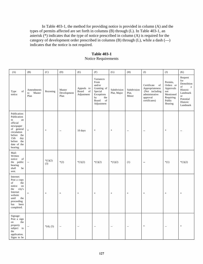
In Table 403-1, the method for providing notice is provided in column (A) and the types of permits affected are set forth in columns (B) through (L). In Table 403-1, an asterisk (*) indicates that the type of notice prescribed in column (A) is required for the category of development order prescribed in columns (B) through (L), while a dash (—) indicates that the notice is not required.
Table 403-1 Notice Requirements
(A) (B) (C) (D) (E) (F) (G) (H) (I) (J) (K)
Type of notice
Amendments to Master Plan
Rezoning
Master Development Plan
Appeals to Board of Adjustment
Variances From and/or Granting of Special Exceptions by the Board of Adjustment
Subdivision Plat, Major
Subdivision Plat, Minor
Certificate of Appropriateness (Not including administrative approval certificates)
Permits, Orders or Approvals not Mentioned Requiring Public Hearing
Request for Demolition of a Historic Landmark or Potential Historic Landmark
Publication: Publication in an official newspaper of general circulation before the 15th day before the date of the hearing.
* * -- 10 days * * -- -- * --
Mail: Written notice of the public hearing shall be sent.
-- *(1)(2) (3) *(2) *(1)(2) *(1)(2) *(1)(2) (1) -- *(1) *(1)(2)
Internet: Post a copy of the notice on the city's Internet website until the proceeding has been completed.
* * * * * * * * * *
Signage: Post a sign on the property subject to the application. Signs to be
-- *(4), (5) -- -- -- -- -- * -- *
127
installed and provided by the city (2)
Notes:
(1) Notice shall be sent to each owner, as indicated by the most recently approved municipal tax roll, of real property, within two hundred (200) feet of the property. Notice for zoning cases shall be sent prior to the tenth day before the date of the public hearing at the zoning commission. Notice for demolition applications shall be sent prior to the seventh day before the date of the public hearing at the historic design and review commission.
(2) Notice shall be sent to registered neighborhood associations within two hundred (200) feet of the project.
(3) Notice shall be sent to members of the planning team, as defined by subsection 35-420(b)(3), for the affected neighborhood, community or perimeter plan, as applicable.
(4) The sign shall measure not less than (96564) eighteen by twenty-four inches and shall contain: City's name, Zoning Case #____________or HDRC Case #____________, Name of Case Manager, and Contact telephone number. The sign shall be constructed of corrugated plastic sign stock and shall be in a highly visible florescent style color with contrasting colors. Lettering shall be a block font in as large a type as permitted by the sign size.
(5) The requirement for the posting of signs on individual lots and properties shall be waived for city initiated area-wide rezoning consisting of six (6) or more individual lots. However, signs will be placed at the general location of the boundary of the area-wide zoning project and its intersection with major arterial and collector streets that provide ingress/egress to the area subject to rezoning.
(c) Action to be Consistent With Notice. The reviewing body may take any action on the application that is consistent with the notice given, including approval of the application, conditional approval (if applicable) of the application, or denial of the application.
(d) Minor Amendments Not Requiring Renotification. (1) The provisions of this subsection (d) shall govern to the extent not
inconsistent with provisions relating to minor amendments for a specific category of development permits of development orders. The reviewing body may allow minor amendments to the application without requiring resubmission of the entire application. For purposes of this subsection, "minor amendments" are amendments which: A. Permit equal or fewer dwelling units, floor area or impervious
surface than that requested on the original application; B. Reduce the impact of the development; or
128
C. Reduce the amount of land involved from that indicated in the notices of the hearing.
(2) The reviewing agency shall not, in any case, permit as a minor amendment: A. An increase in the number of dwelling units, floor area, or
impervious surface development; B. A different land use than that requested in the application; C. A larger land area than indicated in the original application; or D. A greater variance than that requested in the application. In addition, the reviewing agency shall not reduce or eliminate conditions for a specific use authorization or conditional zoning district unless a new notice is provided prior to the final decision thereto.
(3) Zoning Intensity. For purpose of notification the following table of intensity of zoning shall be used. The intensity ranges shall constitute all districts on the following table that lie between the existing zoning district of the subject property and the requested zoning district for the subject property. Consideration of such a recommendation shall not require renotification. An applicant may not amend a rezoning request to multi-family without renotification. Flex districts, overlay districts and special districts shall require renotification.
Table 403-2 Intensity Ranges
"RP" "RE" "R-20" "R-6" "R-5" "R-4" "R-3" "RM-6" "RM-5" "RM-4" "MF-25" "MF-33" "MF-40" "MF-50" "NC" "O-1" "C-1" "C-2NA", "C-2P" "C-2" "O-2" "C-3NA" "C-3R" "C-3" "D"
129

"L" "I-1" "I-2"
Example an applicant with a property presently zoned "R-6" and requesting "C-3" could receive a recommendation for approval of any of the following districts "R-5", "R-4", "R-3", "NC", "O-1", "C-1","C-2NA", "C-2P", "C-2", "O-2", "C-3NA", "C-3R OR "C-3" without requiring renotification. Rezoning to a "MF" district would require renotification.
(Ord. No. 96564 § 3)(Ord. No. 97568 § 2)(Ord. No. 98698 § 1)(Ord. No. 98772 § 1)(Ord. No. 100126 § 2) (Ord. No. 2006-11-30-1333, § 2, 11-30-06) (Ord. No. 2009-01-15-0001, § 2, 1-15-09) (Ord. No. 2009-12-10-1026, § 2, 10-10-09) Sec. 35-451. - Certificate of Appropriateness. (a) Applications proposing work or changes to the exterior of a landmark in a historic
district or in a River Improvement Overlay District shall require review for appropriateness with the provisions of this article, and any adopted design guidelines. In addition, the demolition or relocation of any structure designated historic shall also require review for appropriateness in the same manner. Such applications may include, but are not limited to, (1) Construction and reconstruction, (2) Alteration, additions, restoration and rehabilitation, (3) Relocation, (4) Stabilization, (5) Signage, (6) Landscaping, (7) Construction or reconstruction of a parking lot, (8) Construction or reconstruction of an appurtenance, (9) Acquisition or deaccessioning of artwork, (10) Demolition, and (11) Lighting, furniture and seating plan, and awnings and umbrellas within the
Riverwalk area and in the public right-of-way. (b) Initiation. Applications for certificates of appropriateness shall be referred to the
commission by the historic preservation officer. In the case of an application for demolition, the commission shall be guided by procedures specified in sections 35-614 to 35-617 of this chapter.
(c) Completeness Review. The historic preservation officer shall review an
application for a certificate of appropriateness in accordance with section 35-402 of this chapter. The appellate agency for purposes of completeness review (see subsection 35-402(c) of this chapter) shall be the historic and design review commission.
130
(d) Decision. (1) Commission Review. The commission shall make its written final
recommendation to either approve, deny, or approve with stipulations the application within sixty (60) days after the historic preservation officer's receipt of the completed application. Applications forwarded to the commission shall include all required materials and documents from the applicant. If the commission does not make its final recommendation within a sixty-day period, the application shall be deemed recommended by the commission for approval and the city manager or her designee shall either approve, deny or approve with conditions the application within 5 days of the applicant's demand. The sixty-day time period may be extended up to three additional times, with each time not exceeding 30 days, with the concurrence of the applicant if additional time is required for the preparation of information or for research required by the commission.
(2) City Manager Review. Upon receipt of the recommendation by the commission, the city manager or designee may implement such recommendation by notifying the applicant within ten (10) days from receipt of such recommendation that the application has been approved, conditionally approved, or disapproved. The city manager designee for this purpose shall be the historic preservation officer, unless the city manager chooses to designate otherwise. The city manager or designee shall also submit a copy of the decision to the commission for its information, to the department of planning and development services for issuance of permits, and to other departments, as applicable. The city manager or designee shall assure the decision is based on the criteria established by the Secretary of the Interior's Standards and Guidelines for Archaeology and Historic Preservation, and was considered by the commission in the determination as to issuance or denial of any certificate.
(3) Appeal. An applicant for a certificate may appeal the decision of the city manager or designee to the board of adjustment within thirty (30) days after receipt of notification of the city manager's action. The applicant shall be advised by the city manager or designee of the time and place of the hearing at which the appeal will be considered and shall have the right to attend and be heard as to the reasons for filing the appeal. In determining whether or not to grant the appeal, the board of adjustment shall consider the same factors as the commission, the report of the commission, and any other matters presented at the hearing on the appeal. If the board of adjustment approves the application, it shall direct the city manager or designee to issue a certificate for the work covered. If the board of adjustment disapproves the application, it shall direct the city manager or designee not to issue such certificate. Such disapproval may indicate what changes in the plans and specifications would meet the conditions. Upon receipt of the written disapproval of the board of adjustment, the city manager or designee shall immediately advise the applicant and the commission in writing.
131

(e) Approval Criteria (See article VI of this chapter.) (f) Subsequent Applications. In the case of disapproval of an application by the
board of adjustment, a new application for the same work shall not be resubmitted for consideration until one (1) year has elapsed from the date of disapproval unless the indicated changes in the plans and specifications required to meet the conditions have been incorporated into the new application. The commission, by a majority of its membership, may waive the aforementioned time limitation if the application presents new substantial evidence. If such waiver is granted, a new application shall be filed with the historic preservation officer.
(g) Amendments. A certificate of appropriateness shall be amended in the same manner as the approval of the original application.
(h) Scope of Approval. A certificate of appropriateness shall authorize only those modifications to a building or structure requested in the application and approved as provided herein. The historic and design review commission shall recommend approval, denial, or approval with conditions for the application before it, unless said application is revised with the consent of the applicant. Following commission approval of final design, defined as eighty (80) percent working drawings, and issuance of a certificate, an applicant must secure permits within one hundred eighty (180) days and start work within one hundred eighty (180) days of issuance of permits or the certificate becomes null and void and of no force or effect. Thereafter, the applicant must reapply for reissuance of a certificate to the historic preservation officer. The historic preservation officer will determine whether significant changes have occurred to the final design. If the historic preservation officer determines that significant changes have occurred, then plans must be resubmitted to the commission for rehearing and action.
(i) Recording Procedures. A certificate of appropriateness need not be recorded, but shall be maintained and displayed by the applicant on the premises. The historic preservation officer shall also retain a copy of the certificate of appropriateness for public inspection.
(Ord. No. 95352 § 4) (Ord. No. 98697 § 1, 4 and 6) (Ord. No. 2009-01-15-0001, § 2, 1-15-09) Sec. 35-452. - Certificate of Appropriateness for Administrative Approval. (a) Applicability. The provisions of this section apply to a certificate of
appropriateness requesting ordinary repair and maintenance and certain minor alterations or additions reviewed and approved administratively.
(b) Initiation. Applications for a certificate of appropriateness to authorize ordinary maintenance and repair or certain minor alterations or additions reviewed and approved administratively shall be submitted to the historic preservation officer.
(c) Completeness Review. The historic preservation officer shall review an application for a certificate of appropriateness in accordance with section 35-402 of this chapter. The appellate agency for purposes of completeness review (see
132
subsection 35-402(c) of this chapter) shall be the historic and design review commission.
(d) Decision. Applications for ordinary repair and maintenance may be approved by the director of planning and development services upon recommendation from the historic preservation officer. The decision may be appealed in the same manner as set forth in section 35-481
(e) Approval Criteria. (See article VI, section 35-611 of this chapter.) (f) Subsequent Applications. (See subsection 35-451(f) of this chapter.) (g) Amendments. (See subsection 35-451(g) of this chapter.) (h) Scope of Approval. (See subsection 35-451(h) of this chapter.) (i) Recording Procedures. (See subsection 35-451(i) of this chapter.) (Ord. No. 98697 § 6) Sec. 35-453. - Permits Affecting Property Recommended by the Historic Design and Review Commission for Historic Designation.
(a) Applicability. When an application is made on a building, object, site or structure
recommended by the commission for designation as a historic landmark or of a building, object, site, structure or unimproved land located within an area recommended by the commission for designation as a historic district, the applicant shall follow procedures outlined in this subdivision until the final disposition of the recommendation by city council.
(b) Initiation. The applicant may apply to the commission for review of a proposed project prior to final city council action on the designation request.
(c) Completeness Review. The historic preservation officer shall review the application in accordance with section 35-402 of this chapter. The appellate agency for purposes of completeness review (see subsection 35-402(c) of this chapter) shall be the historic and design review commission.
(d) Decision. The commission shall review the application using criteria set forth in this section and shall follow all regulations and procedures used to review historic landmarks and properties in historic districts. Certificates may be issued following commission approval. Should the commission deny the applicant's request, the applicant may appeal to city council following procedures in this subdivision.
(e) Approval Criteria. The city council may authorize issuance of a certificate on a resource recommended by the commission for designation if, by formal resolution, it deems the certificate necessary for public health, welfare, or safety.
(f) Subsequent Applications. (Not applicable.) (g) Amendments. (Not applicable.) (h) Scope of Approval. Should the city council fail to designate the recommended
building, object, site, structure or cluster as a historic landmark or the recommended area as a historic district, the director of planning and development services shall issue permits requested providing all City Code requirements are met.
(i) Recording Procedures. See subsection 35-451(i) of this chapter.
133
http://library.municode.com/HTML/14228/level2/ARTIVPR_DIV5HIDERE.html#ARTIVPR_DIV5HIDERE_S35-451CEAP
http://library.municode.com/HTML/14228/level2/ARTIVPR_DIV5HIDERE.html#ARTIVPR_DIV5HIDERE_S35-451CEAP
http://library.municode.com/HTML/14228/level2/ARTIVPR_DIV5HIDERE.html#ARTIVPR_DIV5HIDERE_S35-451CEAP
http://library.municode.com/HTML/14228/level2/ARTIVPR_DIV5HIDERE.html#ARTIVPR_DIV5HIDERE_S35-451CEAP
http://library.municode.com/HTML/14228/level2/ARTIVPR_DIV5HIDERE.html#ARTIVPR_DIV5HIDERE_S35-451CEAP
http://library.municode.com/HTML/14228/level2/ARTIVPR_DIV5HIDERE.html#ARTIVPR_DIV5HIDERE_S35-451CEAP
http://library.municode.com/HTML/14228/level2/ARTIVPR_DIV5HIDERE.html#ARTIVPR_DIV5HIDERE_S35-451CEAP
http://library.municode.com/HTML/14228/level2/ARTIVPR_DIV5HIDERE.html#ARTIVPR_DIV5HIDERE_S35-451CEAP
(Ord. No. 98697 § 1, 4 and 6) Sec. 35-454. - Review of Plans for City-Owned Properties. (a) Applicability. The City of San Antonio and all of its boards, agencies and utilities
and those corporations, firms or individuals engaged in the furnishing of telephone service, cable television, wireless service, or other public utilities to the public, shall submit plans for any construction, reconstruction, alteration, restoration, rehabilitation, relocation, stabilization, or demolition affecting any public building, object, site, structure, accessory building, fence, or other appurtenance in any city owned property or any activity which may upon completion obstruct any designated vista for review according to procedures set forth by this article, notwithstanding the provisions of section 35-104 of this chapter.
(b) Initiation. Prior to accepting construction bids on work to be done on public property, the commission, agency, utility, corporation, firm or individual shall submit to the commission project designs for review and recommendation.
(c) Completeness Review. The historic preservation officer shall review the plan review application for completeness in accordance with subsection 35-451(c) of this chapter. The appellate agency for purposes of completeness review (see subsection 35-402(c) of this chapter) shall be the historic and design review commission.
(d) Decision. (See subsection 35-451(d) of this chapter.) (e) Approval Criteria. (See article VI, division 2 of this chapter) (f) Subsequent Applications. (See subsection 35-451(f) of this chapter.) (g) Amendments. (See subsection 35-451(g) of this chapter.) (h) Scope of Approval. (See subsection 35-451(h) of this chapter.) (i) Recording Procedures. (See subsection 35-451(i) of this chapter.) (Ord. No. 98697 § 6) Sec. 35-455. - Demolition Permit Applications. (a) Applicability. The provisions of this section apply to any application for
demolition of a historic landmark (section 35-614 of this chapter). The provisions of this section apply to any historic landmark or any property located within a historic district.
(b) Initiation. (1) Historic Landmarks and Contributing Properties. The applicant shall
submit all necessary materials to the historic preservation officer, hereafter referred to as the HPO, at least fifteen (15) days prior to the HPO hearing in order that staff may review and comment and/or consult on the case. Staff and/or professional comments shall be forwarded to the HPO for consideration and review and made available to the applicant for consideration prior to the hearing. The HPO may require that an applicant furnish such additional information that is relevant to its determination of
134
http://library.municode.com/HTML/14228/level2/ARTIVPR_DIV5HIDERE.html#ARTIVPR_DIV5HIDERE_S35-451CEAP
http://library.municode.com/HTML/14228/level2/ARTIVPR_DIV5HIDERE.html#ARTIVPR_DIV5HIDERE_S35-451CEAP
http://library.municode.com/HTML/14228/level2/ARTIVPR_DIV5HIDERE.html#ARTIVPR_DIV5HIDERE_S35-451CEAP
http://library.municode.com/HTML/14228/level2/ARTIVPR_DIV5HIDERE.html#ARTIVPR_DIV5HIDERE_S35-451CEAP
http://library.municode.com/HTML/14228/level2/ARTIVPR_DIV5HIDERE.html#ARTIVPR_DIV5HIDERE_S35-451CEAP
http://library.municode.com/HTML/14228/level2/ARTIVPR_DIV5HIDERE.html#ARTIVPR_DIV5HIDERE_S35-451CEAP
http://library.municode.com/HTML/14228/level2/ARTIVPR_DIV5HIDERE.html#ARTIVPR_DIV5HIDERE_S35-451CEAP

unreasonable economic hardship and may require that such additional information be furnished under seal. The HPO or its agent may also furnish additional information as the HPO believes is relevant. The HPO shall also state which form of financial proof it deems relevant and necessary to a particular case. In the event that any of the required information is not reasonably available to the applicant and cannot be obtained by the applicant, the applicant shall file with his affidavit a statement of the information which cannot be obtained and shall describe the reasons why such information cannot be obtained.
(2) Other Demolition Permits. All applications for permits to demolish buildings, objects, sites, or structures which are not historic landmarks, contributing properties, or an intrusion in the district shall be referred to the city HPO for the purpose of determining whether or not the building, object, site, or structure may have historical, cultural, architectural, or archaeological significance.
(c) Completeness Review. The historic preservation officer shall review the demolition permit application for completeness in accordance with subsection 35-451(c) of this chapter. The appellate agency for purposes of completeness review (see subsection 35-402(c) of this chapter) shall be the historic and design review commission.
(d) Decision. (1) Historic Landmarks. Whenever an application for a certificate regarding
the demolition of a landmark is submitted to the historic and design review commission, the historic and design review commission shall not hold a public hearing on the application for sixty (60) days from the date the application is received by the Office of Historic Preservation. This time period is intended to permit the city historic preservation officer to discuss the proposed demolition informally with the property owner, other city officials and local preservation organizations, to see if an alternative to demolition can be found before a formal consideration of the application by the historic and design review commission. The historic preservation officer shall prepare, as a part of the submission, a report to the historic and design review commission analyzing alternatives to demolition, and request from other city departments or agencies information necessary for the preparation of this report.
If within this sixty-day period any one (1) of the following three (3) events shall occur, the historic and design review commission may defer hearing the application for six (6) months and it shall be considered to have been withdrawn by the applicant during such six-month period: • The owner shall enter into a binding contract for the sale of the property, • Approved arrangements shall be made for the structure • to be moved to an approved new location, or • The City of San Antonio shall determine to condemn the property and take it by the power of eminent domain for rehabilitation or reuse by the city or other disposition with appropriate preservation restrictions in order
135

to promote the historic preservation purposes of this chapter to maintain the structure and protect it from demolition. If within the sixty-day period none of the three (3) events summarized above shall have occurred, the historic and design review commission shall schedule a hearing on the demolition application at its next regularly scheduled meeting following the expiration of the sixty-day period, shall request all knowledgeable parties to comment at the hearing on the proposed demolition, and shall make its written recommendation within thirty (30) days after hearing the request for demolition. The historic and design review commission shall also request the city engineer to prepare a report on the state of repair and structural stability of the structure for which an application to demolish has been filed. This report shall be presented to the city HPO prior to the date of the historic and design review commission's hearing on the demolition permit application, and shall become part of the administrative record on the application.
(2) Other Demolition Permits. If the property is not a historic landmark, contributing property, or an intrusion in the district, the historic preservation officer shall determine whether or not the building, object, site, or structure may have historic, cultural, architectural, or archaeological significance within thirty (30) days after receipt of the completed application and shall notify the director of planning and development services in writing. If the building, object, site, or structure is determined to have no cultural, historical, architectural, or archaeological significance, a demolition permit may be issued immediately, provided such application otherwise complies with the provisions of the demolition ordinance and all city code requirements. If the building, object, site, or structure is determined by the historic preservation officer to have historic, cultural, architectural, or archaeological significance, the historic preservation officer shall make such information available to the historic and design review commission for review and recommendation as to significance. If the historic and design review commission concurs in the significance, the historic and design review commission shall recommend that the building, object, site, or structure be designated as a historic landmark. Following such determination, the applicant may request a demolition permit by following the procedures for historic landmarks or properties within a historic district as prescribed in this section.
(e) Approval Criteria. See article VI, section 35-614 of this chapter. (1) Historic Landmark. Should the applicant for a certificate regarding
demolition of a historic landmark satisfy the historic and design review commission that he will suffer an unreasonable economic hardship if a demolition permit is not issued, or, in failing to demonstrate unreasonable economic hardship, the applicant demonstrates loss of significance which dictates demolition of the significant historic landmark, the historic and design review commission shall recommend approval of a certificate for the issuance of a demolition permit.
136
(2) Contributing Property. Should the applicant for certificate regarding demolition of a contributing property in a historic district satisfy the historic and design review commission that he will suffer an unreasonable economic hardship if a demolition permit is not issued, or, in failing to demonstrate unreasonable economic hardship, the applicant loss of significance which dictates demolition of the property the historic and design review commission shall recommend approval of a certificate for the issuance of a demolition permit.
(3) Property Deemed to be an Intrusion Into the District. In those cases in which the historic and design review commission finds that a building, object, or structure proposed for demolition is located in a historic district, but is considered an intrusion in the district, the historic and design review commission shall reaffirm the evaluation of the resource as an intrusion using criteria set forth in this article prior to recommending approval of a certificate regarding demolition. When the resource is determined to be an intrusion, the historic and design review commission shall not recommend approval of a certificate regarding demolition unless the property owner agrees to minimum landscape and maintenance requirements as specified under sections 35-615 through 35-616 and all other city ordinances and codes. In any event, when the historic and design review commission recommends approval of such certificate, demolition permits for buildings, objects, sites, or structures in historic districts shall not be issued until all plans for the site have received approval from all appropriate city boards, commissions, departments and agencies.
(f) Subsequent Applications. (See subsection 35-451(f) of this chapter.) (g) Amendments. (See subsection 35-451(g) of this chapter.) (h) Scope of Approval.
(1) Other Agency Approval Required. When the historic and design review commission recommends approval of a certificate regarding demolition of buildings, objects, sites, or structures in historic districts, permits shall not be issued until all plans for the site have received approval from all appropriate city boards, commissions, departments and agencies.
(2) Replacement Plans. Following recommendation for approval of demolition, the applicant must seek approval of replacement plans consistent with the criteria set forth in sections 35-609 to 35-613 prior to receiving a demolition permit and other permits. Replacement plans for this purpose shall include, but shall not be restricted to, project concept, preliminary elevations and master development plans, and completed working drawings for at least the foundation plan which will enable the applicant to receive a permit for foundation construction. Applicants that have received a recommendation for a certificate and approval of required replacement plans shall be permitted to receive such demolition permit without additional historic and design review commission action on demolition, following the posting by the applicant of a performance bond and a payment bond in an amount sufficient to cover all construction costs and to inure to the benefit of the City of San Antonio. If a contractor has been selected, then the bonds may come from the contractor and shall
137
http://library.municode.com/HTML/14228/level2/ARTIVPR_DIV5HIDERE.html#ARTIVPR_DIV5HIDERE_S35-451CEAP
http://library.municode.com/HTML/14228/level2/ARTIVPR_DIV5HIDERE.html#ARTIVPR_DIV5HIDERE_S35-451CEAP
inure first to the benefit of the City of San Antonio, second to the benefit of the developer.
(3) Certificate for New Construction. Applicants that have received an approval of a certificate regarding demolition shall be permitted to receive a demolition permit without additional historic and design review commission action on demolition, following the historic and design review commission's recommendation of a certificate for new construction. Permits for demolition and construction shall be issued simultaneously if requirements of section 35-609, new construction, are met, and the property owner provides financial proof of his ability to complete the project.
(i) Recording Procedures. (See subsection 35-451(i) of this chapter.) Applicants that have received a recommendation for a certificate for demolition of a historic landmark shall document buildings, objects, sites or structures which are intended to be demolished with 35mm slides or prints, preferably in black and white, and supply a set of slides or prints to the historic preservation officer. Applicants shall also prepare for the historic preservation officer a salvage strategy for reuse of building materials deemed valuable by the historic preservation officer for other preservation and restoration activities.
(Ord No. 98697 § 4 and 6) Sec. 35-491. - Civil Enforcement. (a) Enforcement Actions. The city or any proper person may institute any
appropriate civil action or proceedings to prevent violations or threatened violations of these regulations. In particular, but without limitation, in case any building or structure is erected, constructed, reconstructed, altered, repaired, converted or maintained, or any building, structure or land is used in violation of this chapter, the city or any proper person may institute any appropriate action or proceedings to (1) prevent such unlawful acts and to restrain, correct or abrogate such violation; (2) prevent the occupancy of the building, structure or land; or (3) prevent any illegal act, conduct, business or use in or about such premises, including but not limited to all remedies provided in V.T.C.A. Local Government Code § 211.012. The imposition of any penalty hereunder shall not preclude the city or any proper person from instituting any appropriate action or proceedings to require compliance with the provisions of this chapter and with administrative orders and determinations made hereunder.
(b) Subdivision Plats Within Extraterritorial Jurisdiction. Any violation of any provision of these regulations or any other ordinance establishing rules and regulations governing plats and subdivisions of land outside of the corporate limits of the city, but within its extraterritorial jurisdiction: (1) Shall be reported to the city council for whatever action the council may
deem proper, and the city attorney shall, when so directed, institute an action in the district court to enjoin the violation of any provision of these regulations or other ordinance in the extraterritorial jurisdiction.
138

(2) Shall not constitute a misdemeanor under such ordinance nor shall any fine provided for in such ordinance be applicable to a violation within the extraterritorial jurisdiction.
(c) Penalties. (1) Violation of Subdivision Plat or Development Standards. The penalty for violation of any section or other part of articles I, II, and V, and article IV, division 4 of this chapter is hereby established so that the minimum fine shall be twenty-five dollars ($25.00) and the maximum fine shall be one thousand dollars ($1,000.00). Each day a violation is permitted to exist shall constitute a separate offense. (2) Zoning Violations. The penalty for violation of any section or other part
of article III of this chapter is hereby established so that the minimum fine shall be one hundred dollars ($100.00) and the maximum fine shall be two thousand dollars ($2,000.00), provided, however, in the event a defendant has once previously been convicted under article III, the defendant shall be fined an amount no less than two hundred dollars ($200.00) and shall be fined no less than three hundred dollars ($300.00) for a third conviction and for each conviction thereafter. Each day a violation is permitted to exist shall constitute a separate offense.
(3) Civil Penalties Regarding Article VI, Historic Preservation. The civil penalties for violation of any section or other part of article VI of this chapter is as follows: A. Any person who constructs, reconstructs, alters, restores,
renovates, relocates, stabilizes, repairs or demolishes any building, object, site, or structure in violation of any section or other part of article VII shall be required to restore the building, object, site, or structure to its appearance or setting prior to the violation. In addition, the applicant shall not be entitled to have issued a permit or certificate of appropriatness for the subject property until such violation has been corrected. Any action to enforce this provision shall be brought by the City of San Antonio. This civil remedy shall be in addition to, and not in lieu of, any criminal prosecution and penalty.
B. If construction, reconstruction, alteration, restoration, renovation, relocation, stabilization, or repair of a landmark or of any building, object, site or structure found to have significance or located in a historic district, or located in the river improvement overlay districts, or on publicly-owned land, or on a public right-of-way occurs without a permit or a certificate of appropriateness, then the license of the company, individual, principal owner, or its or his successor in interest performing such construction, reconstruction, alteration, restoration, renovation, relocation, stabilization, or repair shall be revoked for a period of three (3) years.
C. If demolition, partial demolition, or relocation of a landmark or of any building, object, site or structure found to have significance or located in a historic district, or located in the river improvement
139
overlay districts, or located on the publicly-owned property, or on a public right-of-way occurs without a permit or a certificate of appropriateness, then any permits on subject property will be denied for a period five (5) years with the exception of a permit to restore such structure or property after obtaining a Certificate of Appropriateness. In addition, the applicant shall not be entitled to have issued to him by any city office a permit allowing any curb cuts on subject property for a period of five (5) years from and after the date of such demolition. No parking lot for vehicles shall be operated whether for remuneration or not on the site for a period of five (5) years from and after the date of such demolition or removal. The historic preservation officer shall cause to be filed a verified notice thereof of these penalties in the Real Property Records of Bexar County and all restrictions listed above shall be binding on future owners of the property for the time period specified. Additionally, in the case of an unauthorized demolition, partial demolition, or relocation that damages the building, object or structure, a fine shall be imposed in the amount of 90 percent of the fair market value of the cost of replacement or repair of such building, object or structure as allowed by state law. No future permits shall be issued until such fine is paid, regardless of any five (5) year deadline. Any monies collected shall be deposited into an account as directed by the historic preservation officer for the benefit, rehabilitation or acquisition of local historic resources.
D. If demolition, partial demolition, or relocation of a landmark or of any building, object, site, or structure found to have significance or located in a historic district, or located in the river improvement overlay districts, or located on publicly-owned property, or on a public right-of-way occurs without a permit or a certificate of appropriateness, then the license of the company, individual, principal owner; or its or his successor in interest performing such demolition shall be revoked for a period of five (5) years.
(4) Criminal Penalties Regarding Article VI, Historic Preservation. Any persons, firm or corporation violating any section of other part of article VI of this chapter shall be guilty of a misdemeanor, and each shall be deemed guilty of a separate violation for each day during which any violation hereof is committed. Upon conviction, each violation shall be punishable by a fine not to exceed one thousand dollars ($1,000.00) per day for each day of each violation.
(d) Remedies. (1) Offenses and Liabilities Preserved. All offenses committed and all
liabilities incurred prior to the effective date of this chapter shall be treated as though all prior applicable zoning ordinances and amendments thereto were in full force and effect for the purposes of sustaining any proper suit, action or prosecution with respect to such offenses and liabilities.
140

(2) Effect of Other Ordinances and Regulations. Whenever higher or more restrictive standards are established by the provisions of any other applicable statute, ordinance or regulation than are established by the provisions of this chapter, the provisions of such other statute, ordinance or regulation shall govern.
(3) Effect of Private Covenants. Nothing herein contained shall be construed to render inoperative any restriction established by covenants running with the land.
(e) Nuisances. (1) Provisions Supplementary. Nothing in this chapter shall be construed as
repealing any ordinance of the city regulating nuisances or permitting uses which were prohibited prior to the adoption of this chapter.
(2) Declaration of Nuisance. The erection, threat of erection, construction or maintenance of any building or the use of any premises in violation of the provisions of this chapter shall be, and is hereby declared to be, a public nuisance when such threat, building or use of the premises constitutes a fire, health or traffic hazard or interferes with the reasonable peaceful enjoyment of their homes by citizens living in the vicinity of such buildings or premises.
(3) City Council Hearing. In addition to the other remedies provided for the enforcement of this chapter, the city council is authorized and empowered to hear and determine the facts in cases of alleged nuisances and where it finds that facts exist which constitute a nuisance as specified in subsection (2) above, the city council may order the cessation and abatement of such nuisance.
(Ord. No. 95352 § 5) (Ord. No. 98697 § 6) Sec. 35-111. - Updates for Amendments.
The purpose of this section is to provide for updates to this chapter in order to modify procedures and standards for workability and administrative efficiency, eliminate unnecessary development costs, and to update the procedures and standards to reflect changes in the law or the state of the art in land use planning and urban design. Beginning 2006 the UDC update program will be conducted every second year on even dated years.
With the exception of amendments initiated by zoning commission, planning commission, board of adjustments, HDRC, city council, or other appropriate city board or council, amendments submitted during the update program shall be limited to the following:
1. Editing amendments to provide for editing changes that do not alter the impact of the provision being addressed and including changes such as spelling, grammar correction, formatting, text selection, or addition of text in compliance with existing ordinances, statutes or case law.
141
2. Clarification amendments to provide for ease of interpretation and understanding of the existing provisions of the UDC. Clarification amendments should not change or alter the intent or meaning of existing UDC provisions.
3. Rule interpretation determinations (RIDs) are written policies and administrative interpretations made by the director of planning and development services or the historic preservation officer for subjects which are not fully provided for in the UDC. RIDs are based on case or project experience and may or may not result in the creation of a UDC amendment.
(a) No later than May 1 of each year, any person may provide a request for amendment to this chapter to the director of planning and development services. The request for amendment shall be labeled an "update request" and shall include a summary of the proposed changes, the reason for the proposed changes, and suggested text amendments.
(b) The director shall not receive request for amendments after July 1. The director shall refer the proposed amendments to various city departments, planning commission technical advisory committee (PCTAC), the planning commission, the zoning commission and the city council. The director may conduct workshops to informally discuss the update requests with neighborhoods, developers, homebuilders, design professionals, and other stakeholders in the development process.
(c) The director of planning and development services shall refer the update requests to the planning commission and/or zoning commission by October 30. The planning commission and/or zoning commission shall refer the update request to the city council by December 1. Any amendments that are finally approved shall become effective January 1 of the following year.
(Ord. No. 98697 § 1, 5 and 6) (Ord. No. 101816, § 2, 12-15-05) (Ord. No. 2006-11-30-1333, § 2, 11-30-06) Sec. 35-112. - Administrative Official.
The administrative official for the purposes of this chapter shall be the city
manager and his assistants, deputies, and department heads insofar as they may be charged by the city manager and the provisions of this chapter with duties and responsibilities with reference thereto. Without limitation, the directors of planning, public works, planning and development services, and the historic preservation officer shall ordinarily administer and enforce the provisions of this chapter.
(Ord. No. 93881 § 10) Sec. 35-C112. - Historic Preservation Fees.
Fees for applications for changes to zoning district boundaries or for any change of the zoning ordinance shall be paid in accordance with all other zoning fees.
142
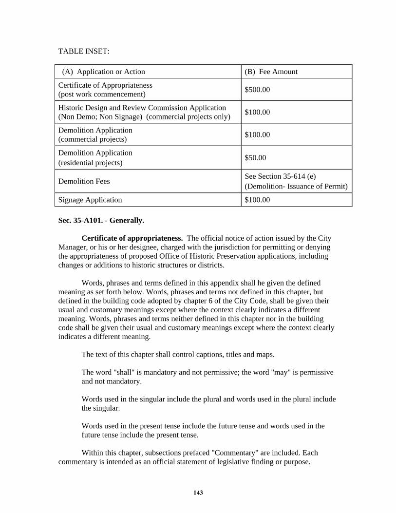
TABLE INSET: (A) Application or Action (B) Fee Amount
Certificate of Appropriateness (post work commencement) $500.00
Historic Design and Review Commission Application (Non Demo; Non Signage) (commercial projects only) $100.00
Demolition Application (commercial projects) $100.00
Demolition Application (residential projects) $50.00
Demolition Fees See Section 35-614 (e) (Demolition- Issuance of Permit)
Signage Application $100.00 Sec. 35-A101. - Generally.
Certificate of appropriateness. The official notice of action issued by the City Manager, or his or her designee, charged with the jurisdiction for permitting or denying the appropriateness of proposed Office of Historic Preservation applications, including changes or additions to historic structures or districts.
Words, phrases and terms defined in this appendix shall he given the defined meaning as set forth below. Words, phrases and terms not defined in this chapter, but defined in the building code adopted by chapter 6 of the City Code, shall be given their usual and customary meanings except where the context clearly indicates a different meaning. Words, phrases and terms neither defined in this chapter nor in the building code shall be given their usual and customary meanings except where the context clearly indicates a different meaning.
The text of this chapter shall control captions, titles and maps.
The word "shall" is mandatory and not permissive; the word "may" is permissive and not mandatory. Words used in the singular include the plural and words used in the plural include the singular. Words used in the present tense include the future tense and words used in the future tense include the present tense. Within this chapter, subsections prefaced "Commentary" are included. Each
commentary is intended as an official statement of legislative finding or purpose.
143

Whenever a section of this chapter is deemed to require clarification, explanation of its intent or further elaboration, that section is followed by a commentary. The commentaries have been legislatively adopted together with the formal text of this chapter. They are intended as a guide to the administration and interpretation of the chapter and shall be treated in the same manner as other aspects of legislative history.
In their interpretation and application, the provisions of this chapter shall be
deemed to be minimal in nature and whenever the provisions, standards or requirements of any other applicable chapter of this Code are higher or more restrictive, the latter shall control.
In computing any period of time prescribed or allowed by this chapter, the day of
the notice or final application, after which the designated period of time begins to run is not to be included. Further, the last day is to be included unless it is not a city working day, in which event the period runs until the next city working day.
For purposes of the landscaping standards of this chapter, reference shall be made
to American Nursery and Landscape Association ("ANLA")(formerly the American Association of Nurserymen), The American Standard For Nursery Stock, (1996), which document is hereby incorporated by reference as if set forth in its entirety herein. Said document may be obtained by contacting ANLA at 1250 I Street NW, Suite 500, Washington, D.C. 20005 (202/789-2900). In addition to the definitions set forth in Appendix "A" to this chapter, the following definitions shall apply to the regulation and control of landscaping within this section.
Words with specific defined meanings are as follows:
1% annual chance floodplain, (formerly 100-year floodplain). The land within a
community subject to a one (1) percent or greater chance of flooding in any given year. These areas are typically designated as a Federal Emergency Management Agency (FEMA) Zone A, AE, AH, or AO on FEMA Flood Insurance Rate Maps (FIRM Panels). Abut or abutting. Having property lines in common. Accessory Structure. In the Office of Historic Preservation, a building, structure or use on the same lot with, and of a nature customarily incidental and subordinate to, the principal building or use. Examples would include garages or tool sheds. Accessory apartment. A dwelling unit located within the principal dwelling, and that is accessory, supplementary, and secondary to the principal dwelling unit. An accessory apartment may be constructed as an attached addition to the principal use or occupied as an accessory to the principal use. An accessory apartment is located within the same building as the principal dwelling unit. Accessory detached dwelling unit. A dwelling unit that is accessory, supplementary, and secondary to the principal dwelling that may be constructed as an addition to the principal
144
structure or as an accessory to the principal structure. An accessory dwelling unit is detached from the principal dwelling. Accessory dwelling. An accessory detached dwelling unit or an accessory apartment. Accessory dwelling standards. See section 35-371 of this chapter. Accessory structure. In the Office of Historic Preservation, a building, structure or use on the same lot with, and of a nature customarily incidental and subordinate to, the principal building or use. Examples would include garages or tool sheds. Accessory use or building. A subordinate use or building customarily incident to and located on the same lot with the main use or building. Accessory use regulations. see section 35-370 of this chapter. Addition. A completely new structure or new component to an existing structure. Adjacent. Two (2) properties, lots or parcels are "adjacent" where they abut, or where they are nearby and are separated by a dissimilar type of manmade or geologic feature including but not limited to a roadway or street, right-of-way, or railroad line, or any stream, river, cancel, lake, or other body of water. Adjacent may or may not imply contact but always implies absence of anything of the same kind in between. Administrative approval. In the Office of Historic Preservation, the process of reviewing certain applications for local regulation compliance and approval without review by the historic and design review commission. Alteration. Any change affecting the exterior appearance of an existing structure or improvement by additions, reconstruction, remodeling, or maintenance; or any structural changes involving changes in form, texture, materials, or color; or, as applied to a building or structure, a change or rearrangement in the structural parts of the existing facilities, or an enlargement, whether by extending on a side or by increasing the height, or the moving from one location to another.
Archaeological. The science or study of the material remains of past life or activities and the physical site, location, or context in which they are found, as delineated in the Archaeological Resources Protection Act of 1979, as amended. Architect/designers/engineer. A principal person or/of the firm contracted to design the overall project to which design enhancements applies.
Architectural features. These include, but are not limited to, the exterior details of a building or structure, such as the type, style, or color of roofs, windows, doors, and
145
appurtenances. Architectural features will include interior architectural features where the interior is authorized for review.
In-Kind. The replacement element is exactly the same as the element it is replacing. For example, wood casement windows that are replaced with wood casement windows identical to those that are being removed.
Top Of Bank. For purposes of determining River Improvement Overlay riverside setbacks in 35-673, the point, stage or elevation at which water overflows the natural or man made banks of the river; alternately, the vertical point along the river where an abrupt change in slope is evident, and where the water level is generally able to overflow the natural bank or man made edge and enter adjacent floodplains (if any) during flows at or exceeding the average annual high water stage. SECTION 3. Chapter 2 of the City Code of San Antonio, Texas is hereby amended as follows: Article V. – Reserved Secs. 2-141—2-217. - Reserved. SECTION 4. All other provisions of Chapter 35 of the City Code of San Antonio, Texas shall remain in full force and effect unless expressly amended by this ordinance. SECTION 5. Should any Article, Section, Part, Paragraph, Sentence, Phrase, Clause or Word of this ordinance, for any reason be held illegal, inoperative, or invalid, or if any exception to or limitation upon any general provision herein contained be held to be unconstitutional or invalid or ineffective, the remainder shall, nevertheless, stand effective and valid as if it had been enacted and ordained without the portion held to be unconstitutional or invalid or ineffective. SECTION 6. The publishers of the City Code of San Antonio, Texas are authorized to amend said Code to reflect the changes adopted herein and to correct typographical errors and to format and number paragraphs to conform to the existing code. SECTION 7. The City Clerk is directed to publish notice of these amendments to Chapter 35, Unified Development Code of the City Code of the City of San Antonio, Texas. Publication shall be in an official newspaper of general circulation in accordance with Section 17 of the City Charter. SECTION 8. This ordinance shall be effective immediately upon passage by eight or more affirmative votes; otherwise, it shall be effective on the tenth day after passage. PASSED AND APPROVED this 24th day of June, 2010.
146
M A Y O R Julián Castro
ATTEST: APPROVED AS TO FORM: _____________________________ ______________________________ Leticia M. Vacek, City Clerk Michael D. Bernard, City Attorney
147

Pur
pose
and
Bas
ic M
etho
d T
he p
rim
ary
purp
ose
of t
he C
ity o
f San
Ant
onio
’s
Offi
ce o
f His
tori
c Pr
eser
vatio
n (O
HP)
is t
o pr
eser
ve a
nd p
rote
ct t
he u
niqu
e hi
stor
ic s
truc
ture
s an
d de
sign
feat
ures
of S
an A
nton
io. A
ccor
ding
ly,
the
hist
oric
and
des
ign
code
s fr
om t
he C
ity’s
U
nifie
d D
evel
opm
ent
Cod
e (U
DC
) req
uire
tha
t ce
rtai
n ac
tions
affe
ctin
g se
vera
l typ
es o
f pro
pert
ies
with
in t
he c
ity li
mits
mus
t be
rev
iew
ed a
nd
appr
oved
, eith
er b
y th
e O
HP
or t
he H
istor
ic a
nd
Des
ign
Rev
iew
Com
mis
sion
(HD
RC
), w
hich
mee
ts
ever
y fir
st a
nd
thir
d W
edne
sday
of
eac
h m
onth
. Fo
r af
fect
ed
prop
ertie
s an
d ac
tions
, the
hi
stor
ic a
nd
desi
gn r
evie
w
proc
ess
mus
t be
co
mpl
eted
and
wri
tten
app
rova
l obt
aine
d fr
om t
he
OH
P be
fore
act
ions
can
be
take
n or
per
mits
can
be
issu
ed b
y th
e Pl
anni
ng a
nd D
evel
opm
ent
Serv
ices
D
epar
tmen
t or
oth
er C
ity d
epar
tmen
ts.
Affe
cted
Pro
pert
ies
The
hist
oric
and
desig
n re
view
is re
quire
d fo
r pro
ject
s af
fect
ing
the
prop
erty
’s ex
terio
r at t
he fo
llow
ing
loca
tions
: Pr
oper
ties
loca
ted
with
in a
ny o
ne o
f the
City
’s
27 h
istor
ic d
istri
cts
or a
ny o
f the
City
’s 2
000
loca
l his
tori
c la
ndm
ark
prop
ertie
s Pr
oper
ties
loca
ted
with
in t
he s
ix R
iver
Im
prov
emen
t O
verl
ay (R
IO) d
istr
icts
(inc
ludi
ng
the
Rive
r W
alk)
Pu
blic
rig
hts-
of-w
ay
Publ
ic c
onst
ruct
ion
proj
ects
O
HP
App
licat
ion
Form
s
Adm
inis
trat
ive
Cer
tific
ate
of A
ppro
pria
tene
ss
(CO
A) A
pplic
atio
n H
isto
ric
and
Des
ign
Rev
iew
Com
mis
sion
(H
DR
C) A
pplic
atio
n D
emol
ition
App
licat
ion
OH
P ap
plica
tion
form
s m
ay b
e ob
tain
ed a
t : O
HP
rece
ptio
n co
unte
r (1
901
S. A
lam
o St
.)
OH
P w
ebsi
te a
t: w
ww
.san
anto
nio.
gov/
hist
oric
By
cal
ling
210/
215-
9274
and
ask
ing
that
the
fo
rms
be m
aile
d or
faxe
d O
HP
appl
icatio
n fo
rm s
ubm
ittal
: M
ust
be s
ubm
itted
in p
erso
n at
the
OH
P re
cept
ion
coun
ter
Mus
t be
sub
mitt
ed O
NLY
at
the
OH
P’s
dow
ntow
n of
fice
(190
1 S.
Ala
mo
Stre
et)
Can
not
be s
ubm
itted
by
fax
or m
ail,
exce
pt fo
r ap
plic
ants
or
proj
ect
cons
ulta
nts
that
are
lo
cate
d ou
tsid
e of
the
city
lim
its
App
licat
ion
Fees
: $1
00 fo
r H
DR
C A
pplic
atio
ns (
com
mer
cial
pr
oper
ties
onl
y)
$100
for
Sign
age
App
licat
ions
$1
00 fo
r D
emol
itio
n A
pplic
atio
ns
(com
mer
cial
pro
pert
ies)
$5
0 fo
r D
emol
itio
n A
pplic
atio
ns
(res
iden
tial
pro
pert
ies)
$5
00 a
pplic
atio
n fe
e fo
r al
l who
beg
in
wor
k pr
ior
to r
ecei
ving
HD
RC
app
rova
l (C
erti
ficat
e of
App
ropr
iate
ness
) Th
ere
is no
fee
for r
esid
entia
l HD
RC a
pplic
atio
ns o
r Ad
min
istra
tive
Certi
ficat
e of
App
ropr
iate
ness
App
licat
ions
. —
——
——
——
——
——
——
——
——
——
——
- A
dmin
istr
ativ
e C
erti
ficat
e of
A
ppro
pria
tene
ss (
CO
A)
App
licat
ion
T
he A
dmin
istr
ativ
e C
OA
is u
sed
for
cert
ain
min
or
alte
ratio
ns, a
dditi
ons,
ordi
nary
rep
airs
, or
mai
nten
ance
as
spec
ified
in t
he U
DC
Ch.
35,
Art
icle
V
I, Se
ct. 3
5-61
1 (a
s am
ende
d 6-
24-2
010)
tha
t m
ay b
e ap
prov
ed a
dmin
istra
tivel
y by
the
His
tori
c Pr
eser
vatio
n O
ffice
with
out
HD
RC
rev
iew
. Ad
min
istra
tive
COA
Exam
ples
: R
epai
r us
ing
the
sam
e m
ater
ials
and
des
ign
Rep
aint
ing
with
the
sam
e co
lors
or
reas
onab
le
chan
ges
to p
aint
col
ors
on p
revi
ously
pai
nted
su
rfac
es w
hich
are
con
sist
ent
with
the
dis
tric
t or
land
mar
k ch
arac
teri
stic
s R
e-ro
ofin
g w
ith t
he s
ame
type
and
col
or o
f m
ater
ial
CIT
Y O
F SA
N A
NT
ON
IO
OFF
ICE
OF
HIS
TO
RIC
PR
ESE
RV
AT
ION
(O
HP)
13
28
with
in 3
0 da
ys a
fter
the
date
of s
ubm
issi
on o
f the
de
mol
ition
app
licat
ion.
If th
e O
HP
dete
rmin
es t
hat
a st
ruct
ure
prop
osed
fo
r de
mol
ition
is s
igni
fican
t ac
cord
ing
to t
he
appl
icab
le h
istor
ic o
r de
sign
cod
e cr
iteri
a, t
hen
a re
ques
t to
the
HD
RC
is m
ade
for
land
mar
k de
sign
atio
n of
the
st
ruct
ure.
The
ap
plic
ant
and
the
prop
erty
ow
ner
are
notif
ied
of t
he
OH
P’s
requ
est,
the
mee
ting
date
and
lo
catio
n w
here
the
re
ques
t w
ill b
e co
nsid
ered
by
the
HD
RC
, and
any
HD
RC
Dem
oliti
on C
omm
ittee
m
eetin
gs t
hat
are
sche
dule
d. T
he a
pplic
ant
and/
or
the
owne
r (if
app
lican
t is
not
the
pro
pert
y ow
ner)
will
hav
e an
opp
ortu
nity
to
expr
ess
thei
r op
inio
ns a
bout
dem
oliti
on o
f the
str
uctu
re, o
r to
de
mon
stra
te u
nrea
sona
ble
econ
omic
har
dshi
p to
th
e H
DR
C d
urin
g th
e H
DR
C m
eetin
g an
d du
ring
an
y H
DR
C D
emol
ition
Com
mitt
ee m
eetin
gs t
hat
are
held
.
If
the
reco
mm
enda
tion
for
desi
gnat
ion
as a
hi
stor
ic la
ndm
ark
is a
ppro
ved
by t
he H
DR
C, t
he
Z
onin
g C
omm
issio
n, a
nd t
hen
City
Cou
ncil,
the
ap
plic
ant
mus
t de
mon
stra
te a
n un
reas
onab
le
econ
omic
har
dshi
p by
thi
s ac
tion
to a
llow
for
de
mol
ition
.
Spec
ific
requ
irem
ents
for
the
dem
oliti
on o
f
desi
gnat
ed la
ndm
arks
and
pro
pert
ies
with
in
hist
oric
and
RIO
dis
tric
ts a
re a
ddre
ssed
in t
he
Uni
fied
Dev
elop
men
t C
ode
(UD
C) S
ectio
n 35
-
61
4 (a
s am
ende
d 6-
24-2
010)
. In
add
ition
to th
e de
mol
ition
app
licat
ion
fee,
ther
e is
a de
mol
ition
per
mit
fee
requ
ired
for p
rope
rties
de
signa
ted
as lo
cal l
andm
arks
or w
ithin
loca
l hist
oric
dist
ricts
. D
emol
ition
per
mit
fees
are
bas
ed o
n th
e ap
prov
ed re
plac
emen
t pla
n sq
uare
foot
age.
Ref
er to
th
e U
DC
Amen
dmen
ts o
f 6/2
4/10
for f
ull d
etai
ls (a
vaila
ble
at: w
ww
.sana
nton
io.g
ov/h
istor
ic)
I wan
t to
wor
k on
my
hist
oric
bu
ildin
g or
my
prop
erty
w
ithi
n a
loca
l hi
stor
ic
dist
rict
. Wha
t do
I do
?
Off
ice
of
His
tori
c P
rese
rvat
ion
P.
O.
Bo
x 83
9966
Sa
n A
nto
nio
, TX
78
283-
3966
(2
10)
215-
9274
w
ww
.san
anto
nio.
gov/
hist
oric
O
HP
@sa
nant
onio
.gov
Pro
cess
for:
Adm
inis
trat
ive
CO
A A
pplic
atio
n,
His
tori
c &
Des
ign
Rev
iew
Com
mis
-si
on (
HD
RC
) A
pplic
atio
n,
Dem
olit
ion
App
licat
ion
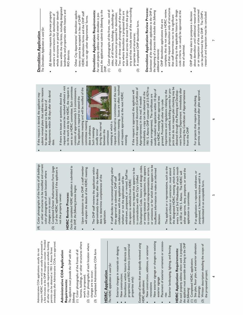
Adm
inis
trat
ive
CO
A a
pplic
atio
ns u
sual
ly d
o no
t re
quir
e H
DR
C r
evie
w a
nd c
an u
sual
ly b
e pr
oces
sed
in
a fe
w m
inut
es a
t th
e O
HP
rece
ptio
n co
unte
r. P
rovi
ded
all o
ther
city
cod
e re
quir
emen
ts a
re s
atis
fied,
bui
ldin
g pe
rmits
can
be
obta
ined
at
1901
S. A
lam
o St
reet
im
med
iate
ly a
fter
Adm
inis
trat
ive
CO
As
are
appr
oved
. A
dmin
istr
ativ
e C
OA
App
licat
ion
Req
uire
men
ts:
The
appl
icant
mus
t pro
vide
the
OH
P w
ith th
e fo
llow
ing:
(1
) C
olor
pho
togr
aphs
of t
he fr
onts
of a
ll
hom
es, b
uild
ings
, or
othe
r st
ruct
ures
whe
re
wor
k is
pro
pose
d;
(2)
Col
or p
hoto
grap
hs o
f eac
h lo
catio
n w
here
ch
ange
s ar
e to
occ
ur;
(3)
Com
plet
ed A
dmin
istr
ativ
e C
OA
form
45
76
(4)
Col
or p
hoto
grap
hs o
f the
fron
ts o
f all
build
ings
or
oth
er s
truc
ture
s to
be
mod
ified
and
cur
rent
co
lor
phot
ogra
phs
of e
ach
loca
tion
whe
re
chan
ges
are
to o
ccur
; (5
) C
ompl
eted
Ow
ner
Aut
hori
zatio
n Fo
rm (p
age
2 of
the
HD
RC a
pplic
atio
n) if
the
app
lican
t is
no
t th
e pr
oper
ty o
wne
r.
HD
RC
Rev
iew
Pro
cess
: O
nce
the
com
plet
ed H
DRC
app
licat
ion
is su
bmitt
ed to
th
e O
HP,
the
follo
win
g pr
oces
s be
gins
:
Upo
n su
bmis
sion
to
the
OH
P, a
sta
ff m
embe
r w
ill e
xpla
in t
he d
etai
ls o
f the
HD
RC
mee
ting.
The
OH
P st
aff r
evie
ws
the
appl
icat
ion
with
in
appr
oxim
atel
y th
ree
days
afte
r th
e de
adlin
e da
te t
o de
term
ine
com
plet
enes
s of
the
ap
plic
atio
n.
If
staf
f dec
ides
to
reco
mm
end
anyt
hing
oth
er
than
app
rova
l as
subm
itted
, OH
P st
aff
colla
bora
tes
with
the
app
lican
t to
dec
ide
w
heth
er o
r no
t th
e ap
plic
atio
n w
ill b
e
with
draw
n, p
ostp
oned
, or
revi
sed.
Sta
ff ha
s
the
optio
n to
with
hold
from
HD
RC
co
nsid
erat
ion
any
requ
est
that
app
ears
to
be
in
con
trad
ictio
n w
ith t
he C
ity’s
Uni
fied
D
evel
opm
ent
Cod
e, h
isto
ric
and
desi
gn c
odes
,
or
zon
ing
stat
utes
or
regu
latio
ns; t
hat
appe
ars
to
con
tain
fact
ual m
isre
pres
enta
tions
, err
ors,
or
om
issi
ons;
or
for
whi
ch t
here
app
ears
to
be
insu
ffici
ent
info
rmat
ion
to m
ake
an in
form
ed
deci
sion
.
The
app
lican
t or
a r
epre
sent
ativ
e, s
uch
as t
he
proj
ect
arch
itect
or
cont
ract
or, m
ust
atte
nd
the
desig
nate
d H
DR
C m
eetin
g, w
hich
occ
urs
ever
y 1s
t an
d 3r
d W
edne
sday
of e
ach
mon
th
at 3
:00
at 1
901
S. A
lam
o. T
he H
DR
C w
ill
eith
er a
ppro
ve, d
eny,
pos
tpon
e, o
r se
nd t
he
appl
icat
ion
to c
omm
ittee
.
If an
app
licat
ion
is r
ejec
ted,
with
draw
n, o
r po
stpo
ned,
it b
ecom
es in
activ
e un
til it
is
resu
bmitt
ed in
an
acce
ptab
le fo
rm.
If th
e re
ques
t is
den
ied,
the
app
lican
t m
ay
subm
it re
vise
d pl
ans
that
add
ress
the
rea
sons
fo
r de
nial
or
appe
al t
o th
e Bo
ard
of
Adj
ustm
ents
with
in 3
0 da
ys a
fter
the
deni
al
date
.
If th
ere
are
issu
es o
r qu
estio
ns a
bout
the
re
ques
t th
at c
anno
t be
res
olve
d w
ithou
t a
visi
t to
the
wor
k si
te b
y th
e H
DRC
, the
req
uest
is
sent
to
an H
DR
C c
omm
ittee
. Eac
h co
mm
ittee
co
nsis
ts o
f app
roxi
mat
ely
3-5
com
mis
sion
ers.
T
he a
pplic
ant
is r
equi
red
to a
tten
d th
e co
mm
ittee
mee
ting
and
will
be
notif
ied
of t
he
com
mitt
ee m
eetin
g da
te in
adv
ance
. Su
ch m
eetin
gs
usua
lly o
ccur
du
ring
the
inte
rval
be
twee
n th
e co
mm
issi
on
mee
ting
at w
hich
a
requ
est
is r
efer
red
to c
omm
ittee
and
the
nex
t co
mm
issi
on m
eetin
g. I
ssue
s ar
e of
ten
reso
lved
an
d re
ques
ts a
ppro
ved
at t
he n
ext
HD
RC
m
eetin
g.
If
the
requ
est
is a
ppro
ved,
the
app
lican
t w
ill
rece
ive
the
appr
oval
doc
umen
t (C
ertif
icat
e of
A
ppro
pria
tene
ss) i
n th
e m
ail.
If ne
eded
im
med
iate
ly, a
cop
y ca
n be
obt
aine
d at
the
19
01 S
. Ala
mo
OH
P co
unte
r (c
all 2
15-9
274
to
mak
e ar
rang
emen
ts).
The
cer
tific
ates
are
us
ually
mai
led
to a
pplic
ants
with
in 1
0 da
ys o
f
th
e H
DR
C m
eetin
g w
hen
appr
oval
was
gr
ante
d. P
rovi
ded
all o
ther
city
cod
e
requ
irem
ents
and
reg
ulat
ions
rel
atin
g to
the
pr
ojec
t ar
e sa
tisfie
d, b
uild
ing
perm
its fo
r pr
o-
ject
s th
at d
o no
t re
quir
e pl
an c
heck
ing
may
be
ob
tain
ed t
hrou
gh t
he P
lann
ing
and
Dev
elop
-
m
ent
Serv
ices
Dep
artm
ent
imm
edia
tely
afte
r
rece
ivin
g th
e C
ertif
icat
e of
App
ropr
iate
ness
fr
om t
he O
HP.
For
proj
ects
tha
t re
quir
e pl
an c
heck
ing,
pe
rmits
can
be
obta
ined
afte
r pl
an a
ppro
val.
Dem
olit
ion
App
licat
ion
Rev
iew
Pro
cess
: Su
bmiss
ion
of th
e de
mol
ition
app
licat
ion
to th
e O
HP
is th
e be
ginn
ing
of a
pro
cess
that
inclu
des
the
follo
win
g ad
ditio
nal e
lem
ents
: O
HP
dem
oliti
on a
pplic
atio
ns t
hat
are
com
plet
e, t
hat
do n
ot r
equi
re H
DR
C r
evie
w,
and
that
req
uest
dem
oliti
on o
nly
of s
truc
ture
s th
at s
taff
dete
rmin
es n
ot t
o be
sig
nific
ant
acco
rdin
g to
the
app
licab
le h
isto
ric
or d
esig
n co
de c
rite
ria,
can
usu
ally
be
appr
oved
at
the
time
of s
ubm
ittal
.
OH
P st
aff m
ay e
lect
to
post
pone
a d
ecis
ion
abou
t de
mol
ition
unt
il ad
ditio
nal r
esea
rch
and/
or a
n in
spec
tion
of t
he s
truc
ture
s co
ncer
ned
can
be p
erfo
rmed
by
the
OH
P. T
he O
HP’
s re
sear
ch a
nd in
spec
tion
mus
t be
con
clud
ed
HD
RC
App
licat
ion_
____
____
____
____
Th
e H
DRC
app
licat
ion
is us
ed fo
r:
Exte
rior
cha
nges
in m
ater
ials
or
desi
gns;
N
ew c
onst
ruct
ion;
D
emol
ition
s w
ithin
his
tori
c di
stri
cts
(all
prop
ertie
s) a
nd R
IO d
istr
icts
(com
mer
cial
pr
oper
ties
only
) Ex
ampl
es o
f ite
ms
that
are
typi
cally
revie
wed
usin
g H
DRC
app
licat
ions
: N
ew c
onst
ruct
ion,
add
ition
s, or
ext
erio
r re
nova
tions
N
ew e
xter
ior
sign
age
or c
hang
es t
o ex
istin
g ex
teri
or s
igna
ge
Plac
emen
t of
ext
erio
r or
nam
ent
or a
cces
so-
ries
Ex
teri
or la
ndsc
apin
g, li
ghtin
g, a
nd fe
ncin
g H
DR
C A
pplic
atio
n R
equi
rem
ents
: Fo
r eac
h pr
oper
ty a
ddre
ss w
here
wor
k is
prop
osed
, th
e ap
plica
nt m
ust a
ssem
ble
and
brin
g to
the
OH
P th
e fo
llow
ing:
(1
) C
ompl
eted
HD
RC
app
licat
ion;
(2
) Si
te p
lan,
floo
r pl
an, a
nd e
xter
ior
elev
atio
n
draw
ings
; (3
) W
ritt
en d
escr
iptio
n de
taili
ng t
he s
cope
of
the
prop
osed
pro
ject
;
Dem
olit
ion
App
licat
ion_
____
____
___
The
Dem
oliti
on A
pplic
atio
n is
used
for:
All
dem
oliti
on r
eque
sts
by p
riva
te p
rope
rty
owne
rs o
r co
ntra
ctor
s fo
r de
mol
ition
s of
w
hole
str
uctu
res
or p
artia
l ext
erio
r de
mol
i-tio
ns w
ithin
the
city
lim
its, i
nclu
ding
des
igna
ted
land
mar
ks a
nd p
rope
rtie
s w
ithin
his
tori
c an
d R
IO d
istr
icts
.
Oth
er C
ity d
epar
tmen
ts’ d
emol
ition
app
lica-
tions
can
not
be a
ccep
ted
in li
eu o
f OH
P/H
DR
C d
emol
ition
form
s an
d th
e O
HP
staf
f do
es n
ot s
ign
othe
r de
part
men
ts’ f
orm
s.
Dem
olit
ion
App
licat
ion
Req
uire
men
ts:
For e
ach
prop
erty
add
ress
whe
re d
emol
ition
is p
ro-
pose
d, th
e ap
plica
nt m
ust s
ubm
it th
e fo
llow
ing
to th
e O
HP:
(1
) C
olor
pho
togr
aphs
of t
he fr
ont,
rear
, and
all
side
s, o
f all
hom
es, b
uild
ings
, out
build
ings
, or
othe
r st
ruct
ures
pro
pose
d fo
r de
mol
ition
; (2
) T
wo
or t
hree
col
or p
hoto
grap
hs o
f the
pro
p-er
ty w
here
dem
oliti
on is
pro
pose
d th
at a
re
take
n fr
om a
cros
s th
e st
reet
from
the
pro
p-er
ty a
nd t
hat
incl
ude
som
e of
the
sur
roun
ding
pr
oper
ties
and
stru
ctur
es;
(3)
A c
ompl
eted
OH
P de
mol
ition
form
.

The
Cit
y of
San
Ant
onio
’s O
ffice
of
His
tori
c P
rese
rvat
ion
revi
ews
exte
rio
r m
od
ific
atio
ns
to
prop
erti
es
that
ar
e in
divi
dual
hi
stor
ic
land
mar
ks
or
are
loca
ted
wit
hin
a hi
stor
ic d
istr
ict.
T
he
Offi
ce
serv
es
as
advi
sory
st
aff
to t
he H
isto
ric
and
Des
ign
Rev
iew
C
omm
issi
on
(HD
RC
), w
hich
m
eets
on
th
e fir
st
and
thir
d W
edne
sday
s of
ea
ch
mon
th.
A p
rim
ary
resp
onsib
ility
of t
he O
ffice
is t
o pr
otec
t Sa
n A
nton
io’s
un
ique
hi
stor
ic
reso
urce
s by
ad
min
iste
ring
the
City
’s U
nifie
d D
evel
opm
ent
Cod
e hi
stor
ic p
rese
rvat
ion
and
desi
gn p
rovi
sion
. T
he
Offi
ce
also
pr
ovid
es
ince
ntiv
es
to
enco
urag
e pr
eser
vatio
n, i
nclu
ding
City
ad
valo
rem
(pr
oper
ty)
tax
exem
ptio
ns f
or “
subs
tant
ial
reha
bilit
atio
ns o
f hi
stor
ic b
uild
ings
in n
eed
of r
epai
r” a
nd fo
r ow
ner-
occu
pied
res
iden
ces
with
in n
ew h
istor
ic d
istri
cts:
Wha
t is
a “
subs
tant
ial
reha
bilit
atio
n” o
f a
hist
oric
bui
ldin
g in
nee
d of
rep
air?
T
he p
rope
rty
mus
t be
a n
atio
nal,
stat
e, o
r lo
cally
des
igna
ted
hist
oric
land
mar
k or
loca
ted
with
in a
nat
iona
l or
loca
l hist
oric
dis
tric
t. T
he
owne
r m
ust
inve
st,
whi
ch
can
incl
ude
“sw
eat
equi
ty”
for
labo
r pr
ovid
ed
by
the
prop
erty
ow
ner,
su
bsta
ntia
l re
habi
litat
ion
effo
rts
that
pro
long
the
life
of
the
build
ing.
Su
bsta
ntia
l re
habi
litat
ion
can
incl
ude
exte
rior
an
d/or
inte
rior
reh
abili
tatio
n w
ork.
3
8
Wha
t do
I ne
ed to
do
to r
ecei
ve a
T
ax
Exe
mpt
ion
or C
redi
t?
At
leas
t 75
% o
f th
e bu
ildin
g’s
inte
rnal
str
uctu
ral
fram
ewor
k m
ust
rem
ain
in p
lace
.
TH
E 1
0% O
R 2
0% F
ED
ER
AL
TA
X C
RE
DIT
: WH
ICH
O
NE A
PP
LIE
S?
The
10%
reh
abili
tatio
n ta
x cr
edit
appl
ies
only
to
non-
hist
oric
bui
ldin
gs b
uilt
befo
re 1
936.
T
he 2
0% r
ehab
ilita
tion
tax
cred
it ap
plie
s on
ly t
o ce
rtifi
ed h
isto
ric
stru
ctur
es.
Onl
y on
e of
the
se t
wo
optio
ns m
ay b
e ap
plie
d to
a
give
n pr
oper
ty.
Mor
e in
form
atio
n is
ava
ilabl
e on
the
Nat
iona
l Pa
rk S
ervi
ce w
ebsi
te a
t ht
tp://
ww
w2.
cr.n
ps.g
ov/
tps/
tax/
broc
hure
2.ht
m o
r co
ntac
t th
e O
ffic
e of
H
isto
ric
Pres
erva
tion
.
CIT
Y O
F SA
N A
NT
ON
IO
Offi
ce o
f His
tori
c P
rese
rvat
ion
2
1
Subs
tant
ial R
ehab
ilita
tion
for
Res
iden
tial
P
rope
rtie
s
Afte
r su
bsta
ntia
l re
habi
litat
ion
of
a hi
stor
ic
pr
oper
ty,
prop
erty
ow
ners
may
cho
ose
one
of
tw
o ta
x in
cent
ives
:
1)
City
pr
oper
ty
taxe
s ar
e fr
ozen
at
th
e
asse
ssed
val
ue p
rior
to
the
impr
ovem
ents
for
ten
(10)
yea
rs.
The
am
ount
of
City
pro
pert
y
taxe
s ow
ed is
det
erm
ined
by
the
asse
ssed
val
ue
pr
ior
to t
he i
mpr
ovem
ents
and
is fr
ozen
at
that
leve
l for
ten
(10
) yea
rs.
2)
No
City
pro
pert
y ta
xes
are
owed
for
the
first
fiv
e (5
) ye
ars.
Fo
r th
e ne
xt f
ive
(5)
year
s,
C
ity p
rope
rty
taxe
s ar
e as
sess
ed a
t a
valu
e th
at
is
50%
of t
he p
ost-
reha
bilit
atio
n as
sess
ed v
alue
.
Th
e pr
oper
ty
tax
exem
ptio
n re
mai
ns
with
th
e
prop
erty
rega
rdle
ss o
f a c
hang
e in
ow
ners
hip.
Su
bsta
ntia
l Reh
abili
tati
on fo
r
Com
mer
cial
Pro
pert
ies
Afte
r su
bsta
ntia
l reh
abili
tatio
n of
a c
omm
erci
al
prop
erty
, no
City
pro
pert
y ta
xes
are
owed
for
th
e fir
st fi
ve (5
) yea
rs.
For
the
next
fiv
e (5
)
ye
ars,
City
pro
pert
y ta
xes
are
asse
ssed
at
a va
lue
th
at is
50%
of t
he p
ost-
reha
bilit
atio
n as
sess
ed
valu
e. T
he p
rope
rty ta
x ex
empt
ion
rem
ains
with
the
pr
oper
ty re
gard
less
of a
cha
nge
in o
wne
rshi
p.
20%
Exe
mpt
ion
for
Ow
ner
Occ
upie
d
Res
iden
ces
in N
ew H
isto
ric
Dis
tric
ts
A
ll re
side
ntia
l pro
pert
ies
occu
pied
by
the
prop
erty
ow
ner
at t
he t
ime
of d
esig
natio
n re
ceiv
e a
20%
tax
exe
mpt
ion
on C
ity t
axes
for
10 y
ears
pro
vide
d th
e ow
ner
rem
ains
in t
he
prop
erty
.
Offi
ce o
f His
tori
c P
rese
rvat
ion
P.O
. Box
839
966
San
Ant
onio
, TX
782
83
215-
9274
w
ww
.san
anto
nio.
gov/
hist
oric
O
HP
@sa
nant
onio
.gov
V
isit
the
O
ffice
of H
isto
ric
Pre
serv
atio
n
at:
ww
w.s
anan
toni
o.go
v/hi
stor
ic
or e
mai
l us
at :
OH
P@
sana
nton
io.g
ov
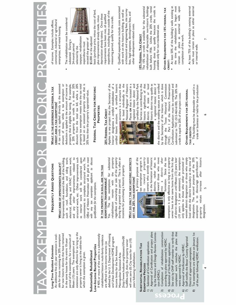
Process
WH
AT
IS T
HE D
IFFE
RE
NC
E B
ET
WE
EN
A T
AX
C
RE
DIT
AN
D A
TA
X E
XE
MP
TIO
N?
A t
ax c
redi
t is
app
lied
dire
ctly
to
the
asse
ssed
am
ount
of
ta
xes,
w
hile
a
tax
exem
ptio
n or
de
duct
ion
is a
pplie
d to
the
am
ount
of i
ncom
e or
pr
oper
ty t
hat
is e
ligib
le fo
r ta
. Fo
r ex
ampl
e,
a 20
%
prop
erty
ta
x cr
edit
is
a di
rect
20
%
disc
ount
fro
m t
he t
otal
tax
bill
, w
hile
a 2
0%
prop
erty
tax
exe
mpt
ion
mea
ns t
hat
the
tax
tota
l is
bas
ed o
n an
ass
esse
d pr
oper
ty v
alue
tha
t is
20%
less
tha
n th
e pr
oper
ty’s
app
rais
ed v
alue
.
FED
ER
AL
TA
X C
RE
DIT
S FO
R H
IST
OR
IC
PR
OP
ER
TIE
S
20%
FE
DE
RA
L T
AX
CR
ED
IT
App
lies
to a
ny p
roje
ct t
hat
the
Secr
etar
y of
the
In
teri
or d
esig
nate
s a
certi
fied
reha
bilit
atio
n of
a
certi
fied
hist
oric
stru
ctur
e.
A
ce
rtifi
ed
hist
oric
st
ruct
ure
is a
str
uctu
re t
hat
is
liste
d in
divi
dual
ly
in
the
Nat
iona
l R
egist
er o
f H
istor
ic
Plac
es O
R t
hat
is lo
cate
d in
a
regi
ster
ed h
istor
ic di
stric
t an
d ce
rtifi
ed b
y th
e N
atio
nal P
ark
Serv
ice
as c
ontr
ibut
ing
to t
he
hist
oric
si
gnifi
canc
e of
th
at
dist
rict
. A
st
ate
or
loca
l hi
stor
ic d
istri
ct m
ay q
ualif
y as
a
regi
ster
ed h
istor
ic di
stric
t if
the
dist
rict
and
the
ena
blin
g st
atut
e ar
e ce
rtifi
ed
by t
he S
ecre
tary
of
the
Inte
rior
, w
hich
is
done
th
roug
h th
e T
exas
H
istor
ical
C
omm
issi
on
(TH
C).
Pa
rt
I of
th
e H
isto
ric
Pres
erva
tion
Cer
tific
atio
n A
pplic
atio
n m
ust
be c
ompl
eted
and
su
bmitt
ed t
o T
HC
(51
2-46
3-61
00).
The
20%
tax
cr
edit
is e
qual
to
20%
of t
he p
roje
ct c
osts
. O
TH
ER R
EQ
UIR
EM
EN
TS
FOR 2
0% F
ED
ER
AL
TA
X C
RE
DIT
S:
The
bui
ldin
g m
ust
be d
epre
ciabl
e or
use
d in
a
trad
e or
bus
ines
s or
hel
d fo
r th
e pr
oduc
tion
of in
com
e. E
xam
ples
incl
ude
offic
es,
com
mer
cial
, ind
ustr
ial o
r ag
ricu
ltura
l en
terp
rise
s, a
nd r
enta
l hou
sing
.
The
reh
abili
tatio
n m
ust
be c
onsi
dere
d su
bsta
ntia
l. D
urin
g a
24-m
onth
per
iod
sele
cted
by
the
taxp
ayer
, reh
abili
tatio
n ex
pend
iture
s m
ust
exce
ed t
he g
reat
er o
f $5
,000
or
the
adju
sted
ba
sis
(pur
chas
e pr
ice,
min
us t
he c
ost
of la
nd,
plus
impr
ovem
ents
alr
eady
mad
e, m
inus
de
prec
iatio
n al
read
y ta
ken)
. O
nce
thes
e re
quir
emen
ts h
ave
been
met
, all
qual
ified
ex
pend
iture
s, in
clud
ing
thos
e ou
tsid
e of
the
m
easu
ring
per
iod,
qua
lify
for
the
cred
it.
Q
ualif
ied
expe
nditu
res
incl
ude
cost
s as
soci
ated
w
ith w
ork
on t
he h
isto
ric
build
ing,
as
wel
l as
arch
itect
ural
and
eng
inee
ring
fees
, site
sur
vey
fees
, leg
al e
xpen
ses,
dev
elop
men
t fe
es, a
nd
othe
r de
velo
pmen
t-re
late
d co
sts.
10%
FE
DE
RA
L T
AX
CR
ED
IT
The
10%
tax
cre
dit
is a
vaila
ble
for
the
subs
tant
ial
reha
bilit
atio
n of
dep
reci
able
non
-his
tori
c bu
ildin
gs
built
bef
ore
1936
. U
nlik
e th
e 20
% c
redi
t, re
ntal
ho
usin
g do
es
not
qual
ify
beca
use
the
cred
it is
avai
labl
e on
ly fo
r no
n-re
siden
tial u
se.
O
TH
ER R
EQ
UIR
EM
EN
TS
FOR 1
0% F
ED
ER
AL
TA
X
CR
ED
IT:
At
leas
t 50
% o
f th
e bu
ildin
g’s
wal
ls e
xist
ing
at
the
time
the
reha
bilit
atio
n is
be
gun
mus
t re
mai
n in
pl
ace
as
exte
rnal
w
alls
up
on
com
plet
ion
of t
he w
ork.
At
leas
t 75
% o
f th
e bu
ildin
g’s
exis
ting
exte
rnal
w
alls
mus
t re
mai
n in
pla
ce a
s ei
ther
ext
erna
l or
inte
rnal
wal
ls.
4 5
7
6
FRE
QU
EN
TLY
ASK
ED
QU
EST
ION
S
WH
AT
KIN
D O
F IM
PR
OV
EM
EN
TS
QU
ALI
FY?
Impr
ovem
ents
tha
t ex
tend
the
life
of t
he b
uild
ing,
su
ch
as
roof
, fo
unda
tion,
an
d si
ding
w
ork;
el
ectr
ical
, pl
umbi
ng,
and
HV
AC
sys
tem
s w
ork;
an
d an
y ot
her
impr
ovem
ents
re
late
d to
st
ruct
ural
wor
k, e
tc.
Oth
er im
prov
emen
ts s
uch
as
inte
rior
w
ork
will
be
co
nsid
ered
up
on
com
mitm
ent
to c
ompl
ete
stru
ctur
al w
ork.
The
O
ffice
of
Hist
oric
Pres
erva
tion
will
be g
lad
to m
eet
with
an
y ta
x ex
empt
ion
appl
icant
to
di
scus
s qu
alifi
catio
n fo
r the
exe
mpt
ions
. I F
TH
E P
RO
PE
RT
Y IS
SO
LD, A
RE T
HE T
AX
E
XE
MP
TIO
NS
TR
AN
SFE
RR
AB
LE?
Yes
.
The
ta
x ex
empt
ions
fo
r su
bsta
ntia
l re
habi
litat
ion
rem
ain
with
th
e pr
oper
ty
rega
rdle
ss o
f ow
ners
hip
or s
ale
of t
he p
rope
rty
du
ring
the
gra
nted
tim
e pe
riod
. T
his
is o
ften
an
ince
ntiv
e fo
r pu
rcha
sing
a hi
stor
ic p
rope
rty.
W
HY
DO
ON
LY T
HE N
EW H
IST
OR
IC D
IST
RIC
TS
GE
T T
HE 2
0% T
AX
EX
EM
PT
ION
? A
pri
mar
y pu
rpos
e of
the
ta
x ex
empt
ion
prog
ram
is
to
rew
ard
pro
pert
y ow
ners
who
act
ivel
y as
sist
in
the
form
atio
n of
his
tori
c di
stri
cts,
ra
ther
th
an
to
rew
ard
thos
e w
ho
mov
e in
to
a di
stri
ct
afte
r fo
rmat
ion.
Si
nce
the
tax
exem
ptio
n is
onl
y ef
fect
ive
as lo
ng a
s a
prop
erty
ow
ner
lives
in t
he s
ame
hom
e fr
om t
he fi
rst
day
of d
istr
ict
desi
gnat
ion
until
fifte
en (
15)
year
s la
ter
(10
year
s +
5 ye
ar e
xten
sion
), th
e ex
empt
ion
only
app
lies
to t
hose
who
eith
er p
rom
oted
or
wan
ted
dist
rict
des
igna
tion
or t
hose
who
sim
ply
lived
with
in t
he d
istr
ict
boun
dary
at
the
time
of
desi
gnat
ion.
Th
e se
cond
pu
rpos
e of
th
e 20
%
exem
ptio
n is
to
disc
oura
ge
gent
rific
atio
n if
prop
erty
va
lues
in
crea
se
afte
r hi
stor
ic
desi
gnat
ion.
L
ong-
Tim
e R
esid
ent
Ext
ensi
on
An
addi
tiona
l fiv
e (5
) yea
r ex
tens
ion
is a
vail-
abl
e fo
r th
ose
rece
ivin
g th
e 20
% e
xem
ptio
n
for
new
his
tori
c di
stri
cts
that
hav
e re
mai
ned
in
the
sam
e ho
use
for
the
entir
e 10
-yea
r
peri
od o
f the
exe
mpt
ion,
for
a m
axim
um o
f fif
teen
(15)
yea
rs.
The
exe
mpt
ion
and
ex
tens
ion
are
only
effe
ctiv
e fo
r as
long
as
the
pr
oper
ty o
wne
r is
livi
ng a
t th
e ad
dres
s fo
r
whi
ch t
he e
xem
ptio
n is
giv
en.
Su
bsta
ntia
lly R
ehab
ilita
ted
Lo
w-I
ncom
e R
enta
l Pro
pert
ies
I
f 40%
or
mor
e of
the
uni
ts in
a s
ubst
antia
lly
r
ehab
ilita
ted
hist
oric
mul
ti-fa
mily
res
iden
ce
a
re o
ffere
d to
low
-inco
me
tena
nts
(as
def
ined
by
the
U. S
. Dep
artm
ent
of H
ousi
ng
a
nd U
rban
Dev
elop
men
t H
OM
E pr
ogra
m
i
ncom
e lim
its fo
r th
e Sa
n A
nton
io
M
etro
polit
an S
tatis
tical
Are
a
[
http
://w
ww
.hud
user
.org
/dat
aset
s/il/
fmr0
0
hud
00tx
.txt]
), th
en t
he p
rope
rty
owne
r
w
ill o
we
zero
(0) C
ity t
axes
for
ten
(10)
yea
rs fo
llow
ing
reha
bilit
atio
n.
S U
BST
AN
TIA
L R
EH
AB
ILIT
AT
ION
TA
X
EX
EM
PT
ION
PR
OC
ESS
1)
Su
bmitt
al o
f Cer
tific
atio
n ap
plic
atio
n.
2)
App
rova
l of
Cer
tific
atio
n an
d pr
ojec
t pl
ans
by t
he H
isto
ric
and
Des
ign
Rev
iew
Com
mis
-si
on (H
DR
C).
3)
Com
plet
ion
of
reha
bilit
atio
n co
nstr
uctio
n ac
cord
ing
to p
lans
app
rove
d by
HD
RC
. 4)
Su
bmitt
al o
f Ver
ifica
tion
appl
icat
ion.
5)
Si
te v
isit
by O
HP
staf
f mem
ber
to v
erify
tha
t co
mpl
eted
w
ork
mat
ches
th
e pl
ans
that
w
ere
appr
oved
by
HD
RC
. 6)
A
ppro
val o
f Ver
ifica
tion
by H
DR
C.
7)
Staf
f not
ifies
the
Bex
ar C
ount
y A
ppra
isal
D
istr
ict
of a
ppro
ved
exem
ptio
n.
8)
Tax
exe
mpt
ions
are
effe
ctiv
e on
Janu
ary
1st
of t
he y
ear
follo
win
g H
DR
C v
erifi
catio
n.
TAX
EX
EMPT
ION
S FO
R H
ISTO
RIC
PRO
PERT
IES

BOARDS AND COMMISSIONS
HISTORIC DESIGN & REVIEW COMMISSION
The Historic and Design Review Commission (HDRC) consists of 11 members who reside in the City of San Antonio appointed by the Mayor and each City Councilmember for two-year terms from the following categories: architecture, architectural history, archaeology, historic preservation, landscape architecture, planning, public art, and the general community. HDRC reviews projects related to exterior changes to properties that are individually designated landmarks; within one of the City's historic districts; located within one of six (6) River Improvement Overlay (RIO) districts (including the River Walk); located within a Viewshed Protection district; or that are publicly-owned (i.e. libraries, parks, fire stations, etc.). In considering whether to recommend approval or disapproval of an application for a Certificate of Appropriateness, the HDRC is guided by the Secretary of the Interior's Standards for Rehabilitation, the City of San Antonio's Unified Development Code, and any additional design guidelines adopted by City Council. Meetings are held twice a month on the first and third Wednesdays at 3:00 PM at the Cliff Morton Development and Business Services Center Board Room, 1901 South Alamo, 1st Floor. For more information, please go to http://www.sanantonio.gov/historic/hdrc.aspx. Liaison: Maria Villalobos - (210) 207-7991
Name District Appointed
Date Date
Expires Mr. TIMOTHY B. CONE District 1 03/31/2005 05/31/2013 Dr. HARRY J. SHAFER District 2 03/05/2009 10/31/2011 Mr. VICTOR SALAS District 3 08/25/2005 10/31/2011 Mr. MICHAEL C. CONNOR District 4 12/10/2009 10/31/2010 Ms. KATHRYN D. RODRIGUEZ
District 5 03/03/2011 05/31/2013

Mr. JESSE ZUNIGA District 6 03/08/2012 05/31/2013 Mr. JACOB VALENZUELA District 7 02/09/2012 05/31/2013 Mr. NORMAN C. BARRERA District 8 10/14/2010 05/31/2013 Mr. SCOTT S. TAK District 9 02/09/2012 05/31/2013
Mr. SCOTT W. CARPENTER District 10
02/12/2009 05/31/2011
Mr. MICHAEL S. GUARINO Mayoral 08/05/2010 05/31/2011 Total Members for Historic and Design Review Commission: 11