OCTOBER 2020 - Waterfront Home
122
OCTOBER 2020 2020 MARINE USE STRATEGY 2020
Transcript of OCTOBER 2020 - Waterfront Home

OCTOBER 2020
2020 MARINE USE STRATEGY 2020

Page left intentionally blank

2020 MARINE USE STRATEGY – RESOURCE GUIDE WATERFRONT TORONTO
WSP October 2020
Page 3
A. 2006 MARINE USE STRATEGY IMPLEMENTATION IDEAS
– STATUS REVIEW .................................................... 6
A.1 Theme 1 – Recognizing an Expanding and Exceptional resource
...................................................................................................... 6
A.2 Theme 2 – Embracing Integrated and Sustainable Planning on the
Waterfront ................................................................................... 7
A.3 Theme 3 – Promoting an Active, Diverse and Accessible Waterfront
...................................................................................................... 8
A.4 Theme 4 – Planning Marine Districts through Revitalization 9
A.4.1 Theme 4.1 – The Inner Harbour .............................................................................. 9
A.4.2 Theme 4.2 – The Port Lands ................................................................................. 12
A.4.3 Theme 4.3 – The Outer Harbour ........................................................................... 14
A.4.4 Theme 4.4 – The Lakes and beaches .................................................................. 15
A.5 Theme 5 – Implementing Strategy through Steady Investment 16
B. DEVELOPMENT PLANS AND IMPACT ON MARINE USES
................................................................................. 18
B.1 Background and Objective of Plan Review ........................... 18
B.2 Central Waterfront Secondary Plan ........................................ 19
B.2.1 Plan Description ..................................................................................................... 19
B.2.2 Implications for Marine Uses ................................................................................. 20
B.3 Port Lands ................................................................................. 21
B.3.1 Relevant studies, plans and initiatives .................................................................. 21
B.3.2 Plan Description ..................................................................................................... 21
B.3.3 Implications for Marine Uses ................................................................................. 24
B.4 East Bayfront ............................................................................ 26
B.4.1 Relevant studies, plans and initiatives .................................................................. 26
B.4.2 Plan Description ..................................................................................................... 26
B.4.3 Implications for Marine Uses ................................................................................. 27
B.5 Jack Layton Ferry Terminal Masterplan ................................ 28
B.5.1 Relevant studies, plans and initiatives .................................................................. 28
B.5.2 Plan Description ..................................................................................................... 29
B.5.3 Implications for Marine Uses ................................................................................. 29
B.6 Bathurst Quay ........................................................................... 30
B.6.1 Relevant studies, plans and initiatives .................................................................. 30
B.6.2 Plan Description ..................................................................................................... 30
B.6.3 Implications for Marine Uses ................................................................................. 31

2020 MARINE USE STRATEGY – RESOURCE GUIDE WATERFRONT TORONTO
WSP October 2020
Page 4
B.7 Billy Bishop Toronto City Airport ........................................... 31
B.7.1 Relevant studies, plans and initiatives .................................................................. 31
B.7.2 Plan Description ..................................................................................................... 31
B.7.3 Implications for Marine Uses ................................................................................. 32
B.8 TRCA Marine Use Strategy ...................................................... 33
B.9 ToCore Plans ............................................................................ 33
B.9.1 Relevant studies, plans and initiatives .................................................................. 33
B.9.2 Plan Description ..................................................................................................... 33
B.9.3 Implications for Marine Uses ................................................................................. 34
B.10 Waterfront Toronto Five Year Strategic Plan ........................ 35
B.10.1 Relevant studies, plans and initiatives .................................................................. 35
B.10.2 Plan Description ..................................................................................................... 36
B.10.3 Implications for Marine Uses ................................................................................. 36
B.11 Waterfront Toronto Best Practice Guide - Sustainable Parks and
Open Space Design (2009) ...................................................... 37
B.11.1 Plan Description ..................................................................................................... 37
B.11.2 Implications for Marine Uses ................................................................................. 37
B.12 Waterfront Toronto Environmental Management Plan for Project-
Related Activities (2013) .......................................................... 37
B.12.1 Plan Description ..................................................................................................... 37
B.12.2 Implications for Marine Uses ................................................................................. 38
B.13 Waterfront Toronto Resilience & Innovation Framework of
Sustainability (2017) ................................................................. 38
B.13.1 Plan Description ..................................................................................................... 38
B.13.2 Implications for Marine Uses ................................................................................. 38
B.14 Development Plans Review - Main Findings ......................... 39
B.14.1 Opportunities .......................................................................................................... 39
B.14.2 Conflicting Interests ................................................................................................ 39
C. MARINE USE TRENDS ANALYSIS .......................... 40
C.1 Cruise Ship Activity ................................................................. 40
C.1.1 Vessel Calls and Passenger Numbers ................................................................. 40
C.1.2 cruise Industry Projected Growth .......................................................................... 46
C.1.3 Cruise Activity Summary ........................................................................................ 49
C.2 Industrial Shipping Activities .................................................. 49
C.2.1 Type of Cargo and Throughput Numbers ............................................................. 49
C.2.2 Industrial Shipping Activity Summary .................................................................... 51
C.3 Recreational Boating Activities .............................................. 52

2020 MARINE USE STRATEGY – RESOURCE GUIDE WATERFRONT TORONTO
WSP October 2020
Page 5
C.3.1 Marine Facilities for recreational Boating .............................................................. 52
C.3.2 Profile of Boaters and Population Characteristics ................................................ 59
C.3.3 Projected Population of Toronto and Greater Toronto Area ................................ 60
C.3.4 Projected Growth in Recreational Boating Activities ............................................ 61
C.3.5 Recreational Boating Summary ............................................................................. 63
C.4 Tour and Charter Boat Activity ............................................... 63
C.4.1 Tour and Charter Boat Capacity ............................................................................ 63
C.4.2 Tour and Charter Boat Summary .......................................................................... 64
C.5 Water Taxi Activity ................................................................... 66
D. DOCKWALL INVENTORY ....................................... 67
D.1 Dock Walls – Ownership .......................................................... 67
D.2 Dock Walls – Physical State .................................................... 68
E. STAKEHOLDERS ..................................................... 70
E.1 Overview of Marine Community & Stakeholders (at the time of this
study) ......................................................................................... 70
E.2 Stakeholder Feedback Log ...................................................... 74
F. ENGAGEMENT INDIGENOUS COMMUNITY ........ 120
2020 MARINE USE STRATEGY – RESOURCE GUIDE WATERFRONT TORONTO
WSP October 2020
Page 6
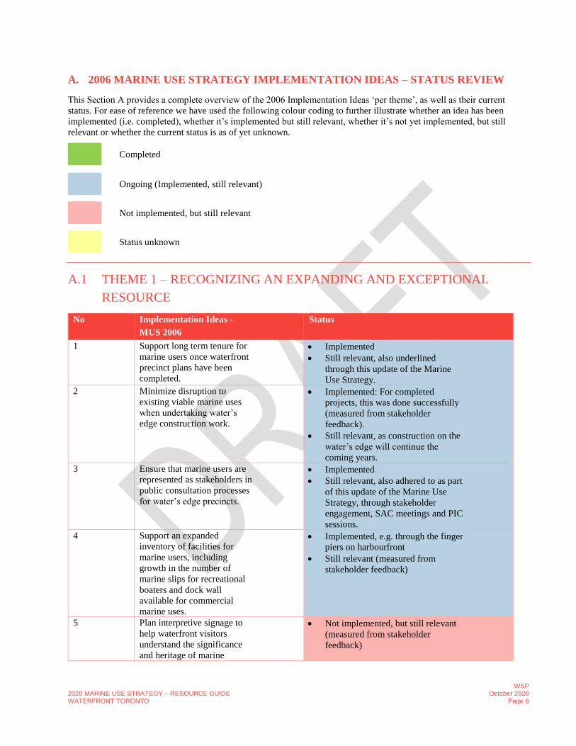
A. 2006 MARINE USE STRATEGY IMPLEMENTATION IDEAS – STATUS REVIEW
This Section A provides a complete overview of the 2006 Implementation Ideas ‘per theme’, as well as their current
status. For ease of reference we have used the following colour coding to further illustrate whether an idea has been
implemented (i.e. completed), whether it’s implemented but still relevant, whether it’s not yet implemented, but still
relevant or whether the current status is as of yet unknown.
Completed
Ongoing (Implemented, still relevant)
Not implemented, but still relevant
Status unknown
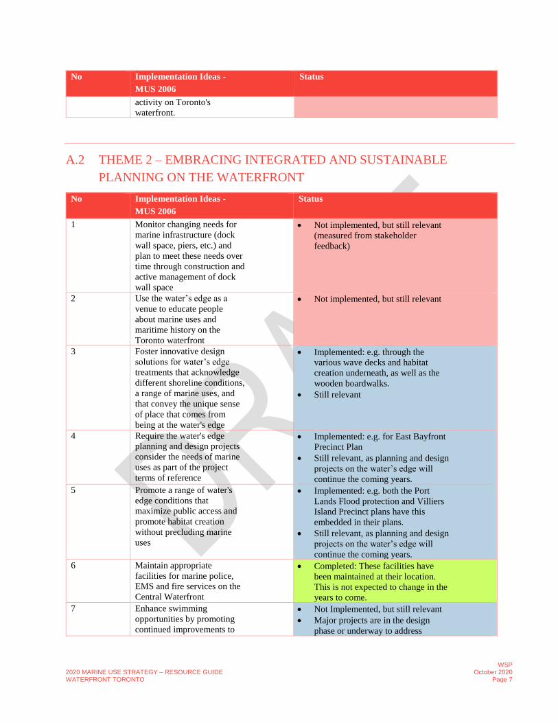
A.1 THEME 1 – RECOGNIZING AN EXPANDING AND EXCEPTIONAL
RESOURCE
No Implementation Ideas -
MUS 2006
Status
1 Support long term tenure for
marine users once waterfront
precinct plans have been
completed.
• Implemented
• Still relevant, also underlined
through this update of the Marine
Use Strategy.
2 Minimize disruption to
existing viable marine uses
when undertaking water’s
edge construction work.
• Implemented: For completed
projects, this was done successfully
(measured from stakeholder
feedback).
• Still relevant, as construction on the
water’s edge will continue the
coming years.
3 Ensure that marine users are
represented as stakeholders in
public consultation processes
for water’s edge precincts.
• Implemented
• Still relevant, also adhered to as part
of this update of the Marine Use
Strategy, through stakeholder
engagement, SAC meetings and PIC
sessions.
4 Support an expanded
inventory of facilities for
marine users, including
growth in the number of
marine slips for recreational
boaters and dock wall
available for commercial
marine uses.
• Implemented, e.g. through the finger
piers on harbourfront
• Still relevant (measured from
stakeholder feedback)
5 Plan interpretive signage to
help waterfront visitors
understand the significance
and heritage of marine
• Not implemented, but still relevant
(measured from stakeholder
feedback)
2020 MARINE USE STRATEGY – RESOURCE GUIDE WATERFRONT TORONTO
WSP October 2020
Page 7
No Implementation Ideas -
MUS 2006
Status
activity on Toronto's
waterfront.
A.2 THEME 2 – EMBRACING INTEGRATED AND SUSTAINABLE
PLANNING ON THE WATERFRONT
No Implementation Ideas -
MUS 2006
Status
1 Monitor changing needs for
marine infrastructure (dock
wall space, piers, etc.) and
plan to meet these needs over
time through construction and
active management of dock
wall space
• Not implemented, but still relevant
(measured from stakeholder
feedback)
2 Use the water’s edge as a
venue to educate people
about marine uses and
maritime history on the
Toronto waterfront
• Not implemented, but still relevant
3 Foster innovative design
solutions for water’s edge
treatments that acknowledge
different shoreline conditions,
a range of marine uses, and
that convey the unique sense
of place that comes from
being at the water's edge
• Implemented: e.g. through the
various wave decks and habitat
creation underneath, as well as the
wooden boardwalks.
• Still relevant
4 Require the water's edge
planning and design projects
consider the needs of marine
uses as part of the project
terms of reference
• Implemented: e.g. for East Bayfront
Precinct Plan
• Still relevant, as planning and design
projects on the water’s edge will
continue the coming years.
5 Promote a range of water's
edge conditions that
maximize public access and
promote habitat creation
without precluding marine
uses
• Implemented: e.g. both the Port
Lands Flood protection and Villiers
Island Precinct plans have this
embedded in their plans.
• Still relevant, as planning and design
projects on the water’s edge will
continue the coming years.
6 Maintain appropriate
facilities for marine police,
EMS and fire services on the
Central Waterfront
• Completed: These facilities have
been maintained at their location.
This is not expected to change in the
years to come.
7 Enhance swimming
opportunities by promoting
continued improvements to
• Not Implemented, but still relevant
• Major projects are in the design
phase or underway to address

2020 MARINE USE STRATEGY – RESOURCE GUIDE WATERFRONT TORONTO
WSP October 2020
Page 8
No Implementation Ideas -
MUS 2006
Status
water quality and continued
public investment in the
provision of safety facilities
and services at public beach
areas and in the water
combined sewer outfall during storm
surges. The Inner Harbour West
Tunnel is scheduled for construction
in 2027.
8 Participate actively in all
environmental assessment
processes with the potential
to impact existing marine
users to ensure they don’t
conflict with TWRC’s Marine
Use Strategy objectives
• Implemented on all ongoing
development projects near the
waterfront.
• Still relevant.
9 Recognize the impacts of
water pollution on the
sustainability and enjoyment
of marine uses and activities
and reinforce the need to
continue efforts to resolve
these issues through
continued implementation of
initiatives such as the City of
Toronto Wet Weather Flow
Master Plan and Toronto and
Region Conservation
Authority Aquatic Habitat
Restoration Strategy
• Implemented on all ongoing
development projects near the
waterfront.
• Still relevant.
10 Acknowledge winter storage
and docking requirements of
marine uses in waterfront
planning
• Implemented (acknowledged)
• Still relevant (measured from
stakeholder feedback)
A.3 THEME 3 – PROMOTING AN ACTIVE, DIVERSE AND ACCESSIBLE
WATERFRONT
No Implementation Ideas -
MUS 2006
Status
1 Sponsor events on the
waterfront that raise the
profile of marine activities
and work with the Council of
the Commodores and others
to encourage more
participation in marine
activities.
• Implemented: e.g. through the tall
ship festival
• Still relevant (measured from
stakeholder feedback)
2 Work with tourism
development partners to
market marine activities and
• Not implemented, but still relevant
• Work with Waterfront Business
Improvement Area (BIA) to

2020 MARINE USE STRATEGY – RESOURCE GUIDE WATERFRONT TORONTO
WSP October 2020
Page 9
No Implementation Ideas -
MUS 2006
Status
foster an understanding of
waterfront revitalization.
promote waterfront events,
including Tall Ship Festival.
3 Consider the needs of marine
users when planning for
vehicle parking and vehicular
access to the dock wall edge
for servicing in waterfront
precincts.
• Not implemented, but still relevant
4 Ensure that water’s edge areas
are designed to be accessible
for people of all ages and
physical abilities.
• Implemented: through several ramps
etc.
• Still relevant (measured by
stakeholder feedback)
5 Plan in accordance with the
City of Toronto’s policy
regulating and limiting the
existence of liveaboards and
float homes to preserve public
areas of the waterfront. In
particular, on-water
residential uses that limit
marine activities and that
serve to privatize public areas
of the waterfront should be
discouraged.
• Completed
6 Recognize the special role
that non-profit boating
organizations play in
enhancing public access to
marine activities on the
waterfront.
• Implemented to some extent (e.g.
through the new location for the
Toronto Brigantine)
• Disabled Sailing Association of
Ontario facility at 283 QQW.
• Still relevant (measured by
stakeholder feedback)
7 Expand the range of facilities
to support recreational
fishing, both from the shore
and the water.
• Completed, e.g. through the TRCA
recreation nodes on Unwin at the
Outer Harbour Marina. These nodes
have become popular fishing spots
A.4 THEME 4 – PLANNING MARINE DISTRICTS THROUGH
REVITALIZATION
A.4.1 THEME 4.1 – THE INNER HARBOUR
No Implementation Ideas -
MUS 2006
Status
1 Incorporate marine uses that
complement, activate and
mutually reinforce the
• Implemented: e.g. through:
- A promenade along the water’s
edge has been constructed in

2020 MARINE USE STRATEGY – RESOURCE GUIDE WATERFRONT TORONTO
WSP October 2020
Page 10
No Implementation Ideas -
MUS 2006
Status
landside uses of the East
Bayfront precinct plan. This
includes the provision of
additional finger piers to
accommodate tour/charter
vessels, a free dock wall
edge at least 200 metres in
length to accommodate
large visiting ships, and the
accommodation of marine-
related tenants in ground
floor retail units at the
water’s edge.
East Bayfront and runs parallel
to the Martin Goodman Trail
and the Queens Quay roadway.
- The Water’s Edge Promenade in
East Bayfront that runs from
Lower Jarvis Street to
Parliament Street, currently
serves as a docking point for
larger ships and vessels.
- The boardwalk and finger piers
are key components of the
promenade that have not yet
been constructed.
- The existing Jarvis Street and
Parliament Street Slips have
been maintained, and retail and
restaurant uses have been
introduced on the ground floor
of the lakeside buildings to
create an active and engaging
environment along the water’s
edge.
- Canada’s Sugar Beach, located
on the east side of the
revitalized Jarvis Street Slip,
was opened in 2010. Canada's
Sugar Beach is a 2-acre
publicly-accessible park that
features an urban beach, plaza
space, and natural granite
outcroppings.
- A new waterfront park named
Sherbourne Common was
constructed at the foot of
Sherbourne Street in 2010 and
2011. The park space includes a
range of seasonal activities
along the water’s edge,
including a splash pad that
converts to an ice skating rink in
the winter, two informal play
areas for children, an active
water channel feature, and art
sculptures.
• Still relevant, e.g. as Parliament Slip
has not yet been revitalized, and the
waterfront park contemplated in the
East Bayfront Precinct Plan to be
located at the foot of Parliament
Street has not been developed.
2020 MARINE USE STRATEGY – RESOURCE GUIDE WATERFRONT TORONTO
WSP October 2020
Page 11
No Implementation Ideas -
MUS 2006
Status
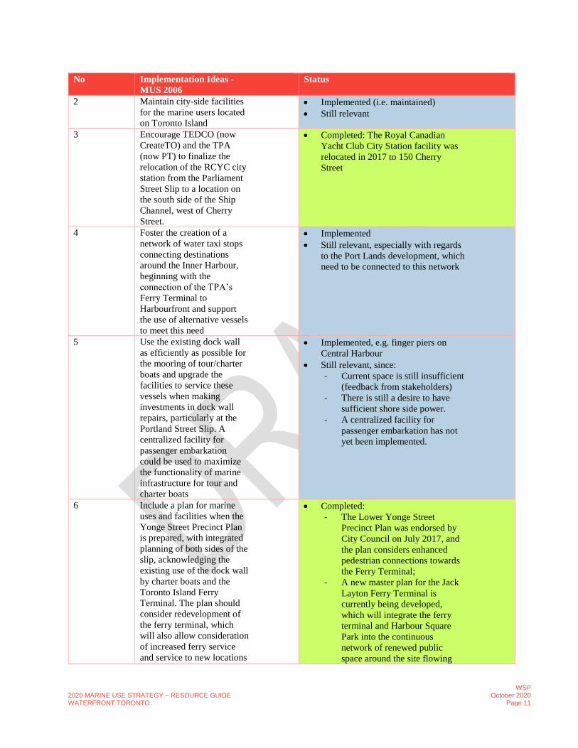
2 Maintain city-side facilities
for the marine users located
on Toronto Island
• Implemented (i.e. maintained)
• Still relevant
3 Encourage TEDCO (now
CreateTO) and the TPA
(now PT) to finalize the
relocation of the RCYC city
station from the Parliament
Street Slip to a location on
the south side of the Ship
Channel, west of Cherry
Street.
• Completed: The Royal Canadian
Yacht Club City Station facility was
relocated in 2017 to 150 Cherry
Street
4 Foster the creation of a
network of water taxi stops
connecting destinations
around the Inner Harbour,
beginning with the
connection of the TPA’s
Ferry Terminal to
Harbourfront and support
the use of alternative vessels
to meet this need
• Implemented
• Still relevant, especially with regards
to the Port Lands development, which
need to be connected to this network
5 Use the existing dock wall
as efficiently as possible for
the mooring of tour/charter
boats and upgrade the
facilities to service these
vessels when making
investments in dock wall
repairs, particularly at the
Portland Street Slip. A
centralized facility for
passenger embarkation
could be used to maximize
the functionality of marine
infrastructure for tour and
charter boats
• Implemented, e.g. finger piers on
Central Harbour
• Still relevant, since:
- Current space is still insufficient
(feedback from stakeholders)
- There is still a desire to have
sufficient shore side power.
- A centralized facility for
passenger embarkation has not
yet been implemented.
6 Include a plan for marine
uses and facilities when the
Yonge Street Precinct Plan
is prepared, with integrated
planning of both sides of the
slip, acknowledging the
existing use of the dock wall
by charter boats and the
Toronto Island Ferry
Terminal. The plan should
consider redevelopment of
the ferry terminal, which
will also allow consideration
of increased ferry service
and service to new locations
• Completed:
- The Lower Yonge Street
Precinct Plan was endorsed by
City Council on July 2017, and
the plan considers enhanced
pedestrian connections towards
the Ferry Terminal;
- A new master plan for the Jack
Layton Ferry Terminal is
currently being developed,
which will integrate the ferry
terminal and Harbour Square
Park into the continuous
network of renewed public
space around the site flowing
2020 MARINE USE STRATEGY – RESOURCE GUIDE WATERFRONT TORONTO
WSP October 2020
Page 12
No Implementation Ideas -
MUS 2006
Status
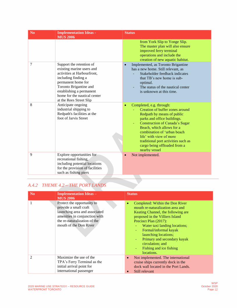
from York Slip to Yonge Slip.
The master plan will also ensure
improved ferry terminal
operations and include the
creation of new aquatic habitat.
7 Support the retention of
existing marine users and
activities at Harbourfront,
including finding a
permanent home for
Toronto Brigantine and
establishing a permanent
home for the nautical center
at the Rees Street Slip
• Implemented, as Toronto Brigantine
has a new home. Still relevant, as
- Stakeholder feedback indicates
that TB’s new home is sub-
optimal.
- The status of the nautical center
is unknown at this time.
8 Anticipate ongoing
industrial shipping to
Redpath's facilities at the
foot of Jarvis Street
• Completed, e.g. through:
- Creation of buffer zones around
Redpath by means of public
parks and office buildings.
- Construction of Canada’s Sugar
Beach, which allows for a
combination of ‘urban beach
life’ with view of more
traditional port activities such as
cargo being offloaded from a
nearby vessel
9 Explore opportunities for
recreational fishing,
including potential locations
for the provision of facilities
such as fishing piers
• Not implemented.
A.4.2 THEME 4.2 – THE PORT LANDS
No Implementation Ideas –
MUS 2006
Status
1 Protect the opportunity to
provide a small craft
launching area and associated
amenities in conjunction with
the re-naturalization of the
mouth of the Don River
• Completed: Within the Don River
mouth re-naturalization area and
Keating Channel, the following are
proposed in the Villiers Island
Precinct Plan (2017):
- Water taxi landing locations;
- Formal/informal kayak
launching locations;
- Primary and secondary kayak
circulation; and
- Fishing and ice fishing
locations.
2 Maximize the use of the
TPA’s Ferry Terminal as the
initial arrival point for
international passenger
• Not implemented. The international
cruise ships currently dock in the
dock wall located in the Port Lands.
• Still relevant

2020 MARINE USE STRATEGY – RESOURCE GUIDE WATERFRONT TORONTO
WSP October 2020
Page 13
No Implementation Ideas –
MUS 2006
Status
vessels but pursue
opportunities to accommodate
the docking of cruise boats
closer to the downtown core
3 Affirm that
industrial/commercial
shipping activity will
continue at TPA facilities and
as the primary use of the Ship
Channel as envisioned in the
City/TEDCO/TPA settlement
but work with the TPA and
TEDCO on a memorandum
of understanding to facilitate
the use of the Ship Channel
for limited recreational
boating, subject to
appropriate safety measures
and management procedures
• Completed (affirmed), although not
sure about the MoU
4 Include a detailed plan for the
accommodation of marine
uses in all precinct plans
prepared in the Port Lands
district, particularly for
Polson and Cousins Quays
• Implemented
- The following plans have been
developed for the Port Lands
and includes various marine uses
since 2006:
o Port Lands Planning
Framework (2017)
o Villiers Island Precinct
Plan (2017)
o Port Lands Flood
Protection and Enabling
Infrastructure (2016)
o Keating Channel Precinct
Plan (2010)
- These plans identified the Port
Lands as the shipping gateway
and industrial hub for Toronto.
(Port Lands Planning Frame
Work, 2017)
• Still relevant, also since
- Precinct plans and
accommodations for marine uses
to be considered in future
planning for Port Lands.
- Lafarge (at Polson) raised a
concern about their terminal
being located alongside a water’s
edge that will experience
significant recreational boat use.
5 Encourage TEDCO and the
TPA to relocate Bayside
Rowing from their current
location potentially to the
• Completed. Review of aerial image
indicates that a construction has been
in progress at the Bayside Rowing

2020 MARINE USE STRATEGY – RESOURCE GUIDE WATERFRONT TORONTO
WSP October 2020
Page 14
No Implementation Ideas –
MUS 2006
Status
north side of the Turning
Basin, as a catalyst for
revitalization. A more
detailed investigation of
potential alternative locations
for the club’s facilities within
the Ship Channel is required
Club location (600 Unwin Avenue,
Toronto) since 2009.
6 Recognize the value of the
existing Atlas crane to marine
shipping and consider the
relocation of the crane when
the Cousins Quay precinct is
redeveloped
• Not yet implemented
• Still relevant
A.4.3 THEME 4.3 – THE OUTER HARBOUR
N
o
Implementation Ideas – MUS
2006
Status
1 Recognize non-motorized
recreational boating as the
primary activity in the Outer
Harbour, acknowledging that
power boating is an accepted use,
particularly with respect to the
Outer Harbour Marina
• Implemented (recognized and
acknowledged)
• Still relevant, as there is significant
recreational boating activity in the Outer
Harbour including a wide variety of non-
motorized forms of boating such as sailing,
kiteboarding, dragon boating, windsurfing,
canoeing and kayaking.
2 Encourage the build out of the
Outer Harbour Marina to
accommodate growth in
recreational boating, including
the construction of facilities on
the north side of the OHM lands
for and the consideration of a
new public boat launch ramp,
after careful consideration of
marine facility
demands/requirements
• Implemented, e.g. through:
- A recognized increase in recreational
boating, both motorized and non-
motorized over the last decade.
- Completion of a new boat storage
facility at the Hanlan Boat Club (east of
Cherry Beach)
- Received planning approvals by
PortsToronto for construction of a youth
rowing club at the Outer Harbour
Marina, which is presently in the
planning stages for this facility.
• Still relevant, since:
- Growth in marine use continues to
increase, with more demand for public
boat launches and facilities to store
boats.
- The Lake Ontario Master Plan (2008)
had several more detailed
recommendations in this regard, but is
currently on hold.
3 Use the Lake Ontario Park
master planning process to create
a plan that resolves the long-term
location, design, and servicing of
• Not implemented, as the Lake Ontario
Master Plan is currently on hold.
• Still relevant

2020 MARINE USE STRATEGY – RESOURCE GUIDE WATERFRONT TORONTO
WSP October 2020
Page 15
N
o
Implementation Ideas – MUS
2006
Status
facilities for the Outer Harbour
Sailing Federation clubs
4 Use investments in the Port
Lands to foster the accessibility
and feasibility of recreational
boating opportunities in the
Outer Harbour including
investments in public transit and
municipal servicing
infrastructure
• Not implemented, as the Lake Ontario
Master Plan is currently on hold.
• Still relevant, as this plan proposes:
- New and renovated entrances at Cherry
Street, Leslie Street and Woodbine
Beach will establish a unified frontage
to the park.
- The City’s commitment to providing
connectivity and access across Unwin
Avenue. Feasibility and details of the
proposed realignment of Unwin
Avenue are subject to an
Environmental Assessment process.
- The Marina Peninsula will continue to
be accessed by a realigned drive off
Unwin Avenue.
5 Improve opportunities for
recreational fishing, including the
provision of appropriate facilities
such as fishing piers and fish
cleaning stations
• Implemented. In 2015 TRCA realized the
TRCA recreation nodes on Unwin at the
Outer Harbour Marina. These nodes have
become popular fishing spots
• Still relevant, as the Lake Ontario Master
Plan (currently on hold) proposes a broad,
waterfront ‘recreation deck’ along the
northern edge of the Marina Peninsula
complete with fishing areas, fish cleaning
station, pedestrian boardwalks and piers,
spectator landings and a new waterfront café.
6 Use the Lake Ontario Park
Master Plan to prioritize
improvements to the aquatic
habitat and shoreline access
• Not implemented, as the Lake Ontario
Master Plan is currently on hold.
• Still relevant
A.4.4 THEME 4.4 – THE LAKES AND BEACHES
N
o
.
Implementation Ideas – MUS
2006
Status
1 Ensure that the value of current
investment in the Western
Beaches Watercourse is
maximized by supporting the
work of the Western Beaches
Watercourse Advisory
Committee regarding operations
and long-term planning
• Implemented and although not within
project study area, still relevant
2 Maintain a public boat launch at
Humber Bay and Ashbridges Bay
as well as Marie Curtis Park,
Bluffer’s Park and Etobicoke
• Completed
2020 MARINE USE STRATEGY – RESOURCE GUIDE WATERFRONT TORONTO
WSP October 2020
Page 16
N
o
.
Implementation Ideas – MUS
2006
Status
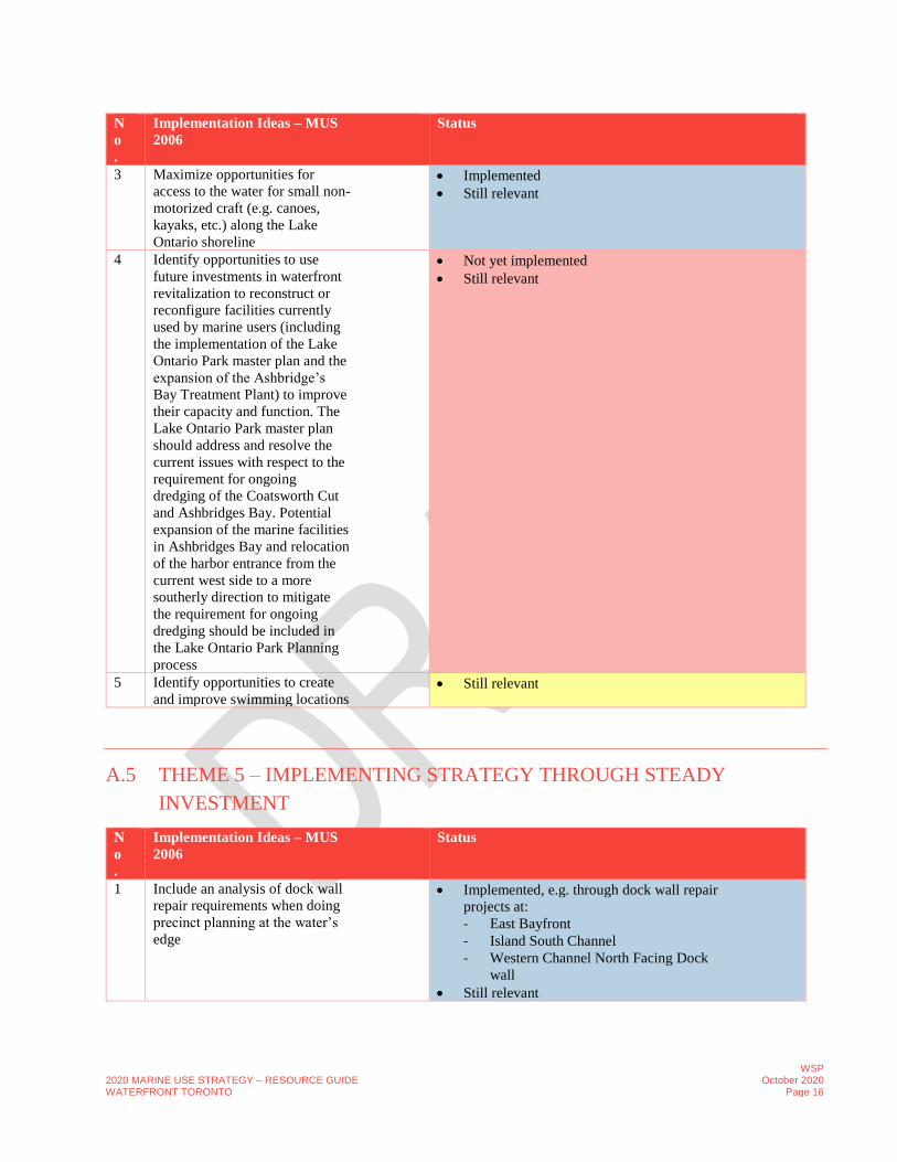
3 Maximize opportunities for
access to the water for small non-
motorized craft (e.g. canoes,
kayaks, etc.) along the Lake
Ontario shoreline
• Implemented
• Still relevant
4 Identify opportunities to use
future investments in waterfront
revitalization to reconstruct or
reconfigure facilities currently
used by marine users (including
the implementation of the Lake
Ontario Park master plan and the
expansion of the Ashbridge’s
Bay Treatment Plant) to improve
their capacity and function. The
Lake Ontario Park master plan
should address and resolve the
current issues with respect to the
requirement for ongoing
dredging of the Coatsworth Cut
and Ashbridges Bay. Potential
expansion of the marine facilities
in Ashbridges Bay and relocation
of the harbor entrance from the
current west side to a more
southerly direction to mitigate
the requirement for ongoing
dredging should be included in
the Lake Ontario Park Planning
process
• Not yet implemented
• Still relevant
5 Identify opportunities to create
and improve swimming locations • Still relevant
A.5 THEME 5 – IMPLEMENTING STRATEGY THROUGH STEADY
INVESTMENT
N
o
.
Implementation Ideas – MUS
2006
Status
1 Include an analysis of dock wall
repair requirements when doing
precinct planning at the water’s
edge
• Implemented, e.g. through dock wall repair
projects at:
- East Bayfront
- Island South Channel
- Western Channel North Facing Dock
wall
• Still relevant
2020 MARINE USE STRATEGY – RESOURCE GUIDE WATERFRONT TORONTO
WSP October 2020
Page 17
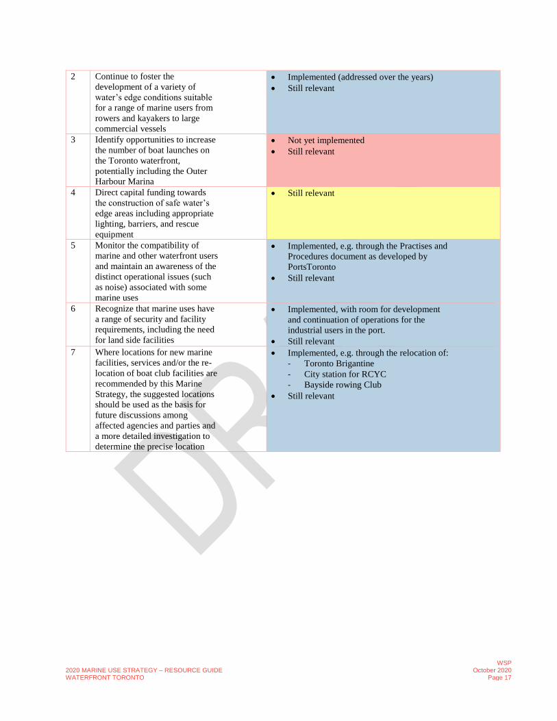
2 Continue to foster the
development of a variety of
water’s edge conditions suitable
for a range of marine users from
rowers and kayakers to large
commercial vessels
• Implemented (addressed over the years)
• Still relevant
3 Identify opportunities to increase
the number of boat launches on
the Toronto waterfront,
potentially including the Outer
Harbour Marina
• Not yet implemented
• Still relevant
4 Direct capital funding towards
the construction of safe water’s
edge areas including appropriate
lighting, barriers, and rescue
equipment
• Still relevant
5 Monitor the compatibility of
marine and other waterfront users
and maintain an awareness of the
distinct operational issues (such
as noise) associated with some
marine uses
• Implemented, e.g. through the Practises and
Procedures document as developed by
PortsToronto
• Still relevant
6 Recognize that marine uses have
a range of security and facility
requirements, including the need
for land side facilities
• Implemented, with room for development
and continuation of operations for the
industrial users in the port.
• Still relevant
7 Where locations for new marine
facilities, services and/or the re-
location of boat club facilities are
recommended by this Marine
Strategy, the suggested locations
should be used as the basis for
future discussions among
affected agencies and parties and
a more detailed investigation to
determine the precise location
• Implemented, e.g. through the relocation of:
- Toronto Brigantine
- City station for RCYC
- Bayside rowing Club
• Still relevant
2020 MARINE USE STRATEGY – RESOURCE GUIDE WATERFRONT TORONTO
WSP October 2020
Page 18
B. DEVELOPMENT PLANS AND IMPACT ON
MARINE USES
B.1 BACKGROUND AND OBJECTIVE OF PLAN REVIEW
Within the overall waterfront revitalization initiative, there are several plans and projects that are being planned or already
being implemented by WT, City and TRCA to guide the redevelopment of the waterfront. The implementation of these
plans may have impacts on the current and future use of the waterfront for the marine activities identified in this study. A
detailed review of these plans and initiatives was therefore undertaken as part of the Marine Use Strategy Update.
The following Sections B2 - B10 provide a summary of the review of the following ongoing waterfront planning
initiatives and projects related to waterfront revitalization and considered highly relevant for this Marine Use Strategy
Update, as well as their implications, opportunities and constraints for marine uses.:
• Central Waterfront Secondary Plan;
• Port Lands, including Villiers Island and Keating Channel;
• East Bayfront;
• Lower Yonge;
• Bathurst Quay Neighborhood Plan;
• Billy Bishop Draft Master Plan;
• TRCA Marine Use Strategy;
• ToCore Parks and Public Realm Plan; and
• Waterfront Toronto Five Year Strategic Plan – Priority Projects 2019/2020 – 2023/2024.
In addition to the above plans, a number of other plans, studies and initiatives have been reviewed in a similar manner.
These ‘other plans’ mainly provide vision, direction and recommendations for development of the overall waterfront area,
specifically in terms of sustainability, resilience, innovation, mobility, public realm and environmental management.
These plan reviews are presented in Sections B11 - B16, and a listing of these is provided below:
• Waterfront Toronto Best Practice Guide – Sustainable Parks and Open Space Design (2009);
• Waterfront Toronto Environmental Management Plan for Project Related Activities (2013);
• Waterfront Toronto Resilience & Innovation Framework of Sustainability (2017);
• Corporate Plan 2018/2019 Waterfront Toronto
• ToCore Downtown Mobility Strategy (2018); and
• ToCore Downtown Secondary Plan (2018).
The following two studies have been left out of this review, as their current status is either unknown, on-hold or too
premature to provide reliable input for the Marine Use Strategy Update;
• Lake Ontario Park Master Plan;
• Toronto Island Park Master Plan.

2020 MARINE USE STRATEGY – RESOURCE GUIDE WATERFRONT TORONTO
WSP October 2020
Page 19
B.2 CENTRAL WATERFRONT SECONDARY PLAN
B.2.1 PLAN DESCRIPTION
The Central Waterfront Secondary Plan (the Plan, refer figure B.1) was adopted by Toronto City Council in 20031. It is
the overarching planning policy document guiding revitalization in the Designated Waterfront Area. It sets a framework
to accommodate over 40,000 new housing units and over 68,000 new people2 on the waterfront.
Figure B.1 – Central Waterfront Area Secondary Plan
The Plan establishes four core principles which are complementary to the vision of the Marine Use Strategy:
• Removing Barriers/Making Connections;
• Building a Network of Spectacular Waterfront Parks and Public Spaces;
• Promoting a Clean and Green Environment; and
• Creating Dynamic and Diverse New Communities.
1 https://www.toronto.ca/wp-content/uploads/2017/11/99c8-CWSP07.pdf 2 https://waterfrontoronto.ca/nbe/wcm/connect/waterfront/5de208ec-6609-4685-97cd-181692f60868/Gardiner+EA+Report+-+CH+3+FINAL.pdf?MOD=AJPERES&CACHEID=5de208ec-6609-4685-97cd-181692f60868

2020 MARINE USE STRATEGY – RESOURCE GUIDE WATERFRONT TORONTO
WSP October 2020
Page 20
The Plan contains policies which guide the creation of new mixed-use communities on the waterfront and stress the
importance of creating a diverse range of attractive public realm and establishing a contiguous public water’s edge. The
Plan also requires that new mixed-use communities will be planned through a precinct planning process.
A map illustrating the conceptual location of waterfront precincts and areas that have been planned to-date is provided
below. Please note that precinct boundaries are conceptual and have been modified over time.
Figure B.2 – Overview Waterfront Precincts planned to-date
B.2.2 IMPLICATIONS FOR MARINE USES
Within the 2003 Central Waterfront Secondary Plan, the following elements that will impact marine use on the waterfront
are recognized and directed:
• The Central Waterfront will (need to) accommodate a variety of maritime activities, including cargo shipping, cross-
lake ferry service, local ferry and water taxi terminals, excursion boats, cruise ships, berthing areas and marinas,
maritime support services and the industrial activities of the Port of Toronto;
• Dock wall space will (need to) be sufficient to meet the needs of industry, cargo shipping, passenger cruise ships,
ferries, excursion boats, recreational boating and other water dependent activities;
• Boating opportunities will (need to) be expanded to draw city residents, workers and tourists to the waterfront.
Toronto’s waterfront is an opportunity to provide world class boating facilities, particularly in the Outer Harbour;
• The “Foot of Yonge” is a Special Study Area where further detailed study is needed to draw residents, tourists,
boaters and cruise ships to the waterfront, visible from both land and water. The area is intended to include major
public amenities and tourist facilities. “A dramatic new pier” is contemplated, “…recognizing and celebrating this
area as the centre of Toronto’s waterfront”. The multi-phase Pier 27 development is being developed at this
location3;
3 https://www.toronto.ca/legdocs/mmis/2011/te/bgrd/backgroundfile-38256.pdf

2020 MARINE USE STRATEGY – RESOURCE GUIDE WATERFRONT TORONTO
WSP October 2020
Page 21
• The Ship Channel will become a focal point for new mixed-use communities, however, the needs of existing
industries for dock wall space and use of the channel will (need to) be balanced with new opportunities. New
north/south canals could expand the use of the channel for activities such as boating or skating;
• Harbourfront Centre will be an area for the arts, education, recreation and entertainment in a magnificent waterfront
setting; and
• The Redpath facility is an important feature of the Toronto Waterfront that should be maintained and future
developments should ensure that there are no undue negative impacts on Redpath’s activities.
B.3 PORT LANDS
B.3.1 RELEVANT STUDIES, PLANS AND INITIATIVES
The following studies, plans and initiatives were reviewed as part of the Port Lands Area:
• Port Land Flood Protection and Enabling Infrastructure Due Diligence Report (2016);
• Port Lands Planning Framework (2017);
• Villiers Island Precinct Plan (2017);
• Keating Channel Precinct Plan (2010); and
• Gardiner Expressway & Lake Shore Boulevard East Configuration EA (2017).
B.3.2 PLAN DESCRIPTION
The Port Lands Project (figure B.3) is a comprehensive strategy for protecting the south-east district of downtown
Toronto - including parts of the Ports Lands, South Riverdale, Leslieville, and the First Gulf/Unilever development site -
from potential loss of life and costly damage associated with a major storm event. This is a five-year construction program
that will implement parks, roads and municipal infrastructure, bridges, environmental remediation and earthworks/flood
protection/climate change resilience measures at the mouth of the Don River, in the Keating Channel Precinct and the
Villiers Island Precinct within the Port Lands.
The Plan recognizes that the Port Lands will continue to host Toronto’s only industrial port. This valuable resource
significantly reduces trucks on streets and contributes to the vitality of the City’s economy. The Port Lands represent 325
hectares of revitalization lands and identifies long-term future precincts, habitat improvements, parks, roads, transit,
bridges, infrastructure and land use considerations. The Plan also contemplates the introduction of new marine uses and
transportation options that would take advantage of waterways for ferry and boat access to and from downtown as well as
extended ferry and water taxi service.

2020 MARINE USE STRATEGY – RESOURCE GUIDE WATERFRONT TORONTO
WSP October 2020
Page 22
Figure B.3 - Port Lands (Flood Protection and Enabling Infrastructure) – Landscape Program Distribution
As part of flood protecting the Port Lands, and an immense portion of the downtown area, the project will also unlock
lands permitting the Keating Channel and Villiers Islands precincts to advance, as well as creating a new river course and
park system. In total, this work could unlock sufficient potential to accommodate housing for 18,000-25,000 people and
commercial space for 25,000-30,000 jobs in the Port Lands alone.
Villiers Island
The Villiers Island Precinct Plan (figure B.4) was introduced in 2017. It envisions the creation of a mixed-use community
on the new Villiers Island and adjacent to the Keating Channel. It also complements the Keating Channel Precinct Plan to
the north. The Plan is designed to accommodate up to 4,865 residential units (8,200 to 10,700 people) as well as 2,900
jobs.

2020 MARINE USE STRATEGY – RESOURCE GUIDE WATERFRONT TORONTO
WSP October 2020
Page 23
Figure B.4 - Villiers Island Precinct Plan Details
Keating Channel
The Keating Channel Precinct Plan (figure B.5) focussed on creating a new mixed-use waterfront community between
Parliament Slip and the Don Roadway along the north bank of the Channel. While the western portion of the Keating
Channel Precinct has recently been flood protected, the finalization and advancement of this Plan is subject to the
completion of transportation, infrastructure and flood protection work associated with the Port Lands Flood Protection and
Enabling Infrastructure Project, the extension of Queens Quay and the Gardiner East Reconfiguration. The Precinct is
intended to accommodate 7,520 people in approximately 4,700 units and 6,000 to 7,020 jobs.
The subsequent Villiers Island Precinct Plan applies to the lands on the south bank the channel. Together, both Plans will
transform the Channel into a central grand canal and focal gathering area for the new surrounding mixed-use
communities.

2020 MARINE USE STRATEGY – RESOURCE GUIDE WATERFRONT TORONTO
WSP October 2020
Page 24
Figure B.5 – Keating Channel Precinct Details
B.3.3 IMPLICATIONS FOR MARINE USES
Port Lands Framework Plan
Within the Port Lands Framework Plan, the following elements might impact marine use on the waterfront:
• The Plan recognizes opportunities to take advantage of the Port Lands waterways for ferry and boat access as a new
movement corridor to and from Toronto’s downtown. Extending ferry and water taxi service to key destinations, such
as Promontory Park and the Hearn, will provide another sustainable transport alternative. The master plan also
envisions a water shuttle on the west dock wall;
• The planned Ship Channel Water’s Edge Promenade includes:
- Northern Edge of the Ship Channel: a series of looped streets provide opportunities for animation and activation
in the winter, coupled with a wide, landscaped promenade, providing extended spaces for pedestrians and
cyclists;
- Southern Edge of the Ship Channel: theatre of working port; and
- The Turning Basin Blue Square: The Plan currently foresees that “the turning basin in the Ship Channel offers
the opportunity for a new kind of public space – allowing critical shipping movements to continue yet using the
space over the water programming activation and recreation. There are opportunities that can be explored for
water-based programming activity to create a unique Toronto destination. In the summer, markets, concerts,
films, art installations, pop-ups and festivals on movable barges, pods or other floating infrastructure are
possible. Its frozen surface in the winter, subject to addressing safety issues, could be used to enable skating,
hockey or curling for year-round activation”.
The turning basin offers opportunities for activation both on land and water, however is a crucial part of the
working port, which although not full time occupied, needs to be available to the shipping industry on a
continuous basis.
Villiers Island Precinct Plan
2020 MARINE USE STRATEGY – RESOURCE GUIDE WATERFRONT TORONTO
WSP October 2020
Page 25
• Villiers Island Precinct Plan offers the potential for water-based transportation, including ferries, water taxis and
small-craft boat activity. Water-based transportation and opportunities to incorporate electric boat technology will be
further explored in future planning and design phases;
• Ferry Access/Water Taxi: Expand Toronto’s ferry service link to connect the Port Lands to other waterfront
destinations. The western dock provides a potential location for a ferry services connection to the Jack Layton Ferry
Terminal. A water taxi terminal could also provide a valuable addition to the overall transportation network;
• Small Boat Craft: The Keating Channel and its existing dock walls offers potential launching points for small boat
activity;
• Non-motorized Recreational Boat Activity: The naturalized River Valley will provide launching points for non-
motorized recreational boat activity, including canoeing and kayaking, with a launch point at the eastern edge of
Villiers Park;
• Western Dock: The western edge of the Island is anchored by the western dock, which will provide opportunities for
public water access including light recreational boating when ships are not docked in the harbour. The dock will
connect to a series of coves and a new rocky edge along the northern portion of the park, with connection to Keating
Channel below the New Cherry Street bridge;
• South of the western dock, a continuous waterfront park trail will connect to River Park along the river valley. The
southern portion of the park will feature an elevated promontory, creating spectacular viewing points overlooking the
harbour;
• Within the Don River mouth re-naturalization area and Keating Channel, the following is proposed:
- Fishing /ice fishing locations;
- Habitat improvements;
- Water taxi landing locations;
- Formal/informal kayak launching locations;
- Primary and secondary kayak circulation; and
- Cycling route.
Keating Channel
• The Keating Channel will no longer convey the primary flow of the Don River and will serve as a secondary channel
for flood protection. The channel will be protected by a weir to control flow and with some modifications to the
existing seawalls, the channel will become the central feature and gathering space for the Precinct; and comparable to
the Rideau Canal in Ottawa, the Lachine Canal in Montreal, and Canal St. Martin in Paris;
• An upper and lower waterfront promenade are planned along the channel walls connecting the future Silo Park and
Channel Parks along with pedestrian / cycling bridge connections across the channel to Villiers Island.
- The upper promenade will be similar to the Central Waterfront Promenade, building up above the dock
elevations to create an upper tier of “slow” waterfront activity;
- The lower promenade, again consistent with the Central Waterfront Promenade, will be the pedestrian “express
lane” with an 8-m wide continuous open walkway to accommodate faster movement oriented towards the
Channel;
• Marine elements included in the Plan are: motorized boat launch, non-motorized boat launch, charter boat docking,
recreational boating, rock shore, lower promenade, and upper promenade;
• The Plan foresees mooring facilities for small boats in Parliament Slip; and
• Retention and celebration of heritage marine-related structures such as the creation of Silo Park around and the
Victory Soya Mills Silos.

2020 MARINE USE STRATEGY – RESOURCE GUIDE WATERFRONT TORONTO
WSP October 2020
Page 26
B.4 EAST BAYFRONT
B.4.1 RELEVANT STUDIES, PLANS AND INITIATIVES
The following studies, plans and initiatives were reviewed as part of East Bayfront initiatives:
• East Bayfront Precinct Plan (2005);
• East Bayfront Marine Strategy (2010);
• East Bayfront Public Art Master Plan (2015);
• Waterfront Transit Reset / Waterfront Transit Network Plan / Union-Queens Quay Link (2018); and
• Quay Side Plan Proposal (2019).
B.4.2 PLAN DESCRIPTION
East Bayfront (figure B.6) envisions a new mixed-use waterfront community that will eventually accommodate up to
8,000 jobs and 6,300 housing units (10,000 people). The plan placed significant emphasis on ensuring public access to the
water’s edge including several parks and a water’s edge promenade. Additional, streetscape and public art elements were
incorporated to draw people south to the precinct. Many of the elements envisioned in the Plan are now complete. The full
extent of the 1.5 km of water’s edge will become a clear vibrant public destination with a variety of experiences and
amenities along its length.

2020 MARINE USE STRATEGY – RESOURCE GUIDE WATERFRONT TORONTO
WSP October 2020
Page 27
Figure B.6 – East Bayfront Master Plan
Phase 1 of the East Bayfront Water’s Edge Promenade from Lower Jarvis Street to Parliament Street has been completed
and currently serves as a docking point for larger ships and vessels. The promenade that has been constructed along the
water’s edge is a key component of the East Bayfront precinct that runs parallel to the Martin Goodman Trail and Queens
Quay. Queens Quay has developed as a major east-west corridor that runs through the heart of East Bayfront precinct
linking Toronto’s downtown core to the Outer Harbour as well as towards the east.
The existing Jarvis Street and Parliament Street slips have been maintained, and retail and restaurant uses have been
introduced on the ground floor of the lakeside buildings to create an active and engaging environment along the water’s
edge. The designated Special Use Site in the precinct plan has been developed as Canada’s Sugar Beach, which opened in
2010 on the east side of the revitalized Jarvis Street slip. Sugar Beach is a 2-acre park that features an urban beach, plaza
space, and natural granite outcroppings.
In 2010 and 2011, a new waterfront park named Sherbourne Common was developed at the foot of Sherbourne Street,
The public park space includes a range of seasonal activities along the water’s edge, including a splash pad that converts
to an ice skating rink in the winter, two informal play areas for children, an active water channel feature, and art
sculptures.
Quayside
The potential for the 5.2-hectare parcel located at Queens Quay Boulevard East and Parliament Street, was previously
explored through the Quayside Plan with Sidewalks Labs during the first two phases of the Marine Use Strategy project
(2019). Waterfront Toronto is no longer engaged in this process, and as such, this area will undergo a competitive
development process in the future, led by Waterfront Toronto.
B.4.3 IMPLICATIONS FOR MARINE USES
Within the East Bayfront development plans, the following elements might impact marine use on the waterfront:
Dock Space for Marine Users
• The Plan envisions that commercial tour and charter boats will be supported, similar to the arrangement at
Harbourfront Centre using finger piers. Fully serviced moorings for commercial tour and charter boats would be
provided along with a commercial fuel dock and water taxi accommodation and boat rentals. The development of
new marine facilities also creates opportunities for the provision of new aquatic habitats.
• Transient docking space for recreational marine users (sail and power boaters) may be considered in East Bayfront,
these uses will be of minor scale.
• The introduction of seasonal slips within Parliament Slip may appeal to residents living within the East Bayfront
District, day boaters traveling from the Outer Harbour and Ashbridges Bay regions, and transient boaters traveling
between marinas within the province or from the United States. The installation of slips (22 slips are proposed) within
Parliament Slipway may attract the seasonal or transient boater market.
• Floating pontoons – complementing the fixed mooring of the boardwalk and finger piers, the use of floating pontoons
have the potential to greatly increase mooring capacity in peak seasons, and during special events. They can also be
configured in various configurations to create flexibility in programming the water’s edge activity.
• The Plan discourages the construction of a significant number of marina slips that threaten the views of the harbour
from the land. Also, extensive docking of boats parallel to the dock wall will be discouraged to preserve views of the
harbour from the land.
Consideration: From a public realm perspective it is understandable to safeguard ‘free and undisturbed’ views of the
harbour from the land. However, this appears to conflict with the need for additional mooring space on the
waterfront.
• In addition to the existing local cruise/charter fleet, waterfront festivals focused on Canadian or global maritime
history presents attractive opportunities for East Bayfront. The American Sailing Training Association (ASTA) holds

2020 MARINE USE STRATEGY – RESOURCE GUIDE WATERFRONT TORONTO
WSP October 2020
Page 28
annual maritime port festivals to educate the public about tall ships, maritime heritage, and the benefits of sailing.
ASTA visited Toronto in the past and has expressed interest in returning to the City if the appropriate infrastructure
was in place.
• Small-ship cruising on the Great Lakes has emerged as a growing segment, where patrons seek a more personalized
cruise experience on vessels carrying as few as 18 up to 100 guests. The Great Lake Cruise Commission has been
tracking the increased demand for this type of cruising. There is an opportunity to utilize the proposed finger piers
and sections of the Water’s Edge Promenade at East Bayfront to capture overnight visits from these ships. The
facilities requirements for these vessels would be similar to those requested by the local tour and charter vessels.
• Industrial cargo vessel will continue to serve the Redpath facility.
Consideration: Most of the cargo vessels serving Redpath will berth inside Jarvis Slip. However, at times, large
Laker vessels will moor in front of this basin, extending on both ends (i.e. in front of the Redpath facility as well as
Sugar Beach). This type of mooring will require the vessels to approach the waterfront in a more parallel way,
requiring an unobstructed approach towards their final mooring destination. In planning the Jarvis Slip Special Use
Site and any finger piers and public art work extending perpendicular into the water at East Bayfront, this type of
mooring will need to be taken into consideration.
Land-side Development Impacting Marine Use
• The development parcels adjacent to the dock wall should consider the access requirements of marine uses, including
the provision of space for ticketing facilities, waiting passengers, and access for services.
• Office and support space for marine users, especially commercial tour boat operators, should be considered for the
ground floor retail areas along the water’s edge in the precinct.
• The water’s edge promenade will create three distinct zones to accommodate a wide variety of activities:
- The upper level will be a broad terrace for outdoor dining, strolling, festivals and special events;
- The lower level will serve as the main public walkway, bringing pedestrians close to the water. Subtle level
changes of less than 1 m will create a dense planting zone and built in seating under a continuous canopy of
trees; and
- The water’s edge boardwalk will support a diversity of marine-related uses. A dedicated bicycle lane and
recreational trail can be located at either the upper or lower levels. The boardwalk should be modeled on the
successful design of the boardwalk opened at York Quay in June 2005, which includes finger piers to
accommodate commercial boating activities.
• The Plan foresees in the creation of public spaces near the waterfront, such as the water’s edge promenade, the Jarvis
Slip and Special Use Site, Sherbourne Park, Aitken Place Park, Parliament Slip; and Queens Quay Boulevard.
• The East Bayfront open spaces network will connect to a much larger system of waterfront parks to the east,
including Don River Park, Commissioners Park, the Don Mouth Naturalization, the Don Greenway, and Lake Ontario
Park.
B.5 JACK LAYTON FERRY TERMINAL MASTERPLAN
B.5.1 RELEVANT STUDIES, PLANS AND INITIATIVES
The following studies, plans and initiatives were reviewed as part of the Lower Yonge development:
• Jack Layton Ferry Terminal Master Plan (2016)

2020 MARINE USE STRATEGY – RESOURCE GUIDE WATERFRONT TORONTO
WSP October 2020
Page 29
B.5.2 PLAN DESCRIPTION
The Jack Layton Ferry Terminal Master Plan (figure B.7) proposes a ferry terminal building upgrade and expansion to
create an iconic terminal that will improve operations in addition to significant public realm improvements from York
Street Slip to Yonge Street Slip, inclusive of Sundial Folly Park and Harbour Square Park. Key goals for the plan were to
integrate the ferry terminal and Harbour Square Park into the continuous network of renewed public space around the site.
The phased implementation plan would enable ferry operations to continue during construction, introduce significant new
aquatic habitat, a wave deck, a floating (moveable) slip bridge, a new bridge across Harbour Slip and finger piers.
Harbour Slip would be programmed for small boaters and canoers in the summer and for ice skating in the winter.
Figure B.7 – Jack Layton Ferry Terminal Master Plan
B.5.3 IMPLICATIONS FOR MARINE USES
• The Plan integrates the Ferry Terminal and Harbour Square Park into the continuous network of renewed public
space around the site flowing from York Slip to Yonge slip.
• The Plan facilitates circulation to and through the Jack Layton Ferry Terminal and Harbour Square Park to
accommodate two major flows of varying intensity, i.e. north/south to the ferry terminal and the east/west Water’s
Edge Promenade.
• The Plan includes several approaches to achieve sustainability including measures to improve aquatic habitat.
• Harbour Slip will be transformed into a basin with direct access to the water for small boaters and canoers. The
existing boardwalk will be refurbished and connected to the promenade adjacent to the Harbour Square
condominium.
• A wooden bridge will be installed across the slip as part of the family of bridges across the waterfront. The bridge
will slightly raise above the water level to allow small boats to enter the slip.
• During the winter, a barrier will be laid in the water, causing the water to freeze evenly, so that the Harbour Slip turns
into an outdoor publicly accessible ice skating rink.
• New aquatic habitat will be installed to enhance the quality of the water.

2020 MARINE USE STRATEGY – RESOURCE GUIDE WATERFRONT TORONTO
WSP October 2020
Page 30
• Yonge Slip will be the point of celebration at the lake for naval activities. Large naval vessels can be welcomed.
• The Yonge Slip Bridge should be able to be installed and removed as programming requires.
B.6 BATHURST QUAY
B.6.1 RELEVANT STUDIES, PLANS AND INITIATIVES
The following plan- was reviewed as part of the Bathurst Quay development:
• Bathurst Quay Neighborhood Plan (2017).
B.6.2 PLAN DESCRIPTION
The Bathurst Quay Neighbourhood Plan (figure B.8) was introduced in 2017. This Plan recognizes that this established
neighbourhood celebrates its waterfront location and aims to welcome visitors to experience waterfront parks and opens
spaces, and heritage, community and cultural amenities.
The Plan proposes streetscape and public realm improvements to enhance integration of the neighbourhood with the
revitalized waterfront elements toward Spadina Slip. The Plan contemplates reconfiguring vehicular traffic and parking
elements to benefit the community and Billy Bishop Airport Landside operations (ferry dock), as well as dock wall
improvements and a new pedestrian bridge over Portland Slip. The Canada Malting Silos are planned to be retained as a
marine related heritage feature.
Figure 3.9 – Bathurst Quay Neighborhood Plan – Artist Impression

2020 MARINE USE STRATEGY – RESOURCE GUIDE WATERFRONT TORONTO
WSP October 2020
Page 31
B.6.3 IMPLICATIONS FOR MARINE USES
• The Plan supports the long-term conservation and adaptive re-use of the historic Canada Malting Silos and the Silos
Administration Building. The vision of the Plan is to transform the Canada Malting Silos site and Marina Quay West
into a Community and Cultural Hub for the neighbourhood and a new waterfront destination.
• The Plan includes a pedestrian bridge over the Portland Slip to improve connectivity and create synergy between the
Canada Malting Silos Site and Marina Quay West; and a shared underground parking facility consolidating
community, civic, and airport parking and pick-up and drop-off functions.
B.7 BILLY BISHOP TORONTO CITY AIRPORT
B.7.1 RELEVANT STUDIES, PLANS AND INITIATIVES
The following, plan was reviewed as part of the Billy Bishop Toronto City Airport re-development:
• Bill Bishop Draft Master Plan;
B.7.2 PLAN DESCRIPTION
This Master Plan (figure 3.10) will serve as an overall guiding document and vision for the airport. The Plan recognizes
that the airport has a rare sustainability advantage in that passengers can walk, bike, shuttle or take transit to/from the
airport. The Plan also calls for the Airport to strive to be as clean and green as possible by using technology, process and
infrastructure to maintain a balance between airport operations, the needs of the travelling public, and the community.
Figure B.9 – Billy Bishop Toronto City Airport – Draft Master Plan

2020 MARINE USE STRATEGY – RESOURCE GUIDE WATERFRONT TORONTO
WSP October 2020
Page 32
B.7.3 IMPLICATIONS FOR MARINE USES
• Airside Infrastructure includes a seaplane ramp which serves floatplane operations that take place in the Inner
Harbour. The ramp, along with a dock were replaced in 2017. Aircraft utilizing the seaplane ramp are typically towed
to and from the site using a dolly.
• The Plan highlights the Port Authority’s participation in and support for the Bathurst Quay Neighbourhood Plan. As
part of City works in the Bathurst Quay Neighbourhood, the City-owned public realm on the south dock wall of the
Western Channel from the Canada Malting Silo to Ireland Park and the Administration Building will be enhanced .
• The mainland ferry terminus was constructed in 2006. Vehicles queuing for the ferry are accommodated on Eireann
Quay with a dedicated drive lane.
• PortsToronto operates two ferries that provide service between the mainland and the airport. The principal ferry is the
Marilyn Bell I. The second ferry is the David Hornell VC, which is used as backup. Both ferries accommodate
passengers and vehicles. Only one ferry is in use at any one time. The ferry is also utilized by large commercial and
public utility vehicles destined for the Toronto Islands that cannot be accommodated on the vehicle ferry used by the
City of Toronto.
• The pedestrian tunnel that connects the mainland to the island has resulted in a 90 per cent decrease in passenger
ferry use. The primary ferry function is now vehicular transport.
• Parking, both on the mainland and on the island, is limited.
• The airport’s aviation fuel farm is located on the south side of the airport at the end of Taxiway Echo. The delivery of
fuel to the fuel farm occurs almost on a daily basis.
• The quality of water in the Inner Harbour and Lake Ontario is important to PortsToronto which has protocols and
procedures in place to ensure that the airport and its tenants do not release contaminates into the storm water system.
This includes spent glycol from aircraft de-icing operations. The airport has a mix of both gravity and forcemain
storm systems. The outfalls along the dock wall of the Western Gap discharge storm water, which does not contain
glycol.
• The South Channel Dock Wall Rehabilitation and Beautification Project on the Island Side was announced in 2018
and will improve the north dock wall along the Western Channel. Phase 1 is dedicated to restoring the structural
integrity of the wall, including repairs above and below the water. Phase 2 will include a boardwalk decking, plants
and seating. The view of the downtown waterfront from this location is notable.
• The Plan recommends to:
- Review the possibility to implement a vehicle ferry operation between the Port Lands and the south side of the
airfield to eliminate heavy commercial vehicles for both the airport and the city of Toronto from Eireann Quay.
- Explore the use of water taxis to/from the central waterfront, the Port Lands to the east, as well as areas to the
west of the downtown core, including Humber Bay. Water taxi stations should be considered at the bottom of
Eireann Quay and/or on the south side of the Western Gap channel, adjacent to the air terminal ferry passenger
transfer facility.
- Consider an alternative ferry service to reduce the number of commercial vehicles accessing the airport and
Toronto Islands via Eireann Quay. This service could potentially operate between the Port Lands and the south
side of the airfield, consolidating City of Toronto and Airport Commercial traffic.
- Modify the existing Port of Toronto dock at 8 Unwin Ave would need to accommodate a larger ferry capable of
holding large commercial vehicles. This would require business case analysis and support from the City of
Toronto and approvals from Transport Canada and other agencies.
- Support future construction projects and reduce impacts at Eireann Quay, a permanent barging facility should be
considered at the south-east corner of the airfield, where the temporary barging operations took place as part of
the Airfield Rehabilitation Program.

2020 MARINE USE STRATEGY – RESOURCE GUIDE WATERFRONT TORONTO
WSP October 2020
Page 33
• PortsToronto is working to convert the biodiesel fuel-powered airport ferry to electric power. This electric power
ferry will be the first of its kind in operation in Canada with and will significantly reduce air and noise emissions in
the local air shed.
• PortsToronto has been a member of Aquatic Habitat Toronto, with members from all levels of government who
represent a consensus-based partnership between agencies with a vested interest in the improvement of aquatic
habitat on the Toronto Waterfront. As part of this collaboration, underwater telemetry equipment to track the
movement of fish species is located within the airport’s marine exclusion zone (MEZ). This location was determined
to be a good location for the equipment, as marine traffic and fishing is not permitted in the MEZ.
B.8 TRCA MARINE USE STRATEGY
This document provides maps for the existing marine uses and includes the following:
• Existing use map for the Central Waterfront, Eastern Waterfront and Inner Harbour;
• Water usage map for the Inner Harbour, Ship Channel, and Outer Harbour;
• Map for Inner Harbour dock wall inventory of tour & charter boats; and
• Map for shoreline structure types.
The information from these maps has been included in the updated inventory map.
B.9 TOCORE PLANS
B.9.1 RELEVANT STUDIES, PLANS AND INITIATIVES
The following studies, plans and initiatives were reviewed in relation to the ToCore Plans:
• ToCore Parks and Public Realm Plan (2018);
• ToCore Downtown Mobility Strategy (2018);
• ToCore Downtown Secondary Plan 41 (2019);
B.9.2 PLAN DESCRIPTION
ToCore Parks and Public Realm Plan (2018)
The Downtown Parks and Public Realm Plan, which was adopted by City Council in 2018, establishes a vision and
framework designed to achieve expanded, improved and connected parks and a public realm network within Downtown
Toronto’s mature urban fabric to support future growth. This plan serves as the ‘Parks Plan’ for the core of the city,
providing a roadmap for acquisition, expansion and improvements to parkland to address population and employment
growth over the next 25 years.
The plan is based on Five Transformative Ideas, a set of integrated spatial transformation that built on the assets of all
areas in and adjacent to the core to guide how the parks and public realm network will be expanded, improved and
connected. The Five Transformative Ideas include The Core Circle, Great Streets, Shoreline Stitch, Park Districts and
Local Places.
ToCore Downtown Mobility Strategy (2018)
The Downtown Mobility Strategy seeks to enable the growing numbers of residents, workers, students and visitors in the
Downtown area to travel safely, efficiently, and more sustainably, while also strengthening the city’s economic

2020 MARINE USE STRATEGY – RESOURCE GUIDE WATERFRONT TORONTO
WSP October 2020
Page 34
competitiveness and environmental resiliency. It outlines a series of actions that work closely together with the
Downtown Parks and Public Realm Plan to help align infrastructure planning with long-term growth.
The strategy also supports and complements the rapid transit network planning initiatives currently underway city-wide
and at a regional scale and is informed by, and builds on, several City transportation initiatives already underway in the
Downtown.
ToCore Downtown Secondary Plan 41 (2019)
This secondary plan describes how Downtown Toronto will look like in the year 2041. The Vision for Downtown Toronto
expects the Waterfront to be “stitched” back into the fabric of Downtown and includes the following:
• Downtown is separated from Lake Ontario by rail lines, the Gardiner Expressway and Lake Shore Boulevard. The
Shoreline Stitch generally comprises the area encompassing the Union Station rail corridor, Gardiner Expressway and
ramps, and Lake Shore Boulevard from Ontario Place to Corktown Common. The Plan identifies a series of public
realm improvements intended to limit the barrier effect of the existing transportation infrastructure and to stitch
communities and their parks and public realm together, thereby increasing accessibility to waterfront parks,
improving connections to community assets and creating new civic places;
• The Plan recognizes “The Blue Park” that the Bay and Inner Harbour are fundamental to the identity and image of
Toronto. Intent of policies is to improve access to the water’s edge and around the Inner Harbour for pedestrians and
cyclists and to promote water-based recreation in Toronto Bay, while supporting the continuation of commercial
shipping and the expansion of water-based transportation. It furthermore establishes that ecological functions and
natural features of the Toronto Islands will be recognized and protected in a resilient manner that considers the
impact of climate change;
• Access to the Toronto Islands will be improved to support their role as a city-wide park resource through exploration
of improved access, transportation and ferry services;
• The Jack Layton Ferry Terminal is a Portal Park on the edge of the core circle that provides a gateway to significant
parks and open space. Improvements and expansions will be made to these parks to promote local use, to improve
visual integration with natural features and to foster an understanding of the City’s relationship to its natural setting;
• Downtown’s Great Streets have citywide and civic importance with a diverse character that conveys Toronto’s public
image to the world and sets the stage for festivals, parades and civic life. Intent of policies is to improve mobility and
the role of Great Streets as connectors to the waterfront. The locations where Great Streets meet the waterfront and
the Core Circle are significant public spaces and will be designed to improve visual and physical connections and to
address the additional requirements necessary to support public life;
• The use of transit to access destinations along the waterfront, including the Island Airport and the Ferry Terminal will
be encouraged by enhancing the public realm between these destinations and nearby transit stops.
B.9.3 IMPLICATIONS FOR MARINE USES
• Shoreline Stitch: Re-connect the downtown area to the waterfront and link the east and west Core Circle;
• Recognize the Inner Harbour as a civic space and envision encircling the Toronto Bay with a diverse and connected
network of places;
• Promote water-based recreation in Toronto Bay, and improve access to the water’s edge and around the Inner
Harbour for pedestrians and cyclists;
• Implement bridges (e.g. the Central Waterfront Master Plan bridges over the heads of slips), peninsulas and water
transport connections to bring Torontonians to and out on the lake;
• Consider new floating programs, strategically expanding park real estate by creating new types of water-based park
experiences;

2020 MARINE USE STRATEGY – RESOURCE GUIDE WATERFRONT TORONTO
WSP October 2020
Page 35
• Promote the experience of the two shorelines: one characterized by the urban fabric of the Downtown area to the
north, with its hard and linear constructed dock walls, and the other characterized by the natural shorelines and
beaches of the Toronto Islands and the Leslie Street Spit. Once connected, these two complimentary yet diverse
experiences can open up three distinct skyline views: the view looking north to the city skyline; the view from the
city looking south to the Islands and Inner Harbour ring; and, the expansive view from the Islands’ outer shoreline to
Lake Ontario;
• Carefully integrate recreational uses to ensure the continued viability of active industry. The revitalization of the
Central Waterfront, the Port Lands, the Toronto Islands and Toronto Bay should infuse new uses and activity, while
respecting industrial uses and the working harbour;
• South: Toronto Islands / Toronto Bay:
- Implement the Central Waterfront Master Plan;
- Implement Slip Bridges, Wavedecks, Boat Launches, and Habitat Nodes;
- Create Harbour Landing;
- Revitalize Centre Island;
- Enhance Shoreline Ecologies / Aquatic Habitat;
- Improve the Toronto Islands Circulation Network and Viewpoints to the Inner Harbour and Lake Ontario;
- Experiment with flexible, water-based or seasonal island access at the Eastern and Western Gap;
- Create new water transport connections;
- Enhance water-based programming and occupation;
- Create a water-based recreation pier;
• Within the Mobility Strategy, the following elements will impact marine use on the waterfront:
- Improve walking connections between transit and destinations along the waterfront, particularly Billy Bishop
Toronto City Airport and the Jack Layton Ferry Terminal through pedestrian realm and signage measures;
- The City is working in partnership with Metrolinx and the Toronto Transit Commission (TTC) on eight new
SmartTrack/GO RER stations within Toronto, one of which is at East Harbour between the Don River and
Eastern Avenue.
• Within the Downtown Secondary Plan, the following elements will impact marine use on the waterfront:
- Increase accessibility to waterfront parks, improving connections to community assets and creating new civic
places;
- Improve access to the water’s edge and around the Inner Harbour for pedestrians and cyclists and to promote
water-based recreation in Toronto Bay, while supporting the continuation of commercial shipping and the
expansion of water-based transportation;
- Protect ecological functions and natural features of the Toronto Islands considering the impact of climate change;
- Encourage use of transit to access destinations along the waterfront, including the Island Airport and the Ferry
Terminal.
B.10 WATERFRONT TORONTO FIVE YEAR STRATEGIC PLAN
B.10.1 RELEVANT STUDIES, PLANS AND INITIATIVES
The following studies, plans and initiatives were reviewed in relation to the Waterfront Toronto Five Year Strategic Plan:

2020 MARINE USE STRATEGY – RESOURCE GUIDE WATERFRONT TORONTO
WSP October 2020
Page 36
• Waterfront Toronto Five Year Strategic Plan – Priority projects 2019/20-2023/24;
B.10.2 PLAN DESCRIPTION
The goal for the next five years is to leverage the framework of connections around the harbour as a foundation for
longer-term gains. The projects highlighted in the Five Year Strategic Plan are aimed at filling in gaps in the ring of
destinations and connections that surround the harbour, including creating new parks, building infrastructure to support
emerging neighbourhoods, working to expand travel options on land and across the water and creating new destinations.
B.10.3 IMPLICATIONS FOR MARINE USES
Port Lands:
• Work on the Cherry Street Lake filling project began in 2017, including lake filling, marine landscaping and dock
wall reconstruction;
• Excavation and soil remediation has been initiated and designs for the streets, bridges, parks and other infrastructure
that will serve the future Villiers Island community and connect it to the mainland are being finalized;
• By 2024, the mouth of the Don River and the area surrounding it will be transformed to enable development of a new
community on Villiers Island. This includes new transit connections and cycling facilities, new parks and natural
habitats all of which will connect the area to the broader City;
Other Priorities
• Extend the Queens Quay revitalization work eastward to Parliament Street; completing infrastructure such as roads,
stormwater systems, and dock reinforcements for the new Bayside and Dockside neighbourhoods;
• Further extending (through Bayside) the Water’s Edge Promenade;
• Constructing the York and Rees Street Parks;
• Completing initial improvements on Jack Layton Ferry Terminal;
• The Plan also identifies several opportunities that Waterfront Toronto is exploring, including:
- Completing the balance of improvements for Jack Layton Ferry Terminal and Harbour Square Park;
- Closing the remaining gaps in the lakeside pedestrian network, including completing the Waterfront Walk
promenade, running from the Portland Slip in the West to the Parliament Slip in the East;
- Implementing a destination playground; and
- Implementing a signature structure.
• Combing various development plans, it transpires that parliament is earmarked for 22 boating slips, barges (for
outdoor performances) and launch space for kayaks. Accommodating all these marine uses may prove challenging
and requires careful planning.
2020 MARINE USE STRATEGY – RESOURCE GUIDE WATERFRONT TORONTO
WSP October 2020
Page 37
B.11 WATERFRONT TORONTO BEST PRACTICE GUIDE - SUSTAINABLE
PARKS AND OPEN SPACE DESIGN (2009)
B.11.1 PLAN DESCRIPTION
The objective of this guide is to provide best practices for parks and open space design that meet the goals outlined for
each of 11 themes in the Sustainability Framework 2005. These 11 themes cover energy, land use transportation,
sustainable buildings, air quality, human communities, cultural resources, natural heritage, water, materials and waste and
innovation.
B.11.2 IMPLICATIONS FOR MARINE USES
The Guide provides the following Best Practices focussed on sustainability related to marine use. These Best Practises
will prevent water-related accidents, will help to enhance the lake water quality and aquatic habitat and will enhances the
overall experience of marine users:
• Develop strategies to attract people to the Waterfront during different seasons;
• Ensure ship corridors or channels do not traverse or that boat docks are not constructed over fragile marine
environments;
• Marine facilities should be developed to allow natural beach sand movement to continue unimpeded;
• Install permanent anchor buoys in harbour areas to mitigate anchor damage to bottom environments;
• Protect sensitive areas like beaches from disturbance;
• Ensure that development near aquatic environments includes an extensive understanding of sensitive resources and
processes;
• Remove sediment and heavy metals from parking areas and trails through composting bioswale, vegetation strips and
constructed wetlands;
• Protect natural site drainage features (water courses, drainage swales, etc.) and associated natural soils and vegetation
to convey and treat runoff; and
• Consider opportunities to treat rainwater on-site prior to discharge (using UV disinfection, biofiltration, constructed
and natural wetlands, bio swales) to help clean out water pollutants before entering receiving water bodies.
B.12 WATERFRONT TORONTO ENVIRONMENTAL MANAGEMENT PLAN
FOR PROJECT-RELATED ACTIVITIES (2013)
B.12.1 PLAN DESCRIPTION
This plan provides processes and procedures to mitigate environmental effects that might result from project-related
activities. It describes the Environmental Protection Plans that must be prepared for Waterfront Toronto construction
projects. These Plans must:
• Describe environmental concerns and applicable regulatory frameworks;
• Outline activities or conditions that would cause the Plan to be invoked;

2020 MARINE USE STRATEGY – RESOURCE GUIDE WATERFRONT TORONTO
WSP October 2020
Page 38
• Detail planning and design considerations, and
• Maintenance, monitoring, and documentation programs.
B.12.2 IMPLICATIONS FOR MARINE USES
From a marine use perspective, the Plan will contribute to:
• Protection of lake water quality;
• Protection of aquatic habitat;
• Allowing marine uses to occur outside the project area.
B.13 WATERFRONT TORONTO RESILIENCE & INNOVATION FRAMEWORK
OF SUSTAINABILITY (2017)
B.13.1 PLAN DESCRIPTION
This framework provides details to incorporate sustainability principals into Waterfront Toronto plans and initiatives.
Waterfront Toronto’s primary goal is to create vibrant and sustainable places for people who live, work, play and draw
inspiration from the waterfront. The Framework is organized around the following four principles:
• Regenerative: Development should revitalize, restore and renew the waterfront. The regeneration process supports
healthy, connected systems and communities;
• Inspired by Water: Connections to Lake Ontario and the Don River should be reflected in design and operations.
Revitalization should respect and enhance the health of the aquatic ecosystem and connect visitors and residents to
the water;
• Catalytic: The waterfront should demonstrate resilience and innovation and inspire people to take community
improvement action. Revitalization should drive innovation and foster capacity locally and globally;
• Prosperous: Projects should create sustained economic development by leveraging innovative partnerships and
funding models.
B.13.2 IMPLICATIONS FOR MARINE USES
From a marine use perspective, the Plan will contribute to:
• Creation of a vibrant and sustainable waterfront for people who live, work and play;
• Creation of vibrant and sustainable marine activities;
• Creation of a sustainable marine aquatic-ecosystem.
Within this Plan, the following elements will impact marine use on the waterfront:
• Increase accessibility to waterfront parks, improving connections to community assets and creating new civic
places;
• Improve access to the water’s edge and around the Inner Harbour for pedestrians and cyclists and to promote
water-based recreation in Toronto Bay, while supporting the continuation of commercial shipping and the
expansion of water-based transportation;
• Protect ecological functions and natural features of the Toronto Islands considering the impact of climate change;

2020 MARINE USE STRATEGY – RESOURCE GUIDE WATERFRONT TORONTO
WSP October 2020
Page 39
• Encourage use of transit to access destinations along the waterfront, including the Island Airport and the Ferry
Terminal.
B.14 DEVELOPMENT PLANS REVIEW - MAIN FINDINGS
Reviewing the various development plans, studies and infrastructure initiatives against the opportunities they may provide
and the impact they may have on the marine use of the waterfront, indicates the following:
B.14.1 OPPORTUNITIES
• Public Realm Most plans have a large focus on the public realm aspects of the waterfront, aiming to attract visitors to
the water, mostly for a non-active marine use experience (enjoy retail, walk alongside the water’s edge, visit festivals
/ cultural events). Ideas put forward to accomplish this range from 3 level boulevards, with the lowest being a wooden
boardwalk over the water, wave decks, pedestrian bridges over existing slips to better connect different stretches on
the waterfront, a ‘destination’ pier people can visit, accommodation of retail at the water’s edge and the need for
year-round programming on the waterfront.
This focus corresponds with feedback as received from stakeholders, as well as with some of the implementation
ideas introduced in 2006. With few exceptions (see below), this focus does not create any conflicts.
• Dock Space and Access to the Water. Some plans highlight the need for sufficient dock space for a variety of marine
users (recreational, tour / charter, cruise and water taxis). Ideas put forward to accomplish this range from the creation
of finger piers to accommodate larger tour/charter boats and even small cruise vessels, small boat mooring facilities
in Parliament slip and locations where people can access the water with kayak’s and canoe’s.
This focus corresponds with feedback as received from stakeholders, as well as with some of the implementation
ideas introduced in 2006. With few exceptions (see below), this focus does not create any conflicts.
• Industry. Some plans identify the need to let existing port industries co-exist with urban development.
This focus corresponds with feedback as received from stakeholders, as well as with some of the implementation
ideas introduced in 2006. There are however a few areas where this creates conflicts (see below)
• Increase in Waterborne Transport. Various plans highlight the need for an increase in waterborne pedestrian
transport, suggesting new ferry terminal and water taxi stations in the Port Lands area. For Billy Bishop Airport, there
is also a need for increased and potentially different vehicle transport to the island.
No conflicts have been identified with this.
B.14.2 CONFLICTING INTERESTS
• The turning basin in the Ship Channel is a crucial part of the working port, which although not full time occupied,
needs to be available to the shipping industry on a continuous basis. Suggestions to use the basin for anything else
(i.e. over-water-programming) are therefore in direct conflict with this.
• From a public realm perspective, it is understandable to safeguard ‘free and undisturbed’ views of the harbour from
the land. This is however in direct conflict with the need for additional mooring space on the waterfront.
• Most of the cargo vessels serving Redpath will berth inside Jarvis slip. However, at times, large Laker vessels will
moor in front of this basin, extending on both ends (i.e. in front of the Redpath facility as well as Sugar Beach). This
type of mooring will require the vessels to approach the waterfront in a more parallel way, requiring an unobstructed
approach towards their final mooring destination. In planning the Jarvis Slip Special Use site and any finger piers and
public art work extending perpendicular into the water at East Bayfront, this type of mooring will need to be taken
into consideration.

2020 MARINE USE STRATEGY – RESOURCE GUIDE WATERFRONT TORONTO
WSP October 2020
Page 40
C. MARINE USE TRENDS ANALYSIS
The marine uses included in this analysis include cruise industry, industrial port, recreational boat use, tour and chart
boats operators, and water taxi on the Toronto Waterfront. The marine use inventory analysis is based on the following
information:
• Data from the 2006 Marine Use Strategy data;
• Stakeholder consultation;
• Port Toronto Annual Reports 2008 – 2018;
• Recreational Boating Feasibility and Capacity Study Phase 1 – Final Report (Touristics & Shoreplan, 2014);
• Boating Ontario 2019 Directory
• Ports, Lake Ontario & The Thousand Islands, The Cruising Guide 2016;
• Great Lakes Cruise Strategy for Ontario’s Ports, Task 2: Business Cases and Cruise Industry Strategic Action
Plan (Bermello Ajamil & Partners, 2019)
C.1 CRUISE SHIP ACTIVITY
C.1.1 VESSEL CALLS AND PASSENGER NUMBERS
The historical number of cruise ship visits and cruise passengers to the Port of Toronto is shown in Figure C.1. Between
1995 and 1999 there were an average of five cruise ship calls to Toronto each year, carrying average of approximately
1,130 passengers each year. Between 2000 to 2004, the average number of cruise ships calls increased to 11 each year and
the average number of passengers carried increased to approximately 1,970. The number of ships calls increased to 17 in
2018 from 4 in 2012. The cruise passengers increased to 6,000 in 2018 from 690 in 2012. The Port of Toronto received 16
and 17 cruise ship visits in 2017 and 2018, respectively and 5,600 and 6,000 corresponding passengers.
Figure C.2 shows the comparison of the actual number of cruise ship calls to the Port of Toronto with the MUS 2006
forecast since 2005. The cruise ship calls for four years (2012 – 2014 and 2016) were below the MUS 2006 forecast. This
may be due to several factors including the global economic recession that started in 2009.
Figure C.3 shows the comparison of actual number of cruise passengers to the Port of Toronto with MUS 2006 forecast
since 2005. The cruise ship passengers are higher than the MUS 2006 forecast since 2015, except for 2016, when the
cruise ship calls were consistent with the MUS 2016 forecast. The higher passenger in these years could be due to the
deployment of larger cruise ships since 2014, such as the Hamburg (420 berths), the Pearl Mist (210 berths), the Saint
Laurent (210 berths), the Victory I (202 berths), and the Victory II (220 berths).
The maximum berth capacity of cruise ships that visited Toronto prior to 2014 is 138 (Grand Carbie). The number of port
calls along with passenger numbers is provided in Tables C.1 for the period of 2005 to 2018.

2020 MARINE USE STRATEGY – RESOURCE GUIDE WATERFRONT TORONTO
WSP October 2020
Page 41
Figure C.1 Historical Number of Cruise Ship Calls and Cruise Passengers to Port of Toronto 1995 - 2018
Figure C.2 Comparison of Number of Cruise Ship Calls to Port of Toronto with MUS 2006 Forecast
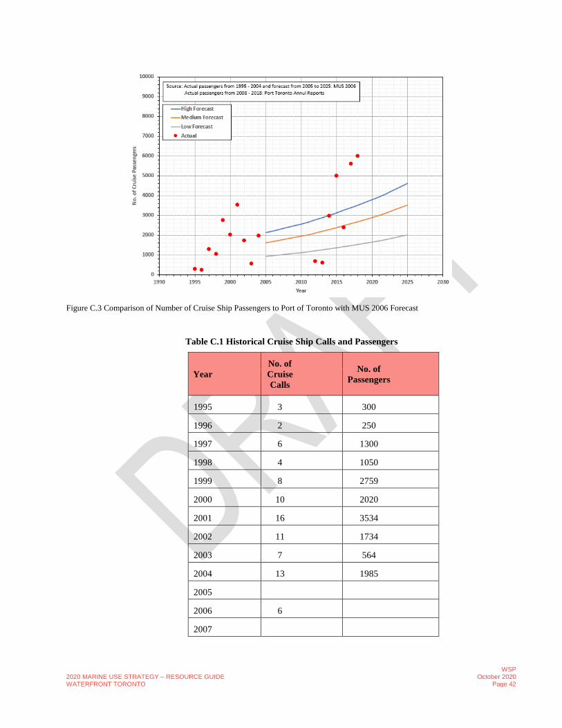
2020 MARINE USE STRATEGY – RESOURCE GUIDE WATERFRONT TORONTO
WSP October 2020
Page 42
Figure C.3 Comparison of Number of Cruise Ship Passengers to Port of Toronto with MUS 2006 Forecast
Table C.1 Historical Cruise Ship Calls and Passengers
Year
No. of
Cruise
Calls
No. of
Passengers
1995 3 300
1996 2 250
1997 6 1300
1998 4 1050
1999 8 2759
2000 10 2020
2001 16 3534
2002 11 1734
2003 7 564
2004 13 1985
2005
2006 6
2007

2020 MARINE USE STRATEGY – RESOURCE GUIDE WATERFRONT TORONTO
WSP October 2020
Page 43
Year
No. of
Cruise
Calls
No. of
Passengers
2008
2009 12
2010
2011
2012 4 690
2013 3 604
2014 6 2986
2015 13 5000
2016 7 2400
2017 16 5600
2018 17 6000
The historical global number of cruise passengers has been steadily increasing since 2015 as shown in Figure C.4. The
global number of cruise passenger forecast reported in the MUS 2016 is also shown in Figure C.4. The global number of
cruise passengers has increased by 152 % between 2005 and 2018, and by 26% between 2014 and 2018. The total number
of global cruise passengers was 28.2 million in 2018 and is expected to increase to 30 million in 2019. The global
passenger projections reported in MUS 2006 are much less than the actual global passengers reported by the Cruise Lines
International Association (CLIA).
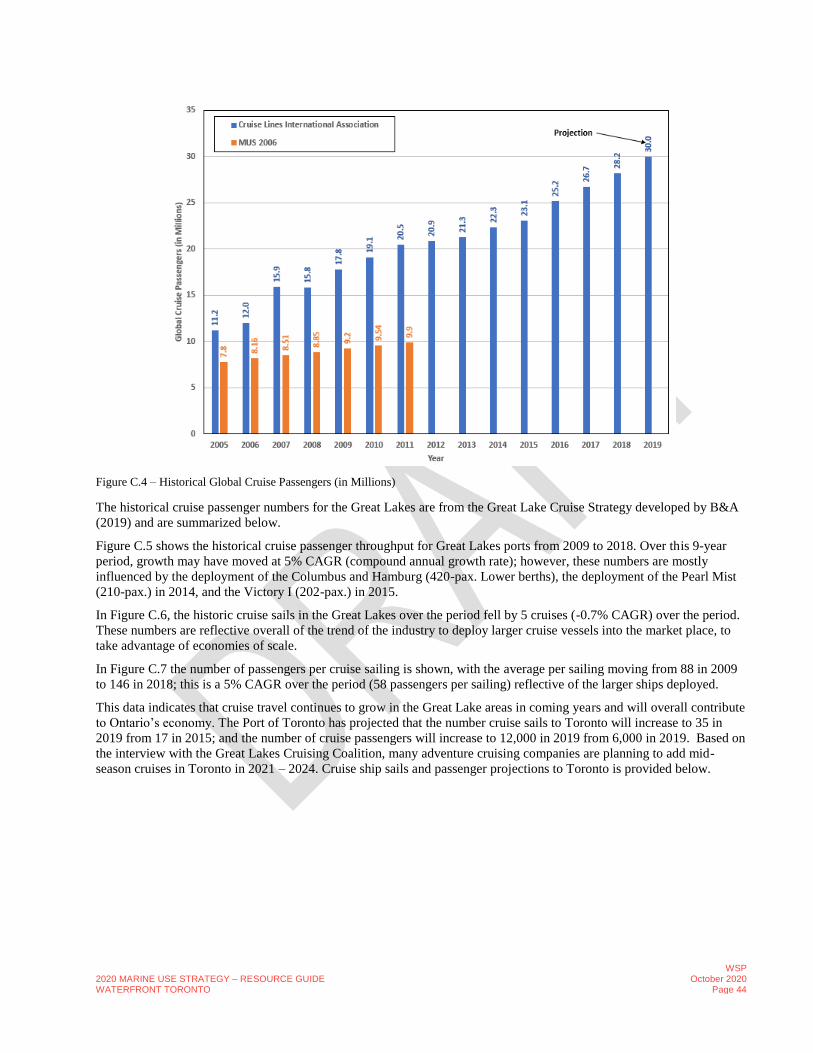
2020 MARINE USE STRATEGY – RESOURCE GUIDE WATERFRONT TORONTO
WSP October 2020
Page 44
Figure C.4 – Historical Global Cruise Passengers (in Millions)
The historical cruise passenger numbers for the Great Lakes are from the Great Lake Cruise Strategy developed by B&A
(2019) and are summarized below.
Figure C.5 shows the historical cruise passenger throughput for Great Lakes ports from 2009 to 2018. Over this 9-year
period, growth may have moved at 5% CAGR (compound annual growth rate); however, these numbers are mostly
influenced by the deployment of the Columbus and Hamburg (420-pax. Lower berths), the deployment of the Pearl Mist
(210-pax.) in 2014, and the Victory I (202-pax.) in 2015.
In Figure C.6, the historic cruise sails in the Great Lakes over the period fell by 5 cruises (-0.7% CAGR) over the period.
These numbers are reflective overall of the trend of the industry to deploy larger cruise vessels into the market place, to
take advantage of economies of scale.
In Figure C.7 the number of passengers per cruise sailing is shown, with the average per sailing moving from 88 in 2009
to 146 in 2018; this is a 5% CAGR over the period (58 passengers per sailing) reflective of the larger ships deployed.
This data indicates that cruise travel continues to grow in the Great Lake areas in coming years and will overall contribute
to Ontario’s economy. The Port of Toronto has projected that the number cruise sails to Toronto will increase to 35 in
2019 from 17 in 2015; and the number of cruise passengers will increase to 12,000 in 2019 from 6,000 in 2019. Based on
the interview with the Great Lakes Cruising Coalition, many adventure cruising companies are planning to add mid-
season cruises in Toronto in 2021 – 2024. Cruise ship sails and passenger projections to Toronto is provided below.

2020 MARINE USE STRATEGY – RESOURCE GUIDE WATERFRONT TORONTO
WSP October 2020
Page 45
Figure C.5 Great Lakes Historical Passenger Throughput 2009 – 2018 (B&A, 2019)
Figure C.6 Great Lakes Historical Cruise Sailings 2009 – 2018 (B&A, 2019)
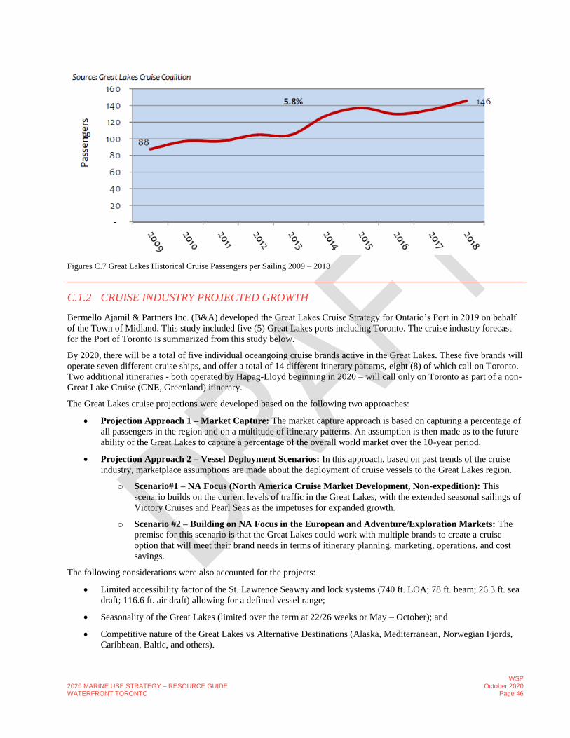
2020 MARINE USE STRATEGY – RESOURCE GUIDE WATERFRONT TORONTO
WSP October 2020
Page 46
Figures C.7 Great Lakes Historical Cruise Passengers per Sailing 2009 – 2018
C.1.2 CRUISE INDUSTRY PROJECTED GROWTH
Bermello Ajamil & Partners Inc. (B&A) developed the Great Lakes Cruise Strategy for Ontario’s Port in 2019 on behalf
of the Town of Midland. This study included five (5) Great Lakes ports including Toronto. The cruise industry forecast
for the Port of Toronto is summarized from this study below.
By 2020, there will be a total of five individual oceangoing cruise brands active in the Great Lakes. These five brands will
operate seven different cruise ships, and offer a total of 14 different itinerary patterns, eight (8) of which call on Toronto.
Two additional itineraries - both operated by Hapag-Lloyd beginning in 2020 – will call only on Toronto as part of a non-
Great Lake Cruise (CNE, Greenland) itinerary.
The Great Lakes cruise projections were developed based on the following two approaches:
• Projection Approach 1 – Market Capture: The market capture approach is based on capturing a percentage of
all passengers in the region and on a multitude of itinerary patterns. An assumption is then made as to the future
ability of the Great Lakes to capture a percentage of the overall world market over the 10-year period.
• Projection Approach 2 – Vessel Deployment Scenarios: In this approach, based on past trends of the cruise
industry, marketplace assumptions are made about the deployment of cruise vessels to the Great Lakes region.
o Scenario#1 – NA Focus (North America Cruise Market Development, Non-expedition): This
scenario builds on the current levels of traffic in the Great Lakes, with the extended seasonal sailings of
Victory Cruises and Pearl Seas as the impetuses for expanded growth.
o Scenario #2 – Building on NA Focus in the European and Adventure/Exploration Markets: The
premise for this scenario is that the Great Lakes could work with multiple brands to create a cruise
option that will meet their brand needs in terms of itinerary planning, marketing, operations, and cost
savings.
The following considerations were also accounted for the projects:
• Limited accessibility factor of the St. Lawrence Seaway and lock systems (740 ft. LOA; 78 ft. beam; 26.3 ft. sea
draft; 116.6 ft. air draft) allowing for a defined vessel range;
• Seasonality of the Great Lakes (limited over the term at 22/26 weeks or May – October); and
• Competitive nature of the Great Lakes vs Alternative Destinations (Alaska, Mediterranean, Norwegian Fjords,
Caribbean, Baltic, and others).

2020 MARINE USE STRATEGY – RESOURCE GUIDE WATERFRONT TORONTO
WSP October 2020
Page 47
Based on the projection model outlined above, a range was established for cruise passenger growth over the 10-year term
for Great Lakes. This illustrates rates from 4.2% to 6.5%, based on the level of strategic effort attributed to the expansion
of the cruise tourism industry to the region. Passenger throughput moves to a range of 15,176 – 18,798 in 2028 (Figure
C.8).
Figure C.9 shows the number of sailings in the Great Lakes moving from 69 in 2018, to a range of 94 – 104 in 2028. The
assumption is that the majority of vessels coming into the Great Lakes market for multiple sailings will be smaller ships,
while those larger vessels (+250-pax.) will continue to use the region on a targeted basis, for less than 4 sailings (likely 2)
per season, and may also skip years, dependent on their target clientele. The numbers below do not include some of the
other day and overnight traffic that is also within the region, such as St. Lawrence Seaway.
Figure C.10 shows the passenger per sailing for each of the projections models illustrated.
Figure C.8 Passenger Projection Range of Opportunity 2019 – 2028 (B&A, 2019)
Figure C.9 Sailing Projection Range of Opportunity 2019 – 2028 (B&A, 2019)
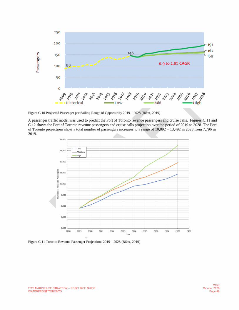
2020 MARINE USE STRATEGY – RESOURCE GUIDE WATERFRONT TORONTO
WSP October 2020
Page 48
Figure C.10 Projected Passenger per Sailing Range of Opportunity 2019 – 2028 (B&A, 2019)
A passenger traffic model was used to predict the Port of Toronto revenue passengers and cruise calls. Figures C.11 and
C.12 shows the Port of Toronto revenue passengers and cruise calls projection over the period of 2019 to 2028. The Port
of Toronto projections show a total number of passengers increases to a range of 10,892 – 13,492 in 2028 from 7,796 in
2019.
Figure C.11 Toronto Revenue Passenger Projections 2019 – 2028 (B&A, 2019)

2020 MARINE USE STRATEGY – RESOURCE GUIDE WATERFRONT TORONTO
WSP October 2020
Page 49
Figure C.12 Toronto Cruise Calls Projects 2019 – 2028 (B&A, 2019)
C.1.3 CRUISE ACTIVITY SUMMARY
The projected number of cruise calls in 5 years is in the range of 29 to 31. Toronto’s existing cruise facilities can
accommodate homeport and port-of-call demands during the period of 2019-2028. However, the ability to provide for a
more centralized location as part of a downtown waterfront, PPP (Public Private Partnership) may provide a boost in
economic impact from the projected passenger throughput; it could also offer future cruise brands an additional option.
C.2 INDUSTRIAL SHIPPING ACTIVITIES
C.2.1 TYPE OF CARGO AND THROUGHPUT NUMBERS
The Port of Toronto is situated on the northwest shore of Lake Ontario. The port handles global cargo from destinations as
far as Germany, Turkey, Australia, South America and the rest of North America. The historical cargo throughput is
shown in Figure C.13 for the period of 1995 to 2018. The data indicate that there is no clear trend in total cargo tonnage
transit through Toronto; the total cargo tonnage increased to a maximum of 2.56 million ton in 2005 from 1.29 million ton
in 1991; then decreased to 1.50 million ton in 2010 and increased to 2.2 million ton in 2017.
The number of port calls to Toronto is shown in Figure C.14. There is no clear relationship between number of port calls
and cargo tonnage. This may be due to the varying sizes of cargo ships calls at Port of Toronto.
In 2018, the Port of Toronto moved 2.2 million metric tonnes of cargo. Sugar, road salt, cement, aggregate and steel were
brought directly into the heart of the city by 178 ships in 2018. The port received steel products including rebar, merchant
bar, steel plate and coils totalling 69,281 metric tonnes, representing the highest levels of steel product moved through the
port in 20 years. In addition, the port recorded 14,391 metric tonnes in warehousing storage, the highest level recorded
since 2011.
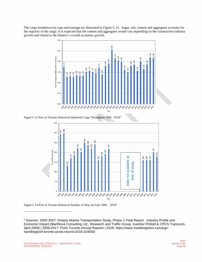
2020 MARINE USE STRATEGY – RESOURCE GUIDE WATERFRONT TORONTO
WSP October 2020
Page 50
The cargo breakdown by type and tonnage are illustrated in Figure C.15. Sugar, salt, cement and aggregates accounts for
the majority of the cargo. It is expected that the cement and aggregates would vary depending on the construction industry
growth and related to the Ontario’s overall economic growth.
Figure C.13 Port of Toronto Historical Industrial Cargo Throughput 1990 - 20184
Figure C.14 Port of Toronto Historical Number of Ship Arrivals 1990 – 20184
4 Sources: 2005-2007: Ontario Marine Transportation Study, Phase 1 Final Report , Industry Profile and Economic Impact (MariNova Consulting Ltd., Research and Traffic Group, Gardner Pinfold & CPCS Transcom, April 2009) | 2008-2017: Ports Toronto Annual Reports | 2018: https://www.insidelogistics.ca/cargo-handling/port-toronto-posts-record-2018-154555/
Data
not
availa
ble
at
tim
e o
f stu
dy

2020 MARINE USE STRATEGY – RESOURCE GUIDE WATERFRONT TORONTO
WSP October 2020
Page 51
Figure C.15 Cargo Breakdown by Type and Tonnage5
C.2.2 INDUSTRIAL SHIPPING ACTIVITY SUMMARY
Average cargo throughput to the Port of Toronto is 1.7 million tons with a minimum of 1.3 million in 1991 and a
maximum of 2.56 million in 2005. The cement and aggregates cargo will vary with Ontario’s economic growth. It is
expected that the Port of Toronto will continue handle cargo throughputs similar to the past.
Data Gap: Please note that number of port calls between 2005 and 2012 are not available from the publicly available data
sources. Cargo breakdown data is also not available between 2008 and 2018 for all or some types of cargo
5 Sources: 2005-2007: Ontario Marine Transportation Study, Phase 1 Final Report , Industry Profile and Economic Impact (MariNova Consulting Ltd., Research and Traffic Group, Gardner Pinfold & CPCS Transcom, April 2009) | 2008-2017: Ports Toronto Annual Reports | 2018: https://www.insidelogistics.ca/cargo-handling/port-toronto-posts-record-2018-154555/

2020 MARINE USE STRATEGY – RESOURCE GUIDE WATERFRONT TORONTO
WSP October 2020
Page 52
C.3 RECREATIONAL BOATING ACTIVITIES
The following marine inventories and data related to recreational boating were collected and reviewed to assess whether
waterfront recreational facilities provide adequate services and to predict the future recreational boating activity future
needs:
• Yacht and boating clubs;
• Marinas;
• Boating/teaching organizations;
• Profile of boaters and population characteristics; and
• Projected population of Toronto and Greater Toronto Area (GTA).
These data were collected from publicly available reports. The study area for marine inventories is the waterfront between
the Humber Bay and Ashbridges Bay. This study area is further sub-divided into the following four sub areas as per MUS
2006:
• Humber Bay to Western Gap;
• Inner Harbour;
• Outer Harbour; and
• Leslie Street Spit to Ashbridges Bay.
C.3.1 MARINE FACILITIES FOR RECREATIONAL BOATING
There are 49 boating facilities including 35 yacht and boating clubs, 5 marinas, and 9 boating/teaching organizations on
the waterfront between Humber Bay in the West and Ashbridges Bay in the east. The list of yacht and boating clubs,
marinas and boating/teaching organizations in the study area is provided in Tables C.2 to C.4. Figure C.16 compares the
current recreational boating facilities on the waterfront with MUS 2006. There are 6 more yacht and boating clubs than
reported in MUS 2006. The number of marinas has remained unchanged since 2005. Boating/teaching organizations
have grown by 2 since 2005. FigureC.17 shows the number of seasonal and transient slips/moorings available in the
study area.
Figure C.16 Comparison of Number of Yacht & Boating Clubs, Marinas & Boating / Teaching Organizations between 2005 and 2019.

2020 MARINE USE STRATEGY – RESOURCE GUIDE WATERFRONT TORONTO
WSP October 2020
Page 53
Table C.2 Yacht and Boating Clubs on Toronto’s Waterfront (Humber Bay to Ashbridge’s Bay)
Club Name Address
Mimico Yacht Club 200 Humber Bay Park
Etobicoke Yacht Club 300 Humber Bay Park
Toronto Humber Yacht Club 101 Humber Valley Road
Greater Toronto Dragon Boat Club Lake Shore Boulevard West (east of
Sunnyside Pool) Boulevard Club 1491 Lake Shore Boulevard West
Toronto Sailing & Canoe Club 1391 Lake Shore Boulevard West
Argonaut Rowing Club 1225 Lake Shore Boulevard West
Alexandra Yacht Club 2 Stadium Road
National Yacht Club 1 Stadium Road
Island Yacht Club 400 Queens Quay West
Toronto Island Sailing Club Centre Island
Royal Canadian Yacht Club South Island
Toronto Island Canoe Club Wards Island
Sunfish Cut Boat Club Algonquin Island
Queen City Yacht Club Algonquin Island
Bayside Rowing Club 600 Unwin Street
Toronto Windsurfing Club Regatta Road
Water Rats Sailing Club Regatta Road
Hanlan Boat Club Regatta Road
Mooredale Sailing Club Regatta Road
St. Jamestown Sailing Club Regatta Road
Westwood Sailing Club Regatta Road
Outer Harbour Centre Board Club Regatta Road
Toronto Multihull Sailing Club Regatta Road
Great White North Dragon Boat Club Unwin Avenue
Aquatic Park Sailing Club Tommy Thomson Park
Ashbridge's Bay Yacht Club 30 Ashbridges Bay Park Road
Toronto Hydroplane Sailing Club 20 Ashbridges Bay Park Road
Balmy Beach Canoe Club 10 Ashbridges Bay Park Road
Freedom Boat Club Outer Harbour Marina
Vanguard Club 10 Ashbridges Bay Park Rd

2020 MARINE USE STRATEGY – RESOURCE GUIDE WATERFRONT TORONTO
WSP October 2020
Page 54
Club Name Address
Virtacore 1 Stadium Road
Sunnyside Paddling Club-Dragon Boat 1755 Lakeshore Boulevard West
Outer Harbour Dragon Boat Club 451 -483 Unwin Ave
Iron River Dragon Boat Club 1 Humber River Recreational Trail
Table C.3 Marinas on Toronto’s Waterfront (Humber Bay to Ashbridge’s Bay)
Marina Name Address
Ontario Place Marina 955 Lake Shore Boulevard West
Marina Quay West 539 Queens Quay West
Marina 4 235 Queens Quay West
Toronto Island Marina Centre Island
Outer Harbour Marina 475 Unwin Street
Table C.4 Boating/Teaching Organizations on Toronto’s Waterfront (Humber Bay to Ashbridge’s Bay)
Name Address
Humber College Sailing & Power Boating
Centre
100 Humber Bay Park Road West
Navy League of Canada 659 Lake Shore Boulevard West
Blind Sailing Association of Canada 539 Queens Quay West
Queen's Quay Sailing & Power Boating 275 Queens Quay West
Queens Quay Disabled Sailing Program 275 Queens Quay West
Harbourfront Canoe and Kayaking School 2283A Queens Quay West
Toronto Brigantine 249 Queens Quay West
Great Lakes Sailing School 1 Leslie St
Sailing Fanatics 14 Regatta Rd
The 20 boating facilities provide 4,604 slips or mooring of which 4,244 are seasonal and 360 are dedicated as transient or
reciprocal slips or moorings on the waterfront. The greatest concentration of boating activity occurs in the area from
Humber Bay to the Western Gap and this area hosts 8 yachting and sailing clubs, one rowing club (Argonaut Rowing
Club), one dragon boat club (Toronto Dragon Boat Club), one private club (Boulevard Club) and one marina (Ontario
Place). 1994 slips or moorings are available in this area.
The Inner Harbour stretching from the western gap to the eastern gap has the second largest concentration of boaters with
four yachting and sailing clubs, three marinas, three canoe club/facilities, two special boating organizations (Blind Sailing
Association of Canada, Queens Quay Disabled Sailing Program), one rowing club (Bayside Rowing Club) and Queens
Quay Sailing & Power Boating. 1260 slips or moorings are available in this area.

2020 MARINE USE STRATEGY – RESOURCE GUIDE WATERFRONT TORONTO
WSP October 2020
Page 55
Figure C.17 Number of Seasonal and Transient Slips on Toronto’s Waterfront
The Outer Harbour which occupies the area south of the Toronto Islands from the eastern gap to the Leslie Street Slip is
home to seven sailing clubs, one wind surfing club (Toronto Windsurfing Club), one rowing club (Hanlan Boat Club) and
one dragon boat club (Great White North Dragon Boat Club) and one marina (Outer Harbour Marina). 914 slips and
moorings spaces are available in this area.
The Ashbridges Bay area to the east of the Leslie Street slip is home to two yachting and sailing clubs and one canoe club
(Balmy Beach Canoe Club). 486 slips and moorings spaces available in this area.
42% (1994) of slips or moorings are located at the waterfront from Humber Bay to the Western Gap; 27% (1260) of slips
or moorings are located in Inner Harbour; 20% (914) of slips or moorings are located in Outer Harbour; and 11% (486) of
slips are located between Leslie Street Spit to Ashbridge’s Bay area (Figure C.18).
Table C.6 compares the number of slips/mooring in waterfront between 2005 and 2019. The total number of slips and
moorings has increased to 4,604 in 2019 from 3,635 in 2005 representing a 27% increase. Please note that the number of
slips and moorings used in this study are from 2014 Recreational Boating Feasibility and Capacity Study. The number of
slips and moorings may have increased since 2014. The slips and moorings spaces occupancy rate was 98.6 percent in
2013 boating season as per the 2014 Recreational Boating Feasibility and Capacity Study. More than 90 percent (i.e.
90.8%) of the 3,635 available slips and moorings are occupied (i.e. 3,299) in 2005 (MUS 2006).
Figure C.18 Percent of Slip Distribution by Waterfront Area

2020 MARINE USE STRATEGY – RESOURCE GUIDE WATERFRONT TORONTO
WSP October 2020
Page 56
Table C.5 Comparison of Slips/Mooring between 2019 and 2005
Waterfront
Area 20051 20192
Change
Numbers Percentage
(%) Humber
Bay to
Western
Gap
1,562 1,994 382 24%
Inner
Harbour
950 1,260 310 33%
Outer
Harbour
783 914 131 17%
Leslie
Street Spit
to
Ashbridges
Bay
340 486 146 43%
Total 3,635 4,604 969 27%
Note. 1 Marine Use Strategy 2016; 2 Recreational Boating Feasibility and Capacity Study 2014
A total of 4,244 slips are available with 118 of the slips are less than 30 feet; 310 of the slips are between 30 and 36 feet;
1633 slips are between 36 and 46 feet; and 2174 slips are greater than 46 feet. Six (6) facilities provide a fuel dock. Ten
(10) facilities provide haul out cranes with lift capacity ranging from 2 to 35 ton. 14 facilities have a pump out. 4 facilities
have launch ramps and 18 facilities has access to power. The Toronto Island Marina and Outer Harbour Marina are the
only facilities offering repairs.
Table C.6 compares the marine facilities services between 2005 and 2019. There was no launch ramp in the marinas and
clubs in 2005 and currently four (4) facilities provide launch ramp (Toronto Humber Yacht Club, Toronto Sailing &
Canoe Club, Outer Harbour Marina, and Toronto Hydroplane Sailing Club). The facilities providing haul out service
increased to 10 in 2019 from 5 in 2005. The facilities providing winter storage increased by 3 to 14. The other services
remain same as in 2005. Details of facilities slips/mooring, haul out, shore power, winter storage and services are
provided in Tables C.7 and C.8.
Table C.6 Comparison of Facilities Between 2005 and 2009
Facility Type 20051 20192 Change
Fuel Supply 5 6 +1
Launch Ramp 0 4 +4
Shore Power 17 17 0
Haul Out 5 10 +5
Pump Out 13 14 +1
Winter
Storage3
11 14 +3
Repairs 2 2 0
Note. 1 Marine Use Strategy 2016; 2 Recreational Boating Feasibility and Capacity Study 2014; 3
Outside
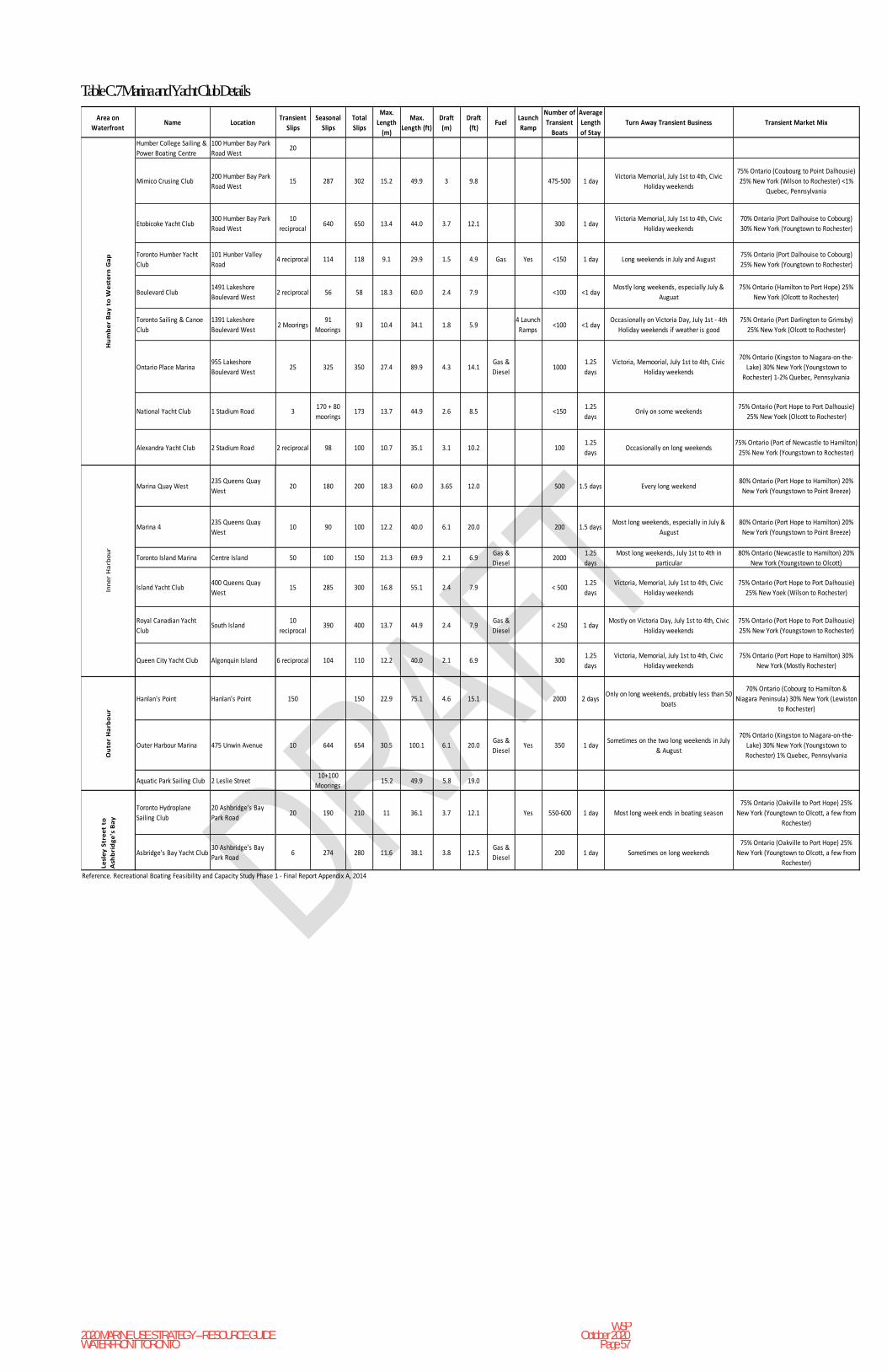
2020 MARINE USE STRATEGY – RESOURCE GUIDE WATERFRONT TORONTO
WSP October 2020
Page 57
Table C.7 Marina and Yacht Club Details
Area on
WaterfrontName Location
Transient
Slips
Seasonal
Slips
Total
Slips
Max.
Length
(m)
Max.
Length (ft)
Draft
(m)
Draft
(ft)Fuel
Launch
Ramp
Number of
Transient
Boats
Average
Length
of Stay
Turn Away Transient Business Transient Market Mix
Humber College Sailing &
Power Boating Centre
100 Humber Bay Park
Road West20
Mimico Crusing Club200 Humber Bay Park
Road West15 287 302 15.2 49.9 3 9.8 475-500 1 day
Victoria Memorial, July 1st to 4th, Civic
Holiday weekends
75% Ontario (Coubourg to Point Dalhousie)
25% New York (Wilson to Rochester) <1%
Quebec, Pennsylvania
Etobicoke Yacht Club300 Humber Bay Park
Road West
10
reciprocal640 650 13.4 44.0 3.7 12.1 300 1 day
Victoria Memorial, July 1st to 4th, Civic
Holiday weekends
70% Ontario (Port Dalhouise to Cobourg)
30% New York (Youngtown to Rochester)
Toronto Humber Yacht
Club
101 Hunber Valley
Road4 reciprocal 114 118 9.1 29.9 1.5 4.9 Gas Yes <150 1 day Long weekends in July and August
75% Ontario (Port Dalhouise to Cobourg)
25% New York (Youngtown to Rochester)
Boulevard Club1491 Lakeshore
Boulevard West2 reciprocal 56 58 18.3 60.0 2.4 7.9 <100 <1 day
Mostly long weekends, especially July &
Auguat
75% Ontario (Hamilton to Port Hope) 25%
New York (Olcott to Rochester)
Toronto Sailing & Canoe
Club
1391 Lakeshore
Boulevard West2 Moorings
91
Moorings93 10.4 34.1 1.8 5.9
4 Launch
Ramps<100 <1 day
Occasionally on Victoria Day, July 1st - 4th
Holiday weekends if weather is good
75% Ontario (Port Darlington to Grimsby)
25% New York (Olcott to Rochester)
Ontario Place Marina955 Lakeshore
Boulevard West25 325 350 27.4 89.9 4.3 14.1
Gas &
Diesel1000
1.25
days
Victoria, Memoorial, July 1st to 4th, Civic
Holiday weekends
70% Ontario (Kingston to Niagara-on-the-
Lake) 30% New York (Youngstown to
Rochester) 1-2% Quebec, Pennsylvania
National Yacht Club 1 Stadium Road 3170 + 80
moorings173 13.7 44.9 2.6 8.5 <150
1.25
daysOnly on some weekends
75% Ontario (Port Hope to Port Dalhousie)
25% New Yoek (Olcott to Rochester)
Alexandra Yacht Club 2 Stadium Road 2 reciprocal 98 100 10.7 35.1 3.1 10.2 1001.25
daysOccasionally on long weekends
75% Ontario (Port of Newcastle to Hamilton)
25% New York (Youngstown to Rochester)
Marina Quay West235 Queens Quay
West20 180 200 18.3 60.0 3.65 12.0 500 1.5 days Every long weekend
80% Ontario (Port Hope to Hamilton) 20%
New York (Youngstown to Point Breeze)
Marina 4235 Queens Quay
West10 90 100 12.2 40.0 6.1 20.0 200 1.5 days
Most long weekends, especially in July &
August
80% Ontario (Port Hope to Hamilton) 20%
New York (Youngstown to Point Breeze)
Toronto Island Marina Centre Island 50 100 150 21.3 69.9 2.1 6.9Gas &
Diesel2000
1.25
days
Most long weekends, July 1st to 4th in
particular
80% Ontario (Newcastle to Hamilton) 20%
New York (Youngstown to Olcott)
Island Yacht Club400 Queens Quay
West15 285 300 16.8 55.1 2.4 7.9 < 500
1.25
days
Victoria, Memorial, July 1st to 4th, Civic
Holiday weekends
75% Ontario (Port Hope to Port Dalhousie)
25% New Yoek (Wilson to Rochester)
Royal Canadian Yacht
ClubSouth Island
10
reciprocal390 400 13.7 44.9 2.4 7.9
Gas &
Diesel< 250 1 day
Mostly on Victoria Day, July 1st to 4th, Civic
Holiday weekends
75% Ontario (Port Hope to Port Dalhousie)
25% New York (Youngstown to Rochester)
Queen City Yacht Club Algonquin Island 6 reciprocal 104 110 12.2 40.0 2.1 6.9 3001.25
days
Victoria, Memorial, July 1st to 4th, Civic
Holiday weekends
75% Ontario (Port Hope to Hamilton) 30%
New York (Mostly Rochester)
Hanlan's Point Hanlan's Point 150 150 22.9 75.1 4.6 15.1 2000 2 daysOnly on long weekends, probably less than 50
boats
70% Ontario (Cobourg to Hamilton &
Niagara Peninsula) 30% New York (Lewiston
to Rochester)
Outer Harbour Marina 475 Unwin Avenue 10 644 654 30.5 100.1 6.1 20.0Gas &
DieselYes 350 1 day
Sometimes on the two long weekends in July
& August
70% Ontario (Kingston to Niagara-on-the-
Lake) 30% New York (Youngstown to
Rochester) 1% Quebec, Pennsylvania
Aquatic Park Sailing Club 2 Leslie Street10+100
Moorings15.2 49.9 5.8 19.0
Toronto Hydroplane
Sailing Club
20 Ashbridge's Bay
Park Road20 190 210 11 36.1 3.7 12.1 Yes 550-600 1 day Most long week ends in boating season
75% Ontario (Oakville to Port Hope) 25%
New York (Youngtown to Olcott, a few from
Rochester)
Asbridge's Bay Yacht Club30 Ashbridge's Bay
Park Road6 274 280 11.6 38.1 3.8 12.5
Gas &
Diesel200 1 day Sometimes on long weekends
75% Ontario (Oakville to Port Hope) 25%
New York (Youngtown to Olcott, a few from
Rochester)
Reference. Recreational Boating Feasibility and Capacity Study Phase 1 - Final Report Appendix A, 2014
Hu
mb
er
Ba
y t
o W
est
ern
Ga
pIn
ne
r H
arb
ou
rO
ute
r H
arb
ou
rLe
sle
y S
tre
et
to
Ash
bri
dg
e's
Ba
y

2020 MARINE USE STRATEGY – RESOURCE GUIDE WATERFRONT TORONTO
WSP October 2020
Page 58
Table C.8 Marina Yacht & Boating Club Details - Services
Area on
WaterfrontName Location Haulout Repairs Food Facilities
Shore Power
(amps)Pumpout Recreation Facilities Hookups Winter Storage
Humber College Sailing & Power
Boating Centre
100 Humber Bay Park
Road West
Mimico Crusing Club200 Humber Bay Park
Road West
dual purpouse crane - lift up to
3,000 lbs mast stepping
ice/water, licensed restaurant
& deck for outdoor dining
showers,
washrooms &
laundry
20 & 30 yespicnic tables, gas BBQ's &
children play area
power, water, public
telephone & wireless
internet
outside
Etobicoke Yacht Club300 Humber Bay Park
Road West2 ton crane, mast crane ice/water, licensed dining & bar
showers,
washrooms &
laundry
30.0picnic tables, gas BBQ's &
children's play area
power, water & wirless
internetoutside
Toronto Humber Yacht Club101 Hunber Valley
Road
ice/water, clubhouse bar &
snack bar
showers &
washrooms15.0 yes picnic tables & gas BBQ's
power, water & public
phoneoutside
Boulevard Club1491 Lakeshore
Boulevard West
ice/water, dining room,
licensed café & bar
showers,
washrooms &
laundry
15 & 30 yes
indoor & outdoor pools,
badminton, tennis, lawn bowling,
fitness sentre, saunas, teen
games room & play area for
preschoolers
power, water, public
telephone & wireless
internet
outside
Toronto Sailing & Canoe Club1391 Lakeshore
Boulevard West
ice/water, catered grill bar &
cold snacks
showers &
washroomsyes picnic tables & gas BBQ's public telephone
Ontario Place Marina955 Lakeshore
Boulevard Westcrane & hydraulic trailers can be arranged
ice/water, marina grill, licensed
outdoor patio
showers,
washrooms &
laundry
30 & 50 picnic table
power, water, public
telephone & wireless
internet
outside - up to
13.7 metres
National Yacht Club 1 Stadium Roadrental crane for
haulout/launch
ice/water, licensed dining room
& balcony for outdoor dining
showers,
washrooms &
laundry
30.0picnic tables, gas BBQ's &
children's playground
power, water, public
telephone & wireless
internet
outside
Alexandra Yacht Club 2 Stadium Road5 1/2 tone crane & rental
crane for haulout/launchice/water & kitchen
showers &
washrooms20.0 yes picnic tables & gas BBQ's
power, water, public
telephone & wireless
internet
outside
Marina Quay West235 Queens Quay
Westice/water & ice cream
showers,
washrooms &
laundry
30 & 50 yes picnic tables
power, water, public
telephone & wireless
internet
Marina 4235 Queens Quay
Westice/water
showers,
washrooms &
laundry
30.0 yes
power, water, public
telephone & wireless
internet
Toronto Island Marina Centre Island 15 ton travel lift & mast crane
hulls, engines,
electricals &
sails
ice/water, groceries, restaurant
& patio bar
showers,
washrooms &
laundry
15, 30 & 50 yes picnic tables
power, water, public
telephone & wireless
internet
outside
Island Yacht Club400 Queens Quay
Westtravel lift
ice/water, dining room, lounge,
bar & snack bar
showers,
washrooms &
laundry
15 & 30 yes
picnic tables, gas BBQ's,
children's playground, swimming
pool & tennis courts
power & water outside
Royal Canadian Yacht Club South Island 20 ton travel liftice/water, formal dining room &
snack bar
showers,
washrooms &
laundry
15 & 30 yes
adult & children's swimming
pools, tennis courts, children's
playground & pations
power & water outside
Queen City Yacht Club Algonquin Island marine railway ice/water, dining room & bar
showers,
washrooms &
laundry
15.0 yespicnic tables, children's play area
& indoor kids' room
power, water & public
telephoneoutside
Hanlan's Point Hanlan's Point ice/water & snack barsshowers &
washrooms15 & 30
picnic tables, BBQ's, wading
pools, tennis, volleyball, beaches
& bicycle rental
power & water
Outer Harbour Marina 475 Unwin Avenue35 ton travel lift, mast crane &
fork lift
hulls, engines &
electricalice/water
showers,
washrooms &
laundry
30 & 50 yes picnic tables & BBQ's power & water outside
Aquatic Park Sailing Club 2 Leslie Street ice/watershowers &
wash roomspicnic tables outside
Toronto Hydroplane Sailing Club20 Ashbridge's Bay
Park Roadice/water
showers &
washrooms15.0 yes picnic tables, gas BBQ's & patio water
Asbridge's Bay Yacht Club30 Ashbridge's Bay
Park Roadice/water
showers,
washrooms &
laundry
15.0 yes picnic tables & gas BBQ's power & water outside
Reference. Recreational Boating Feasibility and Capacity Study Phase 1 - Final Report Appendix A, 2014
Hu
mb
er
Ba
y t
o W
est
ern
Ga
pIn
ne
r H
arb
ou
rO
ute
r H
arb
ou
r
Lesl
ey
Str
ee
t
to A
shb
rid
ge
's
Ba
y
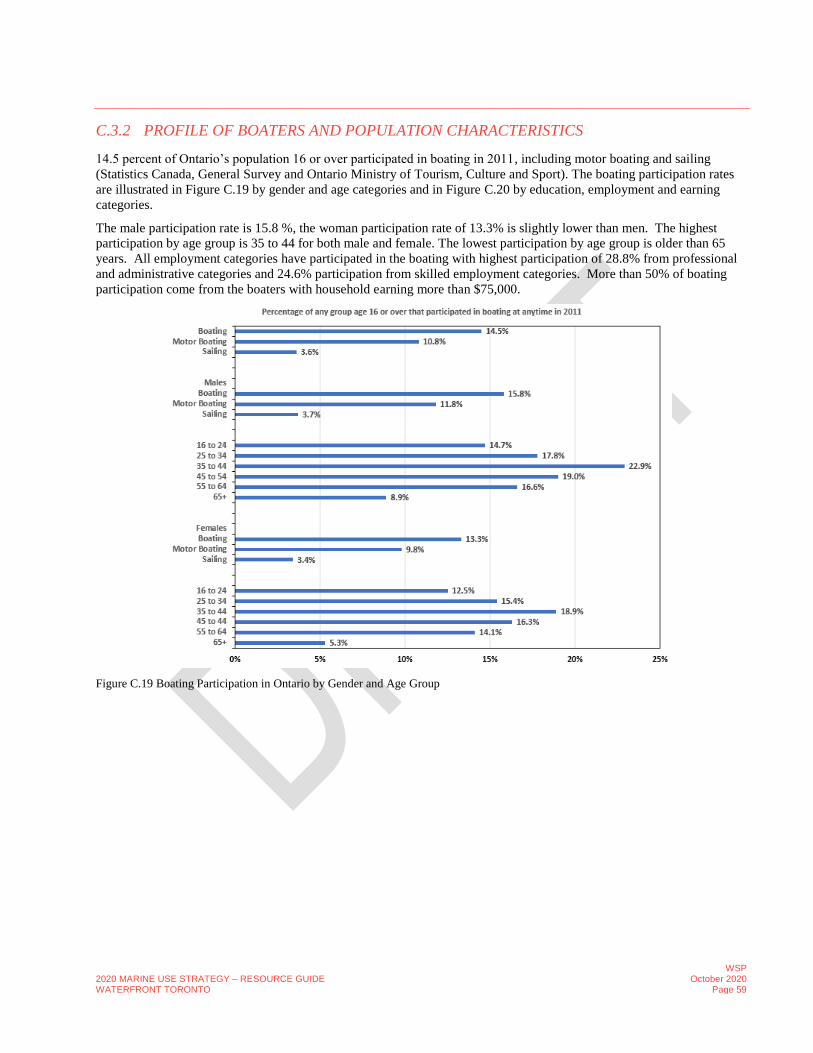
2020 MARINE USE STRATEGY – RESOURCE GUIDE WATERFRONT TORONTO
WSP October 2020
Page 59
C.3.2 PROFILE OF BOATERS AND POPULATION CHARACTERISTICS
14.5 percent of Ontario’s population 16 or over participated in boating in 2011, including motor boating and sailing
(Statistics Canada, General Survey and Ontario Ministry of Tourism, Culture and Sport). The boating participation rates
are illustrated in Figure C.19 by gender and age categories and in Figure C.20 by education, employment and earning
categories.
The male participation rate is 15.8 %, the woman participation rate of 13.3% is slightly lower than men. The highest
participation by age group is 35 to 44 for both male and female. The lowest participation by age group is older than 65
years. All employment categories have participated in the boating with highest participation of 28.8% from professional
and administrative categories and 24.6% participation from skilled employment categories. More than 50% of boating
participation come from the boaters with household earning more than $75,000.
Figure C.19 Boating Participation in Ontario by Gender and Age Group

2020 MARINE USE STRATEGY – RESOURCE GUIDE WATERFRONT TORONTO
WSP October 2020
Page 60
Figure C.20 Boating Participation in Ontario by Education, Job Category and Earnings
C.3.3 PROJECTED POPULATION OF TORONTO AND GREATER TORONTO AREA
There are 5.9 million persons age 15 and over living in the Greater Toronto Area (GTA) including 2.6 million in Toronto
in 2018 according to the Ontario Ministry of Finance. The population of the GTA is projected to increase from 5.9 million
in 2018 to 6.6 million in 2025 and 7.6 million in 2035. This represents a 12% increase in 2025 and a 29% increase in 2035
from 2018. During this time, the population of Toronto is projected to increase from 2.6 million in 2018 to 2.9 million in
2025 and 3.2 million in 2035. This represents an 11% increase in 2025 and 23% increase in 2035 from 2018. There is no
data available by gender group for Toronto and GTA specifically, only for Ontario. Figure C.21 shows the Toronto and
GTA population growth projections over 2018 – 2041 period. This data will be used for recreational boating participation
future projections.

2020 MARINE USE STRATEGY – RESOURCE GUIDE WATERFRONT TORONTO
WSP October 2020
Page 61
Figure C.21 Projected Population Growth in Toronto and Greater Toronto Area 2017 – 20141 (Ontario Ministry of Finance)
C.3.4 PROJECTED GROWTH IN RECREATIONAL BOATING ACTIVITIES
According to Statistics Canada, General Social Survey and Ontario Ministry of Tourism, Culture and Sport, recreational
boating activities is projected to increase as shown in Figure C.22. Table C.10 provides projected participation rates in
2020, 2025, 2030 and 2035 for various recreational boating activities.
Based on these projected recreational boating participation rates and the projected population growth of age 15 and older,
participation rates of power and sail boating are expected to increase by 6,238 in 2020, 19,370 in 2025, 33,780 in 2030
and 45,998 in 2035 in Toronto. Power and sail boating in GTA is expected to rise by 34,135 in 2020, 119,442 in 2025,
215,883 in 2030 and 304,060 in 2035. The recreational boating participation projections are shown in Figures 23 and 24
for Toronto and GTA, respectively.
Table C.10 Projected Recreational Boating Activities Participation Rates
Type of Activities 2018 2020 2025 2030 2035
Power & Sail Boating 17.0% 17.4% 18.4% 19.6% 20.4%
Power Boating 12.7% 13.0% 13.7% 14.6% 15.4%
Canoeing 7.4% 7.6% 8.0% 8.3% 8.6%
Sailing 4.3% 4.4% 4.7% 5.0% 5.0%
Kayaking 4.1% 4.4% 5.0% 5.4% 5.8%
Rowing 3.1% 3.1% 3.2% 3.3% 3.4%

2020 MARINE USE STRATEGY – RESOURCE GUIDE WATERFRONT TORONTO
WSP October 2020
Page 62
Figure C.22 Projected Growth in Percentage of Ontario’s Population Participating in Selected Boating Activities (Statistics Canada,
General Social Survey & Ontario Ministry of Tourism, Culture and Sport)
Figure C.23 Projected Growth in Boating Activity in Toronto

2020 MARINE USE STRATEGY – RESOURCE GUIDE WATERFRONT TORONTO
WSP October 2020
Page 63
Figure C.24 Projected Growth in Boating Activity in GTA 2018 -2035
C.3.5 RECREATIONAL BOATING SUMMARY
Currently marinas and boating/yacht clubs are operating at maximum capacity for seasonal and transient boater on the
waterfront between Humber Bay and Ashbridges Bay. The need for additional slips and moorings is expected to rise in
the coming years with waterfront revitalization, the expected participation rate and population growth. There is also a
need for additional launch ramps for marinas and boating/yacht clubs.
A more detailed assessment is required to forecast the required additional slips and moorings for coming years, which
would require the following data (which is currently missing):
• Existing number of boats in Toronto and boat details (length, beam an draft);
• Projected number of boat growth for Toronto; and
• Existing number of transient boats and projected number of transient boats.
C.4 TOUR AND CHARTER BOAT ACTIVITY
C.4.1 TOUR AND CHARTER BOAT CAPACITY
There are 30 tour and charter boats with a capacity of around 7,500 passengers. In 2015, 31 tour and charter boats were
operating.
During July and August, the York Street Slip sees multiple tour boat departures and arrivals each hour. There are over 50
charter/tour boat departures and arrivals per day on the Toronto Waterfront. Typical charter/tour boat routes cover the
Toronto Inner Harbour; Toronto Inner Harbour, Toronto Island Lagoons and Long Pond, Eastern Gap, Western Gap and
Lake Ontario; and Toronto Inner Harbour, Toronto Island Lagoons, and Western Gap to Ontario Place.

2020 MARINE USE STRATEGY – RESOURCE GUIDE WATERFRONT TORONTO
WSP October 2020
Page 64
The City of Toronto owns and operates five (5) ferries to Hanlan’s Point, Centre Island Park and Ward’s Island from Jack
Layton Terminal at the foot of Bay Street on the central waterfront. During summer months, the ferries make a round trip
each half-hour, and during spring and fall, the ferries operate on a 45-minute round trip. During the winter months, the
ferries serve Ward’s island at longer intervals, and Hanlan’s Point only as needed to deliver or pick up vehicles.
PortsToronto operates a free vehicle and passenger ferry from Eireann Quay at the foot of Bathurst Street to the Billy
Bishop Airport every 15 minutes during airport operating hours. Since the mid-seventies, ferry passenger numbers (to and
from the Toronto Islands) have varied between 1.1 and 1.5 million per year (with few exceptions) and this number is
expected to remain constant.
No historical data for tour and charter boat trips or passenger statistics are available to compare the tour and charter boat
trips projections reported in MUS 2006. Details of tour and charter boats operating on waterfront are provided in Table
C.11.
There are currently 12 tour operators that offer waterfront tour and entertainment packages. Tour components (water
excursions only, water and land excursions, water excursions with meal/entertainment options) and marine vehicles
(charter boats, cruise ships, canoes, kayaks) offer experiences of different durations and at various price points.
Overall, tourism in Toronto had a record-breaking year in 2017, with 43.7 million visitors. For the first time, overnight
visits in Toronto surpassed the 15 million mark (15.5 million), joined by 28.2 million same-day travellers.
C.4.2 TOUR AND CHARTER BOAT SUMMARY
It is expected that tour and charter boat activities would increase in the coming years with the population growth in
Ontario, tourism growth in Toronto and waterfront revitalization. The 2006 Marine Use Study has projected the tour and
charter boating activity based on projected tourism visitation.
Tourism visitation projections for Toronto will be required to more accurately forecast the potential increase in tour and
charter boat activity.
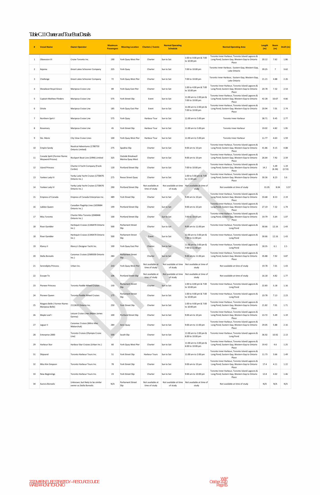
2020 MARINE USE STRATEGY – RESOURCE GUIDE WATERFRONT TORONTO
WSP October 2020
Page 65
Table C.11 Charter and Tour Boat Details
# Vessel Name Owner OperatorMaximum
PassengersMooring Location Charters / Events
Normal Operating
ScheduleNormal Operating Area
Length
(m)
Beam
(m)Draft (m)
1 Obsession III Cruise Toronto Inc. 190 York Quay West Pier Charter Sun to Sat1:00 to 4:00 pm & 7:00
to 10:00 pm
Toronto Inner Harbour, Toronto Island Lagoons &
Long Pond, Eastern Gap, Western Gap to Ontario
Place
20.12 7.62 1.86
2 Kajama Great Lakes Schooner Company 225 York Quay Charter Sun to Sat 7:00 to 10:00 pmToronto Inner Harbour, Eastern Gap, Western Gap,
Lake Ontario39.25 7 3.62
3 Challenge Great Lakes Schooner Company 72 York Quay West Pier Charter Sun to Sat 7:00 to 10:00 pmToronto Inner Harbour, Eastern Gap, Western Gap,
Lake Ontario21.21 4.88 2.26
4 Showboat Royal Grace Mariposa Cruise Line 89 York Quay East Pier Charter Sun to Sat1:00 to 4:00 pm & 7:00
to 10:00 pm
Toronto Inner Harbour, Toronto Island Lagoons &
Long Pond, Eastern Gap, Western Gap to Ontario
Place
20.78 7.32 2.54
5 Captain Mathew Flinders Mariposa Cruise Line 575 York Street Slip Event Sun to Sat11:00 am to 2:00 pm &
7:00 to 10:00 pm
Toronto Inner Harbour, Toronto Island Lagoons &
Long Pond, Eastern Gap, Western Gap to Ontario
Place
42.28 10.67 4.66
6 Oriole Mariposa Cruise Line 185 York Quay East Pier Event Sun to Sat11:00 am to 2:00 pm &
7:00 to 10:00 pm
Toronto Inner Harbour, Toronto Island Lagoons &
Long Pond, Eastern Gap, Western Gap to Ontario
Place
20.94 7.01 2.74
7 Northern Sprit I Mariposa Cruise Line 575 York Quay Harbour Tour Sun to Sat 11:00 am to 5:00 pm Toronto Inner Harbour 38.71 9.45 2.77
8 Rosemary Mariposa Cruise Line 45 York Street Slip Harbour Tour Sun to Sat 11:00 am to 5:00 pm Toronto Inner Harbour 19.02 4.82 1.95
9 Ste. Marie City View Cruise Lines 100 York Quay West Pier Harbour Tour Sun to Sat 11:00 am to 5:00 pm Toronto Inner Harbour 11.77 4.63 1.59
10 Empire SandyNautical Adventures (1780750
Ontario Limited)275 Spadina Slip Charter Sun to Sat 9:00 am to 10 pm
Toronto Inner Harbour, Toronto Island Lagoons &
Long Pond, Eastern Gap, Western Gap to Ontario
Place
41.86 9.15 4.88
11Canada Spirit (Former Name:
Wayward Pricess)Rockport Boat Line (1994) Limited 325
Outside Breakwall
Marina Quay WestCharter Sun to Sat 9:00 am to 10 pm
Toronto Inner Harbour, Toronto Island Lagoons &
Long Pond, Eastern Gap, Western Gap to Ontario
Place
26.64 7.92 2.59
12 Island PrincessCharter A Yacht Company (Frank
Corbin)120 Portland Street Slip Charter Sun to Sat 7:00 to 10:00 pm
Toronto Inner Harbour, Toronto Island Lagoons &
Long Pond, Eastern Gap, Western Gap to Ontario
Place
14.25.49
(6.36)
1.19
(2.53)
13 Yankee Lady IIIYanky Lady Yacht Cruises (1758476
Ontario Inc.)275 Reese Street Quay Charter Sun to Sat
1:00 to 5:00 pm & 7:00
to 11:00 pm
Toronto Inner Harbour, Toronto Island Lagoons &
Long Pond, Eastern Gap, Western Gap to Ontario
Place
30.36 8.23 3.6
14 Yankee Lady IVYanky Lady Yacht Cruises (1758476
Ontario Inc.)290 Portland Street Slip
Not available at
time of study
Not available at time
of study
Not available at time of
studyNot available at time of study 31.05 8.04 3.57
15 Empress of Canada Empress of Canada Enterprises Inc. 489 York Street Slip Charter Sun to Sat 9:00 am to 10 pm
Toronto Inner Harbour, Toronto Island Lagoons &
Long Pond, Eastern Gap, Western Gap to Ontario
Place
33.68 8.53 2.19
16 Jubilee QueenCanadian Flagship Lines (1659684
Ontario Inc.)199 Portland Street Slip Charter Sun to Sat 9:00 am to 10 pm
Toronto Inner Harbour, Toronto Island Lagoons &
Long Pond, Eastern Gap, Western Gap to Ontario
Place
27.19 7.32 1.74
17 Miss TorontoCharter Miss Toronto (2048446
Ontario Inc.)100 Portland Street Slip Charter Sun to Sat 7:00 to 10:00 pm
Toronto Inner Harbour, Toronto Island Lagoons &
Long Pond, Eastern Gap, Western Gap to Ontario
Place
19.79 5.64 1.07
18 River GamblerHarlequin Cruises (1346470 Ontario
Inc.)500
Parliament Street
SlipCharter Sun to Sat 9:00 am to 11:00 pm
Toronto Inner Harbour, Toronto Island Lagoons &
Long Pond30.66 12.16 1.43
18 River GamblerHarlequin Cruises (1346470 Ontario
Inc.)500
Parliament Street
SlipEvent Sun to Sat
11:00 am to 3:00 pm &
7:00 to 11:00 pm
Toronto Inner Harbour, Toronto Island Lagoons &
Long Pond30.66 12.16 1.43
19 Klancy II Klancy's Designer Yacht Inc. 100 York Quay East Pier Charter Sun to Sat11:00 am to 3:00 pm &
7:00 to 11:00 pm
Toronto Inner Harbour, Toronto Island Lagoons &
Long Pond18.35 6.1 2.5
20 Stella BorealisCanamac Cruises (2589200 Ontario
Inc.)284
Parliament Street
SlipCharter Sun to Sat 9:00 am to 11:00 pm
Toronto Inner Harbour, Toronto Island Lagoons &
Long Pond, Eastern Gap, Western Gap to Ontario
Place
35.88 7.92 3.87
21 Serendipity Princess Urban Inc. 210 York Quay West PierNot available at
time of study
Not available at time
of study
Not available at time of
studyNot available at time of study 19.78 7.01 1.43
22 Escape To 106 Portland Street SlipNot available at
time of study
Not available at time
of study
Not available at time of
studyNot available at time of study 16.18 4.82 1.77
23 Pioneer Princess Toronto Paddle Wheel Cruises 150Parliament Street
SlipCharter Sun to Sat
1:00 to 4:00 pm & 7:00
to 10:00 pm
Toronto Inner Harbour, Toronto Island Lagoons &
Long Pond22.83 5.18 1.16
24 Pioneer Queen Toronto Paddle Wheel Cruises 175Parliament Street
SlipCharter Sun to Sat
1:00 to 4:00 pm & 7:00
to 10:00 pm
Toronto Inner Harbour, Toronto Island Lagoons &
Long Pond19.78 7.13 2.23
25Niagara Belle ( Former Name:
Mariposa Belle)2113632 Ontario Inc. 250 York Street Slip Charter Sun to Sat
1:00 to 4:00 pm & 7:00
to 10:00 pm
Toronto Inner Harbour, Toronto Island Lagoons &
Long Pond, Eastern Gap, Western Gap to Ontario
Place
21.82 7.01 1.71
26 Maple Leaf ILeisure Cruise Lines (Myles James
Gamna)100 Portland Street Slip Charter Sun to Sat 9:00 am to 10 pm
Toronto Inner Harbour, Toronto Island Lagoons &
Long Pond, Eastern Gap, Western Gap to Ontario
Place
13.72 5.49 1.19
27 Jaguar IICanamac Cruises (Mitro Mac
Makarchuk)284 Avro Quay Charter Sun to Sat 9:00 am to 11:00 pm
Toronto Inner Harbour, Toronto Island Lagoons &
Long Pond, Eastern Gap, Western Gap to Ontario
Place
29.05 5.88 2.16
28 Enterprise 2000Toronto Cruises (Olympia Cruise
Line)500 South Slip Charter Sun to Sat
11:00 am to 2:00 pm &
6:00 to 10:00 pm
Toronto Inner Harbour, Toronto Island Lagoons &
Long Pond36.92 10.92 2.13
29 Harbour Star Harbour Star Cruises (Urban Inc.) 60 York Quay West Pier Charter Sun to Sat11:00 am to 3:00 pm &
6:00 to 10:00 pm
Toronto Inner Harbour, Toronto Island Lagoons &
Long Pond, Eastern Gap, Western Gap to Ontario
Place
19.42 4.6 1.25
31 Shipsand Toronto Harbour Tours Inc. 51 York Street Slip Harbour Tours Sun to Sat 11:00 am to 2:00 pm
Toronto Inner Harbour, Toronto Island Lagoons &
Long Pond, Eastern Gap, Western Gap to Ontario
Place
11.73 3.66 1.49
32 Miss Kim Simpson Toronto Harbour Tours Inc. 78 York Street Slip Charter Sun to Sat 9:00 am to 10 pm
Toronto Inner Harbour, Toronto Island Lagoons &
Long Pond, Eastern Gap, Western Gap to Ontario
Place
17.4 4.11 1.22
33 New Beginnings Toronto Harbour Tours Inc. 23 York Street Slip Charter Sun to Sat 9:00 am to 10:00 pm
Toronto Inner Harbour, Toronto Island Lagoons &
Long Pond, Eastern Gap, Western Gap to Ontario
Place
12.8 4.02 1.46
34 Aurora BorealisUnknown, but likely to be similar
owner as Stella BorealisN/A
Parliament Street
Slip
Not available at
time of study
Not available at time
of study
Not available at time of
studyNot available at time of study N/A N/A N/A

2020 MARINE USE STRATEGY – RESOURCE GUIDE WATERFRONT TORONTO
WSP October 2020
Page 66
C.5 WATER TAXI ACTIVITY
Seven water taxis operate on the waterfront from four locations; Yonge Street Slip (Toronto Harbour Water Taxi,
New Water Taxi & Infinity Water Taxi) York Street Slip (Toronto Harbour Water Taxi & Aqua Bus), Spadina Street
Slip (Tiki Taxi), and Peter Street Slip (Water Taxi Now).
The water taxis transport passengers to Hanlan’s Point, Centre Island Regatta Grand Stand, Toronto Island Marina,
St. Andrew’s by the Lake Church, Algonquin Island and Ward’s.
The water Taxi licence implemented in October 2013 by the City allow approved water taxi operators to access a
maximum of six (6) locations on Toronto Islands for the purpose of pick-up and drop-off passengers. The licence is
issued for three categories of boat: Class “A” Boat (12 passengers or less); Class “B” Boat (13 to 29 passengers); and
Class “C” Boat (30 passengers or more).
With the waterfront vitalization, population growth and increases in tourism visitation, there is potential for increase
in water taxi use. Additional taxi stations and stops need to be considered.

2020 MARINE USE STRATEGY – RESOURCE GUIDE WATERFRONT TORONTO
WSP October 2020
Page 67
D. DOCKWALL INVENTORY
D.1 DOCK WALLS – OWNERSHIP
Analysis of the actual dock wall ownership (refer table D.1) indicates that:
• The overall study area comprises some 24 km of dock wall, which is owned by 6 different organizations;
• The majority of the dock wall space (43%) is owned by CreateTO, followed by the City (31%) and PortsToronto
(20%);
• CreateTO owns the vast majority of dock wall space in the Port Lands area (including the Keating Channel),
except for the quay walls in the Eastern Gap and berths 512 and 513;
• The City owns the dock wall space on East Bayfront, Central Harbourfront (except for the strip between Jarvis
Street Slip and Yong Street Slip) and Bathurst Quay (i.e. the Northern stretch of the Western Channel);
• PortsToronto owns all the dock wall space surrounding Billy Bishop Airport, which is mainly the Southern
stretch of the Western Channel, as well as the quay walls in the Eastern Gap and berths 512 and 513 and the dock
wall space in the Outer Harbour Marina;
• Waterfront Toronto owns the stretch of quay wall on the Eastern side of Parliament Slip and the adjacent short
stretch towards the Keating Channel;
• Ownership of the quay walls that serve as offshore breakwaters in front of Coronation Park is presently
unknown;
• Ownership of dock walls on Toronto Islands is currently not included in the analysis. It is however understood
that there is a large stretch of mooring (dock wall) space available opposite Muggs Island and Centre Island that
is owned by the City and that is used by visiting private boats; and
• Available information on quay wall lease is limited to what has been provided by Harbourfront Centre for the
area that they manage and sub-let. One could however reason that the lessor / landlord on the lease agreements is
most probably the owner.
Table D.1 – Dock wall Ownership
Ownership Length of
Dock wall
[m]
Percentage
of Total
[%]
TPLC 10,311 42.8%
City 7,525 31.2%
PortsToronto
(PT)
4,898 20.3%
Waterfront
Toronto (WT)
413 1.7%
Provincial 61 0.3%
Private 322 1.3%
Unknown 573 2.4%
Total 24,103 100%

2020 MARINE USE STRATEGY – RESOURCE GUIDE WATERFRONT TORONTO
WSP October 2020
Page 68
D.2 DOCK WALLS – PHYSICAL STATE
Most of the dock walls in the study area were constructed in the previous century between 1910 and 1940. Some of the
structures have seen some form of rehabilitation over the years, but a large number has far exceeded their theoretical
life span.
Going from west to east, and based on feedback as received from stakeholders, information available in the public
domain or data made available through WT, the physical state of the dock walls is described as follows (refer also to
the water’s edge ownership map):
The black labelled stretch of quay
wall (ownership unknown) acts as
an offshore breakwater, protecting
Coronation Park and the National
Yacht Club against incoming
waves.
From sailing past this wall, it
appears that the wall is in
extremely poor condition, with
large stretches of wall being
submerged (possibly due to
settlement and/or tilting), creating
serious navigation hazards for
marine users.
The dock walls on either side of
the Western Gap consist of a
variety of different structures, but
often including closed-face timber
crib structures filled with ballast
rock and supporting a concrete
superstructure.
On the north side, a stretch of quay
wall, directly east of the airport
tunnel is currently being
rehabilitated.
On the south side, a stretch of
some 400m, directly East of the
ferry slip is currently subject of
repair design and will see some
form of rehabilitation shortly.
The state of the dock walls on the
Central Waterfront is at present not
known. Feedback from some of the
marine users indicate that at least
some form of maintenance is
required, although the exact nature
and extent of such repairs are not
clear
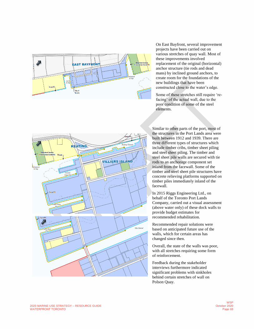
2020 MARINE USE STRATEGY – RESOURCE GUIDE WATERFRONT TORONTO
WSP October 2020
Page 69
On East Bayfront, several improvement
projects have been carried out on
various stretches of quay wall. Most of
these improvements involved
replacement of the original (horizontal)
anchor structure (tie rods and dead
mans) by inclined ground anchors, to
create room for the foundations of the
new buildings that have been
constructed close to the water’s edge.
Some of these stretches still require ‘re-
facing’ of the actual wall, due to the
poor condition of some of the steel
elements.
Similar to other parts of the port, most of
the structures in the Port Lands area were
built between 1912 and 1939. There are
three different types of structures which
include timber cribs, timber sheet piling
and steel sheet piling. The timber and
steel sheet pile walls are secured with tie
rods to an anchorage component set
inland from the facewall. Some of the
timber and steel sheet pile structures have
concrete relieving platforms supported on
timber piles immediately inland of the
facewall.
In 2015 Riggs Engineering Ltd., on
behalf of the Toronto Port Lands
Company, carried out a visual assessment
(above water only) of these dock walls to
provide budget estimates for
recommended rehabilitation.
Recommended repair solutions were
based on anticipated future use of the
walls, which for certain areas has
changed since then.
Overall, the state of the walls was poor,
with all stretches requiring some form
of reinforcement.
Feedback during the stakeholder
interviews furthermore indicated
significant problems with sinkholes
behind certain stretches of wall on
Polson Quay.

2020 MARINE USE STRATEGY – RESOURCE GUIDE WATERFRONT TORONTO
WSP October 2020
Page 70
E. STAKEHOLDERS
E.1 OVERVIEW OF MARINE COMMUNITY & STAKEHOLDERS (AT THE TIME OF
THIS STUDY)
No Company or Organization Category
1 Chamber of Marine Commerce Agency
2 CreateTO/City of Toronto Economic Development
Corporation/Toronto Port Lands Company Agency
3 TRCA Agency
4 Toronto Search and Rescue (T-SAR) Agency
5 Canadian Coast Guard Agency
6 PortsToronto Agency/Federal
7 Harbourfront Centre Institution
8 Hurricane Canvas Business
9 The Waterfront Business Improvement Association Business
10 CanRoof Business
11 Cinespace Business
12 Eastern Marine Business
13 FedEx Ship Centre Business
14 Maple/Cage Production Business
15 McGreggor Industries Business
16 Metrix Business
17 Pinewood Studios Business
18 PS Production Services Business
19 Sprackman Business
20 T&T supermarket Business
21 Telesat Business
22 The Waterford Group Business
23 Toromont (CIMCO Refrigeration) Business
24 Toronto Island Bicycle Rental Business
25 United Rentals Business
26 City of Toronto City
27 Lake Ontario Waterkeeper Conservation/Preservation
28 Friends of the Spit Conservation/Preservation
29 Galcon Marine Contractor
30 Hapag Lloyd Cruises Cruise Line
31 Princess Cruises Cruise Line
32 Victory Cruise Lines Cruise Line
33 Great Lakes Cruising Coalition Cruise Line

2020 MARINE USE STRATEGY – RESOURCE GUIDE WATERFRONT TORONTO
WSP October 2020
Page 71
No Company or Organization Category
34 Great Lakes Cruise Company Cruise Line
35 Pearl Seas Cruises Cruise Line
36 Waterfront Montessori Children's Centre Daycare
37 Mississaugas of the Credit First Nation First Nations
38 Six Nations of the Grand River First Nations
39 Huron-Wendat Nation First Nations
40 Toronto Aboriginal Supports Service Council First Nations
41 Anishnawbe Health Toronto First Nations
42 Toronto Inuit Association First Nations
43 Toronto York Region Metis Council First Nations
44 Keating Channel Pub & Grill Food and Beverage
45 Island Cafe Food and Beverage
46 Rivera Food and Beverage
47 Smiley’s B&B Food and Beverage
48 Cargill Salt Industry
49 Cargo Dockers Industry
50 Compass Minerals Industry
51 CRH Canada Group/
Ontario Redimix Portlands Industry
52 C-TOW Industry
53 Dew Man Marine Industry
54 Lehigh Cement Industry
55 K+S Windsor Salt Industry
56 Lafarge Industry
57 Logistec Stevedoring Industry
58 Nadro Marine Industry
59 Portlands Energy Centre Industry
60 Redpath Sugar Industry
61 Rideau Bulk Terminals Industry
62 Sifto Salt Industry
63 Strada Aggregates Industry
64 Toronto Drydock Industry
65 Toronto Hydro Industry
66 Toronto Industry Networks Industry
67 Toronto Marine Serv. (form. C&C) Industry
68 HMCS York Navy
69 Artscape Gibraltar Point NGO
70 Water Taxi Association Private Marine Passenger Transport
71 Otter Guy Private Marine Passenger Transport
72 Harbour Hopper Private Marine Passenger Transport
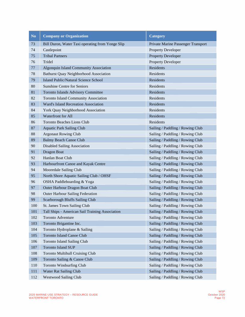
2020 MARINE USE STRATEGY – RESOURCE GUIDE WATERFRONT TORONTO
WSP October 2020
Page 72
No Company or Organization Category
73 Bill Duron, Water Taxi operating from Yonge Slip Private Marine Passenger Transport
74 Castlepoint Property Developer
75 Tribal Partners Property Developer
76 Tridel Property Developer
77 Algonquin Island Community Association Residents
78 Bathurst Quay Neighborhood Association Residents
79 Island Public/Natural Science School Residents
80 Sunshine Centre for Seniors Residents
81 Toronto Islands Advisory Committee Residents
82 Toronto Island Community Association Residents
83 Ward's Island Recreation Association Residents
84 York Quay Neighborhood Association Residents
85 Waterfront for All Residents
86 Toronto Beaches Lions Club Residents
87 Aquatic Park Sailing Club Sailing / Paddling / Rowing Club
88 Argonaut Rowing Club Sailing / Paddling / Rowing Club
89 Balmy Beach Canoe Club Sailing / Paddling / Rowing Club
90 Disabled Sailing Association Sailing / Paddling / Rowing Club
91 Dragon Boat Sailing / Paddling / Rowing Club
92 Hanlan Boat Club Sailing / Paddling / Rowing Club
93 Harbourfront Canoe and Kayak Centre Sailing / Paddling / Rowing Club
94 Mooredale Sailing Club Sailing / Paddling / Rowing Club
95 North Shore Aquatic Sailing Club / OHSF Sailing / Paddling / Rowing Club
96 OSHA Paddleboarding & Yoga Sailing / Paddling / Rowing Club
97 Outer Harbour Dragon Boat Club Sailing / Paddling / Rowing Club
98 Outer Harbour Sailing Federation Sailing / Paddling / Rowing Club
99 Scarborough Bluffs Sailing Club Sailing / Paddling / Rowing Club
100 St. James Town Sailing Club Sailing / Paddling / Rowing Club
101 Tall Ships - American Sail Training Association Sailing / Paddling / Rowing Club
102 Toronto Adventure Sailing / Paddling / Rowing Club
103 Toronto Brigantine Inc. Sailing / Paddling / Rowing Club
104 Toronto Hydroplane & Sailing Sailing / Paddling / Rowing Club
105 Toronto Island Canoe Club Sailing / Paddling / Rowing Club
106 Toronto Island Sailing Club Sailing / Paddling / Rowing Club
107 Toronto Island SUP Sailing / Paddling / Rowing Club
108 Toronto Multihull Cruising Club Sailing / Paddling / Rowing Club
109 Toronto Sailing & Canoe Club Sailing / Paddling / Rowing Club
110 Toronto Windsurfing Club Sailing / Paddling / Rowing Club
111 Water Rat Sailing Club Sailing / Paddling / Rowing Club
112 Westwood Sailing Club Sailing / Paddling / Rowing Club
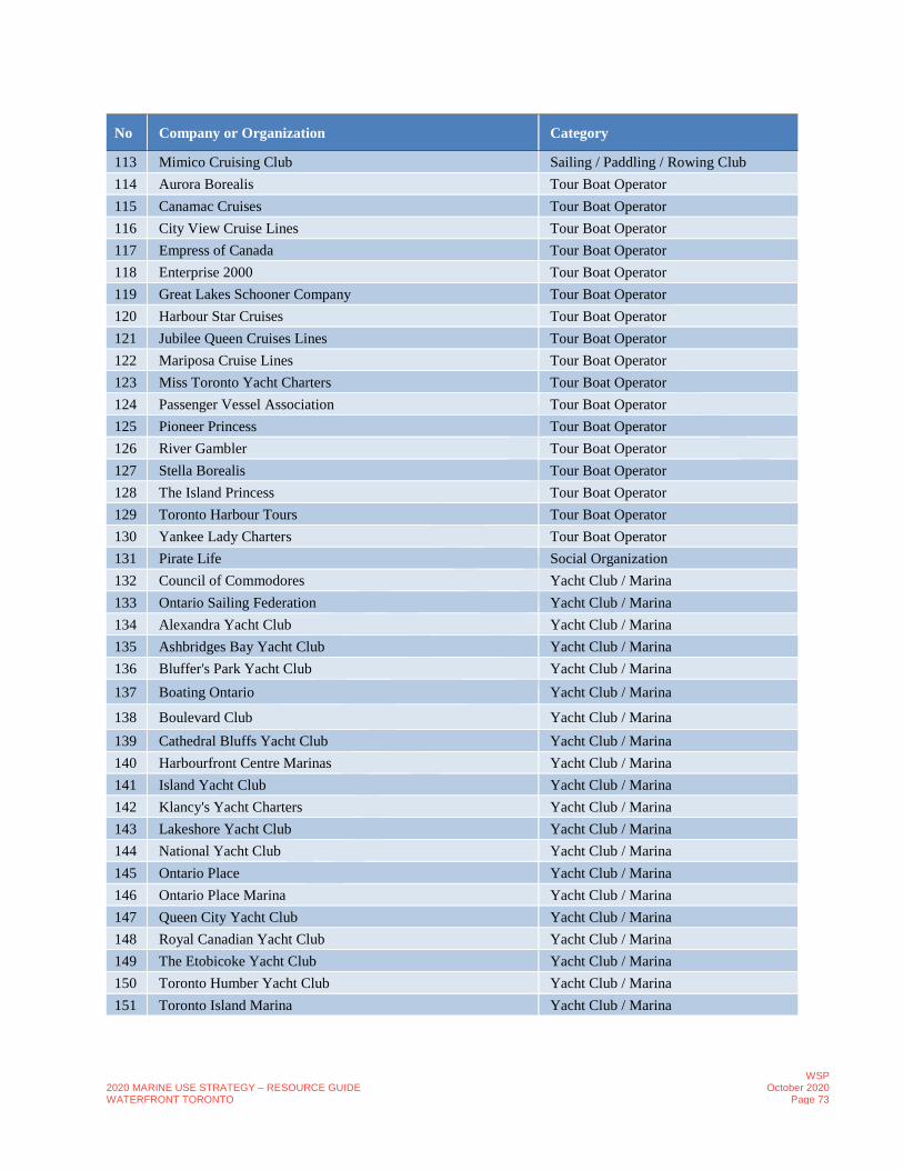
2020 MARINE USE STRATEGY – RESOURCE GUIDE WATERFRONT TORONTO
WSP October 2020
Page 73
No Company or Organization Category
113 Mimico Cruising Club Sailing / Paddling / Rowing Club
114 Aurora Borealis Tour Boat Operator
115 Canamac Cruises Tour Boat Operator
116 City View Cruise Lines Tour Boat Operator
117 Empress of Canada Tour Boat Operator
118 Enterprise 2000 Tour Boat Operator
119 Great Lakes Schooner Company Tour Boat Operator
120 Harbour Star Cruises Tour Boat Operator
121 Jubilee Queen Cruises Lines Tour Boat Operator
122 Mariposa Cruise Lines Tour Boat Operator
123 Miss Toronto Yacht Charters Tour Boat Operator
124 Passenger Vessel Association Tour Boat Operator
125 Pioneer Princess Tour Boat Operator
126 River Gambler Tour Boat Operator
127 Stella Borealis Tour Boat Operator
128 The Island Princess Tour Boat Operator
129 Toronto Harbour Tours Tour Boat Operator
130 Yankee Lady Charters Tour Boat Operator
131 Pirate Life Social Organization
132 Council of Commodores Yacht Club / Marina
133 Ontario Sailing Federation Yacht Club / Marina
134 Alexandra Yacht Club Yacht Club / Marina
135 Ashbridges Bay Yacht Club Yacht Club / Marina
136 Bluffer's Park Yacht Club Yacht Club / Marina
137 Boating Ontario Yacht Club / Marina
138 Boulevard Club Yacht Club / Marina
139 Cathedral Bluffs Yacht Club Yacht Club / Marina
140 Harbourfront Centre Marinas Yacht Club / Marina
141 Island Yacht Club Yacht Club / Marina
142 Klancy's Yacht Charters Yacht Club / Marina
143 Lakeshore Yacht Club Yacht Club / Marina
144 National Yacht Club Yacht Club / Marina
145 Ontario Place Yacht Club / Marina
146 Ontario Place Marina Yacht Club / Marina
147 Queen City Yacht Club Yacht Club / Marina
148 Royal Canadian Yacht Club Yacht Club / Marina
149 The Etobicoke Yacht Club Yacht Club / Marina
150 Toronto Humber Yacht Club Yacht Club / Marina
151 Toronto Island Marina Yacht Club / Marina

2020 MARINE USE STRATEGY – RESOURCE GUIDE WATERFRONT TORONTO
WSP October 2020
Page 74
E.2 STAKEHOLDER FEEDBACK LOG
Theme Comment Stakeholder Stakeholder
Group
Access to Toronto
Islands
Tiki Taxi Service is used and favoured over the ferry docs because
of the lineup.
BQNA Residents
Access to Toronto
Islands
Storm surge has been an issue to access the Island. RCYC Yacht
Club/Marina
Access to Toronto
Islands
The Island is more and more congested and visited a lot. RCYC Yacht
Club/Marina
Access to Toronto
Islands
The Ferry Terminal Expansion is part of the WT Strategic Plan.
During WT Refinement of the Ferry Terminal Plans they need to
improve accessibility.
RCYC Yacht
Club/Marina
Access to Toronto
Islands
Need to find a way to open up the islands and make them
accessible year-round
The Otter
Guy
Private Marine
Passenger
Transport
Access to Toronto
Islands
Water taxis are becoming more important for island residents due
to limited timings of ferry service and because the ferries are so
busy.
WFA and
YQNA
Residents
Access to Toronto
Islands
Consider year-round ferry WFA and
YQNA
Residents
Access to Toronto
Islands
The use of the island has increased significantly all year. Most of
the reasons people are visiting the Island is land based use. There
is an increase in smaller craft boat traffic.
WFA and
YQNA
Residents
Access to Toronto
Islands
Water taxis are seasonal which is an issue in the winter. Are
usually available late night. There are more people who live on the
Island that take water tax’s because of the hours and timing of the
ferries. Water taxis have become a more viable option because the ferry is
very crowded.
WFA and
YQNA
Residents
Access to Toronto
Islands
The ferry system – could be more adaptive and better serve
residents. The ferry schedule is sometimes problematic and shuts
down at 11:30 pm
WFA and
YQNA
Residents
Access to Toronto
Islands
Ferry system is the default way of life for island residents. WFA and
YQNA
Residents
Access to Toronto
Islands
Why are people who take water taxis to the Toronto Islands able
to take the ferries back for free? They should be paying!
Public
Intercepts
Public

2020 MARINE USE STRATEGY – RESOURCE GUIDE WATERFRONT TORONTO
WSP October 2020
Page 75
Theme Comment Stakeholder Stakeholder
Group
Access to
Waterfront
Happy with bike lanes and Queens Quay very pleased with
walkability.
BQNA Residents
Access to
Waterfront
The handling of our ships is admired, and we appreciate the effort
done. It is not the greatest location for access through cycling,
pedestrians but PortsToronto has worked with us to build those
access points such as shuttles, coaches, etc. Would be incredible to
have a more central location but we are working with
PortsToronto to make this location work.
Great Lakes
Cruising
Coalition
Cruise Lines
Access to
Waterfront
Distance from the port terminal to central attractions in the city. Great Lakes
Cruising
Coalition
Cruise Lines
Access to
Waterfront
Its not a very accessible waterfront because the buildings are built
right to the water; a Chicago approach where the buildings are
stepped back would be more ideal.
Great Lakes
Cruising
Coalition
Cruise Lines
Access to
Waterfront
It was painful when we were going through the waterfront
revitalization but we have seen an increase in tourism and visitors
since.
Mariposa
Cruises
Private Marine
Passenger
Transport
Access to
Waterfront
Cherry Street Bridge has been a constraint so there is no longer
access to Cherry Street. Using Unwin has been challenging and is
congested.
RCYC Yacht
Club/Marina
Access to
Waterfront
RCYC has a lot of children’s programs and they say they are
losing business because of the traffic and access constraints.
RCYC Yacht
Club/Marina
Access to
Waterfront
ACCESS TO RCYC IS A MAJOR ISSUE: Infrastructure failure Congestion Bridge Failure Water levels Congestion with trucks
RCYC Yacht
Club/Marina
Access to
Waterfront
500 kids through junior sailing camps is an issue because of access RCYC Yacht
Club/Marina
Access to
Waterfront
The harbour is not deep and contains silt RCYC Yacht
Club/Marina
Access to
Waterfront
RCYC Club hauling and racing program with children have issues
with access to the club.
RCYC Yacht
Club/Marina
Access to
Waterfront
Connectivity is an issue because of the depth issue. Members are
unable to move to the eastern shores because it is not deep -
Coburg etc. There are already clubs there but they do not have
bigger boats because of the depth.
RCYC Yacht
Club/Marina

2020 MARINE USE STRATEGY – RESOURCE GUIDE WATERFRONT TORONTO
WSP October 2020
Page 76
Theme Comment Stakeholder Stakeholder
Group
Access to
Waterfront
Harbour Racing at RCYC (60 boats at night racing). On a windy
night weather has bee a major issue because of the high-rise
development
RCYC Yacht
Club/Marina
Access to
Waterfront
Bridge operation and truck access is a major issue especially with
the Keating Channel Bridge failure.
Toronto
Industry
Network
Industry
Access to
Waterfront
75 -100 feet of space for vessel traffic needed near East Bayfront Toronto
Industry
Network
Industry
Access to
Waterfront
Vessels in the Turning Basin need more room Toronto
Industry
Network
Industry
Access to
Waterfront
Cruise ships are offloading in the middle of nowhere. It is
becoming very popular but difficult to connect them to the
waterfront
Waterfront
BIA
Business
Access to
Waterfront
Access to the water's edge is limited. Areas like Villiers Island
need to be deregulated; private properties are along the water's
edge that should be available for access by the public. Also, areas
east of Bay Street are very limited with access.
WFA and
YQNA
Residents
Access to
Waterfront
Reese Street Slip is overcrowded. WFA and
YQNA
Residents
Access to
Waterfront
The legacy of sailing dominated the waterfront in the 1960’s.
As the water has become cleaner more people are using small
water crafts. As Queens Quay is revitalized more small crafts are
being seen.
WFA and
YQNA
Residents
Access to
Waterfront
HUGE NEED By residents and visitors to get out on the water and
this NEED is not being met. Paddling Access needs to be
increased (wasn't prevalent in 2006 so didn't apply to previous
strategy). Need to find low cost options for increasing local users
and move the emphasis away from big cabin users and yachts.
WFA and
YQNA
Residents
Access to
Waterfront
Reese Street Spit houses everything and is not big enough;
currently overcrowded. Yet large cabin cruisers are occupying a
lot of space and their use is limited.
WFA and
YQNA
Residents
Access to
Waterfront
Our cruise terminal is located just past the Eastern Gap, very far
from central waterfront.
Great Lakes
Cruising
Coalition
Cruise Lines

2020 MARINE USE STRATEGY – RESOURCE GUIDE WATERFRONT TORONTO
WSP October 2020
Page 77
Theme Comment Stakeholder Stakeholder
Group
Access to
Waterfront
We are one of the only sailing clubs that have a direct access from
a main street, Stadium Road. It is great because many people don't
come randomly into the club, however the location is also hidden
from view.
National
Yacht Club
Yacht
Club/Marina
Access to
Waterfront
The waterfront is improving. I look forward to using it more in the
future.
Public
Intercepts
Public
Access to
Waterfront
Make water activities more accessible to the public by reducing
costs and making it easier for first time individuals to try it out
Public
Intercepts
Public
Access to
Waterfront
(used for) relaxing! Public
Intercepts
Public
Access to
Waterfront
2015. -we were moored at centre island. For 3 years – in the Inner
Harbour. Ferry terminal. Accessibly benefit of the city side and
parking lot. WE bring a significant number on the waterfront.
Parking lot.
Pirate Life Art
Studio/Gallery
Access to
Waterfront
We look forward for having access as it is now. Parliament is good
but could be better. OHM – currently underutilized area.
Pirate Life Art
Studio/Gallery
Access to
Waterfront
We were part of the destination in Toronto Islands. Now we are at
t a new destination. Artist – immigrant story staged in Toronto.
Create shows and performances and music, theatre and tell the
stories.
Pirate Life Art
Studio/Gallery
Access to
Waterfront
A lot take wheel trans and are dropped off next to the club house,
beside the marine police building, some take TTC which is close,
very small percent who drive.
DSOA Sailing/Paddlin
g/Rowing
Access to
Waterfront
Access is very good to the clubs, but we have issues with road
access and maintenance, Unwin Ave/Cherry St/Regatta Road (all
clubs on that road, but not too close to the Hearn) – but the area is
mostly composed of industry use (soil, cement) and roads in bad
conditions due to heavy truck traffic.
OHSF Sailing/Paddlin
g/Rowing
Access to
Waterfront
Some access to clubs has deteriorated due to roads not getting
repaired, which has a negative impact on cars – this has gotten
worse over the past 10 years.
OHSF Sailing/Paddlin
g/Rowing
Access to
Waterfront
Unfortunately, it’s not very convenient to travel via TTC if
transporting kayaks or canoes. Guess would be about 75-80 %
drive, the rest take TTC or cycle.
OHSF Sailing/Paddlin
g/Rowing
Access to
Waterfront
Access the clubs is reached predominantly by travelling south
down Cherry St. or via Leslie St. and then along Unwin Ave.
OHSF Sailing/Paddlin
g/Rowing

2020 MARINE USE STRATEGY – RESOURCE GUIDE WATERFRONT TORONTO
WSP October 2020
Page 78
Theme Comment Stakeholder Stakeholder
Group
Access to
Waterfront
Taxis or ferries probably would help, but maybe not a great deal –
when users come down, have to carry all sailing gear and boat
gear which can be difficult to transport on a ferry or in a taxi;
OHSF Sailing/Paddlin
g/Rowing
Access to
Waterfront
Any increase for access to all areas would be helpful for all
vicinities and users in the area
OHSF Sailing/Paddlin
g/Rowing
Accessibility Need more opportunities for the elderly and those with
accessibility constraints such as Cranes to lower the boats may be
needed to get people out on the water and an accessibility launch
(such as at the National Yacht Club)
WFA and
YQNA
Residents
Accessibility Sailing for the disabled should be recognized as important, in the
study. Disabled Sailing allows the disabled and elderly to access
the water. There are now two disabled sailing clubs on the Toronto
waterfront. There should be more. Charitable activities in general
such as Toronto Brigantine (for under-privileged youth) should be
recognized as important when allocating dock wall space, even if
such organizations cannot pay market rates. Brigantine has
relocated to Bluffers Park, as I understand it, because it could get
dock space in the harbour.
WFA and
YQNA
Residents
Accessibility We have accommodations for accessibility with two cranes
installed and two more that have not been installed. We also have
boats that are specifically designed to accommodate people with
disabilities to sail.
National
Yacht Club
Yacht
Club/Marina
Accessibility The new configuration of Queens Quay is not accessible. The
blind, service dogs and others with disabilities have a very
difficult time crossing due to the number of different surfaces and
many different users.
The
Harbourfront
Centre
Art
Studio/Gallery
Accessibility We have been working with accessibility consultants to ensure our
property is accessible, and do our best to make the improvements
necessary.
The
Harbourfront
Centre
Art
Studio/Gallery
Accessibility We see ourselves as accessibility champions. We host numerous
events for people who are disabled; support and give resources to
Blind Sailing Canada in Marina Quay West. We value their
support and we don’t see them as revenue losses. It is a direct hit.
We see that service as a key part of our mandate. Our biggest hit
to revenue is having to upkeep our infrastructure.
The
Harbourfront
Centre
Art
Studio/Gallery
Accessibility Marking sure the spaces are accessible. More space for these
organizations.
Pirate Life Art
Studio/Gallery

2020 MARINE USE STRATEGY – RESOURCE GUIDE WATERFRONT TORONTO
WSP October 2020
Page 79
Theme Comment Stakeholder Stakeholder
Group
Accessibility Would like to see improvements in accessibility everywhere
around the waterfront, aka pathways for chairs and scooters to be
better able to use; better grounds and path consistency, less
variation in grades and type; improvement for wayfinding
DSOA Sailing/Paddlin
g/Rowing
Airport Airport traffic and noise is an issue. BQNA Residents
Airport Concerned about airport expansion due to persons with small
aircrafts and personal aviation, barge traffic for fuel and general
expansion.
Residents expressed need for noise study
Air quality testing is being done with UofT.
BQNA Residents
Airport Keep out buoys around the airport as congestion and use of inner
harbour increases.
BQNA Residents
Airport Airport is also an issue. RCYC Yacht
Club/Marina
Airport Extension of the runway by 300 feet and the exclusion zone is an
issue. Major concern over the expansion of the airport
RCYC Yacht
Club/Marina
Airport An extended runway of the airport would shelter our property
from major southwesterly waves. However, we would still be
concerned with the noise and increased traffic.
National
Yacht Club
Yacht
Club/Marina
Airport We had renters go into the restricted areas a few times, but that
was dealt with. Other than that, no major concerns or issues.
The
Harbourfront
Centre
Art
Studio/Gallery
Airport Having planes land and take off overhead by the island airport is
also not the best experience.
Public
Intercepts
Public
Boat Maintenance
and Servicing
Facilities
Boat repair yards would be nice. We currently get our boats fixed
in London, at Hudson Boat Yards. We have some individuals who
fix minor issues ad-hoc.
Hanlan Boat
Club
Sailing/Paddlin
g/Rowing
Boat Maintenance
and Servicing
Facilities
The improvements did not consider servicing access for
commercial businesses along the south side. We currently can
only access from Simcoe between 8am and 11am. The new street
configuration has negatively impacted our servicing access.
Mariposa
Cruises
Private Marine
Passenger
Transport
Boat Maintenance
and Servicing
Facilities
Servicing access through marine transport would require more
coordination. Currently they are serviced as they are docked and it
is much easier from land then from water.
Mariposa
Cruises
Private Marine
Passenger
Transport
Boat Maintenance
and Servicing
Facilities
When centre is open we bring it in with vehicles, otherwise when
centre is closed we bring through hand dolly.
Mariposa
Cruises
Private Marine
Passenger
Transport

2020 MARINE USE STRATEGY – RESOURCE GUIDE WATERFRONT TORONTO
WSP October 2020
Page 80
Theme Comment Stakeholder Stakeholder
Group
Boat Maintenance
and Servicing
Facilities
There is an opportunity to improve the power along the dock wall
so we don't have to use generators as we do now for our kitchens,
etc.
Mariposa
Cruises
Private Marine
Passenger
Transport
Boat Maintenance
and Servicing
Facilities
Also add more sewage connections. Currently only have in certain
areas which limits us in where we can dock such as Harbourfront
Centre.
Mariposa
Cruises
Private Marine
Passenger
Transport
Boat Maintenance
and Servicing
Facilities
We input our sewage into current system. Mariposa
Cruises
Private Marine
Passenger
Transport
Boat Maintenance
and Servicing
Facilities
Each boat needs to be pulled out of the water once every 5 years
per regulations for check-up. We send out big boats to Hamilton
as there isn't a facility large enough in Toronto.
Mariposa
Cruises
Private Marine
Passenger
Transport
Boat Maintenance
and Servicing
Facilities
Smaller boats can go to the Toronto Dry Docks. Mariposa
Cruises
Private Marine
Passenger
Transport
Boat Maintenance
and Servicing
Facilities
During winter some of our boats are kept at the Toronto Dry
Docks and some are kept at the dock wall, in the water. Its not
ideal as sometimes they can get damaged with the ice.
Mariposa
Cruises
Private Marine
Passenger
Transport
Boat Maintenance
and Servicing
Facilities
The space, power provided and sewage space is specific to our
passenger vessels
Mariposa
Cruises
Private Marine
Passenger
Transport
Boat Maintenance
and Servicing
Facilities
There are no proper boat maintenance facilities in the Inner
Harbour. The maintenance facilities at the Outer Harbour Marina
are always full and don't have the facilities for larger commercial
boats. We currently take our boats to Humber Bay and
Mississauga for maintenance.
The Otter
Guy
Private Marine
Passenger
Transport
Boat Maintenance
and Servicing
Facilities
We need more maintenance shops for boats along the inner
harbour or at the islands. It should have 2 to 3 lifts, a small crane,
forklifts, and 2 to 3 slips that can be used for commercial boat
maintenance. If you want cruise ships to come more often, we
need more space for servicing boats.
The Otter
Guy
Private Marine
Passenger
Transport
Boat Maintenance
and Servicing
Facilities
Popularity of boating is only increasing and even
pleasure/recreational boats need maintenance and servicing.
The Otter
Guy
Private Marine
Passenger
Transport
Boat Maintenance
and Servicing
Facilities
Structural repairs and responsibility is a major issue. Toronto
Industry
Network
Industry
Boat Maintenance
and Servicing
Facilities
Windsor Salt does not own the vessels. Have issues with power
for vessels and truck access in the winter
Toronto
Industry
Network
Industry

2020 MARINE USE STRATEGY – RESOURCE GUIDE WATERFRONT TORONTO
WSP October 2020
Page 81
Theme Comment Stakeholder Stakeholder
Group
Boating
access/docking
Our organization would be opposed to a docking/landing spot near
the spit. We were not happy with maps we have seen of possible
docking locations for boats in the spit area.
Friends of the
Spit
Conservation/P
reservation
Boating
access/docking
We currently have space to dock two ships. We will probably need
to add a third dock within the next 6-7 years.
Great Lakes
Cruising
Coalition
Cruise Lines
Boating
access/docking
We have limited berth/dock wall on the waterfront. From Yonge
Street to Jarvis the dock wall was redone but wasn't built to handle
passenger vessels.
Mariposa
Cruises
Private Marine
Passenger
Transport
Boating
access/docking
Currently we dock between Parliament/Harbourfront Centre to
Bathurst Quay.
Mariposa
Cruises
Private Marine
Passenger
Transport
Boating
access/docking
There is a floating dock on Yonge but it is used as a water taxi
location.
Mariposa
Cruises
Private Marine
Passenger
Transport
Boating
access/docking
We have not added to our fleet because there simply isn't enough
room/dock wall. There is limited space to move our vessels.
Mariposa
Cruises
Private Marine
Passenger
Transport
Boating
access/docking
When they built finger piers we did note that there are fendering
issues due to the material. They need to reconsider the material
used so we don't cause damage to the boats during high waves.
Mariposa
Cruises
Private Marine
Passenger
Transport
Boating
access/docking
Floating decks may work for some operators but would be
difficult with larger vessels due to infrastructure constraints.
Mariposa
Cruises
Private Marine
Passenger
Transport
Boating
access/docking
Would be useful to have a universal boat ramp/dock that all boats
can use. Could be used for emergencies when we need to offload.
Mariposa
Cruises
Private Marine
Passenger
Transport
Boating
access/docking
RCYC launches are an Issue because of industry congestion on the
channel
RCYC Yacht
Club/Marina
Boating
access/docking
RCYC tried a launch a few years ago at Queens Quay - this did
not work because of marine and pedestrian vessel traffic
RCYC Yacht
Club/Marina
Boating
access/docking
Small to medium boat categories need more launch areas. RCYC Yacht
Club/Marina
Boating
access/docking
Trend or need is to have larger boats and a lot of members cannot
be accommodated by RCYC. Max beam of 13 ft. can be
accommodated, otherwise they have to use their dock parking
facility.
RCYC Yacht
Club/Marina
Boating
access/docking
There is very limited space for commercial, recreational and
private boats to access the water. Only 4 public launches, one of
which is Ashbridge's Bay and is extremely far from our facilities.
The Otter
Guy
Private Marine
Passenger
Transport

2020 MARINE USE STRATEGY – RESOURCE GUIDE WATERFRONT TORONTO
WSP October 2020
Page 82
Theme Comment Stakeholder Stakeholder
Group
Boating
access/docking
Marinas are also running very tight on space - piers and slips are
always full or occupied. Recreational users are in conflict with
marine transport operators for space.
The Otter
Guy
Private Marine
Passenger
Transport
Boating
access/docking
Need more public launches, and marina space for recreational boat
users.
The Otter
Guy
Private Marine
Passenger
Transport
Boating
access/docking
Big concern is the disappearance of commercial large vessel dock
space – ex. When the Navy wants to bring a large vessel, we only
have one space we can place it in the Inner Harbour. Important to
still have some historic, industrial, ships or boats coming through
as display to animate the waterfront and we need space to dock
them.
Waterfront
BIA
Business
Boating
access/docking
Need for more casual, short-term marina space which isn`t present
aside from the islands.
Waterfront
BIA
Business
Boating
access/docking
Storage and access to water for paddle boarding, small boats or
crafts is an issue. Retailers cannot sell boats because there is
limited storage and dock space for keeping recreational users.
WFA and
YQNA
Residents
Boating
access/docking
Ashbridges Bay boat launch is used a lot. This should be expanded
- how can we replicate it in other areas of the harbour?
WFA and
YQNA
Residents
Boating
access/docking
Despite the proposed recreational areas at the Port Lands, the
resident group expressed that there still needs to be public boat
access in the central waterfront area due to the proximity to more
users and downtown.
WFA and
YQNA
Residents
Boating
access/docking
Villiers Island has launch spots on the framework but vehicular
access, office facilities for rentals, storage and logistical needs for
camps etc. need to be planned.
WFA and
YQNA
Residents
Boating
access/docking
Residents are currently using private boats and dropping off in
areas which are not permitted for mooring by the public. Need
more public mooring sites.
WFA and
YQNA
Residents
Boating
access/docking
How many transient docking facilities are there? WFA and
YQNA
Residents
Boating
access/docking
Private boats for island residents is LIMITED because of mooring
sites being limited and the cost of finding a spot.
WFA and
YQNA
Residents
Boating
access/docking
Access for charitable organizations and access to the water
They are now parking their boat at Bluffers Park because of access
WFA and
YQNA
Residents
Boating
access/docking
We have mooring and docking space that is reserved for the
membership.
National
Yacht Club
Yacht
Club/Marina

2020 MARINE USE STRATEGY – RESOURCE GUIDE WATERFRONT TORONTO
WSP October 2020
Page 83
Theme Comment Stakeholder Stakeholder
Group
Boating
access/docking
We are looking to expand because we have people calling for dock
space but we don't often have much available. We have a waitlist.
We could also accommodate more kids as part of our kids sailing
program.
National
Yacht Club
Yacht
Club/Marina
Boating
access/docking
We are looking at adding up to 50 slips but it would require
extensive planning and would involve lots of different
stakeholders.
National
Yacht Club
Yacht
Club/Marina
Boating
access/docking
We did a trial for kayakers a few years ago. There is a berm to the
south of our docking area, which also needs repairing. We are
looking at providing more opportunity for kayaks by repairing the
berm and providing more room for kayakers to use the water
National
Yacht Club
Yacht
Club/Marina
Boating
access/docking
Docking Marina 4 is usually full. Under supply; they rent for the
season – we have other areas where we allow visitors to rent for a
day or shorter times.
The
Harbourfront
Centre
Art
Studio/Gallery
Boating
access/docking
connection to amenities for boaters (businesses that cater to
recreational activities along the water)
Boating
access/docking
Make it friendlier for smaller water craft like kayaks, canoes, SUP Public
Intercepts
Public
Boating
access/docking
Not accessible to everyday people. Water activities on the
Harbourfront are mostly for those who own their own boat.
Public
Intercepts
Public
Boating
access/docking
So few easy access points. Harbour filled with fast and large boat
traffic. Dirty water from storm sewer outflows. A spoiled
resource.
Public
Intercepts
Public
Boating
access/docking
Very few places on the seawall to casually dock short
term...Toronto island marina is great place to tie up for few hours
and have lunch. Wish there were more sailboat accessible public
docks cityside too.
Public
Intercepts
Public
Boating
access/docking
I haven't used the inner harbour yet for canoeing or kayaking, but
I hope to next year.
Public
Intercepts
Public
Boating
access/docking
more distinct launch site for smaller boats--away from ferries, that
feels slightly more sheltered than current access points that spit
you immediately out into main harbor (or the buoys for the
airport!)
Public
Intercepts
Public
Boating
access/docking
more launch sites for kayaks and small boats more kayak and
improved kayak storage, maybe something with indoor storage
like canoe/kayak building in the Beach
Public
Intercepts
Public
Boating
access/docking
More access points for non-power craft. No more sewage outflow
and a real plan to improve water quality.
Public
Intercepts
Public

2020 MARINE USE STRATEGY – RESOURCE GUIDE WATERFRONT TORONTO
WSP October 2020
Page 84
Theme Comment Stakeholder Stakeholder
Group
Boating
access/docking
More public day docks along the cityside. Public
Intercepts
Public
Boating
access/docking
Places to Moore other than the island, possibly restaurants that
cater to boaters along the shore line. The inner harbor is like the
401 on water
Public
Intercepts
Public
Boating
access/docking
Mooring – floating wooden structure is smaller and amenable that
is rise and fall of the water. 2 unused berths at the HFC – existing
operators that has not fleet – so there are few that are available but
underutilized.
Pirate Life Art
Studio/Gallery
Boating
access/docking
Difficulty going in and out of dock; it’s a busy ‘channel’/slip and
it’s okay if people have a background in boating but can be very
dangerous with those who are learning or renting motorboats.
DSOA Sailing/Paddlin
g/Rowing
Boating
access/docking
At the DSOA location, they share the space with power boats, sail
boats, canoe/kayaks, public who use motorboats and rentals
DSOA Sailing/Paddlin
g/Rowing
Boating
access/docking
Concern around where the ferries dock, as well as it would be an
additional 20-30 mins walk with equipment being carried.
OHSF Sailing/Paddlin
g/Rowing
Challenge - Noise Tour boats at the western gap; party boats come at high speed and
cause noise
BQNA Residents
Challenge - Noise Racing night at 6 PM is a major issue RCYC Yacht
Club/Marina
Challenge - Noise NOISE from the Event Space and Noise from the Chartered Boats
is common
RCYC Yacht
Club/Marina
Challenge - Noise The party buses are issue and there is collaboration with the party
boats who sometimes load docks. Enterprise Party Boats
mentioned that they are getting access to the North Dock wall
Vessels currently exist there, and is not an issue but could be a
congestion issue.
Toronto
Industry
Network
Industry
Challenge - Noise PARTY CRUISE LINES - Expressed that the party boats are a
concern because they are noise.
Rebel nightclub was an issue with the dominant use. There was a
legal case regarding extending hours etc. The legal case resulted
in WT to state that there needs to be a balance. WT appeared at the
hearing as a witness and demonstrated the balance needed to
regulate the noise.
WFA and
YQNA
Residents
Challenge - Noise NOISE*
Balance between residential areas and enforcement of nightlife
and party boats.
The Nightclub has been a major issue for Island Residents
WFA and
YQNA
Residents

2020 MARINE USE STRATEGY – RESOURCE GUIDE WATERFRONT TORONTO
WSP October 2020
Page 85
Theme Comment Stakeholder Stakeholder
Group
Construction Coordination of vessels with construction has been great Toronto
Industry
Network
Industry
Construction The waterfront revitalization and the 5 years of construction had a
huge impact on operations, but we worked with it and now are
benefitting from a more active waterfront.
The
Harbourfront
Centre
Art
Studio/Gallery
Dredging Cost of dredging and quality of silt cost associated with disposing
the fill is an issue
RCYC Yacht
Club/Marina
Dredging Concern regarding 361 Polson Quay where the slip and dock wall
are in poor condition and the slip has not been dredged in over 40
years. The new Don river is flowing through the south dock wall
and impacting property. Structural failure is a big issue with large
sink holes.
Dredging is a major issue and releases contaminants into water.
Who maintains the remained of the slip? Port owns the dock wall
but the property owner is responsible for the maintenance.
Toronto
Industry
Network
Industry
East Bayfront East Bayfront is a great opportunity to bring some excitement to
the waterfront. Opportunities for passenger vessels, cruise
experiences.
Mariposa
Cruises
Private Marine
Passenger
Transport
East Bayfront The East Bayfront coming together is good to see but the lack of
finishing the masterplan; would be good to continue that progress
Waterfront
BIA
Business
East Bayfront East Bayfront is very sterile, and needs mooring and drop off
locations. It is accessible from the shoreline but there is a long
ribbon of nothing.
WFA and
YQNA
Residents
East Bayfront SUGGESTION OF NORDIC DESIGN
Artificial Harbour with a paddle club in anyplace that does not
take up real estate. Floating dock design with access that are not
allocating land. The City has looked at this in Denmark and may
seek it out because it is cost effective built on piers.
WFA and
YQNA
Residents
East Bayfront Needs to be connected somehow to the main central waterfront.
There is a disconnect between the central to east bayfront.
The
Harbourfront
Centre
Art
Studio/Gallery
East Bayfront Unfortunately, we have been investing in barriers rather than open
spaces; we have to think about to removing barriers, removing
things, having extended pedestrian access points, roads.
The
Harbourfront
Centre
Art
Studio/Gallery
East Bayfront The width of the road on the east end of the waterfront is quite
large (4 lanes) and not that many crossings for pedestrians to
access the eastern waterfront.
The
Harbourfront
Centre
Art
Studio/Gallery

2020 MARINE USE STRATEGY – RESOURCE GUIDE WATERFRONT TORONTO
WSP October 2020
Page 86
Theme Comment Stakeholder Stakeholder
Group
East Bayfront Western harbour is pretty developed, but lots of opportunity on the
east side for more facilities.
Public
Intercepts
Public
East Bayfront Looking to expand east, not give up current location, but add a
second one (around Parliament Slip). Want to look for
opportunities and partnerships as eastern infrastructure is being
built up
DSOA Sailing/Paddlin
g/Rowing
Familiarity with
2006 Strategy
Friends of the Spit was involved, but don’t remember much from
the content because its been such a long time.
Friends of the
Spit
Conservation/P
reservation
Familiarity with
2006 Strategy
Friends of the Spit was involved, but don’t remember much from
the content because its been such a long time.
Friends of the
Spit
Conservation/P
reservation
Familiarity with
2006 Strategy
Aware that one was produced, but no knowledge of the contents Great Lakes
Cruising
Coalition
Cruise Lines
Familiarity with
2006 Strategy
We were not involved in the development of the 2006 strategy.
We are aware of others in our industry who were involved.
Mariposa
Cruises
Private Marine
Passenger
Transport
Familiarity with
2006 Strategy
Very Familiar The Otter
Guy
Private Marine
Passenger
Transport
Familiarity with
2006 Strategy
BIA was formed in 2005, so we don’t know too much about it. Waterfront
BIA
Business
Familiarity with
2006 Strategy
Familiar with study but it was a long time ago WFA and
YQNA
Residents
Familiarity with
2006 Strategy
Were involved in the strategy development as a steering
committee member. Would like a similar role this year as we are a
major leaseholder at the waterfront.
The
Harbourfront
Centre
Art
Studio/Gallery
Familiarity with
2006 Strategy
Not familiar with the 2006 Strategy DSOA Sailing/Paddlin
g/Rowing
Familiarity with
2006 Strategy
Vaguely - wasn't part of the board committee back then. OHSF Sailing/Paddlin
g/Rowing
Food and Beverage
Facilities
We need more food and beverage facilities at the waterfront. Harbour
Hopper
Private Marine
Passenger
Transport
Food and Beverage
Facilities
Food and beverage services have had issues RCYC Yacht
Club/Marina
Food and Beverage
Facilities
Serious lack of food options in the waterfront area. Waterfront
BIA
Business
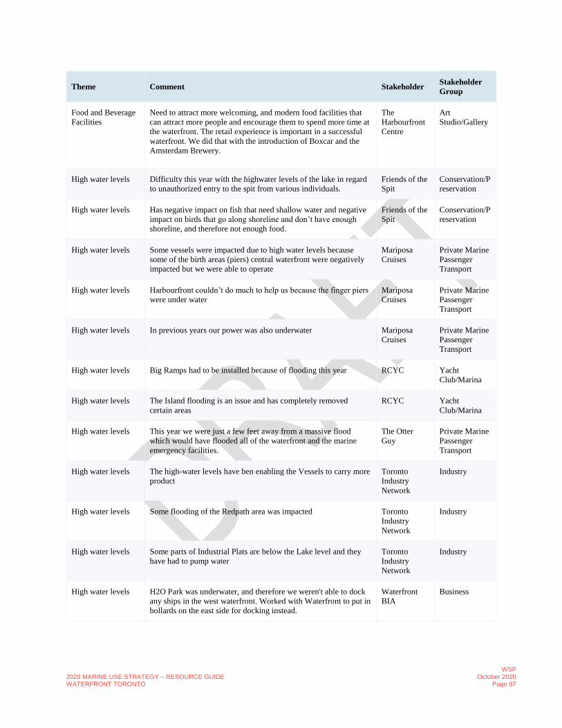
2020 MARINE USE STRATEGY – RESOURCE GUIDE WATERFRONT TORONTO
WSP October 2020
Page 87
Theme Comment Stakeholder Stakeholder
Group
Food and Beverage
Facilities
Need to attract more welcoming, and modern food facilities that
can attract more people and encourage them to spend more time at
the waterfront. The retail experience is important in a successful
waterfront. We did that with the introduction of Boxcar and the
Amsterdam Brewery.
The
Harbourfront
Centre
Art
Studio/Gallery
High water levels Difficulty this year with the highwater levels of the lake in regard
to unauthorized entry to the spit from various individuals.
Friends of the
Spit
Conservation/P
reservation
High water levels Has negative impact on fish that need shallow water and negative
impact on birds that go along shoreline and don’t have enough
shoreline, and therefore not enough food.
Friends of the
Spit
Conservation/P
reservation
High water levels Some vessels were impacted due to high water levels because
some of the birth areas (piers) central waterfront were negatively
impacted but we were able to operate
Mariposa
Cruises
Private Marine
Passenger
Transport
High water levels Harbourfront couldn’t do much to help us because the finger piers
were under water
Mariposa
Cruises
Private Marine
Passenger
Transport
High water levels In previous years our power was also underwater Mariposa
Cruises
Private Marine
Passenger
Transport
High water levels Big Ramps had to be installed because of flooding this year RCYC Yacht
Club/Marina
High water levels The Island flooding is an issue and has completely removed
certain areas
RCYC Yacht
Club/Marina
High water levels This year we were just a few feet away from a massive flood
which would have flooded all of the waterfront and the marine
emergency facilities.
The Otter
Guy
Private Marine
Passenger
Transport
High water levels The high-water levels have ben enabling the Vessels to carry more
product
Toronto
Industry
Network
Industry
High water levels Some flooding of the Redpath area was impacted Toronto
Industry
Network
Industry
High water levels Some parts of Industrial Plats are below the Lake level and they
have had to pump water
Toronto
Industry
Network
Industry
High water levels H2O Park was underwater, and therefore we weren't able to dock
any ships in the west waterfront. Worked with Waterfront to put in
bollards on the east side for docking instead.
Waterfront
BIA
Business
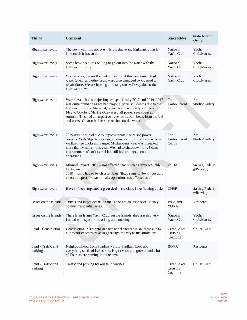
2020 MARINE USE STRATEGY – RESOURCE GUIDE WATERFRONT TORONTO
WSP October 2020
Page 88
Theme Comment Stakeholder Stakeholder
Group
High water levels The dock wall was not even visible due to the highwater, that is
how much it has sunk.
National
Yacht Club
Yacht
Club/Marina
High water levels Some have been less willing to go out into the water with the
high-water levels.
National
Yacht Club
Yacht
Club/Marina
High water levels Our walkways were flooded last year and this year due to high
water levels, and other areas were also damaged so we need to
repair those. We are looking at raising our walkway due to the
high-water level.
National
Yacht Club
Yacht
Club/Marina
High water levels Water levels had a major impact, specifically 2017 and 2019. 2017
was quite dramatic as we had major electric shutdowns due to the
high-water levels. Marina 4, power was completely shut down
May to October; Marine Quay west, all power shut down all
summer. This had an impact on revenue as both boats from the US
and across Ontario had less or no time on the water.
The
Harbourfront
Centre
Art
Studio/Gallery
High water levels 2019 wasn’t as bad due to improvements like raised power
sources; York Slips tenders were coming off the anchor beams so
we fixed the docks and ramps. Marina quay west was impacted
more than Marina 4 this year. We had to shut down for 24 days
this summer. Wasn’t as bad but still had an impact on our
operations.
The
Harbourfront
Centre
Art
Studio/Gallery
High water levels Minimal Impact: 2017 – not affected that much as ramp was able
to stay on
2019 – ramp had to be disassembled (fixed ramp to dock), but able
to acquire portable ramp – aka operations not affected at all
DSOA Sailing/Paddlin
g/Rowing
High water levels Haven’t been impacted a great deal – the clubs have floating docks OHSF Sailing/Paddlin
g/Rowing
Issues on the islands Trucks and major events on the island are an issue because they
obstruct residential areas.
WFA and
YQNA
Residents
Issues on the islands There is an Island Yacht Club, on the Islands, they are also very
limited with space for docking and mooring.
National
Yacht Club
Yacht
Club/Marina
Land - Construction Construction in Toronto impacts us whenever we are there due to
our motor coaches travelling through the city to the attractions
Great Lakes
Cruising
Coalition
Cruise Lines
Land - Traffic and
Parking
Neighbourhood from Spadina west to Stadium Road and
everything south of Lakeshore. High residential growth and a lot
of Tourists are coming into the area
BQNA Residents
Land - Traffic and
Parking
Traffic and parking for our tour coaches Great Lakes
Cruising
Coalition
Cruise Lines

2020 MARINE USE STRATEGY – RESOURCE GUIDE WATERFRONT TORONTO
WSP October 2020
Page 89
Theme Comment Stakeholder Stakeholder
Group
Land - Traffic and
Parking
Traffic and parking for tour coaches is really becoming an issue in
some cities. We now plan around major events (i.e. Caribana) to
avoid major traffic congestion. We now budget for traffic and
construction impacts to our services.
Great Lakes
Cruising
Coalition
Cruise Lines
Land - Traffic and
Parking
We don't have too many issues with parking. We have good access
to a bike path.
Hanlan Boat
Club
Sailing/Paddlin
g/Rowing
Land - Traffic and
Parking
Road conditions near the club aren’t the best and could use
improvements, including lighting at night. (Regatta Road).
Hanlan Boat
Club
Sailing/Paddlin
g/Rowing
Land - Traffic and
Parking
Tour bus operators do not like going to the waterfront as there is
very limited parking and no space for them to turn their buses.
Harbour
Hopper
Private Marine
Passenger
Transport
Land - Traffic and
Parking
Despite the focus on active transportation and transit, which has
become more used by visitors, traffic has got worse and is really
tough in the area.
Mariposa
Cruises
Private Marine
Passenger
Transport
Land - Traffic and
Parking
as 200 Queens Quay parking lot is being redeveloped, parking will
become even more difficult.
Mariposa
Cruises
Private Marine
Passenger
Transport
Land - Traffic and
Parking
We are really tight on facilities, especially parking which are
always full.
The Otter
Guy
Private Marine
Passenger
Transport
Land - Traffic and
Parking
Biggest issue is traffic flow getting product out of the facility, esp.
at Unwin Avenue
Toronto
Industry
Network
Industry
Land - Traffic and
Parking
Asked WT to continue Polson Street East and Connect to the Don
was requested but not completed. Allowance needs to be given for
large trucks etc. Appropriate buffering needed at all hours for
safety and noise, for 9 months of operation.
Toronto
Industry
Network
Industry
Land - Traffic and
Parking
Alternative Routes out of the Port Area needs to be considered as
a major constraint. The responsibility and alternative Rote needs
to be better Coordinated.
Toronto
Industry
Network
Industry
Land - Traffic and
Parking
Issues with parking and drop-off for ferry docks. Ferry docks are a
choking point for access to the islands
WFA and
YQNA
Residents
Land - Traffic and
Parking
Routing all delivery trucks for island deliveries, and busses
dropping large groups, has created a bottleneck on Queens Quay at
the city-side ferry dock. There is little parking and no drop-off
area. There is congestion with busses trucks and traffic. Thought
should be given to creating a second city-side ferry site, with
parking and drop-off facilities, especially for delivery trucks and
busses. YQNA had previously suggested the old Rochester ferry
terminal at the Eastern Gap, which is surrounded by parking and
easily accessible by road.
WFA and
YQNA
Residents

2020 MARINE USE STRATEGY – RESOURCE GUIDE WATERFRONT TORONTO
WSP October 2020
Page 90
Theme Comment Stakeholder Stakeholder
Group
Land - Traffic and
Parking
Traffic isn’t that bad or heavy, just mostly the heavy trucks. Many
cars only use of Unwin to go to fields or the clubs. Majority of
users drive, some bike or take the TTC.
OHSF Sailing/Paddlin
g/Rowing
Land Improvements More seating BQNA Residents
Land Improvements More interesting continuous boardwalks such as Pier 4 in
Hamilton. Use infrastructure such as bridges to animate and add
architectural elements to the waterfront.
Harbour
Hopper
Private Marine
Passenger
Transport
Land Improvements What is missing is dedicated bus drop-off areas. It would signal
that the area is a tourist destination and will make it easier to get
large amounts of people in and out of the area.
Mariposa
Cruises
Private Marine
Passenger
Transport
Land Improvements The improvements such as wave decks, parks have really helped
bring the waterfront to the forefront and given it a new feel
Mariposa
Cruises
Private Marine
Passenger
Transport
Land Improvements The waterfront is definitely more connected but still some work to
do to create continuous waterfront at the water's edge.
Mariposa
Cruises
Private Marine
Passenger
Transport
Land Improvements Considering the many years of issues and the area, they have done
a great job.
Mariposa
Cruises
Private Marine
Passenger
Transport
Land Improvements Land use draw is needed year-round RCYC Yacht
Club/Marina
Land Improvements Year round, all season access is important. RCYC Yacht
Club/Marina
Land Improvements Public accessibility year-round is needed. RCYC Yacht
Club/Marina
Land Improvements Museums; Landmarks; Cultural Centre or Anchors are Needed to
bring people to the Waterfront
RCYC Yacht
Club/Marina
Land Improvements Lack of completeness of some of the improvements such as the
wave decks.
Waterfront
BIA
Business
Land Improvements Animating and connecting the businesses on the north side of
Queens quay has been a big issue, need to find a way to
accommodate pedestrian flows on the south and bring them to the
north of the street.
Waterfront
BIA
Business
Land Improvements Queens quay and the pedestrian areas along the water`s edge are
becoming extremely busy but have a lot of conflicting uses (i.e.
streetcars, cycling, pedestrians, cars).
Waterfront
BIA
Business
Land Improvements The boardwalk along the central waterfront has improved the
waterfront experience; before it was just a water's edge.
National
Yacht Club
Yacht
Club/Marina

2020 MARINE USE STRATEGY – RESOURCE GUIDE WATERFRONT TORONTO
WSP October 2020
Page 91
Theme Comment Stakeholder Stakeholder
Group
Land Improvements The wave decks have been a great addition to enhance the
experience at the waterfront.
National
Yacht Club
Yacht
Club/Marina
Land Improvements MAINTENANCE, frequent HIGH QUALITY maintenance
workers, consistent street furniture,
Public
Intercepts
Public
Land Improvements Development has brought an increase in the number of visitors to
the waterfront which makes the harbour busier and can be
problematic.
DSOA Sailing/Paddlin
g/Rowing
Land Improvements all clubs under the umbrella have benefitted from the
redevelopment, as far as he is able to speak to, he sees that the
improvements have attracted and drawn more people to the
waterfront and to the clubs – it’s brought an increase to the
visibility of the clubs which has had a positive impact on the clubs
OHSF Sailing/Paddlin
g/Rowing
Land Improvements clubs still struggle with getting work improvements done to the
roads done along access routes (aka Unwin Ave and Regatta Rd),
no street lighting, these are issues they’d like the city to address
OHSF Sailing/Paddlin
g/Rowing
Land Improvements Roads getting worse – one consistent complaint at each meeting –
roads getting worse – degenerating – not being repaired because
not enough people and is in an industrial area
OHSF Sailing/Paddlin
g/Rowing
Land Improvements Martin Goodman Trail great for cyclists, but poor weather and
timing can be an impact for transportation to the clubs
OHSF Sailing/Paddlin
g/Rowing
Land Improvements What the city’s been doing so far has been great – turning PLFP
into usable land
OHSF Sailing/Paddlin
g/Rowing
Land Improvements If city could tidy up area between the Leslie St. spit and the club
area, aka roads, would be great
OHSF Sailing/Paddlin
g/Rowing
Land Improvements One area that clubs would like the city to address would be to add
street lighting along roads to the clubs. No incidents yet, but is a
large potential hazard.
OHSF Sailing/Paddlin
g/Rowing
Lease or
Landownership
Friends of the Spit is an advocacy group which only takes
stewardship of spaces and lands.
Friends of the
Spit
Conservation/P
reservation
Lease or
Landownership
We do own land across the country but no land in the City of
Toronto. We have a lab along the waterfront where we do most of
our sampling. We also have an office on Spadina.
Friends of the
Spit
Conservation/P
reservation
Lease or
Landownership
The cruise operators that we see in the great lakes do not own
lands in the waterfront and have no interest in owning land
Great Lakes
Cruising
Coalition
Cruise Lines
Lease or
Landownership
Our land is leased from the City. Would assume other clubs are
similarly leased.
Hanlan Boat
Club
Sailing/Paddlin
g/Rowing

2020 MARINE USE STRATEGY – RESOURCE GUIDE WATERFRONT TORONTO
WSP October 2020
Page 92
Theme Comment Stakeholder Stakeholder
Group
Lease or
Landownership
We lease our land. Current one goes to 2025. There is always a
concern about whether we will get renewed or what will happen in
the future. We understand we are part of the strategy and hope we
continue to be
Hanlan Boat
Club
Sailing/Paddlin
g/Rowing
Lease or
Landownership
We have two piers, will check if we own them or not. We do have
to maintain.
Hanlan Boat
Club
Sailing/Paddlin
g/Rowing
Lease or
Landownership
It is currently very confusing and difficult to understand who owns
what along the waterfront. Whether it is with permits, licences or
others.
Harbour
Hopper
Private Marine
Passenger
Transport
Lease or
Landownership
We know Harbourfront also has capacity issues. We have a good
relationship with them but it is difficult for them to do much
Mariposa
Cruises
Private Marine
Passenger
Transport
Lease or
Landownership
Most of the operators west of York Street are leasing from
Harbourfront Centre
Mariposa
Cruises
Private Marine
Passenger
Transport
Lease or
Landownership
East of York Street is Ports Toronto, then Waterfront Toronto Mariposa
Cruises
Private Marine
Passenger
Transport
Lease or
Landownership
It is very confusing to determine who owns what and who leases
what. There were many more owners before, so there has been
some progress over the past few years.
Mariposa
Cruises
Private Marine
Passenger
Transport
Lease or
Landownership
The Yacht Club owned a slip at Parliament Street Slip and use to
have tender access the Island from there with a large parking lot.
At the end of Queens Quay and Parliament they own a piece of
proper with public facilities where they launch from; they still
own this facility but they had to move out. They also have a
sublease long term lease at 150 Cherry Street
RCYC Yacht
Club/Marina
Lease or
Landownership
The Parliament Street location is either going to be Queens Quay
or Google (sidewalk labs)
RCYC operates club house on the island with barges
RCYC has permanent slips at the Island
RCYC Yacht
Club/Marina
Lease or
Landownership
TEDCO leases to the Port Authority (PORTS); they are prime
owner of the old tender and they are very limited n where thy can
launch from because of Nav Canada Regs
RCYC Yacht
Club/Marina
Lease or
Landownership
RCYC; Canadian Sailing has a high performance training centre
At Cherry Street there is a large parking lot with sea wall where
launches enter. Three tonne cranes to launch small crafts
RCYC Yacht
Club/Marina
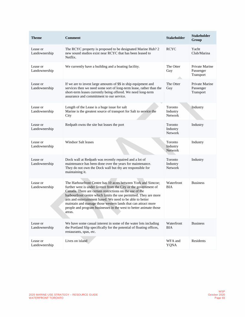
2020 MARINE USE STRATEGY – RESOURCE GUIDE WATERFRONT TORONTO
WSP October 2020
Page 93
Theme Comment Stakeholder Stakeholder
Group
Lease or
Landownership
The RCYC property is proposed to be designated Marine Hub? 2
new sound studios exist near RCYC that has been leased to
Netflix.
RCYC Yacht
Club/Marina
Lease or
Landownership
We currently have a building and a boating facility. The Otter
Guy
Private Marine
Passenger
Transport
Lease or
Landownership
If we are to invest large amounts of $$ in ship equipment and
services then we need some sort of long-term lease, rather than the
short-term leases currently being offered. We need long-term
assurance and commitment to our service.
The Otter
Guy
Private Marine
Passenger
Transport
Lease or
Landownership
Length of the Lease is a huge issue for salt
Marine is the greatest source of transport for Salt to service the
City
Toronto
Industry
Network
Industry
Lease or
Landownership
Redpath owns the site but leases the port Toronto
Industry
Network
Industry
Lease or
Landownership
Windsor Salt leases Toronto
Industry
Network
Industry
Lease or
Landownership
Dock wall at Redpath was recently repaired and a lot of
maintenance has been done over the years for maintenance.
They do not own the Dock wall but thy are responsible for
maintaining it.
Toronto
Industry
Network
Industry
Lease or
Landownership
The Harbourfront Centre has 10 acres between York and Simcoe;
further west is under licence from the City or the government of
Canada. There are certain restrictions on the use of the
harbourfront centre which limits the use permitted. They are more
arts and entertainment based. We need to be able to better
maintain and manage those western lands that can attract more
people and program businesses in the west to better animate those
areas.
Waterfront
BIA
Business
Lease or
Landownership
We have some casual interest in some of the water lots including
the Portland Slip specifically for the potential of floating offices,
restaurants, spas, etc.
Waterfront
BIA
Business
Lease or
Landownership
Lives on island WFA and
YQNA
Residents

2020 MARINE USE STRATEGY – RESOURCE GUIDE WATERFRONT TORONTO
WSP October 2020
Page 94
Theme Comment Stakeholder Stakeholder
Group
Lease or
Landownership
Commodore of a specific area on the island
Resident – leases the waterfront at Algonquin Island – started as
informal and the City formalized it. And the club maintain the
leased area and the status is as much as RCYC is and they are the
same category as they are but have no facilities.
WFA and
YQNA
Residents
Lease or
Landownership
Mentioned they are small scale and very cheap and that they may
entertain growing to rent out spots including canoe and kayaks but
choose not to.
WFA and
YQNA
Residents
Lease or
Landownership
We currently lease from the City of Toronto. National
Yacht Club
Yacht
Club/Marina
Lease or
Landownership
Other sail clubs have lots of land to expand, we don't. We are very
limited with our space and need more members to be able to pay
for extensive renovations that are required.
National
Yacht Club
Yacht
Club/Marina
Lease or
Landownership
We have a 99-year lease with the City for 10 acres of land in the
central waterfront. It is a unique arrangement as it includes
responsibility for maintenance, streets, lighting, dock walls, etc.
The
Harbourfront
Centre
Art
Studio/Gallery
Lease or
Landownership
We have separate leases for some city properties to the west of the
Portland Slip. Does not include the IYC slip.
The
Harbourfront
Centre
Art
Studio/Gallery
Lease or
Landownership
Started out in 1972, started as a crown operation. Originally 100
acres, then changed into a cultural centre.
The
Harbourfront
Centre
Art
Studio/Gallery
Lease or
Landownership
Lease space from the harbourfront - location at the foot of Reese
street, lease dock space and wall space but we own our own dock.
DSOA Sailing/Paddlin
g/Rowing
Lease or
Landownership
Leaseholder OHSF Sailing/Paddlin
g/Rowing
Membership Our membership has been quite stable over the years, roughly 300
members is what we can accommodate. We also have training
classes for new rowers.
Hanlan Boat
Club
Sailing/Paddlin
g/Rowing
Membership We have been running since 1975. Hanlan Boat
Club
Sailing/Paddlin
g/Rowing
Membership Other clubs have limited memberships and storage space but we
just built a boathouse and have sufficient space.
Hanlan Boat
Club
Sailing/Paddlin
g/Rowing
Membership Over 4000 members; went from 0 to 21 high performance sport
boats.
RCYC Yacht
Club/Marina
Membership Not sure how many of our members live in the City, however
some members live on their yachts for the summer months.
National
Yacht Club
Yacht
Club/Marina
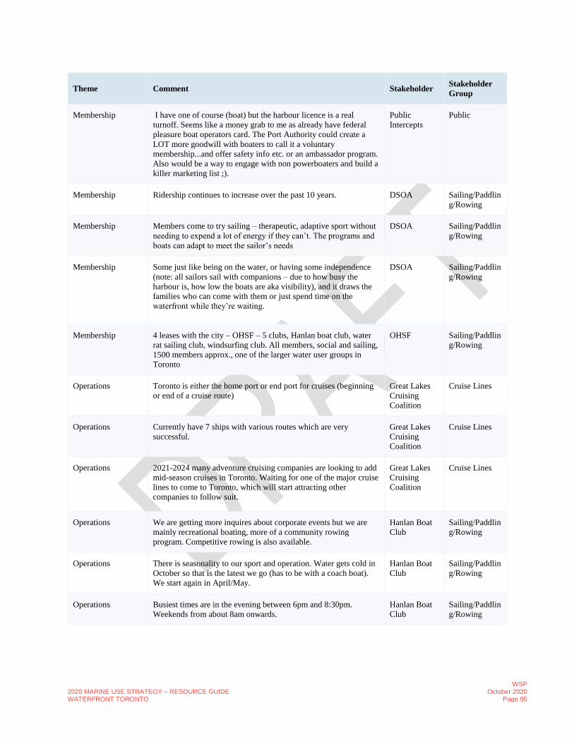
2020 MARINE USE STRATEGY – RESOURCE GUIDE WATERFRONT TORONTO
WSP October 2020
Page 95
Theme Comment Stakeholder Stakeholder
Group
Membership I have one of course (boat) but the harbour licence is a real
turnoff. Seems like a money grab to me as already have federal
pleasure boat operators card. The Port Authority could create a
LOT more goodwill with boaters to call it a voluntary
membership...and offer safety info etc. or an ambassador program.
Also would be a way to engage with non powerboaters and build a
killer marketing list ;).
Public
Intercepts
Public
Membership Ridership continues to increase over the past 10 years. DSOA Sailing/Paddlin
g/Rowing
Membership Members come to try sailing – therapeutic, adaptive sport without
needing to expend a lot of energy if they can’t. The programs and
boats can adapt to meet the sailor’s needs
DSOA Sailing/Paddlin
g/Rowing
Membership Some just like being on the water, or having some independence
(note: all sailors sail with companions – due to how busy the
harbour is, how low the boats are aka visibility), and it draws the
families who can come with them or just spend time on the
waterfront while they’re waiting.
DSOA Sailing/Paddlin
g/Rowing
Membership 4 leases with the city – OHSF – 5 clubs, Hanlan boat club, water
rat sailing club, windsurfing club. All members, social and sailing,
1500 members approx., one of the larger water user groups in
Toronto
OHSF Sailing/Paddlin
g/Rowing
Operations Toronto is either the home port or end port for cruises (beginning
or end of a cruise route)
Great Lakes
Cruising
Coalition
Cruise Lines
Operations Currently have 7 ships with various routes which are very
successful.
Great Lakes
Cruising
Coalition
Cruise Lines
Operations 2021-2024 many adventure cruising companies are looking to add
mid-season cruises in Toronto. Waiting for one of the major cruise
lines to come to Toronto, which will start attracting other
companies to follow suit.
Great Lakes
Cruising
Coalition
Cruise Lines
Operations We are getting more inquires about corporate events but we are
mainly recreational boating, more of a community rowing
program. Competitive rowing is also available.
Hanlan Boat
Club
Sailing/Paddlin
g/Rowing
Operations There is seasonality to our sport and operation. Water gets cold in
October so that is the latest we go (has to be with a coach boat).
We start again in April/May.
Hanlan Boat
Club
Sailing/Paddlin
g/Rowing
Operations Busiest times are in the evening between 6pm and 8:30pm.
Weekends from about 8am onwards.
Hanlan Boat
Club
Sailing/Paddlin
g/Rowing

2020 MARINE USE STRATEGY – RESOURCE GUIDE WATERFRONT TORONTO
WSP October 2020
Page 96
Theme Comment Stakeholder Stakeholder
Group
Operations 2019 has not been a good year due to a rainy April May and
therefore a late start to the season.
Mariposa
Cruises
Private Marine
Passenger
Transport
Operations We have two services, tour boats and trips for conventions,
conferences, weddings, etc. Currently booking for 2020.
Mariposa
Cruises
Private Marine
Passenger
Transport
Operations Last looked at numbers in 2009. 125,000 annually of just
Mariposa. Will report back on more accurate numbers that is
recent including ridership, price points, etc. People are willing to
pay more for cruises than in the past
Mariposa
Cruises
Private Marine
Passenger
Transport
Operations Retention and attracting new members has been a significant
issue.
RCYC Yacht
Club/Marina
Operations The Building is Old; The Club is over 100 years and there is
limited certainty and this impacts the City because the RCYC
provides a significant number of programs and public services and
veterans services; Fundraising events and community events.
RCYC works with disabled Sailing Program Hosted an event at
their club
RCYC Yacht
Club/Marina
Operations We are the only scheduled operator that provides passenger
service from the harbourfront.
The Otter
Guy
Private Marine
Passenger
Transport
Operations Schedules for Vessel Traffic is very unpredictable and dependant
on weather
Toronto
Industry
Network
Industry
Operations 150 trips a night of truck traffic (5 days a week)
2000 metric tonnes a day.
Winter is limited
Floating Storage is currently being used
Toronto
Industry
Network
Industry
Operations Windsor Salt Massive quantities
3 thousand tonnes of product in a 14-hour period (80 trucks in 1
day) **Concrete
Toronto
Industry
Network
Industry
Operations On the southside of the Ship Channel. Access through the lift
bridge is very important to the vessel season end of March to end
of December.
Salt brings in about 15 to 20 vessels in total per year. The
competition is likely the same. The entire Shipping season is used
to get ready for the winter season
Toronto
Industry
Network
Industry
Operations Double to tripled in the last 15 years and the industry groups
continue to grow.
Toronto
Industry
Network
Industry

2020 MARINE USE STRATEGY – RESOURCE GUIDE WATERFRONT TORONTO
WSP October 2020
Page 97
Theme Comment Stakeholder Stakeholder
Group
Operations Our building is about 30-35 years old and will soon require work
and repairs. We are looking at a number of options, talking to
other sail clubs.
National
Yacht Club
Yacht
Club/Marina
Operations Need to determine how to expand; maybe convert some mooring
spaces into docking spaces, but we would need protection from the
dock wall that is damaged.
National
Yacht Club
Yacht
Club/Marina
Operations Our club has been on the waterfront for over 130 years. National
Yacht Club
Yacht
Club/Marina
Operations We have a sail racing program Tuesday, Wednesday, Thursday
where people come out to sail; they like the open area due to being
away from the busy waterfront near the buildings. 10-15% power
and the rest is sailing. We also have a dry sail race area.
National
Yacht Club
Yacht
Club/Marina
Operations We stay out of the central waterfront because its just too busy;
there is a lot going on.
National
Yacht Club
Yacht
Club/Marina
Operations One of the biggest services we provide for the public is a shelter
space during heat, cold. We also provide washrooms which are an
important amenity.
The
Harbourfront
Centre
Art
Studio/Gallery
Operations Pirate life – exists for life and culture. Grassroots, local arts, non-
for profit= we are community organization. A lot for the
community. 60-70% of users are first time marine users and first-
time arts and culture users. Where they have their first experience
on the Lake.
Pirate Life Art
Studio/Gallery
Operations We have a 7 day a week program July – August, the other months
open 5 days a week.
DSOA Sailing/Paddlin
g/Rowing
Operations DSOA organizes events, in summer months, all member events –
3 big events, 100-125 people attend. Also, weekly BBQs Thursday
nights and Sunday nights after the racing. Also, all member
events: season openers, Canada Day, and season closer.
Growing so much that they are looking and talking with
Harbourfront to expand their dock space/access for next year.
DSOA Sailing/Paddlin
g/Rowing
Operations Been in operation since 1972 OHSF Sailing/Paddlin
g/Rowing
Other Information Member of the National Yacht Club from 2003 to 2011. Later
moved to the outer harbour marina because of airplane noise and
difficulty with keep out buoys. Still go out with people with boats
and interested in boating.
BQNA Residents
Other Information We are part of the Outer Harbour Sailing Federation Hanlan Boat
Club
Sailing/Paddlin
g/Rowing
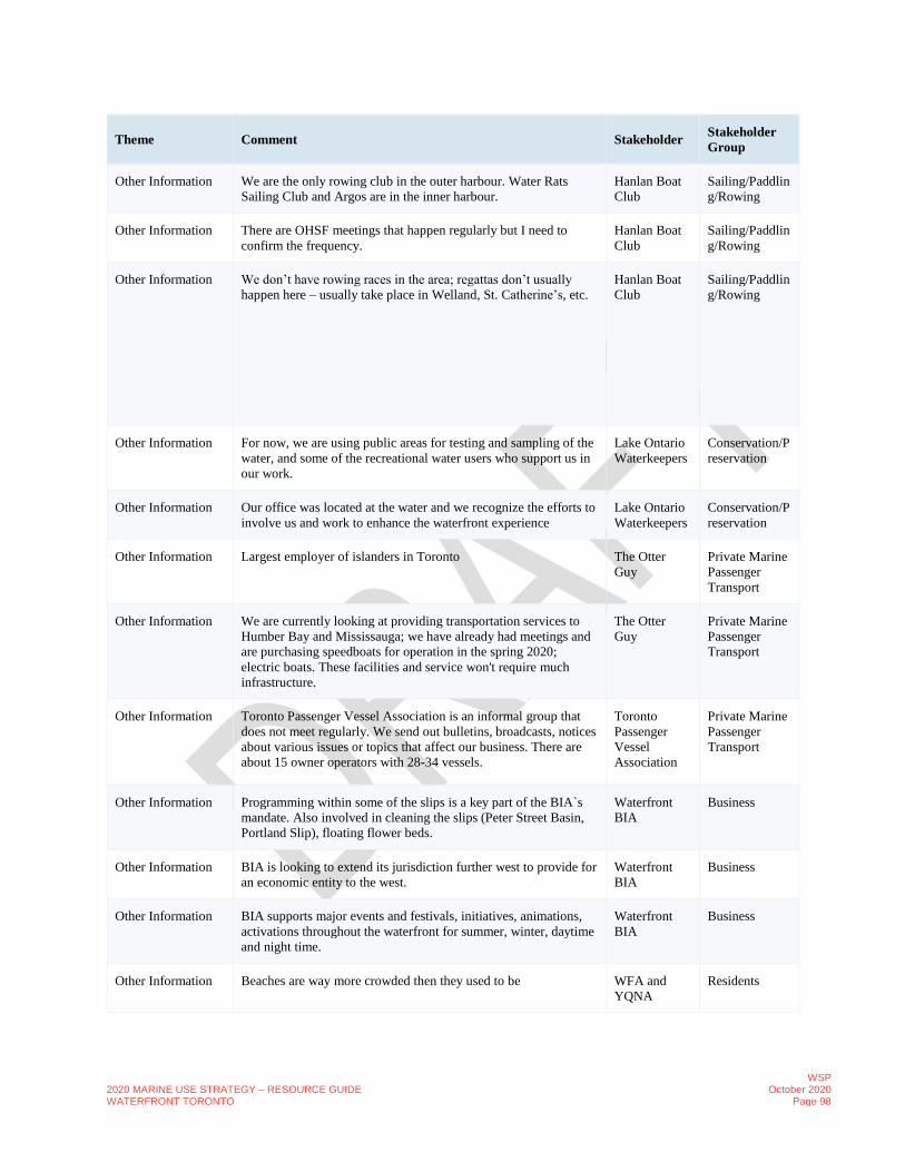
2020 MARINE USE STRATEGY – RESOURCE GUIDE WATERFRONT TORONTO
WSP October 2020
Page 98
Theme Comment Stakeholder Stakeholder
Group
Other Information We are the only rowing club in the outer harbour. Water Rats
Sailing Club and Argos are in the inner harbour.
Hanlan Boat
Club
Sailing/Paddlin
g/Rowing
Other Information There are OHSF meetings that happen regularly but I need to
confirm the frequency.
Hanlan Boat
Club
Sailing/Paddlin
g/Rowing
Other Information We don’t have rowing races in the area; regattas don’t usually
happen here – usually take place in Welland, St. Catherine’s, etc.
Hanlan Boat
Club
Sailing/Paddlin
g/Rowing
Other Information For now, we are using public areas for testing and sampling of the
water, and some of the recreational water users who support us in
our work.
Lake Ontario
Waterkeepers
Conservation/P
reservation
Other Information Our office was located at the water and we recognize the efforts to
involve us and work to enhance the waterfront experience
Lake Ontario
Waterkeepers
Conservation/P
reservation
Other Information Largest employer of islanders in Toronto The Otter
Guy
Private Marine
Passenger
Transport
Other Information We are currently looking at providing transportation services to
Humber Bay and Mississauga; we have already had meetings and
are purchasing speedboats for operation in the spring 2020;
electric boats. These facilities and service won't require much
infrastructure.
The Otter
Guy
Private Marine
Passenger
Transport
Other Information Toronto Passenger Vessel Association is an informal group that
does not meet regularly. We send out bulletins, broadcasts, notices
about various issues or topics that affect our business. There are
about 15 owner operators with 28-34 vessels.
Toronto
Passenger
Vessel
Association
Private Marine
Passenger
Transport
Other Information Programming within some of the slips is a key part of the BIA`s
mandate. Also involved in cleaning the slips (Peter Street Basin,
Portland Slip), floating flower beds.
Waterfront
BIA
Business
Other Information BIA is looking to extend its jurisdiction further west to provide for
an economic entity to the west.
Waterfront
BIA
Business
Other Information BIA supports major events and festivals, initiatives, animations,
activations throughout the waterfront for summer, winter, daytime
and night time.
Waterfront
BIA
Business
Other Information Beaches are way more crowded then they used to be WFA and
YQNA
Residents

2020 MARINE USE STRATEGY – RESOURCE GUIDE WATERFRONT TORONTO
WSP October 2020
Page 99
Theme Comment Stakeholder Stakeholder
Group
Other Information it's okay. could be a lot better. Public
Intercepts
Public
Other Opportunities More frequent LRT service BQNA Residents
Other Opportunities The Bathurst Quay Neighbourhood Plan BQNA Residents
Other Opportunities There is a lack of First Nation culture and works. There is a house
boat docked by a Native Elder, who works in partnership with
Ontario Place and Myseym to present about native culture and
arts.
BQNA Residents
Other Opportunities Gord Downey Pier is a great example of what to do with a
waterfront.
BQNA Residents
Other Opportunities Preservation of greenspace along the waterfront BQNA Residents
Other Opportunities Health and well being need more public space BQNA Residents
Other Opportunities Enhance the Natural Aspects of the WT instead of Add to it; Bring
Back Nature
BQNA Residents
Other Opportunities In Chicago they have architecture tour, maybe we can have a
revitalization or heritage tour.
Mariposa
Cruises
Private Marine
Passenger
Transport
Other Opportunities Cruise guests are amazed at the difference between waterfront and
Toronto islands; opportunity to create something similar in the
port lands or east bayfront.
Mariposa
Cruises
Private Marine
Passenger
Transport
Other Opportunities We are looking for opportunities for new cruising; maybe a
marine route near the port lands or the Keating channel.
Mariposa
Cruises
Private Marine
Passenger
Transport
Other Opportunities Ontario Place is a great place for new dock wall. Mariposa
Cruises
Private Marine
Passenger
Transport
Other Opportunities Transit and Access is key in order for the Anchor to work RCYC Yacht
Club/Marina
Other Opportunities Enhancing the Natural Areas the beaches is a key priority and
protection. There is a huge market opportunity for the Islands but
there is no way to use it. Swimming and New Canadians who do
to have a cottage are really looking for this area as a refuge
RCYC Yacht
Club/Marina
Other Opportunities London is a good example* Water Taxis from Tower Bridge to the
Waterfront. How can we minimize Traffic by using boat services
or marine uses across the waterfront.
RCYC Yacht
Club/Marina

2020 MARINE USE STRATEGY – RESOURCE GUIDE WATERFRONT TORONTO
WSP October 2020
Page 100
Theme Comment Stakeholder Stakeholder
Group
Other Opportunities Spatial Typologies of Waterfronts - Toronto is unique cause it has
a hard edge harbour but also an archaepelgia of the soft edge with
a unique Island view looking back to the City… this may not exist
anywhere
RCYC Yacht
Club/Marina
Other Opportunities Emirates Cup
Sailing GP – a professional Sailing League has emerged this is the
first year and has an event in San Francisco and New York
Toronto may have the ability to host an event here
RCYC Yacht
Club/Marina
Other Opportunities There is limited outreach and education. There appears to be a
perception that safety is important. it would b good to see that
there is more education and outreach with Yacht Clubs Boating
Clubs or Schools.
The volume of ships coming in is not that great and may be
unnoticed. The Ports Toronto can show a greater initiative to do
more outreach and education
Toronto
Industry
Network
Industry
Other Opportunities Integrating the transit facilities proposed to the east - the East
Harbour GO/SmartTrack facilities - to the water's edge.
Waterfront
BIA
Business
Other Opportunities Creating another table of major and key stakeholders such as
Waterfront Toronto, the Harbourfront Centre, Ports Toronto, etc.
to coordinate the management and growth of the waterfront.
Waterfront
BIA
Business
Other Opportunities Should do a proper inventory of all the cruise ships to ensure we
aren't overwhelming the water with traffic.
Waterfront
BIA
Business
Other Opportunities It is of interest to fill in and activate space west of Yonge. Waterfront
BIA
Business
Other Opportunities Water taxing and water bussing as public transportation to the
Ontario Place from the central waterfront has been suggested.
Water taxis are fragmented and ad-hoc, most of traffic is to the
islands. Thinking about how we can use the water better for
transportation that is not just destination-based. Water taxing and
water bussing as public transportation to the Ontario Place from
the central waterfront has been suggested.
Water taxis are fragmented and ad-hoc, most of traffic is to the
islands
Thinking about how we can use the water better for transportation
that is not just destination-based.
Waterfront
BIA
Business
Other Opportunities Important to consider the views from the waterfront; harness the
view out onto the harbour.
Waterfront
BIA
Business

2020 MARINE USE STRATEGY – RESOURCE GUIDE WATERFRONT TORONTO
WSP October 2020
Page 101
Theme Comment Stakeholder Stakeholder
Group
Other Opportunities Infrastructure and buildings with a water-related purpose should
not be repurposed for non-water-related purposes, which is a step
in the wrong direction. Ex. The warehouse and film studios are
obstructing the waterfront access. The space should be used for a
waterfront function.
WFA and
YQNA
Residents
Other Opportunities CONNECTION TO THE EAST of the Waterfront
Waterfront usage in the east would be beneficial in the future
Aspirational goals and takes concentration from Downtown and
spreads it out.
WFA and
YQNA
Residents
Other Opportunities Having more sheltered anchors for boats is important for us and
our members.
National
Yacht Club
Yacht
Club/Marina
Other Opportunities We need more destinations along the waterfront where there is
docking space for boats to pull up. Such as a floating café near the
islands with a view to the skyline.
National
Yacht Club
Yacht
Club/Marina
Other Opportunities There could be potential for east to west transportation along the
water connecting the central waterfront to the east bayfront. There
has been transportation similar to that in previous years from the
Distillery for Luminato.
The
Harbourfront
Centre
Art
Studio/Gallery
Other Opportunities Unfortunately, it is difficult to run regular service in Lake Ontario
as the reliability of the water conditions isn't great, along with east
winds. And there isn't enough of a demand at the moment for east-
west in the water.
The
Harbourfront
Centre
Art
Studio/Gallery
Other Opportunities Parasailing did happen for one season off a platform at the
Harbourfront Centre (west end).
The
Harbourfront
Centre
Art
Studio/Gallery
Other Opportunities Fishing has been missing; a designated fishing area would be nice. The
Harbourfront
Centre
Art
Studio/Gallery
Other Opportunities Facilities and service at the sailboat rental place could be better. Public
Intercepts
Public
Other Opportunities Revitalized Don River should make canoeing and kayaking much
better.
Public
Intercepts
Public
Other Opportunities Better boat rental and more sailing clubs (esp. w memberships
open to pubic)
Public
Intercepts
Public
Other Opportunities Affordable and more options to rent. Public
Intercepts
Public
Other Opportunities WT has a good mandate with the waterfront. Often forgotten in
these studies- arts and culture aspect.
Pirate Life Art
Studio/Gallery

2020 MARINE USE STRATEGY – RESOURCE GUIDE WATERFRONT TORONTO
WSP October 2020
Page 102
Theme Comment Stakeholder Stakeholder
Group
Other Opportunities Provide subsidized – if 20% affordable – 20% subsisted
commercial space for organizations. Marine access should be
marine access.
Pirate Life Art
Studio/Gallery
Other Opportunities Social business model – as non- for profit – tax structure is
incorporated triple bottom line – purpose, planet, People you use
it. Profit – gets reinvested.
Pirate Life Art
Studio/Gallery
Other Opportunities Quayside development* (*refers to Sidewalk Labs proposal which
was still in exploration at the time of the interview) – there’s
subsidized residential but what about subsidized commercial
spaces? Corus provides – kids; upfront gets free office space gets
tickets to event to city for lower income. Starlight foundation –
operated boats but boats are expensive access is hard too.
Pirate Life Art
Studio/Gallery
Other Opportunities Would like to see more for adaptive/disabled sporting
opportunities
DSOA Sailing/Paddlin
g/Rowing
Other Opportunities
- Potential Boat
Launch Sites
Don River Public
Intercepts
Public
Other Opportunities
- Potential Boat
Launch Sites
anywhere readily accessible by foot, bike, and transit access.
naturalized space away from bustle on Queens Quay
Public
Intercepts
Public
Other Opportunities
- Potential Boat
Launch Sites
Sugar Beach, in the new Villiers Island area, Ireland Park Public
Intercepts
Public
Other Opportunities
- Potential Boat
Launch Sites
Inner harbour is not necessary but near cherry beach would be
helpful
Public
Intercepts
Public
Other Opportunities
- Potential Boat
Launch Sites
Eastern harbour Public
Intercepts
Public
Other Opportunities
- Potential Boat
Launch Sites
A good quality kayak launching site would be nice at the kayak
centre
Public
Intercepts
Public
Other Opportunities
- Potential Boat
Launch Sites
East of Yonge Public
Intercepts
Public
Other Opportunities
- Potential Boat
Launch Sites
Anywhere along Harbourfront. Portland’s. Sunnyside. Trillium
Park.
Public
Intercepts
Public
Other Opportunities
- Potential Boat
Launch Sites
Ontario Place Public
Intercepts
Public

2020 MARINE USE STRATEGY – RESOURCE GUIDE WATERFRONT TORONTO
WSP October 2020
Page 103
Theme Comment Stakeholder Stakeholder
Group
Other Opportunities
- Potential Boat
Launch Sites
Dc Public
Intercepts
Public
Other Opportunities
- Potential Boat
Launch Sites
Cherry, Lesley Pitts, commissioner Public
Intercepts
Public
Other Opportunities
- Potential Short-
Term Docking Sites
anywhere? I’m not sure this is something I can really identify for
you. I think the entire waterfront should have more physical space
separated from roadways including a physical buffer (tall
evergreens?) to make it feel like you're actually getting away from
the city. right now it just feels like you step out of your car into
parking lot and then walk a few feet to the trash bin Lake Ontario
Public
Intercepts
Public
Other Opportunities
- Potential Short-
Term Docking Sites
Sugar Beach, in the new Villiers Island area, Ireland Park Public
Intercepts
Public
Other Opportunities
- Potential Short-
Term Docking Sites
Dc Public
Intercepts
Public
Other Opportunities
- Potential Short-
Term Docking Sites
Sherbourne Commons, Queens Quay, anywhere to access parks,
restaurants etc.
Public
Intercepts
Public
Other Opportunities
- Potential Short
Term Docking Sites
Along the water inner harbor Public
Intercepts
Public
Partnerships We run a kids rowing camp to attract children who wouldn't
usually get the opportunity to row. We also have competitive
rowing camps.
Hanlan Boat
Club
Sailing/Paddlin
g/Rowing
Partnerships We also rent our space to the University of Toronto, Upper
Canada College, and one other. UCC is now building a boathouse
nearby.
Hanlan Boat
Club
Sailing/Paddlin
g/Rowing
Partnerships Build partnerships with school boards to host activities for
children at the waterfront and the islands. Currently we host
almost 60,000 kids per year for a life safety, indigenous and art
activities
The Otter
Guy
Private Marine
Passenger
Transport
Partnerships Industry participates in Open Doors every year* to support the
education of the Port Usage
Toronto
Industry
Network
Industry
Partnerships The Industries are keen on partnering with the other groups. Toronto
Industry
Network
Industry
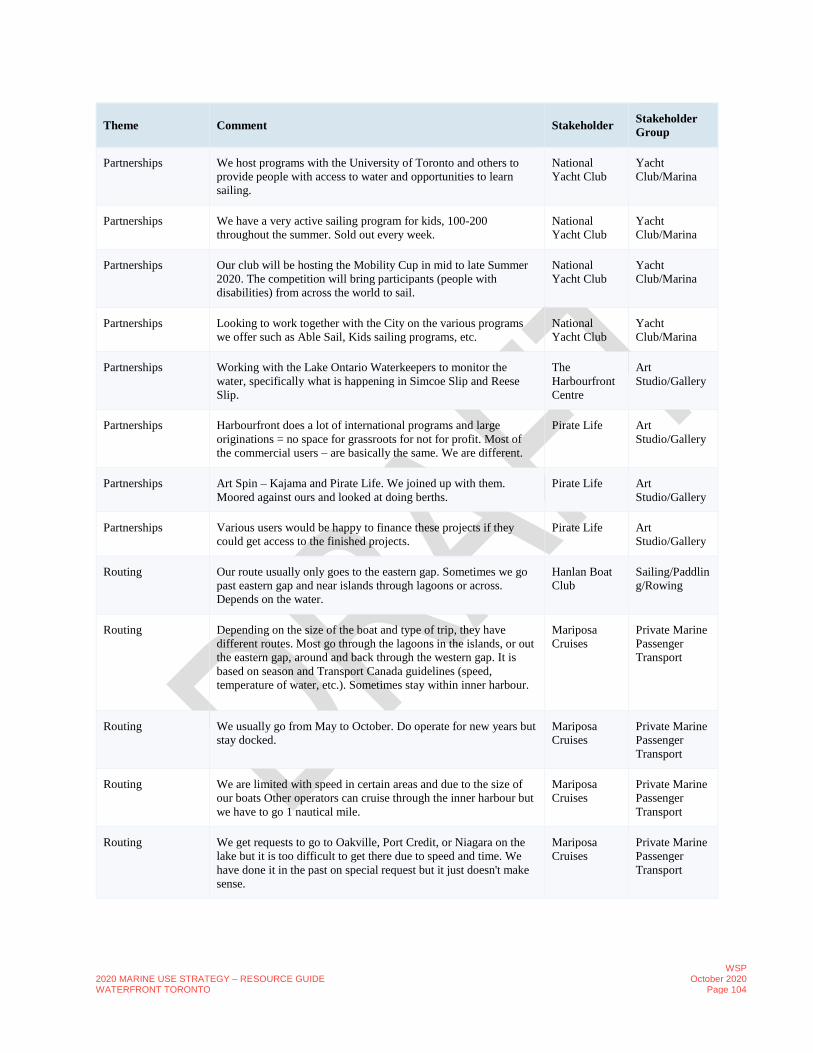
2020 MARINE USE STRATEGY – RESOURCE GUIDE WATERFRONT TORONTO
WSP October 2020
Page 104
Theme Comment Stakeholder Stakeholder
Group
Partnerships We host programs with the University of Toronto and others to
provide people with access to water and opportunities to learn
sailing.
National
Yacht Club
Yacht
Club/Marina
Partnerships We have a very active sailing program for kids, 100-200
throughout the summer. Sold out every week.
National
Yacht Club
Yacht
Club/Marina
Partnerships Our club will be hosting the Mobility Cup in mid to late Summer
2020. The competition will bring participants (people with
disabilities) from across the world to sail.
National
Yacht Club
Yacht
Club/Marina
Partnerships Looking to work together with the City on the various programs
we offer such as Able Sail, Kids sailing programs, etc.
National
Yacht Club
Yacht
Club/Marina
Partnerships Working with the Lake Ontario Waterkeepers to monitor the
water, specifically what is happening in Simcoe Slip and Reese
Slip.
The
Harbourfront
Centre
Art
Studio/Gallery
Partnerships Harbourfront does a lot of international programs and large
originations = no space for grassroots for not for profit. Most of
the commercial users – are basically the same. We are different.
Pirate Life Art
Studio/Gallery
Partnerships Art Spin – Kajama and Pirate Life. We joined up with them.
Moored against ours and looked at doing berths.
Pirate Life Art
Studio/Gallery
Partnerships Various users would be happy to finance these projects if they
could get access to the finished projects.
Pirate Life Art
Studio/Gallery
Routing Our route usually only goes to the eastern gap. Sometimes we go
past eastern gap and near islands through lagoons or across.
Depends on the water.
Hanlan Boat
Club
Sailing/Paddlin
g/Rowing
Routing Depending on the size of the boat and type of trip, they have
different routes. Most go through the lagoons in the islands, or out
the eastern gap, around and back through the western gap. It is
based on season and Transport Canada guidelines (speed,
temperature of water, etc.). Sometimes stay within inner harbour.
Mariposa
Cruises
Private Marine
Passenger
Transport
Routing We usually go from May to October. Do operate for new years but
stay docked.
Mariposa
Cruises
Private Marine
Passenger
Transport
Routing We are limited with speed in certain areas and due to the size of
our boats Other operators can cruise through the inner harbour but
we have to go 1 nautical mile.
Mariposa
Cruises
Private Marine
Passenger
Transport
Routing We get requests to go to Oakville, Port Credit, or Niagara on the
lake but it is too difficult to get there due to speed and time. We
have done it in the past on special request but it just doesn't make
sense.
Mariposa
Cruises
Private Marine
Passenger
Transport

2020 MARINE USE STRATEGY – RESOURCE GUIDE WATERFRONT TORONTO
WSP October 2020
Page 105
Theme Comment Stakeholder Stakeholder
Group
Routing They sail anywhere on the harbour, rarely go onto the lake as their
boats are not designed for big waves.
DSOA Sailing/Paddlin
g/Rowing
Routing Access inner harbour a lot as they’re not a Yacht club and most
boats are dinghies – they don’t go from club to club. Nearly 100%
of the sailing at the clubs is day sailing, or they hold regattas,
boating education, and then return directly to the club.
OHSF Sailing/Paddlin
g/Rowing
Routing Water routes: clubs use outer harbour – 75%, 25% - inner harbour
Dinghies don’t go past the marker points – not safe
100% inner or outer harbour use
OHSF Sailing/Paddlin
g/Rowing
Safety Submerged docks and high-water levels BQNA Residents
Safety Nothing that we have seen that impacts safety at all other than that
it is safe.
Great Lakes
Cruising
Coalition
Cruise Lines
Safety Concern is how to balance the uses of power boats vs. non-power
boats?
Hanlan Boat
Club
Sailing/Paddlin
g/Rowing
Safety We do have safety rules and regulations we follow especially
when it comes to temperature and wind - sometimes you just can't
row. Other times you need a coach boat with you.
Hanlan Boat
Club
Sailing/Paddlin
g/Rowing
Safety We have to be careful when we pass the eastern channel due to
vessel traffic. We have instances where some commercial boats
have come too close and we have caught a wave.
Hanlan Boat
Club
Sailing/Paddlin
g/Rowing
Safety There is a safety issue as there is no lighting west of cherry beach,
there is a gravel road with no lighting. Definitely late-night usage
near the beach, large groups of young people gather sometimes
late at night
Hanlan Boat
Club
Sailing/Paddlin
g/Rowing
Safety We would be concerned if there is an increase in power boat
usage.
Hanlan Boat
Club
Sailing/Paddlin
g/Rowing
Safety The harbour is getting very busy as it is a mixed-use waterfront.
Anytime you have mixed there is more opportunity for users who
are inexperienced and don't know rules.
Mariposa
Cruises
Private Marine
Passenger
Transport
Safety Sometimes we see recreational users such as kayakers at night
without navigation lights.
Mariposa
Cruises
Private Marine
Passenger
Transport
Safety As an operator you want to move the larger vessels out of the
inner harbour as soon as possible due to the busy-ness.
Mariposa
Cruises
Private Marine
Passenger
Transport

2020 MARINE USE STRATEGY – RESOURCE GUIDE WATERFRONT TORONTO
WSP October 2020
Page 106
Theme Comment Stakeholder Stakeholder
Group
Safety Suggest there should be a specific route for recreational users from
the islands to the waterfront. Right now they travel in all
directions.
Mariposa
Cruises
Private Marine
Passenger
Transport
Safety There is a Harbourfront Liaison Committee which meets monthly
to talk about events and collaborations, issues, etc. Marine, Police,
Fire, Marinas, Operators, Sometimes residents, TRCA,
Environment Canada - infrequent attendance.
Mariposa
Cruises
Private Marine
Passenger
Transport
Safety Would be useful to have a universal boat ramp/dock that all boats
can use. Could be used for emergencies when we need to offload.
Mariposa
Cruises
Private Marine
Passenger
Transport
Safety Marine police held a session with passenger vessel operators on
possible emergency situations
Mariposa
Cruises
Private Marine
Passenger
Transport
Safety No one was aware of safety credentials and rules of boating. The Otter
Guy
Private Marine
Passenger
Transport
Safety We started a safety school for people to learn boat safety and
licencing.
The Otter
Guy
Private Marine
Passenger
Transport
Safety Need people who can monitor the dock such as a dock master. We
have had issues where people have fallen into the water and we
had to send a rescue team. We now have many cameras along our
building and always ensure our passengers are getting back on
land safely.
The Otter
Guy
Private Marine
Passenger
Transport
Safety Pier 27 is an area that is often unsafe. The Otter
Guy
Private Marine
Passenger
Transport
Safety Need a marine emergency service center that is a few feet higher
then the rest of the waterfront to ensure they can be operational
during extreme weather events/high water levels.
The Otter
Guy
Private Marine
Passenger
Transport
Safety Section on the east end of the Dock wall is in poor condition and
maintenance of the place is a huge issue.
Toronto
Industry
Network
Industry
Safety A Boulevard in front of a dock wall near Windsor Salt will not
work because of health and safety restrictions. Active Industrial
Sites cannot be open to pedestrians.
Toronto
Industry
Network
Industry
Safety The industry is responsible for securing safety around the vessel
and must provide safety in an area that may not necessarily be
theirs. This poses issues with future increased pedestrian and
recreational boating.
Toronto
Industry
Network
Industry

2020 MARINE USE STRATEGY – RESOURCE GUIDE WATERFRONT TORONTO
WSP October 2020
Page 107
Theme Comment Stakeholder Stakeholder
Group
Safety Bridges and Heavy Operational Concerns with the future because
of large piles and machinery,
Toronto
Industry
Network
Industry
Safety Overhang on each others’ properties is an issue Toronto
Industry
Network
Industry
Safety Behind the Pier 27 development, the area isn`t as animated. Can
be a safety issue but also needs more public access and activities.
Waterfront
BIA
Business
Safety People are cognizant of the water and even the activations and
animations are relatively safe
Waterfront
BIA
Business
Safety It becomes very tough with huge crowds such as when the large
duck, and Jays games and managing flows of people. It is
important to create different zones of the waterfront with different
levels of activity to manage flows and activities.
Development of East Bayfront will help significantly in diverting
crowds.
Waterfront
BIA
Business
Safety In 2006 study dock walls were in good shape. But the resident said
that the dock walls are not currently in good shape.
The Pier located at the northwest corner of the eastern gap had a
long pier that was unsafe and underwater when there were high
water level conditions that the City had to remove. Divided
jurisdiction is an issue as it is not clear who owns the dock wall
and who should maintain. (ex. collapse of western gap north
seawall at the National Yacht Club a few years ago.)
WFA and
YQNA
Residents
Safety Lack of buoys, ladders is a major safety issue. Some property
owners Tridel and Heinz have added safety ladders but others
have not. Pier 27 does not have ladders.
WFA and
YQNA
Residents
Safety Need markets with numbers and showing locations, safety phones;
more directional signage,
WFA and
YQNA
Residents
Safety Water Taxis sometimes go very fast and sometimes hit people.
Speed limits are not being followed.
WFA and
YQNA
Residents
Safety Enforcement is an issue for tourists who are kayaking for the first
time.
WFA and
YQNA
Residents
Safety Need to have 'keep-out' buoys - need to educate on why things are
blocked off.
WFA and
YQNA
Residents
Safety We have had to hire police officers to ticket cars parked illegally
on Stadium Road (specifically during shows like the Air Show.
National
Yacht Club
Yacht
Club/Marina

2020 MARINE USE STRATEGY – RESOURCE GUIDE WATERFRONT TORONTO
WSP October 2020
Page 108
Theme Comment Stakeholder Stakeholder
Group
Safety The water taxis go really fast - don't necessarily follow the speed
restrictions.
National
Yacht Club
Yacht
Club/Marina
Safety We have buoys, red and yellow markers that show our entrances
and exits to the harbour.
National
Yacht Club
Yacht
Club/Marina
Safety There aren’t enough facilities like maps, and tools in case
something happens by the waterfront. The visibility is not the
greatest by the water's edge.
The
Harbourfront
Centre
Art
Studio/Gallery
Safety We had red painted towers which would have devices to help in
case of emergencies. They were taken down when it was
revitalized with short metal poles that host these devices. They are
extremely difficult to see. Therefore, we need a new strategy for
safety that will make these more visible and prevalent along the
waterfront.
The
Harbourfront
Centre
Art
Studio/Gallery
Safety Ladders to access the water in case of emergencies are of two
types:
1. Fixed ladders and towers; they can either be bolted into the
dock wall which can result in damage from water, ice, winter
conditions
2. Raised ladders, when the lake is frozen they are raised. But then
if the lake thaws it’s a safety issue.
The
Harbourfront
Centre
Art
Studio/Gallery
Safety Location maps are also required to know where you’re located in
case of an emergency.
The
Harbourfront
Centre
Art
Studio/Gallery
Safety Some interlocking along the main pathways and walkways needs
to be changed - is becoming a safety issue.
The
Harbourfront
Centre
Art
Studio/Gallery
Safety Marine emergency services are on site and we Have regular
meetings with them, good relationship.
The
Harbourfront
Centre
Art
Studio/Gallery
Safety Safety record of things that happen on the water is quite good
Waterfront at the peak of kids camps are very busy, but things are
very safe.
The
Harbourfront
Centre
Art
Studio/Gallery
Safety We have supported and tried to work with them to create a
controlled environment for them. We have 4 strategic locations
where we allow for water taxis
1. York Slip, 2. York Quay, 3. Peter Street Bridge (unusable due
to high water level this year) and 4. Spadina slip
The wake they create due to the traffic impacts the boats in the
Marina, and boats parked. We have spoken to emergency facilities
and management in regard to abiding by the regulations such as
speeding and managing the wakes.
The
Harbourfront
Centre
Art
Studio/Gallery

2020 MARINE USE STRATEGY – RESOURCE GUIDE WATERFRONT TORONTO
WSP October 2020
Page 109
Theme Comment Stakeholder Stakeholder
Group
Safety As the traffic continues to increase these are some things to be
conscious of (Speed, congestion, wakes). It has increased over the
last few years.
The
Harbourfront
Centre
Art
Studio/Gallery
Safety We are thinking about putting in safety regulations to abide into
the contract when we rent or lease our spaces.
The
Harbourfront
Centre
Art
Studio/Gallery
Safety Too many water taxis and boats going too fast creating large
wakes make kayaking in inner harbour challenging. Sometimes its
like being in a washing machine.
Public
Intercepts
Public
Safety Speed limit is so slow, meanwhile the tiki taxis seem to go as fast
as they want. Unfair the police aren’t more consistent.
Public
Intercepts
Public
Safety Have been kayaking quite a number of years in the inner harbour
and it seems to be getting more chaotic every year. The number of
water taxis is multiply yearly, the number of jet skis is increasing
and they generally seem to race through the harbour and some
boats also speed through at times. This all creates a lot of wake
and washing machine like conditions in the water. Not a great
experience.
Public
Intercepts
Public
Safety Safety issues – encourage my captain to be active on the VHF
radios – they should communicate. No clear lines for traffic.
Recreational boat users. What kind of greater awareness can we
provide to the communications. All commercial operators Channel
16 by law. Commercial operators – communications need to be
established. Transport Canada does not monitor it. means to
measure the nautical speed of the vessel – if its required by the
permit. It becomes a city requirement. Bring some clarity to it.
Speed it set by PT now?
Pirate Life Art
Studio/Gallery
Safety The location can be incredibly busy at times and very unsafe.
DSOA tries to have an understanding with all the regular
neighbours for space usages and right of ways.
DSOA Sailing/Paddlin
g/Rowing
Safety Most dangerous is leaving the channel – need to navigate motor-
boat traffic from the City wall to Amsterdam Brewery or the
Corus building (it is technically a shipping lane so they don’t use
but can be difficult to get across the laneway). Generally, their
boats go straight out of their dock, through shipping lane and past
the tour boats to get to the sailing area. Their sail trips are only an
hour in length and the difficulty in getting across to the harbour to
sail can add significant time to the trips.
DSOA Sailing/Paddlin
g/Rowing
Safety Seen an increase in number of water taxis who travel at dangerous
speeds.
DSOA Sailing/Paddlin
g/Rowing

2020 MARINE USE STRATEGY – RESOURCE GUIDE WATERFRONT TORONTO
WSP October 2020
Page 110
Theme Comment Stakeholder Stakeholder
Group
Safety DSOA works with neighbours to improve flow and access for
other users (canoe and kayak); need more work with HFC to make
area less dangerous for members; their boats are often damaged as
they’re the last in the slip and get clipped as others leave; one
instance, a new user (tourist) in rental boat T-Boned a DSOA boat
as member was dismounting and caused them to have a major
seizure.
DSOA Sailing/Paddlin
g/Rowing
Safety Would like to see a limit to number of taxi licenses and speed in
the harbour
DSOA Sailing/Paddlin
g/Rowing
Safety Biggest problem with power boats, speeding the biggest concern OHSF Sailing/Paddlin
g/Rowing
Safety Common understanding between the rowers, windsurfers,
kayakers and canoers – use a hierarchy and road rules, with only
occasional issues
OHSF Sailing/Paddlin
g/Rowing
Safety would like to see a larger marine police presence the waters –
believe it would help with the speeding issues (don’t see many
alcohol related issues) as there is temptation to be use the power
boats like race cars which provides safety issues for the small
water crafts.
OHSF Sailing/Paddlin
g/Rowing
Safety Overall very safe OHSF Sailing/Paddlin
g/Rowing
Safety It’s a very isolated and dark place and the clubs don’t want any
assaults or causes for harm. Regatta road – has some from the
sports fields, but going south along the club areas, just pitch black,
not the MGT, on the E-W section of regatta road; Lots of sexual
activity, not drug use, in the fields nearby – concern for safety for
younger users
OHSF Sailing/Paddlin
g/Rowing
Space Utilization At the outset the Harbourfront and the Centre is a massive issue
year-round. The requirement for street related retail is an issue
because of the developers
RCYC Yacht
Club/Marina
Space Utilization Some of the challenges include conflicting mandates for the
Harbourfront and the local businesses or water taxis. As the
Harbourfront is focused on arts and entertainment and not
necessarily managing a business. This results in a lot of
underutilized space within the Harbourfront Centre.
Waterfront
BIA
Business
Sustainability Not sure - would need to ask each of the operators. Great Lakes
Cruising
Coalition
Cruise Lines
Sustainability Would love the ability not to use generators; may switch to
electric.
Mariposa
Cruises
Private Marine
Passenger
Transport
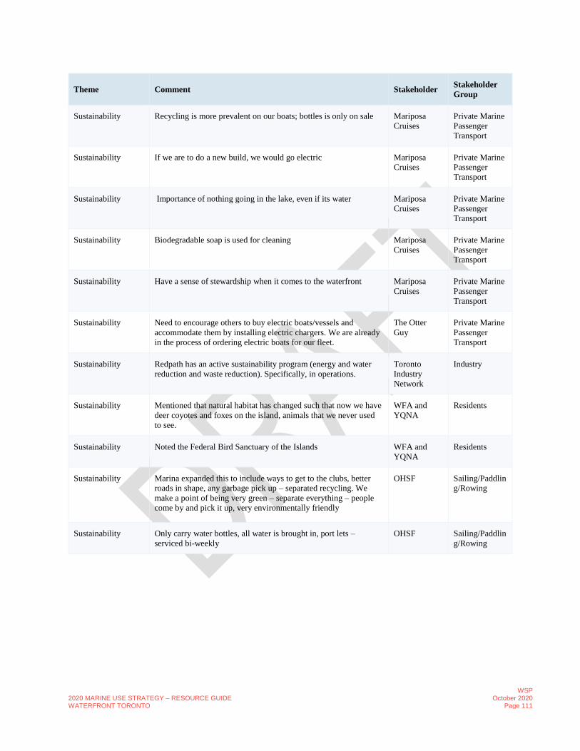
2020 MARINE USE STRATEGY – RESOURCE GUIDE WATERFRONT TORONTO
WSP October 2020
Page 111
Theme Comment Stakeholder Stakeholder
Group
Sustainability Recycling is more prevalent on our boats; bottles is only on sale Mariposa
Cruises
Private Marine
Passenger
Transport
Sustainability If we are to do a new build, we would go electric Mariposa
Cruises
Private Marine
Passenger
Transport
Sustainability Importance of nothing going in the lake, even if its water Mariposa
Cruises
Private Marine
Passenger
Transport
Sustainability Biodegradable soap is used for cleaning Mariposa
Cruises
Private Marine
Passenger
Transport
Sustainability Have a sense of stewardship when it comes to the waterfront Mariposa
Cruises
Private Marine
Passenger
Transport
Sustainability Need to encourage others to buy electric boats/vessels and
accommodate them by installing electric chargers. We are already
in the process of ordering electric boats for our fleet.
The Otter
Guy
Private Marine
Passenger
Transport
Sustainability Redpath has an active sustainability program (energy and water
reduction and waste reduction). Specifically, in operations.
Toronto
Industry
Network
Industry
Sustainability Mentioned that natural habitat has changed such that now we have
deer coyotes and foxes on the island, animals that we never used
to see.
WFA and
YQNA
Residents
Sustainability Noted the Federal Bird Sanctuary of the Islands WFA and
YQNA
Residents
Sustainability Marina expanded this to include ways to get to the clubs, better
roads in shape, any garbage pick up – separated recycling. We
make a point of being very green – separate everything – people
come by and pick it up, very environmentally friendly
OHSF Sailing/Paddlin
g/Rowing
Sustainability Only carry water bottles, all water is brought in, port lets –
serviced bi-weekly
OHSF Sailing/Paddlin
g/Rowing

2020 MARINE USE STRATEGY – RESOURCE GUIDE WATERFRONT TORONTO
WSP October 2020
Page 112
Theme Comment Stakeholder Stakeholder
Group
The Spit Access is currently restricted by land, but it should also be
restricted from the water. Landing of boats or mooring of boats,
should not be permitted.Aquatic Park Sailing Club – users have
access by vehicle. Once park is open full time there is no access
by vehicle allowed. One solution that we suggest is that they focus
on water access rather than vehicular access. The club is lobbying
and encouraging an increase in vehicular access and we fully
disagree with that.There is still some truck traffic in the spit. Ports
Toronto is responsible for enforcing the shoreline and sometimes
trucks do come through.
Friends of the
Spit
Conservation/P
reservation
The Spit We completely disagree with the idea of cutting a canal through
the spit. Would be a disaster for the habitats and the baselands.
Spit is not a city park, but should be maintained as a wilderness
and be kept natural No vehicular access; Pedestrian and Cyclist
friendly area only.
Friends of the
Spit
Conservation/P
reservation
The Spit Unauthorized entry into the spit is not being enforced. TRCA has
backed off, so Ports Toronto should be enforcing but they don’t
currently do that effectively.
Friends of the
Spit
Conservation/P
reservation
The Spit SPIT AND ASHBRIDGES: very isolated on Marine traffic
because you have to go around the spit.
Suggestion to open the turning Basin or cut a channel to have
access to the outer harbour.
WFA and
YQNA
Residents
Top Attributes Swimming off Ontario Place BQNA Residents
Top Attributes Fishing at the foot of Stadium Road and at the wall BQNA Residents
Top Attributes Keeping a working port is important for the history of the
waterfront
BQNA Residents
Top Attributes As Toronto grows and truck and vehicle traffic is an issue, having
a port is very important.
BQNA Residents
Top Attributes Yacht clubs are important and a major marina is favoured BQNA Residents
Top Attributes Slips for visitors and guests BQNA Residents
Top Attributes Chartered Boat Tours to Port Dalousey and Ports near Niagara and
the ferry system are all important
BQNA Residents
Top Attributes Not interested in Museum Ships BQNA Residents

2020 MARINE USE STRATEGY – RESOURCE GUIDE WATERFRONT TORONTO
WSP October 2020
Page 113
Theme Comment Stakeholder Stakeholder
Group
Top Attributes None of the water-based activities proposed in Table 1 would be
appropriate for the Spit. Possibly some recreational fishing.
No canal, sailing club, active uses, restaurants in the spit. The Spit
needs to be preserved and the habitats and marshes need to be kept
as they are.
Friends of the
Spit
Conservation/P
reservation
Top Attributes Maritime Museum would be great. Great Lakes
Cruising
Coalition
Cruise Lines
Top Attributes Open swimming would be nice. But important to have consistent
uses; for ex. If we have big marinas then recreational uses and
open swimming become tough.
Hanlan Boat
Club
Sailing/Paddlin
g/Rowing
Top Attributes Would be nice to have a nice pier where people can go out and eat. Hanlan Boat
Club
Sailing/Paddlin
g/Rowing
Top Attributes Preference is not for a cruise destination. Hanlan Boat
Club
Sailing/Paddlin
g/Rowing
Top Attributes Need to get more exposure about the boating and rowing clubs;
what is available and what we offer.
Hanlan Boat
Club
Sailing/Paddlin
g/Rowing
Top Attributes If we want a recreational pier we need to have anchors that can
attract and invite more people to come and use the waterfront
year-round.
Mariposa
Cruises
Private Marine
Passenger
Transport
Top Attributes Harbourfront centre has great programming but its just not big
enough to be an attraction.
Mariposa
Cruises
Private Marine
Passenger
Transport
Top Attributes Need to develop a four-season waterfront. Mariposa
Cruises
Private Marine
Passenger
Transport
Top Attributes We don't operate from January to March due to the market and the
Toronto harbour is really difficult to cruise in due to icing. Other
cities do it such as Boston and Chicago in similar weather
conditions. If there was an opportunity here it would be amazing.
Mariposa
Cruises
Private Marine
Passenger
Transport
Top Attributes We have had deteriorating usage of the western gap, we would
like the ability to travel into the west Humber Bay.
Waterfront
BIA
Business
Top Attributes We currently have tall ships that come in and out of the harbour;
cinema on the water, etc.
Waterfront
BIA
Business
Top Attributes Portage across the spit is very difficult WFA and
YQNA
Residents

2020 MARINE USE STRATEGY – RESOURCE GUIDE WATERFRONT TORONTO
WSP October 2020
Page 114
Theme Comment Stakeholder Stakeholder
Group
Top Attributes Commercial Shipping is not a Concern and is seen as giving the
Harbour “Credibility”. But there is a lack of data on commercial
shipping, i.e. how much dock space does it actually need?
WFA and
YQNA
Residents
Top Attributes Our centre is always active along the waterfront, and has people
going on and off the water.
The
Harbourfront
Centre
Art
Studio/Gallery
Top Attributes We work to have activities year-round, Summer - paddle boating,
and canoeing, skating in the winter. We are looking for more
activities and use of the water during the winter - this year looking
at the Nordic Festival.
The
Harbourfront
Centre
Art
Studio/Gallery
Top Attributes The whole idea of a successful waterfront, is that the cities see
themselves as a waterfront city – which Toronto doesn’t see itself
as. We need to change that perspective, need to think about our
city as a waterfront city. The Gardiner expressway is a great
barrier towards the Waterfront. Need to make the whole area more
accessible and we need to communicate better the various
activities and opportunities in regard to access to the water.
It’s a much bigger picture we have to think about, beyond the
waterfront area and make the surrounding area, especially the
Gardiner Expressway, more welcoming and flow into the
waterfront.
The
Harbourfront
Centre
Art
Studio/Gallery
Top Attributes Just getting out on the water Public
Intercepts
Public
Top Attributes seeing the city from a different vantage point. getting away from
trash ridden harbor.
Public
Intercepts
Public
Top Attributes Ease of access to Toronto Islands Public
Intercepts
Public
Top Attributes Inner harbour experience is non- existent when you are only
allowed to boat at a snail’s pace. Outer harbour is absolutely
beautiful.
Public
Intercepts
Public
Top Attributes It's fun in the city and makes sense to take advantage of being on a
lake!
Public
Intercepts
Public
Top Attributes Kayaking through the inner harbour early Sunday morning when
barely anybody is out there yet is quite wonderful.
Public
Intercepts
Public
Top Attributes Ferry island rides. Affordable way to get on the water. Public
Intercepts
Public
Top Attributes Being on the water in a city of 6 million people. Public
Intercepts
Public

2020 MARINE USE STRATEGY – RESOURCE GUIDE WATERFRONT TORONTO
WSP October 2020
Page 115
Theme Comment Stakeholder Stakeholder
Group
Top Attributes I like water taxis. they're convenient. Public
Intercepts
Public
Top Attributes Nothing. Public
Intercepts
Public
Top Attributes Active harbour, sailboat races w kids, gorgeous scenery. Hanlan’s
wall, Toronto island in general. Hanlan’s is awesome for
overnights of course & great dockmaster there
Public
Intercepts
Public
Top Attributes The views Public
Intercepts
Public
Top Attributes All of the 10 mentioned – medley of activities that play a role OHSF Sailing/Paddlin
g/Rowing
Tourism/Marketing Most cruise attendees want to visit major attractions in the City
such as the ROM, AGO, Distillery, etc. The waterfront has not
been a top attraction for the cruise operators and has not garnered
much interest.
Great Lakes
Cruising
Coalition
Cruise Lines
Tourism/Marketing If Waterfront Toronto/City could market the cruises better then it
would really help.
Great Lakes
Cruising
Coalition
Cruise Lines
Tourism/Marketing Attractions need to be meaningful for the cruisers to come to the
waterfront rather than the other main attractions. Its only pretty to
look at, but its difficult to attract people.
Great Lakes
Cruising
Coalition
Cruise Lines
Tourism/Marketing Cruise guests need to know more about the waterfront. Need to
use creativity and flair to get the Toronto Waterfront on the
Cruising map.
Great Lakes
Cruising
Coalition
Cruise Lines
Tourism/Marketing Work actively with the cruise planners to bring guests to the
waterfront.
Great Lakes
Cruising
Coalition
Cruise Lines
Tourism/Marketing It would be good to be able to attract more people who would be
nearby our club. Currently we don't have too many nearby. Most
members come from beaches. There is a growing appetite for
endurance sports such as rowing.
Hanlan Boat
Club
Sailing/Paddlin
g/Rowing
Tourism/Marketing There is positive sentiment around the waterfront but
apprehension about Waterfront congestion and high density
residential
RCYC Yacht
Club/Marina
Tourism/Marketing Viewshed and public use is high use attribute RCYC Yacht
Club/Marina

2020 MARINE USE STRATEGY – RESOURCE GUIDE WATERFRONT TORONTO
WSP October 2020
Page 116
Theme Comment Stakeholder Stakeholder
Group
Tourism/Marketing Each year there are more and more tourists coming, even when we
have high water levels. There is far more exposure of the islands
and there is so much happening
The Otter
Guy
Private Marine
Passenger
Transport
Tourism/Marketing Big Gap between Recreational Use and Industrial Use*
Suggestion that outreach and education can be done to help.
Toronto
Industry
Network
Industry
Tourism/Marketing The waterfront attracts large crowds over the summer without
nearby events. Different demographics of people also come at
different times or specific events.
Waterfront
BIA
Business
Tourism/Marketing Need in-destination perspectives to encourage people to come
back and visit again.
Waterfront
BIA
Business
Water Quality Over the years we have seen a huge increase in the number of
people using the harbour through events and activities and
increased development, however this has not resulted in ensuring
good water quality and cleanliness of the water. Based on our
testing the water has high levels of bacteria and sewage
release/discharge is happening a lot more often. The City does not
encourage recreational use of the inner harbour and therefore does
not monitor there (only monitors public beaches).
Lake Ontario
Waterkeepers
Conservation/P
reservation
Water Quality The Bathurst Quay has consistently had some of the worst water
quality in the harbourfront.
Lake Ontario
Waterkeepers
Conservation/P
reservation
Water Quality Awareness and knowledge of water quality and cleanliness by
marine users to encourage recreational usage of the harbour.
Lake Ontario
Waterkeepers
Conservation/P
reservation
Water Quality Ontario Place has some of the best quality of water - we are
encouraging usage of Ontario Place for recreational use as a result.
Lake Ontario
Waterkeepers
Conservation/P
reservation
Water Quality Millennials have a low usage of water based on data. Can`t expect
them to support the protection of water if they have no connection
with the water. Therefore, we would like the water to be kept
cleaner so more recreational uses can be made available.
Lake Ontario
Waterkeepers
Conservation/P
reservation
Water Quality All the ministries and agencies have interests but if quality
improves in the water then everything improves for the waterfront
in general.
Lake Ontario
Waterkeepers
Conservation/P
reservation
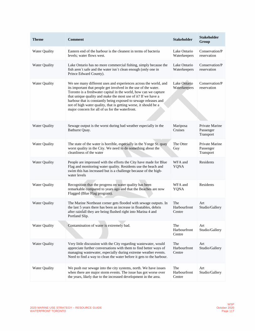
2020 MARINE USE STRATEGY – RESOURCE GUIDE WATERFRONT TORONTO
WSP October 2020
Page 117
Theme Comment Stakeholder Stakeholder
Group
Water Quality Eastern end of the harbour is the cleanest in terms of bacteria
levels; water flows west.
Lake Ontario
Waterkeepers
Conservation/P
reservation
Water Quality Lake Ontario has no more commercial fishing, simply because the
fish aren`t safe and the water isn`t clean enough (only one in
Prince Edward County).
Lake Ontario
Waterkeepers
Conservation/P
reservation
Water Quality We see many different uses and experiences across the world, and
its important that people get involved in the use of the water.
Toronto is a freshwater capital in the world, how can we capture
that unique quality and make the most use of it? If we have a
harbour that is constantly being exposed to sewage releases and
not of high water quality, that is getting worse, it should be a
major concern for all of us for the waterfront.
Lake Ontario
Waterkeepers
Conservation/P
reservation
Water Quality Sewage output is the worst during bad weather especially in the
Bathurst Quay.
Mariposa
Cruises
Private Marine
Passenger
Transport
Water Quality The state of the water is horrible, especially in the Yonge St. quay
worst quality in the City. We need to do something about the
cleanliness of the water
The Otter
Guy
Private Marine
Passenger
Transport
Water Quality People are impressed with the efforts the City have made for Blue
Flag and monitoring water quality. Residents use the beach and
swim this has increased but is a challenge because of the high-
water levels
WFA and
YQNA
Residents
Water Quality Recognition that the progress on water quality has been
remarkable compared to years ago and that the Beaches are now
Flagged (Blue Flag program).
WFA and
YQNA
Residents
Water Quality The Marine Northeast corner gets flooded with sewage outputs. In
the last 5 years there has been an increase in floatables, debris
after rainfall they are being flushed right into Marina 4 and
Portland Slip.
The
Harbourfront
Centre
Art
Studio/Gallery
Water Quality Contamination of water is extremely bad. The
Harbourfront
Centre
Art
Studio/Gallery
Water Quality Very little discussion with the City regarding wastewater, would
appreciate further conversations with them to find better ways of
managing wastewater, especially during extreme weather events.
Need to find a way to clean the water before it gets to the harbour.
The
Harbourfront
Centre
Art
Studio/Gallery
Water Quality We push our sewage into the city systems, north. We have issues
when there are major storm events. The issue has got worse over
the years, likely due to the increased development in the area.
The
Harbourfront
Centre
Art
Studio/Gallery

2020 MARINE USE STRATEGY – RESOURCE GUIDE WATERFRONT TORONTO
WSP October 2020
Page 118
Theme Comment Stakeholder Stakeholder
Group
Water Quality First address the sugar water issue. Public
Intercepts
Public
Water Quality Make enhanced water quality a haymaker. Stop dumping sewage
into the lake. Fund it.
Public
Intercepts
Public
Water Quality lots of trash in the water, no real area that feels like the
recreational space for boaters--very spotty throughout
Public
Intercepts
Public
Water Quality Garbage in water especially after heavy rain can also be very
nasty.
Public
Intercepts
Public
Water Quality Also sugar factory is polluting the water like crazy due to sugar
spillage.
Public
Intercepts
Public
Water Quality After a big rainstorm the nasty stuff that is then flushed into the
inner harbour is just gross – have seen everything from condoms,
tampon applicators, sanitary napkins, dead rats, etc.
Public
Intercepts
Public
Water Quality Disgustingly dirty, I now avoid it entirely. Public
Intercepts
Public
Water Quality Improve water quality. The water in east harbour is sugar water
due to spillage of sugar factory. Shouldn’t they be fined for
constantly polluting the water with sugar?
Public
Intercepts
Public
Water Quality Clean up the water quality – all the garbage that floats down there
is nasty. Have some kind of limit the amount of water taxis that
race through there continuously on the busy nice days.
Public
Intercepts
Public
Water Quality Water testing and cleaning up the harbour. Public
Intercepts
Public
Water Quality Clean water is important – the clubs users end up swimming a lot
(capsized) and the water isn’t terrific;
OHSF Sailing/Paddlin
g/Rowing
Water's Edge
Infrastructure
Improvements
The dock wall has been damaged over time and is sinking and has
visible deterioration. Is becoming a safety hazard for sailors. Also
limits protection from waves onto our property. Major
southwesterly waves cause significant wear and tear on the wall.
National
Yacht Club
Yacht
Club/Marina
Water's Edge
Infrastructure
Improvements
Seems like no one wants to repair the damaged dock wall because
there is disagreement on who owns it and should pay for damages.
In the past when a wall had collapsed, we had to pay a portion of
reconstruction costs for a damaged dock wall, even though we do
not own it - however we should not have to do it again.
National
Yacht Club
Yacht
Club/Marina
Water's Edge
Infrastructure
Improvements
Infrastructure improvements to the dock walls and berms is
crucial. Many are crumbling, falling apart, sinking.
National
Yacht Club
Yacht
Club/Marina

2020 MARINE USE STRATEGY – RESOURCE GUIDE WATERFRONT TORONTO
WSP October 2020
Page 119
Theme Comment Stakeholder Stakeholder
Group
Water's Edge
Infrastructure
Improvements
Even rebuilding the dock wall would require extensive planning as
its removal would expose our whole property. Another wall would
need to be built ahead of time.
National
Yacht Club
Yacht
Club/Marina
Water's Edge
Infrastructure
Improvements
We can’t build too many docks at the moment due to the
unrestricted impact of the waves to the docks, it will damage the
boats and docks if the wall isn’t fixed
National
Yacht Club
Yacht
Club/Marina
Water's Edge
Infrastructure
Improvements
Electric issues are a larger issue. General state of infrastructure.
One piece of a bigger picture where infrastructure hasn’t been
invested in over the years. The broader impact of improvements
has not been done.
The
Harbourfront
Centre
Art
Studio/Gallery
Water's Edge
Infrastructure
Improvements
50% of our revenue comes from our commercial activities. There
is no consistent source of funding for deteriorating infrastructure,
so the programming is allowing us to cover the costs. We are
currently in conversations with the federal government on how to
improve infrastructure in the waterfront.
The
Harbourfront
Centre
Art
Studio/Gallery
Water's Edge
Infrastructure
Improvements
The Nautical Centre area has many sink holes through there, and
they are slowly collapsing.
The
Harbourfront
Centre
Art
Studio/Gallery
Water's Edge
Infrastructure
Improvements
Spadina Pier needs revitalization. (539 Spadina) The
Harbourfront
Centre
Art
Studio/Gallery
Water's Edge
Infrastructure
Improvements
We need bridges across the edge. Public
Intercepts
Public

2020 MARINE USE STRATEGY – RESOURCE GUIDE WATERFRONT TORONTO
WSP October 2020
Page 120
F. ENGAGEMENT INDIGENOUS COMMUNITY
1. Presentation to the Aboriginal Affairs Advisory Committee, November 2019
Please visit this link to view the Aboriginal Affairs Advisory Committee Meeting Minutes:
http://app.toronto.ca/tmmis/viewPublishedReport.do?function=getMinutesReport&meetingId=17848
2. Meeting with the Mississaugas of the Credit First Nation (MCFN)
March 17, 2020, 1-2:30pm, conference call. Attendees: Fawn Sault (MCFN), Hilary Harrison (MCFN), Rei Tasaka (WT), Mira Shenker (WT), Kaleigh Wisman (WT).
• WT/City agreed that MCFN would be consulted regarding the area’s history before anything is published/implemented etc. WT agreed that they will need input on programming and signage in relation to the area’s history as well.
• WT will reach out to the Sustainable Economic Development member of the MCFN regarding future economic opportunities for First Nations groups when economic development opportunities evolve as part of this study. MCFN to provide contact.
• WT to send Marine Use Inventory Map (from page 18 of presentation) to MCFN
• MCFN to send any other comments or feedback they have on the Marine Use Strategy Update including any missing issues or content that we should be looking into.
3. Summary of consultations with local Indigenous groups
Meeting with York Metis Council, Jan 27th, 5:30-6:30pm, Ryerson University campus
Attendees: Shirley, Gabrielle and Maryanne Bloor (YMC), Rei and Kate (WT), Marina (City)
• Water quality testing – gas in lake from motorized boats
• More access to storage (kayak/canoe)
• Access to funding opportunities
• More access to the water/shoreline
• More kayak/canoe launches, also desire for bonfire space
• Better signage/wayfinding – how to use the space, where is it safe to swim or paddle, clarification on what space can be used
by what activities, clarity around permits,
• Education about types of fish that are safe
• How can you get a kayak/canoe to the water’s edge – transportation and accessibility
• Shared kayaking (like bike share)
• Suggested look at the MAPS (Museum Access Pass) program as an example
• Incorporate native traditions/history and education into signage/wayfinding (how to kayak, why canoe at certain times,
significance, how to navigate, safety and comfortability)
• Incorporate native plants from all indigenous groups in the new PLFP planting strategy
• Offer free walking/education tours
• Would like to see indigenous art in the city and parks
Meeting with Toronto Inuit Council, Jan 9th, 9;10am, WT office
Attendees: Sarabeth Holdem, President, Toronto Inuit Association, Rei, Kate and Mira (WT), Marina (City)

2020 MARINE USE STRATEGY – RESOURCE GUIDE WATERFRONT TORONTO
WSP October 2020
Page 121
• Ottawa – largest Inuit population outside of ‘our land’
• More people coming to GTA – growing quickly
• Ottawa has lots of opportunities and programs
• Lots of misunderstandings btw groups and benefits and claims
• Indigenous services Canada – work with Indigenous Affairs – Selena
• Bryan (executive director) sits on TASK with the city – for larger indigenous population, not just First Nations – difference
btw who has access to what, aka housing/medical
• ‘Gathering Place’
• Program coordinator, Youth Life (suicide prevention), tundra squad – Inuit historically very active – encourage youth
participation (TIA/TI)
• A lot of communities are dependent on water access, fishing, scallops, arctic char, Kayaks
• Knowledge is coming back (dog teams, fishing, traditional knowledge) – circle of respect – use the water and use it, but need
to respect it,
• Education is key to help Reduce barriers with water intimidation – life jackets, boat access, hazards, lifeguards
• Urban Inuit kids don’t have opportunity to sit with elders and learn
• aka – when paddling, don’t’ toss trash, pick up trash, protect marine life and comes back to the respect and the
balance of use and disrespect
• TIA – find access to money to distribute to the community and kids for access to water and water programming
• Seasonal education – for public as well – aka why is there trash in the water and why can we swim at some beaches and not
at others