Obstacle-aware Adaptive Informative Path Planning for UAV … · 2019-02-28 · Obstacle-aware...
7
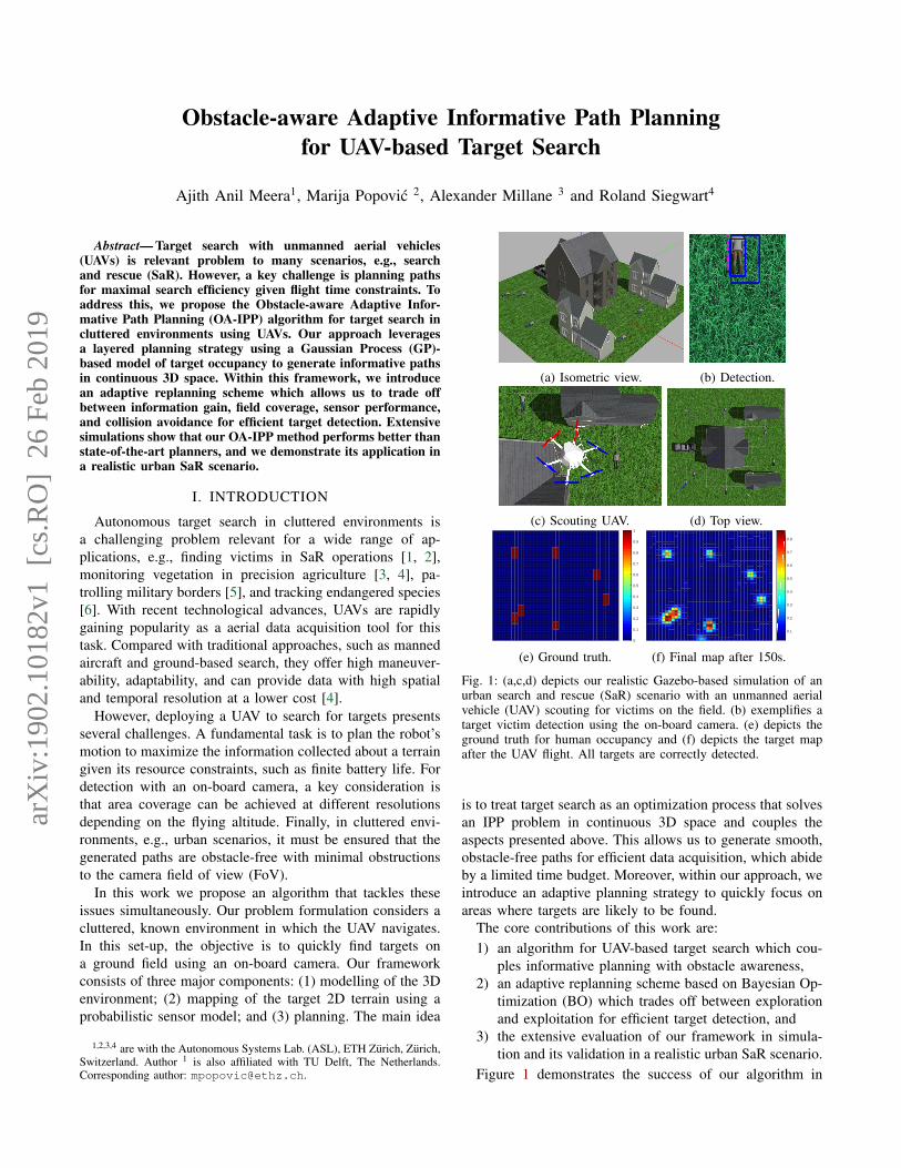
Obstacle-aware Adaptive Informative Path Planning for UAV-based Target Search Ajith Anil Meera 1 , Marija Popovi´ c 2 , Alexander Millane 3 and Roland Siegwart 4 Abstract— Target search with unmanned aerial vehicles (UAVs) is relevant problem to many scenarios, e.g., search and rescue (SaR). However, a key challenge is planning paths for maximal search efficiency given flight time constraints. To address this, we propose the Obstacle-aware Adaptive Infor- mative Path Planning (OA-IPP) algorithm for target search in cluttered environments using UAVs. Our approach leverages a layered planning strategy using a Gaussian Process (GP)- based model of target occupancy to generate informative paths in continuous 3D space. Within this framework, we introduce an adaptive replanning scheme which allows us to trade off between information gain, field coverage, sensor performance, and collision avoidance for efficient target detection. Extensive simulations show that our OA-IPP method performs better than state-of-the-art planners, and we demonstrate its application in a realistic urban SaR scenario. I. INTRODUCTION Autonomous target search in cluttered environments is a challenging problem relevant for a wide range of ap- plications, e.g., finding victims in SaR operations [1, 2], monitoring vegetation in precision agriculture [3, 4], pa- trolling military borders [5], and tracking endangered species [6]. With recent technological advances, UAVs are rapidly gaining popularity as a aerial data acquisition tool for this task. Compared with traditional approaches, such as manned aircraft and ground-based search, they offer high maneuver- ability, adaptability, and can provide data with high spatial and temporal resolution at a lower cost [4]. However, deploying a UAV to search for targets presents several challenges. A fundamental task is to plan the robot’s motion to maximize the information collected about a terrain given its resource constraints, such as finite battery life. For detection with an on-board camera, a key consideration is that area coverage can be achieved at different resolutions depending on the flying altitude. Finally, in cluttered envi- ronments, e.g., urban scenarios, it must be ensured that the generated paths are obstacle-free with minimal obstructions to the camera field of view (FoV). In this work we propose an algorithm that tackles these issues simultaneously. Our problem formulation considers a cluttered, known environment in which the UAV navigates. In this set-up, the objective is to quickly find targets on a ground field using an on-board camera. Our framework consists of three major components: (1) modelling of the 3D environment; (2) mapping of the target 2D terrain using a probabilistic sensor model; and (3) planning. The main idea 1,2,3,4 are with the Autonomous Systems Lab. (ASL), ETH Z¨ urich, Z ¨ urich, Switzerland. Author 1 is also affiliated with TU Delft, The Netherlands. Corresponding author: [email protected]. (a) Isometric view. (b) Detection. (c) Scouting UAV. (d) Top view. 0 0.1 0.2 0.3 0.4 0.5 0.6 0.7 0.8 0.9 1 (e) Ground truth. 0.1 0.2 0.3 0.4 0.5 0.6 0.7 0.8 (f) Final map after 150s. Fig. 1: (a,c,d) depicts our realistic Gazebo-based simulation of an urban search and rescue (SaR) scenario with an unmanned aerial vehicle (UAV) scouting for victims on the field. (b) exemplifies a target victim detection using the on-board camera. (e) depicts the ground truth for human occupancy and (f) depicts the target map after the UAV flight. All targets are correctly detected. is to treat target search as an optimization process that solves an IPP problem in continuous 3D space and couples the aspects presented above. This allows us to generate smooth, obstacle-free paths for efficient data acquisition, which abide by a limited time budget. Moreover, within our approach, we introduce an adaptive planning strategy to quickly focus on areas where targets are likely to be found. The core contributions of this work are: 1) an algorithm for UAV-based target search which cou- ples informative planning with obstacle awareness, 2) an adaptive replanning scheme based on Bayesian Op- timization (BO) which trades off between exploration and exploitation for efficient target detection, and 3) the extensive evaluation of our framework in simula- tion and its validation in a realistic urban SaR scenario. Figure 1 demonstrates the success of our algorithm in arXiv:1902.10182v1 [cs.RO] 26 Feb 2019
Transcript of Obstacle-aware Adaptive Informative Path Planning for UAV … · 2019-02-28 · Obstacle-aware...
Obstacle-aware Adaptive Informative Path Planningfor UAV-based Target Search
Ajith Anil Meera1, Marija Popovic 2, Alexander Millane 3 and Roland Siegwart4
Abstract— Target search with unmanned aerial vehicles(UAVs) is relevant problem to many scenarios, e.g., searchand rescue (SaR). However, a key challenge is planning pathsfor maximal search efficiency given flight time constraints. Toaddress this, we propose the Obstacle-aware Adaptive Infor-mative Path Planning (OA-IPP) algorithm for target search incluttered environments using UAVs. Our approach leveragesa layered planning strategy using a Gaussian Process (GP)-based model of target occupancy to generate informative pathsin continuous 3D space. Within this framework, we introducean adaptive replanning scheme which allows us to trade offbetween information gain, field coverage, sensor performance,and collision avoidance for efficient target detection. Extensivesimulations show that our OA-IPP method performs better thanstate-of-the-art planners, and we demonstrate its application ina realistic urban SaR scenario.
I. INTRODUCTION
Autonomous target search in cluttered environments isa challenging problem relevant for a wide range of ap-plications, e.g., finding victims in SaR operations [1, 2],monitoring vegetation in precision agriculture [3, 4], pa-trolling military borders [5], and tracking endangered species[6]. With recent technological advances, UAVs are rapidlygaining popularity as a aerial data acquisition tool for thistask. Compared with traditional approaches, such as mannedaircraft and ground-based search, they offer high maneuver-ability, adaptability, and can provide data with high spatialand temporal resolution at a lower cost [4].
However, deploying a UAV to search for targets presentsseveral challenges. A fundamental task is to plan the robot’smotion to maximize the information collected about a terraingiven its resource constraints, such as finite battery life. Fordetection with an on-board camera, a key consideration isthat area coverage can be achieved at different resolutionsdepending on the flying altitude. Finally, in cluttered envi-ronments, e.g., urban scenarios, it must be ensured that thegenerated paths are obstacle-free with minimal obstructionsto the camera field of view (FoV).
In this work we propose an algorithm that tackles theseissues simultaneously. Our problem formulation considers acluttered, known environment in which the UAV navigates.In this set-up, the objective is to quickly find targets ona ground field using an on-board camera. Our frameworkconsists of three major components: (1) modelling of the 3Denvironment; (2) mapping of the target 2D terrain using aprobabilistic sensor model; and (3) planning. The main idea
1,2,3,4 are with the Autonomous Systems Lab. (ASL), ETH Zurich, Zurich,Switzerland. Author 1 is also affiliated with TU Delft, The Netherlands.Corresponding author: [email protected].
(a) Isometric view. (b) Detection.
(c) Scouting UAV. (d) Top view.
1 2 3 4 5 6 7 8 910 11 12 13 14 15 16 17 18 19 20 21 22 23 24 25 26 27 28 29 30 31 32 33 34 35 36 37 38 39 40
123456789
10111213141516171819202122232425262728293031323334353637383940 0
0.1
0.2
0.3
0.4
0.5
0.6
0.7
0.8
0.9
1
(e) Ground truth.1 2 3 4 5 6 7 8 9
10 11 12 13 14 15 16 17 18 19 20 21 22 23 24 25 26 27 28 29 30 31 32 33 34 35 36 37 38 39 40
123456789
10111213141516171819202122232425262728293031323334353637383940
0.1
0.2
0.3
0.4
0.5
0.6
0.7
0.8
(f) Final map after 150s.
Fig. 1: (a,c,d) depicts our realistic Gazebo-based simulation of anurban search and rescue (SaR) scenario with an unmanned aerialvehicle (UAV) scouting for victims on the field. (b) exemplifies atarget victim detection using the on-board camera. (e) depicts theground truth for human occupancy and (f) depicts the target mapafter the UAV flight. All targets are correctly detected.
is to treat target search as an optimization process that solvesan IPP problem in continuous 3D space and couples theaspects presented above. This allows us to generate smooth,obstacle-free paths for efficient data acquisition, which abideby a limited time budget. Moreover, within our approach, weintroduce an adaptive planning strategy to quickly focus onareas where targets are likely to be found.
The core contributions of this work are:1) an algorithm for UAV-based target search which cou-
ples informative planning with obstacle awareness,2) an adaptive replanning scheme based on Bayesian Op-
timization (BO) which trades off between explorationand exploitation for efficient target detection, and
3) the extensive evaluation of our framework in simula-tion and its validation in a realistic urban SaR scenario.
Figure 1 demonstrates the success of our algorithm in
arX
iv:1
902.
1018
2v1
[cs
.RO
] 2
6 Fe
b 20
19
detecting all human targets on the field for an SaR problem.
II. RELATED WORK
The task of searching for targets is relevant to many real-world scenarios [2, 4, 6, 7]. Most generally, this problem canbe expressed as a Partially Observable Markov Decision Pro-cess (POMDP), which models planning under uncertainty.However, despite recent advances, current POMDP solvers[1, 8] still scale poorly for practical applications due to high-dimensional belief space.
In robotics, target search is often more efficiently formu-lated as an IPP problem, where information about targetsis maximized subject to a budget constraint. IPP literaturecan broadly be classified based on three aspects: (i) adap-tivity; (ii) myopicity; and (iii) continuity. Adaptive IPP [9]differs from non-adaptive IPP [10] in terms of how newmeasurements influence the planning routine. The formerperforms online replanning while the latter executes an apriori path. Myopic methods [11] differ from non-myopicones [3] in terms of their planning look-ahead. The formernavigates greedily by selecting next-best views, while thelatter plans with a finite lookahead to escape local minima.Finally, whereas discrete strategies [10, 12] perform combi-natorial optimization on pre-defined grids, continuous solvers[3, 13, 14] operate directly in the robot workspace to achievebetter scalability.
Our algorithm is adaptive, non-myopic, and continuous.It falls into a recently emerged category of methods whichoptimize a smooth continuous trajectory for maximal infor-mation gain [3, 9, 14, 15]. Specifically, we build upon thework of Popovic et al. [3] by introducing a new adaptiveplanning scheme based on BO [15] to perform explorationwhile focusing on potential targets as they are detected.
Accounting for sensor uncertainty and facilitating targetre-observation is crucial in procuring an error-free targetmap. Despite abundant prior research, accounting for bothof these factors in cluttered environments is an understud-ied topic. Although Dang et al. [16] and Marchant andRamos [14] plan for target re-observation, they do notconsider variable sensor performance. Whereas the methodsof Popovic et al. [3] cater for sensor uncertainties, they donot address obstacles. By unifying these concepts, our workaims to bridge the gap towards practical applications, i.e.,urban [7, 17] and natural [1] settings.
III. PROBLEM STATEMENT
We formulate the target search task as an IPP problem asfollows. Our aim is to find an optimal continuous trajectoryψ in the space of all trajectories Ψ for the robot:
ψ∗ = arg maxψ∈Ψ
k1Oinfo(ψ)− k2Ccoll(ψ)
tflight(ψ), (1)
where Oinfo(ψ), Ccoll(ψ), and tflight(ψ) are functionsquantifying the information quality, collision cost, and flighttime along a trajectory ψ, and k1 and k2 are non-negativeconstants trading off between useful data acquisition andobstacle avoidance.
IV. PRELIMINARIES
To lay the foundation for our IPP framework, this sectiondescribes our methods of modeling the key elements ofthe target search problem. We first detail our method ofrepresenting cluttered flying environments before describingour field mapping strategy.
A. Environment modeling
Our set-up considers a known cluttered 3D environmentabove the monitored terrain, in which the UAV flies. We treatobstacles as standard geometric shapes and use the Voxbloxsystem [18], based on the Euclidean Signed Distance Func-tion (ESDF), to enable computationally inexpensive collisionchecks. A hard penalty for colliding with obstacles is placedbased on an artificial potential field, defined as:
Chard(x) =
{0 if ESDF(x) ≥ rUAV
2 ,1 otherwise,
(2)
where ESDF(·) is the signed distance to the closest obstaclefrom a UAV configuration x, and rUAV is the radius of thesmallest sphere that can contain the UAV.
Based on Equation 2, we define the collision cost Ccoll(ψ)in Equation 1 as:
Ccoll(ψ) =∑x∈ψ
Chard(x). (3)
Note that Ccoll(ψ) is non-zero if any point x ∈ ψ is insidethe obstacle, thereby incurring a penalty to the objectivefunction. Ccoll(ψ) is evaluated by sub-sampling ψ at a highsampling frequency for flight safety.
B. Field modeling and mapping
Our field mapping strategy is based on the approachof Popovic et al. [3], allowing us to incorporate probabilisticsensor models for data fusion with constant-time measure-ment updates. We represent the monitored ground field oftarget occupancy using a GP model, which captures spatialcorrelations in a probabilistic and non-parametric way [19].The field is assumed to be a continuous function in 2D spaceζ : ε → R, where ε ⊂ R2 is a location on the ground field.The GP is fully characterized by the mean µ = E[ζ] andthe covariance P = E[(ζ−µ)(ζT −µT )] as ζ ∼ GP (µ, P ),where E[·] is the expectation operator.
The field is discretized at a given resolution to obtain ntraining locations X ∈ ε. A set of n′ prediction points X ′ ∈ εare specified at which prior map is to be inferred. To describethe field, we propose using the isotropic Matern 3/2 kernelfunction [19] common in geostatistical analysis, due to itscapability to capture discrete targets. It is defined as:
kMat3(x, x′) = σ2f
(1 +
√3d
l
)exp
(−√
3d
l
), (4)
where l and σ2f are the hyperparameters representing the
lengthscale and signal variance, respectively, and d is theEuclidean distance between input locations x and x′.
The covariance is evaluated using:
P = K(X ′, X ′)−K(X ′, X)[K(X,X) + σ2nI]−1×
K(X ′, X)T , (5)
where K(X,X ′) denotes the n×n′ matrix of the covariancesevaluated at all pairs of training and test points, P is the pos-terior covariance, and σ2
n is a hyperparameter representingthe noise variance. These hyperparameters {l, σ2
f , σ2n} can
be learned by maximizing the log marginal likelihood of atraining dataset [19].
Sensor measurements are fused sequentially into the GPfield map in two steps: (1) FoV estimation and (2) datafusion. First, the camera FoV at the measurement pose isprojected to index the cells in X to be updated. In thisstep, we account for occlusions arising from obstacles inthe 3D ESDF environment (Section IV-A). Then, the fieldmap is updated using a recursive technique based on theKalman Filter (KF), presented by Popovic et al. [3]. Withinour framework, this method enables capturing the altitude-dependant performance of practical target detectors for prob-abilistic mapping, as discussed in the following section.
C. Sensor modeling
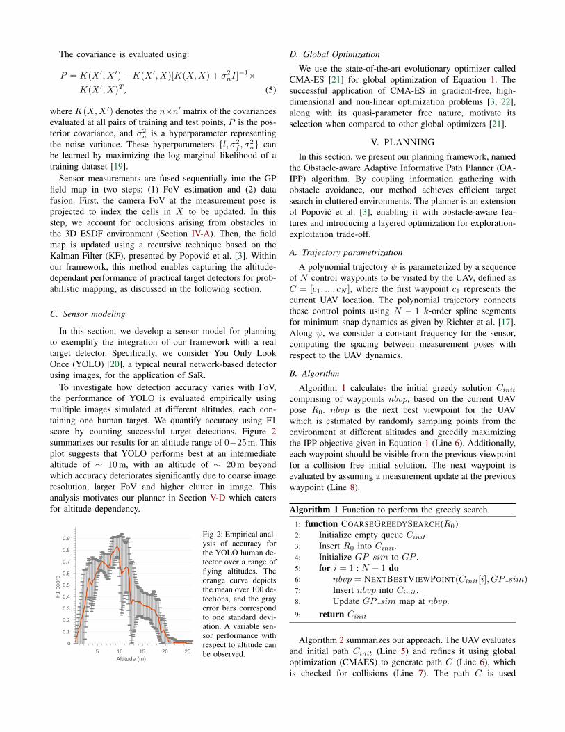
In this section, we develop a sensor model for planningto exemplify the integration of our framework with a realtarget detector. Specifically, we consider You Only LookOnce (YOLO) [20], a typical neural network-based detectorusing images, for the application of SaR.
To investigate how detection accuracy varies with FoV,the performance of YOLO is evaluated empirically usingmultiple images simulated at different altitudes, each con-taining one human target. We quantify accuracy using F1score by counting successful target detections. Figure 2summarizes our results for an altitude range of 0−25 m. Thisplot suggests that YOLO performs best at an intermediatealtitude of ∼ 10 m, with an altitude of ∼ 20 m beyondwhich accuracy deteriorates significantly due to coarse imageresolution, larger FoV and higher clutter in image. Thisanalysis motivates our planner in Section V-D which catersfor altitude dependency.
5 10 15 20 25
Altitude (m)
0
0.1
0.2
0.3
0.4
0.5
0.6
0.7
0.8
0.9
F1
scor
e
Fig 2: Empirical anal-ysis of accuracy forthe YOLO human de-tector over a range offlying altitudes. Theorange curve depictsthe mean over 100 de-tections, and the grayerror bars correspondto one standard devi-ation. A variable sen-sor performance withrespect to altitude canbe observed.
D. Global Optimization
We use the state-of-the-art evolutionary optimizer calledCMA-ES [21] for global optimization of Equation 1. Thesuccessful application of CMA-ES in gradient-free, high-dimensional and non-linear optimization problems [3, 22],along with its quasi-parameter free nature, motivate itsselection when compared to other global optimizers [21].
V. PLANNING
In this section, we present our planning framework, namedthe Obstacle-aware Adaptive Informative Path Planner (OA-IPP) algorithm. By coupling information gathering withobstacle avoidance, our method achieves efficient targetsearch in cluttered environments. The planner is an extensionof Popovic et al. [3], enabling it with obstacle-aware fea-tures and introducing a layered optimization for exploration-exploitation trade-off.
A. Trajectory parametrization
A polynomial trajectory ψ is parameterized by a sequenceof N control waypoints to be visited by the UAV, defined asC = [c1, ..., cN ], where the first waypoint c1 represents thecurrent UAV location. The polynomial trajectory connectsthese control points using N − 1 k-order spline segmentsfor minimum-snap dynamics as given by Richter et al. [17].Along ψ, we consider a constant frequency for the sensor,computing the spacing between measurement poses withrespect to the UAV dynamics.
B. Algorithm
Algorithm 1 calculates the initial greedy solution Cinitcomprising of waypoints nbvp, based on the current UAVpose R0. nbvp is the next best viewpoint for the UAVwhich is estimated by randomly sampling points from theenvironment at different altitudes and greedily maximizingthe IPP objective given in Equation 1 (Line 6). Additionally,each waypoint should be visible from the previous viewpointfor a collision free initial solution. The next waypoint isevaluated by assuming a measurement update at the previouswaypoint (Line 8).
Algorithm 1 Function to perform the greedy search.
1: function COARSEGREEDYSEARCH(R0)2: Initialize empty queue Cinit.3: Insert R0 into Cinit.4: Initialize GP sim to GP .5: for i = 1 : N − 1 do6: nbvp = NEXTBESTVIEWPOINT(Cinit[i], GP sim)7: Insert nbvp into Cinit.8: Update GP sim map at nbvp.9: return Cinit
Algorithm 2 summarizes our approach. The UAV evaluatesand initial path Cinit (Line 5) and refines it using globaloptimization (CMAES) to generate path C (Line 6), whichis checked for collisions (Line 7). The path C is used
for data acquisition and mapping (Line 8-11) at a constantmeasurement frequency. A new path is planned once thestipulated path flight time is complete. This is repeated untilthe budget flight time is exhausted.
Algorithm 2 OA-IPP routine.
1: Create ESDF map.2: Initialize the GP.3: if tflight < Budget then . Replanning.4: do5: Cinit = COARSEGREEDYSEARCH(R0).6: C = GLOBALOPTIMIZATION(Cinit)7: while not ISCOLLISIONFREEPATH(C,ESDF )8: do9: Fly through C and take measurements.
10: Update GP map at measurement locations.11: while flight time for C not exhausted12: Stop UAV and hover.13: else14: Land the UAV.
C. Uncertainty reduction as the objective
Many IPP approaches use uncertainty reduction as theobjective for the IPP problem without using the targetdetections for planning [3, 9]. The information gain can berepresented as:
Oinfo(ψ) = Tr(P−)− Tr(P+), (6)
where Tr(.) denotes the trace of the matrix, P− and P+ arethe prior and posterior covariances, respectively. The latteris evaluated by fusing all measurements along ψ. However,the planner is explorative and does not take target detectioninto account while planning.
D. Layered optimization for adaptive planning
In this section we propose a layered optimization approachthat facilitates target re-observation, rendering the plannerwith exploration-exploitation trade-off capability, which iscrucial for robustness against wrong detections. We definean information-theoretic objective function based on theacquisition function that is used in the BO framework. Weuse the Upper Confidence Bound (UCB) [23] defined byEquation 7 as the acquisition function.
UCB(x) = µ(x) + κσ(x), (7)
Here κ is the exploration-exploitation tuning parameter,and µ and σ2 are the mean and variance of the GP. Wedefine Acquisition View (AV) as the sum total of acquisitionfunction values within the FoV, given by
AV =∑
x∈FoVUCB(x). (8)
The sensor performance curve given in Figure 2 is modelledas a normal distribution N(hopt, σ1), and is used as a rewardfunction for the objective function. The information gain is
then defined as the combination of sensor performance andAV as
Oinfo =
AV ×[
1σ1
√2πe−
12
(h−hoptσ1
)2]h < hsat,
0 otherwise.
(9)
The AV increases with altitude, while the sensor performancefollows the pattern in Figure 2. Therefore, this layer of initialoptimization based on BO given by Equation 9 encodes thetrade-off between sensor performance and FoV by facili-tating target re-observation through a balanced exploration-exploitation strategy that is embedded within the UCB.This objective contributes to the next optimization layer toevaluate the optimal 3D path.
VI. EXPERIMENTAL RESULTSThis section presents our experimental results. We validate
our framework in simulation by comparing it to state-of-the-art methods and study the effects of our adaptive replanningscheme. We then show its application in a realistic urbanSaR scenario.
A. Benchmarking
We evaluate our algorithm on a 30 × 30 × 26 m targetsearch scenario in the RotorS-based simulation environment[24]. The set-up, shown in Figure 3, features a 4×10×26 mobstacle and 7 human targets. Targets are placed on lowerhalf of the field, necessitating target re-observation in thatregion. We use a uniform resolution of 0.75 m for the GPmodel, and initialize the mean with a constant low prior of0.1, assuming a sparse target distribution. The hyperparam-eters of the Matern 3/2 kernel function are similar to thetraining results given in [3]: {σ2
n, σ2f , l} = {1.42, 1.82, 3.67}.
(a) (b)
Fig. 3: (a) shows our simulation set-up in RotorS featuring a tallbuilding and 7 human targets placed on lower half of the field. (b)visualizes the ground truth map of human occupancy.
We use YOLO Tiny 2.0 for human detection with athreshold value of 0.05 and measurement frequency of0.15 Hz. The detector receives images from a downwardfacing camera on the UAV with a FoV of (45, 60)◦. Forplanning, the constants in Equation 9 were experimentallycomputed as: hopt = 10 m, hsat = 26 m and σ1 = 7. Theparameters of the altitude dependent uncertainty model givenin [3] are (A,B) = (1, 0.05).

We compare our approach against (1) ”lawnmower” cov-erage planning [25] and (2) random waypoint selection,running 25 trials for each method with a flight budget of150 s. To evaluate performance, we quantify accuracy usingthe Root Square Error (RSE) with respect to the ground truthmap of human occupancy with the same resolution as theGP. We opt for this metric as it weighs false positive andnegative misclassifications equally, reflecting the practicalaims of a SaR mission. During a mission, higher rates ofRSE reduction indicate more efficient search performance.
For the coverage planner, a fixed flight altitude of 10 mwas set by considering various “lawnmower” patterns forcomplete coverage within the time budget and selecting thebest one. For the random planner, we uniformly sample adestination measurement pose above the field and generatea trajectory by connecting it to the current UAV position.For our planner, we set a reference speed and accelerationof 5 m/s and 3 m/s2 for trajectory optimization [17] with theadaptive planning strategy from Section V-D.
0 50 100 150
Flight time(s)
4.5
5
5.5
6
6.5
7
7.5
RS
E
Coverage planner at h=10mRandom samplingAdaptive IPP planner
Fig 4: Experimentalresults averaged over25 flight trials shownwith one standarddeviation. Our planner(pink) outperformscoverage at altitude10m (red) and randomsampling (blue) bydecreasing RSE at thefastest rate.
Figure 4 shows the evolution of RSE for each methodduring a mission. Our OA-IPP method (pink) outperformsthe state-of-the-art algorithms by reducing error at thefastest rate, as it trades off between sensor performanceand coverage at different altitudes, and actively focuses ontargets as they are found. This strategy permits target re-observation, which decreases false positive detections, andvariable resolution mapping, which refines accuracy overtime. In contrast, the coverage benchmark (red) is limitedin accuracy by the fixed altitude, while the random plannerperforms worst as it is often limited in coverage by the lowaltitude of sampled measurement sites.
B. Adaptive replanning evaluation
Next, the effects of our adaptive replanning scheme areevaluated in terms of target search efficiency. In the samesimulation set-up as above, we compare the performance oftwo variants of our algorithm using the non-adaptive (Sec-tion V-C) and adaptive (Section V-D) planning objectives. Asbefore, we run 25 trials and examine the evolution of RSEover time.
Figure 5 demonstrates that our OA-IPP algorithm out-performs non-adaptive IPP planner. Initially, both the non-adaptive (blue) and adaptive (red) planner perform similarlywhile the UAV performs field coverage (exploration). At laterstages of the mission (< 75 s), the adaptive variant achieves
0 50 100 150Time (s)
5
5.5
6
6.5
7
7.5
RS
E
Adaptive (OA-IPP)Non-adaptive
Fig 5: Experimental resultsof 25 flight trials with onestandard deviation as the er-ror bar. Our adaptive plan-ner (red) outperforms non-adaptive IPP planner (blue).Both prefers coverage strat-egy initially. However, to-wards the end, our plannergenerates more accurate mapdue to target re-observationstrategy.
improved accuracy, as the acquisition function permits theUAV to focus on the half of the field where targets arelikely to be found. This behaviour leads to repeated targetobservations, which renders the search robust to sensinguncertainty and procures a higher-quality end map. Thisaspect illustrated in Figure 7, which shows the GP meanafter measurement updates for the environment in Figure3. Despite the false positive detection after the first update,repeated measurements enable the recovery of a final mapwhich resembles the ground truth in Figure 3.
0 100 200 300Time (s)
0
100
200
300
400
Var
ianc
e
(a)
0 100 200 300Time (s)
0
100
200
300
400
Var
ianc
e
Empty5 units10 units15 units
(b)
Fig. 6: Average results of our OA-IPP method in 100 flight trialsfor environments with low-rising (a) and high-rising (b) obstacleswith varying densities. The error bars corresponds to one standarddeviation. The scenario in (a) exhibits consistent performance due toimproved FoV. However, in (b), high occlusion impedes exploration,leading to lower uncertainty reduction with increasing density.
C. Environment complexity
Next, the obstacle avoidance capabilities of our OA-IPPalgorithm are assessed by examining its performance indifferent environments. We study two types of environmentwithin a 30 × 30 m area, which contain (1) low-rising(4× 4× 13 m) and (2) high-rising (4× 4× 26 m) obstacles,to portray SaR scenarios in different urban landscapes. Case(2) is designed such that the UAV must fly around, ratherthan over, obstacles due to the saturation height hsat of thesensor. To demonstrate the applicability of our approach, weconduct 100 trials in both scenarios, considering variable ob-stacle densities of (5, 10, 15) units with randomly initializedpositions. Since exploratory capabilities are crucial for veryoccluded, complex environments, we use uncertainty as theevaluation metric, quantified by the covariance trace of theGP field model (Tr(P )).
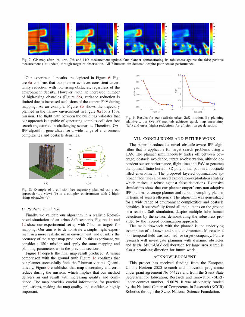
Fig. 7: GP map after 1st, 4rth, 7th and 11th measurement update. Our planner demonstrating its robustness against the false positivemeasurement (1st update) through target re-observation. All 7 humans are detected despite poor sensor performance.
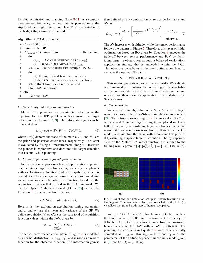
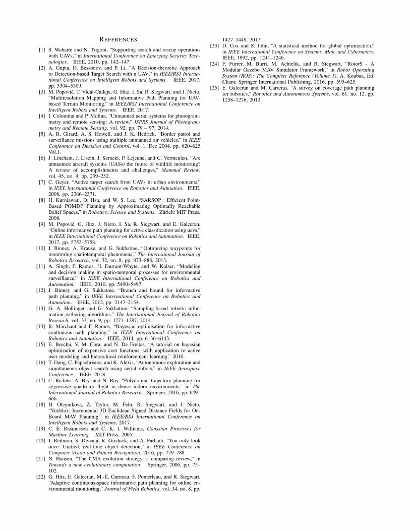
Our experimental results are depicted in Figure 6. Fig-ure 6a confirms that our planner achieves consistent uncer-tainty reduction with low-rising obstacles, regardless of theenvironment density. However, with an increased numberof high-rising obstacles (Figure 6b), variance reduction islimited due to increased occlusions of the camera FoV duringmapping. As an example, Figure 8b shows the trajectoryplanned in the narrow environment in Figure 8a for a 150 smission. The flight path between the buildings validates thatour approach is capable of generating complex collision-freesearch trajectories in challenging scenarios. Therefore, OA-IPP algorithm generalizes for a wide range of environmentcomplexities and obstacle densities.
(a) (b)
Fig. 8: Example of a collision-free trajectory planned using ourapproach (top view) (b) in a complex environment with 2 high-rising obstacles (a).
D. Realistic simulation
Finally, we validate our algorithm in a realistic RotorS-based simulation of an urban SaR scenario. Figures 1a and1d show our experimental set-up with 7 human targets formapping. Our aim is to demonstrate a single flight experi-ment in a more realistic urban environment, and quantify theaccuracy of the target map produced. In this experiment, weconsider a 150 s mission and apply the same mapping andplanning parameters as in the previous sections.
Figure 1f depicts the final map result produced. A visualcomparison with the ground truth Figure 1e confirms thatour planner successfully finds the 7 human victims. Quanti-tatively, Figure 9 establishes that map uncertainty and errorreduce during the mission, which implies that our methoddelivers an end result with increasing quality and confi-dence. The map provides crucial information for practicalapplications, making the map quality and confidence highlyimportant.
0 50 100 150Time (s)
100
150
200
250
300
350
Var
ianc
e
0 50 100 150Time (s)
5
5.5
6
6.5
7
7.5
RS
E
Fig. 9: Results for our realistic urban SaR mission. By planningadaptively, our OA-IPP methods achieves quick map uncertainty(left) and error (right) reductions for efficient target detection.
VII. CONCLUSIONS AND FUTURE WORKThe paper introduced a novel obstacle-aware IPP algo-
rithm that is applicable for target search problems using aUAV. The planner simultaneously trades off between cov-erage, obstacle avoidance, target re-observation, altitude de-pendent sensor performance, flight time and FoV to generatethe optimal, finite-horizon 3D polynomial path in an obstaclefilled environment. The proposed layered optimization ap-proach facilitates a balanced exploration-exploitation strategywhich makes it robust against false detections. Extensivesimulations show that our planner outperforms non-adaptiveIPP planner, coverage planner and random sampling plannerin terms of search efficiency. The algorithm was generalizedfor a wide range of environment complexities and obstacledensities. It successfully found all the humans on the groundin a realistic SaR simulation, despite multiple false humandetections by the sensor, demonstrating the robustness pro-vided by the layered optimization approach.
The main drawback with the planner is the underlyingassumption of a known and static environment. Moreover, anon-temporal field was assumed for target occupancy. Futureresearch will investigate planning with dynamic obstaclesand fields. Multi-UAV collaboration for large area search isalso a promising direction for future work.
ACKNOWLEDGMENTThis project has received funding from the European
Unions Horizon 2020 research and innovation programmeunder grant agreement No 644227 and from the Swiss StateSecretariat for Education, Research and Innovation (SERI)under contract number 15.0029. It was also partly fundedby the National Center of Competence in Research (NCCR)Robotics through the Swiss National Science Foundation.
REFERENCES
[1] S. Waharte and N. Trigoni, “Supporting search and rescue operationswith UAVs,” in International Conference on Emerging Security Tech-nologies. IEEE, 2010, pp. 142–147.
[2] A. Gupta, D. Bessonov, and P. Li, “A Decision-theoretic Approachto Detection-based Target Search with a UAV,” in IEEE/RSJ Interna-tional Conference on Intelligent Robots and Systems. IEEE, 2017,pp. 5304–5309.
[3] M. Popovic, T. Vidal-Calleja, G. Hitz, I. Sa, R. Siegwart, and J. Nieto,“Multiresolution Mapping and Informative Path Planning for UAV-based Terrain Monitoring,” in IEEE/RSJ International Conference onIntelligent Robots and Systems. IEEE, 2017.
[4] I. Colomina and P. Molina, “Unmanned aerial systems for photogram-metry and remote sensing: A review,” ISPRS Journal of Photogram-metry and Remote Sensing, vol. 92, pp. 79 – 97, 2014.
[5] A. R. Girard, A. S. Howell, and J. K. Hedrick, “Border patrol andsurveillance missions using multiple unmanned air vehicles,” in IEEEConference on Decision and Control, vol. 1, Dec 2004, pp. 620–625Vol.1.
[6] J. Linchant, J. Lisein, J. Semeki, P. Lejeune, and C. Vermeulen, “Areunmanned aircraft systems (UASs) the future of wildlife monitoring?A review of accomplishments and challenges,” Mammal Review,vol. 45, no. 4, pp. 239–252.
[7] C. Geyer, “Active target search from UAVs in urban environments,”in IEEE International Conference on Robotics and Autmation. IEEE,2008, pp. 2366–2371.
[8] H. Kurniawati, D. Hsu, and W. S. Lee, “SARSOP : Efficient Point-Based POMDP Planning by Approximating Optimally ReachableBelief Spaces,” in Robotics: Science and Systems. Zurich: MIT Press,2008.
[9] M. Popovic, G. Hitz, J. Nieto, I. Sa, R. Siegwart, and E. Galceran,“Online informative path planning for active classification using uavs,”in IEEE International Conference on Robotics and Automation. IEEE,2017, pp. 5753–5758.
[10] J. Binney, A. Krause, and G. Sukhatme, “Optimizing waypoints formonitoring spatiotemporal phenomena,” The International Journal ofRobotics Research, vol. 32, no. 8, pp. 873–888, 2013.
[11] A. Singh, F. Ramos, H. Durrant-Whyte, and W. Kaiser, “Modelingand decision making in spatio-temporal processes for environmentalsurveillance,” in IEEE International Conference on Robotics andAutomation. IEEE, 2010, pp. 5490–5497.
[12] J. Binney and G. Sukhatme, “Branch and bound for informativepath planning,” in IEEE International Conference on Robotics andAutmation. IEEE, 2012, pp. 2147–2154.
[13] G. A. Hollinger and G. Sukhatme, “Sampling-based robotic infor-mation gathering algorithms,” The International Journal of RoboticsResearch, vol. 33, no. 9, pp. 1271–1287, 2014.
[14] R. Marchant and F. Ramos, “Bayesian optimisation for informativecontinuous path planning,” in IEEE International Conference onRobotics and Autmation. IEEE, 2014, pp. 6136–6143.
[15] E. Brochu, V. M. Cora, and N. De Freitas, “A tutorial on bayesianoptimization of expensive cost functions, with application to activeuser modeling and hierarchical reinforcement learning,” 2010.
[16] T. Dang, C. Papachristos, and K. Alexis, “Autonomous exploration andsimultaneous object search using aerial robots,” in IEEE AerospaceConference. IEEE, 2018.
[17] C. Richter, A. Bry, and N. Roy, “Polynomial trajectory planning foraggressive quadrotor flight in dense indoor environments,” in TheInternational Journal of Robotics Research. Springer, 2016, pp. 649–666.
[18] H. Oleynikova, Z. Taylor, M. Fehr, R. Siegwart, and J. Nieto,“Voxblox: Incremental 3D Euclidean Signed Distance Fields for On-Board MAV Planning,” in IEEE/RSJ International Conference onIntelligent Robots and Systems, 2017.
[19] C. E. Rasmussen and C. K. I. Williams, Gaussian Processes forMachine Learning. MIT Press, 2005.
[20] J. Redmon, S. Divvala, R. Girshick, and A. Farhadi, “You only lookonce: Unified, real-time object detection,” in IEEE Conference onComputer Vision and Pattern Recognition, 2016, pp. 779–788.
[21] N. Hansen, “The CMA evolution strategy: a comparing review,” inTowards a new evolutionary computation. Springer, 2006, pp. 75–102.
[22] G. Hitz, E. Galceran, M.-E. Garneau, F. Pomerleau, and R. Siegwart,“Adaptive continuous-space informative path planning for online en-vironmental monitoring,” Journal of Field Robotics, vol. 34, no. 8, pp.
1427–1449, 2017.[23] D. Cox and S. John, “A statistical method for global optimization,”
in IEEE International Conference on Systems, Man, and Cybernetics.IEEE, 1992, pp. 1241–1246.
[24] F. Furrer, M. Burri, M. Achtelik, and R. Siegwart, “RotorS - AModular Gazebo MAV Simulator Framework,” in Robot OperatingSystem (ROS): The Complete Reference (Volume 1), A. Koubaa, Ed.Cham: Springer International Publishing, 2016, pp. 595–625.
[25] E. Galceran and M. Carreras, “A survey on coverage path planningfor robotics,” Robotics and Autonomous Systems, vol. 61, no. 12, pp.1258–1276, 2013.