Observatorio Oceánico da Marxe Ibérica (RAIA) Oceanic … · Objectives • Improve the oceaninc...
23
Observatorio Oceánico da Marxe Ibérica (RAIA) Interreg IV-A (2009-2011-2013) Galicia – North of Portugal http://www.marnaraia.com Oceanic observatory for the Iberian shelf (RAIA)
Transcript of Observatorio Oceánico da Marxe Ibérica (RAIA) Oceanic … · Objectives • Improve the oceaninc...
Observatorio Oceánico da Marxe Ibérica (RAIA)
Interreg IV-A (2009-2011-2013)Galicia – North of Portugalhttp://www.marnaraia.com
Oceanic observatory for the Iberian shelf (RAIA)

Objectives• Improve the oceaninc observation at the Western
Iberian Peninsula in terms of meteorological,oceanographical and water quality data. To thatend, 5 new buoys will be located at the near-coast.
• Improve operational forecasting models;hydrodynamic and biogeochemical.
• Build up a new operational serverwww.marnaraia.com where all the informationwill be served to the community.
• Prepare specific tools to end-users; harbors,renewable energies, fishermen, tourism, etc
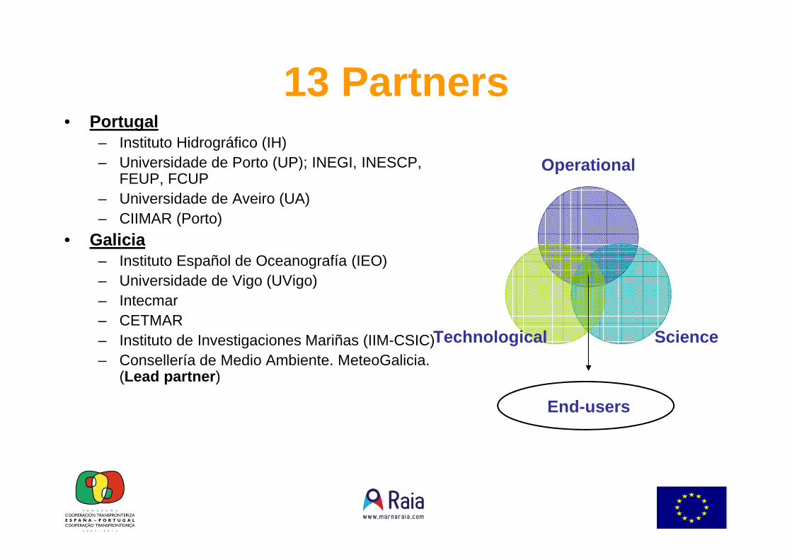
13 Partners• Portugal
– Instituto Hidrográfico (IH)– Universidade de Porto (UP); INEGI, INESCP,
FEUP, FCUP– Universidade de Aveiro (UA)– CIIMAR (Porto)
• Galicia– Instituto Español de Oceanografía (IEO)– Universidade de Vigo (UVigo)– Intecmar– CETMAR– Instituto de Investigaciones Mariñas (IIM-CSIC)– Consellería de Medio Ambiente. MeteoGalicia.
(Lead partner )
Operational
ScienceTechnological
End-users
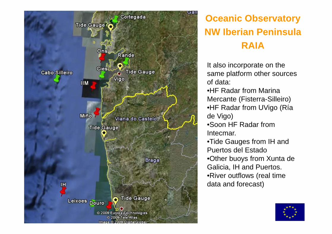
Oceanic ObservatoryNW Iberian Peninsula
RAIA
It also incorporate on the same platform other sources of data:•HF Radar from Marina Mercante (Fisterra-Silleiro)•HF Radar from UVigo (Ría de Vigo)•Soon HF Radar from Intecmar.•Tide Gauges from IH and Puertos del Estado•Other buoys from Xunta de Galicia, IH and Puertos.•River outflows (real time data and forecast)

New oceanic infrastructure
New buoys at Ons, A Guarda, Silleiro and Leixoes off-shore (Alfredo M.- Ramalho).All these buoys have similar instruments; wind, temperature, humidity, solar radiation, sea temperature and salinity at different levels, currents, as well as oxygen and chlorophyll concentrations.Same validation methods and data quality.
New Calibration Laboratory (T,C,P) at Cetmar

Own designs …• Buoys at A Guarda and Ons designed and built at
Galicia. Made to fit…• Buoy at Leixoes (Porto) for renewable energy
measurements (eolic off-shore). • Open source Datalogger Leviathan A1.• Waves height sensor.

Termosalinómetro from Navaz
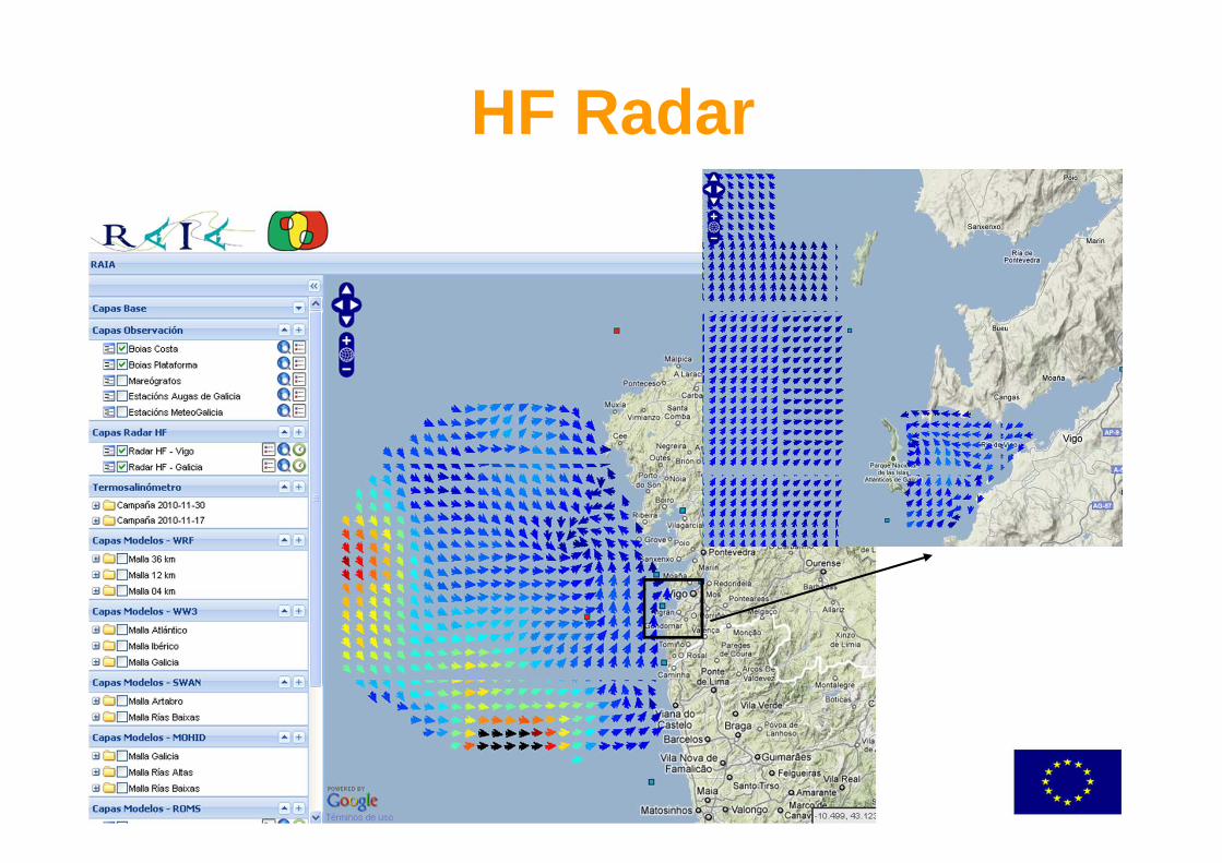
HF Radar

HF Radar

Data availability• All data available through RAIA web site
(www.marnaraia.com) in real time.
Operational OceanographicModels
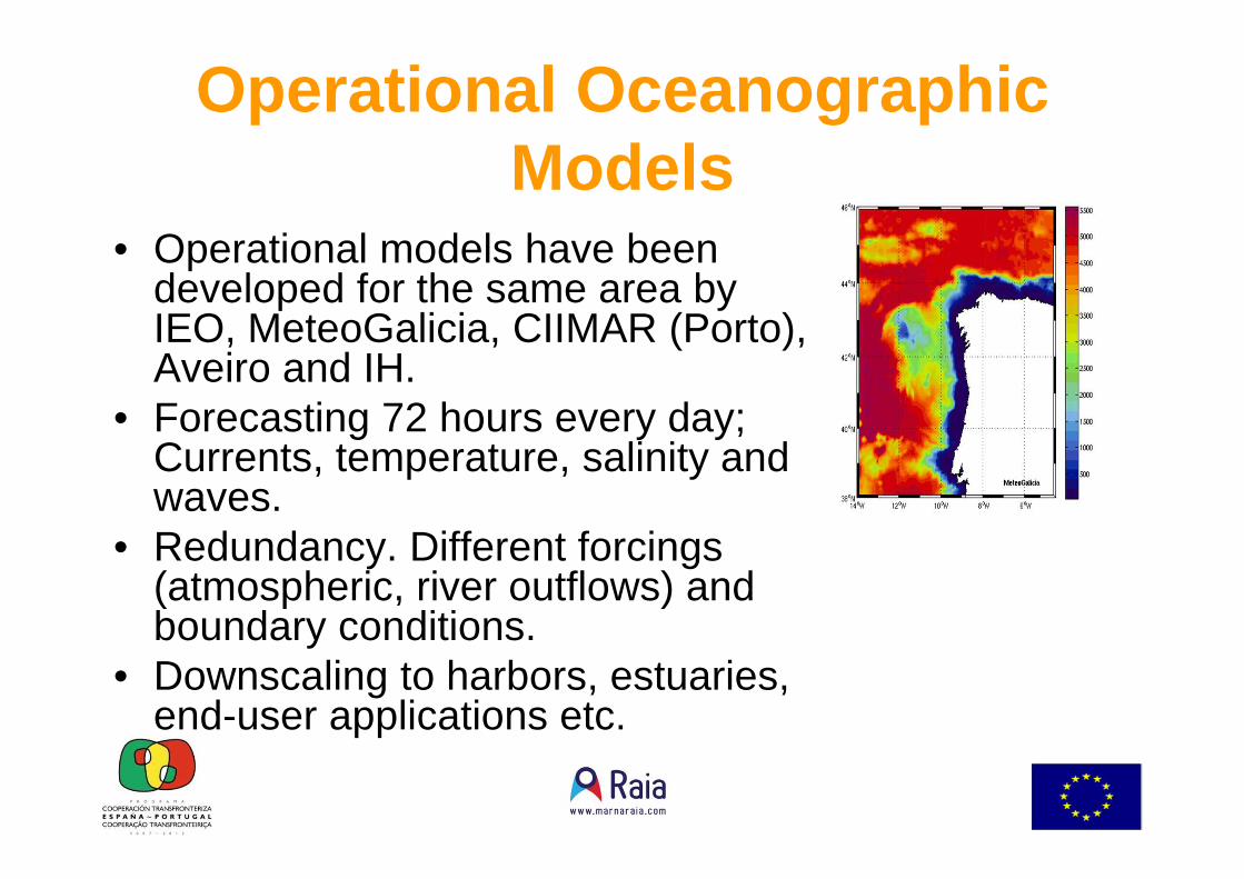
• Operational models have been developed for the same area by IEO, MeteoGalicia, CIIMAR (Porto), Aveiro and IH.
• Forecasting 72 hours every day; Currents, temperature, salinity and waves.
• Redundancy. Different forcings(atmospheric, river outflows) and boundary conditions.
• Downscaling to harbors, estuaries, end-user applications etc.

Output model ROMS
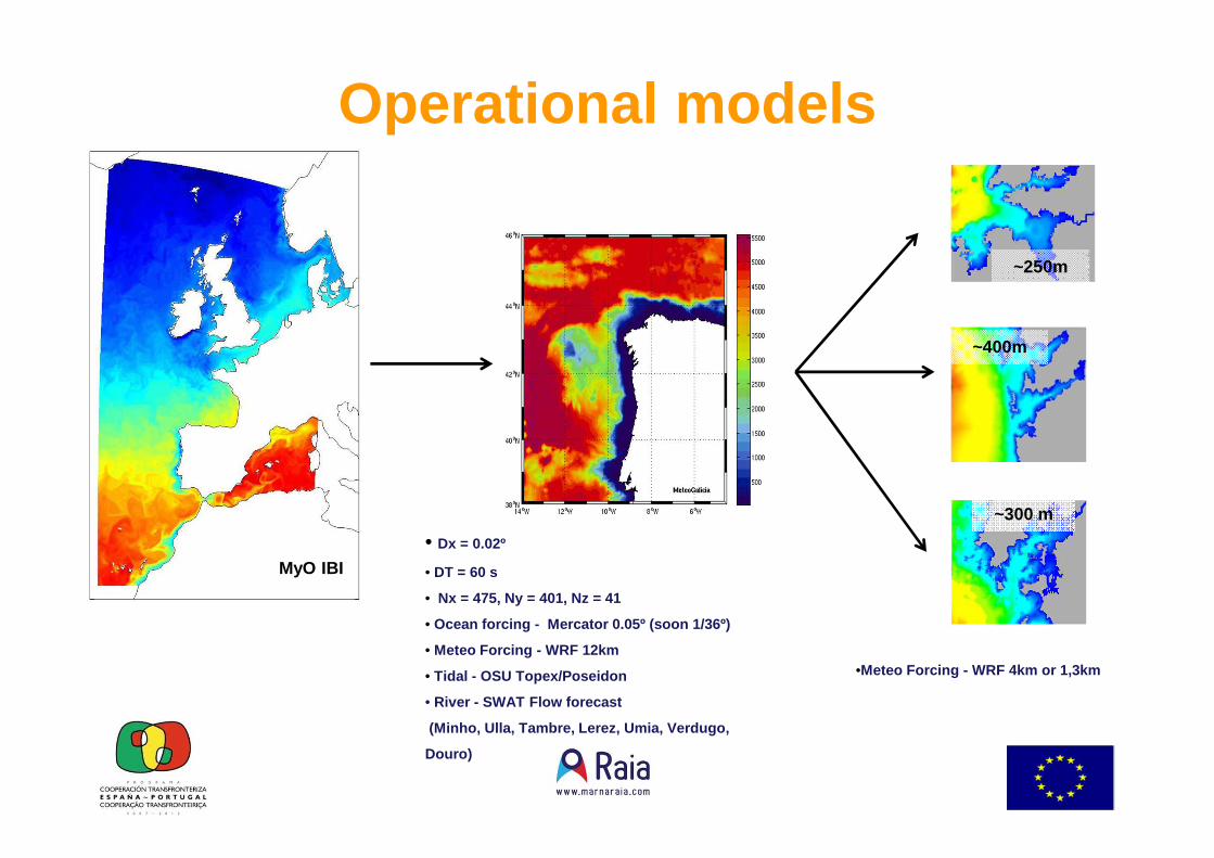
~400m
~300 m
Operational models
•Meteo Forcing - WRF 4km or 1,3km
~250m
• Dx = 0.02º
• DT = 60 s
• Nx = 475, Ny = 401, Nz = 41
• Ocean forcing - Mercator 0.05º (soon 1/36º)
• Meteo Forcing - WRF 12km
• Tidal - OSU Topex/Poseidon
• River - SWAT Flow forecast
(Minho, Ulla, Tambre, Lerez, Umia, Verdugo,
Douro)
MyO IBI
30m
5 Km
30m
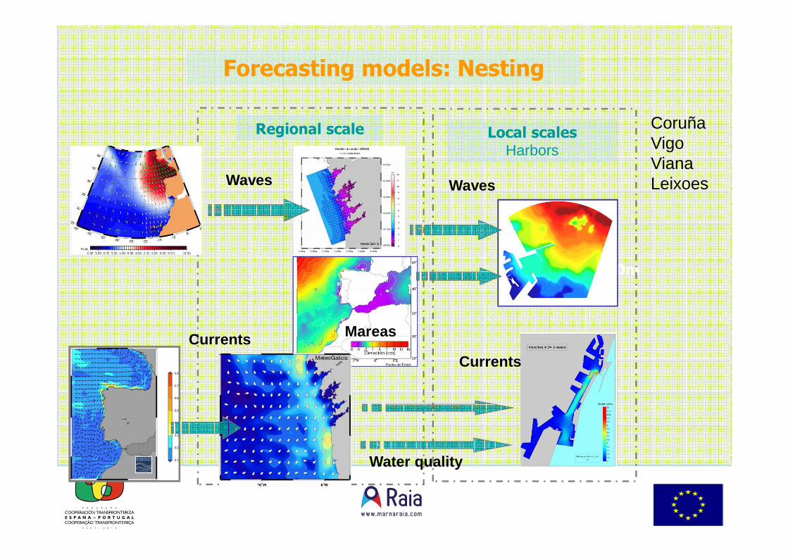
Regional scale Local scalesHarbors
Forecasting models: Nesting
Waves
MareasCurrents
Waves
Currents
Water quality
CoruñaVigoVianaLeixoes
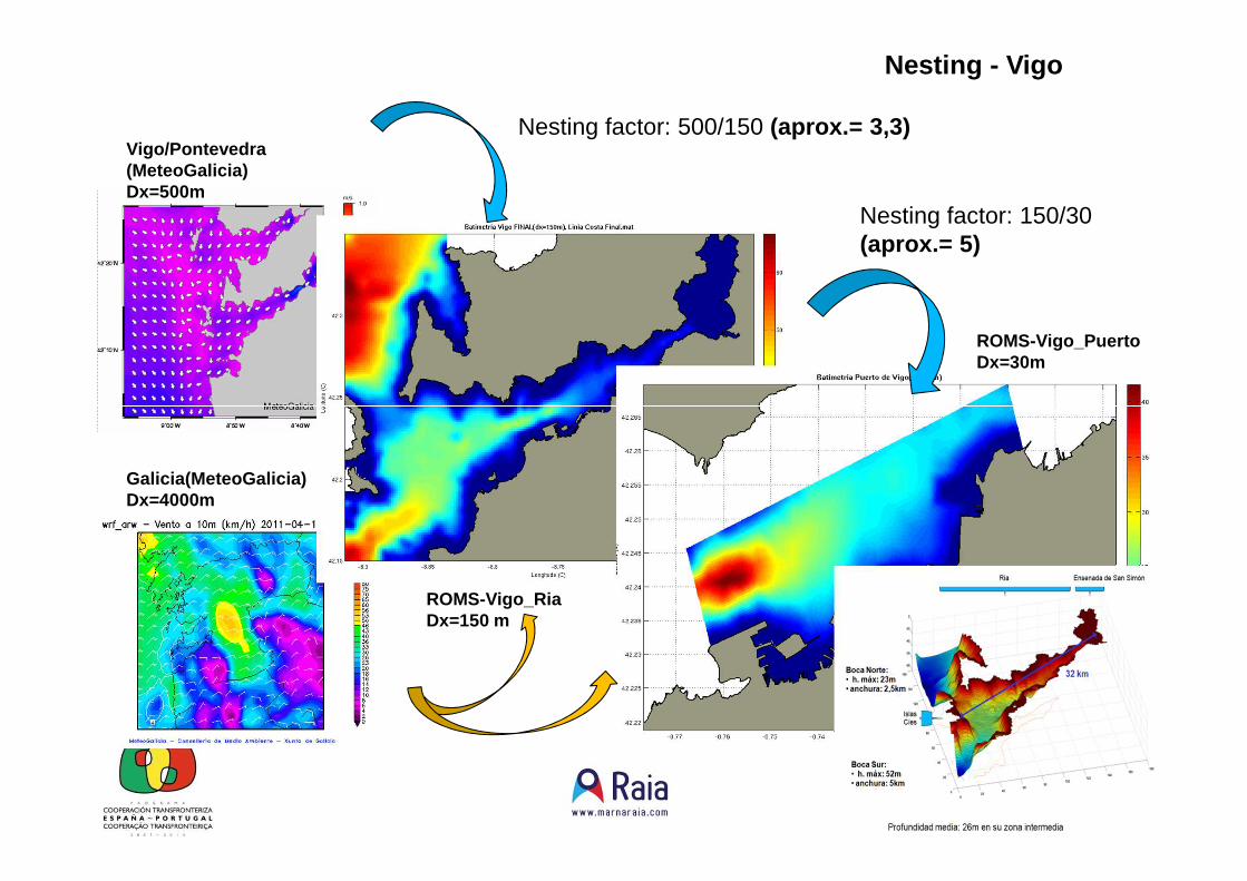
Vigo/Pontevedra (MeteoGalicia)Dx=500m
ROMS-Vigo_RiaDx=150 m
ROMS-Vigo_PuertoDx=30m
Nesting factor: 500/150 (aprox.= 3,3)
Nesting factor: 150/30 (aprox.= 5)
Galicia(MeteoGalicia)Dx=4000m
Nesting - Vigo

ImplementaçãoProdutosP
orto
deLe
ixõe
s
• Séries temporais de nos pontos P1a P4 (apoio à navegação)
• Mapas de Correntes• Inclusão de outros parâmetros

Data dissemination• Both, observations and
model forecasts, available through the web site. Real time data from buoys are shown every 10 min. Same criteria for data acquisition.
• Model and observational data are supplied on other operational useful formats through web based access and THREDDS server.
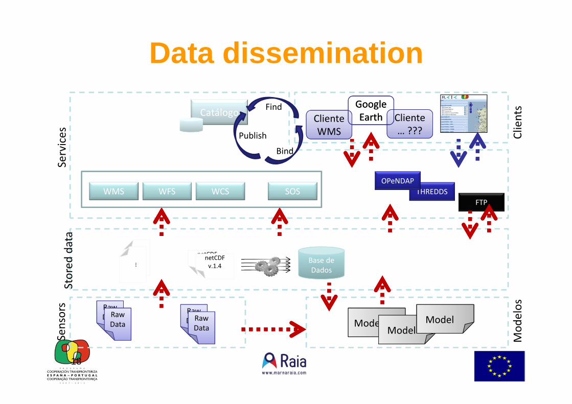
18
Cli
en
ts
Se
nso
rsS
erv
ice
s
Mo
de
los
Raw
DataRaw
Data
Raw
DataRaw
Data
netCDFnetCDF
v.1.4netCDFnetCDF
v.1.4
Cliente
WMS
Cliente
… ???
Earth
Earth
Sto
red
da
ta
Catálogo
WMS
ModeloModel
Model
THREDDS
Publish
Find
Bind
??
?…
WFS
FTP
Base de
Dados
WCS SOS
OPeNDAP
Data dissemination
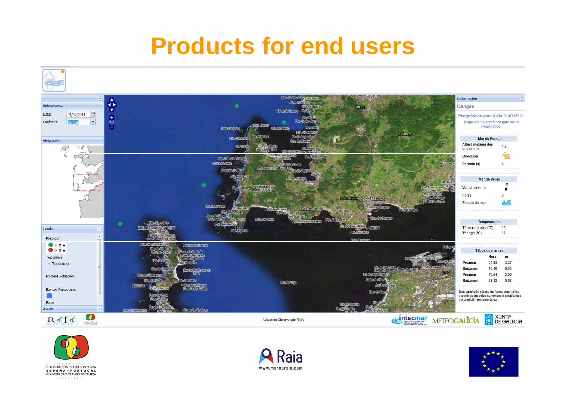
Products for end users

Envío por mail a lospatrones mayores ypuertos deportivos

More end users applications• Distribution of faecal pollution• Dynamic maps for fronts and eddies.• Prediction of avenues and their influence for shell fishing
areas.• Predictions of wind and wave energy offshore (Portugal)• Models of sediment transport.• Prediction of episodes of coastal pollution from residual
waters improperly debugged.• Forecast of waves and wind in the defeats of entrance
and exit of the estuaries and ports.• Apps for smartphones and smartTVs.
Conclusions• The Euroregion Galicia-North of Portugal has at present an infrastructure of oceanic
measurement of very high density; points of measurements, number of observations, etc.
• The network of observation provides reliable information and of quality.• The operational models allow to give forecastings up to 72 hours of the state of the
sea.• We have developed specific applications for end users using the capacity of the
Observatory to provide forecastings and observations in real time; harbors, fishermen, percebeiros, etc.
• The observatory RAIA pretends to be the site of reference of the Euroregión in terms of observation and oceanic prediction.
• Improve the presence of RAIA in different socioeconomic sectors of activity (energy, fishing, recreational boating, tourism, etc) of the Euroregion North of Portugal –Galicia.
• RAIA will be the initial seed for a future oceanic observatory at the WesternIberian Peninsula .

Gracias, Obrigado, Thanks
http://www.marnaraia.com