OAHP1414 (Rev. 11/2001) COLORADO HISTORICAL SOCIETY€¦ · oahp1414 (rev. 11/2001) colorado...
20
OAHP1414 (Rev. 11/2001) COLORADO HISTORICAL SOCIETY COLORADO STATE REGISTER OF HISTORIC PROPERTIES NOMINATION FORM SECTION I Name of Property Historic Name Frisco-Bagley Mill and Tunnel Other Names Frisco Mines & Tunnel Co.; Frisco-Bagley Mining Complex; Bagley Tunnel; Frisco Mill Address of Property [ ] address not for publication Street Address 820 County Road #9 City Silverton vicinity County San Juan Zip 81433 Present Owner of Property (for multiple ownership, list the names and addresses of each owner on one or more continuation sheets) Name Gregg P. and Jean Harlow Address 130 Fulton Street Phone City Broken Arrow State Oklahoma Zip 74012 Owner Consent for Nomination (attach signed consent from each owner of property - see attached form) Preparer of Nomination Name Gregg P. and Jean Harlow Date 2-16-2005 Organization Address 130 Fulton Street Phone City Broken Arrow State Oklahoma Zip 74012 FOR OFFICIAL USE: Site Number 5SA.165 ____________ Nomination Received Senate # House # ___5/13/2005_ Review Board Recommendation ___5/18/2005__ CHS Board State Register Listing __X__Approval ____Denial __X__Approved ____Denied Certification of Listing: President, Colorado Historical Society Date
Transcript of OAHP1414 (Rev. 11/2001) COLORADO HISTORICAL SOCIETY€¦ · oahp1414 (rev. 11/2001) colorado...

OAHP1414 (Rev. 11/2001)
COLORADO HISTORICAL SOCIETY
COLORADO STATE REGISTER OF HISTORIC PROPERTIES NOMINATION FORM
SECTION I Name of Property Historic Name Frisco-Bagley Mill and Tunnel Other Names Frisco Mines & Tunnel Co.; Frisco-Bagley Mining Complex; Bagley Tunnel; Frisco Mill Address of Property [ ] address not for publication Street Address 820 County Road #9 City Silverton vicinity County San Juan Zip 81433 Present Owner of Property
(for multiple ownership, list the names and addresses of each owner on one or more continuation sheets)
Name Gregg P. and Jean Harlow
Address 130 Fulton Street Phone
City Broken Arrow State Oklahoma Zip 74012 Owner Consent for Nomination (attach signed consent from each owner of property - see attached form) Preparer of Nomination
Name Gregg P. and Jean Harlow Date 2-16-2005 Organization Address 130 Fulton Street Phone City Broken Arrow State Oklahoma Zip 74012
FOR OFFICIAL USE: Site Number 5SA.165 ____________ Nomination Received Senate # House # ___5/13/2005_ Review Board Recommendation ___5/18/2005__ CHS Board State Register Listing __X__Approval ____Denial __X__Approved ____Denied Certification of Listing: President, Colorado Historical Society Date

COLORADO STATE REGISTER OF HISTORIC PROPERTIES Property Name Frisco-Bagley Mill and Tunnel SECTION II Local Historic Designation Has the property received local historic designation? [ ] no
[X] yes --- [X]individually designated [ ] designated as part of a historic district Date designated August 24, 1998 Designated by County Commissioners, San Juan Historic Preservation Advisory Board (Name of municipality or county) Use of Property Historic Industry/Extraction: extractive facility Current Not in use Original Owner N. R. Bagley and Franklin Rockefeller (Frisco Mines & Tunnel Co.) Source of Information Silverton Standard, 1903 Year of Construction Tunnel: 1904-1911 Mill: 1912 Source of Information local newspapers (Silverton Standard and Silverton Miner) and other archival materials Architect, Builder, Engineer, Artist or Designer unknown Source of Information Locational Status [X] Original location of structure(s)
[ ] Structure(s) moved to current location Date of move SECTION III Description and Alterations
(describe the current and original appearance of the property and any alterations on one or more continuation sheets)
COLORADO STATE REGISTER OF HISTORIC PROPERTIES Property Name Frisco-Bagley Mill and Tunnel SECTION IV Significance of Property
Nomination Criteria
[X] A - property is associated with events that have made a significant contribution to history
[ ] B - property is connected with persons significant in history
[X] C - property has distinctive characteristics of a type, period, method of construction or artisan
[ ] D - property is of geographic importance
[ ] E - property contains the possibility of important discoveries related to prehistory or history
Areas of Significance
[ ] Agriculture [X] Architecture [ ] Archaeology – prehistoric [ ] Archaeology – historic [ ] Art [ ] Commerce [ ] Communications [ ] Community Planning and Development [ ] Conservation
[ ] Economics [ ] Education [X] Engineering [ ] Entertainment/ Recreation [ ] Ethnic Heritage [ ] Exploration/ Settlement [ ] Geography/ Community Identity [ ] Health/Medicine [X] Industry [ ] Invention
[ ] Landscape Architecture
[ ] Law [ ] Literature [ ] Military [ ] Performing Arts [ ] Politics/ Government [ ] Religion [ ] Science [ ] Social History [ ] Transportation
Significance Statement (explain the significance of the property on one or more continuation sheets) Bibliography (cite the books, articles, and other sources used in preparing this form on one or more continuation sheets) SECTION V Locational Information
Lot(s) N/A Block N/A Addition N/A USGS Topographic Quad Map Handies Peak Verbal Boundary Description of Nominated Property
(describe the boundaries of the nominated property on a continuation sheet)

COLORADO STATE REGISTER OF HISTORIC PROPERTIES Property Name Frisco-Bagley Mill and Tunnel SECTION VI Photograph Log for Black and White Photographs
(prepare a photograph log on one or more continuation sheets) SECTION VII ADDITIONAL MATERIALS TO ACCOMPANY NOMINATION Owner Consent Form Black and White Photographs Color Slides Sketch Map(s) Photocopy of USGS Map Section Optional Materials
For Office Use Only Property Type: [ ] building(s) [ X ] district [ ] site [ ] structure [ ] object [ ] area Architectural Style/Engineering Type: No style
Period of Significance: 1904 - late 1920s Level of Significance: [ X ] Local [ ] State [ ] National Acreage 3.33 P.M. NM Township 42N Range 7W Section (unsectioned) Quarter Sections UTM Reference: Zone Easting Northing (see continuation sheet) Site Elevation: 11,400 feet

COLORADO STATE REGISTER OF HISTORIC PROPERTIES Page 1 CONTINUATION SHEET Section III Property Name Frisco-Bagley Mill and Tunnel DESCRIPTION and ALTERATIONS The Frisco-Bagley Mill and Tunnel are located 12 miles out of Silverton and one-half mile up the West Fork of the Animas Forks in California Gulch at 11,400 feet elevation. The Mill and Tunnel are part of the Gorilla Mining Claim, which is located on the southwest slope of Houghton Mountain. California Mountain and Treasure Mountain are to the south and west. All these mountains range in elevation from 12,000 to 13,000 feet. The site is a popular stopping point for tourists and recreational users of the Alpine Loop Scenic and Historic Byway, a four-wheel drive loop connecting Ouray, Lake City and Silverton over Engineer Pass and Cinnamon Pass. As a result of the heavy traffic, artifact collectors have frequented the site. Most artifacts that can be easily carried away by visitors have been removed. The site includes a partially collapsed 150-ton reduction mill, a mine portal, cement foundations that once anchored compressors, and a recently constructed cabin with its accompanying comfort station. The mill building dominates the landscape. The reduction mill is comprised of three gabled roof sections; each lower than the other as it progresses down slope. Most of the south section, the largest portion of the building, has collapsed. The Frisco Mill was designed and built to be completely modern in 1912 with the latest processing and totally electric. Coal was only used in a small heating stove to keep the men warm in the mill office. This large building is of milled post and beam construction with timber joints through bolted and dapped. It is rectangular in shape 150 feet long X 50 feet wide and 65 feet at the peak. Timber post sizes are 8” X 8” on the upper floors, 10” X 10” and 12” X 12” on the lower floors and rear wall. Footing timbers that sit on top of concrete pillars are 12” X 12”. Exterior walls have 3” X 6” vertical and horizontal blocking, which fastens vertical 1” X 12” pine boards on the exterior. The roof is decked with 1” X 12” pine and was originally covered with corrugated galvanized metal roofing. Lower floor joists are 7” X 10” on 2 foot centers and flooring is double laid 2” X 10” with some areas single layered. Upper floor joists are 3” X 8” with 2” X 10” flooring. Beams are mostly 10” X 10” with some 8” X 8”. The roof trusses make a 16-foot peak and span 50 feet. They are constructed of 8” X 8” pine with 11/2 ½” metal truss rods. Of the fifty 6 over 6, double hung windows, none are intact yet most window frames are still in place. The foundation is poured concrete pillars, footings, and footing walls, all of which are in excellent shape with no deterioration. Most of the heavy post and beam framing is in good shape, with a few timbers needing to be replaced. Inside the building, there is still some evidence of the ore reduction process. Cement foundations for the primary crusher, the cone crushers, and lift belts are still present, as are the collapsed wooden components of the Wilfley tables and classifiers. Unfortunately salvage efforts during WW II and subsequent scavengers removed all the metal components from the building. The tunnel opening is approximately 200 feet away from the mill. Identified on the quad map as Bagley Tunnel, a stream comes out of the portal. The tunnel was an approximately 7 x 7-1/2 foot opening that went straight for 7,500 feet. Bored through mostly solid rock, the tunnel did not require any timber framing. Although work on the tunnel began in 1877, the “great bore” was started in 1904 and reached its completed length by 1911. Two small wood frame buildings, constructed in 1999, are positioned above the tunnel portal. Both have walls of rough cut pine boards and gabled roofs covered in red propanel. The summer cabin is 12’ by 20’ and has aluminum slider windows. The accompanying comfort station is 8’ by 8’ and contains a chemical toilet. These two recently constructed buildings are considered non-contributing.

COLORADO STATE REGISTER OF HISTORIC PROPERTIES Page 2 CONTINUATION SHEET Section III Property Name Frisco-Bagley Mill and Tunnel Alterations The mining complex of the Frisco Mines & Tunnel Co. Inc. originally included many buildings in addition to the very large reduction mill. A camp existed at the site before the 1912 construction of the mill. Photographs taken in the teens and 1920s show the complex also included a large boarding house, a compressor building, a large tool shed, a blacksmith shed, a mine manager’s house, an unidentified log cabin, an unidentified second house, plus several other outbuildings and privies. It is not known when most of these buildings were removed from the property. A 1976 site inventory record specifically noted a prefabricated mill structure and a boarding house, and included a photograph of the boardinghouse (Baker 1976). By 1997, the survey form notes only the mill and the ruins of a small wood frame “office building” (Medville 1997), that is just outside the nomination boundaries. During the late 1970’s a few local people were going to raze the mill building presumably to sell the weathered wood and scrap what metal was left in the truss rods and fasteners. The owners stopped this process but not before extensive damage was done. Stabilization of the mill building was undertaken in 1990. Wire scaffolding was installed to stabilize the east wall with the wire bolted to the foundation and attached to the mid-section of the wall. In 1999, the small summer cabin and comfort station was built on the hill above the tunnel. Considerable damage to the south end of the mill building occurred between the initial 1976 recording and 1997. In addition, the large waste rock piles that surrounded the mill were also impacting the building. These waste rock piles (the country rock extracted during tunnel excavation and to access the ore) were pushing in on the walls. In 2001, the mine dump was moved away from the west wall of the mill for this reason. The building being relieved of its side load immediately came back to square on its own. In 2002, the rear deck was removed to facilitate moving the mine dump away from the north end of the building. Drawings were made of this deck before removal. Although it may look worse for wear, its internal framing is strong and the timber joints are good. Today, the reduction mill building still stands, despite the collapse of a large portion of the southern section. According to the owners, the collapsed condition is due to the siding being removed for the weathered wood, not from weather-related causes.

COLORADO STATE REGISTER OF HISTORIC PROPERTIES Page 3 CONTINUATION SHEET Section IV Property Name Frisco-Bagley Mill and Tunnel SIGNIFICANCE STATEMENT The Frisco-Bagley Tunnel and Mill are eligible under Criterion C for Architecture and Engineering. Constructed in 1912, the Frisco Mill is architecturally significant as an unusual example of a pre-fabricated industrial building. Its pieces were pre-cut, pre-fit, and number/letter coded before being transported via the Silverton Northern Railroad, loaded into wagons and then hauled to the site for assembly. The Bagley Tunnel possesses engineering significance for its size, symmetry and straight northwesterly course through Houghton Mountain. The tunnel is one of the first, if not the first, example of cross cut tunneling in the area. It cut the largest veins in this area at the Mineral Point juncture. The tunnel is absolutely straight for 1-1/2 miles. It does not follow any vein but rather was driven to cut major metal veins at 90 degrees. This allowed all the veins to be worked while providing a haulage tunnel to the mill. It was a very expensive project, a front-loaded expense with no financial return for the first nine years. Although work on the tunnel began in 1877, the “great bore” began in earnest in 1904 and was planned to extend 2-1/2 miles. By 1911, what would be its completed length of 7500 feet was reached. The Frisco-Bagley Tunnel and Mill, once part of the Frisco Mines & Tunnel Co., is also eligible for the State Register under Criterion A in the area of Industry for its association with mining in the upper Animas River Drainage system of the San Juan Mining District. The site represents the extent to which investors speculated in hopes that rich mineral ores could be reached. The mining complex was a pivotal piece in the history of two towns—Animas Forks and Mineral Point. The construction of the tunnel and the mill kept one town alive a little longer and caused the abandonment of the other. Criterion C - Architecture The Frisco Mill was a massive post and beam construction with timber joints through bolted and dapped. The 150-ton ore concentration mill was assembled during the summer of 1912 at an elevation of 11,400 feet. All the framing timbers still carry an identifying letter and number location code. Construction crews assembled the framing of the pre-cut and pre-fit pieces in proper order and sequence based on the location code. None of these pieces had need of cutting on site; the process was similar to a very large jigsaw puzzle. The Silverton Standard reported in April 1912 that framing timbers were being cut and fit at the San Juan Lumber yard [location unknown today]. The newspaper noted in June that the timbers were ready to ship. The paper reported in August that the roof was being installed with most mill equipment present at the site. The August 1912 Silverton Standard noted that the building was constructed around the machinery it housed. (This is evidenced by large holes cut in portions of the walls in order to extricate the equipment later.) Massive poured concrete foundations for the particular pieces of equipment are evident as well as concrete pedestals, footings and footing walls of the building itself. This building is distinct in its design for an ore concentrating mill. In the process of reduction the mineral portions of the ore are separated from the sand, clay and rock in order to ship just mineral to the smelter. There are several steps to this process and each step has machinery peculiar to its own stage of separation. Gravity was used to move the ore during processing. Most all mills stair step down a mountainside in order to create vertical separation so the ore may flow down hill. These steps are usually 15 to 30 feet between one floor and the next.
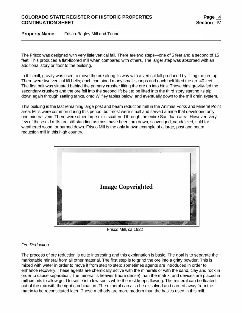
COLORADO STATE REGISTER OF HISTORIC PROPERTIES Page 4 CONTINUATION SHEET Section IV Property Name Frisco-Bagley Mill and Tunnel The Frisco was designed with very little vertical fall. There are two steps—one of 5 feet and a second of 15 feet. This produced a flat-floored mill when compared with others. The larger step was absorbed with an additional story or floor to the building. In this mill, gravity was used to move the ore along its way with a vertical fall produced by lifting the ore up. There were two vertical lift belts; each contained many small scoops and each belt lifted the ore 40 feet. The first belt was situated behind the primary crusher lifting the ore up into bins. These bins gravity-fed the secondary crushers and the ore fell into the second lift belt to be lifted into the third story starting its trip down again through settling tanks, onto Wilfley tables below, and eventually down to the mill drain system. This building is the last remaining large post and beam reduction mill in the Animas Forks and Mineral Point area. Mills were common during this period, but most were small and served a mine that developed only one mineral vein. There were other large mills scattered through the entire San Juan area. However, very few of these old mills are still standing as most have been torn down, scavenged, vandalized, sold for weathered wood, or burned down. Frisco Mill is the only known example of a large, post and beam reduction mill in this high country. Frisco Mill, ca.1922 Ore Reduction The process of ore reduction is quite interesting and this explanation is basic. The goal is to separate the marketable mineral from all other material. The first step is to grind the ore into a gritty powder. This is mixed with water in order to move it from step to step; sometimes agents are introduced in order to enhance recovery. These agents are chemically active with the minerals or with the sand, clay and rock in order to cause separation. The mineral is heavier (more dense) than the matrix, and devices are placed in mill circuits to allow gold to settle into low spots while the rest keeps flowing. The mineral can be floated out of the mix with the right combination. The mineral can also be dissolved and carried away from the matrix to be reconstituted later. These methods are more modern than the basics used in this mill.
Image Copyrighted

COLORADO STATE REGISTER OF HISTORIC PROPERTIES Page 5 CONTINUATION SHEET Section IV Property Name Frisco-Bagley Mill and Tunnel Turn of the century mills were fairly adequate but still operated around 85% recovery. The Frisco Mill was in this group with “modern” equipment in 1912. Ore cars approached the mill from a mine spur track and stopped on a scale to be weighed. They were then pushed across a bridge on to the porch at the back of the mill. On the other side of a large hole in the wall was a small ore bin that fed the primary crusher below. The cars were dumped and a mill man fed the crusher. This was a rod type, which looked like a long drum with one end higher than the other; as it turned, heavy alloy rods rolled inside to crush the ore. At the low end gravel sized pieces and powder fell into a hollow in the floor where the first lift belt raised the material 40 feet and dropped it into big ore bins. The bins gravity feed ore into secondary crushers. There were two of these very large and heavy cone crushers on massive concrete foundations. Gravel is reduced to powder in these machines and is dropped down into a hollow in the floor where the second lift belt raised the material 40 feet for its trip down through processing. Chlorine and water were mixed with the crushed ore, this mixture is called slime. At this point, processing equipment becomes more portable and lighter. There were many variations and forms of this intermediate process. Unfortunately no clues were left telling us what was used in this mill. The end of the process is still evident however. Large settling tanks were installed at the 3rd floor level. These were funnel shaped the smaller being 8 feet across and the larger 12 feet. There were 12 of these (5 still remain). These would separate heavy dense material from lighter sands. On the 2nd floor below these tanks many Wilfley tables worked the ore. These machines had a very stout base of iron and a mechanism for shaking the table top. Its motion was similar to an orbital sander. The top was adjustable with one end higher and one side higher. As the ore was fed on to the top the vibrating motion would begin to separate larger bits from small, and denser (heavier) from light as the ore moved along its length. The heavier and smaller pieces would “walk” to the high side, the heaviest being highest with the lightest at the bottom. This would separate into bands with the help of riffles in the top. Water was added here as a wash and to help with motion. The bands of mineral would be identified by the operator and caught, dried, bagged, and then sent to the smelter. Criterion C - Engineering The Bagley Tunnel is distinctive when compared with other turn-of-the-century mining projects. Enough foresight was applied to bring together all the proven production of the immediate area and combine it all into one mine that was served by one main haulage tunnel. The process of developing an ore body always precedes any ore extraction in modern practices. The mines at the turn of the century were mostly started as individual businesses. There was neither time nor capital to develop anything; it was follow the vein to produce ore and hope enough gold is included to pay for the work. This tunnel however was very different. Work started in 1877, and from its inception the designed purpose and intent was to crosscut the mineral veins of this fissure system at a perpendicular angle. This would allow many different veins to be mined simultaneously or at different times, depending upon what the mill needed. This tunnel did not follow any vein. Its purpose was to provide a way to transport ore to the mill when it reached these veins and to approach the mineralized system from below the older surface workings. The “great bore” was started in 1904 and was planned to extend 2-1/2 miles. It was a crosscut or development tunnel whose purpose was two-fold: 1) to provide a main haulage route to the mill; and 2) to cut through the major mineral veins perpendicularly so all veins could be mined. By 1907, the tunnel had advanced 400 feet and by 1911, it was at its completed length of 7,500 feet. The tunnel size was 7 feet X 71/2 feet, which was very large for it’s time. “It is the delight and

COLORADO STATE REGISTER OF HISTORIC PROPERTIES Page 6 CONTINUATION SHEET Section IV Property Name Frisco-Bagley Mill and Tunnel admiration of all tunnel and mining men who have visited it. It is a marvel of perfection, stability, and safety”, reported the Silverton Miner in a November 1907 issue. The Silverton Standard also noted that its construction made it “one of the largest mines in the San Juan’s” (September 1911). J.O. Campbell ME, in his 1912 report said “the work was done in a very thorough and workman like manner, without accident or loss of life”. The August 1912 Silverton Standard newspaper provided the following description of the tunnel:
The tunnel itself is one of the most perfect mining engineering feats and works ever performed in the San Juan district… it penetrates the center of Houghton Mountain on an even grade and is as straight as an arrow. The whole working system is lighted by [an] electric light system with powerful incandescent lights at frequent and regular intervals and when the mine is in full operation it presents a scene as enchanting as a fairyland picture.
Criterion A – Industry The Frisco Mines and Tunnel Co. is linked with events that have made a significant contribution to the history of the towns of Animas Forks and Mineral Point. Although on the other side of the mountain from Mineral Point and a half-mile from Animas Forks, Frisco Mines and Tunnel Co. came into being because of the Mineral Point area. The project was solely undertaken to access the mineral veins of Mineral Point. The towns of Animas Forks and Mineral Point each had their start in the early 1870s, and the Frisco-Bagley Mining Complex is indelibly linked to both towns. As with most prospecting-camps-turned-mining-town, growth was governed by economics. As mines were developed and ore was produced, the towns prospered. Ore production slowed at Mineral Point in the mid-1870s due to the almost impossible logistics of this more rugged area. The town site of Mineral Point is located at alpine elevation where parallel mineral veins of this fissure system show on the surface. The land in this San Juan region was formed by tectonic and volcanic action, which did away with the sea that dominated the middle of the country. Due to continental plate movements and consequent plate subduction, very active volcanic forces flooded the land with lava. Over extended periods of time and successive eruptions two major vents formed, one known as Silverton at Gladstone and another at Lake City. Each time these vents cooled and the lava solidified a dome formed, which is called a caldera. With further cooling and no eruptions, the material in the pipe that fed the vent began to cool and shrink. This fractured the dome in a circular form. In addition a series of fractures formed which are parallel and close. In the case of Mineral Point, a series of 30 to 40 fractures were found. At a much later time a hot watery mix of sulfide carrying quartz and metals percolated up through these cracks which crystallized and precipitated out of the mix as it cooled. In this process over time the mineral was deposited within the fractures. The walls of the fractures have no mineral content and only the quartz filling show minerals. This quality and form is a fissure system. Mining these veins was done vertically from the surface down. This is the slowest and most costly mine development and operation, involving the continual hoisting of men, supplies, and ore to surface. A shaft was sunk down the mineral vein to a depth where a drift could be driven (a horizontal bore). When this had been extended miners then created an ore block, which would be drilled and blasted from the bottom up toward the surface. This is called a stope and is the most economical way of mining. In the case of Mineral Point mines, logistics was a tremendous problem as no matter how economically sound the stope was, ore needed to be hoisted to the surface through a main shaft and transported to a smelter via mule train—a

COLORADO STATE REGISTER OF HISTORIC PROPERTIES Page 7 CONTINUATION SHEET Section IV Property Name Frisco-Bagley Mill and Tunnel very expensive ordeal. Transportation in the area was in its infancy at the time. A good county road was not even proposed until 1875 and the Silverton Northern Railroad would not be completed to Animas Forks for almost 30 years. Ore was high graded due to the excessive costs, which meant only rich ores made the trip to a smelter and lower grade ores were tossed aside. These ores contained gold in lesser quantities; they were predominantly silver and base metals, which are very good milling ores. In this system gold is found in pockets or streaks, areas of high concentration which pinch out then eventually reappear. These streaks are the high grade that made its way to the smelter. (The difference between high and low ore grade is strictly its gold content. High grade offers enough gold to allow a reasonable profit while low grade was not worth transporting at the time.) By the mid-1870s the mines of Mineral Point reached a state of diminishing return. It became apparent that a more cost-effective way to handle the many tons of lower grade ore was needed. In order to reach these vast quantities of ore, it would be necessary to tunnel under them from a point lower than the rolling alpine area of Mineral Point. The most cost-effective location to accomplish this was on the other side of Houghton Mountain in California Gulch. A tunnel was started which would be driven under the mountain, under the area of Mineral Point, with a proposed exit in Poughkeepsie Gulch near the San Juan Chief Mill. This was a straight-line distance of over three miles. In 1877, this project was started. The company was appropriately named Bonanza Tunnel Company as it followed no mineral vein but was driven as a cross cut tunnel to access the many veins of the Mineral Point area. This tunnel with its perpendicular angle would cut over two dozen notable mineral veins. The granite rock was slow to work using the old equipment, but needed very little timbering. Even though Mineral Point boasted a hotel, several restaurants, a post office, and a few saloons, it began to wane in the early 1880s. Population had peaked between 400 and 500. The destiny and fate of Mineral Point had been set. With the start of the Bonanza Tunnel in 1877, the town’s demise was certain. Animas Forks fared better for a longer period of time due to two factors—the Gold Prince Mill and the Frisco-Bagley mining complex. Things were prosperous here until 1912 while both companies were operating, and the population reached between 400 and 500. However it was decided to move the Gold Prince Mill down the canyon to Eureka. With the Gold Prince Mill gone there would have been no large-scale employer for the men except for the Frisco-Bagley mining complex. The Frisco camp kept up to 32 miners employed plus 8 to 10 mill men. Production records from 1913 and 1914 show 7,166 tons of ore produced from the various veins serviced by the tunnel. Keep in mind the mine car of the day held one ton! From this production the ore yielded the following: 92 ounces of gold; 13,363 ounces of silver; 11,177 pounds of copper; 326,404 pounds of lead; and 119,451 pounds of zinc. Although not as prosperous as it was with the Gold Prince Mill working, the town of Animas Forks was kept alive with the continued work provided through the Frisco-Bagley mining complex. Mine production continued until the late 1920s. The effects of early abandonment of Mineral Point is seen today. Nothing remains of the town site, while Animas Forks boasts several remaining houses and structures. After the Bonanza Tunnel Co. made its start in 1877, it wasn’t long until this concept and vision caught the interest of English capitalists, who purchased the project in the early 1880s. The Silver Peak Mining and Smelting Co. was founded. During their tenure, new equipment was brought to the mine and the tunnel advanced. One can speculate, as the metals market raised and lowered then collapsed in 1893, work also started and stopped in accordance with the market.

COLORADO STATE REGISTER OF HISTORIC PROPERTIES Page 8 CONTINUATION SHEET Section IV Property Name Frisco-Bagley Mill and Tunnel By 1904, most mining in the area had slowed except for the Gold Prince Mine and the mill in Animas Forks. Beginning in 1903, Franklin Rockefeller and N.R. Bagley invested in the Mineral Point vision. By 1905, this new company had acquired 140 mineral claims in the Mineral Point area, which gives an indication of the scope and vision of these men. It was then that the Frisco Mines and Tunnel Co. was organized and incorporated for 6 million dollars. It would not be long when the first major vein, “Hadley,” would be crossed at 1600 feet from the adit and ore production was underway. The first ores were processed at the Gold Prince Mill at Animas Forks a mere half mile away. By 1911, the tunnel reached 7500 feet in length, cutting through a dozen notable veins of importance. The end result was a project of major proportions, even though the tunnel’s full length was never reached. During this time, the Silverton Northern Railroad reached Animas Forks in 1904. This drastically reduced transportation costs making the concentrate from low-grade ores economically feasible. (The Silverton Northern right of way crews graded a branch line up to the Frisco camp sometime after 1907. There is evidence of this grade utilizing two switchbacks however, there has been no evidence found indicating rails were ever laid.) The town of Animas Forks was flourishing even though Mineral Point was reduced to very little activity. All went well until the Gold Prince owners decided to move their mill down the canyon to Eureka. At this point the Frisco owners built a 150-ton reduction mill using the latest of equipment. Electric power was often established in these remote mining areas before it was available to the general public. In 1912, the Frisco Mill was completely electrically powered, as was the camp. The camp also had telephone service that was linked with Animas Forks and ran through Lake City. With the Gold Prince Mill gone there was no major employer besides the Frisco Mines and Tunnel Co. complex. And for this period of time Animas Forks was kept alive.

COLORADO STATE REGISTER OF HISTORIC PROPERTIES Page 9 CONTINUATION SHEET Section IV Property Name Frisco-Bagley Mill and Tunnel
Image Copyrighted

COLORADO STATE REGISTER OF HISTORIC PROPERTIES Page 10 CONTINUATION SHEET Section IV Property Name Frisco-Bagley Mill and Tunnel
The third floor of the Frisco Mill, ca. 1922.
Image Copyrighted

COLORADO STATE REGISTER OF HISTORIC PROPERTIES Page 11 CONTINUATION SHEET Section IV Property Name Frisco-Bagley Mill and Tunnel The Frisco-Bagley Mining Complex ca. 1922 A ca. 1922 photo of the mill that illustrates the massive size of the building.
Image Copyrighted
Image Copyrighted

COLORADO STATE REGISTER OF HISTORIC PROPERTIES Page 12 CONTINUATION SHEET Section IV Property Name Frisco-Bagley Mill and Tunnel BIBLIOGRAPHY Baker, Steven. Site Inventory Record for Frisco Tunnel (5SA.36), 1976. On file in the Office of
Archaeology and Historic Preservation, Colorado Historical Society, Denver, Colorado. ------------. Colorado Cultural Resource Survey Property Re-evaluation Form for Bagley Mill (5SA.165),
1999. On file in the Office of Archaeology and Historic Preservation, Colorado Historical Society, Denver, Colorado.
Campbell, J.O. ME. Examination and Report Frisco Tunnel Co.1912. Campbell, J.O. ME. Personal correspondence to N.R. Bagley 1908. Dallas, Sandra. Colorado Ghost Towns and Mining Camps. University of Oklahoma Press, 1985. Division of Minerals and Geology, Production Records, 1913, 1914. Eberhart, Perry. Guide to Colorado Ghost Towns and Mining Camps. Denver: Sage Books 1959. Harlow, Gregg. Colorado Cultural Resource Survey Form for Bagley Tunnel - Frisco Mill (5SA.36), 1992.
On file in the Office of Archaeology and Historic Preservation, Colorado Historical Society, Denver, Colorado.
Lakes, Arthur. History and Geology of the San Juan, Profile; Colorado School of Mines, 1882. Marshall, John and Zeke Zanoni. Mining the Hard Rock in the Silverton San Juans, A Sense of Place,
A Sense of Time. Medville, Susan. Colorado Cultural Resource Survey Form for Frisco-Bagley Tunnel and Mill (5SA.165),
1997. On file in the Office of Archaeology and Historic Preservation, Colorado Historical Society, Denver, Colorado.
Nossaman, Allen. Many More Mountains, Volume 1 and 2. Reed, D.R. ME. personal correspondence to N.R. Bagley 1906. Colorado School of Mines, Archival Department, some facts concerning Frisco Mines and Tunnel Co. circa
1915, author unknown. Silverton Miner. Nov. 1907 – June 1908. Silverton Standard Dec. 1903, Aug. 1904, June 1905, Oct. 1905, Oct. 1906, Nov. 1907, July 1909, Apr. 1911, Sept .1911, Feb. 1912, Apr. 1912, June 1912, Aug. 1912. Sloan, Robert and Skowronski, Carl. The Rainbow Route, Sundance Publications, 1975. Stockholders Report of Frisco Mines & Tunnel Co., 9 June 1910.

COLORADO STATE REGISTER OF HISTORIC PROPERTIES Page 13 CONTINUATION SHEET Section V Property Name Frisco-Bagley Mill and Tunnel GEOGRAPHICAL DATA VERBAL BOUNDARY DESCRIPTION The nominated property is a part of the Gorilla Mineral Claim No. 17549 within the Eureka Mining District of San Juan County. The boundary was drawn to encompass only that portion of the Gorilla Mineral Claim that includes the adit (the horizontal opening of the tunnel) and the mill building—a parcel of land approximately 300 feet by 492 feet, comprising 3.33 acres. The boundary of the nominated property forms a polygon whose vertices are marked by the following UTM reference points: A) 13 273122mE 4201322mN B) 13 273200mE 4201371mN C) 13 273273mE 4201246mN D) 13 273202mE 4201195mN

COLORADO STATE REGISTER OF HISTORIC PROPERTIES Page 14 CONTINUATION SHEET Section V Property Name Frisco-Bagley Mill and Tunnel Gorilla Mineral Claim No. 17549
COLORADO STATE REGISTER OF HISTORIC PROPERTIES Page 15 CONTINUATION SHEET Section VI Property Name Frisco-Bagley Mill and Tunnel PHOTOGRAPH LOG The following information pertains to all photographs: Name of Property: Frisco-Bagley Mill and Tunnel Location: San Juan County, Colorado Photographer: Jean Harlow Date of Photographs: 2002 Negatives: Jean Harlow Photo No. Photographic Information
1 Frisco Mill, looking northwest. 2 Ground floor with wooden trough, mill drain, and letter/number coding. 3 Ground floor with wooden trough. 4 Ground floor with post and beam, and letter/ number coding. 5 2nd floor with ore bins and lift belt frame at right.
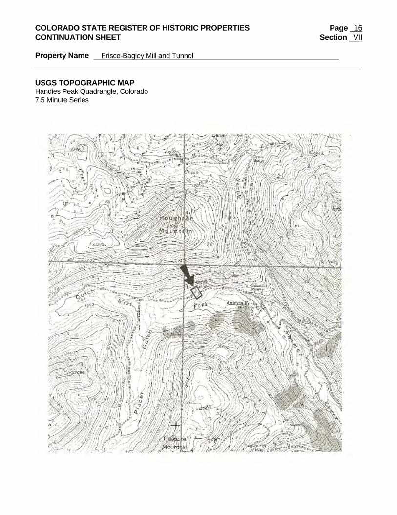
COLORADO STATE REGISTER OF HISTORIC PROPERTIES Page 16 CONTINUATION SHEET Section VII Property Name Frisco-Bagley Mill and Tunnel USGS TOPOGRAPHIC MAP Handies Peak Quadrangle, Colorado 7.5 Minute Series