NZ1-10499763-Review of the Regional Plan for Tarawera ... · The Tarawera River Catchment is within...
107
Report Review of the Regional Plan for Tarawera River Catchment Prepared for Bay of Plenty Regional Council Prepared by Beca Ltd (Beca) 10 June 2015
Transcript of NZ1-10499763-Review of the Regional Plan for Tarawera ... · The Tarawera River Catchment is within...
Report
Review of the Regional Plan for Tarawera River Catchment
Prepared for Bay of Plenty Regional Council
Prepared by Beca Ltd (Beca)
10 June 2015

Review of the Regional Plan for Tarawera River Catchment
Beca // 10 June 2015 4282426 // NZ1-10499763-7 0.7 // i
Revision History Revision Nº Prepared By Description Date
1 Shad Rolleston Working Draft for client 1/4/15
2 Shad Rolleston/Hugh Leersnyder
Draft for review 2/4/15
3 Shad Rolleston Final for client 2/4/15
4 Cushla Loomb Final with Council requested additions 24/4/15
5 Cushla Loomb Further revision with client requested amendments
10/6/15
Document Acceptance Action Name Signed Date
Prepared by Shad Rolleston/Cushla Loomb
10/6/15
Reviewed by Richard Douch
2/4/15
Approved by Hugh Leersnyder
2/4/15
on behalf of Beca Ltd
© Beca 2015 (unless Beca has expressly agreed otherwise with the Client in writing).
This report has been prepared by Beca on the specific instructions of our Client. It is solely for our Client’s use for the purpose for which it is intended in accordance with the agreed scope of work. Any use or reliance by any person contrary to the above, to which Beca has not given its prior written consent, is at that person's own risk.
Review of the Regional Plan for Tarawera River Catchment
Beca // 10 June 2015 4282426 // NZ1-10499763-7 0.7 // ii
Executive Summary This report documents the findings of a review of the efficiency and effectiveness of the Tarawera River Catchment Management Plan (the Plan). The purpose of the Plan is to promote the sustainable management of natural and physical resources within the Tarawera River catchment. The Plan was made operative in 2004 after extensive community engagement and research. The review is a response to the Council fulfilling its statutory obligation under the Resource Management Act 1991 to monitor the effectiveness and efficiency of policies, rules and/or other methods in its policy statement or its plans.
The review considered the relevant statutory documents in order to determine the Anticipated Environmental Results from the Plan and the relationship between the Plan and other Regional Plans. The documents of particular relevance were the Regional Policy Statement, Regional Water and Land Plan, and the On-Site Effluent Treatment Plan. Data and information collected by Council was reviewed, specifically the Natural Environmental Regional Monitoring programme, resource consents, and compliance and incident information. A representative sample of resource consents granted in the catchment were interrogated to determine whether Council has appropriately considered the Plan in assessing applications and whether or not the resource consents’ conditions had been complied with. Consultation was also undertaken with Council staff, key stakeholders, consent holders and local iwi to consider their views on the effectiveness of the Plan.
The findings of the review are that the expectations of the Plan are clear, particularly addressing water quality and the protection and enhancement of water bodies within the catchment. The review indicates there have been noticeable improvements in water quality in the Lower Catchment as a result of industrial users improving their discharges to the river (through compliance with consents granted under the Plan).
The Plan is comprehensive in that it covers a wide spectrum of resource management issues. The Plan contains detailed information, particularly the background and supporting information sections. However, improvements can be made and further work undertaken in the following areas:
n remove duplication of provisions both within the Plan itself (i.e. cross referencing) and between the Plan and other regional plans,
n introduce limits consistent with the National Policy Statement for Fresh Water (both water quantity and quality)
n review non-compliant consents and consider enforcement action, n prepare a monitoring programme to monitor the environment to identify trends n undertake a stocktake of the resources within the catchment, and n review the resource consents assessed as part of this review process and, for those that stated that the
Plan is not relevant or that did not consider the Plan, undertake a further assessment of the reasons for that decision (if given) and whether it was justified.

Review of the Regional Plan for Tarawera River Catchment
Beca // 10 June 2015 4282426 // NZ1-10499763-7 0.7 // i
Contents
1 Introduction 1 1.1 Purpose of the Report 1 1.2 The Regional Plan for the Tarawera Catchment 1 1.3 The Statutory Framework 4 1.4 Methodology Used in the Review 4 1.5 Assumptions and Limitations of the Review 5
2 Consultation and Feedback 7 2.1 Introduction 7 2.2 Summary of feedback received 7
3 Evaluation 9 3.1 Introduction 9 3.2 Evaluation of Effectiveness and Efficiency 9 3.3 Plan Appropriateness 15
4 Conclusion and Recommendations 18
Appendices
Appendix 1 Information Reviewed
Appendix 2 Review of Resource Consent, Data and Compliance Monitoring
Appendix 3 Consultation Records
Appendix 4 Assessment of Anticipated Environmental Results
Appendix 5 Assessment Against Objectives and Policies (not including rules)
Appendix 6 Tarawera Plan Review Report – Water Quality

Review of the Regional Plan for Tarawera River Catchment
Beca // 10 June 2015 4282426 // NZ1-10499763-7 0.7 // page 1
1 Introduction 1.1 Purpose of the Report This report describes the approach and findings of a review of the effectiveness, efficiency and appropriateness of the Regional Plan for the Tarawera River Catchment (the Plan). The Bay of Plenty Regional Council (the Council) commissioned the review of the Plan in order to fulfil its statutory obligations under Section 35 of the Resource Management Act 1991 (RMA).
The Plan was made operative in February 2004 after concerns were raised by the community about the degraded state of the river and its catchment.
The duration of the Plan has a life of ten years. It was intended the Plan would begin a review nine years from the date it became operative.
1.2 The Regional Plan for the Tarawera Catchment The Tarawera River catchment extends from the Tarawera Lakes to the Bay of Plenty coast and includes the Tarawera River and all its sub-catchments, but excludes Lake Rerewhakaaitu and its catchment. The lower reach of the Tarawera River Catchment extends from the watershed of the Manawahe Hills and includes the Matata Lagoon in the west, to the Rangitaiki River in the east.
The Tarawera River Catchment is within the Bay of Plenty Region, administered by the Bay of Plenty Regional Council.
The need for a specific regional plan for the Tarawera River catchment became apparent after the community raised concerns with resource management issues associated with the Tarawera River in 1991. Particular concerns were raised about the degraded state of the Tarawera River down-stream from Kawerau.
The Plan was prepared by Council under the RMA and involved extensive engagement with the community, iwi, special interest groups and organisations with an interest in the Tarawera River catchment.
Council formed a Technical Liaison Group with industry, and Crown Research Institute representatives to review issues associated with the lower catchment. The group was responsible for providing direction for research and further investigation, particularly industrial discharges in the lower reaches of the Tarawera River. The Tarawera River Liaison Group was also formed as a think tank in the development of the Plan and consisted of iwi, industry, environmental groups, community groups and local authorities. In addition to the formation of liaison groups, Council staff engaged extensively with other organisations such as the Department of Conservation, Fish and Game Council, NIWA, Tasman Pulp and Paper Company, Caxton Paper Ltd, iwi authorities and a number of iwi organisations.
Council commissioned research and investigations into a range of issues to inform the preparation of the Plan. Research comprised of community perceptions, water quality, river flow analysis, groundwater and geothermal resource assessments, research into colour and clarity, land use capability, pulp and paper production processes, and resource management.
Council determined through s65(3) of the RMA and issues raised in consultation with the community that it was desirable to proceed with the preparation of the Plan. Council identified the following in reaching its decision:
a) Significant conflicts in terms of differences in attitudes between industry and community groups as to the level of protection required for the Tarawera river water quality

Review of the Regional Plan for Tarawera River Catchment
Beca // 10 June 2015 4282426 // NZ1-10499763-7 0.7 // page 2
b) Significant community demand for the protection of the Tarawera River by a continued reduction in the discharge of contaminants into the river
c) Significant concerns expressed by tangata whenua on the effects of contaminant discharge to the river
d) The need expressed by community survey to actively restore the deteriorated state of water quality in the Lower Reach of the Tarawera River.
After a prolonged plan preparation period, the Plan became operative on 1 February 2004. A plan showing the area over which the Plan has effect is shown in Figure 1.
The purpose of the Plan1 is to assist the Council to promote the sustainable management2 of natural and physical resources within the Tarawera River catchment.
The aim of the Plan3 is to achieve the purpose by ensuring that:
a) There is integrated management of the natural and physical resources of the Tarawera River catchment ;
b) The high quality water in the catchment of the Upper Reach of the Tarawera River is maintained, and improved where appropriate;
c) The water quality in the Lower Reach of the Tarawera River is managed to ensure that the effects of industrial discharges are substantially reduced;
d) The community remains involved in the management process;
e) There is reduction in the discharge of contaminants into the Tarawera River;
f) The Mauri of the Tarawera River is restored and the balance maintained.
1 Section1.2 page 1
2 Sustainable management is defined in section 5 of the RMA as: Managing the use, development and protection of natural and physical resources in a way, or at a rate, which enables people and communities to provide for their social, economic and cultural wellbeing and for their health and safety while: (a) Sustaining the potential of natural and physical resources (excluding minerals) to meet the reasonably foreseeable needs of future generations; and (b) Safeguarding the life-supporting capacity of air, water, soil and ecosystems; and (c) Avoiding, remedying or mitigating any adverse effects of activities on the environment.
3 Section 1.2 page 1

Review of the Regional Plan for Tarawera River Catchment
Beca // 10 June 2015 4282426 // NZ1-10499763-7 0.7 // page 3
Figure 1: Tarawera River Catchment

Review of the Regional Plan for Tarawera River Catchment
Beca // 10 June 2015 4282426 // NZ1-10499763-7 0.7 // page 4
1.3 The Statutory Framework The Council must formally review the Plan no later than ten years from the date it became operative under s79 RMA. Section 35 of the RMA also requires the Regional Council to report on the effectiveness and the efficiency of the Plan provisions at least once every five years. A report on the effectiveness and efficiency has not been previously completed for the Plan.
The purpose of this report as outlined in Section 1.1 is to:
n Review the provisions of the Regional Plan for the Tarawera River Catchment as required under s79(1)(b) of the RMA which states that: 79 Review of policy statements and plans
(1) A local authority must commence a review of a provision of any of the following documents it has, if the provision has not been a subject of a proposed policy statement or plan, a review, or a change by the local authority during the previous 10 years:
(b) a regional plan:
n Review the efficiency and effectiveness of the Regional Plan for the Tarawera River Catchment as required by s35(2)(b) RMA which states: 35 Duty to gather information, monitor, and keep records
(2) Every local authority shall monitor—
b) the efficiency and effectiveness of policies, rules, or other methods in its policy statement or its plan
n Provide advice to Council regarding the appropriateness of the provisions of the Plan and recommendations for future plan development and implementation i.e. giving effect to National Policy Statement for Fresh Water, Freshwater Management and the Regional Policy Statement.
1.4 Methodology Used in the Review The evaluation of the Plan was undertaken in general accordance with the methodology set out in Section 19 of the Plan and in accordance with s79 RMA.
A number of relevant information sources were made available for the evaluation of the Plan efficiency and effectiveness, including relevant statutory documents, resource consent data, compliance monitoring information and results of environmental monitoring. The methodology used in this review is summarised in Table 1 below, and explained in more detail in the report.
Table 1 - Methodology of the Review
Description
Phase 1 Information Review: Relevant Statutory Documents
A literature review of the relevant statutory and supporting documents was undertaken in order to determine the Anticipated Environmental Results from the Plan and the relationship between this document and other Regional Plans. Other relevant regional planning documents include the Regional Policy Statement, the Regional Water and Land Plan (RWLP) and the On-Site Effluent Treatment

Review of the Regional Plan for Tarawera River Catchment
Beca // 10 June 2015 4282426 // NZ1-10499763-7 0.7 // page 5
Description
Regional Plan (OSET Plan).
Databases
The Natural Environmental Regional Monitoring (NERM) programme administered by the Council includes flow and water quality monitoring. Data and information prepared by the Council under the NERM have been taken from Council technical reports and used to assist the review and evaluation of the Plan. The databases used by the Council to record information on resource consents, compliance and incidents have also been used to source information. This information includes monitoring reports prepared by consent applicants and consent holders.
A full list of the reports and databases reviewed as part of the evaluation is included in Appendix 1.
Phase 2 Review of Resource Consent, Data and Compliance Monitoring
The consents database was interrogated to determine the total number of consents in the catchment and those granted since the plan became operative. A selection of resource consents were reviewed based on a number of representative resource consents. To determine a short list of representative consents, the resource consents were categorised based on activity type, scale and location.
The s42A reports prepared for the selected resource consents were reviewed to determine whether or not the Regional Council had appropriately considered the Tarawera Plan in making a decision on the resource consent.
The compliance monitoring records for the selected resource consents were also reviewed to determine whether or not the resource consents’ conditions had been complied with.
A summary of the resource consents in the catchment, along with a summary of the assessment of the activity against the provisions of the Tarawera Plan and the compliance record is included in Appendix 2.
Phase 3 Consultation Consultation was undertaken with Council and territorial authority staff with responsibility for implementing the Plan. Consultation was also undertaken with a number of stakeholders including consent holders, and iwi (discussed in Section 2 of this report and summarised in Appendix 3).
Phase 4 Assessment against plan provisions The outputs of the research have been compiled into a series of evaluation spreadsheets that have been used to analyse the objectives and aims of the Plan. Further discussion and detail from the evaluation spreadsheets is provided in Section 3 of this report.
1.5 Assumptions and Limitations of the Review Due to the number of resource consents in the catchment, a full review of each resource consent was not undertaken. As an alternative, a selection of resource consents were reviewed based on a number of representative resource consents. To determine a short list of representative consents, the resource consents were categorised based on activity type, scale and location. The documents reviewed included the consent application, the s42A report, decision and compliance monitoring reports.
The selected resource consents are considered to be a suitable sub-set for analysis. However, a full review of all resource consents will obviously provide a more comprehensive analysis of how all consented activities

Review of the Regional Plan for Tarawera River Catchment
Beca // 10 June 2015 4282426 // NZ1-10499763-7 0.7 // page 6
meet the requirements of the Plan. It is also noted that the review of consents was undertaken in November 2013 and that some consents may have been renewed or had compliance action carried out since that time.
The review was also based on existing information made available to the project team. It is noted that there are some information gaps, which have been noted in the report.
Consultation was undertaken with iwi who have an interest in the Tarawera catchment. However, it is noted that detailed conversations were not able to be completed with Ngati Awa within the timeframes associated with completion of this review.

Review of the Regional Plan for Tarawera River Catchment
Beca // 10 June 2015 4282426 // NZ1-10499763-7 0.7 // page 7
2 Consultation and Feedback 2.1 Introduction Targeted consultation was undertaken with key stakeholders and Council staff members who have direct involvement in the implementation of the Plan, as listed below:
n Key Regional Council staff n Key District Council staff n Shortlisted consent holders in the Tarawera River Catchment n Iwi/Hapu in the Tarawera River Catchment n Department of Conservation (DOC) Staff n Care groups and river user groups
Feedback on the Plan was sought and received from the following Bay of Plenty Regional Council teams: Māori Policy, Consents, Pollution Prevention, Water Science and Support, Land Management and Rivers and Drainage.
Phone interviews were held with a limited number of consent holders in the catchment, explaining the review process and seeking feedback regarding the cost of implementing resource consents that were granted under the Plan.
Consultation records, including a full list of those consulted with, are included in Appendix 3.
2.2 Summary of feedback received This section provides a summary of the main feedback received during consultation related to Community Attitudes and Perceptions (Chapter 7 of the Plan) and Resource Management Issues of Significance to Iwi (Chapter 8).
2.2.1 Community Attitudes and Perceptions The key provisions of the Plan relevant to Community Attitudes and Perceptions are set out in Chapter 7 of the Plan. While this section of the Plan does not set any methods (which includes rules) to address issues associated with community attitudes and perceptions, the result of consultation with stakeholders suggests that there has been positive change and an improvement in the life supporting capacity of air, water, soil and ecosystems within the catchment. There has been sufficient time since the Plan became operative to identify positive environmental trends within the catchment. Iwi consider that the discharge of human waste to water is still an unacceptable practice, in particular the Whakatane District Council Edgecumbe wastewater discharge to water. The Bay of Plenty Regional Council has not exercised its ability under the Act to review existing consents to ensure that the plan is implemented in a timely manner.
2.2.2 Resource Management Issues of Significance to Iwi The key provisions of the Plan that are relevant to iwi are set out in Chapter 8 of the Plan. The Plan identifies: pollution of water, water quality, wetlands, land management, heritage places, and ownership and management as resource management issues of significance to iwi.
The general approach through consultation with iwi was to understand whether the issues identified in the Plan were appropriate. The general view of iwi through consultation is that there have been improvements in the catchment since 2004. The quality of wetlands along the Lower Catchment of the river has improved over time. However, there is still some way to go.

Review of the Regional Plan for Tarawera River Catchment
Beca // 10 June 2015 4282426 // NZ1-10499763-7 0.7 // page 8
Iwi anecdotal evidence suggests water quality has improved since 2004, particularly from industrial users on the Lower Reaches of the Tarawera River. The quality of traditional resource along the river has improved. However, it’s difficult to attribute improvements solely to the Plan. Iwi note the mauri of the river has been impacted by industrial users and poor land management practices, and there are still concerns about intensive agriculture.
The cultural view is that land based discharges are always preferable. The application of natural filtration processes allow for contaminants to be managed through the land.
Norske Skog Tasman and Carter Holt Harvey through their resource consents have established an MOU between the iwi of Ngati Awa, Ngati Tuwharetoa ki Kawerau and Ngati Rangitihi. The MOU seeks to enhance the Tarawera River in the Lower Catchment. The relationship between iwi and the Mill has improved through the MOU. Restoration projects have been advanced along Tarawera River margins and wetlands.
Review of the Regional Plan for Tarawera River Catchment
Beca // 10 June 2015 4282426 // NZ1-10499763-7 0.7 // page 9
3 Evaluation 3.1 Introduction This section of the report presents a high level assessment of the:
n Overall effectiveness of the Plan n Plan efficiency n Plan appropriateness
The high level assessment has been undertaken in accordance with Chapter 19 of the Plan. Detailed assessments of the Plan provisions are contained in three appendices:
n Appendix 4 provides an assessment of whether each Anticipated Environmental Result (AER) has been achieved;
n Appendix 5 contains an assessment of whether each objective has been achieved and the effectiveness and efficiency of the policies and methods (including rules); and
n Appendix 6 provides a review of the water quality of the Tarawera River Catchment.
3.2 Evaluation of Effectiveness and Efficiency
3.2.1 Review of Resource Consents There were 684 resource consents issued by Council for the Tarawera River catchment for the period 2004 – 2012. Fifty (or 7.5%) of those resource consents were analysed for this review.
The consents reviewed were under the following groupings:
n Works in the Bed of Rivers n Stormwater Discharges n Water permits n Land Use n Dairy Effluent Discharges n Wastewater Discharges n Wetland Restoration
The consents were reviewed to ascertain whether the Section 42 A report considered the Plan and whether the consent conditions had been complied with.
Works in the Bed of Rivers
All but one of the six consents issued were to local authorities or central government departments or agencies. Only one of the six staff reports considered the Plan and the remainder considered the Plan not relevant for a variety of reasons including the geographical location of the site and the relevance of the Regional Land and Water Plan.
Three are compliant with the conditions and one had a minor non-compliance.

Review of the Regional Plan for Tarawera River Catchment
Beca // 10 June 2015 4282426 // NZ1-10499763-7 0.7 // page 10
Stormwater Discharges
Six of the seven resource consents for stormwater discharge gave consideration to the Tarawera Plan in the Section 42 A Report. All consents were issued to business operations or a local authority. Three compliance checks indicated a high compliance. There was a lack of information on the compliance of the other four consents.
Water Permits
Of the six water permits half considered the Tarawera Plan in the Section 42 A Report and the compliance rate was high for two consents and four had recent non–compliances that were being remedied by the consent holder.
Land Use
Of the five consents four did not consider the Tarawera Plan. Two had historical non-compliances but they were currently compliant.
Dairy Effluent Discharges
Of the five consents reviewed, none had considered the Tarawera Plan in the Section 42 A Report. All were compliant with the conditions of consent.
Waste Water Discharges
Eight consents in this category had three considering the Plan in the assessment and the remaining five assessments considered that the Plan was not relevant.
Other Discharges
Of the eight consents in this category five had considered the Tarawera Plan, two did not and one was not considered relevant. Only one consent had a recent non-compliance.
Wetlands
Five consents were issued of which one did not consider the Tarawera Plan. The remaining three considered that the Plan was not relevant.
Summary
Consideration of the Tarawera Plan in the Section 42 A Reports varies with a lack of relevance being evident particularly in the Water Permits, Land Use, Dairy Effluent Discharges, Wastewater Discharges and Wetlands.
3.2.2 Effectiveness Overall effectiveness
Effectiveness is an assessment of whether the outcome sought was achieved. Section 19 of the Plan4 directs an effectiveness evaluation to consider:
4 Section 19.5.4 (3) (i)-(vi) of the Plan, Page 207
Review of the Regional Plan for Tarawera River Catchment
Beca // 10 June 2015 4282426 // NZ1-10499763-7 0.7 // page 11
n Whether or not the policies and methods are achieving the objectives; n Whether or not the policies and methods are achieving the anticipated environmental results; n Whether or not the objectives continue to be realistic or achievable; n The relevance of issues; n Whether new or additional issues have arisen which require attention in the regional plan; n The necessity of the objectives, policies, and methods of implementation to continue to reside within this
regional plan or to form part of a separate regional plan or plans.
It is also worth assessing whether the stated purpose of the Plan has been met. The overall outcome for the Plan5 is:
(a) There is integrated management of the natural and physical resources of the Tarawera River catchment;
(b) The high quality water in the catchment of the Upper Reach of the Tarawera River is maintained, and improved where appropriate;
(c) The water quality in the Lower Reach of the Tarawera River is managed to ensure that the effects of industrial discharges are substantially reduced;
(d) The community remains involved in the management process; (e) There is reduction in the discharge of contaminants into the Tarawera River; (f) The Mauri of the Tarawera River is restored and the balance maintained.
Are the policies and methods achieving the objectives?
The Plan contains a comprehensive description of the catchment and its environmental issues. However, the level of information detracts from the core Objectives, Policies, Methods including rules that are to be implemented.
There is duplication in some provisions with other Regional Plans and District Plans and duplication internally within the document. For example, the Policies within the Community Attitudes and Perception sections are also found in other parts of the Plan. The Issues of Significance to Iwi are another example of duplication and cross referencing within the plan itself. The section on Public Access duplicates the provision of District Councils with regards to the esplanade provisions of the RMA and management of land use generally. The Groundwater and Geothermal provisions are duplicated in the Land and Water Plan.
Many of the Policies contain “process” adjectives and wording that will not assist in the consideration of a resource consent application. Rather they are statements of intent of what the Council itself will be doing in preparing a review of the Plan. This is evident in the Land Use chapter which also highlights the duplication of provisions with other Regional and District Plans.
The Plan is effective in implementing rules for policy on River and Lake Beds, Water Quality and Quantity and Groundwater and Geothermal. However the environmental monitoring information is not able to ascertain whether the improvements in the catchment have been attained solely through the Plan provisions as there is a wealth of other non-statutory methods that have been actioned in the catchment. We have not obtained a clear picture on whether the other Methods have all been applied.
Whilst water allocation appears to be under control there is no minimum flow restrictions and this should be re-considered in the next set of provisions.
5 Section 1.2 of the Plan, Page 1

Review of the Regional Plan for Tarawera River Catchment
Beca // 10 June 2015 4282426 // NZ1-10499763-7 0.7 // page 12
Water quality in the lakes of the Tarawera catchment has been stable over the past few years with the exception of Lake Rotokakahi. Lake Rotokakahi has shown a decline in water quality in recent years with prevalent cyano-bacteria blooms occurring in 2011.
Water quality in the Upper Reach of the Tarawera River meets the Plan criteria for pH, Faecal coliform and Undesirable Biological Growth. The water clarity, as measured by the black disc, has deteriorated.
Water quality in the Lower Reach has improved generally with increased water clarity and decreased colour as a result of improvements to the Tasman wastewater discharge. Levels of nitrogen have increased.
Although the Plan has had some success in improving the water quality and ecology in the river the future provision will need to progress the staged improvements from industrial businesses and local authority wastewater treatment plants.
On balance, the policies and methods prescribed in the Plan give effect to the objectives. However, not all policies and methods have been implemented by the Council, nor is there strong evidence to imply that implementation of the policies has occurred with great intention of complying with the plan provisions. Appendix 5 contains commentary on whether or not the objectives, policies and methods of the plan have been achieved.
Are the policies and methods achieving the anticipated environmental results?
An assessment of whether each Anticipated Environmental Result (AER) has been achieved is contained in Appendix 4. The assessment table has been informed by a review of consents data and compliance monitoring (Appendix 2), noting that approximately 35% of the consents reviewed did not consider the relevant provisions of the plan, and the plan was not relevant to 22% of consents granted within the catchment. The assessment table was also informed by water quality data collected over the past 10 years (Appendix 6). It is noted that not all of the data collected aligns with the attributes set out in the Plan, nor was it all readily available for interpretation.
Overall Plan Contents
The level of information provided detracts from the key Objectives, Policies, Methods (including the rules) and anticipated environmental outcomes. The overwhelming detail contained in the Plan can be simplified to ensure the Plan is more user friendly and accessible to both the community and Regional Council staff.
See also our comments on the duplication between this Plan and the Land and Water Plan and the On-Site Effluent Treatment Plan.
Chapter 7 - Community Attitudes and Perceptions
Reconsider the need for this section in the Plan given the improvements made over the past decade in regards to the non-statutory methods.
Chapter 8 - Resource Management Issues of Significance to Iwi
Given that Issues are not mandatory statements in Plans refine this section down to the cross referencing of Objectives and Policies on the areas of interest.
Chapter 10 - Public Access
Reconsider the need for these provisions in this Plan.

Review of the Regional Plan for Tarawera River Catchment
Beca // 10 June 2015 4282426 // NZ1-10499763-7 0.7 // page 13
Chapter 11 - Land Use
Reconsider the hierarchy of Regional Plans and the Regional implementation as distinct to District implementation Methods and remove duplication with other Plans.
Refine Objectives and Policies to that which can be implemented by the Regional Council and reconsider the role of the Tarawera Plan alongside the Land and Water Plan.
Make a blanket decision of whether non–statutory methods belong in the Plan and place them in the monitoring programme. This applies to all sections of the Plan that contain non-statutory methods. Perhaps they could be gathered into one section of the Plan for ease of reference and monitoring.
Chapter 12 - River and Lake Beds
Refine Policy to that which is implemented through the Plan as distinct to other actions of Councils under the LGA or other agencies.
Reconsider the role of the Tarawera Plan with the Land and Water Plan.
Chapter 13 - Freshwater Ecology
Refine Policy to that which is implemented through the Plan as distinct to other actions of Councils under the LGA or other agencies.
Chapter 14 - Surface Water Quantity
Refine the Objectives to make it clear what allocation management is required for sustainable management of the catchment.
It is recommended that flow restrictions are set in the Plan, consistent with the requirements set out in Policy B1 of the National Policy Statement for Freshwater Management.
Chapter 15 - Surface Water Quality
It is recommended that the Council prepares a monitoring programme that is specific to the water quality criteria included in the Plan and which identifies the priorities for the catchment, and reasons why particular values and resources within the catchment are not monitored and reported on.
It is also recommended that the Council implements the provisions in the Plan particular to the discharge of human waste to water when existing consents are up for renewal. There are existing consented discharges (i.e. WDC) which clearly contravene the provisions in the Plan.
Chapter 16 - Groundwater
There is significant overlap between the Tarawera Plan and Regional Water and Land Plan. A plan change to remove redundant provisions of the Tarawera Plan may be useful, or amalgamate the Tarawera Plan with the Water and Land Plan, with catchment specific objectives and policies where necessary.
There appears to be a lack of specific monitoring programmes in place to demonstrate that the plan is meeting the objectives. While it is understood that the costs associated with a comprehensive monitoring programme against a Regional Plan Objectives can be overwhelming, evidence of a priority based

Review of the Regional Plan for Tarawera River Catchment
Beca // 10 June 2015 4282426 // NZ1-10499763-7 0.7 // page 14
monitoring system would be useful to demonstrate that the Methods and Anticipated Environmental Results from the Regional Plan have been considered.
While many of the AER have been achieved, there is little evidence that this is a result of the implementation of the policies and methods set out in the plan. Other factors contributing to the achievement of the AER could include the reduction in operation at the timber mills and a decline in the population of Kawerau, thereby reducing the contaminants entering the catchment and a reduction in the demand for resources.
Are the objectives realistic or achievable?
The objectives are achievable but will require a long term management plan approach to be achieved.
Has the purpose of the plan been achieved?
The purpose of the Plan6 is to assist the Council to promote the sustainable management of natural and physical resources within the Tarawera River catchment.
It is clear that the significant changes made within the catchment over the past 10 years (particularly the industrial discharges) have been driven by the objectives and policies contained in the plan. The significant changes made by these parties have contributed to the improvement in the sustainable management of the natural and physical resources within the Tarawera River catchment. The on-going monitoring and regulation of the activities that occur within the catchment allows the Council to actively promote sustainable management of resources with those using the resources within the catchment.
The development of work programmes that align with the purpose of the plan (including the objectives, policies and methods) would be useful to demonstrate that the work undertaken within the catchment has occurred with that purpose in mind.
3.2.3 Plan Efficiency Whether or not the methods (which include rules) are achieving an acceptable level of efficiency
Plan efficiency is a measure of the benefits (social, economic, cultural and environmental) relative to its costs (social, economic, cultural and environmental). The higher the ratio is between these benefits and costs the more efficient the Plan.
Given the large number of policies and methods in the Plan, analysis of the provisions is undertaken at an overview level in this section of the report and individually in Appendix 5.
It is noted that there is considerable overlap between the Plan and other operative regional plans for the Bay of Plenty area, which includes the RWLP and the OSET Plan. The overlap between the Plan and the OSET does not result in contradictory provisions (i.e. the policies, objectives and methods, as well as cross referencing of rules all align between the two plans). It is therefore considered that the overlap between the OSET and the Plan is appropriate.
The relationship between the RWLP and the Plan is set out in Section 1.2.3 of the RWLP and states:
“There are overlaps in resource management requirements between the regional plan and the Regional Plan for the Tarawera River Catchment. Some similar issues are managed in both plans in a complementary way.
6 Section1.2 page 1 of the Plan
Review of the Regional Plan for Tarawera River Catchment
Beca // 10 June 2015 4282426 // NZ1-10499763-7 0.7 // page 15
Environment Bay of Plenty envisages that eventually the Regional Plan for the Tarawera River Catchment will be merged with the regional plan. In the meanwhile the requirements of both plans must be met by resource users. Refer to Appendix 1 for clarification of which rules take precedence in the Tarawera River Catchment.
The Regional Plan for the Tarawera River Catchment has its own set of water classification standards and criteria but does not classify all water in the Tarawera River catchment, notably water in drains.”
The water quality objectives and policies in the Plan are consistent with the objectives set out in the OSET. Rule 15.8.4(r) of the Plan specifically refers to the provisions of the OSET, as this rule provides an exception to these provisions by means of introducing a prohibited activity to the catchment.
Have the anticipated environmental results been achieved at a reasonable cost?
The cost of implementing the plan includes the cost to the Council of fulfilling obligations set out in the Plan and costs to the end user of the resource, including consenting (which includes costs associated with preparing and processing the applications), capital costs of ensuing compliance with the plan (including the development of suitable infrastructure) and on-going compliance/monitoring costs.
While the Council has undertaken monitoring within the catchment and has embarked on joint projects with other regulatory bodies (including DOC and Fish and Game), the work programmes do not specifically align with the methods set out in the plan. It is therefore difficult to attribute the costs of these programmes with plan compliance.
Consultation with consent holders shows that significant investment has occurred within the catchment to comply with the Plan. Consent holders did not typically wish to disclose the total costs of the consent and compliance process, however it is noted that the costs for larger scale activities to comply with the Plan are significant compared to allowing the status quo to continue.
The relative cost of implementing the plan is difficult to determine, as it is clear that the previous management of land and water within the catchment was unacceptable to the community and industry, thereby any process under the RMA would require a similar level of improvements. It is also anticipated that similar environmental results and associated costs would be realised if operating under the provisions of the RWLP.
3.3 Plan Appropriateness An evaluation of the Plan appropriateness involves assessing:
n whether or not issues addressed in the plan are still relevant; and n whether additional issues have arisen which require attention within the Plan.
Recommendations to review the provisions of the Plan also need to reflect any relevant changes to the RMA, the regional council’s functions, the emergence of new and significant regional issues and any relevant national instruments (National Policy Statements or National Environmental Standards).
Key issues for the Tarawera Catchment
There are a number of additional resource management issues and duplication with other Plans that have become evident. These issues and redundancies are noted below, along with possible solutions for improved efficiency and effectiveness.
Review of the Regional Plan for Tarawera River Catchment
Beca // 10 June 2015 4282426 // NZ1-10499763-7 0.7 // page 16
Additional Resource Management Issues
Surface Water Quantity, Allocation Limits and Minimum Flows
The provisions in the Plan appear to be sufficient for the allocation of surface water resources, particularly given that the total consented allocation of water from the catchment is below the Plan limit. The Council S42A reports for resource consents appropriately consider flow restrictions for consents to take and use surface water, however there is little guidance in the Plan for water allocation from tributaries and appropriate minimum flow restrictions.
Policy B1 of the National Policy Statement for Freshwater (NPSFW) directs Regional Councils to ensure plans establish environmental flows in fresh water bodies. It is considered that the Plan does not provide sufficient guidance to meet Policy B1 of the NPSFW, as environmental flow and allocation regimes are not set for the tributaries of the Tarawera River, nor is there an environmental flow set for the Tarawera River. The Council will need to establish such limits for the Tarawera catchment.
In 2008, the Ministry for the Environment published a discussion document on a proposed National Environmental Standard (NES) for ecological flows and water levels. The proposed NES was placed on hold prior to notification, awaiting the outcome of the Land and Water Forum. The proposed NES does not currently hold any statutory weight.
The proposed NES has not been through the rigor of a public process and is not operative. While the proposed methodologies for flow and allocation regimes, as set out in the NES discussion document, have some merit, it is not appropriate to review the Plan against these methodologies until the proposed NES becomes operative.
The Resource Management (Measurement and Reporting of Water Takes) Regulations 2010 were made by Order in Council on 23 August 2010, and notified in the New Zealand Gazette on 26 August. The regulations came into effect on 10 November 2010. All water users (above a minimum threshold of 5 litres per second) are required to comply with the regulations. The regulations appear to be sufficient for the purposes of determining how much water is being abstracted from the catchment.
Recommendation: That these data are collected and used to determine how much water is being abstracted from the catchment, compared to the consented rate and volume.
Water Quality
Water quality data for the catchment indicate that the key parameters (dissolved oxygen, etc) that were of concern when the Plan became operative are showing an improvement; however other contaminants such as nitrogen and phosphorous are increasing. These contaminants are typical of diffuse discharges associated with farming activities. Policy A1 of the NPSFW directs Regional Councils to establish freshwater quality limits for all water bodies. Policy A2 of the NPSFW requires Councils to specify targets and implement methods to assist in the improvement of water quality in water bodies.
The reduction in other contaminants in the Tarawera River can be attributed to the restrictive water quality provisions contained in the Plan, however it is understood that there are other contributing factors to an improvement in water quality (such as a reduction in the capacity of the Timber Mills). It has been noted by a number of stakeholders and Council staff that there are existing consented wastewater discharges to the Tarawera River that are not compliant with the provisions of the Plan. It is recommended that the Regional Council uses the appropriate mechanisms set out in the RMA to ensure that all discharges are plan compliant (such as implementing consent reviews).

Review of the Regional Plan for Tarawera River Catchment
Beca // 10 June 2015 4282426 // NZ1-10499763-7 0.7 // page 17
Recommendation: That further monitoring and research is undertaken to understand the cumulative impact of non-point source discharges in the Tarawera Catchment, and appropriate nutrient allocation limits are set in order to protect water quality from all sources of contamination, consistent with the NPSFW.
Plan Redundancies
The Plan is a comprehensive document which canvasses a wide range of resource management issues and provides detailed discussion of key issues and background information.
As a result of reviewing consent s42A reports, other statutory documents and consultation with Council consents staff, it is apparent that a number of other Regional Plans and guidance notes are being used in preference to some of the provisions contained in the Plan.
The relationship between the Plan and other Regional Plans is set out in Table 3 below:
Table 3 - Relationship with other Regional Plans
Activity Plan that applies in the Tarawera Catchment
Installation of culverts, single span bridges and fords Regional Water and Land Plan Stock grazing on the bed of a river, lake or wetland Regional Water and Land Plan Permitted surface water abstractions Regional Water and Land Plan Discharge or waste where may enter groundwater Regional Water and Land Plan Direct point-source injection of contaminants to groundwater (except for industrial discharges)
Regional Water and Land Plan
Take and use of groundwater Regional Water and Land Plan Take and use of geothermal resources, including discharge of geothermal fluids
Regional Water and Land Plan
Discharge of human effluent (except for discharges prohibited by the Plan)
On-Site Effluent Treatment Regional Plan for the Bay of Plenty

Review of the Regional Plan for Tarawera River Catchment
Beca // 10 June 2015 4282426 // NZ1-10499763-7 0.7 // page 18
4 Conclusion and Recommendations Conclusions
The Plan sets clear expectations for the management of freshwater in the Tarawera Catchment, particularly in relation to the improving water quality and the protection and enhancement of water bodies (including wetlands). There are key successes from the implementation of the Plan, particularly the improvements in water quality as a result of enhancements undertaken by the timber mills in compliance with their associated discharge consents.
Key changes to improve effectiveness
Resource management is dynamic, and with improved efficiencies in resource use and reduction in detrimental discharges, it is apparent that there are new priorities that need to be reflected in the policy framework for the Tarawera catchment. In particular, there is a need to set water quality and water allocation limits to be consistent with the NPSFW.
Recommendations
n Simplify the Plan by removing duplication between the provisions contained in the Plan and other Regional Plans, or incorporate provisions specific to the Tarawera Catchment within the Regional Water and Land Plan.
n Introduce limits consistent with the NPSFW (both water quantity and quality). n Review non-compliant consents granted under the Plan and consider enforcement action. n Prepare a priority based monitoring programme to monitor the environment and identify any trends,
particularly in relation to implementing the Plan. Data collected needs to be analysed and reported to Council and published so that information about the state of the environment can be easily disseminated and understood by the community.
n Undertake a stocktake of the resources within the catchment, as per the methods identified in the Plan (for example, identifying existing wetlands). Existing GIS and associated databases are useful tools that can updated to illustrate the existing environment, particularly if the information is available to the public on the Council website.
n Review the resource consents assessed as part of this review process and, for those that stated that the Plan is not relevant or that did not consider the Plan, undertake a further assessment of the reasons for that decision (if given) and whether it was justified.

Review of the Regional Plan for Tarawera River Catchment
Beca // 2 April 2015
4282426 // NZ1-10499763-6 0.6 // page 19
Appendix 1
Information Reviewed
Beca // 2 April 2015 // Page 1
4282426 // NZ1-10494551-15 0.15
Report Areas Covered
Description Summary
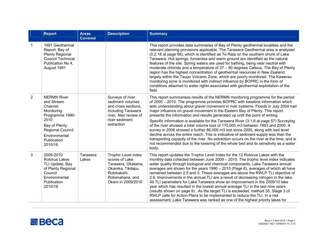
1 1991 Geothermal Report; Bay of Plenty Regional Council Technical Publication No 4, August 1991
This report provides data summaries of Bay of Plenty geothermal localities and the relevant planning provisions applicable. The Tarawera Geothermal area is analysed (5.2.18 at page 66), which is identified as Te Rata on the southern shore of Lake Tarawera. Hot springs, fumaroles and warm ground are identified as the natural features of the site. Spring waters are used for bathing, being near neutral with moderate chloride and a temperature of 37 – 90 degrees Celsius. The Bay of Plenty region has the highest concentration of geothermal resources in New Zealand, largely within the Taupo Volcanic Zone, which are poorly monitored. The Kawerau monitoring zone is monitored with indirect influence by BOPRC in the form of conditions attached to water rights associated with geothermal exploitation of the field.
2 NERMN River and Stream Channel Monitoring Programme 1990-2010
Bay of Plenty Regional Council Environmental Publication 2010/16
Surveys of river sediment volumes and cross sections, including Tarawera river. Also review of river sediment extraction
This report summarises results of the NERMN monitoring programme for the period of 2005 – 2010. The programme provides BOPRC with baseline information which aids understanding about gravel movement in river systems. Floods in July 2004 had major influence on gravel movement in the Eastern Bay of Plenty. This report presents the information and results generated up until the point of writing. Specific information is available for the Tarawera River (3.1.8 at page 57) Surveying of the river showed a total volume loss of 170,000 m3 between 1993 and 2000. A survey in 2006 showed a further 86,000 m3 lost since 2000, along with bed level decline across the entire reach. This is indicative of sediment supply less than the transporting capacity of the river. No extraction occurs on the river at the time, and is not recommended due to the lowering of the whole bed and its sensitivity as a water body.
3 2009-2010 Rotorua Lakes TLI Update; Bay of Plenty Regional Council Environmental Publication 2010/18
Tarawera Lakes
Trophic Level index scores of Lake Tarawera, Okataina, Okareka, Tikitapu, Rotokakahi, Rotomahana, and Okaro in 2009/2010
This report updates the Trophic Level Index for the 12 Rotorua Lakes with the monthly data collected between June 2009 – 2010. The trophic level index indicates water quality through biological and chemical components. Lake Tarawera annual averages are shown for the years 1990 – 2010 (Page 6), averages of which all have remained between 2.5 and 3. These averages are above the RWLP TLI objective of 2.6. Improvements in the annual TLI are a result of decreasing nitrogen in the lake. All TLI parameters for Lake Tarawera show an improvement in the 2009/10 lake year which has resulted in the lowest annual average TLI in the last nine years (results shown on page 9). As the target TLI is exceeded, method 35, Stage 3 of RWLP calls for Action Plans to be implemented to reduce the TLI. In a risk assessment, Lake Tarawera was ranked as one of the highest priority lakes for

Beca // 2 April 2015 // Page 2
4282426 // NZ1-10494551-15 0.15
Report Areas Covered
Description Summary
improvement.
4 Aquatic Plant Survey Report 2010/2011; Bay of Plenty Regional Council Environmental Publication 2011/04
Rotorua Lakes /rivers
Survey of boat users (regarding pest aquatic weed awareness) in the Rotorua lakes and rivers.
Natural resources are under threat in Lake Tarawera from invasive aquatic pest species such as Hornwort, Didymo and pest fish. These species can be transported between water bodies by humans and recreational equipment such as boats. This report summarises a survey created by APTAG which surveyed 793 boat ramp and waterway users in summer 2010/11. Findings concluded 64% of users check their equipment for weeds prior to launching, and 63% had a medium awareness of aquatic pest issues. An awareness campaign was used to advocate aquatic pest issues through retailers and sporting and tourism events. This received a positive reception from retailers and organisers.
5 Water Quality Classification Assessment - Rivers and Streams in the Bay of Plenty (2011); Bay of Plenty Regional Council Environmental Publication 2011/07
Assesses the water quality of streams and rivers against the water quality standards and criteria of the Regional water and land plan.
This report assessed water quality against the criteria given in Schedule 9 of RWLP, based on physical and chemical water quality parameters, macro-nutrients and indicator bacteria. Water quality classifications provide a face-value ‘bottom line’ below which water quality should not fall. Classifications also provide backdrop against which effects of discretionary (consented) activities can be regulated. Cumulative effects are an issue in terms of land use practices that affect the catchment and therefore better tools need to be developed. Three Tarawera sites were assessed. River colour in the lower Tarawera River (Awakaponga) exceeds the classification in Regional Plan due to wastewater discharges from Kawerau pulp and paper mills. Faecal coliform levels are higher than the guideline for stock water (TABLE 3.2 page 8).
6 Bathing and shellfish surveillance monitoring report 2010/2011; Bay of Plenty Regional Council Environmental Publication 2011/13
Uses E.coli levels to test whether swimming sites in rivers/lakes are safe.
The 2010/2011 bathing season showed generally low levels of faecal contamination across most sites. This is suggestive of good recreational water quality. The Tarawera River at Boyce Park were within the green mode of E. coli concentrations, with a single outlier in the orange zone. The two Lake Tarawera sites (Rangiuru and Te Karamea) showed E. coli concentrations less than 100 cfu/100ml. This suggests good water quality in the Tarawera River and Lake.
Beca // 2 April 2015 // Page 3
4282426 // NZ1-10494551-15 0.15
Report Areas Covered
Description Summary
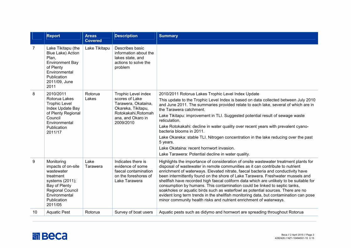
7 Lake Tikitapu (the Blue Lake) Action Plan, Environment Bay of Plenty Environmental Publication 2011/09, June 2011
Lake Tikitapu Describes basic information about the lakes state, and actions to solve the problem
8 2010/2011 Rotorua Lakes Trophic Level Index Update Bay of Plenty Regional Council Environmental Publication 2011/17
Rotorua Lakes
Trophic Level index scores of Lake Tarawera, Okataina, Okareka, Tikitapu, Rotokakahi,Rotomahana, and Okaro in 2009/2010
2010/2011 Rotorua Lakes Trophic Level Index Update This update to the Trophic Level Index is based on data collected between July 2010 and June 2011. The summaries provided relate to each lake, several of which are in the Tarawera catchment. Lake Tikitapu: improvement in TLI. Suggested potential result of sewage waste reticulation. Lake Rotokakahi: decline in water quality over recent years with prevalent cyano-bacteria blooms in 2011. Lake Okareka: stable TLI. Nitrogen concentration in the lake reducing over the past 5 years. Lake Okataina: recent hornwort invasion. Lake Tarawera: Potential decline in water quality.
9 Monitoring impacts of on-site wastewater treatment systems (2011); Bay of Plenty Regional Council Environmental Publication 2011/05
Lake Tarawera
Indicates there is evidence of some faecal contamination on the foreshores of Lake Tarawera
Highlights the importance of consideration of onsite wastewater treatment plants for disposal of wastewater in remote communities as it can contribute to nutrient enrichment of waterways. Elevated nitrate, faecal bacteria and conductivity have been intermittently found on the shore of Lake Tarawera. Freshwater mussels and shellfish have recorded high faecal coliform data which are unlikely to be suitable for consumption by humans. This contamination could be linked to septic tanks, soakholes or aquatic birds such as waterfowl as potential sources. There are no evident long term trends in the shellfish monitoring data, but contamination can pose minor community health risks and nutrient enrichment of waterways.
10 Aquatic Pest Rotorua Survey of boat users Aquatic pests such as didymo and hornwort are spreading throughout Rotorua

Beca // 2 April 2015 // Page 4
4282426 // NZ1-10494551-15 0.15
Report Areas Covered
Description Summary
Plant Survey 2009/2010; Bay of Plenty Regional Council Internal Report 2010/03
Lakes/ rivers (regarding pest aquatic weed awareness) in the Rotorua lakes and rivers
Lakes. This is passed through humans and recreational equipment.
11 First Order Estimation of the nutrient and bacterial input from aquatic birds to twelve Rotorua Lakes; Bioresearches October 2002
Rotorua lakes
Estimates the level of nutrients/faecal material input to lakes from water fowl
Aquatic birds such as waterfowl can be significant contributors of nutrient and bacterial inputs into lake systems. In Rotorua, the estimates provided by this report of bird contributions would be adverse inputs from a point source, however, this is mitigated by a spread-out bird population and diffuse inputs from a range of sources. The weight input of faecal coliform bacteria from ducks is about 11 times higher than that for dairy cows. Lake Rotokakahi and Lake Okareka are most likely to be subject to effects of aquatic birds. The proportion of total nitrogen from wildfowl to the lakes is 1.4% (Rotokakahi) and 1.2% (Okareka). The proportion of phosphorus is 8.3% (Rotokakahi) and 5.1% (Okareka). These can have effect on overall water quality in the Tarawera Catchment, but are at lower levels in the other five lakes. The effect on water quality is reduced through the non-point source of contaminants and difficulties in quantifying it.
12 Cyanobactrial Biovolumes for the Rotorua Lakes; Cawthron Report No. 1504, August 2008
Rotorua Lakes
Estimates biovolumes of blue-green bacteria in the Rotorua lakes
Cyanobacterial (blue-green algal) blooms have become a regular occurrence in Rotorua lakes. The lakes that are sampled most frequently are outside of the Tarawera catchment. The following species have been found within catchment lakes and should be considered in looking at river and lake health overall:
� Anabaena lemmermannii (Okareka and Tarawera); � Anabaena planktonica (Okaro and Tarawera); � Alphanocapsa holsatica (Okareka and Okaro); � Aphanizomenon gracile (Tarawera); � Alphanothece clathrata (Okareka, Okaro and Tarawera); � Microcystis sp. (small) (Okareka, Okaro and Tarawera); and � Microcystis sp. (large) (Tarawera). � Anabaena cf. affinis (Okareka); � Anabaena sp. (Okareka); � Anabaena spiroides (Tarawera and Okareka);
Beca // 2 April 2015 // Page 5
4282426 // NZ1-10494551-15 0.15
Report Areas Covered
Description Summary
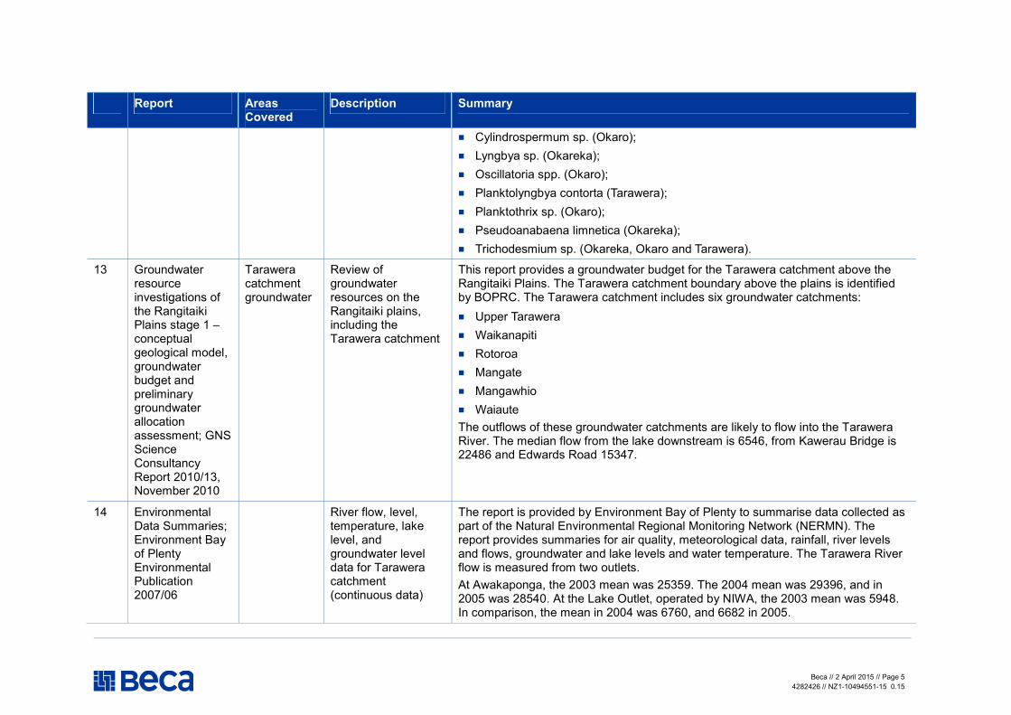
� Cylindrospermum sp. (Okaro); � Lyngbya sp. (Okareka); � Oscillatoria spp. (Okaro); � Planktolyngbya contorta (Tarawera); � Planktothrix sp. (Okaro); � Pseudoanabaena limnetica (Okareka); � Trichodesmium sp. (Okareka, Okaro and Tarawera).
13 Groundwater resource investigations of the Rangitaiki Plains stage 1 – conceptual geological model, groundwater budget and preliminary groundwater allocation assessment; GNS Science Consultancy Report 2010/13, November 2010
Tarawera catchment groundwater
Review of groundwater resources on the Rangitaiki plains, including the Tarawera catchment
This report provides a groundwater budget for the Tarawera catchment above the Rangitaiki Plains. The Tarawera catchment boundary above the plains is identified by BOPRC. The Tarawera catchment includes six groundwater catchments: � Upper Tarawera � Waikanapiti � Rotoroa � Mangate � Mangawhio � Waiaute The outflows of these groundwater catchments are likely to flow into the Tarawera River. The median flow from the lake downstream is 6546, from Kawerau Bridge is 22486 and Edwards Road 15347.
14 Environmental Data Summaries; Environment Bay of Plenty Environmental Publication 2007/06
River flow, level, temperature, lake level, and groundwater level data for Tarawera catchment (continuous data)
The report is provided by Environment Bay of Plenty to summarise data collected as part of the Natural Environmental Regional Monitoring Network (NERMN). The report provides summaries for air quality, meteorological data, rainfall, river levels and flows, groundwater and lake levels and water temperature. The Tarawera River flow is measured from two outlets. At Awakaponga, the 2003 mean was 25359. The 2004 mean was 29396, and in 2005 was 28540. At the Lake Outlet, operated by NIWA, the 2003 mean was 5948. In comparison, the mean in 2004 was 6760, and 6682 in 2005.

Beca // 2 April 2015 // Page 6
4282426 // NZ1-10494551-15 0.15
Report Areas Covered
Description Summary
Lake level data summaries are available for all of the lakes within the catchment. The lake level was higher in 2004 or 2005 than it was in 2003 at all sites, excluding Lake Okataina.
15 Bathing and Shellfish Surveillance Report 2009-2010; Bay of Plenty Regional Council Environmental Publication 2010/13
Uses E.coli levels to test whether swimming sites in rivers/lakes are safe.
Lake sites consistently showed a low level of contamination with only three sites exceeding orange alert levels across this period. Tarawera River at Boyce Park and Rangiuru at Lake Tarawera were below the orange alert level for E. coli concentrations. The site at Te Karamea at Lake Tarawera exceeded the orange alert level at its extreme point. The majority of the box and whiskers plot remained within the green zone. This report is suggestive of good water quality within the catchment, with an extreme that could be attributed to a short-term event.
16 Kiwifruit and Dairying Effects on Shallow Groundwater; Bay of Plenty Regional Council Environmental Publication 2009/06
Kiwifruit crops release less nutrients to shallow groundwater than dairying
The objective is to examine how development of kiwifruit orchards affects nutrient levels, such as nitrate, in shallow groundwater. The report compares the findings of Hort Research modelling of kiwifruit with dairying industries. The report calculates a hydrological budget. In relation to water quality, nitrate contamination is not thought to be a widespread problem in the Bay of Plenty, with risk factors as over-use of nitrogen fertiliser on kiwifruit orchards. Theoretically, very high winter stocking numbers can result in high nitrate leaching from pasture. This is of importance in the Tarawera catchment, where dairying activities occur and water runs off into surface and groundwater systems. Effects of kiwifruit orchards are not as profound as dairying, with phosphorus levels doubled in groundwater beneath the dairy unit compared to the kiwifruit orchard.
17 Lake Ōkataina Nutrient Budget Prepared for Bay of Plenty Regional Council by Lochmoigh, May 2012
Lake Okataina
Quantification of the nitrogen and phosphorous reduction needed
18 Lake Ōkataina water quality
Lake Okataina
Gives historical water quality information
Historical water quality information for Lake Okataina.

Beca // 2 April 2015 // Page 7
4282426 // NZ1-10494551-15 0.15
Report Areas Covered
Description Summary
Background information 2012
for Lake Okataina
19 Rotorua Te Arawa Lakes Baseline Landscape Assessment; MTEC Consultants, Wildland Consultants and Toi Ora & Associates (2012)
Te Arawa Lakes
Reviews the structures and impacts of structures in these lakes
The lakes within the Rotorua/Te Arawa area are distinct. Descriptions of separate lakes are provided in this report. Lake Tarawera and Lake Okareka are the lakes relevant to the Tarawera catchment described. Lake Tarawera is a large lake with scattered small inflowing streams and drainage connections from Lake Rotokakahi and Lake Okareka. Lake Tarawera drains via the Tarawera River and Tarawera Falls. The catchment is largely indigenous forest, and secondary indigenous vegetation as a result of the Tarawera eruption in 1886. The lake is home to substantial populations of dabchick, scaup (water birds), and trout and indigenous fish. Lake Okareka in comparison is a moderate-sized lake with scattered small inflowing streams draining to Lake Tarawera via a managed outlet. The catchment is partly farmed and primarily indigenous forest. Similar birds and fish are present. Fauna using the lake as habitat suggests good waterway health.
20 The condition of twelve lakes in the Rotorua lakes region using lake SPI (2005) NIWA Client Report HAM2005-122, October 2005
Lakes Review of lake SPI for twelve lakes.
NIWA study assesses the condition of Rotorua Lakes using LakeSPI tools. This method focuses on submerged aquatic plants as indicators of lake condition. The lakes were ranked as ‘Good’, ‘Average’ or ‘Poor’. Lake Rotomahana: Good. This lake has the best potential for long term protection against invasive weed species, but has low water clarity which limits submerged vegetation and makes it vulnerable to further deterioration. Lake Okataina: Good. Good potential for maintaining high water quality; however is under threat from hornwort invasion which would impact biodiversity and native character. Lake Tikitapu: Good. Undergoing significant decline and annual monitoring is recommended. Lake Rotokakahi: Average. Presumed to be in a state of decline from deteriorating water quality and should also be monitored annually. New invasive species have not established themselves in this lake since 1988. Lake Okareka: Average. Invasion of Egeria has occurred and is expected to cause further decline as the full extent of the invasion occurs. Lake Tarawera: Average. The state of Lake Tarawera is expected to remain the same as the full impact of hornwort has been reached.

Beca // 2 April 2015 // Page 8
4282426 // NZ1-10494551-15 0.15
Report Areas Covered
Description Summary
Lake Okaro: Poor. Restoration works are being undertaken therefore improvements should be monitored. Overall, the water quality is relatively good, but for areas where algae invasion is occurring.
21 Lake Okareka Trophic State Targets NIWA Client Report: HAM2002-031; October 2002
Lake Okareka
Review of objectives for Lake Okareka (and setting of P and N levels required to achieve)
22 The ecological condition of the Rotorua Lakes using LakeSPI (2008) NIWA Client Report HAM2008-149, September 2008
Rotorua lakes
Calculation of lake SPI for Rotorua lakes in 2008
Submerged Plant Indicators (SPI) are used by NIWA to asses, monitor and report on the condition of lakes in the Rotorua region. Lakes Tikitapu and Rotokakahi show the biggest change in lake condition over the last 20 years on account of deteriorating water quality and clarity. Lake Rotomahana is identified as in the best condition, however invasive species have been introduced and therefore this position is not expected to last. Lake Okataina is under threat from hornwort invasion. Concerns over the average condition of Lake Okareka as the full impact of Egeria is not yet expressed, and hornwort poses an immediate threat. The expected outcome should hornwort invade is displacement of all native charophyte meadows. Lake Tikitapu is considered average, and water quality continues to decline. Lake Rotokakahi also continues to appear to decline over water quality issues. Use of Koura (freshwater crayfish) and Kakahi (freshwater mussels) are being evaluated for their use in supplementing SPI information. Lakes Tarawera and Okaro are considered ‘poor’ in condition, of which Tarawera is stable now that the extent of hornwort invasion has been reached. The report recommends that frequent monitoring be undertaken, and that all possible measures of preventing the transfer of hornwort into vulnerable high condition lakes.
23 The ecological condition of the Rotorua Lakes using LakeSPI (2009) HAM2009-162, September
Rotorua lakes
Calculation of lake SPI for Rotorua lakes in 2009
Submerged plant indicators (SPI) are useful because they integrate long-term environmental influences as well as short-term events. These investigations provide a relative condition of each lake compared to other lakes, whilst enabling particular activities to be prioritised in environmental management. The key points for each lake based on Lake SPI are as follows: Lake Rotomahana: Good. Overall lake condition high, but not declining.

Beca // 2 April 2015 // Page 9
4282426 // NZ1-10494551-15 0.15
Report Areas Covered
Description Summary
2009 Lake Okataina: Moderate. Overall lake condition high and stable, but major threat from hornwort invasion. Lake Okareka: Moderate and likely to decline because of Egaria yet to set in fully. Major threat from hornwort invasion. Lake Tikitapu: Moderate and declining lake water quality. Lake Rotokakahi: Moderate lake condition that has declined drastically over past 20 years. The only Rotorua lake (except for Okaro) to remain relatively free of the worst ‘high impact’ invasive weed species. Lake Tarawera: overall lake condition moderate and likely to be stable in the immediate future. Drastic decline over the last 20 years with invasion of hornwort primarily responsible. Lake Okaro: Poor lake condition that is variable due to unstable water quality and seasonal response of Elodea. Possible signs of some improvement following lake restoration measures.
24 The ecological condition of the Rotorua Lakes using LakeSPI (2010) HAM2010-047, May 2010
Rotorua lakes
Calculation of lake SPI for Rotorua lakes in 2010
Recent discovery of an established bed of hornwort (Ceratophyllum demersum) poses a serious threat to the future stability and condition of Okataina. Lakes Tikitapu and Rotokakahi have seen a reduction in the quality and extent of native plant communities present, without any direct change in invasive species presence or performance over the last 20 years. A slight improvement was recorded in Lake Okaro in the presence of both native and invasive plant covers.
25 The ecological condition of the Rotorua Lakes using LakeSPI (2011) HAM2011-050, August 2011
Rotorua lakes
Calculation of lake SPI for Rotorua lakes in 2011
LakeSPI reports have provided valuable inter-lake comparisons based upon a cost-effective monitoring tool for the past 22 year period. The report holds that measures to prevent further hornwort transfer and establishment need to be utilised as lake condition is generally declining. The report describes the condition of each lake as follows: Lake Rotomahana has shown the largest decline in lake condition over the last 5-6 year period, largely attributable to the introduction and spread of egeria and hornwort which has seen the Invasive Impact Index double. Lake Okataina has been relatively stable, though the recent invasion of hornwort poses a serious threat to future lake condition. Lake Okareka remains relatively stable but is at significant risk of hornwort invasion. A weed cordon was going to be put in place as the risk of invasion and possible

Beca // 2 April 2015 // Page 10
4282426 // NZ1-10494551-15 0.15
Report Areas Covered
Description Summary
impacts are particularly detrimental. Lake Tikitapu is in a state of significant decline over past 22 years due to changing water quality and clarity. No influence of new invasive species which suggests unusual water chemistry that may inhibit impact from present and future invasion. Lake Rotokakahi has been significantly declining over last 20 years. There has been no change in elodea but invasive impact accentuated by decline in native plant communities. Rotokakahi is the only Rotorua lake to remain relatively free of the worst ‘high impact’ invasive weed species. Lake Okaro has improved in 2011 and is now classified as in ‘moderate’ condition. This is attributable to an increase in native plant cover and diversity, and a corresponding decrease in invasive plant covers during the recent survey. There are possible signs of some improvement following lake restoration measures. Lake Tarawera is moderate and relatively stable in condition in the immediate future. The lake condition has declined significantly over past 22 years, which is largely a result of hornwort invasion.
26 Bathing and Shellfish Surveillance Report 2011/2012; Bay of Plenty Regional Council Environmental Publication 2012/09
Uses E.coli levels to test whether swimming sites in rivers/lakes are safe
Water quality/swimming for rivers in 2011/12.
27 EBOP State of the Environment: Groundwater level and quality (2006)
Review of groundwater levels and quality 2006
N/A does not contain information specific to the Tarawera catchment.
28 Lake Okareka and Tikitapu Fish Health Monitoring
Lake Okareka
Examination of fish health and koura in Lake Okareka and Tikitapu (control) to
Fish/koura health in Lake Okareka and Tikitapu 2006.

Beca // 2 April 2015 // Page 11
4282426 // NZ1-10494551-15 0.15
Report Areas Covered
Description Summary
2006 determine impact of Phoslock application
29 Lake Okareka and Tikitapu Fish Health Monitoring 2007
Lake Okareka
Examination of fish health and koura in Lake Okareka and Tikitapu (control) to determine impact of Phoslock application
Fish/koura health in Lake Okareka and Tikitapu 2007.
30 Rangitaiki Tarawera Floodplain Management Strategy; Environment Bay of Plenty Rivers and Drainage Publication 2008/01, September 2008
Tarawera River
Examines the crunnet nature of floodplain and flood control measures, idetnfieis the flood hazards (reviews study of potetential flood risk)
The Rangitaiki Tarawera catchment includes 990 km2 in the Tarawera catchment. The report summarises the headwaters of the Tarawera River including the six lakes which drain into Lake Tarawera from where the river begins. The river drops to a level of 150 metres within 6.5 kilometres of Lake Tarawera, winding through deep pumice country before reaching a gentler grade below Kawerau. Significant tributaries of the Tarawera river are the Mangawhio, Waiwhakapa and the Mangamate upstream of Kawerau, Mangaone, Ruruanga near Otakiri, and Awakaponga Stream near Matata. The deep pumice of the Tarawera catchment together with the ponding effect of the lake regulates the runoff from heavy storms so the maximum-recorded floods are only two to three times the normal flow. A portion of the drainage network on the Rangataiki Plains makes up the Tarawera catchment. The report is descriptive of the flood plain aspect of the Tarawera catchment.
31 Estimate of geothermal nutrient inputs to twelve Rotorua lakes; Bioresearches January 2003
Rotorua lakes
Examines N and P entering lakes from geothermal sources
Geothermal inflows are described for each of the twelve Rotorua Lakes, with emphasis on potential nutrient inflows and contributions. A summary for Lake Tarawera is provided at 3.3, identifying the catchment land cover as 31% lowland scrub and 27% lakes. The highest contributors of nitrogen and phosphorus to the lake per year are pasture and native forest. There are two geothermal inflows to Lake Tarawera: Tarawera Peak/Camp Stream and a Spring 100m North of waterfall. Lake Okataina water quality is influenced by Okataina Springs, which discharge gas and seep warm water into the lake at times. No data is available in the report on this point. Submerged springs in Lake Rotomahana are considered to contribute significant inputs of nutrients to this lake, as well as the Waimangu-Rotomahana Geothermal Area to the south-west. No sources of geothermal inflows have been identified for Lake Rotokakahi. Sediment quality in Lake Okareka and Lake Tikitapu indicates that this lake is potentially affected by geothermal activity; however, there

Beca // 2 April 2015 // Page 12
4282426 // NZ1-10494551-15 0.15
Report Areas Covered
Description Summary
is no identifiable geothermal inflow data available to support this. Lake Okaro is not influenced by geothermal inflows and therefore nutrient input is considered to be zero. Additional information is required to determine and quantify the influence of geothermal inputs on water quality across the lakes.
32 Water Quality of Bay of Plenty Rivers 1989-2008; Bay of Plenty Regional Council Environmental Publication 2009/11
Rivers Reviews trends in water quality indicators for 40 sites from 1989 to 1008
Awakaponga at the Tarawera River showed improvements in the parameters of suspended solids and turbidity. This is suggested as a result of reduced loading for the pulp and paper mills. This site showed increasing phosphorus and nutrient loading. Lake Tarawera sets out the initial Tarawera River water quality. The nutrient balance in the lake is fluctuating. Technical report with good data about changes in river.
33 Rotorua Lakes Water Quality Report 2009 Bay of Plenty Regional Council Environmental Publication 2009/12
Rotorua Lakes
Lake water quality (SPI, TLI) in 2009
Reports findings on trophic-level index for each of the Rotorua Lakes, based on physic-chemical monitoring. All of the lakes exceed the TLI set in the RWLP, meaning Method 41 is triggered. Action Plans have been completed for these lakes within the catchment: Okareka, Okaro, Tarawera, Tikitapu and Okataina. The Executive summary sets out the 3 yearly average TLI. The 3 yearly average to 2009 in TLI units is typically around 0.5 higher than the RWLP target. The results for each individual lake are described, along with the lake management plan in place. The report identifies trends in results and Lake submerged plant indicator results also. The TLI for Lake Tarawera remains stable although nutrients have shown a significantly increasing trend over the past 8 years. This increase has not impacted on the water clarity or productivity of the lake.
34 Aerial Monitoring Of Coastal Indigenous Forest In The Bay Of Plenty Region 2003
Wildland Consultants Contract Report
Review of coastal indigenous forest in BOP in 2003
This report summarises an indigenous forest canopy condition aerial photograph study undertaken in the Bay of Plenty in 2003. The report identifies the role of coastal forest and the multitude of threats it is exposed to. A previous survey of 1988 showed the general coastal forest as healthy. A survey of 1989 – 1991 also showed pohutukawa forests in generally good health. Coastal kanuka at Matata – Whakatane, between the Tarawera and Rangitaiki rivers appeared to be in good condition despite fragmentation issues at the coast.

Beca // 2 April 2015 // Page 13
4282426 // NZ1-10494551-15 0.15
Report Areas Covered
Description Summary
No. 687; November 2003
35 Digital map of significant Natural areas identified in 1996 In the Whakatane District - Wildland Consultants Contract Report No. 1198; September 2005
Overview of natural areas in BOP from 1996, including Tarawera catchment. Also has attributes table of natural area (but missing GIS map)
The digital mapping exercise depicts areas of special natural significance. The table of special areas identifies Tarawera Cut Wildlife Management Reserve, Tarawera Scarp and Tarawera Road Wetland as significant natural areas within Tarawera catchment.
Outstanding Natural Features and Landscapes Review Bay of Plenty region: Appendix 4 Maps
36 Land and Water Aotearoa website
Rotorua Lakes Tarawera River
The Land and Water Aotearoa (LAWA) website brings together environmental monitoring data from all of New Zealand’s regional councils and NIWA, as well as presenting information provided by the Ministry for the Environment. LAWA is partnership between the councils, Cawthron Institute, Ministry for the Environment and Massey University and has been supported by the Tindall Foundation. The website provides data from 2004-2012 for the Tarawera Catchment.
37 Ngati Rangitihi Iwi Management Plan
Upper Tarawera catchment Coast from Maketu to Thorndon
Iwi planning document
The Iwi Management Plan (IMP) documents the key issues for Ngati Rangitihi and proposes objectives, policies and methods. The IMP includes policies for access to the Tarawera River Tarawera Lake margins. Restoration and enhancement of the Tarawera River and Lake is identified as a key objective. The IMP encourages engagement to improve land and water quality within the Tarawera River and Lake. There are a number of sites of significance associated with the Tarawera River and Lake included in the IMP.

Review of the Regional Plan for Tarawera River Catchment
Beca // 2 April 2015
4282426 // NZ1-10499763-6 0.6 // page 20
Appendix 2
Review of Resource Consent, Data and Compliance Monitoring

Beca // 2 April 2015 // Page 1
4282426 // NZ1-10494551-15 0.15
Works in the Bed of Rivers
Consent Number
Name Property Address Purpose Date Granted s42A Assessment Compliance
63343-0 Department Of Conservation
Te Tapahoro Bay, Lake Tarawera, Tarawera Track, Tarawera River
Construct a bridge over Tarawera River
2005 Considers the relevant provisions of the Plan
Compliant with consent conditions. 10 yearly monitoring, next due in 2006
63741-0 New Zealand Railways Corp
Bridge 123, Awatarariki Stream, Matata
Works to replace rail bridge
2008
Appropriately refers to the Bay of Plenty Regional Land Management Plan and the proposed Water and Land Plan
Minor non-compliance, Council staff worked alongside consent holder to remedy
65124-0 New Zealand Transport Agency
Moores Bridge, State Highway 2, Matata
Erosion protection works in stream bed
2007
Appropriately refers to the Bay of Plenty Regional Land Management Plan and the proposed Water and Land Plan
Compliant with consent conditions.
65616-0
Whakatane District Council & Environment BOP
Rangitaiki Plains / Edgecumbe
Structures in the bed of a water body
Not considered relevant - activity occurs on the edge of the Plan boundary
Due to be installed in 2018
60116-0 Herbert JW Lake Okareka, R D 5, Rotorua
To Place And Use Two Single Culverts
Pre - 2004 N/A
65614-0
Whakatane District Council & Environment BOP
Rangitaiki Plains / Edgecumbe
Flood mitigation works - bulk earthworks
2009 Not considered relevant - activity occurs on the edge of the Plan boundary
Compliant with consent conditions
Key: Considers the plan
Does not consider the plan
Plan not relevant

Beca // 2 April 2015 // Page 2
4282426 // NZ1-10494551-15 0.15
Stormwater Discharges
Consent Number
Name Property Address Purpose Date Granted Assessment Compliance
61933-0 Rotorua District Council
Spencer Road, Lake Tarawera, Rotorua
Comprehensive stormwater consent
2005 Considers the relevant provisions of the Plan
Compliant with consent conditions, graded high compliance
67249-0
Peppers Timber Treatment Limited
39 Kowhai Avenue, Edgecumbe
Discharge stormwater from timber treatment plant
2013 Considers the relevant provisions of the Plan
Compliant with consent conditions, graded high compliance
67409-0 Whakatane District Council
98B College Road, Edgecumbe
Discharge stormwater to an open drain
2013 Considers the relevant provisions of the Plan
No compliance date availabe
67457 Norkse/CHH Stormwater discharge to land
2013 Considers the relevant provisions of the Plan
No compliance date availabe
66837 Balance
Stormwater discharge to Omeheu canal to Tarawera River
2012 Considers the relevant provisions of the Plan
No compliance date availabe
65386 Sequal Lumber
Discharge stormwater to ground soakage
2008 Considers the relevant provisions of the Plan
No compliance date availabe
62899-0 Norske Skog Tasman Ltd
Onepu Log yard, Kawerau Road, Kawerau
Dis stormwater from log yard
2005 Does not consider the plan Compliant with consent conditions, graded high compliance
Beca // 2 April 2015 // Page 3
4282426 // NZ1-10494551-15 0.15
Water Permits
Consent Number
Name Property Address Purpose Date Granted Assessment Compliance
64897-0 Whakatane District Council
Waitepuru Stream, Matata
Dam and divert Waitepuru Stream
2006 Considers relevant provisions of the Plan
Compliant with consent conditions, graded high compliance
67046-0 Kawerau District Council
Plunket Street, Kawerau
Take water from Ruruanga Stream for irrigation
2012 Considers relevant provisions of the Plan
Recent minor non-compliances, Council staff working with consent holder to remedy
62847-0 JL Murray & Sons Limited
143 McCutchan Road, Rd 3, Otakiri, Whakatane
Take water from river for irrigation
2004 Considers relevant provisions of the Plan
Recent minor non-compliances, Council staff working with consent holder to remedy
63339-0 Price Family Trust SN & R
146 Hallet Road, Otakiri
Take for irrigation and frost protection
2005 Did not consider the plan Compliant with consent conditions, graded high compliance
62814-0 Otakiri Limited 284 Otakiri Soldiers Road, Otakiri
Take from bore for irrigation and frost
2004-5 Did not consider the plan Recent non-compliances, Council staff working with consent holder to remedy
63212-0 Prowse Family Trust-Trustees
275 Gow Road, Edgecumbe
Take water from bore for irrigation and frost
2005 Did not consider the plan
Recent minor non-compliances, Council staff working with consent holder to remedy
Section 9 Land Use
Consent Number
Name Property Address Purpose Date Granted Assessment Compliance
65724 Carter Holt Harvey
Landfill 2009 Considers relevant provisions of the Plan
Compliant with consent conditions, graded high compliance

Beca // 2 April 2015 // Page 4
4282426 // NZ1-10494551-15 0.15
63818-0 Waiotahi Contractors Ltd
Kopuatawhiti Maori Land Trust, Burt Road, Matata
Deposit clean fill material to land
2006 Did not consider the plan
Historical non-compliance, recently consent holder is compliant with consent conditions
64186-0 Tiaki Plantations Company
Edwards Road Quarry, Tarawera Forest
L/s earthworks for quarry operation
2008 Did not consider the plan Compliant with consent conditions
65522-0 Norske Skog Tasman Ltd
End Of Hogg Road, Onepu
Earthworks for forest harvesting
2008 Did not consider the plan Compliant with consent conditions
65524-0 Viking Global NZ Ltd
Manawahe Forest, McIvor Road, Manawahe
Forest harvesting
2008 Did not consider the plan
Some historic non-compliance, recently consent holder is compliant with consent conditions
Dairy Effluent Discharge
Consent Number
Name Property Address Purpose Date Granted Assessment Compliance
66964-0 Begley JT & IJ 517 Greig Road, Thornton
Discharge dairy effluent to ground and pasture
2011 Did not consider the plan Compliant with consent conditions
67017-0 Tumurau Limited Partnership
889 Braemar Road, Whakatane
Discharge dairy effluent to pasture irrigation
2011 Did not consider the plan
Some historic minor non-compliance. This has been remedied and consent holder is now compliant with consent conditions.
67118-0 PHS & PC Byford Family Trust
869 Thornton Road, Thornton
Discharge dairy effluent to pond soakage
2012 Did not consider the plan Compliant with consent conditions
67135-0 Hill EM 30 Caverhill Road, RD 3, Whakatane
Discharge dairy effluent to pond soakage
2012 Did not consider the plan Compliant with consent conditions

Beca // 2 April 2015 // Page 5
4282426 // NZ1-10494551-15 0.15
61682-0 Steiner JF & E Awaiti Road, Edgecumbe
Discharge treated dairy effluent to pasture
2002-2011 Change 2012, did not consider the plan
Some historic non-compliance. Council staff regularly visit site to ensure consent holder is managing the storage and discharge of effluent effectively.
Waste Water Discharge
Consent Number
Name Property Address Purpose Date Granted Assessment Compliance
61695-0
Norske Skog Tasman & Carter Holt Harvey
Tasman Mill, Kawerau
Operate Tasman solid waste disposal area
2011 2011 Change, did not consider the plan. 2009 change, did consider the plan.
Regular monitoring of comprehensive suite of consent conditions. Consent holder compliant with consent.
67265 Kawerau District Council
Discharge to land (septic tank sludge to land)
2009 Considers relevant provisions of the Plan
New consent not monitored yet
65081 Kawerau District Council
Effluent to land 2009 Considers relevant provisions of the Plan
Compliant with consent conditions
65914-0 Callaghan N & Coombes B
343A Spencer Road, Lake Tarawera
Onsite effluent discharge - Tarawera
yes Did not consider the plan - considers the OSET
62104-0
DJ&AH Edwards T/A Thornton Beach
Thornton Beach Road, Thornton
Dis onsite effluent to ground soakage
2005 Did not consider the plan - considers the OSET
Minor non-compliances have been addressed by consent holder.
63391-0 Central North Island Early
43 & 43a Pollen Street, Matata
Dis onsite effluent to ground soakage
2005 Did not consider the plan - considers the OSET
Some significant non-compliances over past 8 years of monitoring, on-going correspondence with Council staff to ensure continued compliance.

Beca // 2 April 2015 // Page 6
4282426 // NZ1-10494551-15 0.15
66877-0 Ross R 191 Spencer Road, Lake Tarawera
Dis onsite effluent to ground soakage
2011 Did not consider the plan - considers the OSET
66017-0
Te Pou Hinerau For Hahuru Marae Committee
161 Onepu Spring Road, Kawerau
Discharge sewage effluent to land
2011 Did not consider the plan - considers the OSET
Consent holder compliant with consent conditions
Other Discharge
Consent Number
Name Property Address Purpose Date Granted Assessment Compliance
62978-0 Norske Skog Tasman Ltd
Norske Skog Tasman, Plateau Bark Lease Area
Dis contaminants to land from mill
2005 Considered relevant objectives and policies in the Plan
Consent holder compliant with consent conditions
63296-0 Mighty River Power
Kawerau Geothermal Field, West of SH34 & Putauaki Trust Land, Kawerau
Major discharge of geo water to land
2005-2012
New application in 2005 considered relevant provisions of the Plan. Change of conditions in 2012 states that the application is consistent with the relevant regional plans
Consent holder compliant with consent conditions
65386 Sequal Lumber Discharge to soakage from sawmill
2005 Considered relevant provisions of the Plan
Some recent non-compliance, staff working with consent holder to remedy.
67150 SCA Hygiene Australasia Limited
Discharge effluent from tissue mill to land
2013 Considered relevant provisions of the Plan
Consent holder compliant with consent conditions
65549 Ecocast- Vermicomposting bio-solids
2009-11
New application in 2009 considered relevant provisions of the Plan. Change of conditions in 2011 Did not consider the plan
Consent holder compliant with consent conditions, some historic minor non-compliances which was addressed by the consent holder in consultation with the

Beca // 2 April 2015 // Page 7
4282426 // NZ1-10494551-15 0.15
Council.
60378-0 Red Stag Timber Limited
Highlands Road, Rotorua
Discharge waste contaminated wood, bark, waste, etc.
2000/2005 Change of conditions in 2005 did not refer to relevant policies in the Plan
Consent holder compliant with consent conditions,
24137-0 Kawerau District Council
Kawerau Transfer Station, Between 294 And 296 River Road, Kawerau
Discharge contaminants to land
2002 Change of conditions in 2004 and 2008, did not consider the relevant policies in the Plan.
Consent holder compliant with consent conditions, however historic minor non-compliances
67242 Fonterra
Discharge daf and wastewater solids
2013 Does not apply, outside of plan boundary
N/A
Wetlands
Consent Number
Name Property Address Purpose Date Granted Assessment Compliance
64474-0 Whakatane District Council
Clem Elliott Drive &, Western Matata Lagoon, Matata
Lagoon restoration
2007-2012 Plan does not apply - in the CMA
N/A
61870-0 Fish & Game NZ Eastern Region
Awakaponga Wildlife, Management Reserve and, Matuku Wildlife, Management Reserve
Restoration works in wetlands
2003-2012 Change of conditions in 2008 did not consider the relevant policies in the plan
Consent holder compliant with consent conditions
Other

Beca // 2 April 2015 // Page 8
4282426 // NZ1-10494551-15 0.15
Consent Number
Name Property Address Purpose Date Granted Assessment Compliance
65722 Carter Holt Harvey
Discharge sw and effluent to water
All relevant objectives and policies considered
Compliant with consent conditions, graded high compliance
65725 Carter Holt Harvey
Kraft pulp mill air discharge
Plan not relevant N/A
65721 Carter Holt Harvey
Waste water discharge to air
Plan not relevant N/A

Review of the Regional Plan for Tarawera River Catchment
Beca // 2 April 2015
4282426 // NZ1-10499763-6 0.6 // page 21
Appendix 3
Consultation Records

Beca // 2 April 2015 // Page 1
4282426 // NZ1-10494551-15 0.15
Stakeholder Summary
Te Mana o Ngaiti Rangitihi
Ngati Makino Heritage Trust
� Mill is doing a good job but there is room to improve planting along river, worried about agriculture
� Concerned about discharge from Edgecumbe, not concerned by Matata
� Fish and shell fish is plentiful except for Kakahi – wouldn’t eat, Kaura – haven’t been seen
� Full mauri of the river will never be returned
� Afforestation is not an issue, Observed lower flows over more recent years
� Wetlands have improved
� Modification and/or interference of waahi tapu sites should not occur
� The council will consult with iwi but note that decision making opportunities are limited, ideally, co-governance would be awesome, as the iwi would like to have meaningful input at a strategic level and through the implementation stage of plans
� Iwi emphasised the importance of the cumulative impact that agricultural activities are having on water quality Ngati Tuwharetoa Holdings Ltd
� The iwi do not support unnatural discharges to the river they prefer land based discharge
� Consider the discharge of geothermal water in to the river as a “natural” discharge
� The plan could be clearer about water allocation
� Important to iwi that water levels are also maintained in the tributaries of the Tarawera River
� Iwi view wetlands as part of the river, it may need to be explicit in the plan, that wetlands and the river are interconnected
� Landowners need to understand the importance of ADPs
� Some consents applications are being accepted by the council without an assessment of effects on cultural values
� Since the Settlement the iwi may want the values that were established through the settlement process to be captured in any future plan for the catchment
Ngati Rangitihi Raupatu Committee
� River has improved although more could be done
� Concern about the Matata wastewater treatment plant discharge
� Land management practices particularly farming are a concern Tuhourangi Tribal Authority
� Discharges of human waste still an important issues
� Reticulation is planned for the Tarawera Lake community
� Lake is important for trout and koura
� Tarawera Lake has degraded over time
� If Council get the top end of the catchment right it would improve the lower end of the catchment
� Nutrient runoff from farms around the lake need to reduce
� Water takes are not a concern around the lake

Beca // 2 April 2015 // Page 2
4282426 // NZ1-10494551-15 0.15
� There are active forestry block around Rotomahana, and Rotokakahi
� Afforestation tends to increase phosphate levels
� Rotokakahi is degraded
� Lands around the lake are part of the Central North Island Treaty Settlement, and forestry will be maintained
� Concern about Wattle growth around the lake
� Relationship with Council and DoC are important in the management of resources
� Iwi face pressures from other advocacy groups in the upper catchment Kawerau District Council
� KDC now treat their own waste water, they understand that this is a technically good solution for the river, but does have adverse financial implications for the council and rate payers.
� KDC has three main sources of drinking water: Spring in middle of town, Spring at the base of a mountain, Borefield
� KDC takes water from the Tarawera River from four locations for irrigation. Ruruanga stream, to irrigate sports fields.
� Consents do not have minimum flow restrictions as there is not much fluctuation in flow
� KDC has multiple untreated stormwater discharges to the Tarawera River, in the current consent application, KDC do not propose to treat their stormwater
� Approximately 25 pipe discharges, some grit/sediment does go through the cess pits and stormwater systems. Litter is removed from the streets to minimise this from entering the system
� Stormwater treatment would be a big worry for the council (if required), may cost up to $1M to upgrade Whakatane District Council
� Edgecumbe wastewater discharges from a two stage oxidation system into a canal, which discharges into the Tarawera River near the coast
� 2004 the council was asked to upgrade the ponds so that it was compliant with the Plan. WDC undertook investigations to determine how they could meet the conditions of the Plan.
� Standard oxidation ponds can’t meet Plan requirements
� Wetland treatment is an option, provides better quality discharge but is expensive and not 100% effective in treating sewerage
� A third, more expensive option would be required to ensure compliance with the Plan.
� WDC obtained a legal opinion which states that WDC do not need to upgrade the wastewater system until their current consent expires in 2026.
� The operation of the ponds has had significant compliance issues, in particular flooding (overtopping of the ponds) and blockage of the pipes.
� Instead of upgrading ponds to meet plan provisions, WDC increased storage to avoid overtopping in 2006-7.
� Applied for consent to discharge Matata wastewater to an upgraded Edgecubme wastewater system, however this application was not progresses as the best option was for land based treatment of sewerage in Matata.
� WDC long term plan to meet the requirements of the Plan, however currently reluctant to upgrade the system due to perceived
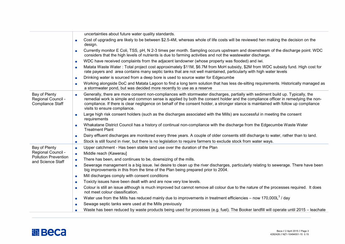
Beca // 2 April 2015 // Page 3
4282426 // NZ1-10494551-15 0.15
uncertainties about future water quality standards.
� Cost of upgrading are likely to be between $2.5-4M, whereas whole of life costs will be reviewed hen making the decision on the design.
� Currently monitor E Coli, TSS, pH, N 2-3 times per month. Sampling occurs upstream and downstream of the discharge point. WDC considers that the high levels of nutrients is due to farming activities and not the wastewater discharge.
� WDC have received complaints from the adjacent landowner (whose property was flooded) and iwi.
� Matata Waste Water : Total project cost approximately $11M, $6.7M from MoH subsidy, $2M from WDC subsidy fund. High cost for rate payers and area contains many septic tanks that are not well maintained, particularly with high water levels
� Drinking water is sourced from a deep bore is used to source water for Edgecumbe
� Working alongside DoC and Matata Lagoon to find a long term solution that has less de-silting requirements. Historically managed as a stormwater pond, but was decided more recently to use as a reserve
Bay of Plenty Regional Council - Compliance Staff
� Generally, there are more consent non-compliances with stormwater discharges, partially with sediment build up. Typically, the remedial work is simple and common sense is applied by both the consent holder and the compliance officer in remedying the non-compliance. If there is clear negligence on behalf of the consent holder, a stronger stance is maintained with follow up compliance visits to ensure compliance.
� Large high risk consent holders (such as the discharges associated with the Mills) are successful in meeting the consent requirements
� Whakatane District Council has a history of continual non-compliance with the discharge from the Edgecumbe Waste Water Treatment Plant
� Dairy effluent discharges are monitored every three years. A couple of older consents still discharge to water, rather than to land.
� Stock is still found in river, but there is no legislation to require farmers to exclude stock from water ways. Bay of Plenty Regional Council - Pollution Prevention and Science Staff
� Upper catchment - Has been stable land use over the duration of the Plan
� Middle reach (Kawerau]
� There has been, and continues to be, downsizing of the mills.
� Sewerage management is a big issue. Iwi desire to clean up the river discharges, particularly relating to sewerage. There have been big improvements in this from the time of the Plan being prepared prior to 2004.
� Mill discharges comply with consent conditions
� Toxicty issues have been dealt with and are now very low levels.
� Colour is still an issue although is much improved but cannot remove all colour due to the nature of the processes required. It does not meet colour classification.
� Water use from the Mills has reduced mainly due to improvements in treatment efficiencies – now 170,000L3 / day
� Sewage septic tanks were used at the Mills previously
� Waste has been reduced by waste products being used for processes (e.g. fuel). The Booker landfill will operate until 2015 – leachate
Beca // 2 April 2015 // Page 4
4282426 // NZ1-10494551-15 0.15
from this landfill is treated and drains to the treatment pond.
� Groundwater naturally has a very low quality in this area – sodium from naturally occurring geothermal reserves.
� Geothermal reconsenting for river discharges – direct discharge to river affects heat load and mercury. There are now three reinjection wells for geothermal fluid instead of discharging to the river. Previously Iwi wanted no direct discharge to the river but now own resource and want to discharge to the river. New geothermal consents are applied for under the Tarawera Plan, not under the RWLP (contact Bridgett for details).
� Stormwater discharges from the Mills is mainly treated by ponds then discharged to the river – stormwater used to be discharged directly to the river and site management was poor so stormwater quality being discharged was poor. Kawerau District Council is currently applying for a Comprehensive Stormwater Consent
� Lower reache
� Land use is predominantly maize crop and dairy.
� Two groundwater systems in the lower catchment – Braemar Spring and Johnson Road.
� Edgecombe Sewerage is still a key issue.
� Irrigation has increased. The question was raised as to whether it was previously perceived / actually a case that river water quality was too poor for irrigation use?
� Regarding water take – suggested that we look at consents for water take allocations and their compliance and see if water take from lower river has increased.
� Because it is a pumice river there are no biological issues.
� Suggested that we check Fonterra consents regarding dairy discharge consents – there are few river mouth discharges. Dairy herd sizes have increased but not land use coverage of dairy – intensification of dairy.
� Whakatane District Council’s Edgecumbe Waste Water pond discharge is still an issue, there is an asset management issue, funding could be sought from Government to fund sewage plant upgrade it is a big cultural issue and BOPRC has not enforced this Plan provision with Whakatane DC
� The Matata waste water system is to be reticulated, the proposed treatment plant is to be close to the Matata township and waste water will be taken across the Tarawera River by pipe.
� Stock management in waterways is an issue still and poorly managed. DoC and Fish and Game
� BOPRC are not aware of cumulative water takes, this is an issue for adjacent wetlands and water levels seem to be dropping and can scar the river bed as the velocity increases. Levels need to be assessed in the plan.
� Catchment management not clear
� There is an increase in aquatic pest plants
� There needs to be better enforcement of rules
� Wetlands of significance include Tumaroa and Kaumatea, Awa O Waiti, some are now crowned owned, again water availability is the biggest issue

Beca // 2 April 2015 // Page 5
4282426 // NZ1-10494551-15 0.15
� Wetland management agreements vary and operationally, partnerships work well
� Want provision to increase areas of wetlands
� In the upper catchment – water quality is a bigger issue than biodiversity
� Lower catchment- biodiversity is sought over water quality
� Wetlands include all types, riparian and drainage canals
� Wetland management agreements are not maintained well, enhancement is needed without consents, perhaps agreements would be better. Private land owners do not want to get involved in the RMA process.
� The plan needs to refer to Wetland Management Agreements and provisions for stock grazing need to be more restrictive and need to include detail specific to wetland management techniques such as grazing, planting trees, fencing
� The state of wetlands are not reported on, there needs to be more monitoring and reporting

Review of the Regional Plan for Tarawera River Catchment
Beca // 2 April 2015
4282426 // NZ1-10499763-6 0.6 // page 22
Appendix 4
Assessment of Anticipated Environmental Results

Beca // 2 April 2015 // Page 1
4282426 // NZ1-10494551-15 0.15
This table shows:
� Whether and how each Anticipated Environmental Result has been achieved
� Linkages between the Anticipated Environmental Results, objectives, policies and methods
Anticipated Environmental Result Objective (O)
Policy (P)
Linkage
Methods (M)
Rules (R)
Evidence Achieved?
Community Attitudes and Perceptions
7.5.5(a) The achievement of continued improvements in waste treatment operations, and in reductions in waste disposal effects on the environment.
O 7.5.2 P 7.5.3 (a)–(c)
Water quality data – from 2004 and now. Cumulative effects and any monitoring locations near existing discharges. There is continued improvement in waste treatment operation and a reduction in waste disposal effects on the environment.
Yes
7.5.5(b) Both the sustainable management of natural and physical resources and the social and economic wellbeing of the community will be safeguarded and enhanced over time.
O 7.5.2 P 7.5.3 (a)–(c)
No clear evidence. Unclear
7.5.5(c) Ensuring that the community concerns about the degraded state of the Lower Reach of the Tarawera River are remedied.
O 7.5.2 P 7.5.3 (a)–(c)
The Council complaints register (since 2004) only contains one specific complaint about the general state of the Tarawera River (complaint received in 2009 in response to a “no swimming” sign). Typically complaints refer to specific events (such as dead animals or debris in the river).
Yes
7.5.5(d) Efficient use and re-use of resources, for example the use of geothermal wastewater, reduces effects on the environment and facilitates new development opportunities.
O 7.5.2 P 7.5.3 (a)–(c)
Only four resource consents to take and use geothermal water have been granted since the plan became operative. Ngati Tuwharetoa Geothermal Assets Limited have applied for a replacement consent for their existing geothermal operation.
Yes

Beca // 2 April 2015 // Page 2
4282426 // NZ1-10494551-15 0.15
Anticipated Environmental Result Objective (O)
Policy (P)
Linkage
Methods (M)
Rules (R)
Evidence Achieved?
7.5.5(e) The eventual restoration of the water quality of the Tarawera River to facilitate the exercise of customary use by iwi.
O 7.5.2 P 7.5.3 (a)–(c)
Consultation with iwi indicates that while the mauri of the river is poor, it is trending upwards. Traditional kai is improving in the river and the majority of species are considered to be a suitable quality for consumption. See 7.5.5 (a) above.
Public Access
10.2.6(a) Protection of soil and water resources from unnecessary adverse effects of public access.
O 10.2.2 P 10.2.3 (a) P 10.2.3 (b)
M 10.2.4 (a)–(e)
No clear evidence. Unclear
10.2.6(b) Continued ease of public access to and along rivers and lakes.
O 10.2.2 P 10.2.3 (a) P 10.2.3 (b)
M 10.2.4 (a)–(e)
Esplanade reserves are available through District Council implementation of the Plan.
Yes
10.2.6(c) Safeguarding of sensitive ecological, natural character, heritage, and similar such areas from the effects of public access.
O 10.2.2 P 10.2.3 (a) P 10.2.3 (b)
M 10.2.4 (a)–(e)
Applied through site specific resource consents. None sited in analysis of resource consents Appendix 2.
Unclear
10.2.6(d) Greater awareness about public access to and along rivers and lakes.
O 10.2.2 P 10.2.3 (a) P 10.2.3 (b)
M 10.2.4 (a)–(e)
This is an LGA matter.
District Council planning maps show esplanade reserves (cadastral).
Unclear
10.2.6(e) Safeguarding of public safety, and property security.
O 10.2.2 P 10.2.3 (a) P 10.2.3 (b)
M 10.2.4 (a)–(e)
This is an LGA matter. No clear evidence.
Unclear
Land Use
11.8.6(a) The production of sediment and nutrients and their movement and deposition
O 11.8.2 P 11.8.3 (a)–(e)
M 11.8.4 (a)–(h)
Water quality data (including water chemistry, ecological values, ecosystem health – check
Yes, with further room

Beca // 2 April 2015 // Page 3
4282426 // NZ1-10494551-15 0.15
Anticipated Environmental Result Objective (O)
Policy (P)
Linkage
Methods (M)
Rules (R)
Evidence Achieved?
onto land and into water bodies has been controlled and minimised.
NERMN). Compare current with 2004 data. to improve
11.8.6(b) Improved water quality, and sustainable water allocation and use in particular parts of the Tarawera River catchment.
O 11.8.2 P 11.8.3 (a)–(e)
M 11.8.4 (a)– (h)
While this anticipated environmental result is unclear, the water quality data for the catchment shows that there is reduction in some contaminants, concentration of other contaminants are on an increasing trend. The resource consent database indicates that the allocation of water is within the sustainable limits set by the plan.
11.8.6(c) Protection and enhancement of significant areas of indigenous vegetation that
contribute to the natural character of the Tarawera River catchment
O 11.8.2 P 11.8.3 (a)–(e)
M 11.8.4 (a)–(h)
RMA provisions in Regional and District Plans achieve this. Not aware of exact numbers of additional SMA protected through this Plan.
Yes
River and Lake Beds
12.2.7(a) Minimisation of the deposition of sediment in, on, over or under the beds of rivers and lakes.
O 12.2.2 P 12.2.3 (a)–(g)
M 12.2.4 (a)–(g) R 12.2.5 (a)–(p) (16 rules)
Consent compliance indicates that there are minor non-compliances however given the limited duration of these activities and the remedial work undertaken by consent holders, the effects associated with non-compliances are not considered significant. Some rules in the plan (including structures and stock access) have been superseded by rules contained in the Regional Water and Land Plan.
Yes
12.2.7(b) The maintenance and enhancement of water quality and quantity.
O 12.2.2 P 12.2.3 (a)–(g)
M 12.2.4 (a)–(g) R 12.2.5 (a)–(p) (16 rules)
See 12.2.7(a) above. Yes
12.2.7(c) The maintenance and enhancement of O 12.2.2 M 12.2.4 (a)– See 12.2.7(a) above. Yes

Beca // 2 April 2015 // Page 4
4282426 // NZ1-10494551-15 0.15
Anticipated Environmental Result Objective (O)
Policy (P)
Linkage
Methods (M)
Rules (R)
Evidence Achieved?
ecological values. P 12.2.3 (a)–(g) (g) R 12.2.5 (a)–(p) (16 rules)
12.2.7(d) Respect for Maori values and maintenance of traditional rights of access and use.
O 12.2.2 P 12.2.3 (a)–(g)
M 12.2.4 (a)–(g) R 12.2.5 (a)–(p) (16 rules)
Improvements noted through consultation but not clear whether they are due to the Plan effectiveness.
12.2.7(e) Avoidance and minimisation of the effects of known natural hazards.
O 12.2.2 P 12.2.3 (a)–(g)
M 12.2.4 (a)–(g) R 12.2.5 (a)–(p) (16 rules)
No clear evidence available. This topic is being refined through the RPS with consequential rules in Regional and District Plans.
Not solely Tarawera Plan focus.
Unclear
12.2.7(f) Avoidance and minimization of any adverse effects on archaeological or traditional sites.
12.2.7(g) Avoidance and minimisation of the adverse effects of works or activities on natural character and landscape values.
O 12.2.2 P 12.2.3 (a) –(g)
M 12.2.4 (a)–(g) R 12.2.5 (a)–(p) (16 rules)
Iwi noted that accidental discovery protocols are being used in consent conditions. Implemented through other legislation and/or Regional and District Plans.
Yes
12.2.7(h) The integration of works and activities with the natural character and landscape values of the environment.
O 12.2.2 P 12.2.3 (a)–(g)
M 12.2.4 (a)–(g) R 12.2.5 (a)–(p) (16 rules)
There do not appear to be any consents granted that are contrary to this anticipated result.
Yes
Freshwater Ecology
13.5.6(a) Remaining wetlands are identified and protected.
O 13.5.2(a) O 13.5.2(b) P 13.5.3 (a)–(h)
M 13.5.4 (a)–(f) Two resource consents have been granted to WDC for the restoration of Matata Lagoon. The DoC and/or Regional Council have completed mapping through SNA.
Beca // 2 April 2015 // Page 5
4282426 // NZ1-10494551-15 0.15
Anticipated Environmental Result Objective (O)
Policy (P)
Linkage
Methods (M)
Rules (R)
Evidence Achieved?
13.5.6(b) Wetlands, lakes and riverine habitats, and riparian margins are protected and enhanced.
O 13.5.2(a) O 13.5.2(b) P 13.5.3 (a)–(h)
M 13.5.4 (a)–(f)
As per 13.5.6(a).
BOPRC has partnered with DoC and Fish and Game to prepare a comprehensive Wetland Restoration Guide (published 2007, re-published 2013). BOPRC also provide guidance and funding programmes for wetland enhancement and development, with additional assistance from Land Management Officers. The information is easily accessible on the BOPRC website.
The Paper Mills are working collaboratively with the local iwi under an MOU to manage adverse effects on the environment as a result of Mill activities. Wetland enhancement and development forms part of their programme of works. The MOU parties are working with consulting firm Wildlands, who advise that there has been significant wetland development in the catchment (i.e. several hundred hectares). The current plan rules associated with protection of stop-banks is a fundamental impediment to further wetland and riparian development and management.
Yes - with some room for improvement
13.5.6(c) The natural values of wetlands, riverine and lake habitats riparian margins are recognised and provided for.
O 13.5.2(a) O 13.5.2(b) P 13.5.3 (a)–(h)
M 13.5.4 (a)–(f)
The surface water abstraction consents granted in the catchment since the plan became operative meet the allocation restrictions. 23 resource consents have been granted to take and use groundwater since the plan became operative, however the plan objectives and policies do not contemplate hydraulic connectivity between the groundwater system and wetlands, hence s42A reports for these
Yes - with some room for improvement
Beca // 2 April 2015 // Page 6
4282426 // NZ1-10494551-15 0.15
Anticipated Environmental Result Objective (O)
Policy (P)
Linkage
Methods (M)
Rules (R)
Evidence Achieved?
activities have not considered effects on wetlands.
13.5.6(d) Additional wetlands may be identified, created and maintained.
O 13.5.2(a) O 13.5.2(b) P 13.5.3 (a)–(h)
M 13.5.4 (a)–(f)
See comments for 13.5.6(b). Yes - with some room for improvement
Surface Water Quantity
14.4.7(a) Protection of the assimilative capacity of the Lower Reach of the Tarawera River.
O 14.4.2 P 14.4.3 (a)–(h)
M 14.4.4 (a)–(d) R 14.4.5 (a)–(j)
Not all resource consents granted specifically consider the allocation limit set in the plan, nor do the s42A reports consider the matters set out in 14.4.5(i), where they are required to consider the allocation of water while protecting the assimilative capacity of the Lower Reach of the Tarawera River. The consents database has recorded the rate and volume of water authorised to be abstracted from existing resource consents, however not all resource consents within the database have recorded the abstraction rates and volumes. The data does show that there is sufficient water available for water abstraction within the set allocation limit. (ie approximately 67,850m3/day compared to an allocation limit of 200,000m3/day). While there is no record of permitted activity abstractions (i.e. takes less than 15m3/day), it is unlikely that, cumulatively, the permitted abstraction takes plus the consented abstractions exceed the allocation limit, which has been set to protect the assimilative capacity of the river.
Yes
Beca // 2 April 2015 // Page 7
4282426 // NZ1-10494551-15 0.15
Anticipated Environmental Result Objective (O)
Policy (P)
Linkage
Methods (M)
Rules (R)
Evidence Achieved?
14.4.7(b) Enhancement and protection of the natural character and life-supporting capacity of wetlands on the Rangitaiki Plains.
O 14.4.2 P 14.4.3 (a)–(h)
M 14.4.4 (a)–(d) R 14.4.5 (a)–(j)
As per 14.4.7(a), water allocation has been set in the plan to protect water levels in wetlands. A greater understanding of hydrology and connectivity between other water sources is required. Water level monitoring (including seasonal fluctuations). No resource consents have been granted to divert or take water from wetlands within the catchment, nor have there been any consents granted for the discharge into a wetland.
Yes
14.4.7(c) Protection of the life supporting capacity of water bodies in the Tarawera River catchment.
O 14.4.2 P 14.4.3 (a)–(h)
M 14.4.4 (a)–(d) R 14.4.5 (a)–(j)
As per 14.4.7(a). Yes
14.4.7(d) Rivers, lakes and wetlands are kept available for a wide variety of amenity activities requiring sufficient water quantity.
O 14.4.2 P 14.4.3 (a) – (h)
M 14.4.4 (a) –(d) R 14.4.5 (a)–(j)
Water allocation limits set in the plan are considered and adhered to when authorising the take and use of water in the catchment.
Yes
14.4.7(e) Water is utilised in an efficient manner and the need for large amounts of water is reduced.
O 14.4.2 P 14.4.3 (a) – (h)
M 14.4.4 (a) –(d) R 14.4.5 (a) – (j)
Verbal evidence shows that there has been a reduction in the non-consumptive take and discharges from the Mills. Resource consent application to take water for community drinking water supply in Kawerau is seeking to take less water due to decreasing population in the town. S42A reports consider the efficient use of water. RMA has introduced water metering and reporting regulations, which will ensure all users will be able to demonstrate how much water is being used.
Yes
Surface Water Quality
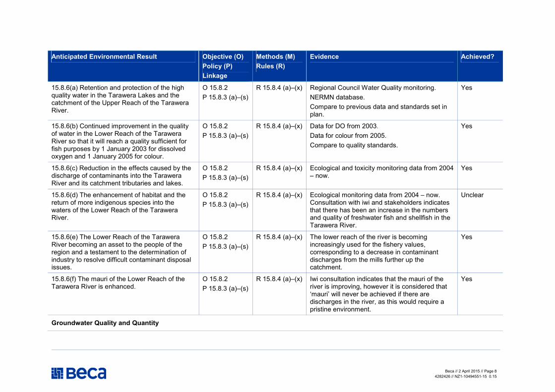
Beca // 2 April 2015 // Page 8
4282426 // NZ1-10494551-15 0.15
Anticipated Environmental Result Objective (O)
Policy (P)
Linkage
Methods (M)
Rules (R)
Evidence Achieved?
15.8.6(a) Retention and protection of the high quality water in the Tarawera Lakes and the catchment of the Upper Reach of the Tarawera River.
O 15.8.2 P 15.8.3 (a)–(s)
R 15.8.4 (a)–(x) Regional Council Water Quality monitoring. NERMN database. Compare to previous data and standards set in plan.
Yes
15.8.6(b) Continued improvement in the quality of water in the Lower Reach of the Tarawera River so that it will reach a quality sufficient for fish purposes by 1 January 2003 for dissolved oxygen and 1 January 2005 for colour.
O 15.8.2 P 15.8.3 (a)–(s)
R 15.8.4 (a)–(x) Data for DO from 2003. Data for colour from 2005. Compare to quality standards.
Yes
15.8.6(c) Reduction in the effects caused by the discharge of contaminants into the Tarawera River and its catchment tributaries and lakes.
O 15.8.2 P 15.8.3 (a)–(s)
R 15.8.4 (a)–(x) Ecological and toxicity monitoring data from 2004 – now.
Yes
15.8.6(d) The enhancement of habitat and the return of more indigenous species into the waters of the Lower Reach of the Tarawera River.
O 15.8.2 P 15.8.3 (a)–(s)
R 15.8.4 (a)–(x) Ecological monitoring data from 2004 – now. Consultation with iwi and stakeholders indicates that there has been an increase in the numbers and quality of freshwater fish and shellfish in the Tarawera River.
Unclear
15.8.6(e) The Lower Reach of the Tarawera River becoming an asset to the people of the region and a testament to the determination of industry to resolve difficult contaminant disposal issues.
O 15.8.2 P 15.8.3 (a)–(s)
R 15.8.4 (a)–(x) The lower reach of the river is becoming increasingly used for the fishery values, corresponding to a decrease in contaminant discharges from the mills further up the catchment.
Yes
15.8.6(f) The mauri of the Lower Reach of the Tarawera River is enhanced.
O 15.8.2 P 15.8.3 (a)–(s)
R 15.8.4 (a)–(x) Iwi consultation indicates that the mauri of the river is improving, however it is considered that ‘mauri’ will never be achieved if there are discharges in the river, as this would require a pristine environment.
Yes
Groundwater Quality and Quantity

Beca // 2 April 2015 // Page 9
4282426 // NZ1-10494551-15 0.15
Anticipated Environmental Result Objective (O)
Policy (P)
Linkage
Methods (M)
Rules (R)
Evidence Achieved?
16.8.7(a) A better community understanding of the potential groundwater resources of the catchment of the Lower Reach of the Tarawera River.
O 16.8.2 P 16.8.3 (a)–(l)
M 16.8.4 (a)–(d) R16.8.5 (a)–(g)
Consents granted in catchment to take and use groundwater since 2004 indicate that groundwater is being used for irrigation purposes in the lower reach of the Tarawera River.
16.8.7(b) Safeguarding of the quality of groundwater resources for future generations.
O 16.8.2 P 16.8.3 (a)–(l)
M 16.8.4 (a)–(d) R16.8.5 (a)–(g)
A number of consents have been granted for the discharge of wastewater, dairy effluent and storm water to land or ground soakage. Not all consents granted have considered the provisions of the Plan; however the consent conditions and the environmental outcomes achieved by adhering to those conditions are similar to those anticipated by the Plan.
Yes
16.8.7(c) Efficient land based disposal systems, designed and managed to ensure minimal long-term effects on surface and groundwater quality and quantity will be encouraged.
O 16.8.2 P 16.8.3 (a)–(l)
M 16.8.4 (a)–(d) R16.8.5 (a)–(g)
As per 16.8.7 (b), addressed by the OSET Plan. Yes
16.8.7(d) Limited agricultural and domestic use if provided for.
O 16.8.2 P 16.8.3 (a)–(l)
M 16.8.4 (a)–(d) R16.8.5 (a)–(g)
Ambiguous. N/A
16.8.7(e) Knowledge of aquifer configurations and groundwater chemical composition will be enhanced.
O 16.8.2 P 16.8.3 (a) – (l)
M 16.8.4 (a) – (d) R16.8.5 (a) – (g)
Not aware of any Council data.
Geothermal Resources
17.4.6(a) Uncontrolled discharges of waste geothermal fluid into the Tarawera River will be avoided.
O 17.4.2 P 17.4.3 (a)–(f)
R 17.4.4 (a)–(g) There have been no complaints submitted to the Council for any unauthorised geothermal discharges.
Yes
17.4.6(b) Actual and potential effects on the quality of water in the Tarawera River resulting
O 17.4.2 R 17.4.4 (a)–(g) No new resource consents to discharge geothermal fluid to the Tarawera River have
Yes

Beca // 2 April 2015 // Page 10
4282426 // NZ1-10494551-15 0.15
Anticipated Environmental Result Objective (O)
Policy (P)
Linkage
Methods (M)
Rules (R)
Evidence Achieved?
from discharges of waste geothermal fluid will be minimised.
P 17.4.3 (a)–(f) been granted since the Plan became operative. Ngati Tuwharetoa Geothermal Assets Ltd have made a consent application to replace an existing discharge to the river, however this consent is yet to be granted. The consent application considers the impact of discharging geothermal fluid to surface water.
17.4.6(c) Activities that would remove residual heat and contaminating minerals will be encouraged, lessening impact on the Tarawera River.
O 17.4.2 P 17.4.3 (a)–(f)
R 17.4.4 (a)–(g) Not clear. No information available.
Unclear

Review of the Regional Plan for Tarawera River Catchment
Beca // 2 April 2015
4282426 // NZ1-10499763-6 0.6 // page 23
Appendix 5
Assessment Against Objectives and Policies (not including rules)
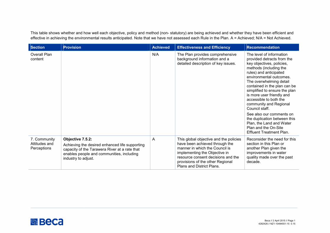
Beca // 2 April 2015 // Page 1
4282426 // NZ1-10494551-15 0.15
This table shows whether and how well each objective, policy and method (non- statutory) are being achieved and whether they have been efficient and effective in achieving the environmental results anticipated. Note that we have not assessed each Rule in the Plan. A = Achieved; N/A = Not Achieved.
Section Provision Achieved Effectiveness and Efficiency Recommendation
Overall Plan content
N/A The Plan provides comprehensive background information and a detailed description of key issues.
The level of information provided detracts from the key objectives, policies, methods (including the rules) and anticipated environmental outcomes. The overwhelming detail contained in the plan can be simplified to ensure the plan is more user friendly and accessible to both the community and Regional Council staff. See also our comments on the duplication between this Plan, the Land and Water Plan and the On-Site Effluent Treatment Plan.
7. Community Attitudes and Perceptions
Objective 7.5.2:
Achieving the desired enhanced life supporting capacity of the Tarawera River at a rate that enables people and communities, including industry to adjust.
A This global objective and the policies have been achieved through the manner in which the Council is implementing the Objective in resource consent decisions and the provisions of the other Regional Plans and District Plans.
Reconsider the need for this section in this Plan or another Plan given the improvements in water quality made over the past decade.

Beca // 2 April 2015 // Page 2
4282426 // NZ1-10494551-15 0.15
Section Provision Achieved Effectiveness and Efficiency Recommendation
Policy 7.5.3(a):
To consider the social and economic wellbeing of people and communities when making decisions about the sustainable management of the Tarawera River.
Policy 7.5.3(b):
To stage the achievement of water quality standards as set out in the methods of Chapter 15 in a way that provides a defined schedule of goals to enable the community including industry to adjust.
Policy 7.5.3(c):
To have particular regard to Kaitiakitanga when making decisions about the sustainable management of the Tarawera River and its catchment.
It is not clear whether there is a defined Schedule of Goals to achieve the staged improvement in water quality.
8. Resource Management Issues of Significance to Iwi
Refer to Chapter 14 (Surface Water Quantity) for objectives, policies
8.2.1(c) Wetlands
Refer to Chapter 13 (Freshwater Ecology) for objectives, policies
8.2.1(d) Land Management
Refer to Chapter 11 (Land Use) for objectives, policies
8.2.1(e) Heritage Places
8.2.1(f) Social and Economic Development
Refer to Chapter 7 (Community Attitudes and Perceptions) for objectives, policies
8.2.1(g) Ownership and Management
N/A This section generally refers to other sections of the Plan and is really providing Iwi with a concise chapter reporting on their concerns and implementation methods.
Consultation with iwi indicated anecdotal improvements to wetlands in the Lower Catchment. Wetlands in the catchment should be considered to be part of the river. Iwi noted more could be done to improve the quality of wetlands.
Land use practices are still a concern, particularly intensive agricultural and the cumulative effects across the catchment.
Heritage areas are managed through
Given that Issues are not mandatory statements in Plans refine this section down to the cross referencing of Objectives and Policies on the areas of interest.

Beca // 2 April 2015 // Page 3
4282426 // NZ1-10494551-15 0.15
Section Provision Achieved Effectiveness and Efficiency Recommendation
District Plans and other legislative regimes. Consultation with iwi revealed no instances where heritage in the catchment was compromised in anyway during the last 10 years.
Treaty Settlement across the Eastern Bay of Plenty has seen the return of lands to iwi. The Tarawera River Catchment has a number of Statutory Acknowledgements which recognise ancestral and customary interest in the catchment.
10. Public Access
Objective 10.2.2:
Maintain and enhance public access to and along rivers and lakes while ensuring that threats to natural heritage, safety and security values caused by public access are minimised.
A This Objective is being met through a range of RMA documents at the Regional and District level
Policy 10.2.3(a):
To ensure that public access to and along rivers and lakes is restricted only in circumstances:
(a) Where sensitive ecological, amenity or heritage values may be compromised; or
(b) Where safety or security may be compromised; or
(c) Where the purpose of a designated reserve may be compromised.
Policy 10.2.3(b):
To encourage the coordination of public access to and along rivers and lakes with district councils, the Department of Conservation and landowners.
Methods
A This Policy duplicates the provisions at the District level with regards to esplanade reserves applied through subdivision and development.
Co-ordinating access of this nature is a role that may be happening as a LGA function – it doesn’t necessitate a requirement for an RMA policy
Reconsider the need for these provisions in this Plan. Decide whether or not non – statutory methods belong in the Plan and, if they do, monitor their effectiveness.

Beca // 2 April 2015 // Page 4
4282426 // NZ1-10494551-15 0.15
Section Provision Achieved Effectiveness and Efficiency Recommendation
Councils are encouraged to:
Consider effects on sensitive ecologies, amenity or heritage values, safety and security and the purpose of designated reserves when controlling or providing for access to and along river and lake margins.
Monitor activities along river and lake margins to ensure that they do not adversely affect the environment.
Coordinate with one another and the Department of Conservation to manage reserves and provide publicly available information about access to and along rivers and lakes.
11. Land Use Objective 11.8.2
Mitigation, remediation and avoidance of erosion and the discharge of nutrients and sediment, and of adverse effects on water quality and quantity arising from inappropriate land uses and land use practices.
Recognise and provide for the protection of heritage values, and the preservation of natural character, in decisions on development, including the national significance of the Tarawera Lakes catchments.
A The Objective is complex by dealing with erosion, nutrient and sediment discharge and water quality in the one sentence and lacks clarity of intent.
This Objective conveys a principle of the RMA that will appear in all the Regional Plans as well as the District Plans.
Reconsider the hierarchy of Regional Plans and the regional implementation as distinct to District implementation methods and remove duplication with other Plans.
Policy 11.8.3(a):
To control unsustainable land uses.
Policy 11.8.3(b):
To remedy those land management practices that are:
(i) Unsustainable on more erosion prone classes of land; or
(ii) May otherwise adversely affect water quality
Policy 11.8.3(a) and (b) are so broad to the point of being un-measurable.
Policy 11.8.3(c) can only take place under a resource consent or the Regional Council may action this through LGA methods such as the Farm Management Plans.
Policy 11.8.3(d) is more likely to be
Refine Objectives and Policies to that which can be implemented by the Regional Council and reconsider role of Tarawera Plan alongside land and Water Plan.

Beca // 2 April 2015 // Page 5
4282426 // NZ1-10494551-15 0.15
Section Provision Achieved Effectiveness and Efficiency Recommendation
and quantity.
Policy 11.8.3(c):
To encourage land users to implement methods that would mitigate, remedy or avoid erosion and the discharge of nutrients and sediment from their land.
Policy 11.8.3(d):
To encourage landowners who wish to legally and physically protect significant indigenous vegetation and fauna habitat.
Policy 11.8.3(e):
Any authority assessing a consent application for any activity within the Tarawera Lakes catchments will recognise and provide for the national significance of those catchments with particular regard to heritage values and those matters of national importance specified in section 6 of the Resource Management Act 1991.
achieved through District Council decisions on subdivision and development resource consents.
Policy 11.8.3(e) cannot be affective for District Councils unless its provided for in the RPS.
Method 11.8.4(a):
Coordinate a programme to identify the extent and status of protected areas within the catchment, by June 1997.
Method 11.8.4(b):
Coordinate the necessary research to provide information on the problems associated with the grazing of different types of stock, or stocking rates on different classes of land, by June 1999.
Method 11.8.4(c):
Coordinate with other relevant organisations and affected landowners to identify and protect areas of significant vegetation that are important for soil conservation, water quality or water quantity.
Not all methods have been undertaken.
The Lake Okaro Action Plan was prepared in 2005.
The Plan does not in itself action achievement of Policies through rules.
Decide whether or not non – statutory methods belong in the Plan and if they do, monitor their effectiveness.
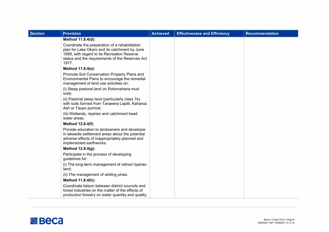
Beca // 2 April 2015 // Page 6
4282426 // NZ1-10494551-15 0.15
Section Provision Achieved Effectiveness and Efficiency Recommendation
Method 11.8.4(d):
Coordinate the preparation of a rehabilitation plan for Lake Okaro and its catchment by June 1999, with regard to its Recreation Reserve status and the requirements of the Reserves Act 1977.
Method 11.8.4(e):
Promote Soil Conservation Property Plans and Environmental Plans to encourage the remedial management of land use activities on:
(i) Steep pastoral land on Rotomahana mud soils;
(ii) Pastoral steep land (particularly class 7e) with soils formed from Tarawera Lapilli, Kaharoa Ash or Taupo pumice;
(iii) Wetlands, riparian and catchment head water areas.
Method 12.8.4(f):
Provide education to landowners and developer in lakeside settlement areas about the potential adverse effects of inappropriately planned and implemented earthworks.
Method 12.8.4(g):
Participate in the process of developing guidelines for:
(i) The long-term management of retired riparian land;
(ii) The management of wilding pines.
Method 11.8.4(h):
Coordinate liaison between district councils and forest industries on the matter of the effects of production forestry on water quantity and quality.
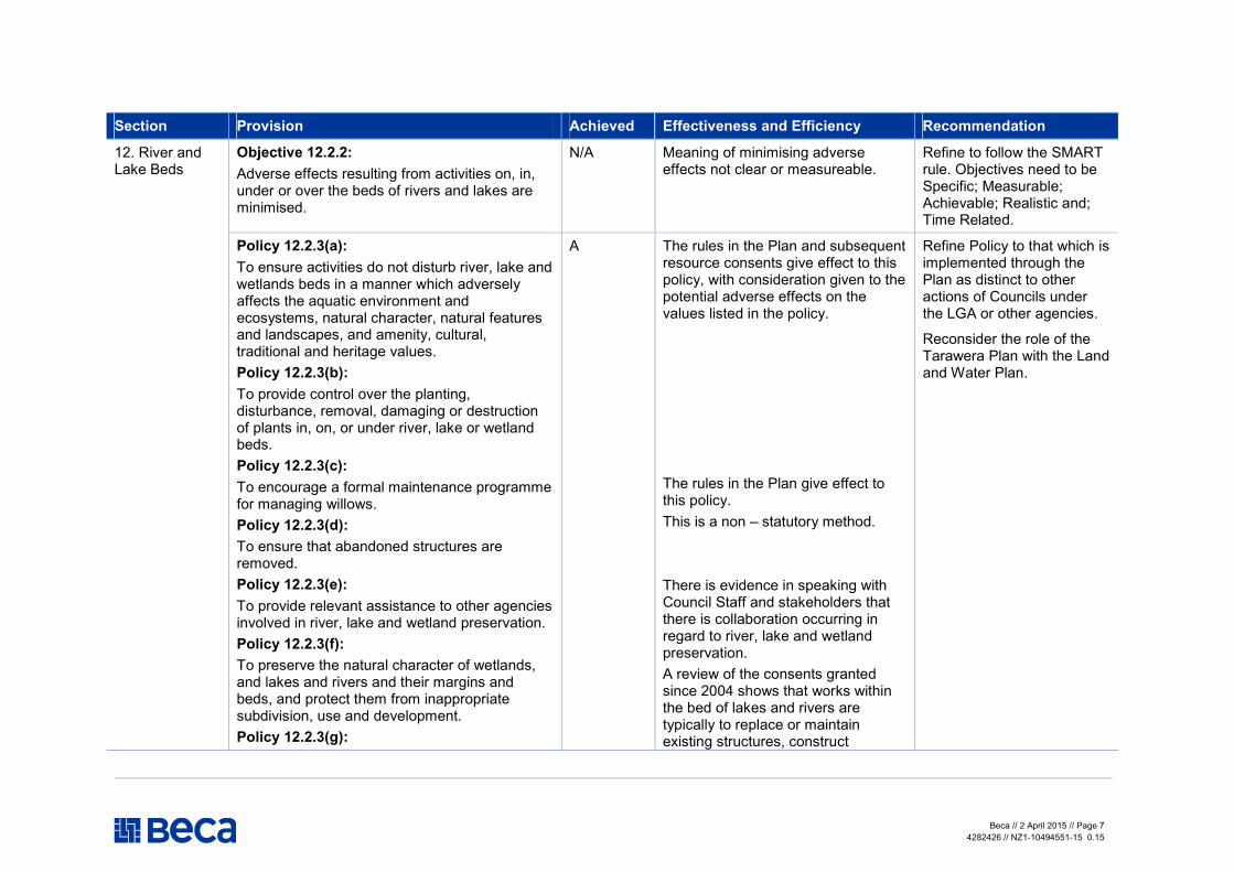
Beca // 2 April 2015 // Page 7
4282426 // NZ1-10494551-15 0.15
Section Provision Achieved Effectiveness and Efficiency Recommendation
12. River and Lake Beds
Objective 12.2.2:
Adverse effects resulting from activities on, in, under or over the beds of rivers and lakes are minimised.
N/A Meaning of minimising adverse effects not clear or measureable.
Refine to follow the SMART rule. Objectives need to be Specific; Measurable; Achievable; Realistic and; Time Related.
Policy 12.2.3(a):
To ensure activities do not disturb river, lake and wetlands beds in a manner which adversely affects the aquatic environment and ecosystems, natural character, natural features and landscapes, and amenity, cultural, traditional and heritage values.
Policy 12.2.3(b):
To provide control over the planting, disturbance, removal, damaging or destruction of plants in, on, or under river, lake or wetland beds.
Policy 12.2.3(c):
To encourage a formal maintenance programme for managing willows.
Policy 12.2.3(d):
To ensure that abandoned structures are removed.
Policy 12.2.3(e):
To provide relevant assistance to other agencies involved in river, lake and wetland preservation.
Policy 12.2.3(f):
To preserve the natural character of wetlands, and lakes and rivers and their margins and beds, and protect them from inappropriate subdivision, use and development.
Policy 12.2.3(g):
A The rules in the Plan and subsequent resource consents give effect to this policy, with consideration given to the potential adverse effects on the values listed in the policy.
The rules in the Plan give effect to this policy.
This is a non – statutory method.
There is evidence in speaking with Council Staff and stakeholders that there is collaboration occurring in regard to river, lake and wetland preservation.
A review of the consents granted since 2004 shows that works within the bed of lakes and rivers are typically to replace or maintain existing structures, construct
Refine Policy to that which is implemented through the Plan as distinct to other actions of Councils under the LGA or other agencies.
Reconsider the role of the Tarawera Plan with the Land and Water Plan.

Beca // 2 April 2015 // Page 8
4282426 // NZ1-10494551-15 0.15
Section Provision Achieved Effectiveness and Efficiency Recommendation
To promote the reasonable shared use, including public use, of private structures occupying public space in or on the beds of water bodies.
culverts, bridges and access points or to undertake works for flooding and/or erosion protections. These activities are not considered to derogate from natural character and are not considered an inappropriate use or development of the water bodies.
Environment Bay of Plenty will:
Method 12.2.4(a):
By 1 July 1997, notify all known owners and/or operators of structures which are not permitted by this regional plan, located in, on, under or over the beds of the lakes, rivers, and wetlands within the catchment as to the requirements for the authorisation of those structures.
Method 12.2.4(b):
Require that within one calendar year following the date on which this regional plan becomes operative, resource consent applications pursuant to rule 12.2.5(c) for existing structures for discretionary activities on, in, under or over beds of rivers, lakes and wetlands shall be lodged.
Method 12.2.4(c):
Require that within one calendar year following the date on which this regional plan becomes operative, all abandoned structures, and structures with no identified ongoing purpose be removed, at their owners’ expense, from the beds of river, lakes and wetlands, except for those structures for which a resource consent application has been lodged but not decided.
Method 12.2.4(d):
While the methodology set out in the Plan is clear and directive, there is little evidence (from discussions with Council staff) that all of the required actions were fulfilled.
It is difficult to judge how much the improvement in the catchment is due to the conditions on resource consents and other actions by the Council and other agencies to achieve the improvements sought.
Decide whether or not non – statutory methods belong in the Plan and if they do, monitor their effectiveness.

Beca // 2 April 2015 // Page 9
4282426 // NZ1-10494551-15 0.15
Section Provision Achieved Effectiveness and Efficiency Recommendation
Where possible, use indigenous plants for soil erosion control purposes alongside the Tarawera River and its tributaries, and in other river, lake, or wetland areas.
Method 12.2.4(e):
Where possible use alternative to willow species and associated invasive cultivars for soil erosion and river control purposes.
Method 12.4.4(f):
Establish a forum with the Department of Conservation, iwi authorities and other interested parties to investigate alternatives to the use of willow species for soil erosion and river control purposes.
District Councils are encouraged to
Method 12.2.4(g):
Avoid the inappropriate subdivision of land in or adjacent to the beds of rivers, lakes, and wetlands.
13 Freshwater Ecology
Objective 13.5.2(a):
Protection, maintenance and enhancement of the life supporting capacity of surface water bodies in the Tarawera River catchment.
Objective13.5.2(b):
Protection, maintenance and enhancement of the indigenous vegetation, habitat and migration pathways of the remnant wetlands, lakes, rivers and their margins in the Tarawera River catchment.
A Surface Water Quality improvements have been achieved with consequential benefits to the ecology, but it’s not clear if that is a reflection of resource consent/statutory methods or the other actions of Council and other agencies.
Policy 13.5.3(a):
To ensure that the natural character of wetlands, lakes, rivers and their margins is not further
Not clear whether this has been effective.
Refine Policy to that which is implemented through the Plan as distinct to other actions of Councils under

Beca // 2 April 2015 // Page 10
4282426 // NZ1-10494551-15 0.15
Section Provision Achieved Effectiveness and Efficiency Recommendation
degraded but is enhanced or protected from inappropriate subdivision, use and development.
Policy 13.5.3(b):
To ensure that wetland, river and riparian values are provided for when maintaining and establishing drainage systems.
Policy 13.5.3(c):
To discourage subdivision and development that results in the drainage, fragmentation or destruction of wetlands, riverine and riparian habitats.
Policy 13.5.3(d):
To discourage the access of stock into wetlands and riparian margins and promote the effective fencing of wetlands and riparian margins.
Policy 13.5.3(e):
To promote the restoration and enhancement of wetlands, lakes and riverine habitats; and their riparian margins.
Policy 13.5.3(f):
To promote the creation of new wetlands.
Policy 13.5.3(g):
To ensure that the existing wetland habitats are preserved and the creation and development of new wetland habitats encouraged.
Policy 13.5.3(h):
To ensure that wetland and river habitats and migration pathways are conserved and, as appropriate, enhanced.
Not clear why this Policy has to be stated when it falls under the Policy above.
This Policy can’t be effective when it’s largely a District Council matter implemented through the District Plan.
“Discourage” is a soft action word and will not be as effective and directive.
“Promotion” is a soft action word and will not be as effective and directive.
“Promotion” is a soft action word and will not be as effective and directive.
This Policy duplicates policy in other Regional and District plans. See comments above on the word promote.
Not clear whether this has been effective
the LGA or other agencies.
Environment Bay of Plenty will:
Method 13.5.4(a):
Make appropriate submissions to district
Not all methods have been
Decide whether or not non – statutory methods belong in the Plan and if they do,
Beca // 2 April 2015 // Page 11
4282426 // NZ1-10494551-15 0.15
Section Provision Achieved Effectiveness and Efficiency Recommendation
councils through the statutory consents process, to discourage the subdivision (resulting in fragmentation), drainage and development of wetlands.
Method 13.5.4(b):
Cooperate with relevant organisations and individuals to determine the most appropriate methods for the protection and enhancement of wetlands, river and lake habitats, and their riparian margins.
Method 13.5.4(c):
Promote the maintenance of water levels in wetlands within the minimum and maximum levels specified in Rule 14.4.5(a) (Chapter 14 – Surface Water Quantity).
Method 13.5.4(d):
Research, in conjunction with district councils, tangata whenua, the Department of Conservation, Eastern Region Fish and Game Council, and other relevant organisations and individuals, the importance of the natural values of the wetlands, lake and riverine habitats and riparian margins in sustaining natural habitats and communities.
Method 13.5.4(e):
Promote, in conjunction with district councils, the Department of Conservation, Eastern Region Fish and Game Council, and other relevant organisations and individuals, research into the location and significance of the wetland and river habitat and migration pathways of aquatic life, particularly native fish species, and fish food species.
Method 13.5.4(f):
undertaken
monitor their effectiveness.

Beca // 2 April 2015 // Page 12
4282426 // NZ1-10494551-15 0.15
Section Provision Achieved Effectiveness and Efficiency Recommendation
Manage its flood control and drainage activities to minimise adverse effects on aquatic habitat and where practicable enhance the natural character and ecological values of the Tarawera River catchment.
14. Surface Water Quantity
Objective 14.4.2:
Effective management of the surface water resources of the Tarawera River catchment to sustain and enhance life supporting capacities and natural character, while providing for a wide range of efficient uses and avoiding, remedying and mitigating adverse effects.
A Considering the current level of water allocated in the catchment, there appears to be sufficient water available for allocation to other future water users, to enable people and communities to provide for their wellbeing.
Refine the Objectives to make it clear what allocation management is required for sustainable management of the catchment.
Policy 14.4.3(a):
To ensure that people and communities continue to have access to sufficient water to provide for their wellbeing. Policy 14.4.3(b):
To ensure that the integrity of aquatic ecosystems and habitats is not adversely affected as the result of water allocation decisions. Policy 14.4.3(c):
To ensure that the natural character of water bodies is not adversely affected by water allocation decisions.
Policy 14.4.3(d):
To ensure that the taking of water from surface water bodies does not adversely affect water quality to the extent that fisheries, wildlife and aquatic life are threatened. Policy 14.4.3(e):
To promote the conservation and efficient use of surface water by existing and future resource
The Plan does not provide a minimum flow restrictions for water bodies in the catchment, however it’s noted that consents granted in the catchment refer to Council guidelines for guidance on appropriate flow restrictions.
Resource consents granted are consistent with the allocation limits set in the Plan.
Set flow restrictions in the Plan which are consistent with the requirements set out in Policy B1 of the National Policy Statement for Freshwater Management.

Beca // 2 April 2015 // Page 13
4282426 // NZ1-10494551-15 0.15
Section Provision Achieved Effectiveness and Efficiency Recommendation
consent holders, and those taking water as a Permitted Activity. Policy 14.4.3(f):
To protect the assimilative capacity of the surface water resources of the Tarawera River catchment by considering in particular the cumulative effects of abstractions. Policy 14.4.3(g):
To provide water quantity information where available. Policy 14.4.3(h):
To promote land uses which do not adversely affect stream and river flows or lake and wetland levels.
Environment Bay of Plenty will: Method14.4.4(a):
Promote the maintenance of water levels in wetlands within established minimum and maximum levels, and promote water levels that ensure the integrity of natural ecosystems and natural character. Method 14.4.4(b):
Contribute financial assistance for capital works associated with the initial restoration and development of wetland water level control structures, on the basis specified in Appendix 12, and consider funding on a case by case basis for the initial restoration and development of wetland water level control structures for other wetlands. Method 14.4.4(c):
Promote the conservation and sustainable use
The Council provides environmental enhancement funds for projects associated with the development and restoration of wetlands. It is unclear how much funding has occurred over the period.
The Council has produced information to provide to the public regarding the efficient use of water resources, and is available on the Bay of Plenty Regional Council website.
Not all methods have been undertaken
Decide whether or not non – statutory methods belong in the Plan and if they do, monitor their effectiveness.

Beca // 2 April 2015 // Page 14
4282426 // NZ1-10494551-15 0.15
Section Provision Achieved Effectiveness and Efficiency Recommendation
of surface water resources. Method 14.4.4(d):
Environment Bay of Plenty will assist district councils in identifying land uses that cause significant reduction in water surface resources and threaten to reduce water levels and flows, and in developing effective methods for controlling such land uses or promoting alternative ones.
15 Surface Water Quality
Objective 15.8.2
Enhance surface water quality in the Tarawera catchment to a level which safeguards the life supporting capacity of the water and meets the reasonable needs of people and communities, especially:
(a) Reduction in the production of waste and discharge of contaminants throughout the catchment; and
(b) The maintenance of “Fish Spawning” water quality standards in the Upper Reach of the Tarawera River and its tributaries; and
(c) The establishment of “Fish Purposes” water quality standards in the Lower Reach of the Tarawera River; and
(d) The conservation of lakes and tributaries in their Natural State; and
(e) The enhancement of the water quality in Lake Okaro to that suitable for contact recreation; and
(f) To recognise that staged changes in industrial processes and waste treatment systems will be necessary to achieve the water quality goals of this regional plan.
A Surface Water Quality improvements have been achieved with but it’s not clear if this is a reflection of resource consent /statutory methods or the other actions of Council and other agencies.
It is unclear whether clauses (b) to (e) have been achieved.
The re-consenting of discharges to the River over the past decade has achieved staged changes in the nature and rate of discharges.

Beca // 2 April 2015 // Page 15
4282426 // NZ1-10494551-15 0.15
Section Provision Achieved Effectiveness and Efficiency Recommendation
(g) Unless there are exceptional circumstances there shall be not discharge of sewage into the surface water of the Tarawera River.
Policy 15.8.3(a):
To establish a range of surface water quality classes that provide standards for the management of surface water bodies in the catchment. The purposes of these classifications are as follows:
(i) The quality of water in the lakes in the catchments of the Tarawera Lakes, excluding Lake Okaro, will be managed to retain its Natural State (NS) (see Rule 15.8.4(b)). For the purposes of the Class NS classification, Environment Bay of Plenty defines natural state to mean that the water quality in the total water column of a lake should remain at 1994 water quality standards or better.
(ii) The quality of water in Lake Okaro will be managed for Contact Recreation (CR) purposes (see Rule 15.8.4(d)).
(iii) The quality of water in the tributaries of the Tarawera Lakes, the tributaries of the Tarawera River, excluding the canals and drains and wetlands on the Rangitaiki Plains, and the Upper Reach of the Tarawera River will be managed for fish spawning purposes (FSUT) (see Rule 15.8.4(f).
(iv) The quality of water in the Lower Reach of the Tarawera River will be managed for fish purposes (FPLT) (see Rule 15.8.4(h)).
Policy 15.8.3(b):
To promote reduction of contaminant discharges into the Tarawera River.
This policy is a management policy that will not assist in the deliberations on an application - it relates to how the Plan should be prepared and reviewed.
Promotion” is a soft action word and will not be as effective and directive
Council prepares a monitoring programme which identifies the priorities for the catchment, and reasons why particular values and resources within the catchment are not monitored and reported on. It is also recommended that the Council implements the provisions in the Plan particular to the discharge of human waste to water when existing consents are up for renewal. There are existing consented discharges (i.e. WDC) which clearly contravene the provisions in the Plan.
Beca // 2 April 2015 // Page 16
4282426 // NZ1-10494551-15 0.15
Section Provision Achieved Effectiveness and Efficiency Recommendation
Policy 15.8.3(c):
To reduce the discharge of contaminants into wetlands, canals and drains on the Rangitaiki Plains.
Policy 15.8.3(d):
To advocate that the discharge of dairy shed effluent is in accordance with guidelines agreed between Environment Bay of Plenty and the agriculture industry.
Policy 15.8.3(e):
To encourage dischargers to avoid, remedy or mitigate any actual or potential adverse effects arising from their direct or indirect discharge of contaminants into water by:
(a) Limiting and reducing quantities and concentrations of discharged contaminants, in particular, contaminants which can reduce the life supporting capacity of aquatic ecosystems.
(b) Promoting dischargers to land in preference to discharges into water in areas of the catchment of the Tarawera River where groundwater is not vulnerable to adverse effects from resulting contaminants and where runoff of contaminants into water can be controlled.
(c) Reducing adverse effects from non- point-source discharges of contaminants to water bodies by supporting and promoting appropriate land and riparian management practices, and discouraging the application of sprays and fertilisers adjacent to or over surface water bodies.
Policy 15.8.3(f):
To establish reasonable mixing zones for all authorised discharges, excluding permitted
“A guide to managing farm dairy effluent” was prepared between Dairy NZ and Council.
The Council produces some reports communicating the water quality sampling, which are made available on the Bay of Plenty Regional Council website. The data do not appear to be consistently gathered and reported.

Beca // 2 April 2015 // Page 17
4282426 // NZ1-10494551-15 0.15
Section Provision Achieved Effectiveness and Efficiency Recommendation
activities, within the Tarawera River catchment, on a case by case basis, relative to but not limited to specified criteria (15.8.4(s)).
Policy 15.8.3(g):
To promote the efficient use of water.
Policy 15.8.3(h):
To enable public access to available water quality information.
Policy 15.8.3(i):
To encourage discharge permit holders to conduct appropriate tests and monitoring of the toxic effect of their effluent.
Policy 15.8.3(j):
To allow for the discharge of uncontaminated stormwater (15.8.4(q)).
Policy 15.8.3(k):
To promote the guidelines and principles of the Operative Bay of Plenty Regional Land Management Plan with regard to the management of land use activities that aggravate soil erosion, and the subsequent sediment contamination of surface water sources.
Policy 15.8.3(l):
To ensure the reduction in discharges with BOD loading into the Lower Reach of the Tarawera River to achieve dissolved oxygen standards required for Fish Purposes.
Policy 15.8.3(m):
To encourage the reduction of colour to achieve Fish Purpose standards for the Lower Reach of the Tarawera River.
The discharge of uncontaminated stormwater is a permitted activity.
The OSET is consistently used for consents to discharge wastewater to land.
Resource consents granted for industrial discharges from the Mills requires a high standard of treatment to improve the colour of the discharge to the Tarawera River. Compliance monitoring indicates that these conditions are sufficient to improve the quality of the discharges.
The rules contained in the Plan

Beca // 2 April 2015 // Page 18
4282426 // NZ1-10494551-15 0.15
Section Provision Achieved Effectiveness and Efficiency Recommendation
Policy 15.8.3(n):
To encourage a reduction in human sewage discharges into the Tarawera River or its tributaries.
Policy 15.8.3(o):
To discourage and eventually prevent the degrading of the purity of water caused by the discharge of human sewage by:
(a) encouraging the use of sewage treatment systems designed in consultation with tangata whenua to enhance or restore the mauri of receiving water;
(b) prohibiting any new sewage discharges to surface water;
(c) encouraging a shift to land based sewage treatment and disposal systems;
(d) requiring any discharge of human sewage from Kawerau township into the Tarawera River to comply with the Fish Purposes classification standards;
(e) requiring any discharge of human sewage from the Edgecumbe township sewage system into the Omeheu Canal to comply with defined effluent quality standards.
Policy 15.8.3(p):
To encourage communities to develop land based treatment systems for sewage disposal.
Policy 15.8.3(q):
To encourage the grant of consents for the discharge of treated sewage to land.
Policy 15.8.3(r):
To allow the discharge of sewage to the Tarawera River and to its tributaries only in
clearly discourage the discharge of human waste to the Tarawera River, however existing consented wastewater discharges to the river have not been reviewed to ensure compliance with the Plan (in particular the WDC discharge at Edgecumbe).
The development of land based wastewater systems has ensued since 2004, including the consenting and construction of the Kawerau District Council discharge at Kawerau and the consent application for a land based system at Matata from WDC.
Beca // 2 April 2015 // Page 19
4282426 // NZ1-10494551-15 0.15
Section Provision Achieved Effectiveness and Efficiency Recommendation
exceptional circumstances where no other practicable options are available, but limited in time to the duration of those circumstances.
Policy 15.8.3(s):
To require a management plan to accompany consent applications; identifying the measures considered appropriate for avoiding the discharge of sewage to the river.
Methods
Implemented by Rules
16 Groundwater Objective 16.8.2:
Protect the quality and quantity of the groundwater resources of the Tarawera River catchment.
A
Policy 16.8.3(a):
To protect groundwater recharge zones from contamination.
Policy 16.8.3(b):
High quality water in the deep aquifers should only be used for activities that require high quality water.
Policy 16.8.3(c):
Non-potable water in the shallow aquifers under the Tarawera River catchment should be used in preference to high quality water for activities which do not require the use of high quality water.
Policy 16.8.3(d):
To require the return of construction, installation and yield test information from production bores or wells.
A Existing rules and consent conditions are sufficient to protect groundwater recharge from contamination.
17 resource consents to take and use groundwater have been granted since 2004, two for public water supply and one for water bottling. The remainder of the consents are for irrigation. Eight of the irrigation bores are at a depth of approximately 9-100m below ground level. The water supply and water bottling bores are much greater than 150m deep. It appears that some of the abstractions for irrigation do occur in the deep aquifers.
It is noted that the rules in the Regional Water and Land Plan take
There is significant overlap between the Tarawera Plan and the OSET and Regional Water and Land Plan. A plan change to remove redundant provisions of the Tarawera Plan may be useful, or amalgamate the Tarawera Plan with the Water and Land Plan, with catchment specific objectives and policies where necessary.
There appears to be a lack of specific monitoring programmes in place to demonstrate that the plan is meeting the objectives. While it is understood that

Beca // 2 April 2015 // Page 20
4282426 // NZ1-10494551-15 0.15
Section Provision Achieved Effectiveness and Efficiency Recommendation
Policy 16.8.3(e):
To discourage the contamination of shallow unconfined aquifers from land based effluent disposal systems.
Policy 16.8.3(f):
To advocate that the discharge of dairy shed effluent is in accordance with guidelines agreed between Environment Bay of Plenty and the agricultural industry.
Policy 16.8.3(g):
To protect the quality of spring water from land use activities that result in contamination through stormwater runoff.
Policy 16.8.3(h):
To promote the use of land based contaminant disposal systems over areas sufficient and appropriate to the long-term treatment capacity of substrata.
Policy 16.8.3(i):
To encourage land based contaminant disposal systems that involve effective nutrient uptake.
Policy 16.8.3(j):
To ensure effective monitoring of the effects that land based contaminant disposal systems may have on both ground and surface water resources.
Policy 16.8.3(k):
To provide, following an initial operation and monitoring period, for long-term discharge consents for land based contaminant disposal systems that effectively dispose waste without significantly adversely affecting water resources.
precedence over the Tarawera Plan.
Some shallow non-potable groundwater is abstracted for irrigation and frost protection purposes, however it is noted that the rules in the Regional Water and Land Plan take precedence over the Tarawera Plan.
Resource consents granted require the submission of bore logs and construction details. There appears to be a high level of compliance with these conditions.
Consents granted for land based disposal refer to a number of plans, including the OSET, the Dairy Effluent Guidelines, the Regional Water and Land Plan and the Tarawera Plan. The restrictions placed on consents are sufficient to discourage the contamination of shallow aquifers.
The dairy effluent consents granted typically refer to the agreed guidelines.
Resource consents are required for stormwater discharges. There is a number of consented discharges that are not continually compliant with consent conditions, however Council staff are working with the consent holders to ensure a higher level of compliance.
the costs associated with a comprehensive monitoring programme against a regional plan objectives can be overwhelming, evidence of a priority based monitoring system would be useful to demonstrate that the methods and anticipated environmental results from the Regional Plan have been considered.

Beca // 2 April 2015 // Page 21
4282426 // NZ1-10494551-15 0.15
Section Provision Achieved Effectiveness and Efficiency Recommendation
Policy 16.8.3(l):
To require the efficient use of groundwater resources.
Land based systems are being used as surface water discharges are discouraged. Where land based disposal systems have been consented, there has been sufficient consideration over the disposal and treatment area.
Pollution Prevention
Resource consents for the discharge of contaminants to land have typically been granted with a 10-year duration. Some larger discharges have been granted with a longer duration; however these discharges have a greater monitoring requirements.
Resource consent applications for the abstraction of groundwater appropriately assess the efficient use of water.
Method 16.8.4(a):
Information held by Environment Bay of Plenty relating to aquifer water quality and quantity will be made readily available to any interested person.
Method 16.8.4(b):
Environment Bay of Plenty will actively discourage and advocate against land use activity that causes or has the potential to cause the contamination of spring water used for domestic or municipal supply.
Method 16.8.4(c):
Environment Bay of Plenty will advise and advocate that the installation and management
Consent conditions of resource consents are consistent with this method.
S42A reports for groundwater consent applications are consistent with this method.
Decide whether or not non – statutory methods belong in the Plan and if they do, monitor their effectiveness.
Beca // 2 April 2015 // Page 22
4282426 // NZ1-10494551-15 0.15
Section Provision Achieved Effectiveness and Efficiency Recommendation
of on-site (sewage) effluent treatment systems within the Tarawera River catchment be in accordance with the policies and rules of the Operative On- Site Effluent Treatment Regional Plan.
Method 16.8.4(d):
Any application to take and use groundwater shall include information describing the efficient use of the groundwater allocation sought relative to the activity proposed.
17. Geothermal Objective 17.4.2:
Protecting freshwater resources from unnecessary contamination from geothermal fluid while maximising the utilization of geothermal waste streams.
A The policies and rules contained in the plan are considered to appropriately give effect to this objective. It is noted that there is considerable duplication of issues and objectives for Geothermal resources contained in the Water and Land Plan. The rules contained in the Water and Land Plan take precedence over the rules contained in the Tarawera Plan.
This objective is considered appropriate for the Tarawera Catchment, however may be replaced with more comprehensive objectives contained in the Regional Water and Land Plan.
Policy 17.4.3(a):
To limit the effects of fluid discharge on the Tarawera River by encouraging reinjection of waste geothermal fluid into the Kawerau field.
Policy 17.4.3(b):
To restrict and limit the discharge of waste geothermal contaminants into the Tarawera River.
Policy 17.4.3(c):
To encourage the use of residual heat and minerals from geothermal discharges, providing the requirement to achieve sustainable
A From the consents database, it appears that only one resource consent has been granted to discharge geothermal water since the Plan became operative. This discharge (consent number 63296) is compliant with this policy.
It is understood that Ngati Tuwharetoa Geothermal Assets Limited are seeking a new consent to discharge geothermal fluid to the Tarawera River.
As above

Beca // 2 April 2015 // Page 23
4282426 // NZ1-10494551-15 0.15
Section Provision Achieved Effectiveness and Efficiency Recommendation
reinjection is not compromised.
Policy 17.4.3(d):
To monitor the effects that the use of the Kawerau Geothermal Field may have on surface and groundwater resources, and land subsidence and tilt.
Policy 17.4.3(e):
To monitor and assess the effects of natural geothermal fluid discharges and changes inflows of fluid into the Tarawera River.
Policy 17.4.3(f):
To discourage the adverse effects of development on significant geothermal surface features.
No regional resource consents have been granted in the catchment, which adversely affect the geothermal surface features.
Methods
Implemented by Rules.

Review of the Regional Plan for Tarawera River Catchment
Beca // 2 April 2015
4282426 // NZ1-10499763-6 0.6 // page 24
Appendix 6
Tarawera Plan Review Report – Water Quality

Report
Tarawera Plan Review - Water Quality
Prepared for Bay of Plenty Regional Council
Prepared by Beca Ltd (Beca)
12 November 2013

Tarawera Plan Review - Water Quality
Beca // 12 November 2013
4282426 // NZ1-8247890-21 0.21 // i
Revision History
Revision Nº Prepared By Description Date
1 Aaron Hodges Draft 12/11/13
2 Hugh Leersnyder Revised Draft for internal review 1/4/15
3
4
5
Document Acceptance
Action Name Signed Date
Prepared by Hugh Leersnyder
2/4/15
Reviewed by Cushla Loomb
Approved by Hugh Leersnyder
2/4/15
on behalf of Beca Ltd
© Beca 2013 (unless Beca has expressly agreed otherwise with the Client in writing).
This report has been prepared by Beca on the specific instructions of our Client. It is solely for our Client’s use for the purpose for which it is intended in accordance with the agreed scope of work. Any use or reliance by any person contrary to the above, to which Beca has not given its prior written consent, is at that person's own risk.

Tarawera Plan Review - Water Quality
Beca // 12 November 2013
4282426 // NZ1-8247890-21 0.21 // ii
Executive Summary
The Tarawera River Catchment Plan (the Plan) was prepared to assist the Bay of Plenty Regional Council
(BoPRC) to promote the sustainable management of natural and physical resources within the Tarawera
River catchment. Surface water quality is a primary issue in the catchment.
The BoPRC is the primary agency responsible for promoting the sustainable management of surface water
quality within the Tarawera catchment. The Council maintains and operates the Natural Environment
Regional Monitoring Network (NERMN) which includes the monitoring of nine lake water quality sites.
The area within the jurisdiction of the Plan has been divided into three distinct geographical areas which are
described in Section 6 of the Plan:
� The Tarawera Lakes and their Catchments
� The Catchment of the Upper Reach of the Tarawera River
� The Catchment of the Lower Reach of the Tarawera River
The Plan provides baseline surface water quality information for each of the three zones based on historic
water quality monitoring. While the plan seeks to maintain or improve these standards, the baseline data is
typically sourced from 1992-1994, approximately 10 years prior to the Plan becoming operative.
Water quality in the lakes is described as stable although the Trophic Level Index results (TLI) indicate an
increase. The Trophic Level Index (TLI) measures the nutrient status as an indicator of the environmental
quality of a lake. In all seven of the lakes the TLI has increased since the 1994 baseline. This has triggered
the implementation of specific management plans to manage the lakes’ water quality.
The results in the Tarawera River at the outlet to Lake Tarawera show an increasing trend in total and
dissolved phosphorous. A similar trend has been seen in lake water quality showing that the nutrient balance
in Lake Tarawera is fluctuating. Nitrogen parameters also display significant trends, although only
ammonium-nitrogen displays a distinct change. Ammonium-nitrogen has a significant decreasing trend which
is contrary to the lake monitoring results. The average results for all of the water quality parameters set in the
Plan meet the criteria with the exception of water clarity.
There is a trend of decreasing conductivity at the Kawerau monitoring site. Ammonium-Nitrogen
concentration has generally increased at this location. Nitrate-Nitrogen has also increased over the study
period, although there is some levelling off of this trend between 2000 and 2008. Turbidity and Suspended
Solids (SS) have also increased over this period. Several sampling peaks in turbidity were observed around
2005, but these have not been observed in more recent surveys. The pH is also decreasing at this site. At
this site there is an approximate 6-fold increase in the SS concentration and turbidity compared to the lake
outlet.
The Awakaponga is the most downstream monitoring site. Suspended sediment concentrations at this site
have been increasing, but with no significant trend. Turbidity at Awakaponga shows a significant decrease
which correlates with improving water clarity. This has occurred due to the improvements in the quality of
wastewater discharged from the Tasman site.

Tarawera Plan Review - Water Quality
Beca // 12 November 2013
4282426 // NZ1-8247890-21 0.21 // i
Contents
1 Water Quality ...................................................................................................... 1
2 The Tarawera Lakes and their Catchments .................................................... 2
2.1 Catchment Definition ....................................................................................................................... 2
2.2 Waterbodies Managed for Contact Recreation ............................................................................... 3
2.3 Ecological Condition ........................................................................................................................ 4
2.4 Bathing and Shellfish Survey ........................................................................................................... 5
3 The Catchment of the Upper Reach of the Tarawera River ........................... 6
3.1 Catchment Description .................................................................................................................... 6
3.2 Water Quality Standards – Upper Reach to be Managed for Fish Spawning Purposes ................. 6
4 The Catchment of the Lower Reach of the Tarawera River ........................... 9
4.1 Catchment Description .................................................................................................................... 9
4.2 Water Quality Standards – Lower Reach to be Managed for Fish Purposes .................................. 9
4.3 Tarawera River at Kawerau ........................................................................................................... 10
4.4 Tarawera River at Awakaponga .................................................................................................... 12
4.5 Water Quality Classification Assessment ...................................................................................... 14

Tarawera Plan Review - Water Quality
Beca // 12 November 2013
4282426 // NZ1-8247890-21 0.21 // page 1
1 Water Quality
The Tarawera River Catchment Plan (TRCP or the Plan) was prepared to assist the Bay of Plenty Regional
Council (BoPRC) to promote the sustainable management of natural and physical resources within the
Tarawera River catchment. Surface water quality is a primary issue in the catchment and is covered in
Section 15 of the Plan.
The BoPRC is the primary agency responsible for promoting the sustainable management of surface water
quality within the Tarawera catchment. The Council maintains and operates the Natural Environment
Regional Monitoring Network (NERMN) which includes the monitoring of nine lake water quality sites. There
are also six river sites; three gauged water quality sites in the Lower Reach of the Tarawera River, two water
quality sites with flow recorders (one each in the Upper and Lower reach of the Tarawera River) and one
water quality monitoring site in the Matata Lagoon. In addition to this baseline monitoring programme the
Council monitors the water quality associated with authorised discharges within the catchment. The area
within the jurisdiction of the Plan has been divided into three distinct geographical areas which are described
in Section 6 of the Plan:
� The Tarawera Lakes and their Catchments
� The Catchment of the Upper Reach of the Tarawera River
� The Catchment of the Lower Reach of the Tarawera River.
Section 15 of the Plan provides baseline surface water quality information for each of the three zones based
on historic water quality monitoring. While the plan seeks to maintain or improve these standards, the
baseline data is typically sourced from 1992-1994, approximately 10 years prior to the Plan becoming
operative.
This report outlines the baseline water quality data for each of the three areas and compares these to data
collected over the previous ten years since the Plan became operative. The data have been sourced from
published reports. Base data have not been accessed in this assessment.
The data sources used for this assessment are referenced in the footnotes.

Tarawera Plan Review - Water Quality
Beca // 12 November 2013
4282426 // NZ1-8247890-21 0.21 // page 2
2 The Tarawera Lakes and their Catchments
2.1 Catchment Definition
This zone is characterised by seven small to medium sized lakes, which includes Lake Tarawera; Lake
Rotokakahi (Green Lake); Lake Okareka; Lake Tikitapu (Blue Lake); Lake Okaro; Lake Okataina and Lake
Rotomahana. These lakes make up 7 of the 12 lakes referred to as the Rotorua District Lakes. Water quality
has been monitored in these lakes by the BoPRC since 1990.
The Third Schedule of the RMA outlines a range of water quality classes which include standards for the
management of surface water bodies for different purposes. These standards provide bottom lines above
which the water quality of the respective water bodies is to be managed. While specific water quality
standards do not have to be established, they are useful in indicating the use for which a water body is being
managed. Six of the 7 lakes within the Tarawera Plan area are classified as Class NS (being water managed
in its natural state). For the purposes of the Class NS classification BoPRC defines the natural state to mean
that the water quality in the total water column of a lake should remain at 1994 water quality standards or
better.
The Tarawera Plan seeks to manage Lake Tarawera; Lake Rotokakahi (Green Lake); Lake Okareka; Lake
Tikitapu (Blue Lake); Lake Okataina and Lake Rotomahana as Natural State waterbodies. The standards for
these waterbodies (after reasonable mixing of any contaminant) are:
(i) The concentration of dissolved oxygen shall exceed 80% of saturation concentration.
(ii) No increase in colour as assessed by measurement on the Munsell Hue scale, and no decrease in visual clarity as assessed by black disc measurement107.
(iii) No detectable increase in acute and chronic toxicity between a reference water sample and a sample of the discharge diluted with that water at the specified mixing ratio.
(iv) No increase in temperature.
(v) No change in pH.
(vi) No production of conspicuous oils and grease films, scums or foams, or floatable or suspended materials.
(vii) No conspicuous increase in biological growths.
(viii) Aquatic food resources shall not be rendered unsuitable for human consumption, nor water rendered unsuitable for stock watering.
(ix) No increase in the emission of objectionable odour.
(x) No increase in nitrogen and phosphorus levels relative to the total nitrogen and total phosphorus levels measured in the lake in 1994.
The available water quality data for the lakes do not include DO, colour, temperature, pH or biological
growth. It is anticipated that any consent applicant that seeks to undertake an activity that may result in a
discharge to these lakes will need to provide the relevant baseline data and an assessment against those
targets.
The Trophic Level Index (TLI) measures the nutrient status as an indicator of the environmental quality of a
lake. It is composed of two biological and two chemical components. Table 1 compares the nutrient and TLI
for the Class NS lakes in the Tarawera catchment.
Tarawera Plan Review - Water Quality
Beca // 12 November 2013
4282426 // NZ1-8247890-21 0.21 // page 3
Table 1 –Class NS (Natural State) Tarawera River Catchment Lakes Water
Lake Total Phosphorus
(mg/m3)
Total Nitrogen
(mg/m3)
Trophic Level Index
1994 20111 1994 2011 1994 20112
Tarawera 6.6 21 119 79 2.6 2.8
Okataina 5.7 12.3 118 93 2.6 2.8
Rotokakahi 6.4 ND 217 ND 3.1 4.2
Tikitapu 3.1 4.6 185 159 2.7 3.0
Okareka 5.1 9.0 221 185 3.0 3.3
Rotomahana 41.1 52.0 247 202 3.9 4.0
Environment Bay of Plenty Report 2011/17 concludes that many of the Rotorua Lakes display stable TLIs
over the past few years. Lake Rotokakahi has shown a decline in water quality in recent years with prevalent
cyano-bacteria blooms occurring in 2011. Nine of the twelve Rotorua lakes now exceed the TLI set by the
Regional Water and Land Plan by 0.2 TLI units. Consequently new Action Plans have been initiated for
Lakes Okataina, Rotokakahi and Tarawera.
The BoPRC undertakes an annual bathing and shellfish surveillance report, which reports on the suitability
for contact recreation for four of the seven lakes within the jurisdiction of the catchment plan. The Bathing
and Shellfish Surveillance Report 2011-2012 shows that all four lakes (with 6 sampling sites in total) all
scored low in terms of potential sources for contamination and were all graded as “very good” in terms of
suitability for recreation.
2.2 Waterbodies Managed for Contact Recreation
Lake Okaro is Class CR water (being water managed for contact recreation). BoPRC has interpreted the
standards for Class CR water to mean the application of standards which will not render the water quality in
the total water column of Lake Okaro unsuitable for bathing.
The standards for contact recreation (after reasonable mixing of any contaminant):
(i) No decrease in visual clarity below 1.6 metres as measured by the black disc technique.
(ii) No detectable increase in acute and chronic toxicity between a reference water sample and a sample of the discharge diluted with that water at the specified mixing ratio.
(iii) No increase in temperature of more than 3°C, and maximum not to exceed 25°C.
(iv) pH shall remain within the range of 6.0 to 9.0.
(v) No production of conspicuous oils or grease films, scums or foams, or floatable or suspended materials.
(vi) No conspicuous increase in biological growths.
1 Rotorua Lakes Trophic Level Index Update 2010/2011, Environment Bay of Plenty 2011/17
2 Three yearly average to 2011 from Rotorua Lakes Trophic Level Index Update 2010/2011, Environment Bay of Plenty 2011/17; Table
2.1, p3.

Tarawera Plan Review - Water Quality
Beca // 12 November 2013
4282426 // NZ1-8247890-21 0.21 // page 4
(vii) The median concentration of enterococci of at least 5 samples taken throughout the bathing season shall not exceed 33 enterococci per 100 millilitre, nor shall any single sample exceed 107 enterococci per 100 millilitre.
(viii) No increase in the emission of objectionable odour.
The BoPRC undertakes annual water quality surveys of popular recreational (bathing) sites and shellfish
beds over the warmer months. The surveys assist in identifying the risk to public health from faecal
contamination at these sites. A total of twenty lake sites are sampled. Of these six are on lakes within the
Tarawera catchment, including Lake Okaro. The median E.Coli concentrations for lake sites were generally
below 15 cfu/100ml indicating a low level of faecal contamination overall (BoPRC Bathing and Shellfish
Surveillance Report 2001/2012).
2.3 Ecological Condition
Sampling of the plants present in Lake Tarawera has been undertaken over the last 20 years (Figure 1).
These results are reported in Edwards, T.; Clayton, J. (2011).
This sampling shows that while the percentage of invasive plant species in the lake has increased since
1988, there has been little change in this level since 1994. The Native Condition Index and Lake SPI
(Submerged Plant Indicators) also dropped significantly between 1988 and 1994, but have remained
relatively stable since this then.
Figure 1: Plant species compositions of Lake Tarawera.
0
10
20
30
40
50
60
70
80
90
100
1988 1994 2005 2008 2010
Pe
rce
nta
ge
(%
)
Year
Lake SPI Index (%)
Native Condition Index (%)
Invasive Impact Index (%)

Tarawera Plan Review - Water Quality
Beca // 12 November 2013
4282426 // NZ1-8247890-21 0.21 // page 5
2.4 Bathing and Shellfish Survey
Between 2009 and 2012, water quality levels achieved 100% compliance with conditions at both Rangiuru
Bay and Te Karamea. Between 2004/5 and 2009/10 median and upper E. coli concentrations did not show
any significant increase for either site. No other variables measured showed a decline over the sampling
periods (Bathing and Shellfish Surveillance Report 2011/2012 (2012); Bay of Plenty Regional Council
Environmental Publication 2012/09).
Tarawera Plan Review - Water Quality
Beca // 12 November 2013
4282426 // NZ1-8247890-21 0.21 // page 6
3 The Catchment of the Upper Reach of the Tarawera River
3.1 Catchment Description
For the purposes of the Plan the catchment of the Upper Reach of the Tarawera River is defined as that area
of the Tarawera River catchment from the outlet of Lake Tarawera to the Kawerau Road Bridge over the
Tarawera River, just north of Kawerau township at Grid Reference: Map Series 260, V15 – 357404. The
landuse of the upper reach area is dominated by exotic forestry. Water quality in the upper reach is
measured at the outlet to Lake Tarawera. Figure 2 shows the relative positions of the lake outfall and key
outfall and monitoring sites along the river.
Figure 2: Tarawera River elevation and site locations (from “Water Quality of the Bay of Plenty Rivers 1989-2008; Environmental Publication 2009/11, p26).”
3.2 Water Quality Standards – Upper Reach to be Managed for Fish Spawning Purposes
All surface waters within the Upper Reach of the Tarawera River are classified to be managed for Fish
Spawning Purposes. The standards3 for Fish Spawning Purposes (after reasonable mixing of any
contaminant) are:
(i) The concentration of dissolved oxygen shall exceed 80% of saturation concentration.
(ii) No increase in colour as assessed by Munsell Hue colour units measurement, and no decrease in visual clarity as assessed by black disc measurement110.
(iii) No detectable increase in acute and chronic toxicity between a reference water sample and a sample of the discharge diluted with that water at the specified mixing ratio.
3 Source: Tarawera River Catchment Plan Section 15.4.1
Tarawera Plan Review - Water Quality
Beca // 12 November 2013
4282426 // NZ1-8247890-21 0.21 // page 7
(iv) No increase in temperature of more than 3°C, and maximum not to exceed 25°C.
(v) pH shall remain within the range 6.5 to 8.5.
(vi) No production of conspicuous oils or grease films, scums or foams, or floatable or suspended materials.
(vii) The seasonal maximum cover of stream and river beds by periphyton as filamentous growths or mats (<ca.3 millimetres thick) shall not exceed 40 percent, and/or biomass shall not exceed 100 milligram chlorophyll-a per square metre or 40 gram AFDW per square metre of exposed surface area, and any change in bacterial and/or fungal slime growths shall not be conspicuous.
(viii) Aquatic food resources shall not be rendered unsuitable for human consumption.
(ix) No increase in the emission of objectionable odour.
Table 2 below summarises the water quality standards from the Plan with the 1994 baseline values for some
parameters and compares these with data from the Land and Water Aotearoa website (lawa.org.nz).
Table 2 – Water Quality Standards – Upper Reach
Quality Standard Baseline4 Post Plan
Implementation5 Standard
Oxygen Content (BOD5 concentration) 10 g/m3 >80% saturated concentration
No data available DO > 80%
Visual Clarity (Black Disc) 2.7 m 1.53 m Black disk – 0% decrease
Colour Measurement (Munsell Hue) 45 No data available 0% increase
Temperature Average summer – 16.6 No data available < 25ºC
pH 6.5-8.5 7.3 6.5-8.5
DRP 0.05 0.05 No set standard
Ammonium Nitrogen 0.015 0.008 (no trend)6 No set standard
Faecal coliform No data available 56 (no trend) < 100 cfu/100ml
Undesirable biological growths(UBG) No data available Nutrient levels below that required for UBGs. No UBGs were observed7
Periphyton < 40% bed cover, and/or 100mg chl-a/m
2
Table 3 below provides a summary of the average results of various water quality parameters measured
between 1989 and 2008. The results show an increasing trend in total and dissolved phosphorous. A similar
trend has been seen in lake water quality showing that the nutrient balance in Lake Tarawera is fluctuating.
Nitrogen parameters also display significant trends, although only ammonium-nitrogen displays a distinct
change. Ammonium-nitrogen has a significant decreasing trend which is contrary to the lake monitoring
results (BoPRC 2009b). The average results for all of the water quality parameters set in the Plan meet the
criteria with the exception of water clarity.
4 Source: Tarawera River Catchment Plan Section 15.4.1 5 Water Quality Classification Assessment - Rivers and Streams in the Bay of Plenty (2011); Bay of Plenty Regional Council Environmental Publication 2011/07 – assessment based on regional monitoring data collected from July 2007 to June 2009. 6 Land and Water Aotearoa website (lawa.org.nz), accessed July 2014 7 Water Quality Classification Assessment - Rivers and Streams in the Bay of Plenty (2011); Bay of Plenty Regional Council
Environmental Publication 2011/07 – assessment based on regional monitoring data collected from July 2007 to June 2009.

Tarawera Plan Review - Water Quality
Beca // 12 November 2013
4282426 // NZ1-8247890-21 0.21 // page 8
Table 3 – Tarawera River at Lake Outlet water quality statistics, 1989 to 2008 (ammonium-N 1995 to 2008, SS and indicator bacteria data 2001to 2008). From “Water Quality of the Bay of Plenty Rivers 1989-2008; Environmental Publication 2009/11, p26.”
Figure 3 below provides a summary of trends in water quality parameter results over the period 1989 to
2008. Conductivity, pH and ammonium showed decreasing trends while total nitrogen and total phosphorous
had increasing trends.
Figure 3: Tarawera River at Lake Outlet water quality statistics, 1989 to 2008 (ammonium-N 1995 to 2008, SS and indicator bacteria data 2001to 2008). From “Water Quality of the Bay of Plenty Rivers 1989-2008; Environmental Publication 2009/11, p72.”

Tarawera Plan Review - Water Quality
Beca // 12 November 2013
4282426 // NZ1-8247890-21 0.21 // page 9
4 The Catchment of the Lower Reach of the Tarawera River
4.1 Catchment Description
For the purposes of the Plan the catchment of the Lower Reach of the Tarawera River is defined as the
catchment area downstream from the Kawerau Road Bridge across the Tarawera River to the Thornton
Road Bridge across the Tarawera River, which is the Coastal Marine Area boundary with the Pacific Ocean.
Water quality in the lower reach is measured at Kawerau (Boyde Park) and at Awakaponga. (refer to Figure
1).
4.2 Water Quality Standards – Lower Reach to be Managed for Fish Purposes
All water within the main stem of the Lower Reach of the Tarawera River is classified to be managed for Fish
Purposes. The standards for water bodies to be managed for fish purposes are:
(i) The concentration of dissolved oxygen shall not at any time fall below: From 1 January 2003: 6.0 grams per cubic metre for the mean of any consecutive 30 days; 5.0 grams per cubic metre for the mean minimum of any consecutive 7 days; 4.5 grams per cubic metre as an absolute minimum.
(ii) Above the Tasman Pulp and Paper Company Limited effluent outfall pipe at Grid Reference NZMS V15 365438, no decrease in visual clarity of more than 20% of the ambient black disc measurement measured at the Kawerau Bridge site. Below the Tasman Pulp and Paper Company Limited effluent outfall pipe at Grid Reference NZMS V15 365438, colour, as measured by the absorption coefficient of a 0.45 micron filtered sample at 440nm on a spectrophotometer, shall not exceed:
a. To 31 December 2000: The 6 month mean shall not exceed 3.8 (equivalent to 50 platinumcobalt units).
b. From 1 January 2001: The 6 month mean shall not exceed 2.3 (equivalent to 30 platinumcobalt units).
c. From 30 December 2005: The 6 month mean shall not exceed 0.8 (equivalent to 10 platinumcobalt units).
(iii) No detectable increase in acute and chronic toxicity between a reference river water sample taken from the Kawerau Bridge site and a sample of the discharge diluted with that water at the specified mixing ratio.
(iv) No increase in temperature of more than 3°C, and maximum not to exceed 25°C.
(v) The pH shall remain within a range of 6.5 to 8.5.
(vi) No production of conspicuous oils and grease films, scums or foams, or floatable or suspended materials.
(vii) From 1 July 2000, the seasonal maximum cover of stream and river beds by periphyton as filamentous growths or mats (>ca.3 millimetres thick) shall not exceed 40 percent, and/or biomass shall not exceed 100 milligram chlorophyll-a per square metre or 40 gram AFDW per square metre of exposed surface area, and any change in bacterial and/or fungal slime growths shall not be conspicuous.
(viii) Aquatic food resources shall not be rendered unsuitable for human consumption, nor water rendered unsuitable for stock watering.
(ix) No increase in the emission of objectionable odour.
Tarawera Plan Review - Water Quality
Beca // 12 November 2013
4282426 // NZ1-8247890-21 0.21 // page 10
Table 4 - Water Quality Standards: Lower Reach
Factor Baseline8 Post Plan Implementation Standard
SH30 Awakaponga
Oxygen Content (BOD5 concentration)
<6g/m3 No data
available No data available
> 4.5g/m3 with mean of 6g/m
3 over
30 consecutive days and a mean of 5g/m
3 over a period of 7
consecutive days
Visual Clarity (Black Disc) 0.7m 1.19 m9 0.88m10 Above mill site, no decrease in visual clarity.
Colour Measurement (Munsell Hue)
26.3 No data available
No data available
Below mill discharge, colour - 0.8 abs at 440nm/cm
Toxicity N/A - to be applied to each consent
N/A N/A No increase in acute and chronic toxicity
Temperature Average Summer – 19.3, average winter – 13.9
No data available
No data available
< 25ºC
pH 6.5-8.5 7.2 7.3 6.5-8.5
E Coli No data available 71n/100ml 96n/100ml Median FC < 100cfu/100ml
Undesirable biological growths (UBG)
No data available No data available
Did not meet the nutrient levels for UBGs, however no UBGs were observed11
Periphyton < 40% bed cover, &/or
100mg chl-a/m2
4.3 Tarawera River at Kawerau
There is a trend of decreasing conductivity at Kawerau (Table 5 and Figure 3). Ammonium-Nitrogen
concentration increased over the monitoring period, although more recent samples show a wide spread of
concentrations (including three recent samples with very low concentrations). Nitrate-Nitrogen has also
increased over the study period, although there is some levelling off of this trend between 2000 and 2008.
Turbidity and Suspended Solids (SS) have also increased over this period. Several sampling peaks in
turbidity were observed around 2005, but these have not been observed in more recent surveys. The pH is
also decreasing at this site. At this site there is an approximate 6-fold increase in the SS concentration and
turbidity compared to the lake outlet.
8 Source: Tarawera River Catchment Plan Section 15.4.1
9 Land and Water Aotearoa website (lawa.org.nz), accessed July 2014 10 Land Air and Water Aotearoa website: http://www.lawa.org.nz/explore-data/bay-of-plenty-region/tarawera-river/tarawera-river-at-
awakaponga/ accessed July 2014 11 Water Quality Classification Assessment - Rivers and Streams in the Bay of Plenty (2011); Bay of Plenty Regional Council
Environmental Publication 2011/07 – assessment based on regional monitoring data collected from July 2007 to June 2009.

Tarawera Plan Review - Water Quality
Beca // 12 November 2013
4282426 // NZ1-8247890-21 0.21 // page 11
Table 5 – Tarawera River at Kawerau, water quality statistics, 1990 to 2008. From “Water Quality of the Bay of Plenty Rivers 1989-2008; Environmental Publication 2009/11, p28.”
Figure 4: Tarawera River at Kawerau, Sen slope trend and residual data for several water quality parameters. From Water Quality of Bay of Plenty Rivers 1989-2008 (2009); Bay of Plenty Regional Council Environmental Publication 2009/11

Tarawera Plan Review - Water Quality
Beca // 12 November 2013
4282426 // NZ1-8247890-21 0.21 // page 12
4.4 Tarawera River at Awakaponga
The SS at the Awakaponga site has been increasing, but with no significant trend. Turbidity at Awakaponga
shows a significant decrease which correlates with improving water clarity. This has occurred due to the
improvements in the quality of wastewater discharged from the Tasman site. These improvements are also
seen in the trend for colour, which has decreased by an average of 6.57% per year and dissolved oxygen
(increased by 0.83% per year). The pH has also been increasing at this site since 2001 (in contrast to the
other sites which are decreasing). However, dissolved nutrient levels have been increasing over the study
period. This includes TN, Ammonium-N, DRP and Nitrate-N. TN and Ammonia-N appear to have peaked
around 2005, with peak concentrations dropping around 2009.
Table 6 – Tarawera River at Awakaponga, water quality statistics, 1989 to 2008 (ammonium-N 1995 to 2008, SS and indicator bacteria data 2001to 2008). From “Water Quality of the Bay of Plenty Rivers 1989-2008; Environmental Publication 2009/11, p30”

Tarawera Plan Review - Water Quality
Beca // 12 November 2013
4282426 // NZ1-8247890-21 0.21 // page 13
Tarawera Plan Review - Water Quality
Beca // 12 November 2013
4282426 // NZ1-8247890-21 0.21 // page 14
Figure 5: Tarawera River at Awakaponga, Sen slope trend and residual data for several water quality parameters. From Water Quality of Bay of Plenty Rivers 1989-2008 (2009); Bay of Plenty Regional Council Environmental Publication 2009/11
4.5 Water Quality Classification Assessment
The Water Quality Classification Assessment (WQCA) was completed for the three river water quality
monitoring sites within the Tarawera Catchment. These were Tarawera at Lake Outlet, Tarawera at
Kawerau, and Tarawera at Awakaponga.
All measurements taken for Tarawera at Lake Outlet in 2011 met the classification standards and criteria on
all sampling occasions for Fish spawning – Upper Tarawera (FSUT).
E. coli levels at Tarawera at Kawerau met the standards for E. coli (126) 70% of the time, and 95% of the
time for E. coli (550). Water at this location also met the standards for stock water, physical, and nutrient
levels for Undesirable Biological Growths (UBGs).
E. coli compliance at Tarawera at Awakaponga was similar to Kawerau, but did not meet the standards for
stock water or nutrient levels for UBG. The site did meet the physical standards.

Tarawera Plan Review - Water Quality
Beca // 12 November 2013
4282426 // NZ1-8247890-21 0.21 // page 15
Table 7: Rangitaiki and Tarawera sites assessed against water quality classification standards and criteria (Water Quality Classification Assessment - Rivers and Streams in the Bay of Plenty (2011); Bay of Plenty Regional Council Environmental Publication 2011/07 – assessment based on regional monitoring data collected from July 2007 to June 2009).
While no baseline data are available for these waterways, the information presented in the report is useful to
demonstrate the state of the environment in 2011.
Tarawera Plan Review - Water Quality
Beca // 12 November 2013
4282426 // NZ1-8247890-21 0.21 // page 16
Bibliography Bay of Plenty Regional Council. (2009). Rotorua Lakes Water Quality Report. Whakatane. New Zealand:
Author
Bay of Plenty Regional Council. (2009). Water Quality of Bay of Plenty Rivers 1989-2008. Whakatane. New
Zealand: Author P Scholes and J McIntosh
Bay of Plenty Regional Council. (2011). Water Quality Classification Assessment - Rivers and Streams in the
Bay of Plenty. Whakatane. New Zealand: Author
Bay of Plenty Regional Council. (2011). Rotorua Lakes Trophic Level Index Update 2010/2011, Environment
Bay of Plenty 2011/17
Bay of Plenty Regional Council. (2012). Bathing and Shellfish Surveillance Report 2011/2012. Whakatane.
New Zealand: Author
Edwards, T.; Clayton, J. (2011). The ecological condition of the Rotorua Lakes using LakeSPI-2009. NIWA
Client Report HAM2009-162. 29 p.
Land Air and Water Aotearoa website: http://www.lawa.org.nz/explore-data/bay-of-plenty-region/tarawera-
river/tarawera-river-at-awakaponga/ accessed July 2014