NWS State College Case Examplescms.met.psu.edu/sref/severe/2017/20Jul2017.pdf · This long-lived...
16
NWS State College Case Examples The Long-lived eastern US tornadic supercell of 20 July 2017 By Richard H. Grumm and Elissa A Smith National Weather Service State College, PA 1. Overview A long lived supercell developed near the eastern end of Lake Erie in western New York and tracked southeastward (Fig. 1) to across western New York, northeastern Pennsylvania, and into New Jersey. The storm produced a particularly sharp damage path along its track (Fig. 2). The damage swath parallels the low-level rotation track very closely. The rotation track product is relative new and clearly is of value in documenting and tracking long-lived convective features. Clearly, in New York and Pennsylvania, this long-lived storm accounted for nearly all the damage reports. The storm first affected western New York (Fig. 3) and the system persisted all the way to New Jersey. The pattern supporting the severe weather (Fig. 4) implied this was a northwest flow event on the periphery of a subtropical ridge (Fig. 4a). Note the closed 5940 m contour over the central United States and the +1 to +2s 500 hPa height anomalies. This included a surge of high precipitable water air into the region from the west (Fig. 4c) and a models low-level jet at 850 hPa. The HRRR (not shown) had a stronger west-northwest jet over New York during the peak of the event. The panel of Figure 4 shows the surface pattern and the observed severe weather relative to the pattern. In addition to the severe weather (Fig. 2 & Fig. 4d) the long lived storm and clearly, another storm on its northern flank produced a significant amount of rainfall along its path (Fig. 5). The peak rainfall in the Stage-IV data was around 24 to 32 mm in western New York and the rainfall extended all the way to the coast of New Jersey. The 6-hourly data (not shown) implied some rainfall near Lake Erie in western New York before 1800 UTC. But most of the observed rainfall was in the 6 hour window from 1800 to 0000 UTC. The NCEP 3km HRRR forecasts on 20 July indicated the potential for persistent and strong storms and strong cores to move from western New York to northern New Jersey and southeastern New York (Fig. 6 & 7). The long-lived nature of the event and the embedded strong cores were well predicted by the 1200 and 1600 UTC cycles and basically all cycles in between. This particular event was well predicted by the HRRR and the radar from 4 cycles valid at 2000 UTC show (Fig. 8) the consistent pattern. The QPF though not shown indicated a successful forecast. The long-lived storm clearly played a critical role in both the observed severe weather and the rainfall from Ontario to New Jersey.
Transcript of NWS State College Case Examplescms.met.psu.edu/sref/severe/2017/20Jul2017.pdf · This long-lived...

NWS State College Case Examples
The Long-lived eastern US tornadic supercell of 20 July 2017 By
Richard H. Grumm and
Elissa A Smith National Weather Service State College, PA
1. Overview
A long lived supercell developed near the eastern end of Lake Erie in western New York and tracked southeastward (Fig. 1) to across western New York, northeastern Pennsylvania, and into New Jersey. The storm produced a particularly sharp damage path along its track (Fig. 2). The damage swath parallels the low-level rotation track very closely. The rotation track product is relative new and clearly is of value in documenting and tracking long-lived convective features. Clearly, in New York and Pennsylvania, this long-lived storm accounted for nearly all the damage reports.
The storm first affected western New York (Fig. 3) and the system persisted all the way to New Jersey. The pattern supporting the severe weather (Fig. 4) implied this was a northwest flow event on the periphery of a subtropical ridge (Fig. 4a). Note the closed 5940 m contour over the central United States and the +1 to +2s 500 hPa height anomalies. This included a surge of high precipitable water air into the region from the west (Fig. 4c) and a models low-level jet at 850 hPa. The HRRR (not shown) had a stronger west-northwest jet over New York during the peak of the event. The panel of Figure 4 shows the surface pattern and the observed severe weather relative to the pattern.
In addition to the severe weather (Fig. 2 & Fig. 4d) the long lived storm and clearly, another storm on its northern flank produced a significant amount of rainfall along its path (Fig. 5). The peak rainfall in the Stage-IV data was around 24 to 32 mm in western New York and the rainfall extended all the way to the coast of New Jersey. The 6-hourly data (not shown) implied some rainfall near Lake Erie in western New York before 1800 UTC. But most of the observed rainfall was in the 6 hour window from 1800 to 0000 UTC.
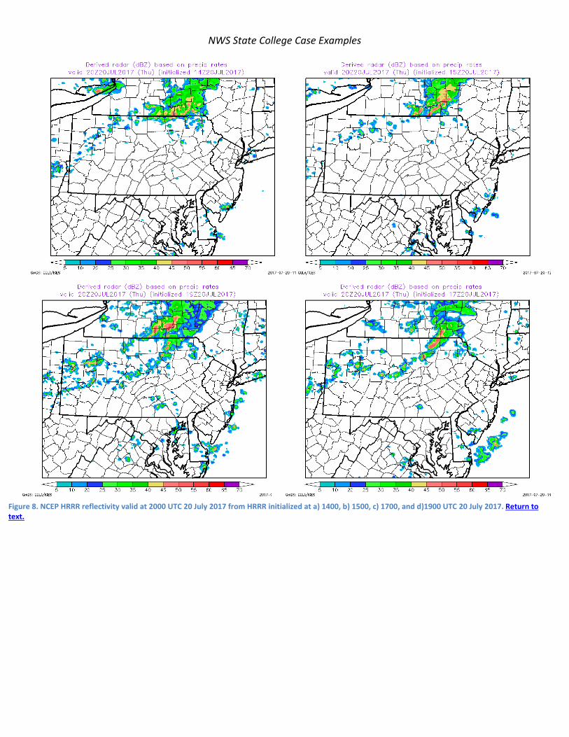
The NCEP 3km HRRR forecasts on 20 July indicated the potential for persistent and strong storms and strong cores to move from western New York to northern New Jersey and southeastern New York (Fig. 6 & 7). The long-lived nature of the event and the embedded strong cores were well predicted by the 1200 and 1600 UTC cycles and basically all cycles in between. This particular event was well predicted by the HRRR and the radar from 4 cycles valid at 2000 UTC show (Fig. 8) the consistent pattern. The QPF though not shown indicated a successful forecast.
The long-lived storm clearly played a critical role in both the observed severe weather and the rainfall from Ontario to New Jersey.

NWS State College Case Examples
2. Radar data
The radar data from KB UF (Fig. 9) shows the initial storm cluster over Ontario, Canada. This storm was strong supercell near Hamburg, NY (Fig. 10). Nearly all the damage in western New York tracked along the path of this single superstorm.
The supercell entered Pennsylvania from Stueben county New York as shown in Figure 11. Most of the damage in Pennsylvania followed the path of this strong supercell, which cycled several times during its life. Note a weak supercell to the northwest which moved from near Westfield toward Mansfield. This storm was weaker and less persistent and produced one report of wind damage in Mansfield.
The primary supercell continued to the southeast. Another cell developed in New York and moved into Pennsylvania. This storm too produced significant wind damage along its path. It developed into a complex vortex with strong wind south of the mesocyclone (Fig. 12). This produced a measured 70 mph wind in Scranton shortly before 2131 UTC (Fig. 13). The high wind was the bowing segment ahead of the rear inflow notch (weak echo region and yellow arrow). The remnants of the older supercell were still visible in this image near Wilkes Barre, PA.
3. Summary
Strong flow of deep moist air over a strong subtropical ridge produced a long-lived supercell and severe weather from the shore of Lake Erie to the Atlantic coast of New Jersey. The initial supercell produced a significant part of the wind reports. The storm cycled several times and another supercell on its northern flank developed into a meso vortex circulation with a bowing segment and a RIN indicated a strong rear inflow jet.
This long-lived convective system produced a stripe of 12 to 32mm or rainfall from Lake Erie to New Jersey. Clearly, this long-lived storm clearly played a critical role in both the observed severe weather and the rainfall from Ontario to New Jersey. The NCEP HRRR did relatively well forecasting the convection, the heavy rainfall, and the nature of the convection. This was clearly a HRRR success story and shows that some strong convective events have promise for the warn-on-forecast concept of operations.

NWS State College Case Examples
Figure 1. MRMS low-level rotation tracks for 1440 minutes in duration ending at 0102 UTC 21 July 2017. The main storm of interest maintained trackable rotation for over 300 miles. Return to text.

NWS State College Case Examples
Figure 2. Storm prediction center (SPC) storm reports by storm type. This image does not reflect storm surveys to be conducted in New York and Pennsylvania on 21 July. Return to text.

NWS State College Case Examples
Figure 3.MMRS radar showing the storm over Ontario around 1554 UTC and over New Jersey at 0000 UTC. Return to text.

NWS State College Case Examples
Figure 4. Climate forecast system re-analysis of the pattern at 1800 UTC 20 July 2017 and SPC storm reports. Data included a) 500 hPa heights and anomalies, b) 850 hPa winds and v-wind anomalies, c) precipitable water and anomalies, and d) mean sea-level pressure and anomalies with storm reports overlaid. Return to text.

NWS State College Case Examples
Figure 5. Stage-IV data showing estimated QPE (mm) from 1200 UTC 20 July through 0600 UTC 21 July 2017. Return to text.

NWS State College Case Examples
Figure 6. NCEP 3km HRRR initialized at 1200 UTC 21 July 2017 showing top) the total accumulated QPE (mm) and the radar at 2000 UTC 20 July 2017. Return to text.

NWS State College Case Examples
Figure 7. As in Figure 6 except for the 1600 UTC run of the HRRR. Return to text.
NWS State College Case Examples
Figure 8. NCEP HRRR reflectivity valid at 2000 UTC 20 July 2017 from HRRR initialized at a) 1400, b) 1500, c) 1700, and d)1900 UTC 20 July 2017. Return to text.

NWS State College Case Examples
Figure 9. KBUF radar at 1604 UTC showing reflectivity, base velocity, storm relative velocity, and correlation coefficient. Return to text.

NWS State College Case Examples
Figure 10. As in Figure 9 except near Hamburg, NY at 1631 UTC. Return to text.

NWS State College Case Examples
Figure 11. As in Figure 10 except KCCX radar at 1932 UTC showing reflectivity and velocity. Storm reports from LSRs are plotted. The orginal supercell is northwest of Mansfield and a weaker storm was near Westfield. Return to text.

NWS State College Case Examples
Figure 12. As in Figure 10 except for KBGM at 2110 UTC showing the storms near Scranton, PA. A northern cell evolved into a more complex circulation with a mesoscale vortex. The yellow arrow shows the rear inflow notch (RIN) with low reflectivity associated with this circulation as moved through northeastern Pennsylvania. Return to text.

NWS State College Case Examples
Figure 13. As in Figure 12 except for 2130 UTC. Return to text.

NWS State College Case Examples