Nubaria-Metnama ESIA FINAL 14062011 - The World Bank
150
The Egyptian Natural Gas Company Prepared by: Nubaria-Metnama Natural Gas Pipeline, Egypt ENVIRONMENTAL AND SOCIAL IMPACT ASSESSMENT June 2011 Final Report Public Disclosure Authorized Public Disclosure Authorized Public Disclosure Authorized Public Disclosure Authorized Public Disclosure Authorized Public Disclosure Authorized Public Disclosure Authorized Public Disclosure Authorized
Transcript of Nubaria-Metnama ESIA FINAL 14062011 - The World Bank
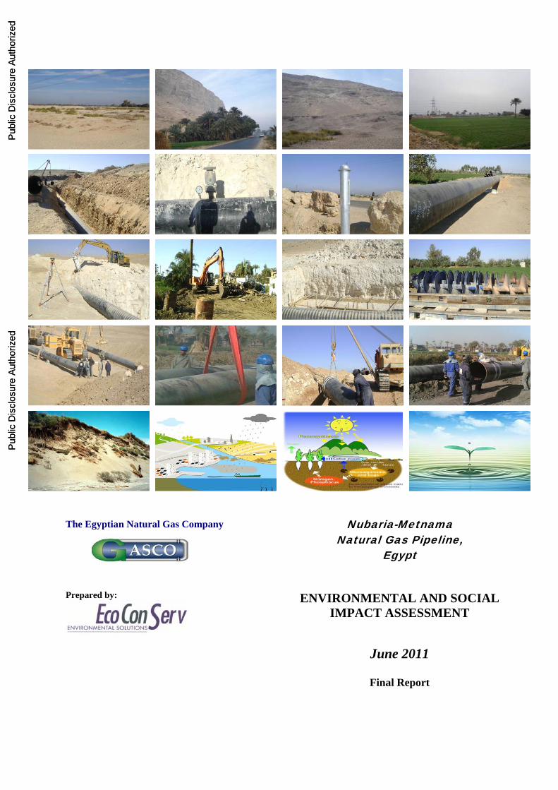
The Egyptian Natural Gas Company Prepared by:
Nubaria-Metnama Natural Gas Pipeline,
Egypt
ENVIRONMENTAL AND SOCIAL IMPACT ASSESSMENT
June 2011
Final Report
Pub
lic D
iscl
osur
e A
utho
rized
Pub
lic D
iscl
osur
e A
utho
rized
Pub
lic D
iscl
osur
e A
utho
rized
Pub
lic D
iscl
osur
e A
utho
rized
Pub
lic D
iscl
osur
e A
utho
rized
Pub
lic D
iscl
osur
e A
utho
rized
Pub
lic D
iscl
osur
e A
utho
rized
Pub
lic D
iscl
osur
e A
utho
rized
wb20439
Typewritten Text
E2818 v5

Nubaria-Metnama Pipeline ESIA
1
Executive Summary Introduction The proposed project is an integral part of Egypt’s strategy which aims to expand the uses of natural gas as a clean source of energy. This project aims to provide natural gas to the North Giza power station and to strengthen the national network of gas. The Egyptian Company for Natural Gas (GASCO) is taking the responsibility of the implementation of this project, with funding and assistance from the World Bank. EcoConServ has been asked to prepare an Environmental and Social Impact Assessment including a Resettlement Policy Framework, in compliance with the requirements and regulations of the Egyptian Government and the World Bank. Approach to Study
Assessment of the potential environmental and social impacts of the project. Comparison of impacts with regard to the requirements and national and international
guidelines. Assessment of the environmental and safety guidelines which is practiced on an ideal
basis through gas delivery activities in Egypt. Inclusion of stakeholder concerns at multiple stages through early scoping session and
final public consultation Monitoring of the Egyptian laws and the World Bank standards, which might affect the
project during implementation. Preparation of the environmental management plan and the environmental monitoring
plan to mitigate the potential negative impacts and monitor the compliance process of the relevant environmental laws.
Provision of an integrated plan for monitoring, evaluating and determining compensation strategies for groups likely to be affected as a result of the implementation of the project.
Evaluation of the institutional capacity of GASCO to implement the project and proposed mitigation measures, and suggestion of institutional capacity raising means if necessary.
Project Description Pipeline Route (El Nubariya – Metnama 32" pipe line and length of 105 km) The pipeline route starts from the end of Abu Homos-Nubaria 42" pipeline route chamber (next to Nubaria power station), and extends to the south along El Rayah El Nasry , until cutting east to reach the intake of North Giza power station. The pipeline then crosses much agricultural land in the heart of the delta region, before linking with the existing El Teena-Metnama 32" pipeline at Nawa (Ezbet Swelem).

Nubaria-Metnama Pipeline ESIA
2
The planned path of the pipeline runs through agricultural lands and near to inhabited areas, crosses several major transportation routes and waterways (including the Nile). Major roads and waterways are crossed using a special tunneling method to avoid major disruptions and impacts. The project includes construction of a Pressure Reduction Station inside the North Giza power station, as well as 11 valve rooms along the route of the pipeline, which aid in isolating leaks and performing maintenance. Construction Phase The project will be carried out under the supervision and control of GASCO. It is anticipated that the construction phase will continue for 15 months, and include the following activities:
Leveling and preparing of the temporary roads leading to the work sites Storing of pipes Trenching Welding and checking the seams Tweaking the welding joints Visual checking of the welding joints Inspection Air tests Laying pipes in the trenches Valves installation Connection works with valves Backfill works Cleaning works Preparation for tests Hydrostatic test Additional air test Water discharging Magnetic cleaning Drying and delivery
Operation Phase Normal operation will include routine audits on pressures and condition of the pipeline. Normal maintenance and monitoring works will also be performed, including a leakage survey and patrolling for encroachment. In case of leak detection, or damage of part of the pipeline, the damaged pipe is replaced. Standard procedures are in place for such incidents. Routing Alternatives Choosing the pipeline route involves selecting paths that, when possible, follow a logical course along existing transportation ways, cross these transportation ways at opportune locations, and avoid populated areas and other sensitive receptors. These efforts must be balanced with efficient use of resources and the desire to minimize the overall length of the pipeline.

Nubaria-Metnama Pipeline ESIA
3
The first section of the pipeline, before it reaches the North Giza Power Station, runs along the El Rayh El Nasry drain. Though this route still intersects some agricultural lands, unutilized desert land is too distant for a viable alternative to be considered in which this does not occur. After the pipeline reaches the North Giza station, it must cut across part of the delta to join the existing Metnama pipeline. One serious alternative was considered for this portion of the pipeline. Under this scenario, the line would have continued south along Al Rayah Al Nasry until the area of Birqash, crossed the Mansouriya Canal and the Maryoutiya Canal, passed near the population centers of Burtus and Oseem, and terminated at the Sharqawiya Complex in an area called Meet Halfa in Qalyub. The total distance of this proposed route is 97 km. Although this shorter distance would have required less crop damage and temporary land acquisition, and thus less compensation, there were several prohibitive factors which made this option unacceptable. The presence of significant numbers of buildings near Burtus and Oseem, in addition to a high density of high voltage electricity towers near the area of Al Waraq, would greatly complicate matters. Furthermore, the large number of buildings on both sides of the Cairo-Alexandria Agricultural Road (in the area just before the termination of this route), are essentially unavoidable. These factors increase the likelihood that some structures would have been affected and resettlements necessary. The proximity of population centers and electricity lines which could induce a current in the line would negatively affecting the safe operation of the pipeline, due to an increased risk of interference, and greater potential damage in the case of an accident. The path selected by GASCO and proposed in this report is sufficiently short and well chosen for its navigation of the critical crossing points and populated areas. GASCO has an unwritten strategy that thoroughly avoids any construction buildings including: houses, graveyards, religious buildings and historical areas. Positive Environmental and Social Impacts Achievement of the previously mentioned project objectives represents many of the social and economic benefits, and will support the achievement of Egypt's strategy for the energy sector. The most significant positive impacts to be achieved are:
Providing work opportunities for local untrained labor or limited trained labor in construction works, as well as opportunities for engineers, welding and coating workers, marine employment (assistance), and supervisors.
To achieve increased commercial activities (such as restaurants and cafes) at construction sites, which exist in the rural areas of Qalubia, El Beheira and Menoufiya.
To stimulate the sale and rental of building materials and construction equipment at the targeted areas, where such projects provide a good marketing opportunity, particularly as a result of distance from the production plants that are buying from them in bulk.
Increased opportunities for workers in the various means of transportation in the different locations, and in particular light transportation means, such as motorcycle and Tuk Tuk

Nubaria-Metnama Pipeline ESIA
4
which spread in the governorates of Qalubia, El Beheira and Menoufiya, and also ferry owners in these areas.
Contribute to improving the opportunities for targeted communities to benefit from the natural gas service.
Utilization of housing units for the project management at site, as well as to accommodate the workers.
Achievement of sustainability and continuity of the energy source, which is environmentally safer and comes with less economic cost. The life span of the facilities used to generate electricity at power stations that will be supplied by gas will be extended. This will lead to improved continuity of electricity in the targeted governorates of Egypt.
The ability to make subsidiary gas connections for the various governorates, which could result in delivery of natural gas to houses around the clock.
Economic benefits as a result of using sustainable local source of energy at the power stations, which will work on the stability of the fuel cost price, unlike other unstable sources such as fuel oil and diesel fuel. This will also reduce the subsidiary cost of petroleum materials which overburden Egypt.
Environmental Impact Rating Summary
Phase Impact Category Impact Rating
Low Medium High
Construction
Hazardous waste generation X Risk to infrastructure X Construction/excavation waste generation X Water use/wastewater generation X Air emissions X Noise production X Soil quality degradation X Biodiversity and habitat destruction X Stability of existing structures X Traffic disruption X
Operation Accidents and emergencies X Repairs and maintenance X
Main Construction Impacts Hazardous Waste Generation The primary sources of hazardous waste are:
Demolished asphalt Containers of chemicals and lubricant oils used for construction machinery
Asphalt waste will come from the 9 open-cut road crossings described in Section 4.1.3, while the chemicals and lubricants will result from the use of machinery described in Section 4.4. It is

Nubaria-Metnama Pipeline ESIA
5
estimated that on average, 12 kg of such waste will be produced daily. Articles 26 through 28 of the Executive Regulations of Law 4 lay down certain steps that must be followed for the granting of handling licenses for these materials. Improper disposal of these items can potentially directly affect the health of anyone who comes in contact with them. Potential soil contamination may result from improper hazardous waste storage, handling, and disposal practices, as well as potential spillage and/or leaks during the course of the construction activities. There is a slight risk of a spilled or leaked substance spreading beyond the project site as a result of nearby ground or surface water contamination, thus becoming a more significant environmental risk, but in general the potential of this impact is local in nature. Damage to Existing Infrastructure Most of the underground infrastructure pipelines (such as water, sewerage and telecommunication) have been established a long time ago, without accurate documentation for its routes and depths. Therefore, the risk of breaking infrastructure lines is relatively high. Normally the contractor takes caution by applying manual excavation to avoid such situations where he is obliged to pay for the damage. The most important environmental impact will arise in case a sewerage pipe is broken, and wastewaters accumulate in the trench and, possibly, over flood to the streets causing significant nuisance to the surrounding environment. Breaking a water supply pipe may result in cutting the supply to a number of residential units, which may, if it takes place for a long period, direct residents to use other sources of water which may be either expensive or unsafe. The effects of cutting telecommunication cables during excavation are mainly socioeconomic, due to cutting possible personal and business communications. Main Operational Impacts Accidents and Emergencies (Quantitative Risk Assessment) In order to assess the potential impact of pipeline operation in terms of human health and safety, a Quantitative Risk Assessment (QRA) was performed to determine the threat of injury or fatality to the public in the case of an accident or emergency. The nature of the project is such that an unforeseen failure in the pipeline operation could result in the release of significant amounts of natural gas into the surrounding environment. The possibility of this gas being ignited poses an environmental risk and threatens the safety of individuals and the public. This risk is fully assessed in the accompanying QRA report. Social Impacts Social Impacts during Construction

Nubaria-Metnama Pipeline ESIA
6
Temporary negative impact on the local livelihoods of farmers due to the temporary
acquisition of land and the subsequent impact of damaging crops. Farming, in most of the cases, is the sole source of income for the affected farmers. The project construction phase will necessitate temporary expropriation of about 400-500 feddans of agriculture land during the construction. It was very difficult to estimate the numbers of potentially affected people during this phase of the project. This will only be possible before the actual construction of the project and upon determining the exact route. During this stage a Resettlement Action Plan (RAP) should be prepared guided by the prepared RPF. The RAP will involve a full inventory survey for the PAPs and a valuation for the compensation that should be paid.
Permanent acquisition of land for the establishment of the valve rooms. In such cases, the common rule of GASCO is to provide full replacement cost for purchasing the land as per the market price under satisfactory, agreeable and appropriate agreement. It might be roughly suggested that each of the land plots (25m x 45 m) for each of the valve rooms is owned by one farmer. Based on this assumption, 11 farmers are expected to sell their land to Gasco for establishing the valve rooms.
Potential traffic congestion due to the accumulation of construction materials and dust that will result from digging. From a social prospective, this impact might affect the income of microbuses, small vehicles and taxi drivers.
Potential temporary inconvenience as result of the construction activities. This could be in the form of accumulation of wastes (both construction and domestic waste in the construction areas, associated odor, air emissions, especially dust as a result of excavation. These impacts are of temporary nature and will be of very limited level of severity, particularly since the construction activities will be in farms and not populated areas
Risks of damaging existing community infrastructure, especially water pipes that are not mapped, can have detrimental social repercussions. Disruption of other utility services such as electricity and communications can also be a nuisance to those affected.
Social Impacts during Operation The possibility of a gas leakage or the occurrence of fires, which could affect the residents in the area, is a concern. The other element is the possibility of extending the residential mass to the pipe line routes, which could lead to encroachment on the line. Additional crop damage as a result of maintenance or surveillance activities is also a possibility.
Nubaria-Metnama Pipeline ESIA
7
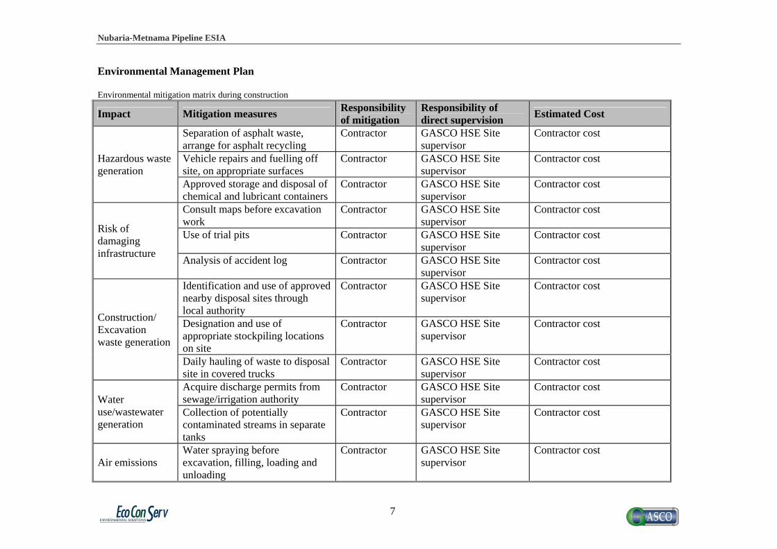
Environmental Management Plan Environmental mitigation matrix during construction
Impact Mitigation measures Responsibility of mitigation
Responsibility of direct supervision
Estimated Cost
Hazardous waste generation
Separation of asphalt waste, arrange for asphalt recycling
Contractor GASCO HSE Site supervisor
Contractor cost
Vehicle repairs and fuelling off site, on appropriate surfaces
Contractor GASCO HSE Site supervisor
Contractor cost
Approved storage and disposal of chemical and lubricant containers
Contractor GASCO HSE Site supervisor
Contractor cost
Risk of damaging infrastructure
Consult maps before excavation work
Contractor GASCO HSE Site supervisor
Contractor cost
Use of trial pits Contractor GASCO HSE Site supervisor
Contractor cost
Analysis of accident log Contractor GASCO HSE Site supervisor
Contractor cost
Construction/ Excavation waste generation
Identification and use of approved nearby disposal sites through local authority
Contractor GASCO HSE Site supervisor
Contractor cost
Designation and use of appropriate stockpiling locations on site
Contractor GASCO HSE Site supervisor
Contractor cost
Daily hauling of waste to disposal site in covered trucks
Contractor GASCO HSE Site supervisor
Contractor cost
Water use/wastewater generation
Acquire discharge permits from sewage/irrigation authority
Contractor GASCO HSE Site supervisor
Contractor cost
Collection of potentially contaminated streams in separate tanks
Contractor GASCO HSE Site supervisor
Contractor cost
Air emissions Water spraying before excavation, filling, loading and unloading
Contractor GASCO HSE Site supervisor
Contractor cost

Nubaria-Metnama Pipeline ESIA
8
Spraying of stockpiles, storage in covered areas
Contractor GASCO HSE Site supervisor
Contractor cost
Implementation of regular maintenance schedule for machinery
Contractor GASCO HSE Site supervisor
Contractor cost
Noise Production
Limit exposure time of workers to elevated noise levels
Contractor GASCO HSE Site supervisor
Contractor cost
Use of earmuffs Contractor GASCO HSE Site supervisor
Contractor cost
Effect on structures by dewatering/tunneling activities
Survey of buildings with damage potential
Contractor GASCO HSE Site supervisor
Contractor cost
Soil investigations Contractor GASCO HSE Site supervisor
Contractor cost
Traffic congestion
Signage and markings to instruct drivers
Contractor GASCO HSE Site supervisor
Contractor cost
Use of alternative routes when roads are obstructed
Contractor GASCO HSE Site supervisor
Contractor cost
Employment of trained drivers Contractor GASCO HSE Site supervisor
Contractor cost
Loss of farmer livelihood due to temporary land acquisition and crop damage
Applying the requirements presented on the prepared RPF Preparation of RAP Providing fair compensation to the land owners for the loss of crops.
GASCO Compensation Committee External Consultant
GASCO Social Development Officer
Estimated amount for crop compensation: USD 339,000
Loss of farmer livelihood due to permanent land acquisition for valve rooms
Providing fair compensation to the land owners for purchasing the land for the valve rooms
GASCO Compensation Committee
GASCO Social Development Officer
GASCO has already purchased the land

Nubaria-Metnama Pipeline ESIA
9
Environmental monitoring matrix during construction
Impact Monitoring indicators
Responsibility Frequency/ Duration
Location Methods Estimated Cost
Construction/ excavation and hazardous waste generation
Use of designated stockpile locations
Contractor Weekly Construction site
Site observation
Contractor cost
Separation of hazardous waste components
Contractor Weekly Construction site
Site observation
Contractor cost
Quantity and type of waste generated
Contractor Daily Construction site
Recording of daily hauling statistics
Contractor cost
Risk of damaging infrastructure
Frequency and location of damage incidents
Contractor Monthly Documentation offices
Documentation in HSE monthly reports
Contractor cost
Water use/ wastewater generation
Quantity of wastewater/sewage discharge from administrative camp
Contractor Daily Construction site
Recording of daily discharge amounts
Contractor cost
Quantity of water diverted for testing
Contractor Continuous during testing
Construction site
Flow rate measurements
Contractor cost
Oily appearance or smell of wastewater stream
Contractor Continuous during testing
Construction site
Site observation
Contractor cost
Contaminant concentrations in wastewater streams
Contractor Upon detection of oily appearance or smell
Approved water treatment lab
Chemical analysis
USD 840
Air emissions Inspection of vehicle and machinery
Contractor Quarterly Documentation offices
Review of schedule
Contractor cost

Nubaria-Metnama Pipeline ESIA
10
Impact Monitoring indicators
Responsibility Frequency/ Duration
Location Methods Estimated Cost
maintenance schedule HC, CO% and opacity
Contractor Once before construction, once quarterly for each vehicle
Vehicle maintenance site
Emissions testing
Contractor cost
Noise Production
Noise intensity, exposure durations and noise impacts
Contractor Quarterly, at least one measurement per contractor per sector
Construction site
Noise recording, reporting in monthly reports
Contractor cost
Complaints from residents
Contractor Quarterly Construction site
Inspection of filed complaints
Contractor cost
Use of earmuffs by construction workers
Contractor Weekly Construction site
Site observation
Contractor cost
Effect on structures by dewatering/ tunneling activities
Amount of soil present in wastewater stream
Contractor As necessary during dewatering/ tunneling
Construction site
Inspection of water from dewatering or tunneling
Contractor cost
Loss of farmer livelihood due to temporary land acquisition and crop damage
Complaints and grievances from PAPs about fair compensation and procedures
GASCO Social Development Officer Compensation Committee
Weekly Project Site Documentation offices
Review list of PAPs, receipts, grievances, and follow up forms
No additional cost required

Nubaria-Metnama Pipeline ESIA
11
Impact Monitoring indicators
Responsibility Frequency/ Duration
Location Methods Estimated Cost
Loss of farmer livelihood due to permanent land acquisition for valve rooms
Complaints and grievances from PAPs about fair compensation and procedures
GASCO Social Development Officer Compensation Committee
Weekly during the phase of project preparation until the purchase of land is done
Project Site Documentation offices
Review list of PAPs, receipts, grievances, and follow up forms
GASCO regular management cost

Nubaria-Metnama Pipeline ESIA
12
Environmental mitigation matrix during operation
Impact Mitigation measures Responsibility of mitigation
Responsibility of direct supervision
Estimated Cost
Accidents and Emergencies
Design to recognized standards, effective inspection, testing, and maintenance plans
GASCO HSE Department
GASCO Headquarters GASCO regular management cost
Rapid isolation of leaks to minimize potential hazards
GASCO HSE Department
GASCO Headquarters GASCO regular management cost
Pipeline patrolling for encroachment and damage risks
GASCO HSE Department
GASCO Headquarters GASCO regular management cost
Pipeline leakage surveys GASCO HSE Department
GASCO Headquarters GASCO regular management cost
Permanent expropriation of land entering urban zoning
Providing compensation to the land owners
GASCO Compensation Committee
Review list of PAPs, receipts, grievances, and follow up forms
Difficult to determine at this stage
Temporary loss of crops during maintenance
Compensation for the loss of crops
GASCO Compensation Committee
Review list of PAPs, receipts, grievances, and follow up forms
Estimated compensations USD 850 annually

Nubaria-Metnama Pipeline ESIA
13
Environmental monitoring matrix during operation
Impact Monitoring indicators
Responsibility Frequency/ Duration
Location Methods Estimated Cost
Accidents and Emergencies
Performance of regular maintenance
GASCO HSE Department
Quarterly Documentation offices
Inspection of maintenance schedule
GASCO regular management cost
Buildings on RoW, land alterations
GASCO Inspection Department
Twice monthly for populated areas
Pipeline route Site observation, inspection of permits
GASCO regular management cost
Leakage noise, pipeline pressure, etc.
GASCO Inspection Department
Twice monthly for populated areas
Pipeline route Leakage detection tools
GASCO regular management cost
Permanent expropriation of land entering urban zoning
PAP registration Compensation forms
GASCO Headquarter and Regional branches
Quarterly Project Site Documentation offices
Site observation and coordination with the LGUs
GASCO regular management cost
Temporary loss of crops during maintenance
PAP registration Compensation forms
GASCO Headquarter and Regional branches, Compensation Committee
Quarterly Project Site Documentation offices
Affected land plots Compensation offered Documentation that prove receiving compensation
GASCO regular management cost

Nubaria-Metnama Pipeline ESIA
14
Social Management Plan Implementation of the social management plan for the project activities is carried out through a committee of GASCO including a lawyer, an accountant, and the committee director. Members of the agricultural associations and the Local Governorate Units in the various governorates will need to cooperate with the committee. In the case of a dispute regarding the provided compensation amount and the failure of the proposed proactive and reactive grievance mechanisms proposed on the RPF in handling these disputes, it should be submitted to the Supreme Commission for Compensation, which is chaired by a consultant from the state council, and the commission is competent to hear appeals for compensation. Also there should be a field Social Development Officer who is responsible for compensation record keeping and monitoring of complaints, among other social responsibilities. Detailed guidelines for dealing with expropriated land, displacement of people, and compensation matters are provided in the Resettlement Policy Framework. Public Consultation Due to the project needs for a temporary expropriation of the agricultural land, the need for supportive community participation for the various activities of the project must be greatly considered. The ESIA and RPF team carried out several consultation activities and community interviews along the planned route. The field surveys involved comprehensive investigations to evaluate the environmental and social assessment of the proposed project. Interviews were carried out with different groups, in order to include their inputs about the proper scope of the study, and what they consider the most important environmental and social impacts. After drafting the results of the ESIA, public consultation was organized to review the draft results with various stakeholders. This activity comes in line with the World Bank disclosure policy and the requirements of the EEAA as part of the EIA guidelines. Questions and comments session was arranged and the comments and suggestions of the stakeholders were incorporated into the findings of the ESIA report. Resettlement and the compensation for various types of land acquisition were key issue that the participants raised during the consultation. Key recommendation to ensure full community participation included:
Provide the names of individuals who need to be compensated for land and crops and disclose transparently.
To discuss prices with agricultural associations to determine the acceptable actual value of the different crops, without prejudice to the right of the affected groups.
To inform the local community about the project and provide the necessary information through NGOs and seminars, and placing guidelines and definitions signs.
Monitoring of complaints related to the project, performance, infringement on the property and report to the project follow-up unit. This should be achieved through adapting both the proactive and the reactive approaches as explained in details in the RPF.

Nubaria-Metnama Pipeline ESIA
15
The ESIA recommended strongly the need for the involvement of various stakeholders and community groups, including
Local Governorate; executive authorities NGOs Agricultural Associations. Mayors and natural leaders Project affected groups
Conclusion The study concluded, after analyzing the various project activities through the phases of construction and operation, and the consequent various environmental impacts, that the basic designs were based on the latest technologies and cleaner production technologies. The study also concluded that the project has many positive impacts on the socio-economic level, in terms of providing several employment opportunities, especially during construction phase, which support the national economy. As for the negative environmental impacts during construction phase, they are considered to be limited and short-term, and can be reduced to the minimum that could be made these impacts negligible, by applying the proposed environmental monitoring and management plan during the construction phase. With regard to the negative environmental impacts during operational phase, the study concluded that they are insignificant and very limited. Similarly, the social impacts of the project are mostly of temporary nature. The negative social impacts could be tackled through adopting a transparent and fair strategy to address resettlement and compensation for the project affected persons. From the foregoing, the study concluded that the project is acceptable in terms of environmental and social aspects, with the following of the proposed social and environmental monitoring and management plan.

Nubaria-Metnama Pipeline ESIA
16
Table of Contents Executive Summary ..................................................................................................................................... 1 List of Acronyms and Abbreviations ......................................................................................................... 19 1. Introduction ....................................................................................................................................... 20
1.1 Background ................................................................................................................................ 20 1.2 Project Overview ....................................................................................................................... 20 1.3 Approach and Methodology ...................................................................................................... 21
1.3.1 Approach to ESIA .............................................................................................................. 21 1.3.2 Data Collection Methodology ............................................................................................ 22 1.3.3 Stakeholders Consultation .................................................................................................. 23
2. Legal and Administrative Framework ............................................................................................... 25 2.1 Applicable National Egyptian Legislation ................................................................................. 25
2.1.1 Law 4/1994 for the Environment ....................................................................................... 25 2.1.2 Law 38/1967 for General Cleanliness ................................................................................ 27 2.1.3 Law 48/1982 for Protection of River Nile and Watercourses ............................................ 27 2.1.4 Law 117/1983 for Protection of Antiquities ...................................................................... 29 2.1.5 Law 4/1988 concerning Petroleum Pipelines ..................................................................... 30 2.1.6 Egyptian Legislation Related to Land Acquisition ............................................................ 30
2.2 World Bank Guidelines and Safeguard Policies ........................................................................ 30 2.2.1 OP 4.01 – Environmental Assessment ............................................................................... 30 2.2.2 OP 4.12 – Involuntary Resettlement .................................................................................. 30 2.2.3 OP 17.50 – Disclosure ....................................................................................................... 31 2.2.4 IFC Environmental Health and Safety Guidelines ............................................................. 31 2.2.5 Pollution Prevention and Abatement Handbook ................................................................ 31
3. Description of the Environment ........................................................................................................ 33 3.1 Administrative Districts ............................................................................................................. 33
3.1.1 Qalubia Governorate .......................................................................................................... 33 3.1.2 Menoufia Governorate ....................................................................................................... 34 3.1.3 El Beheira Governorate ...................................................................................................... 35 3.1.4 6th of October Governorate ................................................................................................ 36
3.2 Location and Land Use .............................................................................................................. 36 3.3 Climate....................................................................................................................................... 37 3.4 Soil ............................................................................................................................................. 39 3.5 Geology ..................................................................................................................................... 40
3.5.1 General outlines ................................................................................................................. 40 3.5.2 Geomorphology ................................................................................................................. 42 3.5.3 Tectonic Frameworks ......................................................................................................... 43
3.6 Groundwater .............................................................................................................................. 46 3.6.1 Groundwater Hydrology .................................................................................................... 46 3.6.2 Groundwater Flow ............................................................................................................. 48 3.6.3 Hydraulic Parameters: ........................................................................................................ 49 3.6.4 Recharge and Discharge: ................................................................................................... 49 3.6.5 Hydrochemistry .................................................................................................................. 50 3.6.6 Groundwater Fluctuation and Rising Problems ................................................................. 50
3.7 Surface Water ............................................................................................................................ 50 3.8 Biodiversity and Habitats .......................................................................................................... 51
3.8.1 Flora ................................................................................................................................... 52 3.8.2 Fauna .................................................................................................................................. 55
4. Project Description ............................................................................................................................ 59

Nubaria-Metnama Pipeline ESIA
17
4.1 Pipeline Components ................................................................................................................. 59 4.1.1 Pipeline Route .................................................................................................................... 59 4.1.2 Pipeline Design Criteria ..................................................................................................... 59 4.1.3 Valve Room Locations ....................................................................................................... 63 4.1.4 Crossings ............................................................................................................................ 63 4.1.5 Nearby Settlements ............................................................................................................ 64 4.1.6 Sectional Maps ................................................................................................................... 64 4.1.7 Pressure Reduction Station ................................................................................................ 70
4.2 Design Gas Composition and Flow Rate ................................................................................... 71 4.3 Work Schedule .......................................................................................................................... 72 4.4 Construction Activities and Methodologies .............................................................................. 73
4.4.1 Planning and system design ............................................................................................... 73 4.4.2 Mobilization of equipment, materials, and workers ........................................................... 73 4.4.3 Site preparation and excavation ......................................................................................... 74 4.4.4 Pipe Storage ....................................................................................................................... 74 4.4.5 Foundations Structural Work or Civil Work ...................................................................... 75 4.4.6 Trenching Lowering and Laying ........................................................................................ 75 4.4.7 Backfilling .......................................................................................................................... 76 4.4.8 Welding and Weld Inspection ............................................................................................ 76 4.4.9 Valves and Tie-ins ............................................................................................................. 77 4.4.10 Pipe Cleaning ..................................................................................................................... 77 4.4.11 Horizontal Directional Drilling .......................................................................................... 77 4.4.12 Pipeline Testing.................................................................................................................. 79 4.4.13 Water Removal .................................................................................................................. 81 4.4.14 Magnetic Cleaning and Geometric Pigging ....................................................................... 81 4.4.15 Drying and Commissioning ............................................................................................... 81 4.4.16 Records and Operating Manuals ........................................................................................ 82
4.5 Description of Operation Phase ................................................................................................. 82 4.5.1 Normal operation ............................................................................................................... 82 4.5.2 Repairs and replacement .................................................................................................... 82
5. Analysis of Alternatives .................................................................................................................... 83 5.1 The “No Action” Alternative ..................................................................................................... 83 5.2 Construction Alternatives .......................................................................................................... 83
5.2.1 Horizontal Directional Drilling (HDD) .............................................................................. 83 5.2.2 Open-Cut Method .............................................................................................................. 84
5.3 Routing Alternatives .................................................................................................................. 84 6. Assessment of Main Environmental and Social Impacts .................................................................. 86
6.1 Positive Impacts ......................................................................................................................... 86 6.2 Negative Environmental Impacts during Construction ............................................................. 88
6.2.1 Hazardous Waste Generation ............................................................................................. 88 6.2.2 Damage to Existing Infrastructure ..................................................................................... 89 6.2.3 Construction/Excavation Waste Generation ...................................................................... 89 6.2.4 Water Use/Wastewater Generation .................................................................................... 90 6.2.5 Air Emissions ..................................................................................................................... 90 6.2.6 Noise Production ................................................................................................................ 91 6.2.7 Soil Quality Degradation ................................................................................................... 92 6.2.8 Biodiversity and Habitat Destruction ................................................................................. 92 6.2.9 Stability of Existing Structures .......................................................................................... 93 6.2.10 Traffic Congestion ............................................................................................................. 93
6.3 Negative Environmental Impacts during Operation .................................................................. 95 6.3.1 Accidents and Emergencies (Quantitative Risk Assessment) ............................................ 95
Nubaria-Metnama Pipeline ESIA
18
6.3.2 Repairs and Maintenance ................................................................................................... 95 6.4 Environmental Impact Rating Summary ................................................................................... 95 6.5 Potential Social Impacts ............................................................................................................ 96
6.5.1 Negative Social Impacts during Construction .................................................................... 96 6.5.2 Negative Social Impacts during Operation ........................................................................ 97 6.5.3 Affected parties .................................................................................................................. 97 6.5.4 Key Issues for Consideration ............................................................................................. 98
7. Environmental and Social Management Plan ................................................................................. 100 7.1 Objectives of the ESMP .......................................................................................................... 100 7.2 Institutional Framework for Implementation ........................................................................... 100
7.2.1 Environmental Management Structure of Implementing Agency ................................... 101 7.2.2 Social Management Structure of Implementing Agency ................................................. 104
7.3 Management and Monitoring Activities during Construction Phase ....................................... 106 7.3.1 Management of Hazardous Waste Generation ................................................................. 106 7.3.2 Management of Excavation Activities Posing Risk on Infrastructure ............................. 106 7.3.3 Management of Construction/Excavation Waste Generation .......................................... 107 7.3.4 Management of Water Use/Wastewater Generation ........................................................ 107 7.3.5 Management of Air Emissions ......................................................................................... 108 7.3.6 Management of Noise Production .................................................................................... 109 7.3.7 Management of Soil Quality Degradation ....................................................................... 109 7.3.8 Management of Biodiversity and Habitat Destruction ..................................................... 109 7.3.9 Management of Dewatering and Tunneling Activities Posing Risk to Structural Stability ... .......................................................................................................................................... 110 7.3.10 Management of Traffic Congestion ................................................................................. 110 7.3.11 Management of Social Impacts ........................................................................................ 111
7.4 Mitigation and Monitoring Tables ........................................................................................... 111 7.5 Management and Monitoring Activities during Operation Phase ........................................... 117
7.5.1 Management of Accidents and Emergencies ................................................................... 117 7.5.2 Management of Repairs and Maintenance ....................................................................... 119 7.5.3 Management of Social Impacts ........................................................................................ 119
7.6 Management and Monitoring Tables for Operation ................................................................ 120 8. Public Consultation ......................................................................................................................... 123
8.1 Scoping Phase .......................................................................................................................... 123 8.2 Public Consultation .................................................................................................................. 123 8.3 Corporate Social Responsibility .............................................................................................. 125
Annex A: Baseline Social Data ............................................................................................................... 126 Annex B: Compensation and Grievance Forms ...................................................................................... 135 Annex C: Public Consultation Documentation ....................................................................................... 137

Nubaria-Metnama Pipeline ESIA
19
List of Acronyms and Abbreviations AST Aboveground Storage Tank
CAPMAS Central Agency for Public Mobilization and Statistics
CBO Community Based Organization
EDHS Egyptian Demographic and Health Survey
EEAA Egyptian Environmental Affairs Agency
EGAS Egyptian Natural Gas Holding Company
EHS Environmental Health and Safety
ESIA Environmental and Social Impact Assessment
ESMP Environmental and Social Management Plan
FGD Focus group discussion
GASCO Egyptian Natural Gas Company
IFC International Finance Corporation
LGUs Local Governorate Unit
LPG Liquefied Petroleum Gas
MOSEA Ministry of State for Environmental Affairs
NG Natural Gas
NGO Non Governmental Organization
PPM Parts Per Million
PPAH Pollution Prevention and Abatement Handbook (WB)
PRS Pressure Reduction Station
RAP Resettlement Action Plan
RPF Resettlement Policy Framework
UNDP Human Development Report
UST Underground Storage Tank
WB World Bank

Nubaria-Metnama Pipeline ESIA
20
1. Introduction 1.1 Background In a country where natural gas is abundant, affordable, and the cleanest of fossil fuels, it is increasingly becoming the fuel of choice. Gas is gaining tremendous momentum as a core item in Egypt’s energy strategy accounting for more than 50% of Egyptian hydrocarbon. Demand on gas is soaring like never before as many industries are shifting to gas for better performance, substantial savings, and environmental compliance. The Ministry of Petroleum manages the utilization of gas in all sectors as well as the implementation of major gas projects covering discovery, delivery, and triggering untapped potential, encouraging the use of natural gas serving different industries (power generation, fertilizer production, iron and steel, industrial cities), while satisfying the local market requirements of natural gas as a fuel, a feedstock for the petrochemical industry, and opening new markets for Egyptian natural gas. The process of maximizing natural gas utilization in Egypt is witnessing outstanding development, rapid progress, and foreign investment through increasing the value added to petroleum products to achieve self-sufficiency of LPG and gas derivatives used as feedstock for the petrochemicals. The global energy industry focuses increasingly on the exploration and development of natural gas. The development of the know-how and the utilization of interactive technology have completely reshaped oil and gas exploration in Egypt leading to the discovery of a host of new gas fields in the Mediterranean, especially the deep water gas discoveries, and the western desert. Focus is increasingly on new technologies for the conversion of gas into marketable products. In response to the energy market change, Egypt has been very keen to play a key role in gas processing in a bid to achieving self sufficiency of LPG and other gas valuable components and derivatives either as feed stocks for the petrochemical industry or as an export option stimulating a wave of national or international projects, adding new dimensions to the gas industry and giving rise to the establishment or the development of petrochemical projects in Egypt. It is a step forward towards achieving integration between all companies working in the gas business. 1.2 Project Overview The aim of the proposed project is to supply natural gas to the North Giza power station and support national gas grid. In Egypt, the domestic market for natural gas is currently under-supplied and demand is growing. Due to major recent discoveries, natural gas is likely to be the primary growth engine of Egypt’s energy sector for the foreseeable future. Egypt’s natural gas sector is now expanding rapidly. In the Nile Delta region, which has become a world-class natural gas basin, the total quantity of natural gas produced from fields and delivered to GASCO reached 43.3 bcm in 2005, achieving 14% development.

Nubaria-Metnama Pipeline ESIA
21
The Egyptian Natural Gas Company (GASCO) is carrying out multiple projects to support the expanding national gas grid. Among them is a proposed 32” diameter, 105 km long pipeline to transport natural gas from the Nubaria power station to a Pressure Reduction Station at the North Giza power station, and continuing to join the Metnama pipeline at an area called Nawa or Ezbet Swelem. Laying of the pipeline will involve digging trenches where possible, but upon encountering waterways, a new trenchless technology called Horizontal Directional Drilling (HDD) will be employed. The project also includes any necessary control stations, compressor stations, pumping stations, etc. that may be constructed along the way. The planned path of the pipeline runs through agricultural lands and inhabited areas, crosses several major transportation routes and waterways (including the Nile), and may potentially encounter and disrupt sites of general cultural or ecological importance in the region. EcoConServ has been awarded the consultancy service for the preparation of an Environmental and Social Impact Assessment (ESIA) including a Resettlement Policy Framework (RPF) for the project of Nubaria-Metnama Gas Pipline. The ESIA examines the potential impacts of the planned project activities on the existing environmental and social conditions of the project area and proposes measures for monitoring and mitigating any potential negative outcomes. The requirements of the Egyptian Environmental Affairs Agency (EEAA) for Environmental Impact Assessments of Oil and Gas Sector Projects, and the relevant World Bank (WB) Environmental and Social Safeguard Policies have been integrated in the preparation of this ESIA. The RPF is a separate document that was prepared, specifically, to set a framework for tackling any potential negative impact related to involuntary resettlement. 1.3 Approach and Methodology 1.3.1 Approach to ESIA The ESIA adapted an interactive and participatory approach and has been prepared according to the following steps:
Conduct several visits with the team of experts, to the site for carrying out site reconnaissance and baseline data collection at the local concerned authorities.
Assess the potential environmental and social impacts of the project in the study area by carrying out baseline surveys.
Assess risks and hazards associated with the project activities Compare the impacts in relation to relevant national and international requirements and
guidelines. Develop screening criteria for acceptability of project intervention from environmental
and social aspects. Develop an environmental and social management plan for the mitigation of the
potentially negative impacts and for monitoring compliance with the relevant environmental laws.
Produce a comprehensive ESIA and RPF. Hold two public consultation events to be publicly announced and well-attended by
relevant stakeholders of the project.

Nubaria-Metnama Pipeline ESIA
22
Assess the capacity of the implementing agencies to implement the developed environmental and social management framework.
Develop a capacity building program to cover any identified gaps in the capacity of the implementing agencies regarding environmental and social measures.
1.3.2 Data Collection Methodology 1.3.2.1 Physical and Biological Data A site visit was conducted in order to collect information and data about the pathway of the pipeline and to come up with the nature of the project route. In order to do so, the visit was established in a way to trace, to the maximum extent possible, the exact route proposed by GASCO, from the source point to the end point. Many stops occurred during the visit in order to examine fauna, flora, type of crops in agriculture lands and source of irrigation, soil type, existence of water bodies (surface and groundwater), drainage networks, main geologic features and outcrops, and geomorphologic and topographic features. Many pictures were taken for the main observation during the visit. The geologic and geomorphologic studies include geologic history (surface and sub-surface), lithostratigraphic succession and the main geologic structures such as faults and folds features, and earthquake history, if any. In addition to topographic and geomorphologic features of the landscape of the areas, in case of the existence of drainage patterns and high land zones, a quantitative geomorphologic study was performed in order to estimate the flood risk that might affect the sites. For the purpose of the flora and fauna studies, the pipeline pathway was investigated as one transect starting from the start point at Nubaria power station to the end point of Nawa. All different species and other plant and animal signs (e.g. dens) were recorded by direct observation during active searches. All habitats and recorded species were documented by photographs. 1.3.2.2 Social Data This study was carried out during February 2011. This survey relied upon two sources of data, namely secondary and primary data. The secondary data was collected from previous reports including but not limited to:
Egyptian Human Development Report (EHDR), 2010, The Egyptian Demographic and Health Survey(EDHS), 2008 Information and census data from the Egyptian Central Agency for Public Mobilization
and Statistics (CAPMAS), 2009 Egypt’s Description by Information 2007, Volume 1 & 2 and the 8th edition
The primary data was collected from carrying out several participatory and consultative activities with the following main groups:

Nubaria-Metnama Pipeline ESIA
23
Governmental Executive Officials NGOs Community members along the line side i.e. farmers, landlords, peasant, Bedouins and
vehicle drivers GASCO staff including site engineers, Environmental Protection Engineers, Health and
Safety officers, lawyers, In addition to the above mentioned sources, documentation with photos took place in order to have a clear overview of different area characteristics that might play a major role during the construction and operation of the line. Moreover, previous projects implemented by GASCO and the local communities feedback about the project cycle were also considered in the analysis in order to have a clear idea about the current monitoring and compensation strategy applied. Additionally, practical challenges on the local level were also examined from the various prospective of both GASCO and local communities’ views 1.3.3 Stakeholders Consultation Stakeholders' consultation was a core part of the preparation of the ESIA and the RPF for this project. The various stages involved several consultation activities where stakeholders were given the opportunity to contribute to the ESIA and the RPF. The stakeholders' consultation has been conducted during the following main phases: 1.3.3.1 Scoping Phase As part of the scoping phase of the ESIA, collective consultation meeting was planned The announcement of the planned meeting was published on the National Newspaper El Ahram on January 27th, 2011. However, due to the various consequences of the 25th January Revolution and the country's wide protests that ensued over the following weeks, governmental and private sector offices were closes, wide curfews were across the country and the security situation in the country was unstable. It was quite difficult to carry out the meeting collectively on the planned time. Few days later and after relative stability of the conditions, the consultant carried out a field survey for the planned route. The field surveys involved comprehensive investigations to evaluate the environmental and social assessment of the proposed project. Interviews were carried out with different groups, in order to include their inputs about the proper scope of the study, and what they consider the most important environmental and social impacts. The following stakeholders were met with:
Environmental Department manager at GASCO, The head of Geodesy Department at GASCO, A lawyer at GASCO, 1 ferry worker 3 farmers 6 people from the current North Giza electricity station

Nubaria-Metnama Pipeline ESIA
24
It is worth mentioning that the sample was interviewed along the line of the project in agricultural areas that might be affected by the project implementation. The study team was guided by the engineers from GASCO. The team believes that the adopted approach during the scoping phase was the most efficient given the current situation in Egypt. The adopted approach allowed for reaching the persons who will be more likely affected by the projects including farmers and Bedouins located within the project route. 1.3.3.2 Public Consultation Phase After drafting the results of the ESIA, public consultation was organized to review the draft results of the ESIA with various stakeholders. This activity comes in line with the World Bank disclosure policy and the requirements of the EEAA as part of the EIA guidelines. This activity brought wide range of stakeholder together to review the analysis and results of the ESIA and the RPF and the proposed mitigation plan. The consultation process reflected the views and interests of the various groups of stakeholders, particularly the potentially affected groups. As part of the Public Consultation phase, a draft version of the Executive Summary of the ESIA report was reviewed by a group of project stakeholders and non-technical presentation was delivered. Questions and comments session was arranged and the comments and suggestions of the stakeholders were incorporated into this final version of the ESIA.

Nubaria-Metnama Pipeline ESIA
25
2. Legal and Administrative Framework 2.1 Applicable National Egyptian Legislation 2.1.1 Law 4/1994 for the Environment The Law for the Environment, its Executive Regulations Decree 338/1995, is the key legislation governing environmental protection in Egypt. The law stipulates in Articles 19 through 23 that an Environmental Impact Assessment should be prepared for development projects, as a step in the licensing procedure. In case the project has been approved, the law obliges the project proponent to keep an Environmental Record to document the environmental performance of the project. EEAA Guidelines of EIA for Oil and Gas Sector, January 2005, has classified "Distribution Network of Natural Gas for Cities" as a Category C Project, which requires a full EIA according to certain conditions, which have been followed in preparation of this study. The Law regulates in Articles 29 through 33 the handling of hazardous substances and wastes. The law stipulates that handling of hazardous substances should be after having license from a competent administrative authority, which is the Ministry of Petroleum in this project. The Ministry of Petroleum has issued a list of substances that are classified as hazardous. Among these substances are the odorant agent used in Pressure Reducing Stations, and possible lubricating oils. Empty containers of such substances will be classified as hazardous waste. The Executive Regulations of the law details in Articles 26 through 28 the steps of granting handling license. Article 33 and Annex 3 of the Executive Regulations specify the required data to be recorded in the Environmental Register related to hazardous materials and wastes. The Executive Regulations of Law 4/1994 gives limits for noise levels in working environment, which apply to excavation/construction activities in the project, and the ambient noise levels in different locations, which applies to areas near construction works of the project. Both limits are given in Tables 2.1 to 2.3 below.
Table 2-1: Noise intensity and maximum exposure periods in working environment
Noise intensity level (LAeq) - Decibel
95 100 105 110 115
Period of exposure - one hour 4 2 1 1/2 1/4
Table 2-2: Noise intensity and maximum number of intermitted impacts1 from heavy hammers
Noise intensity level (LAeq) - Decibel
135 130 125 120 115
Number of permissible impacts - impacts 300 1000 3000 10000 30000
1 Impact is considered intermittent if the period between impacts is one second or more

Nubaria-Metnama Pipeline ESIA
26
Table 2-3: The maximum permissible limit for noise intensity in the different areas PERMISSIBLE LIMIT FOR NOISE
INTENSITY DECIBEL (LAeq) TYPE OF AREA DAY EVENING NIGHT From
07:00 To 18:00
From 18:00
To 22:00
From 22:00
To 07:00
Residential rural areas, hospitals and gardens
45 40 35
Residential suburbs with low traffic 50 45 40 Residential areas in the city 55 50 40 Residential areas in which can be found some workshops or commercial establishments or which are located on a main road
60 55 50
Commercial and administrative areas or downtown
65 60 55
Industrial areas (heavy industries) 70 65 60 Protection of air environment from pollution is governed by Law 4/1994 in Articles 34 through Article 47. The Executive Regulations has determined in Annex 5 maximum concentrations of air pollutants in ambient air, which are listed in Table 2.4. In Annex 6 of the Executive Regulations are standards for emissions from fuel machinery, which are applicable to excavation machinery (trencher, excavators … etc.). These standards are given in Table 2.5.
Table 2-4: Maximum limits for air pollutants in ambient air
POLLUTANT MAXIMUM LIMIT (/m3 if otherwise identified)
EXPOSURE PERIOD
Sulphur Dioxide 350 1 hr 150 24 hrs 60 1 yearCarbon Monoxide 30 Milligrams/cubic meter 1 hr 10 Milligrams/cubic meter 8 hr Nitrogen Dioxide 400 1 hr 150 24 hrs Ozone 200 1 hr 120 8 hr Suspended Particles Measured 150 24 hrsas Black Smokes 60 1 year Total Suspended Particles (TSP)
230 24 hrs
90 1 year

Nubaria-Metnama Pipeline ESIA
27
Respirable Particles (PM10) 150 24 hrs 70 1 year Lead 0.5 1 year (daily averages) in
urban areas 1.5 6 months (daily averages) in
industrial areas
Table 2-5: Maximum limits air pollutants in vehicle emissions Type of vehicle Pollutants Vehicles
manufactured before 2003
Vehicles manufactured starting 2003
Method of measurements
Gasoline Hydrocarbons (ppm)
900 600 During speed 600-900 rpm
CO % 4.5 volume 2.5 volume During speed 600-900 rpm
Diesel Opacity 30 At maximum acceleration
Law 4/1994 includes also articles that control excavation works and correspondent waste disposal. Article 39 of the Law stipulates that developers carrying out excavation, construction or demolition works should take precautions to safeguard against air pollution during production and transportation of excavation/construction waste. The executive regulations, Article 41, identify these precautions as:
Storage of excavation/construction waste should not cause obstruction to pedestrian movements. Waste liable to dispersal shall be covered to avoid air pollution.
Transportation of excavation/construction waste should be though licensed and sufficiently equipped vehicles with suitable special box or an air-tight cover to prevent loose particles of waste and debris from escaping into the air or dropping on the road, special loading and unloading equipment and In good condition according to the rules of safety, solidity and lights and fitted with all safety equipment.
Disposal of excavation/construction waste should be in licensed locations by the local authority. These locations should be away at least 1.5 km from residential areas, at a lower contour level, and leveled after being filled in with the waste.
2.1.2 Law 38/1967 for General Cleanliness The conditions mentioned in the previous paragraph are also mentioned in Law 38/1967 for General Cleanliness and its Executive Regulations. Article 15 of the Executive regulations stipulates that vehicles hauling construction waste should have tight cover to prevent dispersion or falling of its contents. 2.1.3 Law 48/1982 for Protection of River Nile and Watercourses This law regulates the discharge of effluent into the Nile and associated waterways, in view of their protection from pollution. It generally:

Nubaria-Metnama Pipeline ESIA
28
Imposes licensing by the Ministry of Public Works and Water Resources, (MPWWR) of
the discharge of all solids, liquids and gaseous effluents; Specifies quality standards of effluent; Prohibits the use of drainage water unless the suitability is ensured; Entrusts the Ministry of Interior (Police) with control of waterways; Provides authority to the irrigation engineers of MPWWR to inspect all types of
establishments licensed to discharge effluents to waterways; Entrusts the Ministry of Health (MOH) with the collection of samples and laboratory
analysis; Creates a fund to receive fees and fines, to be used for laboratory analysis and studies,
subsidizing water treatment, and rewarding informants on law violation; and Defines penalties.
Decrees issued by MPWWR further specify fields of application, regulations and standards. The following tables indicate the relevant regulatory limits for discharging effluent to non-fresh water sources (identified as drains of all types, lakes, ponds, or other enclosed surface water bodies). Table 2-6: Standards and specifications of sewage and industrial liquid effluent which are licensed to discharge into
brackish or saline surface water bodies.
Parameter
Maximum limit (mg / I)
Sewage Effluent Industrial Liquid
Effluent
Temperature 35°C 35°C
pH 6-9 6-9
Biochemical Oxygen Demand 60 60
Chemical Oxygen Demand (Dichromat) 80 100 Chemical Oxygen Demand (Permanganate) 40 50
Dissolved Oxygen Not less than 4 …………
Oil and Grease 10 10
Dissolved. Solids 2000 2000
Suspended Solids 50 60
Coloured Substances Free of col. sub. Free of col. sub.
Sulphide 1 1
Cyanide …. ….
Phosphate …. 0.1
Nitrate 5 40
Fluorides …. 0.5
Phenol …. 0.005
Total heavy metals 1 1

Nubaria-Metnama Pipeline ESIA
29
All pesticides nil nil
Total Coliform (MPN/100 ml) 5000 5000 When sewage effluents or industrial effluents mixed with sewage effluents are discharged into non-fresh surface water bodies, the effluents must be treated with chlorine for disinfection prior to discharge according to the request of the relevant authority, such that the residual chlorine will not be less than 0.5 mg / L per minutes after its addition.
Table 2-7: Standards and specifications of brackish or saline surface bodies into which discharge of treated liquid effluent
Parameter Standards and Specifications (mg/I unless otherwise noted)
Temperature Not to exceed 50 C above normal average
Dissolved Oxygen Not less than 4 mg/I at any time
pH Within the range 7 - 8.5
Synthetic Detergents Not to exceed 0.5 mg/I
Phenol Not to exceed 0.005 mg/I
Turbidity Not to exceed 50 mg/I
Total Dissolved Solids Not to exceed 650 mg/I
Total Coliform (MPN / 100 ml) Not to exceed 5000 mg/I Articles 2 and 3 of the Executive Regulations of Law 48/1982 states that it is forbidden to use the banks of watercourses for storage of waste or materials that could be dispersed, chemicals or toxic materials except in areas licensed from Ministry of Irrigation and Water Resources. These articles may be most relevant for sites near the Nile/water courses, and sites were the pipeline will be laid by tunneling watercourses, in relation to excavation waste, lubricating oils, or chemicals used in tunneling equipment. 2.1.4 Law 117/1983 for Protection of Antiquities The law defines antiquities as each structure or movable object produced by different civilizations. The definition includes productions of arts, science, literature and religions from ancient ages unit 100 years ago. The definition also includes human corpses, and species from the same age, remained from ancient ages. All discovered antiquities are registered by Decrees of the Minister of Culture, this registration implies certain standards and precautions. Standards that are applicable to the project are:
It is not allowed to demolish all or parts of structures, renovate or change the structure features (Article 13)
The Minister of Culture identifies beatification zones surrounding the site. These beatification zones are considered part of the site, and it is not allowed to construct or excavate or plant trees inside these zones. (Articles 19 and 20)

Nubaria-Metnama Pipeline ESIA
30
Each person finds a movable antiquity, or parts of antiquity structure, should notify the nearest administrative authority within 24 hours and should keep the antiquity in its discovered status. The antiquity becomes State's property. (Article 24)
2.1.5 Law 4/1988 concerning Petroleum Pipelines Law 4/1988 identifies a minimum safe distance of 6 meters from petroleum pipelines to be established, within which future construction is not allowed. 2.1.6 Egyptian Legislation Related to Land Acquisition The Government of Egypt’s policy is to compensate or assist people whose property is affected by any governmental projects. Various laws are in place governing aspects of expropriation and compensation. These issues are discussed in full detail in the prepared RPF study. 2.2 World Bank Guidelines and Safeguard Policies The World Bank has identified 10 environmental and social safeguard policies that should be considered in its financed projects. The objective of these policies is to prevent and mitigate undue harm to people and their environment in the development process. Following are the policies which could be triggered by the project activities. 2.2.1 OP 4.01 – Environmental Assessment According to the World Bank Operational Policy OP 4.01, the Nubaria-Metnama pipeline is classified among Category A projects. Projects under this Category are likely to have significant adverse environmental impacts that are sensitive2, diverse, or unprecedented. The environmental impacts that are likely to be caused by the project shall be analyzed in this study, classified according to its sensitivity and reversibility. Mitigation measures shall be identified for all expected negative impacts, along with an Environmental Management and Monitoring Framework presenting mechanisms for implementation of these mitigation measures. 2.2.2 OP 4.12 – Involuntary Resettlement According to the WB’s safeguard policy on Involuntary Resettlement, physical and economic dislocation resulting from WB funded developmental projects or sub-projects should be avoided or minimized as much as possible. Unavoidable displacement should involve the preparation and implementation of a Resettlement Action Plan (RAP) or a Resettlement Policy Framework (RPF), to address the direct economic and social impacts resulting from the project or sub-project’s activities causing involuntary resettlement.
2 A potential impact is considered “sensitive” if it may be irreversible (e.g., lead to loss of a major natural habitat) or raise issues covered by OP 4.10, Indigenous Peoples; OP 4.04, Natural Habitats; OP 4.11, Physical Cultural Resources; or OP 4.12, Involuntary Resettlement.
Nubaria-Metnama Pipeline ESIA
31
It is not envisaged that the project on hand will result in the physical or economic dislocation of people. However, a RPF has been prepared in order to outline a proposed approach and work plan to guide the implementation, handover, and monitoring and evaluation of the resettlement process, in case OP 4.12 is triggered at any point. 2.2.3 OP 17.50 – Disclosure The World Bank policy OP 17.50 on “Disclosure” details the Banks requirements for making operational information available to the public. The Bank reaffirms its recognition and endorsement of the fundamental importance of transparency and accountability to the development process. In addition, timely dissemination of information to local groups affected by the projects and programs supported by the Bank, including nongovernmental organizations, is essential for the effective implementation and sustainability of projects. 2.2.4 IFC Environmental Health and Safety Guidelines The EHS Guidelines are used by project proponents whenever one or more members of the World Bank Group are involved in a project. They are applied as required by the organization’s respective policies and standards. The EHS Guidelines contain the performance levels and measures that are generally considered to be achievable in new facilities by existing technology at reasonable costs. Both general and industry/sector specific guidelines are provided and should be used in conjunction in the planning and implementation of project activities. The sector guidelines for Onshore Oil and Gas Development are applicable to the proposed project, as they cover activities including gas transportation pipelines, pigging stations, ancillary and support operations, etc. They provide instruction on good international practices for identification and management of industry specific impacts, and corresponding performance indicators and monitoring. The relevant impacts and suggested mitigation measures discussed include those related to:
Air emissions Wastewater/effluent discharge Solid, liquid, and hazardous waste management Noise generation Terrestrial impacts and project footprint Spills
2.2.5 Pollution Prevention and Abatement Handbook
Recommendations on how to reduce pollution emissions, implement good management techniques, and achieve environmental and economic benefits through pollution prevention are provided in the PPAH. While the Egyptian legislation discussed above typically covers most of the issues presented in this document, some of the relevant numerical targets for pollution reduction and normally acceptable and achievable maximum emission levels may found useful.

Nubaria-Metnama Pipeline ESIA
32
The sector-specific guidelines for Onshore Oil and Gas Development primarily deal with the impacts of exploration, drilling, and production operations, and thus are not directly relevant to the proposed pipeline project. However, the associated waste streams identified (which include drilling-waste fluids or mud, drilling-waste solids, produced water, and volatile organic compounds) and their corresponding emission guidelines may be used to facilitate monitoring of these impacts.

Nubaria-Metnama Pipeline ESIA
33
3. Description of the Environment 3.1 Administrative Districts The administrative areas of the relevant Governorates, including 6th of October, Giza, Qalubia, Cairo and Helwan, are not currently defined. The following is a discussion of the background information provided by national reports, mainly The Description of Egypt by Information, 2007 which contains the following details about the governorates. 3.1.1 Qalubia Governorate Qalubia forms a part of the Greater Cairo Region along with Cairo and Giza Governorates. The governorate's total area covers 1124.28 km², and comprises 7 marakez, 10 cities, 2 districts and 47 rural local units annexed by 197 villages. According to the preliminary results of the 2006 census, the population is estimated at 4.24 million people, of whom 37.7% live in urban areas and 62.3% in rural areas. The population's natural growth rate is 20.7 per thousand. The district of Shoubra El Khaima is the agricultural starting point for lower Egypt governorates. The governorate hosts one of the most important mega projects - the underground metro - which extends from Shoubra El Khaima to Cairo and Giza Governorates and has streamlined the traffic in Greater Cairo Region. The governorate also represents one of Egypt's major agricultural and industrial zones. It is famous for growing maize, cotton, wheat, citrus fruits, bananas, apricots and many kinds of vegetables. It is also a major supplier of agricultural crops for Cairo. The largest industries in Qalubia are found in Shoubra El Khaima, and include spinning and weaving, electric appliances, plastics, cars, oil refining, food packing and processing, metal products and glass. In addition, the Abo Za'bal industrial zone is famous for fertilizer and chemical industries. The governorate is currently planning to establish an integrated industrial zone in El Khanka City. Qalubia is also rich in many monumental and tourist sites including Atreep in Banha Markaz, Tal El Yahoodia in Khanka, Abo El Manga Barrages, Koum Ashfeen Church in Shebeen El Kanater, the Revolution Museum and El Kanater El Khairyia. El Kanater El Khairyia draws tourists and visitors from across the country to enjoy the natural sceneries, promenades, and parks stretching across 500 feddans. In cooperation with the Cabinet Information and Decision Support Center (IDSC), 66 information and decision support centers were established and are staffed by the highest caliber of the governorate's
Qalubia Governorate Source: Description of Egypt by Information 2007

Nubaria-Metnama Pipeline ESIA
34
employees. An IT training center was also established in the governorate's Main Department (Diwan Aam) and has provided training for 13,579 students, fresh graduates and working staff of the governorate's administrative body. 3.1.2 Menoufia Governorate Menoufia Governorate was named after Menof city, an ancient Pharaonic city called "Bear Noub" or the Gold House. Menof was the capital of Menoufia from the Islamic conquest until 1826, when Mohamad Ali moved the capital to Shebin El Kom. Shebin El Kom is located on the main green road connecting Cairo with Alexandria and linking Gharbeyia, Kafr El Sheikh, El Behera, and Alexandria. Menoufia is located in the Delta region, which encompasses Gharbeyia, Menoufia, Dakahleyia and Kafr El Sheikh. The governorate covers an area of 2499 km², and comprises 9 administrative marakez, 10 cities, 2 districts, 70 rural local units annexed by 315 villages and 901 hamlets. According to the preliminary results of the 2006 census, the population is about 3.3 million people; of whom 20.4% live in urban areas and 79.6% in rural areas. The population growth rate has reached 18.7 per thousand. Agriculture is the population's main activity due to the region's fertile soil; the total cultivated area covers 356.1 thousand feddans. It is famous for growing cotton, maize and wheat, and also produces vegetables such as potatoes and string beans, a large portion of which are exported. The governorate also contributes to Egypt's industrial activity, hosting large industries such as spinning and weaving. Furthermore, it is famous for the silk carpet export industry in Sakyet Abo Sha'ra village, and the seashell works in Sakyet El Monkedy. Menoufia's industrial development is represented by several industrial establishments and other developmental projects that have provided job opportunities. Two industrial zones that enjoy great investment potential are the Mubarak industrial zone in Qwesna, and the industrial zone southeast of Sadat City. Cultural and historic features of the governorate include several Islamic places, churches, and old monasteries including mosques of the Sufi Seedy Sheble El Aswad in Shohada City, Seedy Khamees in Shebin El Kom, El Abbasy Mosque, and the churches of Mar Gergis and Virgin Mary in Shebin El Kom. The governorate also hosts the Denshway Museum, which commemorates the Denshway incident in pictures and statues, late President Sadat's Museum in Meet Abo El Koum, his birth place, as well as various tourist villages and gardens. Within the framework of developing basic information infrastructure to support decision-making processes at all levels, 83 centers and information units were established on the different levels of the governorate. These include Marakez, cities, specific directorates, central departments in
Menoufia Governorate Source: Description of Egypt by Information 2007
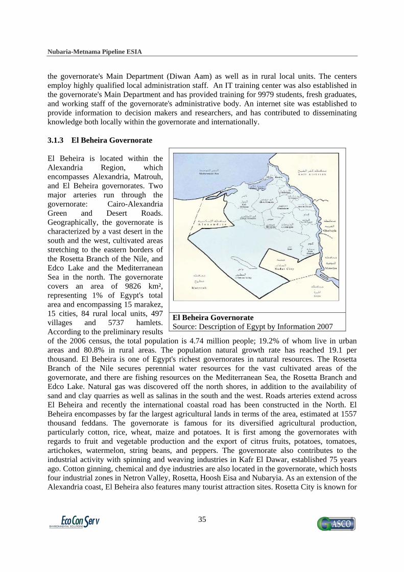
Nubaria-Metnama Pipeline ESIA
35
the governorate's Main Department (Diwan Aam) as well as in rural local units. The centers employ highly qualified local administration staff. An IT training center was also established in the governorate's Main Department and has provided training for 9979 students, fresh graduates, and working staff of the governorate's administrative body. An internet site was established to provide information to decision makers and researchers, and has contributed to disseminating knowledge both locally within the governorate and internationally. 3.1.3 El Beheira Governorate El Beheira is located within the Alexandria Region, which encompasses Alexandria, Matrouh, and El Beheira governorates. Two major arteries run through the governorate: Cairo-Alexandria Green and Desert Roads. Geographically, the governorate is characterized by a vast desert in the south and the west, cultivated areas stretching to the eastern borders of the Rosetta Branch of the Nile, and Edco Lake and the Mediterranean Sea in the north. The governorate covers an area of 9826 km², representing 1% of Egypt's total area and encompassing 15 marakez, 15 cities, 84 rural local units, 497 villages and 5737 hamlets. According to the preliminary results of the 2006 census, the total population is 4.74 million people; 19.2% of whom live in urban areas and 80.8% in rural areas. The population natural growth rate has reached 19.1 per thousand. El Beheira is one of Egypt's richest governorates in natural resources. The Rosetta Branch of the Nile secures perennial water resources for the vast cultivated areas of the governorate, and there are fishing resources on the Mediterranean Sea, the Rosetta Branch and Edco Lake. Natural gas was discovered off the north shores, in addition to the availability of sand and clay quarries as well as salinas in the south and the west. Roads arteries extend across El Beheira and recently the international coastal road has been constructed in the North. El Beheira encompasses by far the largest agricultural lands in terms of the area, estimated at 1557 thousand feddans. The governorate is famous for its diversified agricultural production, particularly cotton, rice, wheat, maize and potatoes. It is first among the governorates with regards to fruit and vegetable production and the export of citrus fruits, potatoes, tomatoes, artichokes, watermelon, string beans, and peppers. The governorate also contributes to the industrial activity with spinning and weaving industries in Kafr El Dawar, established 75 years ago. Cotton ginning, chemical and dye industries are also located in the governorate, which hosts four industrial zones in Netron Valley, Rosetta, Hoosh Eisa and Nubaryia. As an extension of the Alexandria coast, El Beheira also features many tourist attraction sites. Rosetta City is known for
El Beheira Governorate Source: Description of Egypt by Information 2007

Nubaria-Metnama Pipeline ESIA
36
Master plan of the 6th of October Governorate
Source: the Authority of 6th of October City 2009
unique architectural and historical monuments, especially Islamic architecture, and for the discovery of the Rosetta stone. The Netron Valley is characterized by its moderate weather and various famous Coptic monuments. In cooperation with the Cabinet Information and Decision Support Center (IDSC), 131 information centers, covering all administrative levels, were established and developed, and are staffed by highly qualified governorate employees. Eleven IT training centers were established as well as an internet site to provide information to students, decision makers and researchers, and has contributed to disseminating knowledge both locally within the governorate and internationally. 3.1.4 6th of October Governorate 6th of October Governorate is a newly constructed area established in order to reduce the overcrowded population in Greater Cairo. It was named after the 6th of October victory in 1973. It was announced as a governorate in year 2008 according to the presidential decree 114 on the 16th of April 2008. It is located 35 km from Cairo. Giza and Menofiya Governorates form its northern borders, Fayoum Governorate forms the southern border, the administrative boundaries of Giza Governorate and River Nile form the eastern borders and the administrative boundaries of Matouh and Beheira Governorates form the western border. 6th of October Governorate is distributed into 14 districts (Hai), and the total populated area is about 42.39% of the governorate area. The total population is 680.000 thousand people, and can be described as seasonal residential, as the majority of the residents are university students and professors who come to live there during the school year. The governorate is one of the most famous industrial areas in Egypt. The master plan of the city was designed to separate the industrial areas from the populated area, with the industrial zone located in the southwest of the city. 3.2 Location and Land Use The gas pipeline project will cover the area located in agricultural zone of Qalubia, Menofiya and El Beheira Governorates, all of which encompass old agricultural lands. The project will extend along 105 km, among which about 20 km are roads and crossings in the Nile. Therefore, the total agricultural areas to be expropriated temporarily will be about 400-500 feddans of agricultural land. The team has observed that the crops in the area are traditional crops such as maize, corn, vegetables and fruit trees. In the detailed RPF a clear discussion of crops compensation has been be presented.
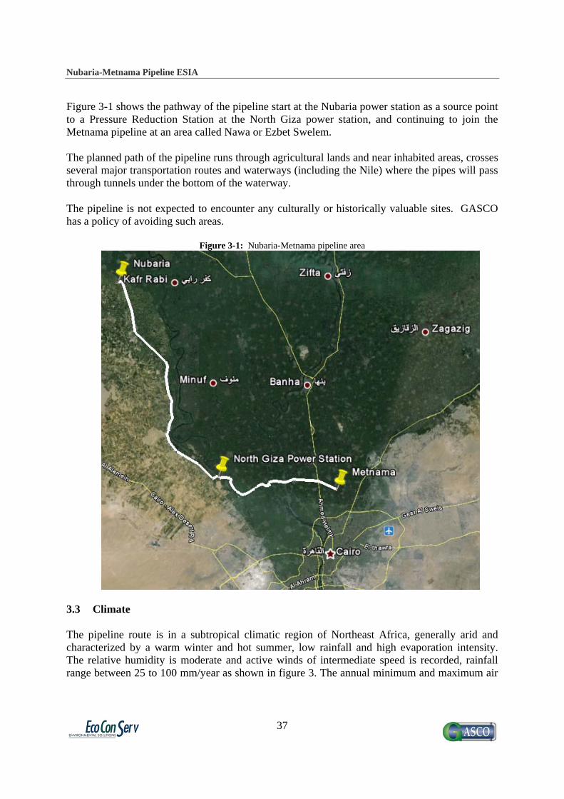
Nubaria-Metnama Pipeline ESIA
37
Figure 3-1 shows the pathway of the pipeline start at the Nubaria power station as a source point to a Pressure Reduction Station at the North Giza power station, and continuing to join the Metnama pipeline at an area called Nawa or Ezbet Swelem. The planned path of the pipeline runs through agricultural lands and near inhabited areas, crosses several major transportation routes and waterways (including the Nile) where the pipes will pass through tunnels under the bottom of the waterway. The pipeline is not expected to encounter any culturally or historically valuable sites. GASCO has a policy of avoiding such areas.
Figure 3-1: Nubaria-Metnama pipeline area
3.3 Climate The pipeline route is in a subtropical climatic region of Northeast Africa, generally arid and characterized by a warm winter and hot summer, low rainfall and high evaporation intensity. The relative humidity is moderate and active winds of intermediate speed is recorded, rainfall range between 25 to 100 mm/year as shown in figure 3. The annual minimum and maximum air

Nubaria-Metnama Pipeline ESIA
38
temperature in this region vary from about 130C to about 280C, respectively. However the temperature frequently rises to about 350C during the summer season.
Figure 3-2: Land use and rainfall
The project area is located in a subtropical climatic region. Among the outstanding weather events are the dust and sandstorms that frequently blow in transitional seasons of spring (March to May) and autumn (September to November). In winter (December to February) the general climate of the area is cold, moist and rainy while during summer (June to August), its climate is hot, dry and rainless. A phenomenon of Egypt’s climate is the hot spring wind that bellows across the country. The winds, known as the Khamasin, usually arrive in April but occasionally occur in March. Unobstructed by geographical features, the winds reach high velocities and carry great quantities of sand and dust from the deserts. These sandstorms, often accompanied by winds of up to 140 kilometers per hour, can cause temperatures to rise as much as 20oC in two hours. The winds blow intermittently and may continue for days. The Khamasin winds cause illness in people and animals, harm crops, and occasionally damage houses and infrastructure. Winds are mostly northerly, with the direction ranging from NW to NE throughout the year. These directions of the wind could cause rapid transportation of pollutants and other urbanized effects from the industrial complex areas in the north.

Nubaria-Metnama Pipeline ESIA
39
Table 3-2: Mean monthly values of metrological parameters recorded in Giza Metrological Station, 1990 - 2004
Parameter Jan Feb Mar Apr May Jun Jul Aug Sep Oct Nov Dec Temperature (C◦)
13.9 14.8 17.5 21.7 25.3 28.0 29.1 28.9 27.4 24.6 19.9 15.2
Relative humidity (%)
68.1 63.8 60.3 53.4 51.5 54.5 59.6 62.3 61.3 63.5 66.7 68.9
Accumulation of Rain Quantity (mm/month)
2.9 3.1 2.2 0.1 0.2 0 0 0 0 0.04 3 2.8
Rain-days (day/month)
2.6 1.5 1.7 0.1 0.4 0 0 0 0 0.3 1.2 1.8
Wind speed (knot)
66.4 69.2 58.8 63.0 47.1 44.1 57.3 57.7 58.5 47.6 37.5 63.9
3.4 Soil Only one type of soil characterize the region through the pathway of the pipeline which is the Calcaric fluvisols, relatively young soils (clay to loam) developed on recently deposited colluvial, fluviatile, lacustrine, or marine sediments in the Nile Valley and Delta as shown in figure 4.(sky blue color)
Figure 3-3: Soil map of Egypt
Fluvisols still show some sedimentary stratification. Organic matter content decreases irregularly with depth (although it remains above 0.35 percent in the upper 1.25m) and the soils have sulphide-rich material within 125cm of the surface. Generally fluvisols exhibit little horizonation, except for a weakly developed A-horizon and peaty horizons. Calcaric fluvisols, however, are strongly calcareous, having significant amounts of free calcium carbonate at depths of 20-50 cm and pH 7. These are the most intensively farmed soils in Egypt and have a high development potential due to the ease of irrigation low water erosion potential, and their ability to be double- cropped. They do not, however, have very high nutrient levels, so the maintenance

Nubaria-Metnama Pipeline ESIA
40
of fertility by traditional manuring practices or by high rates of fertilizer application is of particular importance in crop production. There are also potential wind erosion problems in silt - rich areas if the topsoil is allowed to dry out. The major management task is to control water supply and conserve soil moisture. The Nile fluvisols are extensively irrigated and the management of irrigation scheduling and drainage is time- consuming. In addition, in areas with a high clay content, poor irrigation practices often lead to subsoil compaction and pan formation, secondary salinization, and gleying. 3.5 Geology 3.5.1 General outlines
The surface exposures of the area belong almost totally to the Quaternary and to the Late Tertiary and are essentially developed into clastic facies. Eocene and Upper Cretaceous carbonate rocks are locally exposed and are principally associated with fold-faulted structures. Oligo-Miocene basalt exists in the southern portion and also recorded in the subsurface. Figure 6 and 7 represent the geologic map of the area and legend associated and as well as table 1 gives an idea about the Stratigrphic correlation of the area.
Quaternary: o Holocene: occupies the present floodplain the Nile River, composed of silty layers
and act as semi-confining stratum in the Nile Delta. o Pleistocene: Thick succession of deposits of graded sand and gravels intercalated
with clay lenses, the thickness reach about 100 m near Cairo, this unit act as the main aquifer of the area.
Tertiary: o Miocene: occupies the southern portion of the area, composed mainly of sand and
gravel and local intercalation of limestone or shale. Mesozoic:
o Upper Cretaceous: present in southern portion of the area with a thickness up to 1000 m, and composed mainly of limestone and dolomite.

Nubaria-Metnama Pipeline ESIA
41
Figure 3-4: General geologic map of the area (Egy.Geol.Surv., 1981), scale 1:2,000,000
Figure 3-5: Legend of the geologic map

Nubaria-Metnama Pipeline ESIA
42
Table 3-2: Stratigraphic correlation or the area (Said, 1990) a=age (millions of years) b=thickness (meters)
3.5.2 Geomorphology The pipeline route lies entirely on one main geomorphologic unit - the Young Alluvial Plain (Unit 4 in figure 5) - which occupies the banks of the river Nile. The surface of this flood plain consists of a top layer of clay-silt and underlain by sand and gravels which is water bearing formation of the alluvial aquifer. The Nile floodplain has an elevation of about 21m (amsl), to the east side of the flood plain, the ground surface rises towards El Mokatam to reach about 150m (amsl), to the west side, the surface rises 100m (amsl) at the Pyramid plateau.

Nubaria-Metnama Pipeline ESIA
43
Figure 3-6: Geomorphologic features
3.5.3 Tectonic Frameworks 3.5.3.1 Structure Geology: The selected area for the project implementation is characterized by almost featureless plain with the exception of the small folded and faulted Abu Roach complex which offers a few prominent topographical or geologic features. Figure 3-7 shows major faults in the area, the majority of these faults are steep normal faults and most have a long history of growth.

Nubaria-Metnama Pipeline ESIA
44
Figure 3-7: Major faults in the area (Said, 1990)
The most famous fault in the area is the Abu Roash fold which owes its origin to compressional movement which affected the area during the late Cretaceous-early Tertiary tectonic event, this fold have a northeast-southwest trend.
3.5.3.2 Seismicity
Seismicity in the area is characterized by the occurrence of small, moderate and large earthquakes which has increased in recent years but they are limited within the crust, only micro-earthquakes were frequently observed. Figure 3-8 shows the intensity distribution of earthquakes in Egypt, and Figure 3-9 shows epicenters of recent medium to large earthquakes (A) and the epicenter of small earthquakes.
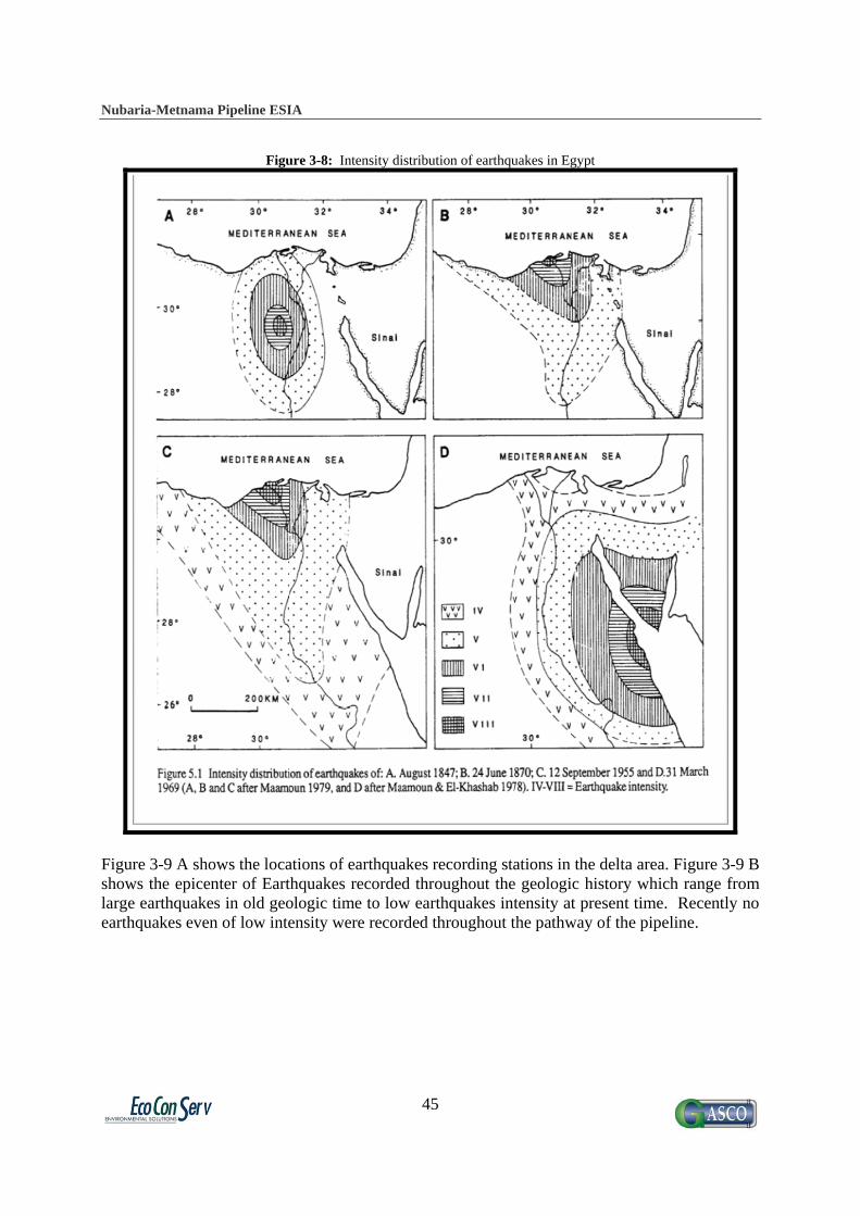
Nubaria-Metnama Pipeline ESIA
45
Figure 3-8: Intensity distribution of earthquakes in Egypt
Figure 3-9 A shows the locations of earthquakes recording stations in the delta area. Figure 3-9 B shows the epicenter of Earthquakes recorded throughout the geologic history which range from large earthquakes in old geologic time to low earthquakes intensity at present time. Recently no earthquakes even of low intensity were recorded throughout the pathway of the pipeline.

Nubaria-Metnama Pipeline ESIA
46
Figure 3-9 A, B: Earthquakes throughout the geologic history (Said, 1992)
The region has faced a number of earthquakes in recent geologic history. The following is a brief description of recorded major earthquakes:
In 1847, an earthquakes of magnitude 8 degree was felt, 100 dead, thousands injured and thousands of houses were destroyed.
In 1870, very wide earthquakes, was felt all over Egypt, Greece, Turkey and Palestine, and has a magnitude of 6 degree.
In 1955 several earthquakes occurred and were strongly felt all over Egypt of magnitude ranging between 6 and 7 degrees.
In 1969, another earthquake of magnitude 6.3. In 1974, and 1984, small earthquakes of magnitude 4.5 were felt in Cairo. In 1992 moderate earthquake, 5.8 degree but caused large damage in greater Cairo.
3.6 Groundwater In greater Cairo, the coarse massive sand and gravel Unit, belonging to the late Pleistocene is considered the main aquifer system with a maximum thickness of about 70 m and occupies almost all the area of the flood plain and parts of the adjacent elevated plains. The groundwater exists under semi-confined condition as well as phereatic condition. 3.6.1 Groundwater Hydrology The pathway of the pipeline runs through Nile Delta Aquifer which consist the main aquifer (Semi-Confined aquifer) in the area, consists of Pleistocene graded sands and gravels, changing to fine sand and clayey facies in the northern part and is overlain by Holocene silty and sandy clay. The thickness of the semi confined layer ranges between 0 to 20 m and occupies almost all the area of the flood plain and a parts of the adjacent elevated plains. The groundwater exists
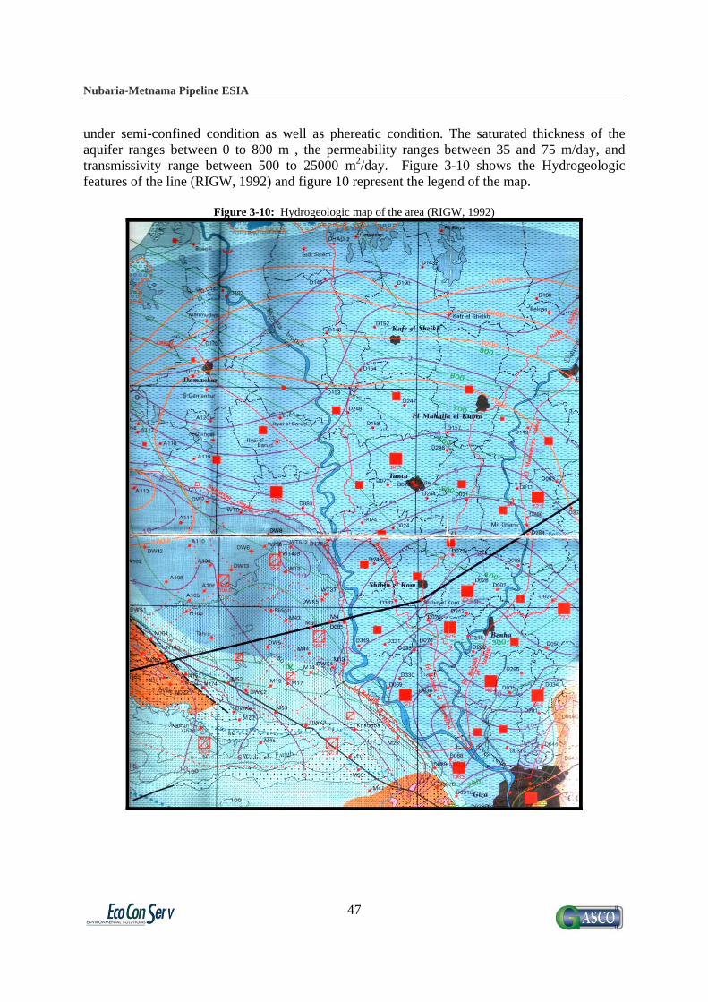
Nubaria-Metnama Pipeline ESIA
47
under semi-confined condition as well as phereatic condition. The saturated thickness of the aquifer ranges between 0 to 800 m , the permeability ranges between 35 and 75 m/day, and transmissivity range between 500 to 25000 m2/day. Figure 3-10 shows the Hydrogeologic features of the line (RIGW, 1992) and figure 10 represent the legend of the map.
Figure 3-10: Hydrogeologic map of the area (RIGW, 1992)
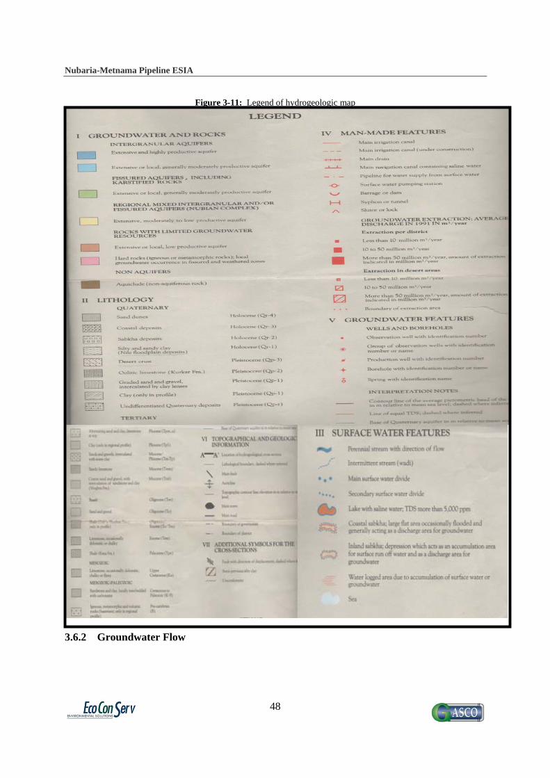
Nubaria-Metnama Pipeline ESIA
48
Figure 3-11: Legend of hydrogeologic map
3.6.2 Groundwater Flow

Nubaria-Metnama Pipeline ESIA
49
Groundwater flow has been observed by the Research Institute of Ground Water (RIGW) since 1950, so a large amount of data is available. It was observed that the piezometric level decreased gradually from more than 15 m+msl in the southern portion to >5 m+msl in the north as shown in Figure 3-12. The average piezometric gradient is about 11 cm/km. Groundwater flow direction is by definition perpendicular to the piezometric contour lines and therefore the flow direction is from south to north.
Figure 3-12: Depth of groundwater (0-5 m)
3.6.3 Hydraulic Parameters: The hydraulic parameters of the groundwater aquifer are as follows:
Vertical permeability of the top layer varies from 35 to 75 m/day Aquifer Hydraulic conductivity varies from 50 to 70 m/day. Transmissivity varies from 5000 to 25000 m2/day, and, Aquifer Storativity varies from 0.0005 to 0.01.
3.6.4 Recharge and Discharge: Recharge sources are:
Seepage from the river and main canals Deep percolation from irrigation of cultivated lands Seepage from drinking water supply networks Infiltration/seepage from the sewage trenches.
Nubaria-Metnama Pipeline ESIA
50
Discharge occurs as:
Groundwater return-flow to the Nile. Interception by sewage system. Groundwater extraction.
3.6.5 Hydrochemistry Many authors, institutes and researchers studied the groundwater quality of the area for the purpose of different projects and/or studies; however, the groundwater quality could be summarized in the following main points:
Groundwater type is bicarbonates, indicating that the source of recharge is surface water. Sodium Chloride and Sodium Sulfate are also present in the deep aquifer which may
indicate fossil water and/or recharge from domestic sources. TDS generally range between 1000 and 2000 ppm.
3.6.6 Groundwater Fluctuation and Rising Problems
Groundwater table in most of Greater Cairo regions ranges between 1-5 meters in most areas. Many places suffer from the problem of groundwater rising especially along the eastern bank of the river Nile. In the old Cairo district the increase of groundwater varies between 1 – 3 m during the last 20 years due to absence of groundwater extraction, in the north western part of greater Cairo a decrease in groundwater heads occurs in the range of 1.75 - 2 m due to due to the extension in building area, also in the south western portion of Greater Cairo a decrease in groundwater of about 0.7 m due to the excess of groundwater extraction for drinking purposes. 3.7 Surface Water River Nile passes through central Egypt, before it reaches the Nile Barrage north of Greater Cairo, where it starts branching to Dammietta Branch and Rosetta Branch forming the Nile Delta. Besides the River Nile, the Ismaileya Canal is a major freshwater canal that supplies Suez Canal cities and passes through Greater Cairo. The Canal starts in Greater Cairo at Shobra district (north of Cairo) and passes through Shobra, Matareya, and Mostorod districts before it continue to the east. There are many irrigation canals which penetrate Greater Cairo, especially at Giza Governorate, such as Zenine Drain, Mariouteya Canal and Mansoureya Canal passing through El Haram, Saft El Laban, and Embaba districts. Water quality in the three latter water courses are relatively lower than corresponding quality of River Nile and Ismaileya Canal, at its upstream reaches in Greater Cairo. They receive effluents from two major sewage treatment facilities (Zenine and Abou Rawash) in addition to receiving solid wastes from urban areas overlooking theses water courses.

Nubaria-Metnama Pipeline ESIA
51
3.8 Biodiversity and Habitats Figure 3-13: Egyptian Protected Areas. The pipeline does not encounter any protected areas.

Nubaria-Metnama Pipeline ESIA
52
3.8.1 Flora The following habitats can be distinguished along the pipeline route:
Farmland (field plots and orchards) Hydrophytic and Canal banks Habitats Roadsides habitats
3.8.1.1 Farmland Fruit trees grown in orchards included mango, date palms, olives, oranges, pomes, grapes, and guava. The field plots were cultivated with winter crops; wheat, broad beans and clover, as well as vegetables including tomatoes and onion. The summer crops are maize and melons. Most common winter weeds included Bidens pilosa, Stellaria palida, Chenopodium murale Brassica nigra, Vicia stativa, Urtica urens, Euphorbia peplus, Melilotus indicus, Emex spinosa, etc. Summer weeds included Portulaca oleracea, Echinochlod colona, Cyperus rotundus, Amaranths viridis, etc. All year weeds were represented by Cynodon dactylon, Convolvlus arvensis, Plantago majo,r Solanum nigrum, Dichanthium annulatum etc.
Figure 3-14: Orchard field showing dense growth of Bidens pilosa and Euphorbia prostratea

Nubaria-Metnama Pipeline ESIA
53
Figure 3-15: Mango (Mangifera indica) growing in the site of the project
3.8.1.2 Hydrophytic and Canal bank Habitats Irrigation water flows rapidly in the major irrigation canals and branches of the Nile. Submerged and floating water plants were growing close to the banks of these canals. e.g. potamogeton nodosun, ceratophyllum demersum and water hyacinth, Eichhornia crassipes. The muddy and moist banks of the Nile and irrigation canals support the growth of populations of hydrophilic species including tall reeds, shrubs, undershrubs and herbs. Zahran and Willis (1992- 333- 34), categorized the plants of the canal banks habitat into: Bank retainers, aggressive species and soil (sand) controllers. Bank retainers are plants which have bankholding qualities due to the fact that their roots bind the soil. They also shade other species which may be harmful. Bank retainers include trees such as Acaia nilotica, Ficus sycomorus, Salix subserrata, Tamarix nilotica, and Ziziphus spina – christi and undershrubs such as Alhagi graecorum, Chenopodium ambrosides or Pluchea dioscorides. Aggressive species are those who make such rapid or robust growth that they prevent many smaller or slow growing plants from establishment. This category includes herbaceous species, e.g. Cyperus laevigatus, Trifolium resupinatum or phyla nodiflora which form mats that soon

Nubaria-Metnama Pipeline ESIA
54
cover patches of bare soil; and tall reeds including Arundo donax, cyperus alopecuroides, C. articulatus or Saccharum spontaneum. Soil controllers are plants that can tolerate or at least partly stabilize drift sand. Wind-break or fence plants belonging to this category include the cultivated trees: Casuarina cunninghamiana, Eucalyptus camaldulensis, Dalbergia sisso or salix babylonica.
Figure 3-16: EL Rayah EL Behieri, the main irrigation canal showing canal bank vegetation
3.8.1.3 Roadsides This included unpaved roads, and motorways, which cut through the cultivated land. The plant communities recognized along the roadsides are dominated by phragmitis austrails, Imprata cylindrica, Desmostachya bipinnata and Alhagi graecorum
Figure 3-17: Railway in the study area

Nubaria-Metnama Pipeline ESIA
55
3.8.1.4 Rare and Endangered Species The surveyed area of the project site is not listed under law 102-1983 as a Protected Area. Of the high number of species observed and recorded at the project site, there is no globally or locally threatened or endangered species. 3.8.2 Fauna The main habitats in the majority of the areas crossed by the pipeline pathway are artificial-terrestrial habitats including arable land, plantations, rural gardens, cultivated agricultural lands and urban areas. Other habitats include wetlands along the main two branches of the River Nile and smaller branches and irrigation canals, as well as inhabited areas, asphalt roads and railways. These habitats can be categorized under two broad ecosystems one being the artificial-terrestrial, and the other is the aquatic (lotic) ecosystem of the River Nile. The following narrative is for the recorded species from the ecosystems that the planned pipeline pathway will cross and is based on the most recent literature about the fauna of Egypt and/or the data recorded during the field visits of the study. The pipeline pathway crosses the previously mentioned ecosystems which provide habitats for several species of vertebrate fauna, also for several invertebrate species, such as snails, worms, ants, Dragon flies, Damselflies, spiders, beetles and other insects. One common invertebrate species, Vagrant Emperor Anax ephippiger was recorded on the exact pipeline-route during the study. The River Nile represents the aquatic (freshwater) ecosystem with many fish species such as Tilapia zilli, Oreohromis niloticus and Clarias gariepinus, in addition to other native invertebrates such as Valvata nilotica and invasive species such as the crayfish Procambarus clarkia. 3.8.2.1 Herpetofauna According to the most recent published literature about the herpetofauna of Egypt (Baha El Din S., 2006), reptiles and amphibians (up to 53 species in some areas) are normally prominent components of the ecosystems that would be crossed by the pipeline pathway. The highest concentration and greatest concentration of species is near the margins of the Delta where the number of recorded species ranges from 32 to 53 species. This is a considerable proportion of the total herpetofauna of Egypt (112 species). Characteristic species of these habitats are Bufo regularis, Ptychdena mascarenensis, Natrix tessellate, Chamaeleo africanus, psammophis sibilans, Malpolon monspessulanus, Hemidactylus tursicus, Tarentola annularis, Trachylepis quenquetaeniata and Naja haje. No herpetofaunal species were recorded during the field survey of the pipeline route. 3.8.2.2 Avifauna There are many bird species potentially occurring in the ecosystems that the planned pipeline pathway will cross. The majority of these birds are common species however, and the pipeline pathway does not pass through any of the 34 IBAs (Important Bird Areas) of Egypt. All recorded bird species during the study are common ones; except one uncommon record for the Great Cormorant Phalacrocorax carbo and one fairly common record Little Bittern Ixobrychus

Nubaria-Metnama Pipeline ESIA
56
minutus, see the following tables. No nesting areas for any species were recorded during the field survey of the pipeline route.
Table 3-3: Bird species in project area
Common Name Scientific Name Arabic name Status RA Barn Swallow Hirundo rustica عصفور الجنة RB,PV,WV C Cattle Egret Bubulcus ibis أبوقردان RB,PV,WV C Common Bulbul Pycnonotus barbatus بلبل RB C Common Chiffchaff Phylloscopus collybita سكسكة PV, WV C Common Moorhen Gallinula chloropus دجاجة الماء RB,PV,WV C Eurasian Hoopoe Upupa epops هدهد RB, PV C Graceful Prinia Prinia gracilis فصية RB C Gray Heron Ardea cinerea رمادي بلشون PV,WV C Green Bee-eater Merops orientalis الخضير RB C Great Cormorant Phalacrocorax carbo غراب البحر PV, WV UC Hooded Crow Corvus cornix غراب بلدى RB C House Sparrow Passer domesticus عصفور دورى RB C Kestrel Falco tinnunculus الجراد صقر RB,PV,WV C Little Bittern Ixobrychus minutus واق صغير RB,PV,WV FC Little Egret Egretta garzetta أبيض بلشون RB,PV,WV C Little Stint Calidris minuta فطيرة PV, WV C Palm Dove Streptopelia senegalensis يمام مصري RB C Pied Kingfisher Ceryle rudis صياد السمك الأبقع RB C Spur-winged Plover Vanellus spinosus زقزاق بلدى RB,PV,WV C Squacco Heron Ardeola ralloides واق أبيض RB,PV,WV C White-throated Kingfisher Halcyon smyreninsis قاوند BR C White Wagtail Motacilla alba أبوفصادة أبيض PV, WV C Yellow Wagtail Motacilla Flava أبوفصادة أصفر PV, WV C
3.8.2.3 Mammalian Fauna About 23 mammalian species (a considerable proportion of the total mammalian fauna of Egypt - 110 species) may occur in the investigated ecosystems, based on the most recent published literature, (Basuony M.I. et al, 2010). There are some important mammals that exist in these ecosystems such as the endemic Swamp Cat Felis chaus nilotica. This species is recorded as a common species and listed as Least Concern according to the International Union for
STATUS RELATIVE ABUNDANCE (RA)
RB Resident Breeder C Common
IB Introduced Breeder F Fairly Common MB Migrant Breeder UC Uncommon WV Winter Visitor R Rare PV Passage Visitor V Vagrant

Nubaria-Metnama Pipeline ESIA
57
Conservation of Nature criteria and categories, meaning there is a very low risk of extinction. No mammalian species were recorded during the field survey of the pipeline route.
Figure 3-18: view from North Giza Station - A) The railways, B) River Nile branch and C) Asphalt road
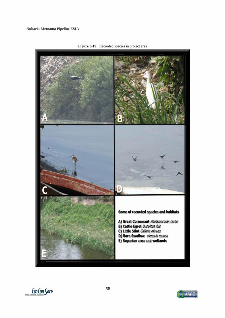
Nubaria-Metnama Pipeline ESIA
58
Figure 3-19: Recorded species in project area

Nubaria-Metnama Pipeline ESIA
59
4. Project Description The proposed project is as an integral part of the country's energy strategy which calls for greater use of natural gas. This initiative will contribute to achieving the government plan for extending natural gas usage and supporting the national gas grid. The planned pipeline is a 32" diameter, 105 km long pipeline to transport natural gas from the Nubaria power station to a Pressure Reduction Station (PRS) at the North Giza power station, and continuing to join the Metnama pipeline. The following section will detail the pipeline components, work plan, construction activities, and the patrolling philosophy of the pipeline. 4.1 Pipeline Components 4.1.1 Pipeline Route The Nubaria-Metnama gas pipeline starts from the valve room at the end of the Abu Homos-El Nubaria 42"-diameter gas pipeline, near Nubaria Electrical Power Station. Then the pipeline continues south, parallel to El Rayh El Nasry, for approximately 62 km. During the first 45 km, the pipeline runs parallel to EL Rayh EL Nasry. For the last 17 km, the pipeline runs parallel to El Katatba-Borkoash asphalt road (this road is also parallel to El Rayh El Nasry), then runs east to cut across El Rayh El Nasry and the railway and El Rayh El Bahery until the turnoff to North Giza Electrical Power Station. The pipeline then starts again from the turnoff of North Giza Electrical Power Station and continues east through north part of El Ata City. The pipeline then cuts through the Nile River (Rashed Branch) and continues parallel to the river for about 14 km. Then the pipeline cuts through El Rayh El Monofy and continues through the Nile Delta heading east until it reaches the existing Tena-Metnama pipeline in an area called Nawa or Ezbet Swelem. The entire length of the pipeline will be below ground. Figure 4-1 shows the entire path of the pipeline, including the locations of valve rooms, major crossings, and nearby settlements. These elements are described in more detail in the following sections. The distance of the path is marked in 5 km increments (indicated by green hash marks) 4.1.2 Pipeline Design Criteria At the minimum, the pipeline will be built, operated, and maintained to the standards of ASME B31.8, which dictates the use of good engineering practices for public safety in all conditions and local regulations as a minimum, along with any additional local regulations. as well as other relevant high standards for pipeline routing with consideration for nearby settlements. Settled areas along the pipeline are classified by population density, which is used to determine the Location Class, as defined in Figure 4-##. Location Classes are used to determine the design criteria appropriate for different sections of the pipeline. They are also used in determining the amount of surveillance activity to be conducted.

Nubaria-Metnama Pipeline ESIA
60
Figure 4-1: Determination of Location Class
Generally a zone 200m wide is considered on either side of the route of the pipeline. To include a maximum number of buildings for human occupancy, the pipeline route is also divided lengthwise into sections of 1 mile. Within a multiple dwelling unit, each separate dwelling unit is counted as a separate building. However, ASME B31.8 does not provide restrictions on the proximity of a pipeline to a building or group of buildings, which can lead to pipelines being constructed close to buildings (and vice versa). The following proximity limits should be applied to all pipeline design and to new buildings developed close to existing pipelines.
No pipeline operating at a pressure greater than 7 bar must can be within 3m of a building in residential areas, and 6m desert areas.
Any pipeline closer than 25 m to a normally occupied building should operate at a pressure that is 40% of the material yield strength or less, and have a wall thickness of at least 0.375".
Any pipeline closer than 12.5m to a normally occupied building should operate at a pressure that is 40% of the material yield strength or less, and be laid with greater than or equal to 0.5" wall thickness.
Wall thickness is also increased at road crossings, and impact protection measures (cast in site or pre - cast concrete slab) shall be provided on all pipeline crossings. Warning tape is placed above and below such impact protection.

Nubaria-Metnama Pipeline ESIA
61
Figure 4-2: Nubaria-Metnama pipeline route

Nubaria-Metnama Pipeline ESIA
62
Figure 4-3: Typical valve room layout
Nubaria-Metnama Pipeline ESIA
63
4.1.3 Valve Room Locations Eleven (11) valve rooms will be constructed along the pipeline, in the following locations:
valve room (1) at zero km (Nubaria power station) valve room (2) at 13 km valve room (3) at 21 km valve room (4) at 29 km valve room (5) at 37 km valve room (6) at 45 km valve room (7) at 61 km valve room (8) at 74 km valve room (9) at 85.2 km valve room (10) at 93.5 km valve room (11) at 105 km
Valve room dimensions are a maximum of 25 m x 50 m, but may be smaller. A typical plot plan for a valve room is shown above in Figure 4-2. 4.1.4 Crossings There are many crossing that the proposed pipeline route encounters. Some of them will be crossed using an open trench, but major crossings and waterways will be crossed using the Horizontal Directional Drilling (HDD) technique, described in Section 4.5.11. The following crossings will be encountered:
Nubaria power station asphalt road Ain Galot asphalt road Badr City asphalt road Omar Makram asphalt road Al-Sokhna asphalt road (HDD) Al-Sadat/Kafr Dawoud asphalt road (HDD) Al-Khatatba road (HDD) Al-Khatatba/Borkash conduit (HDD) Al-Rayah Al-Nasry conduit (HDD) Al-Rayah Al-Nasry railway (HDD) Al-Rayh Al-Baheiry conduit (HDD) Al-Khatatba/Al-Kantar asphalt road (HDD) Nile river - Rashid branch (HDD) Al-Kata asphalt road Sheben/Al-Kom asphalt road (HDD) Bahr Sheben (HDD) Shanaway asphalt road (HDD) Nile river - Damietta branch(HDD) Al-Monyra asphalt road
Nubaria-Metnama Pipeline ESIA
64
Al-Rayah Al-Tawfiky conduit (HDD) Al-Basosya conduit (HDD) Al-Basosya asphalt road (HDD) Al-Baradaa asphalt road Sandbes asphalt road Sanfer drain Abo Al-Naga conduit Kleg Al-Shamy conduit Al-Saroka conduit Namol conduit Al-Sysya conduit Tanash conduit Mard Tanash Tanash asphalt road Cairo/Alexandria agricultural road and railway (HDD) Sheben/Al-Kantar railway and asphalt road (HDD)
The major crossings where HDD will be used are indicated in red on the Sectional Maps in Section 4.1.5. 4.1.5 Nearby Settlements The planned route will not pass directly through any settled areas, but will go close to several small villages and settlements which may be sensitive receptors to the impacts discussed later in the report. The following settlements were identified near the line, and are circled in yellow on the corresponding maps in the next section:
Qaryat Al-Iman Badr Qaryat Umar Makram Qaryat Umar Shahin Izbt Al-Sukhna Al-Jadida Izbt Masjed Ar-Rahman Izbt Sidi Ibrahim Izbt Jamal Al-Faransawi Izbt Al-Raml Kafr Mansur Sheshaa Darawah Al-Shurfa Al-Gharbia Al-Baradah
4.1.6 Sectional Maps

Nubaria-Metnama Pipeline ESIA
65
The following maps show segments of the pipeline approximately 5 km in length, in areas where there are nearby settlements or major crossings.
Figure 4-4: map legend
Figure 4-5: km 5-10

Nubaria-Metnama Pipeline ESIA
66
Figure 4-6: km 15-20
Figure 4-7: km 20-25

Nubaria-Metnama Pipeline ESIA
67
Figure 4-8: km 30-35
Figure 4-9: km 40-45

Nubaria-Metnama Pipeline ESIA
68
Figure 4-10: km 65-70
Figure 4-11: km 80-85

Nubaria-Metnama Pipeline ESIA
69
Figure 4-12: km 85-90
Figure 4-13: km 90-95

Nubaria-Metnama Pipeline ESIA
70
Figure 4-14: km 95-100
Figure 4-15: km 100-105
4.1.7 Pressure Reduction Station The PRS is present inside the North Giza Power Station. Its main function is to deliver 425,000 m3/hour, at an output pressure of 27 bar and an output temperature of 7° C. The station consists of 3 filtering lines (to clean the gas from any particles), 5 reduction lines (to reduce the gas pressure to the desired value), and 3 measurement lines. Additionally 3 heaters will be used.
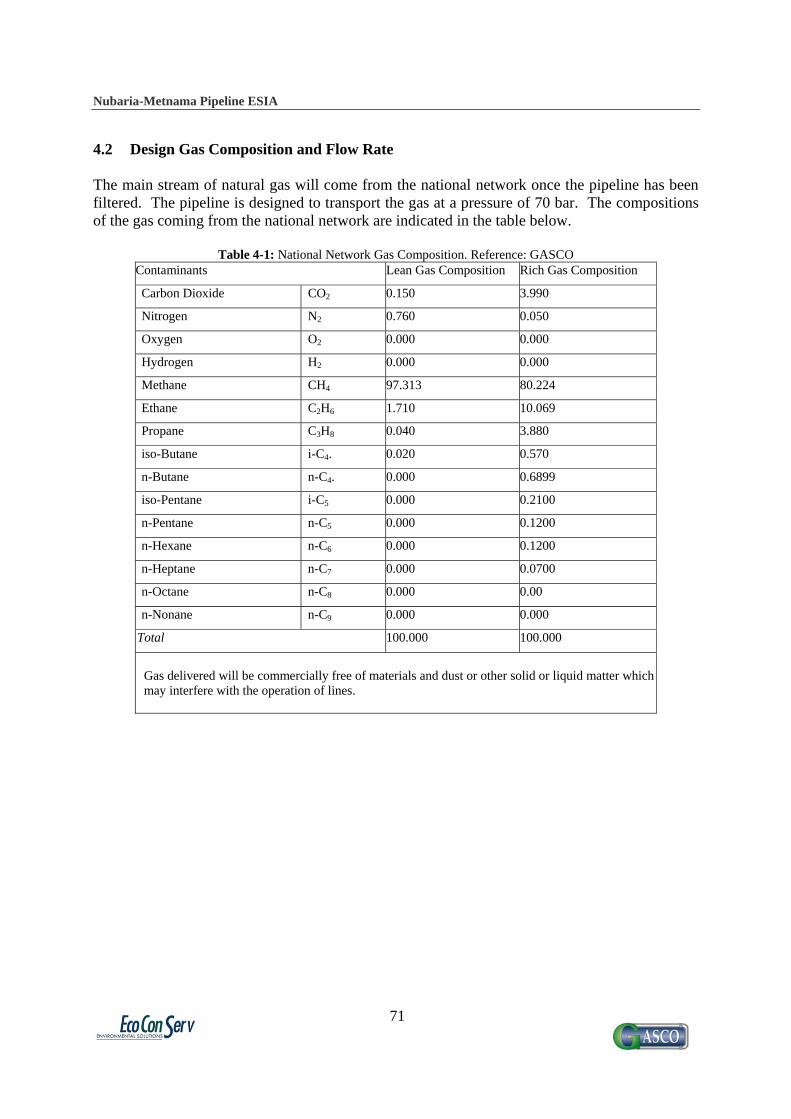
Nubaria-Metnama Pipeline ESIA
71
4.2 Design Gas Composition and Flow Rate The main stream of natural gas will come from the national network once the pipeline has been filtered. The pipeline is designed to transport the gas at a pressure of 70 bar. The compositions of the gas coming from the national network are indicated in the table below.
Table 4-1: National Network Gas Composition. Reference: GASCO Contaminants Lean Gas Composition Rich Gas Composition
Carbon Dioxide CO2 0.150 3.990
Nitrogen N2 0.760 0.050
Oxygen O2 0.000 0.000
Hydrogen H2 0.000 0.000
Methane CH4 97.313 80.224
Ethane C2H6 1.710 10.069
Propane C3H8 0.040 3.880
iso-Butane i-C4. 0.020 0.570
n-Butane n-C4. 0.000 0.6899
iso-Pentane i-C5 0.000 0.2100
n-Pentane n-C5 0.000 0.1200
n-Hexane n-C6 0.000 0.1200
n-Heptane n-C7 0.000 0.0700
n-Octane n-C8 0.000 0.00
n-Nonane n-C9 0.000 0.000
Total 100.000 100.000
Gas delivered will be commercially free of materials and dust or other solid or liquid matter which may interfere with the operation of lines.
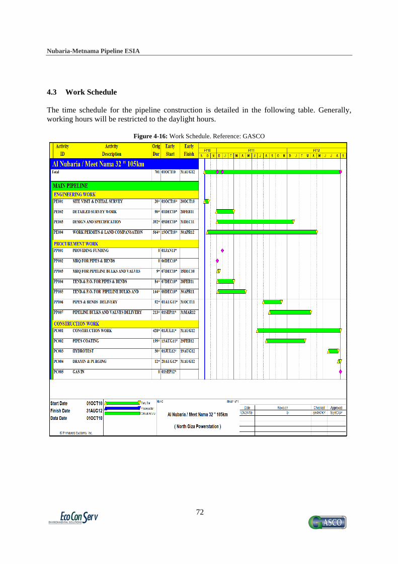
Nubaria-Metnama Pipeline ESIA
72
4.3 Work Schedule The time schedule for the pipeline construction is detailed in the following table. Generally, working hours will be restricted to the daylight hours.
Figure 4-16: Work Schedule. Reference: GASCO

Nubaria-Metnama Pipeline ESIA
73
4.4 Construction Activities and Methodologies Qualified and approved contractors under the supervisions and monitoring of GASCO personnel will carry out construction. Brief descriptions of the key activities during the pre-construction and construction phases are provided in the following sections. 4.4.1 Planning and system design Accurate maps of project areas shall be obtained in order to collect sufficient information for reaching optimum design for the system, surveying works may be carried out at few locations where maps are outdated or do not include recent developments. Routes and depths of existing underground infrastructure shall be obtained from different authorities (water lines, sewage lines, telecommunication lines, and electric cables). However, in some cases no accurate mapping is available for underground infrastructure. In such cases a trial pit shall be manually excavated to locate underground pipes. 4.4.2 Mobilization of equipment, materials, and workers According to the approved phased implementation plan, the contractor mobilizes the required construction equipment, materials, and labor. The contractor normally occupies a location for storing materials and equipment in the project area. This location should be approved by the local authority. These storage locations shall include:
Excavation machinery, such as trenchers, backhoe excavators, jack hammers, loaders, cranes, manual tools …etc.
Piping materials, such as pipes, valves, elbows, coating materials Stockpiles of sand and filling materials Repair machinery, such as compaction machinery, asphalt laying, concrete mixers … etc. Management caravan for the site engineers and staff
Unskilled labor from the nearby villages will be utilized, eliminating the need for large worker camps. Some additional technical staff will be housed in nearby apartments or hotels. An administrative camp will be set up 25 km from the start of the pipeline, remaining for the first 9 months of construction, and then moved to km 77 for the remaining 6 months of construction. This camp will include a water supply, mobile toilets, a cafeteria, and offices.
Table 4-2: Types and Quantity of Equipment Used During Construction Phase. Reference: GASCO
Equipment Quantity 1 Double Cabin Car 8 2 Double Cabin Car 4*4 8 3 Pick Up 8 4 Bus (26 Persons) 20 5 Puller 4 6 Generator 200-250 K.V 6 7 Crane 50 Ton. 4 8 Side Boom D8 15 9 Pipe Welder 4
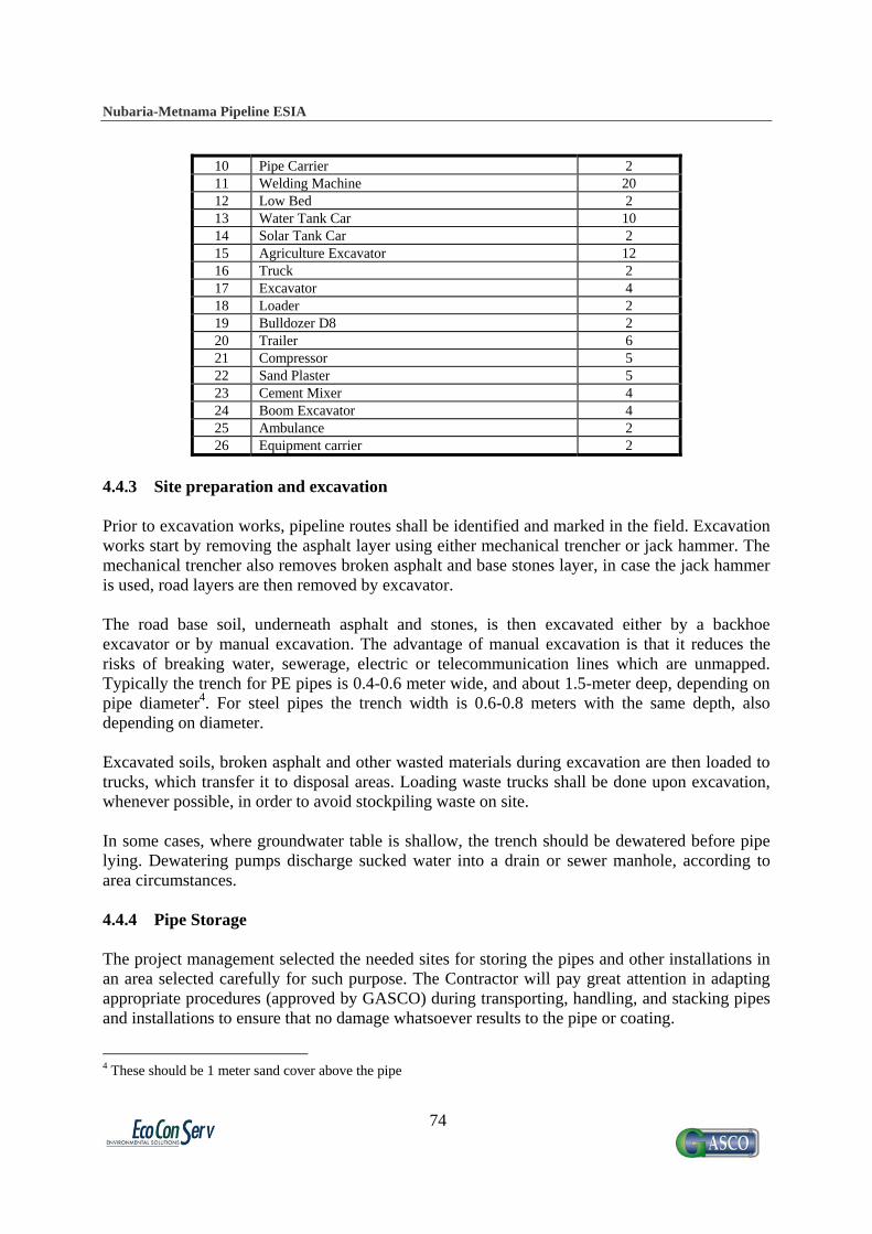
Nubaria-Metnama Pipeline ESIA
74
10 Pipe Carrier 2 11 Welding Machine 20 12 Low Bed 2 13 Water Tank Car 10 14 Solar Tank Car 2 15 Agriculture Excavator 12 16 Truck 2 17 Excavator 4 18 Loader 2 19 Bulldozer D8 2 20 Trailer 6 21 Compressor 5 22 Sand Plaster 5 23 Cement Mixer 4 24 Boom Excavator 4 25 Ambulance 2 26 Equipment carrier 2
4.4.3 Site preparation and excavation Prior to excavation works, pipeline routes shall be identified and marked in the field. Excavation works start by removing the asphalt layer using either mechanical trencher or jack hammer. The mechanical trencher also removes broken asphalt and base stones layer, in case the jack hammer is used, road layers are then removed by excavator. The road base soil, underneath asphalt and stones, is then excavated either by a backhoe excavator or by manual excavation. The advantage of manual excavation is that it reduces the risks of breaking water, sewerage, electric or telecommunication lines which are unmapped. Typically the trench for PE pipes is 0.4-0.6 meter wide, and about 1.5-meter deep, depending on pipe diameter4. For steel pipes the trench width is 0.6-0.8 meters with the same depth, also depending on diameter. Excavated soils, broken asphalt and other wasted materials during excavation are then loaded to trucks, which transfer it to disposal areas. Loading waste trucks shall be done upon excavation, whenever possible, in order to avoid stockpiling waste on site. In some cases, where groundwater table is shallow, the trench should be dewatered before pipe lying. Dewatering pumps discharge sucked water into a drain or sewer manhole, according to area circumstances. 4.4.4 Pipe Storage The project management selected the needed sites for storing the pipes and other installations in an area selected carefully for such purpose. The Contractor will pay great attention in adapting appropriate procedures (approved by GASCO) during transporting, handling, and stacking pipes and installations to ensure that no damage whatsoever results to the pipe or coating.
4 These should be 1 meter sand cover above the pipe

Nubaria-Metnama Pipeline ESIA
75
Piping material must be stored by type, size and material specification. Materials will be supplied color marked, to differentiate types/services of materials. Care must be taken to select and utilize special material such as that manufactured to NACE Std., ASME code and alloys for their required services only. Materials must be checked for their color-coding. For protection of all piping materials, when stored outdoors they shall be supported off the ground. 4.4.5 Foundations Structural Work or Civil Work At this stage, the site is ready for the commencement of starting the construction of the plant (valve room) structure. Through the construction of the various components of the plant structure a lot but similar activities take place which follow the pattern for the preparation for pouring concrete. The pattern is as follow:
Concrete shuttering: which involves the use of shuttering materials mainly plywood for forming the required shape and size of the component being constructed.
Reinforced steel preparation: which involves the sizing , cutting, and shaping of the reinforced steel bars to the required shapes and sizes, as well as the laying of these bars in the shuttering a specified in the structural design.
Concrete pouring inside the formed shuttering (form work) so as to form the required skeleton of the structure. This is done through the use of a concrete batch plant which mixes the concrete components (cement, gravel, sand, and water) internally in batch amounts which is then transported to pouring site through the aid of concrete trans-mixers and poured through the use of concrete pumps and cranes.
The installations of the concrete works subject to exposure with the surrounding ground water table.
Aggregates with different sizes and with an estimated sum total of 10,000 m3 for the use with different types of a concrete mixes to yield different required concrete strengths. 4.4.6 Trenching Lowering and Laying A trench will be dug from the running track to allow the pipeline to be buried. The width of the trench will be the width of the pipe plus 0.4 m. Sub-soil from the trench will be stored in loose piles on the opposite side of the working width to prevent mixing with top soil. The minimum cover on top of the pipeline will be 1.5 m. The bottom of the trench will be uniformly graded and covered with sieved sand to prevent any damage to the pipe coating. The pipeline trench will be a minimum of 2 m from any existing pipeline. The trench will be left open for as short a time as possible before the pipeline is lowered into the trench. During the excavation works, some welding works are taking place above-ground. Once the trench is excavated, the available pipe stretch shall be laid down. The pipeline will be lowered into the trench using wide, non-abrasive belts, and care will be exercised to avoid causing damage to the pipeline coating. In marshy areas, negative buoyancy will be created using a concrete coating. Warning tapes will be installed 30 cm below ground level. Remaining welding works then take place, to connect the laid pipe with the previous stretch.

Nubaria-Metnama Pipeline ESIA
76
The buried metallic structures (pipelines, valves) are coated and cathodically protected according to BS, 739, part 1.
4.4.7 Backfilling The trench will be backfilled with layers of the original stored sub-soil. Once the trench is filled, the reinstatement of the whole working width begins. This involves ripping the sub-soil to rectify any compaction that may have occurred during construction and grading to the original contours. Topsoil will then be replaced across the working width to its original depth, will be graded carefully, and clean up operations will need to be completed within one week of backfilling. 4.4.8 Welding and Weld Inspection The following welding processes are acceptable:
Shielded Metal Arc Welding (SMAW) Gas Tungsten Arc Welding (GTAW) Gas Metal Arc Welding (GMAW) Flux Cored Arc Welding (FCAW) Submerged Arc Welding (SAW)
(Automatic or Semi-automatic) All welding and tacking must be performed by welders who are currently qualified to applicable codes, and to specific variables and materials of the procedure. Welders and welding operators must be currently qualified as required by the applicable ANST/ASME Code. The procedure for welding must conform to the current applicable ASME Code. ASME Section IX forms QW-482 and QW-483 or their equivalent must be used. The following weld inspection methods are applicable:
a) Non destructive tests - Radiographic test (R.T. 100%) - Ultrasonic test (U.T. 10%) - Die penetrate test for weld let, sweepolet and nippolet (½", 1")
b) Destructive tests (Mechanical Test) - Tensile test - Bending test - Macro etching test - Impact test - Nick break test - Hardness test
Every 200-weld joint we made this test (0.5% of all welds) in the laboratory of the faculty of engineering.

Nubaria-Metnama Pipeline ESIA
77
4.4.9 Valves and Tie-ins
Valves requiring frequent operation, and located more than 2 meters (6 feet - 9 inches) above the operating level require extension stems
Valves should not be installed with stems below the horizontal position, unless otherwise approved by Client.
Impact type hand wheels or handles may be installed on extended stems if the stem is independently.
4.4.10 Pipe Cleaning
Materials - Cleaning solutions used shall be compatible with piping materials, valve trim, gaskets, and all other components in the piping. Chemical cleaning shall not exceed 0.2 mils metal penetration. Solutions and water used for detergent flushing of stainless steel piping shall not exceed 50-PPM chloride content.
Acceptance - The cleaning contractor shall make a record of all lines cleaned. For carbon, steel piping the record shall include the degreasing, pickling, and end of cleaning examinations and type of passivator used. For stainless steel, piping the record shall include the degreasing and end of cleaning examinations.
Drying - The cleaning contractor shall drain and dry the cleaned piping. Carbon steel shall be dried to -40 degree F dew point Stainless steel shall be blown out with dry air.
Rust Prevention - The cleaning contractor shall apply a rust preventative on the internal surface of cleaned carbon steel piping immediately after drying. Lube oil and seal oil piping shall be coated with a rust preventative approved by the equipment manufacturer
4.4.11 Horizontal Directional Drilling Vertical excavation described in could not be practiced when the natural gas line intersects with a major waterway, railway or road. When applicable, a special crossing for such obstacles has to be made. Such crossings will be made using a tunneling technique called Horizontal Directional Drilling (HDD), described below. Critical crossings of waterways, railways, and main roads along the route are indicated in Section 4.1.3. In special crossings, the line starts gradual descending below the obstacle by enough horizontal distance to avoid steep connections. This allows easier access for repairing different parts of the line. Crossing of water bodies and main canals, as well as large roads and railways shall not be done by the traditional open-cut method. It shall be done using HDD which is a trenchless tunnelin method that provides an installation alternative that can offer a number of benefits over traditional open-cut. HDD can be implemented with very little disruption to surface activities, requires less working space, and may be performed more quickly than open-cut methods. Also, it can simplify or eliminate certain permitting processes. This type of installation which was applied in municipal underground infrastructure systems and petroleum products pipelines has seen a dramatic increase in recent years. Although there are currently no national standards

Nubaria-Metnama Pipeline ESIA
78
regarding HDD installations for any pipe material, HDD pipeline installations are becoming more and more common and may be the fastest growing trenchless construction method today. They can be used to install new pipelines or replace existing ones. The technique stages outlined and illustrated below. 4.4.11.1 Stage 1 The drilling rig and its associated equipment is set up and positioned on one side of the crossing. The carriage framework is inclined to the desired entry angle, which can be between 5° and 30°. Typically the entry angle is set between 10° and 14° to the horizontal. An 80mm dia. pilot hole is drilled using either a mud motor or a jet bit, attached to 73mm dia. pilot drill pipe. The steering mechanism is provided by means of a small bend or bent sub, usually less than 1° and situated behind the drill. Changes in direction are achieved by partial rotations of the bent sub, as the pilot string proceeds forward. Figure 4-14 gives a detail of the downhole drilling assemblies with mud motor and jet bit. The progress of the pilot hole is monitored by a directional survey steering tool package. A survey probe is positioned just behind the drill head, which is linked by a hard wire up the center of the drill pipe to a computer and printer located in the control cab. The probe contains fluxgates and transducers which measure data in a three-dimensional plan by vector measurement, enabling the course of the pilot hole to be plotted joint by joint. Continuous read outs give the following information:
Inclination relative to the vertical plane. Direction of hole relative to magnetic north, and. The orientation of the steering mechanism or bent sub relative to the high side of the
hole. The drilled distance is measured at the drilling rig by physically monitoring the down hole pipe lengths. The readily available survey information, combined with the ability to steer and drill, allow the pilot hole to be drilled along the planned profile. Progress or drilling speed depends on the suitability of the drilling medium. As the pilot hole progresses the frictional force gradually increases on the 73mm dia. Pilot string and it then becomes necessary to wash-over the pilot string with 127mm dia. wash pipe. The front of the wash pipe is fitted with a cutting bit, typically 300mm dia., and fitted with round 20 kenna metal cutting teeth. Unlike the pilot string, the entire wash pipe rotates in moving forward. In addition to reducing frictional forces the wash-over pipe increases the diameter of the drilled hole. It also serves to smooth the curve and to eliminate any irregularities which may have occurred by use of the steering mechanism.
Figure 4-17: Stage 1 of the Horizontal Directional Drilling Technique (HDD)

Nubaria-Metnama Pipeline ESIA
79
4.4.11.2 Stage 2 Drilling progresses with alternate drilling of pilot drill pipe followed by wash-pipe. The distance between the wash-over pipe cutting bit and the pilot drill bit will be in the range of 25.0 m to 80.0 m. It is not advisable to have wash-over pipe closer than 25.0 m as the proximity may adversely affect the accuracy of the survey tool. Alternate drilling continues until both the pilot string and wash-over pipe exit in the target area. The pilot string is now removed from the system by pulling back to the drill rig, leaving the wash pipe in places as a drawstring for the pre-ream operation. For the pre-ream operation a barrel reamer, fitted with jets and cutting teeth, is attached to the end of the wash pipe. The diameter of the pipe to be installed dictates the diameter of the barred reamer. Typically the diameter of the chosen reamer will be twice the diameter of the pipe to be installed. The barred reamer is rotated along the drilled path enlarging the formed annulus. As the reamer is pulled back, additional lengths of 127 mm drill pipe are added on behind, to ensure that a complete drill string remains in the hole for the next operation.
Figure 4-18: Stage 2 of the Horizontal Directional Drilling Technique (HDD)
4.4.11.3 Stage 3 Either before or during the drilling operation, the pipeline has been fabricated on the target side of the crossing. On completion of hydrostatic testing, the pipeline fabrication is raised onto conveyors. A pulling head is welded onto the front end of the fabrication. The reamer is then transported to the target area, i.e. the opposite side of the crossing. On completion of the pre-ream operation, the reamer is disconnected. The assembly for the pipeline insertion consists of the barrel reamer, followed by a universal joint, and a swivel to prevent rotation of the pipeline being installed. The reamer and pull head assembly are rotated and pulled back from the drill rig using the wash-over pipe. Accordingly a further reaming of the hole takes place as the pipeline is being inserted into the reamed hole.
Figure 4-19: Stage 3 of the Horizontal Directional Drilling Technique (HDD)
4.4.12 Pipeline Testing
Nubaria-Metnama Pipeline ESIA
80
After the line construction it should be tested to locate possible leaks in the line. The testing could be done either through hydrostatic testing, or through pneumatic (air/gas) testing. The first process is normally more complicated than the second, because it needs highly efficient water drainage using the pigging process, which forcing an object through the pipe by liquid or air pressure. 4.4.12.1 Hydrostatic Testing Water shall be clean fresh water and free from any substance, which may be harmful to pipe material. A fitter of sufficient capacity to accommodate the filling capacity of the pumps shall be installed between the water source and the suction flange of the pump and shall be kept in good order all the time of the operations (mesh 20). The lines will maintain static pressure for 24 hours with no unexplainable drop in pressure for test to be acceptable. A pressure-recording instrument shall be connected to the pipeline for the duration of the test. Hydrostatic testing must be followed by dewatering and gauging, the pipeline must not be left with water in it. The pipeline will be tested in two sections; the water used in the first section will be tested to show the possibility of using it in the second section. The steps of the hydrostatic test are as following:
A 'by direction' is placed in the beginning of the pipeline before water flushing. The pipeline is filled with fresh clean water by use of pumps. Filters are placed between
the pumps and the pipeline to remove any contaminants to enter to the pipeline. The by direction is moving in the entering water inside the pipeline to guarantee the
emptiness of the pipeline from air. The by direction comes out from the receiver trap. Assure that there are no 'air pockets' inside the valve rooms. The pressure is raised inside the pipeline till reaching 50% of the required pressure for
the test; for example: if the required pressure is 105 bar, then the pressure is raised to 52.5 bar.
The pressure is stopped for 12 hours. Patrolling on the pipeline and the valve rooms to ensure the absence of any leakage.
After 12 hours, the pressure is raised again till reaching to 105 bar. The pressure is for 24 hours observed and recorded on a chart recorded. After checking and being sure that the pressure is stable for 24 hours, the pressure is
lowered to 0 bars. The receiver trap is opened again and the 'by direction' is placed for sweeping the water.
There is no need for using corrosion inhibitor in the hydrostatic test for the following reasons:
The water used in the test is clean freshwater (NaCl=3%) not sea water. The pipes are internally coated with anti-corrosion substances that don't be affected by
the pigging. The test duration is short; 24 hours, then the pipelines is emptied of the water after.

Nubaria-Metnama Pipeline ESIA
81
4.4.12.2 Pneumatic Testing Utility air or nitrogen can be used as the test medium. The air used for blowing and testing shall be clean, dry and oil free. All instrument air system shall be service tested with its own medium when this is not available, a utility air source supplied by a non-lubricated compressor may be used Air piping receiving a pneumatic test shall be tested at service pressure. Piping receiving a pneumatic test shall be tested at 110 percent of the design pressure, or to the maximum upset pressure, whichever is greater. The pneumatic test pressure shall be continuously maintained for a minimum time of 10 minutes. Records shall be made of each system tested, which shall include:
Date of test. Identification of piping tested. Test medium. Test pressure Approval by the Inspector
4.4.13 Water Removal Dewatering will follow immediately upon completion of a satisfactory hydrostatic test. The pipeline must not be left with water in it. As a minimum this procedure will be based upon the use of foam bodied pigs or rubber cupped bi-direction pigs. Pigs will be run until there is no evidence of water in the pipeline as determined by the company. The test for water shall include assessment of the gain in weight of any foam pig or measuring of the dew point of the compressed air into and out of the pipe line. Measurement will take place before dewatering to complete arrangement with the responsible authorities. Dewatering will continue until the company's engineer is satisfied that pipeline is free from water within acceptance limit. 4.4.14 Magnetic Cleaning and Geometric Pigging A series of magnetic cleaning pigs will be run until the pipeline is judged by the company to be free of magnetic debris. After the pipeline has been cleaned by the magnetic cleaning pig the contractor will run a geometric pig. Acceptance of the pipeline will be based upon a successful report by this pig. Following a successful run by the geometric pig the pipeline will be left with positive pressure in it of at least 2 bar. The medium be with either dry air or dry nitrogen as determined by the company. The discharge will be some metallic components and will be disposed to industrial dump. 4.4.15 Drying and Commissioning The pipeline will be dried by the application of either vacuum drying or by flashing with dry nitrogen at ambient temperature to ensure that no operational problems arise from water left in the pipeline.

Nubaria-Metnama Pipeline ESIA
82
4.4.16 Records and Operating Manuals The constructing contractor will be responsible for the production of all kinds of records relating to the whole construction job. These records include but are not limited to:
Materials records that contain identification number, inspection certificates, test certificates, etc.
Welding records (e.g. welder qualifications, welding procedure, etc.). Protective coating records that contain date, method of cleaning, material used, repairs,
etc. Painting records (e.g. paint type, grade of paint, paint batch number, etc.) Mechanical installation records (e.g. testing procedure, insulation procedure, pipe
alignment, etc.) Structural steel work records (e.g. line, level, plumbness, tightness of bolts, etc.)
In addition, the contractor shall supply all necessary maintenances manuals and training in their application. 4.5 Description of Operation Phase 4.5.1 Normal operation Normal operation will include routine audits on pressures and condition of the pipeline. Normal maintenance and monitoring works for the pipeline include:
Monitoring valves and some selected points on the pipeline. Gas leaks are routinely detected using gas detection sensors
Maintenance of valve boxes and raise of its level whenever needed Checking cathode protection on "Flange Adaptors" by taking voltage readings and
change anodes whenever needed The Pressure Reducing Stations are also routinely tested against leaks and safety issues. 4.5.2 Repairs and replacement In case of leak detection, or damage of part of the pipeline, the damaged pipe is replaced. The following procedures are usually followed:
Stopping leaking line Excavating above the effected part (in case of distribution main or underground
installation line) Venting the line Removing affected pipe Replacing effecting part and welding it with the two ends Filling and road repairs
Nubaria-Metnama Pipeline ESIA
83
5. Analysis of Alternatives Alternatives are explored in the following areas: construction technologies (particularly in crossing roads, railways and waterways), routing options, and locations of associated facilities. The “No Action” alternative is also considered in order to demonstrate potential environmental benefits or detriments that would occur if none of the project activities were carried out. 5.1 The “No Action” Alternative The primary purpose of the proposed project is to supply natural gas to the North Giza Power Station, which will generate electricity for end user consumption. Without the project activities, there are two possible scenarios:
1. Fuel is provided to the station using different means of transportation, and potentially a different fuel
2. Operation of the power station is abandoned Without the pipeline, fuel could be transported over land. However, regardless of fuel choice, this situation is likely to be extremely uneconomical and carries increased risk of dangerous accidents occurring, as well as a negative impact on traffic in the area. This scenario would not require any new construction activities, but the continual operation of transport vehicles generate emissions to the air as well as other waste, and is in general not sustainable. Construction of an alternative pipeline is possible, but this would likely originate at a more distant source, thus increasing the scope of the potentially negative impacts of such a project. Without the additional generation capacity of the North Giza station the supply of electricity may become insufficient, creating shortages in the area that would negatively affect people’s living conditions and quality of life, and the local economy. Additional generation capacity is badly needed, and while there may be more environmentally friendly options such as renewable energy facilities, these require significant capital investment and under current conditions it is not considered feasible for these technologies to completely replace combined cycle power plants. 5.2 Construction Alternatives 5.2.1 Horizontal Directional Drilling (HDD) HDD is a trenchless construction technique, which uses guided drilling for creating an arc profile. This technique is used for long distances such as under rivers, lagoons, or highly urbanized areas. The process involves three main stages: drilling of a pilot hole, pilot hole enlargement, and pullback installation of the carrier pipe.
HDD offers several advantages when compared to other trench-less or open-cut construction methods:
Complicated crossings can be quickly and economically accomplished with a great
degree of accuracy since it is possible to monitor and control the drilling operation.

Nubaria-Metnama Pipeline ESIA
84
Sufficient depth can be accomplished to avoid other utilities such as power and telephone cables.
In river crossing applications, danger of river bed erosion and possible damage from river traffic is eliminated.
Requires only a small construction footprint. The volume of drilled fluids will be estimated only during the start of HDD by a short
time. 5.2.2 Open-Cut Method If a trenchless technology were not employed, the pipeline would have to be laid using open-cut excavation along the entire route. This would have a number of major negative impacts at points where the pipeline crosses roads, railways, and waterways. Main roads would have to be partially or completely obstructed for a significant period of time to allow for excavation and laying of the pipeline, amplifying any negative impacts on traffic discussed in Section 6.2.2. Furthermore, obstruction of main roads and railways would disrupt the flow of people and goods along those routes, which would have a negative effect socially and economically, not only in the project area, but in the larger region linked with the transport routes that were disrupted. This technique would also require partial dismantling/destruction and then reconstruction of the existing infrastructure of roads and railways, thus complicating and expanding the required construction activities of the project. Crossing waterways without using a trenchless technology would require construction activities that directly affected important sources of water, increasing the risk of contamination during both the construction and operation phases. These activities would also disrupt the natural marine environment. It is likely that the pipeline would not be buried in these situations, so it would also be at an increased risk of damage. These impacts could affect the entire downstream portion of the respective waterways. 5.3 Routing Alternatives Choosing the pipeline route involves selecting paths that, when possible, follow a logical course along existing transportation ways, cross these transportation ways at opportune locations, and avoid populated areas and other sensitive receptors. These efforts must be balanced with efficient use of resources and the desire to minimize the overall length of the pipeline. The first section of the pipeline, before it reaches the North Giza Power Station, runs along the El Rayh El Nasry drain and parallel roads, on the edge of the Nile Delta region. The land in this area is in general less populated and less intensively used for agricultural purposed than the middle of the delta. Though this route still intersects some agricultural lands, unutilized desert land is too distant for a viable alternative to be considered in which this does not occur. The other conceivable alternative is that the pipeline immediately cuts into the heart of the delta region, and then down towards the power station. However there are not any major roads that would lead directly from the desired start to the desired finish, and the pipeline would inevitable be closer to more populated areas and disrupt more agricultural land.

Nubaria-Metnama Pipeline ESIA
85
After the pipeline reaches the North Giza station, it must cut across part of the delta to join the existing Metnama pipeline. Most conceivable paths will intersect the same major transport routes and waterways, and all will require the disruption of agricultural land. However, one serious alternative was considered for this portion of the pipeline. Under this scenario, the line would have continued south along Al Rayah Al Nasry until the area of Birqash, crossed the Mansouriya Canal and the Maryoutiya Canal, passed near the population centers of Burtus and Oseem, and terminated at the Sharqawiya Complex in an area called Meet Halfa in Qalyub. The total distance of this proposed route is 97 km. Although this shorter distance would have required less crop damage and temporary land acquisition, and thus less compensation, there were several prohibitive factors which made this option unacceptable. The presence of significant numbers of buildings near Burtus and Oseem, in addition to a high density of high voltage electricity towers near the area of Al Waraq, would greatly complicate matters. Furthermore, the large number of buildings on both sides of the Cairo-Alexandria Agricultural Road (in the area just before the termination of this route), are essentially unavoidable. These factors increase the likelihood that some structures would have been affected and resettlements necessary. The proximity of population centers and electricity lines which could induce a current in the line would negatively affecting the safe operation of the pipeline, due to an increased risk of interference, and greater potential damage in the case of an accident. The path selected by GASCO and proposed in this report is sufficiently short and well chosen for its navigation of the critical crossing points and populated areas. GASCO has an unwritten strategy that thoroughly avoids any construction buildings including: houses, graveyards, religious buildings and historical areas
Nubaria-Metnama Pipeline ESIA
86
6. Assessment of Main Environmental and Social Impacts The impacts of various activities are evaluated based on their effect on sensitive aspects of the surroundings in which GASCO operates, including air, water, land, natural resources, flora, fauna, humans, and their interrelation. The following sections will describe the potential positive impacts of the project, and describe and evaluate the potential negative impacts resulting from construction and operation activities. Impacts are rated qualitatively based on their influence on the aforementioned aspects. Impact significance is judged based on four criteria:
ecological importance social importance environmental standards statistical significance
6.1 Positive Impacts Achieving the project objectives shall yield many social and economic benefits, and will help meeting the targets of the overall Energy Strategy for the country and national development plans formulated by the Egyptian oil/gas sector. Job opportunities will be provided for both skilled and unskilled laborers in the selected governorates. These job opportunities can be divided into two main categories:
The first category encompasses the direct jobs related to the project construction and operation. This involves both permanent and temporary jobs for both high and low skilled labor (e.g. support staff for the welders, coaters, measurement workers).
The second category encompasses indirect job opportunities that will be created as a result of the project and will be useful to various community groups:
- Restaurant and cafes workers in the area, - Ferry workers (helping people cross the river Nile), - People who work in construction materials business in the area, - Owners of small markets and supermarkets in the area, - Drivers of large vehicles and small vehicles that can transport the workers around
the area. “A new project means 200-400 people live in the area for 24 months, they have full eating, purchasing, living…they will flourish the economic status of the area for two years" reported a staff member from GASCO. These jobs are likely to directly benefit several poor community members. If the project is successful in reaching these poor families, this could be a positive impact of major importance to them as it could represent a main source of income during the construction phase potentially lasting for 24 months. Based on the interview conducted with GASCO team, the following are the potential job opportunities to be provided during the construction phase directly on the level

Nubaria-Metnama Pipeline ESIA
87
of GASCO and the contractor. The total job opportunities to be provided will be around 1,500 jobs, among which 20% are welders, 20% work in coating, 30% support staff "bahary" drivers for heavy equipment about 10.0% and the supervisors and engineers.
Figure 6-1: Job opportunities to be provided during the construction phase
As mentioned above, the indirect job opportunities will involve socioeconomic benefits including:
Benefit owners of cafés and small restaurants in the project areas through providing services to the construction workers.
Increase the need for local buses and vehicles to transfer the workers and the equipment to and from the construction sites.
Rent apartments near the pipeline sites for the housing of the technical workers from outside the governorates.
Provide jobs primarily for community members, simultaneously saving on the cost of employing people from outside the governorates and encouraging community acceptance of the project.
Diversification of skill base within the existing workforce. Engender feelings of wellbeing and pride within different communities as new
developmental projects are being implemented in order to enhance the living conditions of community members. Such feelings are important for the communities.
The project shall also result on some environmental benefits, such as:
Natural gas offers substantial environmental benefits over oil and coal as a source of fuel: Natural gas contains less carbon and more hydrogen than oil and coal and so results in the
generation of lower amounts of carbon dioxide per unit of energy output. Compared to other fossil fuels, it also produces lower emissions of nitrogen oxides when burned.
Natural gas contains no solid particulates or inorganic compounds that may give rise to particulate emissions or ash production.
Nubaria-Metnama Pipeline ESIA
88
Natural gas produced from indigenous sources can be made available at costs, which are significantly lower than the cost of importing oil or gas and, in many cases, lower than costs of importing coal.
Whilst some of the natural gas will substitute or replace other less environmentally friendly fuel sources, some will represent new or additional consumption. The balance between replacement and new consumption is beyond the scope of this EIA and has therefore not been considered.
6.2 Negative Environmental Impacts during Construction By analyzing project activities during the construction phase, the negative impacts that may be encountered are:
Hazardous waste generation Risk to infrastructure from excavation Construction/excavation waste generation Water use/wastewater generation Air emissions Noise production Soil quality degradation Biodiversity and habitat destruction Risk to stability of existing structures from dewatering/tunneling Traffic disruption
Impacts in each area are evaluated qualitatively, and an environmental and social management and monitoring plan has been formulated to mitigate the most significant impacts. The plan is detailed in Section 7. 6.2.1 Hazardous Waste Generation The primary sources of hazardous waste are:
Demolished asphalt Containers of chemicals and lubricant oils used for construction machinery
Asphalt waste will come from the 9 open-cut road crossings described in Section 4.1.3, while the chemicals and lubricants will result from the use of machinery described in Section 4.4. It is estimated that on average, 12 kg of such waste will be produced daily. Articles 26 through 28 of the Executive Regulations of Law 4 lay down certain steps that must be followed for the granting of handling licenses for these materials. The asphalt waste could have some hazardous components, such as tar, lubricating oils, some heavy metals, etc. However, its solid nature minimizes transport of such components to the environment. Disposal of asphalt waste to a normal construction waste disposal site is the common practice in Egypt, which is normally not associated with significant environmental risks because of the dry weather nature of the country. However, it would be a more acceptable

Nubaria-Metnama Pipeline ESIA
89
environmental practice is to transport asphalt waste to one of asphalt mixing stations for recycling. Empty containers of chemicals and lubricating oils are considered hazardous waste. Improper disposal of these items can potentially directly affect the health of anyone who comes in contact with them. Potential soil contamination may result from improper hazardous waste storage, handling, and disposal practices, as well as potential spillage and/or leaks during the course of the construction activities. There is a slight risk of a spilled or leaked substance spreading beyond the project site as a result of nearby ground or surface water contamination, thus becoming a more significant environmental risk, but in general the potential of this impact is local in nature. Due to the proximity of agricultural lands and numerous waterways, the impact level is considered “medium”. 6.2.2 Damage to Existing Infrastructure Most of the underground infrastructure pipelines (such as water, sewerage and telecommunication) have been established a long time ago, without accurate documentation for its routes and depths. Therefore, the risk of breaking infrastructure lines is relatively high. Normally the contractor takes caution by applying manual excavation to avoid such situations where he is obliged to pay for the damage. The most important environmental impact will arise in case a sewerage pipe is broken, and wastewaters accumulate in the trench and, possibly, over flood to the streets causing significant nuisance to the surrounding environment. Breaking a water supply pipe may result in cutting the supply to a number of residential units, which may, if it takes place for a long period, direct residents to use other sources of water which may be either expensive or unsafe. The effects of cutting telecommunication cables during excavation are mainly socioeconomic, due to cutting possible personal and business communications. Due to the extensive excavation required for this project, and the relative uncertainty in the location of existing infrastructure, the impact level is considered “medium”. 6.2.3 Construction/Excavation Waste Generation It is estimated that the 200-400 permanent workers will each generate between 0.3 kg and 0.5 kg of construction waste per day. Therefore, approximately 100 kg/day of contruction/excavation waste will be generated during the construction phase. The primary forms of solid wastes that are generated during the construction phase include:
Excavated soil and excess sand Concrete and bricks waste

Nubaria-Metnama Pipeline ESIA
90
For the most part, excavated soil will be backfilled into the trench. Otherwise, it will be transported off-site with the construction waste by trucks to the general authorized landfill. Excavated soil and concrete/bricks waste are inert materials. Improper disposal of such wastes will only have aesthetic effects in the disposal site. The legal standards of Law 4/1994 for the Environment and Law 38/1967, discussed in Section 2, stipulate that these wastes should be disposed in licensed sites by the local authority, which minimizes any aesthetic effects of such waste. An additional 5 kg/month of rubbish waste will be produced from the administrative camp. Due to the inert nature of the waste, and the practice of backfilling excavated soil, the impact level is considered “low”. 6.2.4 Water Use/Wastewater Generation The water used for hydrostatic testing will be drawn from El Rayah El Baheiry canal, and will be discharged in Namoul drain after being examined to be sure no harmful materials are present. The total amount of water used for hydrostatic testing in the construction phase will be approximately of 10,000 m3. A further 100 m3 per month of sewage waste will be generated from the administrative camp. Proper approval must be granted for the discharge of this waste. Improper drainage of dewatering water may result in forming stagnant water ponds around construction site, which can develop, if not drained, infiltrated or evaporated, to form a nuisance and an environment for breeding of insects. Normally dewatered water is relatively clean, and could be drained to a public sewer or even discharged at a watercourse. This course of action may be applied during tunneling a special crossing under a water course. However, there can be exceptions to that, when dewatering is performed from a contaminated trench or near source of pollution seepage to groundwater. This could apply during trenching besides, or under, fuel service station, any UST or AST system, where groundwater could contain hydrocarbons or chemicals. Although such cases could be rare, its occurrence would require collection of contaminated water and special treatment/disposal. Discharging contaminated water with significant amounts of chemicals and hydrocarbons is not legally acceptable neither to sewers nor to fresh watercourses according to Laws 93/1962 and 48/1982 respectively. The amount of water used for project activities is not expected to have a significant or sustained effect on irrigation or other water use in the area. Due to the relatively small amount of water that will be used over the entire course of the project, the impact level is considered “low”. 6.2.5 Air Emissions

Nubaria-Metnama Pipeline ESIA
91
Air emissions during construction shall arise primarily from exhaust from excavation vehicles (excavators, trenchers, loaders, trucks) containing SOx, NOx, CO, VOCs, etc. In general, concentrations will be low, but if the machinery is stationary for an extended period, or the engine is not operating properly due to poor maintenance, potentially harmful quantities may be released. However, rapid dispersion is likely in the open areas of the project site, and a low number of people are potentially affected. Dust generated during construction of the new pipeline will result from clearing and earthworks, including excavation, trenching, levelling, and reinstatement operations. Another major dust sources will be from the movement of vehicles transporting pipes and equipment to the work areas. The effects of such impacts are expected to be local and short term. The occurrence and significance of the dust generation will depend upon meteorological and ground conditions at the time and location of activities. However, under normal meteorological conditions, dust impacts will be limited to within several meters of the construction area(s). Dust generation can affect the ability of nearby vegetation to survive and maintain effective evapo-transpiration. It is also a potential nuisance to workers and employees in the area during the construction activities. It may also pose health risks and irritation to humans, but typically where working in uncontaminated soils, wind-blown dust is normally only considered a nuisance to those exposed. The proposed route for the pipeline is away from residential areas, public gardens and other social activities and there are no sensitive receptors like schools, hospitals, natural protectorates, etc. along the pipeline route. Law 4/1994 has very strict standards to preserve the air quality. As previously indicated in Section 2, the law has identified certain measures to control excavation, soil stockpiling, soil haulage and exhaust from vehicles. These measures have been considered in the recommended environmental management practices in Section 7. Another indirect source of air emissions is the traffic congestions that may happen. Air emissions from vehicles usually are effected by different modes of traffic, including traffic congestions. Due to the point-source emissions from vehicles and relative distance from populated areas, the impact level in considered “low”. 6.2.6 Noise Production Construction activities shall increase noise levels caused by excavation machinery. The noise levels would be similar to those associated with typical construction sites, with activities such as clearing, ditch digging, drilling, sand blasting, facilities handling, and vehicle movements. Construction noise in a particular location will be temporary, and the levels will vary from increase of noise intensity due to engine operation, and intermittent impacts which may take place during demolition of asphalt, either by a trencher or by a jack hammer. Law 4/1994 has defined certain standards for noise intensity and exposure period in work place, in addition to certain limits for ambient noise levels for different types of urban and rural areas.

Nubaria-Metnama Pipeline ESIA
92
The effects on construction labor are considered more significant, because they are exposed to high levels of noise for relatively longer periods. Residents of nearby settled areas are the second level recipients of elevated noise levels, as the noise intensity will be relatively dissipated at their locations, and they will only be affected at certain locations along the pipeline route. When construction nears settled areas, it is not likely that the general public will suffer from hearing damage as a result of environmental noise; it is more a nuisance or disturbance. However, it can make life uncomfortable or stressful for those who may be affected, and when it exceeds the standards, can even cause psychological effects among exposed persons. Traffic congestions, which could be caused by excavation works, may increase ambient average noise intensity levels, but this will not be an issue for most of the smaller roads in the area. Due to the fact that noise generation is mostly a nuisance to the general public and activities are not in heavily populated areas, the impact level is considered “low”. 6.2.7 Soil Quality Degradation The construction and laying activities will result in direct disturbance of soil and specific geological features. This disturbance includes localized alteration of the soil profile within the trench footprint, and soil compaction in the immediate vicinity because of vehicle and construction equipment operations. However, excavation will only occur to a depth of 1-2 meters along the path of the pipeline, with most of the excavated material being replaced, so the impact of these activities on soil profile will be relatively minor. Compaction is not considered to pose a serious environmental risk. Most of the affected land is expected to return to full agricultural productivity once construction is finished. As mentioned before, potential soil contamination may result from improper waste storage, handling, and disposal practices, as well as and potential spillage and/or leaks during the course of the construction activities. Due to temporary nature of disturbance, the impact level is considered “low”. 6.2.8 Biodiversity and Habitat Destruction 6.2.8.1 Flora Although the number of plant species observed and recorded at the project site appears large, almost all of these species are characteristic of agricultural or cultivated lands (weeds of cultivation) in the region and therefore the risk of disrupting them is not considered important. 6.2.8.2 Fauna According to the pipeline trenches dimensions as well as the exact trench-line route, there is a very low impact on the fauna as most of pipeline pathway occurs in insensitive areas, represented by artificial-terrestrial habitats including plantations, rural gardens, cultivated agricultural lands
Nubaria-Metnama Pipeline ESIA
93
and urban areas as well as asphalt roads and railways. No important species or nesting sites were recorded of species from the exact trench-line route and few records around. The depth of the pipeline underground leaves an adequate amount of soil (the same soil that resulted from the digging process, not from another different habitat) on the pipeline to be used by fauna and that helps to mitigate the impact of changing habitat for most of recorded or potentially occurring species in these ecosystems. Finally, all previously mentioned reasons indicate that in general the pipeline pathway has no passive effect on the fauna which may potentially occur in these ecosystems. Due to the low occurrence of species and the lack of sensitive areas, the impact level is considered “low”. 6.2.9 Stability of Existing Structures Although the pipeline RoW will not directly encounter any structures, the larger project working areas may contain various muddy and vulnerable old buildings in terms of construction. Any weak and old structures will be very sensitive to differential settlements, which could be caused by different factors. Among the construction activities that could have impacts on structures are:
Dewatering from regular trenches Tunneling and horizontal drilling
Excavation for natural gas pipelines is usually shallow and does not exceed a depth of 2.0 meter. In the project region, there are very few areas which have ground water depth less than that. If groundwater was not encountered during excavation of normal trenches there shall be no effects. In case if groundwater is encountered and dewatering is applied, there might be effects if the dewatering occurs for a long duration. Dewatering in silty and sandy soils can move fine soil particles and wash them away through the surface pump, which creates voids and spaces in the soil surrounding the excavation and the nearby buildings. The effect of the tunneling process has several folds, but mainly settlement, which can be due to:
Excavation of jacking and receiving shafts in case of micro-tunneling Dewatering if needed for the shafts and/or the tunnel in case of open face machine The tunneling process itself
Due to the complications that will arise if any structures are damaged, the impact level is considered “low”. 6.2.10 Traffic Congestion Construction of the pipeline and facilities will require a large-scale transport operation in order to deliver equipment to the work site. In addition, the pipeline route runs alongside and at times crosses multiple roadways, which potentially entails narrowing major roads, lateral excavation, and temporary blockage of the road.

Nubaria-Metnama Pipeline ESIA
94
6.2.10.1 Impact on Main Roads The primary road network carries the highest traffic volume, and vehicles generally move at higher speed. While complete obstruction of main roads will be avoided by the use of the HDD technique described above, traffic on these roads will still be affected by temporary restructuring/narrowing of the lanes as a result of construction activities taking place nearby. The narrowing of the road will reduce the number of traffic lanes available for traffic movement and will also entail the prohibition of on-street parking along the length of the road works. The narrowing may reduce the right-lane either partially or totally. In either case, traffic will shy away from the construction side and encroach with traffic in the adjacent lanes. A direct result of the construction works would be the reduction in the average travel speed on these roads. Although it is difficult to quantify such an effect without a detailed study, the general conclusion is that the level of service would be reduced one level as a minimum. Lateral excavation is bound to produce similar effect as other roadside work in terms of flow reduction, however this will only occur at one section of the road. This method of construction entails the closure of a lane or more at a point along the road. As such, this type of work can take place during off peak periods, preferably during night-time when traffic volumes are the lowest. The road cross section at the site can then be reinstated during daytimes to resume normal traffic conditions. Therefore, the reduction in the number of lanes will have its minimum effect. In addition, as drivers approach such a construction site, they would tend to change their lanes prior to site and adjust their speed to that of the traffic in the adjacent lanes. These maneuvers will be easier to carry out when traffic volumes are low during night time. The selected times could be from midnight to 6:00 am. 6.2.10.2 Impact on Secondary Roads The network of rural roads carries the lowest traffic volume. Disruptions to traffic due to the construction would be different from those for main roads. The local streets are narrower in width, so lateral excavation would mean almost blocking a direction. Therefore, traffic in both directions would be using one lane only. Opposing traffic (although little) can block the street if they reach at the same time. Therefore, the level of service in this case will depend primarily on the judgment of each driver on the best way to avoid blocking the street. In order to traverse the smaller secondary roads that pass into private farms, the pipeline will be laid using the open cut method. This will require temporary blocking of all or part of the roads. This may result in an inconvenience for regular users of the road. In any case, lesser impact is envisaged on the local road network since they are considered low volume roads that are expected to use these streets with low speed. Due to the low traffic volumes and the use of HDD, the impact level is considered “low”.
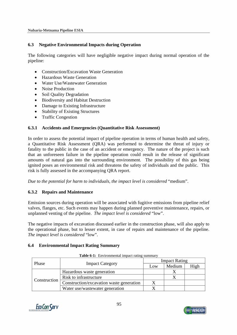
Nubaria-Metnama Pipeline ESIA
95
6.3 Negative Environmental Impacts during Operation The following categories will have negligible negative impact during normal operation of the pipeline:
Construction/Excavation Waste Generation Hazardous Waste Generation Water Use/Wastewater Generation Noise Production Soil Quality Degradation Biodiversity and Habitat Destruction Damage to Existing Infrastructure Stability of Existing Structures Traffic Congestion
6.3.1 Accidents and Emergencies (Quantitative Risk Assessment) In order to assess the potential impact of pipeline operation in terms of human health and safety, a Quantitative Risk Assessment (QRA) was performed to determine the threat of injury or fatality to the public in the case of an accident or emergency. The nature of the project is such that an unforeseen failure in the pipeline operation could result in the release of significant amounts of natural gas into the surrounding environment. The possibility of this gas being ignited poses an environmental risk and threatens the safety of individuals and the public. This risk is fully assessed in the accompanying QRA report. Due to the potential for harm to individuals, the impact level is considered “medium”. 6.3.2 Repairs and Maintenance Emission sources during operation will be associated with fugitive emissions from pipeline relief valves, flanges, etc. Such events may happen during planned preventive maintenance, repairs, or unplanned venting of the pipeline. The impact level is considered “low”. The negative impacts of excavation discussed earlier in the construction phase, will also apply to the operational phase, but to lesser extent, in case of repairs and maintenance of the pipeline. The impact level is considered “low”. 6.4 Environmental Impact Rating Summary
Table 6-1: Environmental impact rating summary
Phase Impact Category Impact Rating
Low Medium High
Construction
Hazardous waste generation X Risk to infrastructure X Construction/excavation waste generation X Water use/wastewater generation X
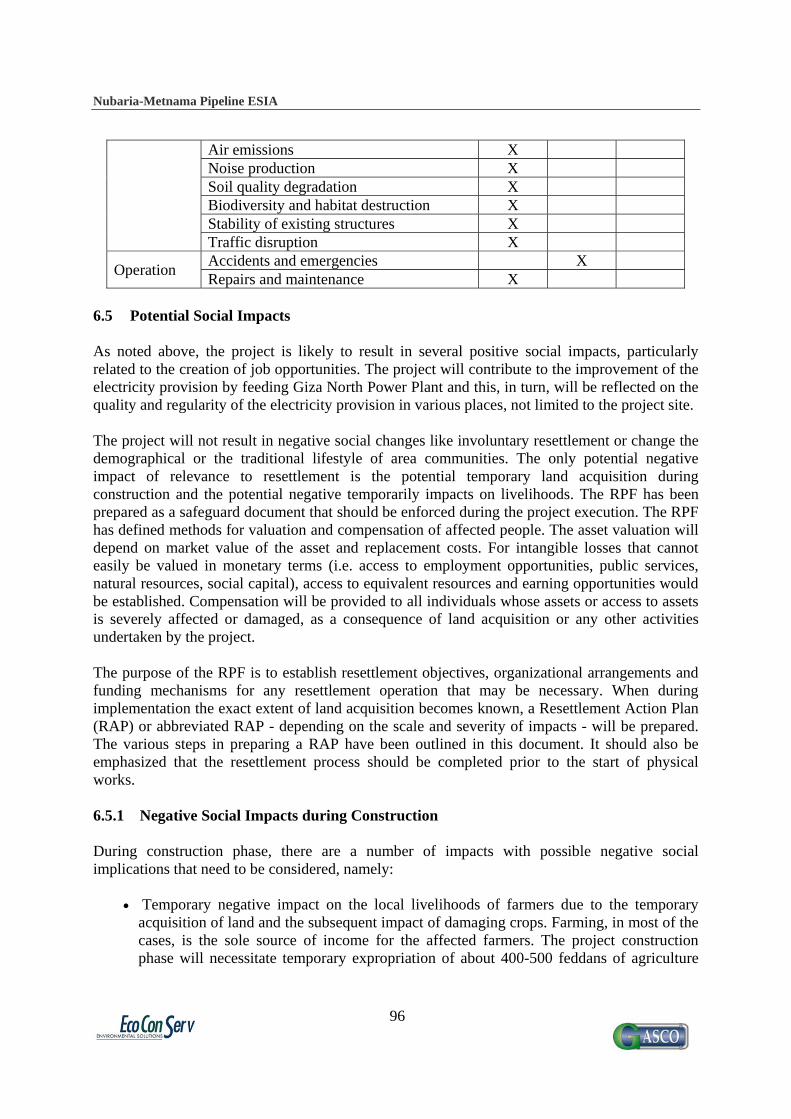
Nubaria-Metnama Pipeline ESIA
96
Air emissions X Noise production X Soil quality degradation X Biodiversity and habitat destruction X Stability of existing structures X Traffic disruption X
Operation Accidents and emergencies X Repairs and maintenance X
6.5 Potential Social Impacts As noted above, the project is likely to result in several positive social impacts, particularly related to the creation of job opportunities. The project will contribute to the improvement of the electricity provision by feeding Giza North Power Plant and this, in turn, will be reflected on the quality and regularity of the electricity provision in various places, not limited to the project site. The project will not result in negative social changes like involuntary resettlement or change the demographical or the traditional lifestyle of area communities. The only potential negative impact of relevance to resettlement is the potential temporary land acquisition during construction and the potential negative temporarily impacts on livelihoods. The RPF has been prepared as a safeguard document that should be enforced during the project execution. The RPF has defined methods for valuation and compensation of affected people. The asset valuation will depend on market value of the asset and replacement costs. For intangible losses that cannot easily be valued in monetary terms (i.e. access to employment opportunities, public services, natural resources, social capital), access to equivalent resources and earning opportunities would be established. Compensation will be provided to all individuals whose assets or access to assets is severely affected or damaged, as a consequence of land acquisition or any other activities undertaken by the project. The purpose of the RPF is to establish resettlement objectives, organizational arrangements and funding mechanisms for any resettlement operation that may be necessary. When during implementation the exact extent of land acquisition becomes known, a Resettlement Action Plan (RAP) or abbreviated RAP - depending on the scale and severity of impacts - will be prepared. The various steps in preparing a RAP have been outlined in this document. It should also be emphasized that the resettlement process should be completed prior to the start of physical works. 6.5.1 Negative Social Impacts during Construction During construction phase, there are a number of impacts with possible negative social implications that need to be considered, namely:
Temporary negative impact on the local livelihoods of farmers due to the temporary acquisition of land and the subsequent impact of damaging crops. Farming, in most of the cases, is the sole source of income for the affected farmers. The project construction phase will necessitate temporary expropriation of about 400-500 feddans of agriculture
Nubaria-Metnama Pipeline ESIA
97
land5 during the construction. It was very difficult to estimate the numbers of potentially affected people during this phase of the project. This will only be possible before the actual construction of the project and upon determining the exact route. During this stage a Resettlement Action Plan (RAP) should be prepared guided by the prepared RPF. The RAP will involve a full inventory survey for the PAPs and a valuation for the compensation that should be paid.
Permanent acquisition of land for the establishment of the valve rooms. In such cases, the common rule of GASCO is to provide full replacement cost for purchasing the land as per the market price under satisfactory, agreeable and appropriate agreement. It might be roughly suggested that each of the land plots (25m x 45 m) for each of the valve rooms is owned by one farmer. Based on this assumption, 11 farmers are expected to sell their land to GASCO for establishing the valve rooms.
Potential traffic congestion due to the accumulation of construction materials and dust that will result from digging. From a social prospective, this impact might affect the income of microbuses, small vehicles and taxi drivers.
Potential temporary inconvenience as result of the construction activities. This could be in the form of accumulation of wastes (both construction and domestic waste in the construction areas, associated odor, air emissions, especially dust as a result of excavation. These impacts are of temporary nature and will be of very limited level of severity, particularly since the construction activities will be in farms and not populated areas
Risks of damaging existing community infrastructure, especially water pipes that are not mapped, can have detrimental social repercussions. Disruption of other utility services such as electricity and communications can also be a nuisance to those affected.
6.5.2 Negative Social Impacts during Operation It is unlikely that the normal operation of the pipeline will create any significant negative social impacts. However, fears were expressed about the possibility that some leakage in the sites might affect the agricultural lands in the area or cause fires, and the potential damage to crops due to any needed work on the pipeline during operation phase. 6.5.3 Affected parties The affected parties or people affected by the project should be discussed in order to try to minimize any hardships they face due to project implementation.
It is foreseen that the affected parties will be mainly among farmers who will either be losing their income due to the temporarily expropriation of crop land or permanently due to selling it to GASCO for the valve rooms.
Moreover, there is the risk of work accidents and injuries to the construction workers during the construction phase. However, the probability of this risk is very low, since GASCO is very strict about the health and safety measures and they have their HSE guidelines which they follow strictly.
5 The calculation was based on the length of the line that will cross agriculture land multiplied by a width of 20 m for excavation.

Nubaria-Metnama Pipeline ESIA
98
6.5.4 Key Issues for Consideration 6.5.4.1 Transparency in the Valuation of Compensations The valuation of the damaged crops and ensuring satisfaction with the compensation are key issues that should be considered during planning for the project. It following, however, should be noted:
The Egyptian Government has a very efficient and fair system for crop compensation that goes in line with the World Bank Safeguard Policy.
GASCO also has a clear valuation system that was primarily based on the Ministerial Decree 347/2007 that declared the necessity of valuing the vegetation is the responsibility of each governorate and the previous experience of GASCO revealed that the majority of farmers who were compensated believe that they were offered fair compensations. The field visits revealed that according to the estimates provide by farmers during the field interviews, only 1% of those who were compensated were not satisfied and their cases was accelerated to disputes. Usually, GASCO overcome such cases through transparent sharing of information which is usually appreciated on the local level.
Transparency in the process of the damaged crops valuation is crucial as a proactive mechanism to eliminate any opportunities for disputes. This is elaborated in more details on the RPF. 6.5.4.2 Sensitivity to the Local Communities' Interests The interviews with GASCO staff and local farmers with previous experience for similar projects implemented by GASCO revealed that a socially sensitive approach is usually adapted by the company when it comes to the actual execution of the project. An instance on that is the flexibility that both GASCO and the contractor show with farmers during the actual execution of the project. Although GASCO does have a decree for temporary acquisition of lands which is issued prior to the implementation of the project, the contractor in several cases allow additional days for the farmers in order for them to harvest their crops.
"When we notice that a crop will be harvested in days, the contractor does his best to avoid working in the plot before the
harvest of the crops unless it will affect the time plan," reported an engineer at GASCO.
6.5.4.3 The Importance of Community Participation The preparation of the ESIA and the ESIA involved a several consultative activities. Local communities were approached, consulted and encouraged to spell out their views and concerns about the project. According to the various groups of the interviewed stakeholders, community participation in developmental projects is quite limited in Egypt and in particular, within this type of projects where the “public interest” prevail over the interests of the poorer groups.. The adapted participatory methodology was largely appreciated. Local people are afraid that the level

Nubaria-Metnama Pipeline ESIA
99
of participation might be declined when it comes to the actual implementation. This is a serious fear that might negatively affect local people's reactions towards the project. Measures, thus, should be considered in order to ensure the maximum level possible of local people engagement in the project. GASCO staff reported that the following measures are usually considered in order to ensure adopting a participatory and transparent approach with the local hosting communities:
Providing information about the project to the community in a timely manner Provision of a clear valuation strategy in order to settle any potential disputes with the
project affected people Provision of information about the owners of the crops in areas Working to mediate between the owners of crops and the Compensation Committee from
GASCO in order to facilitate their work Monitoring of any unfavorable attitudes during the implementation and report the
complaints to the monitoring department of the project GASCO also encourages the involvement of natural leaders like mayors of the villages
and their deputies, religious leaders, youth center managers, etc. The Agriculture Association is also a crucial party that they engage in the process of valuation, paying compensations and channeling complaints. GASCO also showed willingness to involve further grassroots organizations like local CBOs/NGOs located within the project localities. This level of involvement for the local stakeholders will play a role in eliminating the chance of disputes and grievance. This has been elaborated on the RPF as one of the proactive grievance redress mechanisms.

Nubaria-Metnama Pipeline ESIA
100
7. Environmental and Social Management Plan 7.1 Objectives of the ESMP The objective of the Environmental Management Plan (EMP) is to propose mitigation measures for expected negative impacts and to monitor the efficiency of these mitigation measures on relevant environmental indicators. Similarly, the goal of the Social Management Plan (SMP) is to construct guidelines for the avoidance of expected negative social impacts, and initiate a mechanism for implementing these guidelines when issue arise. As discussed before, the primary social impacts are those related to land expropriation and compensation, so the SMP is presented as the accompanying RPF report. The respective plans identify certain roles and responsibilities for different stakeholders for implementation, supervision and monitoring. 7.2 Institutional Framework for Implementation The project shall be implemented by the Egyptian Natural Gas Company (GASCO), an affiliate of the Egyptian Natural Gas Holding Company (EGAS), which owns a majority share. EGAS was established in 2001 as an entity focusing on developing Natural Gas business including upstream and downstream operations. EGAS has number of affiliate companies with different specialties in natural gas business chain. The organizational chart, Figure 7-1, of EGAS indicates that the responsibility of environmental management falls under the responsibility of Assistant Chairman for Safety and Environment, who supervise the General Manager for Environmental Protection and five environmental specialists.
Figure 7-1: Organizational chart for Environmental Protection Department in EGAS
Chairman
Assistant Chairman for Safety and Environment
General Manager for Environmental Protection
General Manager for Safety
Secretary Studies, Development and Information (2 Specialists)
Inspection and External Auditing (3 Specialists)

Nubaria-Metnama Pipeline ESIA
101
Being certified for ISO 14001:2004, EGAS has a well defined Environmental Management System in place and running. The Environmental Policy of EGAS mentions that the company and its affiliates are committed to:
Comply with legislation relevant to their nature of activity Provide training and awareness for their staff in order to carry out their work safely Achieve continual improvement in the fields of safety, health and environment Investigate and analyze incidents to prevent its recurrence Follow-up companies and contractors compliance and implementation of health, safety
and environment rules, regulations and provisions Provide necessary information and data on health, safety and environment Ensure execution of the policy through setting objectives, targets and an action plan. The
policy shall be reviewed whenever needed Staff members of EGAS carry out audits and inspections on affiliate companies, of which GASCO is one, to make sure the EMS is being implemented according to set objectives and targets. As part of the EMS procedures, GASCO presents monthly and quarterly reports about its environmental performance. EGAS reviews these reports, and makes occasional site inspections to compare these reports with field conditions. 7.2.1 Environmental Management Structure of Implementing Agency GASCO is also certified for ISO:14001 and OHSAS:18001, and has direct involvement in the environmental management and monitoring of the natural gas pipeline. One of the standard tasks of the HSE Department of GASCO, which is followed up by EGAS, is establishing Environmental Registers for facilities, and frequent auditing of this register. The Environmental Register is audited by the Environmental Department head of GASCO. The HSE Department performs audits twice annually on the average, in addition to infrequent and emergency inspections. The routine monitoring activities performed include:
Visual inspection of solid waste and scrap, and disposal methods Visual inspection of existence of liquid waste such as leaked condensate hydrocarbons or
chemicals used in the heaters Checking that handling of hazardous waste is according to the approved procedures,
which are described below Use gas analyzers to measure SO2, CO, CH4 and O2 in ambient air, and detect possible
leaks Noise measurements
GASCO HSE personnel have received training on environmental auditing, environmental impact assessments for industrial establishments, and environmental legislation. The Environmental Department of GASCO has been less involved on design, planning, tendering and construction procedures of natural gas connection projects. Their role has been more effective in the operational phase according to the described procedures above. However, the Safety Department in GASCO usually reviews designs, and assigns full time staff member to
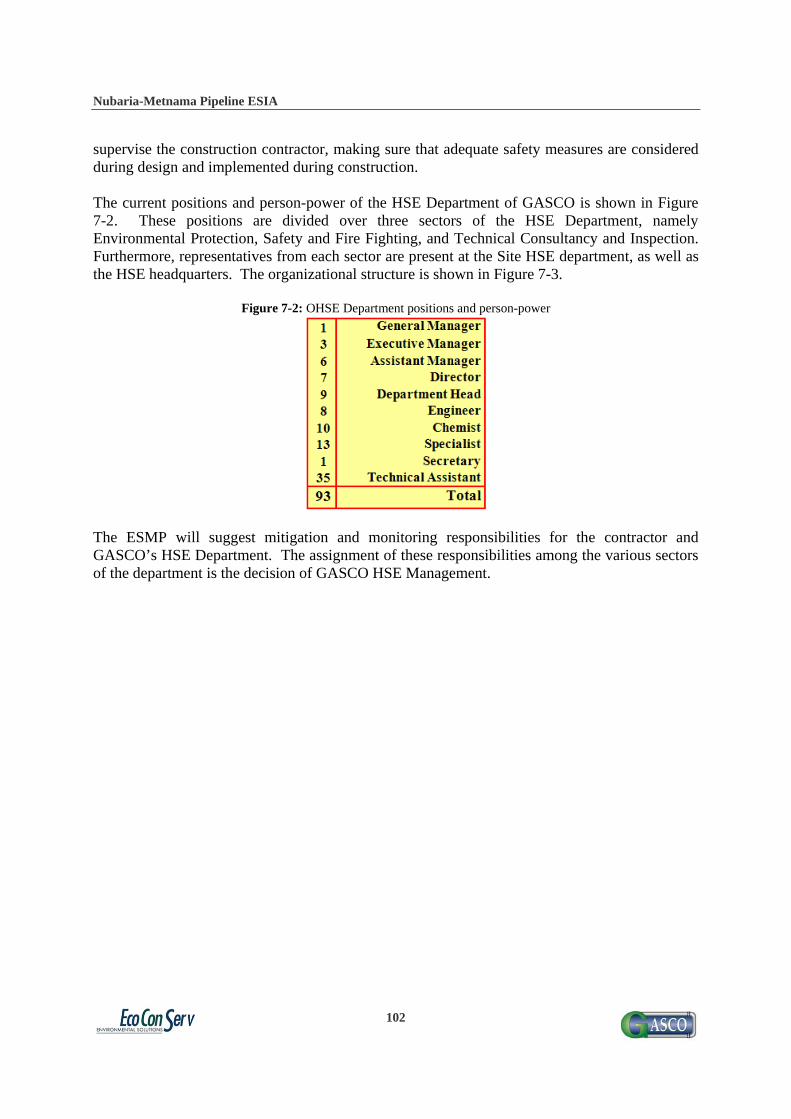
Nubaria-Metnama Pipeline ESIA
102
supervise the construction contractor, making sure that adequate safety measures are considered during design and implemented during construction. The current positions and person-power of the HSE Department of GASCO is shown in Figure 7-2. These positions are divided over three sectors of the HSE Department, namely Environmental Protection, Safety and Fire Fighting, and Technical Consultancy and Inspection. Furthermore, representatives from each sector are present at the Site HSE department, as well as the HSE headquarters. The organizational structure is shown in Figure 7-3.
Figure 7-2: OHSE Department positions and person-power
The ESMP will suggest mitigation and monitoring responsibilities for the contractor and GASCO’s HSE Department. The assignment of these responsibilities among the various sectors of the department is the decision of GASCO HSE Management.

Nubaria-Metnama Pipeline ESIA
103
Figure 7-3: GASCO OHSE organizational chart

Nubaria-Metnama Pipeline ESIA
104
7.2.2 Social Management Structure of Implementing Agency The analysis conducted during the preparation of the ESIA and the RPF showed clearly that the main impacts that should be carefully mitigated and addressed is the impact related to temporary and permanent land acquisition and the accompanying process of crops valuation and paying compensation. Currently, this process is done by GASCO through the Compensation Department, which participated in the formation of a Compensation Committee for the project. The ESIA team noted that although this department is fully aware of the acquisition and compensation issues and is adapting an approach which is very close to the Bank's requirements, certain specific considerations related to OP 4.12 are still not very clear for GASCO staff. The ESIA team suggests appointing a "Social Development Officer" who should be working on full time basis during the project construction to ensure the social management plan is sufficiently addressed. The Social Development Officer might be a GASCO staff with relevant background (e.g. a background in social development or social science). It is required that the "Social Officer" be aware of the World Bank safeguard policy on involuntary resettlement and the associated procedures. Training courses on participatory approaches and the aspects of OP 4.12 might be needed in order to build his/her capacity to efficiently follow up the implementation of the social management plan. The Social Development Officer will be working closely with the Consultant who will be preparing the RAP. 7.2.2.1 Social Development Officer The main roles and responsibilities of the Social Development Officer are as follows:
He/She is the primary person in charge of ensuring that the proposed social management plan is sufficiently considered and applied.
Develop detailed list of the local stakeholders and the NGOs representatives and maintain communication channels with them and ensure that they are engaged and consulted
Developing all the required techniques and formats to monitor the implantation of the social management plan
Report to the WB on the progress related to the ESMP and the safeguard policies including the fair compensation to PAPs
Assure transparent and timely sharing of information Review PAPs grievance and conduct regular feedbacks and meetings as a proactive and
early measure to eliminate disputes Follow up the progress to respond to the concerns of PAPs Work closely with local NGOs and other stakeholders to raise the awareness of local
communities on the safety of line and other related issues. This social management plan involves a monitoring process that will be the main responsibility of the Social Development Officer. The monitoring of the compensation process and the adherence to the safeguard policy OP 4.12 necessitates the development of some forms/templates in order to be able to process the management and monitoring system appropriately. This includes a Registration Form for affected plots, containing specific information to identify the owner and the approximate value of the crops. Also, a grievance form should be used to record

Nubaria-Metnama Pipeline ESIA
105
any complaints and ensure that action will be taken. Draft model for these forms are provided in Annex B. It should be noted that these forms should be updated by the Social Development Officer based on the actual needs. The results of the monitoring and management system should be reported quarterly to the Headquarter of GASCO. The monitoring and management will be implemented by the branches of GASCO in each governorate under the supervision of the Social Development Officer. In addition to appointing the Social Development Officer other local-based mechanisms are also suggested, mainly the establishment Compensation Committee with main objective of working as a safeguard mechanism to ensure that the interests of the poor and most vulnerable are protected and to ensure that the valuation and compensation process is as transparent as possible. 7.2.2.2 Compensation Committee The main roles and responsibilities of the Compensation Committee are as follows:
Supervise the inventory survey for the project affected persons (PAPs) that will be prepared as part of the RAP
Valuate the affected assets Estimate the amount of compensations to PAPs based on the collected information and
on the light of the prepared RPF (Egyptian legislations and the World Bank safeguard policy OP 4.12)
Prepare and disseminate lists of PAPs Obtaining approvals from GASCO on the planned compensation Apply proactive mechanism for grievance redress including transparent sharing of
information, carrying out consultative activities with the local communities and ensuring involvement of local leaders in resolving disputes.
Ensure that grievances are addressed Normally, this Committee (currently is formed under GASCO projects) is composed of a manager, an accountant and a lawyer. In order to ensure a more participatory role for this Committee, the following composition indicted on Box 7.2 is suggested The committee will be composed of the following members:
A representative from the GASCO (namely the Social Development Officer and the staff of the Compensation Department including the lawyer,
A representative from the Local Governorate Unit A representative from the contractor A representative from the Agriculture Association A representative from a local CBO or NGO Natural leader from the villages where the line is crossing
In cases of acceleration of disputes, a Supreme Compensation Committee with the responsibly of settling disputes could involve the same composition above headed by councilor from the

Nubaria-Metnama Pipeline ESIA
106
Supreme Court. It should be stressed here that all possible mitigation actions and procedures should be considered in order to prevent the in necessity of involving the Supreme Committee. 7.3 Management and Monitoring Activities during Construction Phase 7.3.1 Management of Hazardous Waste Generation 7.3.1.1 Mitigation Measures
It is recommended as a best environmental practice to segregate asphalt waste and to send it to an asphalt mixing plant for recycling. Because recycling of asphalt is not a common practice in Egypt, there are doubts that an asphalt plant will accept the waste. For such circumstances this recommendation should not be compulsory. In this case, asphalt waste could be disposed with construction waste according the previous procedures
As an important pollution prevention measure, fueling, lubricating or adding chemicals for excavation should not take place at the construction site except in necessary situations. In such situations, repairs and fueling of machinery should occur over impervious surface such as plastic sheeting, and empty containers of chemicals and lubricating oils should be collected and disposed in an approved hazardous waste facility. The contractor is required, according to the stipulations of Law 4/1994, to keep records and manifests for his management practices of such waste.
7.3.1.2 Monitoring Activities
Monitoring activities for ensuring sound waste management practices shall depend mainly upon observation of hazardous waste stockpiles to ensure how often they are removed from the site, and whether normal construction waste stockpiles contain hazardous components.
7.3.2 Management of Excavation Activities Posing Risk on Infrastructure If a line break occurs, the site manager gives immediate notification to the Police Department and the correspondent authority (according to the type of broken pipe). The authority then starts repairing the line as soon as possible, they claim repair costs back from the contractor later. 7.3.2.1 Mitigation Measures
Collecting most accurate maps for infrastructure routes, whenever available and making such data available to the contractor prior to commencing the works
Excavating manual trial pits in each street to allocated the pipes before using mechanical excavation
In case an infrastructure pipe is damaged, a documentation report shall be prepared for the accident, including:
a. Time and place of accident b. Name of contractor c. Type of infrastructure line

Nubaria-Metnama Pipeline ESIA
107
d. Description of accident circumstances and causes e. Actions taken and responses of different parties, such as infrastructure company f. Duration of fixing the damage g. Damage caused (description shall be according to observation, expertise
judgment, reports of infrastructure company) Analysis and statistics should be undertaken periodically for the accidents taken place,
with recommendations to reduce such risks in consequent excavation activities 7.3.2.2 Monitoring Activities Monitoring activities for such risk, is basically documenting, analyzing reasons that led to the accident and updating procedures to avoid future accidents. Monitoring environmental consequences of such accident, such as depth of effected soils, volumes of effected groundwater, and other social effects are believed to be unnecessary action, though it might be recommended for the authority owning the infrastructure line (Water and Sewage Authority or Telecommunication Authority) for their research activities. 7.3.3 Management of Construction/Excavation Waste Generation 7.3.3.1 Mitigation Measures
The contractor should communicate with the local authorities for officially assigning locations for the disposal of construction waste. Agreement on these sites should be reached prior to commencing construction works
A certain location in the construction site should be assigned for temporary storage or stockpiling of construction waste, in a convenient location close to the stretch of the pipeline that is being constructed. These areas should be agreed between the contractor and the HSE supervisor prior to starting construction works, and should be selected so as not to cause significant obstruction to traffic. The waste should be covered to prevent dust dispersion. No stockpiling is allowed on banks of waterways.
Waste should be hauled at the end of each working day to the allocated disposal site. Waste transportation should be undertaken by adequately equipped trucks. The HSE supervisor should make sure that the trucks are not overloaded and that the waste is adequately contained inside the rear box to prevent dust or particle movements from the truck. The supervisor should also occasionally inspect that the truck drivers are disposing the waste in the approved location, and not through practicing open dumping in the midway, through irregular visits and inquiries in the disposal site.
7.3.3.2 Monitoring Activities
Monitoring activities for ensuring sound waste management practices shall depend mainly upon observation of waste stockpiles of soil and construction waste to ensure how often they are removed from the site, and whether they contain hazardous components.
7.3.4 Management of Water Use/Wastewater Generation

Nubaria-Metnama Pipeline ESIA
108
7.3.4.1 Mitigation Measures
Drainage of dewatering water should be pre-planned, and the necessary permits acquired from the local sewage or irrigation authority.
If dewatering is taking place from a contaminated trench, or contains hydrocarbons that could be observed or smelled, it should be collected in barrels and transported to a wastewater treatment facility for special treatment.
All chemical streams, rinses and drains shall be contained or shall be collected in suitable vats or tanks. No streams shall be allowed to drain upon the ground. Approval must be obtained prior to start draining any material to an existing sewer system.
7.3.4.2 Monitoring Activities
Field observation of oily appearance and possibly smell would indicate whether to classify this water as hazardous waste, and determine whether it should be sent to an appropriate treatment plant.
7.3.5 Management of Air Emissions 7.3.5.1 Mitigation Measures
In areas of loose sandy soils the contractor should provide a source of water for spraying soil before excavation, filling, loading and unloading. If the site supervisor notices a visual/sensible increase of dust emissions, he should ask for additional spraying of water in the spot generating high emissions
Excavated soil stockpiles and stored sand should be located in sheltered areas, sprayed with water and covered with appropriate covering material, such as polyethylene or textile sheets to avoid soil dispersion
Transportation of excavation/construction waste should be through licensed and sufficiently equipped vehicles with suitable special box or an air-tight cover to prevent loose particles of waste and debris from escaping into the air or dropping on the road
Air emissions of excavation machinery should be within the standards of the executive regulations of Law 4/1994, which are presented in Table 2-5. This can be ensured with a regular check-up and maintenance schedule.
Avoid or minimize traffic congestion on main roads during periods of air quality crises, such as during autumn (the black cloud) and during spring (Khamasin winds).
It is recommended that GASCO consider implementing a Mobile Health Care Unit in potentially affected areas in order to provide the needed treatment to the people in those communities which may experience some negative health impacts due to the dispersion of air emissions and fugitive dust.
7.3.5.2 Monitoring Activities
Monitoring of air emissions impacts can be done through periodic inspection of vehicle maintenance schedules, and on-site observation of black smoke being produced from any machinery

Nubaria-Metnama Pipeline ESIA
109
7.3.6 Management of Noise Production 7.3.6.1 Mitigation Measures
Working hours for workers exposed to noise equipment should be designed so that noise exposure periods do not exceed the safe limits as described by the legal standards in Tables 2-1 and 2-2 in Section 2
Workers that operate noisy machines or worker near them should be supplied with earmuffs and should be instructed to put them on when they get into noisy zones. Contractors should be responsible to instruct their workers to abide to this role, and the site supervisor should make sure the contractor is compliant with this role.
Minimize construction through nighttime whenever possible, while working in populated areas. Implementing this measure should be balanced with avoiding peak hours of heavy traffic. If construction works are to take place in important traffic roads, avoiding traffic disturbance in day time may overweigh reducing noise levels in afternoon or night times and vice versa.
7.3.6.2 Monitoring Activities
Monitoring of noise impacts consists of periodic observation of the extent of implementation of the above mitigation measures
7.3.7 Management of Soil Quality Degradation 7.3.7.1 Mitigation Measures
Proper handling of hazardous liquids to avoid spilling or leaks is critical to reducing the chances of soil contamination. Appropriate measures should be taken as describe in Section 7.3.2.
7.3.7.2 Monitoring Activities
Recording incidents of spills or leaks and periodically analyzing the data Once construction has finished, the pipeline route should be revisited to ensure that the
land has returned to normal agricultural production. These observations can be performed as part of the pipeline patrolling and leakage surveying, described in Section 7.7.1.
7.3.8 Management of Biodiversity and Habitat Destruction 7.3.8.1 Mitigation Measures
Refilling the dug trench-line to the same original level of the surface will help to mitigate the impact of making barriers which affect both habitat utilization and distribution of the fauna, and will allow plant species to resume growing on the disturbed land

Nubaria-Metnama Pipeline ESIA
110
7.3.8.2 Monitoring Activities
Because of the low significance of this impact, monitoring in construction sites will not be required.
7.3.9 Management of Dewatering and Tunneling Activities Posing Risk to Structural
Stability 7.3.9.1 Mitigation Measures
For areas screened as including buildings with potential structural problems, in which dewatering (in case groundwater table is high) or tunneling works (in special crossings) will take place, a survey of building status should be undertaken. A list of structures with damage potential should be prepared
Undertake soil investigation program using representative bore holes for soil classification and identification of groundwater depth.
For tunneling process, choosing the location of the jacking and receiving shafts as well as the path of the tunnel, the type of support and the type of tunneling machine should consider the status of surrounding buildings and soil type. Precautions for launching the tunneling machine and recovering it should be clearly stated and submitted showing the steps taken to prevent soil from entering the shaft.
7.3.9.2 Monitoring Activities
Continuous monitoring of the tunneling process by observing the amount of soil excavated versus the advance of the tunneling machine and continuous monitoring of the line and level of the tunneling machine.
If necessary, surveys of structural status of buildings and performing soil investigations shall be undertaken under the supervision of a structural consultancy firm.
7.3.10 Management of Traffic Congestion 7.3.10.1 Mitigation Measures
Whenever road obstruction is necessary due to lateral excavation or otherwise, informational and directional signs should be posted prior to the construction zone so that drivers can react in due time and maintain safe driving. The Egyptian Road Code of Practice (Ministry of Housing, 1998) provides standard arrangements of construction zones. Markings, in the form of lane lines and directional arrows are also needed to guide the drivers to the proper lane changes and turning. Pedestrian crossings can be also provided at proper locations as dictated by each site.
An agreement between contractors and the site supervisor should be reached about the suitable location for temporary storage of construction materials, equipment, tools and machinery prior to starting construction of each reach of the power lines. No storage of construction materials or electric tools should be allowed in traffic lanes
Nubaria-Metnama Pipeline ESIA
111
When crossing a road via the open-cut method, alternative roads for entrance to the farms should be developed, and the crossing should be done after arrangement with the owners of these farms. Work should be conducted when there is not high traffic movement on the road.
In case a narrow road needs to be occupied for limited period (for example by loading/unloading trucks or loaders) the occupation time should be minimized and alternative routes should be facilitated for villagers.
The contractors should make sure that the employed drivers of construction machinery (such as trucks and loaders) have received sensitization/training on safety utilization of their machines in order to minimize accidents risks.
7.3.10.2 Monitoring Activities
All above mitigation measures should be implemented in coordination with Traffic Departments of the appropriate governorate.
7.3.11 Management of Social Impacts 7.3.11.1 Mitigation Measures
Open consultation with the public during the assessment and design stages will help ensure that concerns are met, and future disputes/disagreements are avoided.
A fair compensation plan and grievance mechanism has been set forth in the accompanying RPF report, which is meant to compensate for any temporary or permanent negative impacts that might be experienced by the PAPs.
Registration of affected parties, and prompt recording and response to complaints is essential to minimizing social discontent.
7.3.11.2 Monitoring Activities
Inspection of compensation documentation, including lists of affected parties, compensation receipts, and grievance forms
7.4 Mitigation and Monitoring Tables A matrix illustrating management and monitoring activities during construction, proposed responsibilities of different stakeholders and approximate costs are given in Tables 7-1 and 7-2. Compliance with the roles and responsibilities set forth in these tables should be incorporated into any agreements made with contractors that will be working on site. Where the responsibility of mitigation or monitoring falls on the contractor, the cost will be included in the normal bid price of the contract.

Nubaria-Metnama Pipeline ESIA
112
Table 7-1: Environmental mitigation matrix during construction
Impact Mitigation measures Responsibility of mitigation
Responsibility of direct supervision
Estimated Cost
Hazardous waste generation
Separation of asphalt waste, arrange for asphalt recycling
Contractor GASCO HSE Site supervisor Contractor cost
Vehicle repairs and fuelling off site, on appropriate surfaces
Contractor GASCO HSE Site supervisor Contractor cost
Approved storage and disposal of chemical and lubricant containers
Contractor GASCO HSE Site supervisor Contractor cost
Risk of damaging infrastructure
Consult maps before excavation work
Contractor GASCO HSE Site supervisor Contractor cost
Use of trial pits Contractor GASCO HSE Site supervisor Contractor cost Analysis of accident log Contractor GASCO HSE Site supervisor Contractor cost
Construction/ Excavation waste generation
Identification and use of approved nearby disposal sites through local authority
Contractor GASCO HSE Site supervisor Contractor cost
Designation and use of appropriate stockpiling locations on site
Contractor GASCO HSE Site supervisor Contractor cost
Daily hauling of waste to disposal site in covered trucks
Contractor GASCO HSE Site supervisor Contractor cost
Water use/wastewater generation
Acquire discharge permits from sewage/irrigation authority
Contractor GASCO HSE Site supervisor Contractor cost
Collection of potentially contaminated streams in separate tanks
Contractor GASCO HSE Site supervisor Contractor cost
Air emissions
Water spraying before excavation, filling, loading and unloading
Contractor GASCO HSE Site supervisor Contractor cost
Spraying of stockpiles, storage in covered areas
Contractor GASCO HSE Site supervisor Contractor cost
Implementation of regular maintenance schedule for machinery
Contractor GASCO HSE Site supervisor Contractor cost
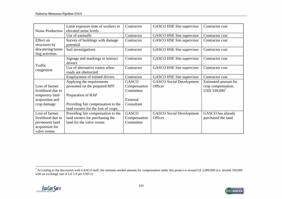
Nubaria-Metnama Pipeline ESIA
113
Noise Production Limit exposure time of workers to elevated noise levels
Contractor GASCO HSE Site supervisor Contractor cost
Use of earmuffs Contractor GASCO HSE Site supervisor Contractor cost Effect on structures by dewatering/tunneling activities
Survey of buildings with damage potential
Contractor GASCO HSE Site supervisor Contractor cost
Soil investigations Contractor GASCO HSE Site supervisor Contractor cost
Traffic congestion
Signage and markings to instruct drivers
Contractor GASCO HSE Site supervisor Contractor cost
Use of alternative routes when roads are obstructed
Contractor GASCO HSE Site supervisor Contractor cost
Employment of trained drivers Contractor GASCO HSE Site supervisor Contractor cost
Loss of farmer livelihood due to temporary land acquisition and crop damage
Applying the requirements presented on the prepared RPF Preparation of RAP Providing fair compensation to the land owners for the loss of crops.
GASCO Compensation Committee External Consultant
GASCO Social Development Officer
Estimated amount for crop compensation: USD 339,0007
Loss of farmer livelihood due to permanent land acquisition for valve rooms
Providing fair compensation to the land owners for purchasing the land for the valve rooms
GASCO Compensation Committee
GASCO Social Development Officer
GASCO has already purchased the land
7 According to the discussion with GASCO staff, the estimate needed amount for compensation under this project is around LE 2,000,000 (i.e. around 339,000 with an exchange rate of LE 5.9 per USD 1)

Nubaria-Metnama Pipeline ESIA
114
Table 7-2: Environmental monitoring matrix during construction
Impact Monitoring indicators
Responsibility Frequency/ Duration
Location Methods Estimated Cost
Construction/ excavation and hazardous waste generation
Use of designated stockpile locations
Contractor Weekly Construction site
Site observation
Contractor cost
Separation of hazardous waste components
Contractor Weekly Construction site
Site observation
Contractor cost
Quantity and type of waste generated
Contractor Daily Construction site
Recording of daily hauling statistics
Contractor cost
Risk of damaging infrastructure
Frequency and location of damage incidents
Contractor Monthly Documentation offices
Documentation in HSE monthly reports
Contractor cost
Water use/ wastewater generation
Quantity of wastewater/sewage discharge from administrative camp
Contractor Daily Construction site
Recording of daily discharge amounts
Contractor cost
Quantity of water diverted for testing
Contractor Continuous during testing
Construction site
Flow rate measurements
Contractor cost
Oily appearance or smell of wastewater stream
Contractor Continuous during testing
Construction site
Site observation
Contractor cost
Contaminant concentrations in wastewater streams
Contractor Upon detection of oily appearance or smell
Approved water treatment lab
Chemical analysis
USD 8408
Air emissions Inspection of vehicle and
Contractor Quarterly Documentation offices
Review of schedule
Contractor cost
8 A single sample costs approximately EGP 500, with 10 separate pipeline sections to be tested, the maximum costs is estimated to be EGP 5,000.

Nubaria-Metnama Pipeline ESIA
115
Impact Monitoring indicators
Responsibility Frequency/ Duration
Location Methods Estimated Cost
machinery maintenance schedule HC, CO% and opacity
Contractor Once before construction, once quarterly for each vehicle
Vehicle maintenance site
Emissions testing
Contractor cost
Noise Production
Noise intensity, exposure durations and noise impacts
Contractor Quarterly, at least one measurement per contractor per sector
Construction site
Noise recording, reporting in monthly reports
Contractor cost
Complaints from residents
Contractor Quarterly Construction site
Inspection of filed complaints
Contractor cost
Use of earmuffs by construction workers
Contractor Weekly Construction site
Site observation
Contractor cost
Effect on structures by dewatering/ tunneling activities
Amount of soil present in wastewater stream
Contractor As necessary during dewatering/ tunneling
Construction site
Inspection of water from dewatering or tunneling
Contractor cost
Loss of farmer livelihood due to
Complaints and grievances from
GASCO Social Development
Weekly Project Site
Review list of PAPs, receipts,
No additional cost required 9
9 Since the Social Officer will be one of GASCO Staff, appointing this person on the project should not associate with additional costs

Nubaria-Metnama Pipeline ESIA
116
Impact Monitoring indicators
Responsibility Frequency/ Duration
Location Methods Estimated Cost
temporary land acquisition and crop damage
PAPs about fair compensation and procedures
Officer Compensation Committee
Documentation offices
grievances, and follow up forms
Loss of farmer livelihood due to permanent land acquisition for valve rooms
Complaints and grievances from PAPs about fair compensation and procedures
GASCO Social Development Officer Compensation Committee
Weekly during the phase of project preparation until the purchase of land is done
Project Site Documentation offices
Review list of PAPs, receipts, grievances, and follow up forms
GASCO regular management cost

Nubaria-Metnama Pipeline ESIA
117
7.5 Management and Monitoring Activities during Operation Phase 7.5.1 Management of Accidents and Emergencies A large part of mitigating the possibility of an accident or emergency is regular monitoring of nearby activities that may threaten the safe operation of the line, as well as monitoring of the performance to ensure against leaks that may lead to any of the scenarios identified in the QRA. GASCO has ensured that it will take all reasonable precautions to safeguard its pipeline and to protect the people living in the vicinity of its pipelines. GASCO will be fully responsible for monitoring and securing the entire length of the pipeline outside of the power stations, but it should be noted that it is the responsibility of the electricity authority to monitor any components inside the power stations. A full description of the technical design measures used to mitigate against the risk of operational failures is provided in the QRA report. The following general measures are recommended:
The emphasis on risk reduction should be on preventative measures, i.e. to minimize the potential for leaks to occur. This would chiefly be achieved through appropriate design (to recognized standards) and through effective inspection, testing and maintenance plans / procedures.
Rapid isolation of significant leaks will not eliminate the risks but will help to minimize the hazards and, particularly, the ignition probability (by limiting the total mass of flammable vapor released). For isolation to be effective, first requires detection to occur and hence best practice fire and gas detection systems, with associated shutdown systems and procedures, will be important mitigation measures.
7.5.1.1 Pipeline Patrolling Pipeline patrolling shall be carried out in order to identify activities or actions that could damage the pipeline. Patrolling will also identify areas of concern, such as land erosion in the general vicinity of the pipeline and the subsequent risks it poses. The frequency of the patrol will vary for differing areas. In desert regions, minimal work is conducted around the pipeline. In urban areas where there is a lot of excavation activity on water mains and sewers, the frequency of inspection shall be the highest. The pipeline patrolmen will carry out vehicle and walking surveys along the pipeline route, at the following frequencies:
Table 7-3: Frequency of patrol, reference: GASCO
PIPELINE LOCATION VEHICULAR WALKING Location Class 1 6 Months No survey Location Class 2 1 Month Vehicular
accessible areas inc canal and river crossings
6 Months Arable land, AGIs, valve rooms, crossings, sleeves
Location Class 3 2 Weeks Survey all areas Location Class 4 2 Weeks Survey all areas

Nubaria-Metnama Pipeline ESIA
118
The patrol will observe and report findings to the Sector Office on a daily basis and where the safety of the pipeline is at risk, notification will be as soon as possible. The patrol will be issued with written authorization to instruct other people affecting and the safety of GASCO property, to stop their work or actions immediately. The patrolman will need to complete a written daily report. These will be logged again on a daily basis, in the Area Office. These daily reports will be audited on a random basis by the patrol's supervisor. The survey diary, issued to each Patrolman, will also be completed by the end of each day. The survey diary will contain all observations along the pipeline route for a particular day. This diary will be used as a check by the patrol supervisor. All necessary permits or permission will be obtained from landowners, farmers, railways, etc. prior to starting work. The patrol will ensure that he holds a valid identity card or letter of authorization. In addition to watching and reporting on the pipelines, the patrol will establish a good liaison with farmers and landowners along the pipeline route. It is not the intent to specifically test for the presence of leakage with gas detection equipment during patrolling. 7.5.1.2 Leakage Survey The leakage survey shall be conducted to protect the population and staff against the effects of escaping gas and to detect damage to the pipeline. The survey shall therefore be conducted where the pipeline runs close to buildings and where staff work. These surveillance methods will be supported by two report sheets: one for each day of the survey for patrolling duties, and one for leakage survey duties. These two sheets are designed to be the only documentation the operative needs to perform the task. The locations for both surveys and the frequency of the leakage survey must be determined in advance by a qualified engineer and reviewed at least annually. The engineer must also fully classify all pipeline routes according to ASME 31.8 within 6 months of implementation of these surveillance methods. Where the two surveys coincide in terms of frequency they can be combined into a Patrol and Leakage survey. It is essential to take all reasonable precautions to reduce the risk of pipelines being struck or damaged. The inspection and surveillance, applied to a particular section of a pipeline, should reflect the likelihood of such damage at that location and the type of frequency levels should be regularly reviewed at intervals not exceeding two years. All staff undertaking the patrol duties and the leakage surveys must be fully trained before carrying out these duties. 7.5.1.3 Emergency Response GASCO already has its own Emergency Preparedness and Response Procedures which instructs workers on how to identify the potential occurrence of accidents and emergency situations and how to respond to each. These procedures also include mitigating actions needed for dealing with and reducing the risks and impacts that may be associated with emergency situations. The

Nubaria-Metnama Pipeline ESIA
119
procedures cover all emergency situations at all GASCO sites and premises. The plan includes the following aspects:
Overview of emergency management Emergencies classes brief description Key personnel responsibilities Typical site emergency procedure Emergency communication plan
The GASCO HSE General Manager coordinates with all GASCO sites to review and updated a plan at least once a year, and all GASCO sites are provided with sufficient and suitable facilities and capabilities needed for emergency situations. These facilities may be some or all of the following:
Fire fighting equipments Fire fighting systems & automatic safety control systems Personal protective equipments A clinic center or first aid materials.
Such facilities are checked periodically by HSE site department for adequacy and validity. Arrangements with neighbor community working field sites are agreed and considered, under the umbrella of GASCO and EGAS, to integrate emergency preparedness facilities and capabilities to overcome any actual happening accidents. Experimental drilling takes place periodically according to contingency plan requirements. A report of each drill results is made by HSE dept. and introduced for debate in the nearest HSE Meeting. Training programs are planned and performed for the purpose of raising staff awareness of emergency subjects, right behavior to avoid accidents and correct the response to emergency cases. Results of any actual accidental situations are reported by the HSE department and discussed in the nearest HSE general department meeting. Related documents and procedures should be revised after actual accidental situations to insure its adequacy. Drill reports and emergency case reports (emergency response practices evaluation sheets) are maintained by the site’s HSE department. 7.5.2 Management of Repairs and Maintenance The same mitigation and monitoring measures discussed for the construction phase shall also apply to repair and maintenance works that will require excavation. 7.5.3 Management of Social Impacts 7.5.3.1 Mitigation Measures

Nubaria-Metnama Pipeline ESIA
120
In cases where the land where the lines or their right of way of 6 meters from both sides
pass enter into urban boundaries, GASCO should purchase the land from the owners in order to ensure the safety of the line. In this case, GASCO should purchase the land in full market price and this is regarded as a permanent land acquisition.
For the mitigation of any crops damage in the areas due to monitoring work should be compensated according to the RPF, and in line with the rules and regulations of the Egyptian Laws, the World Bank safeguards and the strategy of GASCO. Damage to agricultural lands will be compensated only for the affected crops.
Local Governorate Unit (LGUs) should ensure that the roads are paved immediately after finishing the installation to avoid any further congestion and disturbances.
To mitigate the unlikely incidence of fires, there is a need for full compliance with maximum safety measures and close monitoring of the site.
Raising the level of awareness of the people in the project areas through different media channels and with the help of local NGOs.
During the operation phase, it is recommended to monitor the line, especially to make sure that no one tries to build on the routes of the line. Moreover, in case of changing the farm land into construction land, the appropriate compensation should be applied by the Supreme Committee for Compensation in order to limit the unfavorable impacts of the project. 7.6 Management and Monitoring Tables for Operation A matrix illustrating management and monitoring activities during operation, proposed responsibilities of different stakeholders and approximate costs are given in Tables 7-4 and 7-5.
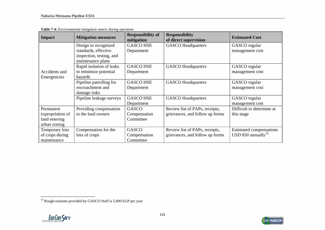
Nubaria-Metnama Pipeline ESIA
121
Table 7-4: Environmental mitigation matrix during operation
Impact Mitigation measures Responsibility of mitigation
Responsibility of direct supervision
Estimated Cost
Accidents and Emergencies
Design to recognized standards, effective inspection, testing, and maintenance plans
GASCO HSE Department
GASCO Headquarters GASCO regular management cost
Rapid isolation of leaks to minimize potential hazards
GASCO HSE Department
GASCO Headquarters GASCO regular management cost
Pipeline patrolling for encroachment and damage risks
GASCO HSE Department
GASCO Headquarters GASCO regular management cost
Pipeline leakage surveys GASCO HSE Department
GASCO Headquarters GASCO regular management cost
Permanent expropriation of land entering urban zoning
Providing compensation to the land owners
GASCO Compensation Committee
Review list of PAPs, receipts, grievances, and follow up forms
Difficult to determine at this stage
Temporary loss of crops during maintenance
Compensation for the loss of crops
GASCO Compensation Committee
Review list of PAPs, receipts, grievances, and follow up forms
Estimated compensations USD 850 annually10
10 Rough estimate provided by GASCO Staff is 5,000 EGP per year

Nubaria-Metnama Pipeline ESIA
122
Table 7-5: Environmental monitoring matrix during operation
Impact Monitoring indicators
Responsibility Frequency/ Duration
Location Methods Estimated Cost
Accidents and Emergencies
Performance of regular maintenance
GASCO HSE Department
Quarterly Documentation offices
Inspection of maintenance schedule
GASCO regular management cost
Buildings on RoW, land alterations
GASCO Inspection Department
Twice monthly for populated areas12
Pipeline route Site observation, inspection of permits
GASCO regular management cost
Leakage noise, pipeline pressure, etc.
GASCO Inspection Department
Twice monthly for populated areas13
Pipeline route Leakage detection tools
GASCO regular management cost
Permanent expropriation of land entering urban zoning
PAP registration Compensation forms
GASCO Headquarter and Regional branches
Quarterly Project Site Documentation offices
Site observation and coordination with the LGUs
GASCO regular management cost
Temporary loss of crops during maintenance
PAP registration Compensation forms
GASCO Headquarter and Regional branches, Compensation Committee
Quarterly Project Site Documentation offices
Affected land plots Compensation offered Documentation that prove receiving compensation
GASCO regular management cost
12 See Table 7-3, above. 13 See Table 7-3, above.
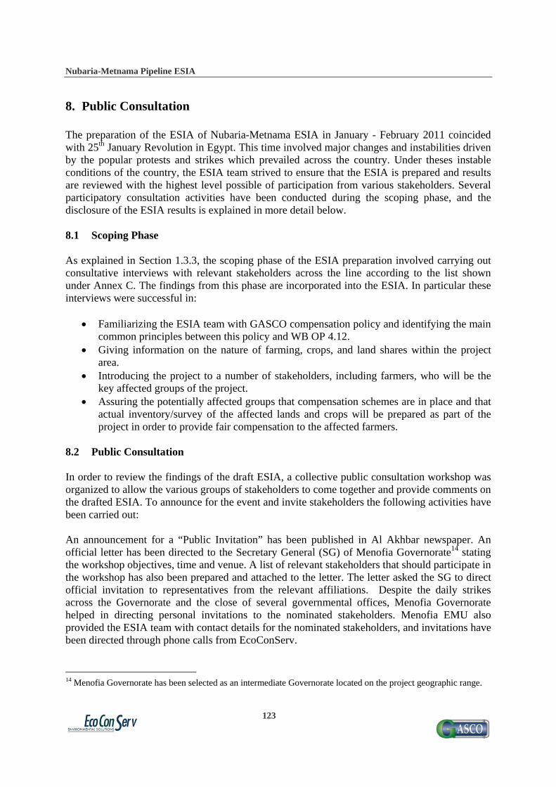
Nubaria-Metnama Pipeline ESIA
123
8. Public Consultation The preparation of the ESIA of Nubaria-Metnama ESIA in January - February 2011 coincided with 25th January Revolution in Egypt. This time involved major changes and instabilities driven by the popular protests and strikes which prevailed across the country. Under theses instable conditions of the country, the ESIA team strived to ensure that the ESIA is prepared and results are reviewed with the highest level possible of participation from various stakeholders. Several participatory consultation activities have been conducted during the scoping phase, and the disclosure of the ESIA results is explained in more detail below. 8.1 Scoping Phase As explained in Section 1.3.3, the scoping phase of the ESIA preparation involved carrying out consultative interviews with relevant stakeholders across the line according to the list shown under Annex C. The findings from this phase are incorporated into the ESIA. In particular these interviews were successful in:
Familiarizing the ESIA team with GASCO compensation policy and identifying the main common principles between this policy and WB OP 4.12.
Giving information on the nature of farming, crops, and land shares within the project area.
Introducing the project to a number of stakeholders, including farmers, who will be the key affected groups of the project.
Assuring the potentially affected groups that compensation schemes are in place and that actual inventory/survey of the affected lands and crops will be prepared as part of the project in order to provide fair compensation to the affected farmers.
8.2 Public Consultation In order to review the findings of the draft ESIA, a collective public consultation workshop was organized to allow the various groups of stakeholders to come together and provide comments on the drafted ESIA. To announce for the event and invite stakeholders the following activities have been carried out: An announcement for a “Public Invitation” has been published in Al Akhbar newspaper. An official letter has been directed to the Secretary General (SG) of Menofia Governorate14 stating the workshop objectives, time and venue. A list of relevant stakeholders that should participate in the workshop has also been prepared and attached to the letter. The letter asked the SG to direct official invitation to representatives from the relevant affiliations. Despite the daily strikes across the Governorate and the close of several governmental offices, Menofia Governorate helped in directing personal invitations to the nominated stakeholders. Menofia EMU also provided the ESIA team with contact details for the nominated stakeholders, and invitations have been directed through phone calls from EcoConServ.
14 Menofia Governorate has been selected as an intermediate Governorate located on the project geographic range.
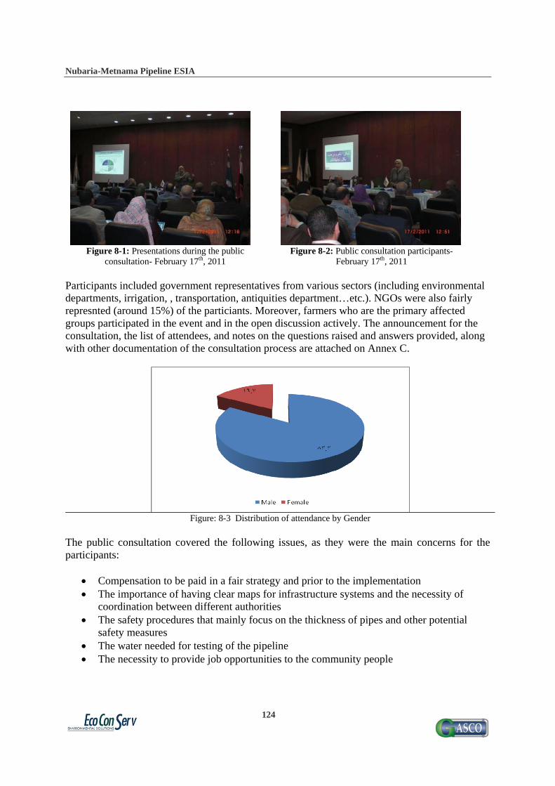
Nubaria-Metnama Pipeline ESIA
124
Figure 8-1: Presentations during the public consultation- February 17th, 2011
Figure 8-2: Public consultation participants- February 17th, 2011
Participants included government representatives from various sectors (including environmental departments, irrigation, , transportation, antiquities department…etc.). NGOs were also fairly represnted (around 15%) of the particiants. Moreover, farmers who are the primary affected groups participated in the event and in the open discussion actively. The announcement for the consultation, the list of attendees, and notes on the questions raised and answers provided, along with other documentation of the consultation process are attached on Annex C.
Figure: 8-3 Distribution of attendance by Gender
The public consultation covered the following issues, as they were the main concerns for the participants:
Compensation to be paid in a fair strategy and prior to the implementation The importance of having clear maps for infrastructure systems and the necessity of
coordination between different authorities The safety procedures that mainly focus on the thickness of pipes and other potential
safety measures The water needed for testing of the pipeline The necessity to provide job opportunities to the community people

Nubaria-Metnama Pipeline ESIA
125
8.3 Corporate Social Responsibility According to the interviews with GASCO team, the company is willing to invest in Corporate Social Responsibility (CSR) activities for the hosting communities. Several ideas have been discussed including the implementation of health care and awareness raising campaigns for local residents during the construction phase. GASCO is planning to carry out a more comprehensive needs assessment survey prior to the start of the projects in order to obtain further information that could help them in deciding upon the most appropriate demand-driven CSR interventions. Since their approach is usually interactive and participatory, GASCO believes that the direct involvement of stakeholders will result in an innovative and realistic list of CSR initiatives.

Nubaria-Metnama Pipeline ESIA
126
Annex A: Baseline Social Data

Nubaria-Metnama Pipeline ESIA
127
The following are some tables that describe the three governorates excluding 6th of October due to the limited information provided. Table A-1: Administrative Division
Qalubia Menoufia Behera
No. of Marakz 7 9 15
No. of Cities 10 10 15
No. of Districts 2 2 0
No. of Rural Local Units 47 70 84
No. of Villages 197 315 497
Villages Outside Local Units 0 0 6
No. of Hamlets 900 901 5737
Source: Description of Egypt by Information 2007 Information and Decision Support Center

Nubaria-Metnama Pipeline ESIA
128
Table A-2: Land Use
Unit Qalubia Menoufia Behera
Total area Km2 1124.28 2499.0 9826
Total populated area Km2 1072.72 2435.93 7093.84
Housing and scattering areas Km2 110.13 103.14 163.04
Facilities and cemeteries Km2 65.45 103.39 129.54
Ponds and fallow Km2 1.02 5.17 188.54
Agricultural land within agricultural borders Km2 807.23 1366.76 4019.26
Agricultural land outside agricultural Km2 88.89 857.47 2593.46
Population density in the populated area 1000 persons/ Km2 3.95 1.34 0.67
Population density in the total area 1000 persons/ Km2 3.77 1.31 0.48
Populated area (% of total area) % 95 97.5 72.2
Source: Description of Egypt by Information 2007 Information and Decision Support Center

Nubaria-Metnama Pipeline ESIA
129
Table A-3: Population
Unit Qalubia Menoufia Beheira
Total population Thousand persons 4386.8 3374.2 4900.9
Females (% of total population) % 48.6 48.5 48.7
The average of family members Person 4 4.2 4.3
Birth rate Live birth/ Thousand persons 26.1 24.8 24.3
Mortality rate Dead person/ Thousand persons 5.4 6.1 5.2
Population natural growth rate Per thousand persons 20.7 18.7 19.1
No. of marriage contracts Contract/ 100 thousand persons 694.3 1085.3 989.3
No. of divorce incidents Incident/ 100 thousand persons 98.9 83.3 83.2
*Source: Egyptian Human Development Report 2010 Source: Description of Egypt by Information 2007 Information and Decision Support Center

Nubaria-Metnama Pipeline ESIA
130
Table A-4: Major Crops 2006
unit Qalubia Menoufia Beheira
Area Production Productivity Area Production Productivity Area Production Productivity
Rice 1000 tons
32.20 112.13 3.48 --- --- --- 217 899.2 4.1
Cotton 1000 quintars
8.15 41.24 5.06 22.96 126.28 5.50 145 873.4 6.0
Wheat 1000 ardabs
48.80 873.47 17.90 109.06 2137.58 19.60 501.1 9050.8 18.1
Bean 1000 ardabs
--- --- --- --- --- --- 61.7 585.4 9.5
Potatoes 1000 tons
--- --- --- 9.22 80.48 8.73 --- --- ---
Maize 1000 tons
75.13 243.70 3.24 254.21 1009.66 3.97 --- --- ---
Source: Description of Egypt by Information 2007 Information and Decision Support Center
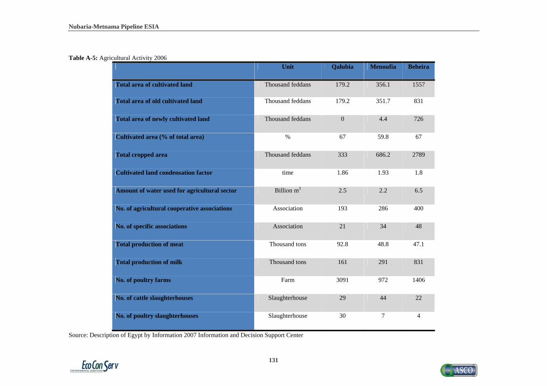
Nubaria-Metnama Pipeline ESIA
131
Table A-5: Agricultural Activity 2006
Unit Qalubia Menoufia Beheira
Total area of cultivated land Thousand feddans 179.2 356.1 1557
Total area of old cultivated land Thousand feddans 179.2 351.7 831
Total area of newly cultivated land Thousand feddans 0 4.4 726
Cultivated area (% of total area) % 67 59.8 67
Total cropped area Thousand feddans 333 686.2 2789
Cultivated land condensation factor time 1.86 1.93 1.8
Amount of water used for agricultural sector Billion m3 2.5 2.2 6.5
No. of agricultural cooperative associations Association 193 286 400
No. of specific associations Association 21 34 48
Total production of meat Thousand tons 92.8 48.8 47.1
Total production of milk Thousand tons 161 291 831
No. of poultry farms Farm 3091 972 1406
No. of cattle slaughterhouses Slaughterhouse 29 44 22
No. of poultry slaughterhouses Slaughterhouse 30 7 4
Source: Description of Egypt by Information 2007 Information and Decision Support Center

Nubaria-Metnama Pipeline ESIA
132
Table A-6: The Standard of Living
The Standard of Living Unit Qalubia Menoufia Beheira
Average of annual household expenditure on food & nonalcoholic beverages
EGP 4616.1 4557.5 4781.4
Average of annual household expenditure on clothing & foot wear
EGP 875.4 847.7 777.1
Average of annual household expenditure on housing, water, gas & others
EGP 1820.4 1689.3 1509.7
Source: Description of Egypt by Information 2007 Information and Decision Support Center

Nubaria-Metnama Pipeline ESIA
133
Table A-7: Income Distribution and Poverty
Income Distribution and Poverty
Unit Qalubia Menoufia Behera
GDP per Capita EGP 8134.4 9854.0 9451.6
Expenditure per Capita EGP 3754 3355 3039
Lowest 40% of people % 25.8 26.4 28.2
Ratio of highest 20% to the lowest 20% % 3.1 3.1 2.6
Gini coefficient % 0.23 0.23 0.19
% Poor of total population % 11.3 17.9 23.5
Ultra poor % 1.8 3.1 3.8
Wages of poor households % 9.3 14.2 17.8
Source: Egyptian Human Development Report 2010

Nubaria-Metnama Pipeline ESIA
134
Table A-8: Labor Force and Unemployment
Income Distribution and Poverty
Unit Qalubia Menoufia Beheira
Labor force (15+) % of total population 30.5 35.1 38.2 % of women in labor force (15+) % 18.7 26.1 30.6 % of labor force (15+) %Agriculture 15.6 32.9 59.3
%Industry 32.6 18.8 10.4 %Services 51.8 48.3 30.3
Professional and technical staff 20.8 21.0 11.4 Wage earners (% of labor force 15+) %Total 72.0 60.3 36.5
%Female 53.1 39.3 15.5 Employment in governmental public sector %Total 30.1 31.1 18.4
%Female 41.1 32.6 12.4 Unemployment rate (%) Total 8.0 6.5 6.8
Female 26.2 13.0 13.7 Unemployment rate (%) Urban 10.4 10.0 11.8
Rural 6.6 5.6 5.7 Unemployment rate by education Below secondary 2.8 3.9 1.9
Secondary 59.3 53.4 76.9 University 37.9 42.7 21.2
Future labor force replacement ratio 304.6 259.1 236.8
Source: Egyptian Human Development Report 2010

Nubaria-Metnama Pipeline ESIA
135
Annex B: Compensation and Grievance Forms
1- Compensation form
Serial __________________________
Place of the plot __________________________
Governorate __________________________
Agriculture valuation __________________________
The total area of the land to be expropriated
__________________________
Name of crop owner __________________________
His ID __________________________
The value of the crops __________________________
Duration of expropriation __________________________
Signature and stamp of the owner of crops
__________________________
Witness from community __________________________
Prepared by (Name of the employee) __________________________

Nubaria-Metnama Pipeline ESIA
136
2- Grievance form
Serial __________________________
Date __________________________
Governorate __________________________
Education of the person reporting the grievance
__________________________
Age of the person reporting the grievance
__________________________
Gender of the person reporting the grievance
__________________________
Topic of grievance __________________________ __________________________ __________________________ __________________________ __________________________ __________________________ __________________________ __________________________ __________________________
Actions to be taken __________________________ __________________________ __________________________ __________________________ __________________________ __________________________ __________________________ __________________________ __________________________
Monitoring of the action __________________________ __________________________ __________________________ __________________________ __________________________ __________________________ __________________________ __________________________ __________________________

Nubaria-Metnama Pipeline ESIA
137
Annex C: Public Consultation Documentation

Nubaria-Metnama Pipeline ESIA
138
Figure C-1: Scanned Copy of Al Ahram Announcement for Public Consultation (published on 27th January 2011)

Nubaria-Metnama Pipeline ESIA
139
Table C-1: List of stakeholders interviewed during the scoping phase 1 Ahmed Abd El Raouf Head of Geodesia Department- GASCO 2 Hany El Saed Lawyer in GASCO 3 Ahmed Galal Khairy Head of enironmental Department GASCO
4 Magdy Aly Abd Hady Ferry worker
5 Islam Abd El hady Farmer
6 Husein Tawfeik Farmer 7 Amgad Shawqy Farmer 8 Mostafa Hassan Head of Security Department in North Giza Electricity Station 9 Ahmed Operator
10 Attendee refused to give a name Farmer 11 Attendee refused to give a name Farmer
12 Attendee refused to give a name Farmer
13 Attendee refused to give a name Farmer
14 Attendee refused to give a name Farmer
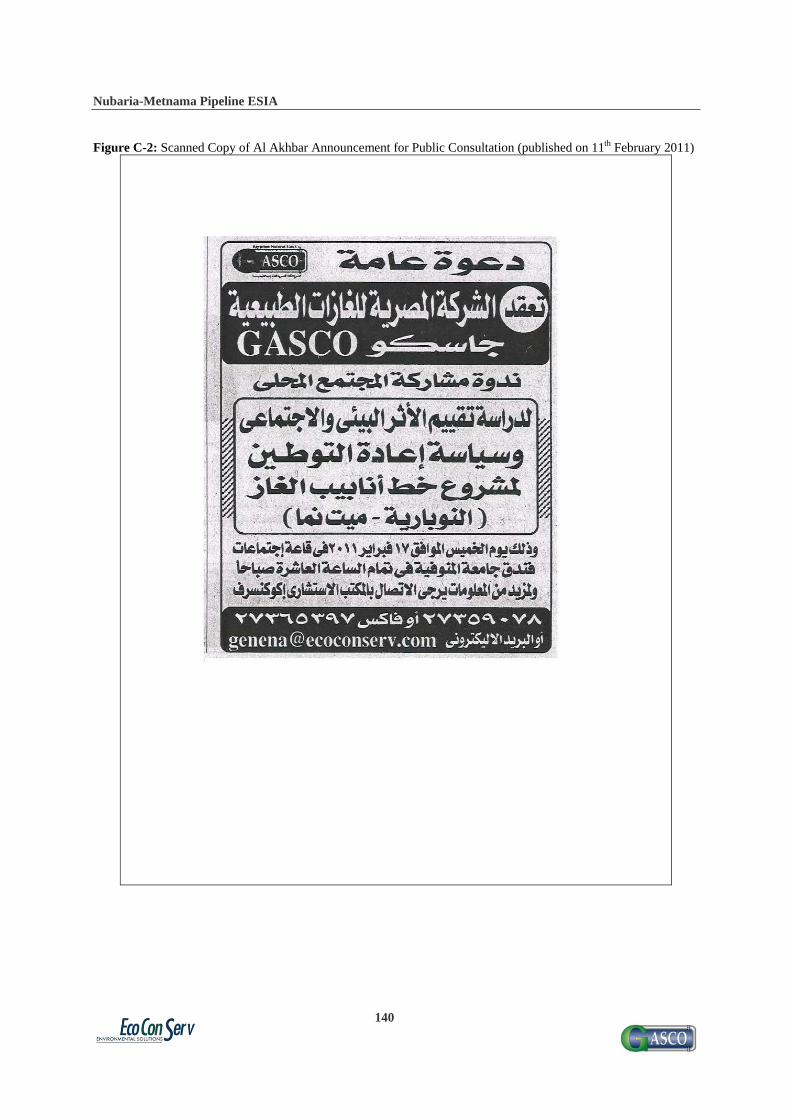
Nubaria-Metnama Pipeline ESIA
140
Figure C-2: Scanned Copy of Al Akhbar Announcement for Public Consultation (published on 11th February 2011)

Nubaria-Metnama Pipeline ESIA
141
Table C-2: List of Participants in Menoufia Public Consultation for Nubaria-Metnama Gas Pipeline -Thursday 17 February 2011, Menoufia University Hotel
No. Name Job Title Phone no. 1 Gihan Rashad Aamer Director High Institute
for Archeology 0121620810
2 Ahmed Ragab Gaafar Director Environmental Dept of the Governorate
0163327692
3 Said Osman Badr 010769059 4 Heba Mohamed Khodir Environmental
Researchers of the Governorate
0107264840
5 Eng. Ahmed Ibrahim Elaw
Director Drinking Water Sector of the governorate
0120900331
6 Eng. Yahia Ibrahim Taha Director. Transportation sector
0107742919
7 Eng. Ihab Salah Hassan Deputy Director Environmental Protection sector.
0108818956
8 Eng. Ahmed Abd El samea
01606010824
9 Eng. Amany Atia Kafafe Ministry Of Irrigation 0105233944 10 Ibrahim Mohamed El
sakaa Driver 0124917542
11 Colonel. Sherif Mohamed Ali
Civil Society Protection Agency
0167518601
12 Marwa Gaber Tahwn PhD. Dentist 0105113925 13 Zainab Mohamed Hafez EcoConServ Social Expert 0166127117 14 Hany Bayoumy Abd El
Halim Environmental Researcher of the Governorate
0162974723
15 Mohamed Reda Shaaban Environmental Researcher of the Governorate
0107720552
16 Mohamed Fathy Taha Environmental Sector of the Governorate
0102799807
17 Eng . Tawfik Mohamed Gad
Director of Maintenance Sector of the Governorate
0103718703
18 Mr. Bahgat Hamam Chairman of Environmental Association.
2320760
19 Dr. Mohamed Abd El fatah Tahwn
General Secretary of Young Generation Club
0109545999
20 Hamdy Mohamed El Dib Director of Land 0124033018
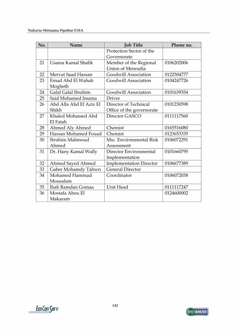
Nubaria-Metnama Pipeline ESIA
142
No. Name Job Title Phone no. Protection Sector of the Governorate
21 Usama Kamal Shafik Member of the Regional Union of Menoufia
0106202006
22 Mervat Saad Hassan Goodwill Association 0122504777 23 Emad Abd El Wahab
Mogheth Goodwill Association 0104247726
24 Galal Galal Ibrahim Goodwill Association 0101639354 25 Said Mohamed Imama Driver 26 Abd Alla Abd El Aziz El
Shikh Director of Technical Office of the governorate
0101230598
27 Khaled Mohamed Abd El Fatah
Director GASCO 0111117560
28 Ahmed Aly Ahmed Chemist 0165516080 29 Hassan Mohamed Fouad Chemist 0123653335 30 Ibrahim Mahmoud
Ahmed Msc. Environmental Risk Assessment
0106072291
31 Dr. Hany Kamal Wally Director Environmental Implementation
0101660795
32 Ahmed Sayed Ahmed Implementation Director 0106677389 33 Gaber Mohamdy Tahwn General Director 34 Mohamed Hammad
Mousalam Coordinator 0106072038
35 Ihab Ramdan Gomaa Unit Head 0111117247 36 Mostafa Abou El
Makaram 0124600002

Nubaria-Metnama Pipeline ESIA
143
Figure C-3: Scanned Registration Form for Nubaria-Metnama Gas Pipelines Public Consultation Workshop (17 February 2011)

Nubaria-Metnama Pipeline ESIA
144
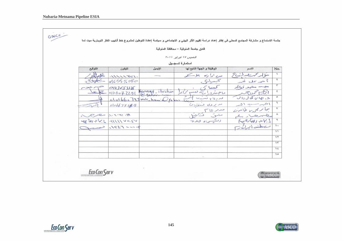
Nubaria-Metnama Pipeline ESIA
145
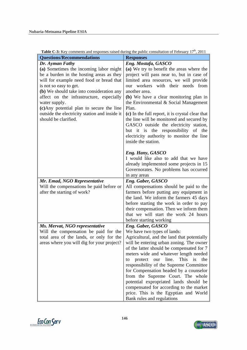
Nubaria-Metnama Pipeline ESIA
146
Table C-3: Key comments and responses raised during the public consultation of February 17th, 2011
Questions/Recommendations Responses Dr. Ayman Fathy (a) Sometimes the incoming labor might be a burden in the hosting areas as they will for example need food or bread that is not so easy to get. (b) We should take into consideration any affect on the infrastructure, especially water supply. (c)Any potential plan to secure the line outside the electricity station and inside it should be clarified.
Eng. Mostafa, GASCO (a) We try to benefit the areas where the project will pass near to, but in case of limited area resources, we will provide our workers with their needs from another area. (b) We have a clear monitoring plan in the Environmental & Social Management Plan. (c) In the full report, it is crystal clear that the line will be monitored and secured by GASCO outside the electricity station, but it is the responsibility of the electricity authority to monitor the line inside the station. Eng. Hany, GASCO I would like also to add that we have already implemented some projects in 15 Governorates. No problems has occurred in any areas
Mr. Emad, NGO Representative Will the compensations be paid before or after the starting of work?
Eng. Gaber, GASCO All compensations should be paid to the farmers before putting any equipment in the land. We inform the farmers 45 days before starting the work in order to pay their compensation. Then we inform them that we will start the work 24 hours before starting working
Ms. Mervat, NGO representative Will the compensation be paid for the total area of the lands, or only for the areas where you will dig for your project?
Eng. Gaber, GASCO We have two types of lands: Agricultural, and the land that potentially will be entering urban zoning. The owner of the latter should be compensated for 7 meters wide and whatever length needed to protect our line. This is the responsibility of the Supreme Committee for Compensation headed by a counselor from the Supreme Court. The whole potential expropriated lands should be compensated for according to the market price. This is the Egyptian and World Bank rules and regulations
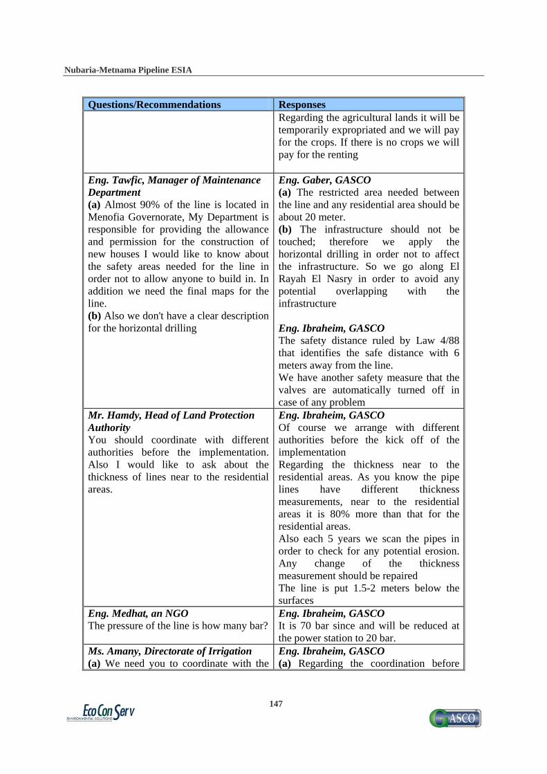
Nubaria-Metnama Pipeline ESIA
147
Questions/Recommendations Responses Regarding the agricultural lands it will be temporarily expropriated and we will pay for the crops. If there is no crops we will pay for the renting
Eng. Tawfic, Manager of Maintenance Department (a) Almost 90% of the line is located in Menofia Governorate, My Department is responsible for providing the allowance and permission for the construction of new houses I would like to know about the safety areas needed for the line in order not to allow anyone to build in. In addition we need the final maps for the line. (b) Also we don't have a clear description for the horizontal drilling
Eng. Gaber, GASCO (a) The restricted area needed between the line and any residential area should be about 20 meter. (b) The infrastructure should not be touched; therefore we apply the horizontal drilling in order not to affect the infrastructure. So we go along El Rayah El Nasry in order to avoid any potential overlapping with the infrastructure Eng. Ibraheim, GASCO The safety distance ruled by Law 4/88 that identifies the safe distance with 6 meters away from the line. We have another safety measure that the valves are automatically turned off in case of any problem
Mr. Hamdy, Head of Land Protection Authority You should coordinate with different authorities before the implementation. Also I would like to ask about the thickness of lines near to the residential areas.
Eng. Ibraheim, GASCO Of course we arrange with different authorities before the kick off of the implementation Regarding the thickness near to the residential areas. As you know the pipe lines have different thickness measurements, near to the residential areas it is 80% more than that for the residential areas. Also each 5 years we scan the pipes in order to check for any potential erosion. Any change of the thickness measurement should be repaired The line is put 1.5-2 meters below the surfaces
Eng. Medhat, an NGO The pressure of the line is how many bar?
Eng. Ibraheim, GASCO It is 70 bar since and will be reduced at the power station to 20 bar.
Ms. Amany, Directorate of Irrigation (a) We need you to coordinate with the
Eng. Ibraheim, GASCO (a) Regarding the coordination before

Nubaria-Metnama Pipeline ESIA
148
Questions/Recommendations Responses other authorities, especially regarding excavations. (b) Will the line capacity be sufficient for future provision of gas to the households of the surrounding villages provide natural gas to the villages? (c) I think that the quantity of water to be used for hydrostatic test is too high that it should cover 105km. From where can you get all of this quantity?
starting the project we have already conducted meetings with some authorities and before the implementation we will have another meeting. (b) Regarding the connection to the line. We have the capacity to serve all populations and factories in the areas in the 4 Governorates as their potential consumption will not exceed 0.5% of the capacity of the new line. In other words the capacity is suffecnt although the connection to the Governorates requires coordination with the concerned authorities. The new line is connected to the national Gas net in Nubaria mainly to provide the NG to the electricity station, but in case of any expansion in the usage of gas in the areas it is no problem. The line was designed to cover 180% of the needs of the electricity station indicating that we have sufficient. (c) Regarding the static water needed, the it was part of the mitigation measurement to use water slowly in order not to affect the fisheries in addition we will need water to cover around 20km only not 105 km that water will be transferred from valve room to the another one. Also we will get permission from the Irrigation Authority regarding the usage of water. Eng. Gaber, GASCO (a) Regarding the coordination with the other authority we had a meeting with General Secretary in the Governorate. Some representatives from Irrigation department have attended. They asked for the maps and designed sector in order to be provided to the contractor. Also we agreed that the contractor who implemented the covered disposal will be responsible for any rehabilitation or re-
Nubaria-Metnama Pipeline ESIA
149
Questions/Recommendations Responses estate for the damaged part if happened.
Eng. Ahmed, Water Company In case of overlapping with water lines, how can you react?
Eng. Gaber, GASCO We have two types of Water connection The main line which lie deep in the ground and we pass our line over it The branches, we detach them and put our lines then we reinstall them Eng. Ibraheim, GASCO It is a must to respect all lines and all authorities so that they will respect our line. It is for the safety of our project
Mr. Seherif, Civil Protection Authority I checked the line of GASCO from Quesna where I noticed that it passes near to the residential area.
Eng. Mostafa, GASCO This was unused old line that we had to reroute due to safety reasons. But it is very important to have such valuable notice. We have a hotline 149 please in case of you find such thing immediately phone us. It is crucial to report such actions in order to protect our line