NOVI IMF Guidelines - gwp.org · Figure 7.2. Impacts of climate change and the related sea level...
130
Transcript of NOVI IMF Guidelines - gwp.org · Figure 7.2. Impacts of climate change and the related sea level...


i
Table of Contents
List of tables ...................................................................................................................................................... iii List of figures ..................................................................................................................................................... iii List of boxes ...................................................................................................................................................... iv List of abbreviations and acronyms ................................................................................................................... v
Foreword .............................................................................................................................. 1
Reader’s Guide ..................................................................................................................... 4
Target Audience .................................................................................................................... 4
Four Key Lessons from the IMF Process ................................................................................ 4
Section I:
Concept of the IMF........................................................................................... 7
Chapter 1: Background and Context of the IMF .................................................................... 9 1.1 Introduction ............................................................................................................................................ 9 1.2. Synergy with other activities ................................................................................................................. 12 1.3 Towards convergence: why “integrate” the “integrated” plans? ......................................................... 13 1.4 Coastal management and planning ...................................................................................................... 15 1.5 IWRM, river basin management and planning ..................................................................................... 17 1.6 Coastal aquifer and groundwater management and planning ............................................................. 19 1.7 Climate change and variability considerations and management plans ............................................... 22
Chapter 2: Theoretical Background of Integration and Key Aspects of Complementary
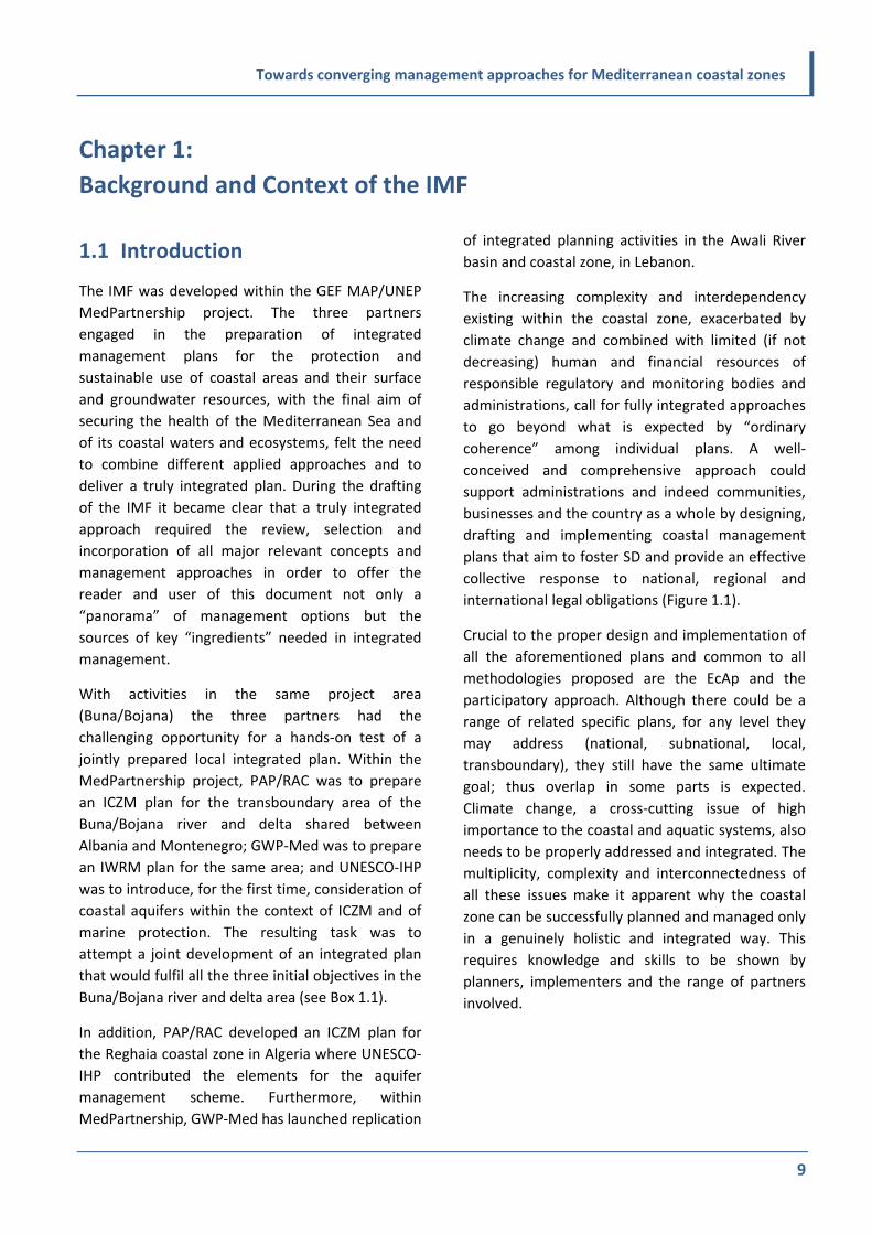
Management Approaches ................................................................................................... 25 2.1 Integration and various aspects of management ................................................................................. 25 2.2 Links of ICZM and IWRM with physical, spatial and marine/maritime planning .................................. 26 2.3 Links of ICZM and IWRM with different types of management approaches ......................................... 29 2.4 SD objective of integrated plans .......................................................................................................... 34 2.5 Role of governance ............................................................................................................................... 36 2.6 Understanding the meaning of “integration of integrated plans” ........................................................ 39 2.7 Some basic concerns: multi‐ and trans‐disciplinarity; implementability; relevance and
adaptability; priority versus sectoral approach .................................................................................... 40
Chapter 3: Aspects of Integration of ICZM with IWRM and Other Frameworks ................... 43 3.1 Integration and geographical coverage ................................................................................................ 43 3.2 Integration across systems .................................................................................................................... 44 3.3 Integration across sectors ..................................................................................................................... 45 3.4 Governance for integration ................................................................................................................... 46 3.5 Methodologies and tools for integrated planning ................................................................................ 49
Chapter 4: Foundation Documents for IMF ......................................................................... 54 4.1 ICZM Protocol ....................................................................................................................................... 54 4.2 WFD ....................................................................................................................................................... 55 4.3 Groundwater directive .......................................................................................................................... 56 4.4 Additional documents to be considered ............................................................................................... 56

ii
Section II:
Operational Guidelines of the IMF .................................................................. 59
Chapter 5: Planning Process and its Five Stages ................................................................... 61 5.1 Introduction .......................................................................................................................................... 61 5.2 Overview, dynamic nature of integrated plans, the DPSIR framework and timeliness ....................... 61 5.3 The Seven I’s ......................................................................................................................................... 62 5.4 Practical suggestions to enhance the multiple usefulness of the plan ................................................ 63 5.5 Schematic representation of the planning process .............................................................................. 63 5.6 Proposed sequence of the five stages .................................................................................................. 64
Chapter 6: Stage 1 – Establishment ...................................................................................... 69 6.1 Aim and objectives ............................................................................................................................... 69 6.2 Key tasks ............................................................................................................................................... 69 6.3 Potential outputs .................................................................................................................................. 70 6.4 Governance for planning ...................................................................................................................... 76 6.5 Understanding the governance context of the plan area .................................................................... 79 6.6 Engaging stakeholders and preparing a communication strategy ....................................................... 81 6.7 Deciding on SEA .................................................................................................................................... 83
Chapter 7: Stage 2 – Analysis and Futures............................................................................ 85 7.1 Aim and objectives ............................................................................................................................... 85 7.2 Key tasks ............................................................................................................................................... 85 7.3 Potential outputs .................................................................................................................................. 85
Chapter 8: Stage 3 – Setting the Vision ................................................................................ 98 8.1 Aim and objectives ............................................................................................................................... 98 8.2 Key tasks ............................................................................................................................................... 98 8.3 Expected output ................................................................................................................................... 98
Chapter 9: Stage 4 – Designing the Future/the Plan ........................................................... 103 9.1 Aim and objectives ............................................................................................................................. 103 9.2 Key tasks ............................................................................................................................................. 103 9.3 Potential outputs ................................................................................................................................ 103
Chapter 10: Stage 5 – Realising the Vision ......................................................................... 109 10.1 Aim and objectives ............................................................................................................................. 109 10.2 Key tasks and potential outputs ......................................................................................................... 109 10.3 Legal and economic mechanisms ....................................................................................................... 109 10.4 Monitoring and review ....................................................................................................................... 114
References ......................................................................................................................... 117

iii
List of tables
Table 2.1. Five principles of good governance adjusted from the PEGASO conceptual framework (from Abrams et al., 2003, modified) ............................................................................................................................................... 37
Table 7.1. Example of a matrix in the pilot demonstration in the Ghar El Melh lagoon, Tunisia (Table copyright, 2015, Andrea Merla) ............................................................................................................................................. 94
Table 8.1. High‐level objectives, sub‐objectives and relevant indicators Source: Adapted from A Handbook for Measuring the Progress and Outcomes of Integrated Coastal and Ocean Management (IOC Manuals and Guides 46. ICAM Dossier, 2. Paris: UNESCO, 2006). ........................................................................................... 100
Table 9.1. The measures grid – from the Buna/Bojana Plan (example only) ....................................................................... 104
List of figures
Figure 1.1. Coastal zone‐relevant international legislation and resulting obligations ........................................................... 12 Figure 1.2. Synergies created ................................................................................................................................................. 13 Figure 1.3. The coastal zone showing the ICZM Protocol boundaries, groundwaters and WFD waters (B. Shipman) .......... 14 Figure 1.4. Coastal aquifers ................................................................................................................................................... 20 Figure 2.1. Typical biosphere reserve zonation (http://portal.unesco.org/geography/en/ev.php‐
URL_ID=8763&URL_DO=DO_TOPIC&URL_SECTION=201.html) ........................................................................... 32 Figure 2.2. The concept of differentiated intensity of management: in C>>B>A .................................................................. 33 Figure 2.3. Sustainable development and its pillars according to Rio (1992) ........................................................................ 34 Figure 2.4. The proposed place of governance in the sustainable development structure .................................................. 34 Figure 2.5. The tetrahedron of sustainable development: the new structure for sustainable development ....................... 35 Figure 2.6. The “anthroposphere” based on the natural environment ................................................................................. 35 Figure 2.7. The analysis of governance tools to obtain sustainable development ................................................................ 36 Figure 2.8. Sustainable development and tools to achieve it ................................................................................................ 36 Figure 2.9. Visualisation of ICZM, IWRM and other management practices ......................................................................... 40 Figure 3.1. Integration and geographical coverage ............................................................................................................... 44 Figure 3.2. Integration across sectors .................................................................................................................................... 45 Figure 3.3. Coordination for integration ................................................................................................................................ 46 Figure 3.4. Stakeholders involved in integration ................................................................................................................... 47 Figure 3.5. Methodologies employed for integrated planning and management ................................................................ 49 Figure 3.6. Transboundary zone: sub‐basin, aquifer and marine zone ................................................................................. 51 Figure 3.7. The core transboundary plan area ....................................................................................................................... 51 Figure 5.1. DPSIR Framework informs the preparation of the Integrated Plan ..................................................................... 61 Figure 5.2. The Seven I’s ........................................................................................................................................................ 62 Figure 5.3. Plan preparation and implementation process: overview ................................................................................... 64 Figure 5.4. Plan preparation and implementation process: detail ........................................................................................ 65 Figure 5.5. The five stages as described in the Buna/Bojana integrated plan ....................................................................... 66 Figure 5.6. The “Roadmap Towards Coastal Sustainability”. Extract from the PEGASO project website
(www.pegasoproject.eu) demonstrating the use of the five‐stage process in ICZM ........................................... 67 Figure 5.7. Process diagram for Lake Bizerte, applying the SUstainable Development for CIties and Regions
(SUDECIR) approach .............................................................................................................................................. 68 Figure 7.1. The concept of backcasting (www.wearearising.org/2009/01/13/backcasting) ................................................. 86 Figure 7.2. Impacts of climate change and the related sea level rise affecting the water management and the
coastal areas in general ........................................................................................................................................ 89 Figure 7.3. The integrated plan – the interrelationships of drivers, pressures, state and impacts ....................................... 90 Figure 7.4. The Buna/Bojana “bow‐tie” ................................................................................................................................. 91 Figure 7.5. Principle of development of vulnerability model ................................................................................................ 92 Figure 7.6. Areas of conflict between non‐built construction areas and areas of the highest vulnerability – coast of
Montenegro .......................................................................................................................................................... 93 Figure 7.7. Vulnerability map from the Ghar El Melh lagoon pilot project. Link to high‐resolution version of
vulnerability map for Ghar El Melh: www.geoprospezioni.it/gharelmelh/GharElMelh_Vulnerability_Map.pdf. Accessible with the password “UNESCOGharElMelh” (Map copyright, 2014, Salvatore Carrubba) ..................................................................... 95

iv
List of boxes
Box 1.1. The MedPartnership project .................................................................................................................................... 10 Box 1.2. Article 5 of the ICZM Protocol: Objectives of ICZM .................................................................................................. 16 Box 1.3. Examples of agricultural considerations within IWRM and ICZM ............................................................................ 19 Box 1.4. Groundwater irrigation economy in the Mediterranean (Shah, 2014) .................................................................... 21 Box 1.5. Risk‐based approach (from van Beek and Lincklaen Arriens, 2014) ........................................................................ 24 Box 2.1. The 12 principles of the ecosystem approach .......................................................................................................... 31 Box 2.2. Defining governance related to water ..................................................................................................................... 38 Box 3.1. Public participation in the EU WFD .......................................................................................................................... 48 Box 4.1. General principles of ICZM (Article 6) ...................................................................................................................... 54 Box 4.2. Some key principles of WFD for IRBM ...................................................................................................................... 55 Box 4.3. WFD requirements for PP (EEA, 3/2014) .................................................................................................................. 57 Box 6.1. SWOT analysis example for coastal zone ................................................................................................................. 75 Box 6.2. Governance mechanism "at work" in CAMP Levante de Almeria, Spain ................................................................. 78 Box 7.1. Drivers and pressures relating to climate change .................................................................................................... 88 Box 9.1. Examples of governance and implementation structures ..................................................................................... 105 Box 10.1. Uses of economic incentives (NCEE, 2001, amended) ......................................................................................... 111 Box 10.2. Common approaches and techniques for raising public awareness .................................................................... 114

v
List of abbreviations and acronyms
APELL Awareness and Preparedness for Emergencies at Local Level B.C. Before Christ BR Biosphere Reserve CAMP Coastal Area Management Programme CB/MEP Capacity‐Building/Mediterranean Environment Programme (Horizon, 2020) CBD Convention on Biological Diversity CD Compact Disc CEM Commission on Ecosystem Management CEMAT European Conference of Ministers Responsible for Spatial/Regional Planning CIS Common Implementation Strategy COP Conference of Parties CSO Civil Society Organization 2D Two Dimensional DPSIR Driving Forces‐Pressures‐State‐Impacts‐Responses DVD Digital Videodisc EEA European Environment Agency EBA Ecosystem‐based Approach EC European Commission EcAp Ecosystem Approach ECI European Citizen’s Initiative EIA Environmental Impact Assessment EIB European Investment Bank EP Environmental Planning ESD Education for Sustainable Development ERM Environmental Resource Management EU European Union EU MED EUWI Mediterranean Component of the EU Water Initiative EU SWIM‐SM European Union Sustainable Water Integrated Management‐Support Mechanism FAO Food and Agriculture Organization FP7 7th Framework Programme GCF Global Climate Fund GEF Global Environment Facility GES Good Environmental Status GIS Geographic Information System GWD Groundwater Directive GWP Global Water Partnership GWP‐Med Global Water Partnership – Mediterranean Ha Hectare ICAM Integrated Coastal Area Management ICCD International Convention to Combat Desertification ICM Integrated Coastal Management ICMM Integrated Coastal and Marine Management ICT Information and Communications Technologies ICZM Integrated Coastal Zone Management IDM Integrated Drought Management IEM Integrated Environmental Management IFM Integrated Flood Management IGWM Integrated Groundwater Management IHP International Hydrological Programme IMF Integrative Methodological Framework IMP Integrated Maritime Policy IPPC Integrated Pollution and Prevention Control IRBM Integrated River Basin Management IUCN International Union for Conservation of Nature

vi
IUWM Integrated Urban Water Management IWRM Integrated Water Resources Management km2 square kilometre LDC Least Developed Countries LME Large Marine Ecosystem m3 cubic metre MAB Man and the Biosphere MAP Mediterranean Action Plan MEdIES Mediterranean Education Initiative For Environment & Sustainability MedPartnership Strategic Partnership for the Mediterranean Large Marine Ecosystem (LME) MeHSIP‐PPIF Mediterranean Hot Spots Investment Programme – Project Preparation and Implementation Facility
(Horizon 2020 initiative) MENA Middle East and North Africa MIO‐ESCDE Mediterranean Information Office for Environment, Culture and Sustainable Development MoU Memorandum of Understanding MSFD Marine Strategy Framework Directive MSP Maritime (or Marine) Spatial Planning MSSD Mediterranean Strategy for Sustainable Development NAMAS Nationally Appropriate Mitigation ActionS NAP National Action Plan NCWR Non‐Conventional Water Resources Nexus Water‐Energy‐Food Nexus NGO Non‐Governmental Organization OECD Organisation for Economic Co‐operation and Development PAP Priority Actions Programme PEGASO People for Ecosystem‐based Governance in Assessing Sustainable Development of Ocean and Coast PP Public Participation PPP Public‐Private Partnerships PSU Practical Salinity Units RAC Regional Activity Centre RBM River Basin Management RBMPs River Basin Management Plans REACH Registration, Evaluation, Authorization and Restriction of Chemicals SAP Strategic Action Plan SAP‐BIO Strategic Action Plan for Biodiversity SAPMED Strategic Action Plan for the Mediterranean SD Sustainable Development SEA Strategic Environmental Assessment SIWI Stockholm International Water Institute SPA/BD Specially Protected Areas / Biological Diversity (Protocol to the Barcelona Convention) SUDECIR SUstainable Development in European CIties and Regions SWOT Strengths, Weaknesses, Opportunities, Threats (Analysis) TAC Technical Advisory Committee TB Transboundary TEC Technical Committee TOR Terms of Reference UNECE United Nations Economic Commission for Europe UNEP United Nations Environment Programme UNESCO United Nations Educational, Scientific and Cultural Organization UNFCCC United Nations Framework Convention on Climate Change US$ US dollar VED Vital, Essential and Desirable WB World Bank WFD Water Framework Directive WMO World Meteorological Organization WWF World Water Forum

Towards converging management approaches for Mediterranean coastal zones
1
Foreword
The coastal zone, simplistically defined as the area
of interaction between the land and the sea, is a
territory that has attracted humans throughout
history. It includes enclosed gulfs, bays and
estuaries that are suitable for developing
settlements and economic activities, and for
building marine and riverine ports, often hosting
fertile plains and sites abundant with surface and
groundwater. Terrestrial, freshwater and marine
ecosystems found in the coastal zone are among
the most productive on the planet. These
ecosystems are also among the most complex to
study, and to manage, and are the most
threatened. The coastal zone is the site of active
geological processes including erosion,
sedimentation, alongshore and onshore sand
transport, shoreline changes, wind/tidal flooding
and dune accretion. It represents open and dynamic
systems with numerous interactions within
themselves (“internal”) as well as with the wider
natural and man‐made environment beyond their
boundaries (“external”). Significant changes at any
point and in any part of these systems may
generate chain reactions far from their point of
origin, and possibly in a totally different system,
whose environmental conditions could be altered
subsequently (UNEP, 1995).
The general public, including the coastal
inhabitants, often do not fully perceive these
interactions and their potential magnitude. Only
when major extreme events hit and cause
casualties and property losses do the public and,
often, decision makers too, realize the complexity
and vulnerability of coastal zones. Science
continuously provides new evidence about the links
within and between related systems. Populations
living in and economic sectors acting on the coastal
zones, with direct dependency on coastal resources,
are often concerned mostly about their rights to
develop and exploit advantages without adequately
addressing the impacts of their activities on the
various environmental and social aspects. Coastal
populations, particularly in estuarine areas, expect
from those living inland and upstream to preserve
the rivers and secure good environmental
conditions for downstream users without, however,
necessarily managing their part of the river
downstream in a sustainable way. Having in mind
that 80 per cent of the pollution load received by
the Mediterranean Sea derives from land‐based
sources, a considerable part of which comes in
through rivers, such a request is clearly legitimate.
However, coastal populations requesting the right
to a clean environment, primarily as a prerequisite
for their development, often forget the right for
development of the upstream communities (e.g.
irrigated agriculture, energy generation). In other
cases, early development downstream may have
already unfavourably affected water allocations for
upstream countries, communities or sectors, a
situation that, in many cases, is very difficult to
rectify. These examples emphasize the need for
applying approaches throughout the water basin,
and including groundwater bodies, with particular
attention to the coastal areas. Furthermore, coastal
development and the subsequent marine pollution,
combined with intensive fishing, may severely
affect offshore marine ecosystems, fish stock in
particular.
Climate variability and change exacerbate and
further complicate the existing environmental,
socioeconomic and cultural problems in coastal
areas.
Over the last few decades, several management
approaches have been developed to respond to
anthropogenic impacts on the terrestrial,
freshwater and marine environment. Among them,
the Integrated Coastal Zone Management (ICZM),
the Integrated Water Resources Management
(IWRM) and, more recently and less widespread,
coastal aquifer and groundwater management.
Consequently, several international legal agreements

Towards converging management approaches for Mediterranean coastal zones
2
and conventions have been developed covering the
aforementioned issues, separately or in combination,
which also refer to the Mediterranean.
The Manila Declaration on “Furthering the
Implementation of the Global Programme of Action
for the Protection of the Marine Environment from
Land‐Based Activities” (2012), signed by 64
governments and the European Union (EU),
stressed among other matters the need and
announced the decision to improve cooperation
and coordination at all levels to deal with issues
related to oceans, coasts, islands and their
associated water needs by applying integrated
management approaches. These include the “ridge‐
to‐reef” concept, involving stakeholders and
developing innovative solutions, to improve
situations and research problems identified (Manila
Declaration, Art 7, UNEP/GCSS, XII/INF/10).
To respond to international/regional legal
provisions and address challenges in coastal areas,
Mediterranean countries are often called on to
prepare specific strategies and plans, many of which
are related to subnational/local and/or sectoral
development (such as for tourism, fisheries,
agriculture, shipping and energy). To become
operational, most of these plans require some kind
of integration (e.g. of objectives) and coordination
(e.g. of executive agencies). In this respect, the
Protocol on ICZM in the Mediterranean of the
Barcelona Convention (UNEP/MAP/PAP, 2008) is
one of the few international legal instruments that
provide grounds for such an integration and
coordination towards the sustainable development
(SD) and improvement of living conditions of coastal
populations.
The ICZM Protocol covers the coastal zones of all
the Mediterranean countries. It provides legal
requirements to holistically take into account the
terrestrial and marine parts of the coastal zone at
national and local level, where the interactions
between and within the coastal ecosystems are
prominent and must not be neglected by
management. Furthermore the Protocol explicitly
refers, in article 9 para. 1c, to the need to ensure
respect for IWRM as well as to environmentally
sound waste management.
Two United Nations conventions, namely the
Convention on the Protection and Use of
Transboundary Watercourses and International
Lakes (United Nations Economic Commission for
Europe (UNECE) Water Convention, Helsinki, 1992)
and the Convention on the Law of the Non‐
Navigational Uses of International Watercourses
(New York, 1997) refer to transboundary water
resources. National water resources are not
addressed by any international or regional
regulatory/legally binding documents, except for
the Protocol on Water and Health (1999) under the
UNECE Water Convention.
Since several Mediterranean countries are
members or in accession process to the EU, it is
appropriate also to consider the relevant EU
legislation. The existing EU acquis include a range of
related directives including the Water Framework
Directive (WFD, 2002) and its daughter directives on
Groundwater (2006) and Floods (2007); the Marine
Strategy Framework Directive (MSFD, 2008); and
the Maritime Spatial Planning Directive (MSP, 2014)
which establishes a framework for maritime spatial
planning. These provide a useful framework for the
management of freshwater systems and the marine
environment. They echo the high value attributed
to water and other natural resources constituting a
helpful guiding framework even for countries
outside the EU where, of course, such legislation is
not binding. From this point of view, key EU
Directives are also considered in the present work
as source documents. It is noteworthy that
although the coastal zone is addressed to a certain
extent, directly or indirectly, by the aforementioned
directives it is not in the focus of any specific EU
legislation.
The fact that ICZM is a dynamic process towards
sustainable management and use of specific coastal
zones and their resources may imply site‐specific
provisions as well as, eventually, somewhat
differentiated approaches between EU and non‐EU
Mediterranean countries, including when
implementing the ICZM Protocol. However, the

Towards converging management approaches for Mediterranean coastal zones
3
ultimate goal of achieving SD remains common. The
EU Directives follow the Ecosystem Approach
(EcAp) which aims at the achievement of Good
(environmental/chemical) Ecological Status (GES) of
the (water) resource in question as a prerequisite
for sustainability. It should be emphasized that
EcAp is one of the general principles of the ICZM
Protocol in the Mediterranean (article 6) and
although the achievement of good environmental
status (GES) is not explicitly mentioned, it is
implicitly considered. The ICZM Protocol refers to
all coastal resources, not only the aquatic ones, in
both the terrestrial and marine parts of the coastal
zone. Moreover, besides the management of
resources, ICZM is also about the management of
uses. Overall, the implementation of EcAp has been
adopted as a key guiding principle of the Barcelona
Convention. Decisions IG 17/6 (COP 15, 2008) and
IG 20/4 (COP 17, 2012) for the “Implementation of
the ecosystem approach to the management of
human activities” and for “Implementing MAP
ecosystem approach roadmap”, respectively,
articulate a systematic process towards more
effective ecosystems‐based management, followed
by a seven‐step road map for the implementation
of the EcAp by the Mediterranean Action Plan
(MAP), i.e. the EcAp process. Therefore, an
important aspect of ICZM, demonstrated in the
present document, is its ability to facilitate bridging
the GES and EcAps with regional development that
also corresponds to optimal management solutions
for sustainable coastal development. Such
management should also respond effectively to the
increasingly complex challenges resulting from the
impact of climate change on the coastal zone and
the efforts to adapt to climate variability and
change.
Of importance for developmental efforts in the
coastal zone, the Water‐Energy‐Food Nexus (Nexus)
approach was introduced relatively recently in the
global natural resources management agenda. Its
aim is to facilitate the enhancement of water,
energy and food security, while preserving
ecosystems and their functions, including under
conditions of climate variability and change. It
focuses on increasing the efficiency and
productivity of resources, reducing trade‐offs,
shifting towards more sustainable consumption
patterns and improving demand management,
building synergies and improving governance across
sectors. With some differences from previous
integrated approaches, the Nexus approach starts
from a balanced cross‐sectoral perspective
considering the biophysical, economic and
institutional dimensions of natural resource
management, analysing the flow of these resources
through different sectors and detecting entry points
for reducing inefficiencies and exploiting synergies
between sectors. Often, the Nexus addresses only
parts of the water‐energy‐food triangle; for
example, it can be concerned with water–energy,
water–food or energy–food, as well as their
linkages with environment, climate, land, waste,
etc.
Within a joint initiative, the Priority Actions
Programme/Regional Activity Centre (PAP/RAC) of
United Nations Environment Programme/
Mediterranean Action Plan (UNEP/MAP), United
Nations Educational, Scientific and Cultural
Organization (UNESCO)‐International Hydrological
Programme (IHP) and the Global Water Partnership‐
Mediterranean (GWP‐Med) wish to propose a
comprehensive, yet comprehensible, Integrative
Methodological Framework (IMF) and an
operational methodology for the sustainable
management of the ecological continuum
constituted by the coastal zone, the river basin and
the coastal aquifer. The present document aspires
to encourage and facilitate planners, practitioners
and interested parties towards a shared, efficient
and effective use of the relatively limited human
and logistical resources usually available in most
Mediterranean countries, and achieve better
coordination, integration and involvement of all
stakeholders, including the general public, in the
planning process.

Towards converging management approaches for Mediterranean coastal zones
4
Reader’s Guide
The present document is designed to provide an
IMF and planning guidelines to assist the
development and convergence of assimilated
solution‐oriented coastal management approaches
and plans. Such plans are requested by the ICZM
Protocol for the Mediterranean, and need to be
drafted with special attention to the associated
watershed management requirements for surface
water, groundwater and coastal aquifers (several of
which are particularly “vulnerable”) as well as to the
management needs of the marine environment,
also addressing effectively the challenges related to
climate variability and change (see box on the next
page).
The publication is designed to inspire and facilitate
integrative planning and management in a flexible
way to allow their implementation at national and
local level. Adaptation to individual local conditions
may dictate amendments to this process within the
overall framework. On the other hand, eventually
the framework can easily be used, with some
modifications, for coastal areas outside the
Mediterranean.
Target Audience
The key target audience of this publication are
administrations, practitioners and partnerships
tasked with the production and implementation of
management plans related to coastal areas in the
Mediterranean (ICZM, IWRM and other). Estuaries
are the point at which ICZM and IWRM meet, and
as these are among the areas most threatened by
sea‐level rise and climate variability and change,
this publication is particularly relevant for those
seeking sustainable solutions, including through
adaptation to climate change, for this part of the
coastal zone.
Four Key Lessons from the IMF Process
The collaboration between the three partners in
drawing up the IMF has been combined with
operational testing in the transboundary coastal
zone of Albania and Montenegro through the
elaboration of an integrated plan for the
Buna/Bojana area. ‘Buna’ is an Albanian and
‘Bojana’ a Montenegrin name for the same river.
From these parallel exercises, and drawing on the
partners’ extensive experience across the
Mediterranean region, many lessons have been
learned. In particular, four key lessons have been
distilled from the process and are identified and
elaborated within the publication using, where
relevant, on‐the‐ground illustrations from the
process used to deliver the integrated plan for the
Buna/Bojana area:
Key lesson 1 Convergence of approaches, including
a common definition of integration, is
key
Key lesson 2 The value of the Drivers‐Pressures‐
State‐Impacts‐Responses (DPSIR)
framework as a tool for integration is
high.
Key lesson 3 Operational practicalities should
remain lean: the value of a simple and
common road map that is adaptable
to local circumstances is recognized.
Key lesson 4 The focus is on delivering results:
realizing the vision renders the
process valid.
The key lessons are elaborated upon at relevant
points in the document.

Towards converging management approaches for Mediterranean coastal zones
5
IMF and operational guidelines
The IMF and operational guidelines are intended to:
identify possibilities and solutions for converging coastal, river basin, aquifer and groundwater management, considering also the implementation of the ecosystem approach
integrate climate change considerations as cross‐cutting issues throughout the planning and implementation processes in coastal zones
support an active involvement of stakeholders and of the general public in the planning and management of coastal zones.
The document is divided into two sections:
Section I: Concept of the IMF
Section II: Operational guidelines.
Section I provides the conceptual framework for integrative management and planning of these zones. It offers to
the reader the general background, clarifications and knowledge for understanding the objectives, processes,
methodologies and key issues within different complementary integration approaches in order to build the
foundations for all‐embracing joint/integrated solutions.
Section II provides a step‐by‐step guide to an integrated planning process. It takes the reader through the objectives,
activities and outputs of each stage, and proposes methodologies, tools and examples towards an integrated plan as
the main end product.
Specific objectives of the IMF
The specific objectives of the IMF are to:
1. provide the rationale and the technical tools for a collective and coherent response to the multiple policy goals and directives that relate to the utilization, development and protection of coastal areas at national and local level and their natural and ecological resources
2. ensure that policy instrument mixes are consistent and mutually supportive
3. produce policy outcomes appropriate to the context of the specific coastal zone problem
4. secure the best knowledge base and support the interdisciplinary approach needed for the successful preparation of an integrated plan
5. add value to individual approaches in order to obtain maximum synergy responding to the principle that the whole is greater than the sum of the parts
6. satisfy different legal requirements through a shared, efficient and effective use of often limited human and logistical resources available for such a process, including reducing costs for planning and particularly for the setting and implementation of management options identified in the plan
7. respond effectively to the more dynamic environment resulting from climate change and development impacts
8. achieve shared ownership by the involved sectors through their better coordination and integration in the planning process
9. achieve sustainable coastal development in the Mediterranean estuaries and wetlands
10. simplify monitoring, evaluation and reporting.

Towards converging management approaches for Mediterranean coastal zones
6

Towards converging management approaches for Mediterranean coastal zones
7
Section I: Concept of the IMF

Towards converging management approaches for Mediterranean coastal zones
8
Towards converging management approaches for Mediterranean coastal zones
9
Chapter 1:
Background and Context of the IMF
1.1 Introduction
The IMF was developed within the GEF MAP/UNEP
MedPartnership project. The three partners
engaged in the preparation of integrated
management plans for the protection and
sustainable use of coastal areas and their surface
and groundwater resources, with the final aim of
securing the health of the Mediterranean Sea and
of its coastal waters and ecosystems, felt the need
to combine different applied approaches and to
deliver a truly integrated plan. During the drafting
of the IMF it became clear that a truly integrated
approach required the review, selection and
incorporation of all major relevant concepts and
management approaches in order to offer the
reader and user of this document not only a
“panorama” of management options but the
sources of key “ingredients” needed in integrated
management.
With activities in the same project area
(Buna/Bojana) the three partners had the
challenging opportunity for a hands‐on test of a
jointly prepared local integrated plan. Within the
MedPartnership project, PAP/RAC was to prepare
an ICZM plan for the transboundary area of the
Buna/Bojana river and delta shared between
Albania and Montenegro; GWP‐Med was to prepare
an IWRM plan for the same area; and UNESCO‐IHP
was to introduce, for the first time, consideration of
coastal aquifers within the context of ICZM and of
marine protection. The resulting task was to
attempt a joint development of an integrated plan
that would fulfil all the three initial objectives in the
Buna/Bojana river and delta area (see Box 1.1).
In addition, PAP/RAC developed an ICZM plan for
the Reghaia coastal zone in Algeria where UNESCO‐
IHP contributed the elements for the aquifer
management scheme. Furthermore, within
MedPartnership, GWP‐Med has launched replication
of integrated planning activities in the Awali River
basin and coastal zone, in Lebanon.
The increasing complexity and interdependency
existing within the coastal zone, exacerbated by
climate change and combined with limited (if not
decreasing) human and financial resources of
responsible regulatory and monitoring bodies and
administrations, call for fully integrated approaches
to go beyond what is expected by “ordinary
coherence” among individual plans. A well‐
conceived and comprehensive approach could
support administrations and indeed communities,
businesses and the country as a whole by designing,
drafting and implementing coastal management
plans that aim to foster SD and provide an effective
collective response to national, regional and
international legal obligations (Figure 1.1).
Crucial to the proper design and implementation of
all the aforementioned plans and common to all
methodologies proposed are the EcAp and the
participatory approach. Although there could be a
range of related specific plans, for any level they
may address (national, subnational, local,
transboundary), they still have the same ultimate
goal; thus overlap in some parts is expected.
Climate change, a cross‐cutting issue of high
importance to the coastal and aquatic systems, also
needs to be properly addressed and integrated. The
multiplicity, complexity and interconnectedness of
all these issues make it apparent why the coastal
zone can be successfully planned and managed only
in a genuinely holistic and integrated way. This
requires knowledge and skills to be shown by
planners, implementers and the range of partners
involved.

Towards converging management approaches for Mediterranean coastal zones
10
Box 1.1. The MedPartnership project
The GEF UNEP/MAP Strategic Partnership for the Mediterranean Large Marine Ecosystem (MedPartnership) aims to
reverse the degradation trends affecting the Mediterranean’s unique large marine ecosystem, including its coastal
habitats and biodiversity. Within this project some of the biggest organizations working in the field of sustainable
development in the Mediterranean – including UNEP/MAP, GEF/World Bank (WB), EU and all partner countries –
joined forces and, through a coordinated and strategic approach, are striving to catalyse the policy, legal and
institutional reforms along with investments. The project was launched in 2009 and it is to be finalized by the end of
2015.
The MedPartnership project is composed of four components:
Integrated approaches for the implementation of strategic action plans (SAPs) and NAPs: ICZM, IWRM and management of coastal aquifers.
Pollution from land‐based activities: implementation of the Strategic Action Plan for the Mediterranean (SAP‐MED) and related NAPs.
Conservation of Biological Diversity: implementation of the Strategic Action Plan for Biodiversity (SAP‐BIO) and related NAPs.
Project coordination, communication and replication strategies, monitoring and evaluation.
ICZM is a part of MedPartnership’s Component 1. Besides PAP/RAC, integrated approaches are the topic for two
more partners: Global Water Partnership – Mediterranean (GWP‐Med), dealing with IWRM and UNESCO‐IHP,
dealing with coastal aquifer and groundwater management.
More information at www.themedpartnership.org
EcAp is... “a strategy for the integrated management of land, water and living resources that promotes conservation
and sustainable use in an equitable way”.
Convention of Biological Diversity
EcAp is... “a strategy for the integrated management of land, water and living resources that provides sustainable
delivery of ecosystem services in an equitable way”.
UNEP Ecosystem Management Programme
The participatory approach is a quality of an approach to enable and facilitate involvement of the public in the
process of identifying problems and to secure taking into consideration their opinions when deciding on priorities
and proposing solutions.
Participatory actions are considered those where at least one of the partners is a civil society stakeholder, such as
NGO, local authority, private sector. Participatory actions are inseparably linked with information and could be
either “vertical”, involving interaction with administration and authorities or “horizontal” among partners.
(Scoullos et al., 2002).

Towards converging management approaches for Mediterranean coastal zones
11
An integrated plan, as presented in this publication,
should be considered as a framework which could
provide an adaptive, operational, “doable” (“down‐
to‐earth”) plan into which other components could
also be integrated. It is important to view this
exercise, which includes a series of key steps (the
sequence and duration of which are governed by
local conditions and priorities), as a continuum. In
doing so, it is recognized that genuinely similar or
even identical conditions are frequently described,
clustered or subdivided – artificially and
conventionally – in ways that inhibit integration.
Therefore, important starting points for this process
are the proper understanding of the meaning of
integration and a fair assessment and utilization of
all relevant information, including eventually pre‐
existing plans and management approaches,
whether applied or proposed.
The intellectual inputs included in the IMF have
been considered from two viewpoints:
1. the actual value of the information, based on its
importance, quality and relevance
2. the contribution (potential “value added”) to the deepening and consolidation of the integrated
approach.
In integrating methodologies, the ultimate goal is a
meaningful solution‐oriented synthesis. It might be
useful from the legal/institutional point of view, but
of lesser importance from a scientific and
operational point of view, to accurately define what
was actually the background or origin of plans and
strategies and what are the new elements to be
added or integrated. This is because ICZM, IWRM,
and coastal aquifer and groundwater management
have – as common guiding principles – the
elaboration and implementation of coherent and
comprehensive SD solutions. If any of these are
properly prepared and in place then they should
provide, by definition, a genuinely open background
to welcome compatible contributions on related
subsystems or processes from all relevant
disciplines, sectors and stakeholders. In this respect,
one may go even beyond ICZM, IWRM and coastal
aquifer and groundwater management in
integrating additional management requirements
such as physical or spatial planning (including MSP)
to the extent that this is feasible and useful.
This observation is of particular relevance for the
Mediterranean, where many countries have already
prepared, or are in the process of elaborating and
implementing, Integrated River Basin Management
(IRBM) plans through the provisions of the WFD.
This applies to the EU Mediterranean countries
through legally binding procedures and to a number
of non‐EU Mediterranean countries (e.g. those in
the EU accession process) on a voluntary basis.
Similarly, all Mediterranean countries that are
Parties to the Barcelona Convention have to
elaborate and implement ICZM plans according to
the ICZM Protocol to the Convention, and
apparently many countries already have sets of
relevant provisions in place. In addition, all parties
concerned have subscribed to the principles of SD
and have agreed to prepare appropriate plans for
its achievement. They have also made a
commitment to implement the EcAp, initially
introduced by the Convention on Biological
Diversity, and have also gradually developed within
the Barcelona Convention System through the EcAp
process. Finally, all countries have to elaborate
national climate adaptation plans, a major focus of
which is on waters and coastal areas.
In such a landscape, only joint work, cooperation
and/or consultation could secure the dependable
plan of activities and measures that is necessary for
SD of coastal zones, and facilitate the rationalization
of the overall process of plan preparation and
reflection of (and integration and/or harmonization
with) the wider natural and socioeconomic
environment and related plans, for example at the
national level.
The level of cooperation and its performance will
depend on the openness and level of maturity of
pre‐existing or new plans (ICZM, IWRM, coastal
aquifer and groundwater). Various situation scenarios
are possible: ICZM is in preparation and IWRM has
been prepared; ICZM is in preparation and IWRM is
not; or both ICZM and IWRM are being developed
simultaneously. Coastal aquifer and groundwater
management have barely been implemented

Towards converging management approaches for Mediterranean coastal zones
12
anywhere yet, while in many cases economic
development, climate change adaptation, risk
management and other specific plans may exist or
are also in preparation. The present document and
the methodology elaborated in it can be applied to
any of the previously mentioned scenarios. The
goals and the procedure to be followed are the
same, while the activities will differ in order to
achieve the required level of integration. The
activities create, as far as possible, the data and
information base necessary for the harmonized
implementation of the existing plans. As such plans
need to be revised at certain intervals, it is both
feasible and convenient to harmonize the individual
integrated plans, including coastal aquifer and
groundwater management, on those occasions.
Figure 1.1. Coastal zone‐relevant international legislation and resulting obligations
1.2. Synergy with other activities
This document is a major contribution of the Global
Environmental Facility (GEF) supported
MedPartnership project. It has been designed to
respond to the need to implementation of the ICZM
Protocol, and also of IWRM and coastal aquifer and
groundwater management, as well as to facilitate the
EcAp, adaptation to climate change and, whenever
appropriate, WFD, MSFD, Horizon 2020 and a
future strategy for water in the Mediterranean.
IMF is tested in three plans in the framework of the
MedPartnership project: The Buna/Bojana
Transboundary Integrated Management Plan, the
ICZM plan in Reghaia, Algeria, and the ICZM/IWRM
plan in Awali River and coastal area, Lebanon. In
addition, the process presented in section II is used
within the EU 7th Framework Programme (FP7) project
People for Ecosystem‐based Governance in Assessing
Sustainable Development of Ocean and Coast
(PEGASO). It was also utilized for training within the
EU Sustainable Water Integrated Management‐
Support Mechanism (SWIM‐SM) project. Finally, an
EU MED EUWI project (a Mediterranean component
of the EU Water Initiative) contributed to the testing
of this document through its activities related to the
IWRM component of the Buna/Bojana area plan.
Valuable feedback from all these activities is
included in the proposed IMF (Figure 1.2).
MSFD, MSP ICZM Protocol
IWRM/WFD
Spatial, environmental, social, economic, infrastructure
biodiversity, climate change‐related
Surface water bodies (rivers, lakes), groundwater,
transitional water, coastal waters and water
environment
Marine (open sea, coastal and transitional water
environment)
National Marine Strategy National ICZM Strategy National Water Strategy
INTEGRATION
Implementation of EcAp and adaptation to climate change, Participatory Approaches, nexus
ICZM Plan River Basin Plan
Integrated Plan
National Adaptation Plan

Towards converging management approaches for Mediterranean coastal zones
13
Figure 1.2. Synergies created
1.3 Towards convergence: why
“integrate” the “integrated”
plans?
The tendency to develop “integrated” management
has its roots in the so‐called “holistic” approaches
of the 1970s (see 2.3) and reached its peak with the
introduction and promotion of the integrated
approach within water resources management and
coastal zone management in the 1990s and beyond
(Figure 1.3). The need to introduce an integrated
approach was a consequence of the increased
conflicts over limited resources that are
progressively more scarce compared to the
demand. Integration was proposed in the first place
as a solution to fragmentation at various
governance levels; competing uses of natural
resources and sectoral approaches; followed by the
lack of coherence in policies, strategies and
approaches related to the environment and
development. Such incoherence often results in
contradictory measures and reduced efficiency of
proposed solutions while delaying and increasing
the cost of their implementation.
The need to combine integrated approaches has
become evident and recognized at various expert
meetings and international forums. For instance, in
the 5th World Water Forum (WWF) in Istanbul in
2009 it was concluded that the enhancement of
synergies between IWRM and ICZM was among the
key political priorities for the Mediterranean,
together with sustainable financing of the water
sector and adoption of adaptation measures to
address climate change. It was also suggested that
tourism and agriculture were the most important
sectors, frequently in competition with each other
in the region, where the management of water and
coastal zones needed to be integrated. Similarly,
the expansion of desalination and the use of
treated wastewaters in agriculture and elsewhere
are key features to be considered by both ICZM and
IWRM, and obviously the solutions to be adopted
need, after all, to be compatible if not identical.
IMF
MedPartnership
TB Integrated Management
Plan Buna/Bojana
ICZM Plan Reghaia
www.themedpartnership.org
Co‐financing TB IMP
www.euwi.net
Horizon 2020
www.h2020.net
EU WFD
www.ec.europa.eu/environm
ent/water/water‐framework/
IWRM
http://www.gwp.org/ToolBox
EU MSFD
http://www.msfd.eu/
EU MSPhttp://ec.europa.eu/ma
ritimeaffairs
ICZM Protocol
www.pap‐
thecoastcentre.org
EcAp
http://www.unepmap.org
Climate Change
Adaptation
Water ‐ Food ‐ Energy
Nexus
EU SWIM‐SM project
www.swim‐sm.eu
PEGASO EU FP7
www.pegasoproject.eu

Towards converging management approaches for Mediterranean coastal zones
14
Furthermore, in most Mediterranean countries, a
significant percentage of the population; industrial
installations including those for tourism; important
infrastructures (highways, airports, ports, etc.); and
agriculture are located within the coastal zone. In
this zone the water demand is very high and rapidly
increasing, leading to heavily exploited and
damaged aquifers, sea intrusion and deterioration
of associated aquatic and terrestrial ecosystems.
The pollution loads carried by rivers or generated
by the wastewater discharges from urban and
industrial sources are still some of the most
important contributors to the pollution of the
Mediterranean Sea. It has been estimated that 80
per cent of the pollution received by the
Mediterranean is generated by three categories of
point sources located in the coastal zone:
wastewater, municipal solid wastes and industrial
pollution (source: Horizon 2020, www.h2020.net/the‐
h2020‐ initiative.html). Therefore, efficient measures
cannot be designed, agreed upon and implemented
unless coordinated management of water and land
resources and their uses is done in synergy within
the physical and “institutional” space of the coastal
zone, including its marine part. To achieve this,
useful methods and experiences developed and/or
tested by a series of organizations, programmes and
projects are to be considered and, when appropriate,
used in a comprehensive way. Finally, the means
(institutional, human, financial, etc.) for promoting
and implementing ICZM and IWRM are in most
cases common, even when some differences may
occur in some specific methodologies followed.
Figure 1.3. The coastal zone showing the ICZM Protocol boundaries, groundwaters and WFD waters (B. Shipman)

Towards converging management approaches for Mediterranean coastal zones
15
1.4 Coastal management
and planning
Coastal management started to develop in the
second part of the twentieth century, mainly since
the 1970s, as a subsystem of both physical planning
and of environmental planning and management.
During the first few decades there was a lot of
discussion about the proper terminology and the
rather small variations or nuances of the concept
behind the various suggestions, such as ICZM;
Integrated Coastal Management (ICM); Integrated
Coastal Area Management (ICAM); and Integrated
Coastal and Marine Management (ICMM), each
having pros and cons.
The Mediterranean ICZM Protocol defines ICZM as
“a dynamic process for the sustainable management
and use of coastal zones, taking into account at the
same time the fragility of coastal ecosystems and
landscapes, the diversity of activities and uses, their
interactions, the maritime orientation of certain
activities and uses and their impact on both the
marine and land parts” (UNEP/MAP/PAP, 2008).
The ICZM Protocol requires countries to:
“further strengthen or formulate a national strategy
for ICZM and coastal implementation plans and
programmes … in conformity with the integrated
management objectives and principles … Coastal
plans and programmes, which may be self‐standing
or integrated in other plans and programmes, shall
specify the orientations of the national strategy and
implement it at an appropriate territorial level,
determining, inter alia and where appropriate, the
carrying capacities and conditions for the allocation
and use of the respective marine and land parts of
coastal zones”.
Although in this paragraph water (fresh water,
surface water and/or groundwater) is not explicitly
mentioned, it was implicitly considered as part of
the land component (natural environment), since
water is the “existence resource” for humans and
the environment. Furthermore, in article 9.1.C, the
ICZM Protocol clearly refers to the need to combine
ICZM with IWRM.
The ICZM plan refers primarily to the activities and
measures aimed at establishing and making
operational an optimal governance framework to
lead society towards sustainable coastal
development. This will be its main objective and
task, for instance, in cases where a physical plan or
a development plan already exists and needs to be
complemented by a management and governance
mechanism which could ensure that ICZM principles
are embedded and respected and that integration is
achieved in all its forms. In other cases, the
objective of the ICZM plan may be more complex,
meaning that it will have a double aim: (1) shaping
the development and management objectives and
options; and (2) designing the processes needed to
deliver them.
During the preparation of the ICZM Protocol, the
terms “ICZM plans” and “coastal plans” were both
used. The term coastal plans is still in use in the
legislation of some Mediterranean countries. The
coastal plan was initially considered to be closer to
a conventional physical development plan, primarily
concerned with land uses.
The objectives and function of ICZM planning may
be more easily understood by examining it in
conjunction with “spatial planning”, since the two
are closely related. There are various types of
spatial plans. Some may provide a general
framework for the entire country, while others refer
to specific areas or sectors. In Greece, for instance,
parliament adopted the “General Framework for
Spatial Planning and Sustainable Development”,
followed by a set of Specific Planning Frameworks
(e.g. for “Coastal Areas” or specific sectoral
activities such as tourism, aquaculture and
industry). These plans provide objectives, principles
and rules, which are not site‐specific. “Regional
frameworks for spatial planning and SD” specify, at
the level of each region, the directions of the
general framework. In addition to the above,
national legislation (which quite often implements
international conventions) introduces specific
provisions that are also to be taken into account.
For instance, in Greece, one important tool at local
scale is provided by Urban Planning Law 2508/1997,

Towards converging management approaches for Mediterranean coastal zones
16
which allows the designation of coastal or riverine
areas not intended for residential development but
for specific uses or functions, such as natural
habitats or sites of high aesthetic value, such as
forests and woodlands. The ICZM for a specific area
needs to take all the above into account and
provide recommendations for implementation. In
some cases, there are site‐specific spatial plans which
may define a desirable picture of the given space in
a given time‐horizon. In this case, an ICZM plan
could be defined as a plan of more concrete actions
and measures enabling the above picture to be
realized. It might be said that an ICZM plan adds
dynamism to the often rather static vision of a
spatial plan.
Spatial planners develop the desirable picture of
the space based on its assessed values, preserving
naturally valuable zones and proposing less valuable
ones for development; they also propose the
necessary infrastructure. However, taking into
account the dynamism of modern society and global
uncertainties such as climate change or financial
crises, coupled with the real strength of private
capital, an ICZM plan needs to support the spatial
plan both by adding elements that will help in
reaching sustainability and by serving as a monitor
of the process. The latter is to be carried out by
verifying whether the objectives and principles of
the ICZM have been respected: articles 5 (see Box
1.2) and 6 (see Box 4.1 ) of the ICZM Protocol.
The ICZM plan is strongly focused on the process
needed to reach the desirable outcome proposed
by the spatial plan. An ICZM plan should, therefore,
provide recommendations for the institutional, legal
and management aspects for the implementation of
the spatial plan. It should also address the remaining
components of the governance framework needed
for achieving sustainability, which are frequently
underdeveloped in a spatial plan, such as use of
technology and science, information/awareness/
education and different dimensions of culture.
Finally, an ICZM plan should provide
recommendations not only for the policies and
strategies to be followed but also for the
instruments and measures to be applied for
environmental assessment, including monitoring
and evaluation; land policy; and economic, financial
and fiscal tools. Such a plan must be developed
through, and reflect, a holistic approach; therefore
it should not be biased by one “pillar” of SD led by
the interests, objectives or assumptions of a single
sector, of a part of some sector (e.g. tourism) or, for
example, only by environmental protection. It is
important to remember that an ICZM plan is not a
substitute for a spatial plan, but a complement to it.
A very important element for the success of an
ICZM plan is its ownership. This is why one of the
key ICZM principles is the application of a
participatory approach, which provides the answer
to the question: Who are those who could enable
the vision of sustainability to become a reality?
Box 1.2. Article 5 of the ICZM Protocol: Objectives of ICZM
The objectives of ICZM are to:
1. facilitate, through the rational planning of activities, the SD of coastal zones by ensuring that the environment
and landscapes are taken into account in harmony with economic, social and cultural development
2. preserve coastal zones for the benefit of current and future generations
3. ensure the sustainable use of natural resources, particularly with regard to water use
4. ensure preservation of the integrity of coastal ecosystems, landscapes and geomorphology
5. prevent and/or reduce the effects of natural hazards and in particular of climate change, which can be induced
by natural or human activities
6. achieve coherence between public and private initiatives and between all decisions by the public authorities
that affect the use of the coastal zone at national, regional and local levels.

Towards converging management approaches for Mediterranean coastal zones
17
Surely, it is not the government alone. In reaching
sustainability everyone has a role; therefore, the
ICZM plan deals to a large extent with governance
mechanisms that obtain on one hand the maximum
consensus and on the other enable changes to be
made on the course towards sustainability.
ICZM plans have in fact been produced all over the
world, in the vast majority of cases as self‐standing
management documents, being the highlights of
ICZM processes. Their content varies widely
according to local conditions. However, a common
feature of them all is that they address a wide range
of interrelated coastal issues and adequately cover
social, economic and environmental aspects.
1.5 IWRM, river basin
management and planning
River Basin Management (RBM) and planning
includes development and management of water
resources for various uses taking into account the
needs, priorities and aspirations of different users
and stakeholders within a specific river basin. The
combination of the above identifies the scale of the
ambition of such intervention.
IWRM, according to the widely accepted Global
Water Partnership (GWP) definition (GWP, 2000), is
a process that promotes the coordinated
development and management of water, land and
related resources in order to maximize economic
and social welfare in an equitable manner without
compromising the sustainability of vital ecosystems
and the environment. To obtain such management,
sound scientific information and knowledge
management is required, while key to its successful
implementation is the active participation of all
stakeholders in creating and maintaining economically
and socially just and viable institutions and
mechanisms to manage water resources. IWRM
initially focused on water (re)allocation across
sectors and rational use, as mentioned above, but
traditionally IWRM has also focused on reduction of
consumption (water demand management) in each
sector, combining and (if possible) balancing supply
and demand. In this respect, water economy and
eventual reforms in agriculture (the most water
demanding sector in the Mediterranean region)
could allow for transfer of water resources to other
competitive sectors, such as tourism, allowing their
further development. IWRM has developed to
include a number of objectives, such as securing
water supply, rationalizing water demand,
preventing and reducing pollution, promoting
sustainable usage of aquatic resources, contributing
to overall environmental protection, improving
aquatic ecosystems and mitigating the effects of
floods and droughts. In this respect both
groundwaters and urban waters management are
understood as integral components of IWRM
though both of them have developed in various
parts of the world elaborated methodologies and
practices for what is frequently referred to as
Integrated Groundwater Management (IGWM) and
Integrated Urban Water Management (IUWM).
As a consequence of the combination of RBM and
IWRM, the concept of IRBM emerged as a "process
of coordinating conservation, management and
development of water, land and related resources
across sectors within a given river basin, in order to
maximize the economic and social benefits derived
from water resources in an equitable manner while
preserving and, where necessary, restoring freshwater
ecosystems." (GWP, 2000).
In the EU, the WFD offers an ambitious and
concrete framework for such an integrated water
management approach with emphasis on river
basins. The process consists of several major steps
including:
assessment of the situation, trends, needs and
legal obligations (including through other EU‐
related directives)
identification of the desired situation (“general
environmental objective of good status which
means both good ecological status and good
chemical status” of all waters including
transitional and coastal waters)
(http://ec.europa.eu/environment/water/water‐
framework/objectives/status_en.htm) (towards
a “vision” for water resources management)

Towards converging management approaches for Mediterranean coastal zones
18
formulation of interventions and measures to
arrive at the desired situation
establishment of a monitoring system to keep
track of results of interventions towards the
achievement of water resources management
goals.
The proper assessment of the situation and needs
requires a good understanding of a series of
parameters such as the physical conditions of the
system in question; the competent stakeholders
and their relationships; the current problems and
eventually their root causes as well as the
envisaged solutions. It also includes a review of the
impacts of human activities on water; economic
analysis of water use; a register of areas that
require special protection; and a survey of all
adjacent bodies of water used in the basin for
abstracting water for human consumption.
According to the WFD, the management plans aim
to prevent deterioration, enhance and restore
bodies of all waters, achieve good chemical and
ecological status, reduce pollution discharges and
emission of hazardous substances and preserve
protected areas.
The established framework also has to contribute to
mitigation of the effects of floods and droughts. The
RBM plan has to balance available water resources
and demand, thus avoiding long‐term water
scarcity, and provide clear links to the management
of flood risk in catchments, which is specially
addressed through requirements in the EU Floods
Directive. WFD requires EU Member States to
clearly demonstrate how climate change
projections have been considered in the assessment
of pressures and impacts, monitoring programmes
and appraisal of measures.
IRBM plans may eventually be complemented by
more detailed management programmes and plans
for sub‐basins (e.g. coastal water resources),
particular types of water (e.g. coastal aquifers),
specific water bodies (estuaries, wetlands, etc.) or
particular water uses (e.g. for irrigation/
agriculture). It is expected that specific attention to
interconnectiveness of subsystems as integral parts
of the overall river basin system will become even
more important in the future due to the already
visible impacts of climate change. This is obviously
the case in wetlands, coastal aquifers and estuaries,
and these areas will be discussed further in the
following chapters.
Box 1.3 focuses on agriculture to demonstrate the
relationship and synergy needed from IWRM and
ICZM in dealing with this sector.
Wetlands include a wide variety of habitats such as marshes, peatlands, floodplains, rivers and lakes, and coastal
areas such as saltmarshes, mangroves, and seagrass beds, but also coral reefs and other marine areas no deeper
than six meters at low tide, as well as human‐made wetlands such as waste‐water treatment ponds and reservoirs.
Ramsar Convention
Although the management of wetlands has a long history and accumulated expertize on its own, it is guided by both
ICZM and IWRM principles and practices and contributes to their effective combination on the ground.

Towards converging management approaches for Mediterranean coastal zones
19
1.6 Coastal aquifer and
groundwater management
and planning
The hydrogeology of coastal zones is characterized
by the layering of fresh water over the more dense
saline waters of the sea. The position of the
interface may vary naturally according to climate
(amount of rainfall). Over‐exploitation of the more
superficial coastal aquifers may result in saline
water intrusion in the aquifer, a process that is
observed not only throughout the Mediterranean
but in all populated coastal areas of the world
(Figure 1.4). Seawater intrusion, being reversible in
a limited number of cases, leads to the progressive
loss of coastal aquifers. This is a problem acquiring
global dimensions, endangering the development of
many highly populated coastal regions. The
problem will, of course, be aggravated by climate
change and sea‐level rise. No simple solution exists,
other than comprehensive water management
regimes embracing entire watersheds, including
constant monitoring of the saline wedge, and
artificial recharge of the coastal aquifers with flood
waters or with properly treated grey water.
In coastal areas, aquifers are inextricably interlinked
with surface water. In this respect it is evident that
aquifers are part of overall hydrological systems
and therefore integral parts of IWRM. However,
either because of historic and practical reasons or
because of their “invisible” nature and linkage to
sometimes complex geological settings and
processes, they are frequently neglected, despite
their capital importance. This is why in the current
IMF approach special emphasis is given to their
management. The goals of coastal aquifer
management and planning are to protect, enhance
and – to the extent possible – restore the status of
all bodies of coastal groundwater, prevent their
pollution and deterioration, ensure a balance
between groundwater abstraction and
replenishment, and reduce seawater intrusion
processes. Groundwater is frequently a water
resource extensively abstracted for domestic and
industrial uses but mostly for irrigated agriculture.
Box 1.3. Examples of agricultural considerations within IWRM and ICZM
Irrigated agriculture is one of the most important sectors in the Mediterranean, where impressive results could be
expected with regards to increasing yields, as has been already observed in some countries where sustainable
practices are applied through a combination of technical and economic tools. In other cases documented in the
region, the potable water used for irrigation has been reduced substantially, by almost 50 per cent, and substituted
by safe treated wastewater. It is also important to remember that 1 m3 of water utilized in high‐value activities could
be counted as 1.5‐1.7 m3 as a consequence of reuse (treated wastewater for irrigation, etc.). To obtain such a shift in
use and reuse of water, or change in cropping patterns, technical and regulatory regimes need to be mobilized in
synergies between IWRM and ICZM. What is clear from the above examples is that the opportunities and
alternatives deriving from IWRM, including decisions for reallocation of water from agriculture to other sectors (e.g.
tourism), could be significantly enhanced and differentiate the options for development in coastal areas.
Another alternative within the IWRM spectrum of measures is to reduce the amount of high‐value potable water
designated to watering low‐value crops. It can be achieved by modifying cropping patterns and by challenging tariff
thresholds, for example by shifting bananas or other water‐demanding cultivations in the Mediterranean
(12,000m3/hectare (ha)) to tomatoes and vegetables requiring only half the amount of water. Also, recent research
claims there are significant economic gains to be made from shifting away from irrigated, low‐profitability
cultivations to high‐value herbs, aromatic and medical plants, which require less water. There is also room for
improvement of non‐irrigated forage rather than increasing irrigated crops; and another option is the introduction of
the so‐called “regulated deficit irrigation” ensuring that trees are only watered at critical times during the fruit‐
production life cycle.

Towards converging management approaches for Mediterranean coastal zones
20
The groundwater footprint of towns and cities
increases directly with increasing population density
until a threshold is reached beyond which cities are
obliged to source water from distant reservoirs and
aquifers. However, agriculture is by far the largest
user of groundwater and, as towns and cities grow,
agriculture will be expected to release groundwater
for servicing urban demand and other high‐value
uses (Shah, 2014). In Spain, between 1960 and 2000
annual groundwater use increased from 2 km3 to 6
km3 before it stabilized (Hernández‐Mora et al.,
2003). In Spain, and in North African countries such
as Morocco and Tunisia, total groundwater use
peaked during the 1980s.
The focus of aquifer management in coastal zones is
on reaching a balance between protection of
ecosystem services – considering that many land,
freshwater and marine ecosystems are groundwater‐
dependent – and the sustainability of the often
aggressive socioeconomic development of the
coastal zones impacted by emerging local as well as
global (climatic) changes. It is a challenging task
since coastal groundwater is vulnerable to impacts
from land use, upstream pollution, marine water
intrusion and complex coastal geological processes.
Figure 1.4. Coastal aquifers
Assessment of the intrinsic vulnerability of coastal
aquifers to contamination both vertically (from
anthropogenic activities on the land surface:
agricultural practices, waste disposal, etc.) and
horizontally (seawater intrusion) is one of the main
management tools, together with monitoring, for
ensuring the protection of the highly valuable fresh
water of coastal aquifers which is often the main
source of drinking water. Coastal aquifer
vulnerability depends on the lithological
characteristics of the subsurface (mostly its
permeability distribution) and on morphology of the
terrains. Vulnerability maps, if coupled with analysis
of existing and potential future land uses (the
various potential human activities likely to occur in
the coastal zone) will allow definition of critical
parameters of the carrying capacity/coastal zone
use capability.
A recent GWP TEC background paper (Shah, 2014)
has thoroughly examined the impact of irrigated
agriculture on groundwater, analysing the above‐
mentioned factors in conjunction with groundwater
governance.
Of the four recognizable groundwater socioecologies
identified (arid agrarian systems, industrial
agricultural systems, smallholder intensive farming
systems and groundwater‐supported extensive
agro‐pastoralism), the first two are particularly
important for the Mediterranean. These differ in
hydroclimatic and demographic characteristics,
land‐use patterns, organization of agriculture and

Towards converging management approaches for Mediterranean coastal zones
21
the relative importance of irrigated and rain‐fed
farming. Also different are the drivers of growth
and the nature and level of the stake of these
societies in their groundwater‐irrigated agriculture.
In the arid Middle East and North Africa (MENA),
water scarcity is the key driver of groundwater
irrigation. The challenge here is striking a balance
between present versus future needs and irrigation
versus urban uses of what is mostly non‐renewable
groundwater. In industrialized countries such as
Italy, Spain and Greece (Crete) groundwater in
some areas suffers from depletion as well as
pollution from agriculture, but it supports high‐
value export agriculture. These countries bring
together vast financial and scientific resources and
institutional capacities to agricultural groundwater
management; as a result, it is here that much of
today’s scientific and institutional knowledge base
for groundwater management has evolved and
been tested.
All these regions face governance challenges,
particularly in achieving sustainable use of aquifers,
because groundwater irrigation is economically very
important (see Box 1.4). The issue of appropriate
management of irrigated agriculture and especially
that of using groundwater is therefore one of the
most difficult to address in the context of IMF
because, in some cases (e.g. Morocco and Spain),
groundwater‐value productivity is high and
groundwater irrigation continues because it has a
large impact on commercial farming incomes and
on agricultural exports. In other cases (such as
Jordan) groundwater is often the only source of
irrigation. In this way the “vicious circle” or
groundwater intensification continues.
Box 1.4. Groundwater irrigation economy in the Mediterranean (Shah, 2014)
The value added to farming from groundwater use is best demonstrated in the Mediterranean region. In Andalusia,
Spain, groundwater users applied less water per hectare compared to surfacewater irrigators – 3900 m3 versus 5000
m3. They achieved higher gross water productivity – US dollars (US$)3.24/m3 versus US$0.97, and increased farm
output value per cubic metre (m3) of water – US$9.94 versus US$4.6 (Hernandez‐Mora et al., 2010).
Another study in Spain in 2006 claimed that groundwater productivity can be as high as US$5.52/m3 for peppers and
tomatoes compared to US$0.28/m3 for field crops such as corn, sunflower and cereals (Garrido et al., 2006). Labour
can be 300 man‐days/ha for groundwater‐irrigated export crops and the gross value of the output as high as
US$55,000/ha for irrigated strawberries and citrus. Many Spanish glasshouse growers generate upwards of
US$95,000/ha from groundwater‐irrigated tomato production (Ramon Llamas, personal communication).
In 2008, farmers in the Jordan River valley earned net revenues from groundwater‐irrigated farming of up to
US$14,000‐US$16,000/ha (Molle et al., 2008). In Morocco, the area irrigated by groundwater is just over one‐third
of the area under irrigation, but it contributes nearly 75 per cent of the country’s exports of high‐value orchard and
vegetable crops. These are shipped mostly to the EU and account for more than one‐half of the total value added
from all sources of irrigation (FAO, 2009). However, 80 per cent of Morocco’s vegetable and fruit production comes
from areas where groundwater levels are falling by 2–3 m annually (Ait Kadi, personal communication, 2013).
Higher economic productivity of groundwater in agriculture readily converts into greater market valuation of
groundwater‐irrigated land. During the early 1970s farmers in the United States of America found that access to
groundwater irrigation increased the value of land from US$187/ha to US$415‐US$427/ha (Lee and Bagley, 1973). In
Spain, access to groundwater rights multiplies the value of land by a factor of 1.5 for vineyards and by a factor of 2
for olive trees, representing an implicit groundwater value of US$2.8‐US$5.5/m3 (Garrido et al., 2006). An earlier
study claimed that Spain needed 50,000 m3 of surface water to create a farm job in rice or cotton, but only 5000m3
of groundwater to do so in greenhouse agriculture for export.

Towards converging management approaches for Mediterranean coastal zones
22
Understanding the economic dynamic is critical to
success in eliciting farmer participation in the
sustainable management of water and of aquifers in
particular. Management based on technical
interventions that fail to factor in this dynamic will
have little chance of success. Where there is
intensive farming by smallholders these impacts are
the norm and may cover large parts of coastal
areas. The most common outcome is alluvial and
hard‐rock aquifer depletion and falling groundwater
levels. This causes shallow wells to run dry; users
who share the same aquifer must compete in
deepening their tube wells, interfering with each
other if they are close together, while pumping
costs increase. As groundwater levels fall, there is
evidence of large‐scale impact as wetlands dry out,
river and stream flows decline and secondary
salinization occurs. In some cases, this increases
concentrations of geogenic contaminants such as
fluoride, arsenic (not so common in the
Mediterranean region) and nitrates in groundwater
which some people still use, untreated, as drinking
water (Shah, 2014).
1.7 Climate change and variability
considerations and
management plans
Coastal zones adjacent to a river are areas where
climate change and variability impacts deriving from
the river basin are combined with those from the
sea, making them extremely vulnerable. In addition,
being rich in natural resources and densely
populated with many socioeconomic activities, they
are also fully exposed to secondary impacts of
climate change. For that reason the topic of climate
change and variability is of great importance for the
elaboration of truly integrated plans.
Changes in climate that are already occurring and
which are expected in future will impact on coastal
areas and aquatic systems in many ways: with
floods, droughts, accelerated erosion and
desertification; salinization of coastal aquifers,
wetlands, estuaries and the soil; decrease in soil
moisture; higher frequency of forest fires; and a
series of other phenomena directly and/or
indirectly related to changes in biodiversity, health,
agricultural production, tourism, etc. An increase in
sea temperature and acidity is expected to
accelerate and alter biogeochemical processes in
the aquatic environment with potential impact also
on the quality and productivity of coastal marine
waters.
Sea‐level rise, combined with storm surges and
other extreme weather events, may cause flooding
of the coastal lands with negative impact on the
environment, infrastructure and buildings in the
coastal zone. Sea‐level rise will also impact on the
coastal aquifers, particularly on the freshwater and
seawater interface, and further decrease the
capacity of coastal aquifers. It may also affect the
hydrological situation of upstream waters and
increase the risk of flooding and the negative
effects of high groundwater. Therefore, coastal
aquatic systems – and particularly aquifers and
wetlands – need due attention and should be
studied and analysed in greater detail than in the
past. Their exploitation should be carefully planned
and managed as specific water bodies within the
overall coastal water resources system.
Many of the above‐mentioned issues have been
identified as of high priority and urgency in the past
two to three decades. This has led to a series of
proposals, recommendations and decisions in the
framework of various conventions and international
organizations for the introduction of specific types
of management. The most important, widely known
and frequently used management plans that are
directly relevant to the integrated planning of water
resources and/or coastal areas are now briefly
examined.
The United Nations Framework Convention on
Climate Change (UNFCCC) has established the
National Adaptation Plan process as a way to
facilitate adaptation planning, initially in least
developed (LD) and developing countries (UNFCCC,
2012). The agreed objectives of the National
Adaptation Plan process are to reduce vulnerability
to the impacts of climate change, by building
adaptive capacity and resilience; and to facilitate

Towards converging management approaches for Mediterranean coastal zones
23
the integration of climate change adaptation, in a
coherent manner, into relevant new and existing
policies, programmes, plans and activities, in
particular development planning processes and
strategies, within all relevant sectors and at
different levels, as appropriate (UNFCCC, 2011).
UNFCCC led a series of Adaptation to Climate
Change Plans and Programmes during the last
decade. These plans vary significantly in their
content and emphasis on the measures to be
considered including different technological and
socioeconomic “menus”. In many cases the data
needed or difficulties in downscaling climate change
models lead to a particular emphasis to be placed
on “no‐regret measures”, the majority of which are
common under regular IWRM.
The European Commission (EC) White Paper
“Adapting to Climate Change; Towards a European
Framework for Action” (COM/2009/147) calls for a
more strategic approach to climate change
adaptation across different sectors and levels of
governance, and for guidance to integrate climate
change adaptation into implementation of the EU
water policy, including WFD and river basin plans. In
such a way the idea of adaptation to climate change
planning is widely recognized.
The UNEP MAP, by implementing the sister project
to the MedPartnership initiative (i.e. the GEF
project "Integration of climatic variability and
change into national strategies to implement the
ICZM Protocol in the Mediterranean") is introducing
and integrating climate variability and change
measures into ICZM plans. A practical example is
the Šibenik‐Knin County ICZM plan led by PAP/RAC
that will contribute to the regional framework of
MAP for climate change adaptation.
Although conceptually parts of the Adaptation to
Climate Change Management Planning, specific
Integrated Flood Management (IFM) and Integrated
Drought Management (IDM) plans have been
proposed (e.g. World Meteorological Organization
(WMO), GWP) and promoted in various parts of the
world. This is because of the frequently very large‐
scale and severe impacts of these phenomena on
populations and the economy, particularly on
livelihoods, households, agriculture and
infrastructures. Two‐ or even three‐dimensional (2D
or 3D) modelling of floods could substantially help
the prioritization of interventions and decision‐
making. In many instances this part of flood
planning is also obviously very closely linked to
another type of planning that has recently gained
considerable support – the IUWM (see 2.3). This is
because an increasing number of floods are not
primarily linked to climate change but, rather, to
the poorly planned expansion of urban areas
resulting to significant changes of land use,
reduction of plant cover and the sealing of the soils
(buildings, pavements, concrete, asphalt, etc.),
therefore inhibiting water percolation in the soil
and dramatically increasing run‐off. The situation is
aggravated by the reduction in the historically
unbuilt spaces, deltas, estuaries and other open
natural areas occasionally flooded by rivers.
A recently developed and related planning tool
useful in the overall IMF approach is the so‐called
“risk‐based approach” (see Box 1.5).
"No‐regret'' measures are such measures that produce benefits even in the absence of climate change.

Towards converging management approaches for Mediterranean coastal zones
24
Another type of management plans linked to
climate change adaptation that should be
considered and integrated in coastal management
are the so‐called water efficiency plans. These may
include extremely useful information and
recommendations concerning water uses and
possibilities for reallocation and improvements in
certain practices, particularly in critical sectors of
the economy directly linked with the availability and
use of water resources in the coastal zone.
National (or subnational) management plans to
combat desertification, suggested by the
International Convention to Combat Desertification
(ICCD) Convention are also useful, particularly when
referring to soil or coastal erosion in a specific area
and when they are combined with analyses of
hydrological regimes and agricultural or forestry
practices and/or risks. The management plans to
combat desertification are frequently linked with
valuable contingency plans (e.g. for wildfires). They
may also include valuable observations/statistical
data on droughts and floods from past periods,
which are not usually linked with climate change
induced by anthropogenic activities, allowing –
eventually – assessment of background conditions.
Finally, there are various management plans aiming
towards mitigation of climate change. “Smart”
cities; sustainable transportation; programmes and
plans for a green and blue economy, including
energy efficiency and renewable energies, low‐
carbon technologies, sustainable management of
land use, land‐use changes and sustainable forestry
are part of suggested interventions as part of the
Nationally Appropriate Mitigation ActionS (NAMAS).
When such interventions exist they should be
mainstreamed through the IMF into long‐, medium‐
and short‐term policies and decision‐making,
depending on the level of the actual planning
ability, culture, governance and capability in each
country.
Box 1.5. Risk‐based approach (from van Beek and Lincklaen Arriens, 2014)
The risk‐based approach to water security looks at how societies cope with variability. Rainfall, in particular, can be
unpredictable and highly variable. There will always be dry and wet years and within those years there will be wet
and dry periods. Many societies cope with variability by growing rain‐fed crops in wet periods, by investing in
irrigation and by building reservoirs with year‐round storage to secure drinking water supplies for cities. Whatever
steps are taken it is not possible to eliminate all water‐related risks. This may be technically possible but may be too
expensive. The question is – how much risk is socially acceptable? The answer depends on the socioeconomic
impacts of system failure. In agriculture a 20 per cent risk (one in 5 years) is often considered acceptable. Designs for
urban drinking water supply systems consider a much lower level of risk (e.g. one day in 5 years) acceptable.
A risk‐based approach to water security generally consists of three steps:
1. Knowing the risks
2. Setting targets
3. Managing the risks.
Various frameworks apply this approach (Rees, 2002; Renn and Graham, 2006; OECD, 2013). The main challenge is
to define, in step (3), the risks that are acceptable, tolerable or intolerable.
While the present risks of climate variability are reasonably well known from statistical analysis of historical records,
future risks are unknown. This uncertainty applies not only to climate change and socioeconomic development, but
also to society’s perspectives on what is acceptable and tolerable. Perspectives may change, depending on
socioeconomic conditions.

Towards converging management approaches for Mediterranean coastal zones
25
Chapter 2:
Theoretical Background of Integration
and Key Aspects of Complementary Management Approaches
Previous chapters explained why we need
integration of planning and management
approaches in coastal zones, and presented the
objectives of ICZM, IWRM and of coastal aquifer
and groundwater management – the key
components of the present IMF. Various planning
approaches to be considered and integrated were
also briefly explained. The most important aspect
within this document is integration. In order to
establish an appropriate understanding of this term
as well as to provide useful guide for its
achievement, the theoretical background of
integration is presented in this chapter together
with some of the key aspects, related principles and
concepts. At the same time, it should be
remembered that the general context within which
integration is implemented is constantly changing
(socioeconomic, natural, technological, tools, etc.),
and with it the needed integration methodologies.
However, the basic theoretical principles that guide
integration are always valid and apparently they
remain unchanged regardless of all the alterations
brought about by the globalized technological
society of the twenty‐first century.
2.1 Integration and various
aspects of management
To understand what integrated management is and
how to approach and achieve it through planning
processes and plans, one should clarify all related
notions, meanings and terms. This is not always
easy, since most of them were introduced several
decades ago, but their acceptance by and
familiarization within administrations and the wider
public are relatively recent and there is frequently a
variety of interpretations in their use and
applications (see also 1.1 and 1.2). In addition to
ICZM, IWRM and coastal aquifer and groundwater
management, the most important notions directly
involved with integrated management and planning
are:
Holistic approach/holistic management
EcAp or Ecosystem‐Based Approach (EBA)
SD plans, planning and management
Environmental management and planning,
physical/space planning (urban planning, e.g.
city planning and management)
Environmental Resource Management (ERM)
IUWM.
Many of the above terms and practices were
developed almost in parallel in the third and mostly
the fourth quarters of the twentieth century, and in
the first years of the twenty‐first century, by people
of different disciplinary backgrounds and frequently
different philosophical points of departure. The
rather recent history of many of them does not
make it easier for some to be combined or merged,
because those who introduced or applied them
originally are still involved and tend to “stick” to
them, to defend the “orthodoxy” of their terms and
“inclusiveness”, “superiority” or “completeness” in
the approaches they prefer, supporting their views
with examples from practical applications.
Furthermore, although many admit the similarity or
even commonality of the different approaches
followed, they prefer to emphasize the
differentiations and “nuances” that might exist. It is
obvious that for the benefit of society, nature and
the economy, a systematic effort is needed to
enhance their commonality and foster synergies
and integration.

Towards converging management approaches for Mediterranean coastal zones
26
In English we use the terms “integrated” and
“holistic” often without realizing their eclectic,
conceptual relationship stemming from their original
terminology in Greek. The term “integrated” comes
from the Latin origin word “integral” which
translates the Greek word “holocleroma” and
“holoclerosis”; in mathematics, “integration”. The
root of both terms in Greek is “holon" (the whole),
which is obviously also the root of the word
“holistic”. In both cases we are referring to
methodologies (the integrated and the holistic
approaches) where we are concerned about the
“holon”, the “whole”, the “totality”, the “entirety”.
“Integrated management” allows for more complete
understanding and accurate representation of the
whole, respecting, however, the differentiations
within it. It is still a “coordinated” approach but not
a “homogeneous” one. On the other hand, the
“holistic” approach considers the “holon” (the
whole) as an entity, recognizing that the whole
includes and represents more functions and
characteristics than the sum of its parts/components.
Obviously, the two approaches are complementary.
Related to the above is also what the great French
philosopher, scientist and mathematician Blaise
Pascal (1623‐1662) taught us: that we cannot
understand the whole without understanding its
parts while it is impossible to understand the parts
without knowing the whole.
Both “holistic” and “integrated” approaches are
much more demanding and rewarding than the
rather superficial so‐called “general” or “generalized
overview” or even the “eagle eye” or “helicopter”
approaches which offer a quick overview of the
situation. We will elaborate further on both integrated
and holistic notions in the following chapters.
2.2 Links of ICZM and IWRM with
physical, spatial and
marine/maritime1 planning
Historically, coastal planning and management
were traditionally developed in the second part of
the twentieth century and mainly since the 1970s as
a subsystem of both physical/spatial planning and
environmental planning and management. For this
reason, it is important to have a better
understanding of its “roots”.
Physical planning has deep and old roots and is
strongly related to land‐use planning, urban design,
transport planning, landscape planning, building
plans, etc. It addresses activities that immediately
affect and programme the physical structure and
environment of cities and neighbourhoods (as
opposed to economic planning or social planning
activities) (CEMAT, 2006).
1 Maritime spatial planning is used as a synonym.
In the present context, management is meant to refer to management of a resource (e.g. water) or a territory
(coastal zone) and the activities influencing their status, development, exploitation and preservation/protection in
order to achieve long‐term objectives. It includes the sum or, better, the “cluster” of all kinds of measures,
approaches and tools employed in order to handle them in the most appropriate way.
Most often management is defined through five functions: to plan, to organize, to equip, to direct and to control.
Planning is the first function of management to which we refer within ICZM, IWRM and coastal aquifer and
groundwater management. In order to propose a useful and efficient management plan for the resource in question,
or for the sustainable development of an area, profound knowledge of the area, its problems and causes of these
problems, as well as opportunities for sustainability, should be taken into account. The complexity of contemporary
societies, as well as current accumulated environmental challenges, means that any planning using an integrated
approach becomes such a large task that considerable attention should be given to this step.

Towards converging management approaches for Mediterranean coastal zones
27
Spatial planning refers to the methods used by the
public sector to influence the distribution of people
and activities in spaces at various scales as well as
the location of the various infrastructures, recreation
and nature areas (CEMAT, 2006). Spatial planning
operates from the large‐scale national or regional
levels down to the local level. At its best, modern
spatial planning is holistic – it sets out the vision
and the policies for places on matters ranging from
the location of major new infrastructures (e.g. for
transport, energy or sewage treatment facilities) to
employment development and the development of
new retail, schools, housing or social facilities needed
by local communities. It is also supposed to protect
the most important habitats and heritage assets,
while balancing society’s future needs with the
pressures created by climate change and other
external natural and social factors.
Spatial planning has the potential to provide a
single system, bringing transparency, accountability
and coordination to decisions over the use of space.
Therefore, ICZM and spatial planning, if the latter is
implemented properly, are complementary: spatial
planning could provide the regulated spatial
framework for coastal areas within which ICZM
could specify integrated management options and
interventions. In this respect spatial planning, ICZM‐
IWRM and other targeted managements can work
in synergy to realize – through projects,
programmes and actions – the shared vision for the
SD of the coastal zone and the river estuary in
question. In such an approach, the integrated
targeted managements should not be required to
mediate between the basic uses of space, or the
protection of important cultural and environmental
assets from uncoordinated development. Rather,
they should increase the value of spatial plans
through adding the dynamic dimension of adaptive
management; elaborating on the critical components
of cost and water; focusing on and implementing
actions; assisting in the resolution of conflicts;
raising awareness on specific issues of priority; and
securing corrections and improvements through
feedback and participation.
A usual problem with spatial/physical planning is
that it often remains disconnected from actual
management on the ground and the competent
authorities mandated with it. This problem could be
addressed to a certain extent through the use and
implementation of IMF.
Spatial plans are commonly arranged hierarchically
with local/municipality plans nesting within wider
regional/county strategies and plans, sometimes
within a nationally determined planning framework.
The ICZM Protocol reflects this approach.
Article 18 of the ICZM Protocol specifies a hierarchy of strategies and plans:
NATIONAL COASTAL STRATEGIES, PLANS AND PROGRAMMES
1. Each Party shall further strengthen or formulate a national strategy for integrated coastal zone management and
coastal implementation plans and programmes consistent with the common regional framework and in conformity
with the integrated management objectives and principles of this Protocol and shall inform the Organization about
the coordination mechanism in place for this strategy.
2. The national strategy, based on an analysis of the existing situation, shall set objectives, determine priorities with
an indication of the reasons, identify coastal ecosystems needing management, as well as all relevant actors and
processes, enumerate the measures to be taken and their cost as well as the institutional instruments and legal and
financial means available, and set an implementation schedule.
3. Coastal plans and programmes, which may be self‐standing or integrated in other plans and programmes, shall
specify the orientations of the national strategy and implement it at an appropriate territorial level, determining,
inter alia and where appropriate, the carrying capacities and conditions for the allocation and use of the respective
marine and land parts of coastal zones.

Towards converging management approaches for Mediterranean coastal zones
28
MSP is commonly understood as a public process
for analysing and planning the spatial and temporal
distribution of human activities in sea areas to
achieve economic, environmental and social
objectives. This is a relatively recent concept in
spatial planning. The ultimate aim of MSP is to draw
up plans to identify the utilization of maritime space
for different sea uses (EC, 2013a). Decision IG20/2
of COP17 of the Barcelona Convention underlined
“that Marine Spatial Planning is a major tool for
ICZM and needs strengthening and better
implementation”.
In geographical terms, MSP deals with the sea,
including territorial sea and open seas, and takes
into account the activities along the coastal areas.
In the Mediterranean, the external limit of the
territorial waters is the seaward limit of the coastal
zone, while the competent coastal unit is its
landward administrative limit according to the ICZM
Protocol of the Barcelona Convention (Article 3).
The Mediterranean legal framework calls for a
harmonized planning and management of the land
and sea components of the coastal zone, which
means that coordination of MSP, ICZM and IWRM
interventions is needed for the common territory
represented by the territorial waters, including
coastal and transitional waters.
The case for a unified system for the whole coastal
zone is, from the conceptual point of view, a simple
one: the coastal zone including land, fresh water
and sea as a single, continuous ecosystem. Onshore
developments have critical offshore impacts
(pollution, sedimentation, etc.). Similarly, offshore
developments have critical onshore effects
(erosion, pressure for infrastructure, visual
amenity). The impacts on water systems exemplify
the close relationship of the two parts. Influences
such as seawater intrusion, altering river flows,
construction of large desalination plants, alterations
of the character and function of lagoons and
intensive aquacultures clearly demonstrate the
inseparable nature of onshore and offshore
components.
It is important to emphasize that the level and exact
nature of these effects depend critically on the
characteristics of the coastal zone and the
associated freshwater resources (river basin) and,
to a lesser extent, seawater. It must not be
forgotten that these mutual impacts change
constantly and are also affected by seasonality and,
of course, by development patterns and climate
variability and changes in the specific river basin
and coastal zone. With adequate understanding and
care of the related marine issues, ICZM and IWRM
have important roles to play in mediating between
the two systems through, for example,
representation in the integration process of the key
stakeholders including various interest groups and
users, as well as academia and research
communities from the land, water and sea sectors.
Environmental Planning (EP) and Integrated
Environmental Management (IEM) refer to the
identification of desirable objectives for the physical
environment (a subsystem of which is the coastal
one) including social and economic objectives and
the creation of administrative procedures and
programmes to meet those objectives.
Obviously, the overall EP informs and supports
environmental management, which involves land
and the atmosphere in addition to the freshwater
systems and the marine environment.
Occasionally the term IEM has been used by some
authors to describe various environmental
management attempts. In most cases, it has been
linked more systematically to the urban environment.
In 2007 the EC published a paper under the title
“Integrated Environmental Management: Guidance
in relation to the Thematic Strategy on the Urban
Environment” (Technical Report 2007–13,
http://ec.europa.eu/environment/
urban/pdf/iem.pdf). This states that “integrated
approaches include long‐term strategic visions and
link different policies at different administrative
levels to ensure coherence. IEM also means tackling
related issues together, such as urban management
and governance, integrated spatial planning,
economic well‐being and competitiveness, social
inclusion and environmental stewardship”.

Towards converging management approaches for Mediterranean coastal zones
29
In conclusion, on the basis of the above definitions
and clarifications, the objective of ICM and planning
is the “preservation of coastal resources while
simultaneously satisfying the sometimes conflicting
needs, interests and requirements of protection,
development, usage and conservation in the coastal
zone” (EEA, http://glossary.eea.europa.eu/
terminology/concept_html?term=coastal%20zone%
20planning); in other words, the creation and
maintenance of enabling conditions for the SD of
the coastal zone and the adjacent aquatic systems.
2.3 Links of ICZM and IWRM with
different types of management
approaches
ERM is the wider category within which water, in
particular, and other natural resources management
approaches are included.
A natural resource is something (e.g. water, a
natural forest, or a kind of plant or animal) that is
found in nature and is valuable to humans.
Environmental resources usually include natural
resources and environmental services. Ecological,
ecosystem or environmental services are closely
linked to biogeochemical mechanisms that regulate
flows of matter and/or energy that directly or
indirectly affect the economy and so‐called natural
capital. The latter is an extension of the economic
notion of capital (manufactured means of production)
to environmental (or ecosystem) goods and services.
It refers to a stock (e.g. a forest, a wetland, a river)
which produces a flow of goods (e.g. new trees,
fish) and services (e.g. carbon sequestration,
erosion control, saltwater intrusion control and
provision of habitat). Natural capital can be further
divided into renewable natural capital and non‐
renewable natural capital. It is noteworthy that the
level of flow or use of non‐renewable natural
capital (e.g. mining of fossil fuels or of fossil water)
is determined politically and, therefore, even if it is
advisable to be part of the integrated management
it may or may not become a component of either
IWRM or ICZM depending on the governance
conditions and patterns.
ERM is therefore defined as “a purposeful activity
with the goal to maintain and improve the state of
environmental resources simultaneously for several
of them affected by human activities” (Pahl‐Wostl,
2004). It is important to understand that it is not
the management of the environment as such, but
rather the management of the interaction and
impact of human societies on the environmental
basis of our livelihoods and economy as a whole.
ERM aims to ensure that ecosystem services are
protected and maintained for equitable use by
future human generations and also to maintain
ecosystem integrity as an end in itself by taking into
consideration ethical, economic and scientific
(ecological) variables. ERM tries to identify the
factors with a stake in the conflicts that may rise
between meeting the needs of societies and
protecting the resources and, in this way, to a large
extent covers many, if not all, the SD parameters.
Obviously, IWRM is the ERM that refers to water.
IUWM deals with water supply management, storm
water or surface water management and wastewater
management in urbanized parts of the coastal zone.
IUWM comprises the design, distribution, connection,
economics, organization and governance of
centralized or decentralized water systems for the
networks of settlements within the coastal zone in
question. This indicates the particular importance of
IUWM for both IWRM and ICZM, since IUWM
sustainability is a precondition for urban zone
sustainability. It is also important to recognize that
IUWM effectively includes in the water cycle the
“new”, non‐conventional water resources and is
one of the most advanced and rapidly developing
management practices as it concerns the use of
models and, more specifically, computer modelling.
Holistic management is part of the wider overall
holistic approach. It refers to a systems thinking
approach for the management of natural resources
that builds biodiversity, improves production,
enhances prosperity, supports sustainability and
improves quality of life for those who use it.
Holistic management is supposed to offer a
decision‐making framework that allows managers in

Towards converging management approaches for Mediterranean coastal zones
30
a variety of cultures, countries, enterprises, etc., to
be assured that their decisions are socially,
economically and environmentally sound, both in
the short term and in the medium to long term.
Although, as described above, the objective of this
management coincides with those of SD
management, it places greater emphasis on the
decision‐making process itself and includes the
notion of the so‐called holistic goal to guide
decision‐making. The holistic goal is, therefore,
becoming the basis of the vision. This ties people’s
desired way of life, based on what they value most
deeply (materially, emotionally and spiritually) to
the ecosystems and resources that support their
vision. In this respect the determination of the
vision becomes a key component of the
management. When it comes to management tools,
however, the framework is more limited in scope.
The EcAp, or EBA, was adopted by the Conference
of the Parties of the Convention on Biological
Diversity (CBD) as the primary frame for action
under the Convention (www.cbd.int/convention). It
is defined as a strategy for the integrated
management of land, water and living resources
that promotes conservation and sustainable use in
an equitable way. The vision behind the EcAp is
that, through this approach, natural systems are
planned and managed so as to provide their
services and function at least sufficiently well. The
EcAp does not refer to any particular resource but
can refer to any functioning unit at any scale. This
understanding is particularly important for river,
aquifers, coasts and seas, where the nature of
water keeps systems and functions interconnected.
An important emphasis of the ecosystems approach
is on the non‐linearity and complexity of the
ecosystem processes, for many of which we have
still incomplete understanding and knowledge, and
their outcomes are often characterized by time lags
and surprises. Any management that is taking into
account the EcAp should be adaptive and apply the
“precautionary principle” in responding.
The EcAp does not preclude other management and
conservation approaches. It is recognized that “there
is no single way to implement ecosystem approach”
but “it may be used as the framework to integrate
the different approaches for delivering the objectives
of the connection in practice” (Convention on
Biological Diversity, https://www.cbd.int/decision
/cop/?id=7148). Essential for the integrated
approach promoted through the IMF guidelines is
article 6b of the Convention on Biological Diversity
which provides that “each Contracting Party shall
integrate, as far as possible and as appropriate the
conservation and sustainable use of biological
diversity into relevant sectoral or cross‐sectoral
plans, programmes and policies”. The main “value
added” of the EcAp for the Mediterranean as
developed in the context of the Barcelona
Convention (i.e. EcAp process) is a “renewed
emphasis on implementation and integration that
will strengthen ability to understand and address
cumulative risks and effects as well as to better
focus the action on priority targets” (Barcelona
Convention: http://planbleu.org/sites/default/files
/upload/files/Information%20Note%20EcAp%20Pro
cess.pdf). In this respect, the IMF guidelines
perfectly respond to and incorporate the EcAp in
The Gaia hypothesis
The Gaia hypothesis is perhaps the fullest holistic approach to an overall earth system because it treats the earth as
a single living organism (system) in which biological, chemical and physical factors all play important and interrelated
roles. This inseparable whole is regulated and kept adapted for life by living organisms themselves. According to this
theory, Gaia is a “complex entity involving the Earth’s biosphere, atmosphere, oceans and soils; the totality
constituting a feed back or cybernetic system which seeks an optimal physical and chemical environment for the life
of this planet” (Lovelock, 1979).

Towards converging management approaches for Mediterranean coastal zones
31
their design and implementation, thus implementing
the requirements of the ICZM Protocol.
In fact, the EcAp further elaborates on and adds to
standard ICZM and IWRM approaches on the
application of appropriate scientific methodologies,
focusing on levels of biological organization that
encompass the essential processes, functions and
interactions among organisms and their environment.
Furthermore, it recognizes that humans, with their
cultural diversity, are an integral component of
ecosystems (as explained in section 3.2, Integration
across systems). Twelve complementary and
interlinked principles of management have been
proposed for the EcAp (see Box 2.1, below).
To provide practical assistance in applying the EcAp
in the field, the International Union for
Conservation of Nature (IUCN) Commission on
Ecosystem Management (CEM) has proposed
organizing the 12 principles into five steps, each
step involving a range of actions:
Step A: Determining the main stakeholders,
defining the ecosystem area and developing the
relationship between them
Step B: Characterizing the structure and function
of the ecosystem, and setting in place
mechanisms to manage and monitor it
Step C: Identifying the important economic issues
that will affect the ecosystem and its inhabitants
Step D: Determining the likely impact of the
ecosystem on adjacent ecosystems
Step E: Deciding on long‐term goals, and flexible
ways of reaching them.
The CEM underlines that Step A involves the most
difficult issues for applying the EcAp and reminds
that previous attempts to manage biodiversity have
tried to fit stakeholders to a chosen area without
considering the broader implications of the EcAp,
which stresses societal choice. To this end, the CEM
recommends working simultaneously on defining
the ecosystem area and on determining the
stakeholders who will support the selection and
management of that area.
The Man and the Biosphere (MAB/UNESCO)
approach and programme for the Management of
Biosphere Reserves (BRs) was first established by
UNESCO in 1971 and has evolved since then. It
shares many perspectives, objectives and tools with
the EcAp (see Solving the Puzzle: The Ecosystem
Approach and Biosphere Reserves,
www.unesdoc.unesco.org).
Box 2.1. The 12 principles of the ecosystem approach
1: Recognise objectives as society’s choice.
2: Aim for decentralised management (i.e. subsidiarity).
3: Consider the extended impacts, or externalities.
4: Understand the economic context and aim to reduce market distortion.
5: Prioritise ecosystem services.
6: Recognise and respect ecosystem limits.
7: Operate at an appropriate scale, spatially and temporally.
8: Manage for the long‐term, considering lagged effects.
9: Accept change as inherent and inevitable.
10: Balance use and preservation.
11: Bring all knowledge to bear.
12: Involve all relevant stakeholders.
Joint Nature Conservation Committee (http://jncc.defra.gov.uk/page‐6380)

Towards converging management approaches for Mediterranean coastal zones
32
BR management focuses on a multi‐stakeholder
system involving local communities, scientists,
national and local government authorities and,
increasingly, other stakeholder groups such as
representatives of the private sector (the food
industry, the tourism industry, etc.). BRs aim at
promoting ecosystem management by protecting
genetic resources, species, land and water, and
through their sustainable use. Taking into account
that each sector of society views ecosystems in
terms of its own economic and societal needs, BRs
seek to foster economic development compatible
with conservation. They also “develop a continuum
of scientific and educational activity to underpin
sustainable resource management” (Hadley, 2002).
The MAB programme has developed a zoning
system of differentiated intensity of management
which is now widely used not only in BRs but also in
many other types of designated areas where the
needs and aspirations of the local population have
to be considered. Ideally, each BR should contain
three zones that have to be implemented in site‐
specific patterns to meet local needs and
geographic conditions (Figure 2.1). First, there must
be one or more core areas of intensive
management. Originally, these were securely
protected sites for conserving biological diversity,
monitoring minimally disturbed ecosystems and
undertaking non‐destructive research and other
low‐impact uses. Next is a clearly identified buffer
zone, which usually surrounds or adjoins the core
areas, and is used for cooperative activities
compatible with sound ecological practices. Last,
there is a flexible transition area, which may contain
a variety of agricultural activities, settlements and
other uses, in which local communities, management
agencies, scientists, non‐governmental organizations
(NGOs), cultural groups, economic interests and
other stakeholders work together to manage and
sustainably develop the area’s resources (Hadley,
2002).
Countries apply this zonation scheme in different
ways to accommodate their geographical
conditions, sociocultural settings, available legal
protection measures and local constraints. The core
area can correspond to an existing or new
protected area such as a nature reserve or a
national park. This may require specific legal
provisions limiting human access to research and
monitoring purposes. The whole concept of zoning
in BRs integrates a dimension of flexibility and can
be used creatively in order to facilitate the “mosaic”
integration of specially designated areas into the
wider bioregional landscape (Scoullos et al., 2013).
Figure 2.1. Typical biosphere reserve zonation (http://portal.unesco.org/geography/en/ev.php‐URL_ID=8763&URL_DO=DO_TOPIC&URL_SECTION=201.html)

Towards converging management approaches for Mediterranean coastal zones
33
The MAB/BRs zoning principle of differentiated
intensity of management can also be expanded and
applied in coastal areas to accommodate different
biodiversity densities, geographical conditions,
sociocultural settings, available legal protection
measures and local constraints.
There is also some analogy with a tool used
sometimes in ICZM, namely preservation by
concentration. The latter is a widely accepted
approach for preserving open coastal areas from so‐
called “ribbon development”, or linear extension of
the urban development first described by Doxiadis
(1964). Ribbon development along the coastline
represents an unsustainable type of development,
often referred to as “littoralization”, which is
particularly destructive to natural ecosystems,
minimizing/inhibiting ecosystem services. Article
8.3 (b) of the ICZM Protocol, therefore, is inviting
countries to limit such development. The best way
to preserve open coastal areas is to concentrate
growth around existing urban areas (Zones A, Figure
2.2), and to use regulatory, fiscal and economic
instruments to discourage ribbon development
along the coast (Zones B and C). Obviously, Zones A
and B are expected to have differentiated
management (see Figure 2.2).
Figure 2.2. The concept of differentiated intensity of management: in C>>B>A
Related to the above is a very important principle,
extremely useful for ICZM: the “fit‐for‐use”
approach. According to this, the management,
criteria and level of restoration/rehabilitation of an
eventually heavily polluted or otherwise
deteriorated site does not have to reach the GES,
provided that it does not endanger neighbouring
areas and fulfils the criteria for the specific long‐
term use it is designated for. This principle was
initially introduced for the management of “brown
areas”: heavily polluted sites such as extensive
abandoned industrial areas, abandoned harbours,
airports or military installations, etc. These sites
require appropriate management and upgrading to
a status suitable for the new activities they are
destined for. In this framework, it is advisable for
new industries, even if they follow state‐of‐the‐art
technology, to be installed in appropriately cleaned
old industrial sites rather than to occupy new “green
lands”. In this respect, it is another aspect of the
principles of “differentiated intensity of management”
and of “preservation by concentration”.
SD management refers to management according
to the principles and guidelines of SD, thus integrating
economic, social and environmental considerations
and targets. SD planning and consequent
management of coastal areas need to address
major challenges inherent in the complex systems
involved at the land‐freshwater‐sea interface where
integration of biogeochemical with socioeconomic
factors is both essential and difficult. In SD planning
and management all three aspects (economy,
environment, society) are combined to ensure that
the development of a particular area (e.g. coastal
zone, city or region) is such that it fulfils the present
needs and aspirations of its society without
inhibiting future generations to obtain similar
benefits from its natural and cultural resources,
considering both the carrying capacity of the local
systems involved and the ecological footprint on
other regions or the future. In the 1990s and 2000s,
after Rio, a number of SD management plans were
elaborated at the local level under “Local Agendas
21” with different degrees of ambition and success.
At a different level, some of the methodologies
needed were developed through the EU‐supported
research project SUDECIR (SD in European CIties
and Regions). The steps used by SUDECIR for
drafting SD plans are presented and considered
later in this document. One of the unique
characteristics of the SUDECIR methodology, useful
for IMF approaches in designing and implementing
Towards converging management approaches for Mediterranean coastal zones
34
ICZM plans, is (1) the fact that although by
definition SD planning takes into account all sectors
and stakeholders, the economically/socially prevailing
ones in the region in question could be used as
“drivers/driving force” with the assumption that if
the influential sector is developed in a sustainable
way the other sectors will follow a similar path as a
consequence; (2) that the definition of the vision is
of utmost importance for the plans; and (3) that the
integral part of the visions are the “sustainability
criteria/indicators” to be adopted and which are
not only objective (set by experts), but negotiated
and subjective, accepted/approved or even
developed by the stakeholders involved.
2.4 SD objective
of integrated plans
Integrated management and SD are mutually
reinforcing notions. SD embodies integration,
understanding and acting on the complex
interconnections that exist between the
environment, economy and society. This is not a
balancing act or a playing of one issue off against
another, but recognition of the interdependent
nature of these three pillars (Drexhage and Murphy,
2010). On the other hand, the analysis of all
integrated management schemes, examined briefly
in previous chapters, indicates clearly that their final
aim is to approach or contribute to SD at various
levels (local, regional, global) using different entry
points. SD management requires deep understanding
of the concept of SD and the tools available for its
attainment. Appropriate/good governance has been
identified as being the essential condition to deliver
the needed integration. Therefore, to the original
scheme of the Greek temple with three pillars of SD
proposed in Rio 1992 (see Figure 2.3), a foundation
is added. As proposed by Scoullos (1998), this
foundation is governance (see Figure 2.4).
However, even in this figure, it is very unclear how
environment, economy and society interact with
each other for the achievement of SD; we know
that most phenomena in the real world are not
purely economic, social or environmental but
combined (socioeconomic, etc.).
Figure 2.3. Sustainable development and its pillars according to Rio (1992)
Figure 2.4. The proposed place of governance in the sustainable development structure
In this respect, the non‐pillar integrated visualization
for SD has been introduced, which no longer refers to
pillars but to “facets” of a tetrahedron (Figure 2.5)
(Scoullos, 2003). The tetrahedron, by the way, is the
most stable structure we know on earth. Each facet
may be considered as expanding indefinitely.
However, only the part that contributes to the
formation of the tetrahedron corresponds to SD.
For instance, from the entire economy, which is
represented by the economy pillar (Figs 2.5 and
2.6), the corresponding facet in the tetrahedron
represents the environmentally and socially sound
economy (e.g. green economy), etc.
Sustainable development
Environment
ecology
Economy
Society
Sustainable development
Governance
Environment
ecology
Economy
Society

Towards converging management approaches for Mediterranean coastal zones
35
This visualization allows us to understand that SD
can be obtained only through integration of major
elements of each one of the three components with
the assistance of governance and makes clear that
for each case (coastal zone, locality, region, country,
etc.) the proportional mix may differ but all three
ingredients should be parts and contribute to the
solution in an integrated way.
An additional strength of this representation is the
possibility of differentiating the basis of the
tetrahedron according to the starting point or
historic tradition and “strength of departure” for
each type of management. Strength of departure
refers to the fact that in some areas the initial
purpose of management may have been different;
for instance economic development, environmental
protection or social development. Usually this
sector could be considered as prevailing or guiding.
In the EcAp the natural environment and the
functioning of its ecosystems is the entry point.
Indeed, if you turn the tetrahedron on the
environment facet this becomes the basis/entry
point (Figure 2.6) and all the other three facets
represent the “human overstructure”, the
“anthroposphere” that needs to be appropriately
adapted/managed in order to deliver a
development compatible to the functioning of the
ecosystems.
Figure 2.5. The tetrahedron of sustainable development: the new structure for sustainable
development
Figure 2.6. The “anthroposphere” based on the natural environment
Environment
Society Econom
y
Governance
Economy Society
Governance is about “the interactions among institutions, processes and traditions that determine how power is
exercised, how decisions are taken on issues of public and often private concern, and how citizens or other
stakeholders have their say”. Or, more succinctly: “Governance determines who has power, who makes decisions,
how other players make their voice heard and how account is rendered”.
http://iog.ca/blog/defining‐governance
Furthermore, governance also includes how the decisions are implemented; that is, the tangible and intangible
means and processes necessary for governance to become operational. In this way governance links to
management.

Towards converging management approaches for Mediterranean coastal zones
36
2.5 Role of governance
As mentioned in chapter 1, the role of governance
is fundamental because only through it is SD
possible. To better understand and demonstrate
this, we have to analyse the most basic elements of
governance (Figure 2.7). According to Scoullos
(2003, 2004) and Scoullos et al. (2013), repeated by
Brusis and Siegmund (2011), these are:
1. Institutions in their widest sense: international, regional, national, local and all legal and
regulatory instruments (laws, etc.), as well as the
enforcement mechanisms (administrations,
monitoring, policing, justice, etc.)
2. The scientific and technological tools, methods,
infrastructures and constant inputs of innovation
that allow the technical expansion of the
carrying capacity of our systems and facilitation
of the natural mechanisms to cope with
anthropogenic pressures (e.g. sewage treatment
plants, composting and recycling plants)
3. The widest information/education, consultation
and participation processes that deal with
cultural‐behavioural changes of individuals,
groups and society at large
4. By combining Figures 2.6 and 2.7, we arrive at
Figure 2.8 which depicts the three fundamental
components of SD and the major governance
management tools to obtain sustainability.
Figure 2.7. The analysis of governance tools to obtain sustainable development
Figure 2.8. Sustainable development and tools to achieve it
In this way, governance is understood as the
interface between the SD goals and objectives and
the tools to obtain them. It is clear that appropriate
governance determines first the proper mix of
economic, societal and environmental objectives
(eventually also accompanied by appropriate SD
indicators), which corresponds to the needs and
aspirations for SD of the specific case (place, time,
conditions). In order to achieve these objectives, the
appropriate governance prepares and implements
an integrated management scheme. This combines,
in the most suitable and “wise” way, the regulatory
legal/administrative with the technological tools
and the information/participatory/cultural processes.
It is, therefore, evident that for each of the integrated
management schemes already mentioned we need
a slightly different mix of environment/economy/
society components obtained through appropriate
combination of the institutions, society and
technology/innovation and awareness/education/
cultural tools. The criteria and indicators needed
are common, in most cases, and in many of the
management practices are encapsulated into the
Institutions
Science&
technologyAw
areness,
education,
culture
Institutions
Science&
technology A
waren
ess,
education,
culture
Environment
Society Econom
y
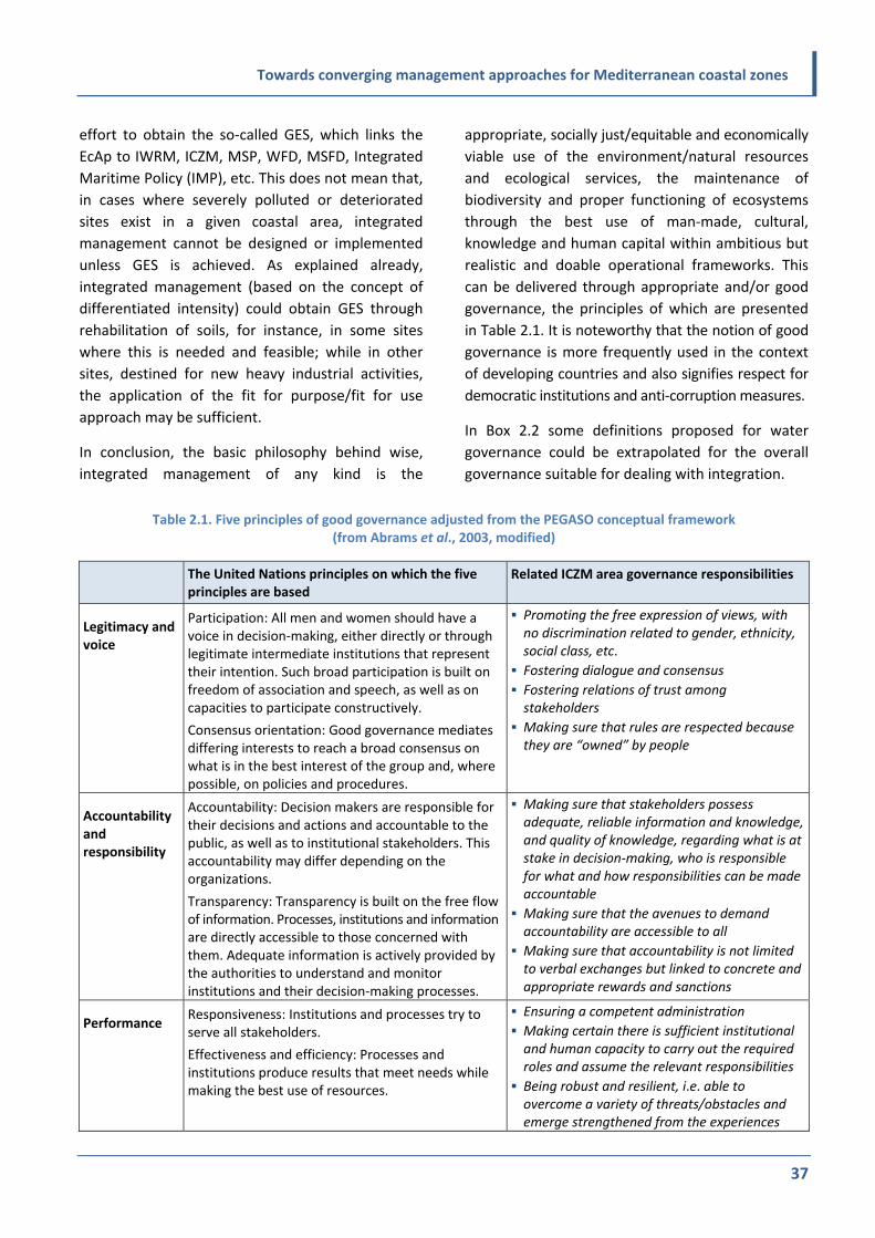
Towards converging management approaches for Mediterranean coastal zones
37
effort to obtain the so‐called GES, which links the
EcAp to IWRM, ICZM, MSP, WFD, MSFD, Integrated
Maritime Policy (IMP), etc. This does not mean that,
in cases where severely polluted or deteriorated
sites exist in a given coastal area, integrated
management cannot be designed or implemented
unless GES is achieved. As explained already,
integrated management (based on the concept of
differentiated intensity) could obtain GES through
rehabilitation of soils, for instance, in some sites
where this is needed and feasible; while in other
sites, destined for new heavy industrial activities,
the application of the fit for purpose/fit for use
approach may be sufficient.
In conclusion, the basic philosophy behind wise,
integrated management of any kind is the
appropriate, socially just/equitable and economically
viable use of the environment/natural resources
and ecological services, the maintenance of
biodiversity and proper functioning of ecosystems
through the best use of man‐made, cultural,
knowledge and human capital within ambitious but
realistic and doable operational frameworks. This
can be delivered through appropriate and/or good
governance, the principles of which are presented
in Table 2.1. It is noteworthy that the notion of good
governance is more frequently used in the context
of developing countries and also signifies respect for
democratic institutions and anti‐corruption measures.
In Box 2.2 some definitions proposed for water
governance could be extrapolated for the overall
governance suitable for dealing with integration.
Table 2.1. Five principles of good governance adjusted from the PEGASO conceptual framework (from Abrams et al., 2003, modified)
The United Nations principles on which the five principles are based
Related ICZM area governance responsibilities
Legitimacy and voice
Participation: All men and women should have a voice in decision‐making, either directly or through legitimate intermediate institutions that represent their intention. Such broad participation is built on freedom of association and speech, as well as on capacities to participate constructively.
Consensus orientation: Good governance mediates differing interests to reach a broad consensus on what is in the best interest of the group and, where possible, on policies and procedures.
Promoting the free expression of views, with no discrimination related to gender, ethnicity, social class, etc.
Fostering dialogue and consensus
Fostering relations of trust among stakeholders
Making sure that rules are respected because they are “owned” by people
Accountability and responsibility
Accountability: Decision makers are responsible for their decisions and actions and accountable to the public, as well as to institutional stakeholders. This accountability may differ depending on the organizations.
Transparency: Transparency is built on the free flow of information. Processes, institutions and information are directly accessible to those concerned with them. Adequate information is actively provided by the authorities to understand and monitor institutions and their decision‐making processes.
Making sure that stakeholders possess adequate, reliable information and knowledge, and quality of knowledge, regarding what is at stake in decision‐making, who is responsible for what and how responsibilities can be made accountable
Making sure that the avenues to demand accountability are accessible to all
Making sure that accountability is not limited to verbal exchanges but linked to concrete and appropriate rewards and sanctions
Performance Responsiveness: Institutions and processes try to serve all stakeholders.
Effectiveness and efficiency: Processes and institutions produce results that meet needs while making the best use of resources.
Ensuring a competent administration
Making certain there is sufficient institutional and human capacity to carry out the required roles and assume the relevant responsibilities
Being robust and resilient, i.e. able to overcome a variety of threats/obstacles and emerge strengthened from the experiences

Towards converging management approaches for Mediterranean coastal zones
38
The United Nations principles on which the five principles are based
Related ICZM area governance responsibilities
Fairness Equity: All men and women have opportunities to improve or maintain their well‐being.
Rule of law: Legal frameworks are fair and enforced impartially, particularly the laws on human rights.
Making sure that development is undertaken with decency, without humiliation or harm to people
Ensuring that the governing mechanisms (e.g. laws, policies conflict resolution forums, funding opportunities) distribute equitably the costs and benefits deriving from development
Making certain that public service promotions are merit‐based
Being consistent through time in applying laws and regulations
Providing fair avenues for conflict management and, eventually, non‐ discriminatory recourse to justice
Direction Strategic vision: Leaders and the public have a broad and long‐term perspective on good governance and human development, along with a sense of what is needed for such development. There is also an understanding of the underpinning historical, cultural and social complexities.
Providing effective leadership, generating and supporting innovative ideas and processes
Providing or supporting initiatives to increase the use of collaborative learning in various forums
Box 2.2. Defining governance related to water
The GWP defines water governance as “the range of political, social, economic and administrative systems that are
in place to develop and manage water resources, and the delivery of water services, at different levels of society”.
Water governance, according to a recent Organisation for Economic Co‐operation and Development (OECD) study,
encompasses administrative systems and formal institutions (including laws and policies) as well as informal
institutions such as power relationships and practices. This can include the political level, and the OECD study also
cites the Stockholm International Water Institute (SIWI), which has stated that water governance “determines who
gets what water, when and how” (OECD, 2011).
Consequently, water governance is about the relationships for water management within the RBM system rather
than simply about government‐led processes. Moreover, stakeholders are not simply “water users” or “interests”;
some are major elements of local economies and societies, as in the case of agricultural interests in farming areas,
and as such are part of water governance. Moreover, the active involvement of these stakeholders – as per the WFD
– is a key element in terms of integrating water management across economic sectors and consequently for the
success of water management goals (EEA, 2014).
“Groundwater governance comprises the enabling framework and guiding principles for responsible collective action
to ensure control, protection and socially‐sustainable utilisation of groundwater resources for the benefit of
humankind and dependent ecosystems.” (Foster and Garduno (2013), cited in Global Diagnostic on Groundwater
Governance, Groundwater Governance a Global Framework for Action (Draft Edition, January 2015), available at
www.groundwatergovernance.org/fileadmin/user_upload/gwg/documents/Global_Diagnostic_on_Groundwater_G
overnance_Draft.pdf).

Towards converging management approaches for Mediterranean coastal zones
39
2.6 Understanding the meaning of
“integration of integrated
plans”
Integration means incorporation, merging and synergy
of the parts of the different components to obtain
better information and comprehension, better
coordination, coherence, avoidance of inappropriate
policies, strategies, investments and activities that are
incompatible and mutually inhibiting, distracting,
overlapping or simply repeating each other.
In other words through integration we aim at
increasing knowledge management efficiency,
harmonization, consistency and economy in human,
material and financial resources. We aim at providing
a better, all‐embracing management and make
governance more efficient and effective. Integration
addresses different disciplines, layers of governance,
sectors, interests, aspects and points of view.
To obtain a more integrated approach usually
requires, at the initial stages, more effort and
higher levels of cooperation and coordination of
different administrations and sectors at all levels.
This is not an easy task, particularly if cooperation
and integration culture is not developed in a
particular country or area. In this respect, because
integration is an objective but, most importantly, a
mean/tool and not an end in itself, there is always a
limit to what should be integrated and what should
either be dealt with separately, or be left aside and
combined as an additional element at a later time,
when the circumstances allow. The ultimate aim is,
of course, the maximum integration of all relevant
components and plans. However, realism, practical
spirit and common sense are crucial for successful
integrated planning and management. For instance,
sometimes 80 per cent of the negative impacts may
be caused by 20 per cent of pressures. In such
cases, integrated policies should primarily focus on
those to ensure a satisfactory response.
The balance is based on the appropriate choice of
the components (e.g. sectors) to be combined; the
tools to be employed and the degree of integration
required may differ significantly from case to case.
In the IMF integration refers, at the first level, to
the overall methodologies of ICZM and IWRM
including both surface waters and groundwaters;
and, at the second, to the individual components of
each of these methodologies as they are used in the
planning that is needed. In fact, the two are closely
interrelated and considered in combination in order
to make the whole approach less theoretical and
more understandable through examples.
In combining ICZM with IWRM, including
groundwaters, it is absolutely fundamental for all
actors involved in the drafting and implementation
of management plans to understand in depth what
is common between the two (or among more of
them) and what is, eventually, different.
It is obvious that in various regions/cases the
commonalities or differences, respectively, may be
differentiated. However, in the vast majority of
cases it is expected that the common/overlapping
part between the two approaches overbalances the
parts relevant only to each one of them (see Figure
2.9). Furthermore, a truly integrated plan is not only
Part I (i.e. the “common”), but the “entire”, (i.e.
Part I + Part II + Part III and, even better, the “entire
plus”). To sum up, in order to produce the plan for
Part I, the problem approach that is to be used, can
take us to any place within the “entire plus” where
the problem is created. Therefore, the plan for Part
I may contain the recommendations, actions,
measures or interventions that are also related to
the “entire plus”.

Towards converging management approaches for Mediterranean coastal zones
40
Figure 2.9. Visualisation of ICZM, IWRM and other management practices
Given that there is a tendency to incorporate the
EcAp in integrated plans, it is relevant to summarize
the specific provisions (objectives and requirements)
that need to be observed for ensuring that the EcAp
has been respected.
Objectives:
The collective pressure of human activities is kept
within levels compatible with the achievement
of GES.
The capacity of ecosystems to respond to
human‐induced changes is not compromised.
The use of ecosystem goods and services by
present and future generations is sustainable.
Requirements:
The preservation and enhancement of ecosystems
and ecosystem services is systematically taken
into account in the development of human
socioeconomic activities.
The objectives to protect and restore the
environment should increasingly set the
boundaries for sustainable use of the natural
environment.
The above do not exclude that part of the system
might not reach the GES but at least the “fit for
purpose/use” approach should be observed.
2.7 Some basic concerns:
multi‐ and trans‐disciplinarity;
implementability; relevance
and adaptability; priority
versus sectoral approach
Perhaps the most serious and common problems
affecting all plans and management schemes are
their low implementability and/or improper
implementation. Reasons for these lie between
technical incompleteness or deficiency, unrealistic
targets, wrong/lack of timeliness (too early or too
late) and political (un)willingness to overcome
political costs that may result from the
implementation of the plans.
In many cases a deficient or dysfunctional plan
results from a partial and incomplete approach,
based on inadequate data, unrealistic expectations
and bias, giving emphasis on a few aspects while
ignoring or neglecting others that may be equally or
more critical.
Traditionally, integrated plans and management of
both IWRM and ICZM were inspired and informed
by natural processes and mechanisms involving
circulation of water (water and sediment) and
energy (photosynthesis, energy production and
consumption). The hydrological cycle, for instance,
ICZM
Entire
Entire plus ("holon" / whole)
Other
OtherOther
IWRM
PART II PART III
PART I

Towards converging management approaches for Mediterranean coastal zones
41
was and is still of fundamental importance for
understanding the different aspects (e.g. physical,
chemical, biological, geological) of the processes
involved and deciding on the appropriate measures
to be included in an integrated management plan.
Understanding the basic processes in nature
requires a multi and trans‐disciplinary approach.
Still, trans‐disciplinarity for approaching natural
processes, though a prerequisite for integrated
management, is no longer a “necessary” and/or
“sufficient” condition. Multi and trans‐disciplinarity
should also include other fields of knowledge and
expertise. Consequently, the basis of integration is
the proper understanding of all the following:
Basic biogeochemical processes in nature
Basic sociopolitical and economic parameters
Basic cultural and behavioural features of the
groups/stakeholders involved
Governance strengths and bottlenecks.
Furthermore, in practical terms, it is no longer
adequate to have in the management plan a chapter
or a set of provisions and measures dealing with, for
example, biological resources management,
another on geology, a third on economic tools and
investment and a fourth on regulations, elaborated
by different experts, if there is no clear and
functional internal coherence and synergy.
Another important problem for proper
implementation is the fragmentation of the
authorities and competences that are needed and
expected to provide coordination of the
implementation. Ministries in most of the
Mediterranean countries tend to work in silos and if
there is no established management coordination
scheme the results are relatively poor, so the plan
needs to provide for the mechanisms of its
implementation (governance scheme processes,
communications, etc.).
It is true that engagement of the various stakeholders
and local society, in particular in preparing and
introducing an integrated plan, is not time‐neutral.
There are specific, more favourable moments than
others (timeliness) for initiating such plans and
these are normally linked with the development
and the phases to be followed. Due consideration of
all the above may enhance the implementability of
a management plan.
One of the essential characteristic of an integrated
plan is adaptability. Adaptability is an inherent
quality of flexibility that needs to be built in and
maintained or even enhanced with time.
Adaptability is requested explicitly under the EcAp
and, of course, it is the core quality for addressing
the impacts of climate change and variability. Very
high levels of adaptability of an integrated plan lead
to so‐called adaptive management, which is not
another type of management but rather a quality
that all integrated management plans should have.
Key principles of adaptive management are:
flexibility and adaptability of the measures to
implement ICZM and IWRM including
groundwater management and any other
compatible planning inputs
regular update of sustainability targets to take into
account the changes observed (opportunities
and bottlenecks) in the system
provisions for integration of the outcomes of
future scientific research.
The main instruments/methods employed for its
implementation are:
monitoring programmes: measuring progress
towards targets (GES or “fit for purpose/use”),
using sets of targets
updating and ameliorating strategies according
to the outcomes of the monitoring process.
Many refer to adaptability in relation to emerging
issues or changing conditions. In fact for this type of
adaptability, flexibility is what we are looking for.
However, there is also another aspect of
adaptability that is rarely mentioned as such. This is
obtained by constant improvement and readjustment
of plans through feedback/amelioration and
refinement of pre‐existing management schemes or
parts of them.

Towards converging management approaches for Mediterranean coastal zones
42
Actually, building on existing plans is in many cases
preferable to abrupt and drastic changes,
particularly if the rest of the conditions (political,
socioeconomic, etc.) remain basically unaltered.
Finally, the safest way to enhance implementability
is by having a plan that is simple, understandable by
non‐experts and based firmly on common sense.
Such a plan has more chance of gaining the support
and ownership of stakeholders, and particularly of
those who should assist its implementation.
It is not to be expected that integration can take
place perfectly from the beginning. Integration is
usually obtained as the outcome of a process in
which a multidisciplinary team contributes. By
working together, people with different experiences
and backgrounds are learning to think out of their
“discipline boxes”, progressively achieving trans‐
disciplinarity and ultimately reaching a holistic
understanding of and consensus on the issue in
question. In section II (planning process) more
details and recommendations are provided on how
integration should be secured throughout the
process.

Towards converging management approaches for Mediterranean coastal zones
43
Chapter 3:
Aspects of Integration of ICZM with IWRM and Other Frameworks
Integration is complex and diverse. It requires a
clear definition of the system, its boundaries, its
transboundary and inner subsystems dimensions,
their connections and processes. For IMF, the
coastal ecosystem is in the focus and includes land,
fresh surface and groundwater, sea, associated
living resources and the man‐made environment.
Importantly, this system has vital and integral
connections with the upstream river basin system
and the downstream marine system.
3.1 Integration and geographical
coverage
The coastline is the interface zone not only between
land and the sea but also between fresh waters
(surface and ground) and the marine environment.
As it concerns IWRM, this interface zone extends to
the entire borders of the river basin, its catchment
area with the sea, and in most cases coincides with
the coastline addressed by the ICZM.
According to the EU WFD, coastal waters are
defined on the seaward side at a distance of 1
nautical mile from the baseline. For countries with
islands that means 1 nautical mile from the last
island. In such cases there could be a considerable
overlap of related territory. In any case, the
principle to be followed is “consideration of the
wider covers the more restricted”.
Over the next decade, expanding economic activities
in offshore areas, close to or further away from the
coast, may result in the introduction of additional
legal provisions for MSP, the coordination and
integration of which already needs strengthening
and better implementation within ICZM.
IWRM extends, theoretically, to the entire river
basin. However, this area may be too extensive for
an integrated plan for a coastal area, and therefore
beyond scale for the effective application of
management options. What is of paramount
importance is to ensure the “integrity of the
functioning” of the “last” downstream part of the
river as the absolutely minimum area that an
integrated plan should address. Upstream, partly
cut‐off, subsystems that function independently or
in a semi‐autonomous way, could be considered as
inputs to the study system with limited further
analysis. Based on the differentiated intensity
management explained in 2.3, some basic
conditions could be agreed with upstream
communities/authorities/managers which will inform
a broad framework for the management of the area
in question. The major coastal part of the
watershed, as presented in Figure 3.1, may be
considered as a sub‐basin of the river basin. In any
case, it is necessary to respect the hierarchy of the
system in order to achieve desirable harmonization
of the goals between the river basin and the coastal
sub‐basin management.
From the ICZM point of view, geographical coverage
is dealt with by Article 3 of the ICZM Protocol. This
article defines the coverage at the seaward side of
the coastal zone as the territorial sea. However, the
integrated plan could also prepare for a small, more
restricted coastal area, in which case the limits
could be smaller than the entire territorial sea. As
for the landward limit, the Protocol considers as
adequate the limit of the competent coastal units.
This may offer a pragmatic approach for certain
coastal areas, particularly where the adjacent river
basin is very extended, since it clearly refers/defines
the authorities responsible for implementation of
the ICZM, and therefore makes the plan more easy
to handle.

Towards converging management approaches for Mediterranean coastal zones
44
Figure 3.1. Integration and geographical coverage
Finally, at national, subnational and local level, the
geographical coverage of a plan reflects, to a large
extent, the governance, culture and competences in
the country or region. The ICZM Protocol that, in
principle, aims to cover the entire coastal zone of a
country, provides for two approaches, either a top‐
down framework for the entire coastal zone or a
bottom‐up framework integrating ICZM plans of
selected areas that may provide the nucleus and
examples for progressive expansion to the entire
coast.
Other adjacent areas of interest for the site in
question (e.g. neighbouring wetlands, lagoons, small
islands) may be considered broadly in formulating
such a framework further and beyond the strict
borders of the plan.
3.2 Integration across systems
The coastal zone and adjacent catchment areas
frequently include a variety of terrestrial as well as
marine, brackish and freshwater subsystems,
surface and subsurface. Although these have
distinctive functions and different properties they
are closely interlinked and synergize with each
other through natural processes, as well as through
the service functions they provide. On these natural
systems several man‐made systems, tangible (e.g.
towns) or intangible (administrations, culture) rely
and often interact, at times harmoniously and at
others aggressively and with tensions. Frequently,
the more complex the clusters of natural systems,
the richer is their biodiversity and the more
valuable are the ecological services they offer.
The management of these physical systems (e.g. the
terrestrial part which may have settlements,
agricultural uses or sand dunes) is frequently under
the responsibility/jurisdiction of ministries or other
authorities that differ from those managing the
brackish lagoons (where traditional aquacultures
exist) or protected wetlands, deltas or the purely
marine parts of the coastal zone.
A traditional IWRM plan is usually restricted to
surface and groundwaters with little reference to
brackish and marine systems. At present the impact
of various pressures, such as groundwater over‐
abstraction followed by saltwater intrusion, directly
and indirectly affects many systems and makes
absolutely necessary the integration of
management across systems on the entire coastal
zone and, sometimes, even beyond. The most
obvious example of integrated management being
needed across a system that extends beyond the
strict borders of the coastal zone is the case of the
riverine systems. Management of the upstream
parts is critical for the situation downstream (e.g. at
the delta area), while pressures/consumption
downstream may inhibit certain uses and
allocations upstream, and vice versa.
ICZMIWRMSome
offshorewaters
Some aquifers,some partly cut‐off upstream parts of the system
The major coastal part of the watershed
Coastsoutside the river basin
Partly cut‐off and/or adjacent areas of interestwhich needs to be considered in a general way
to enhance coherence of policies and buffering effect

Towards converging management approaches for Mediterranean coastal zones
45
Integration across systems is particularly noted and
gains special importance when dealing with
problems related to climate change and
biodiversity. Without a full integration of all
components and subsystems it will not be possible
to solve these problems successfully.
The need to incorporate multi‐ and intra‐/trans‐
disciplinarity is of fundamental importance to
ensure the availability of competences and skills to
work across systems, particularly when man‐made
systems (whether socioeconomic or intangible)
interact with natural systems.
3.3 Integration across sectors
In most cases, a great number of important
economic sectors and activities are active in the
coastal zone and river basin and interact directly or
indirectly. These may include urban and/or rural
developmental activities, agriculture, aquaculture,
fisheries, industry, tourism, transport and energy.
All these sectors are attracted by the natural
resources and opportunities of the coastal and
adjacent river basin areas, and quite often are
either in competition or in synergy over the use of
the resources. Therefore environmental, economic
and societal aspects of these sectors are mutually
affected and interconnected, in positive or negative
ways, and only an integrated approach can address
their concerns and challenges, providing the
optimum interaction to minimize conflicts, losses
and adverse effects while enhancing benefits. For
instance, two similar industries (e.g. iron and steel
mills, one located directly on the coast and the
other several kilometres from the coastline on a
stream connected to the sea) cannot be dealt with
differently under IWRM than under ICZM. Similarly,
a series of production activities in the river basin,
which result in products exported through the port
located on the coast, require an integrated
approach and management.
From most cases studied to date throughout the
Mediterranean, the majority of the sectors present
in the coastal zone and the river basin are common,
with few exceptions (Figure 3.2). Closely and
primarily related to the sectors (and only – to a
lesser extent – on the prevailing geomorphological
characteristics in the study areas) are the pressures
and impacts exerted on the water resources and
the coastal zone. In the majority of cases reviewed,
these pressures are recognized as “common” and of
comparable priority for both IWRM and ICZM
approaches (e.g. agrochemical inputs through run‐
off are equally important if they come from coastal
farms or from further upstream agricultural
activities). Several of them give rise to pollution
hotspots that are at the centre of attention of the
Protocol for the Protection of the Mediterranean
Sea against Pollution from Land‐Based Sources and
Activities, the National Action Plans (NAPs) of the
Mediterranean countries to reduce pollution and
the Horizon 2020 Programme to de‐pollute the
Mediterranean by the year 2020.
Figure 3.2. Integration across sectors
ICZMIWRM
Pleasure boatmarinas
Winter sportcentres
Energy productionfrom upstream dams,some mountainous forests, etc.
Maritimetransport,offshorefisheries
Coastal industry, urban development,
agriculture,coastal transport,aquaculture,
coastal fisheries,tourism, etc.

Towards converging management approaches for Mediterranean coastal zones
46
3.4 Governance for integration
Effective integration requires appropriate governance
at the relevant national, subregional or local level.
This relates to institutional structures and their
coordination, as well as to various participation
mechanisms.
3.4.1 Coordination of governance
structures for integration
Governance is not only about distribution of power
and decision‐making but also includes administration,
allocation and provision of means and services
related to implementation of decisions, etc. It is
exercised at various levels, national, subregional or
local. Depending on the scope of an ICZM plan, the
level of governance will be decided and the relevant
administrations and partners/stakeholders will be
involved.
In most cases ICZM plans are administered by
ministries of the environment and/or physical
planning. The same is true of IWRM plans in
approximately one‐half of the Mediterranean
countries, while in the rest ministries of water (or
agriculture, or water and energy, etc.) are
responsible. The role of river basin organizations,
wherever they exist, varies widely from country to
country, including depending on their actual
capacities. In both cases, coordination is supposed
to include other competent national and regional
services of ministries, for example mercantile marine,
coastguard, tourism, agriculture, fisheries and
interior, while economic ministries (e.g. of national
economy or finances) are directly or indirectly
involved on issues of regional development, taxation,
fees, property rights, different aspects of security,
compensation, economic tools, etc. (Figure 3.3).
This type of integration is usually described as
“horizontal” integration. Such integration is easy to
recommend but difficult to obtain because in the
majority of the Mediterranean countries
administrations function, to a large extent,
individually and in silos. In addition to horizontal
integration it is also necessary to secure vertical,
subnational, integration. This is not simple, either: it
requires integration and coordination of the
national level with the regional (prefectures, river
basin organizations, etc.) and local (e.g. city
councils) authorities of the area(s).
Article 7 of the ICZM Protocol requires that Parties
ensure institutional coordination, through appropriate
bodies or mechanisms, in order to avoid sectoral
approaches, overcome administrative bottlenecks
and facilitate comprehensive approaches.
Figure 3.3. Coordination for integration
ICZM IWRM
Ministry ofMercantileMarine
Ministry of Environment; Ministry of Industry;
Ministry of Agriculture; Ministry of Water;
many local authorities...
Ministry of Energy(
);some local authorities
Dept. of Offshore Hydrocarbon Exploitation
Ministry of Energy( Hydropower);forestry services;River Basin Organizations;some local authorities
Dept. of
Important "peripheral" bodies
The core of the supervising governance structureincluding the "sponsor" organization(s)

Towards converging management approaches for Mediterranean coastal zones
47
In Figure 3.3 different national authorities relevant
to ICZM and IWRM are presented. A potentially
suitable coordination structure for the integrated
management plan has to bring together all
competent authorities (core and peripheral) as well
as other stakeholders. As presented in the second
part of this publication, one way of dealing with this
issue is to have a steering committee consisting of
the core bodies, as well as a consultative group
which may encompass all peripheral bodies involved.
There are different variations and options possible
with the involvement of permanent and ad hoc
committees/bodies/councils. It is to be expected
that a permanent body would have a much more
significant and institutionalized role than an ad hoc
body. Finally, the clarification of the TOR and role of
such a body or bodies is of crucial importance for
the successful management and SD of this area.
3.4.2 Participation for integration
In both ICZM and IWRM, appropriate participation
and engagement of stakeholders are among the key
principles and crucial factor for success. Article 14
of the ICZM Protocol is dedicated to participation,
asking for appropriate involvement in the phases of
formulation and implementation of the plans. Given
the complexity and the diversity of the activities
towards integrated management, all stakeholders
should be involved. Representatives of the relevant
ministries and regional or local authorities, river
basin organizations and professional bodies/
chambers, etc., of the key sectors active in a focus
area have to be involved. In addition, economic
operators and civil society organizations (CSOs)
such as national, regional or local environmental
and users/consumers groups, irrigators and
fishermen associations, hoteliers, industries,
academia, NGOs, youth and women’s organizations,
etc., and the general public, must be included. In
the vast majority of cases the relevant to IWRM and
ICZM stakeholders – as groups and sometimes even
as persons – coincide, perhaps with the exception
of few experts/academics involved only for specific
issues (Figure 3.4).
Figure 3.4. Stakeholders involved in integration
Much greater differentiations are expected from
the professional and labour unions and particularly
among some interest groups (proprietors of land,
irrigators, etc.) between the coastal area and
professions linked with it (e.g. fishermen, coastal
hoteliers) compared with those from more
upstream sites (e.g. farmers, shepherds or
hydropower companies). However, considerable
differentiation in synthesis or emphasis and priority
of the various stakeholders involved is not
associated entirely with the nature of the site or
type of management (ICZM versus IWRM), but
already exists within each of these management
practices and is a very common issue particularly
when dealing with water allocation in IWRM.
Sources of valuable input on participation aspects in
implementation planning are derived from a recent
report on implementation of the WFD, the most
important conclusions of which are given in Box 3.1.
ICZMIWRM
Scuba divingclubs
Mountain climbingclubs
ShepherdsFerry boatowners& crew
Local authorities
Academia
NGOs
Farmers
CSOs
Stakeholders
Youth
Fishermen
Private sector
Users' organizations
Chambers of Tourism and Commerce

Towards converging management approaches for Mediterranean coastal zones
48
3.4.3 Schemes of governance for integration
Well‐defined governance structures improve
integration processes by enhancing communication,
establishing guidelines and policies, reducing and
resolving conflicts, and fostering coordination and
cooperation. The success lies in forging partnerships
and linking initiatives in order to harmonize needs,
expectations and initiatives, at the same time
avoiding getting lost in complex structures,
processes and overlapping administrations.
It is important to repeat that governance is
fundamental to ICZM and IWRM since it allows an
integrated and adaptive management approach. If
we agree that the coastal zone needs to be
approached in a holistic way (i.e. as a unique
socioecological system governed by multiple links
and interactions), adequate governance models
could be found which are capable of responding to
cultural, socioeconomic and environmental challenges
with dependable solutions.
Various governance architectures are known and each
situation will require a locally tailored and, in any case,
nested governance approach. As one of the main
common principles of ICZM and IWRM is the EcAp, it
is expected that the existence of a governance
mechanism covering the needs of both will contribute
to the coherence between the policies, plans and
programmes they rely on. It will also help in defining
the competencies/roles, capacities and capabilities
that the different stakeholders have in management,
and will facilitate structured connections, sharing of
Box 3.1. Public participation in the EU WFD
In the context of the EU WFD, public participation (PP) is viewed as a means of improving water management
through better planning and more informed decision‐making. The active involvement of all interested parties and
influencers in the deliberation and decision‐making process is generally expected to foster an environment of
accessibility, receptiveness and mutual respect that ultimately promotes transparency and trust among participants
and can then increase the success rate of policies due to better acceptance by stakeholders. Naturally, this kind of
setting is highly desirable, especially when the topic under discussion is a cross‐cutting issue involving multiple
stakeholders and reflecting numerous interests.
A review of the existing literature establishes the theoretical background and outlines the principal objectives of PP
mentioned above, as well as the core principles that constitute a good participatory process: openness, protection of
core values, speed and substance.
The review of the case studies showed that the institutional set‐up, shared or ambiguous remits of authorities and
the links between natural and administrative boundaries can all reduce the effectiveness of participatory processes.
These elements should therefore be carefully considered and factored in, in order to plan River Basin Management
Plans (RBMPs) effectively. Furthermore, clarity appeared to be key for achieving effectiveness, first in terms of
describing how the participatory process is planned and conducted, including feedback on how the information
gathered will be used. Second, clarity and tailored approaches are needed concerning the technical level (and
language) of the information provided to participants. This also relates closely to the best practice of fostering
transparency and a sense of ownership through clarity and early involvement, respectively. And finally, trust
appeared to be vital for good PP. Good practice here meant having technical experts engage in face‐to‐face
discussions, appointing independent facilitators and selecting tools targeting a specific audience.
The goal for PP is both involving members of the public and involving organized stakeholders. Involving organized
stakeholders is as important for a good planning process as the involvement of the wider public which, in some
cases, is even more challenging and needs appropriate tools and encouragement. There are already some good
practices in that, such as the European Citizen’s Initiative (ECI), which need to be further exploited.
(Adapted from the Executive Summary of the EEA Report 3/2014:
Public Participation: Contributing to better Water Management)

Towards converging management approaches for Mediterranean coastal zones
49
responsibilities and, when necessary, trade‐offs (e.g.
on cross‐cutting responsibilities, missing or
overlapping responsibilities and rights, conflicts).
To be efficient, governance provisions and
structure(s) have to be designed jointly by a cluster
of institutions and partners which decide what
works best for them. Nevertheless, each structure
should have, as a minimum, a document that sets
forth its goals and objectives, establishes the
decision‐making process, confirms the commitment
of partners and defines their responsibilities.
Although it is normal and expected that major
changes in policies and government schemes may
affect management priorities in a given area,
governance structures must be established in such
a way that they are as robust as possible and are
not abolished or lose their mandates by eventual
changes in government, in partners’ participation or
through replacement of leadership. It is always an
asset if in the governance structure committed
partners and a “champion” leadership exists,
ensuring coordination, continuity and smooth
working relationships, to keep the integration
efforts moving forward and to monitor progress.
3.5 Methodologies and tools for
integrated planning
Different methodologies and tools are used for
integrated planning. These could be clustered or
specified according to the needs (e.g. for preparation,
drafting, assessment/approval, implementation and
monitoring/follow‐up of the plans).
To a very large extent the methodologies used by
ICZM and IWRM are common or very similar (Figure
3.5) and include:
knowledge management, in general
data collection (time series data) and assessments,
including all kinds of qualitative and quantitative
measurements of pressures, statistical information
about socioeconomic and environmental trends
(economic growth, population, consumption of
water and energy, transport, housing, etc.; also
education, social welfare)
surveys and fieldwork/measurements for filling
information gaps using a variety of methods and
techniques, such as remote sensing and
Geographic Information Systems (GIS)
application of information sharing and
communication tools
enhancement of public participation (PP)/
consultation with stakeholders applying, inter
alia, public consensus‐building tools
systematic use of indicators of performance
(progress of implementation)
systematic use of indicators of progress/results/
impacts/improvement of the situation (towards
GES)
establishing and utilizing various types of
monitoring, employing the appropriate networks
and agencies
ensuring feedback and readjustment/adaptation
mechanisms.
Figure 3.5. Methodologies employed for integrated planning and management
ICZMIWRM
Data set on specific upstreamstatistics
DPSIRGIS
Ecosystem approachVulnerability assessment
Methodologies& tools
Data set on offshore marine resources

Towards converging management approaches for Mediterranean coastal zones
50
More on methodologies and tools appropriate for
ICZM and IWRM will be provided in section II
through the operational, step‐by‐step guidelines.
Lesson: convergence of approaches: a common
definition of integration
The most important term within IMF is integration.
As already explained in chapter 2, its common
meaning is more often assumed rather than clearly
defined, since there are frequently different
interpretations, uses and applications of integration
and integrated management. When approaching a
particular case, it is important to define the spatial,
political, socioeconomic, natural and technological
context within which integration is implemented.
The latter is not static but may be subject to
frequent change.
The IMF identifies the key dimensions within which
integration and integrated management must be
defined. These are:
Integration across commonly defined geographic
space
According to the IMF approach, the entire river
basin should be considered. In practice, this
depends on the specific size and geomorphology
of the basin, but what should be included is the
coastal sub‐basin, with its groundwaters,
transitional waters and coastal waters.
Landward, the ICZM Protocol proposes the limit
of the “competent coastal units”. This offers a
pragmatic approach for identifying the
appropriate geographical coverage, particularly
where the adjacent river basin is very extended,
since it clearly refers/defines the authorities
responsible for the implementation of the ICZM.
Experience from Buna/Bojana: boundaries –
defining the transboundary plan area
The plan was defined according to guidelines in the
ICZM Protocol and the EU WFD and the natural
characteristics of the area, and refined according to
local circumstances. A transboundary zone was made
up of the transboundary natural elements, that is,
coastal zone, catchment, aquifers, transitional and
coastal waters – up to the external limit of
territorial sea – and the relevant administrations
(see Figure 3.6).
However, the plan is focused on a core zone within
which the transboundary and land‐sea interactions
are concentrated. The boundary of this core zone is
based predominantly on the watershed, aquifers
and ecosystem of the Buna/Bojana and the inshore
waters where the influence of the river system can
be clearly identified and measured (see Figure 3.7).
In practical terms, the land boundary of the plan
area was drawn using the local administrative
boundaries that broadly conformed to the physical
boundary of the watershed, thereby facilitating
analysis of the natural and physical environment
alongside the available socioeconomic information.
In Montenegro this includes the municipality of
Ulcinj, while in Albania this includes a number of
communes within the county of Shkoder (Ana e
Malit, Bërdice, Dajç and Velipojë). The approximate
surface of the terrestrial part of the transboundary
zone is 500 square kilometres (km2).
The inshore marine zone was drawn according to
the primary influence of the surface water flows on
inshore marine waters, as indicated by the level of
salinity (using the maximum sea surface salinity
isolines to approximate average threshold at 35
PSU). This zone comprises approximately half of the
national territorial waters.

Towards converging management approaches for Mediterranean coastal zones
51
Figure 3.6. Transboundary zone: sub‐basin, aquifer and marine zone
Figure 3.7. The core transboundary plan area

Towards converging management approaches for Mediterranean coastal zones
52
Integration across natural and physical systems
The natural and physical systems of the coast do
not function in isolation. The impact of various
pressures such as over‐abstraction of groundwater
is followed by saltwater intrusion and directly and
indirectly affects many systems. The integration of
management across the natural systems of the
entire coastal zone and even beyond is, therefore,
necessary. Management of the upstream, riverine
parts is critical to the situation downstream, for
example at the delta, while pressures/consumption
downstream may inhibit certain uses and
allocations upstream.
Integration across sectors
A wide number and various types of important
economic sectors and activities are present in the
coastal zone and the river basin and interact
directly or indirectly. Such sectors include urban
and rural activities and development, agriculture,
aquaculture, fisheries, industry, tourism, transport,
energy, etc. All these sectors are attracted by the
natural resources and opportunities of the coastal
and adjacent river basin areas, and quite often are
either in competition or in synergy over
sustainability of the resources.
Experience from the Buna/Bojana plan:
upstream hydropower exploitation
Operation of the hydropower dams upstream of the
plan boundary on the Drin River is focused on the
maximization of electricity production. The dam’s
operation rules and practices do not take into
consideration the risk of downstream flooding
incidents in the event of extreme meteorological
conditions. Therefore, the proper regulation of the
dams through adaptation of the operational
practices of this sector (including provisions for
early warnings, cooperation with downstream
communities and other sectors, etc.), is of critical
importance for the reduction of hazards and
effective management of water resources within
the plan area.
Integration across systems gains special importance
when dealing with problems related to climate
change and biodiversity. Without a full integration
of all components affecting interventions and all
subsystems affected by them it will not be possible
to solve these problems effectively.
Integration and governance
Effective integration requires appropriate governance
at the relevant national, subregional or local level to
achieve and promote it.
For the supervision of the planning process and,
later on, for the implementation of the plan, there
are various options for governance architecture, and
each situation requires a locally tailored governance
approach. They can range from permanent to ad
hoc committees, bodies or councils.
Experience from the Buna/Bojana plan: the
complexity of transboundary governance
Taking into account the importance of governance,
the land boundary of the Buna/Bojana plan area
was drawn using the local administrative
boundaries that broadly (but not exactly) conform
to the physical boundary of the watershed, and as a
close approximation to the ICZM Protocol’s definition
of the coastal zone based on administrative units.
However, the two countries have very different
scales of local administration. In Montenegro,
therefore, this includes only a single municipality,
while in Albania this includes a number of communes
within the wider county of Shkoder. Further,
administrative responsibilities and capacities also
differ widely. The experience indicates the practical
realities of the use of administrative units. Plans
must adapt to national and local circumstances, and
the ICZM Protocol term “administrative units” may
be on a scale that requires the drawing of coastal
zone boundaries that encompass multiple small
units or the subdivision of larger ones.

Towards converging management approaches for Mediterranean coastal zones
53
Experience from the Buna/Bojana plan: use of
existing management bodies
Importantly, the plan governance structures
established for plan preparation are likely to be
different from those needed for its implementation,
requiring a transition from the process of plan
preparation to the process of implementation.
Integration for participation
In ICZM and IWRM the participation and
engagement of stakeholders are identified as key
principles and crucial factors for success. In the vast
majority of cases, relevant IWRM and ICZM
stakeholders – as groups and sometimes even as
individuals – broadly coincide.
Experience from the Buna/Bojana plan:
participating bodies
Most of the bodies competent for ICZM in the
Buna/Bojana area are common with those
responsible for and interested in IWRM.

Towards converging management approaches for Mediterranean coastal zones
54
Chapter 4:
Foundation Documents for IMF
Plans for coastal areas including estuaries within
the Mediterranean should be developed within the
context of the ICZM Protocol and IWRM principles.
An institutionalized approximation of such an
approach is also provided by the EU WFD. The latter
is obligatory only for EU Member States while its
provisions are voluntarily followed by Accession
States. However, some other Mediterranean
countries follow also its principles which, in any
case, may be used as inspiration towards IWRM.
4.1 ICZM Protocol
The ICZM Protocol adopted in 2008 was the 7th
Protocol in the framework of the Barcelona
Convention, and represents a major milestone in
the history of the MAP. It completes the set of
protocols for the protection of the marine and
coastal environment of the Mediterranean region
and it is hoped it will help Mediterranean countries
to better manage and protect their coastal zones, as
well as address newly emerging coastal environmental
challenges, such as those linked with climate change.
Ultimately, the ICZM Protocol identifies a hierarchy
of a Mediterranean ICZM strategy, national
strategies and coastal plans and programmes for
individual coastal areas (including transboundary
ones; Box 4.1).
The ICZM Protocol sets an ambitious framework
and “qualities” of ICZM plans, which should be:
Innovative
Forward‐looking and proactive – preventing and
not only reacting to coastal problems
Comprehensive – covering all issues crucial for
coastal environment (marine and terrestrial) and
its protection in the twenty‐first century
Integrated – ensuring institutional coordination,
cooperation of national, regional and local
authorities, involvement of partners/stakeholders
(includes NGOs and other competent bodies).
Box 4.1: General principles of ICZM (Article 6)
a) The marine and land part of the coast should be taken as a single entity.
b) All elements relating to hydrological, geomorphological, climatic, ecological, socioeconomic and cultural systems shall be taken into account in an integrated manner.
c) The ecosystem approach shall be applied.
d) Appropriate governance allowing adequate and timely participation in a transparent decision‐making process shall be ensured.
e) Cross‐spectrally organised institutional coordination shall be required.
f) The formulation of land use strategies, plans and programmes covering urban development and socioeconomic activities and other sector policies shall be required.
g) The multiplicity and diversity of coastal activities shall be taken into account and priority shall be given to public services and activities requiring the immediate proximity of the sea.
h) The allocation of uses should be balanced and unnecessary concentration and urban sprawl should be avoided.
i) Preliminary assessments shall be made of the risks associated.
j) Damage to the coastal environment shall be prevented, and where it occurs, appropriate restoration shall be effected.

Towards converging management approaches for Mediterranean coastal zones
55
The presumption in the General Principles of the
Protocol (article 6) is that all sectors are of equal
importance in the EcAp, achieving the optimal
combination of the approaches within a common
spatial and temporal context. Plans for coastal areas
should therefore reflect the aspirations and interest
of all sectors in a balanced way. Where plans are
produced with the involvement of several sectors, a
clear foundation statement should be made
through the process, which expresses the shared
vision of working together; the main objectives and
commitments of partners; and an outline of key
operational directions. Such vision should be
ambitious and not a mere compromise based on a
common denominator approach among sectors.
The larger macro‐ or high‐level elements of policy
could be abstracted from policies or strategies
concerning individual sectors and cross‐cutting
themes. What should be examined and enhanced
are the interrelationships/communality between
them, along with the existing operational policy
means and the consolidated actions. Sectoral
integration should achieve optimal solutions rather
than mere compromises or distortions due to
different institutional and/or funding priorities.
The scale and nature of an ICZM plan or programme
may vary from case to case. According to article 18,
paragraph 3 of the ICZM Protocol for the
Mediterranean: “Coastal plans and programmes,
which may be self‐standing or integrated in other
plans and programmes, shall specify the
orientations of the national strategy and implement
it at an appropriate territorial level, determining,
inter alia and where appropriate, the carrying
capacities and conditions for the allocation and use
of the respective marine and land parts of coastal
zones.”
4.2 WFD
In 2000, the EU adopted the WFD which introduces
a new legislative approach to managing and
protecting water, based not on national or political
boundaries but on natural geographical and
hydrological formations: river basins. It also
requires coordination of different EU policies, and
sets out a timetable for action, with 2015 as the
target date for getting all European waters into
good condition. The EU established a 6‐year
planning cycle for the development of RBM plans,
and the first are to be reviewed in 2015. Box 4.2
summarizes some key principles of the WFD.
Box 4.2: Some key principles of WFD for IRBM
Objective: achieving “Good Status” for all EU rivers, lakes, groundwaters, coastal waters, etc., by 2015.
Establishing a 6‐year planning cycle for the development of river basin management plans.
First review to take place in 2015.
The WFD:
aims to protect all waters, surface and groundwaters
aims to cover all impacts on waters
comprehensively defines water quality in terms of biology, chemistry and morphology
bases water management on river basins
provides for monitoring programmes on surface and groundwaters, both as planning tools and as assessment instruments
considers economic instruments (getting the prices right to promote prudent use of water)
introduces mandatory public participation
is complemented/guided by an enhanced cooperation on implementation
aims to reduce marine pollution from land‐based sources and protect ecosystems in coastal waters.

Towards converging management approaches for Mediterranean coastal zones
56
EU Member States have had to draw up river basin
management plans (RBMPs) to safeguard each of
the 110 river basin districts of the EU. The EU now
has more than 127,000 surface water bodies: 82 per
cent of them rivers, 15 per cent lakes and 3 per cent
coastal and transitional waters. The same river can
contain different water bodies, since the status of
the water may change. The total number of
groundwater bodies reported is 13,261
(Commission Staff Working document, available at
http://ec.europa.eu/environment/water/water‐
framework/pdf/CWD‐2012‐379_EN‐Vol1.pdf).
PP is a fundamental principle in this process, so
European citizens are expected to play an influential
role in planning and implementing the WFD measures.
The WFD introduces a series of important criteria
and classifications. The ecological status looks at
the abundance of aquatic flora and fish fauna, the
availability of nutrients and aspects such as salinity,
temperature and pollution by chemical pollutants.
Morphological features such as quantity, water
flow, water depths and structures of the river beds
are also taken into account. The WFD classification
scheme for surface water ecological status has five
categories: high, good, moderate, poor and bad.
High status means no or very low human pressure;
good status means a slight deviation from this
condition; moderate status means a modest
deviation, and so on.
To define good chemical status, environmental
quality standards have been established for 33 new
and eight previously regulated chemical pollutants
of high concern across the EU. The WFD is backed
up by other EU legislation such as the Registration,
Evaluation, Authorization and Restriction of
Chemicals (REACH) regulation on chemicals and the
Directive for Integrated Pollution and Prevention
Control (IPPC) for industrial installations.
The rules for groundwater are slightly different and
good chemical and quantitative status is the objective.
Member States must use geological data to identify
distinct volumes of water in aquifers, and European
law limits abstraction to a portion of the annual
recharge. Groundwater should not be polluted at all
– any pollution must be detected and stopped.
Under the WFD, Member States have to hold
extensive consultations with the public and
interested parties, first to identify the problems,
and then the solutions, to be included in RBMPs.
Box 4.3 presents the WFD requirements for PP.
Finally, WFD also addresses the changing
environment which creates challenges for the
future, including climate change, floods and droughts.
4.3 Groundwater directive
The EU Directive “on the protection of groundwater
against pollution and deterioration”, while not
specifically mentioning coastal aquifers and their
particular set of groundwater‐related problems,
provides general criteria for the assessment of good
groundwater chemical status and for the
identification and reversal of significant and
sustained negative trends. It also complements the
provisions already in the WFD that prevent or limit
inputs of pollutants into groundwater.
4.4 Additional documents to be
considered
In addition to the two basic documents already
mentioned that support the IMF and all elements
and lessons that can be deduced from the other
integrated (targeted) management approaches, one
should consider some important inputs from other
legal documents such as:
1. The EU MSFD which – to a large degree –
covers the extension of management beyond
the transitional waters to the marine
environment and maritime activities and which
constitutes a compulsory framework for EU
Member States
2. IMP, overarching EU strategy for a coherent
approach to maritime issues, with increased
coordination between different policy areas
3. MSP (linked to point 2, above)
4. The UNECE Convention on the Protection and
Use of Transboundary Watercourses and
International Lakes (1992) which has been
signed and ratified by many Mediterranean
countries

Towards converging management approaches for Mediterranean coastal zones
57
5. The Protocol on Water and Health (1999)
under the UNECE Water Convention, also
ratified by many Mediterranean countries
6. The Model Provisions on Transboundary
Groundwaters (2012) under the UNECE Water
Convention which provide guidance for the
implementation of the Convention to
transboundary groundwaters (based on the
draft articles on the law of transboundary
aquifers annexed to United Nations General
Assembly Resolution 66/118)
7. EU White Paper – Adapting to Climate Change
8. EU Flood Risk Directive
9. A series of other conventions (such as Ramsar,
CBD, etc.) to be taken into account in the
relevant parts of the integrated plans
10. Mediterranean Strategy for SD (MSSD)
11. EcAp process in the Mediterranean.
Box 4.3: WFD requirements for PP (EEA, 3/2014)
The WFD requirements for PP are explained here as a three‐level process. The groundwork required or precondition
for PP is information supply. This first level should provide the public with the knowledge and background
documents necessary to take part in the process. According to the EU Guidance document on PP in relation to the
WFD, “as a minimum the background documents should include all the documents that are summarized in the River
Basin Management Plan”.
Three levels of public participation, after WFD Guidance document No 8 Common Implementation Strategy (CIS) Working Group 2.9, 2003
Consultation is the second level of PP: this consists in making a document available to the public for their comments
and ideas, based on their perceptions and experiences. This can be executed in written or oral form, and can be
conducted passively (an open invitation to participate is extended) or actively (opinions are requested directly
through surveys, for instance). In a consultation, the party requesting opinions is not bound to integrated them into
the outcome, and the public does not play a decision‐making role.
The third level of PP is active involvement, which is a higher level of participation than consultation. Active
involvement implies that stakeholders and the public are invited to contribute actively to the planning process by
discussing issues and contributing to their solution (CIS Working Group 2.9, 2003). The CIS Guidance document on
PP, the whole process of the WFD common implementation and numerous examples in the literature suggest that
active involvement of a wide range of stakeholders facilitates achievement of WFD objectives and improvement of
our water environment. When preparing the first draft RBMPs, initial steps for active involvement of all interested
parties often consisted in the setting‐up of working groups with a predominantly advisory role, involved directly in
the drafting of plans, or consulted afterwards (Kampa, 2009, referenced in EEA, 2014).

Towards converging management approaches for Mediterranean coastal zones
58

Towards converging management approaches for Mediterranean coastal zones
59
Section II: Operational Guidelines of the IMF

Towards converging management approaches for Mediterranean coastal zones
60

Towards converging management approaches for Mediterranean coastal zones
61
Chapter 5:
Planning Process and its Five Stages
5.1 Introduction
There is no single recipe for preparing an integrated
plan because there are numerous opportunities for
starting points and methods to be followed
depending on the site, its history, previous
management efforts and the political and
socioeconomic circumstances. There is a wealth of
planning experience under a variety of names and
frameworks, the most important of which have
been presented in section I and were of particular
usefulness for the design of the present section.
Many elements and components need to be
synthesized. In fact, after reviewing a considerable
number of IWRM, ICZM and other types of
integrated plans, SD plans, and relevant strategies,
projects and schemes proposed in the literature
and applied to date, we are in a position to broadly
describe and propose a logical sequence of key
stages that seem to be both essential and practical
for the preparation/drafting of plans.
5.2 Overview, dynamic nature of
integrated plans, the DPSIR
framework and timeliness
It is very important to understand the various
stages or phases of planning to be presented in
chapter 6 not as discrete steps but as parts of a
continuum which is enhanced by multistage
feedback. The latter, if successful, could lead to a
virtuous cycle of improvement, deepening and
(depending on need) adding details without,
however, becoming involved in describing
micromanagement which may soon become
obsolete. Furthermore, provisions should be in
place to allow the results of scientific research and
studies related to biogeochemical processes in the
region – as well as on socioeconomic, cultural, etc.,
aspects and developments – to inform and improve
management.
5.2.1 The DPSIR framework
A very instructive depiction of the dynamic nature
of planning and the close relationship of the
integrated plan with the policy cycle is the DPSIR
sequence or framework developed by the European
Environment Agency (EEA, 1969). It is a descriptive,
simple and flexible cause‐consequence loop which
illustrates the links between human activities and
environmental processes. It has been widely used in
environmental research and communication, as it
helps stakeholders to understand the importance of
natural systems in the decision‐making, as well as
the repercussions of economic activities (Figure 5.1).
Figure 5.1. DPSIR Framework informs the preparation of the Integrated Plan
Responses
Impact
Drivers
Pressures
State
Integrated plan
e.g.
Industry and transport
e.g.
Polluting emissions
e.g. Air, water, soil quality
e.g.
Clean production, clean transport, regulations, taxes,information, etc.
e.g.
Ill health, biodiversity loss, economic damage

Towards converging management approaches for Mediterranean coastal zones
62
The DPSIR framework, even if it might sometimes
be disturbed by unexpected external parameters,
indicates that the initiation of an integrated plan
corresponds to the responses phase of a well‐
documented and communicated cycle where the
pressures and impacts are well understood and
therefore there is adequate public support or even
demand for a coherent strategy to address the
problem. Therefore, during the analysis stage, drivers,
pressures, state and impact should be documented,
analysed and understood. However, feedback,
monitoring and appropriate adaptations should be
considered as an integral part of the overall process
of plan preparation and implementation.
5.2.2 Timeliness
The DPSIR framework may also be useful in
obtaining optimum timeliness”. Timeliness refers to
identification of the appropriate moment for the
introduction of an integrated plan. Engagement of
the various stakeholders and local society at large,
in particular, and also the chances for introduction
of institutional changes and legal provisions or
funding opportunities, etc., are not time‐neutral.
There are some specific moments that are more
favourable than others for initiating or
implementing such plans; these are normally linked
with the development and individual stages of the
DPSIR policy cycle.
5.3 The Seven I’s
In approaching integrated planning one should also
remember that integration is only one of the
important “Seven I’s”, which are all relevant for the
planning process and for follow‐up. They should be
taken into account from the design phase; and,
while implementation may be considered as the final
aim, and integration as the process of obtaining it,
information, involvement of stakeholders, innovation,
investment and international experience‐sharing
and cooperation are all‐important tools in achieving
both, as shown in Figure 5.2.
Figure 5.2. The Seven I’s
INTEGRATION
Investment
Innovation
Information
Involvement
International cooperation
IMPLEMENTATION

Towards converging management approaches for Mediterranean coastal zones
63
5.4 Practical suggestions to
enhance the multiple
usefulness of the plan
In elaborating and implementing truly integrated
plans, three clusters of actions should be considered:
1. Planning by keeping in mind the inclusion of “no‐
regret measures”, several of which have been
identified by local communities or scientists (e.g.
by avoiding building infrastructures in vulnerable
areas, by giving preference to low energy and
reduced material demand options, by promoting
waste recycling options)
2. Using nature, ecological services and natural capital in an appropriate way as capital and
service (see relevant chapters) by enhancing the
functions of natural regulation systems (e.g. by
re‐naturalizing areas that could act as natural
buffer or detention zones, such as transitional
and intermittent wetlands for absorbing flood
pressures, tsunamis, pollution). This is the main
message of the EcAp.
3. Securing/preparing/providing both technical and human resources for adaptation to climate
variability and change; and to increase the
robustness and resilience of the systems
involved to climate change and also to
emergencies and extraordinary events of
whatever nature. This also includes elaboration
and testing of contingency plans, trainings and
early warning systems, and also putting in place
relevant facilities (e.g. high‐capacity removable
pumps), which could provide exceptionally
useful services at difficult times and enhance the
efficiency of the operation of an integrated plan.
All the above are also important in plans related to
adaptation to climate change.
5.5 Schematic representation of
the planning process
In order to achieve integration, a planning process
is suggested within IMF, to guide the step‐by‐step
preparation of the plan, and identify the issues for
permanent and focused integration of coastal, river
basin and aquifer/groundwater management. The
guidelines that follow are structured into five
sections representing the five stages of a planning
process within which the ICZM ingredients are
combined with those of IWRM, coastal aquifer and
groundwater management, the EcAp principles and
several other important inputs. More specifically,
this process was developed by taking into account
the experience of several PAP/RAC Coastal Area
Management Programme (CAMP) projects and a
methodology, introduced under the EU‐funded
SUDECIR programme (Scoullos et al., 1999). The
programme was implemented with emphasis on
tourism on the island of Rhodes, Greece (Scoullos,
2004), and more recently on Lake Bizerte, Tunisia,
within the framework of Horizon 2020, obtaining an
agreed plan/framework (www.h2020.net/news‐and‐
events/news/107‐ceremony‐for‐the‐signature‐and‐
adoption‐ of ‐the‐ charter‐ for‐ the‐ sustainable‐
development‐of‐lake‐bizerte.html; and www.
h2020.net/ news‐ and‐ events/ news/ 95‐ the‐ lake‐
bizerte‐ charter‐ a‐ step‐ towards‐ its‐ sustainable‐
development‐ horizon‐ 2020‐ enhances‐stakeholder‐
participation‐for‐the‐integrated‐management‐of‐lake‐
bizerte‐in‐tunisia.html) (Figure 5.7) as well as a
series of good practices on IWRM plans
accumulated in the GWP Toolkit (www.gwp.org/
ToolBox) and through the work of the EU FP7
PEGASO project (www.pegasoproject.eu) (Figure
5.3).

Towards converging management approaches for Mediterranean coastal zones
64
Figure 5.3. Plan preparation and implementation process: overview
5.6 Proposed sequence of the five
stages
As mentioned already, there are many ways to
design, draft and present a planning process and
even more ways to systematically depict it. This
depends on where the emphasis is placed. Planning
includes both “substance” in the content of each
stage and “process” which is dynamic. If the broad
content of each stage is the main purpose of the
document, the schematic representation of the
planning can be simple and relatively linear. If the
emphasis is on explaining the process itself with
some accuracy, the representation becomes more
complex and cyclic.
It is of crucial importance to understand that the
stages cannot be developed separately, in isolation,
without overlapping and without feedback. Linear
representations of the stages of the process should
be understood as including dynamic internal
interaction among the various stages but also
within each one of the stages. Figure 5.4 depicts an
overview of the plan preparation and
implementation process in a rather abstract,
simplified, linear way. The sequence of the stages is
very clearly presented and the arrow on the left
emphasizes the gradually increasing degree of
integration obtained with time and further
elaboration of the plan. The arrow on the right
indicates the expected and needed feedback during
the preparation and, most importantly, during the
implementation of the plan.
The triggers for the initiation of the plan may be
different: legal requirements (such as the ICZM
Protocol, WFD norms or some other international
or national legal requirements); escalation of
problem in need of solution; new developments
representing opportunities for some more
sustainable approach; or opportunities provided
through international donors, etc. The timeliness of
the initiation as part of the response in the DPSIR
framework has been explained already above
(under 5.2.1).
REALISING THE VISION
DESIGNING THE FUTURE
SETTING THE VISION
ANALYSIS & FUTURES
ESTABLISHMENT
INTEGRATION
FEED
BACK

Towards converging management approaches for Mediterranean coastal zones
65
Figure 5.4. Plan preparation and implementation process: detail
The five‐stage process is described in these
guidelines in detail. Each stage includes a number of
tasks and each task a series of steps, actions and
deliverables/outputs.
When getting into the planning process the
systematics and sequence of the various steps may
be differentiated according to local, site‐specific
conditions, opportunities and well‐established or
emerging priorities.
In some cases, the initial description of the process
based on superficial analysis of the situation is
incomplete and the actual process becomes far
more complex than expected. In other cases, the
complete process described might be
“maximalistic”, ideal or unnecessarily complex. In
fact, in some cases the description on paper may be
more complicated and difficult than it is in practice.
In view of the above observations, some things
should be understood properly right from the
beginning. Even if the process is a rather long and
complex, the final product (the integrated plan)
should be basically simple and relatively brief but
not superficial. Both the plan and the planning
process, apart from describing and analysing the
specific issues of interest to the specific site and
reflecting/respecting the consensus vision about
the future of the plan area, should also:
create the enabling working framework for
different organizations, disciplines, authorities
and stakeholders to cooperate
succeed in positively influencing the behaviour
of target user groups and institutions including
the various donors and investors
lead to tangible results and visible benefits,
obtaining an appropriate balance between
environment and human society
be holistic and not sectoral, and not
“captured/hostage” or unduly influenced by a
single economic sector (e.g. transport/tourism/
agriculture) or centred on a single problem (e.g.
nature conservation, soil erosion)
be based on targets tested and applied
somewhere else
find a balance between ambition and realism
(overcome obstacles and bottlenecks but remain
“doable”).
•Definig Territorial Scope
•Scoping issues, pressures,..
•Establishing Coordination Mechanisms
•Defining Governance Context
•Engaging Stakeholders
•Proposing a Vision
•Deciding on SEA
ESTABLISHMENT
•Building the Evidence
•Identifying FuturesANALYSIS & FUTURES
•Building Consensus
•Setting the Direction
•Measuring Success
SETTING THE VISION
•Formulating Plan
•Establishing Management Structure
•Embedding
DESIGNING THE FUTURE
•Implementing
•Acting
•Monitoring and Reviewing
REALISING THE VISION
INTEG
RATIO
N
FEEDBACK

Towards converging management approaches for Mediterranean coastal zones
66
Lesson: Operational practicalities – the value
of the simple, common road map adaptable to
local circumstances
In order to achieve integration, a planning process –
the simple five‐stage road map ‐ is proposed by the
IMF to guide the step‐by‐step preparation of the
plan and deliver its outcomes, and to identify the
issues for the focused integration of coastal, river
basin and aquifer/groundwater management. It is
meant as a guide and is adaptable for use at local
level, according to local circumstances and resources.
In the review of existing planning process
methodologies around the world, clear
commonalities were identified – the broad stages of
analysis through to realization of the plan, and its
subsequent monitoring and review. However, many
these processes are described in ever‐increasingly
complex language and organograms. Methodologies
are often described for a technical audience, over‐
concentrating on a predominantly scientific analysis.
Issues are selected for management on a top‐down
basis that more closely reflect the objectives of the
project proponents than the community on the
ground. Often the methodologies do not fully
recognize the realpolitik of work at a local level, the
limitation of resources and the all‐important plan‐
delivery stage. Thereby these complex
methodologies prove difficult to translate into a
practical planning process for application at the
local level.
The guidelines for the IMF are therefore
deliberately simple and structured into clear
sequential sections: establishment; analysis and
futures; setting the vision; designing the future; and
realizing the vision representing the five key stages
of the planning process. They are firmly based on
Mediterranean experience (Scoullos, 1999;
Vonkeman, 2000).
Emphasis is based on four key principles that
recognize the limitation of resources, the need to
engage non‐expert audiences and, ultimately, that
lead to real outcomes. These principles are:
the establishment of a firm foundation at the
beginning of the process and before the
“scientific” analysis – including, for example,
developing the workplan, scoping the local
issues and agreeing the plan boundaries
the development and use throughout of a
shared common vision for the plan area
the pragmatic use of “fit‐for‐use” data and
information rather than over‐complex research
and analysis, combined with the use of clear,
non‐technical language
the focus on delivery – agreeing a commonly
agreed vision for the plan area and providing the
foundations for delivering real outcomes.
The diagram in Figure 5.5, which illustrates the
process, appears almost naïve in its simplicity and
linearity. This is deliberate, as it provides a
framework around which to design a rigorous
intellectual process of analysis and planning, a
simple structure upon which to “hang” deadlines
and targets, and through which to allocate financial
and human resources during the planning cycle.
Figure 5.5. The five stages as described in the Buna/Bojana integrated plan

Towards converging management approaches for Mediterranean coastal zones
67
The diagram also acts as a convenient “top layer”
for use in a web environment. The process was
developed in parallel with the EU FP7 PEGASO
project, the main goal of which is to construct a
shared ICZM governance platform for the
Mediterranean and Black Sea linked with new
models of governance for the Mediterranean and
Black Sea. The IMF process is used as the
framework for “Roadmap towards Coastal
Sustainability” – an online wiki through which each
of the five stages can be explored and infinitely
expanded in ever greater detail (Figure 5.6).
In Lake Bizerte, the SUDECIR (Vonkeman, 2000)
approach was applied. The analysis part, which
corresponds to stages 1 and 2 of IMF, was largely
carried out by H2020, Mediterranean Hot Spots
Investment Programme – Project Preparation and
Implementation Facility (MeHSIP‐PPIF) and the
European Investment Bank (EIB). This was followed
by the agreement by consensus of the Bizerte
Charter which represents the collective vision,
facilitated by H2020 Capacity‐Building /
Mediterranean Environment Programme (CB/MEP)
(www.h2020.net/resources/training‐
materials/finish/192/1712.html).
Figure 5.6. The “Roadmap Towards Coastal Sustainability”. Extract from the PEGASO project website (www.pegasoproject.eu) demonstrating the use of the five‐stage process in ICZM
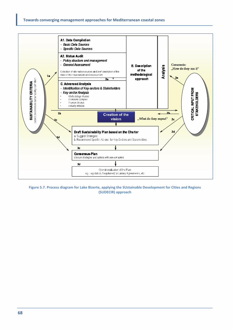
Towards converging management approaches for Mediterranean coastal zones
68
Figure 5.7. Process diagram for Lake Bizerte, applying the SUstainable Development for CIties and Regions (SUDECIR) approach

Towards converging management approaches for Mediterranean coastal zones
69
Chapter 6:
Stage 1 – Establishment
6.1 Aim and objectives
The overall aim and objectives of the establishment
stage is to define/make known the intention for
drafting the plan and identify the convening
authority/the initiator authority or body responsible
for the overall coordination of the planning. All
parties who should be involved from the state,
regional or local authorities and stakeholders
should be identified, and an operational foundation
established for the subsequent preparation of the
plan and its implementation. The core group or task
team (different names are in use) generates the
process of understanding the challenges facing the
area, including the differences in perceptions of
those challenges, and begins building a
constituency of support for the plan.
In the initiation step efforts should be focused on
clarifying what the mission context and mandate
are. Who is asking for the integrated plan? Which
authority will lead and take the main responsibility
for the plan? To what extent and how will ICZM,
IWRM, aquifers, etc., be integrated? What
statutory/conventional purposes or obligations
towards international conventions will the plan
serve or may cover? What are the likely driving
forces to support the planning process? What are
the available time and financial frameworks within
which the plan should be delivered? All major
partners interested in plan preparation should be
identified, informed and agree in principle on the
most appropriate/desirable final legal status of the
plan, particularly when this plan is intended to meet
the statutory purposes of more than one sectors.
All relevant national, regional authorities should be
aware and, if possible, signed up to the preparation
of the plan and help to identify and agree on the
body or bodies responsible for its adoption as soon
as possible. All the above could be eventually put in
a first document, a so‐called foundation statement,
issued by the convening/initiator authority,
sometimes co‐signed by other key partners.
In the same step, coordination mechanisms for the
planning process (steering group or committee, the
core group or task team, the technical group and/or
the consultative group) will be established with
provisions for amendments and inclusion/
cooperation/co‐option/ employment of other parties,
as necessary. Depending on the site and scale of the
undertaking, the steering committee and the core
group /partners may or may not coincide.
It is not the intention or purpose of this stage to
achieve a fully detailed scientific analysis of the
state of the plan area or the complex
interrelationships between issues. Rather, the
purpose is to specify the system, achieve a picture
of the likely range of human and natural forces, the
existing sectoral policies and plans, as well as their
potential interrelationships to be used as a focus for
discussion, challenges, opportunities, analysis and
the identification of priorities in subsequent stages.
At this early stage, effort should also be directed to
creating tools for engaging stakeholders through
good design of process and the supporting
documents in non‐technical language and
employing appropriate media.
6.2 Key tasks
1. Defining the initial territorial scope by identifying the boundaries of the specific plan area and the
ecosystems involved
2. Scoping of the major river basin issues
3. Defining the governance context
4. Engaging stakeholders and preparing
communication strategy
5. Proposing a potential vision for the plan area
6. Deciding on strategic environmental assessment
(SEA).

Towards converging management approaches for Mediterranean coastal zones
70
The key tasks are not necessarily performed in the
order outlined above; they can also run in parallel.
A workplan should define the appropriate timing for
each task.
6.3 Potential outputs
Depending on the type, scale and magnitude of the
undertaking, an inception report (including the
workplan) and/or a scoping report may be needed.
These may be combined into a single
document/report.
6.3.1 Inception report
The inception report should be agreed among the
core partners in the planning process to include:
Background and purpose of the project,
including the trigger factors/driving forces for
the process (the trigger may be a political
decision, a strategic priority or a response to a
specific local problem or issue)
Potential framework of focus issues towards a
shared vision; this should be generated through
a combined top‐down or bottom‐up process
The operational policy means of delivery,
funding and consolidated actions
The geographical boundaries of the plan area
including both the terrestrial and marine
boundaries (system concept)
External influences (challenges and opportunities)
International and/or national context, including
the relevant legal and strategic context and
parameters of the process
The governance and the proposed coordination
structure, in the form of the steering group or
committee, including its objectives, tasks,
TOR/mode of operation, etc.
6.3.2 The workplan
The workplan is a constituent part of the inception
report. It should clearly detail the tasks and
milestones of the process and the allocation of
responsibilities among partners, along with the
logistical structure for technical and administrative
support. The objective of the workplan is to ensure
the smooth running of the project and to define the
resources needed for the various phases of the
planning. Typically, the workplan should include:
A basic time frame and timeline that should
reflect some fundamental elements of the
planning process
A detailed description of activities proposed,
based on the analysis of a wide range of
practical, political and financial considerations
A simple GANTT chart (named after Henry Gantt)
is commonly used in project management,
showing activities displayed against time
(Gantt.com, 2012‐2015). It depicts graphically
the order in which various stages of the planning
process should be completed to facilitate
communication with partners and stakeholders.
This should set out the duration of each phase,
outputs and the key milestones. The GANTT
chart should comprise:
Planning process stages
Major outputs
Key event dates
Critical milestones centred on key events
Key financial requirements
The schedule of implementation
Risks analysis for the plan and provisions to
overcome unforeseeable difficulties or delays.
6.3.3 Scoping report
The scoping report may not be part of the
initiation/establishment step but of the analysis
step, depending on the specificities of the work
system followed. In any case, it is compiled after
the inception report and is guided by the work
programme. It may include the following:
The geographical boundaries and the description
of the plan area.
A preliminary assessment of the problems,
issues, drivers, pressures, existing response and
their effectiveness, risks along with their relative
importance, policy context and interrelationships.

Towards converging management approaches for Mediterranean coastal zones
71
Coastal governance baseline defining institutional,
legal and policy context, as well as detailed
identification and mapping analysis of the key
stakeholders to identify their real competencies/
roles, their capacity and importance/relevance
for the plan. The ICZM Protocol specifies the
range of stakeholders to be included in the
planning process: “the territorial communities and
public entities concerned; economic operators;
non‐governmental organizations; social actors;
the public concerned”. For a truly integrated
plan (see section I) a few more may be needed
to cover and represent IWRM, aquifer and
groundwater concerns properly.
A communication strategy.
A potential preliminary vision for the plan area
(again, its elaboration may be carried out in
parallel or in sequence depending on the case).
SEA decision. The environmental authorities of
the relevant state should therefore be consulted
on the requirement for an SEA and its TOR. In a
number of cases an SEA might not be needed
but only an EIA on major infrastructures is to be
included; but these are not part of the plan
itself.
6.3.3.1 Defining the territorial scope
Geomorphological/physical considerations
Section I includes a clear reference to this issue,
including the provisions of article 3 of the ICZM
Protocol for the Mediterranean, which defines the
geographical boundary of the coastal zone as the:
(a) ”seaward limit of the coastal zone; the external
limit of the territorial sea”
(b) “landward limit of the coastal zone; the limit of
the competent coastal units”
Exceptions to this are defined where:
1. “the seaward limit is less than the external limit
of the territorial sea”
2. “the landward limit is different, either more or
less, from the limits of the territory of coastal
units as defined above, in order to apply, inter
alia, the ecosystem approach and economic and
social criteria and to consider the specific needs
of islands related to geomorphological
characteristics and to take into account the
negative effects of climate change.”
(UNEP/MAP/PAP, 2008.)
In this respect, more recently (September 2013) the
UNEP/MAP Secretariat specified the lists of series of
Annexes to the SPA/BD Protocol and the reference
list of habitats adopted by the Parties to the
Barcelona Convention that should be amended to
become further meaningful for the coastal
terrestrial habitats/species. This would ensure that
the two protocols apply the EcAp in an integrated
way. During the development of the plan, it will
emerge if the same or a different body will be
responsible for the implementation of the plan.
The maximum seaward limit is therefore relatively
clear: that is, the external limit of the territorial sea.
However, this is to be decided according to the size
of the area chosen for the plan. The landward limit
is, however, less clear – the type and nature of
“competent” coastal units varies enormously
around the Mediterranean in terms both of their
geographical scale (from small municipalities to
extensive counties and regions), and in terms of
their functions, competencies and capacities.
It is emphasized again that defining the territorial
boundaries of the planning area is of crucial
importance for the smooth elaboration and
implementation of the plan. The boundary should
be defined in a way that encompasses all important
problems in the coastal zone most effectively,
including – if needed – transboundary issues. That
means that the boundary should include ecosystem,
socioeconomic system and associated water
resources important for the zone. In addition, one
should keep in mind that climate change may affect
the territorial boundaries and, therefore, the
boundaries should reflect future scenarios. Climatic
changes may impact areas that do not respect the
boundaries of a coastal zone as defined in the plan.
Sea‐level rise, for example, may well affect areas
outside the defined zone, and extreme events could
impact areas that extend beyond the defined

Towards converging management approaches for Mediterranean coastal zones
72
boundaries yet are part of a larger area that
includes the coastal zones.
The water resources management plan, on the
other hand, must cover an entire river basin district
and, at least in theory, there should be one
administrative authority for the entire river basin;
this is often served by a river basin organization.
Some countries follow that approach (suggested
also by the WFD) while in other countries
historically pre‐existing administrative structures
(e.g. perfectures or other decentralized entities of
the national administration) were maintained and
mandated for the management of “operational
parts” of a river basin. Where river basin districts
are particularly large, the division of the district into
operational areas/sub‐basin areas is both possible
and recommendable. This provides an opportunity
for ICM plans which will cover entire river sub‐
basins in coastal areas. These sub‐basins usually
cover transitional waters, estuaries, wetlands,
coastal aquifers and coastal waters, and smaller or
larger areas of the upstream river parts, according
to local conditions and needs. Within such sub‐
basins in the Mediterranean we frequently identify
intermittently flowing and stagnant sections of
rivers where fresh water is mixing with sea water
and a series of complex biogeochemical processes
take place under anoxic and intermittently anoxic
conditions (Scoullos et al., 2014). With respect to
groundwater it is necessary to encompass the area
that has significant impact on the coastal ecosystem
and socioeconomic activities. These water bodies
should be fully integrated within the ICM plan in
order to fulfil the requirements of both IWRM and
the ICZM Protocol (in particular article(s) 18 and
10).
In practice a pragmatic approach is proposed. The
experience from the preparation of the
Buna/Bojana plan (see Experience from
Buna/Bojana, chapter 3.5) is an interesting practical
illustration of the challenge of defining boundaries,
notably in a coastal zone transcending the boundary
of Albania and Montenegro. In this case, the
boundary was defined by adapting the guidelines in
the ICZM Protocol and the EU WFD and the natural
characteristics of the area, and refined according to
local circumstances.
From the above it becomes clear that the exact
geographical scale of the plan area cannot be
precisely predefined. It will be determined by taking
into account a combination of the following:
1. National guidance or the allocation of plan responsibilities to individual administrations or
to levels of administration such as coastal
regions, river basin authorities,
counties/prefectures or municipalities
2. The importance of freshwater resource
characteristics and eventual historic water rights
and/or allocations to certain communities or
sectors, coastal or upstream, including
traditional administrative borders
3. The physical nature of the area and its landscape (scientifically the most appropriate)
4. Initiatives from local coastal administrations
5. Local and traditional perceptions of the plan area and its priority issues
6. Functional areas (e.g. in the neighbourhood) that share common infrastructure, transport and
access
7. The characteristics of the marine area, which
should always be included/considered.
Whatever the scale, the plan itself should recognize
the inter‐dependencies and provide for synergies,
on the one hand within the plan area and its
ecosystems and on the other between the plan
zone and the neighbouring areas, as explained in
section I and further detailed below.
Balancing Physical, Administrative and
Operational aspects of boundaries
For deciding the plan boundary the competent
coastal units/entities should be reconciled with the
ecosystem, economic, social and political criteria
and “geometries” as above, but also take into
consideration the actual management potential
(the highest possibilities for efficient management).
This also applies to maritime zones, where
economic, social and sometimes wider political

Towards converging management approaches for Mediterranean coastal zones
73
criteria usually prevail, including recreation, coastal
tourism, landscape aesthetics, coastal/marine
archaeology, culture, agriculture and many other
economic uses, and also patterns of transport,
accessibility and urbanization. In order to define
boundaries of the plan, main processes and impacts
should be recognized and the boundary should be
delineated in such a way that the transboundary
connections (with other similar national entities or
other countries) are easily understood and
managed. In this manner the connections between
different systems (natural, man‐made, social,
economic, etc.) can be recognized and addressed
more easily. In the same manner drivers and
associated pressures and conditions for the land‐
freshwater‐sea interface should be considered in
order to define a boundary which is appropriate
(i.e. as clear as possible). On the other hand, in
most situations ecosystems are linked as open
systems, and extend even beyond the boundaries of
the entire catchment area.
Within a fully integrated approach involving water
resources, groundwater and aquifer management
the boundary of concern may extend to include
entire river basins and hydrological management
units including both recharge and discharge areas;
the latter in particular may extend far beyond the
plan area. Similar concerns often apply to
biodiversity planning, which cannot operate
effectively in closed ecosystems.
On the other hand, experience has shown that the
use of administrative boundaries should be retained
where possible to maintain the integrity of
stakeholder ownership accountability and
recognition, policy conformity and statistical
information. In conclusion, in complex situations a
balanced pragmatic compromise between ecosystem
and administration concerns may be required. It is
not only the ecosystem that may extend beyond a
“manageable” physical or administrative boundary
but also certain operational aspects: policies,
strategies, tools (e.g. communication) or impacts.
ICZM has traditionally dealt with the challenge of
tackling issues that transcend management
boundaries by accepting that, although the physical
boundary remains fixed, policy and programme
actions may be required “upstream” or
“downstream”. In such a case, the principle and
practices of differentiated intensity management
and/or zonation (explained in section I) may be
applied. It will be the responsibility of competent
authorities or individual parties to define the
appropriate zone boundaries at the scoping stage.
This in turn may feed back into the stakeholder
analysis as there may be significant interested
bodies or individuals who may be required to provide
input.
In reconciling the differing sectoral boundaries and
scales based on different concepts, the IMF adopts
the following approach: it recognizes that policy‐
and programme‐level actions are designed to
impact within a boundary fixed or close to
administrative entities, but that those actions may
also take place externally to those boundaries.
The central message is that, while a map boundary
may be fixed and defined clearly, the operational
limits will almost inevitably spill over significantly
into adjoining areas, and possibly into areas which,
although relatively physically remote from the plan
area, are functionally linked within the boundaries
of ecosystems in terms of drivers, pressures,
impacts and the necessary responses. In such an
approach the concept of differentiated intensity
management could be applied.
Overall, a pragmatic approach is necessary. While
the plan is being prepared, more details should be
provided on how to deal with conflicts between
administrative definitions and ecological, economic,
social and political differentiations within the zone
or with neighbouring areas. Some reconciliation and
resolution mechanisms of eventual conflicts and
arbitration processes should be proposed and
agreed upon. The local plans should, then, work
within the agreed boundary definitions.
It is noteworthy that the boundary of the plan may
extend beyond national boundaries, where
relevant. Article 28 of the ICZM Protocol draws
special attention to the need for transboundary
cooperation: “The Parties shall endeavour, directly

Towards converging management approaches for Mediterranean coastal zones
74
or with the assistance of the Organization or the
competent international organizations, bilaterally
or multilaterally, to coordinate, where appropriate,
their national coastal strategies, plans and
programmes related to contiguous coastal zones.
Relevant domestic administrative bodies shall be
associated with such coordination.” Similar
statement and practices are also valid for the IWRM
plans (see also in EU WFD).
6.3.4 Scoping the problems, issues, drivers,
pressures and risks
6.3.4.1 The objectives
The objective of this task is to describe the
generally understood conditions of the plan area at
the start of the planning process, whether or not
they are verified or verifiable at this stage. It is
better to include all perceived problems and issues
at this stage, leaving them to be distilled into a
manageable and refined set of core issues later in
the process.
The first analysis of key problems, issues and actors
should be relatively cursory, primarily to guide
future discussions, assist in the preliminary mapping
of stakeholders and identify work priorities. It
should be recognized that the above may change to
some extent and need to be refined over the whole
project cycle once a wider range of stakeholders is
brought into the process.
The initial identification of drivers and pressures
could be carried out to describe how natural and
societal drivers lead to pressures on ecosystems in
the plan area. In addition, it can provide a vital
communication tool to engage stakeholders.
The objective of the risk identification is to analyse
key areas of uncertainty, to understand and explain
vulnerability, and to help identify measures to
increase the resilience of the plan area. This task
seeks to identify natural and man‐made risks to the
plan area that are of a magnitude that exceeds
normal trends and/or other pressures.
6.3.4.2 Methodologies and tools
National, subnational and local literature search,
review of current and former projects and
programmes; stakeholder consultations and
interviews; use of local consultants; observation;
brainstorming; strengths, weaknesses, opportunities,
threats (SWOT) analysis (Box 6.1); initial drivers
identification, etc., are all included in the
methodologies and tools to be used for the scoping.
As mentioned above, the selection of issues must
encompass the full spectrum of the three
pillars/facets of sustainability (i.e. environment,
society and economy); an observer bias in the
identification and selection of issues (e.g. resulting
from the professional background of the persons
conducting the analysis) should be avoided. The
nature and quality of existing governance is also a
key theme that needs to be included in the analysis
of problems and issues. The problems and issues
could therefore be classified and described under
governance, environmental and socioeconomic
headings.
The identification of initial drivers and pressures at
the establishment stage will primarily be a desktop
exercise supported by participative techniques such
as brainstorming; for example the Blue Plan's
IMAGINE (www.planbleu.org) systemic and
sustainability analysis method or the SUDECIR
method (Kontostanou‐Karalivanou et al., 2000).
Drivers are the high‐level forces that “impel” the
society to impose or decrease pressure on the
environment of the plan area. As with the problems
and issues analysis, the identification of drivers
must comprise the full spectrum of the three
pillars/facets of sustainability but also identify, very
broadly, obvious gaps and overlaps in governance
as part of the socioeconomic and cultural reality of
the plan area.

Towards converging management approaches for Mediterranean coastal zones
75
Additionally, the analysis of drivers should also
include relevant existing or potential economic,
social and environmental policies and programmes
of national or local governments that are likely to
drive change in the plan area or, even, its
neighbourhood. Examples include subregional
economic policies such as incentives for
development of particular sectors; agricultural
subsidy regimes; fisheries quotas; and waste‐ and
water‐related provisions and directives. These may
include both national and local policies and legal
and fiscal instruments, as well as relevant site‐
adapted global and regional conventions and
European legislation. Conversely, the lack of a
comprehensive or adequate policy and legislative
framework may also be considered a driver.
The scoping should include climate drivers and
pressures, which are usually dealt with in the
adaptation to climate change (national) plans; these
should serve as a source of data. At this stage an
identification of these pressures, and an idea of
where and when they are likely to be most serious,
is required.
Box 6.1. SWOT analysis example for coastal zone
“Lake Bizerte Charter” (www.h2020.net/news‐and‐events/news/95‐the‐lake‐bizerte‐charter‐a‐step‐towards‐its‐
sustainable‐development‐horizon‐2020‐enhances‐stakeholder‐participation‐for‐the‐integrated‐management‐of‐
lake‐bizerte‐in‐tunisia.html).
www.tvrl.lth.se/fileadmin/tvrl/files/vvr040/10_ICZM_3pp.pdf
Typical coastal zone drivers and pressures (indicative rather than definitive at this stage):
Local (land‐use change, urbanization, tourism and recreation demand, wastewater discharges, solid waste,
agriculture intensification, traffic, water abstraction, etc.)
Regional (water abstraction, change of regional hydrological regime, fisheries and aquaculture, watershed
deforestation, air pollution, upstream change in land use and crops, etc.)
Global (economic and population growth, international transport and trade, climate change, sea‐level rise, etc.)
SWOT analysis:
Group exercises with different types of stakeholder groupings at both centre and local levels;
What is percieved as a “strength” by one could be perceived as a “weakness “ by others!
SWOT analysis:S: Strengths; W: Weaknesses; O: Opportunities; T: Threats.
Technical resources
Natural resources; Social resources; Human resources; Administrative resources; Competence, capacity resources; Financial resources; Climatic resources.
Although recognizing problems and shortcomings, to focus on possibilities, embracing the potentials of the future!

Towards converging management approaches for Mediterranean coastal zones
76
Risk identification and initial risk analysis is
primarily also a desk exercise in conjunction with
key stakeholders and technical experts from
relevant sectors. Examples include severe flooding;
acute pollution from activities in the watershed or
the adjacent marine area; or enhanced disaster risk
as a result of topography (e.g. high soil or coastal
erosion, slidings); sensitivity or proximity to a major
natural or man‐made risk source (e.g. forest fires,
industrial accidents); or even social or economic
instability. Risk vulnerability is conventionally
categorized for each risk according to the:
1. nature of the risk and its consequence
2. magnitude of the possible adverse consequences
from each risk
3. probability of occurrence of each risk.
The most demanding exercise is to consider the
individual risks in combination and synergy.
Quantification may be possible for several types of
risks (e.g. area of land subject to flooding according
to likely scenarios). However, in many cases,
approximations and simplifications similar to those
proposed above may also be appropriate for risks.
Climate change adds a new and challenging
dimension to risk analysis in coastal areas, not only
because of the uncertainty of its scale and impacts,
but mainly because of its long‐term nature.
Guidelines for integration of climate variability and
change aspects into the ICZM Process were
elaborated by PAP/RAC within the GEF project
"Integration of climatic variability and change into
national strategies to implement the ICZM Protocol
in the Mediterranean". Guidelines are built along
the same stages of the planning process and are
therefore a good reference to take into account.
(http://pap‐thecoastcentre.org/pdfs/National ICZM
Strategy Guidelines.pdf).
6.4 Governance for planning
6.4.1 Establishing coordination
mechanisms/bodies
The objective of this task is to ensure that the plan
drafting process is based on good governance
principles, is well informed, representative and
transparent, and enhances the plan’s legitimacy and
long‐term sustainability. To this end, appropriate
bodies should be put in place. The development of
this stage is a natural result of the initiation stage.
There are three important, and very distinct,
qualities/functions that should be included within
any plan drafting coordination mechanism: to
ensure political and social legitimacy; to provide
scientifically based, high‐quality solutions; and to
address aspirations and include the opinions and
expertise of the community.
Sometimes these three functions can be placed on a
Vital, Essential and Desirable (VED) scale:
1. Vital: political legitimacy and accountability,
financial management
2. Essential: technical/operational guidance and support
3. Desirable: local representation and consultation.
There are various governance architectures, and
each situation may require a locally tailored
approach; however, the following model reflects
the above VED scale. The stakeholders, as well as the
administrations responsible for ICZM and IWRM, are
usually common with a few, sometimes significant,
differentiations (see 3.4). The EcAp also requires
coordination and participation by (more or less) the
same administrative bodies and stakeholders.
Finally, institutional coordination with bodies
responsible for climate adaptation and mitigation
strategies and plans is required. This may be done
through the entity responsible for the UNFCCC
national communication or any equivalent body or
interministerial committee or related provision.
In addition, local authorities are often responsible
for local planning processes towards climate change

Towards converging management approaches for Mediterranean coastal zones
77
adaptation and mitigation measures. It is essential
that these authorities and their plans and
procedures be brought into the planning process at
this (establishment) stage.
1. Steering group or committee
Composition: representatives of the core political
and financial stakeholders in the area covered by
the plan, including representatives of the national
government, through the competent line ministries
(environment, water, mercantile marine, agriculture,
fisheries, forestry, planning, energy, etc.), the
higher‐level competent local administration(s) and
of the funding bodies. Good and appropriate
balance of local, regional and national
representatives is of vital importance. Depending
on the case, some of the above may participate only
through experts in the technical or consultative
group. It may be useful that very few external
experts are included in the steering committee, if
resources allow for the transfer of knowledge and
help in consensus building. This group needs to
include at least one representative from national
government or the higher‐level competent local
administration(s) familiar with climate change
issues, and ideally involved in one or more other
national/regional bodies dealing with this topic.
Function: to ensure the smooth running of the
project; to support and facilitate implementation of
decisions; to enhance synergy among competent
authorities to ensure political legitimacy and
provide financial accountability.
2. Technical group
Composition: technical staff or representatives of
organizations and institutions with knowledge,
information and data resources for the plan area
and its key issues (e.g. coastal, marine, surface and
groundwater, land use), along with logistical and
Information and Communications Technologies
(ICT) support staff. The technical group also needs
one or more persons with a working knowledge of
adaptation to climate change. Experts from
ministries, agencies, universities and/or
consultancies are expected to be its members.
Function: to develop a high‐quality plan using the
best available technical and logistical support.
3. Consultative group
Composition: representatives of the two above‐
mentioned bodies. The final composition of the
group is defined after stakeholder mapping/analysis.
This group should include someone responsible for
communication as well as representatives from
sectors where climate issues have been assessed.
Function: to reflect the opinions and expertise of
the community and to act as a consultative body at
all stages of the drafting and approval of the plan.
The steering group or committee requires
timetabled and formally constituted meetings.
Depending on the case, the technical and
consultative groups may be more flexible and some
of their meetings may be ad hoc or eventually
served through mailing lists, virtual media, etc. Each
group will require its own clear and precise Terms
of Reference (TORs) to specify remit; membership
distribution or roles; work division; frequency of
meetings; meeting procedures, etc. The CAMP
Levante de Almería, Spain, was a very good example
of how the coordination mechanism worked in
practice. The project had its technical and
governance parts, which worked hand in hand
according to their mandates and capacities. The so‐
called “institutional coordination and public
participation framework” – that is, the governance
mechanism of this project – had all three levels
elaborated above. This mechanism enabled the
close coordination between the technical part of
the project and its governance structure which was
established at the very beginning of the project. See
Box 6.2 and find more at
www.camplevantedealmeria.com.
When the integrated plan is finalized, the steering
group approves the plan and specifies the route and
appropriate national or regional procedures and
body or bodies to formally adopt/endorse the plan.
The plan may be adopted by one or more
ministries; and by national, regional or local
authorities. It may also receive joint endorsement.

Towards converging management approaches for Mediterranean coastal zones
78
Sponsoring organizations funding its implementation
or investing in development in the plan area may,
according to the plan, also ask for or require a
formal endorsement as a prerequisite for
investment or, vice versa, may be asked to endorse
the plan or at least the vision (see Bizerte Charter,
www.h2020.net/resources/training‐
materials/finish/192/1712.html).
6.4.2 Themes to be considered
It is important to design the scale and complexity of
the governance structure consistent with the staff
and logistical resources available to support it. It is
necessary to take into consideration the
characteristics of the plan area and the problems
being addressed, especially with regard to the
transboundary drivers and impacts.
Central themes for coordination and governance
are to:
ensure equal involvement/participation of all
stakeholders and partners
search and secure funding for the
preparation/communication/approval of the
plan and, if possible, for its implementation
set realistic goals and objectives with a
reasonable implementation time frame
keep ongoing, open lines of communication with
all stakeholders involved, even those who are
eventually most sceptical
have unconditional support of local and
regional/national authorities and selected
officials following the process
have a well‐trained and committed staff
standardize and network all software, hardware
and protocols as much as possible
use ICTs as wisely as possible.
Box 6.2. Governance mechanism “at work” in CAMP Levante de Almeria, Spain

Towards converging management approaches for Mediterranean coastal zones
79
6.5 Understanding the governance
context of the plan area
6.5.1 The objective
The objective of this task is to define and
understand the actual governance structure and
power distribution mechanisms in the plan area.
Stakeholders should be informed and facilitated,
not only to participate and get involved in the
development of the plan, but so they are prepared
for its implementation on the ground after its
completion. Also, they should provide feedback into
complementary plans and programmes, and identify
policy and institutional gaps. For appropriate
understanding of the governance issue see 1.3. This
step is a prerequisite for the full engagement of
stakeholders as described in the next step.
The “mapping” of the many relevant institutions,
along with their policies and functions, is an
essential first step in defining the operating
governance context. A thorough understanding of
key institutional, legal and policy drivers at
international, national and local scales, and their
interaction, is key to ensuring the relevance and
effectiveness of the plan. The spatial boundaries of
administrations and their relevant functions should
also be mapped, correlated to the decision‐making
processes and if necessary revisited/adapted.
A stakeholder analysis should be performed to
identify and assess the importance of key
organizations, groups of people, institutions and
even individuals who may have significant influence
for the development and success of the planning
process and, later on, for the implementation of the
plan. This analysis is in essence an act of identifying
those in the plan area and sometimes outside of it
(e.g. national, regional, professional, environmental
organizations) who are likely to affect and/or be
affected by the actions proposed in the plan. It is
important for the analysis to include, to the extent
possible, the real competencies/roles and capacities
of the various stakeholders and also the
relationships (e.g. cross‐cutting responsibilities,
missing and overlapping responsibilities, rights,
synergies, antagonisms, levels of conflict) within
and among them.
Relevant institutions to be considered at national
scale are the relevant government ministries or
agencies. As explained in section I, institutions
responsible for coastal and for water resources
management may or may not be the same. In
addition, the influence on current or future
development of a plan area of other sectoral
ministries or agencies – for example water,
agriculture, forestry, fisheries, tourism, infrastructure,
industrial or urban development, maritime affairs,
etc.– may be of equal or greater significance.
With respect to climate change, the institutional
context at national level is usually well established
and includes ministries of agriculture (for possible
impacts in terms of crop yields); environment,
especially the department dealing with water
management, pollution control and ecosystem
health, and eventually the departments responsible
for land classification and land‐use planning; water
resources management, if exists; health, dealing
with consequences of heat waves, vector‐ and
waterborne diseases and increased risks of food
contamination with higher temperatures; tourism,
etc.
A mapping and understanding of relevant private
and particularly competent programmes, as well as
international, regional, national, local NGOs and
CSOs is also essential. In many countries such
organizations have the expertise, convening power,
constituencies and legitimization as well as
resources and influence comparable, or even
greater, than some local or even national
authorities. Academia, and researchers and their
institutions, are another important group of
stakeholders to be involved.
Productive sectors, enterprises and individuals with
significant investments in the plan area and the
related labour unions and employers associations,
etc., are important stakeholders which may be
directly or indirectly affected by the new/revised
plan. They and others will be well aware of the
increased climate risks and will be planning to take

Towards converging management approaches for Mediterranean coastal zones
80
some measures as far as climate variability and
change are concerned. For instance, one sector
most endangered by climate change in a plan area
may be the insurance industry; it and the banking
sector may be key partners in identifying
appropriate alliances and adaptation measures in
the plans. It is critical that the ICZM and IWRM take
into account the private sector’s plans and provide
it with the right framework and incentives so it can
make a cost‐effective contribution to the plan and
its implementation.
As well as the private sector, the potential role of
NGOs as service providers should be well
understood and explored. They may be able to
provide information, commentary on data, etc., or
means (e.g. meeting space); they may be potential
clients for plan outputs, potential facilitators or
intermediaries with other key groups, or partners in
the implementation of certain tasks in the
management itself.
Similarly, the policy context may be equally broad,
depending on the site. It may range from spatial
plans to economic development strategies and
sectoral plans and policies for environmental
protection, energy, transport, waste, agriculture,
tourism, water resources management, etc. The key
plans and programmes, along with the
organizations responsible for them, must be
identified.
In the analysis of power distribution, it is as
important to assess the effectiveness, influence and
efficiency of the institutions, policies and
programmes as it is to identify their existence and
significance or their absence. Mapping should
therefore encompass all strengths, weaknesses/gaps
and eventual tendencies and opportunities.
Finally, the legal context for ICZM, IWRM and
aquifers/groundwater planning interventions
should be defined. In principle, major legal acts
affecting overall coastal or river basin development
are being adopted at the national or regional level.
All relevant laws and regulations should be
identified and their impacts on the respective plan
area briefly assessed. In addition, it is most likely
that regulations at lower, subregional or municipal
administrative level also exist. They should be
identified and analysed in the same manner
described above.
6.5.2 Methodologies and tools
Stakeholder analysis is carried out in the
establishment stage, in most cases, but its results
will be fully utilized in the subsequent stages of the
planning process. The process should allow for the
iterative evolution of the analysis as more
stakeholders become involved.
Identification of legislation, policies and
programmes is a desk‐based analysis of documents
supplemented by interviews with individuals or
focus groups early in the process.
Various tools are available for institutional and
functional analysis for mapping and clustering.
However, there is no straightforward technique for
identifying “political” sensitivity by those managing
the process. Institutions should be considered
according to their:
remit, both functionally and spatially
relevance to plan area, water resources and
climate change, as well as to their ability to deal
with problems at policy and operational level
resources and skills, including technical
resources, personnel, databases and information
available
influence, including in formulating and proposing
legislation and in political/social communication
(informing public opinion)
role in relation to the planning process as either
service provider, client, facilitator or potential
management partner.

Towards converging management approaches for Mediterranean coastal zones
81
6.6 Engaging stakeholders and
preparing a communication
strategy
6.6.1 The objective
The objective of this step is to ensure full
engagement of stakeholders and the public in the
planning process and its implementation.
Time and resources must be made available for the
process of consultation, either formally and/or
informally, to ensure that stakeholders and the
wider public are not just aware of the drafting of
the plan and its importance, but are also engaged in
the process. As far as climate change is concerned
key groups need to be informed about the potential
major climate changes in the area of interest, the
likely consequences of these changes and the
increased risks they may represent. This can be
done even without providing much technical detail.
The groups that need to be involved have been
mentioned already in this document. They should
include local communities; government agencies;
NGOs; media and opinion leaders, etc.; business,
such as industry providers of tourism and transport
services; the energy sector (particularly dams
upstream and renewable resources installations);
private developers; and those engaged in
agriculture, forestry and fisheries.
The above stakeholders are expected to participate
in consultations and to identify recommendations
and preferred options to be included in the plan.
The same groups need to be consulted once these
options have been screened/evaluated technically
to get their feedback. The final plan will be based
on a consensus that includes their active
involvement in formulating the common vision (see
6.6.3 and chapter 8).
6.6.2 Developing a communication
strategy
It is recommended that a simple communication
strategy be produced during or shortly after the
establishment stage, outlining how these different
participatory activities will be carried out and what
other, wider communication activities will be
undertaken.
The communication strategy should be developed
with the input of one or more experts. It is essential
that the requested expertise should include not
only communication studies and skills per se
(knowledge of techniques, etc.), but also expertise
on participatory processes and knowledge of the
issues and the area in question.
A communication strategy could contain the
following:
1. Communication objective – communication
should support the vision and the objectives of
the plan as well as the key messages (the
“identity” of the plan) including the main issues
to be tackled and the expected outcomes. ICZM,
IWRM and other acronyms are not recognized or
relevant to the non‐technical audience.
Unnecessary reference to the technical nature of
the process can be a barrier to effective
communication. The key message should be
positive, simple, straightforward and widely
accepted (see Setting the Vision, chapter 8). The
language used should be simple and avoid
jargon.
2. Identification of key audiences: this should follow from the stakeholder analysis, but should
include a brief description of what each group
should know about the plan; what reaction or
result from each group (e.g. raised awareness,
becoming involved, change in entrenched
attitudes, giving political support) is expected
and where they could contribute more. The
identification and involvement of the appropriate
media involved is a very serious issue. Key
individuals who may become “ambassadors” for
the plan may also be identified. The audiences
will also divide between external (i.e. local
communities, government agencies, NGOs,
business, media and opinion formers, etc.), and
internal (partners, technical staff and external
consultants, etc.). The communication strategy
has to deal with these two groups separately.

Towards converging management approaches for Mediterranean coastal zones
82
3. Communication and promotion mix: this should
define how the message is conveyed. For
instance, to the external audience this will
include press and TV messages, online and
printed material, events, press conferences and
other meetings. Internally this will include
coordination meetings and use of printed and
electronic media (including e‐mailing and social
networking). Training in communication may be
required for some partners. Innovative methods
of communication and visualization should be
used widely and wisely.
4. Measurable targets and indicators: these should
be set, whenever possible (e.g. number and
frequency of press releases, printed material,
number and type of meetings), along with
indicators (or at least indicators of immediate
response to the strategy) of effectiveness (e.g.
hits on website, attendance at meetings).
5. Budget: define what funds are required for communication within the programme and what
external support can be offered by partners (e.g.
human resources, web hosting, meeting venues).
6. A professional branding and identity specification: this should be developed to ensure consistency
of presentation across media and the Internet
throughout the process, and enhance the wider
visibility of the plan.
6.6.3 Formulating the plan vision
The scoping process should help to identify the key
points around which the vision could be formulated,
as well as themes where there are already different,
potentially conflicting sectoral visions.
The first step in the planning process is to formulate
the vision and goals of the integrated plan. The
planning process should be guided by a vision
statement to be discussed and agreed by the
stakeholders. A successful vision statement should
be site‐specific and cover, in a balanced way, the
shift to a better environment and overall SD based
on a green/circular economy with the specific
concerns and aspirations of the stakeholders
identifying:
1. what should be done to remove what is
unsustainable
2. how to move gradually to fulfil the prerequisites
and aspirations that are compatible with
sustainability.
Technically this will require a combination of inputs
from meetings and written procedure. To ensure
that the latter is a meaningful exercise the drafting
group should frequently test whether the vision
reflects the aspirations and views expressed by the
stakeholders.
The underlining principle of the vision is that the SD
of a plan area should improve the life of its citizens
based on greening the economy and enhancing
social cohesion while protecting or even restoring/
improving the environment. In a green economy,
for instance, the growth in income and employment
should be driven by public and private investments
that drastically reduce carbon emissions and
pollution, enhance energy and resources efficiency,
prevent the losses of biodiversity and ecosystem
services and create an equitable society. Economic,
social and environmental issues in the plan area are
inseparable and have a major impact on the local
(green) economy. How to shift towards a green
economy in a particular plan area is unavoidably
linked to wider national or even international (e.g.
EU) provisions. Existing or expected frameworks,
laws, incentives, etc., should be taken into account in
drafting the vision (a forecasting exercise) (see 7.3.1).
On the other hand, the stakeholders require a mix of
short‐, medium‐ and long‐term policies well adapted
to the characteristics of the plan area (natural,
social and economic) and its wider environment
(cut‐off upstream parts of the river basin and other
areas of interest), but most significantly the plan
should resonate with the aspirations of all
stakeholders through open debate and consensus.
For example, spatial plans may propose large urban
and tourism developments in areas that are highly
vulnerable to climate change (e.g. due to sea‐level
rise and coastal inundation). In other scenarios,
proposals to enable protection from flooding or
coastal erosion could vary significantly on their

Towards converging management approaches for Mediterranean coastal zones
83
impacts on biodiversity losses, natural recharge of
aquifers, etc. The need for SD is a well‐accepted
determinant of the vision for the future; however,
there are often substantial differences in
understanding what actually is sustainable and how
sustainability can be obtained.
The scoping report should at least pose the
question “what do you consider unsustainable that
needs to be changed?”. This is a very important
unifying question, leading gradually (according to
the experience of the authors) to consensus. This
may be followed eventually by a second question:
“what do we want to see in the area in a 15‐20
years’ time?”. Based on the responses to the above
a tentative vision could be proposed (at least
among the majority of key stakeholders) that could
then be further exposed to a wider audience in
order to reach consensus and trigger the next stage
– analysis and futures.
PAP/RAC has defined a generic model vision for the
Mediterranean coast which encompasses six
principles of SD (Shipman et al., 2009):
”A coast that is:
resilient – resilient to climate change, resilient to
natural processes, resilient to human processes
productive – productive financially, competitive,
high in value, increasing GDP, alleviating poverty
diverse – diverse in ecological, diverse in
experiential terms
distinctive – distinctive culturally, distinctive in
marketing
attractive – attractive to visitors, investors and
to local people
healthy – free from pollution”
These principles are useful attributes for such a
vision.
Based on the vision statement, goal and objective
setting as a substantive exercise should be defined
when a clear idea of the problem and full knowledge
of the commitment to a solution are known.
In a number of very successful cases (Rhodes
SUDECIR, CAMPs, Lake Bizerte 2013, Malta Non‐
conventional Water Resources (NCWR)/GWP 2014,
Drin River Memorandum of Understanding (MoU),
H2020 Capacity‐Building/Mediterranean Environment
Programme (CB/MEP), the coastal plan for the
Šibenik‐Knin county (Croatia), the Reghaia coastal
plan and the national ICZM strategy, Algeria) the
vision statement was prepared during open public
meetings. At these meetings various phases or
elements of the project were presented and
discussed, such as the resumé of the Inception
report, scoping report and feasibility study. Also,
prior to the definition of those visions, discussions
with target groups were convened. This helped the
understanding of what “the novelist” wanted to
say. In the cases above, the vision statement was
negotiated and drafted openly in public. This is,
undoubtedly, the best and most legitimate way to
obtain a vision statement but such an exercise
requires an extremely knowledgeable and
experienced facilitator/arbitrator having a wide and
common acceptance (e.g. a committed public figure
with status).
6.7 Deciding on SEA
SEA is another assessment technique that may be
relevant or necessary for the plan team to consult,
because it is particularly required according to the
provisions of EU legislation, and by law for some
countries. For EU Member States SEA is required for
large plans or programmes. SEA is also requested by
ICZM Protocol’s article 19 for plans and
programmes affecting the coastal zone. However,
with respect to coastal plans, programmes and
strategies most of the requirements within SEA are
already embedded in the ICZM Process itself.

Towards converging management approaches for Mediterranean coastal zones
84
Obviously, if there is already an SEA prepared for
the plan area, it should be taken into account, and
vice versa. Experience has shown that an SEA
should be carried out independently, but in close
collaboration with the planning team, and may
proceed in the same or a very similar manner as the
planning process. It should also be an interactive
process producing judgements and recommendations
formulated by SEA experts, and should be viewed as
an integral but parallel part of the planning process.
The SEA report may be part of the plan, but in any
case it must be clearly distinguishable.
“Strategic Environmental Assessment (SEA) is a systematic process for evaluating the environmental consequences
of proposed policy, plan or programme initiatives in order to ensure that they are fully included and appropriately
addressed at the earliest stage of decision‐making, on a par with economic and social considerations.”
Evaluating Socio Economic Development, SOURCEBOOK 2: Methods & Techniques. Strategic environmental impact
assessment. EU Regional Policy, INFOREGIO, December 2009.

Towards converging management approaches for Mediterranean coastal zones
85
Chapter 7:
Stage 2 – Analysis and Futures
7.1 Aim and objectives
The overall aim of the analysis and futures
(alternative scenarios for the future) stage is to
establish an operational foundation for the
subsequent preparation of the plan and its
implementation – making the invisible visible, and
engaging stakeholders in the search for outcomes.
The objectives of the analysis and futures stage are:
1. to substantiate the issues and problems through
more rigorous analysis and review, describe the
present state and likely future trends
2. to evaluate the natural, technical, financial and managerial capacities of the plan area including
future options resulting from climate change
impacts
3. to assess system change and effective response
to external changes and opportunities
4. to identify the strategic options of plan area development for achieving its goals
5. to identify carrying capacities and conditions for the allocation and use of the respective marine
and land parts of the plan area in accordance
with the identified expected changes
6. to generate and test alternative views of the future through the use of tools and scenarios
7. to lay the foundations of future cooperation and implementation through pilot actions and the
identification of potential future funding
sources.
7.2 Key tasks
1. Building the evidence: closer analysis of key issues where needed and undertaking the DPSIR
policy cycle
2. Identifying futures: building alternative scenarios and, if conditions allow, testing (including pilot
actions and identifying potential future funding
sources).
7.3 Potential outputs
Diagnostic report: assessing of all our knowledge on
the state and trends. It is recommended that the
DPSIR framework is completed at this stage.
Alternative scenarios: it is always useful to consider
more scenarios in order to have a better
understanding of the future. These scenarios should
also include a preliminary schedule of future
funding sources for implementation, and a first set
of pilot actions, where appropriate. The alternatives
have to be technically feasible, environmentally
sound, socioeconomically acceptable and politically
permissible.
7.3.1 Building the evidence: diagnostic
report
Building the evidence and the elaboration of the
diagnostic report should start from identification of
the sources of the existing data and information,
and their collection and processing (e.g. coastal
lands, marine waters, hydrological, environmental,
socioeconomic, legal, institutional, infrastructure).
Much information will be already available through
the preparation of the inception and scoping reports.
In some cases these reports may be framed as steps
(preliminary or interim) towards the diagnostic
report which may be given different names.
Its task is to facilitate better understanding of both
the present context and the future alternative
options for the development/evolution of the plan
area. This may be achieved by including:
1. a general description of characteristics of the plan area, including capacity (natural environment, built
environment, social environment, economic
environment)
2. an analysis, in greater detail, of key problems,
pressures, impacts and drivers, and then
summarizing the existing conditions of the area

Towards converging management approaches for Mediterranean coastal zones
86
and its root causes, focusing on the agreed
priorities (governance, environmental and
socioeconomic)
3. an assessment of the water system structure
and roles in terms of the hierarchy from
governance to management and to organization,
as well as what service functions the water
system currently provides
4. a projection of the conditions going forward (forecasting) on the basis of possible or likely
trends for periods compatible with the lifespan
of the plan
5. an examination of factors such as goods and
services provided by the ecosystem, along with
issues affecting the wider area such as erosion,
land husbandry, deforestation, water
abstraction and pollution (both point sources
and diffuse) either through their impact on the
plan or by displaced impacts in other areas
resulting from actions within the plan area
6. an analysis of the wider environment to provide
necessary evidences of existing and future
trends and impacts on the plan area and
eventual footprint outside. Impacts from climate
change are already taking place; the question
about where assessments are needed for
adaptation measures is governed by how fast
these changes are taking place and their
magnitude.
The objectives here are twofold: first, to ensure a
solid basis for discussion and understanding of the
current situation and of business‐as‐usual; and
second, for comparison and understanding of the
distance between the vision and the actual
situation, to provide a basis for “backcasting”
(Figure 7.1), testing, development and discussion of
alternative futures. In other words, this will allow
the vision to be realized and will “make the invisible
visible”.
Local or indigenous knowledge should also be
recognized, valued and sourced. The affected
citizens and those employed in the various
economic sectors in a coastal/river basin
community may have a profound knowledge of the
coastal/river basin system, and should be actively
involved in the analysis in order to improve the
quality of the analysis itself.
Figure 7.1. The concept of backcasting (www.wearearising.org/2009/01/13/backcasting)
The concept of backcasting (Quist and Vergragt, 2006) is central to a strategic approach to planning for sustainable
development in a plan area. The successful outcome is imagined in the future and then the question is asked “what
is needed today in order to reach that vision of success?”. In fact, it is the same practice we apply as individuals
when we plan a trip or when we search for a new home, etc. (see Figure 7.1).
Backcasting is often more effective than forecasting, which tends to produce a more limited range of options, hence
limited creativity. Forecasting relies on what is known today and it is well known that our understanding of the
current situation is always imperfect and that things change rapidly over time.

Towards converging management approaches for Mediterranean coastal zones
87
Techniques and tools
While technical data, measurable objectives and
indicators are easily visible and underpin integrative
planning, it is the intangibles – the assumptions,
interests, beliefs, agendas and real power
structures – that must be also taken into account
and engaged positively to allow any real progress.
The challenge is how to create the preconditions for
these intangibles to become apparent and play a
legitimate role in the plan.
Much data and information will already be
available, so the first task is to collect, assess and
present this in the appropriate form. New research
should only be required to fill the identified gaps or
update old data and information. Importantly, the
data and information collected should be fit for
purpose for its intended use; that is, it should be
appropriate and of a necessary quality, without
being excessively complex or expensive to obtain.
Experience from the Buna/Bojana plan illustrates,
however, an important practical issue when
implementing the guidance – namely the lack of or
unreliability of data in order to carry out the
analysis properly. The scoping for the plan
highlighted other practical concerns, not least the
lack of, and need to collect data. An important
example was the requirement for an ecological
status characterization, a first for Montenegro and
Albania, as a reference point. It was also necessary
to harmonize data and mapping between the two
countries including socioeconomic data and
groundwater mapping. In practice these issues
significantly delayed the progress of the plan in its
early stages.
This practical example acts as a cautionary reminder
that it will not always be possible to accurately
quantify the analysis in all respects and that
pragmatic choices may need to be made.
DPSIR framework
One of the important ways of utilizing the data at
this stage is to construct a DPSIR framework, since it
is a tool that aims to develop appropriate
management responses to certain environmental
problems. The main elements of a DPSIR framework
are:
drivers (or driving forces of certain
environmental problem). These are frequently a
result of human needs. They include, for
instance, social, economic and demographic
changes across the coastline or enhanced and
demanding tourism; they may also link to
changes in production and consumption levels,
and people’s lifestyles in general
pressures on the environment resulting from
drivers. Usually, these are reflected in increased
emissions of harmful substances; land‐use
changes; excessive usage of certain resources;
alterations in sediment supply or in water
availability, etc.
an altered state of the environment resulting
from pressures. The state of the environment
represents the level of environmental quality,
which is reflected in the environment’s
biological, physical and chemical conditions
environmental and economic impacts on
ecosystems (loss of biodiversity, coastal erosion,
social and economic impacts, repercussions on
human health, etc.) result from alterations in the
state of the environment
responses are prioritizations which aim to
reduce negative impacts on the environment
and on the economy and society in general.
Responses represent, broadly, the integrated
plan and can address/affect any part of the chain
between drivers and impacts. In the case of the
planning process, the responses should be
discussed in the form of proposals of how to
deal with environmental issues.
Drivers and the resulting pressures on the plan area
should be divided into two basic groups: (1)
internal: those within the plan area; and (2)
external: those outside the plan area and which
may be transboundary. The internal drivers are
controlled locally while the external drivers are
subject to regional and/or global changes.
Accordingly, it is at that level that they have to be

Towards converging management approaches for Mediterranean coastal zones
88
addressed/solved and at the same level the plan
area adapts to the external pressures and situations
(e.g. climate change, see Box 7.1). However, when
speaking of water resources management, ICZM
can and must deal with the current and expected
pressures and situations (upstream and
downstream processes and impacts) in an
integrated way with IWRM, including aquifer and
groundwater resources (Figure 7.2).
Box 7.1. Drivers and pressures relating to climate change
The main drivers and pressures for adaptation to climate change include the following: sea‐level rise; changes in
temperature, humidity, water acidity and precipitation (causing droughts and decline in water availability in some
areas and during some seasons and causing floods in other areas and in other seasons); increased frequency of
extreme events (hurricanes, floods, etc., heatwaves); and possible increases in risks of vector and waterborne
diseases. The extent of impact of the pressures will depend, among other things, on future development and land‐
use plans.
For a local ICZM plan relevant data with information of some degree of spatial disaggregation should be assembled
from existing sources (national meteorological service, scientific institutes, etc.). For further information on the likely
pressures, a downscaling exercise may be needed.
The main impacts arising from climate change have been broadly identified under the following headings: damage to
infrastructure from sea‐level rise and flooding; health risks from heatwaves; risks to human life from extreme
weather events; shortages of water due to changes in precipitation and possible saline water intrusion and
contamination of groundwater; risks to human and ecosystem health due to water salinization; declines in
agricultural yields; possible declines in tourism in the high season and possible increases in the shoulder seasons due
to changes in climate; damage to ecosystems from changes in temperature, acidity, water availability and
deteriorating quality, etc.

Towards converging management approaches for Mediterranean coastal zones
89
Coastal Areas Impacts
A. Marine Part Sea‐level rise
Acidification
B. Estuary and rivers Increased risk of flooding
Population at risk
Changes in sediment load: riverbed elevation
Backwater effect
Saltwater intrusion
Increased seepage
Crop losses, land degradation, changes in ecosystems: decrease in diversity of species
C. Coastal zone and hinterland Increased risk of flooding
Increased wave attack
Increased tidal range
Increased storm surge
Population at risk
Changes in morphology: Coastal erosion Dune erosion Shoreline retreat
Land losses, land degradation
D. Coastal groundwater flow regime Saltwater intrusion in aquifers
Rise in piezometric level
Extra upconing saline groundwater
Decrease in freshwater resources
Increase of seepage: quantitative qualitative
Overall impact on water management and the coastal area, in general
Safety
Domestic & industrial water supply
Agriculture & horticulture: salt damage to crops
Flushing of water courses
(Beach) recreation: narrowing of sand‐dune areas
Ecosystems: degradation
Navigation
Irrigation
Infrastructure
Figure 7.2. Impacts of climate change and the related sea‐level rise affecting the water management and the coastal areas in general
Climate change
Global warming
B. Estuary and rivers
A. Marine artp
C. Coastal zone and hinterland

Towards converging management approaches for Mediterranean coastal zones
90
Lesson: the DPSIR framework as a tool for
integration
As explained in 5.2.1, the DPSIR framework provides
a simple tool for capturing, visualizing and analysing
the cause‐effect relationships between the
interacting components of complex social,
economic and environmental systems, and in
managing the information flow between these
parts. By thinking about the whole system within
the DPSIR framework rather than the individual
themes or sectors, decision makers and
stakeholders can better visualize how elements in
the system are linked together, informing the plan
accordingly.
Experience from the Buna/Bojana plan: Using
the DPSIR framework
The DPSIR framework (Figure 7.3) has been given
practical effect by the experience of the
Buna/Bojana plan. While the legal and resource
origins of IWRM, ICZM and coastal aquifer and
groundwater management differed, the DPSIR
framework provided a systemic tool for integrating
and visualizing the interplay between the key
drivers. These drivers included the attractiveness of
the coastal zone in the Buna/Bojana plan area and
the pressures on the environment such as
unplanned urbanization, and the state – as well as
the current quantification – of that issue (e.g.
widely dispersed development, the number of
illegal constructions). This, in turn, led to impacts on
ecosystems, landscapes and water pollution, as well
as the cost of infrastructure services. The response,
or lack of response, might for example include
measures to improve regulation, or financial
instruments to deter such development. In turn
these responses provide feedback on the drivers, on
the pressures, or on the state and impacts (in
reality, the relationships are not so linear and the
drivers, pressures, state and impacts interrelate in
complex and overlapping ways.)
Figure 7.3. The integrated plan – the interrelationships of drivers, pressures, state and impacts
Thus the Buna/Bojana plan was able to clearly
integrate and visualize, in a simple tabular form, the
common issues and themes from the three
disciplines (IWRM, ICZM and coastal aquifer and
groundwater management) into a common
framework for analysis. The DPSIR’s key value was
in breaking down boundaries between the IWRM,
ICZM and coastal aquifer and groundwater
management, facilitating an integrated approach.
As explained in chapter 5, the responses step leads
to the integrated plan. The way this is done is not
described in the DPSIR methodology and it has been
approached differently in the various cases where
DPSIR has been applied. The experience of the
Buna/Bojana plan highlighted a set of practical
difficulties in linking the analysis and description of
the drivers, pressures, state and impacts to
effective cross‐sectoral responses and the plan
objectives.
Integrated Plan
RESPONSE
DRIVER IMPACTS
STATE PRESSURES

Towards converging management approaches for Mediterranean coastal zones
91
In a complex policy environment, the analysis of
problems and issues does not automatically lead
the policymaker to the responses in a linear fashion
and a parallel dialogue is required to identify
common societal objectives.
This was overcome in Buna/Bojana through an
innovative adaptation of the “bow‐tie methodology”
(www.cgerisk.com/knowledge‐base/risk‐assessment/
thebowtiemethod) developed to manage risk,
typically in a complex industrial environment.
Simply put, the method combines multiple causes
and multi‐sectoral responses into a single diagram
centred on a set of agreed objectives.
The diagram, when plotted, resembles a bow‐tie. Its
value lies in its simplicity, and in demonstrating how
the step is made from the complex analysis stage to
the wide range of policy and programme responses
and, in particular, in demonstrating the value of the
multi‐sectoral approach. Figure 7.4 illustrates the
bow‐tie developed for the Buna/Bojana plan.
A possible way to depict the state combined with
pressures and eventual impacts, pointing towards
appropriate responses, is provided by vulnerability
assessment maps (Figure 7.5). As explained in 1.6,
vulnerability assessment is a valuable tool for
sustainable coastal zone management. It is a
method used to determine more vulnerable (that is,
unsuitable) spatial segments for the possible
intervention or activity. Presented in a form of
maps, these could be used as a useful
communicating tool, illustrating the extent and
relative severity of risk to which a system is subject
(more at www.pap‐thecoastcentre.org/pdfs/
Synthesis_Report_web.pdf).
Figure 7.4. The Buna/Bojana “bow‐tie”
The attractiveness of the coast
Climate variability and change
Structural economic weaknesses and market
transition
Structural issues in agricultural sector
Demographic changes
Developmental planning and prioritization
Upstream drivers
Policy and legal framework
Weak institutional and technical capacity
Out‐dated, or inadequate infrastructures
EU accession
Lack of awareness
Transboundary nature of the area
Spatial planning
Water quality
Management
IHP
Flood management:
‐ Prevention and mitigation
‐ Flood warning
‐
Waste management
Economy
‐ Tourism
‐ Fisheries
‐ Agriculture
Biodiversity
I. Improve the transboundary governance and cooperation between the two countries
II. Support policy changes at national levels
III. Develop the knowledge base for the management of the system
IV Prevent, mitigate and remediatenegative impacts of anthropogenic activities
V. Raise the economic and social well‐being of the area's communities
VI. Increase plan area's resilience to the impacts of climate change and natural disasters
DRIVERS PLAN OBJECTIVES POLICY AREA
CROSS‐SEC
TORAL
PRESSURES RESPONSES
STATE

Towards converging management approaches for Mediterranean coastal zones
92
Figure 7.5. Principle of development of vulnerability model
For example, these maps are well adapted for
handing and communicating information about the
intrinsic vulnerability of coastal aquifers, and also
for other systems, if this is required.
Vulnerability assessment, if coupled with existing
and potential land use and consideration of the
various potential human activities likely to occur in
the coastal zone, can be used as a decision‐making
tool by identifying (in)compatibility between human
activities and the land on which they occur and by
identifying remediation measures.
Lesson: Vulnerability assessments from
Buna/Bojana (Albania and Montenegro), the
Ghar El Melh lagoon (Tunisia) and other cases
As part of the CAMP Montenegro an assessment of
vulnerability has been prepared, not as an
independent assessment per se but as a baseline,
for preparation of the coastal area spatial plan, as
well as for the national strategy for ICZM. The
assessment determined the most valuable spatial
units that should be preserved from future
degradation (i.e. those spatial segments unsuitable,
or less suitable, for designation for certain activities
or interventions). In addition, the results were used
to identify conflicting zones between areas of high
vulnerability and areas planned for construction
(Figure 7.6).

Towards converging management approaches for Mediterranean coastal zones
93
Figure 7.6. Areas of conflict between non‐built construction areas and areas of the highest vulnerability – coast of Montenegro
Areas of conflict between non‐built construction areas
and areas of the highest vulnerability
Construction areas
Built areas
Vulnerability
Very low vulnerability (1)
Low vulnerability (2)
Moderate vulnerability (3)
High vulnerability (4)
Very high vulnerability (5)

Towards converging management approaches for Mediterranean coastal zones
94
Results of the vulnerability assessment for CAMP
Montenegro were used in the preparation of the
coastal area spatial plan mainly by location changes
for given interventions and definition of alternative
solutions for determining land uses. To some
extent, proposals for technological improvements
(changing existing technologies and introducing
advanced technological alternatives) were also
applied. Two similar applications of the vulnerability
assessments were prepared for CAMP projects in
Slovenia and Spain.
Another example of application of vulnerability
assessments can be derived from a pilot
demonstration of coastal zone use capability with
respect to coastal aquifer integrity carried out as
part of MedPartnership in the Ghar El Melh lagoon
in Tunisia (Table 7.1; Figure 7.7). The assessment
simultaneously estimated the vulnerability of this
coastal aquifer to land‐based sources of pollution
and seawater intrusion. The assessment of
comprehensive vulnerability was followed by an
additional analysis of the potential environmental
degradation that could occur from land‐based
human activities. A matrix was prepared to show
the degree to which these activities may or may not
be compatible with the geological properties of the
underlying aquifer.
Table 7.1. Example of a matrix in the pilot demonstration in the Ghar El Melh lagoon, Tunisia (Table copyright, 2015, Andrea Merla)
Vulmerability map units Activities
Land unit Geology
Comprehensive vulnerability of
coastal aquifers
Fish farming
Solid waste disposal
Surface disposal of untreated liquid wastes
Heavy construction
Excavation and
extraction of natural materials Devegetation
Use of herbicides, pesticides, insecticides Irrigation Cemeteries
Groundwater abstraction
Northern slopes
Permeable sands and calcarenites
Medium O O O X X O
Impermeable Maris and clays
Low
Coastal plain
Recent alluvial deposits and beach sands
High O O O O O X X X
Estuary Deltaic deposits at sea level
Very high X XX XX XX XX X XX XX XX
Coastal wetlands
Salt water marsh
X
Significant problems unlikely
Undesirable: problems likely X
Undesirable: significant problems likely XX
Possible problems O
Not applicable

Towards converging management approaches for Mediterranean coastal zones
95
Figure 7.7. Vulnerability map from the Ghar El Melh lagoon pilot project. Link to high‐resolution version of vulnerability map for Ghar El Melh: www.geoprospezioni.it/gharelmelh/GharElMelh_Vulnerability_Map.pdf. Accessible with the
password “UNESCOGharElMelh” (Map copyright, 2014, Salvatore Carrubba)
7.3.2 Exploring futures: scenarios, pilot
actions and potential funding
This is a preparatory step before setting the vision.
In some cases this step is not considered separately
but as an integral part of setting the vision. In other
cases it could be considered as part of the previous
step of building the evidence. In fact, it is the bridge
between the two.
Based on the building the evidence stage and the
resulting diagnostic report in this step the task is to
analyse several scenarios in order to identify the
possible future options. The final configuration of
the vision is determined by selecting a relatively
small number of representative and promising
alternatives for detailed analysis.
Scenarios – alternatives, “what if?” visions of the
future – and the process of generating them are to
be used as a key part of the plan’s development.
Scenarios are also to be used to:
provoke debate about common futures
expand the range of options
expose contradictions and conflicts
clarify and communicate the technical analysis
expose uncertainties for future state and
developments
evaluate policies in the face of an uncertain
future
create ownership.
In other words this is a step where forecasting and
backcasting are confronted, compared and possibly
combined through scenarios. Scenarios and the
process of scenario development should engage the
imagination of both the planners and the
UNESCO‐IHP has undertaken a number of pilot projects in the Mediterranean to demonstrate the use of new tools
to help countries improve their understanding and management of precious coastal groundwater resources. One of
these pilot projects involved the use of hydrogeochemical techniques to study the processes affecting groundwater
quality and salinization in the Bou‐Areg coastal area and the Nador Lagoon in Morocco. In addition, a series of pilot
projects on aquifer vulnerability mapping provided concrete examples of vulnerability assessments in the context of
karstic aquifers (two case studies in Croatia) and in aquifers under the influence of saltwater intrusion (one case
study in Tunisia). Finally, the role of groundwater in sustaining coastal ecosystems is being documented at two sites
in Lebanon, where researchers are studying the water feeding regimes in coastal wetlands and investigating changes
in climate and hydrology in the area.

Towards converging management approaches for Mediterranean coastal zones
96
stakeholders. Their value should be in widening the
participants' perception of possible future events
and possibilities and encourage “thinking the
unthinkable”.
There are many variations for the approach of this
stage including all, or some, of the following:
scenario building (forecasting/backcasting), pilot
actions and exploratory work on funding.
7.3.2.1 Scenario building
Scenarios should be driven by, on one hand, a
combination of aspirations and, on the other,
projected trends. The former is practically shaped
and reflected in the drafting of the plan through
backcasting (see chapter 7). The latter can be
generated through a combination of factors such as
demographics and economic growth, with plausible
alternative political, social, technical, legal and
environmental trends (forecasting/projections on
the current situation) as key variables. Future
trends will inevitably be speculative, but whenever
possible they should match or approach those
predictions used by sectoral decision makers and
will therefore be more “likely” than “desirable”
trends at this stage.
When developing a scenario, transboundary or
external (upstream to river basin and downstream
to the sea) challenges and opportunities have to be
considered properly. Climate change scenarios
should also be part of the integrated scenarios for
the plan area.
Asking what actions are required to mitigate the
negative, or reinforce the positive aspects of the
likely scenarios can then inform the development of
the plans. Finalization of the scenario to be
considered in the final integrated plan may require
adjustments based on various combinations of
tactical options, which can be implemented within
the existing scenario framework, and structural
options, which require fundamental changes to the
existing scenarios.
There are many variations of scenario‐producing
processes, but they can be placed between two
extremes:
1. A limited number of expert top‐down scenarios
generated formally by the planning team and
subject to a formal consultation – often
consisting of “high” and “low” intervention
options
2. A fully participative process involving facilitated workshops, etc., at which participants may come
with their own “agreed” scenario based on
aspirations and opportunities. A number of the
most visible constraints, as perceived by the
public, are imposed. Few constraints are placed
on the number or range of alternative scenarios
generated. It is important to note that scenario
making is not, per se, a decision‐making process.
It may simulate decisions, but actual decision‐
making can take place only in the planning
process.
Indicators may be used to help to assess the
expected impacts of the alternative scenarios in
terms of costs and benefits, recognizing and
accepting that in most cases these are speculative.
The degree of sophistication applied to the
technical evaluation of alternatives through, for
example, coast‐benefit analysis, will be dependent
on the resources and expertise available. Risk
indicators may be also included and play an
important role in the alternative analyses.
7.3.2.2 Pilot actions
Pilot actions are one of the proposed tools used for
securing stakeholder and public “buy‐in” to the
planning process and the integrated plan. The
execution of pilot actions –‐ especially eye‐catching,
showcase projects – can be one of the most
important tools to demonstrate the benefits of
collaborative action to the area. They may run in
parallel with the planning process initiated usually
around this stage and are delivered or assessed
during the drafting of the plan (see chapter 9). Pilot
actions and small‐scale demonstration projects
could be designed to:

Towards converging management approaches for Mediterranean coastal zones
97
1. give real, practical and visible substance to the planning process
2. build trust and capacity by engaging a wide variety of stakeholders in collaborative activities
3. test and enhance the local potential for future interventions.
Community‐based pilot actions can take many
forms: data collection and local knowledge‐sharing;
awareness‐raising events; or even the construction
of relatively small‐scale concrete actions. In
particular, the actions should test the benefits of an
integrated approach. Their inauguration or the
presentation of their results can be linked to wider
events such as the annual Mediterranean Coast Day
or Global Water Forum. There is no set/accepted
technique for selecting or implementing pilot
actions. Such actions should be closely adapted to
the local cultural context plus the local capacity for
such projects.
However, the quality, usefulness and cost‐benefit of
these actions should be unquestionable because
otherwise they may become counterproductive to
the planning process.
Key criteria for selecting the right project as a
“pilot” can include:
Relevance
Response to urgency and/or demand by the
public
Integrative nature
Timeliness
Duration
Manageability and community involvement
Cost.
7.3.2.3 Exploratory work on funding
It is important, at this stage, to perform a
preliminary identification of key potential funding
sources for the subsequent realization of the vision
and implementation of the plan. Although the
action plan will not yet have been elaborated, the
identification of potential major funding sources
will help create favourable preconditions for the
delivery of the results of the planning process, by
linking them with the results of scenario
development. If a specific scenario has the
feasibility of its implementation tested through
identification of potential funding sources it could
be considered, then, as more realistic and included
in the priorities of the plan by:
1. ensuring that the proposed actions are realistic and deliverable
2. reducing the time gap between plan and actions,
thereby maintaining momentum, stakeholder
confidence and support.
Example of pilot: During the planning process and preparation of the scoping report of Lake Bizerte under the
Horizon 2020 Initiative to de‐pollute the Mediterranean by 2020, and while preparing for the vision/charter of Lake
Bizerte as a pilot project, the construction of a fishing port was carried out which also helped the fishermen’s buy‐in
to the plan.

Towards converging management approaches for Mediterranean coastal zones
98
Chapter 8:
Stage 3 – Setting the Vision
8.1 Aim and objectives
The overall objective of the setting the vision stage
is to engage stakeholders in the joint vision for the
plan area, and to set the course for the eventual
shape of the plan and its implementation. From a
selected set of alternatives the team, in agreement
with stakeholders and based on the necessary
trade‐offs between different interest groups and
uses, will propose the optimal long‐term vision.
A vision should be both rational and inventive:
"Prospective is above all an attitude of mind (…) and
a way of behaving (…) If it has no future direction
the present is empty of meaning (…) The rational
and the inventive trends of strategic planning are
complementary, only prima facie they seem
opposite” (Godet, 1987).
The vision should include, or be complemented by,
a set of goals so we know what we want to
accomplish, who are committed to this vision and
eventually how they will contribute. The “when”
and the “what” will question how much it will cost
and what the consequences and benefits will be.
8.2 Key tasks
1. Building consensus – reaching agreement among
stakeholders and the wider community on the
key problems, issues and priorities for the plan
area
2. Preparing the vision statement (setting the
direction) – observing the priorities and the
consistency of the objectives of the plan
3. Measuring success – selecting the necessary set
of (at least preliminary “core”) indicators to
measure the success of both the planning
process and its outcomes.
8.3 Expected output
The format of a single vision statement may
respond to local culture and specificities, as well as
to the stakeholders involved. It may, for example,
include priorities, objectives and key commitments
supporting interpretative material and reports of
the participation process, as well as an indicator
matrix (to be populated throughout the following
stages of the plan preparation and its
implementation).
8.3.1 Consensus building
8.3.1.1 Enhancing clarity/systematizing the
vision
Stakeholders identified in the stakeholder mapping
and analysis that was performed in the establishment
stage, and then approached, informed and trained
through the preparatory steps described previously,
should now be fully aware and active. This will allow
them to filter, validate and amend the issues
(confirmed and further developed during the
analysis and scenarios stage) arising from the
scoping report, with the aim of identifying priorities
that are “negative” (unsustainable) and “positive”
(desired and agreed as needed). The objectives of
consensus building are to:
validate and, if needed, amend the analysis
report based on stakeholders’ reaction
identify the interlinkages between drivers,
pressures, state and impacts in a DPSIR
framework, and to agree on the key
management responses;
refine a shared set of priorities.
This process also has to decide which alternatives
are optimal/preferred (and eventually rate the
other options), particularly in terms of selecting
criteria, and has to answer the “why” question. At

Towards converging management approaches for Mediterranean coastal zones
99
this stage a better understanding/rationalization/
distinction between vision, goals and objectives and
their relationship has to be obtained. Stakeholders
should be reminded that objectives are means to
fulfil the goals, while the goal is the explanation and
concretization of the vision. Objectives will describe
in measurable terms the desired end state of the
plan and could provide the measure of the plan’s
performance.
8.3.1.2 Bottom‐up versus top‐down
priorities
At this stage, effort should be made to reconcile the
community‐based (bottom‐up) priorities with those
originating from top‐down approaches at a higher
governmental or sectoral level (river basin,
environmental, socioeconomic, etc.) Ideally, these
two should be mutually supportive where, for
example, community concerns relating to local
seawater quality are reflected in a statutory
requirement to meet national or international
standards or groundwater quality. Equally, however,
priorities may conflict (e.g. between tourist
development/top‐down and conservation of
biotopes/bottom‐up). Open spaces may be required
for flood detention and retention purposes leading
to urban expansion restrictions in adaptation to
climate change (top‐down decisions). These may be
confronted by local group interests to maintain or
expand activities within the areas that may
potentially be affected by floods (a bottom‐up
reaction). Similarly, top‐down/bottom‐up conflicts
are common in respect of groundwater abstraction
restrictions, etc. A further refinement or
consolidation into a shorter number of headline
issues may aid objective and indicator selection in
later stages.
8.3.2 Setting the direction (preparing the
vision statement)
Setting the direction, or preparing the vision
statement, will define the desired or intended
future state, function and services of the plan area.
The vision describes in simple terms the condition
of the plan area in the future, in a timespan of 10‐
30 years and even beyond, if the plan is
implemented successfully. Ideally the vision
statement should be:
Clear and compelling
Aligned with plan partners’ and the community’s
aspirations and existing policies
Ambitious and memorable
A vivid picture of a desired but doable future.
Apart from recognizing positive and negative
priorities the vision statement may list objectives
derived from the agreed priorities. Objectives may
be further expanded to describe how the
implementation of the vision statement can be
measured, and will reflect the governance and /or
major follow‐up steps. It means that vision should
try, as far as possible, to be politically and
technically feasible, and also environmentally
sound, socioeconomically acceptable and legally
permissible.
Classically, the objectives should be measurable,
attainable, realistic and time‐targeted. Beyond this
simple description, however, the objectives can
become more ambitious and complex,
distinguishing between high‐level objectives (or
goals) and clusters of sub‐objectives (Table 8.1).
Many objectives may be predetermined in existing
international, national and subnational policies that
are linked in many ways with the plan and they are
also connected with specific indicators; examples
include “Horizon 2020”, the WFD, the MSFD and
IMP. In many cases these adequate benchmarks
should be taken into account as they provide a
useful basic set of objectives and indicators.
However, they should be reviewed to make them
relevant to the plan area and also in order to
identify the potential to exceed them. For climate
change, for instance, a clear statement is needed of
the importance given to adaptation to climate
change as a high‐level objective/goal. This can be
followed by a list of the areas where action is seen
to be required, and the cross‐sectoral priorities (e.g.
adaptation to climate versus short‐term
development imperatives).

Towards converging management approaches for Mediterranean coastal zones
100
Table 8.1. High‐level objectives, sub‐objectives and relevant indicators Source: Adapted from A Handbook for Measuring the Progress and Outcomes of Integrated Coastal and Ocean
Management (IOC Manuals and Guides 46. ICAM Dossier, 2. Paris: UNESCO, 2006).
Indicator type Human pressure Pollution
Example of objective/ indicator matrix
Indicator desription
(not including measures)
Land use and composition
Population and tourist
capacity
Extent of hard surfaces
Unlicensed fishing and
hunting
Population served by
wastewater treatmen
t
Volume, number and type of
point‐source discharges
Non‐point‐source nutrient
loading
Discharged sed
imen
ts and
nutrients
Litter and waste
HIGH‐LEVEL OBJECTIVES
SUB‐OBJECTIVES S1 S2 S3 S4 S5 S6 S7 S8 S9
A healthy and productive economy
Maximizing economic development
X
Increase employment X X
Foster economic diversification X
A healthy and productive
environment
Minimize habitat destruction and alteration
X X X
Reduce volume of all types of pollutants
X X X X X X
Public health and safety
Protect human life and public and private property
X
Social cohesion Maintain equitable population dynamics
X X
8.3.3 Measuring success: indicator
selection
In preparing an integrated plan a set of governance,
environmental and socioeconomic indicators, which
align with the objectives, should be prepared to
determine whether the plan interventions are
achieving their intended objectives and to measure
the performance of the measures implemented.
Effective monitoring and evaluation is an
indispensable tool in the planning and
implementation process. Indicators serve both as a
corrective function during the planning cycle,
enabling adjustments, as a guide to structuring
implementation effectively and as a communication
tool. The selection of indicators may be considered
as a stand‐alone step or combined with other stages.
The reason why the selection of indicators step is
presented under this stage is not only because of its
relevance with objectives. Indicators, and
particularly those linked with the successful
implementation of the plan (and even if prepared
and suggested by the planning steering group or
committee) should, ideally, meet the aspirations of
the stakeholders and be approved/accepted by
them. The indicators should therefore be:
1. Clearly aligned with the objectives
2. Clearly linked to the output/outcome being
monitored
3. Developed with stakeholders
4. Part of the management process and not an end
in themselves.

Towards converging management approaches for Mediterranean coastal zones
101
In selection and implementation of indicators one
should start with those required by the laws,
international conventions, frameworks and any
other kind of agreements and those required by
other sectoral management provisions. Having in
mind that integrated plans encompass coastal
areas, river basins, aquifers and groundwater the
number of potentially suitable indicators will be
large, so it is important to define criteria for
selection and use of the most appropriate/
needed/useful ones.
8.3.3.1 Relationship of indicators to
objectives
The matrix of indicators will become a core of the
plan, quantifying the objectives and ultimately
measuring the implementation of the plan. They
will also play an important role in:
Quantifying the objectives
Evaluating options – providing a checklist to
measure plan outcomes both positive and
negative
Measuring the implementation of the plan
Reconciling the long‐ and short‐term horizons –
measuring short‐term outputs against long‐term
outcomes.
Different types of indicators can be used, such as
input, output and performance indicators, provided
that they are able to indicate if “we are doing the
right thing” and if “we are going about the right
thing in the right way”. One of the suggested
options is to use:
1. Sustainability indicators: measures to show that
the plan purpose is realized – long‐term outcomes.
2. Impact indicators: measures to show that the plan
outputs are achieved – medium‐term outcomes.
3. Performance indicators: measures to show that
project activities are undertaken – short‐term
outcomes.
These must be visible, understandable and even
“monitorable” by the public themselves (e.g. with
mobile phones/social networking).
The identification and collecting of data for
indicators can appear daunting. However, a simple,
preliminary ranking of relative importance of the
three types of indicator in relation to the ease of
gathering will assist the allocation of resources to
this task.
8.3.3.2 Indicator hierarchy – headline and
specific indicators
It is important to remember that monitoring based
on indicators is an expensive business. Too many
indicators are not only expensive to follow but may
aggravate rather than help the process. A limited
suite of indicators is required: headline indicators
and specific indicators. The detailed specific
indicators may be appropriate for a technical
audience or for core and funding partners; for a
wider audience, specific indicators are not needed
and may be considered meaningless and
obfuscating.
A further refinement therefore will be to select a
limited number of headline indicators to effectively
report trends to a non‐technical audience on
sustainability, impact and performance. These in
turn should be presented in a way that quickly
conveys a picture of progress across the plan. In
many cases the indicator data are condensed into
simple graphic forms such as emoticons (e.g. smiley
faces), traffic lights or other images, ordinal ranking
scores (1st = worst, 5th = best).
The prime function of headline indicators is
communication and transparency, so which are the
best‐understood indicators to convey the overall
progress of the plan? Which indicators will have an
emotional resonance with the target audience?
8.3.3.3 Assessing Indicators
The indicator may be measurable in an accurate
way, and assessed; non‐measurable indicators,
however, may be assessed by their quantitative and
qualitative attributes. Indicators needed for the
plan are always combinations of these two types.
The complexity and number of indicators will vary
according to the nature of the area and the

Towards converging management approaches for Mediterranean coastal zones
102
resources available. They should, however, include
governance, environmental and socioeconomic
indicators that align with the specific objectives of
the plan.
The climate change indicators identified earlier, and
included in the analysis and scenarios stage, will be
part of the overall set of plan indicators. Then, as
the plan is implemented (see stage 5 in chapter 10),
eventual changes in the set of indicators are
possible. This need not be done too frequently, as
the indicators should not change that easily. For the
climate indicators, calculations at regular (e.g. 5‐
year) intervals should be acceptable. The estimation
of the appropriateness of indicators is carried out as
part of the implementation of the plan.

Towards converging management approaches for Mediterranean coastal zones
103
Chapter 9:
Stage 4 – Designing the Future/the Plan
9.1 Aim and objectives
This is the most important formal stage of the
planning process: the actual drafting and
finalization of the integrated plan which it is hoped
will shape the future of the entire plan area.
The ultimate aim of this stage – and, indeed, of the
whole process – is to lay the foundations for
management that promotes and supports a self‐
sustaining process of SD. It will be based on a
combination of instruments including concrete
actions to be achieved through an investment
portfolio, awareness‐raising and eventually
capacity‐building, institutional adjustments and
policy changes. These will ultimately transform,
adjust and improve the governance, structure and
culture, and also the community's understanding
and care for the plan area. At this stage, the
investment portfolio is expected to include location
and capacity for structures and measures, costs,
benefits, risks, etc., for the selected alternative. It is
at this stage that the process shifts from analysing,
consulting, planning, etc. to catalysing change:
making things happen. It should always be
remembered that the plan should be politically,
technically, financially and legally implementable
and socially acceptable.
9.2 Key tasks
1. Formulating the integrated plan and pilot actions
(activities and assignments) that may facilitate
the drafting and implementation of an action
workplan – evaluating, simultaneously, the
planning process and programme formulation
2. Establishing governance and management
structures – setting up the intersectoral
management, facilitation and consultation
structures for the long‐term, post‐plan period
3. The cross‐sectoral integrated management or
governance structure tasked with the
implementation and review of the plan with
TORs and clear lines of responsibility and
reporting
4. Embedding – obtaining formal approvals for
funding wider institutional support and legal
adoption.
9.3 Potential outputs
The potential outputs of this stage include the
following:
Integrated plan (consultation draft)
The implementation (work) programme/road map
Public consultation material and final consultation
The approved integrated plan.
9.3.1 Integrated plan (consultation draft)
The draft plan should be the logical output of the
preceding processes. The integrated plan (draft)
sets a number of objectives that should be achieved
in order to fulfil its aim. The objectives will then be
divided into several measurable and achievable
targets (Table 9.1). The plan will outline the
resources to be targeted, who are responsible for
the actions, what actions are needed, how they will
be managed and how to implement them, in order
that sustainability is achieved and the available
resources can benefit future generations.
The plan should include, necessarily, definition of
the management area and the proposed long‐
term governance and implementation structures.

Towards converging management approaches for Mediterranean coastal zones
104
Table 9.1. The measures grid – from the Buna/Bojana Plan (example only)
Objectives Specific
objectives Outcome indicators Measures Priority actions 2015‐2020
1. Improve transboundary governance and cooperation between the two countries
1.1 Establish appropriate mechanisms so relevant issues of transboundary importance are considered and acted upon bilaterally
Coordination
mechanism in place
The Skadar/
Shkoder agreement
between Albania
and Montenegro
Buna/Bojana Accord
endorsed
1.1.1 Develop a form of transboundary coordination mechanism for implementation of plan objectives
1.1.1.1 Feasibility study to look into options for a governance framework (coordination mechanism)
1.1.1.2 Undertake official consultation process to discuss feasibility study
1.1.1.3 Detailing feasibility study based on preferences by the two countries; detailed road map to establish most appropriate transboundary coordination mechanism
1.1.1.4
…….
1.1.2 Develop joint transboundary action programmes and projects for Buna/Bojana area
1.1.2.1 Prepare and endorse Buna/Bojana Accord indicating main fields of cooperation
1.1.2.2 Prepare transboundary project proposals and submit for adoption
1.2 Raise awareness and improve communication of the plan area’s natural and cultural values, potential threats to it and development opportunities
Materials produced
Campaigns organized
1.2.1 Develop common interpretive material for Buna/Bojana as a whole (on natural and cultural heritage and development potentials)
1.2.1.1 Develop and maintain shared website for the whole area
1.2.2
……..
1.2.2.1
…….
Note: Dots indicate that there are data for these cells but they have not been entered in this example.

Towards converging management approaches for Mediterranean coastal zones
105
Definition of the plan area
More specifically, the plan area and the preferred
trajectory of change should be clearly identified
based on the approved vision, including its
terrestrial and freshwater parts, water resources
and aquifers (river sub‐basin), transition and marine
areas, as described in previous stages. It should
complement and not replace existing spatial and
other plans or programmes for the area.
The integrated plan will also contain:
A mix of proposed “soft” tasks such as changes
to laws and procedures, regulations, pricing,
institutional development, training, awareness‐
raising and other soft interventions (i.e. enabling
a framework)
Consistent measures and programmes of
measures eventually inspired or initiated by
other compatible parallel or management
approaches already in the pipeline (e.g. for
achievement of GES of all waters) referring to
the same geographical area.
Proposed long‐term governance and
implementation structures
Governance structures will not necessarily be the
same as those responsible for the preparation of
the plan. Critically, these should include all key
national and local agencies that can enable or
facilitate delivery of the plan and implementation of
the actions proposed.
As explained in previous chapters, appropriate
governance could greatly and essentially support
and implement an integrated plan and promote SD.
Through adaptive management it could improve,
refine, perfect and strengthen even an incomplete
or weak plan and make it truly integrated, while a
poor governance could destroy and make
ineffective even the best drafted and brilliant plan.
Appropriate governance will be effective with
coordination among competent ministries, regional
and local authorities and with the involvement of
stakeholders.
For the appropriate governance structure/
architecture please consult 3.4.3 of section I
(governance schemes). Experience has shown that
appropriate governance works both horizontally
(bringing together line ministries or their regional
branches, such as the ministry of environment, of
water resources (if separate), ministry of mercantile
marine development and economic ministries); and
vertically, starting from securing endorsement of
the plan at the highest possible administrative level.
For example, it might begin with a presidential
degree or a joint ministerial decision, or
consignment by ministers with other parties, and
move to country/sub‐regional/prefecture authorities,
as well as to unions of local authorities/city councils,
professional associations, investors, chambers of
commerce and industry, NGOs, academia, etc. Most
probably a core/inner circle could act as the
executive body and a wider circle may form a
council, meeting less frequently, and/or a
consultative advisory committee (body) with wider
participation (Box 9.1).
Box 9.1. Examples of governance and implementation structures
In the case of Lake Bizerte, for instance, the charter was co‐signed in a public ceremony by all line ministries,
international organizations and donors, as well as by all regional and local authorities and stakeholders/NGOs and
media. Following that, a “cellule” of competent authorities was established and physically installed in the region to
coordinate the plan and the related follow‐up activities.
In the case of the Drin River, when agreeing the vision step the planning process obtained the formal and ceremonial
co‐signing of an MOU by the riparians. This established, under the ministers, a core group with a secretariat and two
expert groups to contribute to the finalization and implementation of the action plan (de Châtel et al., 2014).

Towards converging management approaches for Mediterranean coastal zones
106
Experience has shown that, in many cases,
collaboration fostered during the planning process
between the initiator authority/body and the core
group can create the nucleus of a well‐functioning
governance scheme, with public acceptance and
support that could be politically endorsed and
formalized together with the adoption of the plan.
In any case, a mandate of a few years for the
governing body is usually agreed at the
endorsement stage, renewable upon review and
approval of progress obtained.
9.3.2 The implementation programme/
action (workplan)/road map
The integrated plan will contain an implementation
programme. The implementation programme,
which may have various names such as action plan,
workplan or road map, aims to secure the
realization of the plan through concrete actions,
allowing its success to be measured with a set of
indicators. The road map could define specific
periods: short (3‐5 years), medium (5‐10 years) and
long term for implementation of the proposed
undertakings. It should also provide for designation
of responsibilities for delivery, how costs will be
shared and lines of accountability.
The implementation programme (it comes under
any of the previous names) will specify
responsibilities for action, how costs will be shared,
lines of accountability and channels for exchanging
and distributing information. The integrated plan
will most likely contain operational details about a
mix of infrastructure, maintenance and non‐
structural tasks such as changes to laws and
procedures, regulations, pricing, institutional
development, training and other soft
interventions already specified briefly in the
integrated plan. It should not be a wish list of
projects but a cluster of well‐programmed
interventions with time frames, budget, distribution
of tasks and clearly defined expected outputs.
9.3.3 Public consultation material and final
consultation
As soon as the final draft is ready and reviewed
through the competent internal procedures (e.g. by
the steering group or committee) it can become
public and available through electronic media and
eventually in hard copies to the competent partners
and stakeholders, as a draft to collect the final
series of comments. The format and details of the
widespread consultation depend on local conditions
and the participating culture. Following this step,
there are two options depending on the political
culture of the country/region. Either the amended
(final) draft, together with the “response”
document will become available again electronically
and presented in a public meeting where, hopefully,
the draft will be approved with minor on‐the‐spot
amendments and then it will be forwarded for
formal approval to the authorities at higher level.
Alternatively, the public meeting could be omitted,
although the former is the preferred procedure.
From this it becomes evident that the consultation
support material needed are: the plan (draft), the
consultation response statement together with a
flyer/document explaining all the previous
consultation steps followed, the type (or even
names) of the institutional stakeholders involved
and the vision statement (which should normally be
in the introduction of the draft integrated plan).
In completing the consultation, it is useful to
compare the content of the final draft against a
checklist and, if needed, fill any of the identified
gaps.
A tip from experience: In some cases when, at the last minute, a group of stakeholders or even one of them does not
accept the consensus or wishes to differentiate with the plan, we may give them the chance to issue a statement
with their views that the organizers of the meeting will circulate together with the other documents. This move will
ensure the smooth continuation of the procedures while ensuring full respect of democratic participation and will
facilitate wide adoption of the plan.

Towards converging management approaches for Mediterranean coastal zones
107
The checklist makes sure that the plan:
locates and activates existing responsibilities,
capacities and interests related or relevant to
plan area management tasks and brings them
together in an environment where problems,
issues and actions can be addressed in a
coordinated way
provides linkage and access to institutional
expertise and experience in an issue‐specific
context
provides for the dissemination of information
about and by the plan as well as creates
awareness related to the plan area management
issues
promotes the multidisciplinary approaches
required in truly integrated management
provides opportunities for training by doing
initiates and reinforces the formation of an
institutional and personalized network of bodies
and/or individuals with responsibilities related to
ICZM, IWRM and aquifer/groundwater
management
makes the plan a local product generated
through the work carried out by the existing
government machinery and supported by the
stakeholders within the plan area
provides manpower, resources and capacities to
carry out the numerous and demanding tasks
required by the plan.
Furthermore, in order to build confidence in the
plan it is worth reviewing, at this key stage, whether
the following questions have been answered:
Have the right issues and problems been
addressed?
Is the vision on which the plan is based
universally shared?
Have unenforceable planning and management
options (legal, political, societal, financial) been
eliminated?
Have the major stakeholders been engaged and
their interests adequately identified and
reflected?
Is the scale and the geographic extent affected
by the issues and system boundaries adequately
defined and properly agreed?
Is the initiative politically realistic and the route
for formal adoption by the appropriate national
or regional bodies secured?
Have adequate sustainable funding options been
identified?
9.3.4 The approved integrated plan
The steering group or committee should approve
the final document, which has to be adopted by one
or more ministries or by local authorities at the
appropriate level. It may also receive joint
endorsement from a vertical combination of both.
Sponsoring organizations may also be asked for or
require a formal endorsement for the final
document to enable it to become the approved
integrated plan.
As a document, the approved plan may be
structured and presented according to the
traditions of each country/region. However it
should, in one way or another, include the
following:
The goals and the objectives of the plan
The formal statement of adoption by the
appropriate levels of government
A preambular part explaining the scope and
process followed for its production and
approval/endorsement
The endorsement by the stakeholders
The vision
The context derived from the analysis, the
scoping report, etc.
Long‐term policies, based on the objectives
Governance structure to achieve integration and
effective delivery
Institutional framework for implementation;
relationship and connections with other plans
for the area or beyond should be also clarified

Towards converging management approaches for Mediterranean coastal zones
108
Action plan (road map) and investment portfolio,
probably on a 3‐6 year basis (this may be a
separate document)
The pre‐selected indicators quantified to enable
measurement and monitoring of both the
process and outcomes of the plan.
Integrated plans should as a rule complement, not
replace, existing plans. Where spatial or other plans
are in place, and they provide a legal base for
development, the integrated plan should add value
by providing a qualitative and dynamic dimension
to spatial policies. Integrated plans may also inform
the spatial planning process through a deeper
analysis of specific coastal issues such as surface
and groundwater resource management, climate
change adaptation, coastal erosion and marine
water quality, or the nature and type of appropriate
areas for tourism. The same added value principle
applies to other sectoral plans. Special
consideration should be given to the potential of
the plan to provide an MSP as explained in section I.
The ICZM Protocol extends the coastal zone to the
territorial limit that – in almost all situations –
exceeds that of existing spatial plans or the spatial
boundaries of competent coastal authorities. The
approved integrated plan will make proposals for
the marine zone, which ideally should include
spatial planning policies, provided that the
competent authorities have been involved and
agreed though the planning process.
The action plan should have specific climate‐related
provisions. These may include measures related to
sea‐level rise such as sea defences and changes in
land‐use regulations, as well as measures derived
from the areas of agriculture, tourism, health, water
and ecosystems, mostly in conjunction with
national policies in these areas. Integrated plans
should also include flood hazard and risk maps,
flood risk management plans and drought
management and water scarcity adaptation.
Specific to climate change will be also issues
relating to funding.
External funds should be available from the Global
Climate Fund (GCF), which is being set up and which
will set out some guidelines for the documentation
that needs to be provided for projects that are
requesting funding. Much of the information to be
collected as part of the integrated planning should
be of great value in preparing such proposals,
although further data may be required.

Towards converging management approaches for Mediterranean coastal zones
109
Chapter 10:
Stage 5 – Realising the Vision
10.1 Aim and objectives
The objective of this very important and long‐lasting
(ongoing) stage, where policy design shifts to the
facilitation of change, is to ensure continuity and
sustainability of the implementation of the plan. The
inclusion of this as the fifth stage in the planning
process refers to a period that will be suggested by
the steering group or committee and decided by the
implementing governance structure. It is important
that there is a long enough (but specified) test period
to closely monitor the implementation of the
provisions of the plan, with particular attention to
the soft provisions, in order to ensure proper
feedback and, with adaptive management, to make
the necessary adjustments and improvements.
Integrated plans will deploy a combination of policy
instruments, management processes and actions.
The way in which the vision and the plan are to be
realized/implemented is of utmost importance. In
section I and previous parts of section II the
prospects and difficulties for fully integrated
planning and its implementability have been
analysed. The format of the operationalization
depends on governance abilities and willingness,
and the commitment and preparedness of the
stakeholders to contribute actively.
10.2 Key tasks and potential
outputs
10.2.1 Key tasks
The key tasks at this stage include:
1. Implementation – implementing legal, economic
and spatial instruments and management
processes
2. Supporting actions – awareness‐raising,
partnerships, financing and investment
3. Monitoring and review – regular feedback into the
review of the plan, programme and its action plan.
The implementation programme should have a
clear action workplan/road map, embedded into
supporting funding programmes, achieving
maximum “gearing” through multiple sponsors. The
long‐term governance structure should be in place,
ready to function, soon after the announcement of
approval of the plan.
Outputs and their subsequent outcomes should
now be visible and monitored in the best possible
way to provide feedback, but also as part of the
overall ongoing monitoring and review process.
Raising and maintaining public awareness will be
also an ongoing activity.
10.2.2 Potential outputs
1. A plan review on an agreed timescale leading to
recommendations for improvements
2. Outputs as defined in the implementation
programme (including awareness‐raising/
education campaigns, etc.) or its review (follow‐
up of 1, above).
10.3 Legal and economic
mechanisms
ICZM deploys a combination of policy instruments.
In most Mediterranean countries ICZM does not
itself have national legal status, except where the
ICZM Protocol was ratified and transposed to a
national legal system. This lack of a formal legal
status is both a strength and a weakness.
Integration with IWRM and other targeted sectors
relevant to the coast allows for such an integrated
scheme to operate across a range of issues and to
utilize tools and measures not open to individual
sectors restricted by legal statutes. However, the
lack of statutory basis leads to a potential lack of
engagement in and weak support from regulatory
bodies.

Towards converging management approaches for Mediterranean coastal zones
110
10.3.1 Legal mechanisms for ICZM, IWRM
and aquifers/groundwater
It is important to distinguish between legislation
specifically for ICZM and the use of legislation from
specific sectors to achieve the purposes of ICZM
together with all other important components
already analysed.
10.3.1.1 Specific ICZM legislation
The ICZM Protocol in the Mediterranean (www.pap‐
thecoastcentre.org/pdfs/Protocol_publikacija_May
09.pdf) highlights a number of ways in which
governments can provide an enabling legal
framework for ICZM. These include specific
provisions such as article 8 (www.pap‐
thecoastcentre.org/pdfs/article_8_final.pdf)
requiring the establishment of zones where
construction is not allowed (known as “setback”),
and criteria in national legal instruments for the
sustainable use of coastal zones. Other Protocol
articles can only be fully implemented through
action at national government level. Article 18, for
example, requires the strengthening or formulation
of national strategies for ICZM and coastal
implementation plans and programmes. Separate
guidances for the preparation of such national ICZM
strategies has been prepared by PAP/RAC
(http://pap‐
thecoastcentre.org/pdfs/National%20ICZM%20Strat
egy%20Guidelines.pdf), and for the establishment
of appropriate institutional coordination required
by article 7 (www.pap‐thecoastcentre.org/pdfs/
explanatory_article_7_outline_final_feb13.pdf).
Several Mediterranean countries have specific
framework legislation for coastal zones that allows
for specific plans to be introduced with common
ministerial decisions or decrees of prefectural/
regional countries.
10.3.1.2 Specific IWRM legislation
The most prominent and widely used legislation in
integrated management, particularly for the IWRM
component, is the EU WFD. Although it only relates
to EU Member States it has been used as a good
practice guide for many Mediterranean countries
that have introduced compatible or similar
legislation.
Several other directives could also provide
opportunities for integrated legal implementation
of coastal management for EU Member State
Mediterranean countries, such as the MSP, the
MSFD and the Groundwater Directive (GWD)
(http://ec.europa.eu/environment/water/water‐
framework/groundwater/framework.htm).
It is obvious that these legal mechanisms cannot be
implemented successfully unless they are
appropriately integrated with full involvement of
the competent authorities. This is a key prerequisite
for sustainable coastal development.
10.3.1.3 Specific groundwater legislation
The EU WFD is also an important instrument for the
management of groundwater. According to the
WFD, groundwater is assigned to the most
appropriate river basin district. The “good status”
objective for groundwater concerns quantitative
and chemical status. The quantitative status
objectives are identified in the WFD, and the
chemical status objectives in the GWD. The GWD
also sets out measures to prevent or limit inputs of
pollutants into groundwater.
10.3.2 Economic and financial instruments
Using economic and fiscal measures to change
behaviours is a practice that is in increasing use.
Market‐based instruments and fiscal mechanisms
provide financial incentives and disincentives to
guide behaviour towards environmentally
responsible activity, and mitigate undesirable
activities, in an effort to reduce damage to the
environment. If properly designed, these tools can
effectively integrate environmental management
into economic decision‐making. Fiscal instruments
depend on regulators setting clear direction and
rules, and then allowing markets to achieve desired
environmental outcomes through price signals.
Such instruments may be complex (requiring
appropriate primary legislation) or relatively simple

Towards converging management approaches for Mediterranean coastal zones
111
(encouraging voluntary actions). The type and range
of fiscal instruments are immensely varied and
locally dependent, and their description and use go
beyond the scope of the present guidelines.
Some examples shown in Box 10.1 derive from the
publication of the National Center for Environmental
Economics of the United States of America (NCEE,
2001).
Box 10.1. Uses of economic incentives (NCEE, 2001, amended)
Product charges and taxes
Levies on products that are harmful to the environment when made, consumed or disposed of, aiming to
influence purchasing or behavioural habits. Typical examples include carbon tax, pesticide tax and levies on
packaging and plastic bags.
User charges and taxes
Payments for the costs of collective services primarily used as a financing device by authorities. Typical examples
are water user charges, road user charges, quarrying and mining charges, and entrance fees to parks.
Pollution charges and taxes
Requires regulated parties to pay for each unit of pollution emitted, discharged or disposed of. Generally such
schemes require primary legislation and complex monitoring/enforcement mechanisms.
Deposit‐refund systems
A refundable deposit that is paid on products which can cause pollution if discarded. Typical examples are
beverage containers, vehicle bodies and lead‐acid batteries.
Purchase of development rights
Financial compensation to landowners willing to protect the natural heritage of their land.
Transfer of development rights
Encourages transfer of development to less sensitive areas within a coastal region, while minimizing development
on environmentally sensitive land.
Tradable/marketable permits
A transferable right to discharge a prescribed level of pollutants or use a certain amount of a resource. Such rights
could be allocated for emissions, effluents or fisheries access.
Performance bonds
Requires regulated parties to place financial assurance with a regulator to ensure performance or against
environmental damage.
Fiscal reform and financial programmes
Fiscal support for positive environmental or social outcomes. Typical examples are programmes or grants to
encourage sustainable or traditional agricultural practices.
Environmental liability
Requires parties causing environmental damage to compensate those harmed.
Land trusts
Non‐profit organizations established to protect and conserve important natural or cultural sites or landscapes.
Land trusts range from the very local to the national, and even international scale. The term “land trust” does not
exist in all legal frameworks but national parallels (e.g. société civile des terres in France) may provide a similar
vehicle for land conservation measures. Measures used by trusts include acquisition of land or the purchase of
conservation easements on the property to prevent development or other exploitation. Land trusts rely on
private donation of land, easements or finance, often supported by tax incentives, but can also be vehicles for
government funding through grants.

Towards converging management approaches for Mediterranean coastal zones
112
10.3.3 Supporting actions
10.3.3.1 Financing and investments
Financial accountability is essential to all public and
private projects and enterprises related to the
implementation of the integrated plan, including
water resources activities. Responsible financial
strategy is essential for the SD of the plan area and
associated water resources. To achieve this,
ongoing planning for adequate financing should be
part of the process.
The supply of funds is critical for financial planning and
funding sources have to be viewed from the
perspective of both the capital and operating budgets.
For the most part, water and coastal zone projects are
financed from public revenues such as taxes, transfers
and fees. Other relevant sources are international
sources (grants and loans) and increasingly the private
sector and/or Public–Private Partnerships (PPP).
Capital funds are generally considered more
difficult to obtain. This problem is more central to
the planning than to the operation costs, although
the sustainability of the projects frequently relies
on the continuity of funding for maintenance and
smooth operation, etc.
There are different financing options for investments
projects based on local, regional, national or
international sources: assistance or development
funds (regional, national, international); grants;
loans and their combinations; local debt‐financing
bonds; local debt‐financing state assistance;
investment of pension funds; fee systems; lease
financing and privatization and mixed schemes.
However, it is very important to take into account
the lengthy and difficult process involved in
preparing such projects to become “bankable” and
sustainable. A recent validation carried out by the
EIB and the MeHSIP‐PPIF of Horizon 2020 (EC,
2013b) concluded that from inception to operation,
an investment project may require between 7 and
10 years. The most important reason for delays or
abandonment of a project needing secured finance
is linked to a poor preparatory phase. Particular
emphasis was put on the consultation with civil
society and adequate definition of the project
scope. During project implementation, issues linked
to tendering and construction can lead to further
delays. Issues linked to difficulties in ensuring a
project’s financial sustainability (partially due to
inadequate cost‐recovery mechanisms) were also
highlighted, together with the need to enforce
environmental laws and put in place adequate
monitoring mechanisms.
For the operating budget, fees and dedicated tax
revenues are quite common. “User‐pays” and
application of the “polluter‐pays” principle are
common practices in EU Member States. Some of
them have been legally introduced/supported.
10.3.3.2 Awareness raising and
partnerships
"Tell me, and I will forget. Show me, and I may
remember. Involve me, and I will understand”
(Confucius, circa 450 B.C.). This simple but smart
statement clearly shows the direction of action for
awareness planning and capacity‐building.
"A fully aware, well informed and properly trained population is the best guarantee of safety and of successful
response to any disaster."
UNEP DTIE, 2005
Enabling framework or preconditions required to successfully implement the Plan consist in supporting structures
and systems creation (such as governance structures, ICZM Protocol adoption, National Coastal Strategies definition,
coastal legislation) and capacity building for ICZM (training, research, data & information and public awareness).
Shipman et al., 2009

Towards converging management approaches for Mediterranean coastal zones
113
Awareness‐raising is a broad and somewhat vague
term, yet one that is almost intuitively understood
in most societies and cultures. To raise awareness
of something – good, bad or indifferent – is to
promote its visibility among stakeholders and
within a community and society at large. To raise
awareness is also to inform and educate people
about a topic or issue with the intention of
influencing their attitudes, behaviours and beliefs
towards the achievement of a defined purpose or
goal (Scoullos and Malotidi, 2004). It is also closely
linked and, in a way, a prerequisite for active PP and
involvement. SD of a coastal zone is difficult and
may be also costly. It may require realization of
expensive infrastructure investments but also a set
of soft measures aiming either to promote,
facilitate and speed up a particular intervention
(targeted capacity‐building) or the change of culture
towards sustainability (overall awareness‐raising).
Sustainable natural environments and sustainable
built environments cannot be achieved without
implementation of such measures, without real
engagement of the public or without a change of
culture in society’s relationship with the
environment – something requiring both top‐down
and bottom‐up approaches.
Awareness‐raising is considered, depending on its
character (where and how it is delivered), as
informal or non‐formal education. In fact, Education
for SD (ESD) including, of course, the formal variety
within schools and other educational institutions,
has been recognized as the prerequisite for SD.
There are many programmes and projects on
awareness‐raising and ESD in the Mediterranean
region, many of which also refer to coastal zones or
are focusing on them. There is also considerable
expertise in programmes and networks specializing
on ESD issues (such as Mediterranean Education
Initiative For Environment & Sustainability, MEdIES)
as well as rich educational and awareness material
that can be used, in many cases downloadable from
the Internet at no cost (www.medies.net).
Awareness‐raising may cover a range of activities:
anything that involves people understanding,
learning or doing something new; visioning the
future; working out how to change something in
their lives; or talking to someone else about what
they have done. All are part of the process of raising
awareness about the need for sustainable coastal
zone development.
Any model of awareness‐raising or campaign
planning should be a tool to stimulate discussions
and innovations in the design of the process.
Understanding the process of change is a key tool in
designing effective awareness‐raising activities.
Awareness‐raising need not always be about
speaking and telling people things; listening is also
an important element. It is important also to design
awareness‐raising activities for different audiences
but also to design your messages in a way that is
meaningful for everybody. Working in partnership
with competent organizations for awareness‐raising
can help (www.medies.net/staticpages.asp?
aID=385). This will also allow everyone involved to
learn a little about each other’s strengths and skill
in the area (Scoullos et al., 2002; Hopkings, 2011).
Campaigning is often less well understood and may
be seen as a broadly organized effort to change
practices, policies or behaviours. It is based on the
ability of stakeholders to communicate the same
message to a variety of audiences using a range of
approaches.
There are four key components of an effective
awareness‐raising campaign and all should be
defined and described in our planning:
1. Message
2. Audience
3. Strategy
4. Timing.
Common approaches and techniques for raising
public awareness are presented in Box 10.2.

Towards converging management approaches for Mediterranean coastal zones
114
Partnerships amplify mutual interests and success,
and present the parties involved with special
challenges that must be navigated by agreement or
mutual interest and contribute to the SD of the plan
area. Partnerships for integrated planning within
and across sectors and institutions (horizontally and
vertically) and working teams can be extremely
useful. Non‐profit, religious and political
organizations may also be partnered with planners
and others to increase the likelihood of each party
achieving their mission. However, governmental,
(sub)regional and local institutions may partner to
achieve their institutional national/regional interests.
Different characteristics and combinations of
partnerships can match the characteristics and
needs of the problem. For successful ICZM and
IWRM the partnership with the people/public in the
area is crucial. The setting up and smooth
functioning of a partnership requires a participating
culture. CSOs and NGOs are, to some extent, cells
or nuclei to wider partnerships. In the
Mediterranean, we have a very large number of
CSOs and NGOs at all levels, from local and national
to regional/international where big networks,
federations and international NGOs exist. Some go
beyond environmental protection or sectoral issues
and cover SD issues. For further information on
awareness‐raising, PP, legal provisions and rights to
information, methodologies and indicators on PP in
the Mediterranean, see Scoullos et al., 2002 and
www.mio‐
ecsde.org/_uploaded_files/article_file_97_TF6MYR
3EBY3VN.pdf.
10.4 Monitoring and review
Monitoring is used to follow and oversee progress
of both the action plan/road map and of the overall
plan itself. This is usually linked to reporting, which
advises on positive and negative events, allowing
for enhanced or remedial action as appropriate.
Box 10.2. Common approaches and techniques for raising public awareness
Personal communication with community members through public meetings, presentations, workshops and informal social events
Structured education and training programmes in schools, colleges, universities, adult learning centres and libraries
Enhanced information literacy skills within libraries, schools and universities
Static and travelling exhibitions and displays
Printed materials ‐ for example, brochures, billboards, cartoons, comics, pamphlets, posters, and resource books
Audio‐visual resources ‐ for example, pre‐recorded cassettes, videos, CDs and DVDs
Websites, e‐mail discussion lists and Web Logs (blogs)
Mass media interviews and articles in newspapers, magazines and electronic publications accessible via the Internet
Mass media interviews and news items on radio and television
Celebrity spokespeople ‐ for example, Desmond de Silva in support of the Autism Awareness Campaign in Sri Lanka
Where oral traditions dominate, performances of specially composed stories, songs, dances, plays and poems
Strategic partnerships and alliances with other organizations ‐ for example, local libraries, schools and civil society
Public Relations (PR)
Political advocacy and lobbying Sayers, 2006

Towards converging management approaches for Mediterranean coastal zones
115
Importantly, monitoring should distinguish between:
1. monitoring of the conditions in the plan area
itself, including environmental, economic and
social factors
2. monitoring the specific outputs of the action
plan in terms of their costs, effectiveness and
quality and if the actions continue to be viable in
terms of the strategic objectives of the plan
3. monitoring the wider outcomes of both actions
and the policies of the plan as a vehicle in
delivering SD.
Each of the above relates back to the indicators
identified earlier in the process when setting the
vision, namely the:
1. sustainability indicators: measures to show that
the plan purpose is realized (long‐term outcomes)
2. impact indicators: measures to show that the
plan outputs are achieved (medium‐term outputs)
3. performance indicators: measures to show that
project activities are undertaken (short‐term
outputs).
The above are linked to reporting at agreed review
milestones. This reporting provides the steering
group or committee with a summary of the status
of the plan and its actions at regular intervals.
The monitoring process should feed into a review of
the integrated plan, typically on a 5‐year cycle. As
the plan is implemented, necessary changes in its
set of indicators can be made. As new needs may
emerge and other areas become less important,
provisions and flexibility for change should be built
in the system.
Lesson: Delivering results – the importance of
realizing the vision
The strong emphasis on the delivering of real
outcomes of direct benefit to local communities
and the environment helps shape the design of the
planning process and, in particular, engagement of
stakeholders within it. The integrated plan should
be politically, technically, financially, and legally
implementable, and be socially acceptable. Thus the
importance given to establishing the shared vision
for the area and the advocating of scenarios as a
tool for building “futures” around which the plan
measures can be shaped. It is at this stage that the
process shifts from analysing, consulting, planning,
etc. – to catalysing change – “making things happen”.
The strength of the integrated plan proposed by the
IMF is the use of a combination of instruments from
the ICZM, IWRM and coastal and aquifer
management, and other methodologies. These
include not only policy changes, but also concrete
actions to be materialized through a costed
investment portfolio based on an implementation
road map, awareness‐raising and capacity‐building,
and institutional adjustments.
The IMF plan is therefore seen as transformative ‐
improving governance, structure and cultures,
providing on‐the‐ground concrete actions, and
raising the community's understanding and care for
the coastal zone.
Experience from the Buna/Bojana plan: the
objectives, measures and actions grid
Governance is seen as the foundation of the
integrated plan, and to delivering results. It is
critical that governance structures, which will not
necessarily be the same as the structure responsible
for the preparation of the plan, should include all
key national and local agencies that can enable or
facilitate the delivery of the plan and the
implementation of the actions proposed.
Appropriate governance will be effective with
coordination among competent ministries, regional
and local authorities, and with the involvement of
stakeholders. Common experience from the
disciplines (CZM, IWRM, coastal aquifers and
groundwater management) is that appropriate
governance works both horizontally (bringing
together line ministries or their regional branches,
such as the ministry of environment, of water
resources and economic ministries) and vertically
(starting from securing endorsement of the plan at
the highest possible administrative level, e.g.
obtaining a presidential degree or a joint ministerial
decision and moving to subregional, prefecture and
municipality levels, as well as unions of local

Towards converging management approaches for Mediterranean coastal zones
116
authorities, city councils, professional associations,
investors, chambers of commerce and industry,
NGOs, academia).
The basic philosophy of “wise”, integrated
management is:
1. the socially just, equitable and economically
viable use of environment, natural resources and
ecological services, and
2. the maintenance of biodiversity and proper
functioning of ecosystems through the best use
of man‐made, cultural knowledge and human
capital.
Both should be delivered within ambitious but
realistic operational frameworks. This can only be
achieved through good governance.

Towards converging management approaches for Mediterranean coastal zones
117
References
Abrams, P., and others (2003). Evaluating
governance – A handbook to accompany a
participatory process for a protected area. PARKS
CANADA and TILCEPA—Theme on Indigenous and
Local Communities, Equity and Protected Areas of
IUCN CEESP/WCPA. Draft for field testing.
Brusis, M., and J. Siegmund (2011). Designing
Sustainable Governance Indicators 2011: Criteria
and Methodology. SGI Bertelsmann Stiftung,
Munich, Germany.
CEMAT (2006). Spatial Development Glossary.
European Conference of Ministers Responsible for
Spatial/Regional PLANNING (CEMAT). Strasbourg,
France: Council of Europe Publishing.
de Châtel F., G. Holst‐Warhaft, and T. Steenhuis
(2014). Water Scarcity, Security and Democracy: A
Mediterranean Mosaic. Athens, Greece and Ithaca,
New York: Global Water Partnership
Mediterranean, Cornell University and Atkinson
Center for a Sustainable Future.
Doxiadis, C.A. (1964). The ancient Greek city and
the city of the present. Ekistics, Vol. 18, No. 108,
346‐364.
Drexhage J., and D. Murphy (2010). Sustainable
Development: From Brundtland to Rio 2012.
Background Paper prepared for the High Level
Panel on Global Sustainability, GSP1‐6, New York:
United Nations.
EC (2000). European Water Framework Directive
(WFD). Brussels: EU.
EC (2009). The European Commission White Paper:
Adapting to climate change; Towards a European
Framework for Action. Brussels: Council of the
European Communities.
EC (2013a). Proposal for a DIRECTIVE OF THE
EUROPEAN PARLIAMENT AND OF THE COUNCIL;
establishing a framework for maritime spatial
planning and integrated coastal management.
Report of the meeting of the Horizon 2020 Steering
Group, Brussels, Belgium: EU.
EC (2013b). Sixth Meeting of the Horizon 2020
Steering Group, Summary Report.
EEA (2014). Public Participation: Contributing to
Better Water Management. Experiences From Eight
Case Studies Across Europe. EEA Report No 3/2014.
Luxembourg: Publications Office of the European
Union. doi:10.2800/20918.
FAO (Food and Agriculture Organization of the
United Nations) (2009). Groundwater Management
in Morocco: Synthesis Report. Rome: FAO.
GANTT.com (2012‐2105). What is a gantt chart?
www.gantt.com, accessed 12 March 2014.
Garrido, A., P. Martínez‐Santos, and M.R. Llamas
(2006). Groundwater irrigation and its implications
for water policy in semiarid countries: the Spanish
experience. Hydrogeology Journal, Vol. 14, No. 3,
pp. 340‐349.
Global Water Partnership (2000). Integrated Water
Resources Management. Technical Advisory
Committee (TAC), TAC Background Papers No. 4.
GWP, Stockholm.
Godet, M. (1987). Scenarios and Strategic
Management. London: Butterworth.
Hadley, M. (2002). Biosphere Reserves: Special
Places for People and Nature. UNESCO, Paris,
208pp.
Hernández‐Mora, N., C.L. Martinez, and J. Fornes
(2003). Intensive groundwater use in Spain. In
Intensive Use of Groundwater: Challenges and
Opportunities, M.R. Llamas and E. Custodio, eds.
Rotterdam, Netherlands: A.A. Balkema Publishers,
pp. 387‐414.
Hernández‐Mora, N., and others (2010).
Groundwater in the southern member states of the
European Union: an assessment of current
knowledge and future prospects. Country Report,
European Academies Science Advisory Council.
Available from:

Towards converging management approaches for Mediterranean coastal zones
118
www.easac.eu/fileadmin/PDF_s/reports_statement
s/Spain_ Groundwater_country_report.pdf.
Hopkings, R. (2011). The Transition Companion.
Making Your Community More Resilient in
Uncertain Times. Totnes, UK: Green Books.
Kontostanou‐Karalivanoy O., and others (2000). In
Sustainable Development for European Cities and
Regions (SUDECIR), G.H. Vonkeman G.H., ed.
Netherlands: Kluwer Academic Publishers,
Dordrecht, Netherlands.
Lee, S.H. and E.S. Bagley (1973). Ground water and
land values in Southwestern Kansas. Groundwater,
Vol. 10, No. 6, pp. 27‐36.
Lovelock, J.E. (1979). Gaia: A New Look at Life on
Earth. Oxford University Press: Oxford, UK.
Molle, F.; Venot, J.‐P.; Hassan, Y. 2008. Irrigation in
the Jordan Valley: Are Water Pricing Policies
Overoptimistic? Agricultural Water Management
Vol. 95, No. 4, 427‐438.
MSP DIRECTIVE, Directive 2014/89/EU of the
European Parliament and of the Council of the EU,
23 July 2014.
NCEE (National Center for Environmental
Economics) (2001). The United States Experience
with Economic Incentives for Protecting the
Environment, The United States Experience with
Economic Incentives for Protecting the
Environment, Office of Policy, Economics, and
Innovation, Office of the Administrator, US
Environmental Protection Agency, Washington, DC
20460, EPA‐240‐R‐01‐001.
OECD (2011). Water Governance in OECD Countries:
A Multi‐level Approach. OECD Studies on Water,
Paris: OECD Publishing. DOI:
http://dx.doi.org/10.1787/9789264119284‐en.
Pahl‐Wostl, C. (2004). The implications of
complexity for integrated resources management.
Keynote paper in iEMSs 2004 International
Congress: "Complexity and Integrated Resources
Management". C. Pahl‐Wostl, S. Schmidt and T.
Jakeman (eds). International Environmental
Modelling and Software Society, Osnabrück,
Germany, June.
Quist J., and P. Vergragt (2006). Past and future of
backcasting: The shift to stakeholder participation
and a proposal for a methodological framework.
Futures, Vol. 38, No. 9, pp. 1027‐1045.
Sayers R. (2006). Principles of Awareness‐Raising:
Information Literacy, A Case Study. Communication
and Information (CI) UNESCO Asia and Pacific
Regional Bureau for Education: Bangkok, Thailand.
Scoullos M. (1998). “Environment and Society:
Education and Public Awareness for Sustainability”,
in: Scoullos, M. (ed.) Proceedings of the
Thessaloniki International Conference (8‐12
December 1997). UNESCO, University of Athens,
MIO‐ECSDE, Ministry for the Environment and
Ministry of Education: Athens, pp. 862.
Scoullos, M. (2003). Brief Overview of the Evolution
of Concepts about Education for Environment and
Sustainable Development in Environmental
Education: The Mediterranean Perspective.
Proceedings of the Conference in Athens, 15
December 2002. Athens: MIO‐ECSDE & Hellenic
Ministry for the Environment, Physical Planning and
Public Works.
Scoullos, M. (2004). Managing the impacts of
tourism in European destinations: using carrying
capacity. In The Challenge of Tourism Carrying
Capacity Assessment, Harry Coccossis, ed. Ashgate,
Farnham, UK.
Scoullos, M. and V. Malotidi (2004). Handbook on
Methods Used in Environmental Education and
Education for Sustainable Development. MIO‐
ECSDE: Athens.
Scoullos, M., and others (1999). Planning
Sustainable Regional Development: Principles, Tools
& Practices ‐ The case study of Rhodes Island‐
Greece. SUDECIR Project. MIO‐ECSDE: Athens.
Scoullos, M., A. Roniotes, and V. Malotidi (2002).
Public Participation, Information and Awareness in
the Mediterranean. MIO‐ECSDE: Athens. www.mio‐
ecsde.org/_uploaded_files/article_file_97_TF6MYR
3EBY3VN.pdf.
Scoullos, M., and others (2013). Education for
Sustainable Development in Biosphere Reserves and

Towards converging management approaches for Mediterranean coastal zones
119
other Designated Areas. A Resource Book for
Educators in South‐Eastern Europe and the
Mediterranean. UNESCO: Athens.
Scoullos, M., F. Botsou, and C. Zeri (2014). Linking
environmental magnetism to geochemical studies
and management of trace metals. Examples from
fluvial, estuarine and marine systems. Minerals, Vol.
4, No. 3, pp. 716‐745.
Shah, T. (2014). Groundwater Governance and
Irrigated Agriculture. TEC Background Papers No 19.
Global Water Partnership Technical Committee
(TEC). GWP, pp. 69, ISSN: 1652‐5396 ISBN: 978‐91‐
87823‐06‐0.
Shipman, B., Y. Henocque, and C. Ehler (2009). The
Way Forward for the Mediterranean Coast: A
Framework for Implementing Regional ICZM Policy
at the National and Local Level. Priority Actions
Programme/Regional Activity Centre: Split, Croatia.
UNEP (1995). Guidelines for Integrated
Management of Coastal and Marine Areas – With
Special Reference to the Mediterranean Basin,
United Nations Environment Programme Regional
Seas Report and Studies No. 161. Split, Croatia:
Priority Actions Programme Regional Activity Centre
(PAP/RAC) of the Mediterranean Action Plan (MAP ‐
UNEP).
UNEP DTIE (2005). Awareness and Preparedness for
Emergencies at Local Level (APELL). Paris: United
Nations Environment Programme.
UNEP/MAP/PAP (2008). Protocol on Integrated
Coastal Zone Management in the Mediterranean.
Split, Croatia: Priority Actions Programme.
UNFCCC (2012). A National Adaptation Plan
Process. A Brief Overview. Bonn: LDC Expert Group
of the UNFCCC Secretariat.
UNFCCC/CP (2011). Decision 5/CP.17.
https://unfccc.int/files/adaptation/cancun_adaptati
on_framework/national_adaptation_plans/applicati
on/pdf/decision_5_cp_17.pdf.
Van Beek, E. and Lincklaen Arriens W. (2014). Water
Security: Putting the Concept into Practice. GWP
TEC Background Paper No 20, ISSN: 1652‐5396
ISBN: 978‐91‐87823‐07‐7.
Vonkeman, G.H., ed. (2000). Sustainable
Development of European Cities and Regions
(SUDECIR). Springer‐Science+Business Media, B.V.:
Athens (see relevant chapters by Scoullos, M.J., et
al.)

Towards converging management approaches for Mediterranean coastal zones
120