![Registration of Marriages Ordinance 1952 [53 of 1952]](https://static.fdocuments.net/doc/165x107/55cf85fc550346484b936752/registration-of-marriages-ordinance-1952-53-of-1952.jpg)
November, 1952 Number Two THE ARCHEOLOG
10
November, 1952 Number Two THE ARCHEOLOG PUBLICATION OF THE SUSSEX ARCHAEOLOGICAL ASSOCIATION ' 0. H. PEETS. EDITOR THE above view of Lewes Creek shows the bend which is almost certainlY the one intended in the manuscript map of this a'rea in de Vries' book of his travels. (The Lewes museum was given a reprint of this rare volume by the late Robert Richards.) The shelter house at the left fore- ground covers a !;pring known as the Fountain of Youth. A soldier, who in 1662 had been stationed here, is quoted in a manuscript in the British Museum as saying that there was a "glorious" spring not far from the fort. Although now some- what less than glorious, this may well be the spring of the soldier's account. At the extreme right of our photograph is a low hill which answers de Vries' description of the place where he stood when he looked across the creek at the damaged but distinguishable stockade surrounding the house of his ill-fated colony. Slightly to the left of the X is the monument to de Vries erected in 1909. The evidence upon which the location for the monument was determined is impressive but it is entirely circumstantial. The inscription says that the monument is to commemorate the settlement ''on this spot'' of the first Dutch colon;'\T under de Vries in 1631. Spot is an e 1 astic term but the average tourist and at least one historian bas taken this to mean that the brick house or fort of the first colony stood where the monument now stands. According to de Vries' map the house was not on the bank of the creek but in about the center of the which touched the creek only with its northern tip. That would have been the logical arrangement aud we have no for supposing LEWES, DELAWARE the map to be in error until archaeological evidence gives support for a different view. No study was made of the recoi:d in the ground before the monu- ment was erected and it is probable that the English earthwork, which was here before the Revolution, had caused such disturbance of the soil as to obliterate the earlier story. A few yellow Dutch brick were found but, they could have been unloaded here or dredged out of the river. It is possible that the monument stands where the north bastion of the stockade rested on the bank of the creek. If we accept that as probable, then the house of vellow brick must have stood somewhere in the old. cemetery to the south across Pilot Town road. Such a house would have had the shallow footing of Dutch .colonial houses and if this were not removed when the bricks and tiles were taken it would have disappeared when the ground was cleared .for graves. One yellow Dutch brick was found h-ere in 1951. Others mav later be found in the Pilot Town area lining the dry wells or vegetable pits of the early colonists who thought clay-covered logs good enough for chimneys. This cemeterv across from the monument was called "the an-cient burying ground" in a suit brought in 1687 by the inhabitants of Lewes against John Bailey who attempted to close off this area as his private property. The ground occupied by the .cemetery is at the beginning of a gradual slope toward the conjunction of Canary and Lewes creeks and is the logical place for a fortification; why it came to be used as a cemetery is not so easily explained but the remains of the two persons killed CCJ11tinued on first page. ( J ;,. -
Transcript of November, 1952 Number Two THE ARCHEOLOG

November, 1952 Number Two
THE ARCHEOLOG PUBLICATION OF THE
SUSSEX ARCHAEOLOGICAL ASSOCIATION
' 0. H. PEETS. EDITOR
THE above view of Lewes Creek shows the bend which is almost certainlY the one intended in the manuscript map of this a'rea in de Vries' book of his travels. (The Lewes museum was given a reprint of this rare volume by the late Robert Richards.) The shelter house at the left foreground covers a !;pring known as the Fountain of Youth. A soldier, who in 1662 had been stationed here, is quoted in a manuscript in the British Museum as saying that there was a "glorious" spring not far from the fort. Although now somewhat less than glorious, this may well be the spring of the soldier's account. At the extreme right of our photograph is a low hill which answers de Vries' description of the place where he stood when he looked across the creek at the damaged but distinguishable stockade surrounding the house of his ill-fated colony. Slightly to the left of the X is the monument to de Vries erected in 1909.
The evidence upon which the location for the monument was determined is impressive but it is entirely circumstantial. The inscription says that the monument is to commemorate the settlement ''on this spot'' of the first Dutch colon;'\T under de Vries in 1631. Spot is an e1astic term but the average tourist and at least one historian bas taken this to mean that the brick house or fort of the first colony stood where the monument now stands. According to de Vries' map the house was not on the bank of the creek but in about the center of the
~----:::stockade which touched the creek only with its northern tip. That would have been the logical arrangement aud we have no reaso1~ for supposing
LEWES, DELAWARE
the map to be in error until archaeological evidence gives support for a different view. No study was made of the recoi:d in the ground before the monument was erected and it is probable that the English earthwork, which was here before the Revolution, had caused such disturbance of the soil as to obliterate the earlier story. A few yellow Dutch brick were found but, they could have been unloaded here or dredged out of the river. It is possible that the monument stands where the north bastion of the stockade rested on the bank of the creek. If we accept that as probable, then the house of vellow brick must have stood somewhere in the old. cemetery to the south across Pilot Town road. Such a house would have had the shallow footing of Dutch .colonial houses and if this were not removed when the bricks and tiles were taken it would have disappeared when the ground was cleared .for graves. One yellow Dutch brick was found h-ere in 1951. Others mav later be found in the Pilot Town area lining the dry wells or vegetable pits of the early colonists who thought clay-covered logs good enough for chimneys.
This cemeterv across from the monument was called "the an-cient burying ground" in a suit brought in 1687 by the inhabitants of Lewes against John Bailey who attempted to close off this area as his private property. The ground occupied by the .cemetery is at the beginning of a gradual slope toward the conjunction of Canary and Lewes creeks and is the logical place for a fortification; why it came to be used as a cemetery is not so easily explained but the remains of the two persons killed
CCJ11tinued on first page.
(
J ;,.-

(Continued from Cover.) in the house would almost certainly have been buried here by men of De Vries' party of whale-hunters. They may also have collected bones of other victims lying in the fields nearby. De Vries himself continued up the river and this may account for his failure to mention this probable action. (The "historical" reference which put the bones on the other side of Lewes has been disposed of elsewhre in this number.)
There is no inclination to doubt the honesty or =c~uracy of de Vries' account of the fate of the colony but as to the map which shows the stockade, there are two schools of thought--one of them points out the lack of scale of this map and refuses to attach any importance to it; the other accepts the convention which makes objects of interest larger than areas that are irrelevant or unexplored. In the lithe-plate I have enlarged a corner of this map and expect to be told that the only reason that this corner is irregular is that de Vries' or Pieter Heyes' hand shook while he was drawing it. I have hamde pen drawings off and on for 50 years and I hold that the hand which made perfect points in eleven, in drawing this stockade, could have managed the twelfth if no difference were intended. We found remains of several modern fence posts in this corner but no large postmold such as we take to be very old. This may later be shown to be only a coincidence but at present it seems worth recording.
The ruins of the brick house - still standing in 1672 - set in remains of the stockade would have seemed like a church in a church-yard and an appropriate palce for a cemetery even if there were no graves there from the massacre of a few years before. This, of course, is only supposition, but our excavaticns refuted the theory that this was a private burial place of the Bail~y family· for ··we f0und indications of several interments, unmarked, unless some small but deep postmolds were marks of wooded crosses.
In 1951 this ancient burial ground-probably the most ancient in America-came into possession of St. Peter's Episcopal church of Lewes. Plans were immediat~ly made by the vestry to mnke a new and much needed cemetery of it. Up to that time ~!-.~ Sussex Archaeological Association had not seriously considered excavating in this area. Some exploration had been made, hut only with the hope of finding some indications of an old road connecting this point with the Old Housesite and the dike or causeway across Pagan Creek. It was felt, as stated in the "Archeolog",when the matter was first brought up, that a complete excav~tion was beyond our means because of the labor and money needed. We said then that "all we hope to find is some slight discoloration of the soil which would indicate the line of the palisade and some still slighter markings where the old graves were dug." Jpwever. the feeling became qeneral among our members that later investigators of this whole istoric area would blame our neglect of a plain obligation if we did not record as much as was in our power of those observations which, for the most part, could never be makde again. So, reluctantly, the Assoication voted to undertake an investigation and the project was nut in charae of Chesleigh A. Bonine, formerly head of the qeoloqy department of Pennsylvania State College, whose lon~ practice in making accurate maps was an essential requirement as was also the ability to decide what variations in the soil were natural and what ~re the work of men.
O.H.P.

2
Methods of Investigation
The old cemetery plot was first surveyed with a plane table and telescopic alidade using a scale of twenty-five feet to an inch. Base lines were established through the center and along the N.W. and s.w. boundaries, a bench mark was placed in the trunk of a large hockberry tree growing near the N.W. boundary and elevations were obtained at the corners of the plot and along the base lines. The maximum difference of elevation was only about three feet as the plot was essentially flat. Measurements were made with a hundred foot steel tape and a six foot folding ruler.
A road scraper, and later, a ... bulldozer, were used to remove the top soil ·arid expose the light yellow subsoil, cuts about the width of the bulldozer blade being exposed for examination. These cuts were made at frequent intervals across the plot paralled with the boundaries and also, short cuts were made at right angles to the N.W. and s.w. boundary lines making a continuous exposure along these important lines of postmolds.
Close watch was kept for objects of interest in the material being turned up as the bulldozBr moved along the strip and also of the plane surface exposed after the blade had passed over the subsoil. When darker suspicious looking areas were exposed the bulldozer was stopped until an investigation could be made and when the subsoil was well exposed in each strip the bulldozer was moved to another strip so that the archelolgists could study the strip.
Particular attention was given to the two lines of postmolds uncovered. ·They were mapped on the scale of about one inch equals five feet. Vertical profiles were made by trenching parallel :.to the line in contact with the outer edges of the molds to ascertain their contents such as old nails, fragments of pottery, etc. Specimens were placed in bags and given the serial number of the mold. Photographs were taken of the area, postmold lines, profiles and other important features.
Three trenches were dug by hand in order to study particular areas requiring more careful treatment. Ei0ht specimens of brick found were sent to Dr. Frederick Mastson, archeologist of the Pennsylvania State College for study.
Archeologists of national reputation were consulted throughout the duration of the field work, three of whom visited the site and gave helpful advice. They were: Dr. T.D. St~wart, of the Smithsonian Institution, Washington, D. c., Dr. John Witthoft of the Pennsylvania Museum, Harrisburg, Pennsylvania, and Dr. J.C. Harrington of the National Park Servic8, Richmond, Virginia.
Realizing the necessity for more complete historical data to supplement the field work, such as maps and discriptions of stockades, photostats of Ft. Orangs {Albany, N.Y.) were secured from Miss Edna L. Jacobsen of the N.Y. State Library. Mrs. Margaret C. Blaker of the Smithsonian Institution has furnished references and descriptions of ancient palisades. Mr. w. W. Rhodes, president of the Netherlands Society of Philadelphia has written to the Netherlands Ambassador asking that a search be made in Holland for records of the Dutch West Indies C9mpany having a bearing on the de Vries' site and Mr. L. B. w. Soutendyk, Financial Counsellor of the Netherlands Embasay has promised to interest the Director of the Museum in Hoorn Holland in searching his records.
•
, J -
/ f 3
'
N'i~~U'!n~•:nt &I Ato~s u:;~ 1erl ·a.~·a l1atr~ni ~i ~h;~t 'f>'t\ge -a-Ye the po'St'l"nc>ld~ f ou n.a. in the, S\\J. c~yrn e,,.- C>f l'he old. Cfime~~ry.
1 Sc-ak.l 1nc"h=5 fte.~. 187 posl-mo1aSt we-re rnapptd lt\ the are-a e-XC'a~aled. (D). (8) 1~vrofi\e. of mo\ds 99 tolo3, (A) shows '\Jil ~~r 1~ine.a: a-ark
. 11-ne tonn~d:iug- m.old~ along {hi.; S:lcl~. -P~obal:>ly con(;-nuous, this hne c~n be t10.ced only where i c 1 s 1 O"\V e I' .
Ill fh-~11 the top so11. (A) f :1 1.CJ Enlar~eme11t of . " c:or-ne,..- of aeVries 1nap ..
/DJ
/00
99
-0 "\ 0 .., ...
.. . -
· Pl':\11
DRIVEN. 9 'f
POST_S • . ' _q 3
• • ••
- I
PROF. C.A. BONINE, DIRECTOR o~ the.
-
PROJECT ,
.MAP of '
ARfA ~-"?'" /
l:XCAVATED.
\
oF POST M01-05
-D
•
..s
qow WAS THE STOCKADE BUILT? 4
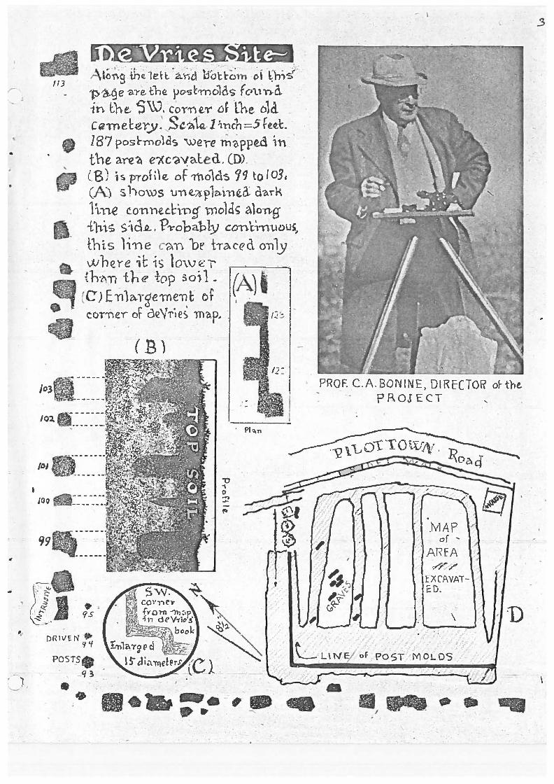
Although we did not qive much thought to the sort of construction that we would find at the deVries' site, we were inclined at first toward the idea that there would he a continuous line of Post molds such as have been fou~d on many Indian sites in nearby states. At present our attempts to show that another manner would be more logical for a group of Dutch colonists may seem inspire~ hy a wish to make a new hypothesis in accord with the markings we have found. But was not our ori~inal supposition too hastily made? ~·fo know of no model of Indian fortifications in thlij vicinity thnt could have influenced the building style of a ·band of exoerienced farmers and laborers fresh from the O~.d -·orld. De Vries seemed to have no prior knowledge of this stockade when he noted from his position on the hill that the colonists had surrounded the. co~munity house with "palisadoes". The word as he writes it looks snanish ;:md it may have become current durin~ the Spanish invasion of Hofland. The word is from Latin palus, a stake or palinq.
The original D~tch colony on the site of Kingston N.Y. was prote8ted by a stockade built in lfi52. ~he colonists were instrncted to supply palisades "ten feet lonq, pointed and flat." The map of the stockade shows that it was almost a rectangle. This shape was not demanded by the contours except perhaps on the north side and suqqest that straight r~ns suited the manner of building. There were ledges of rock in several places where digging a ditch to place a row of logs would have been i~possible. Also if the palisades ;:·;ere set three feet in the qround and a foot or more give~ to the point, the effective defensive covera~e would be onLy six feet.
The dr awing below is of a type of heavy fence used today to surIJund junk yards. The palinqs are made of slab cuts but the colonists would have used pine logs sPlit in two. The lower ends do not rest on the qround but on a horizontal pl2 : ~k of a wood that does not rot easily. There are two stringer s and in early times wooden pegs would have been used t~ attach the palings to them. Heavy cedar posts like those o f which we found so many traces around the old cemetery Wtmld have been used as upriqhts settled deeply in the ground. The long dark lines on the northwest boundry could be of the horizontal planks put in a little deeper here whera t he slope begins. There is nothing unconunon in such a fenc .:::. and it satisfies several of the requ:=ements of the mar~ inqs we have found. It illustrates a suoposition.
' 1\~\/I, .h./~/\/\/\0(Y\/v\_ ~~\ /
_ _1 I ·, \ 1 r--, ~ ) } ( 1 _l_L~ 1 i__L__l__.L> .tt. r. ~"·111!~! I ~ _..:. .. - ·'- . .:.. .. : ' • ~ '
+l2i> ·~l1JJ_J ·. J .' ) . ; \1
~ 1 . • •
'.l F I~\ ) \ /.-f· ,.~\ .... /,.~.,), 1 , , ., . ,, l/'A.dl\~/lldf\''''\~ 1',-\tf~\1\/11/:-~l'f \\._,.....---
F' . CTS vs F I C T I 0 N
The fcllowinq quotation is taken from Runk's Biographical and Geneoloqic .~l ,:. ~ : ::ory of Delaware ~tol. I paqes :t r ana l2, PubJ.ishE:~ ~ :.1 ...... : .. _-,.~~ · ;, ; :.,.. , - c::-.arnbe:i..-., ~., , ~ ~:g , P e:. ~, 1999. Describinq :the fate of the deVries' colony of 1631 at Lewes, Delaware he :..: :.. .:....t ... t:?s : ••••• "Moved with deep pity bv the sad spectable, de Vries and his f ollmmrs set to work to qather up the bones of the slain and qive them Christian burial. A trench was dug in which the fragments 0 f th~ unfortunates were placed and then carefully covered with earth .· ,.,,hen the burial party returned to their ships and sailed awav, ·
M.ore than twc ·:-:.nd a half centuries rolled away, and the circurnstancG of the cru~ l massacre had passed from the memory of man. It was one o f the fPr gotten incidents of the earlv efforts of a
5
band of adventurous ~ioneers to found a settlement in the New World; historians had cease ri. to notice it and the fncts of the tragedy were no longer recaJled. But time, which reveals all things, came to the rescue. A fe ·~' years aqo, when excavations were being made for the construction of a railroad, the workmen laid bare the place of sepulture of the hones of the early colonists. Many of them were in a good state of nr eservation, but the smaller bones crumbled on beinq exposed tc thP atmosphere. The skulls and thiqh bones were intact. Dr. D.L. ~~~ stard an old physician and resident of Lewes, examined these fragm0ntar~ remains, and had. no hesitancy in pronouncinn" then of Ancr:: ::J-Saxon oriqin. This was regarded as conclusiogie, evidence that they h ~ longed to the deVries Colonists. After this careful examination ; i n which others participated with Dr. Mustard, the bones were caref·.:i. lly collected and reinterred, where they will probably be undist~rbed until thev have been crumbled into dust.
'rhus perished t he first men and women who attempted to found a settlement on the Delaware bay, within what are now the confines of the State of Delcl•mre. Their place of sepulture is within a few hundred yards o f thr. nresent borough of Lewes, on the Hoorn Kill." (Bnd of ouotation)
Since the late l"}r. n.L. Mustard was prominently mentioned in the above quotation r I got in touch with his granddaughter-r11rs. Caleb f; . Layton, ,.,he forwarded Dr. Mustard's diary and other papers to me. On page 1 of his diary and in his own handwriting occurs the followinq statem~ .nt: "An Indian village probably stood where the town (Lewes) is :'low locatert, for in the gradinq the Junction and Breakwater R. Road (1868) in passing thro Capt. E. n. Hitchins' land a large number of human bones were excavated and of very large size. It is presumGd they were Indians as we have no record or intimation of anv qraveyard havinq been located there". Thus by rare good fortune WE- n.re able to refute a statement made as convincinq as a writer c f commercialized history could make it.
~n imnortant part of the theory behind the Sussex Archaeological Association's excava·i.".ion on the borders of the old cemetery near the de Vries monument is that de Vries' men (De Vries himself had sail~ d up the rive.r) would have interred here those killed within the stockRde and prehaps others found hearby, so inauqurating the "ancient" cem terv. Our anxiety, therefore, to check an item which p:':."..cea. their hurial about a mile and a ~:alf away mav be :; · imaqined. The old railroad mentioned above ran near sites where the association has found large skeletons which Dr. Stewart of the Smithsonian has called typicaily Algonkian.
Helene c. Potter

\
~
'...?'
'"
1i. .f
-1? \'" >.•
The Crossing of Pagan (now Canary) Creek is Shown With Shoding on Dotted Line of Road.
The DIKE The Importance of thl11 <'auseway across Canary Creek
depends on the date of Its construction. For more than a year the earliest date we could give It with documentary support was 1833, but now we have a map showing It was an essential feature In a road which must have been the main outlet of the Lewes-Pllottown peninsula and connecting link with roads leading to Georgetown and up-state, In the 1700s.
We are grateful to Mr. Lewis Art Chambers, a retired pilot. for calling our attention to this map and allowlng us to photograph It. It Is a pen copy made for Dr. Turner, a careful historian of local matters, of an orlglnal we have not yet located and said to have been In very bad condition when this copy was made. Mr. Chambers Is a great-grandso11 of Jacob Art who died In 1769 and was burled In the nnclent cemetery. His gravestone Is one of the few which have survived there. Reliable, though Imprecise, accounts agree that there were several late 17th. Century stones still standing not many years ago. If this Is true It Is unfortunate-tor this and other reasons-that the State did not acquire this acre when It secured the ground on which the monument to deVrles was placed. They belong to the same episode-If either belongs to 1t.
Was the dike bullt by the Dutch? Elsewhere In th~se pages Mr. Hutchinson suggeats that It might have been built by the Indians as was a causeway mentioned by Geo. Washln!{ton. It ts almost certain thAt the Indians had an Important path connecting the vlllages we know to have existed In this area and skirting the Great Marsh and It Is probable that It crossed the creek somewhere near the dike but an Indian causeway would hardly have been wider than would have permitted' a single file whereas the dike Is wide enough for carts. Mthougb It has one bend the lines of the dike are still 11tra1ght enough to suggest surveying Instruments and finally two Indian arrowheads were found In a small test trench cut across lhe dike making It probable that the sol! was brought from the surface of the nearby Russell site Indian village. The "charges" of earth though r&tper small are too large for baskets. The posslblllty that there was an Indian path and causeway here adds to the likelihood that this crossing was bullt as soon as the need for It was felt. -
Dr. Marine, from a study of the Duke of York grants on both sides of the creek at this point considers It probable that the road led to the mill which gave the name Miii Creek found In D. of Y. grants of 1675. The Dutch settlers would not have waited untll they were· under the orders of an English gpvernor to build a mill or the causeway -to reach It-In fact several years earlier a large dike In Yorkshire was built under Dutch supervision.
We have not been able to trace this road over the dike to "Polit (sic) Town" but It must have gone close to the Old House site and on, by Pllottown road or across the fields, to the deVrles' site.
The Information that the records of the Dutch West India Company were sold as waste paper early In the 19th. century has about done away with our hope of getting answers to our questions in Holland. From now on we must look to digging to make clear what history has left vague or unrecorded, but It Is comforting to know that our work Is part of· an expanding effort to make use of archaeology to do this. Begun appropriately at Jamestown where recently old property lines have been traced In the subsoil by dark streaks showing the location of ditches, a number of well conducted excavations have settled such questions as how and where the colonists first made Iron, glass and pottery and demonstrated that the observation tower of an early governor was not a Viking fort. A purpose of this number of the "Archeolog" Is to provide a statement of our problems for use In asking other historical and archaeological groups to give us what Information they may have and In urging them to make some excavations where they know stockades to have existed. In Schenectady, N. Y., for example, there was a log blockhouse In existence until about 1900. There se.,ms some doubt as to the time at which It was built but It Is suopos!!d to be on the line of the old stockade and there are still places where this line could be uncovered.
In Lewes we have an area of great historical Importance and unique In that a large proportion of the ground Is still open for exploration though we are conscious of a race with building oper11tlons. which close sites after giving tantalizing glimpses of what they contain.
~'-~-~-,-- --··

&
•'
COMMENTS on the Annual Meeting of the EASTERN STATES ARCHAEOLOGICAL FEDERATION (1952)
I wish everymember of our association could have heard all the interesting papers read at this meeting. I can mention only a few.
The Grave Creek Mounds, by Delf Norma, illustrated a typical "mound builders .. culture. Geo Washington who was surveying in this area in the early 1700s noted a sand "causway" through swamps along the "old Indian Path". Could this be similar to the "dyke" near our Russell site? B. c. Mccary told about a "workshop 11 in Dinwiddle County Virginia where they had found about 75 fluted points of the 11 Folsom" type. W.J.Mayer-Oakes of the Carnegie Museum told of a late prehistoric site in Penna. with shell tempered cord marked pots with round bottoms and flared tops, and peculiar earth markings -- also triangular bone arrow points. A.F.Guthe of the Rochester Museum described the Westfield Site situated on an old portage between the headwaters of the Alleghany and Lake Etie. Pits followed the line of an old beach. Several types of burials including ossuaries being present. We mentioned bone tube beads and 53 qt pots. (Those would be larger than ones found by us.) J.C.Harrington spoke of difficulties in giving definate dates to "Trade Pipes" even when initialed and described the evolution of the shape and size of these pipes from circa 1580 to 1840.
7
Dr.T.Dale Stewart described the Historic Patawomeke Site, especially the enormous amount of documentary research that had been made in connection with it. C.Malcolm Watkins was extremely interesting in discussing the identification of Colonial ceramics and we saw almost tons of reference samples. John Witthoft described in a vivid manner the excavations of The Conny Town 1718-42 near Bainbridge Pa. Charles A. Philhower had a detailed report on the nunsec-Lenape Site in Sussex Co. N.J. And C.A.Weslager gave interesting details of what was found under the Colonial log cabin near Wilmington, Del. Something unusual were pictures by Sigfus Olafson of potroglyphs found near the Guyandotte River in West Virginia.
Most outstanding in "diggers" interest was Wm.A.Ritchie's talk on the early Point Peninsula Burial Complex in New York State. This was a very highly developed culture. Carbon 14 dates it c. lOOOBC.
Coming closer to home -- J.Alden Mason reviewed his and other's findings at Sandy Hill on the Choptank river near Cambridge Md. Deeply covered withwind-blown sand were flexed burials wit:l\ grave goods including large blades, cooper beads, effegy pipes, steatite pots, red ochre etc., all similar to the Adena in many Ohio valley sites. In the deep burials were usually one or more stone tubes which gave varying musical notes when blown across the end. This ties the peninsula with a much earlier culture than most of our local diggings have so far uncovered. This whole meeting left me with the feeling that we should in some way establish closer relations with our fellow Archaeological Societies so as to be able to profit by the knowledge and facts that they are bringing forth.
Henry H.Hutchinson Nov.1952

"
•
AMERICAN ANTIQUITY, Vol. XVIII, No. I, July, 1952. (Members will find copies at the Lewes Museum.)
8
The leading article deals with the Pit House in the Old World and in Native North America. These aboriginal dwellings were much the same as the Cliff Dwellers' kivas described by Dr. Marine at our last meeting. They are found in southern Russia, Siberia, along the Asian Pacific Coast and in Alaska, and were used by such of the Plains Indians as the Mandan. In the Southwest the pit house ceased to be a dwelling and became a ceremonial structure.
The Fallis Site, in Ontario, Canada, is covered in a lengthy article. This site represents two cultures, Huron and Lalonde, and a qualtity of artifacts of both have been found there.
Bernard G. Hoffman discusses radio carbon datings for the DorsAt Culture, establishing the age of the earliest at about 5400 years. This is compared with Nest Virginia datings of 10,000 years ago, and others in Wisconsin and Connecticut of 7,000 to B,000 years, seeming to prove that the Dorset culture came from southward rather than down from the Artie.
A further report deals with pottery found at Hooper Bay, Alaska, and another with late Eskimo archaeology in Western Mackenzie Delta area. Lastly there is an extended report, profusely illustrated on the Middle Columbia Cremation Complex.
AMERICAN ANTIQUITY, Vol. XVIII, No. 2, October, 1952.
In this issue, "The Gordon Site in Southern Mississippi", by John L. Cotter, is a model of information and deduction. The drawings depicting the sites investigated, the very clear photographs of the objects recovered, and the conclusions drawn from the finds as to the manner of life of the prehistoric inhabitants, all make for an unusually interesting presentation. The remaining articles deal with Georgia-Florida pottery, a sling found in Nevada, .and quill headbands from Colorado. As usual there are many items of interest in "Facts and Comment" and in the reviews of books and articles. The July number has a review by Dr. T. Dale Stewart of a book by a practicing dentist on Indian teeth. If we could master its technical language this would give us a quick way of recognizing a skull as Indian.
S. P. **************
ARCHEOLOGY of the EASTERN UNITED STATES (Chicago University Press 10.00) is a handsome book with many hand-drawn planographic plates. Only mention of Delaware is the old one that little is known of its collections. The ARCHEOLOG hopes also to have a "plano" in this number -- hand-drawn except for an experimental Halftone we have persuaded Prof. Bonine to let us use. The Photograph was made by Ralph Karl.
,,.,
New Plan for Indian Sites 9
Not only are the Indian sites very numerous in this area, but persons more interested in them than in other subjects comprise a large part of our membership. At two recent meetings this matter was discussed and it was decided to divide our territory into several parts - though without any hard and fast boundaries - and to name a leader to guide the work in each section.
This method had been used with good results in the case of the Willin site under the direction of President Hutchinson, whose report, in its presentation and coverage, is one of the high points of our work. It is unfortunate that this report cannot be printed in an edition large enough to give each member a copy. A substitute idea was to make a resume of it in the "Archeolog." We have not given up this idea but the problem of summarizing 29 pages of a text that is already carefully compressed and containing important tables which cannot be presented in reduced form, has been too difficult for us. There is also the matter of the 11 plates with about 170 separate drawings; their total is important and a single plate would not be a satisfactory sample. It may even be questioned whether these final reports (this one is entitled "Tentative Closing Report" but may be final) are in the real province of the "Archeolog." While the work was in progress we were happy to have enough material on the Willin site to make the bulk of one issue, just as the present number will be devoted largely to the de Vries site but it cannot take the place of the final report. It will give our membership an idea of some of the problems and how they have been treated, and suggest ways in which they can take part in this work while it is going on ·.
The problem of getting ade~uate reports from each person on a dig is one that has been with us - at times in an acute form -since our first project. Many excellent workers find excuses, valid to themselves, for failing to fill out all the details ultimately needed to make those tables which are the real meat of a report. Mr. Hutchinson got all his workers together when the report was being prepared and made sure that anything lacking was made up orally while it could be supplied from memory by the wo~ker who had been n~gligent or by another who had worked with him.
It was agreed that Henry Hutchinson should continue to supervise excavations in the Seaford area; Warren Callaway, the territory near Bridgeville, especially Chicone Creek; Frank B. Austin, Milford and his own Arrowhead Farm; Ralph E. Karl, sites in both Lewes and Rehoboth, leaving open, however, the designating of specific sites to be under the direction of persons who are especially interested in them.
***************
The "Archeolog" hopes that the leaders in these special dis-' tricts will have our needs in mind and supply material for an
Indian number for early in 1953. Several members have pointed out that a regular number of issues each year would be desirable. We are dependent to a considerable extent-and would gladly be entirely dependent - on what comes in, and an excavation may be active but have only "more of the same" to report. This is the second and last number of the year.
•