NOTICE OF SPECIAL MEETING - Tracy · 2013. 5. 22. · NOTICE OF A REGULAR MEETING Pursuant to...
52
NOTICE OF A REGULAR MEETING Pursuant to Section 54954.2 of the Government Code of the State of California, a Regular meeting of the City of Tracy Planning Commission is hereby called for: Date/Time: Wednesday, May 22, 2013 7:00 P.M. (or as soon thereafter as possible) Location: City of Tracy Council Chambers 333 Civic Center Plaza Government Code Section 54954.3 states that every public meeting shall provide an opportunity for the public to address the Planning Commission on any item, before or during consideration of the item, however no action shall be taken on any item not on the agenda. REGULAR MEETING AGENDA CALL TO ORDER PLEDGE OF ALLEGIANCE ROLL CALL MINUTES APPROVAL DIRECTOR’S REPORT REGARDING THIS AGENDA ITEMS FROM THE AUDIENCE - In accordance with Procedures for Preparation, Posting and Distribution of Agendas and the Conduct of Public Meetings, adopted by Resolution 2008-140, any item not on the agenda brought up by the public at a meeting, shall be automatically referred to staff. If staff is not able to resolve the matter satisfactorily, the item shall be placed on an agenda within 30 days 1. OLD BUSINESS 2. NEW BUSINESS A. PUBLIC HEARING TO CONSIDER APPLICATIONS FOR A CONDITIONAL USE PERMIT AND DEVELOPMENT REVIEW FOR A PRESCHOOL BUILDING, OUTDOOR PLAY AREA, AND PARKING AREA IMPROVEMENTS AT 160 W. BEVERLY PLACE - APPLICANT IS SCHACK & COMPANY, INC. AND OWNER IS PASTOR OF ST. BERNARD’S CHURCH - APPLICATION NUMBERS CUP13-0002 & D13-0004 B. PUBLIC HEARING TO CONSIDER APPROVAL OF A 61-LOT TENTATIVE SUBDIVISION MAP ON AN 11.8-ACRE PARCEL LOCATED ON THE NORTH SIDE OF STARFLOWER DRIVE AT HUMMINGBIRD WAY, EAST OF CORRAL HOLLOW ROAD FOR THE CONSTRUCTION OF 61 SINGLE-FAMILY HOMES. THE APPLICANT IS MACKAY AND SOMPS AND OWNER IS STANDARD PACIFIC HOMES- APPLICATION NUMBER TSM13-0001 3. ITEMS FROM THE AUDIENCE 4. DIRECTOR’S REPORT 5. ITEMS FROM THE COMMISSION 6. ADJOURNMENT May 16, 2013 Posted date The City of Tracy complies with the Americans with Disabilities Act and makes all reasonable accommodations for the disabled to participate in public meetings. Persons requiring assistance or auxiliary aids in order to participate should call City Hall (209-831-6000), at least 24 hours prior to the meeting. Any materials distributed to the majority of the Planning Commission regarding any item on this agenda will be made available for public inspection in the Development and Engineering Services department located at 333 Civic Center Plaza during normal business hours.
Transcript of NOTICE OF SPECIAL MEETING - Tracy · 2013. 5. 22. · NOTICE OF A REGULAR MEETING Pursuant to...

NOTICE OF A REGULAR MEETING Pursuant to Section 54954.2 of the Government Code of the State of California, a Regular meeting of the City of Tracy Planning Commission is hereby called for: Date/Time: Wednesday, May 22, 2013 7:00 P.M. (or as soon thereafter as possible) Location: City of Tracy Council Chambers 333 Civic Center Plaza Government Code Section 54954.3 states that every public meeting shall provide an opportunity for the public to address the Planning Commission on any item, before or during consideration of the item, however no action shall be taken on any item not on the agenda. REGULAR MEETING AGENDA CALL TO ORDER
PLEDGE OF ALLEGIANCE
ROLL CALL
MINUTES APPROVAL
DIRECTOR’S REPORT REGARDING THIS AGENDA
ITEMS FROM THE AUDIENCE - In accordance with Procedures for Preparation, Posting and Distribution of Agendas and the Conduct of Public Meetings, adopted by Resolution 2008-140, any item not on the agenda brought up by the public at a meeting, shall be automatically referred to staff. If staff is not able to resolve the matter satisfactorily, the item shall be placed on an agenda within 30 days
1. OLD BUSINESS
2. NEW BUSINESS
A. PUBLIC HEARING TO CONSIDER APPLICATIONS FOR A CONDITIONAL USE PERMIT AND DEVELOPMENT REVIEW FOR A PRESCHOOL BUILDING, OUTDOOR PLAY AREA, AND PARKING AREA IMPROVEMENTS AT 160 W. BEVERLY PLACE - APPLICANT IS SCHACK & COMPANY, INC. AND OWNER IS PASTOR OF ST. BERNARD’S CHURCH - APPLICATION NUMBERS CUP13-0002 & D13-0004
B. PUBLIC HEARING TO CONSIDER APPROVAL OF A 61-LOT TENTATIVE SUBDIVISION MAP ON AN 11.8-ACRE PARCEL LOCATED ON THE NORTH SIDE OF STARFLOWER DRIVE AT HUMMINGBIRD WAY, EAST OF CORRAL HOLLOW ROAD FOR THE CONSTRUCTION OF 61 SINGLE-FAMILY HOMES. THE APPLICANT IS MACKAY AND SOMPS AND OWNER IS STANDARD PACIFIC HOMES- APPLICATION NUMBER TSM13-0001
3. ITEMS FROM THE AUDIENCE
4. DIRECTOR’S REPORT
5. ITEMS FROM THE COMMISSION
6. ADJOURNMENT
May 16, 2013 Posted date The City of Tracy complies with the Americans with Disabilities Act and makes all reasonable accommodations for the disabled to participate in public meetings. Persons requiring assistance or auxiliary aids in order to participate should call City Hall (209-831-6000), at least 24 hours prior to the meeting.
Any materials distributed to the majority of the Planning Commission regarding any item on this agenda will be made available for public inspection in the Development and Engineering Services department located at 333 Civic Center Plaza during normal business hours.

MINUTES TRACY CITY PLANNING COMMISSION
WEDNESDAY, MARCH 27, 2013 7:00 P.M.
CITY OF TRACY COUNCIL CHAMBERS 333 CIVIC CENTER PLAZA
In accordance with Procedures for Preparation, Posting and Distribution of Agendas and the Conduct of Public Meetings, adopted by Resolution 2008-140, any item not on the agenda brought up by the public at a meeting, shall be automatically referred to staff. If staff is not able to resolve the matter satisfactorily, the item shall be placed on an agenda within 30 days.
* * * * *
CALL TO ORDER Chair Ransom called the meeting to order at 7:00 p.m.
PLEDGE OF ALLEGIANCE Chair Ransom led the pledge of allegiance
ROLL CALL Roll Call found Chair Ransom, Vice Chair Sangha, Commissioner Johnson, Commissioner Mitracos, and Commissioner Orcutt. Also present were staff members Alan Bell, Senior Planner, Kimberly Matlock, Assistant Planner, Bill Sartor, Assistant City Attorney and Jan Couturier, Recording Secretary.
DIRECTOR’S REPORT REGARDING THIS AGENDA Mr. Bell advised that Bill Dean, Assistant Director Development Services would not be attending this meeting due to an out of town development meeting.
ITEMS FROM THE AUDIENCE – None
MINUTES APPROVAL – Chair Ransom reviewed the minutes of the February 27, 2013 meeting of the Planning Commission. Commissioner Mitracos made a motion to approve the minutes as presented, Commissioner Johnson seconded, all in favor, none opposed
OLD BUSINESS – None
NEW BUSINESS –
A. PUBLIC HEARING TO CONSIDER AN APPLICATION FOR A CONDITIONAL USE PERMIT APPLICATION FOR AN EDUCATIONAL AND VOCATIONAL FACILITY AT 324 E. ELEVENTH STREET AND A PLANNING COMMISSION DETERMINATION FOR MINIMUM OFF-STREET PARKING REQUIREMENTS FOR EDUCATIONAL AND VOCATIONAL USES. APPLICANT IS UNITED CEREBRAL PALSY AND PROPERTY OWNER IS TOM BLACK FOR TRACY CITY PLAZA, LLC. APPLICATION NUMBERS CUP13-0001 AND DET13-0001
Chair Ransom read the title and opened the staff report.
Kimberly Matlock, Assistant Planner, reviewed the proposed use of the 4,200 square foot space to be used as an educational/vocational training facility for United Cerebral Palsy located at 324 East Eleventh. The site is zoned professional Office Medical and Schools are a conditionally permitted use requiring Planning Commission approval of a conditional use permit. Training will take place both on site and off site, but on site will be inside. Ms. Matlock reviewed operational
barbarah
Typewritten Text
DRAFT

Planning Commission Agenda March 27, 2013 Page 2
details inclusive of the transport of United Cerebral Palsy clients via van; staff will use their own vehicles.
Ms. Matlock then reviewed the parking element of the staff report. She indicated that the Tracy Municipal Code does not have an off-street parking requirement for educational/vocational training facilities. She stated that it was anticipated there would be one car per each staff member and a maximum of 13 staff members and 4 transit vehicles for a total need of 17 off street parking spaces. She advised that Tracy Municipal Code authorizes the Planning Commission to determine a minimum number of parking spaces for uses not otherwise specified. The previous use of the space was office space; the standard for which is one space per 250 square feet of office space. As this location is 4,200 square feet it would require a total of 17 spaces.
Ms. Matlock summarized the staff report and requested that Planning Commission approve the Conditional Use Permit and determine off street parking for educational/vocational training facilities to be a rate of one parking space per staff person at peak times and one space for a transit vehicle that will be parked on site.
Chair Ransom opened the meeting to the commission.
Commissioner Mitracos asked about proposed tenant space as indicated on the plans attached to the staff report and the number of handicapped spaces as well as the general ADA accessibility of the space. Ms. Matlock explained that the applicant did not have benefit of an architect to prepare the plans from the property owner so they filled in the space on the plans provided. She advised there were no changes to disable access requirements proposed with the application, but they may be triggered by the building permit for the tenant improvement.
Commissioner Johnson had a question on the different entrances and the location of the parking spaces for the location. Staff advised that the applicant’s staff would park in the parking lot off Eleventh Street as their primary parking.
Commissioner Johnson also asked about special events that may require extra parking by United Cerebral Palsy.
Chair Ransom opened to the public hearing.
Corinne Fielder, the representative for United Cerebral Palsy, reviewed the fact that as a vocational training facility there would not be graduations or other special events; that training is ongoing, and therefore, no additional parking would be necessary for graduations or other special events.
Commissioner Johnson asked if students currently attend school locally. Ms. Fielder indicated students may be coming from anywhere. The program is year-round and it is for adults who need help; indicating that the program is next step for them and is designed to give them more support or help. Commissioner Johnson expressed concern about the size of the space. Ms. Fielder indicated that the space is more than adequate. She advised that the staff to customer ratio is one to three. There was a general discussion of the program and outside trips.
Commissioner Johnson asked if the handicap access was adequate. Ms. Fielder indicated yes, that the customers attending will be higher functioning. Chair Ransom asked about ADA accessible vans. Staff reviewed the types of vehicles that would be used and the arrangements required. Ms. Fielder advised that any larger cut-away vans would be parked on street.
Commissioner Mitracos asked general questions about United Cerebral Palsy. Applicant explained the various services offered by United Cerebral Palsy and reviewed the types of disabilities which they serve.
barbarah
Typewritten Text
DRAFT

Planning Commission Agenda March 27, 2013 Page 3
Chair Ransom closed the public hearing and returned to the commissioners for comment at 7:22 p.m.
Chair Ransom requested greater clarification of the cut-away vans as to their parking outside the parking lot and requesting greater specificity. Mr. Bell indicated that additional verbiage could be added suggesting the applicant only store or otherwise park vehicles that would fit into the pre-existing spots. Ms. Matlock reviewed the Conditions of Approval Section B2 for the Commission. Chair Ransom questioned the conditions as written. Ms. Matlock suggested adding to the end of the second sentence in section B2 “and shall not park on site.” Chair Ransom was in agreement
Mr. Sartor suggested that the motion to approve should include “with Condition of Approval Section B2 as revised.”
Chair Ransom requested a motion.
Commissioner Orcutt moved to approve the application and the parking supplement for the Conditional Use Permit for the educational/vocational training facility as amended with section B2 being amended for the location at 324 East Eleventh Street including the minimum off street parking requirements.
Chair Ransom suggested adding the specific number of “17 parking spaces” to the motion. Ms. Matlock responded by advising that the goal of the staff-recommended parking determination was to keep the determination flexible. Commissioner Mitracos indicated the resolution seemed a bit vague.
Mr. Bell reviewed the staff’s request to have the Commission approve the Conditional Use Permit. He added that the second resolution was to formalize the determination of the off street parking requirement. There was general discussion about the manner of approving the two resolutions. Mr. Sartor suggested perhaps Commissioner Orcutt would wish to re-state his motion and break it into two motions.
Commissioner Orcutt made a motion to approve the Conditional Use Permit for the educational/vocational training facility at 324 East Eleventh Street. Mr. Sartor advised that this was the resolution with the amended Conditions of Approval. Commissioner Orcutt agreed and added “with the amended sentence in Section B 2.” Commissioner Johnson seconded. Chair Ransom restated the motion; all in favor, none opposed.
Prior to asking for a motion on DET13-0001, Chair Ransom raised the issue of number of parking spaces requesting that there be a firm number. Mr. Bell indicated that Planning Commission could advise the total number of spaces. He reviewed the code requirements. He added that staff was asking the Planning Commission to determine the proper allotment of parking spaces.
Commissioner Mitracos asked if by the Planning Commission approving this request would that affect all future educational vocational training facilities. Mr. Bell indicated that it would and reviewed the resolution re-stating the first recital.
Mr. Sartor advised that the final statement in the resolution read “Now, therefore be it resolved that the Planning Commission does hereby determine a minimum off-street parking requirement for ‘this’ educational and vocational training use….” Chair Ransom commented about the total number of occupants in the entire complex, not just this applicant’s usage. There was further discussion about the appropriate number of spaces and whether it is necessary to be specific while limiting the applicant to the correct number so as to not interfere with the other businesses.
barbarah
Typewritten Text
DRAFT

Planning Commission Agenda March 27, 2013 Page 4
Ms. Fielder approached the podium, so Chair Ransom re-opened the public hearing at 7:40 p.m. Ms. Fielder reviewed the staffing levels and indicated they would grow proportionally to the number of customers. The proposal addressed the maximum number of staff and customers.
Mr. Bell added that United Cerebral Palsy would have the ability to manage their site to accommodate increased capacity and that they could come back to the Planning Commission for additional need. There was some general discussion about how United Cerebral Palsy would address future use.
Chair Ransom brought the issue back to the Commission.
Commissioner Orcutt asked if the resolution applied only to this applicant or to all similar uses. Mr. Bell indicated normally this recommendation would apply to all, but in this case we are suggesting an amendment that would apply only to this use.
Mr. Sartor suggested a possible amendment to the Conditional Use Permit depending on the Commission’s interest in adding a square footage delimiter.
Commissioner Sangha asked if the entire complex was fully occupied. Ms. Matlock indicated that the applicant’s request was the only vacant space.
Chair Ransom then asked about the other tenant parking spaces. It was determined that the entire complex would have a requirement of 51 spaces based on the current parking requirement for offices plus the 17 for the applicant’s space.
Mr. Bell spoke to parking issues of the entire site. He reviewed the City Council’s thought process in adopting parking requirements in 1989.
Commissioner Mitracos reviewed the motions which included discussion by the Commissioners and Mr. Sartor gave an overview suggesting that the “not to exceed one space for every 250 square feet of office” as an option. There was some additional discussion on the exact wording of the motion.
Chair Ransom asked for a motion. Commissioner Johnson moved to make the minimum off street parking requirement for this educational and vocational training use of one parking space per staff at peak times plus one parking space per transit vehicle that will be parked on site with a not to exceed cap of one parking space per every 250 square feet based on the findings and subject to the conditions as stated in the Planning Commission Resolutions dated March 27, 2013 as amended. Commissioner Sangha seconded the motion, all in favor none opposed.
ITEMS FROM THE AUDIENCE – None
DIRECTOR’S REPORT – None
ITEMS FROM THE COMMISSION Commissioner Mitracos discussed The State of the City meeting on March 27, 2013.
ADJOURNMENT Commissioner Orcutt made a motion to adjourn. Chair Ransom seconded and adjourned.
TIME 8:00 p.m.
_____________________________ _____________________________
CHAIR STAFF LIAISON
barbarah
Typewritten Text
DRAFT

MINUTES TRACY CITY PLANNING COMMISSION
WEDNESDAY, APRIL 24, 2013 7:00 P.M.
CITY OF TRACY COUNCIL CHAMBERS 333 CIVIC CENTER PLAZA
CALL TO ORDER Chair Ransom called the meeting to order at 7:08 p.m.
PLEDGE OF ALLEGIANCE Chair Ransom led the pledge of allegiance
ROLL CALL Roll Call found Chair Ransom, Vice Chair Sangha, Commissioner Johnson, Commissioner Mitracos, and Commissioner Orcutt. Also present were staff members Andrew Malik, Development Services Director, Bill Dean, Assistant Development Services Director, Victoria Lombardo, Senior Planner, Bill Sartor, Assistant City Attorney, and Steve Noack, Principal with Design, Community & Environment/The Planning Center, Inc. and Jan Couturier, Recording Secretary.
MINUTES APPROVAL Chair Ransom requested that the March 27 minutes be amended to reflect that the public hearing was re-opened because the applicant, Ms. Fielder, wished to address the Planning Commission. Commissioner Johnson moved to approve the March 27, 2013 minutes as amended, Vice Chair Sangha seconded; all in favor none opposed.
Chair Ransom requested comments on the April 10, 2013 minutes; there were none. Commissioner Orcutt moved to approve the April 10, 2013 minutes, Commissioner Mitracos seconded; all in favor, none opposed.
DIRECTOR’S REPORT REGARDING THIS AGENDA None
In accordance with Procedures for Preparation, Posting and Distribution of Agendas and the Conduct of Public Meetings, adopted by Resolution 2008-140, any item not on the agenda brought up by the public at a meeting, shall be automatically referred to staff. If staff is not able to resolve the matter satisfactorily, the item shall be placed on an agenda within 30 days
ITEMS FROM THE AUDIENCE - None
A. OLD BUSINESS None
B. NEW BUSINESS
A. MINOR AMENDMENT TO THE PLAZA ONE FINAL DEVELOPMENT PLAN TO REPLACE PARKING STALLS WITH AN OUTDOOR DINING AREA ADJACENT TO THE BUILDING AT 2972 WEST GRANT LINE ROAD - APPLICANT IS JS KENDALL CONSTRUCTION, INC. FOR PLAZA ONE, LLC
Chair Ransom reviewed Agenda Item 2A and requested the staff report. Ms. Lombardo provided a review of the project stating that it had originally been approved in 2000. She further described the project’s history and location. She advised that the proposal was a minor amendment to the original approval which would add an outdoor seating area which would replace 7 existing parking stalls. She further advised that there would be some added landscaping referring to the rendering in attachment B and that the parking would still meet the guidelines for that project.
Ms. Lombardo further reviewed Attachment C which gave a representation of the outdoor seating area. She indicated that staff recommended approval of the minor amendment which

Planning Commission Agenda April 24, 2013 Page 2
does not compromise the overall site plan. She indicated that it meets all the codes and guidelines.
Chair Ransom asked for comments from the Commission. Hearing none; Chair Ransom opened the Public Hearing. There were no comments.
Chair Ransom asked for a motion from the Commission. Commissioner Mitracos moved that the Planning Commission recommend the City Council approve the minor amendment to the Plaza One Final Development Plan to replace seven parking stalls with an outdoor dining area; based on the findings contained in Planning Commission Resolution date April 24, 2013 Attachment D. Commissioner Orcutt seconded the motion; all in favor, none opposed.
B. PUBLIC HEARING TO RECEIVE COMMENTS ON THE CORDES RANCH SPECIFIC PLAN PROJECT DRAFT ENVIRONMENTAL IMPACT REPORT, AND TO DISCUSS AND RECEIVE COMMENTS ON THE DRAFT CORDES RANCH SPECIFIC PLAN, AND RELATED DRAFT GENERAL PLAN AMENDMENT
Chair Ransom reviewed Agenda Item 2B and requested the staff report. Mr. Dean advised that this Public Hearing was a continuation of the process of bringing the Cordes Ranch project to the Planning Commission. He further indicated that this was an additional opportunity for the public to review the project and comment specifically on the Draft Environmental Impact Report (EIR). He mentioned that this Draft EIR was quite technical.
Mr. Dean introduced Steve Noack who then proceeded to provide an overview of the EIR. He discussed the various technical terms that were included in the report along with a description of the project; the project location, its size and the development plans.
Mr. Noack provided a PowerPoint presentation during which he advised that an EIR is required by California Environmental Quality Act and is an informational document meant to disclose any effects to the environment based on a project’s General Plan. He added that the primary purpose of the report is to provide information and show the manner in which these impacts might be mitigated.
Mr. Noack reviewed the timeline for this process; highlighting opportunities for public comment. He summarized the various environmental impacts outlined in the EIR process and those specific to the Cordes Ranch project, including those which were significant and unavoidable.
Mr. Dean mentioned that the list of impacts was typical for projects of this sort.
Mr. Noack summarized that the process required the applicant to review alternatives for mitigation, including those considered superior. He restated that the purpose of this meeting was to focus on the adequacy of the document not on the merits of the project. He indicated all comments would be reviewed and responded to in the final EIR.
Mr. Dean advised that the bulk of comments tend to be from various agencies involved as well as from the public at large.
Chair Ransom asked the Commissioners for their comments.
Commissioner Mitracos asked how the amount of park land had been calculated and if park land is required in such projects. Mr. Dean responded that the City of Tracy mitigates for parkland through residential development standards. He advised that in this case there had been numerous discussions about the dynamics of the space, but indicated there was no specific policy.

Planning Commission Agenda April 24, 2013 Page 3
Commissioner Mitracos asked about Alternative 3. He reviewed past practices and commented on Mixed Use guidelines.
Mr. Dean indicated that although the question was not entirely about the EIR he would comment on the General Plan portion of the question. He advised that plans are amendable and that the City would consider amendments over time from members of the community and the Planning Commission.
Commissioner Mitracos then spoke to rail alignments and the two alignments that are in the area. Mr. Dean advised the rail alignment was not a specific proposal for this project. He advised that it would involve other properties.
Commissioner Orcutt asked about the wetlands described in the EIR and the issue of the expiration of one area in 2006. He asked if that expiration was something that would be mitigated via legal action.
Mr. Noack responded that this was a previous wetlands delineation. Because no action had been taken place on that site; that delineation had expired. A new review would have to be done and the Army Corps of Engineers would need to work with the applicant going forward to determine what impacts would occur as a result of the project.
Orcutt commented on the Mountain House community status until full build out adding that it would be somewhat isolated. He wanted to know how the use of parkland area would be amenable to traditional uses of a park versus the present definition included in the Draft EIR.
Mr. Dean responded by referring to the City of Tracy’s recent approval of the Parks Master Plan which would address the uses of various parks in the city; that the Master Plan provided policies that would guide the process of developing residential parks.
Chair Ransom asked if there would be a formal response to the wetlands questions raised by Commissioner Orcutt. Mr. Noack responded that he had recorded the question and would provide a written response in the final document.
Chair Ransom then opened the public hearing at 7:40 p.m. Seeing no further comments, she advised that any further comments would be accepted, in writing, up until May 20, 2013
Mr. Noack advised where the public would be able to review the Draft EIR.
Chair Ransom asked if the Commissioners had any further questions. Hearing none, Chair Ransom requested items from the audience.
3. ITEMS FROM THE AUDIENCE None
4. DIRECTOR’S REPORT None
5. ITEMS FROM THE COMMISSION None
6. ADJOURNMENT - Commissioner Mitracos moved to adjourn and was seconded by Commissioner Orcutt at 7:43 p.m.
_____________________________ _____________________________
CHAIR STAFF LIAISON

May 22, 2013
AGENDA ITEM 2-A REQUEST
PUBLIC HEARING TO CONSIDER APPLICATIONS FOR A CONDITIONAL USE PERMIT AND DEVELOPMENT REVIEW FOR A PRESCHOOL BUILDING, OUTDOOR PLAY AREA, AND PARKING AREA IMPROVEMENTS AT 160 W. BEVERLY PLACE - APPLICANT IS SCHACK & COMPANY, INC. AND OWNER IS PASTOR OF ST. BERNARD’S CHURCH - APPLICATION NUMBERS CUP13-0002 & D13-0004.
DISCUSSION
Background and Site Description
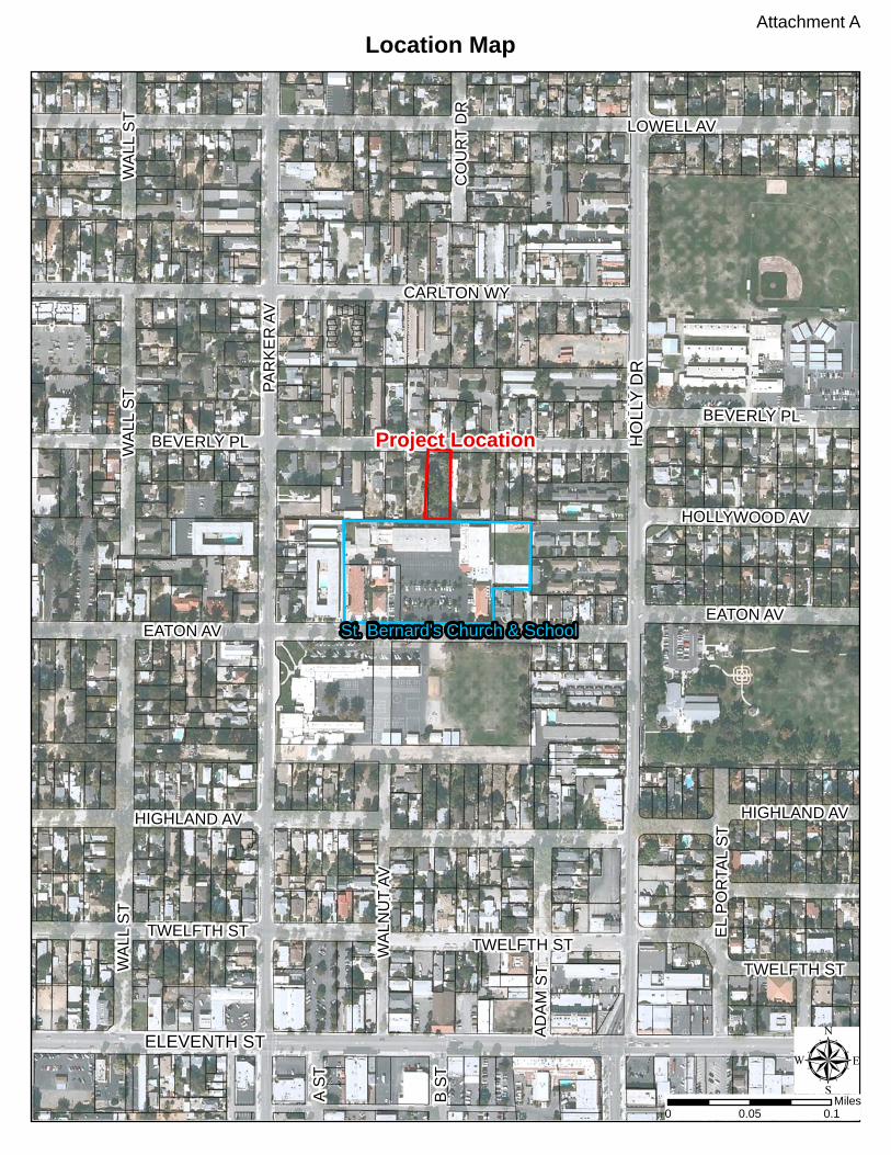
St. Bernard’s Church & School, located at 163 W. Eaton Avenue, proposes to open a preschool in addition to their place of worship and school operations. Because there is no room to construct the preschool on their property, St. Bernard’s Church & School has acquired a residential lot adjacent to the north of the school building for the preschool.
The project site is located at 160 W. Beverly Place and zoned High Density Residential (HDR). The project site is bordered to the north, east, and west by sites consisting of single-family residences and apartment complexes, zoned HDR, and St. Bernard’s Church & School to the south, zoned HDR (Attachment A). Project Description The proposal is to establish a preschool to be operated by St. Bernard’s Church & School. Schools are conditionally permitted in the HDR zone, and a Conditional Use Permit is required before a preschool may be established. In accordance with Tracy Municipal Code (TMC) Section 10.08.4250 et seq., the Planning Commission is empowered to grant or to deny applications for Conditional Use Permits and to impose reasonable conditions upon the granting of use permits. The project proposal also requires Development Review approval of the approximately 4,500 square foot building, outdoor play area, and parking area improvements (Attachment B). The existing single-family home on site would be removed and new improvements would be constructed. Because the Conditional Use Permit is subject to Planning Commission review, the Development Review permit for the proposed site improvements is also presented to the Planning Commission for review, approval, and efficiency in processing.
Land Use and Project Analysis
St. Bernard’s Church & School has operated in a compatible manner with the adjacent residences, and the preschool addition has been designed to minimize potential adverse impacts to neighboring residences. The preschool proposal consists of three classrooms, an administrative office, outdoor play area for students, and a small parking area for staff only. According to the applicant, the preschool will operate in conjunction with the main campus on Eaton

Agenda Item 2-A May 22, 2013 Page 2
Avenue, including use of the rear play area, auditorium building, and parking lot. The preschool would serve approximately 60 students ages three to five and employ four staff members. Typical hours of operation would be 7:00am to 5:30pm, similar to that of St. Bernard’s Church and School. Student drop off and pick up would occur through the main campus parking lot on Eaton Avenue to minimize traffic impacts on Beverly Place. According to the applicant, the school principal has discussed the project proposal with some of the adjacent property owners; staff has not received any comments or concerns from neighboring properties as of the date of publication of this staff report. Site Design and Architecture The site has been designed to complement the existing streetscape. The building setback is moderately deep, similar to the deep setback of the adjacent apartment complex to the east, and a low wrought iron fence with trees and landscaping is proposed within the front yard setback to mimic the shallower setbacks and front yard landscapes of nearby single-family residences. The outdoor play area will be located behind a security wall to prevent children from playing in the parking lot or street. The proposed building employs a balance of architectural enhancements and variety of materials on all four sides of the building consistent with the City’s Design Goals and Standards. The building is modeled after the buildings on the main St. Bernard’s Church and School campus, including the asymmetrical design of the administrative building, the front elevation of the classrooms building, the decorative gates on site, and the materials and colors used throughout the site (Attachment C). Parking, Circulation, and Landscaping The project site is designed with adequate vehicular and pedestrian circulation. As previously mentioned, staff parking is provided on site while student drop off and pick up will take place through the main campus parking lot accessed by Eaton Avenue to minimize traffic impacts on Beverly Place. The project, as designed, meets the TMC off-street parking and landscaping requirements. Landscaping, not including play area turf, will be subject to the City’s Guidelines for Water Efficient Landscape Design, Development and Maintenance.
Project Approval and Expiration Per the TMC, Development Review approvals are valid for one year from the date of approval (TMC Section 10.08.4080) and Conditional Use Permit approvals are valid for six months from the date of approval unless a building permit is issued and construction is commenced (TMC Section 10.08.4350). The TMC also permits Planning Commission to grant a greater time limit for Conditional Use Permit approvals (TMC Section 10.08.4360).
Costs associated with the proposed improvements can be significant. According to the applicant, St. Bernard’s Church and School may not be able to construct the entire project at one time. They would like to construct and occupy the office, two classrooms, the parking lot, and the play area within the next two years, and they anticipate it may take up to five years to complete construction of the third classroom, dependent on when

Agenda Item 2-A May 22, 2013 Page 3
funds to complete this construction may become available. Therefore, the applicant is requesting the Conditional Use Permit and Development Review approvals be granted validity for five years to allow the complete construction of the building and full establishment of the use. According to the applicant, St. Bernard’s Church and School aims to have the office and two classrooms in operation by the 2014 fall semester, and if the third classroom has not been constructed yet, that portion of the site would be temporarily improved as play area until the third classroom can be constructed. Planning Commission has granted longer validity periods for projects in the past, including a previous St. Bernard’s Church and School remodel (Application No. 10-95-CUP), the Islamic Society of Tracy project (Application Nos. CUP08-0002 & D08-0004), and the Grace Baptist Church expansion (Application Nos. CUP10-0003 & D10-0005). Environmental Document The project is categorically exempt from the California Environmental Quality Act pursuant to CEQA Guidelines Section 15332, which pertains to certain in-fill development projects. Because the project is consistent with the General Plan and Zoning, occurs within city limits on a project site of no more than five acres substantially surrounded by urban uses, has no value as habitat for endangered, rare or threatened species, would not result in any significant effects relating to traffic, noise, air quality, or water quality, and can be adequately served by all required utilities and public services, no further environmental assessment is necessary.
RECOMMENDATION Staff recommends that the Planning Commission do the following: 1) Approve the Conditional Use Permit application to establish a preschool with outdoor play area at 160 W. Beverly Place, 2) Approve the Development Review application for an approximately 4,500 square foot building, outdoor play area, and parking, landscape, and hardscape improvements at 160 W. Beverly Place, and 3) Approve a validity period of one year and approve four subsequent consecutive one-year extensions for the complete construction of the project and establishment of the use, based on the findings and subject to the conditions as stated in the Planning Commission Resolutions dated May 22, 2013 (Attachments D and E).
MOTION
Move that the Planning Commission do the following: 1) Approve the Conditional Use Permit application to establish a preschool with outdoor play area at 160 W. Beverly Place, 2) Approve the Development Review application for an approximately 4,500 square foot building, outdoor play area, and parking, landscape, and hardscape improvements at 160 W. Beverly Place, and

Agenda Item 2-A May 22, 2013 Page 4
3) Approve a validity period of one year and approve four subsequent consecutive one-year extensions for the complete construction of the project and establishment of the use, based on the findings and subject to the conditions as stated in the Planning Commission Resolutions dated May 22, 2013 (Attachments D and E).
Prepared by Kimberly Matlock, Assistant Planner Reviewed by Bill Dean, Assistant Development Services Director Approved by Andrew Malik, Development Services Director
ATTACHMENTS
Attachment A— Location Map Attachment B— Site Plan, Floor Plan, Elevations, Landscape Plan dated May 8, 2013 Attachment C— Color Rendering Attachment D— Planning Commission Resolution for the Conditional Use Permit Attachment E— Planning Commission Resolution for the Development Review
Project Location
St. Bernard's Church & SchoolH
OLL
Y D
R
ELEVENTH ST
PAR
KE
R A
V
LOWELL AV
EATON AV
HIGHLAND AV
TWELFTH ST
EATON AV
BEVERLY PL
WA
LL S
T
CARLTON WY
E S
T
WA
LNU
T AV
AD
AM
ST
EL
PO
RTA
L S
T
TWELFTH ST
HIGHLAND AV
A S
T
B S
T
HOLLYWOOD AV
CO
UR
T D
R
WA
LL S
TW
AL L
ST
BEVERLY PL
TWELFTH ST
µ0 0.10.05
Miles
Location Map Attachment A

©
P:\P
rojec
ts\12
032\d
wgs\C
UP\C
UP01
-001
.dwg,
5/6/20
13 1:
06:28
PM,
12:12
barbarah
Typewritten Text
ATTACHMENT B

©
P:\P
rojec
ts\12
032\d
wgs\C
UP\C
UP02
-001
.dwg,
5/6/20
13 1:
06:33
PM,
12:12

©
P:\P
rojec
ts\12
032\d
wgs\C
UP\C
UP03
-001
.dwg,
5/6/20
13 1:
06:36
PM,
12:12

©
P:\P
rojec
ts\12
032\d
wgs\C
UP\C
UP04
-001
.dwg,
5/6/20
13 1:
06:40
PM,
12:12

©
P:\P
rojec
ts\12
032\d
wgs\C
UP\C
UP05
-001
.dwg,
5/6/20
13 1:
14:09
PM,
12:12

barbarah
Typewritten Text
ATTACHMENT C

RESOLUTION 2013-____
APPROVAL OF A CONDITIONAL USE PERMIT A PRESCHOOL AT 160 W. BEVERLY PLACE - APPLICANT IS SCHACK & COMPANY, INC. AND OWNER IS PASTOR OF ST.
BERNARD’S CHURCH - APPLICATION NUMBER CUP13-0002
WHEREAS, On March 13, 2013, Schack & Company, Inc., on behalf of St. Bernard’s Church and School which is a place of worship and school located at 163 W. Eaton Avenue, submitted applications for a Conditional Use Permit and Development Review for an approximately 4,500 square foot preschool building, outdoor play area, and parking area improvements at 160 W. Beverly Place; and WHEREAS, The site at 160 W. Beverly Place is adjacent to the north of St. Bernard’s Church & School, and the preschool will be owned and operated in by St. Bernard’s Church and School; and WHEREAS, The site at 160 W. Beverly Place is zoned High Density Residential, and a Conditional Use Permit is necessary for land use approval of the establishment of schools in the High Density Residential zone; and
WHEREAS, The applicant requested five years to fully establish the use, because funding restraints may only afford for construction of the first phase and delay completed construction of the second phase for five years; and
WHEREAS, The project is categorically exempt from the California Environmental
Quality Act requirements under Guidelines Section 15332 pertaining to infill development; and
WHEREAS, The Planning Commission held a public meeting to review and consider the application for Conditional Use Permit and Development Review applications on May 22, 2013.
NOW, THEREFORE BE IT RESOLVED, that the Planning Commission does hereby 1) Approve the Conditional Use Permit establish a preschool with outdoor play area, and 2) Approve a validity period of five years for the establishment of the use at 160 W.
Beverly Place, subject to the conditions as stated in Exhibit “1” attached and made part hereof, based on the following findings:
1. There are circumstances applicable to the use which makes the granting of a use permit necessary for the preservation and enjoyment of substantial property right. St. Bernard’s Church and School desire to open and operate a preschool and have outgrown their site located immediately to the south. Operation of a preschool at the subject site requires approval of a Conditional Use Permit to establish the preschool use.
2. The proposed location of the conditional use is in accordance with the objectives of the Tracy Municipal Code and the zone in which the site is located, because the project, as conditioned, will conform to the requirements and intent of the City of Tracy General Plan, High Density Residential zone, the Off-Street Parking ordinance, and other applicable chapters of the Tracy Municipal Code. The project will also meet all applicable State laws, City regulations, and City standards.
3. The proposed location of the use and the conditions under which it would be operated or
maintained will not be detrimental to the public health, safety, or welfare with properties in

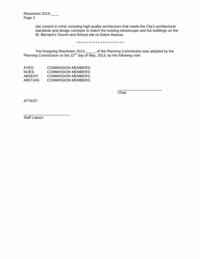
Resolution 2013-____ Page 2
the vicinity or to the general welfare of the City. The preschool would be compatible with the existing St. Bernard’s school and residential uses within the vicinity because the project has been designed to minimize potential adverse impacts to the neighborhood by providing adequate off-street parking facilities and separating outdoor play areas from neighboring properties with fences. Furthermore, the site provides for adequate off-street parking and vehicular and pedestrian circulation, minimizing potential traffic impacts to the residential street.
* * * * * * * * * * * * * * * * * * * *
The foregoing Resolution 2013-_____ of the Planning Commission was adopted by the Planning Commission on the 22nd day of May, 2013, by the following vote: AYES: COMMISSION MEMBERS: NOES: COMMISSION MEMBERS: ABSENT: COMMISSION MEMBERS: ABSTAIN: COMMISSION MEMBERS: ______________________ Chair ATTEST: _______________________ Staff Liaison
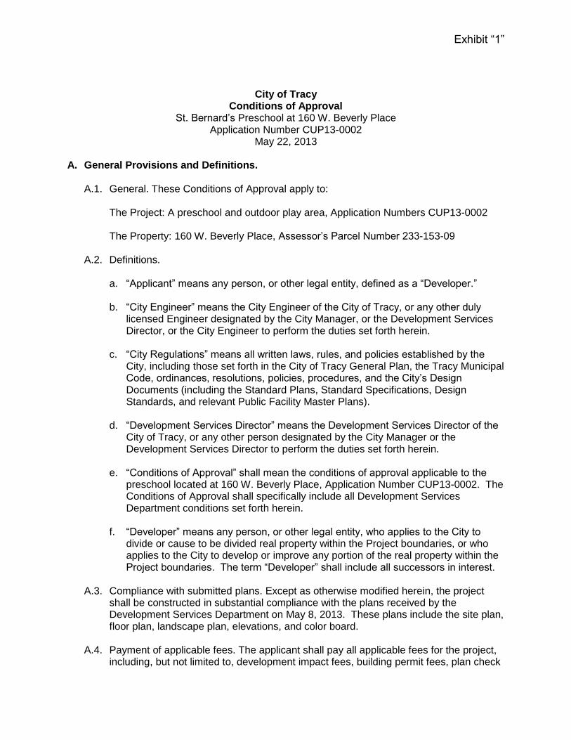
Exhibit “1”
City of Tracy Conditions of Approval
St. Bernard’s Preschool at 160 W. Beverly Place Application Number CUP13-0002
May 22, 2013 A. General Provisions and Definitions.
A.1. General. These Conditions of Approval apply to:
The Project: A preschool and outdoor play area, Application Numbers CUP13-0002 The Property: 160 W. Beverly Place, Assessor’s Parcel Number 233-153-09
A.2. Definitions.
a. “Applicant” means any person, or other legal entity, defined as a “Developer.” b. “City Engineer” means the City Engineer of the City of Tracy, or any other duly
licensed Engineer designated by the City Manager, or the Development Services Director, or the City Engineer to perform the duties set forth herein.
c. “City Regulations” means all written laws, rules, and policies established by the
City, including those set forth in the City of Tracy General Plan, the Tracy Municipal Code, ordinances, resolutions, policies, procedures, and the City’s Design Documents (including the Standard Plans, Standard Specifications, Design Standards, and relevant Public Facility Master Plans).
d. “Development Services Director” means the Development Services Director of the
City of Tracy, or any other person designated by the City Manager or the Development Services Director to perform the duties set forth herein.
e. “Conditions of Approval” shall mean the conditions of approval applicable to the
preschool located at 160 W. Beverly Place, Application Number CUP13-0002. The Conditions of Approval shall specifically include all Development Services Department conditions set forth herein.
f. “Developer” means any person, or other legal entity, who applies to the City to divide or cause to be divided real property within the Project boundaries, or who applies to the City to develop or improve any portion of the real property within the Project boundaries. The term “Developer” shall include all successors in interest.
A.3. Compliance with submitted plans. Except as otherwise modified herein, the project
shall be constructed in substantial compliance with the plans received by the Development Services Department on May 8, 2013. These plans include the site plan, floor plan, landscape plan, elevations, and color board.
A.4. Payment of applicable fees. The applicant shall pay all applicable fees for the project,
including, but not limited to, development impact fees, building permit fees, plan check

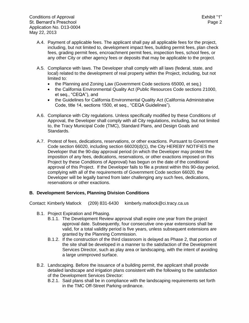
Conditions of Approval Exhibit “1” St. Bernard’s Preschool Page 2 Application No. CUP13-0002 May 22, 2013
fees, grading permit fees, encroachment permit fees, inspection fees, school fees, or any other City or other agency fees or deposits that may be applicable to the project.
A.5. Compliance with laws. The Developer shall comply with all laws (federal, state, and
local) related to the development of real property within the Project, including, but not limited to:
the Planning and Zoning Law (Government Code sections 65000, et seq.)
the California Environmental Quality Act (Public Resources Code sections 21000, et seq., “CEQA”), and
the Guidelines for California Environmental Quality Act (California Administrative Code, title 14, sections 1500, et seq., “CEQA Guidelines”).
A.6. Compliance with City regulations. Unless specifically modified by these Conditions of
Approval, the Developer shall comply with all City regulations, including, but not limited to, the Tracy Municipal Code (TMC), Standard Plans, and Design Goals and Standards.
A.7. Protest of fees, dedications, reservations, or other exactions. Pursuant to Government
Code section 66020, including section 66020(d)(1), the City HEREBY NOTIFIES the Developer that the 90-day approval period (in which the Developer may protest the imposition of any fees, dedications, reservations, or other exactions imposed on this Project by these Conditions of Approval) has begun on the date of the conditional approval of this Project. If the Developer fails to file a protest within this 90-day period, complying with all of the requirements of Government Code section 66020, the Developer will be legally barred from later challenging any such fees, dedications, reservations or other exactions.
B. Development Services, Planning Division Conditions Contact: Kimberly Matlock (209) 831-6430 [email protected]
B.1. Parking. The on-site parking lot should be reserved for staff only. Students and parents shall enter through the parking lot on St. Bernard’s Church and School site located at 163 W. Eaton Avenue and access the preschool building from the southern entrance of the site.
B.2. Activities indoors. The use shall be conducted wholly within the building, with the exception of the outdoor play area, unless a Temporary Use Permit is approved or otherwise authorized by the Development Services Director.

RESOLUTION 2013-____
APPROVAL OF DEVELOPMENT REVIEW FOR A PRESCHOOL BUILDING, OUTDOOR PLAY AREA, AND PARKING AREA IMPROVEMENTS AT 160 W. BEVERLY PLACE -
APPLICANT IS SCHACK & COMPANY, INC. AND OWNER IS PASTOR OF ST. BERNARD’S CHURCH - APPLICATION NUMBER D13-0004.
WHEREAS, On March 13, 2013, Schack & Company, Inc., on behalf of St. Bernard’s
Church and School which is a place of worship and school located at 163 W. Eaton Avenue, submitted applications for a Conditional Use Permit and Development Review for an approximately 4,500 square foot preschool building, outdoor play area, and parking area improvements at 160 W. Beverly Place; and WHEREAS, The site at 160 W. Beverly Place is adjacent to the north of St. Bernard’s Church & School, and the preschool will be owned and operated in by St. Bernard’s Church and School; and
WHEREAS, The applicant requested five years to complete construction of the project, because funding restraints may only afford for construction of the first phase and delay completed construction of the second phase for five years; and
WHEREAS, The project is categorically exempt from the California Environmental
Quality Act requirements under Guidelines Section 15332 pertaining to infill development; and
WHEREAS, The Planning Commission held a public meeting to review and consider the application for Conditional Use Permit and Development Review applications on May 22, 2013.
NOW, THEREFORE BE IT RESOLVED that the Planning Commission does hereby 1) Approve the Development Review for an approximately 4,500 square foot building,
outdoor play area, and parking, landscape, and hardscape improvements; and 2) Approve a validity period of one year and approve four subsequent consecutive one-
year extensions for the complete construction of the project and establishment of the use at 160 W. Beverly Place, subject to the conditions as stated in Exhibit “1” attached and made part hereof, based on the following findings:
1. The desirability, benefits of occupancy, most appropriate development, and maintenance or improvements of surrounding properties will not be adversely affected by the project. The project would be compatible with the St. Bernard’s Church and School and residential uses within the vicinity because the project has been designed to minimize potential adverse impacts to the neighborhood. The building was designed with sensitivity to potential views from neighboring residences through the use of high-quality architecture and landscaping, and the site provides for adequate off-street parking and vehicular and pedestrian circulation.
2. The project will not be detrimental to the public health, safety, or welfare or materially injurious to or inharmonious with properties in the vicinity or to the general welfare of the City, because the project will conform to the requirements and intent of the City of Tracy General Plan and Tracy Municipal Code and all applicable State laws, City regulations, and City standards. Additionally, the outdoor play area will be separated from neighboring properties with fences and from the parking lot and public street by a security wall.
3. The project, as conditioned, will not cause a decrease in the value of properties within the vicinity, because the proposed building and site improvements have been designed with
Resolution 2013-____ Page 2
site context in mind, including high quality architecture that meets the City’s architectural standards and design concepts to match the existing streetscape and the buildings on the St. Bernard’s Church and School site on Eaton Avenue.
* * * * * * * * * * * * * * * * * * * *
The foregoing Resolution 2013-_____ of the Planning Commission was adopted by the Planning Commission on the 22nd day of May, 2013, by the following vote: AYES: COMMISSION MEMBERS: NOES: COMMISSION MEMBERS: ABSENT: COMMISSION MEMBERS: ABSTAIN: COMMISSION MEMBERS: ______________________ Chair ATTEST: _______________________ Staff Liaison

Exhibit “1”
City of Tracy Conditions of Approval
St. Bernard’s Preschool at 160 W. Beverly Place Application Numbers D13-0004
May 22, 2013 A. General Provisions and Definitions.
A.1. General. These Conditions of Approval apply to:
The Project: An approximately 4,500 square foot preschool building and associated play area, parking, landscape, and hardscape improvements, Application Number D13-0004
The Property: 160 W. Beverly Place, Assessor’s Parcel Number 233-153-09
A.2. Definitions.
a. “Applicant” means any person, or other legal entity, defined as a “Developer.” b. “City Engineer” means the City Engineer of the City of Tracy, or any other duly
licensed Engineer designated by the City Manager, or the Development Services Director, or the City Engineer to perform the duties set forth herein.
c. “City Regulations” means all written laws, rules, and policies established by the
City, including those set forth in the City of Tracy General Plan, the Tracy Municipal Code, ordinances, resolutions, policies, procedures, and the City’s Design Documents (including the Standard Plans, Standard Specifications, Design Standards, and relevant Public Facility Master Plans).
d. “Development Services Director” means the Development Services Director of the
City of Tracy, or any other person designated by the City Manager or the Development Services Director to perform the duties set forth herein.
e. “Conditions of Approval” shall mean the conditions of approval applicable to the
preschool located at 160 W. Beverly Place, Application Number D13-0004. The Conditions of Approval shall specifically include all Development Services Department conditions set forth herein.
f. “Developer” means any person, or other legal entity, who applies to the City to divide or cause to be divided real property within the Project boundaries, or who applies to the City to develop or improve any portion of the real property within the Project boundaries. The term “Developer” shall include all successors in interest.
A.3. Compliance with submitted plans. Except as otherwise modified herein, the project
shall be constructed in substantial compliance with the plans received by the Development Services Department on May 8, 2013. These plans include the site plan, floor plan, landscape plan, elevations, and color board.
Conditions of Approval Exhibit “1” St. Bernard’s Preschool Page 2 Application No. D13-0004 May 22, 2013
A.4. Payment of applicable fees. The applicant shall pay all applicable fees for the project, including, but not limited to, development impact fees, building permit fees, plan check fees, grading permit fees, encroachment permit fees, inspection fees, school fees, or any other City or other agency fees or deposits that may be applicable to the project.
A.5. Compliance with laws. The Developer shall comply with all laws (federal, state, and
local) related to the development of real property within the Project, including, but not limited to:
the Planning and Zoning Law (Government Code sections 65000, et seq.)
the California Environmental Quality Act (Public Resources Code sections 21000, et seq., “CEQA”), and
the Guidelines for California Environmental Quality Act (California Administrative Code, title 14, sections 1500, et seq., “CEQA Guidelines”).
A.6. Compliance with City regulations. Unless specifically modified by these Conditions of
Approval, the Developer shall comply with all City regulations, including, but not limited to, the Tracy Municipal Code (TMC), Standard Plans, and Design Goals and Standards.
A.7. Protest of fees, dedications, reservations, or other exactions. Pursuant to Government
Code section 66020, including section 66020(d)(1), the City HEREBY NOTIFIES the Developer that the 90-day approval period (in which the Developer may protest the imposition of any fees, dedications, reservations, or other exactions imposed on this Project by these Conditions of Approval) has begun on the date of the conditional approval of this Project. If the Developer fails to file a protest within this 90-day period, complying with all of the requirements of Government Code section 66020, the Developer will be legally barred from later challenging any such fees, dedications, reservations or other exactions.
B. Development Services, Planning Division Conditions Contact: Kimberly Matlock (209) 831-6430 [email protected]
B.1. Project Expiration and Phasing. B.1.1. The Development Review approval shall expire one year from the project
approval date. Subsequently, four consecutive one-year extensions shall be valid, for a total validity period is five years, unless subsequent extensions are granted by the Planning Commission.
B.1.2. If the construction of the third classroom is delayed as Phase 2, that portion of the site shall be developed in a manner to the satisfaction of the Development Services Director, such as play area or landscaping, with the intent of avoiding a large unimproved surface.
B.2. Landscaping. Before the issuance of a building permit, the applicant shall provide detailed landscape and irrigation plans consistent with the following to the satisfaction of the Development Services Director: B.2.1. Said plans shall be in compliance with the landscaping requirements set forth
in the TMC Off-Street Parking ordinance.

Conditions of Approval Exhibit “1” St. Bernard’s Preschool Page 3 Application No. D13-0004 May 22, 2013
B.2.2. Trees shall be a minimum of 24” box size, shrubs shall be a minimum size of 5 gallon, and groundcover shall be a minimum size of 1 gallon.
B.2.3. Said plans shall demonstrate compliance with the City’s Guidelines for Water Efficient Landscape Design, Development and Maintenance.
B.2.4. Before the issuance of a building permit, the applicant shall execute an Agreement for Maintenance of Landscape and Irrigation Improvements and submit financial security to the Development and Engineering Services Department. The Agreement shall ensure maintenance of the on-site landscape and irrigation improvements for a period of two years. Said security shall be equal to the actual material and labor costs for installation of the on-site landscape and irrigation improvements or $2.50 per square foot of on-site landscape area.
B.3. Parking. B.3.1. Before the issuance of a building permit, the applicant shall provide detailed
plans that demonstrate a minimum of one foot candle throughout the parking area as defined in TMC Section 10.08.3450.
B.3.2. Before final inspection or certificate of occupancy, all exterior and parking area lighting shall be directed downward or shielded, to prevent glare or spray of light into the public rights-of-way and onto any adjacent private property to the satisfaction of the Development and Engineering Services Director.
B.3.3. Before the issuance of a building permit, the applicant shall provide site plans and construction details that demonstrate 12-inch wide concrete curbs along the perimeter of landscape planters where such planters are parallel and adjacent to vehicular parking spaces to provide access to vehicles without stepping into the landscape planters.
B.4. Screening utilities and equipment. B.4.1. Before final inspection or certificate of occupancy, no roof mounted equipment,
including, but not limited to, HVAC units, vents, fans, antennas, sky lights and dishes, whether proposed as part of this application, potential future equipment, or any portion thereof, shall be visible from any public right-of-way to the satisfaction of the Development Services Director.
B.4.2. Before final inspection or certificate of occupancy, all PG&E transformers, phone company boxes, Fire Department connections, backflow preventers, irrigation controllers, and other on-site utilities, shall be vaulted or screened from any public right-of-way, behind structures or landscaping, to the satisfaction of the Development Services Director.
B.4.3. Before final inspection or certificate of occupancy, all vents, gutters, downspouts, flashing, electrical conduit, shall be internal to the structures and other wall-mounted or building-attached utilities shall be painted to match the color of the adjacent surfaces or otherwise designed in harmony with the building exterior to the satisfaction of the Development Services Director.
Conditions of Approval Exhibit “1” St. Bernard’s Preschool Page 4 Application No. D13-0004 May 22, 2013
C. Development Services, Engineering Division Conditions Contact: Criseldo Mina (209) 831-6425 [email protected]
C.1. Improvement Plans The Improvement Plans that are required in this section shall include the design and construction details of all improvements that are required to serve the Project, which will be located within City’s right-of-way. Prior to obtaining the City Engineer’s signature on the Improvement Plans, all the requirements set forth in this section shall be completed, to the satisfaction of the City Engineer, including but not limited to, the following:
C.1.1. The Developer has completed all the requirements set forth in this section.
C.1.2. Improvement Plans to be signed by the City Engineer must be provided on a 4-
mil thick 24” x 36” size polyester film (mylar) and prepared under the supervision of, and stamped and signed by a Registered Civil Engineer.
C.1.3. Sanitary Sewer - The Developer shall design and install sewer connection for
this Project in accordance with City Regulations. The Developer is hereby notified that the City will not provide maintenance of the sewer lateral within the public right-of-way unless the sewer cleanout is located and constructed in conformance with Standard Plan No. 203. The City’s responsibility to maintain the sewer lateral is from the wye fitting to the point of connection with the sewer main on the street.
C.1.4. Domestic and Fire Service Water - Domestic water service shall be installed in
accordance with City Regulations and at the location approved by the City Engineer. City’s responsibility to maintain water lines shall be from the water main on the street to the back of the water meter (inclusive) only. The backflow prevention device must be installed outside City right-of-way. Repair and maintenance of all on-site water lines, laterals, sub-meters, valves, fittings, fire hydrant and appurtenances shall be the responsibility of the Developer.
C.1.5. Asphalt Concrete Overlay – When street cuts are made for the installation of
utilities, the Developer will be required to apply 2” inches thick asphalt concrete overlay 25 feet from each side of the utility trench. To retain the existing street crown elevation and cross slope, the existing pavement has to be cut 2 inches deep (uniform thickness) over the entire are to applied with asphalt concrete overlay. The entire street width shall be applied with asphalt concrete overlay, if the utility trench extends beyond the street centerline. Damaged pavement marking and striping, if applicable, are to be replaced per City Regulations.
C.1.6. Concrete Curb, Gutter, Driveway and Sidewalk – The new driveway shall be
installed per City Regulations. All concrete curb, gutter, and sidewalk that are impacted as result of installing new domestic and irrigation service, sanitary sewer connection, driveway, and other improvements will be removed and replaced per City Regulations, and to the nearest scoreline(s) and/or construction joint(s).
Conditions of Approval Exhibit “1” St. Bernard’s Preschool Page 5 Application No. D13-0004 May 22, 2013
C.1.7. Street Tree – Install street tree at the location approved by the City Engineer
and per City Regulations. The minimum spacing between street trees is 40 feet.
C.1.8. The Improvement Plans shall contain the Tracy’s Fire Marshall’s signature
indicating their approval of the Project’s fire service connection, fire and emergency vehicle access to the Project, and compliance of the City Fire Department’s requirements. Written approval from the Fire Department required in this section shall be obtained by the Developer, prior to City Engineer’s signature on the Improvement Plans.
C.2. Grading Permit
No application for grading permit and encroachment permit within the Project boundaries will be accepted by the City as complete until the Developer provides all documents required by City Regulations and these Conditions of Approval, to the satisfaction of the City Engineer, including but not limited to, the following: C.2.1. The Developer has completed all the requirements set forth in this section and
Condition C.1, above. C.2.2. A Grading and Storm Drainage Plan prepared by a Registered Civil Engineer
and accompanied by Engineering Soil Reports. The Engineering Soil Reports shall provide recommendations regarding adequacy of sites to be developed by the proposed grading and also information relative to the stability of soils. Prior to the issuance of the first building permit within the Property, the Developer shall submit a letter, signed and stamped by a Registered Geo-technical Engineer, certifying that grading work, including excavation, backfilling, compacting and backfilling work performed by the Developer, meets the requirements of the Project’s Soils Report and was completed under the supervision of the Project’s Geo-technical Engineer (licensed to practice in the State of California).
C.2.3. All grading shall require a Grading Permit. Erosion control measures shall be
implemented in accordance with plans approved by the City Engineer for all grading work not completed before the 15th of October of that year. Improvement Plans shall designate all erosion control methods and materials to be employed.
C.3. Encroachment Permit
No application for encroachment permit within the Project boundaries will be accepted by the City as complete until the Developer provides all documents required by City Regulations and these Conditions of Approval, to the satisfaction of the City Engineer, including but not limited to, the following: C.3.1. The Developer has completed all requirements set forth in this section and
Conditions C.1, and C.2, above.

Conditions of Approval Exhibit “1” St. Bernard’s Preschool Page 6 Application No. D13-0004 May 22, 2013
C.3.2. A construction cost estimate for all required public improvements or facilities, prepared in accordance with City Regulations. Total construction cost shall include fifteen percent (15%) construction contingencies. Engineering review fees are calculated based on the approved Engineer’s Estimate.
C.3.3. Payment of all applicable processing fees, including improvement plan check
fees, engineering fees for processing Conditions of Approval, encroachment and grading permits and inspection fees, and other fees as required by these Conditions of Approval and City Regulations.
C.4. Building Permit
No building permit within the Project boundaries will be approved by the City until the Developer demonstrates, to the satisfaction of the City Engineer, compliance with all required Conditions of Approval, including, but not limited to, the following: C.4.1. The Developer has completed all requirements set forth in this section, and
Conditions C.1, C.2, and C.3, above. C.4.2. Payment of all applicable development impact fees (a.k.a. capital in-lieu fees),
San Joaquin County Facilities Fees, Regional Transportation Impact Fees, and all fees required by these Conditions of Approval and City Regulations. Development impact fees are adjusted annually based on the Construction Cost Index (CCI) published in the Engineering News Record (ENR). The final development impact fees to be paid by the Developer are the development impact fees that are in effect at the time of issuance of the building permit.
C.5. Final Building Inspection
The City shall not conduct a final building inspection on any building within the Project boundaries until the Developer provides documentation which demonstrates, to the satisfaction of the City Engineer, that: C.5.1. The Developer has completed all requirements set forth in this section, and
Conditions C.1, C.2, C.3, and C.4, above. C.5.2. The Developer has completed construction of public facilities or improvements
required to serve the Project for which a building certificate of occupancy is requested. Unless specifically provided in these Conditions of Approval or other City Regulations, the Developer shall take all actions necessary to construct all public facilities required to serve the Project, and the Developer shall bear all costs related to the construction of the public facilities (including all costs of design, construction, construction management, improvement plans check, inspection, land acquisition, program implementation, and contingency).

May 22, 2013 AGENDA ITEM 2-B
REQUEST
PUBLIC HEARING TO CONSIDER APPROVAL OF A 61-LOT TENTATIVE SUBDIVISION MAP ON A 11.8-ACRE PARCEL LOCATED ON THE NORTH SIDE OF STARFLOWER DRIVE AT HUMMINGBIRD WAY, EAST OF CORRAL HOLLOW ROAD FOR THE CONSTRUCTION OF 61 SINGLE-FAMILY HOMES. THE APPLICANT IS MACKAY AND SOMPS AND OWNER IS STANDARD PACIFIC HOMES- APPLICATION NUMBER TSM13-0001
BACKGROUND
Site and Project Area Description This 61-lot subdivision is a component of a larger residentially-zoned area (called the Kagehiro Annexation) that began construction many years ago. Annexed in 1997, the initial phase of the project, called Muirfield 7, consisted of 145 units, but left this portion undeveloped. The second component, called Eastgate, was constructed south of this site and consisted of 112 single-family units. Remaining are these 61 lots, the recently approved 8-lot Muirfield 7 Phase 3 project (now under construction), and the final 47 acres to the south of Eastgate (Attachment A). The subject property is and infill site located on the north side of Starflower Drive, between earlier phases of the Muirfield 7 and Eastgate subdivisions. The project site is also east of Corral Hollow Road (Attachment A). The project area is 11.8 acres, to be subdivided for the construction of 61 single-family homes, herein called the project site. The zoning designation of the project site as well as the surrounding properties is Low Density Residential (LDR), with a General Plan designation of Residential Low, allowing for 2.1 to 5.8 dwelling units per gross acre.
DISCUSSION
Subdivision The proposal is to divide the property into 61 lots in order to develop 61detached single-family homes on approximately 11.8 acres (Attachment B). The proposed lot sizes range from 5,608 to 10,560 square feet, which is in compliance with the minimum 5,600-square foot lot size that is required on properties within the LDR zone. The subdivision design includes 61 lots on the north side of Starflower Drive and Dove Way. Because there are existing developed subdivisions that surround the proposed subdivision, this project will complete the gap in Hummingbird Way, and Foxclove Drive, and will create a new street north of and parallel to Dove Way named Kyle Dayton Drive (for a Tracy deceased veteran). This street configuration was determined when the original phases of the Muirfield subdivision were mapped years ago, with all of these streets either stubbed to the site or already partially constructed.

Agenda Item 2-B May 22, 2013 Page 2
Per Tracy Municipal Code Section 12.16.070, the Planning Commission has approval authority for a Tentative Subdivision Map, rather than making a recommendation for City Council action, as is required for Vesting Tentative Subdivision Maps. Access There is one existing main signalized access point for the overall subdivision, located at Corral Hollow and Starflower. There are additional streets that connect to the site from other directions, such as Dove Way, which connects with Sycamore Parkway to the east and Egret Drive connecting to residential areas to the north. Building Setbacks, Development Standards The minimum building setbacks are to be consistent with the standards of the LDR zone, which include front yard setbacks of 15 feet from the sidewalk, side yard setbacks of 10 feet and four feet to the property lines (maintaining 14 feet between buildings) and rear yard setbacks at a minimum of 10 feet, with a 15-foot average. These building setbacks are the same as those of the surrounding houses within both the adjacent Muirfield 7 and Eastgate subdivisions. The proposed maximum building height within the LDR zone is 2 ½ stories or is 35 feet (whichever is less), which is consistent with the zoning regulations of all of the adjacent single-family homes also within the LDR zone. Because this project is proposed as a Tentative Subdivision Map (not a Vesting Map) and is within the LDR zone, the development of single-family homes on those lots is exempt from the requirement for Development (architectural) Review. The proposed construction documents will be reviewed by staff at the time of building permit applications for compliance with the applicable Uniform and California Building Codes. Residential Growth Allotments (RGAs) The project will require 61 RGAs for the construction of the 61 proposed residential units. RGAs are required prior to the issuance of building permits and are allocated development projects in a manner that ensures consistency with the City’s policies related to residential growth. The project will be eligible to apply for and receive RGAs per the regulations set forth in the Growth Management Ordinance and Growth Management Ordinance Guidelines after a Tentative Subdivision Map is approved. Schools The Tracy Joint Unified School District has determined that the project does not need to dedicate property for a school site within the subdivision. However, in order to mitigate the proposed developments’ impacts on school facilities, the School District and the developer executed an MOU that caused the property to participate in a Community Facilities District for the payment of school fees mitigating the project’s impacts on the local school system.

Agenda Item 2-B May 22, 2013 Page 3
Parks Parks are required to be established within residential neighborhoods to serve the residents of the homes that are established in Tracy. In order to meet the need for park land, projects are either required to build their own park, or pay park in-lieu fees. Since the minimum park size within the City is typically required to be four acres, this project will pay the park in-lieu fees as established to be used for future park development. Environmental Document
The project is consistent with the Negative Declaration approved by the City Council for the Kagehiro Annexation. Pursuant to CEQA Guidelines Section 15162, no additional environmental documentation is required, as no significant changes have occurred to the project or the environment after the approval of the Negative Declaration. An analysis of the project shows that there will be no significant on or off-site impacts as a result of this particular project which were not already discussed in the Kagehiro Mitigated Negative Declaration. There is also no evidence of any significant impacts to occur off-site as a result of the project, as traffic, air quality, land use and other potential cumulative impacts have already been considered within the original environmental documentation. No new evidence of potentially significant effects has been identified as a result of this project. Public Resources Code section 21083.3 and its parallel Guidelines provision, section 15183, provide for streamlined environmental review for projects consistent with the development densities established by existing zoning, general plan, or community plan policies for which an environmental impact report (“EIR”) was certified. Such projects require no further environmental review except as might be necessary to examine whether there are project-specific significant effects that are peculiar to the project or its site. If an impact is not peculiar to the parcel or to the project, has been addressed as a significant impact in the prior EIR, or can be substantially mitigated by the imposition of uniformly applied development policies or standards, then an additional EIR need not be prepared for the project solely on the basis of that impact. On February 1, 2011, the City adopted a new General Plan and certified the associated General Plan EIR (SCH# 2008092006). The General Plan land use designation for the Project site is Residential Low. The development density of the project is consistent with the Residential Low land use designation. Staff has examined the environmental effects of the project and has determined that no further review is necessary because there are no:
(a) environmental effects that are peculiar to the project or the parcel on which the project would be located. The project is a phase of an existing neighborhood that is consistent with the City’s General Plan and Zoning.;

Agenda Item 2-B May 22, 2013 Page 4
(b) environmental effects that were not analyzed as significant effects in the General Plan EIR. This project is within the development density contemplated in the general Plan EIR and does not include unique development features; (c) potentially significant off-site impacts and cumulative impacts which were not discussed in the General Plan EIR. This project is consistent with all the assumptions of the General Plan EIR; or (d) previously identified significant effects in the General Plan EIR which, as a result of substantial new information which was not known at the time the EIR was certified, is determined to have a more severe adverse impact than discussed in the EIR. No new information has emerged that differs from the impact areas discussed in the General Plan EIR.
Finally, the General Plan EIR specified a number of feasible mitigation measures to address significant effects on the environment that would result in implementing the Plan. To the extent applicable, these mitigation measures are incorporated as part of the project or as part of the project’s conditions of approval.
RECOMMENDATION
Staff recommends that the Planning Commission approve the Muirfield 7 Phase 4 61-lot Tentative Subdivision Map, Application Number TSM13-0001, based on the findings and subject to the conditions contained in the Planning Commission Resolution (Attachment C) dated May 22, 2013.
MOTION
Move that the Planning Commission approve the Muirfield 7 Phase 4 61-lot Tentative Subdivision Map, Application Number TSM13-0001, based on the findings and subject to the conditions contained in the Planning Commission Resolution (Attachment C) dated May 22, 2013.
Prepared by Victoria Lombardo, Senior Planner Reviewed by Bill Dean, Assistant Development Services Director Approved by Andrew Malik, Development Services Director ATTACHMENTS
Attachment A—Location Map Attachment B—Subdivision Map Attachment C—Planning Commission Resolution to approve TSM

µ 0 0.1 0.2 0.3 0.40.05Miles
Location Map Attachment A
Original KagehiroAnnexation Area
Project Site
OriginalMuirfield 7

barbarah
Typewritten Text
ATTACHMENT B

RESOLUTION________
PLANNING COMMISSION APPROVING THE 61-LOT MUIRFIELD 7 PHASE 4
TENTATIVE SUBDIVISION MAP FOR AN 11.8 -ACRE SITE LOCATED ON THE NORTH SIDE OF STARFLOWER DRIVE AT HUMMINGBIRD WAY, EAST OF
CORRAL HOLLOW ROAD - APPLICATION NUMBER TSM13-0001
WHEREAS, The subject property was annexed to the City of Tracy in 1997 and is an infill parcel, with a General Plan land use designation of Residential Low; and WHEREAS, The project will create 61 single-family dwelling units, on 11.79 gross acres, with an overall density of approximately 5.2 dwelling units per acre, which is consistent with the General Plan land use and density requirements; and WHEREAS, The proposed map is consistent with the General Plan, and Title 12, the Subdivision Ordinance, of the Tracy Municipal Code. The General Plan designation of the property is Residential Low, which provides for a density range of 2.1 to 5.8 dwelling units per acre. The General Plan identifies that the characteristic housing for the Low Density Residential categories includes single family detached units, as well as other housing types; and
WHEREAS, The site is physically suitable for the type of development, as the
site is virtually flat and the characteristically high clay content of Tracy’s soils may require amendments and treatment for proposed landscaping, foundations, and other surface and utility work. The physical qualities of the property make it suitable for residential development in accordance with City standards; and
WHEREAS, The site is physically suitable for the proposed density of
development. The 5.2 dwelling units per acre proposed is consistent with the allowable density range prescribed by the General Plan. Traffic circulation is designed in accordance with City standards for the proposed density to ensure adequate traffic service levels are met; and
WHEREAS, The design of the subdivision or the proposed improvements will not
cause substantial environmental damage or substantially and avoidably injure fish or wildlife or their habitat. The City adopted a Negative Declaration in 1996 for this project. The City also completed an Environmental Impact Report that was certified for the City’s General Plan in 2011. Significant fish or wildlife or their habitat have not otherwise been identified on the site and no further environmental documentation is required; and
WHEREAS, The design of the subdivision or the type of improvements will not
conflict with easements, acquired by the public at large, for access through or use of, property within the proposed subdivision; and
WHEREAS, The project complies with all other applicable ordinances,
regulations and guidelines of the City, including but not limited to, the local floodplain ordinance. The subject property is not located within any floodplain and the project, with conditions, will meet all applicable City design and improvement standards; and

Resolution Number ______ Muirfield 7 Phase 4, TSM13-0001 Page 2
WHEREAS, All the public facilities necessary to serve the subdivision will be in place prior to the issuance of building permits. All the public facilities necessary to serve the subdivision or mitigate the impacts created by the subdivision will be assured through a subdivision improvement agreement prior to the approval of a final map; and WHEREAS, The Planning Commission conducted a public hearing to review and consider the Tentative Subdivision Map on May 22, 2013. NOW, THEREFORE, BE IT RESOLVED, That the Planning Commission does hereby approve the Muirfield 7 Phase 4 61-lot Tentative Subdivision Map, Application Number TSM13-0001, subject to conditions stated in Exhibit “1” attached and made part hereof.
* * * * * * * * * * * * * * * * * The foregoing Resolution ________was adopted by the City Council on the 22nd day of May, 2013, by the following vote: AYES: COMMISSION MEMBERS: NOES: COMMISSION MEMBERS: ABSENT: COMMISSION MEMBERS: ABSTAIN: COMMISSION MEMBERS:
______________________ Chair ATTEST: _______________________ Staff Liaison

Exhibit 1
Conditions of Approval for Muirfield 7 Phase 4 61-Lot Tentative Subdivision Map
Application Number TSM13-0001 A. These Conditions of Approval shall apply to the real property described as Muirfield 7
Phase 4 61-Lot Tentative Subdivision Map, Application Number TSM 13-0001 (hereinafter “Project”), generally located on approximately 11.8 gross acres on the north side of Starflower Drive at Hummingbird Way, east of Corral Hollow Road, Assessor’s Parcel Number 242-040-42.
1. The following definitions shall apply to these Conditions of Approval:
a. “Applicant” means any person, or other legal entity, defined as a
“Developer”.
b. “City Engineer” means the City Engineer of the City of Tracy, or any other duly licensed engineer designated by the City Manager, or the Public Works Director, or the City Engineer to perform the duties set forth herein.
c. “City Regulations” means all written laws, rules, and policies established
by the City, including those set forth in the City of Tracy General Plan, the Tracy Municipal Code, ordinances, resolutions, policies, procedures, and the City’s Design Documents (including the Standard Plans, Standard Specifications, Design Standards, and relevant Public Facility Master Plans).
d. “Development Services Director” means the Development Services
Director of the City of Tracy, or any other person designated by the City Manager or the Development Services Director to perform the duties set forth herein.
e. “Conditions of Approval” shall mean the conditions of approval applicable
to the Muirfield 7 Phase 4 61-lot Tentative Subdivision Map, Application Number TSM13-0001. The Conditions of Approval shall specifically include all Development Services Department Conditions set forth herein.
f. “Project” means the real property consisting of approximately 11.8 gross
acres located on the north side of Starflower Drive at Hummingbird Way, east of Corral Hollow Road, Assessor’s Parcel Number 242-040-42.
g. “Subdivider” means any person, or other legal entity, who applies to the
City to divide or cause to be divided real property within the Project boundaries, or who applies to the City to develop or improve any portion of the real property within the Project boundaries. “Subdivider” also means the Developer. The term “Subdivider” shall include all successors in interest.
2. The Developer shall comply with all laws (federal, state, and local) related to the
development of real property within the Project, including, but not limited to: the

Muirfield 7 Phase 4 61-lot Tentative Subdivision Map Application No. TSM13-0001 May 22, 2013 Page 2
Planning and Zoning Law (Government Code sections 65000, et seq.), the Subdivision Map Act (Government Code sections 66410, et seq.), the California Environmental Quality Act (Public Resources Code sections 21000, et seq., “CEQA”), and the Guidelines for California Environmental Quality Act (California Administrative Code, title 14, sections 15000, et seq., “CEQA Guidelines”).
3. Unless specifically modified by these Conditions of Approval, the Developer shall
comply with all City Regulations, including, but not limited to the Low Density Residential Zone district.
4. Unless specifically modified by these Conditions of Approval, the Developer shall
comply with all mitigation measures identified in the General Plan Environmental Impact Report, dated February 11, 2011.
5. Pursuant to Government Code Section 66020, including Section 66020 (d)(1),
the City HEREBY NOTIFIES the Developer that the 90-day approval period (in which the Developer may protest the imposition of any fees, dedications, reservations, or other exactions imposed on this Project by these Conditions of Approval) has begun on the date of the conditional approval of this Project. If the Developer fails to file a protest within this 90-day period, complying with all of the requirements of Government Code Section 66020, the Developer will be legally barred from later challenging any such fees, dedications, reservations or other exactions.
B. Planning Division Conditions
Contact: Victoria Lombardo (209) 831-6428 [email protected]
1. Prior to the issuance of a building permit, the developer shall document
compliance with all applicable school mitigation requirements consistent with City Council standards and obtain certificate of compliance from Tracy Unified School District for each new residential building permit. School mitigation requirements include payment of all special taxes associated with Community Facilities District 97-1 and the Sterling Act “school fee”.
2. Prior to the issuance of a building permit, the Subdivider shall prepare a detailed
landscape and irrigation plan consistent with City standards, including the Water Efficient Landscape Guidelines, to the Satisfaction of the Development Services Director.
3. Prior to the recordation of the first Final Map, the Subdivider shall show public
utility easements necessary to accommodate the needs of local utility providers in accordance with City standards, to the satisfaction of the City Engineer.
4. Prior to approval of the first Final Map, the Developer shall obtain approval of all
street names from the Development Services Department. At least one street

Muirfield 7 Phase 4 61-lot Tentative Subdivision Map Application No. TSM13-0001 May 22, 2013 Page 3
shall be named after a deceased veteran in accordance with City Council Resolution Number 87-041.
C. Engineering Division Conditions Contact: Criseldo Mina (209) 831-6425 [email protected]
C.1. Tentative Subdivision Map Prior to signature of the Tentative Subdivision Map by the City Engineer, the Subdivider shall comply with the requirements set forth in this section, to the satisfaction of the City Engineer.
C.1.1. Revise the Tentative Subdivision Map to change the street name “Kell Drive” to “Kyle Dayton”.
C.1.2. Submit one (1) reproducible copy of the approved tentative
subdivision map for the Project within ten (10) days after Subdivider’s receipt of notification of approval of the tentative map. The owner of the Property must sign the Tentative Subdivision Map.
C.2. Final Map
No final map within the Project boundaries will be approved by the City until the Subdivider demonstrates, to the satisfaction of the City Engineer, compliance with all required Conditions of Approval, including, but not limited to, the following: C.2.1. The Subdivider has completed all the requirements set forth in this
section, and Condition C.1., above. C.2.2. The final map prepared in accordance with the Subdivision
Ordinance, the City Design Documents, and in substantial conformance with the Tentative Subdivision Map for the Project.
C.2.3. The Subdivider has obtained the approval of all other public agencies
with jurisdiction over the required public facilities.
C.2.4. The Final Map shall include dedications or offers of dedication of all right(s)-of-way and/or easement(s) required to serve the Project described by the Final Map, in accordance with City Regulations and these Conditions of Approval.
C.2.5. Horizontal and vertical control for the Project shall be based upon the
City of Tracy coordinate system and at least three 2nd order Class 1 control points establishing the "Basis of Bearing" and shown as such on the final map. The final map shall also identify surveyed ties from

Muirfield 7 Phase 4 61-lot Tentative Subdivision Map Application No. TSM13-0001 May 22, 2013 Page 4
two of the control points to a minimum of two separate points adjacent to or within the property described by the Final Map.
C.2.6. A detailed construction phasing plan showing the limits and logical
sequence of construction of street and utilities improvements. The construction phasing plan shall clearly identify the improvements to be constructed with each construction phase of the Project.
C.2.7. A construction cost estimate of subdivision improvements and for all
required public facilities, prepared in accordance with City Regulations. Add ten percent (10%) for construction contingencies.
C.2.8. All the required improvement agreements are executed, improvement
security is submitted and documentation of insurance are provided, as required by these Conditions of Approval. The amounts of improvement security shall be approved by the City and the form of improvement security shall be in accordance with the Tracy Municipal Code.
C.2.9. The Subdivider shall participate in any applicable Benefit Districts,
Assessment Districts, or sub-regional reimbursement areas, in accordance with City Regulations.
C.2.10. Payment of all fees required by these Conditions of Approval and City
Regulations.
C.2.11. All public facilities that are required to serve the proposed development within the final map boundaries, including water distribution, sewer conveyance, and water and wastewater treatment capacities have been financially assured by the Subdivider. The Subdivider acknowledges that complex planning and financing are involved in providing the public facilities required to serve the Property. Such public facilities are not available now. The City will make reasonable efforts to facilitate the necessary planning, but cannot and does not guarantee that sufficient public facilities, and the resulting capacity, will be available before expiration of the Tentative Map for this Project (under Government Code Section 66452.6 and relevant City Regulations
C.2.12. In order to provide adequate wastewater treatment facilities to serve
the Project, the Subdivider shall secure rights to wastewater treatment capacity, and contribute appropriate funding toward expansion of the municipal wastewater treatment facilities.
C.2.13. The Subdivider shall demonstrate to the satisfaction of the City
Engineer, and a finding made by the City Engineer that City’s water and wastewater facilities (capacities at the treatment plant and

Muirfield 7 Phase 4 61-lot Tentative Subdivision Map Application No. TSM13-0001 May 22, 2013 Page 5
distribution or transmission lines, and sewer conveyance) are be adequate to meet Project’s water and sewer flow demands, and are consistent with the City's Water and Wastewater Facilities Master Plans. The Subdivider shall pay the costs of analysis by City consultants required to make such finding, if necessary.
C.3. Improvement Plans
The Improvement Plans that are required in this section shall contain the design and construction details of street and utilities improvements on Starflower Drive, Hummingbird Way, Kyle Dayton Drive, Foxclove Drive and all subdivision improvements that are required to serve the Project. The Improvement Plans shall compose of the Grading and Drainage Plans, Irrigation and Landscaping Plans, Joint Utility Trench Plans, Retaining Wall Plans, In-tract and Off-tract Improvement Plans, and others. Prior to obtaining the City Engineer’s signature on the Improvement Plans, all the requirements set forth in this section shall be completed, to the satisfaction of the City Engineer, including but not limited to, the following:
C.3.1. The Subdivider has completed all the requirements set forth in this
section, and Conditions C.1., and C.2., above.
C.3.2. Improvement Plans to be signed by the City Engineer must be provided on a 4-mil thick 24” x 36” size polyester film (mylar) and prepared under the supervision of, and stamped and signed by a Registered Civil Engineer.
C.3.3. Sanitary Sewer - The Subdivider shall design and install sanitary
sewer facilities including the Project’s sewer connection in accordance with City Regulations. The Subdivider is hereby notified that the City will not provide maintenance of the sewer lateral within the public right-of-way unless the sewer cleanout is located and constructed in conformance with Standard Plan No. 203. The City’s responsibility to maintain on the sewer lateral is from the wye fitting to the point of connection with the sewer main.
C.3.4. Domestic and Fire Service Water - Domestic water service shall be
installed in accordance with City Regulations and at the location approved by the City Engineer. City’s responsibility to maintain water lines shall be from the water main on the street to the back of the water meter (inclusive) only. Repair and maintenance of all on-site water lines, laterals, sub-meters, valves, fittings, fire hydrant and appurtenances shall be the responsibility of the Subdivider.
C.3.5. Fire Service and Access - The Improvement Plans shall contain the
Tracy’s Fire Marshall’s signature indicating their approval on the Project’s fire service connection, fire and emergency vehicle access to the Project, and compliance of the City’s Fire Department fire

Muirfield 7 Phase 4 61-lot Tentative Subdivision Map Application No. TSM13-0001 May 22, 2013 Page 6
protection requirements. Written approval from the Fire Department required in this section shall be obtained by the Subdivider, prior to City Engineer’s signature on the Improvement Plans.
The Subdivider shall design and install fire hydrants within the Project at the locations approved by the City’s Building and Safety Division.
C.3.6. Cluster Mailbox - The Subdivider shall coordinate with the Tracy Post
Master for location of, and installation (by the Subdivider) of, cluster type mailbox units. Design and construction criteria shall be in accordance with City requirements.
C.3.7. Prior to recordation of any final map within the Project, the Subdivider
shall coordinate with the City and the School District(s) regarding vehicular and pedestrian access to schools from this residential development. The Subdivider shall submit plans to the City showing pedestrian routes, facilities for bus transportation and bike paths for approval by the City.
C.3.8. The Subdivider shall abandon or remove all existing irrigation
structures, channels and pipes as directed by the City after coordination with the irrigation district, if the facilities are no longer required for irrigation purposes. If irrigation facilities including the tile drain are to remain to serve existing adjacent agricultural uses, the Subdivider will design, coordinate and perform required modifications to the facilities to the satisfaction of the affected agency and the City. Written permission from irrigation district or affected owner(s) will be required to be submitted prior to City approval of the final map(s).
C.3.9. The Subdivider shall, to the satisfaction of the affected utility
companies and the City Engineer, underground or relocate all utilities within the Property and along the residential lots on-site street frontages. The Subdivider shall submit joint utility trench plans for City’s review and approval.
C.3.10. All engineering calculations such as the pavement design, hydrologic
and storm drainage calculation, sanitary sewer design, water line design, soil report, technical specifications, and other documents related to the design of the subdivision improvements.
C.3.11. The Subdivider shall design and install landscaping improvements
with automatic irrigation system (Motorola or approved equivalent) on frontage streets in accordance with City Regulations. Type, size, and location of residential street trees shall be in accordance with the City’s Park and Parkways Design Manual.

Muirfield 7 Phase 4 61-lot Tentative Subdivision Map Application No. TSM13-0001 May 22, 2013 Page 7
C.3.12. Pavement markings and traffic signs shall be constructed in accordance with City Regulations. Pavement design shall be based on State of California "R" value method, using Traffic Indices specified in the Design Standards, to the satisfaction of the City Engineer. The street longitudinal grade on any street shall be more than 0.30%. Street crown shall have a minimum slope of 2%. Valley gutters shall not be used to provide drainage across any through street or through intersections. All traffic control devices, including stop signs, speed limit signs, street name signs, legends and striping shall be installed in accordance with a detailed striping and signing plan prepared by the Subdivider and approved by the City Engineer. The Subdivider shall design and install street lights in accordance with City Regulations and at the locations approved by the City Engineer.
C.4. Grading Permit
No application for grading permit and encroachment permit within the Project boundaries will be accepted by the City as complete until the Subdivider provides all documents required by City Regulations and these Conditions of Approval, to the satisfaction of the City Engineer, including but not limited to, the following: C.4.1. The Subdivider has completed all the requirements set forth in this
section and Conditions C.1., and C.2., above. C.4.2. A Grading and Storm Drainage Plan prepared by a Registered Civil
Engineer as required in Condition C.3., and accompanied by Soils Engineering and Engineering Geology reports shall be submitted to the City with the Improvement Plans. The reports shall provide recommendations regarding adequacy of sites to be developed by the proposed grading and also information relative to the stability of soils. Slope easements, if necessary, shall be recorded per City Regulations. Prior to the issuance of the first building permit within the Property, the Subdivider shall submit a letter, signed and stamped by a Registered Geo-technical Engineer, certifying that grading work, including excavation, backfilling, compacting and backfilling work performed by the Subdivider, meets the requirements of the Project’s Soils Report and was completed under the supervision of the Project’s Geo-technical Engineer (licensed to practice in the State of California).
C.4.3. All grading shall require a Grading Permit. Erosion control measures
shall be implemented in accordance with plans approved by the City Engineer for all grading work not completed before the 15th of October of that year. Improvement Plans shall designate all erosion control methods and materials to be employed.

Muirfield 7 Phase 4 61-lot Tentative Subdivision Map Application No. TSM13-0001 May 22, 2013 Page 8
C.4.4. Prior to the issuance of the Grading Permit, the Subdivider shall submit three (3) sets of the Storm Water Pollution Prevention Plans (SWPPP) and a copy of the Notice of Intent (NOI) submitted to the State Water Quality Control Board (SWQCB) and any documentation or written approvals from the SWQCB, including the Wastewater Discharge Identification Number (WDID#). After the completion of the Project, the Subdivider is responsible for filing the Notice of Termination (NOT) required by SWQCB. The Subdivider shall provide the City, a copy of the completed Notice of Termination. Cost of preparing the SWPPP, NOI and NOT including the filing fee of the NOI and NOT shall be paid by the Subdivider. The Subdivider shall provide the City with the WDID#, prior to the issuance of the Grading Permit. The Subdivider shall comply with all the requirements of the SWPPP and applicable Best Management Practices (BMPs), City’s Storm Water Regulations, and the City’s Storm Water Management Program.
C.4.5. All existing on-site wells shall be abandoned in accordance with the
City and San Joaquin County requirements. All costs associated with the abandonment of existing wells including the cost of permits, if required, shall be the responsibility of the Subdivider. The Subdivider shall provide the City documentation or copy of permit issued by the San Joaquin County, approving the removal or destruction of existing well(s), if applicable, prior to the issuance of the Grading Permit.
C.4.6. The Project’s on-site storm drainage system and site grading shall be
designed such that the Project has a functional overland storm drainage release point. The purpose of the overland storm drainage release point is to provide a low spot or an area where water leaves the Project site and drains directly to an improved public street with a functional storm drain system, in an event the on-site storm drainage system fails to function as designed or it is clogged. The building finish floor is recommended to be at least 0.70 feet higher than the overland storm drainage release point. The Grading and Drainage Plans must indicate the location and elevation of the overland storm drainage release point and specify any improvements that may be necessary to create a functional overland storm drainage release point.
C.5. Encroachment Permit
No application for encroachment permit within the Project boundaries will be accepted by the City as complete until the Subdivider provides all documents required by City Regulations and these Conditions of Approval, to the satisfaction of the City Engineer, including but not limited to, the following: C.5.1. The Subdivider has completed all requirements set forth in this
section and Conditions C.1., C.2., C.3., and C.4., above.

Muirfield 7 Phase 4 61-lot Tentative Subdivision Map Application No. TSM13-0001 May 22, 2013 Page 9
C.5.2. A construction cost estimate for all required public improvements or
facilities, prepared in accordance with City Regulations. Total construction cost shall include fifteen percent (15%) construction contingencies. Engineering review fees are calculated based on the approved Engineer’s Estimate.
C.5.3. Payment of all applicable processing fees, including improvement
plan check fees, engineering fees for processing Conditions of Approval, encroachment and grading permits and inspection fees, and other fees as required by these Conditions of Approval and City Regulations.
C.6. Building Permit
No building permit within the Project boundaries will be approved by the City until the Subdivider demonstrates, to the satisfaction of the City Engineer, compliance with all required Conditions of Approval, including, but not limited to, the following: C.6.1. The Subdivider has completed all requirements set forth in this
section, and Conditions C.1., C.2., C.3., C.4., and C.5., above. C.6.2. Payment of all applicable development impact fees (a.k.a. capital in-
lieu fees), San Joaquin County Facilities Fees, Regional Transportation Impact Fees, School Mitigation Fees, and all fees required by these Conditions of Approval and City Regulations. Development impact fees are adjusted annually based on the Construction Cost Index (CCI) published in the Engineering News Record (ENR). The final development impact fees to be paid by the Subdivider are the development impact fees that are in effect at the time of issuance of the building permit.
The Subdivider agreed that no building permit applications will be
accepted and processed until the City approves the development impact fees applicable for this Project. If the development impact fees are not adopted, the City will accept cash deposit as a guarantee for payment towards the Project’s development impact fees. The amount of cash deposit will be determined by the City Engineer, prior to the approval of the Final Map.
C.6.3. A letter signed and stamped by the Project’s Geo-Technical Engineer
certifying that all grading work that were performed by the Subdivider within the Project meets the requirements of the Project’s Geo-technical/Soils Report and the recommendations of the Project’s Geo-Technical Engineer, and that the grading work was performed under the direct supervision of the Project’s Geo-technical Engineer, as required in Condition C.4.2., above.

Muirfield 7 Phase 4 61-lot Tentative Subdivision Map Application No. TSM13-0001 May 22, 2013 Page 10
C.6.4. The 61st building permit within the Project boundaries will not be
approved by the City until the Subdivider provides and demonstrates that there are two (2) vehicular access points to an improved public street.
C.7. Agreements, Improvement Security, and Insurance
C.7.1. Inspection Improvement Agreement - Prior to City approval of a final map, the Subdivider may request to proceed with construction with the public facilities required to serve the real property described by the final map only if the Subdivider satisfies all of the following requirements to the satisfaction of the City Engineer:
a. The Subdivider has submitted all required improvement plans in
accordance with the requirements of City Regulations and these Conditions of Approval, and the improvement plans have been approved by the City Engineer.
b. The Subdivider has submitted a complete application for a final
map which is served by the required public improvements, and the final map is in the process of being reviewed by the City.
c. The Subdivider has paid all required processing fees including plan
check and inspection fees.
d. The Subdivider executes an Inspection Improvement Agreement, in substantial conformance with the City’s standard form agreement, by which (among other things) the Subdivider agrees to complete construction of all required improvements, and the Subdivider agrees to assume the risk that the proposed final map may not be approved by the City.
e. The Subdivider posts all required improvement security and
provides required evidence of insurance.
C.7.2. Subdivision Improvement Agreement - Concurrently with the City’s processing of a final map, and prior to the City’s approval of the final map, the Subdivider shall execute a Subdivision Improvement Agreement (for the public facilities required to serve the real property described by the final map), which includes the Subdivider’s responsibility to complete all of the following requirements to the satisfaction of the City Engineer:
a. The Subdivider has submitted all required improvement plans in
accordance with the requirements of City Regulations and these Conditions of Approval, and the improvement plans have been approved by the City Engineer.

Muirfield 7 Phase 4 61-lot Tentative Subdivision Map Application No. TSM13-0001 May 22, 2013 Page 11
b. The Subdivider has submitted a complete application for a final
map which is served by the required public improvements, and the final map has been approved by the City Engineer.
c. The Subdivider has paid all required processing fees including plan
check and inspection fees.
d. The Subdivider executes a Subdivision Improvement Agreement, in substantial conformance with the City’s standard form agreement, by which (among other things) the Subdivider agrees to complete construction of all required improvements.
e. The Subdivider posts all required improvement security and
evidence of insurance.
C.7.3. Deferred Improvement Agreement - Prior to the City’s approval of the first final map within the Project, the Subdivider shall execute a Deferred Improvement Agreement, in substantial conformance with the City’s standard form agreement, by which (among other things) the Subdivider agrees to complete construction of all remaining public facilities (to the extent the public facilities are not included in the Subdivision Improvement Agreement) which are required by these Conditions of Approval. The Deferred Improvement Agreement shall identify timing requirements for construction of all remaining public facilities, in conformance with the phasing plan submitted by the Subdivider and approved by the City Engineer.
C.7.4. Improvement Security - The Subdivider shall provide improvement
security for all public facilities, as required by an Inspection Improvement Agreement or a Subdivision Improvement Agreement. The form of the improvement security may be a bond, or other form in accordance with City Regulations. The amount of the improvement security shall be in accordance with City Regulations, generally, as follows: Faithful Performance (100% of the approved estimates of the construction costs of public facilities), Labor & Material (100% of the approved estimates of the construction costs of public facilities), and Warranty (10% of the approved estimates of the construction costs of public facilities).
C.7.5. Insurance - For each Inspection Improvement Agreement and
Subdivision Improvement Agreement, the Subdivider shall provide the City with evidence of insurance, as follows:
a. General. The Subdivider shall, throughout the duration of the
Agreement, maintain insurance to cover Subdivider, its agents, representatives, contractors, subcontractors, and employees in

Muirfield 7 Phase 4 61-lot Tentative Subdivision Map Application No. TSM13-0001 May 22, 2013 Page 12
connection with the performance of services under the Agreement at the minimum levels set forth below.
b. Commercial General Liability (with coverage at least as broad as ISO form CG 00 01 01 96) coverage shall be maintained in an amount not less than $3,000,000 general aggregate and $1,000,000 per occurrence for general liability, bodily injury, personal injury, and property damage.
c. Automobile Liability (with coverage at least as broad as ISO form
CA 00 01 07 97, for “any auto”) coverage shall be maintained in an amount not less than $1,000,000 per accident for bodily injury and property damage.
d. Workers’ Compensation coverage shall be maintained as required
by the State of California.
e. Endorsements. Subdivider shall obtain endorsements to the automobile and commercial general liability with the following provisions:
1) The City (including its elected and appointed officials, officers,
employees, agents, and volunteers) shall be named as an additional “insured.”
2) For any claims related to this Agreement, Subdivider’s coverage shall be primary insurance with respect to the City. Any insurance maintained by the City shall be excess of the Subdivider’s insurance and shall not contribute with it.
f. Notice of Cancellation. Subdivider shall obtain endorsements to
all insurance policies by which each insurer is required to provide thirty (30) days prior written notice to the City should the policy be canceled before the expiration date. For the purpose of this notice requirement, any material change in the policy prior to the expiration shall be considered a cancellation.
g. Authorized Insurers. All insurance companies providing coverage to Subdivider shall be insurance organizations authorized by the Insurance Commissioner of the State of California to transact the business of insurance in the State of California.
h. Insurance Certificate. Subdivider shall provide evidence of
compliance with the insurance requirements listed above by providing a certificate of insurance, in a form satisfactory to the City.

Muirfield 7 Phase 4 61-lot Tentative Subdivision Map Application No. TSM13-0001 May 22, 2013 Page 13
i. Substitute Certificates. No later than thirty (30) days prior to the policy expiration date of any insurance policy required by the Agreement, Subdivider shall provide a substitute certificate of insurance.
j. Subdivider’s Obligation. Maintenance of insurance by the
Subdivider as specified in the Agreement shall in no way be interpreted as relieving the Subdivider of any responsibility whatsoever (including indemnity obligations under the Agreement), and the Subdivider may carry, at its own expense, such additional insurance as it deems necessary.
C.7.6. Release of Improvement Security – Release of improvement security
shall be in accordance with the requirements of the Tracy Municipal Code. The City shall not release any improvement security until after the Subdivider provides as-built plans, to the satisfaction of the City Engineer. Within twenty (20) days after the City’s approval of the final map, the City shall provide the Subdivider one (1) set of reproducible duplicates on polyester film of all approved Improvement Plans. Upon completion of the construction by the Subdivider, the City shall temporarily release the originals to the Subdivider so that the Subdivider will be able to document revisions to show the "As Built" configuration of all improvements. The Subdivider shall submit these As-Built Plans (or Record Drawings) to the City Engineer within 30 days after City Council acceptance of the public improvements.
C.8. Final Building Inspection
The City shall not conduct a final building inspection on any building within the Project boundaries until the Subdivider provides documentation which demonstrates, to the satisfaction of the City Engineer, that: C.8.1. The Subdivider has completed all requirements set forth in this section,
and Conditions C.1., C.2., C.3., C.4., C.5., and C.6., above.
C.8.2. The Subdivider has completed construction of public facilities or improvements required to serve the Project for which a building certificate of occupancy is requested. Unless specifically provided in these Conditions of Approval or other City Regulations, the Subdivider shall take all actions necessary to construct all public facilities required to serve the Project, and the Subdivider shall bear all costs related to the construction of the public facilities (including all costs of design, construction, construction management, improvement plans check, inspection, land acquisition, program implementation, and contingency).