Notes on the Pleistocene Geology and Prehistory of the … · 2012-03-01 · Notes on the...
12
Notes on the Pleistocene Geology and Prehistory of the Central Disbon Valley, Upper Galilee, Israel by A. Ronen *, D. Gilead*, G.Bruder** and P.Meller* with PI. II 13 The area under consideration here is in the eastern part of the Upper Galilee of Israel. This region has long been known for its wealth of Acheulian sites (Gilead 1970), but none of these were subjected to a detailed study till now. One of us (G. B.) has intensively surveyed, mapped and collected finds in the area for several years. At his invitation, a group of the Department of Archaeology of TelAviv Univer- sity joined in 1971 in the survey and prehistoric research of the central Dishon valley. The following is a short report on this project, which still continues. Description of the Area (Fig. 1; PI. II) Upper Galilee is the highest area of Israel. Being the northernmost part of the country, it is also the coolest and the rainiest. Consequently, the locallimestone is of a highly carstic nature and the vegetation cover is dense, relative to other parts of Israel. The eastern part of Upper Galilee has been strongly in- fluenced by the tectonic movements that created the Jordan Graben, which borders between Galilee on the west and the Golan and Transjordanian plateaux on the east. The major drainage system of eastern Upper Galilee is that of the Dishon river. It flows eastward to the Hula basin in the Graben, transver- sally to the geological strata. According to Nir, eastern Upper Galilee (as well as the Lebanese Galilee) consists of two erosion sur- faces that are recognisable in spite of the tectonic disturbances. Each surface is built of various geological strata and was leveled regardless of the geological substructure (Nir 1970). The upper and earlier erosion surface lies between 1200 and 900 m. above sea level, the lower surface between 900 and 700 m. a. s.l. The lower surface is dissected by the Dishon and its tributaries down to 550-500 m., in deeply incised, V shaped gorges. The lower and younger erosion surface is locally covered by basalt flows. Two large basalt areas exist south of the Dishon river, on the plateaux of Dalton and Alma. Three less extensive basalt areas exist north of the Dishon river; these are the plateaux of Yiron and Baram, and a small dyke near Avot, across the wadi north of Yiron plateau (not marked in the geological map 1: 250,000). Apart from the dyke at Avot, the origin of the other basalt covers is not clear. The Yiron basalt lies upon gravels and fossil t er r a r o s s a, hence Nir concludes that the basalt flows postdate the leveling of the underlying erosion surface. Both the high and the low erosion surfaces are dated by Nir to the Tertiary. He considers that their leveling was due to an overall westward (Mediter- ranean) oriented erosion, prior to the formation of the Jordan Graben and to the ensuing eastward erosion system of the Dishon. The basalt flows are considered to date from Plio-Pleistocene transition, but they were not yet dated more precisely. Similarly, it is not yet determined whether the presently isolated basalt areas are remnants of a once continuous cover. It seems to the present writers that such is * TelAviv University, the Department of An:haeology. ** Kibutz Baram.
Transcript of Notes on the Pleistocene Geology and Prehistory of the … · 2012-03-01 · Notes on the...

Notes on the Pleistocene Geology and Prehistory of the Central Disbon Valley, Upper Galilee, Israel
by A. Ronen *, D. Gilead*, G.Bruder** and P.Meller*
with PI. II
13
The area under consideration here is in the eastern part of the Upper Galilee of Israel. This region has long been known for its wealth of Acheulian sites (Gilead 1970), but none of these were subjected to a detailed study till now. One of us (G. B.) has intensively surveyed, mapped and collected finds in the area for several years. At his invitation, a group of the Department of Archaeology of TelAviv University joined in 1971 in the survey and prehistoric research of the central Dishon valley. The following is a short report on this project, which still continues.
Description of the Area (Fig. 1; PI. II)
Upper Galilee is the highest area of Israel. Being the northernmost part of the country, it is also the coolest and the rainiest. Consequently, the locallimestone is of a highly carstic nature and the vegetation cover is dense, relative to other parts of Israel. The eastern part of Upper Galilee has been strongly influenced by the tectonic movements that created the Jordan Graben, which borders between Galilee on the west and the Golan and Transjordanian plateaux on the east. The major drainage system of eastern Upper Galilee is that of the Dishon river. It flows eastward to the Hula basin in the Graben, transversally to the geological strata.
According to Nir, eastern Upper Galilee (as well as the Lebanese Galilee) consists of two erosion surfaces that are recognisable in spite of the tectonic disturbances. Each surface is built of various geological strata and was leveled regardless of the geological substructure (Nir 1970). The upper and earlier erosion surface lies between 1200 and 900 m. above sea level, the lower surface between 900 and 700 m. a. s.l. The lower surface is dissected by the Dishon and its tributaries down to 550-500 m., in deeply incised, V shaped gorges. The lower and younger erosion surface is locally covered by basalt flows. Two large basalt areas exist south of the Dishon river, on the plateaux of Dalton and Alma. Three less extensive basalt areas exist north of the Dishon river; these are the plateaux of Yiron and Baram, and a small dyke near Avot, across the wadi north of Yiron plateau (not marked in the geological map 1: 250,000). Apart from the dyke at Avot, the origin of the other basalt covers is not clear.
The Yiron basalt lies upon gravels and fossil t er r a r o s s a, hence Nir concludes that the basalt flows postdate the leveling of the underlying erosion surface. Both the high and the low erosion surfaces are dated by Nir to the Tertiary. He considers that their leveling was due to an overall westward (Mediterranean) oriented erosion, prior to the formation of the Jordan Graben and to the ensuing eastward erosion system of the Dishon. The basalt flows are considered to date from Plio-Pleistocene transition, but they were not yet dated more precisely. Similarly, it is not yet determined whether the presently isolated basalt areas are remnants of a once continuous cover. It seems to the present writers that such is
* TelAviv University, the Department of An:haeology. ** Kibutz Baram.

14 A. Ronen, D. Gilead, G. Bruder, P. MeZZer
9r... __ l...-_~2\lfn.0Jll> Acheullan Site 1'!1 Achaullan Finda -+BR>nmA~Je Sita elleolfthic Sita ~Bosalt
Fig. 1. Map of Central Dishon Valley and location of sites.
the case at least for the Yiron and Baram plateaux, which are at a similar elevation and separated by a deeply incised wadi. Furthermore, it seems that the basalt cover extended originally further west. Isolated fragments of basalt are continuously found west of the plateaux of Yiron and Baram to a distance of 1500 m. where, at an altitude of 730 m. a. s.l., they disappear. There is no western source where these basalt fragments could have been brought from and their altitude is 40-50 m. higher than both Yiron and Baram plateaux, where basalt exists between 660 and 690 m. a. s.l. Therefore we think that the YironBaram basalt cover once extended ca. 1500 m. further west.
While flint does not of course occur in the basalt, a large quantity of flint nodules is spread on top of the Baram and Yiron basalt covers, embedded in the soil together with the Acheulian implements. Flint nodules abound in the surrounding Iimestone areas, so that a substantial transportation of raw material by man is unlikely. The great quantity of nodules also argues against their being manuports. In our opinion, the flint nodules were laid on the basalt areas by water action and survived while Iimestone gravels disintegrated. This erosion - deposition phase is to be placed after the basalt flows and prior to the Acheulian occupation on the plateaux. Whether this erosion was oriented west to the Mediterranean or already eastward to the Jordan Graben is still to be determined. W e are presently inclined to see in it the initial or Old Disbon system, with a valley approximately four km. wide, at an altitude of ca. 700 m. a. s.l. (Fig. 2).
Distribution of Sites
The survey of the central Dishon valley yielded sites of the following prehistoric periods: Acheulian, Neolithic and Chalcolithic-Bronze Age. The Acheulian is located solely on the lower erosion surface, never below 680 m. a. s.l. The highest Acheulian site is at 830 m. The only Pre-Pottery Neolithic site, on the other hand, is down at the river bed, at 560 m. a. s.l. on a small terrace where two wadis join. The

Notes on the Pleistocene Geology and Prehistory of the Central Dishon Valley, Upper Galilee, Israel 15
Chalcolithic-Early Bronze sites (four are known) occupy the plateaux as well as the wadi beds near presently active streams. Hence, the Dishon river system had reached its present depth of incision at least by the Neolithic, or early Holocene. It may be postulated that during the Acheulian occupation, river beds were less deeply incised, otherwise no source of water seems to have been available for these sites. Due to the carstic limestone, the plateaux are practically devoid of springs at present, and until now no fossil springs were recorded on them. Numerous springs are active in the wadi beds at present.
A preference for basalt as an occupation ground is clearly shown by the Acheulians: of the ten sites or concentrations known, only the one near Sasa is far from basalt. We suggest that the Acheulian finds close to the Yiron-Baram basalt on its west side were originally also located on basalt, which was since weathered as already mentioned. Apparently the clayey basalt soil had a more open type of forest than the surrounding Iimestone areas (Gilead 1970; Dan, pers. comm.), which may have redered it more attractive.
An indication for an ancient river bank, possibly of Acheulian time, may be seen in a basalt escarpment that surrounds the Yiron plateau on the north, east and south. The escarpment is between 7 and 12m. high with its base at ca. 660-670 m. a. s.l. A similar feature is seen in the Avot basaltat the same altitude. The preservation of the escarpment in basalt but not in Iimestone seems due to their different lithological properties. On the other hand, the absence of such a cliff anywhere else at the basalt-limestone junction may indicate that a different response to weathering in itself does not result in basalt cliffs. Hence the hypothesis of a fluviatile origin for the Yiron and Avot escarpments is reinforced (Fig. 2).
AVOT YIIOI IAIAM SSE
~r ....... , ~·-~ ... ;.. ~ ....... ,.~~ V "-../' ~ ~ ~~--.......!':Js~
Fig. 2. Section across Centra1 Disbon Valley.
From the preceding observations, the following geological and prehistorical sequence emerges : 1) Formation of the high erosion surface. Drainage believed to the Mediterranean. 2) Formation of the lower erosion surface, drainage believed same. 3) Basalt cover on parts of the lower erosional surface, commonly said of Plio-Pleistocene border. 4) Flint gravel deposited on basalt covers. Perhaps the Old Dishon with banks at 700-750 m. at Yiron
Baram (Fig. 2). 5) Dishon and tributaries incised down to ca. 660 m. near Yiron-Baram (testified by cliffs in Yiron
and Avot basalt). Acheulian occupation on the basalt. 6) Drainagesystem incised another 100m. or more, to 550-500 m. near Yiron. The incision occurs in
response to a lowering base level in the Hula basin.The stages of this incision have not yet been studied in detail. Nevertheless, several high terraces document the lowering of the Hula Lake and three fluviatile terraces were recorded at the outlet of the Dishon.
7) Present land configuration of the central Dishon valley is attained by the beginning of the Holocene, as testified by the Neolithic village of the 8th or 7th millenium B.C. *
* A test excavation in 1974 by W. Taute of Tübingen revealed an Epi-Palaeolitbic layer under the Neolithic site sbown in Fig. I. Hence tbe Disbon valley was already incised to its present bed by tbe end-Pleistocene.

16 A. Ronen, D. Gilead, G. Bruder, P. Meller
Except for stage 7 in this schematic sequence, no other stage can be securely dated. The date of the Acheulian occupations have an obvious importance in this respect, even though we need to rely on typological considerations alone. None of these series seems tobe older than Late-MiddleAcheulian, or LateMiddle Pleistocene. However vague, this consideration leaves too little in the geological history for the entire Lower and Middle Pleistocene. The attribution to the Tertiary of the erosion surfaces, and especially the lower one, should be reconsidered.
The Acheulian lndustry of Baram
The study of the various series collected during the survey of eastern Upper Galilee is in progress now. W e shall briefly describe here the largest series, that of the Baram plateau. It includes 115 tools on flakes, 83 handaxes, I275 unretouched flakes, 660 cores and ca. I800 waste and debris. Only the flake tools and handaxes will be discussed.
Flake Tools
Technique: The flakes are on the average thick and large. The Levallois technique hardly exists (IL 2.3) and the facetting of butts is unfrequent (IF 14.8, IF• 8.5). The blade index is very low (2.8), and the blades are thick and crude in appearance like the flakes.
Typology: The Typological Levallois index is I3.9. Most of the Levallois products in the Baram series were left unretouched. Racloir index is 20.0; knife index (lAu) is quite high, 5.2; biface index is 41.9. The Mousterian group of implements (group II) counts for 26.6 ; the Upper Palaeolithic group (111) surprisingly attains 25.2; the denticulates (group IV) are relatively few, 6.0.
Description
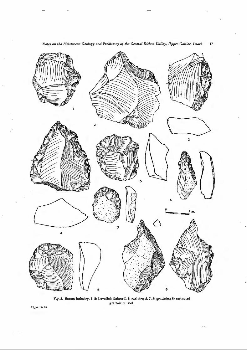
Levallois flakes number I6 (I3.9 Ofo). Almost all are thick as the rest of the Baram flakes. Thickness was not regarded in distinguishing typical (9) from atypical Levallois flakes (7), only the more or less perfect radial preparation was considered. The two illustrated examples are typical and thinner than usual (Fig. 3, nos. I, 2).
Mousterian point. Only one, rather enigmatic example. Limaces. Six examples (5.2 Ofo). Two are limaces by their shape but their ventral face is also retouched.
The other four are typical. Allaremore crude than the dassie limace (Fig. 4 no. 3) . Racloirs. Their number altogether is 23 (200/o). Halfare simple-convexe (11 , 9.5%; Fig. 3 no. 3). The
other half is of varied types: convergent convexe (three examples, Fig. 3 no. 4), canted (three examples) , transversal (three examples), one on ventral face and one with abrupt retouch. The absence of any double racloirs is to be noted. All racloirs are made on thick flakes, like the two illustrated ones.
Grattoirs. These tools are surprisingly typical and numerous (I9 specimens, I6.5 Ofo) . lnclined at first to regard them as intrusives, we now think that they do belong to the Baram industry because I) all grattoirs have the same patina as other flakes and handaxes at Baram; 2) the characteristic, thick flakes of the Baram industry serve as blanks for the grattoirs; 3) there is no indication for the presence of an Upper Palaeolithic industry here, to which the grattoirs would have most readily fit: there is not a single blade core, no typical blades, nor any other tool of Upper Palaeolithic type. In this respect, the rarity of burins in our series is of importance (see below). lt is worth mentioning that those late industries that do occur in the area, Neolithic and later, are completely unpatinated.
The grattoirs of the Baram Acheulian show quite a variety of types; in other words, they are not standardized. Some degree of standardization is, however, to be seen in the two examples of Fig. 3, nos. 5
and 8: made on thick flakes of roughly the same dimensions, both are retouched on the left side in addi-
Notes on the Pleistocene Geology and Prehistory of the Central Dishon Valley, Upper Galilee, Israel 17
2 Quartär 25
3
5
6
0 --===--.i3 cm.
7
4
9
Fig. 3. Baram industry. 1, 2: Levallois flakes; 3, 4: racloirs; 5, 7, 8: grattoirs; 6: carinated grattoir; 9: awl.

18 A. Ronen, D. Gilead, G. Bruder, P. Meller
2
Fig. 4. Baram industry. 1, 2: knives; 3: limace; 4: nucleiforme handaxe; 5: Micoquian handaxe ; 6: cordiforme handaxe; 7: amygdaloide handaxe.

Notes on the Pleistocene Geology and Prehistory of the Central Dishon Valley, Upper Galilee, Israel 19
Fig. 5. Baram industry. Handaxes. I, 3, 5: ovaloids; 2: lanceolate; 4: ovaloid, backed. 2*

20 A. Ronen, D. Gilead, G. Bruder, P. Meiler
Fig. 6. Bararn industry. Handaxes. I : awl-handaxe (site of Alrna); 2, 5: Abbevillian; 3: sub-triangular ; 4: discoidal.
Notes on the Pleistocene Geology and Prehistory of the Central Dishon Valley, Upper Galilee, Israel 21
tion to the working edge. Fig. 3 no. 6 is an elongated carinate grattoir with a typical lamellar retoudJ confined to the working edge alone. Finally, Fig. 3 no. 7 is a grattoir on a thin flake, relatively to the Baram industry.
Burins. Only two specimens were found, one atypical. This low number adds an argument against considering the grattoirs as intrusions.
Awls. Two examples only. One had its bulb removed by flat flaking (Fig. 3 no. 9). Knives. This is another element in the Upper Palaeolithic group (111) that is weil represented in the
Baram industry. There are six specimens (5.2°/o), of whidJ two are typical (Fig. 4 no. 2). In addition, there are seven naturally backed knives (6.00/o, Fig. 4 no. 1).
The flake tool assemblage is completed by three notches (2.6 Ofo), seven denticulates (6.0 °/o, relatively few), one tanged item, one chopper and two chopping-tools. A high percentage of miscellaneous (19 pieces, 16.5 Ofo) indicate that the type-Iist we are using does not completely suit the Baram industry. Among the miscellaneous, a combined grattoir-awl deserves to be mentioned.
Summary of Flake Industry
The Baram industry is typified by thick flakes, of non-Levallois technique and not facetted. Typologically, it is characterised by an almost identical ratio of Middle and Upper Palaeolithic components: group II 26, group 111 25. The Middle Palaeolithic group is composed of racloirs of various types, double racloirs excluded, and by a primitive type of limace. The Upper Palaeolithic group is dominated by grattoirs, seconded far behind by backed knives. Burins and awls are rare. Notches and denticulates form rather minor elements.
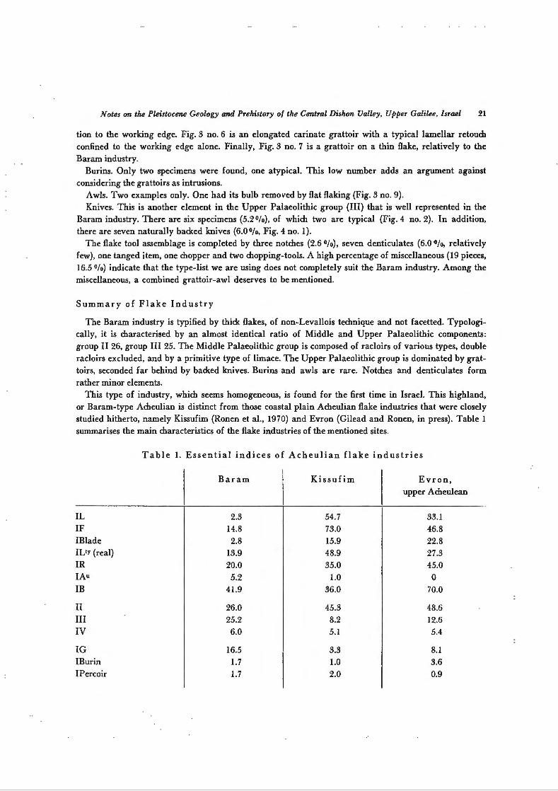
This type of industry, which seems homogeneous, is found for the first time in Israel. This highland, or Baram-type Acheulian is distinct from those coastal plain Acheulian flake industries that were closely studied hitherto, namely Kissufim (Ronen et al., 1970) and Evron (Gilead and Ronen, in press). Table 1
summarises the main characteristics of the flake industries of the mentioned sites.
IL IF IBlade IL!Y (real) IR JAu
IB
II 111 IV
IG IBurin IPercoir
Table 1. Essential indices of Acheulian flake industries
Baram
2.3 14.8 2.8
13.9
20.0
5.2 41.9
26.0 25.2
6.0
16.5 1.7 1.7
Kissufim
54.7
73.0 15.9 48.9
35.0
1.0 36.0
45.3 8.2
5.1
3.3 1.0 2.0
Evron, upper Acheulean
33.1 46.8 22.8
27.3 45.0
0 70.0
48.6
12.6
5.4
8.1 3.6 0.9

22 A. Ronen, D. Gilead, G. Bruder, P. Meiler
As can be seen, the coastal sites are of Levallois technique and facetted, in contrast to Baram. The Baram industry is far lower in racloirs and in the entire Middle Palaeolithic component than the coastal Acheulian. On the contrary, Baram is outstanding for its exceptionally high Upper Palaeolithic component, due first to grattoirs, then to knives, but not to burins or awls. The striking differences between these series render their almost identical percentage of denticulates the more interesting.
Handaxes
83 handaxes were found by us in the site of Baram. On the whole, they tend to be thick and of a mediocre manufacture. Several are clearly made on flakes.
The cordiforms count for 6.0°/o (Fig. 4 no. 6) . The amygdaloids are the most abundant in the series, 38.5% (Fig. 4 no. 7). Discoidals (14.40Jo) and ovaloids (13 .20Jo) are weil represented. (Discoidal: Fig. 6
no. 4; ovaloid : Fig. 5 nos. 1, 3-5). The tool in Fig. 5 no. 5 is exceptional by its dark red patina and the extremely asymmetrical section. The normal patina in the Baram industry is brown and yellow-brown. Several flakes and debris are patinated red, and the red group is more heavily rolled than the rest. Only rare tools are patinated red, and the one biface mentioned.
The other types of handaxes are represented each by a small number of artifacts: sub-triangulars (3.6°/o,
Fig. 6 no 3), micoquians (3.6 Ofo, Fig. 4 no. 5), lanceolates (2.4 Ofo, Fig. 5 no. 2), cleavers (2.4 Ofo) , nucleiformes (4.8 Ofo, Fig. 4 no. 4) and Abbevillians (3.6 Ofo, Fig. 6 nos. 2 and 5). The former is the only one handaxe made of basalt that could be safely identified in this site, in spite of the abundance of basalt fragments. The "Abbevilian" appearance of this hadaxe is probably dictated by the raw material.
Miscellaneous handaxes count for 7.20/o, including partial and special types. A rare type, the awlhandaxe, is here illustrated (Fig. 6 no. l) although belanging to the site of Alma (Fig. 1).
Two more observations are worth noting here. Backed handaxes are quite numerous in Baram, 7.2 Ofo, with a back either of cortex or heavy retouch (Fig 5, nos. 1 and 4). In this study backed handaxes were
% 30
~ I\ --------- KISSUFIM I\
25 I \ I \ BARAM I \ I \
I \ I \ I \
20 I \ I \ I \ I I
I \
I \ I \ I \
15 I I I \ I \ I \ I \ I \ I I I \ I I
10 I \ I I \ I \ I \
\ I I \
\ I \ I \ s I \
\ I I \ I '----' ' ' ,,
31 36 41 46 51 56 61 66 71 76 81 86 81 96 ~m >< 100
35 40 45 50 55 60 65 70 75 80 85 90 95 100
Fig. 7. Thickness/breadth ratio of Baram and Kissufim handaxes.

Notes on the Pleistocene Geology and Prehistory of the Central Dishon Valley, Upper Galilee, Israel 23
counted within their respective form category. Another characteristic is the noticeable presence (10.8°/o)
of handaxes with a concave edge opposing a convexe one. They too were counted according to their respective overall form.
The refinement index of handaxes (mean thickness/breadth ratio) at Baram is 0.55, at Evron upper layer it is 0.52, at Kissufim 0.49 (Fig. 7).
Cordiforme Amygdaloide Discoidal Ovaloid Sub-triangular Micoquian Lanceolate Abbevillian Nucleiforme Cleaver Miscellaneous Total
Backed Convexe-concave Refinement index
Table 2. Comparison of Handaxe Types
Baram N=83
6.0
38.5 14.4
13.2
3.6
3.6
2.4
3.6
4.8
2.4
7.2
99.7
7.2
10.8
0.556
Kissufim N=95
10.0
29.5
9.5 20.0
2.0
0
6.0
0
0 2.0
11.0
100.0
0.520
Evron, upper layer N= 160
14.0
36.5 13.5
9.5 4.0
3.0
7.0
0
0 3.0
9.5
100.0
0.490
As shown in Table 2, the handaxes of the Baram Acheulian do not differ from those of the coastal Acheulian as radically as the flake industry does. Furthermore the coastal handaxe series differ among them as much as they do from the Baram series *.
* The authors wish to thank Kibutz Baram for the warm hospita1ity and for the facilities that were generously extended during the survey.
References
G i 1 e a d, D., 1970. Handaxe Industries in Israel and the Near East. World Archaeology 2: 1-11. G i 1 e a d, D. and A. R o n e n. The Acheulian Industries of Evron, Western Galilee Coastal P1ain (in press). Ni r, D., 1970. Geomorpho1ogy of Israel. Jerusa1em, Academon (in hebrew). R o nen , A., D. Gi 1 ead, E. Shachnai and A. S a u1 , 1972. Upper Acheulian in the Kissufim Region. Proc. Am.
Phil. Soc. 116: 68- 96.

Th
e n
ort
her
n s
lope
of
Yir
on P
late
au, l
ooki
ng e
ast.
Rig
ht
and
cen
ter
back
grou
nd-
the
basa
lt e
scar
pmen
t. E
ocen
e Ii
mes
ton
e is
see
n ac
ross
the
Wad
i on
th
e le
ft