
Notes NATURAL DISASTERS - National Institute of Open … · MODULE - 6 The Physical setting of...
22
MODULE - 6 The Physical setting of India Notes 51 Natural Disasters GEOGRAPHY Humans have been coping with natural disasters since time immemorial. There are so many disaster which can not be controlled by human intervention. They are destined to bring their tragic consequences of human destruction. Due to human intervention in the natural processes, the destructive power and frequency of natural disasters have increased considerably. According to U N statistics, natural disasters kill 1,00,000 persons on an average and cause property damage of Rs 20,000 crores world wide per year. Among the top ten natural disaster-prone countries, India stands second after China.Therefore, there is a need for creating awareness among all sections of the people about it’s causes, consequences as well as preventive measures so that they can handle as an individual, and as a members of society. In this chapter we will study five natural disasters i.e. earthquakes, land slides, droughts, floods and cyclones. OBJECTIVES After studying this lesson you will be able to: explain the meaning of the words natural ‘Hazard’ and ‘Disaster’. differentiate between hazard and disaster recognize and describe some disaster-prone areas from each physical division of India. describe some adverse effects of natural disasters. give example of some other nuturological disasters. suggest measures to mitigate or reduce the problems and sufferings arising before, during or after the disaster. 18 NATURAL DISASTERS
Transcript of Notes NATURAL DISASTERS - National Institute of Open … · MODULE - 6 The Physical setting of...
MODULE - 6The Physical setting of India
Notes
51
Natural Disasters
GEOGRAPHY
Humans have been coping with natural disasters since time immemorial. There areso many disaster which can not be controlled by human intervention. They aredestined to bring their tragic consequences of human destruction. Due to humanintervention in the natural processes, the destructive power and frequency of naturaldisasters have increased considerably. According to U N statistics, natural disasterskill 1,00,000 persons on an average and cause property damage of Rs 20,000crores world wide per year. Among the top ten natural disaster-prone countries,India stands second after China.Therefore, there is a need for creating awarenessamong all sections of the people about it’s causes, consequences as well aspreventive measures so that they can handle as an individual, and as a members ofsociety.
In this chapter we will study five natural disasters i.e. earthquakes, land slides,droughts, floods and cyclones.
OBJECTIVES
After studying this lesson you will be able to:
explain the meaning of the words natural ‘Hazard’ and ‘Disaster’.
differentiate between hazard and disaster
recognize and describe some disaster-prone areas from each physical divisionof India.
describe some adverse effects of natural disasters.
give example of some other nuturological disasters.
suggest measures to mitigate or reduce the problems and sufferings arisingbefore, during or after the disaster.
18
NATURAL DISASTERS
MODULE - 6
Notes
The Physical setting of India
52
Natural Disasters
GEOGRAPHY
18.1 DISASTERS IN INDIA – A BACKGROUND
India is struggling with disasters from many years. How can we forget the daywhen killer waves (tsunami) struck the coastal parts of India on 26th December2004 or the morning of 26th January 2001, when western part of India wasbadly affected by earthquake. These are just few examples. We always listensuch kind of news in print or electronic media that one part of India is affectedby flood where as another faces drought.
Due to vulnerability of different kinds of disasters, it is said that India is a disasterprone country, the reasons are:
1. Over 55% of the land area is vulnerable to earthquakes,2. 12% is flood prone,3. 8% is vulnerable to cyclones and4. 70% of the land under cultivation is drought prone.
18.2 NATURAL HAZARDS AND DISASTERS
The vulnerability of enviornment has been increasing continuously due to humanactivities. But this is not one sided relationship. Humans are also the componentsof the enviornment. Hence they can’t escape from the effects of environmentalchange processes. When local, regional or global processes of environment posedanger to humans or their property, they are simply natural events. For example,the blizzard blowing in the Antarctica is a natural event. But if this blizzard porsesdangers to our lives and property, then it becomes a disaster.
For instance, tsunami was caused by an earthquake that occurred in the sea nearSumatra (Indonesia) on 26 December, 2004. It turned into a disaster for India,Srilanka and some other countries of Southeast Asia. It caused wide spread lossto human life and property in Andaman and Nicobar Islands and on the coasts ofAndhra Pradesh and Tamil Nadu.
Table 18.1: Difference between Natural Hazard and Disaster
Hazard Disaster
1. A hazards is a dangerous 1. A disaster disrupts the normalphysical condition or event. function of the society caused by
a hazard.
2. Earthquakes, floods, 2. It causes damage to propertyvolcanic erruption, and loss of life but it disruptsland slides, droughts etc the opportunities of employ-are called natural hazards before ment also.they cause loss of lifeand damage to property.
MODULE - 6The Physical setting of India
Notes
53
Natural Disasters
GEOGRAPHY
3. Small number of people are 3. A large number of people areaffected. affected by it.
4. It may cause injury, loss 4. It causes wide spread loss toof life or damage of property. life and property.
5. Earthquakes, floods, 5. It affects the society to suchvolcanoes, tsunami, an extent that external aidland slide, drought etc. are becomes, necessary to compen-natural hazards. sate the losses.
Nearly 6 crore people are effected by natural disasters every year.
Natural events, when pose danger to humans, are called hazards.
INTEXT QUESTIONS 18.1
1. When do natural events become natural hazards?
________________________________________________________
________________________________________________________
2. What is a tsunami?
________________________________________________________
________________________________________________________
18.3 FLOODS
With the arrival of Monsoon, people living in 4 crore hectares area of the countrybecome extremely nervous. No one knows when there will be a flood in the riverand their hard earned belongings will be washed away. In comparison to otherdisasters flood cause more damage to life and property. Twenty percent of deathscaused by floods in the world, occur in India.
What is a flood
The inundation of an area by water is called a flood. In other words, when a riverover flows its banks and water spreads in the surrounding areas is a flood. Variouscauses of flood, losses by flood and flood control measures are described below:
Cause of flood
The causes of flood in India are as follows:
MODULE - 6
Notes
The Physical setting of India
54
Natural Disasters
GEOGRAPHY
(i) Heavy rainfall : Heavy rain in the catchment area of a river causes water toover flow its banks, which results in the flooding of nearby areas.
(ii) Sediment deposition : River beds become shallow due to sedimentation.The water carrying capacity of such river is reduced. As a result the heavyrain water over flows the river banks.
(iii) Deforestation : Vegetation hampers the flow of water and forces it topercolate in the ground. As a result of deforestation, the land becomesobstruction free and water flows with greater speed into the rivers and causesflood.
(iv) Cyclone : Cyclone generated seawaves of abnormal height spreads the waterin the adjoining coastal areas. In October 1994 Orissa cyclone generatedsevere floods and caused unprecedented loss of life and property.
(v) Interference in drainage system: Drainage congestion caused by badlyplanned construction of bridges, roads, railway tracks, canals etc. hampersthe flow of water and the result is flood.
(vi) Change in the course of the river: Meanders and change in the course ofthe river cause floods.
(vii) Tsunami : Large coastal areas are flooded by rising sea water, when a tsunamistrikes the coast.
Losses by flood : Humans and animals both are affected by flood. People arerendered homeless. Houses are damaged or collapse. Industries are crippled.Crops are submerged in flood water. Domestic as well as wild animals die. Boatsand fishing nets etc. are lost or damaged in coastal areas. Out break of epidemicslike malaria and diarrhoea etc. are common after flood. Potable water iscontaminated and sometimes becomes scarce. Food grains are lost or spoiled,their supplies from outside become difficult.
Losses by annual floods, instead of decreasing are increasing every year. In 19532.43 crores of people were affected. By 1987 the number of flood affected peoplerose to 4.83 crore.
According to an estimate on an-average property worth Rs. 210 crores is lost infloods every year. Flood affects about 6 crore people and crops of one crorehectare are damaged.
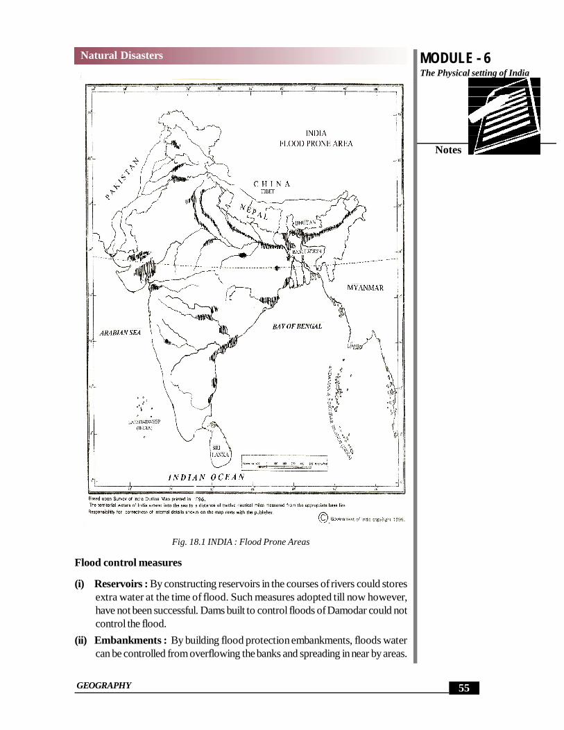
Flood prone areas : About 4 crore hectare area of our country is flood-prone,which is one eighth of the total area. The most flood prone areas are the Brahmputra,Ganga and Indus basins. As far as states are concerned, Uttar Pradesh, Bihar,West Bengal and Orissa are the most flood affected states followed by Haryana,Punjab and Andhra Pradesh. Now a days Rajasthan and Gujarat also feel the furyof floods. Karnataka and Maharashtra are no-longer immune to floods.
MODULE - 6The Physical setting of India
Notes
55
Natural Disasters
GEOGRAPHY
Fig. 18.1 INDIA : Flood Prone Areas
Flood control measures
(i) Reservoirs : By constructing reservoirs in the courses of rivers could storesextra water at the time of flood. Such measures adopted till now however,have not been successful. Dams built to control floods of Damodar could notcontrol the flood.
(ii) Embankments : By building flood protection embankments, floods watercan be controlled from overflowing the banks and spreading in near by areas.
MODULE - 6
Notes
The Physical setting of India
56
Natural Disasters
GEOGRAPHY
Building of embankments on Yamuna, near Delhi, has been successful incontrolling the flood.
(iii) Afforestation : The furry of flood could be minimized by planting trees incatchment areas of rivers.
(iv) Restoration of original drainage system : Drainage system is generallychoked by the construction of roads, canals railway tracks etc. Floods couldbe checked if the original form of drainage system is restored.
Flood Management : About 4 crore hectare area is flood prone. Out of this,1.44 crore hectare areas has been made secure to some extent from the devastationby floods. To achieve this goal, embankments and drainge channels have beenconstructed. Protection of towns and cities have been adopted. Villages arerelocated on comparative by higher ground. By the end of Ninth Plan 8000 crorerupees have been spent on flood management.
Some do’s and donts before, during and after the flood
(i) Listen to the radio for advance information and advise.
(ii) Disconnect all electrical appliances, move all valuable household goods andclothing out of reach of flood water. Adopt such measures only when there isa forecast of flood or you suspect that flood water may reach the house.
(iii) Move vehicles, farm animals and moveable goods to the higher ground.
(iv) Prevent dangerous pollution.
(v) Keep all insecticides, pesticides etc. out of the reach of flood water.
(vi) Switch off electricity and gas, in case you have to leave the house.
(vii) Lock all door and windows if you have to leave the house.
(viii) Do not enter flood water on foot or in a vehicle as far as possible.
(ix) Never wander in the flooded area on your own.
The inundation of an area by rain water is called flood. The basins of Indus, Ganga and Brahamaputra rivers are the
most flood prone areas.
INTEXT QUESTION 18.2
1. Name any two causes of flood.
(i) ____________________________________________________
(ii) ____________________________________________________
MODULE - 6The Physical setting of India
Notes
57
Natural Disasters
GEOGRAPHY
2. How much area of the country is flood prone?
________________________________________________________
3. Name any two measures of flood control.
(i) ____________________________________________________
(ii) ____________________________________________________
18.4 DROUGHT
The tragedy caused by drought affects the people slowly and vastly. This is differenttype of agony but painful. To see domestic animals to die of hunger and thirstbefore ones own eyes; to send beloved members of the family in search ofemployment to far off places in extremely uncertain and exploitative conditions,reduction in diet to reduce the already meager diet, to wander in search of workall day long in relief works and return rejected and empty-handed in the night,these are some of the heart rending scenes from the drought affected areas ofIndia.
What is a drought ? According to meteorologists the rainfall deficiency during along period over a large area is called a drought. Some times in Hindi languagefamine Akal and Anavrishty are also used for drought. Drought can also occurwhen ground water level is not within reach of agricultural communities. Thegovernment also declares on area affected by drought, if more than 50 percentcrop loss happens in an area due to meteorological condition.
Causes of drought
Major cause of drought in India is scarcity of rain. But humans have interfered inthe environment processes by their activities. People have filled up the naturalresources like ponds and lakes. They have destroyed the vegetation cover.Vegetation cover impedes the flow of rainwater and force it to percolate in theground. Humans have dug lakhs of tube wells and depleted the ground waterreservoirs.
Impact of drought : Droughts cause scarcity of food and water. Hungry andthirsty people cry for help. People die of hunger, malnutrition and epidemics. Peopleare forced to migrate from their area of residence. Crops fail due to scarcity ofwater. Cattle because fodder and water are not easily available.
Farmers are deprived of their employment. People leave their villages with theirfamilies for a long, unknown and uncertain journey in the pursuit of food, water,green fodder and employment.
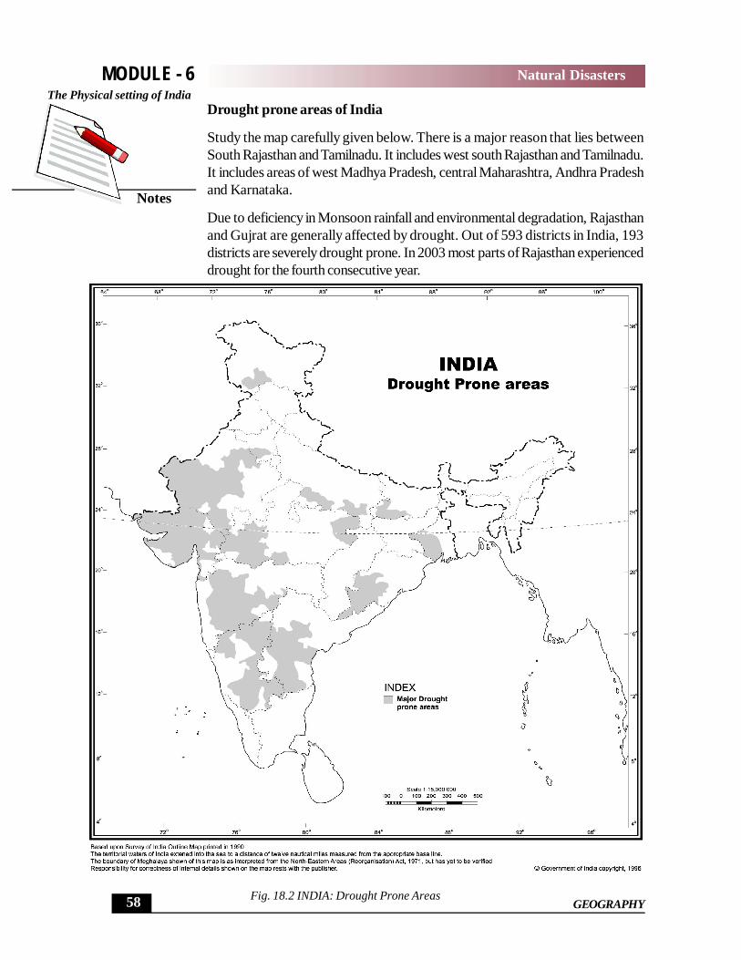
Drought prone areas of India
Study the map carefully given below. There is a major reason that lies betweenSouth Rajasthan and Tamilnadu. It includes west south Rajasthan and Tamilnadu.It includes areas of west Madhya Pradesh, central Maharashtra, Andhra Pradeshand Karnataka.
Due to deficiency in Monsoon rainfall and environmental degradation, Rajasthanand Gujrat are generally affected by drought. Out of 593 districts in India, 193districts are severely drought prone. In 2003 most parts of Rajasthan experienceddrought for the fourth consecutive year.
Fig. 18.2 INDIA: Drought Prone Areas
MODULE - 6
Notes
The Physical setting of India
58
Natural Disasters
GEOGRAPHY

Measures to cope with Drought(i) Suitable farming methods for arid areas : By adopting the following
methods it is possible to mitigate the intensity of drought. The methods are:Production of coarse and hardy cereals; conservation of soil moisture bydeep ploughing, storing water behind small dams, collecting water in pondsand tanks and use of sprinklers for irrigation.
(ii) Sowing drought resistant crops: By sowing drought resistant crops ofcotton, Moong, pearl millet, wheat etc, the impact of drought could be mitigatedto a certain extent.
(iii) Rain water harvesting : Collection of each and every drop of rain couldhelp in coping with the drought.
(iv) By making high bunds around the fields, adoption of terrace cultivation, plantingtrees on the bunds of fields, the use of rainwater can be maximised.
(v) Water can also be conserved by taming the irrigation canals with mortar andbricks.
(vi) Small quantity of water can irrigate comparatively larger area by using dripirrigation method.
Drought prone area programmeThis programme was initiated in 1973. The objectives of the programme are asfollows:(i) To minimise the adverse impact of drought on crops, domestic animals,
productivity of land, water and human resources. This could be done byintegrated development by using appropriate technologies as it was done forthe natural resources of Gujrat.
(ii) By developing, conserving and suitably using the rainwater, the ecologicalbalance could be maintained for a longer period.
(iii) To improve the economic and social conditions of the section of society whodo not have access to resources and facilities. The rainfall deficiency during a long period over a large area is
called a drought. States of Rajasthan and Gujrat are comparatively more drought-
prone than other states.
INTEXT QUESTIONS 18.31. What is a drought?
________________________________________________________2. Fill in the blanks with appropriate words out of these given in the brackets.
(i) The most drought prone state of India is _____________ (Assam,Rajasthan, Chhatisgarh)
(ii) In drought prone areas the impact of drought can be minimised byadopting _____________ (Flood irrigation, sprinkler irrigation)
MODULE - 6
Notes
The Physical setting of India
60
Natural Disasters
GEOGRAPHY
18.5 LANDSLIDES
A major landslide occurred in the midnight in a place called Lamari on the footpath leading to Kailash Mansarover about 60 km away from Dharchula, in August1998. Lamari is situated between Bendi and Malpa. The debris of this landslideslipped into river Kali and blocked its flow. The water of the river spread over anarea of 1½ square km. Thus a lake was created in which the water was flowing.Some pilgrims going to Kailash Mansarovar were resting here in this fateful night.This landslide killed 60 pilgrims.
What is a Landslide
The slipping of masses of rocks, earth or debris downwards on the mountainslopes or banks of the rivers is called a landslide. The occurance of landslides inmountainous areas is increasing day by day. The impact of landslides on the peoplein the mountains is clearly visible.
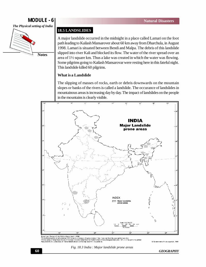
Fig. 18.3 India : Major landslide prone areas 60
Natural Disasters
MODULE - 6The Physical setting of India
Notes
61
Natural Disasters
GEOGRAPHY
Landslide prone areas : The landslides are a common feature in Himalaya,Western ghats and in river valleys. The state of Jammu & Kashmir, HimachalPradesh, Uttarakhand, Sikkim and all the seven states of North East India, aremost vulnerable to landslide. In southern India Mahrastra, Karnataka, Tamil Naduand Kerala bear the brunt of landslides.
Causes of landslides
1. Heavy rain : Heavy rain is the main cause of landslides.2. Deforestation : Deforestation is another major cause of landslides. Tree,
brushes and grasses keep the soil particles compact. Mountain slope loosestheir protective cover by felling of trees. The rain water flows on such slopeswith unempeded speed.
3. Earthquakes and volcanic explosions : Earthquake is a common featurein the Himalaya. Tremors destabilize the mountains and the rocks tumbledownwards. Volcanic explosions also trigger landslides in the mountainousareas.
4. Building of roads: Roads are built in mountainous areas for development.During the process of the construction of road, a large amount of rocks anddebris has to be removed. This process dislodges the rock structure andchanges the angle of slopes. Consequently landslides are triggered.
5. Shifting agriculture : In the North Eastern part of India, the number andfrequency of landslides has increased due to the practice of shifting agriculture.
6. Construction of houses and other buildings : For giving shelter to theever-increasing population and promotion of tourism more and more houseand hotels are being built. In building processes large amount of dibrisescreated. This causes the landslides.
Impact of landslide
(i) Degrading of environment : Landslides are degrading the environment ofmountains. Natural beauty is deminishing slowly and slowly.
(ii) Sources of water are drying up.(iii) Flooding in rivers is incrasing.(iv) Roads are blocked.(v) Life and property are lost
Measures to control landslides and to mitigate their impact
(i) Afforestation : Trees and brushes help in binding the soil particles.(ii) New technology in road construction : Roads should be constructed in such
a way, that lesser amount of debrisses are generated.(iii) Ban on quarrying of stones and mining of minerals
MODULE - 6
Notes
The Physical setting of India
62
Natural Disasters
GEOGRAPHY
(iv) Instead of exploitation of forests, they should be used scientifically.(v) Permanent crops like orchards of fruits should replace the seasonal or annual
Drops.(vi) By controlling the surface flow of water, seepage of water should be minimised.(vii) Retaining walls can be built of mountain slopes to stop land from slipping.(viii) Hazard mapping should be done to locate areas commonly prone to
landslides. Building and construction activities may be banned in such areas.
The slipping of masses of rocks, earth or debris downwards on themountain slopes or banks of rivers is called a landslide.
During rainy season landslides are a common feature in Himalaya,Western Ghat and deep river valleys.
INTEXT QUESTIONS 18.4
1. Name any two causes of landslide.
(i) ______________________ (ii) ______________________
2. Name two most landslide prone areas.
(i) ______________________ (ii) ______________________
3. Choose the correct answers given in the brackets.(i) Which state of South India is landslide prone? (Andhra Pradesh, Tamil
Nadu)(ii) Which measure is adopted to controll landslide (Levelling of slope,
construction of strong wall on the slope).
18.6 EARTHQUAKE
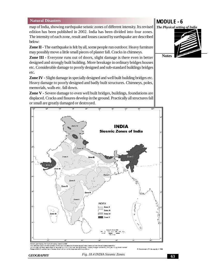
In simple words sudden shaking or trembling of the earthsurface is an earthquake.Most earthquake are a minor tremor. Larger earthquakes usually begin with slighttremors but suddenly they turn into violent shocks and after that the intencity ofshocks deminishes. Tremors or shocks are felt for a few seconds only.Earthquake is a hazard that strikes suddenly. A hindi poet described the earth-quake in these word. “Earthquakes strikes without pre information but the breath-ing stops without informing the man.”Earthquake can occur at any time of the year, day or night. Its impact is verysudden. There are no warning signs of earthquakes. Extensive and sincere re-search has been conducted but success has eluded humans in the forcast or pre-diction of earthquake.High risk earthquake prone areas: Bureau of Indian Standard has prepared a
MODULE - 6The Physical setting of India
Notes
63
Natural Disasters
GEOGRAPHY
map of India, showing earthquake seisnic zones of different intensity. Its revisededition has been published in 2002. India has been divided into four zones.The intensity of each zone, result and losses caused by earthquake are describedbelow:Zone II - The earthquake is felt by all, some people run outdoor. Heavy furnituremay possibly move a little small pieces of plaster fall. Cracks in chimneys.Zone III - Everyone runs out of doors, slight damage is there even in betterdesigned and strongly built building. More breakage in ordinary bridges housesetc. Considerable damage to poorly designed and sub-standard buildings bridgesetc.Zone IV - Slight damage in specially designed and well built building bridges etc.Heavy damage to poorly designed and badly built structures. Chimneys, poles,memorials, walls etc. fall down.Zone V - Severe damage to even well built bridges, buildings, foundations aredisplaced. Cracks and fissures develop in the ground. Practically all structures fallor small are greatly damaged or destroyed.
Fig. 18.4 INDIA Siesmic Zones
MODULE - 6
Notes
The Physical setting of India
64
Natural Disasters
GEOGRAPHY
Delhi and Mumbai are situated in high risk zone no. IV. The whole of North EastIndia, Kachchh, Gujrat, Uttarakhand, Himachal Pradesh and Jammu & Kashmirare in the very high risk zone no. V. Now peninsular plateau is not safe fromearthquakes. Earthquake of Latur (1993, intensity on rich for scale 6.4) and Koyna(1967 intensity 6.5) in Maharashtra testify it.
Impact of Earthquake(i) Damage of property : when earthquake occurs, all buildings from cottage
to palaces and stronger skyscrapers are greatly damaged or totally destroyed.Underground pipelines and railway lines are damaged or broken. Dams onriver collapse, resultant floods cause havoc. The earthquake in 1967 in Koynadamaged the Dam.
(ii) Human loss - Duration of tremors of earthquake is normally of only fewseconds, but thousands of people may die in this short period. Five severelydevastating earthquakes have occurred in India between 1988 and January26, 2001. Nearly 31000 people lost their lives prematurely. Bihar earth-quake of 1934 and Kangra earthquake of 1905, 10,000 and 20,000 peopledied respectively. Numerous people lost their shelter and many became or-phans. The earthquake that occurred in Gujarat on 26 January, 2001 wasdevastating and disastrous. More than 25,000 people died due to the impactof this earthquake. The destruction of property was tremendous and couldnot be estimated properly and exactly.
(iii) Changes in river courses: Sometimes river channels are blocked or theircourses are changed due to the impact of earthquake.
(iv) Tsunamis : are caused by earthquake. This is a Japanese word, meaningextremely high sea wave. It wreaks havoc on settlement of coastal areas. Itsinks large ships. Tsunami that occurred on 26-12-2004 near coast of Sumatra(Indonesia) property worth billions of rupee. More than two lakh people losttheir lives in Southeast Asia, India and Sri Lanka.
(v) Fountains of mud : Due to the intense impact of earthquake hotwater andmud appear on the surface and take a form of fountains. In Bihar earthquakeof 1934 some cracks and fissures had developed. The fields of farmer werecovered by knee-deep mud and the crops were destroyed.
(vi) Cracks and fissures : Sometimes cracks and fissures develop in roadsrailway tracks, and fields, making them useless. Well known san Andreasfault formed during the earthquake of San Fransisco (California).
(vii) Landslides and avalanches are triggeredSome Do’s and Don’t during and after the earthquake:
Inside the house Don’t run outside, set your family into-doorways, under table or if they are
bedridden, more them under the beds; keep away from windows and chim-neys.
MODULE - 6The Physical setting of India
Notes
65
Natural Disasters
GEOGRAPHY
Outside the house Don’t go near the buildings, high walls, or electric wires.
While driving
If an earthquake occurs stop driving and keep sitting in the vehicle.
To be done immediately
(i) Put off domestic fire, and all electrical switches.
(ii) Leave the house if possible and go to open space.
(iii) Leave the house if a gas leak is detected after the gas is turned off.
(iv) Save water
(v) Untie and free pets and domestic animals (dogs, cats and cattles)
Sudden shaking or trembling of the earth surface is an earth-quake.
The whole North East India, Kachchh area of Gujarat, HimachalPradesh, Uttaranchal and Jammu and Kashmir are in the veryhigh risk zone No. 5.
INTEXT QUESTION 18.5
1. In which state did the earthquake occur on the occasion of Republic Day of2001?
________________________________________________________
________________________________________________________
2. What names is given to the high sea-wave triggered by earthquake?
________________________________________________________
________________________________________________________
3. In which earthquake zone Delhi has been included on the basis of the tensityof the earthquakes?
________________________________________________________
________________________________________________________
18.7 CYCLONES
Cyclones are centers of low atmospheric pressure, in which the air pressure in-
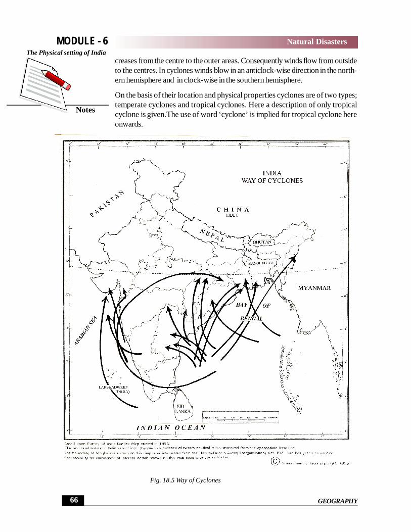
creases from the centre to the outer areas. Consequently winds flow from outsideto the centres. In cyclones winds blow in an anticlock-wise direction in the north-ern hemisphere and in clock-wise in the southern hemisphere.
On the basis of their location and physical properties cyclones are of two types;temperate cyclones and tropical cyclones. Here a description of only tropicalcyclone is given.The use of word ‘cyclone’ is implied for tropical cyclone hereonwards.
MODULE - 6
Notes
The Physical setting of India
66
Natural Disasters
GEOGRAPHY
Fig. 18.5 Way of Cyclones
Cyclone is a violent circular stormy, in which high velocity winds blow from out-side to the centre and are associated with torrential rain. Cyclones play an impor-tant role in the general circulation of the atmosphere. A fully developed cyclonecan transfer 3.5 billion tons of warm humid air within an hour.
When do cyclones occur?
Cyclone is a phenomenon. It is concentrated to certain seasonal cyclic segment.In India, most of the cyclones occur in the post monsoon season, i.e. from Octo-ber to December or in pre-monsoon season from April to May. The life span of acyclone is generally from 7 to 14 days.
The Movement of Cyclones
The cyclone, with its whole system, moves forward from east to west (in Bay ofBengal) with a speed of 15 to 30 km per hour. The cyclone that struck orissa,originated near Andaman & Nicobar Islands and reached Orissa on 29-10-1999after many days. The movement of cyclone in a direction is like the movement ofa spinning top. Cyclones originate over the sea surface and dissipate as they reachland.
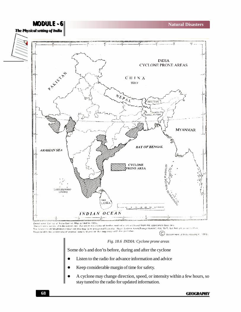
Where do the cyclones strike in India
The eastern coast of India is the most cyclone affected region. The cyclone pronestates are; West Bengal, Orissa, Andhra Pradesh and Tamil Nadu: Western coastis affected by the cyclones which originate in the Arabian Sea. Gujarat on the westcoast, is most affected by cyclones. The coastal areas and interior of Maharstraare affected by cyclones too. More cyclones originate in the Bay of Bengal andthe Arabain Sea than any other seas of the world.
Devastation by cyclones
The violent winds of a cyclone destroy whatever come in their way from; thatchedcottage to the palaces, forts built of concrete, iron and stones. Trees are uprooted.Lines of electricity and communication are destroyed. Torrential rains cause floods.Floods wreak havoc all around. High sea waves are generated in the sea by speedycyclonic winds. They strike the coastal areas like high wall of water and flood theareas upto 10-15 km from the coast. In these areas houses, crops, roads, build-ings, villages and cities one and all are submerged. Landslides triggered by cy-clonic rains are more devastating.
Developed countries have evolved measures to mitigate the fury of cyclones. Thewarning of cyclone is issued. They are broadcasted and telecasted at right time.This saves the life of people. On the contrary the people in developing countriesget premature deaths. In USA, a fierce hurricane named Hugho struck in Septem-ber 1989. Only 21 people lost their lives due to its impact, because a timelywarming was issued, but contrary to this 1,39,000 people lost their lives inBangladesh when a cyclone struck the country in 1991.
MODULE - 6
Notes
The Physical setting of India
68
Natural Disasters
GEOGRAPHY
Fig. 18.6 INDIA: Cyclone prone areas
Some do’s and don’ts before, during and after the cyclone
Listen to the radio for advance information and advice
Keep considerable margin of time for safety.
A cyclone may change direction, speed, or intensity within a few hours, sostay tuned to the radio for updated information.
MODULE - 6The Physical setting of India
68
Natural Disasters
GEOGRAPHY
MODULE - 6The Physical setting of India
Notes
69
Natural Disasters
GEOGRAPHY
If high velocity winds or severe gales are forecasted for your area:
Store or secure loose boards, corrugated iron sheets, old tin boxes, anythingelse that could become dangerous.
Close the windows tightly to prevent them from breakage. Move to the safe shelter built for this purpose, or leave the area on the advice
of some authoritative government agency.
When the storm strikes.
Stay in the house and take shelter in the stronger portion of your house. Listen to the radio and follow instructions. Open windows of the safe portion of the house if the roof begins to lift. Find shelter if you are in open at the hitting time of the cyclone. Do not go out of your house or to a beach during or lay down along an
elevated footpath in open field the storm. Cyclone often generates large surgesin these oceans or lakes.
Cyclone is violent circular storm. In its centre the air pressure isextremely low. High velocity winds flow towards the centre.
Most cyclone prone states of India are: West Bengal, Orissa,Andhra Pradesh and Tamil Nadu.
INTEXT QUESTIONS 18.6
1. Which are the most cyclone prone months?
________________________________________________________
2. Which state was hit by the seriously devastating cyclone on 29th of October,1999?
________________________________________________________
3. Which state is most valuable to cyclone on the western coast of India?
________________________________________________________
WHAT YOU HAVE LEARNT
Among the top ten disaster prone countries, India stands second after China.More than 6% of the total population bear the brunt of natural disasters. Naturalhazard, which devastates life and property, are called disasters. More than 20%
MODULE - 6
Notes
The Physical setting of India
70
Natural Disasters
GEOGRAPHY
of the deaths caused by floods in the world, occur in India. Floods are caused byheavy rain, deposition of sediment and tsunami. 65% of cultivated area of India israin fed. This is the area where droughts are common. Degradation of environ-ment caused by human activities is also responsible for drought. By adopting somemeasures, the impact of drought could be mitigated. 191 districts, out of the 593(2001) districts of India, are vulnerable to drought. Landslides cause heavy dam-age on mountainous slopes in rainy season. Jammu and Kashmir, Himachal Pradesh,Uttarakhand, Sikkim and all the seven states of North East India are landslideprone. Landslides are caused by deforestation, earthquakes, construction of roadsand buildings, and shifting agriculture. A very severe earthquake occurred on 26January, 2001 in Gujarat. Earthquakes not only destroy life and property, but alsochanges the courses of rivers. Tsunami, mud fountains, cracks and fissures arealso caused by severely devastating earthquakes. The quake prone areas areNorth East India, Gujarat, Uttarakhand, Himachal Pradesh and Jammu and Kash-mir. Cyclones originate in the Bay of Bengal and affects the states of easterncoasts. Cyclones that originate in the Arabian Sea have a devastating impact overMaharashtra and Gujarat coast If some precise precautions are taken, the impactof cyclones could be mininised.
TERMINAL QUESTIONS
1. Differentiate between natural hazard and natural disaster.
2. What is a flood ? Explain the causes of flood and its destruction.
3. Describe the drought prone areas of India.
4. What is a landslide? What activities of human bening have increased thefrequency of landslides.
5. What is an earthquake? Describe its impact on humans.
6. When do cyclones occur in India? Describe the measures adopted for pro-tection from the cyclones.
ANSWERS TO INTEXT QUESTIONS
18.1
1. When physical events pose danger to humans and their property, they arecalled hazards.
MODULE - 6The Physical setting of India
Notes
71
Natural Disasters
GEOGRAPHY
2. Tsunami is large sea waves caused by earthquake below sea water.
It causes heavy destruction to life and property on coastal areas thousandsof kilometers away from its place of origin.
18.2
1. Heavy rains, deforestation, cyclones, tsunami (any two).
2. 4 crore hectare.
3. Construction of reservoires and embankments, tree plantation, restorationof natural drainage system.
18.3
1. The rainfall deficiency during a long period, over a large area is called adrought.
2. Rajasthan.
3. Sprinkler irrigation.
18.4
1. Earthquakes, volcanic explosions, heavy rain, deforestation, road construc-tion, shifting agriculture (any two).
2. Himalaya and Western Ghats.
3. (i) Tamil Nadu
(ii) Cosntruction of strong wall on the slope.
18.5
1. Gujarat
2. Tsunami
3. Zone No. IV
18.6
1. October, Novemer, December, April and May
2. Orissa
3. Gujarat.
MODULE - 6
Notes
The Physical setting of India
72
Natural Disasters
GEOGRAPHY
HINTS TO TERMINAL QUESTIONS
1. Refer to table No. 18.1
2. Refer to 18.3
3. Refer to 18.4
4. Refer to 18.5
5. Refer to 18.6
6. Refer to 18.7