Northern Virginia Conservation Corridors · The Northern Virginia Conservation Corridors ... •...
117
i Northern Virginia Conservation Corridors Maps and Report www.novaregion.org/conservation Northern Virginia Regional Commission May 2011 This project is funded in part by the Virginia Coastal Zone Management Program at the Department of Environmental Quality through Grant #NAO9NOS4190163 of the U.S. Department of Commerce, National Oceanic and Atmospheric Administration, under the Coastal Zone Management Act of 1972, as amended.
Transcript of Northern Virginia Conservation Corridors · The Northern Virginia Conservation Corridors ... •...

i
Northern Virginia Conservation Corridors Maps and Report www.novaregion.org/conservation
Northern Virginia Regional Commission May 2011
This project is funded in part by the Virginia Coastal Zone Management Program at the Department of Environmental Quality through Grant #NAO9NOS4190163 of the U.S. Department of Commerce, National Oceanic
and Atmospheric Administration, under the Coastal Zone Management Act of 1972, as amended.

ii
Acknowledgements Thank you to the following organizations for your participation in the various meetings held during this first phase: Local Government (Open Space Managers, Land Managers, Urban Foresters) City of Alexandria Loudoun County Arlington County City of Manassas Town of Dumfries City of Manassas Park City of Fairfax Town of Occoquan Fairfax County Town of Purcellville City of Falls Church Town of Quantico Town of Herndon Town of Vienna Town of Leesburg Town of Clifton
Regional, State, and Federal Organizations George Washington Regional Commission National Park Service – GWMP Rappahannock‐Rapidan Regional Commission National Park Service ‐ Manassas Metropolitan Washington COG Bureau of Land Management VA DCR US Fish & Wildlife Service VA DOT US Army – Ft Belvoir VA DOF US Marine Corps Base – Quantico MD Department of Natural Resources
Other Interested Parties Northern Virginia Regional Park Authority Prince William Conservation Alliance Northern Virginia Conservation Trust Northern Virginia Urban Forestry Roundtable
Project Team Northern Virginia Regional Commission
o Laura Grape, Senior Environmental Planner o Samantha Kinzer, Regional Planner o Cliff Fairweather, Intern
Green Infrastructure Center, Inc. o Karen Firehock, Executive Director o Casey Williams, Associate
Skeo Solutions o Alisa Hefner, Associate o Luis Carrasco, Associate

iii
Table of Contents
I. Conservation Corridors Project Background and Goals .............................................................2 II. Conservation Corridors in Northern Virginia Maps....................................................................4
a. Base Corridor Network ..............................................................................................................................5 b. Conserved Lands........................................................................................................................................6 c. Nature‐based Recreation Resources .........................................................................................................7 d. Water Resources – Assets .........................................................................................................................8 e. Water Resources – Impairments ...............................................................................................................9 f. Known Cultural Heritage Resources ........................................................................................................10 g. Agricultural Resources.............................................................................................................................11
III. CityGreen Analysis of Select Cores...........................................................................................12 IV. Local Plan and Policy Review ...................................................................................................14 V. Discussion and Next Steps .......................................................................................................15
List of Appendices A. Participation Guidelines, Schedule and Outcomes.............................................................................17 B. Meeting Summaries............................................................................................................................21 C. Local Policy Review Table ...................................................................................................................51 D. Conservation Corridor Base Map Methodology.................................................................................78 E. Draft Agenda for Public Summit .........................................................................................................84 F. Northern Virginia Conservation Corridor Presentation, also on enclosed CD ...................................84

1
About this Report This report fulfills the product requirements set for in the 2009 Virginia Coastal Zone Management Program Grant, Task 97.02 (NOAA Grant #NA09NOS419163) for:
Product #1 ‐ NoVA Conservation Corridor Maps and Report
Product #2 ‐ NoVA Conservation Corridor Presentation
Specifically, the report includes the conservation corridor maps, the outcomes and action items of project meetings, and recommendations for next steps. Results from the analysis on the benefits of the cores for pollutant removal and carbon sequestration will be presented. Finally, the report will include model language for incorporating the conservation corridors into comprehensive plans and other local planning tools.
About the Northern Virginia Regional Commission The Northern Virginia Regional Commission (NVRC) is a regional council of local governments in Northern Virginia. NVRC serves as a neutral forum where representatives of the member governments can discuss and decide how to approach problems that cross county, city and town boundaries. NVRC helps member governments share information about common problems; recognize opportunities to save money or to be more effective by working collaboratively; and take account of regional influences in planning and implementing public policies and services at the local level. NVRC’s programs and polices are established by a 25‐member Board of Commissioners. The Board is composed of elected officials appointed by the governing bodies of NVRC’s 14 member localities that include the Counties of Arlington, Fairfax, Loudoun, and Prince Williams; the Cities of Alexandria, Fairfax, Falls Church, Manassas, and Manassas Park; and the Towns of Dumfries, Herndon, Leesburg, Purcellville, and Vienna.
Maryland
George Washington Regional Commission
West Virginia
Rappahannock-Rapidan Regional Commission
Green Infrastructure is
“…the interconnected natural systems and ecological processes that provide clean water, air quality and wildlife habitat. Green infrastructure sustains a community’s social, economic, and environmental health.”
Definition and Image courtesy of the Green Infrastructure Center, Inc.

2
I. Conservation Corridors Project Background and Goals Northern Virginia is a dynamic area that experiences on average an annual population growth of 30,000‐35,000 residents. With this trend expected to continue over the next 30 years, there will be an increased need for housing, roadways, buildings, and other “grey” infrastructure placing additional pressure to the remaining natural spaces in the region. The Northern Virginia Conservation Corridors project is an opportunity to identify and map ecologically sensitive spaces and other natural and human‐related assets that are important to defining the Northern Virginia region. The Virginia Coastal Zone Management (CZM) Program has made significant contributions to the development of a Coastal Zone‐wide network of conservation corridors, also known as green infrastructure. In 2008, all but two regions had completed a conservation corridor/green infrastructure plan or had one underway (Figure 1). To form a comprehensive network, CZM provided funding to the Northern Virginia Regional Commission (NVRC) to develop a locally‐focused plan. To improve the resolution of the state‐wide analyses, through the Conservation Corridors in Northern Virginia project, the Northern Virginia Regional Commission (NVRC) will identify and map natural resource features across the Northern Virginia region that should be considered as potential conservation corridors. This effort will identify a regional network of open and forested green space. Connections between the Northern Virginia region with the ongoing efforts of the George Washington and Rappahannock‐Rapidan Regional Commissions and the state of Maryland were highlighted to improved connectivity among neighboring jurisdictions. The goals of the Northern Virginia Conservation Corridors Planning Project are to work collaboratively to:
• Refine state analyses using local data and priorities.
• Identify & map high value cores and corridors across the region.
• Highlight opportunities for regional connections.
• Quantify benefits of these areas.
• Understand requirements for refinement at the local planning level.
• Develop model language for possible incorporation of GI/CC into comprehensive planning efforts.
• Develop communication products and strategy for promoting conservation opportunities to elected officials and the public.
NVRC contracted technical support services from the Green Infrastructure Center, Inc. (GIC) and E2 Inc., based in Charlottesville, VA. The GIC team developed a methodology for creating a base map, provided facilitation support services, and extended technical support and guidance through the development of the draft base and thematic maps.
Figure 1. Status of Conservation Corridor Planning in Virginia's Coastal Zone (September 2009).

3
This first phase of work focused primarily on establishing a working group to help guide the process and identify important information at the local level, compiling datasets to map region‐wide assets, learning about past and current local and regional green infrastructure efforts, and initiating a dialogue on implementing conservation corridors in Northern Virginia. Throughout the first year, the Commission convened four meetings, including the following with their general discussions: May 21, 2010 – Information Session
– Presented Green Infrastructure 101
– Introduced Conservation Corridor Planning in Northern Virginia Project
July 8, 2010 – Work Session
– Highlighted Green Infrastructure Planning Applications
– Reviewed Draft Base Map (Unprotected Resources)
August 20, 2010 – Work Session
– Revised Draft Base Map & Draft Thematic Maps
– Introduced American Forest’s CITYgreen
– Reviewed Existing Local Policies & Tools
September 24, 2010 – Work Session
– Reflected on Green Infrastructure Initiatives, Challenges, and Opportunities
– Discussed a Northern Virginia Conservation Corridor Base Map
– Initiated Discussion of an Implementation Framework
Meeting summaries and resources for the stakeholder process are in appendices A and B. To foster greater support and encourage participation from advisory group members who were unable to attend meetings, NVRC staff met individually with jurisdiction representatives between March and September. Additionally, NVRC and the GIC director co‐facilitated and presented at a working session for the Prince William County Planning Commission in July 2010 in support of their revision to the Environmental Chapter of the Prince William County Comprehensive Plan.
Benefits of Conservation in Northern Virginia
• Combating global warming (carbon
sequestration) and improving air quality.
• Protects and preserves water quality and supply.
• Provides stormwater management, hazard mitigation.
• Preserves biodiversity and wildlife habitat.
• Improves quality of life and fitness by access to recreation.
Local governments throughout Northern Virginia recognize the importance of planning for future growth in a sustainable manner, as many of the region’s local governments integrate commitments to open space and identifying and mapping their ecologically sensitive areas in their planning efforts.

4
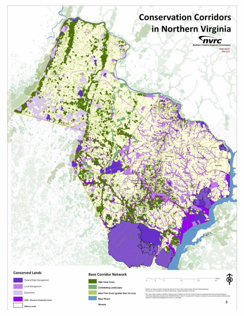
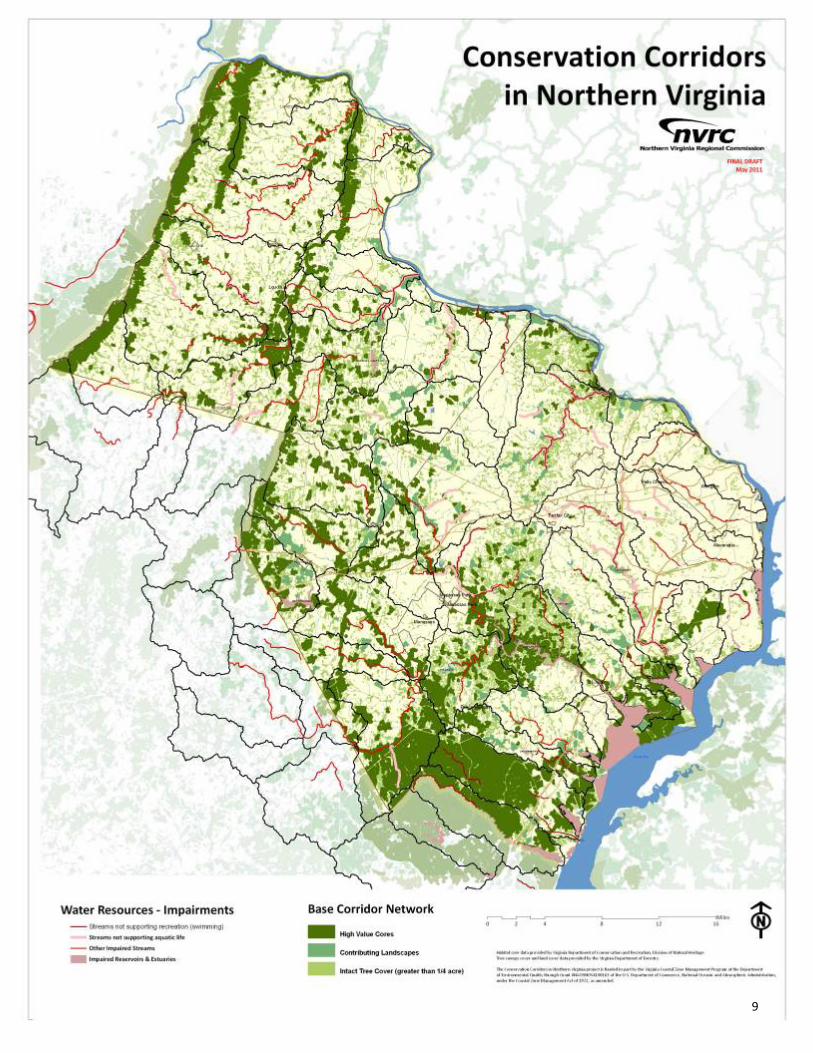
II. Conservation Corridors in Northern Virginia Maps Following a methodology developed by the Green Infrastructure Center Inc/Skeo Solutions team (Appendix D), NVRC developed base maps of conservation corridor areas in Northern Virginia and draft thematic maps that highlight a variety of natural assets identified in consultation with the Conservation Corridors working group. It should be noted that the maps presented in this report are not considered final, since they have not been formally adopted by a governing board. The maps and their definitions, include: Northern Virginia Conservation Corridors Base Map features the areas of highest ecological integrity across the Northern Virginia landscape (high priority conservation areas), along with possible connections of good quality landscapes, and the contribution of other landscapes identified using local knowledge gathered through the Northern Virginia Conservation Corridor Advisory and Resource Groups. Conserved Lands in Northern Virginia Map represents lands that are under private or public conservation easement, are managed by government as parkland and/or open space, or have regulatory protection. These do not include active recreation areas (e.g. athletic fields and golf courses). Nature‐Based Recreation Theme Map includes regionally‐significant areas with public access for recreational opportunities dependent upon a “natural” environment. Water Resources – Assets Theme Map portrays the regionally‐important surface and drinking water features that are dependent upon good source water quality. Water Resources – Impairments Theme Map includes stream segments listed on the Virginia Department of Environmental Quality’s 303(d) impaired waters listing for water quality impairments that are dependent upon the use of the land (benthic/sediment/flow). Known Cultural Heritage Theme Map includes known sites of architectural or archeological importance that are contextually‐dependent upon the surrounding landscape. Locations are representative of the significant historic periods defined by the Virginia State Landmark Register and National Register. Agricultural Resources Theme Map depicts areas that support agricultural production. USDA soil classifications are included to designate state and nationally significant agricultural areas, which are suitable for agriculture and natural resource management.

55
6
6

7
7

8
8
9
9

10
10

11
11

9
III. CityGreen Analysis of Select Cores Four areas that cross jurisdictional boundaries were evaluated using American Forest’s CityGreen software to determine their benefits at removing air pollution, storing and sequestering carbon, and stormwater management. To highlight areas with multiple benefits, NVRC used Virginia Conservation Lands Needs Assessment attributes, as well as American Forests CityGreen on four cross‐jurisdictional locations.
1
2
3
4

10
Area 1 Northern Loudoun County 5,434 acres 161 acres of Tier 1 Habitat
Depth of Interior = 700 acres Seven Elements of Occurrence
CityGreen Summary
% Tree Canopy 68.1 percent
(1,645.0 acres)
Lbs of Air Pollutants removed/year (estimated annual value)
165,699($443,655)
Tons of Carbon Stored (Total) Tons of Carbon Sequestered (Annually)
70,787 551
Cu. Ft of Stormwater Retained (estimated total stormwater value)
12,157,891 cu. ft($72,947,347)

11
Area 2 Fairfax‐Loudoun Border 845 acres 206.2 acres of Tier 1 Habitat
Depth of Interior = 300 acres Four Elements of Occurrence
CityGreen Summary
% Tree Canopy 87.4 percent(738.8 acres)
Lbs of Air Pollutants removed/year (estimated annual value)
74,416($199,246)
Tons of Carbon Stored (Total) Tons of Carbon Sequestered (Annually)
31,790 247
Cu. Ft of Stormwater Retained (estimated total stormwater value)
4,832,337 cu. ft($28,994,024)

12
Area 3 Fairfax‐Prince William Border 5,434 acres 646 acres of Tier 1 Habitat
Average Depth of Interior = 550 acres One Element of Occurrence
CityGreen Summary
% Tree Canopy 56.0 percent
(3,043.5 acres)
Lbs of Air Pollutants removed/year (estimated annual value)
306,573($820,840)
Tons of Carbon Stored (Total) Tons of Carbon Sequestered (Annually)
130,968 1,020
Cu. Ft of Stormwater Retained (estimated total stormwater value)
27,767,086 cu. ft($166,602,515)

13
Area 4 Quantico 45,956 acres
Average Depth of Interior = 1300 acres 27 Elements of Occurrence
CityGreen Summary
% Tree Canopy 43.9 percent
(24,635.7 acres)
Lbs of Air Pollutants removed/year (estimated annual value)
2,481,536($6,644,243)
Tons of Carbon Stored (Total) Tons of Carbon Sequestered (Annually)
1,060,110 8,253
Cu. Ft of Stormwater Retained (estimated total stormwater value)
183,243,441 cu. ft($1,099,460,644)

14
IV. Local Plan and Policy Review During summer 2010, NVRC intern, Cliff Fairweather did a comprehensive assessment of local plans and policies that incorporate a commitment to green infrastructure or green infrastructure‐related planning. The results of his assessment revealed the five largest jurisdictions in Northern Virginia incorporate a green infrastructure map, mention desires to develop one, or include specific conservation strategies within their planning documents. A short list includes the following, which is explained in greater detail in Appendix C:
City of Alexandria Fairfax County
Open Space Plan & Concept Plan Map Tree Action Plan
Arlington County Fairfax County Park Authority
Public Space Master Plan Proof of Concept Map
Loudoun County Natural Areas Geospatial Model Initiative
Revised General Plan Prince William County
Chapter 5, The Green Infrastructure Park Authority Comprehensive Plan
Chapter 7 Rural Policy Area
Green Infrastructure Map
Throughout the first phase of this project, the Prince William County was revising their Environmental Chapter to their comprehensive plan. The Prince William County Planning Commission approved the following language for integration within their plan, which could be transferred to other localities as model language for updates to their comprehensive plan:
EN POLICY 1, AS3. Identify and pursue opportunities for open space preservation that preserve unique habitats of special. B‐20 EN POLICY 1, AS 6. Upon completion of the Northern Virginia Regional Commission’s conservation corridors project, update the Environment Chapter to include the priorities identified in the report. B‐22 EN POLICY 2, AS 2. Map all Environmental Resources to prioritize conservation planning, and make this information available on the County Mapper. B‐23 EN POLICY 2, AS 3. Inventory county‐owned properties, to include Park Authority and Prince William Public School properties, to identify environmental resources, as identified in the Environmental Constraints Analysis. Provide inventory/mapping of forest areas in Prince William County and make this information available to the public. B‐24 EN POLICY 2, AS 6. All County offices, to include Park Authority and Prince William Public School properties, involved in land use will coordinate with local, federal, state, and regional environmental organizations to facilitate the exchange of data and implementation of environmental protection measures. B‐24

15
EN POLICY 2, AS7. Conduct a County‐wide analysis of the economic value of our existing green infrastructure (native and urban forests) toward energy conservation, storm water control off‐sets, property values, protecting and improving water quality, and reducing air pollution. B‐25
These amendments were approved by the Prince William County Planning Commission in a resolution dated September 15, 2010, available online at: http://www.pwcgov.org/docLibrary/PDF/13054.pdf.
V. Discussion & Next Steps Discussions with the Northern Virginia Conservation Corridors Advisory Group revealed three common issues concerning the implementation of the Conservation Corridors project. They include:
• A need to reinforce the importance of managing conserved natural resources, which includes deer management. Advisory Group members stress the importance of not only conserving lands but also managing them in order to sustain environmental, recreational, and/or historical assets and to reduce the risk of encroachment and invasion from non‐native species. Specifically, foraging by white‐tailed deer in the region is a threat to forest succession across Northern Virginia.
• A desire to expand public participation opportunities and general awareness of sensitive areas on private property. Successful implementation will require outreach and education to all property owners. Many property owners may be unaware of regionally‐significant features on their properties and Advisory Group members recognize that many may voluntarily look for opportunities to either place land under easement or manage the land themselves to maintain its environmental, recreational, and/or historical value.
• A recognition that the regional effort serves as a broad guide of conservation opportunities, specifically cross-jurisdictional connections. Conservation priorities can be identified at a variety of scales. Advisory Group members recognize the value of the regional analysis in identifying regionally‐significant areas, especially those crossing jurisdictional boundaries. Implementation at the local level will require higher data resolution to highlight opportunities at the parcel‐scale and to incorporate unique features, priorities and datasets suggested by the Advisory Group members. Many of these dataset cannot be incorporated, compared, or prioritized in a regional analysis due to inconsistencies and/or data incompatibilities.
Phase II will focus on refining the base and thematic maps in order to identify areas of priority based on multiple benefits. Relationships between the conservation corridors network and water resources are of particular interest, as the advisory group seeks to identify restoration opportunities. NVRC plans to explore the relationship of the existing network as a means of providing a buffer for inundation due to projected coastal inundation, as studied through the Sustainable Shorelines and Community Management Project. Public participation will enlarge through a public summit in summer 2011. A draft agenda for the summit is provided in Appendix E. Additionally, information about how best to implement these priorities at the local level, highlight data needs and other resource requirements will be discussed. Finally, NVRC will work with the Metropolitan Washington Council of Governments to integrate the work of the Northern Virginia Conservation Corridors project as baseline information in the Region Forward report – www.regionforward.org.

16
Appendices

17
Appendix A. Participation Materials: Participation Guidelines
Schedule and Outcomes
18
Northern Virginia Regional Commission – Conservation Corridor Project Participation Guidelines
The process detailed in this document is intended to serve as a guide for participants in the conservation corridor/green infrastructure mapping project coordinated by the Northern Virginia Regional Commission (NVRC). The initial goal is to develop a map representing a regional conservation network that can be used at the regional scale to better conserve regional environmental and cultural resources and to preserve important linking corridors for wildlife and recreation. The second phase of the project will focus on further refining these maps to the local scale, using unique datasets. The creation of all maps requires consistent participation by those reviewing the work, as well as reasonable representation from each locality within the NVRC planning district. All are welcome to attend and share ideas. The following categories of participation are intended to ensure adequate and fair representation in this process, as well as accommodate for a group size that allows for full participation and dialogue amongst participants. There are three levels of participation: Advisory Group, Resource Group and Observer.
Advisory Group (AG): This member represents a specific locality in an official capacity (e.g. staff) or represents a regional conservation organization. In either case, representatives commit to: receive permission and acknowledgement of that role from their organization and provide input from their respective organizations, as well as keep their organization up‐to‐date on the process and outcomes of the project, and support the promotion of the public summit to their constituents. Those who are advisors for each locality are limited to four participants of the following types (planners, GIS data analysts, park or open space staff, elected officials). Please see participant list for who are the designated staff who meet this criteria. For regional conservation organizations, representation is limited to one individual per organization. The AG will assist in identifying key map elements to include based on established mapping criteria and highlight key community priorities. As each locality is unique ‐‐ ecologically, socially and economically ‐‐ representatives are needed to ensure the maps are both accurate and useful for planning to conserve green infrastructure. Representatives should also inform the group of future land use plans or priorities of each locality that may affect the future of the green infrastructure network. Recommendations from the AG are advisory only. The NVRC will take all ideas, suggestions and edits under consideration in order to create a map that best represents the region's green infrastructure assets and opportunities for conserving them. The AG will convene approximately six times over a 12 month period with the understanding that meeting timing depends upon the work being performed (e.g. meet when a new map or modeling report is ready for review). Members of the AG should be able to attend a majority of the meetings, especially the working sessions.
Resource Group (RG): The resource group is made up of technical experts who may attend one or all meetings to provide background information. For example, someone working on a regional trail may only need or wish to participate if an issue was being discussed that could impact or add to the regional trail. These participants may provide input as requested but they are not official members of the AG.
Continues on next page

19
Observers: All meetings are open to the public. Anyone from a governmental or nongovernmental organization may attend a meeting and observe the proceedings. Observers may make comments or ask questions of staff about the proceedings or maps at the beginning or end of the meeting.
Ground Rules:
Comments will be recorded but not attributed to particular individuals.
The NVRC will take all comments for consideration. However, not all comments or concerns will be addressed in the regional map. All views will be respected, discussed and captured.
The AG will not conduct voting to reach decisions but when possible, a general sense of any group agreement will be reported.
All meetings of the AG are open to the public. The public may attend AG meetings as ‘observers’ and public meetings as ‘participants.’
In order to ensure continuity and fairness in project planning, AG members must attend the majority of the meetings. Members should notify staff if they will be unable to participate.
Project Contact: Laura Grape, Senior Environmental Planner Northern Virginia Regional Commission [email protected] 703‐642‐4625 3060 Williams Drive, Suite 510 Fairfax, VA 22031
20
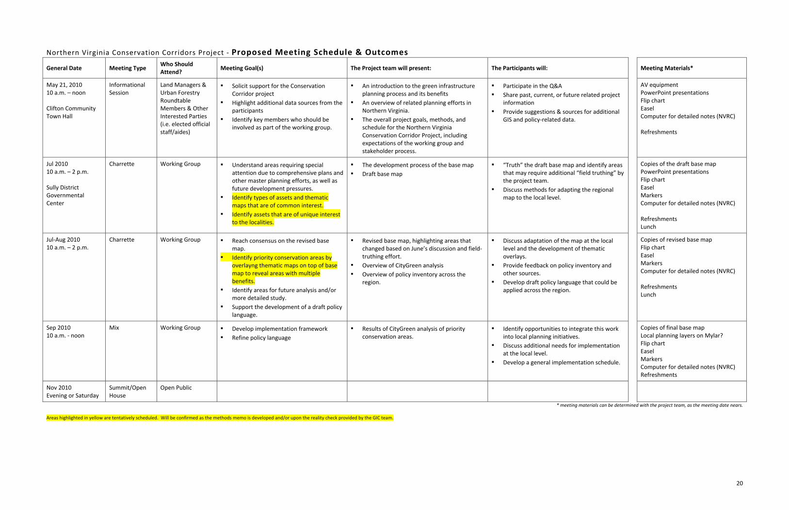
Northern Virginia Conservation Corridors Project ‐ Proposed Meeting Schedule & Outcomes
General Date Meeting Type Who Should Attend?
Meeting Goal(s) The Project team will present: The Participants will: Meeting Materials*
May 21, 2010 10 a.m. – noon Clifton Community Town Hall
Informational Session
Land Managers & Urban Forestry Roundtable Members & Other Interested Parties (i.e. elected official staff/aides)
▪ Solicit support for the Conservation Corridor project
▪ Highlight additional data sources from the participants
▪ Identify key members who should be involved as part of the working group.
▪ An introduction to the green infrastructure planning process and its benefits
▪ An overview of related planning efforts in Northern Virginia.
▪ The overall project goals, methods, and schedule for the Northern Virginia Conservation Corridor Project, including expectations of the working group and stakeholder process.
▪ Participate in the Q&A
▪ Share past, current, or future related project information
▪ Provide suggestions & sources for additional GIS and policy‐related data.
AV equipment PowerPoint presentations Flip chart Easel Computer for detailed notes (NVRC) Refreshments
Jul 2010 10 a.m. – 2 p.m. Sully District Governmental Center
Charrette Working Group ▪ Understand areas requiring special attention due to comprehensive plans and other master planning efforts, as well as future development pressures.
▪ Identify types of assets and thematic maps that are of common interest.
▪ Identify assets that are of unique interest to the localities.
▪ The development process of the base map
▪ Draft base map
▪ “Truth” the draft base map and identify areas that may require additional “field truthing” by the project team.
▪ Discuss methods for adapting the regional map to the local level.
Copies of the draft base map PowerPoint presentations Flip chart Easel Markers Computer for detailed notes (NVRC) Refreshments Lunch
Jul‐Aug 2010 10 a.m. – 2 p.m.
Charrette Working Group ▪ Reach consensus on the revised base map.
▪ Identify priority conservation areas by overlayng thematic maps on top of base map to reveal areas with multiple benefits.
▪ Identify areas for future analysis and/or more detailed study.
▪ Support the development of a draft policy language.
▪ Revised base map, highlighting areas that changed based on June’s discussion and field‐truthing effort.
▪ Overview of CityGreen analysis
▪ Overview of policy inventory across the region.
▪ Discuss adaptation of the map at the local level and the development of thematic overlays.
▪ Provide feedback on policy inventory and other sources.
▪ Develop draft policy language that could be applied across the region.
Copies of revised base map Flip chart Easel Markers Computer for detailed notes (NVRC) Refreshments Lunch
Sep 2010 10 a.m. ‐ noon
Mix Working Group ▪ Develop implementation framework
▪ Refine policy language
▪ Results of CityGreen analysis of priority conservation areas.
▪ Identify opportunities to integrate this work into local planning initiatives.
▪ Discuss additional needs for implementation at the local level.
▪ Develop a general implementation schedule.
Copies of final base map Local planning layers on Mylar? Flip chart Easel Markers Computer for detailed notes (NVRC) Refreshments
Nov 2010 Evening or Saturday
Summit/Open House
Open Public
* meeting materials can be determined with the project team, as the meeting date nears. Areas highlighted in yellow are tentatively scheduled. Will be confirmed as the methods memo is developed and/or upon the reality check provided by the GIC team.

21
Appendix B. Meeting Summaries July 8, 2010
August 20, 2010
September 24, 2010

22
Northern Virginia Regional Commission Conservation Corridor Plan Working Session
Thursday, July 8, 2010 Sully District Governmental Center – Frank Room
10 am – 2 pm Meeting Summary
Laura Grape, Senior Environmental Planner and Project Manager with the Northern Virginia Regional Commission provided a review of green infrastructure principles and how green infrastructure concepts have been incorporated into local plans and policies. The presentation explained the process for developing the region’s draft green infrastructure base map that shows forested areas and streams that are unprotected, by combining the Virginia Department of Forestry’s 2005 Forest Cover with the Virginia Natural Landscape Assessment (VaNLA) and with areas that are currently under a protected designation. Also, Laura reviewed guidelines and ground rules for participating in the project as a member of the Advisory Group, the Resource Group, or as an Observer. A copy of the participation guidelines and ground rules is enclosed in Appendix B.
Project team member Karen Firehock of the Green Infrastructure Center, Inc then led a group discussion about policies, programs, and data sources to consult for refining the draft green infrastructure map. Key ideas from the discussion are listed in the following discussion section under “Opportunities and Resources Brainstorm”.
For the second half of the meeting, participants broke into two groups to review and analyze information reflected on the green infrastructure base maps. This work session allowed stakeholders to identify priority conservation areas, determine potential connection and restoration areas, and identify areas incorrectly characterized as green infrastructure or may have changed since the development of the Forest Cover dataset (2005). Each group then presented their ideas to the larger group. These ideas were recorded and are listed in the following Discussion section under “Green Infrastructure Base Map Review”.
Ten stakeholders attended the July meeting. A list of invited organizations and those who attended can be found in Appendix C. Additional notes and questions raised during the session are found are the end of the memo. Appendices: A – Meeting Agenda B – NVRC ‐ Conservation Corridor Project Participation Guidelines C – Meeting Participants and Invited Organizations
The meeting’s PowerPoint presentation and the draft base maps are available on NVRC’s website, at: www.novaregion.org/conservation

23
Discussion
Opportunities and Resources Brainstorm The following data sources and resources were mentioned for possible inclusion in the green infrastructure base map and/or for consideration when conducting a local policy analysis:
Arlington County
Natural Resource Inventory and Management Plan
Land Acquisition and Preservation Policy (LAPP)
Urban Tree Canopy Survey Fairfax County
iTree data collected, waiting for results [recommend consulting Mike Knapp]
Tyson Conservation Plan – 1,700 acres, highly developed within the headwaters of 4 watersheds
Towns of Leesburg and Purcellville
Include recent urban tree canopy analysis Cities of Falls Church and Fairfax
Open Space Plans Regional
The Fort AP Hill Quantico Map shows conservation priorities and protection areas for military funding/spending opportunities
Washington Smart Growth Alliance, Regional Priority List – map items listed in plan
Potomac River Flyway: very important area to protect
Protect shoreline areas to benefit wildlife ecology and birding migration
Culpeper Basin, Monticello Park: both are important bird areas to protect (see Cornell University list)
Girco (?) has series of NOVA bird area maps which were created by birders – very valuable resources
Include and distinguish areas that are under temporary protection such as agricultural forest districts. Once land is placed in an ag/forest districts, they are often ripe for a conservation easements
Watershed plans could be very valuable to include for restoration opportunities

24
Green Infrastructure Base Map Review During the work session, participants broke into two groups to review and familiarize themselves with the base map. They made notes on the maps that highlighted areas to protect, connect, restore, and remove. The following letters were used to label each suggested change:
P = Protect ‐‐ agree that this is a key green infrastructure resource A = Add ‐‐ another key feature that is missing ‐‐ e.g. an important marsh, natural feature etc. is not included in the base map and should be. C = Connector ‐‐ identify good connecting corridors to add or to restore ‐‐ e.g. an stream valley or connection that could be restored with trees/vegetation to provide a good wildlife corridor. D = Delete ‐ this feature is not part of the network ‐‐ e.g. it has been developed already, it's quality is questionable, it is not appropriate to include.
Each suggestion was labeled with one of the above letters and a number. The groups provided rational for each suggestion. Summary of Comments: As the workgroup evaluated the maps they identified locations that needed refinement and updating and it was possible to see some preliminary priorities and corridor connections. The forest cover layer served to visualize those areas of the region that are unprotected but may have ecological value. It was noted however, that the cover layer is from 2005 and is outdated in some areas. Workgroup members outlined several north‐to‐south and east‐to‐west corridors across the region. Mountainous forested regions in the western parts of Prince William and Loudoun were highlighted. In more urban areas the group looked at smaller scale parcels that could link some of the larger parks. Several large private property holdings were recognized as worthy priorities for conservation. The workgroup came to several conclusions to make the maps more current and functional. It was agreed that military lands needed to be removed from being considered conserved, since there is little restriction on the property use. The group also determined to remove any active recreation sites considered conserved because they offer little ecological value. Corridors along water bodies were identified as significant to migration and other indicators of quality habitats, especially those along the Potomac River. The work session provided superior understanding of local land use and insight to ongoing priorities by each jurisdiction.

25

26
Group 1 ‐ Map A 1P – Spalding Farm, potential conservation easement – 400 acres, worth protecting because large area of land 2P – Kincheloe Properties – 240 acres, contains regional parkland and Bull Run Park, Occoquan Watershed, no invasive species (Fairfax County) 3P – Charlie Hoof – large tract of land owned by one person (Fairfax County) 4P – Airport buffer area (Loudoun County) 5P – Cox Farm in the middle of a protected area (Fairfax County) 6P ‐ Engineering proving grounds (Fairfax County) 1C – Eagle Property, connect properties with land owner cooperation (Fairfax County) 2C – Madeira School – connection opportunities (Fairfax County) 3C – Connection opportunity between Bull Run Mountains and Battlefield (Prince William) 4C – Cross county connector line/trail (Fairfax County) 5C – Alexandria green crescent (Alexandria) 6C – Four Mile Run connection (Alexandria and Arlington) 1CP – Short Hill Mountains – large area of unprotected forests that can also serve as a connection (Loudoun County) 2CP – Bull Run to Catoctin Mountains – large area of unprotected forests that can also serve as a connection (Loudoun County) 3CP – Beaver Dam Reservoir, connection with unprotected forest (Loudoun County) 4CP – Meeker – large property along Accotink Creek (Fairfax County) 1D – Delete military land (Fairfax) 2D – Delete Quantico military development (Prince William)

27

28
Group 2 ‐ Map B 1P – Dove’s Landing – most environmentally significant area in NOVA (Prince William) 2P – Prince William has multiple eco‐zones overlapping with unique topography and spans costal/tidal + mountain areas (Prince William) 3P – Wetlands, forests, Vulcan quarry on TNC priority map (Prince William) 4P – Connect protected parcels with unprotected lands (Prince Williams) 5P – Bull Run Mountains (Prince William) 6P – Green Vest – protect forests, opportunity for a state park (Loudoun County) 1A – Gilberts Corner – now a regional park 2A – Occoquan Dams in between 2 dams 1C – Connection (Prince William) 2C ‐ Connection (Prince William) 3C – Connection between river banks/wetlands and shoreline protection (Prince William) 4C – Connection of Prince William Forest Park with Quantico Creek (Prince William) 5C – Connection (Prince William) 1D – Delete areas of active recreation (Prince William) 2D – Cherry Hill is now a golf development (Prince William) 3D – Active recreation area: skate park, ball fields, heavily developed (Prince William) 4D – South Market development site southwest of intersection of Route 55 (50?) and 15 (Prince William) 5D – Remove Quantico and Fort Belvoir ? – Landfill in Prince William further characterized (Prince William) General note: Remove the Prince William County park sites – active recreation

29
Additional Comments and Questions Diversify map color scheme on base map to include various levels of protection – currently difficult to distinguish between protected and unprotected forest. Attendees would like copy of the power point, possibly to put up on their websites. Attendees would also like to see all of the information presented on the NVRC website. Attendee suggested adding “draft” before “policy language” on the workgroup schedule for September 24th. Define acronyms on presentation: scu = species of concern, t&e = threatened and endangered, core isolation index. Chesapeake Bay Preservation Plans are not available near Arlington and Alexandria yet for the development of the base map. This data will be included once it is available. Concern raised over the green corridors shown around the streams on the map ‐ these areas are not actually protected yet. Concern raised over forest cover on the map. The forest data is from 2005 and some of it may no longer exist. One attendee asked for the map’s definition of a forest. One attendee wanted specific examples of how governments actually use green infrastructure plans. She was directed to the Green Infrastructure Center website. Questions brought up about additional local data not presented on regional base maps. Attendee was wondering about the Natural Heritage Inventory of Arlington. Laura explained that data not available to every community will not appear on the regional map but will be represented on the individual local maps. Several attendees mentioned that military bases should not be listed as protected lands because community has little influence over their development (e.g. Quantico). If an easement is included as part of a Green Infrastructure plan, it qualifies for safe harbor from the IRS. Green Infrastructure maps can be used to strategically target lands for conservation easement. Include major roads on future maps so attendees can better locate existing or potential areas on the map. Suggestion: There is a need to protect viewsheds. Make a cultural map with historical sites, scenic roads and views that need buffering and create a local registry of important viewsheds. Suggestion: create a new map with high quality gray spaces that could be turned into green space. This would make it easier to find restoration opportunities. Next Steps
The next steps for the project entail refining the green infrastructure base map and establishing an advisory working group made up of local government staff to ground truth and refine the base maps. Before the Advisory Group meeting on Friday, August 20, 2010, NVRC will meet with the individual jurisdictions that we not in attendance at this meeting to get their input on the draft map, opportunities, and additional resources.

30
Also, Advisory Group member Kim Hosen coordinated a work session for the Prince William County Planning Commission for Wednesday, July 14th. Laura Grape and Karen Firehock will provide an overview of Green Infrastructure Planning Principles and the Conservation Corridor Project. If interested, other Advisory Group and Resource Managers are encouraged to extend similar invitations to their respective groups.
A revised base map will be presented at the August 20, 2010 Advisory Group meeting.

31
Appendix A Meeting Agenda
Northern Virginia Regional Commission Conservation Corridor Plan Working Session
Thursday, July 8, 2010 Sully District Governmental Center – Frank Room
10 am – 2 pm 10:00 Welcome and Project Background 15 min (Laura Grape) 10:15 A Green Infrastructure Approach to Land Planning 45 min (Laura Grape and Samantha Kinzer) Green infrastructure 101, Review of relevant locality policies, and Process to develop the base green infrastructure map 11:00 Discussion of Regional Opportunities and Benefits 30 min (Karen Firehock and Casey Williams) How can the Green Infrastructure Plan help localities achieve their planning goals? What other policies, programs or studies are relevant? (Group homework: everyone provide information/updates to what was presented on relevant policies/programs before next meeting) 11:30 Working Group Ground Rules and Process 20 min (Karen Firehock and Laura Grape) 11:50 Lunch 40 min 12:30 Small Group Discussions on Draft Green Infrastructure Map 45 min Participants work in small groups to ground truth and analyze their base maps. Each group will be assisted by a facilitator. This information will be used to update and refine the base map for the next meeting where we will discuss key themed maps. Transparency paper will be provided to each group to draw over the base map. Instructions for the small group discussion are on back of the agenda. 1:15 Debrief the maps 35 min Each group report on their ideas and interpretations 1:50 Wrap Up 10 min Review of next steps, project schedule and homework requests for localities

32
Appendix B – NVRC Conservation Corridor Project Participation Guidelines The process detailed in this document is intended to serve as a guide for participants in the conservation corridor/green infrastructure mapping project coordinated by the Northern Virginia Regional Commission (NVRC). The initial goal is to develop a map representing a regional conservation network that can be used at the regional scale to better conserve regional environmental and cultural resources and to preserve important linking corridors for wildlife and recreation. The second phase of the project will focus on further refining these maps to the local scale, using unique datasets. The creation of all maps requires consistent participation by those reviewing the work, as well as reasonable representation from each locality within the NVRC planning district. All are welcome to attend and share ideas. The following categories of participation are intended to ensure adequate and fair representation in this process, as well as accommodate for a group size that allows for full participation and dialogue amongst participants. There are three levels of participation: Advisory Group, Resource Group and Observer.
Advisory Group (AG): This member represents a specific locality in an official capacity (e.g. staff) or represents a regional conservation organization. In either case, representatives commit to: receive permission and acknowledgement of that role from their organization and provide input from their respective organizations, as well as keep their organization up‐to‐date on the process and outcomes of the project, and support the promotion of the public summit to their constituents. Those who are advisors for each locality are limited to four participants of the following types (planners, GIS data analysts, park or open space staff, elected officials). Please see participant list for who are the designated staff who meet this criteria. For regional conservation organizations, representation is limited to one individual per organization. The AG will assist in identifying key map elements to include based on established mapping criteria and highlight key community priorities. As each locality is unique ‐‐ ecologically, socially and economically ‐‐ representatives are needed to ensure the maps are both accurate and useful for planning to conserve green infrastructure. Representatives should also inform the group of future land use plans or priorities of each locality that may affect the future of the green infrastructure network. Recommendations from the AG are advisory only. The NVRC will take all ideas, suggestions and edits under consideration in order to create a map that best represents the region's green infrastructure assets and opportunities for conserving them. The AG will convene approximately six times over a 12 month period with the understanding that meeting timing depends upon the work being performed (e.g. meet when a new map or modeling report is ready for review). Members of the AG should be able to attend a majority of the meetings, especially the working sessions.
Resource Group (RG): The resource group is made up of technical experts who may attend one or all meetings to provide background information. For example, someone working on a regional trail may only need or wish to participate if an issue was being discussed that could impact or add to the regional trail. These participants may provide input as requested but they are not official members of the AG.
Continues on next page
Observers: All meetings are open to the public. Anyone from a governmental or nongovernmental organization may attend a meeting and observe the proceedings. Observers may make comments or ask questions of staff about the proceedings or maps at the beginning or end of the meeting.
Ground Rules: Comments will be recorded but not attributed to particular individuals.
The NVRC will take all comments for consideration. However, not all comments or concerns will be addressed in the regional map. All views will be respected, discussed and captured.

33
The AG will not conduct voting to reach decisions but when possible, a general sense of any group agreement will be reported.
All meetings of the AG are open to the public. The public may attend AG meetings as ‘observers’ and public meetings as ‘participants.’
In order to ensure continuity and fairness in project planning, AG members must attend the majority of the meetings. Members should notify staff if they will be unable to participate.
General Meeting Schedule (subject to change):
July 8, 2010 10 a.m. – 2 p.m.
Review and truth draft base map. Identify types of assets and thematic maps of common interest. Identify unique assets.
August 20, 2010 10 a.m. – 2 p.m.
Reach consensus on revised base maps. Identify priority conservation areas based on thematic overlays. Discuss policy opportunities and gaps.
September 24, 2010 10 a.m. ‐ noon
Develop draft policy language. Identify opportunities for integratation into planning initiatives.
November 2010 Public Summit
January 2011 Review results from the summit. Discuss communication strategy and timeline for wider promotion to the public and elected officials.
March 2011 Present communication strategy. Discuss local analysis, identify areas for development scenario case studies.
July 2011 Review local analyses and case study results.
Project Contact: Laura Grape, Senior Environmental Planner Northern Virginia Regional Commission [email protected] 703‐642‐4625

34
Appendix C – Meeting Participants and Invited Organizations
July 8, 2010 Working Session Meeting Participants:
Name Organization Email Address
Jim McGlone DOF [email protected]
Stella Koch ANS – Fairfax Co EQAC [email protected]
Mike Nardolilli NVCT [email protected]
Laurel Hammig GWRC [email protected]
Bryant Bays VDOF [email protected]
Heather Ambrose Fairfax County DPWES‐SWPD
Greg Weiler USFWS [email protected]
Jenny Biche RRRC [email protected]
Isabel McLoughlin RRRC [email protected]
Kim Hosen PW Conservation Alliance [email protected]
Organizations invited to send representatives include: Local Government (Open Space Managers, Land Managers, Urban Foresters) City of Alexandria Loudoun County Arlington County City of Manassas Town of Dumfries City of Manassas Park City of Fairfax Town of Occoquan Fairfax County Town of Purcellville City of Falls Church Town of Quantico Town of Herndon Town of Vienna Town of Leesburg Town of Clifton Regional, State, and Federal Organizations George Washington Regional Commission National Park Service – GWMP Rappahannock‐Rapidan Regional Commission
National Park Service ‐ Manassas
Metropolitan Washington COG Bureau of Land Management VA DCR US Fish & Wildlife Service VA DOT US Army – Ft Belvoir VA DOF US Marine Corps Base – Quantico MD Department of Natural Resources Other Interested Parties Northern Virginia Regional Park Authority Prince William Conservation Alliance Northern Virginia Conservation Trust Northern Virginia Urban Forestry Roundtable

35
Northern Virginia Regional Commission Conservation Corridor Plan Working Session
Friday, August 20th, 2010 Sully District Governmental Center – McDonnell Room
10 am – 2 pm Meeting Summary
The Northern Virginia Regional Commission (NVRC) hosted a working session from 10 a.m. to 2 p.m. at the Sully Government Center in Chantilly, Virginia to present the draft Regional Conservation Corridors Base Map and Thematic Overlays to members of the project Advisory Group and other stakeholders. The purpose of the meeting was to reach consensus on the revised base map, identify areas where additional analysis is needed, and evaluate priority conservation identified by the thematic maps.
Laura Grape, Senior Environmental Planner and Project Manager with NVRC, provided a recap of the project’s past meetings and the role the Advisory Group has played in developing the draft Regional Conservation Corridors Base Map and Thematic Overlays. Ms. Grape also discussed opportunities for the local jurisdictions to break the green infrastructure analysis down to the local level, once the regional analysis is complete, such as using locally‐specific data to further refine priorities. Meeting participants then broke into two working groups to review the base map and thematic overlays, identify areas for more detailed study and highlight opportunities for regional connections. Each group was assisted by a facilitator, who recorded key ideas and interpretations from the discussion. Key ideas and comments are listed in the following section under “Small Group Analysis”.
Project team member Karen Firehock of the Green Infrastructure Center (GIC) then presented an overview of CITYgreen, a GIS extension software tool developed by American Forests that helps to make an economic case for green infrastructure by quantifying the important role trees play in improving water quality, sequestering carbon, removing pollutants from the air, and capturing and filtering runoff. She noted that CITYGreen can also be use to model "what if" scenarios. One could use the model to show the benefits of adding more trees to a particular area such as a park, a neighborhood or a downtown business district. CITYGreen prints out an easy‐to‐read report that details the pollutant reductions as well as the cost savings.
Cliff Fairweather, Intern with the NVRC then presented an inventory of conservation policies across the region. The goal of showcasing existing tools for implementing conservation corridors was to get participants thinking about what strategies and resources are available for incorporating conservation opportunities into local plans. Appendices: A – Meeting Agenda B –Meeting Participants and Invited Organizations
Workshop presentations and maps are available for download at: www.novaregion.org/conservation

36
Small Group Analysis As the working groups evaluated the thematic maps, they noted several corridor connections running north‐to‐south and east‐to‐west. The groups also noted map components that needed refinement and updating. Several new data sources and resources were mentioned for possible inclusion in the green infrastructure base map. In particular the groups commonly noted:
The streams identified as high quality in the aquatic resource integrity layer are inconsistent
with local knowledge.
Several water quality‐related datasets should be added to the water quality‐themed map, including (but not limited to):
o Mitigation wetland banks o Drinking water intakes o Drinking water reservoirs o Impaired streams
These comments and other ideas are listed below, by working group. Comments that pertain to more specific details on the maps are noted with an asterisk symbol (*). NVRC noted that refinements to the maps will be made based on these suggestions.
Working Group 1
Migratory bird habitats (along the Potomac) are important to consider. Breeding bird studies
could be used to determine important areas or stop‐off locations to add to the map.
For the new landfill (see map), contact Tom Dombrowski or Tom Smith in Prince William County
to learn the landfill boundaries as this will impact some of the existing green infrastructure *
The front of James Long Park (Prince William County) is largely artificial turf field but the back
has good habitat. Check the park map to ensure not including too much of area that is actually
artificial turf. *
Add trails from localities to the map, especially Prince William and Fairfax Counties which have
these GIS layers available.
XZ = see map for symbol ‐‐ was recently rezoned for development and probably needs to be
removed. (GIC comment: Development plans could be designed to protect the GI network
however, so this site could be marked as a priority) *
Not all historic districts are on the map. Get this information from the localities.
Review the findings of the American Battlefields Protected Areas Study to determine battlefields
that need to be added or are at risk: http://www.nps.gov/hps/abpp/CWSII/CWSII.htm
There are some significant wetland banks in Northern VA (Prince William and Loudoun
Counties). Since these can never be developed, it might be worth adding them to the maps.
They are maintained by a private banking company(s) such as Wetland Studies and Solutions
(http://www.wetlandstudies.com/?tabid=211), who may be willing to share locations. There are

37
two wetland banks located near Cedar Run, at least one of which is the subject of a Boy Scout
project.
The group felt that there might be a useful study from American Farmland Trust to reference
(although the GIC has not located a study that maps at risk farms for Northern VA, so we are not
sure to what the participants were referring).
Check the aquatic resource inventory layer shown on the water quality map to better
understand why Cameron Run and Accotink Creeks ‐‐ both highly impaired ‐‐ are listed as being
high quality.
Add drinking water supply reservoirs and their watersheds. This will help identify areas that
filter drinking water as source protection areas.
Graphics comment: Avoid colors that are purple and blue next to each other as color blind
people have difficulty telling the difference. It is also tough to distinguish blue and green color
differences when adjacent.
The National Park Service has a cultural resources group. They would be a good group to review
the cultural theme map. They only meet quarterly so they made need to convene a separate
meeting to meet the project timeframe. Contact Eric (NPS) to find out how best to access the
group.
Working Group 2
There was some concern expressed about how the tree canopy was defined for the base map.
The high resolution or selection criteria do not pick up the canopy in urban areas, which may
cause alarm within certain jurisdictions. The project team explained the need to use consistent
data across the region for comparison purposes, and that jurisdictions have the opportunity to
refine the data to create a more detailed map for their locality. They could do this by adding an
aerial image in the background to show areas of existing canopy. May be an issue for the way
the forest cover is shown in the legend – (GIC recommendation to state intact tree canopy,
greater than ¼ acre in size).
There was a suggestion to add the DCR Vulnerability Model as another overlay.
It was noted that the maps do not show Fairfax County’s Environmental Quality Corridors
(EQCs). However, these areas may not be digitized.
Identify the new runway location for Dulles Airport. *
The EPG site (see map) is actively being developed, so the ecological corridor is shrinking to hug
the narrow stream valley. *

38
Change the title “Legend” to “Resources” on all maps.
Identify what’s been protected as part of Laurel Hill. Laurel Hill is now under Park Authority
protection and includes trails and native meadows restoration. *
Check on the status of the 12‐acre forest adjacent to Arlington National Cemetery. *
Check on the status of the forest and wildlife corridors at Fort Belvoir. *
Add HOA commonly held properties, such as the large one in Reston, or recommend that local
jurisdictions add these to their more detailed green infrastructure maps. *
Add the following information to the Water Quality Map:
o TMDL data for streams across the region
o Headwater streams in mountainous areas
o Streams included in the Northern Virginia Conservation Trust’s Bull Run Headwaters
Initiative
o Drinking water intakes
o Community wells
Use county data to cross‐reference and refine state water quality data.
There is a potential data inconsistency regarding stream information reported for Fairfax
County. The integrity of the aquatic resource integrity layer is questionable.
Add the following information to the Cultural Resources Map:
o Old Colchester Road
o Potential prehistoric roads Old Carolina Road Braddock Road
Add the following information to the Recreational Resources Map:
o Rochambeau Trail
o Cross County Trail
o East Coast Greenway (?)
Additional Arlington trails are mapped and available for incorporation (?)

39
Next Steps
The next steps for the project entail refining the Regional Conservation Corridors Base Map and Thematic Overlays based on input received during the working session. A final Base Map and refined Thematic Overlays will be presented at the Working Session on Friday, September 24, 2010. The purpose of the final Working Session is to develop draft policy language and local implementation ideas for the Regional Conservation Corridor Plan. NVRC will also present the results of their CITYgreen analysis on a few priority conservation areas in the region.

40
Appendix A ‐ Meeting Agenda Agenda
Northern Virginia Regional Commission
Conservation Corridor Plan Working Session
Friday, August 20, 2010
Sully District Governmental Center – McDonnell Room 10 am – 2 pm
10 a.m. Welcome and Introductions
(Laura Grape, NVRC) 10:10 a.m. Development of a Regional Conservation Corridors Base Map and Thematic Overlays
(Laura Grape, NVRC) Recap of past meetings and their influence on the process to develop a regional conservation corridors base map and corresponding thematic maps. Discuss opportunities to break this down further to the local level.
10:45 a.m. Small Group Discussion on Revised Regional Conservation Corridor Base Map
Participant work in small groups to review the base map and draft thematic maps, highlighting opportunities for regional connections. Each group will be assisted by a facilitator. Participants will also truth thematic maps for accuracy and provide insights on the use of additional data.
11:30 a.m. Debrief the maps
Each group will report on their ideas and interpretations of the base and thematic maps.
12 p.m. Lunch
12:30 p.m. CITYgreen Overview
(Sam Kinzer, NVRC) CITYgreen is a software tool for planners, landscape architects, engineers, developers, community groups, and regulatory agencies that helps make the economic case for green infrastructure by quantifying the important role that trees play in improving water quality, sequestering carbon, removing pollutants from the air, and capturing and filtering runoff.
1:15 p.m. Existing Tools for Implementing Conservation Corridors in Northern Virginia
(Cliff Fairweather, NVRC) What policy tools exist for implementing a conservation corridor strategy? Participants will discuss opportunities for incorporating a regional analysis into their local plans and what other resources may be necessary to do so.
1:55 p.m. Wrap‐Up Next Advisory Group Meeting – Friday, September 24, 2010 10 a.m. – noon at the Sully District Government Center – McDonnell Room

41
Appendix B– Meeting Participants and Invited Organizations
August 20th, 2010 Working Session Meeting Participants: Name Organization Email Address
Heather Schinkel FCPA [email protected]
Adam Draper NVCTA [email protected]
Erik Oberg NPS, GW Parkway [email protected]
Diane Probus Arlington Co, PRCR [email protected]
Julia Flanagan PWCo DPW/Arborist [email protected]
Deirdre Clark RRRC [email protected]
Noel Kaplan Fairfax Co Planning & Zoning [email protected]
Ray Utz PWCo Planning
Jinx Fox Bureau of Land Management [email protected]
Cliff Fairweather Audubon Society of NoVA [email protected]
Organizations invited to send representatives include: Local Government (Open Space Managers, Land Managers, Urban Foresters) City of Alexandria Loudoun County Arlington County City of Manassas Town of Dumfries City of Manassas Park City of Fairfax Town of Occoquan Fairfax County Town of Purcellville City of Falls Church Town of Quantico Town of Herndon Town of Vienna Town of Leesburg Town of Clifton Regional, State, and Federal Organizations George Washington Regional Commission National Park Service – GWMP Rappahannock‐Rapidan Regional Commission National Park Service ‐ Manassas Metropolitan Washington COG Bureau of Land Management VA DCR US Fish & Wildlife Service VA DOT US Army – Ft Belvoir VA DOF US Marine Corps Base – Quantico MD Department of Natural Resources Other Interested Parties Northern Virginia Regional Park Authority Prince William Conservation Alliance Northern Virginia Conservation Trust Northern Virginia Urban Forestry Roundtable

42
Northern Virginia Regional Commission Conservation Corridor Plan Working Session
Friday, August 20th, 2010 Sully District Governmental Center – McDonnell Room
10 am – 2 pm Meeting Summary
The Northern Virginia Regional Commission (NVRC) hosted a working session on September 24, 2010 as part of its effort to refine the state’s analysis of conservation priority areas by using local data and local priorities to establish a Regional Conservation Corridors Base Map for the region. The purpose of the base map is to inform a strategy for collaboration on regional priorities related to green infrastructure. The goals of the meeting, which marked the end of Phase I, were to review current Green Infrastructure planning initiatives in the region, highlight areas of interest illustrated by the base map that can inform strategic planning initiatives in the future, and discuss an implementation framework for refining and integrating the base map with local planning efforts.
Laura Grape, Senior Environmental Planner and Project Manager with NVRC, provided a recap of the project’s past meetings and the role the Advisory Group has played in developing the draft Regional Conservation Corridors Base Map and Thematic Overlays. Ms. Grape then introduced a panel of local government staff that provided their insights on how green infrastructure is being considered within their jurisdictions, their review of the challenges and opportunities they have faced, and their thoughts on the program’s effectiveness and lessons learned. General notes from the panel discussion are included in below.
Appendices: APPENDIX A: Meeting Agenda
APPENDIX B: Meeting Participants and Invited Organizations
APPENDIX C: Phase I draft Regional Conservation Corridors Base Map
Workshop presentations and maps are available for download at: www.novaregion.org/conservation

43
Panel Discussion of Local Green Infrastructure Initiatives Members of the local panel included:
Charles Smith, Natural Resource Manager, Fairfax County Park Authority
Joe Gorney, Senior Planner, Loudoun County
Ray Utz, Chief, Long Range Planning, Prince William County
Mike Nardolilli, President, Northern Virginia Conservation Trust
Key points from the panelists are listed below.
Charles Smith – Fairfax County
The Fairfax County Park Authority, the largest land owner in Fairfax County, works with other land owners in the region on land conservation initiatives.
The Park Authority launched a GIS effort a couple of years ago to develop a green infrastructure model based on the county’s assets, but the modeling process did not allow for
field verification of data used to construct the base map.
The Park Authority realized additional resources were needed to verify and maintain the data
sources, so they scaled back expectations on what the model could do and how it could be
used.
The county was also concerned about public misuse or manipulation of the GIS data.
They decided they needed to rethink the purpose of the data and the plan for making it
available to the public.
The county’s goal was to use the data to guide resource management decisions and measure
changes over time.
Joe Gorney – Loudon County
Loudon County’s Comprehensive Plan and Heritage Preservation Plan both address Green
Infrastructure.
The county is also considering voluntary adoption of the Chesapeake Bay Preservation Act.
As part of the county’s Strategic Watershed Management Solutions (SWMS) effort, the county
has created comprehensive watershed management plans that outline stream assessment
strategies.
The county has several policies and tax incentives, such as land use zoning and
Agricultural/Forestal Districts, to support and promote the county’s rural economy.
Loudon County has numerous trails, but some residents have objected to publishing locations
for private trails, such as those located within subdivisions.
The county has several overlay districts, including a Floodplain, Karst, and Mountain Top
Overlay District. The Conservation Design Overlay District was unpopular with the
development community and has since been eliminated.

44
The county has a 725‐acre preservation area called Banshee Preserve, which includes trails
and naturalist programs.
While the county has a Water Resource Technical Advisory Committee, there is no designated
environmental planner or bike/pedestrian coordinator.
The Regional Conservation Corridors Plan presents a great opportunity to educate the current
Board of Supervisors on the benefits of having a green infrastructure plan and to gain their
support.
Ray Utz – Prince William County
Prince William County is currently updating the Environmental Chapter of their
Comprehensive Plan. The Parks and Open Space Chapter was updated a couple years ago.
Several years ago, the county collected information on several green infrastructure
opportunities, include open spaces, cultural resources, and environmentally sensitive lands.
The county’s greatest challenge has been incorporating the full scope of stakeholder
perspectives. The community is interested in using conservation corridors for several
purposes, including recreation, heritage and environmental purposes.
The community did not originally like the county’s plan, so they created their own. The two
groups then combined their efforts to create a collaborative plan that better reflects the
community’s values and includes recreational trails and a revised definition of parks.
The citizen‐driven effort led to the establishment of a formal group tasked with organizing the
various interest groups and providing an avenue for the groups to comment on planning
initiatives. This group, currently called the Trails and Blueways Council, reports to the Prince
William County Parks Authority with public input.
The county benefits from several privately owned parks and open spaces.
Several of the conservation priorities do not include a due date, so they do not get the
emphasis or attention they need in order to be established.
The county has encountered the challenge of incorporating a detailed level of precision into
plans for small scale areas. GIS data layers can be very coarse, and the county recognizes that
there are regional differences and that different regions need different open space plans in
the county.
The county is currently focused on improving their watershed plans. The plans are currently
focused on fixing critical capital projects but do not include the long range strategic planning
needed to address big‐picture problems in the future.
Mike Nardolilli, Northern Virginia Conservation Trust (NVCT)
The NVCT is assisting local governments and private landowners in preserving and caring for
natural areas, trails, streets, parks, and historic and cultural resources for the benefit of current
and future generations.
45
Growth projections for the area predict that the number of people equivalent to the current
population of Houston will move to the Northern Virginia region by 2050, and that 22,000 acres
will be needed to absorb the growth.
The NVCT works with each jurisdiction to help them draft and implement open space plans.
The NVCT uses a variety of tools to conserve nature, including Conservation Easements/Land
Donations, Federal Income Tax Deduction, State Income Tax Credit, Federal Estate Tax Exclusion,
Local Real Estate Tax Reduction, and Purchase or “Bargain Sales”.
The NVCT also works with individual landowners to help them qualify for easements on their
property. The IRS will accept easements and offer tax benefits for properties pursuant to a
clearly delineated official governmental policies. The Conservation Corridors base map can
provide the basis for a regional governmental policy by providing a regional goal and identifying
priority locations that the NVCT can use to target lands for potential easement.
The NVCT has assisted with several conservation initiatives in the region, including the Bull Run
Headwaters Initiative, the Arlington Ash Lawn Trail, Alexandria Green Crescent, and the Fairfax
Clifton Trail.
Establishing the Northern Virginia Regional Conservation Corridor Map Ms. Grape and Karen Firehock of the Green Infrastructure Center (GIC) facilitated a discussion on the next steps needed to reach consensus on the Phase I Northern Virginia Regional Conservation Corridor Map. Ms. Grape presented the draft base map and highlighted opportunities for cross‐county collaboration in four specific areas of high ecological value that cross jurisdictional lines. The NVRC team presented a CITYGreen analysis for these areas of interest to show the benefits of adding more trees to these particular areas. The NVRC provided copies of the CITYGreen analysis report for each site detailing the pollutant reductions as well as the cost savings identified by the model. Members of the work group requested to have an electronic copy the draft base map distributed after the meeting so key staff from each county could make a detailed evaluation of the base map, verify the information displayed is accurate, and provide additional input. Ms. Grape agreed to distribute the map and specify a time frame for county staff to conduct their internal review and provide feedback.
Developing an Implementation Framework The group then discussed the need to start building support for implementation of regional priorities at the local level. Themed‐asset maps that recognize important sectors such as heritage and recreation and support the prioritization of conservation areas can help define a framework for implementing regional strategies at the local level. Karen Firehock presented a wide range of case studies on how other Virginia localities have used asset maps to inform and guide their conservation planning efforts. Ms. Grape and Ms. Firehock then led a discussion on what needs to be done to complete the regional theme maps and the opportunities for the local jurisdictions to break the regional green infrastructure analysis down to the local level and incorporate the conservation corridors into local planning initiatives. Key ideas and comments from this discussion are listed below.
Implementation Framework Discussion Notes A base map with areas identified as priority conservation corridors can help to reinforce
conservation work already underway, identify opportunities for future downzoning or
preventing further subdivision, strategically target lands for incorporation into the Virginia

46
Outdoors Plan, which would better enable these lands to obtain funds for land acquisition and
qualify for tax benefits associated with conservation easements.
The base map should be set up to provide a strategic focus for land conservation and
management, but should also be an umbrella for creating more detailed and precise local maps
that focus on implementation.
The application of the conservation corridor maps depend on their scale. The regional map
provides a helpful road map, but a more detailed map is needed to support local
implementation efforts.
Local policies must be in place in order to establish priority areas for achieving conservation and
open space goals.
The thematic maps should address the following topics and include elements that depend on
protection of the surrounding landscape in order to maintain their value: Nature‐Based
Recreation, Water Quality, Cultural Heritage, Agriculture, Wildlife Habitat, and Restoration
opportunities.
The Water Quality theme map should include community wells, ground water recharge areas
and an overlay of the regional plan for water supply.
The Cultural Heritage map should include regional battlefields and other areas of interest for
cultural tourism.
The Wildlife Habitat map could include migratory bird flyways and strategically target areas or
communities that abut high value habitat lands and establish conservation buffers surrounding
these areas. This would provide an opportunity for conservation groups to know how to
strategically target areas with support and technical assistance.
The Restoration theme could identify and prioritize gaps in the green infrastructure network for
restoration.
It is important to recognize adjacency and connections on all thematic maps.

47
Next Steps
Next steps for Phase II of the project include circulating the base map for internal review within each county, convening resource‐specific groups to develop thematic overlay maps that will help to identify priority conservation areas throughout the region, and evaluating when and how to start building county support for the initiative by sharing the established base map with elected board officials or planning commissioners to get their buy‐in and endorsement of the Regional Conservation Corridor Map as a valuable resource planning tool.
Ms. Grape then reviewed the plans for incorporating resource specific meetings into Phase II of the project to further refine the thematic maps and to establish common terminology and definitions for resources and data sets. She requested members of the Advisory Group submit names of the resource managers that should be included in each thematic focus area.
A copy of the meeting agenda is enclosed as Appendix A, a list of invited organizations and those who attended can be found in Appendix B, and a copy of the Phase I draft base map can be found in Appendix C. Past presentations, meeting summaries and other project information is available on the project’s web site: www.novaregion.org/conservation

48
Appendix A Meeting Agenda
Northern Virginia Regional Commission
Conservation Corridor Plan Working Session
Friday, September 24, 2010
Sully District Governmental Center – McDonnell Room 9 am – Noon
9 a.m. Welcome (Laura Grape, NVRC) 9:15 a.m. Reflecting on Current Local Green Infrastructure Initiatives (Advisory Group Panel)
Local government staff will provide their insights on how green infrastructure is currently being considered within their jurisdictions, what conservation plans and policies are in place, their thoughts as to the programs’ effectiveness, their lessons‐learned, and any roadblocks to implementing green infrastructure plans.
10:15 a.m. Establishing the Northern Virginia Regional Conservation Corridor Map
(GIC) The Green Infrastructure Center will lead a discussion to reach consensus on the base conservation corridor map for Northern Virginia.
11:00 a.m. Developing an Implementation Framework (NVRC/GIC)
Participants will join in a facilitated dialogue to develop an implementation framework to integrate or refine the map to the local level. Case studies highlighting examples of local implementation will be provided, along with a local application of the CITYgreen model to show the benefits maintaining or restoring an area can have toward reducing pollution, sequestering carbon, and to meet regulatory requirements and voluntary commitments. What else may be necessary to link local planning to the regional green infrastructure network and how can localities develop more refined plans that tie into the green infrastructure network?
11:55 a.m. WrapUp

49
Appendix B– Meeting Participants and Invited Organizations
September 24th, 2010 Working Session Meeting Participants: Name Organization Email Address
Joe Gorney Loudoun County Planning Dept. [email protected]
Greg Weiler FWS Potomac River NWR [email protected]
Bob Slusser VA‐DCR [email protected]
Diane Probus Arlington Co, PRCR [email protected]
Julia Flanagan PWCo DPW/Arborist [email protected]
Deirdre Clark RRRC [email protected]
Noel Kaplan Fairfax Co Planning & Zoning [email protected]
Ray Utz PWCo Planning
Heather Ambrose Fairfax County [email protected]
Kim Hosen PWCA [email protected]
Mike Nardolilli NVCT [email protected]
Cliff Fairweather Audubon Society of Virginia [email protected]
Charles Smith Fairfax County Park Authority [email protected]
Organizations invited to send representatives include: Local Government (Open Space Managers, Land Managers, Urban Foresters) City of Alexandria Loudoun County Arlington County City of Manassas Town of Dumfries City of Manassas Park City of Fairfax Town of Occoquan Fairfax County Town of Purcellville City of Falls Church Town of Quantico Town of Herndon Town of Vienna Town of Leesburg Town of Clifton
Regional, State, and Federal Organizations George Washington Regional Commission National Park Service – GWMP Rappahannock‐Rapidan Regional Commission National Park Service ‐ Manassas Metropolitan Washington COG Bureau of Land Management VA DCR US Fish & Wildlife Service VA DOT US Army – Ft Belvoir VA DOF US Marine Corps Base – Quantico MD Department of Natural Resources
Other Interested Parties Northern Virginia Regional Park Authority Prince William Conservation Alliance Northern Virginia Conservation Trust Northern Virginia Urban Forestry Roundtable

50
Appendix C – Final Draft Conservation Corridor Base Map

51
Appendix C. Local Policy Review Table

52
Comprehensive Plan
Title, Components, & Website
GI Map? Special Designated Areas?
Zoning/Subdivision Ordinances (Tree
Canopy Goals)
Jurisdiction
Counties
Arlington*
Arlington County Comprehensive Plan http://www.arlingtonva.us/departments/CPHD/ planning/plan/CPHDPlanningPlanMain.aspx General Land Use Plan (see Open Space), Chesapeake Bay Preservation Ordinance and Plan (see Watersheds), Public Spaces Master Plan (see Open Space), Historic Preservation Master Plan (see Cultural Resource Plans)
no North Tract SPD – 30 acre parcel designated for parks, open space, recreation, environment preservation
Chesapeake Bay Preservation Ordinance and Plan (canopy goals ‐ see urban forest plan)
Fairfax* Fairfax Co. Comprehensive Plan 2007 Edition http://www.fairfaxcounty.gov/dpz/comprehensiveplan/ policyplan/ Relevant Sections: Environment Land Use Parks & Recreation Chesapeake Bay Supplement Environment – Policy Plan From county board environment goals: Development in Fairfax County should be sensitive to the natural setting, in order to prevent degradation of the County’s natural environment. Obj. 9: Identify, protect and enhance an integrated network of ecologically valuable land and surface waters for present and future residents of Fairfax County. Pol. a: Environmental Quality Corridors (EQCs) to achieve: habitat quality, connectedness, aesthetics, pollution reduction Pol. b: provide density incentives for EQC preservation Obj. 10: Conserve and restore tree cover on developed and developing sites. Provide tree cover on sites where it is absent prior to development.
FCPA(?) Occoquan Watershed down zoned area – 5 acre minimum lot size (RC Great Falls down zoned area (need more research on this)
Chesapeake Bay Preservation Ordinance (see Watersheds)

53
Pol. a: Protect or restore the maximum amount of tree cover on developed and developing sites consistent with planned land use and good silvicultural practices. Pol. b: Require new tree plantings on developing sites which were not forested prior to development and on public rights of way. Pol. c: Use open space/conservation easements as appropriate to preserve woodlands, monarch trees, and/or rare or otherwise significant stands of trees, as identified by the County. Obj.11: Promote the use of open space/conservation easements as tools to preserve environmental resources. Pol. a: for the preservation of EQCs, Resource Protection Areas, and other environmentally sensitive areas. Pol. b: to preserve open space in already developed areas in order to provide natural areas, protect environmentally sensitive resources and preserve wildlife habitat in an urban or suburban context. Objective 12: Improve the identification and mitigation of environmental impacts, and the monitoring and enforcement of environmental policies as applied to land disturbing activities. Pol. a: Require both public and private development proposals to identify environmental constraints and opportunities and demonstrate how environmental impacts will be mitigated. Land Use From county board environment goals: …and ensure sound environmental practices in the development and redevelopment of land resources. Land Use Appendix – Policy Plan Guidelines for Cluster Development 1. Individual lots, buildings, streets and parking areas should be designed and situated to minimize disruption to the site's natural drainage and topography. 2 EQC lands should be preserved and should be dedicated to the County whenever such dedication is in the public interest. 3. Site design should take advantage of opportunities to preserve high quality open space or to provide active or passive recreation and should be sensitive to surrounding properties, in order to be compatible with and to complement surrounding development. Heritage Resources Calls for Register of Archeological Sites Parks & Recreation Park Purposes: (1) to protect and preserve environmentally sensitive land, habitat connectivity, and water resources, and areas of archaeological, historical and/or cultural significance; and (2) to provide opportunities for residents, workers and visitors to pursue leisure activities in safe,

54
accessible, and enjoyable parks and community recreational facilities. Obj. 1: Identify and serve current and future park and recreation needs through an integrated park system that provides open space, recreational services and facilities, and stewardship of natural and cultural resources. Pol. i: Acquire those EQC segments needed to connect and complete the public stream valley network and trail systems. Where land acquisition may not be feasible or desirable, work to obtain use of privately‐owned resources through voluntary means such as conservation easements and cooperative agreements.. Pol. l: Work cooperatively with private and public landowners to develop and provide trail connections to parkland from existing and planned trails and encourage non‐motorized access to parks. Obj. 2: Protect appropriate land areas in a natural state to ensure preservation of significant and sensitive natural resources. Pol. a: Identify and acquire lands with significant natural resources including exemplary natural areas, natural areas in highly developed areas, large natural areas, areas connected to other protected lands and stream valleys. Pol. b: Manage and protect significant natural resources throughout the County, in cooperation with other agencies, organizations and partners, by implementing ecosystem management principles, restoring degraded natural resources, linking major resource areas and supporting habitats essential to biological diversity, where possible. Pol. d: Protect, monitor, plan, manage and restore wildlife, and wildlife habitat, on parkland to protect the ecosystem function, including increasing biodiversity of native species. Obj. 3: Protect and preserve significant cultural resources on parklands. Obj. 4: Provide for current and future park and recreational needs through a combination of development of new and existing sites and the optimal use of all existing facilities. Pol. d: Develop a regional and integrated open space and greenway system and provide mutually supportive recreation opportunities in cooperation with other public park agencies. Obj. 5: Ensure the long term protection, preservation and sustainability of park resources. Pol. a: Protect parklands from adverse impacts of off‐site development and uses. Specifically, identify impacts from development proposals that may negatively affect parklands and private properties under protective easements and require mitigation and/or restoration measures, as appropriate. Pol. b: Ensure the protection and appropriate resource management of, and public access to, designated stream valleys through dedication to the Fairfax County Park Authority or other park agencies. Obj. 6: Ensure the mitigation of adverse impacts to park and recreation facilities and service levels caused by growth and land development

55
through the provision of proffers, conditions, contributions, commitments, and land dedication. Pol. e: Seek dedication of appropriate lands to the Fairfax County Park Authority that meet the criteria for Resource Protection Areas and parkland adjacent to stream valleys as defined respectively by the Chesapeake Bay Preservation Ordinance and the Fairfax County Park Authority Stream Valley Policy.
Loudoun* Revised General Plan Chp. 5, The Green Infrastructure Goals:
Conservation – Creating a stronger relationship between natural and built environments.
Preservation – Retaining and protecting existing environmental, natural and heritage resources.
Restoration – Adding to the Green Infrastructure wherever possible
The Green Infrastructure components:
Group One: Natural Resource Assets (River and Stream Corridors; Scenic Rivers and the Potomac River; Surface and Groundwater Resources; Geologic and Soil Resources; Forests, Trees and Vegetation; and Plant and Wildlife Habitats)
Group Two: Heritage Resource Assets (Historic and Archaeological Resources, and Scenic Areas and Corridors)
Group Three: Open Space Assets (Greenways and Trails, Parks and Recreation, Public School Sites, and Open Space Easements)
Group Four: Complementary Elements (Air Quality, Lighting and the Night Sky, and Aural Environment)
General plan Chp. 5 details specific policies for each of the GI components listed above. Implementation strategies:
Identification and mapping of the Green Infrastructure.
Regulatory protection of the Green Infrastructure & incentives for adding to the Green Infrastructure.
Provisions for public and private stewardship.
Education program about the Green Infrastructure. Green Infrastructure Policies:
Green Infrastructure will provide the framework for strategic land use planning policies, provide the context for all development and ensure quality of life throughout the County.
County will use integrated management strategies in using the Green Infrastructure to ensure that all land use planning and development respect and preserve the holistic nature of the
yes Rural Policy Area (RPA) Includes all of the western part of the County outside of the Towns, as well as Joint Land Management Areas (JLMAs) around certain Towns. The southern, western, and northern boundaries are the County’s shared borders with Prince William, Fauquier, and Clarke counties, and with the West Virginia and Maryland’s Potomac River boundaries. The policy area’s eastern boundary, immediately adjacent to the Transition Policy Area, is defined by a combination of Leesburg’s town boundary, the Dulles Greenway, Route 621, and the Broad Run watershed boundary. RPA GI Related Features:
Calls for reduced density in RPA
Recognizes links btw/ GI & working landscape & rural economy
Encourages conservation design for development
Specifies GI elements in RPA
Calls for protection of GI elements
Includes GI specific policies GI Elements in RPA
Steep slopes
State Scenic Rivers
Rich soils
Historical & cultural resources
Limestone conglomerate area Transition Policy Area (TPA)
Envisioned to serve as a visual and spatial transition between the Suburban Policy Area to the east and the Rural Policy Area to the west.
Natural open spaces will be the predominant visual element and create a contiguous network of green spaces consistent with the Countywide GI objectives.
Specifies GI elements, including: drinking water sources; agricultural potential; cultural
Limestone Overlay District Mountainside Development Overlay District Floodplain Overlay District Scenic Creek Valley Buffer Steep Slope Standards Tree canopy replacement requirements for development/redevelopment.

56
elements of the Green Infrastructure.
All natural resources will be protected and preserved to the extent that such protection and preservation is consistent with other policies of this Plan. The County’s watersheds are the key natural resource element in the Green Infrastructure and will be used as its primary organizing unit.
County will prepare and maintain a map of the Green Infrastructure and its elements, and identify the location of future Green Infrastructure elements as part of an integrated system and contiguous net‐work of natural and passive open spaces, and active recreational sites.
A conservation design method will be applied during the land development and redevelopment processes. Elements of the Green Infrastructure will be identified with the initial submission of each proposal, as a guide to the placement of structures, drainage, utilities, and roads. Regulations will be developed with performance standards that will direct their placement.
County will develop a form of conservation easement to protect open space areas in subdivisions and to ensure long‐term maintenance and protection of the area. Such easements will be recorded as part of the subdivision process.
The Facilities Standards Manual, the Land Subdivision and Development Ordinance, and other pertinent administrative documents will be revised to implement management strategies and to model development principles based on the Green Infrastructure.
The County will develop reasonable criteria for open‐space dedications and will expect all landowners to dedicate land, or provide fees in lieu, for general open space and/or parks.
The County will proactively promote private, state and federal conservation programs and their allocated resources to advance conservation programs within the County through public and private means such as grants, voluntary easements, dedications, etc.
Note: some key implementing ordinances (Limestone Overlay District, River and Stream Corridor Overlay District Chp. 7 Rural Policy Area See under special designated areas (next column) Chp. 8 Transition Policy Area See under special designated areas (next column)
& historical resources; & geological resources.

57
Prince William* Comprehensive Plan, 2008 Measures listed for creating a livable community includes providing large amounts of open space, particularly in preservation and conservation areas. Livable community goal includes:
preservation of areas of rural character and significant cultural/historical resources and
sound environmental quality. GI Related Sections: ENVIRONMENT SECTION EN‐POLICY 1: Consider environmental concerns at all levels of land use‐related decision‐making.
Update the Zoning Ordinance environmental constraints analysis requirements to show the following as three separate items:
a. Approximate delineation of all wetland areas b. Approximate location of all Chesapeake Bay Resource Protection Areas c. All intermittent streams
Ensure that open space is maintained in the County and that a minimum of 39 percent of the total land area will be retained as open space by build‐out of the Comprehensive Plan, through appropriate amendments to the Zoning Ordinance or other appropriate documents, to increase open space requirements.
Amend the open space requirements in the Zoning Ordinance to ensure preservation/ provision of open space within all developments.
EN‐POLICY 4: Protect and manage the County’s soils and natural vegetation.
Discourage development adjacent to a perennial stream in areas such as wooded slopes of 25 percent and greater with highly erodible soils, permeable soils or marine clay soils; wooded 100‐year floodplain.
Seek commitments prior to the time of rezoning and special use permit approval that many of the landforms identified in action strategy 1 above will be set aside as a preservation/ conservation area.
Use native plants that are adapted to local soil and weather conditions when re‐vegetating disturbed areas.
Minimize clearing of vegetation and disturbance of soils. EN‐POLICY 5: Maintain or enhance the integrity of surface bodies of water (lakes, ponds, rivers, and streams) and watersheds.
Develop, in coordination with the Community Design Plan, general design evaluation guidelines, criteria, and techniques that
Open Space & Corridors Map in Parks, Open Space & Trails Plan
The Rural Area (aka Rural Crescent):
Contains agricultural, open space, forestry, and large‐lot residential land uses, as well as two federal parks.
Large‐lot residential clusters, providing large tracts of permanent open space, are an alternative residential pattern permitted in the Rural Area.
Helps preserve the County’s agricultural economy and resources, the quality of the groundwater supply, and the present open space and rural character
May be served by public water facilities but not by public sewer facilities, except under the emergency conditions.
Designation of the Rural Area and application of the development goals, policies, and action strategies for it are intended to help avoid the negative economic, social, and environmental characteristics of sprawl development.
Sec. 32‐300.42. ‐ Open space – cluster development

58
promote the preservation of natural landscapes – especially those that tend to be drought resistant – and apply them in the evaluation of rezoning and/or special use permit applications.
Encourage the preservation of a natural buffer of existing woodland or forestation area of a least 50 feet along each side of all waterways that are not otherwise protected under the Chesapeake Bay regulations or similar legislation.
Encourage cluster development in areas of the County that have steep slopes and highly erodible soils.
EN‐POLICY 7: Promote the preservation and use of natural ground surface features which facilitate the effective management of stormwater runoff.
Maintain or establish areas of natural vegetation downstream of disturbed soils to help filter sediments and other pollutants.
EN‐POLICY 10: Ensure the high quality of public drinking water sources, such as Lake Manassas and the Occoquan Reservoir.
Promote open space uses and – where practical – acquire land along the Occoquan Reservoir for special use parks that are designed to promote an appreciation of the natural environment and facilitate passive recreation (such as fishing, hiking, and non‐motorized boating).
EN‐POLICY 11: Preserve natural vegetation – especially existing and mature trees – and provide for the replacement of trees.
Maintain and update the County’s buffer areas, landscaping, and tree cover requirements contained in the Zoning Ordinance and DCSM. Promote tree preservation instead of tree replacement.
Continue to support and implement the Agricultural and Forestal District program to preserve farmland and woodland areas in the County.
Continue the progress towards establishing a Countywide greenway and path system through the voluntary donation of land and conservation easements from interested property owners, as a means of environmental protection.
Coordinate with the Virginia Department of Forestry to implement an urban forestry program.
Conduct a professional study to identify the County’s mature hardwood forests (such as oak/hickory) and the location of those forests deserving special protection.
Consider acquisition of select sites for public parks/forests and/or encourage the dedication of such sites by private property owners.
Study the practicality of adopting various reforestation strategies. EN‐POLICY 12: Identify, manage, and protect all ecological communities and wildlife – especially critical habitats – as well as endangered and threatened species, and species of special concern, as identified in official Federal and State lists.
Develop and implement protection guidelines for endangered

59
and threatened populations of plants and wildlife that occur in the County. These guidelines apply to County and privately‐owned lands.
To protect the biological diversity, processes, and functions of natural habitats, identify a network of preservation corridors or large woodland areas to be incorporated into an overall habitat protection network.
Investigate the benefits of establishing a private conservancy fund for the purpose of purchasing privately held lands for preservation purposes and seeking perpetual conservation easements to preserve open space.
Identify areas suitable for wetlands restoration and develop procedures whereby a developer/landowner can contribute to such wetlands mitigation banks when no alternative to wetland preservation exists on‐site.
EN‐POLICY 13: Identify significant natural viewsheds in Prince William County. Cultural Resources Plan See under Cultural Resources Parks, Open Space & Trails Plan See under Open Space, Park Trail Plans
Cities Alexandria* Master Plan
http://alexandriava.gov/planning/info/ default.aspx?id=7518 Relevant Sections: Land Use Land Use ‐ Goals, Objectives, Policies: Goals 5. To preserve and increase parkland (for both active and passive uses) and open space throughout the city. Objective 6: To require open space or parkland, particularly in nearby developing areas targeted for dense residential and commercial use. Objectives: 6. To require open space or parkland, particularly in nearby developing areas targeted for dense residential and commercial use. Policies: 7. Development plans should make effective use of existing parkland and open space by site plan orientation, enhancement of existing stream beds and coordinated plazas. 8. The use of publicly‐owned space should be periodically reassessed to determine if such space can be converted to parkland or open space
See Open Space Concept map (under open space plan)

60
use. 9. Land should be purchased for public use where no other reasonable alternatives exist to provide desirable parkland and open space. 10. Coordinated Development District development must include dedicated and protected parkland and/or open space. Parks & Recreation: Goals, Objectives & Policies Goals: 3. To integrate public and private open space into the fabric of the City at all scales, In order to provide for leisure and recreation, preserve natural resources, and provide a healthy and attractive environment. Promote the provision of publicly accessible parks and recreation facilities in development projects through appropriate Incentives. 4. Protect remaining open spaces in the City and acquire appropriate portions of such land for park and recreation uses wherever practical in order to increase the ratio of open space per capita for future populations. Objectives: 1. To provide a park within walking distance of every Alexandria resident and a safe pleasant way to get there. Objective 2: To develop a park system plan, defining the types of open spaces and facilities to be provided throughout the City. Develop a park stream valley system to provide continuous linkage and access to recreational facilities. 5. To protect, preserve and enhance the City's waterfront and waterways. 9. To catalog all significant historic sites in the city, sign them for public Information purposes, and acquire the sites when they may otherwise be destroyed by development. 11. To promote the use of scenic easements. 12. To aggressively seek federal and state assistance In acquiring additional parkland, such as the river front and land adjacent to the George Washington Parkway, the Cameron Station wildlife preserve, etc. 13. To catalog all vacant land owned by the City, identify that which should be used as parkland and ask for park designation; identify other areas of the City that need parkland and trade or sell City properties to permit purchase of the needed land. 14. To catalog all vacant land owned by the City, identify that which should be used as parkland and ask for park designation; identify other areas of the City that need parkland and trade or sell City properties to permit purchase of the needed land. 18. To continue development of the bike trail system. 20. To preserve and expand the number and variety of trees in the City, and to encourage sound forestry practices. Policies: Specific projects (including potential green infrastructure components

61
such as new parkland, trails, etc.) are listed for each Alexandria planning district.
Fairfax*
Falls Church*
Manassas*
Manassas Park*
Towns
Aldie
Blumont
Clifton
Dumfries*
Hamilton
Haymarket
Herndon*
Hillsboro
Leesburg*
Lovettsville
Middleburg
Occoquan
Purcellville*
Quantico
Round Hill
Vienna*
* NVRC member

62
Open Space Plan
Title & Web Access Goals Implementation Strategy
Jurisdiction
Counties Arlington* Public Spaces Master Plan 2005 (previously
known as Open Space Master Plan) http://www.arlingtonva.us/ departments/ ParksRecreation/forums /openspace/publicspaces/ PublicSpaceMain.aspx Open Space Policy (General Land Use Plan) Policy: • Open Space ‐ Arlington County shall insure, for this and future generations, the provision of an adequate supply of beneficial open space which is safe, accessible, and enjoyable and take the necessary steps to protect, enhance, and acquire open space to meet these needs. • Acquisition ‐ The County shall give high priority to preserving, enhancing, and expanding public open space assets, with particular attention to the protection of important, threatened natural and heritage resources and the securing of open space throughout the County. • Recreational, Natural, and Heritage Resources ‐ Arlington County shall insure the best utilization of parks and recreation facilities. The County shall reserve appropriate land areas in a natural state to conserve ecological resources, protect environmentally and historically significant areas, and carefully maintain active and passive recreation areas and open space in neighborhoods and metro corridors.
Objectives 1. Balance Acquisition and Development of Public Spaces 2. Preserve and enhance the Environment 3. Improve Access and Usability 4. Enhance Arts, Culture and History 5. Develop and Enhance Partnerships 6. Manage Assets Effectively
Chp. 4 Admin & Planning Chp 5 Recommendations GI Related Recommendations: 1.2 Develop land acquisition policy 1.3 Emphasize planning for 4 Mile Run 1.8 Ensure River Access 2.2 Enhance Tree Canopies and Natural Buffers 2.3 Preserve and Enhance Existing Natural Areas 2.4 Pursue the Use of Easements to Protect Natural Areas and Heritage Resources 2.7 Develop and Implement a Green Infrastructure Plan 5.3 Create a Partnership Plan with Managers of Federal Lands Appendix K ‐ Potential Public Space Acquisition Sites Land Acquisition & Preservation Policy http://www.arlingtonva.us/departments/parksrecreation/scripts/ planning/page76192.aspx Establishes clear goals, criteria, and strategies for Arlington County for the acquisition and preservation of public space for purposes of public recreation, natural resources protection, and environmental sustainability; meets mandate of 2005 Public Spaces Master Plan. Policy Objectives
Responds to the needs for public space with a strategic, proactive, and incremental approach; and
Balances short‐term, and sometimes competing, interests with long term goals; and
Enhances and/or complements the County’s Comprehensive Plan; and
Cultivates and supports interdepartmental cooperation and community support for public space acquisition; and
Responds to the County’s efforts toward sustainability and a climate action plan.
Acquisition Goals:

63
Complete (or Begin) Land Assembly for Planned Parks
Protect Existing Natural Resources
Promote Environmental Restoration
Improve Trail Connections
Increase Recreational Opportunities in Under Served Areas
Deliverables: Phase 1: Update Inventory of Existing Public Spaces
Update Maps and GIS Data
Update Database of Open Spaces and Facilities
Update Website Information Phase 2: Public Space and Natural Resources Gap Analysis
Define Public Space Standards, Criteria, and Definitions
Provide Public Spaces Gap Analysis
Provide Natural Resources Acquisition / Preservation Analysis
Phase 3: Land Preservation Policy Framework
Acquisition / Preservation Tools and Strategies
Process for Evaluation and Prioritization of Land Acquisition / Preservation
Process for Publicizing Interest in and Pursuing Acquisition / Preservation
Draft Definitions of Park & Non‐Park Open Spaces, including: Community Park, Neighborhood Park, Mini Park, Private Park with Public Easement, Regional Park, Federal Sites & Parks, Pedestrian Plaza, Events Plaza
Fairfax* From BOS Comp Plan goals: Open Space ‐ Fairfax County should support the conservation of appropriate land areas in a natural state to preserve, protect and enhance stream valleys, meadows, woodlands, wetlands, farmland, and plant and animal life. Small areas of open space should also be preserved in already congested and developed areas for passive neighborhood uses, visual relief, scenic value, and screening and buffering purposes.
Open Space Preservation Fund
Loudoun* PRCS Strategic Plan 2010‐2015 (Draft) Goal ‐ Establish parkland or easements along stream valley corridors. • Strategy 1‐ Identify major and minor stream valleys in Loudoun County and determine ownership of corridors and feasibility of acquisition. • Strategy 2 ‐ Identify opportunities for donation, funding and/or proffers. • Strategy 4‐Implement development plan for passive and recreational use (e.g., canoe launch,

64
trails, fishing, picnicking). Goal ‐ Develop a recreational trails system that links parks and natural and historic resources within Loudoun County. • Strategy 1 ‐ Identify current and planned resources that potentially can be linked through a trail system. • Strategy 2 ‐ Identify the existing trail segments, right‐of‐ways, utility corridors, easements, etc. that provide connectivity. • Strategy 3 ‐ Determine ownership and feasibility of acquisition or opportunities for partnerships or agreements and identify opportunities for donation, funding and/or proffers. • Strategy 4‐ Implement the design and construction of interconnected recreational trails system. Goal ‐ Complete the section of the Potomac Heritage National Scenic Trail within Loudoun County. • Strategy 1‐ Continue to work with the National Park Service, adjacent jurisdictions and other agencies or organizations on the creation of the PHNST corridor. • Strategy 2 ‐ Identify missing segments of the PHNST in Loudoun and determine the feasibility of incorporating the missing segments into the trail. • Strategy 3 ‐ Continue partnering with volunteer groups for trail establishment and maintenance. Goal ‐ Preserve existing and acquire future open space and natural resources. • Strategy 1 – Create and implement a plan for the acquisition, protection and accessibility of natural open space and resources in support of the County’s green infrastructure policy. • Strategy 2 – Enlist support and input from the PROS Board in issues related to open space and natural resources.
Prince William* Parks, Open Space, & Trail Plan (from 2008 Comp. Plan) http://www.pwcgov.org/planning/ documents/13_P&OS.pdf This document is composed of separate Parks, Open Space & Trail plans.
PARKS PLAN INTENT The integrated park system serves as the primary public mechanism for accomplishing two equally important purposes: (1) to protect and preserve environmentally sensitive land, habitat connectivity, and water resources, and areas of archaeological, historical and/or cultural significance; and (2) to provide opportunities for
PARKS PLAN POLICIES & ACTION STRATEGIES (GI Related) PARKS GOAL PK‐POLICY 1: Preserve at least 70 acres per 1,000 population of Prince William County in parks accessible to the general public.
Land proffered to the county or acquired by the county that is classified as resource protection area (RPA) should be

65
PARKS PLAN Existing & Projected Parks Map Park Classification system includes a category of Linear and Resource‐Based Parks which are parks that primarily preserve, protect, and interpret natural and/or cultural resources. Wildlife corridors are one of the specifically mentioned purposes of these parks. Open Space & Corridors Map
residents, workers and visitors to pursue leisure activities in safe, accessible, and enjoyable parks and community recreational facilities. PARKS GOAL: Provide park lands and recreational facilities of a quantity, variety, and quality appropriate to meet the needs of the current and future residents of Prince William County. NATURAL AND CULTURAL RESOURCES GOAL: Identify, preserve, protect, and manage the significant natural and cultural resources on county park land. OPEN SPACE GOAL: Preserve existing protected open space, maintain high quality open space, and expand the amount of protected open space within the County. CORRIDORS GOAL: Identify, protect and preserve environmental, heritage, and recreational corridors.
considered for conveyance to the Park Authority if the land furthers the goals and objectives of the Park Authority.
Consider recommendations of the Virginia Outdoors Plan, the Virginia Wildlife Plan, and the Virginia Natural Heritage Resources Assessment, and the Virginia Department of Historic Resources’ Cultural Resources Inventory during park planning efforts.
Coordinate park planning efforts with federal, state, regional, and local public and private open parks and recreational facility providers.
Coordinate park and open space planning with adjoining jurisdictions and with the towns of Occoquan, Quantico, Dumfries, and Haymarket.
Ensure the availability of adequate funding in order to take advantage of opportunities to acquire park land and develop appropriate facilities.
Utilize creative funding solutions, such as special taxing districts, foundations, grants, private donations, endowments, partnerships, and bond referendums for park land acquisition and recreational facility construction.
Consider conveying to the Park Authority any unused rights‐of‐way or other unused or abandoned land (including but not limited to the School Board and Service Authority) that meet land, facility, or corridor needs identified in this chapter or the Park Authority Comprehensive Plan.
PK‐POLICY 2: The County shall encourage the preservation and use of private lands for park and recreation facilities.
At the time of rezoning and special use permit, ensure that new residential development with a density greater than 1 unit per acre is within one mile of a neighborhood park, or provide such facility within the proposed development.
Update the DCSM to establish facility standards for home owner association parks intended to meet the neighborhood park needs of a community.
Neighborhood park sites and facilities should be provided primarily by HOAs and other community organizations and built to neighborhood park standards per the DCSM.
NATURAL AND CULTURAL RESOURCES GOAL NCR‐POLICY 1: Consider natural and cultural resource stewardship needs at all levels of land use related decision making.
The county shall inventory current park land holdings to identify rare, sensitive and high quality natural and cultural resources.
Rare, sensitive and high quality resources and connectivity corridors will be preserved, protected and managed on park

66
land.
As part of the rezoning and special use permit process, developers are encouraged to dedicate and/or preserve lands that contain rare, sensitive and high quality natural and cultural resources and connectivity corridors.
At least 50% of county park lands shall be left undeveloped for resource protection, open space or passive recreation.
Prioritize identified sensitive ecological resources and corridors for acquisition, and encourage the dedication of land or easements for such sites by private property owners.
Identify opportunities to use open space preservation or acquisition as a means of protecting cultural resources.
OPEN SPACE GOAL OS‐ POLICY 1: Complete and maintain an up‐to‐date inventory of protected open space in Prince William County. OS‐ POLICY 2: Partner with other government agencies, businesses, and non‐government organizations, including nonprofit organizations and home owner associations to permanently protect open space and increase public access to open space areas. OS‐ POLICY 3: Identify county‐owned land and designate such land for open space, where suitable. OS‐ POLICY 4: Retain existing open space in the county.
Review and implement programs, including the purchase of development rights (PDR), transfer of development rights (TDR), and outreach highlighting opportunities available through private conservation easements in order to protect existing open space.
Review and implement programs that provide incentives for landowners in the rural area to preserve agricultural land uses, protect prime soils, and prevent non‐agricultural uses from negatively impacting the primary land use.
OS‐POLICY 5: A minimum of 39 percent of the total area in the County, (exclusive of acreage of Marine Corps Base Quantico for all calculation purposes), should be retained as protected open space.
When and where possible and appropriate, work with home owner associations, utility companies, and other private property owners to obtain appropriate easements and covenants that ensure permanent protection of open space.
Review the open space development standards and definitions in the Zoning Ordinance, including the rural cluster component, and update them to reflect the goals and policies of this chapter.
In the Comprehensive Plan, identify and map existing open

67
space and other areas where acquisition of additional protected open space should be prioritized.
Review opportunities, including the purchase of development rights (PDR) and transfer of development rights (TDRs) and implement appropriate programs in order to provide incentives for landowners to protect open space and to shift density to appropriate locations where infrastructure is planned or in place.
Actively seek to acquire easements or fee interest in property – through land purchases, grants, proffers, and donations – that is suitable for protected open space, including existing open spaces, or where an environmental constraints analysis shows that by‐right development would result in substantial community impacts.
Acquire easements as authorized by the Virginia Open Space Land Act.
Update the Zoning Ordinance to ensure increased requirements for protected open space.
Consider open space acquisition as a regular component of the capital improvement program.
CORRIDORS GOAL CO‐POLICY 1: Ensure connectivity, and encourage diverse forms of transportation between neighborhoods/employment centers/transit nodes and open space that is accessible to the public. CO‐POLICY 2: Partner with others to plan and manage heritage, environmental, and recreational corridors. Support the efforts of state and federal agencies to establish corridors linking public parks, forests, and wildlife management areas.
Work with private and public organizations, utility companies, and other county, regional, state and federal agencies to develop heritage, environmental, and recreational corridors.
Ensure opportunities for public participation in developing partnerships for heritage, environmental, and recreational corridors, including planning and maintenance of the corridors that get established.
Ensure that all county agencies use best practices to develop and maintain corridors, including topographic standards, environmental concerns, and Americans with Disabilities Act (ADA) access requirements, where appropriate.
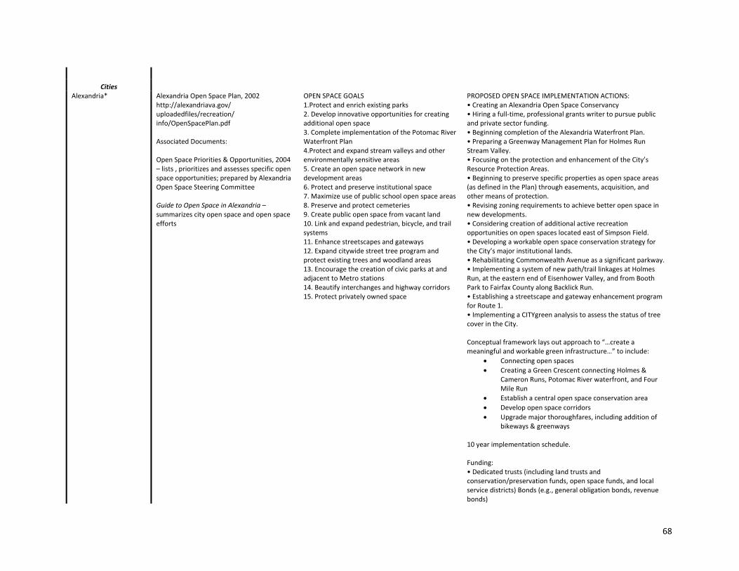
68
Cities Alexandria* Alexandria Open Space Plan, 2002
http://alexandriava.gov/ uploadedfiles/recreation/ info/OpenSpacePlan.pdf Associated Documents: Open Space Priorities & Opportunities, 2004 – lists , prioritizes and assesses specific open space opportunities; prepared by Alexandria Open Space Steering Committee Guide to Open Space in Alexandria – summarizes city open space and open space efforts
OPEN SPACE GOALS 1.Protect and enrich existing parks 2. Develop innovative opportunities for creating additional open space 3. Complete implementation of the Potomac River Waterfront Plan 4.Protect and expand stream valleys and other environmentally sensitive areas 5. Create an open space network in new development areas 6. Protect and preserve institutional space 7. Maximize use of public school open space areas 8. Preserve and protect cemeteries 9. Create public open space from vacant land 10. Link and expand pedestrian, bicycle, and trail systems 11. Enhance streetscapes and gateways 12. Expand citywide street tree program and protect existing trees and woodland areas 13. Encourage the creation of civic parks at and adjacent to Metro stations 14. Beautify interchanges and highway corridors 15. Protect privately owned space
PROPOSED OPEN SPACE IMPLEMENTATION ACTIONS: • Creating an Alexandria Open Space Conservancy • Hiring a full‐time, professional grants writer to pursue public and private sector funding. • Beginning completion of the Alexandria Waterfront Plan. • Preparing a Greenway Management Plan for Holmes Run Stream Valley. • Focusing on the protection and enhancement of the City’s Resource Protection Areas. • Beginning to preserve specific properties as open space areas (as defined in the Plan) through easements, acquisition, and other means of protection. • Revising zoning requirements to achieve better open space in new developments. • Considering creation of additional active recreation opportunities on open spaces located east of Simpson Field. • Developing a workable open space conservation strategy for the City’s major institutional lands. • Rehabilitating Commonwealth Avenue as a significant parkway. • Implementing a system of new path/trail linkages at Holmes Run, at the eastern end of Eisenhower Valley, and from Booth Park to Fairfax County along Backlick Run. • Establishing a streetscape and gateway enhancement program for Route 1. • Implementing a CITYgreen analysis to assess the status of tree cover in the City. Conceptual framework lays out approach to “…create a meaningful and workable green infrastructure…” to include:
Connecting open spaces
Creating a Green Crescent connecting Holmes & Cameron Runs, Potomac River waterfront, and Four Mile Run
Establish a central open space conservation area
Develop open space corridors
Upgrade major thoroughfares, including addition of bikeways & greenways
10 year implementation schedule. Funding: • Dedicated trusts (including land trusts and conservation/preservation funds, open space funds, and local service districts) Bonds (e.g., general obligation bonds, revenue bonds)

69
• Taxes and general fund money • Easements • Public and institutional grants • Operational support mechanisms (e.g., corporate support, volunteer programs) $.01/$100 of real estate assessment allocated to open space purchase and conservation easements ($2 million/year potential); city council must approve annually; Open Space Fund and Living Landscape Fund; conservation easements. GI Related Maps Current Open Space; Cultural/Historical Sites; Environmentally Sensitive Sites; Natural Resource Areas; Recreational Sites; Rivers & Streams; Open Space Vision; Open Space Opportunity Sites; Open Space Concept Plan (effectively a green infrastructure map); priority Actions Open space Classification Overview (‐open space inventory)
Fairfax*
Falls Church*
Manassas*
Manassas Park*
Towns
Aldie
Blumont
Clifton
Dumfries*
Hamilton
Haymarket
Herndon*
Hillsboro
Leesburg*
Lovettsville
Middleburg
Occoquan
Purcellville*
Quantico
Round Hill
Vienna*

70
* NVRC member

71
Watershed Plans
Title & Website Stream Restoration Riparian Buffer Restoration
Jurisdiction
Counties
Arlington* Chesapeake Bay Preservation Ordinance and Plan Ordinance Watershed Management Plan Chesapeake Bay Preservation Plan http://www.arlingtonva.us/ Departments/ EnvironmentalServices/epo/ EnvironmentalServicesEpoWatershedIntro.aspx#cbpp
http://www.arlingtonva.us/ departments/ EnvironmentalServices/ wpcp/StormSewer/ page73424.aspx Donaldson Run (Tribs A & B) Four Mile Run (Benjamin Banneker Park) Lower Four Mile Run Windy Run Little Pimmit Run Ballston Beaver Pond
Same URL as for Stream Restoration Donaldson Run (Tribs A & B) Four Mile Run (Benjamin Banneker Park) Lower Four Mile Run Windy Run Little Pimmit Run Ballston Beaver Pond
Fairfax* Chesapeake Bay Preservation Ordinance Stream Protection Strategy Watershed Management Plan
Individual watershed plans completed or in process for all county watersheds
Loudoun* Comprehensive Watershed Management Plan http://www.loudoun.gov/Default.aspx?tabid=2914 Predictive Wetlands Model
Cardinal Glen, eastern Loudoun (demonstration project)
Cardinal Glen, eastern Loudoun
Prince William* See under Comprehensive Plan, Environment, Polcy 5, above. Chesapeake Bay Preservation Area Overlay District & Map Watershed Plans & Studies: Bull Run Watershed Study 2010 Farm Creek and Marumsco Creek Watershed Management Plan 2009 Lake Montclair Sedimentation Control Feasability Study 2008 Powells Creek Watershed Management Plan 2008
Neabsco Ck. (Andrew Leith Park) Cow Branch
Powells Creek (Meadow at Barnes Crossing) Cow Branch
Cities Alexandria* Environmental Management Ordinance (ChesBay)
http://alexandriava.gov/tes/oeq/info/default.aspx? id=3824#ordinance
Fairfax* Watershed Management Plan
Falls Church*
Manassas*
Manassas Park*

72
Towns
Aldie
Blumont
Clifton
Dumfries*
Hamilton
Haymarket
Herndon*
Hillsboro
Leesburg*
Lovettsville
Middleburg
Occoquan
Purcellville*
Quantico
Round Hill
Vienna*
* NVRC member

73
Plans Urban Forestry Natural Resource Management Cultural Resources Management
Archeologically Important
Areas
Jurisdiction
Counties
Arlington* Urban Forestry Master Plan, 2004 (canopy goals: 40% o.a.; 50% suburban resitdential; 25% urban residential; 15% urban core) http://www.arlingtonva.us/ departments/ParksRecreation/ scripts/parks/UFMP_Final.pdf
Natural Resource Management Plan (Draft) May 2010, adoption expected fall 2010 http://www.arlingtonva.us/ departments/parksrecreation/ documents/file76445.pdf
Historic Preservation Master Plan, 2006 Historic resources and districts listed in Open Space Master Plan & Public Spaces Master Plan http://www.arlingtonva.us/ departments/CPHD/ons/hp/ file73804.pdf
Identification of sites called for in Historic Preservation Master Plan
Fairfax* Tree Action Plan
Natural Resources Management Plan Green Infrastructure Model (FCPA) & Green Infrastructure Priorities Map
Cultural Resources Management Plan
Comp plan calls for Register of Archeological sites.
Loudoun* Forest cover mapping & monitoring planned. Heritage Preservation Plan, 2009 http://www.loudoun.gov/ Default.aspx?tabid=574 Historic District Guidelines
Plan calls for identification of individual sites, use of predictive techniques.
Prince William* Comprehensive Plan, Environment, Policy 11 calls for establishment of an urban forestry plan
Cultural Resources section of Comprehensive Plan http://www.pwcgov.org/ docLibrary/PDF/11039.pdf Makes specific mention of viewsheds
Historic & Prehistoric Sensitivity Areas Map CR‐POLICY 5: Identify and preserve known (but ill‐defined) or expected prehistoric or historic resources through the application of standard archaeological modeling methods, reconnaissance level surveys, and use of appropriate maps and other documents.
Cities
Alexandria*
Fairfax*
Falls Church*

74
Manassas*
Manassas Park*
Towns
Aldie
Blumont
Clifton
Dumfries*
Hamilton
Haymarket
Herndon*
Hillsboro
Leesburg*
Lovettsville
Middleburg
Occoquan
Purcellville*
Quantico
Round Hill
Vienna*
* NVRC member

75
Trail Plans
Trail Plan Gen'l Connectivity Goals Nature‐based Rec. Goals Conservation Goals Trail Map/Networks
Jurisdiction
Counties
Arlington* No specific park trail plan; trails managed by individual parks. Public Spaces Master Plan (RSMP) discusses trails
PSMP Rec. 1.8 – Ensure River Access: Work w/ NPS to coordinate connectivity, creating trail extensions, multi‐use trails, bridges and parking as appropriate to allow for human access and wildlife corridor connectivity. Rec. 2.4 – Pursue the Use of Easements to Protect Natural Areas and Heritage Resources: The County should give top priority to easements or, if necessary, purchases that abut existing natural areas or would connect existing “islands” of natural habitat. The creation of protected corridors would aid the movement of wildlife and enable a more expansive system of trails for passive recreation. Rec. 2.7 – Develop and Implement a Green Infrastructure Plan: cites “recreation (trails)” as one element of GI. Rec. 3.2 – Update and Implement Trail Systems Management Identify the pportunities to make better linkages to the existing trail network, including natural resource and multi‐use trails
Rec. 2.3 – Preserve and Enhance Existing Natural Areas: provide sensitively‐designed trails to provide access for the public to enjoy.
Bikeways map
Fairfax* Countywide Trail Plan Map Loudoun* Greenways & Trails Policies,
1994 Recommends approaches to acquisition: Developers –proffers Land owners – easements, bequests, voluntary donations, leasebacks, remainder interest Revised General Plan, Chp. 5 Green Infrastructure,
Greenways & Trails Policies ‐ Goals:
Link neighborhoods & communities
Link towns From Revised General Plan:
Prepare and implement a Greenways and Trails Plan identifying desired … connections to neighboring urisdictions’ greenways and trails. Trails may include hiking, biking and equestrian trails.
From Revised General Plan: …link people to the area’s natural … resources
Greenways & Trails Policies ‐ Goals:
Protect rivers, streams, & watersheds
Protect ecologically critical & sensitive areas
Maintain & link wildlife habitats
Provide natural flood control, discourage channelization

76
Greenways & Trails See also under Open Space ‐ PRCS Strategic Plan 2010‐2015 (Draft)
Greenways and trails…will serve as a linking element in all policy areas to other components of the Green Infrastructure... The system should connect to existing trails like the Appalachian Trail in the Rural Policy Area and trails within towns and villages, and link people to the area’s natural, recreational, cultural, and commercial resources.
Lists specific trail priorities for and land acquisitions (through public purchase, proffer, density transfer, donation or open‐space easement) for trails & greenways listed.
Prince William* Trail Plan (from 2008 Comp. Plan, Parks, Open Space & Trails Plan)
A network of multi‐use trails will connect residential areas with county, state, and national parks, forests, and wildlife management areas, as well as with places of cultural and historical interest, schools, retail areas, and transportation nodes.
Trails Map
Cities Alexandria* See Open Space Plan (trails
treated as subcategory of open space) and Recreation, Parks, & Cultural Activities Master Plan
Connect parks and open space w/ 15 miles of new trails over next 10 years
See Open Space Plan, Fig. 26; also potential trail routes described in Open Space Priorities & Opportunities, Sec. III
Fairfax*
Falls Church*
Manassas*
Manassas Park*
Towns
Aldie
Blumont
Clifton
Dumfries*
Hamilton
Haymarket
Herndon*
Hillsboro

77
Leesburg*
Lovettsville
Middleburg
Occoquan
Purcellville*
Quantico
Round Hill
Vienna*
* NVRC member

78
Appendix D. Conservation Corridor Base Map Methodology

79
Green Infrastructure Center Inc.
TO: LAURA GRAPE, SAMANTHA KINZER – NORTHERN VIRGINIA REGIONAL COMMISSION (NVRC)
FROM: ALISA HEFNER, LUIS CARRASCO – GREEN INFRASTRUCTURE CENTER (GIC)
SUBJECT: METHOD PROTOCOL FOR DEVELOPMENT OF A GREEN INFRASTRUCTURE BASE ASSET MAP
DATE: MAY 17, 2010
CC: KAREN FIREHOCK, CASEY WILLIAMS
Green Infrastructure Base Assets Map Model for Northern Virginia Goals:
This model consists of a series of GIS operations to be conducted with selected datasets to identify green infrastructure base assets for Northern Virginia to be performed by the Northern Virginia Regional Council.
This regional scale model will focus on water resources conservation and will be complemented with wildlife conservation and other factors such as cultural resources conservation.
This model will use a variable approach based on developed and rural landscape types.
The methodology to inventory green infrastructure assets for the Northern Virginia Region is based on the following criteria:
o Identifying and incorporating water resources conservation assets
o Identifying and incorporating wildlife habitat conservation assets
o Identifying and incorporating other supplementary criteria provided by NVRC (e.g., cultural resources, local initiatives)
Steps: 1. Define and Identify Landscape Types (urban, suburban, rural)
Option A (Recommended): Use two landscape type classifications – urban and rural – and label urban lands “developed” to account for the variance of development density (dense urban to less dense suburban). Use land cover data to produce an approximation of developed and rural landscapes in the region because it would provide a more precise approximation than using census tract data to determine landscape types. This approach would require the following steps:
I. Reclassify urban/residential and commercial as one class (e.g., 1 or urban development), and the rest of the classes in the land cover dataset as another single

80
class (e.g., 2 or rural landscape). 2006 land cover data is available through Va Dept of Forestry and it is possible that more current data is available for the region. The most recent region-wide land cover data should be used.
II. Generalize urban and rural classes using a focal statistics (raster operation) with a “majority rule”. A recommended cell size output is between 100 m x 100 m and 250 m x 250 m. Using a larger cell size would overestimate rural areas and consequently underestimate urban areas in the region. The objective of this step is to generalize the urban areas into larger clusters that could be much more practical to work with at the regional scale.
III. Convert the resulting raster classes into polygons.
IV. Merge the resulting polygon dataset with the cities (and other large developed areas that might not be captured in city boundaries, e.g., Dulles airport) of the region to provide a more precise approximation of developed and rural areas for the region.
Option B: Use census tracts and population density data. A practical approach to identify different human landscapes is to use census tracts data classified by population density for the whole region. The USFS has developed the following breakdown for all continental states in the US for managing wildland and urban interface:
o Wildland: 8 or less per square mile
o Rural: 8-40 per square mile
o Mixed or Wildland Urban Interface: 40-400 per square mile
o Suburban: 400-1600 per square mile
o Urban: >1600 per square mile
Using the above categorization, a suggested breakdown for this region is:
Rural: up to 400 people per square mile
Developed: above 400 people per square mile
This classification can provide a coarse breakdown of landscape areas at the regional level that considers administrative units. However, the range of the population density classes could be revisited by NVRC to adjust to regional views or objectives. The Developed class breakdown is actually including suburban areas for simplicity purposes. Similarly, the rural class is including urban interface landscapes, again, for simplicity purposes. The main limitation of this approach is that pockets of development could remain hidden in large census tracts such as those covering rural areas which tend to be larger than tracts within urban areas. Alternatively, the NVRC can use smaller administrative units that contain population density data to identify smaller developed and rural areas. Option C: Incorporate city boundaries into urban classes defined by option B.

81
2. Develop Protected Lands Layer
Merge available datasets of protected and conserved lands to develop base asset of lands that are already protected. This layer will be an important component for network design and prioritizing conservation efforts in later phases of the project (for example: identifying links to existing conservation lands; expanding existing protected areas or increasing distribution of protected areas throughout region). This step would include the following datasets:
Existing Conservation Lands available from DCR
Existing Easement data available from DCR
Supplement state data with local protected lands data (nature-based parks, easements, etc) and resource protection areas (RPAs and other regulatory protection area if available).
Note: Consider distinguishing areas by level of protection or “least likely to change”. For example, state-owned land is least likely to be developed than a parcel with a conservation easement if the owner is willing to pay back taxes and take the land out of conservation. Note: Consider showing protected (or high priority) assets outside the region in adjacent counties and in Maryland. Avoid clipping assets to municipal boundaries, instead show the full extent of the assets screened back in areas outside the region. We will create a mask shapefile of all the counties/states outside the region and represent it with a white fill at 50% transparency.
3. Develop a stream network based on stream and watershed health
o Gather watershed and stream integrity dataset from VCU Center for Environmental Studies (aquatic resource integrity layer developed by VCU CES using INSTAR stream reaches). This dataset should be available for all VA. (The GIC team has made an initial request with VCU-CES that NVRC can continue to pursue)
o Intersect aquatic resource integrity layer with NHD datasets to identify streams and water bodies ranked by health integrity. It is possible that VCU has already performed this intersection and the dataset is available.
o From the intersection above, consider selecting the healthiest streams for network (top two ranks).
o This partial dataset can be supplemented with USFWS National Wetlands Inventory (if not already included in the stream reaches dataset). NVRC can determine whether to include all NWI wetlands as part of the network or only those wetlands that intersect buffered healthy streams identified in the previous step. If wetlands are included in the protected lands layer developed in Step 2, this step would be redundant.
o Rural landscape approach
The product of this intersection (stream and health integrity) could be buffered by 150 meters (300 meters total) to identify a healthy stream network that provide conservation corridor opportunities. Riparian buffers at this width provide

82
additional habitat for wildlife and pathways for animals to move across the landscape.
Evaluate additional healthy streams that connect to the Protected Lands layer for including in network.
Evaluate additional healthy streams that connect to key assets in surrounding counties or Maryland for including in the network.
o Urban landscape approach
It is likely that stream health will be compromised in urban areas and an alternative approach will be needed. While the areas generated using the Aquatic Integrity Resource dataset could help identify water resources conservation assets in rural areas, the PCA could be used in developed areas to identify and prioritize urban stream corridors. The coverage extent of the PCA is also more consistent with the extent of developed areas.
Determine best buffer width for streams.
- Option A - buffer streams by 100 feet (minimum requirement under Chesapeake Bay Act) for filtering runoff and addressing nutrient loads.
- Option B - buffer streams based on stream order. Example: 30 m for streams of 1st order, 60 m for streams of 2nd order, 90 m for streams of 3rd order and above. These buffer distances were used in the Aquatic Integrity Resource integration step of the PCA model.
Use the PCA to prioritize urban stream corridors. Buffered stream reaches that consist of a majority of high priority PCAs will become part of the network (in lieu of health indicator used in rural areas).
V. Consider clipping forest canopy by buffered stream layer (for both developed and rural areas) to represent those streams with existing forested buffers. This layer can be used in later phases of the project to show gaps in the riparian network and opportunities for restoration.
VI. Validation: develop base maps and share with GIC team for internal review.
4. Incorporation of Wildlife conservation core elements
o Intersect buffered streams (from Step 3) with VaNLA cores to extend network and capture habitat nodes along stream network
o Rural landscape approach
Integrate high value VaNLA cores (C1-C4) to the partial model and other cores within 1 mile of protected lands to identify opportunities to enhance conservation cores and to identify potential stepping stones for the conservation corridors.

83
o Urban landscape approach
Integrate all VaNLA cores to the partial model
o Incorporate Landscape corridors (from VaNLA), add as is for both rural and developed areas. The corridors identify opportunity for linking landscapes based on landscape features and should be identified as opportunities not existing corridor assets.
VII. Validation: develop base maps and share with GIC team for internal review. Recommend representing assets identified in Step 2, 3 and 4 as one color as these features combined represent the green infrastructure network. This network can be used a base map layer for overlaying additional themes of regional importance (cultural assets, recreational assets, heritage tourism, working lands, and risks and opportunities).
5. Incorporate cultural resources elements
o Rural and Urban Landscape: add features representing cultural conservation elements (points, polylines, polygons). Only features dependent on rural viewsheds or landscape context should be included (battlefields, large historic sites). Historic buildings within the urban context would not need to be added to the base green infrastructure asset map since they are not landscape context sensitive.
6. Incorporate other priorities
o This section will be updated based on any input from the stakeholder meeting on May 21, 2010.
7. Guidance for implementation at the local level
o The project team will develop this section and submit to NVRC by second stakeholder meeting tentatively scheduled for June 2010.

84
Appendix E. Draft Agenda for Public Summit

85
CONSERVATION CORRIDORS IN NORTHERN VIRGINIA Public Summit
Week of June 13, 2011 6:30 – 8:30 p.m. Location TBD
AGENDA ‐ First Draft Registration with Static Orientation Station
Base Map & “Conserved Lands” Maps with poster explanation Slideshow Presentations (30 mins)
Background on Green Infrastructure & Conservation Corridor Project (GIC/NVRC; 15 – 20 mins)
Ways to Conserve (possibly NVCT; 10 – 15 mins) Breakout Stations (15 – 20 minutes per station, blow train whistle to rotate) OPTION 1: Base Map and Theme Map at each station:
Base + Water Resources
Base + Agricultural Resources
Base + Nat‐based Recreation
Base + Known Cultural Resources o Maybe combine NBR and KCHR into a Favorite Places Station
1. Draw the things that are related to GI 2. Combo of NBR and KCHR maps – places that they like to visit or recreate 3. Record on flip charts why it’s a favorite spot 4. Include a “Conserved Lands” Map
OPTION 2: Have multiple Favorite Places Stations with other maps as references
Draw the things that are related to GI
Combo of NBR and KCHR maps – places that they like to visit or recreate
Record on flip charts why it’s a favorite spot
Include a “Conserved Lands” Map

86
Appendix F. Northern Virginia Conservation Corridors Presentation
1
Conservation Corridors in Northern Virginia
Laura Grape, Senior Environmental PlannerSamantha Kinzer, Regional Planner

2
Thanks to Our Partners!
This project is funded in part by the Virginia Coastal Zone Management Program at the Department of Environmental Quality through Grant #NAO9NOS4190163 and #NA10NOS4190205 of the U.S. Department of Commerce, National Oceanic and
Atmospheric Administration, under the Coastal Zone Management Act of 1972, as amended.

3
Presentation Overview
• Northern Virginia: Challenges and Opportunities
• Conservation Corridors Planning in Northern Virginia
– Our Process
– Our Maps
• Next Steps

4
Northern Virginia
• 1,340 square mile area situated across the Potomac River from the nation's capital
• Comprising the Virginia portion of the Washington, DC, MSA
• Contains four counties, five cities and fourteen towns

5
Projected Growth
• Northern Virginia has been growing by about 35‐38,000 people per year, on average, for more than 30 years
• By 2020, its population will reach 2.5 million
• Population growth is equivalent to adding a new county every eight years, with a population equivalent to the number living in Loudoun today—about 300,000
• Pace of growth has continued for more than 30 years
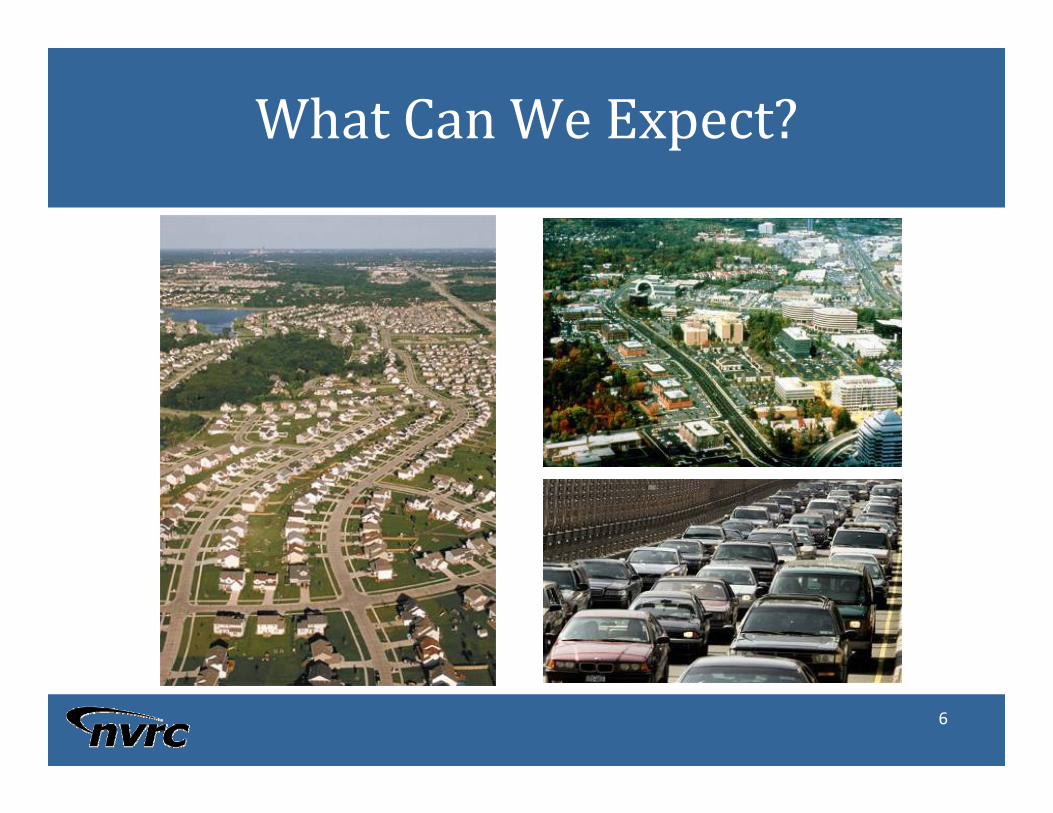
6
What Can We Expect?

7
Conservation Corridor Planningin Northern Virginia
Work collaboratively to:
– Refine state analyses using local data and priorities.
– Identify & map high value cores and corridors across the region.
– Highlight opportunities for regional connections.
– Quantify benefits of these areas.
– Develop model language for incorporation of GI/CC into comprehensive planning efforts.
– Develop communication products and strategy for promoting conservation opportunities to elected officials and the public.

8
The Process
PHASE I
• Initiate working group
• Develop draft maps
• Construct draft policy language
PHASE II
• Expand public participation
• Finalize maps
• Determine how best to refine at the local scale

9
Working Group
Northern Virginia Conservation TrustTown of Vienna
Northern Virginia Urban Forestry RoundtableTown of Quantico
Prince William Conservation AllianceTown of Purcellville
Northern Virginia Regional Park AuthorityTown of Occoquan
US Marine Corps ‐ QuanticoCity of Manassas Park
U.S. NPSTown of Leesburg
Maryland DNRCity of Falls Church
Virginia DOTCity of Alexandria
Virginia DCRPrince William County
Stafford CountyFairfax County
US Army – Fort BelvoirCity of Manassas
U.S. FWSTown of Herndon
U.S. BLMCity of Fairfax
Virginia DOFTown of Dumfries
Metropolitan Washington COG Loudoun County
Town of CliftonArlington County

10
Phase I
Develop potential policy language. Identify opportunities to integrate into planning initiatives. Sep 24, 2010
May 21, 2010 Informational meeting. Introduce green infrastructure planning, and the Conservation Corridor Planning in Northern Virginia project.
Jul 8, 2010 Review and truth draft base map. Identify types of assets and thematic maps of common interest. Identify unique assets.
Aug 20, 2010 Reach consensus on revised base maps. Identify priority conservation areas based on thematic overlays. Discuss policy opportunities and gaps.
Discussions with Prince William County’s Planning Commission

11
Phase II
Submit Final Report to Virginia Coastal Zone Management ProgramNov 2011
Continue implementation strategy discussion and next stepsSep 2011
Review outcomes from the summit; Review draft report outline; Review finalmaps; Continue implementation strategy discussion; Continue identifyingpossible pilot projects and funding opportunities
Jul - Aug 2011
Host public green network summitMay – Jun 2011
Review thematic maps, identify key areas for conservation. Discuss promotion of green network summit – roles & responsibilitiesMar 2011
Coordinate resource-specific group meetings to refine thematic mapsJan – Feb 2011

12

13
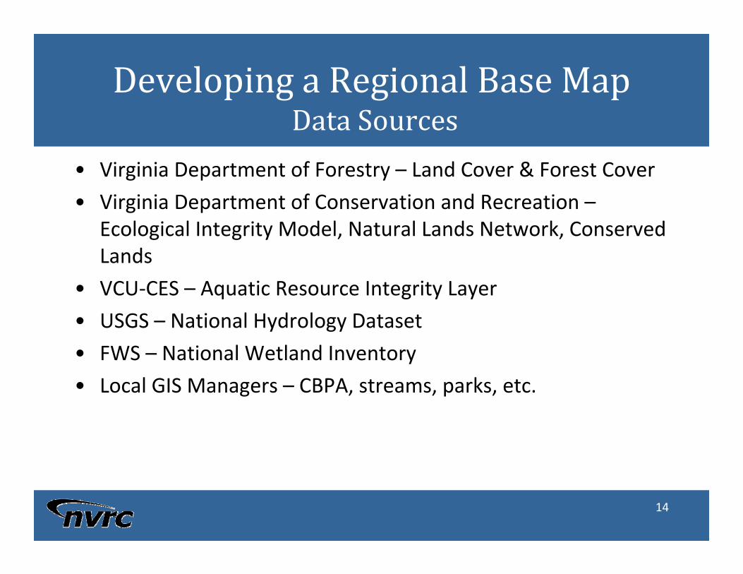
14
Developing a Regional Base MapData Sources
• Virginia Department of Forestry – Land Cover & Forest Cover
• Virginia Department of Conservation and Recreation –Ecological Integrity Model, Natural Lands Network, Conserved Lands
• VCU‐CES – Aquatic Resource Integrity Layer
• USGS – National Hydrology Dataset
• FWS – National Wetland Inventory
• Local GIS Managers – CBPA, streams, parks, etc.

15
An example of a cross‐countyopportunity
DRAFT

16
845 acres
206.2 acres of Tier 1 Habitat
DoI = 300 acres
4 Elements of Occurrence
LoudounCounty
FairfaxCounty
6,292,791 cu. ft($37,756,749)
Cu. Ft of Stormwater Retained (estimated)
42,539
331
Tons of Carbon Stored
Tons of Carbon Sequestered
99,578($266,616)
Lbs of Air Pollutants removed
83.8 percent(988.6 acres)
% Tree Canopy
17
Next Steps&
Enlarged Participation

18
Theme Map Development
Prime Ag SoilsAg-Forestal DistrictsAgri-tourism locations
WineriesPick-your-own
VA Tech Co-op ExtensionRural EDAs?Virginia DOFUSDA?PEC
Agriculture
Maintain Rural Heritage
Historic Districts and SitesBattlefieldsPre-historic RoadsPre-historic SettlementsHistoric Estates (i.e. Mt. Vernon, Oatlands)American Indian LandsHighway Markers
Cultural Heritage Resource ManagersArcheologistsBattlefield Preservationists?NPS – Manassas
Landscaped-based Cultural Heritage
Historic Resources
Regional TrailsNature PreservesParks for Passive Recreation Important Birding Areas (?)Birding and Wildlife TrailsScenic Rivers / BluewaysPublicly accessible Conservation Lands
(WMAs, etc)Boat ramps (?)
Open Space ManagersNatural Resource ManagersPreserve ManagersPark ManagersNaturalists
Nature-Based Recreation
Wildlife HabitatSignificant Flora and Fauna
WatershedsStream QualityDrinking Water Sources, including Reservoirs
and recharge areasWellsCommunity WellsImpaired Streams (DEQ)
Environmental PlannersWater Resource EngineersEcologistsStream Monitoring Project Managers
Water Quality
Restoration OpportunitiesDrinking Water Protection
Possible Datasets*Possible ParticipantsTheme
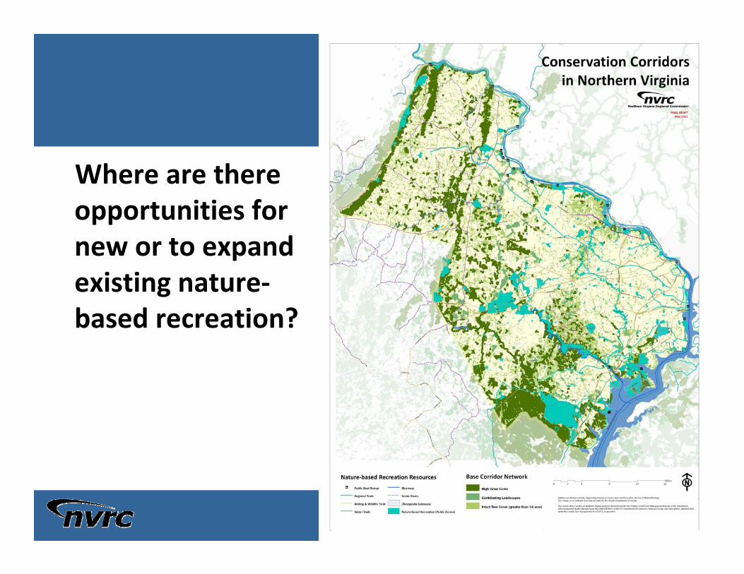
19
Where are there opportunities for new or to expand existing nature‐based recreation?

20
Opportunities for Enhancing & Protecting Water Quality
– Streams
– Drinking Water Sources
– Wells

21
Opportunities for Enhancing & Protecting Water Quality
– Streams
– Drinking Water Sources
– Wells

22
Opportunities for Conserving Our Cultural Heritage
– Historic Sites & Districts
– Battlefields

23
Opportunities to highlight the region’s best agricultural lands

24
CONSERVATION CORRIDORS IN NORTHERN VIRGINIA
Public Summit
Week of June 13, 2011
6:30 – 8:30 p.m.
Location TBD

25
Thank You! Questions?
Laura Grape
Sr. Environmental Planner
703‐642‐4625
Samantha Kinzer
Regional Planner
703‐642‐4636