NORTH WATERFRONTPARK - Wilmington, North Carolina
48
Development Master Plan NORTH WATERFRONT PARK February, 2016 “North Waterfront Park” is a temporary name for Wilmington’s newest open space in the northern riverfront area of downtown.
Transcript of NORTH WATERFRONTPARK - Wilmington, North Carolina

Development Master PlanNORTH WATERFRONT PARKFebruary, 2016
“North Waterfront Park” is a temporary name for Wilmington’s newest open space in the northern riverfront area of downtown.

2NORTH WATERFRONT PARKDevelopment Master Plan
Master PlanPreview
Public Input Survey Results: Top 10 Park Elements
Greenspace/Lawn
Performance Space
Gardens
Water Feature
Playground
Natural Area
Shade/Trees
Festival space
River Access
Art
1
6
2
7
3
8
4
9
5
10
Harn
ett St.
Nutt St.
Old Front Festival Street
Nutt St.Cow
an S
t.
1
2
3
5
8
7
9
10
4
68
3NORTH WATERFRONT PARKDevelopment Master Plan
Additional Resources to Inform the Park Design(Included as an Appendix to this Plan)
Design Cues• Historic Photographs• Sanborn Maps• Site Photos• Park Precedent Studies• Public Comments
Technical Data• Brownfields Agreement• City Survey• Deeds & Easements• Letters of Agreement
Relevant Plans & Studies• Vision 2020: A Waterfront
Downtown Plan• Parks and Recreation
Open Space Master Plan• Evaluating Postindustrial
Urban Waterfront Redevelopment in Downtown Wilmington’s Northern Riverfront District (Design Study)
• Create Wilmington Comprehensive Plan
Table of Contents
Project TeamCity of Wilmington Staff
Amy Beatty, Supt. of Parks and Recreation, Project ManagerAllen Davis, Urban DesignerSteve Harrell, Director of Community ServicesMike Kozlosky, Executive Director, WMPOMike Naklicki, Sr. Construction Project ManagerRyan O’Reilly, Parks, Landscape and Urban Forestry Manager Bethany Windle, Landscape Designer and Planner
City of Wilmington Leadership
Sterling Cheatham, City ManagerTony Caudle, Deputy City Manager Richard King, Deputy City Manager
City Council
Bill Saffo, MayorMargaret Haynes, Mayor Pro-TemNeil AndersonPaul LawlerKevin O’GradyCharlie RivenbarkEarl SheridanLaura Padgett (former member)
Document Purpose .................................................................................................................4Site Location & Project Introduction .......................................................................................4Goals of the Park .................................................................................................................6Overview of the Planning Process ..................................................................................8History of Site ......................................................................................................................... 17Environmental Conditions .........................................................................................................20Context of Surrounding Development & Area Assessment ....................................................21Relationship to Surrounding Sites & Redevelopment Concepts ......................................... 24Urban Design Framework for the Park .............................................................................26Park Program ............................................................................................................................27 Park Design ..................................................................................................................28Economic Impact ..........................................................................................................46Funding Strategy .......................................................................................................47

4NORTH WATERFRONT PARKDevelopment Master Plan
“I can imagine a day in the life of this park...as the sun rises some runners, dog walkers, and maybe a few people doing some tai chi or yoga are enjoying the space. As the day progresses a family with kids are running and playing, maybe climbing over the big art structures and having lunch. A boater docks and strolls down to a nearby shop or restaurant. A free band or movie is being set up for the evening concert or showing and maybe on another corner a small wedding ceremony is being set up.” -Community Comment
Site Location & Project IntroductionOn November 19, 2013, the Wilmington City Council voted unanimously to purchase 6.63 acres of property for a passive park on the northern downtown waterfront. The $4.1 million dollar park was purchased through a combination of general fund dollars and capital project balances. The urban park fulfills a long-held goal to provide a sizable open space for residents, employees and visitors to downtown Wilmington.
Park Site
Document PurposeThe purpose of this document is to guide the detailed site planning of the future waterfront park (currently called “North Waterfront Park”) in downtown Wilmington, NC. This will be the essential tool used by planners, landscape architects, engineers and others to ensure the desires of elected official and the general public are integrated into the constructed park. This plan will also be used to coordinate the park with surrounding development sites, attract additional funding, and determine programming and maintenance needs. This plan is a guide to creating a successful public park in an urban mixed-use district.

5NORTH WATERFRONT PARKDevelopment Master Plan
A Unique Place
The site is located along the Cape Fear River among an emerging mixed-use district. It is bound by a newly-constructed section of the Riverwalk, a pump station, and several sites available for high-density urban development. The new park will bring all of these places together as a legible district.
Site photos of the park land and the Riverwalk.

6NORTH WATERFRONT PARKDevelopment Master Plan
Goals of the ParkUnmet Needs
The City of Wilmington is expected to grow by 56,000 people in the next 35 years. Much of this growth is projected to occur in walkable areas such as downtown Wilmington. As the core of downtown Wilmington is largely built-out, growth downtown is expected to occur in the northern district where the park is located.
Existing parks in central downtown largely consist of pocket parks between .10 acres and 1.5 acres and cannot adequately serve the recreational needs of downtown residents, workers and visitors. Downtown Wilmington lacks sufficient children’s play areas. The closest playground to North Waterfront Park is .53 miles away mapped on GIS and .9 miles by road. It is farther than a 10 minute walk. The closest green space or lawn suitable for casual recreational use one mile away from the site.
The area around the park is expected to become a high density residential neighborhood that will need a recreation area to serve it. A 278-unit apartment complex bordering the park on the
north side and a 305-unit residential complex to the south will begin construction soon. The Upper and Lower Northside Communities, located within a half mile and one mile from the park respectively, are low income neighborhoods with under-served young families and minorities. The Brooklyn Arts District is a revitalized area mixing residential uses with restaurants, bars, art and concert venues and is located within a mile of the park. A new 112-unit apartment building in this neighborhood was just recently constructed. The current “monument”-type parks in these areas which are less than one acre in size cannot accommodate recreation uses.
In addition to serving the recreational needs of current and future residents, the park is expected to serve as a central gathering space for the community at-large. In fiscal year 2013, 45 different special events took place in downtown Wilmington including concerts, markets, races, rallies, and parades. With no dedicated public venue to host these events, organizers and City staff are forced to use streets and parking lots
to accommodate the events. This presents a challenge logistically and has the potential to interrupt commerce due to the associated street closures. In fiscal year 2013, downtown streets were closed 72 times to accommodate special events. (Some of the 45 events were series events.) Developing a community gathering space to hold these events is a more sustainable approach.
While enhancing the neighborhood’s quality of life and meeting the recreational needs of the community at large, it is expected that the park will also provide an economic benefit to Wilmington by serving as the central amenity to the developing northern downtown district and positively impacting property values. Since the park is easily accessible to a nearby parkway and highway, it is projected to host major community events that should spur spin-off economic activity to downtown businesses. The park is also expected to boost bookings at the Wilmington Convention Center, located near to the park.
“Park first.”This was the primary design objective for Nashville, TN as they developed their riverfront park and performance space. The result is a public park which provides a world-class amphitheater and successfully meets the open space needs for their downtown.

7NORTH WATERFRONT PARKDevelopment Master Plan
Recommendations from Adopted Plans
Acquisition and development of a park along the northern downtown waterfront is identified in Wilmington Vision 2020: A Waterfront Downtown Plan, (Vision 2020). Two of the plan’s key objectives are:
• Preservation of historic and natural resources
• Promotion of public spaces for civic and leisure activities
Vision 20/20 notes downtown open spaces are missing. Recommended actions include activating the water’s edge with open space. The plan also specifies a new city park adjacent to the Isabelle Holmes Bridge which is the area where the North Waterfront Park is located.
The Parks, Recreation and Open Space Master Plan 2010-2015 recommends land acquisition for public parks at the north and south ends of the Riverwalk near the Holmes Bridge and Memorial Bridge respectively.
Assessing unmet needs, reviewing plan recommendations, utilizing public input and identifying best practices of successful urban parks shaped the paradigm for the North Waterfront Park which is that it become a lush and vibrant, intensely-used world-class park predicated on a design of outdoor rooms that promote safety, versatility of use and innovation that honors Wilmington’s past as working waterfront.
Key Objectives for the Park
• Ensure a safe, clean comfortable park for citizens and visitors
• Showcase Wilmington’s history and identity as a port city
• Maximize opportunities to engage with the Cape Fear River
• Ensure the park is accessible to pedestrians, cyclists and drivers
• Provide a versatile performance space that is usable for programs and casual use when events are not scheduled
• Be able to host large community events, like concerts and special celebrations
• Create a vibrant, passive space that provides for “intense casual use”
• Create a number of small areas (outdoor rooms) that will accommodate a variety of uses
• Minimize the use of park land for parking
• Encourage neighboring buildings to fit with the park through pedestrian-friendly uses and good urban design
“I’ve been hoping for this! It’s going to be awesome!”
-Community Comment

8NORTH WATERFRONT PARKDevelopment Master Plan
Overview of the Planning ProcessIntroduction
Concurrent to park planning, a public engagement campaign was implemented. The campaign was launched at a public meeting held on May 22, 2014 at City Hall. Though public input for the planning phase concluded on December 31, 2014, citizen and stakeholder feedback will continue throughout the design phase and beyond. The campaign centers on a multifaceted program to:
• Inform, educate and engage the public about the purpose of the property acquisition and the park development process
• Facilitate the acceptance of input and feedback on park design and development design
• Disseminate information following park development.
Intended Goals for Public Engagement
To complete the North Waterfront Park design using an open, transparent and inclusive planning process that conveys the intended purpose of the park and its benefit to the community, and provide an opportunity for citizens to give feedback on what aspects of a downtown passive park are most important to them.
Create an awareness and understanding of the importance of urban parks and open space to the sustainability and livability of the community and to educate the public and elected officials on funding alternatives recommended to implement park development.
1
2 The public engagement campaign involved an electronic survey, public meetings and presentations to stakeholder groups.
“This space is much needed. Thanks for planning and taking the time to get community input.”
-Community Comment

9NORTH WATERFRONT PARKDevelopment Master Plan
Public Input Strategies
Social Media
The City utilized its current platforms which include its websites, Facebook pages, twitter and Instagram accounts in order to provide up-to-date information about the planning process and drive people to complete the public input survey. These avenues serve as a repository of information about the project and provide the most current information about the planning process, public meetings, background information, interim reports and links to the survey.
Conduct Stakeholder Interviews
City staff believes that an understanding of the project’s objectives by external stakeholders is essential to the successful development of the North Waterfront Park. In an effort to receive stakeholder input, City staff conducted interviews with identified key groups which included the Chamber of Commerce and Cape Fear Future, the Wilmington Convention Center, Wilmington Downtown Incorporated, the Wilmington Housing Authority and concert promoters/festival organizers.
Attendance at Public Events
City staff attended public events to disseminate information regarding project development. Tables were hosted by City staff during public events providing background material and asking citizens and visitors to complete the project survey. Attended events included the Penguin Music Festival,Wilmington/New Hanover County Safety Expo, Riverfest, and Fire in the Pines Festival. Feedback from attendees at these types of events is viewed as critically important as the audience demonstrates diversity in age, residence, and income.
Displays at Recreation Facilities
Staff posted exhibits and made available project brochures at various recreation facilities including the Althea Gibson Tennis Complex, Fit For Fun Center, Boxing and Fitness Center, and Martin Luther King Community Center. As is noted with having a presence at community events such as festivals, gaining input from customers at these recreation facilities represents a divers cross-section of the citizenry.
The planning and design process for the new park was established very soon after it was purchased. This plan represents the completion of the third phase.
1
2
3
4

10NORTH WATERFRONT PARKDevelopment Master Plan
“I would love to see Wilmington support fitness at this park.”
“Restaurants with outdoor seating overlooking the park would be great!”
“The park should have good evening lighting and a walk/run track around the outside...”
Mayor Bill Saffo
Community Members
Area Employees
Event Promoters
City Staff
Downtown Residents
Civic Groups
Landscape Architects
Business Leaders
Elected Officials
“Make it safe and welcoming. People like being near the water, incorporate the water into the park”
A large public open house was held in May of 2014 to capture ideas and concerns about the future park.
Community Comments
Provided here are a few of the many actual comments received from the public engagement campaign’s electronic survey and public input meetings.
Positive, constructive and forward-looking comments were chosen to be shown here. Optimism and cooperation are essential to keep Wilmington moving forward.
City Manager

11NORTH WATERFRONT PARKDevelopment Master Plan
“We need to betterutilize and highlight our riverfront and create a reason for people to spend time downtown.”
“Give young families more of a reason to come downtown! Our area is lacking concert facilities.”
“I think it should be kept simple. I personally do not like going to the beach in the summer. I see the park as a large, well kept, grassy space to take dogs, kids, etc. as a alternative to crowded beaches.”
“...a nice space to read a book and people watch and watch the world move by, or to take a grand child to watch the boats and the river.”
“A flexible amphitheater venue that could attract headline bands such as those at Red Hat in Raleigh.”
“Build something that has culture and class.”
“I would like to see lots of benches, so one can sit and gaze at the beautiful river. A playground should be built but it should be small. It should be designed in such a way that adults can watch the children and enjoy nature, at the same time.”
“This is a great opportunity to increase the quality of life for Wilmington and the entire Cape Fear area.”
“Make it something timeless, but creative. We have to find a cool way to draw people there, but not make it look weird or tacky.”
“Please think of the people who live and work downtown everyday, not just tourists.”
“Gardens, flowers with visual and smell and textures. Things that involve as many of the senses as possible.”
“I work in PPD building and I have a view of this particular space. It could really make a huge difference in the overall attractiveness of our downtown if this were a beautiful riverfront park.”
“The passive park concept is wonderful. It will be a great addition to our city and keep us on top of the best waterfront list. But where can people park their cars?”
“By replanting some native plants here and along the banks bordering the bridge, a significant contiguous habitatcould be recreated for birds and other animals for all to enjoy.”
“Put some thought into how families reachthe park easily with all the gear needed to stay a few hours.”
“It’s a great location with a fantastic view - please carefully consider the layout so as not to diminish or obstruct theview.”
“It is really important to keep in mind our citizens with disabilities. Please make this park universally accessible for everyone.”
“I think some open space for events, concerts or playing Frisbee, etc are good, but please, please, please plan for large native shade trees.”
“I like that it will connect to the river walk. Also, downtown workers would have another alternative to get outside for their breaks.”
“Summertime will require lots of shade to make this park useful. Without shade, it would be difficult to take kids and older visitors too.”
“It would be nice for downtown to have a place where people could use some lawn to picnic and relax but still be very close to down town.”
“The kids play area should be an extension of the river habitat, rather than a piece of commercial equipment you wouldfind in any other park.”
“...Please plan for largeshade trees. There are very few public spaces in downtown Wilmington, that can accommodate large trees - thisshould be such a place.”
“It would be nice to have a place for plays and bands to perform and people to sit on the grass or in shade to watch performances. A splash feature would be cool, too. Maybe a concession feature for when there are events.”
12NORTH WATERFRONT PARKDevelopment Master Plan
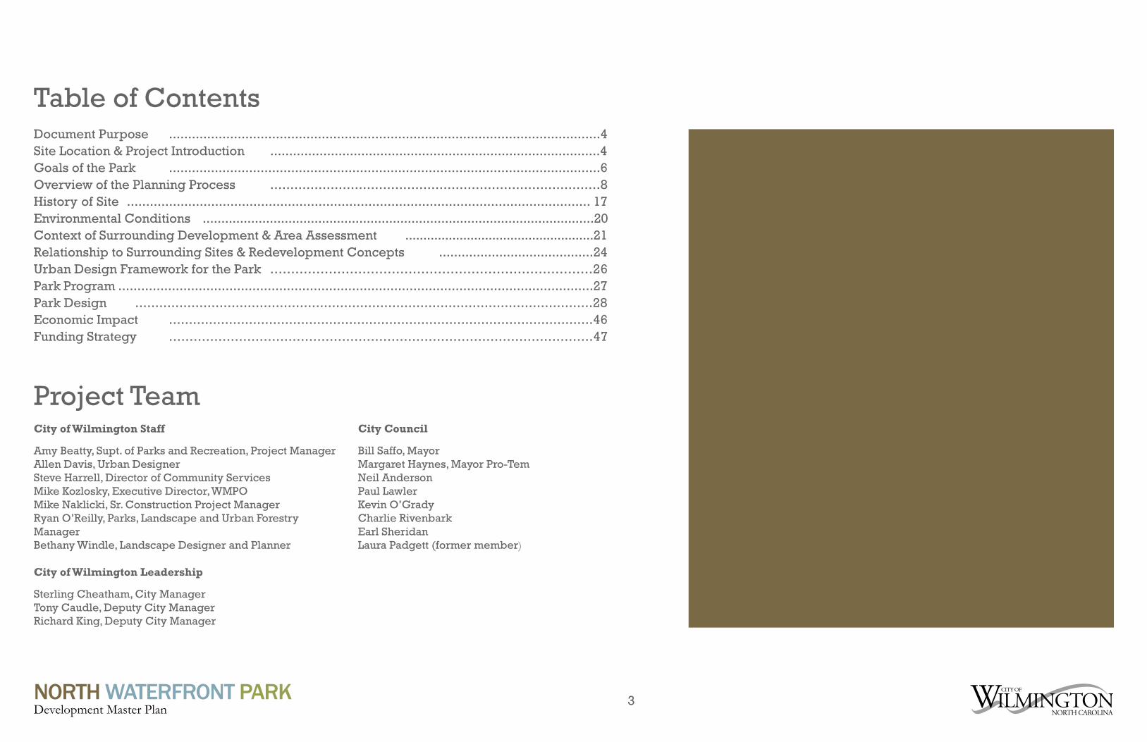
Survey Respondents Age
Survey Respondents Connection to Downtown
Concern:Survey respondents want ample parking to access the park and other amenities in the district.
Concern:Survey respondents don’t want a place for undesirable or criminal activity to occur.
Solution: Using Crime Prevention Through Environmental Design (CPTED) principles, the park design addresses access and visibility concerns and uses active urban edges to provide eyes on the street through open public viewsheds.
Public Input Survey Results: Top 10 Desired Elements
Public Identified Concerns: Parking and Crime
Greenspace/Lawn
Performance Space
Gardens
Water Feature
Playground
Natural Area
Shade/Trees
Festival space
River Access
Art
1
6
2
7
3
8
4
9
5
10(See page 21 for more information about how structured parking and CPTED solutions have been implemented into the park and surrounding district development framework.)
(See page 25 to see how this information is used in the park program.)
Solution: No portion of the park will include surface parking other than on-street. Structured parking in adjacent development sites will be used to allow visitors to park vehicles and enjoy park amenities.

13NORTH WATERFRONT PARKDevelopment Master Plan
Good Examples as Stated by the Community
Waterfront Cities• Chattanooga, TN• Austin, TX• Baltimore, MD• Buffalo, NY• Savannah, GA• San Antonio, TX• Charleston, SC• Seattle, WA• New Orleans, LA• Chicago, IL• Philadelphia, PA• Beaufort, SC• Louisville, KY• San Diego, CA
Specific Parks• Red Hat Amphitheater
(Raleigh, NC)• West Riverfront Park &
Ascend Amphitheater (Nashville, TN)
• The Yards Park (Washington, DC)
• Peace Center (Greenville, SC)
• Brooklyn Bridge Park (Brooklyn, NY)
• Millennium Park (Chicago, IL)
• Battery Park (Charleston, SC)
• Bryant Park (New York City, NY)
• Boston Public Gardens (Boston, MA)
• Piedmont Park (Atlanta, GA)
Park Examples
The project team conducted various site visits and precedent studies throughout the planning process. Lessons have been taken from other cities and places and will inform the design and program of Wilmington’s future waterfront park.
The following open spaces were studied by the project team and presented to the public for review during the public engagement campaign:
• Discovery Green (Houston, TX)• Waterfront Park
(Charleston, South Carolina) • Henry Chambers Park
(Beaufort, South Carolina)• Pack Square Park
(Asheville, North Carolina)• City Center Park
(Greensboro, North Carolina)• Ellis Square (Savannah, Georgia) • Waterfront Park
(Louisville, Kentucky)
During the course of the public engagement campaign, two additional sites were identified for their exemplary use of specific features: Peace Center
in Greenville, South Carolina was explored firsthand by city planning staff for its use of an outdoor stage along a waterway and The Yards park in Washington, DC was examined for its use of a popular water feature.
A key precedent site was added after the public engagement campaign was closed, due to its exemplary success in combining a waterfront park with a large event facility. This park, Nashville’s West Riverfront Park and Ascend Amphitheater, was visited and studied by members of the project team. Team members met with civic leaders, designers and other members of the Nashville team to gain insights and lessons learned.
Community members and local design professionals mentioned several example cities and sites during the public engagement campaign, all of which have been reviewed by the project team in some capacity. (These cities and sites are listed in the sidebar on this page.)
The boardwalk in the park offers a bike and pedestrian connection along the perimeter of the park with views from downtown to the Cooper River.
Waterfront Park, Charleston, SC

14NORTH WATERFRONT PARKDevelopment Master Plan
West Riverfront Park & Ascend Amphitheater (Nashville, Tennessee)
This is the most successful example of a park that has incorporated a first-class performance venue in a way that effectively positions the park to host A-list performers, stimulating economic impact. The performance space does not compromise other park amenities. During development Nashville’s Mayor at the time, Karl Dean, so emphasized that the project was first and foremost a park that a project motto, “Park First” emerged.
Henry Chambers Park(Beaufort, South Carolina)
Henry Chambers is Beaufort’s go-to park for festivals and large-scale community events. The waterfront Park demonstrates the concept of “outdoor lawns” by segmenting areas with various landscape, paths and plazas featuring play areas and event lawns. The park flows in a permeable way with surrounding commercial development. The design allows for the park to serve as the “front yard” for adjacent restaurants and other retail stores.
Pack Square Park(Asheville, North Carolina)
A great lawn anchors this urban park that hosts festivals, weddings and major civic events. Sculptural art is prominently displayed. The park was thoughtfully designed to connect park pathways with sidewalks and city blocks. Development of the park spurred a variety of adjacent land uses and investment.
Waterfront Park(Charleston, South Carolina)
Charleston’s waterfront park is located along an urban riverfront. It contains interpretive features that teach about the City’s past. A main focal point is a large water feature, an elevated splash plaza. The park has lawns and lots of trees and shade. Shaded pedestrian entrances connect to the city grid and the nearby city street extends out into the water with a large pier. The tree-lined edge along buildings are used for walking and sitting in the shade. There are also plenty of ledges and benches for seating.
Discovery Green(Houston, Texas)
Called “Houston’s new backyard,” Discovery Green is a citywide amenity that has supported the growth in downtown residents as well as major real estate investment in the surrounding area. Amenities include two event areas, 11 gardens, 4 water features, stage, playground, putting green and outdoor library reading rooms. All parking is serviced by an adjacent parking garage. Discovery Green is located by the edge of downtown, near the city’s convention center. It has a large performance space surrounded by lawns and gardens designed for both programmed and casual uses.
Primary Example Parks
Detailed analysis of some example parks can be found in the appendix.

15NORTH WATERFRONT PARKDevelopment Master Plan
Detailed analysis of some example parks can be found in the appendix.
City Center Park(Greensboro, North Carolina)
Situated in a revitalized area of downtown Greensboro, this urban oasis is enjoyed both casually by downtown workers and residents but is also highly programmed. Interactive water features, movable chairs, large shade structures and trees define the park. The development of this park is a great lesson in leveraging public space to spur redevelopment.
Ellis Square(Savannah, Georgia)
Ellis Square catalyzed surrounding development along all sides of the park, with new buildings facing the park. It features outdoor rooms separated by paths, a splash area and contemporary, movable seating/park furniture.
Waterfront Park(Louisville, Kentucky)
Situated on the Ohio River, this large-scale park can host a variety of large scale events at one time. A water feature, visitor center, tree groves and kids play area are linked by lawns and pathways. The pathways are both straight lines and organic shapes and connect the city to the waterway.
Peace Center(Greenville, South Carolina)
Falls Park was part of a redevelopment plan that completely transformed South Main Street in downtown Greenville. By converting a vehicular bridge to a pedestrian bridge, residents and visitors finally had access to the Reedy River, creating new recreational opportunities and connections. The park provides different areas to maximize programming opportunities. On a given night, people are enjoying a performance at a small amphitheater while a large-scale concert is taking place at the Peace Center at the other end of the park.
Yards Park(Washington, District of Columbia)
This waterfront park is the center piece of a redevelopment project in the Capital Riverfront Neighborhood. The vision for the park was a clean, friendly and vibrant world class public park and has earned numerous awards and honors for its design. The park features open grassy areas and well-landscaped outdoor rooms, a waterfall and canal like water feature, an elevated overlook, an iconic bridge and light sculpture, performance venue and a riverfront boardwalk.
Primary Example Parks (Continued)

16NORTH WATERFRONT PARKDevelopment Master Plan
Park Profile:West Riverfront Park & Ascend Amphitheater(Nashville, TN)
During development of West Riverfront Park & Ascend Amphitheater, Nashville’s Mayor at the time, Karl Dean, emphasized that the project was first and foremost a park, creating a project motto, “Park First,” to embody this sentiment. Though larger than the footprint of Wilmington’s proposed 6.8 acre North Waterfront Park, this 11 acre site shares the following site similarities:
• Parks are located on each city’s respective working riverfronts
• Parks are located on Brownsfields
• Parks are located in areas of downtown that are being redeveloped
• Both cities in need of performance space
1
123
35
5
5
7
7
7
77
7
9
9
9
9
9
4
46
6
8
8123
5
7
9
4
6
8
Difficult to screen loading area.
Lawn terraces and performance space.
Riverfront gardens work very well.
Restrooms and concessions to the side.
Make walkable connections to downtown.
Seating, signage and fitness equipment.
Box office and performance infrastructure.
Non-ticketed people want to see for free.
The Green is more heavily used by the public; the Bowl area is less used (despite being open when no performance).
Lessons Learned from Site Visit
Relatable Design Elements:• Nashville’s amphitheater complex is creatively
designed so that all of the outdoor spaces are open to the public as part of the park at all times except when concerts are in progress or being set up or taken down.
• West Riverfront Park contains ornamental gardens including the Betty Brown Tree Trail which includes 225 trees representing 43 species
• Nashville successfully designed the park with distinct areas for casual or programmed use (the “outdoor room” philosophy ) including a large lawn area
• The park contains sculptural art• The park contains a trail that connects to a
larger greenway• All designed in a flowing, permeable way that
is highly visible, creating a safe, comfortable and clean feeling

17NORTH WATERFRONT PARKDevelopment Master Plan
History of Site
ca. 1910
ca. 1920
The site is overlaid onto a historic map from June, 1910. Some of these features could inform the design of the new park.
“Design a landscape in alignment with past historical maps of the area to showcase history of the downtown.” -Community Comment
The Port City
In the early 20th century, the North Waterfront Park property was a working waterfront. The property consisted of hard-edge wharves with cut-out bays for staging and storage. Large sheds were used for storage of lumber, cotton, fertilizer and other goods. The Old Front Street right-of-way was used to funnel numerous rail spurs to the entire industrial district.
This part of Downtown Wilmington lacks physical evidence of this maritime industrial history. In fact, there are few public spaces outside of the local Historic District that showcase or celebrate the legacy of Wilmington’s working waterfront.
Park Site
1
2
2
2
3
The old Front Street right-of-way was used to funnel numerous rail spurs to the entire industrial district.
Rail LinesLarge sheds used for storage of lumber, cotton, fertilizer and other goods.
WarehousesThe site consisted of hard-edge wharves with accessible bays for staging and storage.
Lumber PondThis rail line extended out over the river, one of many interesting features along the “working waterfront”.
Rail Extension1 2 3 4
4

18NORTH WATERFRONT PARKDevelopment Master Plan
1898 Insurrection
Another railroad-related exodus occurred even earlier than the final departure of Atlantic Coast Line Railroad and has tremendous significance for park site’s history.
On November 10, 1898, a mob of residents overthrew the elected local government, forcing officials to resign and running many out of town, torched the offices of a African-American newspaper and killed a number of African-American residents. A memorial to the 1898 event is located at the intersection of Davis Street and North Third Street, approximately two blocks from the North Waterfront Park site.
As shown by the map on this page, the park site is the location from which numerous African-American families fled Wilmington during and following the 1898 Insurrection. Since that time, African-American population steadily declined and that community’s sociocultural relationship with Cape Fear River has been challenging.
The map on this page also reveals the grid structure that once connected the district surrounding the park site.
Legacy of the Railroad
Rail has been a dominant feature of downtown Wilmington’s urban waterfront since the early 1800s. A robust network of freight rail lines existed between the heart of Downtown and the water’s edge to serve port operations. Passenger rail also operated in this area.
On December 15th, 1955, the Atlantic Coast Line Railroad announced it would relocate its headquarters to Jacksonville, Florida. The day was dubbed “Black Thursday” and would have a damaging impact on Wilmington’s economy for decades to follow. The Atlantic Coast Line Railroad abandoned the last of its facilities in 1960, removing approximately 1,300 employees and their families, most of whom lived within or near the park site.
A network of rail lines can be observed on the park site using the Sanborn Map on the previous page. It appears that all lines serving areas immediately south, and likely most operations for the entire northern Downtown, flowed through North Front Street. The lines “fan out” towards the southern portion of the site.
MU
LB
ER
RY
(GR
AC
E)
ST.W
AL
NU
TS
T.
RE
DC
RO
SS
ST.
CA
MP
BE
LL
ST.
HA
NO
VE
RS
T.
BR
UN
SW
ICK
ST.
BL
AD
EN
ST.
HA
RN
ET
TS
T.
SW
AN
NS
T.
NIX
ON
ST.
November 10, 1898Wilmington Race Riot — INSET
Map by Mark A.MooreResearch Branch
North Carolina Office of Archives & HistoryRaleigh, N.C.
Blacks Shot & Killed
Blacks Wounded
Whites Wounded
Exodus of Fleeing During RiotBlacks
Partial Representation of Streetcar Tracks
Estimated Route of Machine Gun Wagon through Brooklyn
Peden’sBarbershop
Moore’sDrug StoreMayo
SpruntCottonCom-press
ACLDepot
Cap
eFea
r
Lumber
Pla
nt
SeaboardCCRR
Depot
0
MILES
MANHATTAN PARK
ST. STEPHEN’S CHURCH
CONFRONTATION AT SPRUNTCOTTON COMPRESS
THOMAS CLAWSON REPORTED SHOTSFLYING UP AND DOWN BLADEN ST.
Cape Fear River
FIRST SHOTS OF RIOT FIRED AT 4TH & HARNETT, 11:30 a.m.
HAYDEN REPORT (1954): 25 KILLED
Park Site
1898 Memorial
The exodus of African-Americans via rail, the pattern of previous site elements, and the key role that rail lines at this location played in supporting the entire downtown are interesting aspects of site history that can be memorialized in the landscape through site design, public art and signage.

19NORTH WATERFRONT PARKDevelopment Master Plan
Urban Renewal
The nationwide 1960s and 1970s Urban Renewal movement focused narrowly on making cities more economically competitive and paid less attention to key qualities of urban environments like historic assets and small blocks. Massive infrastructure projects intended to “alleviate urban blight” ultimately accelerated the decline of American downtowns.
The Wilmington Urban Renewal Plan (WURP) was approved in 1965 and covered the northern riverfront area, including the Water Street Parking Deck and Cape Fear Community College to the south. Federal funding provided two-thirds of the cost for major projects, with the value of recently abandoned Atlantic Coast Line Rail Road land and buildings accounting for the city’s one-third share. The area surrounding the site was almost completely demolished in favor of a new block pattern and large sites to accommodate suburban-style commercial and industrial development. The legacy of these large streets, blocks and sites is legible on the park and its surroundings today. These are factors to be overcome through good urban and site design.
Park Site

20NORTH WATERFRONT PARKDevelopment Master Plan
Environmental Conditions The park site is one that has been “reclaimed” from a state of industrial contamination and abandonment. From approximately 1850 to 2005, the site served as the home to the Almont Shipping Facility. Historical uses of the site have been documented to include the storage and distribution of potash, zircon sand, granite, limestone, canola meal, calcium nitrate, ammonium nitrate, iron ore pellets, pelletized urea, chromium ore, salt and salt cake. A portion of the Almont Shipping Facility also included the bulk storage of petroleum products. Contamination from the adjacent CSX property spill of 2.2 million gallons of diesel in 1982 was suspected, although a Phase II assessment showed it not to be a problem at this mostly side-gradient property.
In 2008, Riverfront Holdings II, LLC. entered into a Brownsfield Agreement with the North Carolina Department of Environment and Natural Recourses for a 23.37 acre site which includes the North Waterfront Park site. As a condition of the City of Wilmington’s Offer to Purchase the park, the property was delivered to the City capped with two vertical feet of clean fill per the Brownsfield Agreement and with a grading plan approved by the City.
Potential development along the southern edge of the site will cast some shadow on the park. The northern portion of the park and most of the Riverwalk will be exposed to full sun throughout the day, throughout the year. In summer, the entire park will be in full sun, which can be very hot.
Solar Orientation
July at 2pm November at 2pm

21NORTH WATERFRONT PARKDevelopment Master Plan
Context of Surrounding Development & Area AssessmentThe park will be a focal point in the emerging northern downtown district. In 2005, the City of Wilmington, New Hanover County and Pharmaceutical Product Development, LLC (PPD) entered into a development agreement that provided for public infrastructure improvements in exchange for investment goals to be met by PPD. The investment is largely seen as the catalyst for subsequent public and private development projects in the district that to date include the extension of the Riverwalk, a 1.75 mile
long boardwalk along the Cape Fear River; the Wilmington Convention Center; expansion of Cape Fear Community College’s campus; and two private marinas. Two restaurants and two residential projects have both been released for construction. These projects and others are driving the development of the northern riverfront district as a high-density, mixed-use urban destination, with a vibrant park space at its center.
Wilmington is expected to grow by 56,000 people in 35 years, especially in walkable urban areas like Downtown. Since the Historic Core and its immediate surroundings are limited in developable space, much of the future growth will be captured in the Northern Riverfront area and the Brooklyn Arts District.
Guide to Images on this Page
1. PPD headquarters anchors the district and is located one block south of the park.
2. The newly-constructed Cape Fear Community College Fine Arts Center will attract more people to the district. It represents the northern edge of the community college campus.
3. The Brooklyn Arts District is an arts-based corridor along North Fourth Street. It is a newly-revitalized mixed-use main street with medium-scale infill development along the edge of the Northside community area.
4. Pier 33 is soon to be constructed. It is a mixed-use building that will provide retail, restaurant, apartments and structured parking one block south of the park site.
5. The Vision 2020: A Waterfront Downtown Plan calls for this district to be a vibrant, urban mixed-use area as indicated in the plan and shown on the diagram. The northern extension of downtown allows for high densities outside of the constrained historic district.
31
542
(More information is available about the surrounding development area. See various studies in the Appendix.)
Park Site

22NORTH WATERFRONT PARKDevelopment Master Plan
0 100 200 400 Feet
1 inch = 100 feet
Development Activity and Additional Opportunities
As shown in this “existing and emerging conditions” analysis map, there are quite a few large-scale development projects near the site. These have the potential to provide numerous residents, workers, shoppers and visitors to the area who will use the new park. Also shown here is the vast development potential of surrounding sites. The park site is strategically located as to be the centerpiece of the redevelopment area. The park will be used to connect these sites to one another and encourage them to develop at maximum densities.
Planned Redevelopment
North Waterfront Park Site
Redevelopment Site

23NORTH WATERFRONT PARKDevelopment Master Plan
0 100 200 400 Feet
1 inch = 100 feet
Parking and Safety Strategy
There are several potential redevelopment sites that could provide public parking for the park and the district as a whole. In high-density urban areas like this one, such parking arrangements are often accomplished through public-private partnerships. This allows the park space to be maximized for public enjoyment without dedicating land to parking.
Crime, vagrancy and other undesirable urban elements will be prevented by providing a new roadway and inhabited buildings along the park edges. This will allow the park to be monitored. Lighting and video surveillance will also be used, in addition to CPTED principles previously discussed in this plan.
Redevelopment Site
North Waterfront Park Site
Potential Public Parking Deck
New Street Connection
Active Urban Edges for Safety

24NORTH WATERFRONT PARKDevelopment Master Plan
0 100 200 400 Feet
1 inch = 100 feet
Marina Village and Pier 33: Mixed-use Development
The riverfront restaurants, apartments and retail at the foot of Harnett Street (intersecting Nutt Street) surround a private roundabout (#1). A bandshell at the end of the large event pier will be complementary to the North Waterfront Park program. People will use the Riverwalk and Nutt Street extension to move from place to place. Pier 33 (#2) mixed-use development lies just south of the roundabout.
PPD Campus and River Ventures Block
The main entrance of PPD headquarters (#2) is located at the corner of Harnett and Front Street. The building has a parking and service entrance at the mid-block area of Harnett Street, but does not provide ground-floor entrances along that area. The park can be seen from the upper floors of the building.
The site located to the north of PPD (#3) is owned by River Ventures. The future development outcome of this block, which separates the park from the rest of the district to east, is of critical importance to the future park. A well-designed development at this location would encourage pedestrians to comfortably walk along Harnett and Cowan streets to access the future park. (More discussion on the River Ventures site is found on page 28.)
Guide to Images on this Page
1. Perspective view of Port City Marina, two waterfront restaurants and an event pier. (Note that the future hotel and office buildings shown on the map as #4 and #5 can be seen in the background.)
2. A band shell is being constructed at the end of the event pier. Boaters and pedestrians along the Riverwalk will be able to experience the sound and entertainment environmental from public space, but events to the pier will be ticketed from the restaurants.
3. PPD headquarters building as seen from the corner of Front Street and Harnett Street (looking towards the Cape Fear River). Windows line much of the street level closer to Nutt Street, but no individual entrances are provided along Harnett or at the important corner of Nutt and Harnett streets. The River Ventures block is shown on the right (north).
4. The River Ventures block has a steep, wooded grade. It lies between Front Street and the future park. A building on this site would overlook front onto a planned roadway and overlook the park.
1
1 32 4
2 3 4
Relationship to Surrounding Sites & Redevelopment Concepts
1
2
4
3
7 88
9
3
6
5
Park Site
11
10

25NORTH WATERFRONT PARKDevelopment Master Plan
“Northern Riverfront” Mixed-use Area and Parking Decks
The developer is currently planning a full-service hotel and restaurants on the block along the river (#5), with an office and parking deck on the block bound by the park (#6). These sites directly adjoin the park and their configurations, ground floor uses and facade designs are of critical importance.
Harnett “Main Street” and the “Brewery Blocks”
Harnett Street should be treated as a “main street” to connect the Brooklyn Arts District with the future park (#7). Pedestrian-friendly buildings, landscaping and on-street parking are essential. The adjacent blocks are ripe for mixed-use buildings to capitalize on a proposed craft brewery (#8).
Sawmill Point & Upper Dean
Sawmill Point is under construction and is exclusively residential in use (#9). Efforts should be made to connect this development with the park around Cowan Street Pump Station. The Upper Dean site (#10) could use tall buildings to look out over Sawmill Point and use retail to activate Cowan Street.
Cowan Street Pump Station
The pump station at the foot of Cowan Street is a significant barrier. It prevents access to the Riverwalk, separates the future park from Sawmill Point and is unsightly and foul-smelling. This constraint must be dealt with in the park design by creating a buffer and active edge along the north side of the park.
Guide to Images on this Page 1. Elements of the conceptual example shown here
such as ground floor activation will be important for connecting adjacent develop to the park.
2. The sites are constrained by their parcel boundaries such that they are just long enough to fit a parking garage. This means that the walls of parking garages are likely to abruptly face the park and surrounding public streets. Every effort must be made to ensure that retail and other active uses are installed along the ground level of the parking garages, especially those facing the park and street corners. This example from Raleigh shows how this might be accomplished.
3. A comfortable main street environment is envisioned along Harnett Street from North Fourth Street to Nutt Street. This would require streetscape improvements and ensuring that buildings address the street in a way that makes pedestrians want to walk along it. Active ground floor uses, like retail and restaurants, should be encouraged.
4. A regional craft brewery could anchor 2-3 blocks of mixed-use development between North Front Street and North Third Street. A similar development was accomplished in Portland, Oregon’s Pearl District surrounding a regional craft brewery.
5. Rendering of Sawmill Point as seen from the Isabel Holmes Memorial Bridge. It includes luxury residential units, private waterfront open space and a marina.
6. The Upper Dean site has tremendous potential. It’s large size, change in grade, high visibility and generous height limitation zone allow for a robust, mixed-use development complex with high-rise towers and structured parking facilities. (This is an ideal candidate for public-private partnership to secure structured public parking to service the park.)
7. Cowan Street Pump Station as seen from the roundabout at the end of Cowan Street. The facility has been in place long before the area was planned for mixed-use development.
8. The Cowan Street Pump Station occupies the northern edge of the future park and separates the street system from the Cape Fear Riverwalk.
3
75 86
1 5
9
7
1110
42 6 8

26NORTH WATERFRONT PARKDevelopment Master Plan
Urban Design Framework for the ParkThe following diagrams describe the surrounding context to which the park must respond in order to accomplish the common objectives and community goals. This context shapes the macro-scale elements of the park, like major pathways and connections, and sets the stage for how the details of the park will be designed.
The park will be the centerpiece of surrounding buildings. The walls of these buildings must engage the park with “active” uses on the ground floor and visually through the architectural design of upper floors. This will ensure the park is safe and comfortable.
Active Urban Edges
Sites to the north must be well-connected to sites in the south so that the entire district performs well for private investors and the public users. In addition to the Riverwalk, at least two north-south pathways are needed to accomplish these goals.
North-South Multimodal Pathways
To function well as a large event space, the park must be accessible from a variety of “gateways”. This helps with ticketing, security and emergency exiting. Its also important the park be easily accessible when no major events are taking place.
Major Access Points & Event Space
The park is a critical activity area along the Riverwalk. Various connections from the park to the newly constructed walkway will need to be made.
Links to Riverwalk
3
3
1
1
44
2
2
Active Urban Edges
Cowan Pump Station Edge
Primary Connection
Secondary Connection
Riverwalk
Possible Riverwalk Connections
Center of Park
Access Points from District

27NORTH WATERFRONT PARKDevelopment Master Plan
Park ProgramAppropriate Activities
North Waterfront Park has been thoughtfully planned as a place to be active or relax and enjoy the view of the river. The anchor of the park will be a performance venue surrounded by open grassy lawns, well-landscaped gardens and traversing paths to create outdoor rooms; an interactive water feature and a children’s area, dotted throughout with sculptural art. State of the art, modern techniques will be used in design. At the same time, the design will reflect on the property’s past life as a working waterfront.
The park will become Wilmington’s premier destination for first-class concerts. Meaningful community gatherings will occur here. The park will be designed both for programmed uses - lively events such as festivals, corporate events, exhibitions and markets - and unprogrammed enjoyment like playing Frisbee, eating lunch or walking the dog.
Management Strategy
A combined internal and external management strategy is recommended. In order to effectively promote the performance venue with the resources needed for optimal success, an entertainment company specializing in booking talent should be secured. Contracted management of the performance venue by industry experts will allow City staff ’s efforts to focus on maintenance and management of the park at-large.
This recommendation is based upon researching similar sites and through assessment of the City’s current operation of the Hugh Morton Amphitheater at Greenfield Lake. The City’s Hugh Morton Amphitheater has achieved maximum success under current staff management but significant growth could be achieved through outsourcing management. Currently, the City devotes .75 of a FTE to oversee management of the amphitheater. This staff person is assisted by a 19-hour per week facility attendant and concession staff. Additional man hours are needed in order to sustain present use and accommodate growth.
Nationally, the most “in demand” performance venues are those with capacity between 6,000-8,000. There is a shortage of this size venue nationally and none currently located in southeast North Carolina. Accordingly, the entertainment industry is seeking new opportunities in these venues. Examples of externally managed municipal venues in North Carolina include Cary’s Koka Booth, Raleigh’s Red Hat, and Charlotte’s Uptown Amphitheater .
The mission of the Parks and Recreation staff for North Waterfront Park is to dedicated maintenance, management and programming of the park at-large to ensure the park is at all times, clean, friendly, inviting and befitting of its many compelling attractions. It is recommended that three FTE’s (Recreation Supervisor, Grounds Crew Leader and Grounds Crew Technician), three year-round part time staff and seasonal temporary workers be hired in order to achieve the mission.
25%
19%10%
10%
9%
8%8%
5% 4% 2%
Greenspace / Lawn
Performance Space
GardensWater Feature
Playground
Natural Area
Shade/Trees
Festival Space
River Access Art
Green / Soft Active / Events Water Nature
The park program is based on the ranking of park elements favored by the public. The distribution of these features and their general qualities (green, active, water, etc.) should be reflected in the final site plan composition for the park.
28NORTH WATERFRONT PARKDevelopment Master Plan
Park DesignThe concept plan captures and conveys the vision of city residents, elected officials, city staff and other stakeholders. This chapter uses three sections to explain the park design:
Design Overview
Outdoor Rooms: Areas of the Park
Palette of Essential Park Elements
1
2
3
The park design is conceptual in nature and subject to change during the detailed landscape architecture and engineering process.
Various images are presented with annotations that explain the park spaces. Diagrams are also used to describe how these spaces function.
Each of the “outdoor rooms” are described in greater detail. The spaces are unique and provide for interesting experiences or accommodate one or more particular functions.
Important details of the park. These are to be placed in the park in various ways in the detailed design process.

29NORTH WATERFRONT PARKDevelopment Master Plan
Design Overview1An “outdoor rooms” strategy is used to arrange the park spaces into various zones, but does not confine each space to its own function. Pathways link multiple destinations and “stitch” together the northern riverfront district. The edges of adjacent buildings are designed to maximize social and community activity in the public realm while creating opportunities for businesses. A performance stage will accommodate large and small acts. Its efficient loading and ticketing requirements are designed such that they do not compromise the passive nature of the waterfront open space. This design provides spaces for large and small festivals as well as opportunities to engage the Cape Fear River in a variety of settings.

30NORTH WATERFRONT PARKDevelopment Master Plan
Outdoor Rooms: Areas of the ParkThe outdoor rooms of the park are referenced on the site plan and described in the following pages.
1 The Stagehouse
2 Old Front Festival Street
3 The Wedge
4 Park Plaza
Nutt Street Extension
Children’s Play Area
Harn
ett St.
Nutt St.
Old Front Festival Street
Nutt St.Cow
an S
t.
Inland Boardwalk
5 Splash Plaza
Garden Path
12 River Landing
13 Riverwalk & Connections
15 Shade & Mounds
16
6 Shade & Seat Wall
14 Great Lawns
18 Cafe & Restrooms
19 Bridgeview Gardens
17 Wetland
7 Sidewalk Cafe Areas
8 Beer Gardens
9
10
11
20 Shipping Container Wall
2
P
P
12
3
4
5
10
67
9
7
7 8
8
11
12
13
13
14
15
16
17
18
19
20

31NORTH WATERFRONT PARKDevelopment Master Plan
1 The Stagehouse
The triangular portion along the eastern park edge for the stage complex allows the main part of the park to go undisturbed by essential, utilitarian aspects of entertainment setup and breakdown, such as loading and equipment handling. The orientation of the stage towards the Cape Fear River limits sound from negatively affecting nearby neighborhoods and buildings. The complex is a multi-purpose building that includes a box office and accommodations for performers and their road crews. The stage will have an open back for views and safety. A path is created behind the complex, connecting Old Front Festival Street to a portion of Cowan Street east of the roundabout.
1
23
5
5
5
7 4
6
8
Stage at Discovery Green Stage in Greenville, SC Festival Street in Los Angeles
2 Old Front Festival Street
Similar to (but not a replacement of) Riverfront Park in the historic area of Downtown, this new street is intended to be closed off during events, if needed, and can be lined with festival tents. It will provide connectivity to the district and allow the park to be seen from police and other passing vehicles. It will have on-street parking, street trees paving of various materials.
123
5
7
4
6
8
Performance Stage
Backstage and Loading Area
Bus and Truck Parking (Screened)
Security Point during Events
Offices and Performer Accommodations
Box Office at Cowan St. Roundabout
“Backstage Pass” Connecting Pathway
Wide Driveway (with Mid-block Crossings and Planted Areas to Divert Pedestrians)
Parts of the Stagehouse
Old Front Festival Street

32NORTH WATERFRONT PARKDevelopment Master Plan
3 The Wedge
The Wedge is a pie slice-shaped zone designed to provide a unique outdoor festival and concert experience. This venue could host the Azalea Festival as well as acts big and small throughout the year. The wedge works alongside other areas of the park to accommodate crowd levels of intensity moving from the Stagehouse to the Cape Fear River. Paths are created for access and the location of the stage allows for it to be set lower than the center of the park, creating a subtle amphitheater effect. The Wedge is mostly composed of grass, but also includes the brick Old Front Festival Street and various landscaped and shaded edges. Supportive services are located along the edges, such as restrooms and concessions.
Site Design Challenge
The low elevation of this part of the site allows the stage to be set lower than the park, creating a subtle amphitheater effect. This configuration has some challenges that can be overcome. The area is a very low and currently traps a lot of the upland surface water flow. The environmental issues in this area have not yet been addressed. In order to place the stage in this location at the current elevation, two feet of potentially-contaminated soil may need to be excavated and disposed of, with at least two feet of clean fill put back in place. Other options are to place impervious surfaces (ie. asphalt and concrete) in this area or build up the area with two feet of clean fill. Either way, the detailed design will need to address the significant amount of water that collects here and handle in accordance with the brownfields regulations.
1
3
2

33NORTH WATERFRONT PARKDevelopment Master Plan
Secure Perimeter & TicketingAs shown in the diagram, there are two conditions upon which a secured perimeter can be created to control ticket holder access for large and medium-sized performances. One closes the entire park using the street intersections and building spacing as entry points. The second option allows for only half of the park to be closed. Both options allow the Cafe Seating Zones and Nutt Street Extension areas to remain open to the public at all times. This allows the restaurant, retail and entertainment corridors along the building edges to go uninterrupted during a performance. Finally, the Festival Street can be closed for free performances and other events if needed.
Concession and Restroom AreasThe Wedge will use 2, possibly 3, areas of the park to provide essential services to users, mainly restrooms and concessions. These are indicated on the diagram. Aside from option 3, they are generally located along the sides of the Wedge area, allowing people to avoid intense crowds in order to access these facilities. These are located in areas that have a multi-purpose function. Location 1 uses the ground floor of the parking facility, location 2 is a standalone building coupled with a cafe that has outdoor seating, and location 3 uses the Stagehouse.
Public restrooms at these locations will benefit park and Riverwalk users when there is no performance occurring at the Wedge.
Levels of ActivityThe diagram shows how the wedge will accommodate various audience members according to their desired level of intensity, closeness of individuals to one another (personal space), and type of seating people want to use. Close to the stage, the hardscape street will allow for people to stand and dance close together without harming the lawn, or use lawn chairs to enjoy a small performance. The lawn portion of the Wedge allows for standing crowd, families who want to use blankets, lawn chairs. The edges of planter and various mounds allow people to sit where they can rest in the shade and/or see above the audience. People in the Great Lawns and those sitting in the Cafe Zone can enjoy a performance while also engaging in a separate activity. Finally, people walking along the Riverwalk can hear the performance, but will be encouraged to come into the park to enjoy the full experience (sometimes requiring the purchase of a ticket).
34NORTH WATERFRONT PARKDevelopment Master Plan
4 Park Plaza
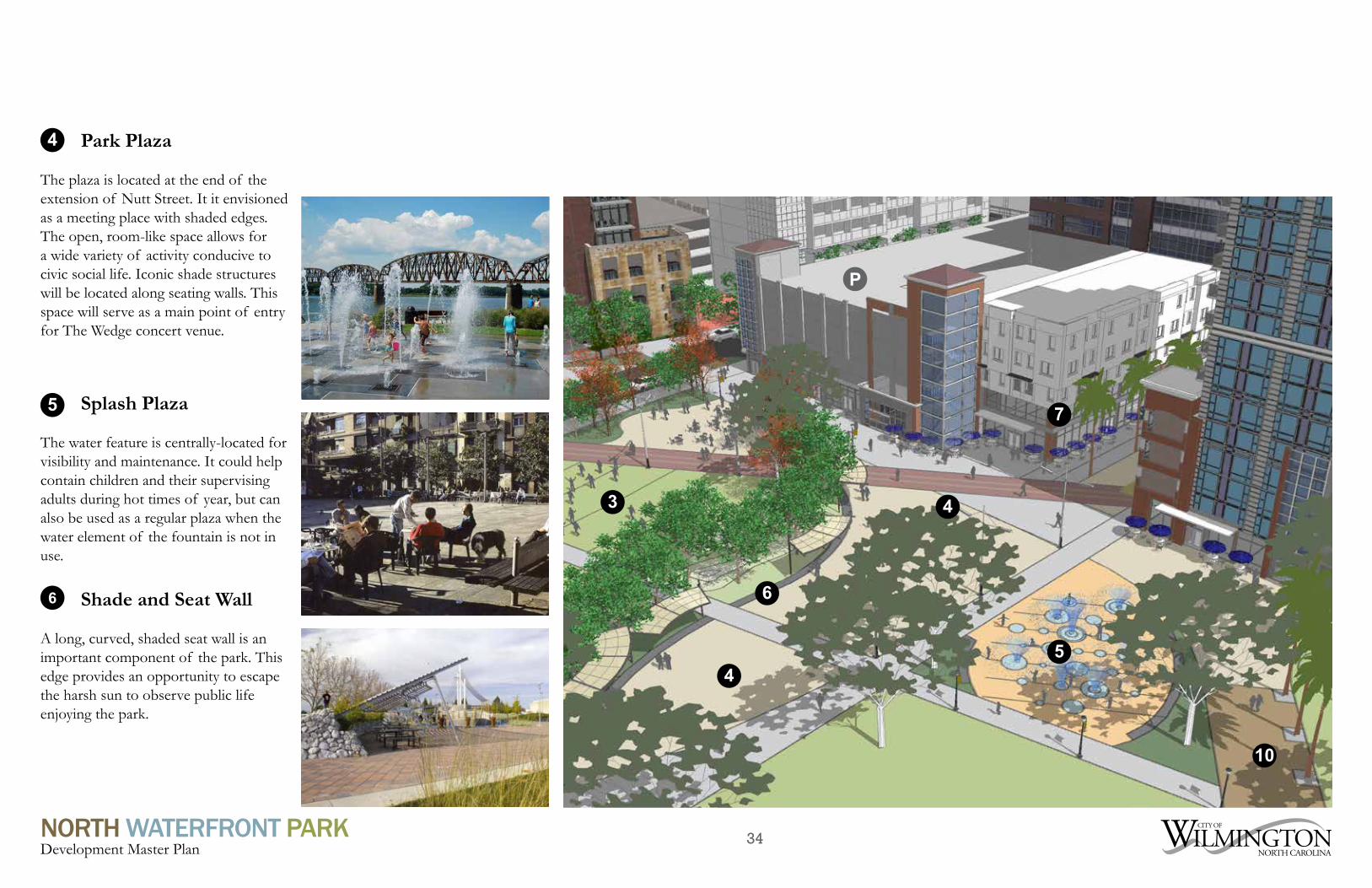
The plaza is located at the end of the extension of Nutt Street. It it envisioned as a meeting place with shaded edges. The open, room-like space allows for a wide variety of activity conducive to civic social life. Iconic shade structures will be located along seating walls. This space will serve as a main point of entry for The Wedge concert venue.
5 Splash Plaza
The water feature is centrally-located for visibility and maintenance. It could help contain children and their supervising adults during hot times of year, but can also be used as a regular plaza when the water element of the fountain is not in use.
6
4
4
7
5
3
Shade and Seat Wall
A long, curved, shaded seat wall is an important component of the park. This edge provides an opportunity to escape the harsh sun to observe public life enjoying the park.
6
P
10

35NORTH WATERFRONT PARKDevelopment Master Plan
Beer Gardens
Two locations are identified for beer gardens, each at opposite edges of the park and near possible locations for restrooms. The beer gardens are designed such that consumption of alcoholic beverages can be controlled. Seating, string-type lighting, and a family-oriented atmosphere are important aspects of these spaces.
Sidewalk Cafe Zones
Buildings along the park’s southern edge should contain retail and cafe spaces along their ground floor. This is envisioned as a vibrant urban place with various outdoor dining opportunities.
7
8O
ld F
ron
t Fes
tiva
l Str
eet
8
7
7

36NORTH WATERFRONT PARKDevelopment Master Plan
Active Urban Edges
Cowan Pump Station Edge
1
Southern Mixed-use DevelopmentThe wide pedestrian-only pathway, also called a “promenade,” should be activated by retail and other shopfront-like conditions along its southern edge. This area will be part of an “Upper Downtown” mixed-use development complex, and how it’s building facades relate to the park is of absolute critical importance for the success of each site.
1
2
River Ventures Redevelopment SiteThe southern portion of this block is ideal for an urban, vertical mixed-use development that “wraps” a structured parking deck. The deck can be accessed from Old Front Festival Street as indicated on the plan at the lower level and from North Front Street at an upper level. The northern portion of this edge should be composed of an active building wall, especially a mid-rise or high-rise owner that overlooks the park and the Cape Fear River. Alternatively, the northern portion could serve as a future phase of the park, and remain a heavily-wooded and sloped natural open space. Either outcome will create an interesting, engaging backdrop to the stage and “The Wedge”. This site should be integrated with the design of North Waterfront Park and be considered for public parking.
2
3
Upper Dean Redevelopment SiteAlthough this site does not front directly onto the park, it is of vital importance to it in terms of views and the placement of a strong architectural corner mass that would relate to the park. Ideally, new development at that location would be tall, as to allow views to the park and Cape Fear River over the neighboring Sawmill Point apartments, and provide an active ground floor component to enliven the public space along the Cowan Street roundabout.
3
4
Cowan Street Pump StationThis edge must accomplish the goal of concealing the Cowan Street CFPUA pump station and its facilities from the sight and smell park users. Ideally, this edge condition would be composed of uses in a one- or two-story building with uses such as restrooms, retail, restaurants and others that provide activity to an otherwise passive, and potentially boring, area of the park. Efforts should be made to provide the same level of active use that would occur if Sawmill Point fronted directly onto the park instead of the pump station.
4
Active Urban Edges
The creation of active urban edges through coordinated building and site design is critical to the success of the park. These edge conditions should provide active uses directly not park land such as retail, lobbies, restaurants and bars, art studios, small offices or any others that provides a shopfront-like ground floor. Such uses contribute to a vibrant public realm and provides natural surveillance to ensure a safe space. The four main edge opportunities are discussed here, with the sidewalk cafe zones described in more detail.

37NORTH WATERFRONT PARKDevelopment Master Plan
Nutt Street Extension
The northern extension of Nutt Street from its intersection of Harnett Street will serve as the park’s southern entrance. It will be a pedestrian-only corridor lined with mixed-use buildings, restaurants with outdoor seating, and various landscape features as shown in the examples on this page. There is a possibility of including a small-scale street for automobiles if it is needed to support retail uses close to the park.
Inland Boardwalk
A pathway composed of wooden boards that brings the Riverwalk into the park. The path should be wide, well-shaded, and be the most prominent connection from the Riverwalk to the Nutt Street Extension. A curvilinear pathway is encouraged to contrast with the straightness of the Riverwalk. The path will be lined with trees.
9 10
Site Design Challenge
Future site planning will require working closely with the future developer of the sites along the Nutt Street extension. These parcels have the potential to positively or negatively affect the success of the park through the placement of particular building fronts and the construction of habitable space along parking decks. This is highly related to the proposed cafe zones along the park edge, access to structured parking, and the use of parking deck ground floor area along the park for essential facilities. The City and potential developer will work together in partnership to ensure mutually-beneficial outcomes and create a vibrant mixed-use district with safe, active public spaces.
Harnett Street

38NORTH WATERFRONT PARKDevelopment Master Plan
River Landing
The River Landing is a platform that leads down to the water. It’s shape recalls the lumber pond that used to cut into the site. The materials, shape and use of interpretive features could call attention to this historic land pattern. (See the Sanborn Map on page 14 for more information.)
Garden Path
An thin inland path that surrounds the park’s river edge. This allows people to meander along the river and experience a variety of planted and educational natural conditions.
12
11
10
11
11
12
13

39NORTH WATERFRONT PARKDevelopment Master Plan
Riverwalk & Connections
The edge along the river is currently composed of a mixed-condition shoreline that meanders below a straight wooden portion of the Cape Fear Riverwalk. Without shade and frequent connections to the mainland (as it exists today), the long Riverwalk could be uncomfortable for users during hot summer months. Efforts should be made to soften this edge with shade trees and structures and also allow park users to engage the water and access the Riverwalk.
13
Site Design Challenge
The outside edge of the Riverwalk is consistent with the US Harbor Line. There are federal regulations against any permanent structures beyond this line. Therefore any potential tree planting would need to be discussed with CAMA and/or the US Army Corps of Engineers.
A potential public access to the water’s edge would also need to be discussed with the local NCDENR brownfields group. When placing the two foot clean soil cover on the site, an agreement was reached with NCDENR that, at the bottom of the steep slopes, the City could “feather” the cap down at the water’s edge. This eliminated the potential for having to dig out contaminated soils at rivers edge and possible releasing them into the river or disturbing wetlands.
Riverwalk Connection Points
RiverwalkPark New Connection Point

40NORTH WATERFRONT PARKDevelopment Master Plan
Children’s Play Area
The children’s play area is located in a corner of the park bound by trees, gardens, mounds and views of docked boats. There will be a mix of adventure and conventional play structures. The design of the space allows parents and other guardians to sit along the edge of to monitor their playing children. Fun colors and innovative play features should be incorporated into the design.
16 Great Lawns
Large open areas of grass with shaded edges can accommodate various activities, including informal play, relaxing, outdoor exercise classes, festivals. A large concert at The Wedge can be experienced from this location as well. Although the Cape Fear River can be seen from the lawns, the primary viewing area is still the Riverwalk.
14
14
Shade and Mounds
Shade and mounds are found throughout the park. These provide comfort, create visual interest, and accommodate both rest and play. Mounds may transition into raised beds, garden and/or lawn areas.
1515
15
16

41NORTH WATERFRONT PARKDevelopment Master Plan
Wetland
The Wetland uses a portion of the site that is currently very low. A stormwater management facility spanned by a dock-like bridge will connect the park to Sawmill Point and other northern destinations while providing opportunities for education and passive enjoyment. The bridge connects to the main park pathway, the Garden Trail and the restaurant pavilion.
17
Site Design Challenge
Due to brownfields restrictions, any surface water feature would most likely need to be lined to prevent surface water contact with contaminated soils below clean cover for public health reasons. Unfortunately this eliminates to productive use of such a feature as a storm water pond and would only serve as an aesthetic feature. The other option would be to potentially install a secure decorative fence or barrier around to the pond to keep public away. This again would require discussion with the brownfields group.
17
42NORTH WATERFRONT PARKDevelopment Master Plan
Cafe and Restrooms
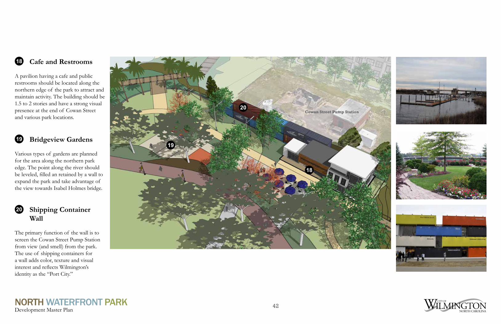
A pavilion having a cafe and public restrooms should be located along the northern edge of the park to attract and maintain activity. The building should be 1.5 to 2 stories and have a strong visual presence at the end of Cowan Street and various park locations.
18
Shipping Container Wall
The primary function of the wall is to screen the Cowan Street Pump Station from view (and smell) from the park. The use of shipping containers for a wall adds color, texture and visual interest and reflects Wilmington’s identity as the “Port City.”
20
Bridgeview Gardens
Various types of gardens are planned for the area along the northern park edge. The point along the river should be leveled, filled an retained by a wall to expand the park and take advantage of the view towards Isabel Holmes bridge.
19
20
19
18
Cowan Street Pump Station

43NORTH WATERFRONT PARKDevelopment Master Plan
3Industrial Relics (New and/or Reclaimed)
During the public input process, numerous comments called for art to be featured throughout the park. Including relics that point back to the site’s storied past is a way to include art into the park design. Potential relics could include those referencing various industries once located on or near the site, like the railroad, logging, fishing, or other historic industries.
Wayfinding and Interpretive Signage
The City’s standard pedestrian wayfinding signage will be used to help navigate people through the district and along the edges of the park. Custom signage should be developed for the park itself. This may include modern panels with maps, explanatory signs for landscape elements, and artistic gateway signs. The custom signage and standard City signs must appear to be cohesive.
Palette of Essential Park Elements
Parking Deck Facades Facing the Park
The parking deck facades adjacent to the site should be designed with the park views in mind. Using creative and varying facades that serve to screen the cars and blend into the surrounding natural and built environments is important to the overall park design.
Series of Outdoor Rooms
A destination park of this size will require a design that allows for various programmatic uses. Dividing the park onto smaller spaces for these uses in a collection of outdoor rooms is a way to make the space usable for multiple active and passive activities at the same time. Outdoor rooms bring the park to a more human scale for interaction with the landscape and other park users. The park should be designed with outdoor rooms to ensure that users feel comfortable in the park space.
44NORTH WATERFRONT PARKDevelopment Master Plan
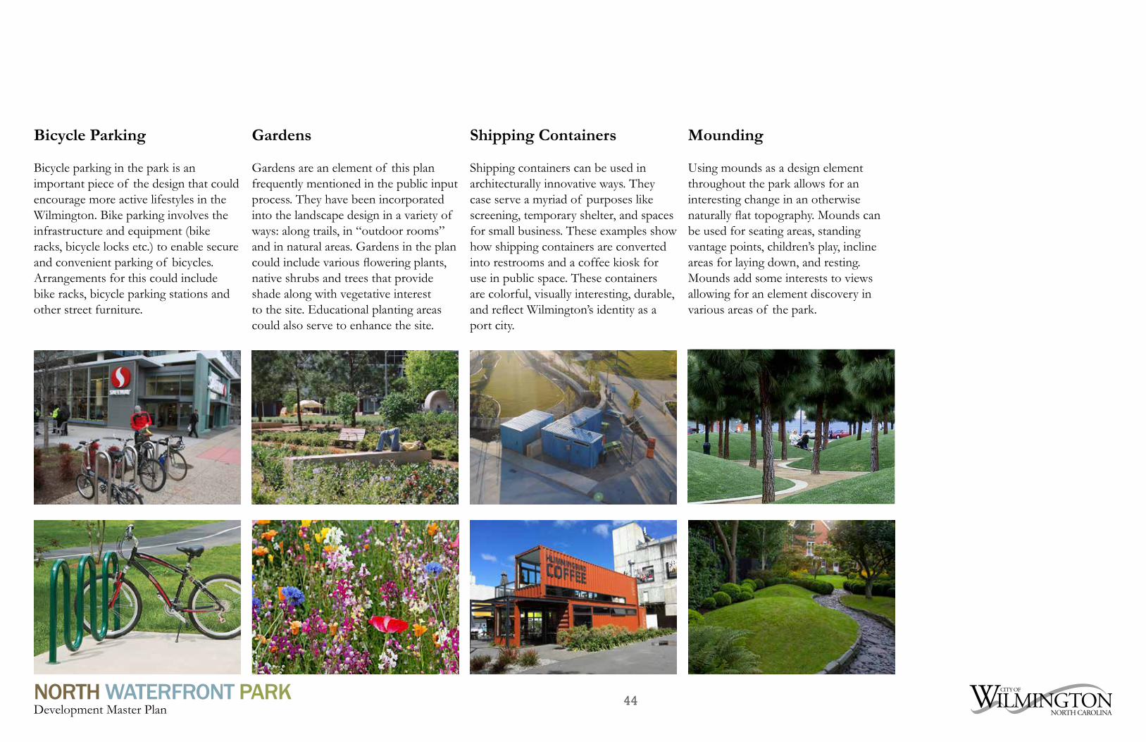
Bicycle Parking
Bicycle parking in the park is an important piece of the design that could encourage more active lifestyles in the Wilmington. Bike parking involves the infrastructure and equipment (bike racks, bicycle locks etc.) to enable secure and convenient parking of bicycles. Arrangements for this could include bike racks, bicycle parking stations and other street furniture.
Mounding
Using mounds as a design element throughout the park allows for an interesting change in an otherwise naturally flat topography. Mounds can be used for seating areas, standing vantage points, children’s play, incline areas for laying down, and resting. Mounds add some interests to views allowing for an element discovery in various areas of the park.
Shipping Containers
Shipping containers can be used in architecturally innovative ways. They case serve a myriad of purposes like screening, temporary shelter, and spaces for small business. These examples show how shipping containers are converted into restrooms and a coffee kiosk for use in public space. These containers are colorful, visually interesting, durable, and reflect Wilmington’s identity as a port city.
Gardens
Gardens are an element of this plan frequently mentioned in the public input process. They have been incorporated into the landscape design in a variety of ways: along trails, in “outdoor rooms” and in natural areas. Gardens in the plan could include various flowering plants, native shrubs and trees that provide shade along with vegetative interest to the site. Educational planting areas could also serve to enhance the site.

45NORTH WATERFRONT PARKDevelopment Master Plan
Adventure Play
Allowing children (and sometimes adult) the freedom to play outside the typical play structure model is what the adventure play movement is all about. Adventure play generally entails natural play areas for climbing, jumping, and affording the opportunity for the user to build his or her own play day experience with moveable play objects.
Public Art
Public art is an important part of the park design that was specifically mentioned in the public input process. Art in the park could take lots of difference forms. It can be sculpture, mural or even the landscape itself. Art can be colorful, historic, and/or temporary. Local art is a valuable cultural resource that should have a place in the park.
Shade Areas & Walkways
Nearly all of the park’s walkways are lined with trees to provide much-needed shade on hot days. Paths connect various destination, enabling park users to walk from one place to another while shaded from the sun. The walkways in this plan connect various points of interest throughout the site, assisting users to get from point to point uninhibited.
Movable Seating
Movable seating enables a person to make a place feel like his or own for a short period of time. Public space studies show that people move chairs and tables to accommodate their use, which vary from person to person and situation. This create the feeling that a person is in his or her own backyard and increases the level of intimacy in the space.

46NORTH WATERFRONT PARKDevelopment Master Plan
Status Cost Residential Units / Hotel Rooms
Commercial Space (sq. ft.)
Total Size (sq. ft.)
Port City Marina Complete $15,000,000 Port City Marina Restaurants Under Construction $10,000,000 14,000Embassy Suites Planned $33,600,000 186 161,000Riverwalk (Public investment) Sections from Convention Center to Harnett and Cowan Streets and Marina extension)
Complete $9,693,000
CFCC Fine Arts Complete $36,000,000 158,000City Park (Land) Planned $4,100,000 Brooklyn Townhomes Under Construction $1,000,000 24 (4 Complete)City Block Apartments Complete $15,500,000 112Sawmill Point Apartments Under Construction $45,500,000 278Pier 33 Apartments Planned $50,000,000 300 30,000 Riverfront Park water, sewer, stormwater project
Under Construction $6,300,000
Water Street Deck Planned $68,000,000 190 31,600 Total $294,393,000 1,090 75,600 319,000
Notable Development Projects Since 2011 (as of 2/5/16)APA Key PointsEconomic Impact
The future North Waterfront Park is envisioned as an economic development tool, used to leverage the redevelopment of surrounding properties into a vibrant, mixed-use district. The use of a park to create value is a “win-win” for the general public, where tax revenues used for government programs and projects can be increased while a highly-valued public asset is (a public park) is created. Research and case studies have proven that successful parks are used for economic development, community revitalization, crime reduction, and other direct benefits to local areas.
The American Planning Association writes:
Parks provide intrinsic environmental,aesthetic, and recreation benefits to our cities. They are also a source of positive economic benefits. They enhance property values, increase municipal revenue, bring in home-buyers and workers, and attract retirees. At the bottom line, parks are a good financial investment for a community.

47NORTH WATERFRONT PARKDevelopment Master Plan
In 2006, Center City Park, a 1,9 acre green space opened on North Elm Street in Greensboro, NC. Owned by the Joseph M. Bryan Foundation, the park was developed utilizing private funds. Center Pointe, a $40 million luxury condominium development located next to the park opened in 2009 in a renovated bank building. Roy Carroll of the Carrolls Company in Greensboro said, “The development of Center City Park is a key reason I decided to renovate the building”
Discovery Green is an 11 acre park located in Houston Texas, adjacent to a convention center and a short walk away from downtown’s Houston commercial hub. It is downtown Houston’s first major urban park. According to Discovery Green’s website, the park plays an important role in the city. It has engendered a level of ownership among all residents in the downtown core and throughout the region and instilled a new level of civic pride within the city. Development of the park was a public/private project. The City paid 55% of the cost. 45% was paid for by donations, naming rights, and large contributions from foundations. According to Benchmark, Discovery Green, an economic impact study, Discovery Green was the catalyst for more than $500 million in downtown development projects (completed or underway, that specifically note the park’s creation as an impetus for the dramatic investments.
In the summer of 2015, Nashville Metro Parks opened Ascend Amphitheater and West Riverfront Park, an 11 acre urban park located in downtown Nashville on a brownsfield site along the Cumberland River. The park contains a first class performance space situated among lawns, gardens, open space and trails. The park was part of a larger West Riverfront Improvement Plan a $52 million dollar project funded with bonds. The amphitheater’s operation is externally contracted. In addition to the fee the operator pays to the City to manage the amphitheater, the City receives fees for each ticket sold that go toward other metro parks. Parks Department officials and the Operator called the inaugural season a “resounding success”.
1 2 3
Funding Strategy
Conservative, preliminary estimates indicate North Waterfront Park development will cost up to $23 million dollars. For development to become a reality, a cafeteria of funding acquisitions is recommended. In addition to financing park development in the City’s Capital Improvement Program, the City should pursue additional strategies to includepublic grants, private investment and naming rights in the form of a sponsorship develop program. City staff recommends naming rights for park amenities be based on a percentage of the value (land + amenity). The likelihood of a successful public-private development project will depend upon the resources devoted toward the effort. To facilitate that success, it is recommended that a private donation campaign be designed and overseen by a cross-organizational committee led by a group such as the Wilmington Parks and Recreation Advisory Board. A bond referendum is the most likely funding strategy for raising funds to build this park.
In 2005, the City of Wilmington entered into a development agreement with PPD, a global contract research company. That investment was the catalyst that sparked a revitalization in northern downtown Wilmington. Public investment in the northern district over last 9 years totals $89,361,000.
Urban parks can be value generators and it is expected that the development of the North Waterfront Park will intensify the momentum of the northern district development. Three examples of economic benefit from the Master Plan’s benchmark parks are listed here.