
North Dakota Wheat Transportation Knowledge for Market
54
North Dakota Wheat Transportation Knowledge for Market Enhancement Kimberly Vachal Mark Berwick Doug Benson Upper Great Plains Transportation Institute North Dakota State University, Fargo December 2010
Transcript of North Dakota Wheat Transportation Knowledge for Market

North Dakota Wheat Transportation Knowledge
for Market Enhancement
Kimberly Vachal
Mark Berwick
Doug Benson
Upper Great Plains Transportation Institute
North Dakota State University, Fargo
December 2010

Acknowledgements
This research was supported by the North Dakota Wheat Commission and Federal Highway
Administration.
Disclaimer
The contents of this report reflect the work of the authors, who are responsible for the facts and the
accuracy of the information presented. This document is disseminated under the sponsorship of the
Mountain-Plains Consortium in the interest of information exchange. The U.S. Government assumes no
liability for the contents or use thereof.
North Dakota State University does not discriminate on the basis of age, color, disability, gender expression/identity, genetic information, marital status, national origin, public assistance status, sex, sexual orientation, status as a U.S. veteran, race or religion. Direct inquiries to the Vice President for Equity, Diversity and Global Outreach, 205 Old Main, (701)231-7708.

ABSTRACT
North Dakota wheat producers are located long distances from major consumer and export markets.
Understanding the competitive position of their products is important to focusing efforts for market
development and transportation investments. Research here provides some fundamental knowledge about
market trends that is based on existing data sources. The data reveal shifts in some of the origin-
destination corridors, a narrowing in rail rate spreads, and lower expenditures per bushel mile in rail
wheat markets. In addition, a spike in deliveries to the Duluth market is identified for the most recent
marketing year as well as an increasing trend in durum imports for the U.S. consumer market. Ongoing
attention to logistics in the wheat market establishes a sustained knowledge base and provides systematic
attention to this important market aspect.

TABLE OF CONTENTS
1. Introduction .......................................................................................................................................... 1
2. Objective................................................................................................................................................ 3
3. Methods and Data ................................................................................................................................ 5
4. Market Scope ........................................................................................................................................ 7
5. Market Flows ...................................................................................................................................... 11
6. Rail Rates ............................................................................................................................................ 17
7. Generalized URCS Comparative Revenue to Variable Cost Ratio Analysis ................................ 19
7.1 Selected North Dakota Origins ...................................................................................................... 20 7.1.1 Fuel Surcharge ......................................................................................................................... 20
7.2 Regional BEA Comparison ............................................................................................................ 22 8. Summary ............................................................................................................................................. 25
9. References ........................................................................................................................................... 27
Appendix A. BEA Region Map and List of Names ................................................................................ 29
Appendix B. North Dakota Rail Wheat Shipments, 1999 to 2008 ........................................................ 33
Appendix C. Canada Origin Supplement, TBEA and Rates ................................................................ 37
Appendix D. Wheat Inspected by Export Region and Import Country ............................................. 39
Appendix E. Market Briefs for HRS Wheat and Durum ...................................................................... 45

LIST OF FIGURES
Figure 4.1 Wheat Production, by Class 2007/08 to 2009/10 .................................................................... 7
Figure 4.2 Modal Cost Comparison .......................................................................................................... 8
Figure 4.3 Share of Wheat Production Exported, by Class ....................................................................... 9
Figure 5.1 Imports as Share of Domestic Use ......................................................................................... 11
Figure 5.2 BEA Origin States ................................................................................................................. 12
Figure 5.3 BEA Destination Territories .................................................................................................. 12
Figure 5.4 Rail Utilization Index, Rail Shipments to Production ........................................................... 13
Figure 5.5 Change in Rail Wheat Destinations, 1999 to 2008 ................................................................ 14
Figure 6.1 Wheat Rail Rates in the ND Market Region .......................................................................... 17
Figure 6.2 Wheat Rail Rate Trends, Tariff Rates from ND to Minneapolis ........................................... 18
Figure 6.3 Wheat Rail Rate Trends, Tariff Rates from ND to the PNW ................................................ 18
Figure 7.1 Estimated Generalized Revenue to Variable Cost Ratios (URCS 2010). .............................. 21
Figure 7.2 Estimated Generalized Revenue to Variable Cost Ratios Illustration for Selected
BEAs to Major Market BEA for Median Public Use Waybill Wheat Shipments
(URCS 2010). ........................................................................................................................ 23
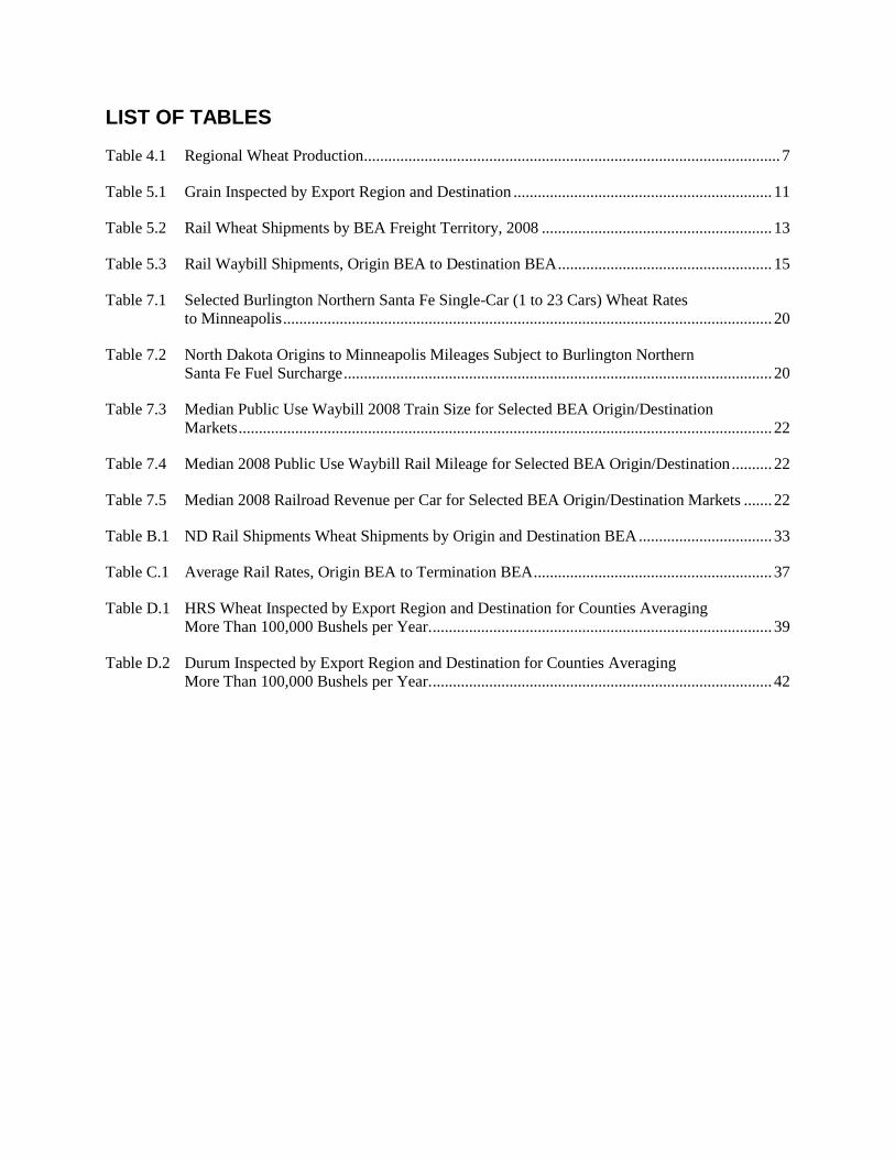
LIST OF TABLES
Table 4.1 Regional Wheat Production ....................................................................................................... 7
Table 5.1 Grain Inspected by Export Region and Destination ................................................................ 11
Table 5.2 Rail Wheat Shipments by BEA Freight Territory, 2008 ......................................................... 13
Table 5.3 Rail Waybill Shipments, Origin BEA to Destination BEA ..................................................... 15
Table 7.1 Selected Burlington Northern Santa Fe Single-Car (1 to 23 Cars) Wheat Rates
to Minneapolis ......................................................................................................................... 20
Table 7.2 North Dakota Origins to Minneapolis Mileages Subject to Burlington Northern
Santa Fe Fuel Surcharge .......................................................................................................... 20
Table 7.3 Median Public Use Waybill 2008 Train Size for Selected BEA Origin/Destination
Markets .................................................................................................................................... 22
Table 7.4 Median 2008 Public Use Waybill Rail Mileage for Selected BEA Origin/Destination .......... 22
Table 7.5 Median 2008 Railroad Revenue per Car for Selected BEA Origin/Destination Markets ....... 22
Table B.1 ND Rail Shipments Wheat Shipments by Origin and Destination BEA ................................. 33
Table C.1 Average Rail Rates, Origin BEA to Termination BEA ........................................................... 37
Table D.1 HRS Wheat Inspected by Export Region and Destination for Counties Averaging
More Than 100,000 Bushels per Year. .................................................................................... 39
Table D.2 Durum Inspected by Export Region and Destination for Counties Averaging
More Than 100,000 Bushels per Year. .................................................................................... 42

1
1. INTRODUCTION
U.S. wheat producers have long enjoyed the benefits of a relatively efficient and effective transport
system. Over recent years, the American wheat rail transportation system has undergone some
fundamental changes, including larger 100-plus car trains, capacity rationing, and North American
network integration; and all have impacted the competitiveness of wheat among regions and markets, and
relative to other commodities.
Study of rail rate deregulation and North Dakota railroads suggests wheat differs from other commodities,
in its shipment and rate characteristics (Tolliver and Bitzan 2002, Bitzan and Vachal 2004). In that
analysis of the U.S. Confidential Rail Waybill, findings suggested that the rail rate differential between
wheat and other major crops, and within wheat shippers, is diverging.
In addition to inland transportation market phenomenon, it is important to recognize that as competitors
make strategic transportation investments to gain competitive advantages, it is prudent for U.S. wheat
producers to play an active role in shaping the transportation system and services that they utilize in
marketing their products.

2

3
2. OBJECTIVE
The objective of this investigation is to provide insight about the competitive position of North Dakota
wheat related to transportation. By increasing knowledge of market flows and transportation rates to
primary domestic markets and export market gateways, additional focus can be achieved in strengthening
positions in existing and prospective markets. Understanding trends and shifts in transportation related
factors is critical in assessing future transportation investments and policies.

4

5
3. METHODS AND DATA
Descriptive analysis will used to assess the competitive position of North Dakota wheat in domestic and
export markets. Several data sources will be used, including the ND Public Service Commission Elevator
Grain Movement Database (GMDB), Surface Transportation Board Public (STB), Carload Waybill
Sample, U.S. Department of Agriculture grain export and marketing price data, and railroad published
rate tariffs. The GMDB is a database of monthly reports from North Dakota elevators that is summarized
in aggregation to satisfy confidentiality for individual elevators. It details information on mode, shipment
size, and destination markets – as provided by the elevator originating shipments bound for end-user
markets. The Waybill Sample is a “stratified sample of carload waybills for all U.S. rail traffic submitted
by those rail carriers terminating 4,500 or more revenue carloads annually” (Surface Transportation Board
2009). It includes information such as origin, destination, rate, shipment size, interline connections, and
car load factor. The Public Use Waybill Sample includes five-digit STCC identifiers which disaggregate
grains to crops but do not allow class identification, such as hard red spring (HRS), to the degree possible
by production patterns and demand points may be used to varietal insights.
The jurisdictional boundaries used in these datasets vary. State-level estimates will be used in a discussion
of regional wheat transportation characteristics and trends. Additional detail regarding rail shipment
available with the Waybill Sample will rely on U.S. Census Bureau of Economic Analysis (BEA)
boundaries. Port information on wheat exports uses port regions such as the Pacific Northwest and Gulf,
which encompass numerous port authorities and facilities. The ND GMDB will be summarized under
both state-level and crop reporting district jurisdictions. Data for the most recent five years will be used to
explore wheat markets. Additional historical data may be included as available and appropriate for the
study.

6

7
4. MARKET SCOPE
The United States produces over 2 billion bushels of wheat annually. Producers deliver most of the crop
to local elevators where it is consolidated for sale to domestic and international buyers. Pricing in the
market is based on factors such as class, quality, time, and quantity. Sellers compete to fulfill buyer
requirements for wheat ingredients used in their end products. Transportation is a key market factor in
this competition. Leading wheat producing states in the Midwest market are North Dakota, Kansas,
Montana, and South Dakota – these states supplied about half of U.S. wheat – 28%, 30%, 15%, and 12%,
respectively, over the past five years (Table Table 4.1). The focus is on wheat transportation for these
states, along with limited information regarding rail shipments from Canadian origins because of class
competition with North Dakota’s hard red spring (HRS) and durum wheat products.
Table 4.1 Regional Wheat Production
1999-2004 2005 2006 2007 2008 2009
Kansas 35% 33% 32% 27% 30% 30%
Minnesota 8% 6% 9% 8% 9% 7%
Montana 13% 17% 17% 14% 14% 15%
Nebraska 6% 6% 7% 8% 6% 6%
North Dakota 28% 26% 27% 29% 26% 31%
South Dakota 10% 12% 9% 14% 15% 11%
Share of U.S. 49% 55% 51% 51% 47% 55%
Source: NASS, USDA
Hard red winter (HRW) wheat is largest among wheat classes, nationally, based on production over the
three most recent market years (Figure 4.1). HRS is the largest wheat class in North Dakota, with durum
also produced in substantial quantity. Neighboring state Montana is predominately HRS in wheat
production, while the Kansas and South Dakota classes are mainly winter wheat. The quality attributes
and end-use product requirements influence prices and buyers’ decisions in year-to-year purchase
decisions that determine market flows.
Figure 4.1 Wheat Production, by Class 2007/08 to 2009/10

8
Distinguishing export and domestic consumption of wheat is an important factor in understanding market
flows and relevant transportation factors. The export market demand is centered in port regions, where
large volume international purchases are discharged into ships. Delivery to these export facilities is
largely completed by barge and rail. Multi-tow barges typically move in 15-barges tows, hauling a total of
22,500 tons of grain, on the lock portion of the Mississippi River. Commonly employed large rail units of
100 plus cars contain roughly 9,000 tons. These large units provide significant scale economies compared
to the truck and single-car rail shipments. Domestic demand is widely dispersed, with millers making
purchases in smaller lots that are completed primarily through truck and rail delivery from the local
elevator to a mill facility.
Figure 4.2 Modal Cost Comparison
The United States exports about half of its production each year. After dipping to near 40% in the late
1990s, the share has trended upward (Figure 4.3). HRS wheat has historically had a greater dependence
on international markets with exports equaling more than 60% of production in the most recent years.
Durum and HRW wheat classes are more likely to be marketed domestically, but both have seen
expansion in the export market. In the most recent three-year average, from 2007/08 to 2009/10, an
equivalent of 48% of HRS and 44% of durum and 46% HRW wheat production, respectively, moved to
export markets.
Distance
Cost Truck
Rail
Barge
D1 D2

9
Figure 4.3 Share of Wheat Production Exported, by Class
Production and use information established a focus for competitive analysis related to the position of
North Dakota in the wheat market. North Dakota is concentrated in producing hard wheat that has been
competitively marketed to both domestic and export customers. While a comprehensive market flow
model is beyond the resources available for this report, valuable insight for designing this type of model
can be gained by studying information available regarding export customers, rail origins and destinations,
and freight rates.

10

11
5. MARKET FLOWS
A fundamental aspect in addressing competitiveness
in the market is understanding market geography, both
in terms of competition and opportunities. As noted
above, global competitiveness is key since about half
of U.S. wheat is exported annually. North Dakota has
a central location in the region with regard to
coastlines – while other states, such as Kansas, are in
closer in proximity to individual markets, such as the
Gulf export region.
USDA grain inspection information also provides
valuable insight regarding wheat marketed by U.S.
producers. HRS exports are increasingly concentrated
in the Pacific Region when the durum exports are less
predictable considering the Gulf, Great Lakes, and
Canadian bound volumes over the most recent five
years (Table 5.1). A distinct drop-off in the Lakes
inspections is reported for 2008 and 2009, compared with the previous three years for HRS wheat. Durum
inspections at the Lakes ports also dropped substantially in 2008 but recovered somewhat in 2009. A
spike in durum shipments to Canada is also reported for the most recently completed market year.
Knowing the final destination for HRS and durum exports may also be useful in understanding customer
options and opportunities for wheat moved through these export regions (Appendix D).
Table 5.1 Grain Inspected by Export Region and Destination
Share and Average Metric Tons
HRS Wheat 2005 2006 2007 2008 2009 Average
Pacific 46% 62% 50% 60% 67% 4,463,334
Gulf 23% 22% 20% 21% 19% 1,689,972
Great Lakes 10% 10% 11% 4% 3% 639,324
To Canada 9% 2% 8% 5% 5% 484,332
St Lawrence Swy 10% 2% 7% 5% 4% 475,554
Interior 2% 2% 3% 3% 1% 188,412
Atlantic 0% 1% 2% 1% 0% 70,548
Durum 2005 2006 2007 2008 2009 Average
Gulf 57% 38% 38% 83% 37% 466,944
Great Lakes 37% 60% 58% 13% 45% 447,906
To Canada 2% 0% 2% 0% 12% 33,450
St Lawrence
Swy 4% 0% 2% 0% 6% 24,720
Atlantic 0% 1% 0% 4% 0% 6,948
Interior 0% 0% 0% 0% 0% 2,088
Pacific 0% 0% 0% 0% 0% 1,110
Source: Federal Grain Inspection Service, USDA
0%
10%
20%
30%
40%
50%
60%
19
90
/91
19
92
/93
19
94
/95
19
96
/97
19
98
/99
20
00
/01
20
02
/03
20
04
/05
20
06
/07
20
08
/09
Imp
ort
s as
Sh
are
of
Do
me
stic
Use
HRW
HRS
Durum
Figure 5.1 Imports as Share of Domestic Use

12
It is also important to recognize opportunities in domestic wheat markets related to other states and
competition evidenced in U.S. wheat imports. Average HRS imports, as a share of domestic use, were
14% over the past five years. This share is 7% higher than the average over the past two decades. Durum
imports during the most recent five years averaged 47% of domestic use. The share is 32% greater than
the average over the past 20 years. HRW wheat imports are negligible, accounting for less than 1% of
domestic use (Figure 5.2). Since local and surface transport costs are usually a greater share of delivered
product costs in the domestic market, these trends suggest a more in-depth supply chain assessment may
be beneficial.
Two primary data sources are used to illustrate activity and trends with regard to national wheat market
flows – the U.S. DOT Waybill Sample and USDA Export Inspections. Figure 5.2 illustrates the BEA
geography included to estimate state Carload Waybill statistics. The BEA freight territories includes 170
BEAs grouped into regions (Figure 5.3). These regions show the primary grain export regions used for
the USDA data.
Figure 5.2 BEA Origin States
The rail utilization index presented in Figure 5.4 provides a measure for relative importance of rail in
marketing wheat production in the region. It is calculated as the ratio of rail to production for an
individual state in wheat compared with that for the region. The index does not reflect an exact measure
of rail shipment for a state since the BEA boundaries used to measure do not follow state boundaries. The
trend in the measure over the eight years does show strong and increasing utilization in North Dakota and
Montana. These states have always had a high reliance on rail due to long distances in reaching export,
consumer, and barge transshipment delivery points. South Dakota also shows an increasing utilization of
rail in marketing its wheat crop, especially over the past four years. The increase in these states may be
related to elevator investment and railroad strategies to utilize trains of 100 cars or more in transporting
wheat. Kansas and Nebraska have remained relatively stable, with a large decline for rail utilization in the
Minnesota market. The Minnesota decline may, however, be a function of shipments reported for
Minneapolis as an arbitrage point for spot and eastern markets rather than marketing decisions related to
local production.
Figure 5.3 BEA Destination Territories

13
Figure 5.4 Rail Utilization Index, Rail Shipments to Production
A snapshot of annual rail market flow information is provided with the figures in Table 5.2. In 2008, a
majority of North Dakota rail wheat shipments were bound for western markets – including export and
domestic buyers – with 61% of wheat shipments terminated in the Western BEA Territory. North Dakota
wheat was also shipped in large quantity to the Mountain Pacific Territory, where about a quarter of the
rail shipments were terminated. South Dakota also shipped the largest share of its wheat to western
markets – 62%, with another large portion, 26%, destined for the Southwestern BEA Territory. Montana
wheat was destined almost exclusively, at 93%, for the Mountain Pacific Territory with a small share
shipped into the Western BEA Territory. Kansas wheat was shipped largely to southern markets with a
more limited amount to the Mountain Plains Territory. The Canadian shipments are dispersed, rather than
concentrated, as 34%, 28%, and 21% are shipped to northeastern, western, and southern territories,
respectively. Canadian shipments are also reported into the Southwestern and Mountain Pacific
Territories.
Table 5.2 Rail Wheat Shipments by BEA Freight Territory, 2008
BEA Freight Territory
State, by BEA
Group Northeastern Southern Western Southwestern
Mountain
Pacific
Thousand
Bushels
North Dakota 2% 1% 61% 7% 28% 365,557
Kansas 0% 5% 17% 65% 13% 303,476
South Dakota 0% 1% 62% 26% 10% 145,451
Montana 0% 0% 6% 1% 93% 163,041
Canada 34% 21% 28% 11% 5% 84,650

14
Figure 5.5 Change in Rail Wheat Destinations, 1999 to 2008
Additional detail regarding wheat shipments from BEA regions in the states to destination markets are
presented in TableTable 5.3. Shipments from the most recently available year are presented, along with
average shipments for the most recent three years and for historical shipments between 1999 and 2001.
This information may be useful in focusing efforts to specific marketing corridors and in identified
increases and decreases in competitiveness associated with specific markets. For instance, the Grand
Forks BEA has substantially increased rail wheat shipments to the Pacific Northwest area as encompassed
in the Portland, OR-Salem, WA, BEA in recent years compared with the historical shipments. The share
of shipments bound for the Chicago area, from the Grand Forks BEA, has declined substantially in recent
years compared with the historical distribution figures. The Minot BEA, covering the northwest region of
North Dakota along with a segment of northeast Montana, has seen a shift away from Chicago and
Minneapolis toward primarily western markets. The Bismarck BEA, primarily covering southwest North
Dakota, has shifted away from Chicago and the Pacific Northwest markets to deliver a larger share to
other western markets. The Fargo BEA, as with the Grand Forks BEA, has shifted away from eastern
markets to serve export and domestic markets in the west.
Among other major wheat suppliers, the Billings and Great Falls BEAs in Montana have retained
relatively similar distribution patterns, considering destination BEAs, with a majority of wheat moving to
the Pacific Northwest region. The Wichita BEA has diversified markets in expanding the share of its rail
wheat moving to the southwest market territory.

15
Table 5.3 Rail Waybill Shipments, Origin BEA to Destination BEA
2008
Avg
99-01
Avg
06-08
Avg
99-01
Avg
06-08
Grand Forks. ND-MN (ND, NE BEA -#110) Tons
Portland-Salem. OR-WA 1,073,243 35,109 1,019,011 2% 25%
Territory – Western 759,993 133,022 780,680 6% 19%
Chicago-Gary-Kenosha. IL-IN-WI 611,932 584,339 203,977 26% 5%
St. Louis. MO-IL 318,100 348,098 542,917 15% 13%
Minneapolis-St. Paul. MN-WI-IA 197,101 187,894 185,820 8% 5%
Houston-Galveston-Brazoria. TX 136,131 71,123 107,020 3% 3%
Minot. ND (ND, NW BEA - #111)
Portland-Salem. OR-WA 371,838 338,520 558,146 21% 26%
St. Louis. MO-IL 336,573 155,130 266,924 9% 12%
Territory - Western 195,989 33,290 353,712 2% 16%
Chicago-Gary-Kenosha. IL-IN-WI 195,291 184,674 65,097 11% 3%
Minneapolis-St. Paul. MN-WI-IA 73,579 92,793 89,750 6% 4%
San Antonio. TX 69,524 16,571 37,550 1% 2%
Bismarck. ND-MT-SD (ND, SW BEA - #112)
Chicago-Gary-Kenosha. IL-IN-WI 562,941 355,184 187,647 22% 8%
Portland-Salem. OR-WA 275,010 461,367 336,733 29% 14%
Minneapolis-St. Paul. MN-WI-IA 153,758 91,388 123,789 6% 5%
Territory – Western 135,421 109,333 456,742 7% 19%
Los Angeles-Riverside-OrangeCnty.CA-AZ 131,628 17,877 109,346 1% 5%
St. Louis. MO-IL 121,397 147,367 270,662 9% 11%
Fargo-Moorhead. ND-MN (ND, SE BEA - #113)
Chicago-Gary-Kenosha. IL-IN-WI 556,258 712,659 185,419 30% 7%
Portland-Salem. OR-WA 556,194 118,968 546,296 5% 20%
Territory – Western 328,330 114,445 580,568 5% 21%
St. Louis. MO-IL 279,435 327,624 374,695 14% 14%
Minneapolis-St. Paul. MN-WI-IA 172,891 201,901 127,376 8% 5%
Rochester. MN-IA-WI 93,002 0 66,998 0% 2%
Billings. MT-WY (MT, W BEA - #144)
Portland-Salem. OR-WA 1,124,688 890,913 1,214,400 63% 61%
Seattle-Tacoma-Bremerton. WA 133,547 41,221 144,642 3% 7%
Territory – Western 68,122 28,627 92,586 2% 5%
St. Louis. MO-IL 57,402 16,272 68,262 1% 3%
Chicago-Gary-Kenosha. IL-IN-WI 51,162 84,823 17,054 6% 1%
San Francisco-Oakland-San Jose.CA 43,856 41,984 41,069 3% 2%
Great Falls. MT (MT, NC BEA - #145)
Portland-Salem. OR-WA 2,134,649 1,059,168 2,717,069 82% 83%
Territory - Mountain Pacific; 189,600 146,541 248,523 11% 8%
Los Angeles-Riverside-OrangeCnty.CA-AZ 82,053 36,447 170,016 3% 5%
Seattle-Tacoma-Bremerton. WA 41,765 4,873 43,655 0% 1%
San Francisco-Oakland-San Jose.CA 26,857 30,704 33,037 2% 1%
Territory - Southwestern 21,855 0 19,171 0% 1%

16
Missoula. MT (MT, E BEA - #146)
Portland-Salem. OR-WA 101,680 14,899 45,894 32% 41%
Los Angeles-Riverside-OrangeCnty.CA-AZ 39,612 23,146 38,877 49% 34%
Denver-Boulder-Greeley. CO-KS-NE 15,581 0 7,596 0% 7%
San Francisco-Oakland-San Jose.CA 7,960 5,239 11,571 11% 10%
Territory - Mountain Pacific; 3,920 1,320 1,307 3% 1%
Salt Lake City-Ogden. UT-ID - 0 2,640 0% 2%
Wichita. KS-OK (KS, E BEA - #122)
Houston-Galveston-Brazoria. TX 2,340,299 3,115,719 1,600,807 44% 25%
Territory - Southwestern 1,815,475 812,733 1,682,491 12% 26%
Los Angeles-Riverside-OrangeCnty.CA-AZ 546,899 221,415 507,315 3% 8%
Kansas City. MO-KS 461,834 478,979 370,361 7% 6%
St. Louis. MO-IL 433,343 579,540 479,112 8% 7%
New Orleans. LA-MS 386,911 215,780 220,597 3% 3%
Canada (CN, BEAs #173 to #183)
Chicago-Gary-Kenosha. IL-IN-WI 564,309 764,294 188,103 38% 9%
Territory - Southern 292,319 133,543 240,509 7% 11%
Minneapolis-St. Paul. MN-WI-IA 275,598 344,283 242,699 17% 11%
San Antonio. TX 244,788 29,588 184,844 1% 9%
New Orleans. LA-MS 195,267 204,448 226,976 10% 11%
Kansas City. MO-KS 112,603 9,379 135,281 0% 6% Source: Surface Transportation Board

17
6. RAIL RATES
Rail rates are an important factor in the competitiveness of North Dakota wheat. Analysis of the Public
Use Waybill shows that revenue per ton mile (RPTM) has trended down for the Minot BEA – while it
still remains above the average RPTM paid for rail shipments originated from other North Dakota and
competitor BEAs. RPTM from the Minot BEA averaged $0.0433 in 2008 compared with $0.0462 in
2001. All BEAs have experienced a decrease in the RPTM, comparing 2008 with 2001, with the
exception of the Kansas and Canada BEAs. The declines, in percentage change, are reported for the
Billings and Grand Forks BEAs, where average RPTM in 2008 is 13% lower than that reported in 2001.
The change in RPTM may be a result of railroad pricing that reduces shipment costs for a like shipment
made in the past. Alternatively, the rate declines may be a function of changes in the shipment types –
such as investment in elevator infrastructure to a shift to relatively lower cost 100-plus car rail shipments,
or shifts in distribution markets where relatively more competitive rail rate structures are in place. The
Waybill does not account for fuel surcharges or other rail market premiums or discounts.
Figure 6.1 Wheat Rail Rates in the ND Market Region
Published tariff rates also provide insight for understanding trends and shifts in the rail market as a vital
element in the competitiveness of North Dakota wheat. Rail rate bundles for Minneapolis and the Portland
are used to illustrate rate trends over recent years in Figure 6.2 and Figure 6.3. The information included
is based on rate data collected periodically for wheat market projects. Unlike the RPTM trends, the North
Dakota tariff rates are mixed, with some evidence of increasing rates during the most recent year.
Statistical tests regarding trends were not conclusive due to limited data points. The Minneapolis single
and multiple car rates have increased over recent years; at the same time, the gap has narrowed so
shipping under multiple car rates offer customers little advantage in competitively accessing North
Dakota wheat supplies. The unit train rate has been absorbed into the DET (domestic efficiency train)

18
program. Under the DET program, a large train of about 100 cars is loaded at origin and may be split into
four smaller trains beyond a named railroad arbitrage point such as Chicago. Rates to the PNW have been
relatively stable until recent years when the gap between single and multiple car rates was narrowed and
these rates were increased. The shuttle rate was also increased in the most recent marketing year.
Figure 6.2 Wheat Rail Rate Trends, Tariff Rates from ND to Minneapolis
Figure 6.3 Wheat Rail Rate Trends, Tariff Rates from ND to the PNW

19
7. GENERALIZED URCS COMPARATIVE REVENUE TO VARIABLE COST RATIO ANALYSIS
In addition to trends in market pricing, understanding rail pricing relatively to cost is important in
discussions of long-term industry health and competitiveness. A generalized analysis of railroad cost was
performed using the Uniform Railroad Cost Program (URCS), the official costing procedure of the
Surface Transportation Board (STB).1 Railroad cost estimates were developed using URCS, and
compared with tariffs published by the Burlington Northern Santa Fe (BNSF) railroad for selected North
Dakota or with median BEA revenues for selected regional BEAs containing the area of study. This
comparison, in this report a generic analysis, provides an overview of railroad costs to railroad revenue.
This analysis was performed for several North Dakota origins shipping wheat to Minneapolis and for
selected BEA’s shipments of wheat to their largest market destination. Because of the generalized nature
of this analysis, revenue to variable cost ratios are estimates and are rounded for presentation.
Again, the analysis is illustrative and not confirmed for specific rate analysis. Detailed railroad shipment
costing parameters are generalized and, with the exception of route miles, are identical among the railroad
routing locations. For example, all URCS run BNSF system-wide default costing parameters, and apply
identical values for movement characteristics or detailed parameters. Rail car switching, way train miles,
or other specific movement characteristics that would vary amongst the costing comparisons have not
been investigated for use in this report. The URCS batch process was utilized with the STB costing data-
year matching the railroad revenue year.
BNSF offers several service levels from these origins to their major market destinations. This analysis
compared a level of service offered in 2008 to all origin/market routes. The Public Use Waybill was used
to estimate the median train size as representative of the level of service. The service is in covered
hoppers with a load factor of 102 tons. Wheat (STCC 0113710), wheat not organically grown free of
fertilizer and/or pesticide applications, is used in the analysis. For analysis here the North Dakota selected
origins published single-car BNSF tariffs were used as revenues for the single-car level of service.
1 The STB, in a report to Congress dated May 27, 2010, proposes updating URCS. In the STB report, Surface
Transportation Board Report to Congress Regarding the Uniform Rail Costing System, several reasons are given for
the update. Of particular interest is the second reason, as noted in the executive summary of the STB report to
Congress, which states, in part, “Second, the Board has increased its reliance of URCS. In the past 5 years, the
Board has adopted a number of changes to its rate case methodologies that give URCS a more prominent role in
determining whether a rate is reasonable and what relief a rail shipper should receive.”

20
7.1 Selected North Dakota Origins
BNSF wheat shipments to Minneapolis from several North Dakota origins were analyzed for three
separate years. Table 7.1 details the origins and the rates used for 2002, 2005, and 2008. Fuel surcharges,
described below, were applied in 2008 and are used to reflect a shipper’s perspective of railroad revenues
and costs.
Table 7.1 Selected Burlington Northern Santa Fe Single-Car (1 to 23 Cars) Wheat Rates to Minneapolis
Origin 2002 2005 2008
2008
(with fuel
surcharge)
Bottineau $2,693 $2,951 $3,056 $3,458
Crosby $3,375 $3,628 $3,525 $3,992
Devils Lake $2,230 $2,474 $2,627 $2,952
Grand Forks $1,810 $2,021 $2,219 $2,477
Joliette $2,055 $2,242 $2,418 $2,737
Minot $3,075 $3,319 $3,267 $3,645
Rolla $2,555 $2,809 $2,928 $3,306 Source: BNSF, UGPTI
7.1.1 Fuel Surcharge
Each Class I railroad has a fuel surcharge cost structure. For the 2008 rates in Table 7.2, the applicable
BNSF fuel surcharge is mileage-based and is determined by the using the U. S. Average Price of Retail
On-Highway Diesel Fuel (HDF) from the U. S. Department of Energy’s EIA Retail On-Highway Diesel
Prices Report. Mileages between BNSF-served originating or terminating stations is available on their
Web site. Table reports the mileage subject to fuel surcharges between the North Dakota origins and
Minneapolis.
Table 7.2 North Dakota Origins to Minneapolis Mileages
Subject to Burlington Northern Santa Fe Fuel
Surcharge
Origin Mileage
Bottineau 502
Crosby 584
Devils Lake 406
Grand Forks 323
Joliette 399
Minot 472
Rolla 472 Source: BNSF
The BNSF mile inquiry Web site was used to find mileage.2 The BNSF mileage-based fuel surcharge was
$0.80 per gallon for July, 2008.
2 http://www.bnsf.com/bnsf.was6/RailMiles/RMCentralController.

21
By comparison, BNSF terminations into the Pacific Northwest (PNW) export destinations are grouped
using Seattle, WA, as the destination upon which the mileage-based fuel surcharge will be calculated for
all whole grain (STCC 011) shipments. BNSF lists these PNW export destinations as follows:
Rivergate, OR
Portland, OR
Kalama, WA
Seattle, WA
Tacoma, WA
Vancouver, WA.
BNSF also reports that Texas Gulf export facilities will be grouped using Houston, TX, as the destination
upon which the mileage-based fuel surcharge will be calculated for all whole grain (STCC 011)
shipments. Export destinations will be as follows:
Beaumont
Corpus Christi
Galena Park
Galveston
Houston
Port of Brownsville, TX.
Figure 7.1 shows the estimated generalized revenue to variable cost ratios for selected North Dakota
single car wheat shipments to Minneapolis. These rates cover train shipments of 1 to 23 cars. The 2008
rate does include the fuel surcharge. So even though the tariff rates increased, the URCS analysis shows
the revenue to variable cost ratios for the selected North Dakota shipments were reduced.
Figure 7.1 Estimated Generalized Revenue to Variable Cost Ratios (URCS 2010)
100%
120%
140%
160%
180%
200%
220%
240%
260%
280%
2002 2005 2008
Bottineau
Crosby
Devils Lake
Grand Forks
Joliette
Minot
Rolla

22
7.2 Regional BEA Comparison
Three originating BEA regions were selected for comparison. These three are 1) Grand Forks. ND‐ MN,
2) Bismarck, ND‐ MT‐ SD, and 3) Great Falls, MT. The major markets for these BEAs are detailed in
Table 3. The largest major BEA market was selected for analysis and is the destination BEA in Table 7.3.
This table also reports the 2008 median train size originating and terminating between the selected BEAs.
The train size, an URCS input parameter, was estimated from the Public Use Waybill.
Table 7.3 Median Public Use Waybill 2008 Train Size for Selected BEA Origin/Destination Markets
Origin BEA Destination BEA
2008 Median
Train Size
Grand Forks. ND-MN (ND, NE BEA ‐#110) Portland-Salem. OR‐WA 110
Bismarck. ND‐MT-SD (ND, SW BEA ‐ #112) Chicago-Gary‐Kenosha. IL‐IN‐WI 25
Great Falls. MT (MT, NC BEA - #145) Portland-Salem. OR‐WA 48 Source: Public Use Waybill, STB 2008
The Public Use Waybill was also used to calculate the median rail mileage and estimated median railroad
revenue for wheat shipments originating and terminating between the selected BEAs. The median rail
mileages and median railroad revenues per car were used in the URCS Analysis. Table 7.4 lists the
median rail mileage. Table 7.5 reports the median railroad revenue per car.
Table 7.4 Median 2008 Public Use Waybill Rail Mileage for Selected BEA Origin/Destination
Origin BEA Destination BEA
Median Rail
Mileage
Grand Forks. ND-MN (ND, NE BEA ‐#110) Portland-Salem. OR-WA 1,550
Bismarck. ND‐MT-SD (ND, SW BEA ‐ #112) Chicago-Gary-Kenosha. IL‐IN‐WI 910
Great Falls. MT (MT, NC BEA - #145) Portland‐Salem. OR-WA 870 Source: Public Use Waybill, STB 2008
Table 7.5 Median 2008 Railroad Revenue per Car for Selected BEA Origin/Destination Markets
Origin BEA Destination BEA
Median
Revenue per
Car
Grand Forks. ND-MN (ND, NE BEA ‐#110) Portland-Salem. OR‐WA $3,859
Bismarck. ND-MT‐SD (ND, SW BEA ‐ #112) Chicago‐Gary‐Kenosha. IL-IN‐WI $3,112
Great Falls. MT (MT, NC BEA - #145) Portland-Salem. OR‐WA $2,829 Source: Public Use Waybill, STB 2008

23
Figure 7.2 illustrates estimated and generalized regional ratios from the selected BEAs. In this example,
Grand Forks to the PNW has the highest revenue to variable cost ratio.
Figure 7.2 Estimated Generalized Revenue to Variable Cost Ratios Illustration for Selected BEAs
to Major Market BEA for Median Public Use Waybill Wheat Shipments (URCS 2010).
160%
140%
130%
100%
120%
140%
160%
180%
Grand Forks Bismarck Great Falls

24

25
8. SUMMARY
Monitoring and understanding transportation in the wheat market is important to investment and policy
decisions that affect competitiveness of North Dakota wheat. The market information presented in this
report is used to identify shifts and trends in wheat market logistics based on existing market information.
Leading wheat producing states in the Midwest market are North Dakota, Kansas, Montana, and South
Dakota. These states supplied 28%, 30%, 15%, and 12% of U.S. wheat over the past five years. HRS is
the largest wheat class in North Dakota, with durum also produced in substantial quantity. Neighboring
state Montana is predominately HRS in wheat production, while the Kansas and South Dakota classes are
mainly winter wheat. Production and use information establish a focus for competitive analysis related to
the position of North Dakota in the wheat market. North Dakota is concentrated in producing hard wheat
that has been competitively marketed to both domestic and export customers.
The United States exports about half of its production each year, and after retreating to near 40% in the
late 1990s, the share has recently trended upward. HRS wheat has historically had a greater dependence
on international markets with exports equaling more than 60% of production in the most recent years.
Durum and HRW wheat classes are more likely to be marketed domestically, but both have seen some
expansion in the export market.
While modal alternatives are available, rail is predominant in the state’s wheat market. The rail utilization
index provides a measure of relative importance of rail in marketing wheat in the region. It is calculated
as the ratio of rail to production for an individual state in wheat compared with that for the region. The
increasing trend in the index shows the strong and increasing rail usage in North Dakota and Montana,
and these states have always had a high reliance on rail due to long distances to almost all markets. South
Dakota also shows an increasing utilization of rail in marketing its wheat crop, especially over the past
four years. The increase in these states may be related to elevator investment and railroad strategies to
utilize trains of 100 cars or more.
Sudden or gradual shifts in legacy market flows can provide valuable insight for market participants.
Understanding origin-destination channels is important in monitoring relative competitive position of
products – on a domestic and international front. It may highlight new opportunities for market
development and need for related investments.
Rail rates are an important factor in the competitiveness of North Dakota wheat. Analysis of the Public
Use Waybill shows that RPTM (revenue per ton mile) has trended down for all BEAs when comparing
2008 with 2001, with the exception of the Kansas and Canada BEAs. The change in RPTM may be a
result of railroad pricing that reduces shipment costs for a like shipment made in the past. Alternatively,
the rate declines may be a function of changes in the shipment types such as the shift to relatively lower
cost 100-plus car rail shipments or shifts in distribution markets where more competitive rail rate
structures exist. The Waybill does not account for fuel surcharges or other rail market premiums or
discounts.
Unlike the RPTM trends, the North Dakota tariff rates are mixed with some evidence of increasing rates
during the most recent year. The Minneapolis single and multiple car rates have increased over recent
years, at the same time the gap has narrowed so shipping under multiple car rates offer customers little
advantage in competitively accessing North Dakota wheat supplies. The unit train rate has been absorbed
into the domestic efficiency train (DET) program. Under the DET program, a large train of about 100 cars
is loaded at origin and may be split into smaller trains beyond a named railroad arbitrage point such as
Chicago.

26
A generalized analysis of railroad cost was performed using the Uniform Railroad Cost Program (URCS),
the official costing procedure of the Surface Transportation Board (STB). Railroad cost estimates were
developed using URCS and compared with tariffs published by the Burlington Northern Santa Fe (BNSF)
railroad for selected North Dakota sites or with median BEA revenues for selected regional BEAs. This
generic analysis provides an overview of railroad costs to railroad revenue. The estimated revenue to
variable cost ratios for the selected North Dakota origins for single car wheat shipments to Minneapolis
during three years displays a downward trend.

27
9. REFERENCES
Economic Research Service, 2010. Wheat Year in Review (Domestic): 2008 U.S. Wheat Production Rose
in Response to High Prices. U.S. Department of Agriculture, Electronic Outlook Report, WHS-2009.
Accessed online March 4, 2010, at www.ers.usda.gov.
Federal Grain Inspection Service, 2010. Wheat Inspected and/or weighed for Export by Class, Region,
and Country of Destination, Market News. U.S. Department of Transportation. Accessed online at
www.ams.usda.gov/mnreports/wa_gr151.txt, Washington, D.C.
Surface Transportation Board, Public Use Carload Waybill Sample. U.S. Department of Transportation.
Accessed December 14, 2009, at www.stb.dot.gov/stb/industry/econ_waybill.html.
Uniform Rail Costing System, Surface Transportation Board, Washington, DC
http://www.stb.dot.gov/stb/index.html

28

29
APPENDIX A. BEA REGION MAP AND LIST OF NAMES
Source: Surface Transportation Board

30
Source: Surface Transportation Board

31

32

33
APPENDIX B. NORTH DAKOTA RAIL WHEAT SHIPMENTS, 1999 TO 2008 Table B.1 ND Rail Shipments Wheat Shipments by Origin and Destination BEA
Origin Termination BEA 1999 2000 2001 2002 2003 2004 2005 2006 2007 2008 Avg 99-01
Avg 06-08
Grand Forks. ND-MN Tons
Portland-Salem. OR-WA 46,550 26,478 32,299 203,829 44,160 618,253 401,522 1,140,270 843,520 1,073,243 2% 25%
Territory - Western 99,592 151,568 147,906 159,873 284,940 969,825 107,308 680,700 901,348 759,993 6% 19%
Duluth-Superior. MN-WI 811,208 459,540 569,528 779,866 954,512 859,758 1,098,136 837,749 888,840 - 27% 14%
St. Louis. MO-IL 291,923 417,678 334,694 295,077 351,693 594,231 432,650 684,772 625,880 318,100 15% 13%
Chicago-Gary-Kenosha. IL-IN-WI 438,040 559,637 755,339 614,112 417,237 - 506,762 - - 611,932 26% 5%
Minneapolis-St. Paul. MN-WI-IA 194,329 161,088 208,266 228,051 118,882 186,097 264,138 147,991 212,368 197,101 8% 5%
Houston-Galveston-Brazoria. TX 4,085 86,291 122,993 63,153 90,229 126,336 243,235 67,001 117,927 136,131 3% 3%
Rochester. MN-IA-WI - - - - - - - 53,173 185,042 67,003 0% 3%
New York-NewJrsy-LongIs NY-NJ-CT-PA-MA-VT 3,917 49,588 38,888 97,313 69,051 68,620 130,366 46,818 141,386 9,974 1% 2%
Territory - Mountain Pacific; - - 17,638 4,125 - - - 121,172 - 53,019 0% 1%
Territory - Southwestern - 4,002 34,488 22,718 22,698 3,960 36,642 64,164 19,175 54,830 1% 1%
Dallas-Fort Worth. TX-AR-OK 32,460 40,366 48,587 37,369 - - 37,846 86,775 45,981 3,966 2% 1%
Grand Forks. ND-MN - - - - - - - - - 127,970 0% 1%
Des Moines. IA-IL-MO 31,759 21,627 20,785 - 31,145 21,013 22,007 97,033 24,004 3,960 1% 1%
Fargo-Moorhead. ND-MN 9,900 11,060 - 10,270 - - 29,315 69,831 25,232 19,546 0% 1%
Kansas City. MO-KS 12,074 70,966 61,231 14,200 24,063 61,080 34,654 48,883 36,407 14,399 2% 1%
New Orleans. LA-MS 41,225 48,405 - 40,385 64,558 131,654 94,244 - 50,877 48,127 1% 1%
Wichita. KS-OK 33,821 16,985 34,713 - - - - - 27,265 59,186 1% 1%
Territory - Southern 10,964 - - 10,270 24,476 24,530 18,343 9,950 18,060 39,709 0% 1%
Omaha. NE-IA-MO 10,426 32,573 5,980 6,025 - - 20,617 - 11,043 56,070 1% 1%
San Antonio. TX - - - - 11,356 82 8,344 - 10,278 39,764 0% 0%
Albany-Schenectady-Troy. NY - - 10,197 - - - - - - 40,937 0% 0%
Oklahoma City. OK 10,348 20,091 - 55,236 - 7,921 - - 24,426 7,938 0% 0%
Phoenix-Mesa. AZ-NM - - - - - - - 11,695 - - 0% 0%
Mexico - - - - - - - - - 9,753 0% 0%
Seattle-Tacoma-Bremerton. WA - - - - - - - 5,950 - - 0% 0%
Birmingham. AL - - - - - - - 3,963 - - 0% 0%
San Francisco-Oakland-San Jose.CA - 4,003 - 7,171 - - - - 3,961 - 0% 0%
Chattanooga. TN-GA - 18,052 10,600 15,880 10,868 - 14,321 - - - 0% 0%
Cleveland-Akron. OH-PA - 10,140 - - - - - - - - 0% 0%
Evansville-Henderson. IN-KY-IL - - 3,960 - - - - - - - 0% 0%
Amarillo. TX-NM - - - 3,961 - - - - - - 0% 0%
Great Falls. MT - - - 3,600 - - - - - - 0% 0%
Los Angeles-Riverside-OrangeCnty.CA-AZ - 20,816 3,964 - - - - - - - 0% 0%
Alberta - - 3,998 - - - - - - - 0% 0%
2,082,621 2,230,954 2,466,054 2,672,484 2,519,868 3,673,360 3,500,450 4,177,890 4,213,020 3,752,651

34
Minot. ND
Portland-Salem. OR-WA 331,362 272,343 411,854 678,269 664,048 686,650 568,421 533,383 769,218 371,838 21% 26%
Territory - Western 24,099 21,553 54,219 19,825 224,124 209,815 20,669 450,266 414,880 195,989 2% 16%
Duluth-Superior. MN-WI 353,995 358,620 668,592 231,723 276,958 245,136 252,163 313,635 674,112 - 28% 15%
St. Louis. MO-IL 150,390 108,803 206,196 61,697 218,382 231,988 240,858 340,771 123,428 336,573 9% 12%
Kansas City. MO-KS 32,869 75,592 66,885 20,974 125,967 38,303 25,075 70,181 186,986 32,788 4% 4%
Minneapolis-St. Paul. MN-WI-IA 140,408 52,952 85,019 27,910 36,590 62,380 70,463 96,063 99,609 73,579 6% 4%
Chicago-Gary-Kenosha. IL-IN-WI 305,763 175,651 72,609 154,653 239,772 - 329,083 - - 195,291 11% 3%
Fargo-Moorhead. ND-MN 235,690 268,369 127,954 231,613 - 161,560 120,799 97,286 36,120 59,433 13% 3%
Houston-Galveston-Brazoria. TX - - 9,875 - 83,348 - 73,532 63,856 38,780 40,443 0% 2%
New York-NewJrsy-LongIsd.NY-NJ-CT-PA-MA-VT - 11,949 - - - 19,622 68,992 38,194 48,245 45,030 0% 2%
San Antonio. TX 9,483 31,162 9,069 - - 10,719 42,220 - 43,127 69,524 1% 2%
Denver-Boulder-Greeley. CO-KS-NE - - - 3,645 3,561 - - 24,202 52,060 24,994 0% 2%
Los Angeles-Riverside-OrangeCnty.CA-AZ - 4,122 3,964 - - 6,139 11,860 12,130 32,920 53,150 0% 2%
Dallas-Fort Worth. TX-AR-OK - - - - - 3,561 - 34,472 10,599 25,623 0% 1%
Des Moines. IA-IL-MO - - 11,188 - 11,939 9,887 13,501 51,832 17,357 - 0% 1%
Territory - Mountain Pacific; - 10,296 83,261 27,665 11,484 7,920 - 3,961 45,193 3,633 2% 1%
Territory - Southwestern 20,736 9,800 - - 23,760 30,100 - - 40,849 10,024 1% 1%
San Francisco-Oakland-San Jose.CA - 16,458 - 4,200 - - - 8,804 5,900 31,501 0% 1%
Seattle-Tacoma-Bremerton. WA - - - - - - - - 20,853 23,221 0% 1%
Grand Forks. ND-MN - - - - - - - - - 40,363 0% 1%
Albany-Schenectady-Troy. NY - - - - - - - - - 31,779 0% 0%
New Orleans. LA-MS 4,120 20,251 22,540 15,398 32,639 21,216 19,537 15,574 - 11,594 1% 0%
Rochester. MN-IA-WI - - - - - - - 14,712 10,604 - 0% 0%
Phoenix-Mesa. AZ-NM - 4,001 - - - - - 17,874 - - 0% 0%
Other - - - 4,042 - - - - - - 0% 0%
Omaha. NE-IA-MO - - 4,804 - - - - - - - 0% 0%
Wichita. KS-OK - - 29,959 - - - - - - - 1% 0%
Great Falls. MT - - - 3,374 - - - - - - 0% 0%
Salt Lake City-Ogden. UT-ID - 10,364 - - - - - - - - 0% 0%
Richland-Kennewick-Pasco. WA - 3,546 - - - - - - - - 0% 0%
Alberta - - 18,653 - - - - - - - 0% 0%
1,608,915 1,455,832 1,886,641 1,484,988 1,952,572 1,744,996 1,857,173 2,187,196 2,670,840 1,676,370

35
Bismarck. ND-MT-SD
Chicago-Gary-Kenosha. IL-IN-WI 551,755 267,240 246,557 163,882 310,610 - 591,653 - - 562,941 22% 8%
Portland-Salem. OR-WA 351,397 365,923 666,782 450,141 213,150 173,413 317,640 290,466 444,722 275,010 29% 14%
Minneapolis-St. Paul. MN-WI-IA 114,963 39,180 120,022 139,726 100,098 37,023 131,466 131,825 85,785 153,758 6% 5%
Territory - Western 185,385 53,726 88,888 32,751 71,114 708,725 115,524 718,641 516,164 135,421 7% 19%
Los Angeles-Riverside-OrangeCnty.CA-AZ - 10,687 42,943 3,528 - - 23,410 62,617 133,792 131,628 1% 5%
St. Louis. MO-IL 43,939 212,931 185,231 163,160 130,042 307,707 210,221 325,074 365,515 121,397 9% 11%
Des Moines. IA-IL-MO 21,411 - - - 5,906 24,712 31,890 39,441 65,197 95,015 0% 3%
Rochester. MN-IA-WI - - - - - - - 55,698 35,238 90,444 0% 3%
Territory - Mountain Pacific; 13,299 - 17,134 27,711 54,470 87,105 9,895 3,961 85,413 58,965 1% 2%
Houston-Galveston-Brazoria. TX - 21,437 24,210 - - - - 4,163 - 53,068 1% 1%
San Francisco-Oakland-San Jose.CA - - 10,829 10,322 - 9,875 13,127 14,294 35,871 47,745 0% 1%
Seattle-Tacoma-Bremerton. WA - - - - - - - 35,681 77,685 44,742 0% 2%
Kansas City. MO-KS 19,857 54,992 - - 67,104 25,166 20,302 59,361 18,726 35,769 2% 2%
Grand Forks. ND-MN - - - - - - - - - 32,740 0% 0%
San Antonio. TX - 10,692 - - 25,335 - - - 19,502 30,374 0% 1%
Dallas-Fort Worth. TX-AR-OK 16,282 10,687 - 3,960 18,484 9,900 17,013 58,912 77,562 20,154 1% 2%
Billings. MT-WY - - - - - - - - - 18,537 0% 0%
Territory - Southwestern - - - - 9,925 - 4,768 9,480 42,898 13,214 0% 1%
New Orleans. LA-MS - 29,652 20,955 - 23,202 29,998 39,711 - - 12,000 1% 0%
New York-NewJrsy-LongIsland.NY-NJ-CT-PA-MA-VT 136,653 72,430 42,283 48,036 29,137 34,667 29,923 8,170 20,127 6,399 5% 0%
Albany-Schenectady-Troy. NY 3,958 - - - - - - - - - 0% 0%
Chattanooga. TN-GA - - - 20,592 - 3,960 38,892 - - - 0% 0%
Evansville-Henderson. IN-KY-IL - - - - - 8,712 - - - - 0% 0%
Duluth-Superior. MN-WI 101,364 262,346 228,623 253,283 202,201 256,452 172,949 467,983 608,593 - 12% 15%
Fargo-Moorhead. ND-MN 30,346 16,514 55,316 24,029 - 4,041 34,665 50,087 - - 2% 1%
Omaha. NE-IA-MO - - 3,615 12,931 - - 11,900 - - - 0% 0%
Wichita. KS-OK - - - - - - - - 10,247 - 0% 0%
Oklahoma City. OK - - - - - - - - 24,204 - 0% 0%
Denver-Boulder-Greeley. CO-KS-NE - - - 20,989 49,299 - 32,343 24,118 24,628 - 0% 1%
Phoenix-Mesa. AZ-NM - 5,103 - - - - - 73,241 - - 0% 1%
Richland-Kennewick-Pasco. WA - 3,579 - - - - - - - - 0% 0%
Territory - Southern - - 10,692 - 20,153 10,039 40,660 11,072 22,031 - 0% 0%
1,590,609 1,437,119 1,764,080 1,375,041 1,330,230 1,731,495 1,887,952 2,444,285 2,713,900 1,939,321

36
Fargo-Moorhead. ND-MN
Territory - Western 115,976 123,103 104,256 158,424 82,473 792,588 75,207 750,981 662,393 328,330 5% 21%
Portland-Salem. OR-WA 36,970 10,542 309,391 289,584 67,454 580,826 427,978 813,063 269,632 556,194 5% 20%
Duluth-Superior. MN-WI 545,836 388,884 330,541 594,610 610,329 749,970 798,476 607,003 607,468 - 18% 15%
St. Louis. MO-IL 369,826 259,832 353,213 417,754 560,841 412,204 338,012 515,664 328,985 279,435 14% 14%
Chicago-Gary-Kenosha. IL-IN-WI 704,743 737,509 695,725 570,386 610,730 - 663,957 - - 556,258 30% 7%
Minneapolis-St. Paul. MN-WI-IA 151,176 180,932 273,594 133,662 112,373 88,618 103,914 66,657 142,581 172,891 8% 5%
Fargo-Moorhead. ND-MN 26,144 24,023 27,267 29,156 - 145,776 144,145 89,346 138,154 62,798 1% 4%
Rochester. MN-IA-WI - - - - - - - 35,551 72,440 93,002 0% 2%
Houston-Galveston-Brazoria. TX 10,937 50,880 92,384 106,036 66,337 125,117 53,411 46,952 61,334 39,788 2% 2%
Dallas-Fort Worth. TX-AR-OK 28,254 19,160 23,328 65,407 9,867 8,364 29,660 94,637 24,636 25,542 1% 2%
Territory - Southwestern - 15,890 64,963 20,437 48,172 - 7,080 59,391 30,871 43,018 1% 2%
New Orleans. LA-MS 122,785 87,921 92,606 41,181 81,638 109,673 267,268 21,911 73,474 28,769 4% 1%
New York-NewJrsy-LongIsd.NY-NJ-CT-PA-MA-VT 125,554 86,108 33,511 7,057 28,294 76,016 82,694 9,826 48,690 53,236 3% 1%
Kansas City. MO-KS 50,210 36,073 16,562 20,544 42,340 33,463 59,739 12,550 25,564 36,878 1% 1%
San Antonio. TX - - - - 10,530 30,348 - - 21,414 42,472 0% 1%
Territory - Mountain Pacific; - - - - - - - 24,520 8,405 24,636 0% 1%
Des Moines. IA-IL-MO 21,572 21,936 22,519 7,110 50,342 - 18,768 20,819 36,495 - 1% 1%
Omaha. NE-IA-MO 10,794 14,610 12,240 - - - 15,113 - 25,901 17,634 1% 1%
Other - - - - - - - - 31,383 - 0% 0%
Wichita. KS-OK - - 24,999 8,250 - - - - - 24,808 0% 0%
Oklahoma City. OK - - - 60,313 - - - 16,087 8,684 - 0% 0%
Grand Forks. ND-MN - - - - - - - - - 22,155 0% 0%
Birmingham. AL - - - - - - - 21,039 - - 0% 0%
Seattle-Tacoma-Bremerton. WA - 10,426 - - - - - - 3,576 8,930 0% 0%
Los Angeles-Riverside-OrangeCnty.CA-AZ - - 12,120 - - - - - 3,630 7,524 0% 0%
Territory - Southern 13,200 - - 31,871 3,961 - 13,507 6,729 - 4,087 0% 0%
Denver-Boulder-Greeley. CO-KS-NE - - - - - - - 6,384 - - 0% 0%
Billings. MT-WY - - - - - - - - - 3,732 0% 0%
Albany-Schenectady-Troy. NY 145,227 30,329 10,049 - - - - - - - 3% 0%
Chattanooga. TN-GA - 14,800 11,420 - 21,804 10,911 35,872 - - - 0% 0%
Cleveland-Akron. OH-PA - - 5,940 - - - - - - - 0% 0%
Salt Lake City-Ogden. UT-ID - - - - - 4,200 - - - - 0% 0%
Pendleton. OR-WA - - 10,017 - - - - - - - 0% 0%
Richland-Kennewick-Pasco. WA - 8,336 - - - - - - - - 0% 0%
Territory - Official (NE) 3,567 - - - - - - - - - 0% 0%
2,482,771 2,121,294 2,526,645 2,561,782 2,407,485 3,168,074 3,134,801 3,219,110 2,625,710 2,432,117

37
APPENDIX C. CANADA ORIGIN SUPPLEMENT, TBEA AND RATES
Table C.1 Average Rail Rates, Origin BEA to Termination BEA
2008
Avg
99-01
Avg
06-08
Avg
99-01
Avg
06-08
Ontario
Tons
Territory - Official (NE) 54,748 56,248 72,284 51% 37%
Toledo. OH 34,848 12,206 46,007 11% 23%
Territory - Southern 36,712 4,796 38,103 4% 19%
Chicago-Gary-Kenosha. IL-IN-WI 26,220 0 8,740 0% 4%
Albany-Schenectady-Troy. NY 15,998 1,333 8,025 1% 4%
Buffalo-Niagara Falls. NY-PA 0 19,556 6,822 18% 3%
Manitoba
New Orleans. LA-MS 133,891 148,523 146,237 15% 21%
San Antonio. TX 162,121 15,995 113,671 2% 16%
Territory - Southern 128,553 111,796 108,840 11% 16%
Chicago-Gary-Kenosha. IL-IN-WI 228,013 376,277 76,004 39% 11%
Territory - Official (NE) 8,041 5,309 62,272 1% 9%
Minneapolis-St. Paul. MN-WI-IA 81,949 106,488 46,437 11% 7%
Saskatchewan
Territory - Official (NE) 0 1,334 236,890 0% 20%
Minneapolis-St. Paul. MN-WI-IA 193,649 227,204 194,928 27% 17%
Kansas City. MO-KS 92,015 4,009 127,085 0% 11%
Chicago-Gary-Kenosha. IL-IN-WI 306,036 366,721 102,012 44% 9%
Territory - Southern 123,214 16,951 92,286 2% 8%
Des Moines. IA-IL-MO 58,153 38,754 81,212 5% 7% Source: Surface Transportation Board

38

39
APPENDIX D. WHEAT INSPECTED BY EXPORT REGION AND IMPORT COUNTRY
Table D.1 HRS Wheat Inspected by Export Region and Destination for Counties
Averaging More Than 100,000 Bushels per Year.
Share and Average Bushels in 1,000s
Export
Region
Importing
Country 2005 2006 2007 2008 2009 Average
PACIFIC
JAPAN 55,875 57,195 53,440 62,598 51,250 56,072
PHILIPPINES 36,723 39,437 27,159 36,363 22,472 32,431
CHINA T 21,733 16,813 25,830 14,654 17,882 19,382
KOREA REP 13,834 13,718 13,523 11,986 11,294 12,871
THAILAND 7,628 7,284 7,157 6,427 10,193 7,738
INDONESIA 2,064 3,595 11,192 4,920 2,715 4,897
EL SALVADOR 973 3,827 6,747 4,179 4,008 3,947
MALAYSIA 4,085 3,121 2,948 1,944 3,049 3,029
GUATEMALA - 5,705 1,891 414 1,660 1,934
CHINA MAIN 6,231 926 36 10 1,978 1,836
VIETNAM 882 346 2,067 1,059 113 893
COLOMBIA 606 - 650 2,222 606 817
SINGAPORE 670 353 925 604 965 703
PERU - - 1,883 961 - 569
SPAIN - - - - 2,704 541
BANGLADESH - - 1,671 - - 334
TANZANIA - - 1,579 - - 316
SRI LANKA - - 202 - 1,078 256
MALAWI - - - - 735 147
GULF
VENEZUELA 18,269 10,353 15,193 12,702 6,311 12,566
DOMINICN REP 7,325 4,115 6,737 5,150 5,469 5,759
MEXICO 5,409 4,020 3,403 5,007 3,597 4,287
COLOMBIA 6,675 1,910 4,714 3,184 755 3,448
COSTA RICA 4,045 3,641 3,374 3,044 2,433 3,307
JAMAICA 3,434 3,216 3,411 1,963 3,364 3,078
NICARAGUA 3,393 3,207 3,439 2,351 2,565 2,991
TRINIDAD 3,140 3,250 2,720 2,156 2,289 2,711
PANAMA 2,790 3,267 3,032 2,243 1,899 2,646
HONDURAS 2,453 2,210 3,040 1,710 2,141 2,311
NIGERIA 714 3,669 1,664 2,074 3,016 2,227
BARBADOS 1,397 1,006 1,305 1,485 1,085 1,256
EL SALVADOR 3,726 652 28 321 261 998
REP S AFRICA 3,950 - 620 - - 914

40
GHANA 1,316 1,335 1,475 - - 825
MOZAMBIQUE 1,010 1,586 661 - 796 811
GUATEMALA 1,420 1,214 - - 219 571
ST. VINCENT 211 336 1,025 712 532 563
ECUADOR 2,225 268 184 - - 535
CUBA - 605 - 2,020 - 525
NAMIBIA 698 906 486 223 - 463
SPAIN - - 2,149 - - 430
UN ARAB EM - - 933 - 1,010 389
BELIZE 328 441 359 276 321 345
KENYA 349 500 478 - - 265
TANZANIA - - 735 579 - 263
EGYPT - 318 308 331 331 258
GUYANA 576 313 - 222 - 222
TURKEY - - - 1,051 - 210
TUNISIA - - 947 - - 189
CAMEROON - - 605 - - 121
BAHRAIN - - - 577 - 115
CHILE - - 158 405 - 113
LAKES
SPAIN 8,833 2,309 14,957 3,607 667 6,075
ITALY 9,983 5,535 3,639 601 1,568 4,265
BELGIUM 3,216 1,981 5,687 1,431 428 2,549
UN KINGDOM 2,998 961 4,590 1,752 351 2,130
VENEZUELA 3,693 5,014 - - - 1,741
PORTUGAL 3,102 329 2,422 1,934 878 1,733
MALTA 1,061 1,460 575 357 268 744
MOROCCO - - 687 720 1,437 569
DOMINICN REP - 2,142 - - - 428
COLOMBIA - 1,394 - - - 279
GHANA - 510 659 - - 234
NETHERLANDS - - 719 - - 144
MEXICO - 694 - - - 139
JORDAN - 693 - - - 139
ATLANTIC
VENEZUELA 176 1,414 2,094 1,105 - 958
ITALY - - 1,713 1,068 - 556
SPAIN - - 1,478 - - 296
MOROCCO - - 1,010 - - 202
PORTUGAL - - 967 - - 193
DOMINICN REP - 707 - - - 141

41
INTERIOR
MEXICO 6,344 4,734 9,983 7,844 1,700 6,121
INDONESIA - - 329 392 - 144
ST LAWR SWY
ITALY 12,848 2,380 4,806 4,676 1,728 5,288
SPAIN 7,795 808 4,895 6,275 1,353 4,225
EGYPT 4,317 - - - 1,176 1,099
MOROCCO - - 4,936 - - 987
GHANA 1,263 1,007 899 417 400 797
REP S AFRICA 2,365 - - - 1,213 716
NIGERIA - 363 1,941 - - 461
SUDAN - - 1,624 - - 325
BANGLADESH - - - - 1,590 318
UN KINGDOM 297 - 394 - 449 228
TURKEY - - - 1,010 - 202
VENEZUELA 957 - - - - 191
PORTUGAL 564 - 184 - - 150
BELGIUM - - 329 370 - 140
SWITZERLAND 604 - - - - 121
SENEGAL - - 573 - - 115
MALTA - - - 570 - 114
KENYA - - - - 511 102
TO CANADA 29,841 4,108 24,644 12,409 9,720 16,144
Source: Federal Grain Inspection Service, USDA

42
Table D.2 Durum Inspected by Export Region and Destination for Counties Averaging More Than
10,000 Bushels per Year
Share and Average Bushels in 1,000s
Export
Region
Importing
Country 2005 2006 2007 2008 2009 Average
GULF
ITALY 7,253 4,574 6,309 8,544 6,054 6,547
NIGERIA 1,838 2,290 3,568 3,263 3,696 2,931
VENEZUELA 2,905 2,602 1,783 3,947 312 2,310
COSTA RICA 1,007 897 881 627 629 808
ALGERIA 1,856 945 - - - 560
MOROCCO - 1,412 971 - - 477
TUNISIA - - - 1,174 889 413
DOMINICN REP 526 640 348 - 118 326
CUBA 403 - 175 192 377 229
SPAIN 986 - - - - 197
REP S AFRICA 897 - - - - 179
PANAMA - 152 115 118 234 124
GUATEMALA - 325 237 - - 112
COLOMBIA 277 40 92 98 - 101
CHILE 364 - - - - 73
UN ARAB EM - - 351 - - 70
HONDURAS 157 105 - - - 52
EL SALVADOR - 123 - - - 25
PERU 73 - - - - 15
ECUADOR 58 - - - - 12
LAKES
ALGERIA 6,808 8,425 3,607 808 4,516 4,833
ITALY 3,847 5,935 8,392 943 4,179 4,659
MOROCCO 318 5,320 3,469 - 2,681 2,358
TUNISIA - 2,501 3,102 - 377 1,196
PORTUGAL 473 - 1,233 959 244 582
NETHERLANDS - - 1,324 - 826 430
TURKEY - - - - 1,396 279
BELGIUM 246 - 174 - 403 165
SWITZERLAND - - 539 - - 108
UN KINGDOM - - 196 - 289 97
SPAIN - - 484 - - 97
VENEZUELA - - 349 - - 70
NORWAY 170 - - - - 34
FINLAND 118 - - - - 24

43
PACIFIC
GUATEMALA - 139 - - - 28
JAPAN - 1 17 12 33 13
ST LAWR SWY
ITALY 1,454 - 456 - 933 569
ALGERIA - - - - 925 185
TUNISIA - - 352 - - 70
ATLANTIC
TUNISIA - - - 916 - 183
VENEZUELA - 242 - - - 48
INTERIOR
MEXICO - 124 168 20 36 70
TO CANADA 682 - 808 - 4,085 1,115
Source: Federal Grain Inspection Service, USDA

44

45
APPENDIX E. MARKET BRIEFS FOR HRS WHEAT AND DURUM

46

47

48