NORTH CLAYMONT AREA MASTER PLAN FINAL … · · 2017-01-23• Jon Hickey • Linda Hill •...
87
NORTH CLAYMONT AREA MASTER PLAN FINAL REPORT JANUARY 2017
Transcript of NORTH CLAYMONT AREA MASTER PLAN FINAL … · · 2017-01-23• Jon Hickey • Linda Hill •...

NORTH CLAYMONT AREA MASTER PLANFINAL REPORTJANuARY 2017

2 | NORTH CLAYMONT AREA MASTER PLAN
Acknowledgments
Project Partners• TheClaymontCommunity• WILMAPCO• NewCastleCounty• ClaymontRenaissanceDevelopmentCorporation• DelawareOfficeofStatePlanningCoordination• DelawareDepartmentofTransportation• DelawareDepartmentofNaturalResources• DelawareTransitCorporation(operatingasDARTFirstState)
• DelawareEconomicDevelopmentOffice
Project ManageMent coMMittee• TigistZegeye,WILMAPCO• HeatherDunigan,WILMAPCO• DaveGula,WILMAPCO• BillSwiatek,WILMAPCO• MarcoBoyce,NewCastleCounty• GeorgeHaggerty,NewCastleCounty• DouglasMacMillan,NewCastleCounty• PhilMcBride,NewCastleCounty• OwenRobatino,NewCastleCounty• AntoniSekowski,NewCastleCounty• BrettSaddler,ClaymontRenaissanceDevelopmentCorporation
• ConnieHolland,OfficeofStatePlanningCoordination
• HerbInden,OfficeofStatePlanningCoordination• BruceAllen,DelDOT• CatherineC.Smith,DelDOT• TimothySnow,DelDOT• KevinCoyle,DelawareDepartmentofNaturalResourcesandEnvironmentalControl
• EricPugliano,DARTFirstState• JohnCalnan,DARTFirstState• DavidArcher,DelawareEconomicDevelopmentOffice
• TroyMix,UniversityofDelaware
advisory coMMittee ParticiPants• AnnArcher• MarkBaillie• FrancisBarry• KimBarry• JohnBland• MikeBoyer• PatsyBoys• DaveBrady• BobByrd• BobCameron• RobertCameron• LouisCapanoIII• ArthurCarota• DanielleCarrozza• BrittanyKillionCarter• CouncilmanJohnCartier• MarkCassel• BillCreighton• JohnDeCostanza• KeithDelaney• JulieDelMuto• BruceDorbian• KikiEvinger• GeorgeFantini• BrianFerreira• KevinFields• VernaleeFrey• BabakGolgolab• JeffGraf• SamHaber• BarbaraHarbin• AngelaHarris• KimokoHarris• MarkHarris• EdHassel• AlisonHastings• Rep.DebraHeffernan• JonHickey• LindaHill• ShirleyIbrahimovic• AlexJohn• RandallJostes• TerriKelly• BethKloetzer• LarryLambert• MichaelLeventry
• JerryLovell• JamesMaravelias• MichaelMarinelli• Rep.SeanMatthews• SenatorHarrisB.McDowellIII• MickyMcGene• MarkMcMullen• SusanMcMullen• CarolynMercadante• FrankMinor• JenniferMitchell• ConsueloMitra• MaryModesti• LeoMozzoni• LyndieMozzoni• GeorgeNeedles• AnnO’Leary• JimParks• Rev.EdwinPease• LeroyPfarner• DavidRoberts• DonRobitzer• JonathanRosen• MichaelRuane• BethSellers• TomShaffer• LorraineSheldon• Rep.BryonShort• JohnJ.Skehan• MaureenSmith• TimSmith• CharlieSmutz• JamesSpadola• LisaStapleford• AnitaSterling• WillStevens• TomTalley• LarryTarabicos• SophiaTarabicos• JimTevebaugh• JamesThornton• (Former)Rep.RobertValihura• JohnWard• TiffWeinkopff• DeeWhildin• HarveyWoods• TerryWright
Focus grouP & interview ParticiPants(not listed here if participant was also on a committee)
• KemiAdelege• DorothyAndrew• JoanBailey• JohnBland• DevonBoyd• DonCarbaugh• LarryCarlton• BeverleyCarlton• LindaCelestian• LPatriceChildress• SenatorCatherineCloutier• SteveCollins• BrianDennis• SharikkaFrisby• BobbieGeier• DavidGersec• LenoreHackneyos• JohnJanelli• AnneKrolicki• WilliamMcGee• AndrewMcGuire• ReverendPope• TonyRizzi• SolMRobles• LuisSantiago• WillieL.Stanley• LarryStrantz• MarcelTrudeau• TomWheeler• JamesWilson• MattYoder• NathanYoder
consultant teaM• Rhodeside&Harwell,Incorporated• Whitman,Requardt&Associates,
LLP• W-ZHA,LLC
The preparation of this document was financed in part with funds provided by the Federal Government, including the Federal Transit Administration and the Federal Highway Administration of the United States Department of Transportation.
endorsed by wilMaPco council on january 12, 2017

NORTH CLAYMONT AREA MASTER PLAN | 3
tAble of contents
executive summAry
View to the southwest from the administration building on the Claymont Steel Mill site
5
9
15
27
31
45
53
79
87
section 1. introduction
section 2. existing conditions
section 3. goAls & objectives
section 4. scenArios
section 5. scenArio AnAlysis
section 6. mAster PlAn recommendAtions
section 7. imPlementing the PlAn
APPendices

4 | NORTH CLAYMONT AREA MASTER PLAN
figuressection 1. introduction ............................................................ 9
Figure1-1.PlanAreaMap......................................................................................11Figure1-2.ProjectProcess.....................................................................................13Figure1-3.RelatedPlanningEffortsMap...............................................................14
section 2. existing conditions .............................................. 15
Figure2-1.HistoricSitesandDistrictsMap...........................................................16Figure2-2.PopulationsWithinCertainDrivingTimesToStudyArea....................17Figure2-3.2014Population-ProportionbyRace..................................................17Figure2-4.2014Population-ProportionbyAge.................................................17Figure2-5.CurrentLandUseMap.........................................................................18Figure2-6.CurrentZoningMap.............................................................................19Figure2-7.CurrentZoningProportions.................................................................19Figure2-8.Streets,Sidewalks,andBicycleRoutesMap........................................20Figure2-9.TransitRoutesMap...............................................................................21Figure2-10.EnvironmentalConstraintsMap........................................................22Figure2-11.OpenSpaceandParksMap...............................................................23Figure2-12.MarketAssessmentConsiderationsMap..........................................24Figure2-13.RetailSalesLeakage(2015)................................................................25
section 3. goAls & objectives ................................................ 27
Figure3-1.SummaryofCommunityMeeting#1GoalPrioritizationActivity.......28Figure3-2.Finalgoalsandobjectives....................................................................29
section 4. scenArios .................................................................. 31
Figure4-1.LandUseChangeAreasMap...............................................................32Figure4-2.Scenario1Map.....................................................................................35Figure4-3.Scenario2Map.....................................................................................37Figure4-4.Scenario3Map.....................................................................................39Figure4-5.Scenario4Map.....................................................................................41Figure4-6.ConnectivityFrameworkMap..............................................................43
section 5. scenArio AnAlysis ................................................. 45
Figure5-1.ObjectivesMeasuredwithMetrics......................................................46Figure5-2.ProportionsofHousingTypes(ByScenario)........................................47Figure5-3.LandUsewithin1/4mileofHeavyIndustrial(ByScenario)...............48Figure5-4.JobProportions(ByScenario).............................................................48Figure5-5.LandUse(ByScenario)........................................................................48Figure5-6.Parks,OpenSpace,andBufferAreas(ByScenario).............................49Figure5-7.TrafficComparison:PMPeakHour(ByScenario)................................50Figure5-8.SurveyResponses-ScenarioPreference..............................................51Figure5-9.SurveyResponses-WhatRespondentsLikedabouttheScenarios.....52Figure5-10.SurveyResponses-WhatConcernedtheRespondentsaboutthe
Scenarios...........................................................................................52
section 6. recommendAtions .................................................. 53
Figure6-1.EstimatedJobPotentialfortheScenarios...........................................54Figure6-2.LandUseProportionsfortheRecommendedScenario......................54Figure6-3.RecommendedScenarioMap..............................................................55Figure6-4.TransportationRecommendations.......................................................62Figure6-5.Keymapforcrosssections,showingcorridoranddirectionofview..64Figure6-6.NaamansRoadCrossSection..............................................................64Figure6-7.SpineRoadCrossSection-WestofPhiladelphiaPike..........................65Figure6-8.SpineRoadCrossSection-EastofPhiladelphiaPike...........................65Figure6-9.PhiladelphiaPikeCrossSection-RetailAreas......................................66Figure6-10.PhiladelphiaPikeCrossSection-Non-RetailAreas............................66Figure6-11.FocusAreasMap................................................................................70Figure6-12.TrainStationFocusArea:ConceptualRedevelopmentDiagram.......70Figure6-13.Transit-OrientedDevelopment:ConceptualGraphics.......................71Figure6-14.ProposedSpineRoadCrossSectionatKnollwood............................73Figure6-15.Tri-StateMallRedevelopment:ConceptualGraphic.........................75Figure6-16.IntersectionImprovements:ConceptualGraphic.............................77
section 7. imPlementing the PlAn ......................................... 79
Figure7-1.ImplementationActions......................................................................82
APPendices ...................................................................................... 87

ExEcutivE summary
NORTH CLAYMONT AREA MASTER PLAN | 5

6 | NORTH CLAYMONT AREA MASTER PLAN
Figure 0-1. Plan Area Map
the north clAymont AreA mAster PlAn
Amasterplanisadocumentthatidentifiesgeneralimprovementsandinfrastructureneededinaspecificarea.Itisintendedtoguidegrowthanddevelopmentoveranumberofyearsandinphases.1
Thenorth claymont area Master Plan (ncaMP)usedacollaborativeprocesstocreatea comprehensivevision for the future that includesconsiderationof fourelements:
Transportationland use
and design
environment and
open space
community and
economic development
TheMaster Plan process assessed the potential for North Claymont to supporta mixed-use residential, commercial, and industrial area designed to promoteeconomic activity, make public transit successful, make walking and bicyclingconvenientandsafe,andprovideforavibrant,livablecommunity.
TheMasterPlanDoesNot:• establish requirementsregardingtheformofthebuiltenvironment.
TheMasterPlanDoes:• Putforthrecommendationsthatcanbeadoptedandimplementedbythe
Countyandotheragencies.Theseincludestrategiessuchasnewplannedlanduses,zoningupdates,andadherencetocertainguidelines.
• Provide a framework forpotentialdevelopersandinvestorstofollow.
Plan Area
north clAymont
Claymontisanareaofenormousopportunity.Withexcellentaccesstotransportationsystems(includingI-95andI-495,Amtrak'sNortheastCorridor,SEPTARegionalRailservice,andmultipleotherpublictransitsystems),aDelawareRiverborder,severalexistingneighborhoods,andalargeportionofundevelopedandunderutilizedland,thearea is ripeforredevelopmentandgrowth(Figure0-1).TheNorthClaymontAreaMasterPlanprocess(Figure0-2)providedawayforthecommunitytoactivelyparticipateincreatingavisionforthefuture.
1 - Definition adapted from the American Planning Association & Delaware Office of State Planning Coordination
0 0.25 0.5
NMILES

NORTH CLAYMONT AREA MASTER PLAN | 7
Process / timeline
Novem
ber2
015
Decembe
r201
5Janu
ary20
16
Februa
ry201
6
March201
6
April201
6
May201
6
June
201
6
July201
6
Augu
st201
6
Septem
ber2
016
Octob
er201
6
Novem
ber2
016
Decembe
r201
6
AnalyzeExistingConditions*EstablishGoalsthroughCommunityVisioningCreateScenarios
EvaluateScenarios
SelectPreferredScenario
PrepareFinalReportFigure 0-2. Plan Process
* An earlier task completed by the Project Partners included a comprehensive review of existing and planned land use, transportation, and demographics in the North Claymont area. A summary of findings is contained in the Appendix.
STAkEHOLdER ENgAgEMENT
ContinuedinvolvementfromthecommunityandotherstakeholderswaskeytothesuccessoftheNorthClaymontAreaMasterPlan.
• Theclaymont communityparticipatedthroughthreeinteractiveworkshops,andgaveinputthroughtheprojectwebsiteandsocialmedia(Facebook).
• AProjectManagementCommittee(PMC),comprisingrepresentativesfromseverallocal,regional,andstateagenciesandorganizations,guidedtheoverallprocess.
• AnAdvisoryCommitteebroughttogetheravarietyofpublicandprivatestakeholderstorepresentthegeneralcommunityandgiveinputatkeypointsintheprocess.
• other stakeholders(identifiedwiththePMC)whohaveinterestsinandknowledgeofspecifictopicsinthestudyareaparticipatedthroughinterviewsandsmallgroupdiscussions.
goAls And objectives
Asetofgoalswasidentifiedandrefinedusingcommunityandcommitteeinput.EachgoalfallsunderoneofthefourelementsoftheMasterPlan,andeachhasassociatedobjectives. Thegoalsandobjectivesprovidedaguiding framework fordevelopingscenariosandevaluatinghowwelleachscenarioachievedthecommunity'svisionforNorthClaymont.ThefullsetofgoalsandobjectivescanbefoundinSection3.
el
em
en
ts
go
Al
s
PromoteEconomic
DevelopmentandExpandJobOpportunities
EncourageDesignthatBuildsOnCommunityStrengths
CreateaSafe,Healthy,andWelcomingCommunity
LandUseandDesign CommunityandEconomicDevelopment
FosteraVarietyofHousing
ProtectandRestoretheEnvironment
IncreasetheNetworkofOpenSpace
andRecreationFacilities
EnvironmentandOpenSpace
ImproveLocalandRegionalMultimodalTransportation
Connections
Transportation
el
em
en
ts
go
Al
s

8 | NORTH CLAYMONT AREA MASTER PLAN
finAl recommended AlternAtive
ThefinalvisionforNorthClaymont(Figure0-3)isoneofafuturethatcontainsamixofusesinamultimodal,livableenvironment.ItenhancesconnectivitybothwithintheNCAMPareaandto/fromotherareasofClaymont. Itprovidesa frameworkthatwelcomesgrowth in the formofnewbusinessesandnew residents,whileenhancing the environment and quality of life for the people who are alreadyliving, working, and providing jobs and amenities in the area. The frameworkanddevelopmentplanareconsistentwiththeDelawareCompleteCommunitiesinitiativeandstatespendingplans,aswellastheToolkitforaHealthyDelawareand New Castle County's forthcoming Healthy Communities and PlacemakingStandards, which include provisions for a mix of uses, transportation options,diversity,civicspaces,accesstohealthyfood,andmore.
Therecommendedstrategiesprovideapathtowardrealizingallelementsofthepreferredscenario.Thisdocumentpresentsasetofarea-widestrategiesaswellasasetofstrategiesfocusedonspecificRedevelopmentFocusAreas.
Strategy1:ImplementaNewFutureLandUsePlan
Strategy2:ImproveConditionsforAllTransportationModes
Strategy3:CraftanEconomicDevelopmentStrategyforClaymont
Strategy4:EnhanceSafetyforExistingNeighborhoodsand(Re)DevelopingAreas
Strategy5:BeautifyClaymont
Strategy6:PromoteCommunityHealthandWellness
Strategy7:ImproveandAddRecreation,Parks,andGreenSpaces
Strategy8:MitigateAir,Water,andNoisePollution
Forspecificactionsandtimelinesrelatedtotherecommendations,pleaserefertoSections6and7.
scenArios And scenArio AnAlysis
Fourinitiallandusescenariosweredevelopedandrefinedusingcommitteeandpublicinput.ThescenariospresentedfourpotentialvisionsforthefutureofNorthClaymont.EachaddressedthefourelementsofaMasterPlan, indifferentwaysandmagnitudes.Theirabilitytoaddressthegoalsandobjectiveswasevaluatedbasedonasetofmetrics.MoreinformationonthescenariosandscenarioanalysisprocesscanbefoundinSections4and5.
dELAWARE RIVER
G
d
P2
F1
I
E
H2C
F2
F2A
B
P1
riDGE r
OaD
Hic
Km
aN
rO
aD
PHiL
aDELP
Hia
PiK
E
NaamaNs rOaD
myrtLE a
vEN
uE
AddICkS ESTATES
kNOLLWOOd
ANALINEVILLAgE
PENNSYLVANIA
dELAWARE
EAST COAST GREENWAY
nAAm
An
s c
reek
H1
J
retailmultifamily or mixed residentialindustrial/light industrialofficeinstitutionalmixed-use [retail/office] mixed-use [retail/office/residential] mixed-use lifestyle center [retail/residential/institutional]mixed-use [retail/institutional]Proposed & existing green space/Parks/forest enhanced bike/Pedmajor multimodal street connectionsminor multimodal street connectionsmultimodal hub/bus transfer station
ProPosed existing
0 0.25 0.5
NMILES
Figure 0-3. Recommended Scenario Map
retail/commercial/servicessingle-family residentialmultifamily residentialofficeinstitutionalheavy industrial utilitiescemeteryPedestrian bridgeshistoric Propertiesrailroadstudy Area boundary

NORTH CLAYMONT AREA MASTER PLAN | 9
sEctiON 1. iNtrODuctiON
existing

10 | NORTH CLAYMONT AREA MASTER PLAN
the north clAymont AreA mAster PlAn
Claymontisanareaofenormousopportunity.Withexcellentaccesstotransportationsystems(includingI-95andI-495,Amtrak'sNortheastCorridor,SEPTARegionalRailservice,andmultipleotherpublictransitsystems),severalexistingneighborhoods,a Delaware River border, and a large portion of undeveloped and underutilizedland, the area is ripe for development and growth. The North Claymont AreaMasterPlanprocessprovidedawayforthecommunitytoactivelyparticipate increatinganewfuturevisionthatpromoteseconomicactivity,makespublictransitsuccessful,makeswalkingandbicyclingconvenientandsafe,andfostersavibrant,livablecommunity.
A master plan is a document that identifies general improvements andinfrastructureneededinaspecificarea(Figure1-1).Itisintendedtoguidegrowthanddevelopmentoveranumberofyearsandinphases.1Thenorth claymont area Master Plan (ncaMP) used a collaborative process to create a comprehensivevision for the future that includesconsiderationof fourelements:LandUseandDesign,Transportation,CommunityandEconomicDevelopment,andEnvironmentandOpenSpace.
TheMasterPlanDoesNot:• establish requirements regardingtheformofthebuiltenvironment.
TheMasterPlanDoes:• Putforthrecommendationsthatcanbeadoptedandimplementedbythe
Countyandotheragencies.Theseincludestrategiessuchasnewplannedlanduses,zoningupdates,andadherencetocertainguidelines.
• Provide a framework forpotentialdevelopersandinvestorstofollow.
Communitystakeholders(propertyowners,businessowners,institutions,andthegeneralpublic)willplayanimportantroleinimplementationoftheplan.
Includingprovisionsfor...
• Walking• Biking• Transit• Driving• Freight
• Landusestobestachievecommunitygoals
• Designguidelines
• Parks• Stormwater• Pollution
mitigation• Riverandcreek
protectionandenhancement
• Neighborhoodsimprovements
• Safetyenhancements
• Jobgrowth
Transportationland use
and designenvironment and
open space
community and economic
development
1-DefinitionadaptedfromtheAmericanPlanningAssociation&DelawareOfficeofStatePlanningCoordination
Plan
el
emen
ts

NORTH CLAYMONT AREA MASTER PLAN | 11
0 0.25 0.5
NMILES
Plan AreaFigure 1-1. Plan Area Map
0 2.5 5
NMILES

12 | NORTH CLAYMONT AREA MASTER PLAN
community collAborAtion
Continued involvement from the community andother stakeholderswas key tothesuccessoftheNorthClaymontAreaMasterPlan,andanimportantpartoftheprocess(Figure1-2).
• Theclaymont community participatedinthreeinteractiveworkshopsatkeypointsinthealternativesdevelopmentandevaluationprocess.Meetingswereadvertisedviaradio,civicassociations,email,andsocialmedia,andallmeetingmaterialswerepostedontheprojectwebsite.Socialmedia(Facebook)wasalsousedtogathergeneralfeedbackandsharerelevantnewsduringtheprocess.
• WhileWILMAPCOandNewCastleCountyco-managedthisstudy,alarger ProjectManagementCommittee(PMC),comprisingrepresentativesfromseverallocal,regional,andstateagenciesandorganizations,collaboratedtoguidetheoverallMasterPlanprocess.
• AnAdvisoryCommitteebroughttogetheravarietyofpublicandprivatestakeholderstorepresentthegeneralcommunityandgiveinputthroughouttheentireprocess.Thecommitteeincludedparticipantsrepresenting:» Neighborhoods» CivicAssociations» Communityorganizations» ClaymontDesignReviewAdvisoryCommittee(DRAC)» Localandstateagencies» Businessandindustry
• other stakeholders (identifiedwiththePMC)whohaveinterestsinandknowledgeofspecifictopicsinthestudyareagaveinputthroughinterviewsandsmallgroupdiscussions.Participantsincluded:» Communityandcivicgroups,includingneighborhoodassociations» Electedofficials» Regionalagencyrepresentatives» Representativesfromadjacentjurisdictions» Propertyowners» Developers» Industryrepresentatives
Public Workshop #2 (June 6, 2016, at Claymont Community Center)
Public Workshop #3 (October 24, 2016, at Archmere Academy)
Project Management Committee meeting
Advisory Committee meeting

NORTH CLAYMONT AREA MASTER PLAN | 13
Process
Committee Meetings
Public Workshop (with date/location)
Figure 1-2. Project Process
nov2015
dec jAn2016
feb mAr APr mAy jun jul
AnalyzeExistingConditions*
establish goals through community visioning
create scenarios
select Preferred scenario
Prepare Final report
evaluate scenarios
focus groups/interviews
Aug sePt
February 3, 2016 (Archmere Academy)
June 6, 2016 (Claymont Community Center)
oct
October 24, 2016 (Archmere Academy)
nov dec
* An earlier task completed by the Project Partners included a comprehensive review of existing and planned land use, transportation, and demographics in the North Claymont area. A summary of findings is contained in the Appendix.

14 | NORTH CLAYMONT AREA MASTER PLAN
First State Crossing (Commercial Development Company)
Train Station Relocation Study (WILMAPCO/Delaware Transit Corporation)
Port Feasibility Study (Diamond State Port Corporation)
Darley Green Development
Sunoco Logistics Expansion
relAted/Previous PlAnning efforts
There are a variety of development plans, studies, and proposals currentlyunderwayor recentlycompletedwithin thestudyarea (Figure1-3).ThemasterplanningprocessisanopportunityfortheNorthClaymontcommunitytoestablishaunifiedvisiontowhichtheseandfuturedevelopmentscancontribute.
In addition, the State ofDelaware has classifiednearly the entire study area aseither Investment Level 1 or 2 in its Strategy for State Policies and Spending.Levels1–3aretheareaswhereinStatepolicieswillsupportgrowthandeconomicdevelopmentactivities,withLevels1and2beingtheprimaryfocus.Intheseareas,theStatewouldliketoseelocalgovernmentlandusepoliciesthatpromotehigherdensitiesandmixed-usetypedevelopmentinappropriateareassuchthatcompletecommunitiescanbedevelopedasplaceswherepeoplecouldlive,play,work,andshop.
Figure 1-3. Related Planning Efforts Map0 0.25 0.5
N
MILES
frequently Asked questions
Question:HowdoesthisMasterPlanimpacttherestofClaymont?
answer: This plan forNorth Claymont is intended to build on and complementtherestofClaymont.WhileitdoesnotspecificallyrecommendlandusesorotherchangesoutsideoftheNCAMParea,changeswithintheMasterPlanareacouldleadtoimprovementsfortherestofClaymont,includingtransportationandcirculationimprovements,andincreasedaccesstojobs.
Question:Howwillimplementationbefunded?
answer:Itdependsontheaction.Itisverycommonfordeveloperstofundsomepublicimprovementsontheirsites.CountyandStateagencieswillalsoplayapartincommittingfunds,ofteninpartnershipwithprivateorganizations.TransportationprojectswillbeincorporatedintotheRegionalTransportationPlanandprioritizedforfundingandinclusionintheWILMAPCOTransportationImprovementProgram.
Question:CanthisMasterPlanforcelandownerstotakeanyactions?
answer:No.However, landowners intendingtodeveloporredeveloptheir landshouldconsidertherecommendationsinthisdocumenttobeaguidingframework.OnceitisincorporatedintotheNewCastleCountyComprehensivePlanandotherrelevantplanningdocuments,thisMasterPlancanbeusedtoevaluatedevelopmentproposals.TheMarketAssessment(seeAppendix)andotherfindingsmayalsobeusefultolandownersconsideringnextsteps.

NORTH CLAYMONT AREA MASTER PLAN | 15
sEctiON 2. ExistiNG cONDitiONs

16 | NORTH CLAYMONT AREA MASTER PLAN
history
HISTORIC SITES
There are several historic sites in and around the study area (Figure 2-1). TheRobinsonHouse,constructedaround1723,washometoColonelThomasRobinson,adecoratedRevolutionaryWarofficer.HickmanRow,a setofbrick townhomescompleted in 1919, served as segregated housing for African-American steelworkersandtheir familiesthroughthemid-century.NaamansCreekSchool,theDarleyHouse,andArchmereAcademyarerecognizedhistoricsitesjustsouthofthestudyareaalongUS13.Whilenotanofficialhistoricsite,earlysettlementsweredocumentedneartheDelawareRiver.
HISTORY OF INduSTRY
NorthClaymont has a long history of industrial development. From the formerClaymontSteelMilltotheexistingindustrialsites,manufacturinghasalwaysplayedapart indefiningClaymont.There isnodoubtthattheclosingof theClaymontSteelMillhadan impacton thecommunity in termsofeconomicvibrancyandavailabilityofjobs.However,theclosingofthemillalsoprovidesthelocalresidentsandbusiness/propertyownerswiththeopportunitytorevitalizethecommunitywhilestillpreservingtheindustriallegacyofthisarea.
introduction
ExistingconditionsinNorthClaymontwerethoroughlyexploredduringarelatedexerciseledbytheProjectPartners,withfindingsdocumentedintheTask1Report(seeAppendix).Whatfollowsisasummaryofthosefindings.Fordetails,pleaserefertothefulldocument,whichcanbefoundatwilmapco.org/ncamp.
Former Claymont Steel site
Historic Hickman Row homes Robinson House
Figure 2-1. Historic Sites and Districts Map

NORTH CLAYMONT AREA MASTER PLAN | 17
demogrAPhics
NewCastleCounty ispartof thePhiladelphia-Camden-WilmingtonMetropolitanArea. With approximately six million people, theMetro Area is the sixth mostpopulous in the United States, and is comparable in size to the Washington-Arlington-Alexandria, DC-VA-MD Metropolitan Area. Of the six million people,about2.7millionlivewithina40minutedrivetimetothestudyarea,about1.5million livewithina30minutedrive,and460,000 livewithina20minutedrive.Thesenumbersareexpectedtogrowinthecomingyears(Figure2-2).
Five-yearpopulationestimatesfrom2010-2014indicatethatthe2014populationofClaymont(ZIPcode19703)was15,143.Ofthosepeople,7,025livedintheU.S.CensusblockgroupslocatedinandadjacenttotheNorthClaymontarea.Inthoseblockgroups,62%ofdwellingunitsarerentals,24%areowner-occupied,and14%werevacant.
Thestudyareaisraciallydiverse(Figure2-3).Residentsarealsodiverseintermsof age, with the largest proportion aged 25-34 (Figure 2-4). This is particularlynoteworthyasthe25to34yearoldagerangeisconsideredcrucialforalocation’seconomic development. Young, college-educated people fuel the knowledgeeconomy,andthereisconsiderablecompetitionamongjurisdictionstodrawthesehouseholds.
Non-Hispanic White46%
Non-Hispanic Black39%
Non-Hispanic Asian 4%Two or More Races (Non-Hispanic) 5%
Hispanic or Latino 6%
7%
10%
8%
3%
8%
18%
13%
12%
10%
6%
3%
2%
Under 5 Years
5 to 9 Years
10 to 14 Years
15 to 17 Years
18 to 24 Years
25 to 34 Years
35 to 44 Years
45 to 54 Years
55 to 64 Years
65 to 74 Years
75 to 84 Years
85 Years and over
465,648 467,779 475,561 483,988
946,484 991,057 1,021,267 1,046,961
805,511 842,520 875,128 898,273
0
500,000
1,000,000
1,500,000
2,000,000
2,500,000
2000Population
2010Population
2016Population
2021Projected
Population
Peop
le
20 minute drive time20-30 minute drive time30-40 minute drive time
estiMated 2014 PoPulation: 7,025(forthefourCensusBlockGroupsthatcontainNorthClaymont)
Non-Hispanic White46%
Non-Hispanic Black39%
Non-Hispanic Asian 4%Two or More Races (Non-Hispanic) 5%
Hispanic or Latino 6%
7%
10%
8%
3%
8%
18%
13%
12%
10%
6%
3%
2%
Under 5 Years
5 to 9 Years
10 to 14 Years
15 to 17 Years
18 to 24 Years
25 to 34 Years
35 to 44 Years
45 to 54 Years
55 to 64 Years
65 to 74 Years
75 to 84 Years
85 Years and over
465,648 467,779 475,561 483,988
946,484 991,057 1,021,267 1,046,961
805,511 842,520 875,128 898,273
0
500,000
1,000,000
1,500,000
2,000,000
2,500,000
2000Population
2010Population
2016Population
2021Projected
Population
Peop
le
20 minute drive time20-30 minute drive time30-40 minute drive time
Figure 2-2. Populations Within Certain Driving Times To Study Area
(Adapted from data provided by Commercial Development Company)
Figure 2-3. 2014 Population - Proportion by Race
(2010-2014 American Community Survey Estimates)
Figure 2-4. 2014 Population - Proportion by Age
(2010-2014 American Community Survey Estimates)

18 | NORTH CLAYMONT AREA MASTER PLAN
DARLEYGREEN
CLAYMONTLIBRARY
ADDICKSESTATES
CLAYMONTSTATION
CLAYMONTSTEEL SITE
CLAYMONTSTEEL SITE
CLAYMONTSTEEL SITE
OCEANPORT GENERALCHEMICAL
SUNOCO
HONEYWELL
ANALINEVILLAGE
HICKMANROW
LAWN CROFTCEMETARY
TRI-STATEMALL
CLAYMONTSTEEL SITE
NORTHTOWNEPLAZA
Pennsylvania
Delaware
Delaware River
KNOLLWOOD
ARCHMEREACADEMY
491
92
cemetery
lAnd use
NorthClaymontcurrentlyhasamixoflanduses,dominatedbycurrentandformerindustrialuses,whichmakeup429acresofthe961acrestudyarea(Figure2-5).Commercial,openspace,andresidentialusesarepresentintheremainderofthearea.
Figure 2-5. Current Land Use Map
Land Use
PHiLaDELPHia PiK
E
NaamaNs rOaD

NORTH CLAYMONT AREA MASTER PLAN | 19
Zoning
Thestudyareaiscurrentlyzonedforindustrial,residential,andcommercialuses(Figures2-6and2-7).
Industrialandheavyindustrialzonesaccountfor667acres.• Thecharacteroftheseareasissuburbantransition;manyareexisting
industrialparks.• Inkeepingwithevolvingemploymenttrends,NewCastleCountyallowsa
rangeofusesandrequiresviewsfromroadsbescreened.• Heavyindustrydistrictstypicallyhaveaccesstoraillinesornavigable
marinewaterwaysinadditiontoroadwayaccess,asdemonstratedbyindustrialparcelswithinthestudyarea.
• NewCastleCountyCoderequiresdistrictstobelocatedtominimizeadverseeffectsfromneighboringdistrictssuchasnoise,airpollution,andunsightlystructures.
Residentialandmanufacturedmobilezoningdistrictsmakeup167acres.• ResidentialinthestudyareaiszonedNeighborhoodConservation(NC).
NCdistrictsareintendedtoprotecttheresidentialcharacterofexistingneighborhoods.Asdevelopmentstandardscontinuetoevolve,thesedistrictsprotectolderdevelopmentsfrombeingdesignatedasnon-conforming.
Commercialzoningdistrictsmakeup127acres.Theseinclude:• OfficeNeighborhood(ON),intendedtoprovideforprofessionaland
administrativeofficesinapark-likesetting.• CommercialRegional(CR),intendedtoprovideforcommunityandregional
commercialserviceswithasuburbantransitioncharactertopromotecirculationbyfootandautomobilewithincontiguouscommercialorofficeareas,andallowamixofuses.
• CommercialNeighborhood(CN),intendedtoensurethatusesprimarilyservethesurroundingneighborhoodsandreflecttheirsuburbancharacter.
Heavy and Light Industrial
70%
Residential/Manufactured Mobile
17%
Commercial13%
Total Acreage961
Figure 2-6. Current Zoning Map
Figure 2-7. Current Zoning Proportions
PHiLaDELPHia PiK
E
NaamaNs rOaD

Myrtle and Manor Avenues Sidewalks are funded for construction in FY 2017-2018
I-495/US 13 Safety improvements are funded for constructionin FY 2017
East Coast Greenway is a plannedtrail from Maine-Florida nationally,or Philadelphia - Wilmington locally.
DARLEYGREEN
CLAYMONTLIBRARY
ADDICKSESTATES
CLAYMONTSTATION
CLAYMONTSTEEL SITE
CLAYMONTSTEEL SITE
CLAYMONTSTEEL SITE
OCEANPORT
GENERALCHEMICAL
SUNOCO
HONEYWELL
ANALINEVILLAGE
HICKMANROW
LAWN CROFTCEMETARY
TRI-STATEMALL
CLAYMONTSTEEL SITE
NORTHTOWNEPLAZA
Pennsylvania
Delaware
Delaware River
KNOLLWOOD
ARCHMEREACADEMY
491
92
cemetery
20 | NORTH CLAYMONT AREA MASTER PLAN
trAnsPortAtion
STREETS, SIdEWALkS, ANd BIkE ROuTES
Thetransportationnetwork(Figure2-8)presentsalargeopportunityforNorthClaymont,butitalsopresentssomeissues.NorthClaymonthasgoodhighwayaccessbutthehighwayscreateabarrierforpeoplewalkingandbicycling.Ingeneral,thearealackscomfortableroutesforpeoplewhoarewalking.FundedprojectsincludenewsidewalksonMyrtleandManorAvenues,andsafetyimprovementsattheI-495/NaamansRdinterchange.TheEastCoastGreenwayisanoff-road,planned(thoughunfunded)walkingandbicyclingroute.Streetsandintersectionsoperatewithouttrafficcongestion,withtheexceptionoftheinterchangesatI-95/NaamansRoadandI-495/PhiladelphiaPikeduringcommuterpeakhours.
Though there is a sidewalk on the north side of Naamans Road, it is often disconnected.
Walking south on Philadelphia Pike requires use of narrow sidewalks and crossing an I-495 access ramp.
Figure 2-8. Streets, Sidewalks, and Bicycle Routes Map
Streets, Sidewalks, Bike Routes
PHiLaDELPHia
PiK
E
NaamaNs rOaD

NORTH CLAYMONT AREA MASTER PLAN | 21
DARLEYGREEN
CLAYMONTLIBRARY
ADDICKSESTATES
CLAYMONTSTATION
CLAYMONTSTEEL SITE
CLAYMONTSTEEL SITE
CLAYMONTSTEEL SITE
OCEANPORT
GENERALCHEMICAL
SUNOCO
HONEYWELL
ANALINEVILLAGE
HICKMANROW
LAWN CROFTCEMETERY
TRI-STATEMALL
CLAYMONTSTEEL SITE
NORTHTOWNEPLAZA
Pennsylvania
Delaware
Delaware River
KNOLLWOOD
ARCHMEREACADEMY
491
92
A
DHB
E
FG
C
1,152 SEPTA average weekday train riders
13
I-95
I-95
I-495
Figure 2-9. Transit Routes Map
Transit
Source: Bus ridership information provided by DART First State and SEPTA.
trAnsPortAtion
BuS ANd TRAIN
NorthClaymontisservedbythreeDARTFirstStatebusroutes:Route1,Route21,andRoute61(Figure2-9).Route1isDART’sbusiestNewCastleCountybusroute.NorthClaymontisservedbyoneSEPTAbusroute,Route113,whichextendstoChesterandthroughDelawareCounty,connectingwithotherbusandrailroutestoPhiladelphia.SEPTAhasindicatedthatthisisthebusiestsuburbanbusrouteintheirsystem.
SEPTAcommuterrailprovidesserviceatClaymontStationtoPhiladelphiaandtoWilmingtonandNewarkwith20trainsineachdirectiononweekdays.ClaymontStationhasadailyridershipofalmost1,200trips,andapproximately90%oftripsboardingatClaymontaretravelingtowardPhiladelphia.Approximately70trainridersperdaytraveltoClaymontStationbybus.DARTFirstStateevaluatesbusservicetwiceannuallytodetermineneedforroute,stop,orschedulechanges.SEPTAconductsaserviceevaluationannually.
DelDOT and DART are leading a projectto design a relocated train station (theClaymont Regional Transportation Center)thathasexpandedparkingandmeetsADArequirements. The new station is beingfundedbyaTIGERgrantawarded in2016;theanticipatedstartofconstructionis2018.
PHiLaDELPHia P
iKE
NaamaNs rOaD

22 | NORTH CLAYMONT AREA MASTER PLAN
environment And oPen sPAce
CONSTRAINTS
Environmentalconstraintsarepresentthroughoutmuchofthestudyarea(Figure2-10).Wetlands,floodplains,andforestsoccupylandsborderingtheDelawareRiverandNaamansCreek.AlllandeastofUS13isprotectedbyDelaware'sCoastalZoneAct,whichrestrictsthetypeofredevelopmentwhichcanoccur.In2014,a0.40acresiteat307RidgeRoadwascertifiedasabrownfield.Hazardoussubstancesaresuspectedtobepresentthere,asaresultofpastuseasagasstationandautomotiverepairfacility.Inaddition,theClaymontSteelsiteiscurrentlyundergoingremediationactivities.PortionsofthestudyareaeastoftheNortheastCorridorrailroadmaybeimpactedbysealevelriseandstormsurgeevents,accordingtoDelawareDepartmentofNaturalResourcesandEnvironmentalControl(DNREC)scenarios.Smallareaswouldbeimpactedbyaslittleas1.6feetofsealevelrise,whilelargerportionsaroundareatriskofinundationduringafloodingeventafterlessthan3.3feetofsealevelrise. Figure 2-10. Environmental Constraints Map
PHiLaDELPHia
PiK
E
NaamaNs rOaD
NORTH CLAYMONT AREA MASTER PLAN | 23
Area within 100-yr floodplain
Parks and Open Space
Historic Site
Coastal Zone
Forest
Wetlands
Water
Brownfield Site
DARLEYGREEN
CLAYMONTLIBRARY
ADDICKSESTATES
CLAYMONTSTATION
CLAYMONTSTEEL SITE
CLAYMONTSTEEL SITE
CLAYMONTSTEEL SITE
OCEANPORT
GENERALCHEMICAL
SUNOCO
HONEYWELL
ANALINEVILLAGE
LAWN CROFTCEMETARY
TRI-STATEMALL
CLAYMONTSTEEL SITE
NORTHTOWNEPLAZA
Pennsylvania
Delaware
Delaware River
KNOLLWOOD
ARCHMEREACADEMY
491
92
HICKMANROW
NAAMANSSTONE SCHOOL
DARLEYHOUSE
ROBINSONHOUSE
cemetery
and Assets
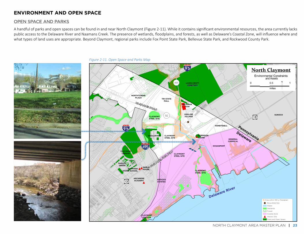
Figure 2-11. Open Space and Parks Map
environment And oPen sPAce
OPEN SPACE ANd PARkS
AhandfulofparksandopenspacescanbefoundinandnearNorthClaymont(Figure2-11).Whileitcontainssignificantenvironmentalresources,theareacurrentlylackspublicaccesstotheDelawareRiverandNaamansCreek.Thepresenceofwetlands,floodplains,andforests,aswellasDelaware’sCoastalZone,willinfluencewhereandwhattypesoflandusesareappropriate.BeyondClaymont,regionalparksincludeFoxPointStatePark,BellevueStatePark,andRockwoodCountyPark.
PHiLaDELPHia P
iKE
NaamaNs rOaD

24 | NORTH CLAYMONT AREA MASTER PLAN
mArket AnAlysis
TheNCAMPMarketAssessment,completedJanuary2016,examinedindustrial,office,residential,andretailforexistingconditions,trends,andfuturemarketdynamics.Significantchanges,underwayandplanned,willimpacttheStudyArea’spositioninthemarketplace(Figure2-12).
redevelopment of the claymont steel site:CDCboughtthesiteandpreparedthe“FirstStateCrossing”concept.ThoughthePortofWilmington’soperator,DiamondStatePortCorporation,evaluatedthissitewithanumberofothersalongtheDelawareRiverforPortexpansion,thissiteisnolongerbeingconsidered.Remediationeffortsareunderway.
ClaymontRegionalTransportationCenter:DARTFirstState/DelawareTransitCorporationandCommercialDevelopmentCorporation(CDC)areindiscussionsrelatedtorelocatingthestation.Anewlocationmayprovidebetteraccess,moreparking,amodernizedstationfacility,andanopportunityfortransit-orienteddevelopment.
SunocoLogisticsInvestments:Aformeroilrefinery,theSunocoLogisticscomplexhasbeenre-positionedasastorage,processing,anddistributionterminalfornaturalgasliquids.Sunocoplanstomakeitthelargestnaturalgasliquidscomplexontheeastcoastbyyear-end2016.
tri-state Mall:Tri-StateMalliscurrently40%occupied.TheMall’sabilitytore-positionitselfhasbeenimprovedbytheexpirationofKmart’sleaseinAugustof2015,andtheredevelopmentoftheClaymontSteelsite.
Figure 2-12. Market Assessment Considerations Map
Retail Sales Surplus and Leakage 10-Minute Drive Time from Naamans Road and I-95 Intersection
2015
Source: ESRI; W-ZHA
($300,000,000)
($250,000,000)
($200,000,000)
($150,000,000)
($100,000,000)
($50,000,000)
$0
$50,000,000
$100,000,000
Reta
il Sa
le S
urpl
us o
r (Le
akag
e)
Electronics
/
Appliances
Miscella
neous
General Merch
andise
Clothing/Acce
ssorie
s
Sporting Goods,
Hobby, Book,
and Music
Health
/
Personal C
are
Grocery/Liquor
Building/
GardenFurnitu
re
NORTH CLAYMONT AREA MASTER PLAN | 25
dEVELOPMENT POTENTIAL
Dependingonforceswithinandnearthestudyareainthenext10years,themarkethasthepotentialtosupport:
industrial land uses: 200,000to400,000squarefeet(sq.ft.)ofwarehouseanddistributionspace,withthehigherendoftherangeonlyrealisticifacontainerportisdeveloped.Themarketalsohasthepotentialtosupport120,000to180,000sq.ft.offlexspace.WiththegrowthofSunoco,therewilllikelybeinterestfrommanufacturingcompaniesoverthenextdecade.
oFFice land uses: 50,000to100,000sq.ft.ofofficespaceoverthenext10years,thoughitismostlikelytodevelopalongwitharelocatedrailstationandatransit-orientedenvironment.
residential land uses: 380-580multifamilyunits(apartments,generally)and60-210for-saledwellingunitsoverthenext10years.
retail land uses: 300,000to500,000sq.ft.ofnewretailandeat/drinkspace.
INduSTRIAL BuILdINg TYPES ANd LOCATION FACTORS
There are generally three types of industrial buildings:manufacturingbuildings,wholesale/distributionbuildings,andflexbuildings.
ManufacturingBuildings
Manufacturingbuildingsaredesignedtoserveaspecificmanufacturing process. These types of buildings arelocated either near the raw product necessary for themanufacturingprocess,inalocationwherethereareothercomplementaryindustries,and/orinlocationsthatofferacompetitiveedgeingettingtheirproducttomarket.Theygenerally range in size from100,000 to 300,000 squarefeet.
WholesaleandDistributionFacilities
These buildings are designed for the storage anddistribution of goods. The buildings typically have 36’ceiling clearances and plenty of land to allow trucks tomaneuver.Thesebuildingscanrangefrom40,000toover1,000,000squarefeet.Thebusinessesthatoccupythesebuildings need a road network that provides excellenttruckaccesstotheirtargetmarkets.Theymayalsorequirerailaccess.
FlexBuildings
Flexbuildingscontainwarehousespaceaswellasofficespace, and are very flexible, allowing the tenant tocustomizethespacefortheirneeds.Flexbuildingsrangein size from20,000 square feet to 100,000 square feet.Flexbuildinglocationparametersaremoresimilartoretailthanmanufacturingordistributionlanduses.Flexbuildingsseeklocationsthatareeasilyaccessibletotargettenants.Flex industrial has far fewer conflictswith residential as
ExISTINg uNMET dEMANd FOR RETAIL
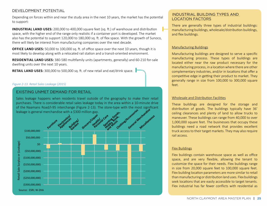
Sales leakage happens when residents travel outside of the geography to make their retailpurchases.Thereisconsiderableretailsalesleakagetodayintheareawithina10-minutedriveoftheNaamansRoad/I-95 interchange(Figure2-13).Thestore-typewiththemostsignificantleakageisgeneralmerchandisewitha$300milliongap.
Retail Sales Surplus and Leakage 10-Minute Drive Time from Naamans Road and I-95 Intersection
2015
Source: ESRI; W-ZHA
($300,000,000)
($250,000,000)
($200,000,000)
($150,000,000)
($100,000,000)
($50,000,000)
$0
$50,000,000
$100,000,000
Reta
il Sa
le S
urpl
us o
r (Le
akag
e)
Electronics
/
Appliances
Miscella
neous
General Merch
andise
Clothing/Acce
ssorie
s
Sporting Goods,
Hobby, Book,
and Music
Health
/
Personal C
are
Grocery/Liquor
Building/
GardenFurnitu
re
Figure 2-13. Retail Sales Leakage (2015)

26 | NORTH CLAYMONT AREA MASTER PLAN
Homes in the Study Area, along Ridge Road

NORTH CLAYMONT AREA MASTER PLAN | 27
sEctiON 3. GOaLs & ObjEctivEs

28 | NORTH CLAYMONT AREA MASTER PLAN
0
10
20
30
40
50
60
70
Create a Safe andWelcomingCommunity
Promote Economicand BusinessDevelopment
ImproveTransportation
Connections for All
Protect and Restorethe Environment
Encourage Designthat Enhances the
Existing CommunityContext
Increase theNetwork of Open
Space andRecreation Facilities
Foster a Variety ofHousing
Num
ber o
f res
pons
es
Very ImportantSomewhat ImportantNo OpinionNot Very ImportantNot Important At All
develoPment of goAls/objectives
Goalsandobjectivesprovidedtheframeworkforevaluatingthescenarios.Aninitialsetofgoalswasdevelopedwithinputfromfocusgroups,theProjectManagementCommittee, and the Advisory Committee. This set of goals was then evaluatedby the community at the first PublicWorkshop (February 3, 2016, at ArchmereAcademy).Therewereapproximately100peopleinattendanceattheworkshop,wherecommunitymembersworkedinsmallgroupstoevaluateandprioritizethegoals. Feedback from themeeting directly influenced the final set of goals andobjectives.Themainfindingfromtheworkshopwasthatthecommunitywantedtoseeaplanthatprovidedabalancedapproachtomeetingthegoals,withapriorityplacedoncommunitysafetyandeconomic/jobdevelopment(Figure3-1).
Each of the seven final goals contains several related objectives (Figure 3-2).Metricsweredevelopedtomeasurehowwelleachscenarioaddressedthesetoftheobjectives.(SeeSection5.)
goals: Broad statements that describe adesiredfuturestate.ThesefitunderoneofthefourMasterPlanelements.
oBjectives: Specificstatementsinsupportofeachgoal.
Metrics: Ways to measure how well eachscenarioaddressestheobjectives.
Figure 3-1. Summary of Community Meeting #1 Goal Prioritization Activity

NORTH CLAYMONT AREA MASTER PLAN | 29
el
em
en
ts
go
Al
so
bje
ct
ive
s
PromoteEconomic
DevelopmentandExpandJobOpportunities
EncourageDesignthatBuildsOnCommunityStrengths
CreateaSafe,Healthy,andWelcomingCommunity
LandUseandDesign CommunityandEconomicDevelopment
FosteraVarietyofHousing
» Promoteanattractive,walkable,transit-orientedenvironment
» Preserveandrespectthehistoryofthearea
» Limitthevisibilityofsurfaceparkinglotsandencouragestructuredparking
» Encouragehousingfor55+andassistedlivingfacilities
» Includedevelopmentofhousingforavarietyofincomesandinavarietyoftypes,includingmixed-use
» Planfornewresidentialareaswithviewsofthewaterfrontandprotectexistingviews
» Providejobopportunitiesthroughsupportforindustryandretail,includingsmall,localbusinesses
» Supportjobtrainingopportunities(includingapotentialsatellitecampus)
» Encouragedevelopmentofagreatervarietyofrestaurants,shops,andentertainmentdestinations
» Creategatewaystothecommunityandimprovewayfinding
» Enhancesafetyofexistingneighborhoodsandensuresafetyofnewly-developedareas
» Bufferexistingandnewresidential,commercial,institutional,andopenspaceareasfromindustrialareas
» Encouragesupportforfamilyandhumandevelopment
» Expandopportunitiesforimprovedcommunityhealthandwellness
ProtectandRestoretheEnvironment
IncreasetheNetworkofOpenSpace
andRecreationFacilities
EnvironmentandOpenSpace
ImproveLocalandRegionalMultimodalTransportation
Connections
Transportation
» Promotesafefacilities,particularlyfacilitiesthatdonotconflictwiththemovementoftrucks,forpeoplewalkingandbicycling
» Relocateanddesignthetrainstationtobecomeamoreconvenientandappealingfacility
» Encouragedevelopmentofamultimodaltrain/bus/bike/walkhub
» ImprovebusservicewithinClaymont
» Reducetrafficcongestionandcrashes
» Provideaccesstomorepublicopenspaceandrecreationfacilities,includingparks
» Designatepublicaccessareasonthewaterfront
» ContinuetheEastCoastGreenwayandprovidemoreoff-roadtrails
» EnhanceNaamansCreekwaterway
» Mitigateexistingandfutureair,water,andsoundpollution
Figure 3-2. Final goals and objectives

30 | NORTH CLAYMONT AREA MASTER PLAN
First community workshop for the project (February 3, 2016)

NORTH CLAYMONT AREA MASTER PLAN | 31
sEctiON 4. scENariOs
32 | NORTH CLAYMONT AREA MASTER PLAN
Existinglanduseconditions,witharelocatedtrainstation.ThisscenariowasusedasabasisofcomparisonforScenarios2-4.
Amixofusesindistinct,connectedzones.
Intenseindustrialonthewaterfront,withnew,largeretailandofficeareas.
Avarietyoflandusesthroughoutthestudyarea,primarilyinmixed-useareas,withagreaterindustrialpresence.
scenarios 2-4 all include the following, which the community and other stakeholders deemed to be necessary components of the long-term vision for north claymont:
the lAnd use scenArios
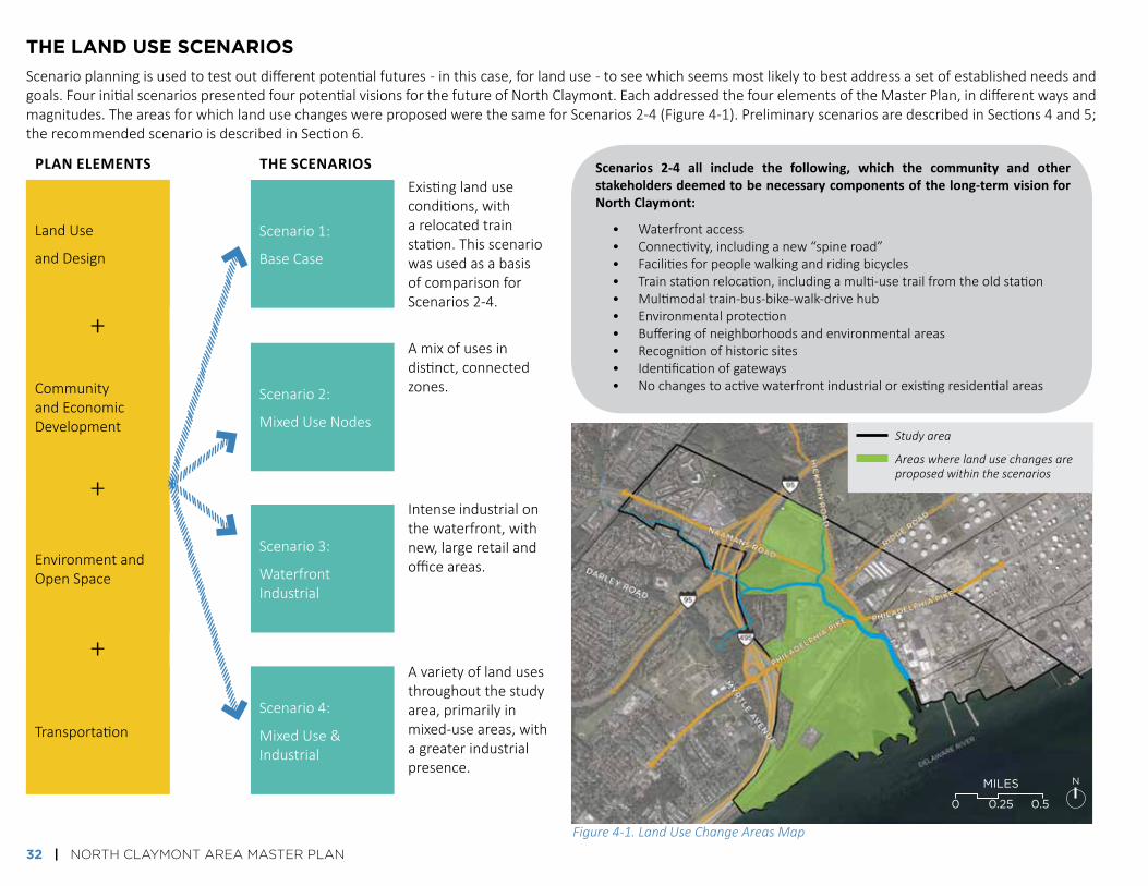
Scenarioplanningisusedtotestoutdifferentpotentialfutures-inthiscase,forlanduse-toseewhichseemsmostlikelytobestaddressasetofestablishedneedsandgoals.FourinitialscenariospresentedfourpotentialvisionsforthefutureofNorthClaymont.EachaddressedthefourelementsoftheMasterPlan,indifferentwaysandmagnitudes.TheareasforwhichlandusechangeswereproposedwerethesameforScenarios2-4(Figure4-1).PreliminaryscenariosaredescribedinSections4and5;therecommendedscenarioisdescribedinSection6.
Transportation
LandUse
andDesign
EnvironmentandOpenSpace
CommunityandEconomicDevelopment
+
Scenario4:
MixedUse&Industrial
Scenario1:
BaseCase
Scenario3:
WaterfrontIndustrial
Scenario2:
MixedUseNodes
+
+
• Waterfrontaccess• Connectivity,includinganew“spineroad”• Facilitiesforpeoplewalkingandridingbicycles• Trainstationrelocation,includingamulti-usetrailfromtheoldstation• Multimodaltrain-bus-bike-walk-drivehub• Environmentalprotection• Bufferingofneighborhoodsandenvironmentalareas• Recognitionofhistoricsites• Identificationofgateways• Nochangestoactivewaterfrontindustrialorexistingresidentialareas
Study area
Areas where land use changes are proposed within the scenarios
Plan eleMents the scenarios
Figure 4-1. Land Use Change Areas Map
0 0.25 0.5
NMILES

retail
oFFice
single FaMily residential
MultiFaMily or Mixed residential
institutional
light industrial
heavy industrial
vacant industrial
MIxEdUSE(RETAIL,OffICE)
MIxEdUSE(RETAIL,institutional, RESIdEnTIAL)
MIxEdUSE(MIxEdindustrial, oFFice/fLEx)
NORTH CLAYMONT AREA MASTER PLAN | 33
whAt is in eAch scenArio?
TYPES OF LANd uSES
Thefollowingpagesshowthesetofinitialscenarios,whichincludemanydifferenttypesoflanduses.Thepicturesbelowshowexamplesoftheformtheselandusesmighttake.
Shops,restaurants
Professionalofficesandservices
Onehouseholdperparcel
Manyhouseholdson
oneparcel
Medicalcampus,educationalcampus
FormerClaymontSteelsite
Warehouse,flexspace,lightmanufacturing,wholesale,repair
Intensivemanufacturing
Developmentsthatincorporateretailandoffice,usuallywithretailatgroundlevel
Awalkable,livelycommercialcenter
Officeandlightindustrialuses

34 | NORTH CLAYMONT AREA MASTER PLAN
TRAINSTATIONRELOCATION,withamulti-usetrailtothenewstationA
SCENARIO 1: BASE SCENARIO
TheBaseScenarioconsistsofexistinglanduseconditions,witharelocatedtrainstation(Figure4-2).ThisscenariowasusedasabasisofcomparisonforScenarios2-4.Circledlettersbelowcorrespondtothemaponthefollowingpage.
1. Multifamily residential 2. Tri-State Mall
3. Naamans Road 4. Robinson House
5. Train station 6. View northeast from mill site
7. Philadelphia Pike (view toward southwest)
8. River view from mill site 9. Bridge on mill site
exaMPles oF existing conditions

dELAWARE RIVER
NORTH CLAYMONT AREA MASTER PLAN | 35
existing retail/commercial/services
existing single-family residential
existing multifamily residential
existing office
existing institutional
existing Active industrial
existing inactive industrial
existing green space/Parks/forest
existing cemetery
other existing undeveloped Areas
existing wetlands
existing utilities
existing Pedestrian bridges
Planned trail
existing historic Properties
existing bus transfer
existing railroad
study Area boundary
riDGE r
OaD
Hic
Km
aN
rO
aD
PHiL
aDELP
Hia
PiK
E
NaamaNs rOaD
myrtLE a
vEN
uE
WOODSHAVEN KRUSE PARK
TRI-STATE MALL
AddICkS ESTATES
kNOLLWOOd
dARLEYgREEN
DARLEYHOUSE
ROBINSONHOUSE
ANALINEVILLAgE
NORTHTOWNE
HICKMANROW
PENNSYLVANIA
dELAWARE
EXISTING TRAIN STATION &
PARKING
EXISTING RAIL UNDERPASS
THREE EXISTING TUNNELS UNDER
RAILWAY
A
KNOLLWOOD PARK
nAAm
An
s c
reek
1
2
3
4
5
6
7
8
9
Figure 4-2. Scenario 1 Map
0 0.25 0.5
NMILES
Numbers correspond to the photos on the previous page.
36 | NORTH CLAYMONT AREA MASTER PLAN
A TRAINSTATIONRELOCATION,withamulti-usetrailtothenewstation,andabustransferstation/multimodalhub
WATERFRONTPARK,potentiallywithtrailtoFoxPointStatePark
MIXED-USEOFFICEWITHRETAILC1. Retail/restaurants[7,000sq.ft.]andoffice[100,000sq.ft.]along
PhiladelphiaPikeC2. Office[build-tosuit-500,000sq.ft.withparkinggarage]andretail
[100,000sq.ft.]
RETAIL,withshopsandservices[200,000sq.ft.]
RESIDENTIALE1. Apartments[400units]E2. Townhouses[80units],apartments[400units]E3. Apartments[800units],townhouses[80units]
TRANSIT-ORIENTEDMIXED-USE,withoffice[300,000sq.ft.]andretail[5,000sq.ft.]
INSTITUTIONAL,withmedicaland/ortrainingfacilities[300,000sq.ft.]
INDUSTRIAL/FLEX[100,000sq.ft.]
PARKINGP1. Parkinggaragewithlinerbuilding[700cars]P2. Parkinglot[existing]
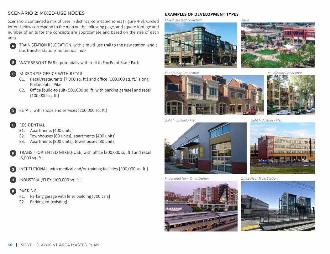
SCENARIO 2: MIxEd-uSE NOdES
Scenario2containedamixofusesindistinct,connectedzones(Figure4-3).Circledlettersbelowcorrespondtothemaponthefollowingpage,andsquarefootageandnumberofunitsfortheconceptsareapproximateandbasedonthesizeofeacharea.
exaMPles oF develoPMent tyPesMixed Use (Office/Retail) Retail
Multifamily Residential Multifamily Residential
Light Industrial / Flex Light Industrial / Flex
Residential Near Train Station Office Near Train Station
b
c
d
e
f
g
h
P

EAST COAST GREENWAY
ProPosed
existing
dELAWARE RIVER
NORTH CLAYMONT AREA MASTER PLAN | 37
retail
multifamily or mixed residential
industrial/light industrial
office
mixed-use [retail/office]
neighborhood buffer Areas
Proposed & existing green space/Parks/forest
enhanced bike/Ped
major multimodal street connections
minor multimodal street connections
multimodal hub/bus transfer station
retail/commercial/services
single-family residential
multifamily residential
office
institutional
heavy industrial
utilities
cemetery
Pedestrian bridges
historic Properties
railroad
study Area boundary
riDGE r
OaD
Hic
Km
aN
rO
aD
PHiL
aDELP
Hia
PiK
E
NaamaNs rOaD
myrtLE a
vEN
uE
WOODSHAVEN KRUSE PARK
AddICkS ESTATES
kNOLLWOOd
dARLEYgREEN
DARLEYHOUSE
ROBINSONHOUSE
ANALINEVILLAgE
NORTHTOWNE
HICKMANROW
PENNSYLVANIA
dELAWARE
THREE EXISTING TUNNELS UNDER
RAILWAY
KNOLLWOOD PARK
Figure 4-3. Scenario 2 Map
0 0.25 0.5
NMILES
nAAm
An
s c
reek
E2
d
P1
P2
E1
E3
C1
f
f
C2
H
G
A
B
B
B

38 | NORTH CLAYMONT AREA MASTER PLAN
SCENARIO 3: WATERFRONT INduSTRIAL
Scenario3incorporatedintenseindustrialusesonthewaterfront,withnewretail,office,andresidentialareasfurthertothenorth(Figure4-4).Circledlettersbelowcorrespondtothemaponthefollowingpage,andsquarefootageandnumberofunitsfortheconceptsareapproximateandbasedonthesizeofeacharea.
exaMPles oF develoPMent tyPes
A TRAINSTATIONRELOCATION,withamulti-usetrailtothenewstation,andabustransferstation/multimodalhub
WATERFRONTPARK,potentiallywithtrailtoFoxPointStatePark
MIXED-USEOFFICEWITHRETAIL,includingretail/restaurants[7,000sq.ft.]andoffice[100,000sq.ft.]alongPhiladelphiaPike
RETAILD1. Retail,withshopsandservices[300,000sq.ft.]D2. Retail,withshopsandservices[350,000sq.ft.]
RESIDENTIAL,includingtownhouses[80units]andapartments[400units]
TRANSIT-ORIENTEDMIXED-USEF1. Flexindustrial[180,000sq.ft.]F2. Office[75,000sq.ft.]
OFFICE[build-tosuit-500,000sq.ft.withparkinggarage]
INDUSTRIALH1. Heavyindustrial(Manufacturing,logistics,etc)[243acres,approx.H2. Industrial[10acres,approx.]
PARKINGP1. Parkinggaragewithlinerbuilding[700cars]P2. Parkinglot[existing]
b
c
d
e
f
g
h
P
Mix of Adjacent Uses (Residential / Retail / Office / Light industrial / Flex)
Office / Light Industrial
Residential Near Retail Office
Light Industrial / Flex With Green Buffer

retail
single-family residential
industrial/light industrial
office
mixed-use [retail/office]
mixed-use [flex/light indus./office]
Proposed & existing green space/Parks/forest
neighborhood buffer Areas
enhanced bike/Ped
major multimodal street connections
minor multimodal street connections
multimodal hub/bus transfer station
retail/commercial/services
single-family residential
multifamily residential
office
institutional
heavy industrial
utilities
cemetery
Pedestrian bridges
historic Properties
railroad
study Area boundary
ProPosed
existing
dELAWARE RIVER
NORTH CLAYMONT AREA MASTER PLAN | 39
Figure 4-4. Scenario 3 Map
riDGE r
OaD
Hic
Km
aN
rO
aD
PHiL
aDELP
Hia
PiK
E
NaamaNs rOaD
myrtLE a
vEN
uE
KNOLLWOOD PARK
WOODSHAVEN KRUSE PARK
AddICkS ESTATES
kNOLLWOOd
dARLEYgREEN
DARLEYHOUSE
ROBINSONHOUSE
ANALINEVILLAgE
NORTHTOWNE
HICKMANROW
PENNSYLVANIA
dELAWARE
THREE EXISTING TUNNELS UNDER
RAILWAY
EAST COAST GREENWAY
nAAm
An
s c
reek
Light Industrial / Flex With Green Buffer
0 0.25 0.5
NMILES
d1
d2
P2
G
E
H1
H2
C F1
F2A
B
P1

40 | NORTH CLAYMONT AREA MASTER PLAN
SCENARIO 4: MIxEd-uSE ANd INduSTRIAL
Thefinalscenarioincludedabalancebetweenindustrial,openspace,andresidentialusesnear the railwayandwaterfront,witha clusterofofficedevelopmentnearthetrainstationandamixofusestothenorth(Figure4-5).Circledlettersbelowcorrespondtothemaponthefollowingpage,andsquarefootageandnumberofunitsfortheconceptsareapproximateandbasedonthesizeofeacharea.
exaMPles oF develoPMent tyPes
A TRAINSTATIONRELOCATION,withamulti-usetrailtothenewstation,andabustransferstation/multimodalhub
WATERFRONTPARK,potentiallywithtrailtoFoxPointStatePark
MIXED-USEOFFICEWITHRETAILC1. Retail/restaurants[7,000sq.ft.]andoffice[100,000sq.ft.]along
PhiladelphiaPikeC2. Office[build-tosuit-500,000sq.ft.withparkinggarage]andretail
[100,000sq.ft.]
RETAIL,withshopsandservices[350,000sq.ft.]
RESIDENTIALE1. Townhouses[40units],cottagehomes[25units]E2. Apartments[300units]E3. Apartments[250units],townhouses[80units]
OFFICE[125,000sq.ft.]
MIXED-USE[LIFESTYLECENTER],withretail[200,000sq.ft.].institutional[100,000sq.ft.],andapartmentsaboveretail[180units]
INDUSTRIALANDFLEXH1. Heavyindustrial[200,000sq.ft.]H2. Flex/lightindustrial/R&D[180,000sq.ft.]
PARKINGP1. Parkinggaragewithlinerbuilding[700cars]P2. Parkinglot[existing]
b
c
d
e
f
g
h
P
Light Industrial-Flex Office Above Retail
Lifestyle Center Lifestyle Center
Cottage Homes Residential Above Retail

riDGE r
OaD
Hic
Km
aN
rO
aD
PHiL
aDELP
Hia
PiK
E
NaamaNs rOaD
myrtLE a
vEN
uE
WOODSHAVEN KRUSE PARK
AddICkS ESTATES
kNOLLWOOd
dARLEYgREEN
DARLEYHOUSE
ROBINSONHOUSE
ANALINEVILLAgE
NORTHTOWNE
HICKMANROW
PENNSYLVANIA
dELAWARE
THREE EXISTING TUNNELS UNDER
RAILWAY
KNOLLWOOD PARK
EAST COAST GREENWAY
dELAWARE RIVER
nAAm
An
s c
reek
0 0.25 0.5
NMILES
retail
single-family residential
multifamily or mixed residential
industrial/light industrial
office
mixed-use [retail/office]
mixed-use lifestyle center [retail/residential/institutional]
Proposed & existing green space/Parks/forest
neighborhood buffer Areas
enhanced bike/Ped
major multimodal street connections
minor multimodal street connections
multimodal hub/bus transfer station
retail/commercial/services
single-family residential
multifamily residential
office
institutional
heavy industrial
utilities
cemetery
Pedestrian bridges
historic Properties
railroad
study Area boundary
ProPosed
existing
dELAWARE
dELAWARE RIVER
NORTH CLAYMONT AREA MASTER PLAN | 41
Figure 4-5. Scenario 4 Map
nAAm
An
s c
reek
C2
D
P2
E2
E1
E3
H1
H2
C1
G
F
A
B
B
P1

42 | NORTH CLAYMONT AREA MASTER PLAN
COMPLETE STREETS
TheStateofDelaware’spolicyistoprovideforalltravelers,whetherthey’redriving,walking,bicycling,orridingtransit.Forthatreason,allstreetsintheNCAMParea,whetherneworexisting,willbe“CompleteStreets”thatinclude:• Drivinglanes• Sidewalks• Busstopsenhancedwithpull-offareas,benches,andshelters,as
appropriate• Bicyclefacilitiesdesignedforlow“trafficstress”sothey’recomfortablefor
mostpeople» Thetypeoffacilitywilldependonthenatureofthestreet.Onsmall,
localstreetsthathavelowtrafficandlowspeeds,peoplebicyclingmayusethesamelaneascartraffic.Busierand/orfasterstreetswillfeaturebikelanesorpathsseparatedfromtraffic.
WALkABILITY ON THE I-495 ANd I-95 CROSSINgS
RedevelopmentofNorthClaymontmustsupportthemanyyearsofsuccessthathavealreadybeenachievedinthehistoriccenterofClaymont.WalkingbetweencentralClaymontandNorthClaymontrequirescrossingI-495,whichisunpleasantand perceived as dangerous. Potential improvements to increase comfort forpeoplewalkinginclude:• Tighteningthecurvesontheramps,whichwillslowtrafficbutstillallow
truckstomakenecessaryturns• Slowingdowntrafficspeeds• Shorteningcrosswalks• Wideningsidewalks• ImprovingtheexistingpedestrianbridgeoverI-495.
SHORT-TERM IMPROVEMENTS ON RIdgE ROAd & SOCIETY dRIVE
Duringthemasterplanningprocess,manyresidentsexpressedconcernsrelatedtotrafficoperationsonSocietyDrive.TheyalsoexpressedconcernsaboutRidgeRoad,particularlywhereittransitionsfromfourlanesinPennsylvaniatotwolanesinDelaware.Thescenariosincluderecommendationsforimprovingbothlocations.
EAST COAST gREENWAY CONNECTION
The East Coast Greenway passes through North Claymont. Incorporating acontinuous shared use path for the Greenway is a central focus of this plan'stransportationnetwork.
Example of a low-speed street, where people riding bicycles would share a lane with vehicles
Example of a bicycle and pedestrian path separated from the street
i-4
95
i-4
95
central claymont
Philadelphia Pike
trAnsPortAtion elements common to All scenArios
A concept for improving walkability across I-495 along Philadelphia Pike

riDGE r
OaD
Hic
Km
aN
rO
aD
PHiL
aDELP
Hia
PiK
E
NaamaNs rOaD
myrtLE a
vEN
uE
unsignalized intersections (right turn in, right turn out movements only)
signalized intersections
multi-use Pathway (east coast greenway)
enhanced walking and bicycling network
new streets (major) - with high quality facilities for walking and bicycling
new streets (minor) - with high quality facilities for walking and bicycling
new industrial connection
development node: north of naamans rd
development node: between naamans rd and Philadelphia Pike
development node: between Philadelphia Pike and sePtA rail
development node: east of sePtA rail
streets
signalized intersections
NORTH CLAYMONT AREA MASTER PLAN | 43
EAST COAST GREENWAY
connectivity frAmework
AllscenariosincludedasimilarframeworkforconnectingtheredevelopmentareasandimprovingcirculationwithinNorthClaymont(Figure4-6).
ProPosed
existing
THREE EXISTING TUNNELS UNDER
RAILWAY
Figure 4-6. Connectivity Framework Map
0 0.25 0.5
NMILES

44 | NORTH CLAYMONT AREA MASTER PLAN
Exit from the current train station parking lot

NORTH CLAYMONT AREA MASTER PLAN | 45
sEctiON 5. scENariO aNaLysis
46 | NORTH CLAYMONT AREA MASTER PLAN
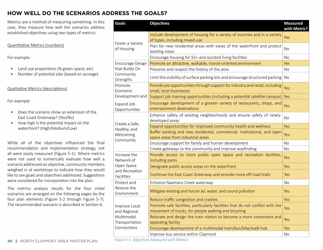
how well do the scenArios Address the goAls?
goals Objectives Measured with Metric?
FosteraVarietyofHousing
Includedevelopmentofhousingforavarietyofincomesandinavarietyoftypes,includingmixed-use Yes
Planfornewresidentialareaswithviewsofthewaterfrontandprotectexistingviews No
Encouragehousingfor55+andassistedlivingfacilities NoEncourageDesignthatBuildsOnCommunityStrengths
Promoteanattractive,walkable,transit-orientedenvironment YesPreserveandrespectthehistoryofthearea No
Limitthevisibilityofsurfaceparkinglotsandencouragestructuredparking No
PromoteEconomicDevelopmentand
ExpandJobOpportunities
Providejobopportunitiesthroughsupportforindustryandretail,includingsmall,localbusinesses Yes
Supportjobtrainingopportunities(includingapotentialsatellitecampus) YesEncourage development of a greater variety of restaurants, shops, andentertainmentdestinations Yes
CreateaSafe,Healthy,andWelcomingCommunity
Enhance safety of existing neighborhoods and ensure safety of newly-developedareas No
Expandopportunitiesforimprovedcommunityhealthandwellness YesBufferexistingandnew residential, commercial, institutional, andopenspaceareasfromindustrialareas Yes
Encouragesupportforfamilyandhumandevelopment NoCreategatewaystothecommunityandimprovewayfinding No
IncreasetheNetworkofOpenSpaceandRecreationFacilities
Provide access to more public open space and recreation facilities,includingparks Yes
Designatepublicaccessareasonthewaterfront Yes
ContinuetheEastCoastGreenwayandprovidemoreoff-roadtrails Yes
ProtectandRestoretheEnvironment
EnhanceNaamansCreekwaterway No
Mitigateexistingandfutureair,water,andsoundpollution Yes
ImproveLocalandRegionalMultimodalTransportationConnections
Reducetrafficcongestionandcrashes YesPromotesafefacilities,particularlyfacilitiesthatdonotconflictwiththemovementoftrucks,forpeoplewalkingandbicycling Yes
Relocateanddesignthetrainstationtobecomeamoreconvenientandappealingfacility Yes
Encouragedevelopmentofamultimodaltrain/bus/bike/walkhub YesImprovebusservicewithinClaymont No
Figure 5-1. Objectives Measured with Metrics
Metricsareamethodofmeasuringsomething.Inthiscase, they measure how well the scenarios addressestablishedobjectivesusingtwotypesofmetrics:
QuantitativeMetrics(numbers)
Forexample:
• Landuseproportions(%greenspace,etc)• Numberofpotentialjobs(basedonacreage)
QualitativeMetrics(descriptions)
Forexample:
• DoesthescenarioshowanextensionoftheEastCoastGreenway?(Yes/No)
• Howhighisthepotentialimpactonthewaterfront?(High/Medium/Low)
While all of the objectives influenced the finalrecommendation and implementation strategy, notallwereeasilymeasured(Figure5-1).Wheremetricswere not used to numerically evaluate how well ascenarioaddressedanobjective,communitymembersweighedinatworkshopstoindicatehowtheywouldliketoseegoalsandobjectivesaddressed.Suggestionswereconsideredforincorporationintotheplan.
The metrics analysis results for the four initialscenariosarearrangedonthefollowingpagesbythefour plan elements (Figure 5-2 through Figure 5-7).TherecommendedscenarioisdescribedinSection6.

NORTH CLAYMONT AREA MASTER PLAN | 47
HOW dO THE SCENARIOS STACk uP?
lAnd use & design
Metric scenario 1: Base Case(ExistingConditions)
scenario 2: Mixed use nodes
scenario 3: waterfront industrial
scenario 4: Mixed use & industrial
does it promote a walkable, transit-oriented environment?
No Yes -
Very well
Yes - Somewhat Yes -
Very well
goals Objectives Measured with Metric?
FosteraVarietyofHousing
Includedevelopmentofhousingforavarietyofincomesandinavarietyoftypes,includingmixed-use Yes
Planfornewresidentialareaswithviewsofthewaterfrontandprotectexistingviews No
Encouragehousingfor55+andassistedlivingfacilities NoEncourageDesignthatBuildsOnCommunityStrengths
Promoteanattractive,walkable,transit-orientedenvironment YesPreserveandrespectthehistoryofthearea No
Limitthevisibilityofsurfaceparkinglotsandencouragestructuredparking No
PromoteEconomicDevelopmentand
ExpandJobOpportunities
Providejobopportunitiesthroughsupportforindustryandretail,includingsmall,localbusinesses Yes
Supportjobtrainingopportunities(includingapotentialsatellitecampus) YesEncourage development of a greater variety of restaurants, shops, andentertainmentdestinations Yes
CreateaSafe,Healthy,andWelcomingCommunity
Enhance safety of existing neighborhoods and ensure safety of newly-developedareas No
Expandopportunitiesforimprovedcommunityhealthandwellness YesBufferexistingandnew residential, commercial, institutional, andopenspaceareasfromindustrialareas Yes
Encouragesupportforfamilyandhumandevelopment NoCreategatewaystothecommunityandimprovewayfinding No
IncreasetheNetworkofOpenSpaceandRecreationFacilities
Provide access to more public open space and recreation facilities,includingparks Yes
Designatepublicaccessareasonthewaterfront Yes
ContinuetheEastCoastGreenwayandprovidemoreoff-roadtrails Yes
ProtectandRestoretheEnvironment
EnhanceNaamansCreekwaterway No
Mitigateexistingandfutureair,water,andsoundpollution Yes
ImproveLocalandRegionalMultimodalTransportationConnections
Reducetrafficcongestionandcrashes YesPromotesafefacilities,particularlyfacilitiesthatdonotconflictwiththemovementoftrucks,forpeoplewalkingandbicycling Yes
Relocateanddesignthetrainstationtobecomeamoreconvenientandappealingfacility Yes
Encouragedevelopmentofamultimodaltrain/bus/bike/walkhub YesImprovebusservicewithinClaymont No
goals Objectives
FosteraVarietyofHousingIncludedevelopmentofhousingforavarietyofincomesandinavarietyoftypes,includingmixed-use
EncourageDesignthatBuildsOnCommunityStrengths
Promoteanattractive,walkable,transit-orientedenvironment
0%
25%
50%
75%
100%
Scenario 1: Base Case(Existing Conditions)
Scenario 2: Mixed Use Nodes
Scenario 3: Waterfront Industrial
Scenario 4: Mixed Use & Industrial
Retail Mixed use (office/retail) Residential (all) Office Open space
33 33 33 33
120
20
80
40
50
42
Conceptual Naamans Creek parks/buffer areas
Conceptual waterfront parks or open space
Existing parks and open spaces
Scenario 1: Base Case(Existing Conditions)
Scenario 2: Mixed Use Nodes
Scenario 3: Waterfront Industrial
Scenario 4: Mixed Use & Industrial
27%12%
32%18%
5%
5%
5%
73%83%
63%
69%
8%
Scenario 1(1354 Units):
Base Case (ExistingConditions)
Scenario 2(3114 Units):
Mixed Use Nodes
Scenario 3(1554 Units):
Waterfront Industrial
Scenario 4(2229 Units):Mixed Use &
Industrial
Single family detachedTownhomesMultifamily housingMixed use (apartments above retail)
Figure 5-2. Proportions of Housing Types (By Scenario)

48 | NORTH CLAYMONT AREA MASTER PLAN
community & economic develoPment
HOW dO THE SCENARIOS STACk uP?
» Moreretailandmixed-usespace=potentialforagreatervarietyofrestaurants,shops,andentertainmentdestinations» Moreinstitutionalspace=morejobtrainingpotential» Moreopenspace=morepotentialtrailsandoutdooractivityareas
0%
25%
50%
75%
100%
Scenario 1: Base Case(Existing Conditions)
Scenario 2: Mixed Use Nodes
Scenario 3: Waterfront Industrial
Scenario 4: Mixed Use & Industrial
Retail Mixed use (office/retail) Residential (all) Office Open space
33 33 33 33
120
20
80
40
50
42
Conceptual Naamans Creek parks/buffer areas
Conceptual waterfront parks or open space
Existing parks and open spaces
Scenario 1: Base Case(Existing Conditions)
Scenario 2: Mixed Use Nodes
Scenario 3: Waterfront Industrial
Scenario 4: Mixed Use & Industrial
27%12%
32%18%
5%
5%
5%
73%83%
63%
69%
8%
Scenario 1(1354 Units):
Base Case (ExistingConditions)
Scenario 2(3114 Units):
Mixed Use Nodes
Scenario 3(1554 Units):
Waterfront Industrial
Scenario 4(2229 Units):Mixed Use &
Industrial
Single family detachedTownhomesMultifamily housingMixed use (apartments above retail)
54%
25%
13%7% 1%
Scenario 1: Base Case (Existing Conditions)
63%14%
5%1%
17%
Scenario 2: Mixed Use Nodes
49%
24%
17%
11%
Scenario 3: Waterfront Industrial
64%22%
8%2% 5%
Scenario 4: Mixed Use & Industrial
Institutional(medical/educational)
HeavyIndustrial
LightIndustrial
Retail
Office
goals Objectives
PromoteEconomicDevelopmentand
ExpandJobOpportunities
Providejobopportunitiesthroughsupportforindustryandretail,includingsmall,localbusinessesSupportjobtrainingopportunities(includingapotentialsatellitecampus)Encouragedevelopmentofagreatervarietyofrestaurants,shops,andentertainmentdestinations
CreateaSafe,Healthy,andWelcomingCommunity
Expandopportunitiesforimprovedcommunityhealthandwellness
Bufferexistingandnewresidential,commercial,institutional,andopenspaceareasfromindustrialareas
Scenario1(Existing) 1,400
scenario 2 8,200
scenario 3 8,400
scenario 4 6,800
Approximate Number of Potential Jobs Based On Land Use Type and Area
0 200 400 600 800 1000
0
200
400
600
800
Scenario 1: Base Case (ExistingConditions)
Scenario 2: Mixed Use Nodes Scenario 3: Waterfront Industrial Scenario 4: Mixed Use & Industrial
Acre
s
RetailMixed Use (Office/Retail)Mixed Use (Retail/Residential/Institutional)InstitutionalResidential (all)OfficeIndustrial (all)UtilityOpen Space
Scenario 1: Base Case (Existing)
Scenario 2: Mixed Use Nodes
Scenario 3: Waterfront Industrial
Scenario 4: Mixed Use & Industrial
Acres
RetailMixed Use (Office/Retail)Mixed Use (Retail/Residential/Institutional)InstitutionalResidential (all)OfficeIndustrial (all)UtilityOpen Space
Retail Mixed Use (Office/Retail)Mixed Use (Retail/Residential/Institutional) InstitutionalResidential (all) OfficeIndustrial (all) UtilityOpen Space
Figure 5-3. Land Use within 1/4 mile of Heavy Industrial (By Scenario)
Figure 5-4. Job Proportions (By Scenario)
Figure 5-5. Land Use (By Scenario)
Prop
ortio
n of
tota
l lan
d us
e ar
ea

NORTH CLAYMONT AREA MASTER PLAN | 49
HOW dO THE SCENARIOS STACk uP?
environment And oPen sPAce
Metric scenario 1: Base Case(ExistingConditions)
scenario 2: Mixed use nodes
scenario 3: waterfront industrial
scenario 4: Mixed use & industrial
Continuationof east coast greenway
No Yes Yes Yes
Potentialimpact of development on the waterfront
Low Low High Medium
0%
25%
50%
75%
100%
Scenario 1: Base Case(Existing Conditions)
Scenario 2: Mixed Use Nodes
Scenario 3: Waterfront Industrial
Scenario 4: Mixed Use & Industrial
Retail Mixed use (office/retail) Residential (all) Office Open space
33 33 33 33
120
20
80
40
50
42
Conceptual Naamans Creek parks/buffer areas
Conceptual waterfront parks or open space
Existing parks and open spaces
Scenario 1: Base Case(Existing Conditions)
Scenario 2: Mixed Use Nodes
Scenario 3: Waterfront Industrial
Scenario 4: Mixed Use & Industrial
27%12%
32%18%
5%
5%
5%
73%83%
63%
69%
8%
Scenario 1(1354 Units):
Base Case (ExistingConditions)
Scenario 2(3114 Units):
Mixed Use Nodes
Scenario 3(1554 Units):
Waterfront Industrial
Scenario 4(2229 Units):Mixed Use &
Industrial
Single family detachedTownhomesMultifamily housingMixed use (apartments above retail)
Figure 5-6. Parks, Open Space, and Buffer Areas (By Scenario)
Appr
oxim
ate
Acre
s
goals Objectives
IncreasetheNetworkofOpenSpaceandRecreationFacilities
Provideaccesstomorepublicopenspaceandrecreationfacilities,includingparks
Designatepublicaccessareasonthewaterfront
ContinuetheEastCoastGreenwayandprovidemoreoff-roadtrails
ProtectandRestoretheEnvironment
Mitigateexistingandfutureair,water,andsoundpollution

50 | NORTH CLAYMONT AREA MASTER PLAN
goal Objectives
ImproveLocalandRegionalMultimodalTransportationConnections
Reducetrafficcongestionandcrashes
Promote safe facilities, particularlyfacilities that do not conflict with themovementoftrucks,forpeoplewalkingandbicyclingRelocate and design the train stationto become a more convenient andappealingfacility
Encouragedevelopmentofamultimodaltrain/bus/bike/walkhub
0
1000
2000
3000
Scenario 1: BaseCase (Existing
Conditions)
Scenario 2:Mixed Use
Nodes
Scenario 3:WaterfrontIndustrial
Scenario 4:Mixed Use &
Industrial
Vehi
cle
Trip
s by
Are
a
Scenario Traffic Comparison (PM Peak Hour)
North of Naamans Rd
Between Naamans Rd & US 13
Between US 13 and SEPTA rail
East of SEPTA rail
trAnsPortAtion
HOW dO THE SCENARIOS STACk uP?
Metric scenario 1: Base Case(ExistingConditions)
scenario 2: Mixed use nodes
scenario 3: waterfront industrial
scenario 4: Mixed use & industrial
More comfortable bicyclefacilities
No Yes Yes Yes
More crossing areas for people walking
No Yes Yes Yes
Trainstationrelocation
Yes Yes Yes Yes
Multimodaltrain, bus, bike, walk, drive hub
No Yes Yes Yes
0
1000
2000
3000
Scenario 1:Base Case(Existing
Conditions)
Scenario 2:Mixed Use
Nodes
Scenario 3:WaterfrontIndustrial
Scenario 4:Mixed Use &
Industrial
Vehi
cle
Trip
s by
Area
Figure 5-7. Traffic Comparison: PM Peak Hour (By Scenario)
0
1000
2000
3000
Scenario 1:Base Case(Existing
Conditions)
Scenario 2:Mixed Use
Nodes
Scenario 3:WaterfrontIndustrial
Scenario 4:Mixed Use
& Industrial
See Appendix for more information about the traffic analyses.
0 0.25 0.5
NMILES

NORTH CLAYMONT AREA MASTER PLAN | 51
stAkeholder inPut on the scenArios
The initial scenarios and analysis results were first reviewed with the ProjectManagementCommitteeandthenwiththeAdvisoryCommittee.Refinedscenariosandanalysisresultswerethendiscussedwiththecommunityatthesecondpublicworkshop(June6,2016,attheClaymontCommunityCenter).
Attheworkshop,whichwasattendedbyabout120people,attendeeswereaskedtofilloutasurvey.Themajorityofthecommunityindicatedapreferenceformixed-usedevelopmentthatincorporatesindustrialorotherjob-producingdevelopment,while still reserving someof thewaterfront space forpublicaccess (Figure5-8).Moreresultsfromthesurveyquestionscanbefoundonthefollowingpage(Figure5-9andFigure5-10).
Question: "Each scenario presents a potential long-term vision for North Claymont. Which scenario(s) do you prefer?" Survey respondents were allowed to choose more than one scenario, or to choose “Combination of Scenarios” or “None/Other”. There were no responses of “None/Other”. Nine people left the question blank.
Community Workshop #2
Figure 5-8. Survey Responses - Scenario Preference
2
21
4
13
4
Scenario 1: BaseCase (Existing
Land UseConditions)
Scenario 2:Mixed Use Nodes
Scenario 3:WaterfrontIndustrial
Scenario 4:Mixed Use &
Industrial
Combination ofscenarios

52 | NORTH CLAYMONT AREA MASTER PLAN
Question: "What are the top three things that you saw in the meeting material that you liked?" These responses were open-ended. Responses were grouped into the general categories shown below.
likes (categories based on responses) responsesGreenspace(especiallynearwater) 13Trainstationimprovements/transit-orienteddevelopment 13Multimodalconsiderations 10Mixofuses 4Scenariooptions/graphics 4Jobpotential 3ConnectiontoFoxPointPark 2Lessheavyindustry 2Buildingdesigns 2Riverfrontandcreekrestoration 2Other 9
Question: "What are the top three things that you saw in the meeting material that concern you?" These responses were open-ended. Responses were grouped into the general categories shown below.
concerns (categories based on responses) responsesHeavyindustryonriver/impactofindustry 10Concernsabouttrainstation(surfaceparking;heightofparkinggarage;location)
7
Othertransportation/connectivityconcerns 5Traffic 4Environmental/openspaceconcerns 4Uncertaintywithtiming,funding,etc. 3Historicpreservationconcerns 2Other 8
Community Workshop #2
Figure 5-9. Survey Responses - What Respondents Liked about the Scenarios
Figure 5-10. Survey Responses - What Concerned the Respondents about the Scenarios

NORTH CLAYMONT AREA MASTER PLAN | 53
sEctiON 6. rEcOmmENDatiONs

54 | NORTH CLAYMONT AREA MASTER PLAN
overAll vision
ThefinalvisionforNorthClaymontisoneofafuturethatcontainsamixofusesinamultimodal,livableenvironment.ItenhancesconnectivitybothwithintheNCAMPareaandto/fromotherareasofClaymont.Itprovidesaframeworkthatwelcomesgrowth in the form of new businesses and new residents, while enhancing theenvironmentandqualityoflifeforthepeoplewhoarealreadyliving,working,andproviding jobsandamenities in thearea. (SeeFigures6-1and6-2 for somekeymetricstocomparewiththefourinitialscenarios.)
TheframeworkanddevelopmentplanareconsistentwiththeDelawareCompleteCommunities initiative and State spending plans, as well as the Toolkit for aHealthyDelawareandNewCastleCounty'sforthcomingHealthyCommunitiesandPlacemakingStandards,whichincludeprovisionsforamixofuses,transportationoptions,diversity,civicspaces,accesstohealthyfood,andmore.Therecommendedstrategiesthatfollowprovideapathtowardrealizingallelementsofthepreferredscenario.
Retail13%
Single Family
Residential7%
Multifamily Residential
4%
Light Industrial
3%
Heavy Industrial
24%Former
Industrial (Vacant)
44%
Office<1%Utility
1%Open Space
4%
Retail10%Single Family
Residential8%
Multifamily Residential
8%
Light Industrial
5%
Heavy Industrial
29%
Office2%
Mixed Use (Office/Retail)
3%Mixed Use
(Lifestyle Center)4%
Utility1%
Open Space30%
Retail12%Single
Family Residential
10%
Multifamily Residential
5%
Light Industrial
5%
Heavy Industrial
39%
Office3%
Mixed Use (Office/Retail)
1%Utility
1%
Open Space24%
Retail9%
Single Family Residential
7%
Multifamily Residential
13%
Light Industrial
4%
Heavy Industrial
24%
Institutional1%
Office4%
Mixed Use (Office/Retail)
2%Utility
1%
Open Space35%
Retail9%
Single Family Residential
7%
Light Industrial
5%
Heavy Industrial27%
Institutional1%
Office1%
Mixed Use (Office/Retail) 2%
Mixed Use (Office/Retail/Res.) 5%
Mixed Use (Retail/Institutional) 3%
Utility 1%
Open Space26%Multifamily
Residential9%
Mixed Use (Lifestyle Center) 4%
745
5,24
5
4,12
0
4,37
0
4,99
5
350 1,
133 1,99
3
1,49
3
1,86
8
181
381 1,
412
541
541
94 94 91
7
127
127
12
1441
12 345
1579
Scenario 1: Base Case(Existing Conditions)
Scenario 2: Mixed Use Nodes
Scenario 3: WaterfrontIndustrial
Scenario 4: Mixed Use & Industrial
Scenario 5:Recommended Scenario
Office Retail Industrial - warehouse/flex Industrial - port/heavy Institutional - all
Figure 6-1. Estimated Job Potential for the Scenarios
Figure 6-2. Land Use Proportions for the Recommended Scenario
Retail13%
Single Family
Residential7%
Multifamily Residential
4%
Light Industrial
3%
Heavy Industrial
24%Former
Industrial (Vacant)
44%
Office<1%Utility
1%Open Space
4%
Retail10%Single Family
Residential8%
Multifamily Residential
8%
Light Industrial
5%
Heavy Industrial
29%
Office2%
Mixed Use (Office/Retail)
3%Mixed Use
(Lifestyle Center)4%
Utility1%
Open Space30%
Retail12%Single
Family Residential
10%
Multifamily Residential
5%
Light Industrial
5%
Heavy Industrial
39%
Office3%
Mixed Use (Office/Retail)
1%Utility
1%
Open Space24%
Retail9%
Single Family Residential
7%
Multifamily Residential
13%
Light Industrial
4%
Heavy Industrial
24%
Institutional1%
Office4%
Mixed Use (Office/Retail)
2%Utility
1%
Open Space35%
Retail9%
Single Family Residential
7%
Light Industrial
5%
Heavy Industrial27%
Institutional1%
Office1%
Mixed Use (Office/Retail) 2%
Mixed Use (Office/Retail/Res.) 5%
Mixed Use (Retail/Institutional) 3%
Utility 1%
Open Space26%Multifamily
Residential9%
Mixed Use (Lifestyle Center) 4%
745
5,24
5
4,12
0
4,37
0
4,99
5
350 1,
133 1,99
3
1,49
3
1,86
8
181
381 1,
412
541
541
94 94 91
7
127
127
12
1441
12 345
1579
Scenario 1: Base Case(Existing Conditions)
Scenario 2: Mixed Use Nodes
Scenario 3: WaterfrontIndustrial
Scenario 4: Mixed Use & Industrial
Scenario 5:Recommended Scenario
Office Retail Industrial - warehouse/flex Industrial - port/heavy Institutional - all
Estimated number of potential jobs was calculated based on estimated land use acreage.
Includes existing land uses, where they are not proposed to change, as well as potential new land uses.
P
SCENARIO 5: RECOMMENdEd SCENARIO
Therecommendedscenarioincorporatesavarietyoflanduses,largelyinmixed-useareas(Figure6-3).Squarefootageandnumberofunitsareapproximateandbasedonthesizeofeacharea.
A TRAINSTATIONRELOCATION,withamulti-usetrailtothenewstation,andabustransferstation/multimodalhub
WATERFRONTPARK,potentiallywithtrailtoFoxPointStatePark
MIXED-USEOFFICEWITHRETAIL,withretail/restaurants[7,000sq.ft.]andoffice[100,000sq.ft.]alongPhiladelphiaPike
MIXED-USERETAILWITHINSTITUTIONAL,withretail[250,000sq.ft.]andinstitutional[100,000sq.ft.]
RESIDENTIAL,withapartments[250units],townhouses[80units]
MIXED-USEOFFICEWITHRETAILANDRESIDENTIALF1. Office[build-tosuit-500,000sq.ft.withparkinggarage],retail
[100,000sq.ft.],andresidential[100unitsonupperfloors]F2. Office[250,000sq.ft.],retail[50,000sq.ft.],residential[300unitson
upperfloors]
INSTITUTIONAL[300,000sq.ft.],suchasmedicaloreducationaluses
INDUSTRIALANDFLEXH1. Heavyindustrial/lightindustrial[200,000sq.ft.]H2. Lightindustrial/flex/research&development[180,000sq.ft.]
MIXED-USE[LIFESTYLECENTER],withretail[200,000sq.ft.].institutional[70,000sq.ft.],andapartmentsaboveretail[250units]
MARINAANDWATERFRONTRETAIL/RECREATION
PARKINGP1. Parkinggaragewithlinerbuilding[700cars]P2. Parkinglot[existing]
b
c
d
e
f
g
h
i
j

NORTH CLAYMONT AREA MASTER PLAN | 55
Figure 6-3. Recommended Scenario Map
dELAWARE RIVER
G
d
P2
F1
I
E
H2C
F2F2
A
B
P1
riDGE r
OaD
Hic
Km
aN
rO
aD
PHiL
aDELP
Hia
PiK
E
NaamaNs rOaD
myrtLE a
vEN
uE
KNOLLWOOD PARK
WOODSHAVEN KRUSE PARK
AddICkS ESTATES
kNOLLWOOd
dARLEYgREEN
DARLEYHOUSE
ROBINSONHOUSE
ANALINEVILLAgE
NORTHTOWNE
HICKMANROW
PENNSYLVANIA
dELAWARE
THREE EXISTING TUNNELS UNDER
RAILWAY
EAST COAST GREENWAY
nAAm
An
s c
reekH1
J
retail
multifamily or mixed residential
industrial/light industrial
office
institutional
mixed-use [retail/office]
mixed-use [retail/office/residential]
mixed-use lifestyle center [retail/residential/institutional]
mixed-use [retail/institutional]
Proposed & existing green space/Parks/forest
enhanced bike/Ped
major multimodal street connections
minor multimodal street connections
multimodal hub/bus transfer station
retail/commercial/services
single-family residential
multifamily residential
office
institutional
heavy industrial
utilities
cemetery
Pedestrian bridges
historic Properties
railroad
study Area boundary
ProPosed
existing
0 0.25 0.5
NMILES

56 | NORTH CLAYMONT AREA MASTER PLAN
lAnd use & design of the built environment
IMPLEMENT A NEW FuTuRE LANd uSE PLAN
ThefuturelanduseplanforNorthClaymontemphasizesusesthatwillencouragepositive impacts to community and economic development, and incorporatesflexibility that will allow future development to adjust to changing marketconditions.Futurelandusechangesareonlyproposedfortransitioningorvacantsites(i.e.,Tri-StateMallandtheformerClaymontSteelsite).However,otherareaswithintheMasterPlanareahavethepotentialtogrowandchangeinthefuture.Accordingly,guidelinesinthissectionsuggesttheformthatnewdevelopmentorredevelopmentshouldtakethroughoutNorthClaymont.
Ageneraldescriptionof the intention foreach landuse type isprovidedbelow.Other sections that follow include specific recommendations related to historicproperties,housing,design,andpotentialzoningchanges.
Plan For new land uses, where necessary
Residential• Incorporaterelativelydenseresidentialareasnearthetrainstation.• Promoteamixofresidentialunittypesatvariouspricepointsinorderto
accommodateresidentsatavarietyoflifestagesandincomelevels.• Focuson1-2bedroomapartmentsandtownhousestodiversifythecurrent
housingstockwithinNorthClaymontandfulfillmarketopportunities.• Incorporateuniversaldesignfeaturestohelpensurethatpeopleareableto
stayintheirresidencesandneighborhoodsastheyage.• Takeadvantageoftopographyandheighttoaccessviewsofwaterfront.• Bufferexistingsingle-familyneighborhoodsandallnewresidentialareas
fromincompatibleuses.
Office• Focusonofficedevelopmentnearthestation(asthestationisanasset
thatwilldrawClassAandClassBofficedevelopment,ifcombinedwithavibrantmixed-uselandusepattern)andalongNaamansRd,neartheI-95interchange.
retail • Fosterarangeofshopsandentertainmenttenantsthatcatertoavarietyof
visitorsandresidentsthroughouttheday.• Requireconvenientaccessibilityfromboththesidewalkandparkingareas,
withparkinglocatedalongthestreetsandbehindbuildings.
Institutional• Encouragemedicaluses(suchasahospitalormedicaloffices)ortraining/
educationaluses(suchasatechnicalschoolorsatellitecampus).
Mixed-use areas• IntheLifestyleCenter,focusonretailandinstitutionaluses,withresidential
ontheupperfloors.Allowflex/lightindustrialorotherflexibleuses,particularlyontheperiphery.
• Nearthetrainstation,focusonofficeusesaboveground-floorretail.Ideally,thetransit-orienteddevelopmentaroundthestationwouldalsoincluderesidentialuses.
light industrial / Flex / research & development• Allowforarangeofusesfocusedonmanufacturingandinnovation,
potentiallyincludingincubatorspacesthathelptogrowsmallbusinesses.
heavy industrial• Allowheavyindustrialoperationstobuildonexistingactiveindustrialuses,
butrequirebufferingfromothernon-compatibleuses,includingsensitiveenvironmentalandresidentialareas.
OpenSpaceandRecreation• Provideaccesstonaturalresources,includingtheDelawareRiverand
NaamansCreek.• Encourageawiderangeofparksandopenspaces,includingpassiveand
activerecreation,indoorsandoutdoors.• Incorporateplazasandothergatheringspacesintodevelopments.
Parking• Requirestructuredparkingwheneverpossible,particularlynearthetrain
station.• Placesurfacelotsbehindbuildingsandbufferfromroadways,accessroads,
neighborhoods,andcommercialareaswithtreesandothervegetation.• Requirelandscapedstormwatermanagementforallsurfaceparkinglots,
andincorporategreenroofsintoparkingstructureswherepossible.

NORTH CLAYMONT AREA MASTER PLAN | 57
design For livaBility Designguidelinesdictatewhat formdevelopmentshould take.The futurevisionfor North Claymont encourages mixed-use, compact, universally-accessibledevelopmentthat isdesignedforavarietyof incomesandgenerations, toallowpeople toage inplace.Newdevelopmentsshouldalsocomplement theexistingstyleandscaleofdevelopmentthroughoutClaymont,particularlywithregardtohistoricpropertiesandthestyleofnewdevelopmentssuchasDarleyGreen.
Existing design requirements in the New Castle County Code, as well as theforthcoming guidingprinciples for development inNewCastleCounty, generallysupport these goals, and should be used as guidelines for development withinNorthClaymont.Inaddition,whiletheClaymontCommunityRedevelopmentPlanisfocusedontheClaymontHometownOverlayarea(ofwhichNCAMPisnotapart),theassociatedManualofDesignGuidelinesfortheOverlayshouldbeconsidered,particularlywhendevelopingorredevelopingareasadjacenttotheOverlayarea.
consider Potential Zoning changesWhile the Master Plan and relevant guidelines put forth recommendations forfuturedevelopmentandredevelopment,thezoningcodewilldeterminewhattypeofusescanbedeveloped,andwhere.NewCastleCounty’sUnifiedDevelopmentCodemayneedtoberevisedtoallowforagreatervarietyofuseswithincertainareas,ortoencouragewalkable,mixed-usedevelopment.ThelargestchangestothecodewilllikelyneedtohappenontheClaymontSteelsite,whichiscurrentlyzonedforindustrialandheavyindustrialuses.Potentialchangesmayinclude:• Re-zoningtheClaymontSteelsitetoallowresidential(upperstoryor
otherwise)andrecreationaluses,wherepermittedbyDNREC.• Encouragingupper-storyresidentialusesontheTri-Stateproperty.• Long-termprovisionsforallowingmedium-densityhousingwithinexisting
single-familyneighborhoods,particularlywithintheareasnearthetrainstation(AddicksEstatesandKnollwood).
• Updatingdesignrequirementstopromotethetypesofdevelopmentdescribedinthisplan(e.g.,designthatincorporatesparkinglocatedbehindbuildings,mixed-usebuildings,etc.).
Darley Green townhousesExample of transit-oriented housing above retail in Dallas, Texas
LIVE
STUDY
LIVE
STUDY
EAT
EAT
WORK
WORK
SHOP
SHOP
PLAY
PLAY
Walkable, Transit-Oriented
Development
Auto-Oriented Development
Transit Station
LIVE
Zoning can provide support for design that promotes a walkable community

58 | NORTH CLAYMONT AREA MASTER PLAN
Protect and celeBrate the history oF clayMont North Claymont contains recognized historic buildings, as well as buildings andstructuresthatmore informallyrepresentthehistoryofthearea.Therearealsoelementsofhistory thatarenot currently recognized,but couldbe representedwithinthestudyarea.
StrategiestocelebratethehistoryofNorthClaymontmayinclude:• RequiringanynewdevelopmentorredevelopmentwithinNorthClaymont
toincludeanevaluationofimpactstohistoricresources,includingtheRobinsonHouseandHickmanRow.
• Reconfiguringtheright-of-wayinfrontofRobinsonHousetotightentheturnradius,therebyreducingcrossingdistance,increasingthegreenspacearoundthehouse,anddecreasingthesite’sisolation.Thiswillcreateamorepleasantexperienceforvisitorstothesiteandwillallowmorespaceforinterpretiveelements.
• EnhancingrecognitionfortheWashington-RochambeauRevolutionaryRouteNationalHistoricTrailalongPhiladelphiaPike,includingaplanforimprovingthesignedanddesignatedroutewithinterpretiveelements.
• Incorporationofsignage,art,orotherinformationalelementsrelatedtoearlysettlers(e.g.,AdolfUlricWertmüller,awell-knownSwedishartistwhosettledneartheDelawareRiverinClaymont).
• Ifthereisinterestfrompotentialdevelopers,encouragingrepurposingofstructuresontheClaymontSteelsiteorotherareas,topreserveelementsofNorthClaymont'shistoriccharacterwithintheproposedmixed-useenvironment.ThoughcurrentremediationplansdonotcallformostofstructurestoremainontheClaymontSteelsite,itmaybefeasible,particularlyforsmallerstructuressuchastheonepicturedtotheright.
• EncouragingincorporationofdesignelementsthatrecalltheindustrialhistoryofClaymont.
• Consideringusingspacenearthenewtrainstationtocelebratelocalhistory.
World War II Memorial in Knollwood
Building remaining on the Claymont Steel siteCurrent signage for the W3R route

NORTH CLAYMONT AREA MASTER PLAN | 59
seek oPPortunities to Provide a range oF housing oPtionsThe future landuse plan calls for apartments above retail on the Tri-StateMallproperty,and includesa long-termvision for residentialuseson thewaterfront.ResidentialusesarenotcurrentlyallowedtobebuiltontherestoftheClaymontSteel site, according to DNREC remediation agreements, but future developersareabletoseekremediationplansthatwouldallowforresidentialuses.Becausehousingiscriticaltotheviabilityofmixed-usedevelopmentnearthetrainstation,upper-storyusesaboveretailandofficehavebeenincludedintherecommendedscenario. There is also a long-term opportunity to increase housing options byprovidingmoredensityofhousingwithinexistingneighborhoods.
Strategiesforexpandinghousingoptionsmayinclude:• Buildingonthetrainstationasanassetbyincludingresidential
developmentwithinacomfortablewalkingdistanceofthestation.ThebenefitsofincludingresidentialdevelopmentinredevelopmentoftheClaymontSteelsiteincludethepotentialforenhancedtrainridership,andthepotentialformorearound-the-clockactivityonthesite,whichwouldbenefitsafetyandencourageawidervarietyofretailandentertainmentoptions.Thisshouldincludeamixofhousingoptions,encompassingbothmarketrateandaffordableunits.Examplesofmixed-incomehousingcanbefoundnearotherSEPTAstations,includingthePaseoVerdedevelopmentneartheTempleUniversityStation.
• Incorporatinghousingintomixed-useredevelopmentontheTri-Stateproperty.
• Includingresidentialuseswithinthemixed-useretailandofficedevelopmentsouthofNaamansRoad.Whilenotcurrentlyallowedonthatsite(duetoDNRECremediationagreements)residentialusesontheupperfloorsofthemixed-usebuildingswouldtakeadvantageofstunningviews,andwouldgiveresidentseasyaccesstoboththetrainstationandredevelopmentonTri-StateMall,aswellasquickaccesstotheinterstate.DNRECremediationagreementscanberevisitedinthefuturetoexaminethepotentialtoallowresidentialuses.
• Consideringslightlyhigherdensitieswithinsingle-familyneighborhoods.Ifandwhensingle-familyhomesorneighborhoodsredevelop,theremaybeanopportunitytoallowforhigherresidentialdensitieswithinneighborhoods.Agenciesshouldensurethatnewdevelopmentsareconsistentwithdesignguidelines.
Paseo Verde, near SEPTA's Temple University Station
Example of a four-unit building that could easily blend into a single-family neighborhood

60 | NORTH CLAYMONT AREA MASTER PLAN
trAnsPortAtion
IMPROVE CONdITIONS FOR ALL TRAVELERS
NorthClaymontmustbecomeasafeandaccessiblemultimodalarea,andstreetswithinNorthClaymontmustservetheneedsofallusersandcomplywithDelDOT’sCompleteStreetsPolicy.• People walking and bicyclingshouldhavesafeand
comfortablefacilitiesthatarewell-litandbufferedfromtraffic.
• People riding transit shouldhavecomfortableanddignifiedplacestowaitfortheirbusesortrains.
• People driving vehiclesshouldhaveefficientandclearroutesthatallowthemstraightforwardaccesstodestinationswithinNorthClaymont.
• People moving freightshouldbeabletoeasilyaccessindustrialareasandinterstates.
The central focus of all transportation recommendations intheMaster Plan is to provide a dense, varied transportationnetwork that provides a range of travel choices for peoplelivingin,workingin,orvisitingtheNorthClaymontarea.Anewroadway,inthisreportcalledthe“spineroad,”isproposedtoconnecttheTri-StateMallpropertywiththeClaymontRegionalTransportationCenter.Thespineroadservesasanorganizingprinciple for all of the transportation recommendationsand will provide accommodations for all modes of travel:walking,bicycling,ridingtransit,andsecondarily,driving.Thespine road allows existing highways—Naamans Road andPhiladelphia Pike—to continue to serve important industrialaccessfunctions.
Thefollowingrecommendationsrelatetovarioustransportationmodes. The table that follows (Figure 6-4) contains specificprojects that address key improvements along certaincorridors.Becausemostprojectswouldimproveconditionsformorethanonemode,thetableprovidesabreakdownofwhichmodesareaddressed.ThepriorityprojectsinthetableshouldbeconsideredforinclusionintheRegionalTransportationPlanandTransportationImprovementPlan.
recoMMendations related to walking • Wide,bufferedsidewalksonbothsidesofstreetsthroughoutthestudyarea.• Safe,comfortablecrosswalksatsignalizedintersections.• Comfortableinterstatecrossings.• Shared-usepaths.
» ContinuationoftheEastCoastGreenwaythroughNorthClaymont.» TrailsalongthecreekandtoFoxPointPark.
• Well-lit,well-signedwalkingroutes.• Furtherevaluationofoptionsforphysicalaccesstothewaterfrontarea,through
discussionswithAmtrakandindustriallandowners.» Potentialopportunitiesincludeuseoftunnelsneartheintersectionof
PhiladelphiaPikeandNaamansRoad,and/oruseofthetunnelleadingtotheeast-boundtrainstationplatform.
recoMMendations related to Bicycling• Separatedbicyclefacilitiesorsharedoff-roadfacilitiesonallmainroadwaysto
providesafe,comfortable,andconvenientopportunitiesforallriders.(On-roadbikelanesarenotsufficienttomakebicyclingcomfortableforawidevarietyofpeople.)
• Secureall-daybicycleparkingatthetrainstation,commercialareas,andatpublicrecreationareas.
recoMMendations related to driving• Astrategytomonitortrafficsafetyandoperationsandtriggerspecificroad
improvementsonceathresholdhasbeenreached.(Seeboxonnextpage.)• Evaluationofspeedlimitstoensuretheyareappropriateforawalkingenvironment.• Potentialnewstreetconnectionsthroughactiveindustrialareas.• Parallelon-streetparkinginfrontofretailuses,withotherparkingavailablebehind
buildings.
east coast greenway connectionThe current routing for the Greenway through Claymont is on-road, utilizing Governor PrintzBoulevard and Philadelphia Pike. The path recommended in this plan deviates to createmoreopportunitiesforoff-roadconnections.Fromthesoutheast,theGreenwaywouldfollowGovernorPrintzandcrossI-495ontheexistingwalkingandbicyclingbridge.Theroutewouldpassthroughtheexistingtrainstationparkinglot,crossMyrtleAvenue,andextendintotheformerClaymontSteelsite.ThepathwouldbeplacedbehindAddicksEstates(withanappropriatebufferfromthehomes)andextendnorthtoPhiladelphiaPike,whichwouldbereconfiguredtoaccommodatewalkingandbicyclingfacilities.Aftercrossingthecreek,theGreenwaywouldturntotherightdownthehillandwould pass under theNortheast Corridor rail line through an existing tunnel/underpass. (Initialreview indicates that thepathcanbeconstructedatagradeof less thanfivepercent,meetingaccessibilityrequirements.)TheGreenwaywouldthenturnnorththroughtheadjacentproperty,joiningtheproposedaccessroadtotheriverfrontdevelopmentarea,andfollowPhiladelphiaPiketothestateline.

NORTH CLAYMONT AREA MASTER PLAN | 61
The transportation recommendationsaddress conditions that will result fromprojected development over the next 25years. Implementation of the Master Planshouldincludea“monitoringandtriggering”processtoensurethatallrecommendationsare implemented as needed: neither priorto the anticipated need nor subject tounnecessary delay after need is identified.The monitoring process should involve acommittee(composedsimilarlytotheMasterPlan’s PMC) which would meet roughlyannuallytoreviewchangingconditionsintheNorthClaymontarea.Thecommitteewouldconsider:• Landdevelopment• Trafficconditions• Right-of-waypreservation• Highwaysafety• Transitserviceandridership• Regionalhighwayandtransitprojects• Statusofprojectsindesign• Status/impactofimplementedprojects
The committee’s assessment of theseconditions would form the basis for thetriggeringprocess.Forexample:• Majorlanddevelopmentactivity
wouldtriggerimmediatereviewoftransportationneeds:levelofserviceimplications/strategy,transitserviceneeds/opportunities,safetyconcerns,andwalkingorbicyclingneeds.
• SteadydeteriorationinlevelofservicetoDorworsewouldtriggeraresponseintheformofstrategiestostabilize/reducetrafficdemand(i.e.,through
Monitoring the need For traFFic saFety and oPerations iMProveMentsrecoMMendations related to riding transit• Atrainstationthatisvisibleandcomfortably
walkablefrommajoraccessroads,particularlyPhiladelphiaPikeandMyrtleAvenue.
• Busstopsandcirculationdesignedtolinkpresentresidentialandcommerciallandusesandfuturedevelopment.» Onmajorexistingroadsandtheproposed
"spineroad,"providebuspulloffs,busshelters,andotheramenitiesthatencouragetheuseofpublictransit(wherespaceisavailable).
» IntegratebuscirculationintotheconceptfortheClaymontRegionalTransportationCenter.
• Improvedsidewalkconnectionsandcrossingsnearstationsandbusstops.
• ExaminationofthefeasibilityofalteringthepresentbusroutestructureandscheduledserviceinClaymontandnortheasternNewCastleCounty.Considerationsshouldinclude:» WhetherthebustransferstationatTri-
StateMallmightbebettersitedatthetrainstation,orwhetheranadditionaltransferstationiswarranted.
» ThefeasibilityofaprivateorpublicbusroutedirecttoPhiladelphiaInternationalAirportfromthetrainstation(likelyanon-demandserviceorflexibleroute).
recoMMendations related to delivering Freight• RoadwayreconfigurationsonPhiladelphia
PikeandNaamansRoadthatsupportcontinuedsuccessofsurroundingindustrialandcommercialdevelopmentwhilecreatingawalkableenvironment.
• Designatedtruckroutesthatdirect/encouragetrucktraffictoavoidneighborhoodswhileaccommodatingdeliveries.
traveldemandmanagementmeasuresortransitimprovements)orincreasecapacity.
• SafetyimprovementsrecommendedbyDelDOT’sHazardEliminationProgramreviewteamwouldtriggeranevaluationofthecompatibilityoftheproposedimprovementswiththeMasterPlanandoftheneedtomakeadjustmentstothePlan.
• TransitservicechangesproposedbyDTCorSEPTAwouldtriggeranevaluationofimprovementsneededtocomplementtheservicechanges,suchassidewalksorshelters,thatshouldbeadvancedthroughtheMasterPlan’simplementation.
• TransportationimprovementsthatarenotpartoftheMasterPlanbutthatimpacttheareaandareproposedforimplementationwouldtriggeranevaluation.TheevaluationwouldfocusoncompatibilityoftheproposedimprovementswiththePlanandtheneedtomakeadjustmentstothePlan.
Assessmentof thesepotential changesmaytrigger oneof the followingoptions to bestrespondtothenewconditions:• Continuewithprojectsascurrently
scheduledintheTransportationImprovementProgram(TIP)/CapitalTransportationProgram(CTP).
• Moveproject(s)forwardintheTIP/CTPscheduleanddetermineappropriatelevelofeffortfordesignactivities.
• Moveproject(s)backintotheoutyearsoftheTIP/CTPschedule.

62 | NORTH CLAYMONT AREA MASTER PLAN
TransportationRecommendations travel Mode(s) improvedwalking Bicycling riding
transitdriving
(cars & trucks)
ConstructspineroadconnectingNaamansRoadandPhiladelphiaPike,with:abridgeoverNaaman’sCreek,onevehiclelaneineachdirectionwithparkingontheeast(development)side,turnlanesaddedapproachingsignalsatNaamansRoadandPhiladelphiaPike,andaprotectedbicyclefacilityorsharedusepath
X X X X
WideneastboundNaamansRoadfromthreelanestofivelanesapproachingthespineroad(2leftturn,2through,1rightturn)
X
Whennecessary,installaDivergingDiamondInterchange(DDI)atI-95andNaamansRoadwithdedicatedspaceforwalkingandbicycling
X X X X
ImproveI-95southboundoff-rampbywideningandsignalizingramprightturn X X XTightenI-95northboundoff-rampradius X X XEnsureallnewinternalstreetsarecompletestreets X X X XRethinkaccessmanagementonNaamansRoadandonPhiladelphiaPike(e.g.,newsignalsatthespineroadintersections;improvementstosignalspacingbyconvertingAlcottAvenuetoright-in,right-out)
X X X
InstallnewroadconnectionfromAlcottAvenuetospineroadforleftturnaccesstoKnollwood X X XReducecornerradiiandimprovecrossingsatPhiladelphiaPike/NaamansRoadintersection X X XImproveI-495rampterminalforcrossingbypeoplewalkingandridingbicycles(e.g.,tightenradiiandsignalizenorthboundofframprightturn)
X X
AddramplanestoI-495northboundramp XImproveRidgeRoadbychangingfreerightturnfromNaamansRoadtoayield,andimprovingeastboundRidgeRoadlanemergeapproachingAnalineVillageusingsignsandpavementmarkings
X X X
ImproveSocietyDrivewithanallwaystoporaroundaboutattheNorthtownePlazadriveway/busstopcrossing X X X
View south along Philadelphia Pike
Figure 6-4. Transportation Recommendations

NORTH CLAYMONT AREA MASTER PLAN | 63
TransportationRecommendations travel Mode(s) improvedwalking Bicycling riding
transitdriving
(cars & trucks)
PlantheEastCoastGreenwayalignmentthroughoutprojectareaasatwo-waysharedusepathalongsouthsideofPhiladelphiaPike,crossingunderNortheastCorridorviaexistingtunnelandcrossingoverI-495viapedestrianbridgefromtheold/currentClaymonttrainstation
X X
InstallasharedusepathalongthesouthsideofNaamansRoad,orinvestigateothersidewalk/sharedusepathcombinationsorotherprotectedbikefacilitiesforNaamansRoad
X X
ImprovetheexistingI-495pedestrianbridge,andimproveandlightthepathleadingtoPhiladelphiaPikefromthewest
X X
InstallanewI-495pedestrianbridgenexttoPhiladelphiaPike. X XInstallstreetlighting,especiallyinneighborhoodsandalongHickmanRoad. X X X XCompleteothersidewalkupgrades:• ExtendsidewalkonHickmanRoad200feettoWoodfieldDriveforaccesstoTri-StateMallareadevelopment.• ProvidenewaccesstoredevelopmentareafromAnalineVillagebycreatingamulti-usepathfromParkway
AvenuetoWoodfieldDrive• ConnectthemissinglinkofsidewalkonDarleyRoadalongthefrontageofDarleyPlaza(outofstudyarea)• ExtendMyrtleAvenuesidewalktoproposedEastCoastGreenwayandpathtonewtrainstation
X X
ConstructtheClaymontRegionalTransportationCenter XEnhancebusservicetostationandTri-StateMallsite XContinueconnectiontoSEPTAbusservices XBuildindustrialaccessroadtofutureindustryeastofNortheastCorridorrailwithnewbridgeoverNaamansCreek XExploreaccesstofutureresidential/marinaeastofNortheastCorridorrailthroughadjacentLindeproperty X
Pedestrian bridge across I-495 to Knollwood

64 | NORTH CLAYMONT AREA MASTER PLAN
AdHERE TO STREETSCAPE dESIgN guIdELINES
AllstreetswithinNorthClaymontshouldadheretogeneralmultimodaldesignguidelines, includingDelDOT’sCompleteStreetspolicyandtheNACTOUrbanStreetDesignGuide,toprovidesafefacilitiesforallusers.ThisMasterPlanincludesrecommendedcrosssectionsforallmajorstreetswithintheNCAMParea(Figures6-5through6-10).ThestreetsectionsassumelandusesthatareconsistentwiththeMasterPlan;streetdesignmaychangebasedonfuture landuses.Forexample, ifsomeofthelandalongPhiladelphiaPikedevelopsasindustrialinsteadofoffice/retail,widesidewalkstosupportsidewalkcafésinthoseareaswouldnotbeappropriate.
Crosssectionsincludeseveralcommonelements:• On-streetparkingisimportantforactivatingstreet-frontingbuildings,butshouldonlybe
includedinfrontofactiveretailareas.Tominimizedelaystopeopledriving,treatments(suchasstripingouteverythirdspace)canbeusedtomakeparallelparkingeasyandquick.
• Allnewroadsshouldhaveburiedutilities,whenpossible.Onmajorexistingroads(PhiladelphiaPikeandNaamansRoad),utilitiesshouldbemovedbehindbuildingswhenpossible,todeclutterthestreetscape.Busstopsandamenitiesshouldbeprovidedwhereappropriate.
• Notallofthestreetsectionneedstobeinpublicrightofway.Forexample,thepublicrightofwayforNaamansRoadmightonlybe80feet,withthesharedusepathsandsidewalksineasementslocatedonprivateproperty.
1
2
34
5
Figure 6-5. Key map for cross sections, showing corridor and direction of view
8-18'
Sidewalkandamenityzone
6'
Treeandutilityzone
8'
Parkinglane
11'
Drivinglane
11'
Drivinglane
16'
Treeandplantingzone;leftturnlanesatintersections
11'
Drivinglane
11'
Drivinglane
8'
Parkinglane
6'
Treeandutilityzone
12'
Sharedusepath
4'
Treezone
10'
Amenityzone
Figure 6-6. Naamans Road Cross Section
1.nAAMAnSROAd(fACIngSE):122-132'
0 0.25 0.5
NMILES

NORTH CLAYMONT AREA MASTER PLAN | 65
2.SPInEROAdwESTOfPhILAdELPhIAPIkE(fACIngnw):70-76'
12'
Sharedusepath
6'
Treeandutilityzone
11'
Drivinglane
11'
Drivinglane
9'+
Bufferzone
8-14'
Sidewalkandamenity
zone
6'
Treeandutilityzone
7'
ParkingLane
8-14'
Sidewalk&amenityzone
6'
Treeandutilityzone
7'
Parkinglane
7'
Parkinglane
11'
Drivinglane
8-14'
Sidewalk&amenityzone
6'
Treeandutilityzone
12'
Separatedbikepath
6'
Plantingbuffer
Note that where the "spine road" approaches signalized intersections, additional lanes will need to be provided for turning movements.
Figure 6-7. Spine Road Cross Section - West of Philadelphia Pike
Figure 6-8. Spine Road Cross Section - East of Philadelphia Pike3.SPInEROAdEASTOfPhILAdELPhIAPIkE(fACIngnw):82-94'
11'
Drivinglane
See the graphic on page 71 for more details about the concept for the spine road near the train station.
Figure 6-6. Naamans Road Cross Section
Examples of a shared-use path (top) and separated bike path (bottom)

66 | NORTH CLAYMONT AREA MASTER PLAN
5.PhILAdELPhIAPIkEnOn-RETAILAREAS(fACIngnE):100'
4.PhILAdELPhIAPIkERETAILAREAS(fACIngnE):118-126'
8-12'
Sidewalkandamenityzone
4'
Treeandutilityzone
8'
Parkinglane
11'Drivinglane
11'Drivinglane
16'
Treeandplantingzone;leftturnlanesatintersections
11'Drivinglane
11'Drivinglane
8'
Parkinglane
4'
Treeandutilityzone
8-12'
Sidewalkandamenityzone
7'
Bikelane
2'
Utilityandbufferzone
2'
Utilityandbufferzone
7'
Bikelane
10'
Sharedusepath
10'
Treeandutilityzone
11'Drivinglane
11'Drivinglane
16'
Treeandplantingzone;leftturnlanesatintersections
11'Drivinglane
11'Drivinglane
10'
Sharedusepath
10'
Treeandutilityzone
Figure 6-9. Philadelphia Pike Cross Section - Retail Areas
Figure 6-10. Philadelphia Pike Cross Section - Non-Retail Areas
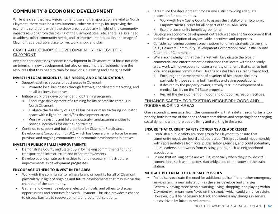
NORTH CLAYMONT AREA MASTER PLAN | 67
community & economic develoPment
WhileitisclearthatnewvisionsforlanduseandtransportationarevitaltoNorthClaymont,theremustbeasimultaneous,cohesivestrategyforimprovingtheeconomicconditionswithinthestudyarea,particularlyinlightofthecommunityimpactsresultingfromtheclosingoftheClaymontSteelsite.Thereisalsoaneedtoaddressothercommunityneeds,andtoimprovethereputationandimageofClaymontasadesirableplacetolive,work,shop,andplay.
CRAFT AN ECONOMIC dEVELOPMENT STRATEgY FOR CLAYMONT
AnyplanthataddresseseconomicdevelopmentinClaymontmustfocusnotonlyonbringinginnewdevelopment,butalsoonensuringthatresidentshavetheresourcesthattheyneedtotrainfornewjobsinexistingandemergingfields.
invest in local residents, Businesses, and organiZations• Supportexisting,successfulbusinessesinClaymont.
» Promotelocalbusinessesthroughfestivals,coordinatedmarketing,andsmallbusinessincentives.
• Initiateworkforcedevelopmentandjobtrainingprograms.» Encouragedevelopmentofatrainingfacilityorsatellitecampusin
NorthClaymont.» Evaluatethefeasibilityofasmallbusinessormanufacturingincubator
spacewithinlightindustrial/flexdevelopmentareas.» Workwithexistingandfutureindustrial/manufacturingentitiesto
provideincentivesforon-the-jobtraining.• ContinuetosupportandbuildoneffortsbyClaymontRenaissance
DevelopmentCorporation(CRDC),whichhasbeenadrivingforceformanypreviousandongoingcommunityandeconomicdevelopmentinitiatives.
invest in PuBlic realM iMProveMents• DemonstrateCountyandStatebuy-inbymakingcommitmentstofund
transportationinfrastructureandotherimprovements.• Developpublic-privatepartnershipstofundnecessaryinfrastructure
improvementsasdevelopmentprogresses.
encourage others to invest in the area • WorkwiththecommunitytorefineabrandoridentityforallofClaymont,
particularlyinlightofongoingandfuturedevelopmentsthatmayevolvethecharacterofthecommunity.
• Gatherlandowners,developers,electedofficials,andotherstodiscussopportunitiesandprioritiesforNorthClaymont.Thisalsoprovidesachancetodiscussbarrierstoredevelopment,andpotentialsolutions.
• Streamlinethedevelopmentprocesswhilestillprovidingadequateprotectionforcommunities.» WorkwithNewCastleCountytoassesstheviabilityofanEconomic
EmpowermentDistrictforallorpartoftheNCAMParea.» Explorecommunitybenefitagreements.
• Developaneconomicdevelopmentoutreachwebsiteand/ordocumentthatincludesadescriptionofanyavailableincentivesandproperties.
• Considerconveningbusinessorganizationstoformastrategicpartnership(e.g.,DelawareCommunityDevelopmentCorporation;NewCastleCountyChamberofCommerce).
• Whileacknowledgingthatthemarketwilllikelydictatethetypeofcommercialandentertainmentdestinationsthatlocatewithinthestudyarea,workwithdeveloperstofosteravarietyoftenantsthatcatertobothlocalandregionalcommunities.UsetheMasterPlanasarecruitmenttool.» Encouragethedevelopmentofavarietyofhealthcarefacilities,
particularlythoseservingbothfamiliesandagingpopulations.» Ifdesiredbythepropertyowner,activelyrecruitdevelopmentofa
medicalfacilityontheTri-Stateproperty.» Recruitthedevelopmentofindoorandoutdoorrecreationfacilities.
ENHANCE SAFETY FOR ExISTINg NEIgHBORHOOdS ANd (RE)dEVELOPINg AREAS
One resoundingmessage from the community is that safety needs to be a toppriority,bothintermsoftheneedsofcurrentresidentsandpreparingforachangingsocialdynamicwithmorepeoplelivingandworkinginthearea.
ensure that current saFety concerns are addressed• EstablishapublicsafetyadvisorygroupforClaymonttoensurethat
communityneedsareheardandaddressed.Thisgroupcouldmeetmonthlywithrepresentativesfromlocalpublicsafetyagencies,andcouldpotentiallyutilizeleadershipnetworksfromexistinggroups,suchasneighborhoodassociations.
• Ensurethatwalkingpathsarewell-lit,especiallywhentheyprovidevitalconnections,suchasthepedestrianbridgeandotherroutestothetrainstation.
Mitigate Potential Future saFety issues• Periodicallyevaluatetheneedforadditionalpolice,fire,orotheremergency
services(e.g.,anewsubstation)astheareadevelopsandchanges.Generally,havingmorepeopleworking,living,shopping,andplayingwithinClaymontwillmeanmore“eyesonthestreet,”whichcouldenhancesafety.However,itwillbenecessarytotrackandaddressanychangesinserviceneedsdrivenbyfuturedevelopment.

68 | NORTH CLAYMONT AREA MASTER PLAN
BEAuTIFY CLAYMONT
encourage ProPerty uPkeeP• Continueenforcementofpropertymaintenanceviolations,and
communicationofrequirements.• EnsurethatState-andCounty-ownedpropertiesareproperlymaintained.• Incentivizepropertyimprovementsandincreasedowner-occupiedhousing
withinexistingneighborhoods,includingthroughenhancedmarketingorexistingprograms.
• ProvideassistanceandguidelinesforHickmanRowpropertyownersandotherstorestoreandmaintainhistoricfacadestotheextentpossible.
Maintain the streetscaPe• Increasestreetscapemaintenanceforimprovedsafetyandaesthetics.
create gateways and enhance wayFinding• Ensurethattherearewelcoming,cleargatewaysintoClaymont,particularly
fromtheinterstates,trainstation,andattheDelawareborder.» Similartreatmentscouldbeusedoutsideofthestudyareaatentrances
intoClaymontalongPhiladelphiaPikeorothermajorroadways.Gatewayanddirectionalsignagewasalsorecommendedinthe2003ClaymontTransportationPlan.
• DesignandinstallacoordinatedwayfindingsysteminClaymont,includingenhancementstotheNationalParkService’sWashington-RochambeauRevolutionaryRouteNationalHistoricTrailroute.
• CreatevisiblesignagetodirectmotoristsfromtheinterstatestoamenitiesthroughoutClaymont,andparticularlytoareaswheretheycanparktheircarsonceandwalktomanydestinations.
• UsethewatertowernexttoTri-StateMall,alreadyanarealandmark,asabrandingopportunityforClaymont.
PROMOTE COMMuNITY HEALTH ANd WELLNESS
require coMPliance with ForthcoMing county standards For healthy coMMunities and PlaceMaking • Encourageactivelivingthroughdesign.
» Installdirectionalsignsthatprovidemileageandtimedistancestodestinationsforpeoplewhoarewalkingandridingbicycles.
» Developwalkingtrails/routeswithexcellentstreetscapingandminimalintersectiondisruptions.TheseroutescouldleadthroughdifferentareasofClaymont,includingparks,neighborhoods,andretailareas.Theyshouldincorporatewaterfountains,shadedareas,andbenches.
• Encouragedevelopmentofactiveindoorandoutdoorrecreationopportunitiesforchildren,teens,andadults.Investigateandimprovehealthyfoodaccess.» Facilitatedevelopmentofapermanentorseasonalfarmersmarket.
ThiscouldpotentiallytakeplaceintheparkinglotoftheTri-StateMallproperty.
» Exploreintegrationofcommunitygardensinparksandneighborhoodopenspace.
Facilitate the develoPMent oF suPPort services• Facilitatethedevelopmentoffamilysupport,trainingcenters,andother
similarfacilities,particularlywithininstitutionalareas,andinmixed-use,transit-accessible,andwalkablesettingsforeasyaccessbyresidents.
Overgrown vegetation along Naamans Road Example of wayfinding signage

NORTH CLAYMONT AREA MASTER PLAN | 69
environment & oPen sPAce
There are parks within and near North Claymont, but they do not meet theneighborhood-scale needsofmost users due to lack of accessibility and lack ofparkprogramming.Asthecommunitychangesandgrows,itwillbenecessarytoenhanceexistingparksandcreatenewpassiveandactivespacesforavarietyofusers.
OneofClaymont’sgreatestassets is itsproximitytotheDelawareRiver,andthecommunityhasmade itclearthataccesstothewaterfront isatoppriority.Thisplan allows for amix of uses on thewaterfront property east of theNortheastCorridor,whilestillencouragingawaterfrontparkareathatcanbeusedforactiveandpassiverecreation.NaamansCreek,anothervaluableenvironmentalfeature,hasbeendegradedbyyearsofproximity toheavy industrialuses.Like the river,the creek presents an excellent opportunity for active and passive recreation,including trails. Areas along the creek and river should be buffered frommoreintensedevelopmentandmadeaccessibleforopenspaceandrecreationaluses.Restorationof thewaterfrontandcreekwouldallowanopportunity to increasecommunity access to natural areas while improving stormwater management,improvingwaterquality,andpreventingfuturedegradation.
Airqualityisalsoaconcernforresidents,giventhelargeindustrialpresence.Likewise,noisepollutionhasbeennotedasanissuefromneighborhoods,particularlythoseneartheinterstates.Whilethereareexistingconcerns,theredevelopmentwithinthisareamaycauseadditionalissues,bothduringtheconstructionprocessandafterdevelopmentiscompleted.Negativeenvironmentalfactorsshouldbemitigatedtotheextentpossible.
IMPROVE ANd Add RECREATION, PARkS, ANd gREEN SPACES
develoP new PuBlic Parks and oPen sPace• PlanforapublicopenspaceontheDelawareRiver.Thisshouldincludetrails
andotherpassiveandactiverecreationareas.• Incorporateapublicparkandtrailintothebufferareaaroundthecreek,
coordinatedwithcreekrestorationefforts.• Ensurethatnewprivately-developedpublicopenspaceshaveadequate
managementplans.
uPgrade existing Parks and oPen sPaces • Improvefacilitiesatexistingparksandplazas.• Provideaccesstogreenspaceswithinandnearexistingneighborhoods.
develoP a trail systeM• IncorporaterecommendedtrailsandrelatedguidelinesintoDelaware’s
FirstStateTrailsandPathwayPlanandWILMAPCO’sNewCastleCountyGreenwaysPlan.
• AmendtheproposedEastCoastGreenwayrouteandsupportdevelopmentoftheEastCoastGreenwaythroughClaymont.DiscusspotentialroutemodificationswithMarcusHook.
• Providetrailswithinallexistingandnewpublicgreenspacesandparkareas,particularlyneartheriverandcreek.
• Incorporateexercisestationsforarangeofabilitiesalongrecreationaltrails.• StudythefeasibilityofatrailconnectionfromNorthClaymonttoFoxPoint
StatePark.
MITIgATE AIR, WATER, ANd NOISE POLLuTION
share inForMation• Continuetoprovideinformationtothecommunityregardingtheresults
ofsoilandairqualitytestingandhowtomitigateanyimpacts,particularlyrelatedtotheClaymontSteelsiteandactiveindustrialareas.
require BuFFering oF incoMPatiBle uses and nuisance areas• Bufferindustrialusesfromthosewithwhichtheyareincompatible,
particularlywheretherearenoiseand/orairqualityconcerns.• Bufferresidentialareasfrominterstates.
Protect the delaware river and naaMans creek• Requireadvancedstormwatermanagementstrategiesfornew
developmentsnearthecreekandriver.Ideally,theseareasshouldbepark-likeandaccessibletothepublicviatrails.
Example of a creek park with a pedestrian crossing and overlook area

70 | NORTH CLAYMONT AREA MASTER PLAN
focus AreAs
InordertoelaborateonhowtheserecommendationswillimpactNorthClaymont,the study area is broken up into seven focus areas (Figure 6-11). Four of theseareas incorporate significant changes in land use and are therefore labeled“RedevelopmentFocusAreas.”Theotherthreeareas(called“FocusAreas”)donotcontainsignificantlandusechanges,butareimpactedbyotherrecommendationsintheMasterPlan.
FocusAreas:1. TrainStation2. Waterfront3. CentralNode4. Tri-StateMallArea5. NaamansRoadfromHickmantoUS-136. WestofI-957. ExistingActiveIndustrial
REdEVELOPMENT FOCuS AREA: TRAIN STATION
ThetrainstationredevelopmentareaisafocalpointwithinNorthClaymont(Figure6-12). The station is currently a hub for activity during commutinghours at thebeginningandendoftheday,butarelocatedtrainstationprovidestheopportunityfor a mixed-use, transit-oriented hub that would be lively throughout the day(Figure6-13).Keyelementsofthisfocusareainclude:• RelativelydensedevelopmentonthewestsideoftheNortheastCorridor.
ThiswouldbethedensestareaofdevelopmentwithinNorthClaymont.• Developmentthatismixed-use,includingoffice,retail,andlightindustrial/
flex/R&Dspace.Ideally,residentialuseswillbeincorporatedneartherelocatedtrainstation,ashousingwillbekeytocreatingthevibrant,livable,transit-orientedenvironmentthatwillattracthigh-qualityofficeandbusinessestothearea.
• Trainstationparkingthatislargelyprovidedinstructures,withotherparkingareaslocatedbehindthebuildingsliningthespineroad.
• Acomfortablewalkingandbicyclingenvironment,bothwithinthefocusareaandalongkeyroutesto/fromthefocusareafromnearbyneighborhoodsandtheexistingClaymontcommercialareaalongPhiladelphiaPikesouthofI-495.
• Astreetgridthatwillbothincreasewalkability/bikeabilityanddispersetraffic.
• Protectionforexistingresidentswithinthefocusarea,includingbufferingAddicksEstatesfromnewdevelopmentwithgreenspaces.
A:TrainStationRelocationB:WaterfrontParkC:Mixed-Use-Retail/Restaurants[7,000sq. ft.],Office[100,000sq. ft.]D:Mixed-Use-Retail[250,000sq. ft.],Institutional[100,000sq. ft.]E:Residential[250Apts/80Townhouses]G:Transit-OrientedMixed-Use :Office [250,000sq. ft.],Retail [50,000sq. ft.],Residential[300UnitsOnThe3rd/4thFloorsAboveOffice/Retail]H:Industrial• H1:HeavyIndustrial[200,000sq. ft.]• H2:LightIndustrial/Flex/R&D[180,000sq. ft.]
K:Marina&WaterfrontRetail/RecreationP:Parking• P1:ParkingGarage• P2:ParkingLots
Figure 6-11. Focus Areas Map
Figure 6-12. Train Station Focus Area: Conceptual Redevelopment Diagram
PHiLaDELPHia PiKE
i-495
dELAWARE
RIVER

NORTH CLAYMONT AREA MASTER PLAN | 71
Former conditions near proposed train station site (facing south)
Proposed train station site with transit-oriented development concept (facing south)
Figure 6-13. Transit-Oriented Development: Conceptual Graphics
Proposed concept for spine road approach to train station (facing south)
dELAWARE
RIVER
PHiLaDELPHia PiKE
i-495
DELaWarE rivEr
NOrtHEast cOrriDOr raiLWay

72 | NORTH CLAYMONT AREA MASTER PLAN
REdEVELOPMENT FOCuS AREA: WATERFRONT
ThewaterfrontareabetweentheNortheastCorridorandtheDelawareRiverwilllikelydeveloponthelongesttimelineofallMasterPlanimprovements,duetoissuesofaccessandenvironmentalremediation.However,itpresentsaveryexcitinganduniqueopportunity toprovideavarietyofnewwaterfrontamenities.There isalarge amount of community support for access to thewaterfront. There is alsopotential fornewresidential, commercial, and industrialdevelopment tocoexistalongthewater.Becausetheexpenseofaroadwayconnectiontothewaterfrontareawilllikelybehigh,anydevelopmentwillneedtobevaluableenoughtojustifyadevelopermaking the investment.High-end,high-density residentialmaybealogicaldevelopmentinthelongterm.
The First State Crossing Plan, put forth by the current owner of the ClaymontSteelsite(CommercialDevelopmentCompany)proposesamorerobustindustrialpresence on the waterfront than is proposed here. The North Claymont AreaMasterPlanrecognizesthebenefitsofcontinuingindustrialusesonthesite,anddoesnotprecludeasubstantialindustrialpresenceeastoftheNortheastCorridor.ThereisflexibilityintheMasterPlantoallowforshiftingnon-industrialuses(e.g.,thepark,retail,andpotentialfutureresidential)furthertothesouthtoallowformoreindustrialdevelopmentwhilestilladdressingotherMasterPlangoals.Whileany industrial presence will need to be buffered from incompatible uses, thewaterfrontareaisspaciousandallowsformanytypesofusestotakeadvantageofopportunitiesaffordedbythisuniquelocation.
Keyelementsofthisfocusareainclude:• Awaterfrontpark,includingpublicaccesstotheDelawareRiver,and
potentiallyaconnectiontoFoxPointStatePark.• Amarinaentertainmentarea,whichwouldprovidethegeneralpublicwitha
placetoaccesstheriver,withthepotentialforriverfrontdining,recreation,andotheropportunities.
• Waterfrontresidentialdevelopmentuses,whichwerenotexploredaspartoftheMarketAssessment,butwouldlikelybeveryfeasibleinthelong-term.WhileinitialDNRECreportsmaynotallowresidentialontheproperty,remediationrequirementsarebasedonthetypesofusescurrentlyexpectedontheproperty.Ifresidentialusesaredesired,adeveloperwouldlikelybeabletorenegotiateagreementswithDNREC.Dependingontheamountofcontamination,remediationcostsmaybesubstantial.However,developersmayfindtherareopportunitytocreatemorewaterfrontdevelopmentandaccessinthisareatobeworththecost.
• Anindustrialareathatcouldbuildonactiveandgrowingindustrialdevelopmenttotheeast.
• Abufferareabetweenindustrialandresidential/commercialdevelopments.• AnewconnectiontothewaterfrontareabetweentheNortheastCorridor
andtheDelawareRiver,suchas:» Accessviatunnelsandconnectionsfromthetrainstationbridge.» RoadwayconnectionthroughLindeproperty,takingadvantageofan
existingbridgeoverNaamansCreek.» RoadwayconnectionthroughOceanportproperty,requiringanew
bridgeoverNaamansCreek.
Though the Delaware River waterfront area (the area between the river and the Northeast Corridor) is in need of rehabilitation, it could provide an area ideal for commerce and recreation, and enjoying views of the water and the Commodore Barry Bridge

NORTH CLAYMONT AREA MASTER PLAN | 73
REdEVELOPMENT FOCuS AREA: CENTRAL NOdE
Thecentralnodeisenvisionedasalower-densityretailandinstitutionalareabuiltalong the new spine road (Figure 6-14). This area also includes the Knollwoodneighborhood and portions of Naamans Creek,which should be embraced andenhancedasacommunityasset.
Keyelementsofthisfocusareainclude:• BuildingspulleduptothesidewalksalongPhiladelphiaPike,toprovidea
comfortablewalkingenvironment.ParkinglotsbehindbuildingswillbeaccessiblefromthespineroadandfromPhiladelphiaPike.
• Anewmultimodalroad-the"spineroad"-thatconnectsdevelopmentareastothetrainstation.
• AconnectiontothespineroadfromKnollwood.AlcottDrivewillremainanaccessoption,butonlyrightturnsintoandoutofthecommunitywillbeallowed,fortrafficoperationsreasons.TheexistingpedestrianbridgeacrossI-495andrelatedpathsconnectingtoPhiladelphiaPikeshouldbeenhancedforsafety.
• Retailthatwilllikelyinclude“bigbox”storeswitharelativelycondensedsize,mixedwithsmallershopsandeducationalinstitutionalareas.Themainaccesstothisnewdevelopmentareawillbeviathespineroad,thoughthereshouldbedirectaccessfromPhiladelphiaPike.
• Anoffice/retaildevelopmentwhereNaamansRoadmeetsthespineroad,totakeadvantageoftheaccesstotheinterstateandrelativeproximitytothetrainstation.Itisrecommendedthatdevelopmentsinthisareaincorporateresidentialuses(whichwouldrequireremediationbeyondcurrentplans).
• EnhancementstoNaamansCreek,includingabufferandaparkarea.TheEastCoastGreenwaycanextendunderPhiladelphiaPikeandmergewiththesidepathalongNaamansRoadwithinthebufferarea.Optionsforaflood-ableparkshouldbeexamined.
Figure 6-14. Proposed Spine Road Cross Section at Knollwood (Facing North)
As previously noted, not all of the street section needs to be in public right of way. For example, the right of way for the spine road might only be 50 feet, with the shared use paths and sidewalks in easements.

74 | NORTH CLAYMONT AREA MASTER PLAN
REdEVELOPMENT FOCuS AREA: TRI-STATE MALL AREA
Thefinal redevelopment focusareare-envisionsthecurrentlyTri-StateMallasamixed-uselifestylecenterthatincorporatesresidential,retail,andinstitutionalusesinawalkable, comfortableenvironment (Figure6-15). Itwouldconnect into thespineroad,givingresidentsandvisitorseasyaccesstoandfromthetrainstation,about¾mileaway.
Thecommunityhasexpressedaneedformorehealthcarefacilitiesinthevicinity.Withanagingpopulation,thosefacilities(especiallyinatransit-accessiblelocation)will become even more necessary. Other institutional uses, such as a satelliteeducationalcampus,couldalsothriveinthismixed-useenvironment.Theadditionofinstitutionaluses(suchasamedicaloreducationalfacility)shouldbeconsideredtotakeadvantageofthesite'slocationataninterchangeonI-95,whichmakesthesiteveryvisibleandeasilyaccessible.
Keyelementsofthisfocusareainclude:• Adirectconnectiontothetrainstationviathespineroad,withsafeand
comfortablecrossingsforNaamansRoad.• BuildingspulleduptothesidewalkalongNaamansRoad,foracomfortable
experienceforpeoplewhoarewalking,andtovisuallynarrowtheroadway.• Amixofsmallandlargeretailusesmixedwithentertainment,dining,and
institutionaluses.• Alargerinstitutionalanchor.• Apartmentslocatedaboveretailuses.• Acentralsquareforcommunitygathering.Thismaybeanideallocationfor
aseasonalfarmersmarketorothercommunityfestivals.• Asmallparklocatedalongthecreek.• Anopportunitytocontinuethelightindustrialusescurrentlyfunctioning
northofTri-StateMall,whichwouldbecompatiblenexttoalifestylecenterdevelopment.ThisareacouldalsoredevelopalongwiththeTri-StateMallsite.
• Accommodationofthemovementoffull-sizedtransitbusesandincorporationofotherelementsdescribedintheguidelinesproducedbySEPTAandtheDelawareValleyRegionalPlanningCommission(seehttp://septa.org/strategic-plan/reports/SEPTA-Bus-Stop-Design-Guidelines-2012).
Existing conditions near Tri-State Mall (facing east on Naamans Road)

NORTH CLAYMONT AREA MASTER PLAN | 75
Recommended improvements near the current Tri-State Mall site (facing east on Naamans Road)
Figure 6-15. Tri-State Mall Redevelopment: Conceptual Graphic

76 | NORTH CLAYMONT AREA MASTER PLAN
FOCuS AREA: NAAMANS ROAd FROM HICkMAN TO uS-13
WhiletherearenolandusechangesproposedfortheareasurroundingtheeasternportionofNaamansRoad,severalotherimprovementscouldimprovethecharacterof the area’s historic assets and create a much more comfortable multimodalenvironment.
Keyelementsofthisfocusareainclude:• AroadwayreconfigurationattheintersectionofNaamansRoadand
PhiladelphiaPike(Figure6-16),toprovidemorecomfortforpeoplewhoarewalkingandestablishagatewayforthehistoricRobinsonHouse.
• Apublicparkwithinthecreekbufferarea.• RidgeRoadtrafficoperationsimprovements.• PotentialtoconsolidatecurbcutsonthenorthsideofNaamansRoad.• Assistingcommunitymemberswithupgradingtheirproperties,particularly
forhistoricpropertiesonHickmanRow,butalsoforpropertiesinAnalineVillage.
• PotentialforanewparkonaformerrailwaynorthofRobinsonHouse.
Existing conditions at Philadelphia Pike and Naamans Road
Philadelphia Pike
naamans road
Robinson House

NORTH CLAYMONT AREA MASTER PLAN | 77
Philadelphia Pike and Naamans Road intersection, with recommended improvements (facing south on Philadelphia Pike)
Figure 6-16. Intersection Improvements: Conceptual Graphic
naamans road
Robinson House
Phila
delp
hia P
ike

78 | NORTH CLAYMONT AREA MASTER PLAN
FOCuS AREA: WEST OF I-95
TheareatothewestoftheI-95/I-495interchangeisamixed-useareathatcontainssingle-family,multi-family,retail,andofficeuses.Aswiththepreviousfocusarea,therearenolandusechangesproposedhere,butavarietyofimprovementswouldimpactqualityoflifeandtransportationoperationsinthisarea.
Keyelementsofthisfocusareainclude:• Constructionofadivergingdiamondinterchange(DDI)atI-95andNaamans
Roadtoaccommodateanticipatefuturetraffic.Thisinterchangetypecarriestrafficmoreefficientlythanaconventionaldiamondinterchange,whichmeansthatthebridgesoverI-95andtheI-495rampwillnotneedtobewidened.ADDIalsoprovidesawide,physicallyprotectedpathinthecenteroftheinterchangeforpeoplewalkingandbicyclingacrossI-95.Unlikethecurrentdiamondinterchange,allcrosswalkswouldbesignalized.
• StreetscapeimprovementsalongNaamansRoad.Sidepathshouldcontinuewestoftheinterchange,ifpossible.
• TrafficoperationsimprovementsforSocietyDrive.• Potentialtoformalizethegreenspaceareatothenortheastofthe
interchange.• Examinationoflong-termplansfortheretail/commercialareas.While
currentlyoperatingsuccessfully,theretailstripmallinthisareamayevolveorgrow,asmayretail/officeonthesouthsideofNaamansRoad.
FOCuS AREA: ExISTINg ACTIVE INduSTRIAL
Therearenolandusechangesrecommendedfortheactiveindustrialsitesinthesoutheastportionofthestudyarea.However,newconnectionsthroughthearea– including theEastCoastGreenwayandpotentialnewroadwayconnections tothewaterfront–couldgreatlyenhancetherestoftheareawith little impactonindustrial operations. It will be necessary to ensure that current industrial usescontinuetohaveefficientfreightaccessandcirculationasNorthClaymontbecomesamorelivablecommunitythatfostersagreatermixofuses.
Keyelementsofthisfocusareainclude:• AnewroadwayconnectiontothewaterfrontareaeastoftheNortheast
Corridor.• VitalconnectionstoextendtheEastCoastGreenwayalongPhiladelphia
Pike.
Diverging diamond interchange examples

NORTH CLAYMONT AREA MASTER PLAN | 79
sEctiON 7. imPLEmENtiNG tHE PLaN

80 | NORTH CLAYMONT AREA MASTER PLAN
overview
ImplementationoftheNorthClaymontAreaMasterPlanwillrequirecoordinationbetween a number of people and groups over many years. It will not happenovernight.However, it isclearthatdevelopmentis imminent:remediationoftheClaymontSteelsiteisunderway,agenciesareinvolvedinplanningfortherelocatedtrain station (with construction slated to start in 2018), several areas withinNCAMP are ripe for redevelopment, and the community hasmade it clear thatimprovementsareneededandsupported.
This section presents a set of implementation strategies and actions that willhelptoensurethatthecommunityvisionforNorthClaymontisincorporatedintoongoingandfutureplansanddevelopments(Figure7-1).Eachactionnotesatimeframefor implementation,whichgoalsareaddressedbyeachaction,andwhichagenciesand/ororganizationsaremostlikelytoactasimplementingparties.MoreinformationaboutstrategiesandactionscanbefoundinSection6.
PRIORITY ACTIONS
• Incorporatethefuturelanduseplan,transportationimprovements,andotherrecommendationsintoCounty,regional,andStateplanningdocuments.(Action1.1)
• UpdatetheClaymontCommunityRedevelopmentPlantoincorporatetheNCAMParea.(Action1.2)
• ContinuetoparticipateintheClaymontRegionalTransportationCenterdevelopmentprocess,andencourageandfacilitatethedevelopmentofamixed-use,walkabletransithubinamannerthatisconsistentwiththeMasterPlanrecommendations.(Action2.3)
• IncorporaterecommendedtransportationprojectsintotheRegionalTransportationPlanandprioritizeforinclusionintheTransportationImprovementProgram.(Action2.4)
• Conveneaforumofdevelopersandelectedofficialstodiscusspriorities,opportunities,andconstraintsfordevelopmentinClaymont.(Action3.1)
• EstablishapublicsafetyadvisorygroupforClaymont,utilizingexistingneighborhoodandbusinessleadershipnetworks.(Action4.1)
• Workwithneighborhoodstoidentifyareaswithaneedforenhancedstreetlights,andsecurefundingforinstallation.(Action4.3)
• SeekdesignationsthatallowentitieswithinClaymonttoseekadditionalfundingassistance.(Action5.1)
• Createacommunityassistanceprogramtofundcommunity-ledpropertyupgradesandsmall-scaleprojects,increaseoutreachrelatedtoexistingopportunities,andsupportlocalorganizationsinseekinggrantopportunitiestomakecommunityimprovements.(Action5.3)
• EnsurethatdevelopmentsinClaymontmeetnewCountydevelopmentstandardsforplacemakingandhealthycommunities.(Action6.1)
• Allotfundsforparksandrecreationenhancementsandmaintenance.(Action7.2)
• Continuetomonitorforair,water,andnoisepollutionthatmighttriggerprotectiveactions,andreportregularlyonfindings.(Action8.1)
View toward the Delaware River from Naamans Road west of I-95

NORTH CLAYMONT AREA MASTER PLAN | 81
gOAL REFERENCE NuMBERS FOR ACTIONS TABLES
(1)FosteraVarietyofHousingOptions
(2)EncourageDesignthatBuildsOnCommunityStrengths
(3)PromoteEconomicDevelopmentandExpandJobOpportunities
(4)CreateaSafe,Healthy,andWelcomingCommunity
(5)IncreasetheNetworkofOpenSpaceandRecreationFacilities
(6)ProtectandRestoretheEnvironment
(7)ImproveLocalandRegionalMultimodalTransportationConnections
ABBREVIATIONS FOR ACTIONS TABLES
CRDC ClaymontRenaissanceDevelopmentCorporation
DEDO DelawareEconomicDevelopmentOffice
DelDOT DelawareDepartmentofTransportation
DHSS DelawareDepartmentofHealthandSocialServices
DTC DelawareTransitCorporation(operatingasDARTFirstState)
ECGA EastCoastGreenwayAlliance
NCC NewCastleCounty
OSPC OfficeofStatePlanningCoordination
SEPTA SoutheasternPennsylvaniaTransportationAuthority
TID TransportationImprovementDistrict
TIP TransportationImprovementProgram
WILMAPCO WilmingtonAreaPlanningCouncil
Entrance to Knollwood Park

82 | NORTH CLAYMONT AREA MASTER PLAN
Actions ImplementingParties
TimeFrame Goal(s)AddressedNow/Ongoing 1-5years 6-10years
Action1.1:Incorporatethefuturelanduseplan,transportationimprovements,andotherrecommendationsintotheCounty’sComprehensivePlanandrelevantstateandMPOplanningdocuments.
NCC,WILMAPCO,DelDOT,OSPC
X All
Action1.2:UpdatetheClaymontCommunityPlantoincorporatetheNCAMParea. CRDC,NCC X 2Action1.3:ApprovechangestotheUnifiedDevelopmentCode,asnecessary,whentheyconformtothefuturelanduseplans.
NCC X 1,2
Action1.4:MonitortheNorthClaymontAreaMasterPlanonayearlybasistomakeupdatesasnecessary.
WILMAPCO,NCC,DelDOT
X X All
strAtegy 1: imPlement A new future lAnd use PlAn for north clAymont
Figure 7-1. Implementation Actions(continues on the following pages)

NORTH CLAYMONT AREA MASTER PLAN | 83
strAtegy 2: imProve conditions for All trAnsPortAtion modes
Actions ImplementingParties
TimeFrame Goal(s)AddressedNow/Ongoing 1-5years 6-10years
Action2.1:MonitorprogressontheClaymontTransportationPlanandNCAMPtransportationrecommendations.Toensureeffectivetrafficoperations,institutea“monitoringandtriggering”policytoensuremajorinvestmentssuchastheI-95/NaamansRoadinterchangeimprovementsarebuiltonlywhentrafficoperationconditionsdictatethattheyarenecessary.
WILMAPCO,DelDOT,NCC
X 4,5,7
Action2.2:ContinuetorequiretransportationimpactstudiesofdevelopmentintheNCAMParea,andsharestudieswithotheragenciesinvolvedinNCAMPtransportationimprovements.
NCC,DelDOT,DTC X 7
Action2.3:ContinuetoparticipateintheClaymontRegionalTransportationCenterdevelopmentprocess,andencourageandfacilitatethedevelopmentofamixed-use,walkabletransithubinamannerthatisconsistentwiththeMasterPlanrecommendations.
WILMAPCO,DTC X 7
Action2.4:IncorporaterecommendedtransportationprojectsintotheRegionalTransportationPlanandprioritizeforinclusionintheTransportationImprovementProgram.
WILMAPCO X X 4,5,7
Action2.5:Begindevelopingaframeworkforpublic-privatepartnershipsthatmakestructuredparkingmoreeconomicallyfeasibleandattractivetodevelopers,particularlynearthetrainstation.
NCC,DTC X 7
Action2.6:AddNCAMPbicyclenetworkrecommendationstotheDelDOTBicycleMasterPlan
DelDOT X 7
Action2.7:UpdateNCCzoningandlanddevelopmentregulationstorequireprovisionsforallmodesoftravel–sidewalks,accesstotransitstops,provisionsforbicycletravelandparking
NCC X 7
Action2.8:PromotecompletionoftheEastCoastGreenwaythroughtheNCAMParea. WILMAPCO,ECGA,DelDOT,NCC
X 7
Action2.9:Whendevelopmentbeginstoprogress,considercreationofaTransportationImprovementDistrict(TID)todistributeinfrastructureimprovementcostsbetweenmajorpropertyownerswithinNorthClaymontona“fair-share”basis.
DelDOT,NCC,WILMAPCO
X 7
Action2.10:Considerchangestotransitservices(routechanges,busstopchanges,considerationofnewservice)duringthebi-annualservicechangereviews,particularlyasdevelopmentprogresses.Ifnecessary,considercontractedshuttle/circulatorservicestomeetdemand.
DTC,WILMAPCO,SEPTA
X X 7

84 | NORTH CLAYMONT AREA MASTER PLAN
strAtegy 5: beAutify clAymont
Actions ImplementingParties
TimeFrame Goal(s)AddressedNow/Ongoing 1-5years 6-10years
Action5.1:SeekdesignationsthatallowentitieswithinClaymonttoseekadditionalfundingassistance.Forexample,seekaDowntownDevelopmentDistrictdesignationforthePhiladelphiaPikearea,includinglandonbothsidesof495.
CRDC,NCC X 4
Action5.2:Ensureconsistentandfrequentenforcementofpropertymaintenanceviolations.
NCC X 2,4
Action5.3:Createacommunityassistanceprogramtofundcommunity-ledpropertyupgradesandsmall-scalecommunityprojects(e.g.,façadeimprovements,communitygardens),increaseoutreachrelatedtoexistingopportunities,andsupportlocalorganizationsinseekinggrantopportunitiestomakecommunityimprovements.
NCCComm.Dev.andHousing,CRDC
X 4
Action5.4:EstablishvisualgatewaystoClaymont,withanaestheticthatmatchesotherdirectionalsign-ageandtheresultsofany“re-branding”efforts.
DelDOT,NCC,CRDC X X 4
Action5.5:DesignandinstallacoordinatedwayfindingsysteminClaymont,includingenhancementstotheNationalParkService’sWashington-RochambeauRevolutionaryRouteNationalHistoricTrail(W3R)route.
DelDOT,NCC,CRDC X X 4,5
strAtegy 3: crAft An economic develoPment strAtegy for clAymont
Actions ImplementingParties
TimeFrame Goal(s)AddressedNow/Ongoing 1-5years 6-10years
Action3.1:Conveneaforumofdevelopersandelectedofficialstodiscusspriorities,opportunities,andconstraintsfordevelopmentinClaymont.
CRDC,DEDO,NCC,electedofficials
X 3
Action3.2:Explorepartnershipsthatincentivizehiringandtraininglocalcommunitymembersinlocalindustryandmanufacturing.
DEDO,electedofficials
X 3
Action3.3:If/whenanordinanceisfinalized,considerseekinganEconomicEmpowermentDistrictdesignationforNorthClaymont.
NCC X X 3
strAtegy 4: enhAnce sAfety for existing neighborhoods And (re)develoPing AreAs
Actions ImplementingParties
TimeFrame Goal(s)AddressedNow/Ongoing 1-5years 6-10years
Action4.1:EstablishapublicsafetyadvisorygroupforClaymont,utilizingexistingneighborhoodandbusinessleadershipnetworks.
NCC;electedofficials;localandstatesafetyofficials
X 4
Action4.2:MonitorimplementationoftheMasterPlanandbuildoutoftheareatohelpensurethatemergencyservicespacewithgrowth.
NCC X 4
Action4.3:WorkwithneighborhoodswithinNCAMPtoidentifyareaswithaneedforenhancedstreet-lights,andsecurefundingforinstallation.
Electedofficials X 4

NORTH CLAYMONT AREA MASTER PLAN | 85
strAtegy 6: Promote community heAlth And wellness
Actions ImplementingParties
TimeFrame Goal(s)AddressedNow/Ongoing 1-5years 6-10years
Action6.1:EnsurethatdevelopmentsinClaymontmeetthenewCountydevelopmentstandardsforplacemakingandhealthycommunities.
NCC X 4
Action6.2:Installdirectionalwalkingsignagealongwalkingroutestoencouragewalkingasatransportationoption,particularlyasdevelopmentincreasesanddensifies.ExploretheTransportationAlternativesProgram(TAP)asapotentialfundingsource.
DelDOT,NCC,CRDC X X 4,5
Action6.3:Ifdesiredbylandowners,assistwithactivelyrecruitingdevelopmentofindoorand/oroutdoorrecreationalfacilities.
NCC,CRDC X X 4,5
Action6.4:Encouragethedevelopmentoffamilysupport,trainingcenters,andothersimilarfacilitieswithininstitutionalareas.
NCCDepartmentofCommunityServices,CRDC,DHSS
X X 4
strAtegy 7: imProve And Add recreAtion, PArks, And green sPAces
Actions ImplementingParties
TimeFrame Goal(s)AddressedNow/Ongoing 1-5years 6-10years
Action7.1:Continuetomonitorandrequireamanagementplanforopenspacesrequiredtobeallottedwithinnewdevelopments.
NCC X 4,5,6
Action7.2:Allotfundsforparksandrecreationenhancementsandmaintenance. NCC,DNREC X 4,5,6
strAtegy 8: mitigAte Air, wAter, And noise Pollution
Actions ImplementingParties
TimeFrame Goal(s)AddressedNow/Ongoing 1-5years 6-10years
Action8.1:Continuetomonitorforair,water,andnoisepollutionconcernsthatmighttriggerprotectiveactions,andreportregularlytothepublicandelectedofficialsonfindings.
DNREC,NCC X 6

86 | NORTH CLAYMONT AREA MASTER PLAN
imAge credits
Page7
(Left to right, top to bottom) Ingrid Taylar via flickr, Better Cities& Towns,NewEngland Development, Derek Jensen via Wikimedia Commons, Marcbela viaWikimediaCommons,AllredRestoration,BicycleCoalitionofGreaterPhiladelphia.
Page29
Seephotocreditsforpage7.
Page33
(Lefttoright,toptobottom)UrbanPlacesandSpacesBlog,LikeWhereviaflickr,Karbank Real Estate Company, Michael Grass / GovExec.com, Hilton Realty,Williamsport Web Developer Weblog, Newark Office of Planning Zoning &Sustainability, UpstateNYer via Wikimedia Commons, Smallbones via WikimediaCommons, Vindico, Another Believer via Wikimedia Commons, Eaaumi viaWikimediaCommons,CoburnPartners,AndersonWangviaThePeak,RytyhousaviaWikimediaCommons,HelenAdamsRealty,LaCittaVitaviaflickr.
Page36
(Left to right, top to bottom) M.O. Stevens via Wikimedia, Anthony Prater viaHampton Roads Association for Commercial Real Estate, KDAArchitects, PaytonChungviaCNU,CoburnPartners,IanPoelletviaWikimediaCommons,IngridTaylarviaflickr,CBRE.
Page38
(Lefttoright,toptobottom)LooneyRicksKissArchitects&RTKLviaCNU,HowardTurner via Archinect, Coburn Partners, Karbank Real Estate Company, MerrittProperties.
Page40
(Lefttoright,toptobottom)U.S.DepartmentofHousingandUrbanDevelopment,NorthwoodRavin,SperryVanNess,ScottMurrayLandPlanning,FederalRealtyviadesignforwalkability.com,PaytonChungviaflickr.
Page57
(Left)SteveHindsviaMultifamilyExecutive.
Page59
(Toptobottom)HalkinMasonPhotographyviaUrbanLandInstitute,BrownDesignStudio.
Page63
GoogleMaps.
Page64
CrosssectionsadaptedfromStreetmixgraphics.
Page65
Cross sections adapted from Streetmix graphics. Photos, top to bottom: VictorGrigasviaflickr,JimHendersonviaWikimediaCommons.
Page66
CrosssectionsadaptedfromStreetmixgraphics.
Page68
(Left)L&HSignCompany.
Page71
(Topleft)GoogleMaps.
Page74
GoogleMaps.
Page76
(Left)WGN-TV.
Unlistedphotoswereprovidedbymembersoftheprojectteam.
NORTH CLAYMONT AREA MASTER PLAN | 87
aPPENDicEsThereisaseparatedocumentcontaining:• Task1Report• MarketAssessment• TransportationTechnicalReport• CommunityMeetingSummaries