NORTH ARKANSAS FIELD RULE SUMMARIES
28
2/6/2015 1 NOTE: Please refer to actual Orders for a complete & accurate reading of Field Rules. FIELD ORDER COUNTY RESERVOIR LOCATION/DESCRIPTION UNIT SURFACE CASING AETNA 33-56 Logan & Franklin Barton, Orr, Hale 1050’ of C. of D.U.; S/2 of Gov. sec. and N/2 of Gov. sec. immed. Below 640 200’ 7-64 Logan & Franklin Barton, Orr, Hale Ext. to cover portions of Sec. 1, 2, 3 4, 9-8N-26W & Sec. 33, 34, 35, 36-9N-26W 16-66 Franklin Barton, Orr, Hale Ext. to cover S/2 Sec. 14; S/2 Sec.15; S/2 Sec. 16; Sec. 21, 22, 23, 28; N/2 Sec. 26; N/2 Sec. 27; Sec. 33- 9N-27W; N/2 Sec. 4-8N-27W 69-66 Franklin Est. Irr. D.U. Unit #1 part frac. Sec. 13 part Frac. Sec. 24 part AR River (572 acres) Unit #2 part Frac. Sec. 24 part Frac. Sec. 25 part AR River (578 acres) 18-71 Cleburne, Conway, Crawford, Franklin, Johnson, Logan, Pope, Scott, Sebastian & Yell 1,320' FUB - All gas wells 29-78 Franklin Barton, Orr, Hale Ext. to cover S/2 Sec. 29 & N/2 Sec. 32-8N-27W 47-78 Logan & Franklin Atoka & Morrow Ext. to cover all zones w/i Atoka & Morrow 144-84 Franklin Hunton Ext. to cover Hunton 125-86 Franklin Hale Multiple zones w/i Hale Sands; Amend to allow Multiple completions w/I Hales Sands ALBION 83-82 White Arbuckle 1,320' FUB; Gov Sec 12-8N-8W 640 800’ ALMA 34-61 Crawford Atoka 1000' of center; Gov Sec S/2 & N/2 located immed. South 640 350’ 14-67 Crawford Atoka & Morrow Amend to include all reservoirs w/i Atoka & Morrow 24-68A Crawford Atoka & Morrow Ext. to cover S/2 Sec. 4; S/2 Sec. 5; S/2 Sec. 6; N/2 Sec. 7;N/2 Sec. 8; N/2 Sec. 9-9N-30W 18-71 Cleburne, Conway, Crawford, Franklin, Johnson, Logan, Pope, Scott, Sebastian & Yell 1,320' FUB - All gas wells 44-87a Crawford Atoka & Morrow Rescind three D.U. N/2 Sec. 4-9N-30W; S/2 Sec. 33- 10N-30W; N/2 Sec. 33-10N-30W; S/2 Sec. 28-10N- 30W; N/2 Sec. 32-10N-30W 90-90 Crawford Lower Carpenter & above Move N/2 20 & S/2 17 to Kibler-Williams Field ALMA NORTH 44-87b Crawford Morrow & Boone 1,320' FUB/OR# 18-71; N/2 S/2 Gov Sec 640 Rule B-15 ALTUS 34-60 Franklin & Johnson Basal Atoka, Hale 1050' of center; Gov Sec 640 300'; Rule B-15 7-62 Franklin Atoka & Morrow Amend to include Atoka & Morrow & Sec. 4-9N-26W Sec. 34-10N-26W, except for well in Dunn "A" & Jenkins 21-62 Franklin Atoka & Morrow Ext. to cover Sec. 14-9N-26W 25-62 Franklin Kelly Form. & Hale Sand Ext. to coverSec. 3-9N-26W NORTH ARKANSAS FIELD RULE SUMMARIES
Transcript of NORTH ARKANSAS FIELD RULE SUMMARIES

2/6/2015
1
NOTE: Please refer to actual Orders for a complete & accurate reading of Field Rules.
FIELD ORDER COUNTY RESERVOIR LOCATION/DESCRIPTION UNIT SURFACE CASING
AETNA 33-56 Logan & Franklin Barton, Orr, Hale 1050’ of C. of D.U.; S/2 of Gov. sec. and N/2 of Gov. sec. immed. Below
640 200’
7-64 Logan & Franklin Barton, Orr, Hale Ext. to cover portions of Sec. 1, 2, 3 4, 9-8N-26W & Sec. 33, 34, 35, 36-9N-26W
16-66 Franklin Barton, Orr, Hale Ext. to cover S/2 Sec. 14; S/2 Sec.15; S/2 Sec. 16; Sec. 21, 22, 23, 28; N/2 Sec. 26; N/2 Sec. 27; Sec. 33-9N-27W; N/2 Sec. 4-8N-27W
69-66 Franklin Est. Irr. D.U. Unit #1 part frac. Sec. 13 part Frac. Sec. 24 part AR River (572 acres) Unit #2 part Frac. Sec. 24 part Frac. Sec. 25 part AR River (578 acres)
18-71 Cleburne, Conway, Crawford, Franklin, Johnson, Logan, Pope, Scott, Sebastian & Yell
1,320' FUB - All gas wells
29-78 Franklin Barton, Orr, Hale Ext. to cover S/2 Sec. 29 & N/2 Sec. 32-8N-27W47-78 Logan & Franklin Atoka & Morrow Ext. to cover all zones w/i Atoka & Morrow144-84 Franklin Hunton Ext. to cover Hunton125-86 Franklin Hale Multiple zones w/i Hale Sands; Amend to allow
Multiple completions w/I Hales Sands
ALBION 83-82 White Arbuckle 1,320' FUB; Gov Sec 12-8N-8W 640 800’
ALMA 34-61 Crawford Atoka 1000' of center; Gov Sec S/2 & N/2 located immed. South 640
350’
14-67 Crawford Atoka & Morrow Amend to include all reservoirs w/i Atoka & Morrow
24-68A Crawford Atoka & Morrow Ext. to cover S/2 Sec. 4; S/2 Sec. 5; S/2 Sec. 6; N/2 Sec. 7;N/2 Sec. 8; N/2 Sec. 9-9N-30W
18-71 Cleburne, Conway, Crawford, Franklin, Johnson, Logan, Pope, Scott, Sebastian & Yell
1,320' FUB - All gas wells
44-87a Crawford Atoka & Morrow Rescind three D.U. N/2 Sec. 4-9N-30W; S/2 Sec. 33-10N-30W; N/2 Sec. 33-10N-30W; S/2 Sec. 28-10N-30W; N/2 Sec. 32-10N-30W
90-90 Crawford Lower Carpenter & above Move N/2 20 & S/2 17 to Kibler-Williams Field
ALMA NORTH 44-87b Crawford Morrow & Boone 1,320' FUB/OR# 18-71; N/2 S/2 Gov Sec 640 Rule B-15
ALTUS 34-60 Franklin & Johnson Basal Atoka, Hale 1050' of center; Gov Sec640
300'; RuleB-15
7-62 Franklin Atoka & Morrow Amend to include Atoka & Morrow & Sec. 4-9N-26W Sec. 34-10N-26W, except for well in Dunn "A" & Jenkins
21-62 Franklin Atoka & Morrow Ext. to cover Sec. 14-9N-26W25-62 Franklin Kelly Form. & Hale Sand Ext. to coverSec. 3-9N-26W
NORTH ARKANSAS FIELD RULE SUMMARIES

2/6/2015
2
NOTE: Please refer to actual Orders for a complete & accurate reading of Field Rules.
FIELD ORDER COUNTY RESERVOIR LOCATION/DESCRIPTION UNIT SURFACE CASING
NORTH ARKANSAS FIELD RULE SUMMARIES
17-63 Amend 34-60 - Rule 10 - Allow.52-64 Franklin Atoka & Morrow Ext. to cover Sec. 23, 24, 25 & 26-9N-26W74-65 Amend 34-60 - Rules 8-1018-71 1320’ FUB67-78 Franklin Atoka & Morrow Ext. to cover E ½ 36-9N-26W; W ½ 31-9N-25W; E ½
31 W ½ 32-9N-25W 81-78 Johnson Atoka & Morrow Dissolve D.U. (Sec. 18-9N-25W) & Establish S/2 7 N/2
18-9N-25W17-63 Amend 34-60 - Rule 1074-65 Amend 34-60 - Rules 8, 9. & 10 & Rule 1 of 17-63
B-43 (See Rules & Regs)
Section "C" Lands: Arkansas, Cleburne, Conway, Cross, Faulkner, Independence, Jackson, Lee, Lonoke, Monroe, Phillips, Prairie, St. Francis, Van Buren, White & Woodruff Section "D" Lands: Crawford, Franklin, Johnson & Pope
Fayetteville Shale, Moorefield Shale, Chattanooga Shale
Unconventional: 560' FUB & cross - section wells, 448 from internal wells (16 wells max.) Conventional: 1120' FUB (1 well) All Commission approved Fayetteville Shale & non-Fayetteville Shale fields within Sec. "C" & "D" lands are abolished and governed by this rule. Defined as "established" or "exploratory".
640 Ac. B-15
006-2009-01 Cleburne Creation of Exc. D.U.- all of Sec. 8, Part of Sec. 5-T11N-R9W
895 Ac
235-1-2012-09 Cleburne Fayetteville Omission of lands owned by US gov't in Sec. 11-T11N-R11W
236-1-2012-09 Cleburne Fayetteville Omission of lands owned by US gov't in Sec. 35-T11N-R11W
260-1-2012-09 Van Buren Fayetteville Omission of lands owned by US gov't in Sec. 8-T10N-R15W
264-2012-09 Van Buren Fayetteville Omission of lands owned by US gov't in Sec. 9-T10N-R13W for any future wells drilled after effective date of order. Pre-existing wells not impacted
288-1-2012-12 Cleburne Fayetteville Omission of lands owned by US gov't in Sec. 21-T11N-R10W
290-2012-12 Cleburne Fayetteville Omission of lands owned by US gov't in Sec. 4-T11N-R10W for any future wells drilled after effective date of order. Pre-existing wells not impacted
B-44 (See Rules & Regs)
SEE RULE B-44 All Unconventional: 560' FUB & wells; Middle Atoka: 560' FUB & wells' Upper Atoka & Freiburg: 560' FUB & wells; Conventional: 1120' FUB (1 well) All Commission approved fields within covered lands are abolished and governed by this rule. Defined as "established" or "exploratory"
640 B-15
554-1-2008-10 Logan Middle Atoka Creation of Exc. D.U. -all of Sec. 35 & 36-T7N-R25W 1280

2/6/2015
3
NOTE: Please refer to actual Orders for a complete & accurate reading of Field Rules.
FIELD ORDER COUNTY RESERVOIR LOCATION/DESCRIPTION UNIT SURFACE CASING
NORTH ARKANSAS FIELD RULE SUMMARIES
068-1-2009-01 Sebastian Omission of Lands owned by US gov't in Sec. 21, 28, & 29, T4N-R29W
641-1-2009-08 Logan Creation of Exc. D.U. N/2 Sec.36-T7N-R27W & all Sec. 25-T7N-R27W
BALDWIN 119-85 Washington Sylamore 280' FUB; Gov ¼ ¼ Sec. 40 Ac. 100'
BARNEY 30-90 Faulkner Hale 1,320' FUB; Gov Sec 640 Rule B-15
BATES 50-83 Scott Middle Atoka 1000’ FUB; Gov Sec 640 500’
BATSON 49-73 Johnson Atoka & Morrow 1000’ FUB; Gov Sec 640 100'; RuleB-15
36-74 Johnson Atoka, Morrow & Boone 1000’ FUB
BLAIR CREEK 234-87 Washington Sylamore 280' FUB; Gov 1/4 Sec. N/2 S/2 E/2W/2 80 Ac. Rule B-15
BLICK 16-68 Conway Atoka 1050’ C of D.U.; Gov Sec 300’18-71 Cleburne, Conway,
Crawford, Franklin, Johnson, Logan, Pope, Scott, Sebastian & Yell
1,320' FUB - All gas wells
82-96 Conway Atoka Ext. to cover N/2 Sec. 32 & 33-9N-16W S/2 Sec. 32 & 33-9N-16W
BONANZA 49-63 Sebastian Hale & Hunton 1320’ FUB; Gov Sec 640 to 800 400’38-63 Sebastian Hale & Hunton 1320’ FUB; Gov Sec 640 400’29-64 Sebastian Hale, Hunton, Middle Atoka & 1320’ FUB; Gov Sec 640 to 850 400’88-65 Amend 44-63 & 29-64 - Allow.13-67 Sebastian Hale, Hunton, Middle Atoka &
SpiroExt. to cover Sec. 8; N/2 Sec. 17-6N-32W; (Unit 1); S/2 Sec. 17-6N-32W (Unit 2)
18-71 Cleburne, Conway, Crawford, Franklin, Johnson, Logan, Pope, Scott, Sebastian & Yell
1,320' FUB - All gas wells
71-78 Sebastian Hale, Hunton, Middle Atoka & Spiro
Ext. to cover Sec. 34-7N-31W (Unit 1) Sec. 35 (except N/2 NE/4 & SE/4 NE/4) & SW/4 SW/4 Sec. 36-7N-31W (Unit 2)
70-82 Amend 49-63 - Reform to irreg. oversized unit149-82 Sebastian Atoka, Morrow, Hunton &
PentersExt. to cover all zones w/i Atoka, Morrow, Hunton, & Penters Chert
8-92 Sebastian, Logan & Scott Atoka Upper & Mid. (Alma & Basham)
Designation of "Tight Formation"
50-98 Sebastian Ext. to cover Frc. 29 & N/2 Frc. 32-T6N-R32W 651.21320-2007-07 Sebastian Atoka 560' FUB & wells - Amend 38-63, allow auto. Ext. in
northern T6N of Atoka

2/6/2015
4
NOTE: Please refer to actual Orders for a complete & accurate reading of Field Rules.
FIELD ORDER COUNTY RESERVOIR LOCATION/DESCRIPTION UNIT SURFACE CASING
NORTH ARKANSAS FIELD RULE SUMMARIES
405-2007-08 Sebastian Atoka 560' FUB Amend 38-63, allow auto Ext. in northern T6N of Atoka
152-2008-03 Sebastian Atoka 560' spacing in Sec. 11-6N-32W and automatic extensions thereto. 560' spacing requirement for automatic extensions thereto limited to northern limit of Township 6 North in Sebastian County.
General Rule B-44
Partial rescinsion of existing Field Rules, see General Rule B-44
BOONEVILLE 21-58 a & b Sebastian Atoka 1050’ C of D.U.; Gov Sec 640 200’28-61 Logan Atoka Ext. to cover Sec. 7-6N-28W53-64 Atoka Amend 21-58A & B to cover 24-T6N-R29W less 108.5
ac. In Ft. Chaffee18-71 Cleburne, Conway,
Crawford, Franklin, Johnson, Logan, Pope, Scott, Sebastian & Yell
1,320' FUB - All gas wells
196-83 Logan Atoka Ext. to cover Sec.1-6N-28W101-84 Franklin Atoka Ext. to cover Sec. 36-7N-28W206-85 Sebastian Rescind 13-T6N-R29W except portions in Ft. Chaffee26-94 Franklin Atoka (Pnilmon) 280’ FUB 80 Rule B-1534-95 Franklin Hartshorne 280’ FUB 40 Rule B-1578-95 Franklin Atoka Amend to cover Sec. 25 & 26-7N-29W
86-2001-05 Logan Upper Borum Field Wide122-2002-09 Logan, Franklin, & Sebastian Middle Atoka (Basham, Nichols,
Turner and Borum Sands)Amend - SEE ORDER, Reg. 1/4 gov. sec., 1320' from ext. boundary & 560' from interior boundary
160
34-2003-03(3) Amend 122-2002-09 to remove allow. penalties84-2003-07 Logan, Franklin, & Sebastian MIDDLE ATOKA SANDS Amend to 560' FUB & wells; 1/2 Gov 1/4 sec., stand
up or lay down 80
130-2004-10 Logan, Franklin, & Sebastian WASHBURN ANTICLINE UPPER & MIDDLE ATOKA
560' FUB - Amend to delete 80-ac. subdv. ref., 640
General Rule B-44
Partial rescinsion of existing Field Fules, See Rule B-44
463-2010-07 Franklin Lower Carpenter and/or Basham Sand
Sec. 25 & 26-7N-29W. Lower Carpenter and/or Basham in both units the same as Middle Atoka,
BRENTWOOD 45-77 Washington Wedington 280' FUB; rectangular sec. 80 100’
42-78 Washington Wedington Amend Surface casing 60'
BROCK CREEK 32-91 Logan Atoka 1320’ FUB - 12-7N-23W; Gov Sec 640 Rule B-155-92 Logan Bell Zone of the Atoka
Formation280' FUB; Gov ¼ Sec N/2,S/2,E/2,W/2 80 Rule B-15
61-93 Logan Upper Alma Designation as "Tight Formation"15-2002-02 Logan Amend to provide a stripper gas well designation

2/6/2015
5
NOTE: Please refer to actual Orders for a complete & accurate reading of Field Rules.
FIELD ORDER COUNTY RESERVOIR LOCATION/DESCRIPTION UNIT SURFACE CASING
NORTH ARKANSAS FIELD RULE SUMMARIES
General Rule B-44
Partial rescinsion of existing Field Fules, See Rule B-44
CAULKSVILLE 80-65 Logan Basal Atoka (Orr) 1329' FUB; Gov Sec 640 400’71-67 Logan Atoka & Morrow Ext. to cover Sec. 16 & 17-7N-27W18-71 Cleburne, Conway,
Crawford, Franklin, Johnson, Logan, Pope, Scott, Sebastian & Yell
1,320' FUB - All gas wells
187-80 Logan Hunton Ext. to cover Sec. 6-7N-27WGeneral Rule B-
44Partial rescinsion of existing Field Fules, See Rule B-44
443-1-2008-08 Logan & Franlin Tackett Exc. Drilling Unit. S/2 Sec. 35 & S/2 Sec. 36-T8N-R27W & N/2 of Sec. 1-7N-R27W
960
546-1-2010-10 Logan Middle and Lower Alma Exc. Drilling Unit S/2 Sec. 1-7N-27W & N/2 Sec. 12-7N-R27W
640
588-2010-12 Logan & Franlin Desmoinesian Interval Amend Field Rules to Include entire Desmoinesian Geologic Interval
218-1-2011-08 Logan Lower Carpenter Two (2) Exc. Units: (1) N/2 Sec. 15-T7N-27W & N/2 Sec. 16-T7N-27W; (2) S/2 Sec. 15-T7N-R27W & S/2 Sec. 16-T7N-R27W.
640
338-1-2011-12 Logan S/2 of Sec. 6 & N/2 of Sec. 7-T7N-R26W. 338-2-2011-12 for Exc. Loc.
640
CECIL 14-50 Franklin Hale 660’ C of Gov. Sec. 640 250’32-50 Franklin Atoka Amend Field Rules Dual Completions6-51 Franklin Atoka Clarify Ord. 32-50 - Dual Completions
35-52 Amend 14-50 - Delete Rule VIIA27-57 Franklin Atoka 1980’ FUB (Amend 14-50)20-62 Sebastian Amend 39-61 to dissolve 25-T9N-R30W & create 2
new irreg. units690
30-62 Sebastian Ext. to cover 36-T9N-R30W 11639-61 Franklin Atoka & Hale Extension of field rules to cover Sec. 36-9N-30W Sec.
6-8N-29W, (840), Sec. 25-9N-30W; Gov Sec44-62 Franklin Atoka Ext. to cover portions of Sec. 3, 4, 5, 6, 7, 8, 9,10, 18-
9N-28W; Sec. 30, 31-9N-27W; Sec. 7, 8, 9, 10, 11, 12-8N-28W; Sec. 7, 8, 9, 10, 11, 12-8N-29W; Sec. 13, 14, 21, 22, 27, 28 & 29-9N-29W
8-64 Franklin Amend to cover Frc. 4-T9N-R27W & part of bed of AR River lying bet. High water mark on SE & NW banks as described; Fr. 13-T9N-R28W, Frc. NW/4 7-T9N-R27W & part of bed of AR River as described.
660
66-64 Amend 14-50 - Allow.22-65 Franklin Atoka Ext. to cover portions of 1, 2, 3, 4,
9,10,11,12,13,14,15, 16-9N-27W

2/6/2015
6
NOTE: Please refer to actual Orders for a complete & accurate reading of Field Rules.
FIELD ORDER COUNTY RESERVOIR LOCATION/DESCRIPTION UNIT SURFACE CASING
NORTH ARKANSAS FIELD RULE SUMMARIES
70-66 Crawford & Franklin Atoka Ext. to cover Sec. 2-9N-29W (640) Unit 1; Sec. 15-9N-29W (575) Unit 2; W ¾ Sec. 11-9N-29W; Sec. 14-9N-29W (685) Unit 3; E/4 Sec. 11-9N-29W; Sec. 12-9N-29W (705) Unit 4
76-67 Franklin Pre-Pennsylvanian Ext. to cover Pre-Pennsylvania18-71 Cleburne, Conway,
Crawford, Franklin, Johnson, Logan, Pope, Scott, Sebastian & Yell
1,320' FUB - All gas wells
73-84 Franklin Hale Amend - Multiple completions69-93 & 109-81 Franklin Atoka, Morrow Group & Pre-
PennsylvanianExt. to cover 35-T10N-R28W
405-84 Franklin Atoka - Upper Alma 660' FUB - Amend spacing and unit size 160 acre increased density unit & Ext. to cover S/2 SE/4 of Sec. 30 & N/2 NE/4 of Sec. 31-10N-27W. Sec. 29, 30, 31, 32-10N-27W
160
74-95 Comm.
CENTERTON 55-81 Benton Sylamore 330' FUB; 2 Gov ¼ ¼ E/2 W/2 Sec. 80 100’93-81 Benton Sylamore Amend unit size; Gov ¼ ¼ sec. 40105-91 Benton Sylamore Dissolve D. U. E/2 SE/4 SE/4 & W/2 SW/4 SW/4 Sec
3-19N-21W (Unit 1); W/2 SE/4 S/4 E/2 SW/4 SE/4 Sec. 4-19N-21W (Unit 2); Reform D.U. SW/4 SW/4 Sec. 3-19N-31W (Unit 1); SE/4 S/4 Sec.4-19N-31W (Unit 2); Gov ¼ ¼ sec.
40
CENTER RIDGE 73-2005-05 Conway All formations from surface of earth to base of Boone. Well bore currently commingled in Boone and Moorefield formations
1,320' FUB - Section 35-9N-15W 640 500'
CHAFFEE ARKOMA 83-98 Franklin & Sebastian Atoka 1,320' Delete acreage from Ewing, Gragg, Greenwood & Ursula to form this unit.
General Rule B-44
Partial rescinsion of existing Field Fules, See Rule B-44
CHAMBERS 112-2001-06 Sebastian Hartshorne Coal Vertical 280’ FUB & Horizontal 200’ FUB 300’170-2001-11 Sebastian Hartshorne Coal Amend and clarify Ord. 112-2001-06 - 280' from
pinnate unit boundaries436-2007-09 Sebastian Hartshorne Coal Amendment of Casing Requirements for Coalbed
Methan Gas Wells506-1-2007-10 Sebastian Hartshorne Coal 280' FUB (internal) & 200' FUB (External)
Establish Field-Wide Unit 242.43

2/6/2015
7
NOTE: Please refer to actual Orders for a complete & accurate reading of Field Rules.
FIELD ORDER COUNTY RESERVOIR LOCATION/DESCRIPTION UNIT SURFACE CASING
NORTH ARKANSAS FIELD RULE SUMMARIES
CHISMVILLE 46-78 Logan Atoka 1,320' FUB/OR# 18-71; Gov Sec N/2 & S/2 of adjoining sec.
640 400’
80-78 Logan Atoka Ext. to cover Sec S½ 3,4,5-6N-27W, N½ 8,9, 10-6N-27W
5-80 Logan Atoka Ext. to cover Sec. S ½ 34-7N-27W N ½ 3-6N-27W
25-80 Logan Atoka Ext. to cover Sec S ½ 8,9,10-6N-27W N ½ 15,16,17-6N-27W
72-80 Logan Atoka Ext. to cover Sec. S ½ 35-7N-27W N ½ 2-6N-27W7-81 Logan Atoka Ext. to cover Sec. 6 & 7-6N-27W, 12-6N-28W
6-82 Logan Atoka Ext. to cover Sec. 31 & 32-7N-26W, Sec. 5,6,7,8-6N-26W
164-82 Logan Atoka Ext. to cover Sec. S ½ 12,15, 16-6N-27W N ½ 13,21,22-6N-27W
168-82 Logan Atoka Ext. to cover Sec. 18-6N-27W65-83 Logan Atoka Ext. to cover Sec. 13-6N-28W145-83 Logan Atoka Ext. to cover Sec. 24-6N-28W 19-6N-27W S ½ 17, N
½ 20-6N-27W, Amend Loc. Prov. N/2 S/2192-83 Logan Atoka Ext. to cover Sec. S ½ 11-6N-27W N ½ 14-6N-27W
224-83 Logan Atoka Ext. to cover Sec. S ½ 14-6N-27W, N ½ 23-6N-27W
294-83 Logan Atoka Ext. to cover Sec. 25-6N-28W, Sec. 30-6N-27W11-84 Logan Atoka Ext. to cover Sec. S ½ 23-6N-27W, N ½ 26-6N-27W,
Amend Loc. Prov. N/2 S/2 30-84 Logan Atoka Ext. to cover Sec. S ½ 20-6N-27W, N ½ 29-6N-27W,
Amend Loc. Prov. N/2 S/245-84 Logan Atoka Ext. to cover Sec. 3,4,9, 10-6N-26W Sec. 33,34-7N-
26W50-84 Logan Atoka Ext. to cover Sec. S ½ 22, N ½ 27-6N-27W, Amend
Loc. Prov. N/2 S/2102-84 Logan Atoka Ext. to cover Sec. 6-6N-27W127-84 Logan Atoka Ext. to cover Sec. S ½ 21-6N-27W, N ½ 8-6N-27W169-84 Logan Atoka Ext. to cover Sec. S ½ 13, N ½ 24-6N-27W199-84 Logan Atoka Ext. to cover Sec. Sec. 29-6N-27W, 32-6N-27W,
Amend Loc. Prov. N/2 S/2216-84 Logan Atoka Ext. to cover Sec. N ½ 4-6N-27W222-84 Logan Atoka Ext. to cover Sec. N ½ 5-6N-27W223-84 Logan Atoka Ext. to cover Sec. S ½ 24-6N-27W, N ½ 25-6N-27W
273-84 Logan Atoka Amend 46-78 to delete Par. 3C287-84 Logan Atoka Ext. to cover Sec, 19-6N-26W
201-1985 Logan Atoka Rescind S/2 32, S/2 33, S/2 34-T6N-R27W, N/2 3, N/2 4 & N/2 5-T5N-R27W
93-94 Logan Atoka (Upper Borum) Amend Multiple Completions Sec.16-6N-27W

2/6/2015
8
NOTE: Please refer to actual Orders for a complete & accurate reading of Field Rules.
FIELD ORDER COUNTY RESERVOIR LOCATION/DESCRIPTION UNIT SURFACE CASING
NORTH ARKANSAS FIELD RULE SUMMARIES
53-95 & Corr. Logan Atoka (Basham & Nichols Sands)
280' - Sec. 7-T6N-R27W; N/2, S/2, E/2, W/2 of Gov. 1/2 sec.
80
100-96 Logan Atoka (Basham & Nichols Sands)
280’ FUB - Sec. 12-6N-28W; Gov N/2 S/2 E/2 W/2 ¼ Sec.
80
122-2002-09 Logan, Franklin, & Sebastian Middle Atoka (Basham, Nichols, Turner and Borum Sands)
Amend - SEE ORDER, Reg. 1/4 gov. sec., 1320' from ext. boundary & 560' from interior boundary
160
34-2003-03(3) Amend 122-2002-09 to remove allocation penalities84-2003-07 Logan, Franklin, & Sebastian MIDDLE ATOKA SANDS Amend to 560' FUB & wells; 1/2 Gov 1/4 sec., stand
up or lay down 80
130-2004-10 Logan, Franklin, & Sebastian WASHBURN ANTICLINE UPPER & MIDDLE ATOKA
560' FUB - Amend to delete 80-ac. subdv. ref., 640
27-2005-05 Logan Borum A & C, Upper Comm.26-2005-05 Logan Borum A & C, Upper Comm.123-2007-03 Logan Turner & Borum Ext. to cover N/2 Sec. 34 & N/2 Sec. 35-T7N-R27W562-2007-12 Logan Middle Atoka Include Freiburg Sandstone in Middle Atoka
General Rule B-44
Rescind existing Field Fules, See Rule B-44
CLARKSVILLE 18-66 Johnson Atoka & Hale 1320’ FUB; Gov Sec N/2 S/2 640 275’59-68 Johnson Atoka & Hale Ext. to cover Sec. S ½ 10, N ½ 15-10N-24W; S ½ 11,
N ½ 14-10N-24W; S ½ 12, N ½ 13-10N-24W; S ½ 13, N ½ 24-10N-24W; S ½ 14, N ½ 23-10N-24W; S ½ 15, N ½ 22-10N-24W
18-71 Cleburne, Conway, Crawford, Franklin, Johnson, Logan, Pope, Scott, Sebastian & Yell
1,320' FUB - All gas wells
140-85 Johnson Ext. to cover 29 & 30-10N-24W (from Union City) 1,320' FEL or FWL & 1,170' FNL or FSL
71-90 Johnson Hale Amend - Multiple completions
CLINTON NE 63-96 Van Buren Hale 330’ FUB - SE/4 24-10N-16W 160 - Gov ¼ Sec. Rule B-15171-2001-11 Van Buren Reinstate field rules16-2004-02 Van Buren Reinstate field rules which had expired
CNR HARTFORD 44-2003-04 Sebastian Hartshorne Coal 280' from external B. & horiz. Pennate legs 200' -Establish Field Wide Unit - Multiple pinnate wells
17-2004-02(4) Sebastian Hartshorne Coal Amend to include casing requirements 300' for vertical cavity & 150' for articulated lateral
169-2007-03 Sebastian Hartshorne Coal Amend to allow use of vaccum pumps for certain wells - (Exception to General Rule B-32)
COAL HILL 3-60 Johnson Hurst & Sells 1050’ C of Gov Sec S/2 & N/2 immed. Below 640 400’63-67 Amend 3-60 - Rules 8, 9 & 1018-71 Cleburne, Conway,
Crawford, Franklin, Johnson, Logan, Pope, Scott, Sebastian & Yell
1,320' FUB - All gas wells

2/6/2015
9
NOTE: Please refer to actual Orders for a complete & accurate reading of Field Rules.
FIELD ORDER COUNTY RESERVOIR LOCATION/DESCRIPTION UNIT SURFACE CASING
NORTH ARKANSAS FIELD RULE SUMMARIES
172-83 Johnson Atoka & Morrow & Hale Ext. to cover Atoka & Morrow & Multiple completions in Hale
24-84 Johnson Atoka & Morrow Ext. to cover Sec. N½ Sec. 26 & S½ Sec. 23-10N-25W
82-84 Johnson Atoka & Morrow Ext. to cover Sec. S½ Sec. 22 & N½ Sec. 27-10N-25W
84-84 Johnson Atoka & Morrow Ext. to cover Sec. S½ Sec. 7 & N½ Sec. 18-10N-25W
14-87 Johnson Atoka & Morrow Ext. to cover Sec. S/2 Sec. 14 & N/2 Sec. 23-10N-25W, N/2 14 N/2 15-10N-25W
61-92 Johnson Atoka, Morrow & Penter/Hunton Ext. to cover Atoka, Morrow, & Penter/Hunton
DELAWARE 39-70 Logan Atoka 1320’ FUB; Gov Sec 640 200’18-71 1,320' FUB/OR# 18-71118-80 Logan Atoka Ext. to cover Sec. 29-8N-22W304-84 Logan Atoka61-93 Logan Alma, Upper Designation of Tight Formation
DOVER 5-60 Pope Atoka 1050’ C of Gov. Sec. 640 250’31-60 Pope Hale 1050’ C of Gov Sec59-64 Pope Casey, Upper & Lower Allen,
Barton 'A' & 'B', Basel Atoka & Hale
Ext. to cover Casey, Upper & Lower Allen, Barton ‘A’ & ‘B’, Basal Atoka & Hale
39-65 Pope McGuire Ext. to cover McGuire Sand (Sec. 16-9N-20W)82-65 Amend 5-60, 31-60, 59-64 - Allow.73-66 Pope (All sands above) Ext. to cover Sec. 9-9N-20W18-71 Cleburne, Conway,
Crawford, Franklin, Johnson, Logan, Pope, Scott, Sebastian & Yell
1,320' FUB - All gas wells
47-72 Pope Atoka & Hale Dissolve F.R. for Booger Hollow & Reclassify D.U. Sec. 33-10N-20W Sec. 4-9N-20W as in Dover
114-88 Pope Hale Amend Field Rules (Fieldwide) Multiple Completions306-84 Pope Penters Amend to extend to Penters Formation
29-96 Corr. Pope Barton "B" Dissolve D.U. (2 & 3-T9N-R20W) & Reform 1275.5637-97 Pope Upper Hale & Basal Atoka Dissolve D.U. (Sec 9 & 10-9N-20W), Reform Irr.
Oversized D.U. (Sec. 9 & 10-9N-20W)56-2003-05 Pope Boone, Viola & St. Peter Sec. 32 and Sec. 33-10N-20W145-2004-12 Pope Ext. to cover 32 & 33-T10N-R20W 1280
DRIPPINGS SPRINGS 66-83 Crawford Morrow & Boone 1,320' FUB/OR# 18-71; Gov Sec 200’412-84 Crawford Atoka Ext. to cover Sec. 22-10N-32W
DYER 43-64 Crawford Atoka 1320’ FUB; Gov Sec 250’40-70 Amend Allow.64-70 Crawford Morrow Ext. to cover Sec. 7-9N-29W

2/6/2015
10
NOTE: Please refer to actual Orders for a complete & accurate reading of Field Rules.
FIELD ORDER COUNTY RESERVOIR LOCATION/DESCRIPTION UNIT SURFACE CASING
NORTH ARKANSAS FIELD RULE SUMMARIES
18-71 Cleburne, Conway, Crawford, Franklin, Johnson, Logan, Pope, Scott, Sebastian & Yell
1,320' FUB - All gas wells
16-73 Crawford Atoka & Morrow Group Redesignate 1-T9N-R30W from Kibler-Williams to Dyer & Dissolve unit 1 & 12-T9N-R30W
EWING 4-65 Crawford & Sebastian Atoka (below 3500') & Hale 1320 FUB Unit #1 - 804.10 acres Unit #2 - 789.40 acres Unit #3 - 671.30 acres
350’
28-68 Sebastian Atoka Ext. to cover 26-29-T8N-R30W18-71 Cleburne, Conway,
Crawford, Franklin, Johnson, Logan, Pope, Scott, Sebastian & Yell
1,320' FUB - All gas wells
59-72 Crawford & Sebastian Atoka (below 3500’) & Hale Ext. to cover Sec. 6, 9, & 10-7N-30W Sec. 5-7N-30W, Part of Sec. 4-7N-30W
34-75 Crawford & Sebastian Penters Ext. to cover 7-7N-30W & 8-7N-30W14-78 Crawford & Sebastian Atoka (below 3,500'), Hale &
PentersExt. to cover Sec. 1-7N-30W
102-79 Crawford & Sebastian Atoka (below 3,500'), Hale, Penters & Hunton
Ext. to cover Hunton Sec. 8-7N-30W
40-94 St. Peter83-98 Franklin & Sebastian Atoka 1320' FUB - Add Ac. from Ewing, Gragg, Greenwood
& Ursula to form Chaffee Arkoma Unit134-1-2008-02 & 134-2-2008-
02
Sebastian Amend to allow creation & creation of a 1280 acre borehole D.U.- all Sec. 26 & 35-T8N-R30W for the Cecil Jones #5 Well
1,280
EXCELSIOR 67-70 Sebastian Atoka 1320’ FUB; Gov Sec 200’18-71 Cleburne, Conway,
Crawford, Franklin, Johnson, Logan, Pope, Scott, Sebastian & Yell
1,320' FUB - All gas wells
8-92 Sebastian, Logan & Scott Atoka Upper & Mid. (Alma & Basham)
Designation of "Tight Formation"
103-2005-07 & Corr.
Sebastian Atoka 560' FUB or well - Sec. 19, 20, 21, 28, 29, 30, 31, 32 & 33-T6N-R31W & Sec. 25, 35, 36-T6N-R32W & Sec. 1, 2, 11 & 12-T5N-R32W; & Sec. 6-T5N-R31W
640
76-1-2008-02 Sebastian Atoka Extend to include 17-T6N-R31W and considered controlled zones
General Rule B-44
Rescind existing Field Fules, See Rule B-44
FERN SPRINGS 35-82 Franklin Wedington 1,000' FUB; Gov Sec 400’33-93 Franklin Wedington & Boone Ext. to cover Sec.6-11N-28W

2/6/2015
11
NOTE: Please refer to actual Orders for a complete & accurate reading of Field Rules.
FIELD ORDER COUNTY RESERVOIR LOCATION/DESCRIPTION UNIT SURFACE CASING
NORTH ARKANSAS FIELD RULE SUMMARIES
FLETCHER CREEK 65-66 Logan Atoka 1050’ FUB; Gov Sec 200’18-71 Cleburne, Conway,
Crawford, Franklin, Johnson, Logan, Pope, Scott, Sebastian & Yell
1,320' FUB - All gas wells
45-2002-04 Logan Dissolve regular gov. Sec. 13 & 24, T5N-R28W, & form in lieu unit composed of S/2 Sec.13 & N/2 Sec.24-T5N-R28W
General Rule B-44
Rescind existing Field Fules, See Rule B-44
FRIENDSHIP CHURCH 47-87 Washington Sylamore & Boone 280' FUB; Gov 1/4 1/4 Sec 40 Rule B-15
FROG BAYOU 68-92 Crawford Atoka 1000' FUB; Gov Sec Rule B-15
FURGERSON 22-66 Pope Atoka & Hale 1050’ FUB; Gov Sec 300’18-71 Cleburne, Conway,
Crawford, Franklin, Johnson, Logan, Pope, Scott, Sebastian & Yell
1,320' FUB - All gas wells
28-79 Pope Atoka & Hale Ext. to cover Sec. 5-8N-20W
100' orcementlongstring
GRAGG 55-60 Logan & Sebastian Atoka 1050’ C of D.U.; Gov Sec 300’27-61 Sebastian Atoka Ext. to cover Sec. 19,20,29,30,31,32-6N-29W, Sec.
25,26,27,28,29,32, 33,34,35, & 36-6N-30W; 20 & 30-6N-29W
35-61 Sebastian Atoka Ext. to cover SW/4 SE/4 & SE/4 SW/4 & S/2 SW/4 SW/4 Sec. 16 & Sec. 21-6N-29W (except N 30 acres NE/4 NE/4)
710
41-61 Sebastian Atoka Ext. to cover S/2 & NE/4 & S/2 NW/4 & S 34 acres of NE/4 NW/4 & S/2 NW/4 NW/4 of Sec. 20-6N-29W
614
42-61 Sebastian Atoka Ext. to cover S/2 & S/2 N/2 of Sec. 22-6N-29W 48047-61 Sebastian Atoka Ext. to cover Sec. 21-6N-30W14-62 Sebastian Comm.6-64 Sebastian Atoka Ext. to cover S/2 & S/2 NE/4 & SE/4 NW/4 Sec. 24-6N-
30W (440 acres)31-64 & Corr. Amend 55-60 - Allow.
85-65 Amend 55-60 & 31-64 - Allow.
183-85GOOSE CREEK Washington Sylamore 280' FUB; Gov 1/4 1/4 Sec 40

2/6/2015
12
NOTE: Please refer to actual Orders for a complete & accurate reading of Field Rules.
FIELD ORDER COUNTY RESERVOIR LOCATION/DESCRIPTION UNIT SURFACE CASING
NORTH ARKANSAS FIELD RULE SUMMARIES
18-71 Cleburne, Conway, Crawford, Franklin, Johnson, Logan, Pope, Scott, Sebastian & Yell
1,320' FUB - All gas wells
75-82 Sebastian Atoka Reform 55-60 & 42-61 as 22-T6N-R29W 640264-83 Sebastian Atoka Ext. to cover Sec. 9-6N-30W 207-85 Sebastian Atoka Ext. to cover 13 & 24-T6N-30W lying within Ft.
Chaffee208-85 Sebastian Atoka Ext. to cover 17-T6N-R29W & 20-T6N-R29W 68018-86 Logan Nichols Amend Field Rules (Multiple Completions) 109-86 Sebastian Borum Amend Field Rules (Multiple Completions)8-91 Sebastian Atoka Ext. to cover 13 & 24-T6N-30W lying within Ft.
Chaffee840
8-92 Sebastian, Logan & Scott Atoka Upper & Mid. (Alma & Basham)
Designation of "Tight Formation"
83-98 Franklin & Sebastian Atoka Deletion of Acreage to form Chaffee Arkoma Unit8-2003-01 Sebastian Middle Atoka Sec. 19-36-6N-30W
55-2003-05 Sebastian Middle Atoka Ext. to provide for unit subdivisions. See Notice for description.
120-2003-10 SEBASTIAN Delineate unit subdivisions & establish 560' FUB adjoining Ft. Chaffee. SW/4 24-T6N-R30W (160 ac.); SE/4 24-T6N-R30W (160 ac.) & S/2 NE/4 & SE/4 NW/4 24-T6N-R30W (120 ac.)
89-2004-07 SEBASTIAN UPPER AND MIDDLE ATOKA Delete ref. to 160 ac. unit subdivisions and est. 750' bet. Completions; sep. prod. allowables for completions closer than 750'. 560' FUB
640
23-2006-02 Sebastian & Faulkner Atoka & Arbuckle 1,320' FUB - Sec. 26-T6N-30W 300'General Rule B-
44Rescind existing Field Fules, See Rule B-44
GREENBRIAR 182-84 Faulkner Morrow 1,320' FUB/OR# 18-71; Gov Sec 500’
GREENWOOD 26-69 Sebastian Atoka 1320’ FUB; Gov Sec 400’6-70 Sebastian Atoka Ext. to cover 3-T6N-R30W, except Lots 1-5 & N. 330'
Lot 10 (510.79 ac.); SE/4 & S/2 SW/4 & S/2 NE/4 SW/4 33-T7N-R30W & N/2 4-T6N-R30W, except Lot 6 & 330' off N. side Lot 7 (623.19 ac.); S/2 Sec.4 & N/2 Sec. 9-T6N-R30W (640 ac.); S/2 SE/4 SE/4 32-T7N-R30W & Sec. 5 except pt. of Lot 2 lying N. & W. of Oak Grove Creek (716.65 ac.); 8-T6N-R30W (640 ac.); S/2 Lot 1 Sec. 31-T7N-R30W & 6-T6N-R30W, except W/2 Lot 2, & N/2 Lot 3 & Lots 4 & 5 (740.49 ac.); 7-T6N-R30W (725.72 ac.); 12-T6N-R31W (640 A )

2/6/2015
13
NOTE: Please refer to actual Orders for a complete & accurate reading of Field Rules.
FIELD ORDER COUNTY RESERVOIR LOCATION/DESCRIPTION UNIT SURFACE CASING
NORTH ARKANSAS FIELD RULE SUMMARIES
18-71 Cleburne, Conway, Crawford, Franklin, Johnson, Logan, Pope, Scott, Sebastian & Yell
1,320' FUB - All gas wells
300-84 Sebastian Atoka Ext. to cover Sec. 4 & 6-6N-30W Sec. 31 & 33-7N-30W, 32-7N-30W & (Except S ½ SE ¼ SE ¼) Lot 2 of Sec. 5-6N-30W
83-98 Franklin & Sebastian Atoka Deletion of Acreage to form Chaffee Arkoma UnitGeneral Rule B-
44Rescind existing Field Fules, See Rule B-44
HAGARVILLE 10-72 Johnson Atoka 1,320' FUB; Gov Sec 640 200’18-71 Cleburne, Conway,
Crawford, Franklin, Johnson, Logan, Pope, Scott, Sebastian & Yell
1,320' FUB - All gas wells
HARDT 235-87 Washington Wedington, Boone & Sylamore 280' FUB; N/2 S/2 E/2 or W/2 Gov 1/4 Sec 80 Rule B-15HARTFORD 94-2002-07 SEBASTIAN HARTSHORNE COAL 280’ FUB - SEC. 20, 29 AND 30-4N-32W 300’/150’
121-2002-09 Sebastian Hartshorne Coal Formation Amend to include 7 additional units: Pts. 24 & 25-T4N-R33W & Pts. 19 & 30-T4N-R32W of 5th Prin. Meridian (348.93 ac.); Pts. 19, 20, 29 & 30-T4N-R32W of 5th Prin. Mer. (367.21 ac.); Pt. 20-T4N-R32W of 5th PM (150.27 ac.); Pts. 24 & 25-T4N-R33W & Pt. 19-T4N-R32W of 5th PM (279.34 ac.); Pts. 13 & 24-T4N-R33W & Pts. 18 & 19-T4N-R32W of 5th PM (350.48); Pt. 13-T4N-R33W & Pt. 18-T4N-R32W of 5th PM (233.20 ac.); Pt. 17 & 18-T4n-R32W of 5th PM (189.32 ac.)
4-2003-01 Delete Unit "D" defined as Pt. 20 & 29-T4N-R32W of Fifth Principal Meridian
74.30 Ac. 100'
5-2003-01 SEBASTIAN Amend field rules reform units “I”, “J”, “K”, and add units “L” and “M”; Portions of sec. 17, 18, 19-4N-32W and portions of fractional section 13, 24, and 25-4N-33W
HAZEL VALLEY 88-80 Washington Wedington & Sylamore 280' FUB; Gov 1/4 Sec Rule B-15217-84 Washington Wedington & Sylamore 2 wells per 160 acre unit 660' apart 160
HECTOR 89-84 Pope Atoka & Morrow 1,320' FUB/OR# 18-71; Gov Sec 100’
HICKORY CREEK 67-2001-04 Madison Wedington 280' FUB 40
HIGH OCEAN 133-86 Washington Sylamore 200' FUB; Gov 1/4 1/4 Sec. 40 100' or cement longstring to surface

2/6/2015
14
NOTE: Please refer to actual Orders for a complete & accurate reading of Field Rules.
FIELD ORDER COUNTY RESERVOIR LOCATION/DESCRIPTION UNIT SURFACE CASING
NORTH ARKANSAS FIELD RULE SUMMARIES
HOLLIS LAKE 44-60 Crawford & Sebastian Atoka & Hale 1000’ FUB; Gov Sec 640 350’15-62 Comm.21-63 Ext. to cover 24-T9N-R31W (moved from Kibler-
Williams.)64-65 Amend 44-60 Rules 8, 9, 10 - Allocation40-68 Comm.18-71 Cleburne, Conway,
Crawford, Franklin, Johnson, Logan, Pope, Scott, Sebastian & Yell
1,320' FUB - All gas wells
57-72 Crawford & Sebastian Atoka & Hale Ext. to cover Sec. 34, 35, 36-8N-31W 1-7N-31W10-73 Crawford St. Peter Ext. to cover St. Peter of Simpson Group (Sec. 12-9N-
31W)11-73 Reform 57-72 to 612 ac. - 1-T7N-R31W less N/2
NW/4 lying N. of Missouri-Pacific Railroad R.O.W. (73 ac.) & Pt. NE/4 1-T7N-R31W (11 Ac.)
612
174-82 Crawford & Sebastian Dissolve 71-70 & Reform to irr. oversized unit 21 & 28-T8N-R31W & all pt. of AR River lying bet. ordinary high water mark on N. or left bank and ord. high water mark on S. or right bank……
920
34-89 Crawford Carpenter, Lower Deregulate 28 & 32-T9N-R31W2-96 Sebastian Penters/Hunton Ext. to cover Penters/Hunton
2-96A Sebastian Penters/Hunton Ext. to cover 24 & Pt. 25-T9N-R32W (885.9 ac.)30-97 Remove 1 & 12-T9N-R32W & 6 & 7-T9N-R31W from
Lee Creek & Hollis Lake Fields
HUNT 44-69 Johnson Atoka 1050’ C of D.U.; Gov Sec 200’18-71 Cleburne, Conway,
Crawford, Franklin, Johnson, Logan, Pope, Scott, Sebastian & Yell
1,320' FUB - All gas wells
115-83 Johnson Atoka 1320’ FUB - Sec. 10-10N-25W24-84 Rescinded Order # 44-69 as pertains to Sec. 23-10N-
25W218-87 Johnson Morrow & Atoka Ext. to cover Morrow & multiple completions in Hale
HUNTSVILLE 33-76 Madison Ordovician 280' FUB; Gov 1/4 Sec 160 100’288-83 Madison Boone 280' FUB; Gov 1/4 1/4 Sec 40 100’342-84 Madison Ordivician & Sylamore 4 wells per existing 160 acre unit or new 506’ from
producing well; Gov 1/4 1/4 Sec40
395-84 Sylamore Amend 342-84 to dissolve unit in 10, 11, 14, & 15-T6N-R26W & add NE NE 15-T6N-R26W
HURRICANE CREEK 36-82 Crawford Wedington & Boone 1,000' FUB; Gov Sec 640 400’
JERUSALEM 10-56 Conway Atoka 1050’ C of D.U.; Gov Sec 640 200’40-57 Conway Allen Ext. to cover Allen83-65 Amend Allow.

2/6/2015
15
NOTE: Please refer to actual Orders for a complete & accurate reading of Field Rules.
FIELD ORDER COUNTY RESERVOIR LOCATION/DESCRIPTION UNIT SURFACE CASING
NORTH ARKANSAS FIELD RULE SUMMARIES
18-71 Cleburne, Conway, Crawford, Franklin, Johnson, Logan, Pope, Scott, Sebastian & Yell
1,320' FUB - All gas wells
38-92 Conway Atoka, Allen Dissolve Sec. 32 & 33-9N-17W, Reform D. U. E/2 Sec. 32 W/2 Sec. 33-9N-17W
23-2005-03 CONWAY BOONE Delete unit from Sec. 27-T9N-R17W from Jerusalem Field & Integration also made it an extension of field rules to Griffin Mtn. Field.
JERUSALEM EAST 23-89 Conway Atoka 1320' FUB of gov sec 640 B-1518-63 Franklin Cane Hill Comm.
JETHRO 75-67 Franklin Atoka & Morrow 1050’ C of D.U.; Gov Sec 640 300’18-71 Cleburne, Conway,
Crawford, Franklin, Johnson, Logan, Pope, Scott, Sebastian & Yell
1,320' FUB - All gas wells
81-88 Franklin Morrow Amend Field Rules - Fieldwide Multiple Completions Hale & Cane Hill Extension of field rules to cover Morrow
27-2004-03 FRANKLIN WEDINGTON; PITKIN AND BOONE
Amend field rules to apply to all intervals from surface of earth to Base of Boone formation including Pitkin, Wedington & other previously omitted intervals.
097-2011-04 Franklin Hale Exc. 1280 borehole unit; all of Sec. 26 & 27-T11N-R27W
1280 - (borehole only)
KIBLER-WILLIAMS 40-58 Crawford & Sebastian Atoka 1000’ C of D. U.; Gov Sec. S/2 & N/2 immed. Below 640 350’33-60 Comm.26-62 Crawford Ext. 40-58 to cover S/2 9 & N/2 16-T8N-R30W39-62 Crawford & Sebastian Pre-Pennsylvanian 1000’ C of D. U. 350’21-63 Crawford Atoka & Hale Delete Sec. 24-9N-31W & place under Hollis Lake75-64 Crawford Atoka, Hale & Pre-Pennsylvania Ext. to cover Sec. S/2 3 N/2 10-8N-30W; S/2 4 N/2 9-
8N-30W; S/2 6 N/2 7-8N-30W; S/2 5 N/2 8-8N-30W; S/2 7 N/2 18-8N-30W; S/28 N/2 17-8N-30W
36-65 Amend Allow.18-71 Cleburne, Conway,
Crawford, Franklin, Johnson, Logan, Pope, Scott, Sebastian & Yell
1,320' FUB - All gas wells
16-73 Crawford Atoka & Morrow Group Dissolve 1-T9N-R30W and redesignate as being in Dyer Field; Dissolve drilling unit in S/2 1 & N/2 12-T9N-R30W
90-90 Crawford L.Carpenter & Above Ext. to cover Sec. S/2 17, N/2 20-9N-30W; Ext. to cover N/2 Sec 20 & S/2 Sec 17 (moved from Alma Field)
2/6/2015
16
NOTE: Please refer to actual Orders for a complete & accurate reading of Field Rules.
FIELD ORDER COUNTY RESERVOIR LOCATION/DESCRIPTION UNIT SURFACE CASING
NORTH ARKANSAS FIELD RULE SUMMARIES
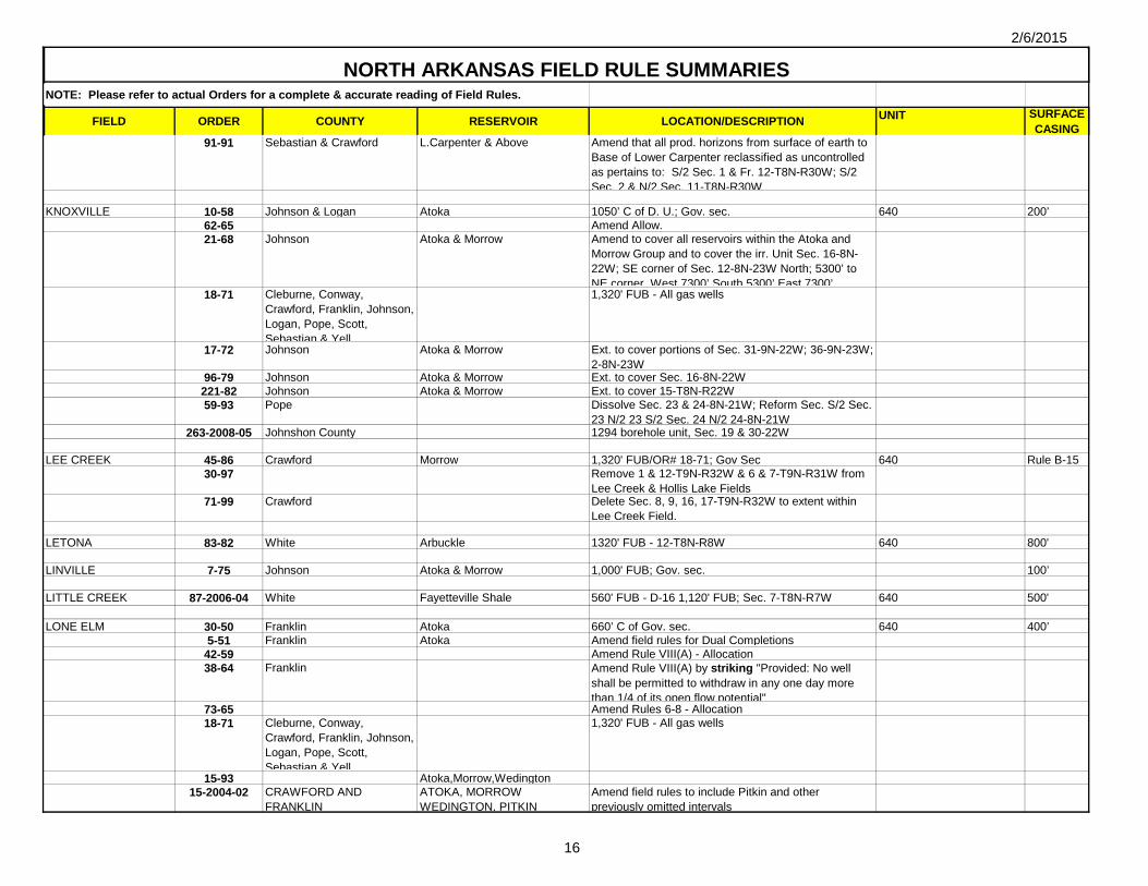
91-91 Sebastian & Crawford L.Carpenter & Above Amend that all prod. horizons from surface of earth to Base of Lower Carpenter reclassified as uncontrolled as pertains to: S/2 Sec. 1 & Fr. 12-T8N-R30W; S/2 Sec. 2 & N/2 Sec. 11-T8N-R30W
KNOXVILLE 10-58 Johnson & Logan Atoka 1050’ C of D. U.; Gov. sec. 640 200’62-65 Amend Allow.21-68 Johnson Atoka & Morrow Amend to cover all reservoirs within the Atoka and
Morrow Group and to cover the irr. Unit Sec. 16-8N-22W; SE corner of Sec. 12-8N-23W North; 5300’ to NE corner, West 7300’ South 5300’ East 7300’
18-71 Cleburne, Conway, Crawford, Franklin, Johnson, Logan, Pope, Scott, Sebastian & Yell
1,320' FUB - All gas wells
17-72 Johnson Atoka & Morrow Ext. to cover portions of Sec. 31-9N-22W; 36-9N-23W; 2-8N-23W
96-79 Johnson Atoka & Morrow Ext. to cover Sec. 16-8N-22W221-82 Johnson Atoka & Morrow Ext. to cover 15-T8N-R22W59-93 Pope Dissolve Sec. 23 & 24-8N-21W; Reform Sec. S/2 Sec.
23 N/2 23 S/2 Sec. 24 N/2 24-8N-21W263-2008-05 Johnshon County 1294 borehole unit, Sec. 19 & 30-22W
LEE CREEK 45-86 Crawford Morrow 1,320' FUB/OR# 18-71; Gov Sec 640 Rule B-1530-97 Remove 1 & 12-T9N-R32W & 6 & 7-T9N-R31W from
Lee Creek & Hollis Lake Fields71-99 Crawford Delete Sec. 8, 9, 16, 17-T9N-R32W to extent within
Lee Creek Field.
LETONA 83-82 White Arbuckle 1320' FUB - 12-T8N-R8W 640 800'
LINVILLE 7-75 Johnson Atoka & Morrow 1,000' FUB; Gov. sec. 100’
LITTLE CREEK 87-2006-04 White Fayetteville Shale 560' FUB - D-16 1,120' FUB; Sec. 7-T8N-R7W 640 500'
LONE ELM 30-50 Franklin Atoka 660’ C of Gov. sec. 640 400’5-51 Franklin Atoka Amend field rules for Dual Completions
42-59 Amend Rule VIII(A) - Allocation38-64 Franklin Amend Rule VIII(A) by striking "Provided: No well
shall be permitted to withdraw in any one day more than 1/4 of its open flow potential"
73-65 Amend Rules 6-8 - Allocation18-71 Cleburne, Conway,
Crawford, Franklin, Johnson, Logan, Pope, Scott, Sebastian & Yell
1,320' FUB - All gas wells
15-93 Atoka,Morrow,Wedington15-2004-02 CRAWFORD AND
FRANKLINATOKA, MORROW WEDINGTON, PITKIN
Amend field rules to include Pitkin and other previously omitted intervals

2/6/2015
17
NOTE: Please refer to actual Orders for a complete & accurate reading of Field Rules.
FIELD ORDER COUNTY RESERVOIR LOCATION/DESCRIPTION UNIT SURFACE CASING
NORTH ARKANSAS FIELD RULE SUMMARIES
223-2006-07 CRAWFORD AND FRANKLIN
Fayetteville Shale Governed by Rule B-43
LUDWIG 27-66 Johnson Atoka 1320’ FUB; Gov Sec 350’ 25-69 Johnson Atoka & Hale Extension of field rules to cover Sec. 5, 6, 10, 13, 14,
15, 23, & 24-10N-23W
18-71 Cleburne, Conway, Crawford, Franklin, Johnson, Logan, Pope, Scott, Sebastian & Yell
1,320' FUB - All gas wells
183-82 Atoka & Morrow Dissolve Drilling Units: Gov. Section: 16, 17, 20, 28, & 29; Create New Units: S/2 Sec. 16 & N/2 21, S/2 Sec. 17 & N/2 20, S/2 Sec. 20 & N/2 29, S/2 Sec. 21 & N/2 28, S/2’s 28 & 29, All in 10-23W
88-92 Johnson Hale Amend 25-69 to extend to all of Hale to permit multipletions and allowables.
10B-2001-01 Johnson Atoka Dissolve unit N/2 Sec. 16 & N/2 Sec. 17-T10N-R23W. Create 2 new drilling units described as: S/2 Sec 9, N/2 Sec 16-10N-23W; S/2 Sec 8, N/2 Sec 17-10N-23W
2-2002-01 JOHNSON PERMIT FORMATION OF A 1,280 ACRE BOREHOLE UNIT
Include Sec. 18-10N-23W & SEC. 19-10N-23W; Gov. sec.
640
413-2006-12 Johnson Amend 27-66 - Include & reform sections into 4 units: Unit A: N/2 12-T10N-R23W; N/2 7-10N-R22W; Unit B: N/2 Sec.12-T10N-R23W; N/2 Sec.13-T10N-R23W; Unit C: S/2 Sec.7-T10N-R22W; N/2 Sec.18-T10N-R22W; Unit D: S/2 Sec. 13-T10N-R23W; S/2 Sec.18-T10N-R22W
MANSFIELD 47-66 Scott Atoka 1320’ FUB; Gov Sec N/2 or S/2 640 400’18-71 Cleburne, Conway,
Crawford, Franklin, Johnson, Logan, Pope, Scott, Sebastian & Yell
1,320' FUB - All gas wells
215-84 Logan Atoka Extend 47-66 to cover N/2 6-T4N-R29W356-84 Sebastian Atoka Ext. to cover Sec. N/2 1-4N-31W (lots 1-14)
104-91 Scott & Sebastian Atoka Designation as Tight Formation8-92 Sebastian, Logan & Scott Atoka Upper & Mid. (Alma &
Basham)Designation as Tight Formation
69-99 Comm.195-2007-04 Scott Atoka Ext. to include Sec.9-16, T4N-R30W; Sec. 24-T4N-
R30W except S/2 S/2; & all Sec. 7, 18, 19 & 30, T-4N-R29W
163-2001-10 SEBASTIAN, SCOTT AND LOGAN
MIDDLE HARTFORD “A” FORMATION
660' FUB - SEC. 35-5N-30W; Gov. 1/4 sec. 640

2/6/2015
18
NOTE: Please refer to actual Orders for a complete & accurate reading of Field Rules.
FIELD ORDER COUNTY RESERVOIR LOCATION/DESCRIPTION UNIT SURFACE CASING
NORTH ARKANSAS FIELD RULE SUMMARIES
134-2002-10 SEBASTIAN, SCOTT AND LOGAN
MIDDLE HARTFORD “A” FORMATION
Make 163-2001-10 Permanent and Remove Well Limitation
28-2004-03 SEBASTIAN, LOGAN AND SCOTT
MIDDLE HARTFORD "A" SANDSTONE, MIDDLE AND UPPER ATOKA
Amend spacing 560' FUB or other well producing from same source of supply. Allow multiple wells Upper & Middle Atoka
General Rule B-44
Rescind existing Field Fules, See Rule B-44
MASSARD 30-52 Crawford & Sebastian Basal Atoka 660’ C of Gov. Sec. 640 150’11-53 Sebastian Basal Atoka Revised D.U. from W/2 W/2 Sec. 1 E ¾ Sec. 2-7N-
32W to N ¾ W/2 W/2 Sec. 1 E ¾ Sec. 2-7N-32W 13-57 Sebastian Hale 660’ C of D. U.; Gov. Sec. 640 200’ 48-61 Crawford Hale, Spiro & Dunn 'B' 660’ C of D. U.; Gov. Sec. 640 200’ 38-62 Pre-Pennsylvanian 660’ C of D. U.; Gov. Sec. 640 450’47-64 Sebastian Amend 30-52 - Allow.5-65 Basal, Atoka, Hale, Spiro, Dunn
"B", Pre-PennsylvanianAmend 47-64 - Allow.
38-66 Sebastian Basal Atoka, Hale, Spiro, Dunn ‘B’ & Pre-Penn
Extension of field rules to cover Sec. 5 & N/2 Sec. 8; Sec. 17 & S/2 Sec. 8; Sec. 30 & N/2 Sec. 29; Sec 32 & S/2 Sec. 29-7N-32W
14-68 Crawford & Sebastian Basal Atoka, Hale, Spiro & Dunn 'B'
Ext. to cover Atoka & Morrow
18-71 Cleburne, Conway, Crawford, Franklin, Johnson, Logan, Pope, Scott, Sebastian & Yell
1,320' FUB - All gas wells
23-77 Sebastian Atoka, Morrow, & Pre-Pennsylvania
Ext. to cover Sec 4-7N-32W except SE/4 SE/4
41-78 Crawford & Sebastian Atoka, Morrow, & Pre-Pennsylvania
Ext. to cover 5 & 8-T8N-R32W & 32-T9N-R32W
186-81 Sebastian Atoka, Morrow & Pre-Pennsylvania
Ext. to cover Sec. 10-8N-32W
189-82 Crawford & Sebastian Atoka, Morrow, & Pre-Pennsylvania
Ext. to cover Frac. Sec. 20 & N/2 Frac. Sec. 29-8N-32W
209-85 Sebastian Atoka, Morrow, & Pre-Pennsylvania
Ext. to cover Frc. 32 & S/2 Frc. 29-T8N-R32W 562.78
12-88 Crawford & Sebastian Atoka, Morrow & Pre-Pennsylvania
Ext. to cover 33-T9N-R32W
3-96 Crawford & Sebastian Lower Carpenter 660' FUB in Sec. 13,24,25-8N-32W; Frac. 18,19,30,17 20-8N-31W
200-1-2008-04 Sebastian Lower Carpenter Ext. Order No, 3-96 to cover Sec. 14-8N-32W564-1-2008-10 Sebastian Lower Carpenter Ext. Order No, 3-96, as amended by 200-1-2008-04, to
cover Sec. 11-8N-32W
MORELAND 49-55 Pope Barton 1050’ C of D.U.; Gov. Sec. 250’ 32-56 Pope Hale 'A' 1050’ C of D.U.; Gov. Sec. 250’

2/6/2015
19
NOTE: Please refer to actual Orders for a complete & accurate reading of Field Rules.
FIELD ORDER COUNTY RESERVOIR LOCATION/DESCRIPTION UNIT SURFACE CASING
NORTH ARKANSAS FIELD RULE SUMMARIES
39-57 Pope Basal Atoka 1050’ C of D.U.; Gov. Sec. 250’9-65 Amend 49-55 - Allocation
18-71 Cleburne, Conway, Crawford, Franklin, Johnson, Logan, Pope, Scott, Sebastian & Yell
1,320' FUB - All gas wells
237-83 Pope Atoka & Morrow Ext. to cover Atoka & Morrow, (Sec. 3-8N-19W & Sec. 7-8N-19W)
80-94 Pope McGuire & Hale Dissolve D.U. (Sec. 8 & 17-8N-19W) Reform Irr. D.U. (Sec. 8 & 17-8N-19W; 1280 acres)
154-2001-09 Pope Base of Morrow Group to Base of Penters/Hunton
All of Sec. 15-9N-19W; Further amend ORN 49-55 & 100-98
121-2003-10 Pope Hale Sec. 7 and 8-8N-19W; Provide for a 1,280 acre unit for the prod. of gas from a single wellbore
52-2004-05 POPE Amend to permit formation of a 1,280 acre borehole unit to permit drill of a well adjacent to the section line between sectionn 5 & 6.
NATURAL DAM 12-78 Crawford Atoka 1,000' FUB; reg. Gov. unit or 2 half sec. forming square
640 100’
NEW HOPE 21-61 Pope Atoka & Casey 1050’ C of D.U.; S/2 & N/2 of adjacent gov. sec. to south
640 300’
60-64 Pope Upper & Lower Allen, Barton ‘A’ & ‘B’, Basal Atoka & Hale
1050’ C of D.U.; amend & extend 300’
74-66 Pope Ext. to cover S/2 Sec. 5; S/2 Sec. 6; N/2 Sec. 7; N/2 Sec. 8-9N-20W
18-71 Cleburne, Conway, Crawford, Franklin, Johnson, Logan, Pope, Scott, Sebastian & Yell
1,320' FUB - All gas wells
178-80163-82 Pope Atoka & Hale Ext. to cover S/2 Sec. 29; S/2 Sec. 30-9N-20W
7-68 Amend 21-61 Rules 7-9 - Allocation
OAK GROVE 43-77 Pope Atoka & Morrow 1,320' FUB/OR# 18-71; Gov. sec. 640 200’120-87 Pope Hale, Lower Allow.
69-2005-05 POPE ARECI FORMATION 560’ FUB - Sec. 20, 21, 22, 23, 26, 27, 28, 29,, 32, 33, 34, AND 35-8N-18W AND 3-7N-18W
OZARK 62-61 Franklin Henson, Cecil, Orr & Brentwood 1050’ C of D.U.; Gov. Sec. 640 200’
2-67 Amend 62-61 - Allocation18-71 Cleburne, Conway,
Crawford, Franklin, Johnson, Logan, Pope, Scott, Sebastian & Yell
1,320' FUB - All gas wells

2/6/2015
20
NOTE: Please refer to actual Orders for a complete & accurate reading of Field Rules.
FIELD ORDER COUNTY RESERVOIR LOCATION/DESCRIPTION UNIT SURFACE CASING
NORTH ARKANSAS FIELD RULE SUMMARIES
35-88 Franlklin Atoka, Morrow, Boone, & Penters
Ext. to cover Atoka, Morrow, Boone, & Penters
OZONE 4-74 Johnson Atoka, Morrow & Boone 1320’ FUB; Gov. Sec. 640 200’ 35-74 Johnson Atoka, Morrow & Boone Amend spacing requirements: 1000’ FUB
PARADISE 236-83 Franklin Hale, Upper & Lower Wedington 1,000' FUB; Gov. sec. 640 200'
PARIS 22-61 Logan Atoka (Orr) & Morrow (Brentwood)
1050’ FUB; Gov. Sec. 640 300’
57-69 Johnson & Logan Atoka (Orr) & Morrow (Brentwood)
18-71 Cleburne, Conway, Crawford, Franklin, Johnson, Logan, Pope, Scott, Sebastian & Yell
1,320' FUB - All gas wells
87-79 Logan & Johnson Atoka & Morrow (all sands) Amend to cover Atoka & Morrow
PETER PENDER 28-63 Franklin Atoka & Morrow 1050’ C of D. U.; Gov. sec. 640 250’75-65 Amend 28-63 - Allocation18-71 Cleburne, Conway,
Crawford, Franklin, Johnson, Logan, Pope, Scott, Sebastian & Yell
1,320' FUB - All gas wells
175-80 Franklin Viola Ext. to cover Sec. 3-7N-28W 19-86 Franklin Hale Amend Field Rules (Multiple Completions w//i Hale
Zone)79-2003-07 Franklin Viola and Penters Hunton Amend to include all intervals from the surface to the
base of the Viola Formation and to reclassify the Penters Hunton as a single formation.
General Rule B-44
Partial rescinsion of existing Field Fules, See Rule B-44
PINE RIDGE 116-86 Logan Atoka 1,320' FUB/OR# 18-71; Gov. sec. 640 500'

2/6/2015
21
NOTE: Please refer to actual Orders for a complete & accurate reading of Field Rules.
FIELD ORDER COUNTY RESERVOIR LOCATION/DESCRIPTION UNIT SURFACE CASING
NORTH ARKANSAS FIELD RULE SUMMARIES
POTEAU MOUNTAIN 332-2008-06 Sebastian, Scott Hartshorne Coal Establish Field-Wide Unit. 280' From external boundaries; multiple horizontal wells; Field Defined as: Township 4N, Range 32W: Section 35: ALL, Section 36: W/2; Township 3N, Range 32W: Section 1: ALL, Section 2: ALL, Section 3: ALL, Section 4: ALL, Section 5: ALL, Section 6: S/2; S/2 NE/4; SE/4 NW/4, Section 7: ALL, Section 8: ALL, Section 9: ALL, Section 10: All Except SW/4 SW/4, Section 11: ALL, Section 14: W/2 NE/4; SE/4 NE/4; NW/4 NW/4, Section 15: NE/4 NE/4; S/2 NE/4; N/2 SE/4, Section 17: N/2 N/2; SW/4 NW/4, Section 18: N/2; N/2 SE/4; S/2 SE/4, Section 19: N/2 NE/4; Township 3N-Range 33W: Section 1: Fractional S/2, Section 12: Fractional S/2 and Fractional N/2, Section 13: Fractional N/2 and
9,249.11
POSSUMTROT 76-66 Franklin Atoka & Morrow 1050’ C of D.U.; Gov. sec. 640 200’18-71 Cleburne, Conway,
Crawford, Franklin, Johnson, Logan, Pope, Scott, Sebastian & Yell
1,320' FUB - All gas wells
51-89 Franklin Atoka & Morrow Dissolve D.U. (Sec. 9; N/2 NE/4 Sec. 16; Sec. 10; NW/4 NW/4 Sec. 15-10N-27W); Create D.U. (S/2 Sec. 9; S/2 Sec. 10; NW/4 NW/4 Sec. 15; N/2 NE/4 Sec. 16-10N-27W)
PRAIRIE VIEW 39-73 Logan Atoka 1,320' FUB/OR# 18-71; Gov. sec. 640 400’426-84 Logan Morrow Ext. to cover Morrow (Sec. 20-8N-24W)
RENA 3-98 Crawford Hale & Boone 1320’ FUB; Gov Sec. E/2 or W/2 640 Rule B-15106-98 Crawford Hale & Boone Remove Sec 2 & 11-9N-32W from Lee Creek & add to
Rena; Reform D.U. S/2 Sec. 1 & N/2 Sec. 12-9N-32W; Sec. 6-9N-31W; Sec. 7-9N-31W; S/2 Sec. 2 & N/2 Sec. 11-9N-32W; S/2 Sec 11 & S/2 Sec. 12-9N-32W
RICH HOLLOW 8-90 Washington Wedington 280' FUB; N/2, S/2, E1/2 or W1/2 of Gov 1/4 sec. 80 Rule B-15
RICH MOUNTAIN 304-2006-09 Logan Atoka 560' from external boundary B-3 - Sec. 24-T7N-R25W 640 500' B-15
General Rule B-44
Rescind existing Field Fules, See Rule B-44
ROCK CREEK 14-60 Franklin Atoka 1050' C of D.U.; Gov. sec. 640 250’49-64 Amend 14-60 Rule 10 - Allocation55-65 Amend Allocation 51-73 Franklin Morrow Amend to apply to all zones within Morrow Group.14-76 Franklin Atoka & Morrow Amend Location Provisions - 1000’ FUB

2/6/2015
22
NOTE: Please refer to actual Orders for a complete & accurate reading of Field Rules.
FIELD ORDER COUNTY RESERVOIR LOCATION/DESCRIPTION UNIT SURFACE CASING
NORTH ARKANSAS FIELD RULE SUMMARIES
94-86 Franklin Wedington 1000’ FUB; Gov. Sec. 250’93-88 Comm.
63B-2002-05 Franklin Dissolve 19 & 20-T11N-R26W & Estab. E/2 19 & W/2 20-T11N-R26W
640
ROSS 53-61 Pope & Johnson Atoka (McGuire) 1050’ C of D.U.; Gov Sec. 200’ 23-66 Pope & Johnson Atoka (all zones) Ext. to cover all zones w/i Atoka18-71 Cleburne, Conway,
Crawford, Franklin, Johnson, Logan, Pope, Scott, Sebastian & Yell
1,320' FUB - All gas wells
60-71 Pope Atoka Ext. to cover Sec. 9,10,11,14,15-9N-21W12-72 & Corr. Pope Atoka Ext. to cover Sec. 1,2,3,12,13-9N-21W
42-73a Pope Atoka Ext. to cover N/2 Sec. 24-9N-21W Delete N/2 Sec. 24 from New Hope and add to Ross
42-73b Pope Hale Ext. to cover Hale (Sec. 11-9N-21W); Multiple completions
32-83 Johnson Atoka & Hale Ext. to cover Sec. S/2 28-10N-22W; N/2 33-10N-22W; Sec. 12-9N-23W
48-87 Johnson Atoka & Hale Dissolve N/2 14, N/2 15, S/2 14 & S/2 15-9N-22W4-2002-01 Johnson & Pope Dissolve 13-9N-22W & 14-9N-22W and form units
N/2 Sec. 13, N/2 SEC. 14-9N-223, S/2 Sec. 13, & S/2 SEC. 14-9N-22W - 1,170' from short side of units
74B-2003-07 Johnson Ext. to cover W/2 27 & W/2 34; E-2 27 & W/2 Sec. 26; E/2 Sec. 34 & W/2 Sec. 35 E/2 Sec. 26 & E/2 Sec. 35-T10N-R22W (see Silex for Order)
640
RUDY 31-52 Crawford Atoka & Hale 330’ FUB; 2 Gov 1/4 Sec 320 150’48-64 Crawford Amend 31-52 - Allocation & allow.
121-82 Crawford Atoka, Hale & Boone 1,320' from length wise, 1,170' from narrow extrm Sec. W/2 30-10N-31W
125-83 Amend 31-52 - Allocation & allow.295-83 Crawford Atoka Ext. to cover Sec.19, 20, 21, E½ 28, 31, 32, 33-10N-
31W; E/2 or W/2 102-98 Crawford Atoka & Hale Ext. to cover Sec. 20-10N-31W; N/2 & S/2 only
105-98 Crawford Atoka & Hale Amend Field Rules; Sec. N/2 & S/2 31-10N-31W109-2000-09 Crawford Reform existing 320-acre units from E/2 & W/2 to N/2
& S/2 Sec. 19-T10N-R31W
SCOTTSVILLE 2-62 Pope Barton & Upper Morrow 1050’ C of D.U.; Gov. sec. 640 Rule B-1518-71 Cleburne, Conway,
Crawford, Franklin, Johnson, Logan, Pope, Scott, Sebastian & Yell
1,320' FUB - All gas wells
14-96 Pope Penters/Hunton Ext. to cover Sec. W/2 Sec. 3, E/2 4-9N-19W282-2009-04 Pope Dunn A 1320"FUB. Ext. to cover Sec. 35-10N-19W
2/6/2015
23
NOTE: Please refer to actual Orders for a complete & accurate reading of Field Rules.
FIELD ORDER COUNTY RESERVOIR LOCATION/DESCRIPTION UNIT SURFACE CASING
NORTH ARKANSAS FIELD RULE SUMMARIES
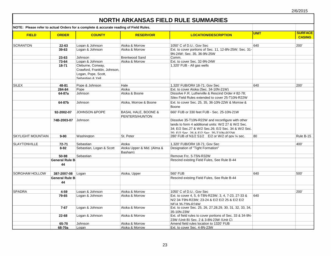
SCRANTON 22-63 Logan & Johnson Atoka & Morrow 1050’ C of D.U.; Gov Sec 640 200’39-63 Logan & Johnson Atoka & Morrow Ext. to cover portions of Sec. 11, 12-8N-25W; Sec. 31-
9N-24W; Sec. 35, 36-9N-25W23-63 Johnson Brentwood Sand Comm.73-64 Logan & Johnson Atoka & Morrow Ext. to cover Sec. 32-9N-24W18-71 Cleburne, Conway,
Crawford, Franklin, Johnson, Logan, Pope, Scott, Sebastian & Yell
1,320' FUB - All gas wells
SILEX 48-81 Pope & Johnson Hale 1,320' FUB/OR# 18-71; Gov Sec 640 200’284-84 Pope Atoka Ext. to cover Atoka (Sec. 34-10N-21W) 64-87a Johnson Atoka & Boone Dissolve F.R. Lutherville & Rescind Order # 82-78;
Silex Field Rules extended to cover 25-T10N-R22W 64-87b Johnson Atoka, Morrow & Boone Ext. to cover Sec. 25, 35, 36-10N-22W & Morrow &
Boone92-2002-07 JOHNSON &POPE BASAL HALE, BOONE &
PENTERS/HUNTON660’ FUB or 330 feet FUB - Sec. 25-10N-21W
74B-2003-07 Johnson Dissolve 35-T10N-R22W and reconfigure with other lands to form 4 additional units: W/2 27 & W/2 Sec. 34; E/2 Sec.27 & W/2 Sec.26; E/2 Sec. 34 & W/2 Sec. 35; E/2 Sec 26 & E/2 Sec 35-T10N-R22W
SKYLIGHT MOUNTAIN 9-90 Washington St. Peter 280' FUB of N1/2 S1/2 E/2 or W/2 of gov ¼ sec. 80 Rule B-15
SLAYTONVILLE 72-71 Sebastian Atoka 1,320' FUB/OR# 18-71; Gov Sec 400’8-92 Sebastian, Logan & Scott Atoka Upper & Mid. (Alma &
Basham)Designation of "Tight Formation"
50-98 Sebastian Remove Frc. 5-T5N-R32WGeneral Rule B-
44Rescind existing Field Fules, See Rule B-44
SORGHAM HOLLOW 387-2007-08 Logan Atoka, Upper 560' FUB 640 500'General Rule B-
44Rescind existing Field Fules, See Rule B-44
SPADRA 4-59 Logan & Johnson Atoka & Morrow 1050’ C of D.U.; Gov Sec 200’79-65 Logan & Johnson Atoka & Morrow Ext. to cover 4, 5, 6-T8N-R23W; 3, 4, 7-23, 27-33 &
N/2 34-T9N-R23W; 23-24 & E/2 E/2 25 & E/2 E/2 NE/4 36-T9N-R24W
640
7-67 Logan & Johnson Atoka & Morrow Ext. to cover Sec. 25, 26, 27,28,29, 30, 31, 32, 33, 34, 35-10N-23W
22-68 Logan & Johnson Atoka & Morrow Ext. of field rules to cover portions of Sec. 33 & 34-9N-23W (Unit B) Sec. 2 & 3-8N-23W (Unit C)
65-70 Johnson Atoka & Morrow Amend field rules location to 1320’ FUB68-70a Logan Atoka & Morrow Ext. to cover Sec. 4-8N-23W

2/6/2015
24
NOTE: Please refer to actual Orders for a complete & accurate reading of Field Rules.
FIELD ORDER COUNTY RESERVOIR LOCATION/DESCRIPTION UNIT SURFACE CASING
NORTH ARKANSAS FIELD RULE SUMMARIES
18-71 Cleburne, Conway, Crawford, Franklin, Johnson, Logan, Pope, Scott, Sebastian & Yell
1,320' FUB - All gas wells
27-71a Logan & Johnson Atoka & Morrow Ext. to cover Sec. N/2 1-8N-24W; S/2 36-9N-24W & adjacent bed of AR River within East line of said Sec. 36 & West line of said Sec. 1
58-76 Logan Atoka & Morrow Group & St. Peter/Simpson
Ext. to cover Pt. 10 & 11-T8N-R23W 884.84
42-77 Logan & Johnson Atoka & Morrow Ext. to cover portions of Sec. 14 & 15-8N-23W20-84 Logan & Johnson Atoka & Morrow Ext. to cover Pt. 26-T8N-R23W204-85 Johnson Atoka & Morrow Ext. to cover 25-T9N-R24W 64052-89 Dissolve N/2 6-T8N-R23W, S/2 31-T9N-R23W, N/2 1-
T8N-R24W, S/2 36-T9N-R24W. Create 6-T8N-R23W, 1-T8N-R24W, S/2 31-T9N-R23W, S/2 36-T9N-R24W
85B-2002-06 Logan Ext. to cover 25-T8N-R23W 657.58
118B-2004-09 JOHNSON Ext. to cover 33 & 34-T10N-R23W 1,280
ST. VINCENT 13-76 Conway Morrow 1,320' FUB - 32-T8N-R16W; Gov Sec 640 200’18-71 Cleburne, Conway,
Crawford, Franklin, Johnson, Logan, Pope, Scott, Sebastian & Yell
1,320' FUB - All gas wells
SUGAR HILL 19-2006-02 Washington Sylamore 280' FUB - Sec. 1 & 2-T14N-R33W; Sec. 35 & 36-T15N-R33W
40 B-15
SUGAR LOAF MTN (AKA LULA DELEON)
179B-2006-06 Sebastian Hartshorne Coal Establish Field-Wide Unit. 280' From external boundaries; 200' Horizontal Field Defined as: 24-T4N-R32W; Est. Field Wide Unit: Sec. 19 & 20; S/2 NW/4; N/2 SW/4 & SW/4 SW/4 Sec. 21; W/2 NW/4 Sec. 28; N/2 & SW/4 Sec. 29; Sec. 30.
2709.89
SUNSET 98-88 Washington Wedington 280' FUB; 2 Gov ¼ ¼ Sec in form of rectangle 80 Rule B-15
UNION CITY 15-60 Johnson Atoka 1050’ C of D.U.; Gov. sec. 640 350’50-64 Johnson Amend Allocation66-65 Amend Allocation 29-70 Johnson Atoka & Morrow Ext. to cover all reservoirs w/i Atoka & Morrow

2/6/2015
25
NOTE: Please refer to actual Orders for a complete & accurate reading of Field Rules.
FIELD ORDER COUNTY RESERVOIR LOCATION/DESCRIPTION UNIT SURFACE CASING
NORTH ARKANSAS FIELD RULE SUMMARIES
18-71 Cleburne, Conway, Crawford, Franklin, Johnson, Logan, Pope, Scott, Sebastian & Yell
1,320' FUB - All gas wells
27-74 Johnson Atoka & Morrow Ext. to cover 10-T9N-R25W (taken from Coal Hill)140-85 Johnson Rescind 29 & 30-T10N-R24W & move to Clarksville
Field
URSULA 19-64 Franklin & Sebastian Lower Carpenter & Lower Morris
1050’ C of DU; Gov. sec. 640 200’
25-65 Franklin & Sebastian Lower Carpenter & Lower Morris
Ext. to cover Sec. 29-8N-29W; Sec. 30-8N-29W; Sec. 31-8N-29W; Sec. 34-8N-29W; Sec. 35-8N-29W; Sec. 2-7N-29W; Sec. 3-7N-29W; Sec. 4-7N-29W; Sec. 5-7N-29W
56-67 Atoka Ext. to cover each sep. reservoir within Atoka & amend Allocation
18-71 Cleburne, Conway, Crawford, Franklin, Johnson, Logan, Pope, Scott, Sebastian & Yell
1,320' FUB - All gas wells
209-87 Franklin & Sebastian Morrow Ext. to cover Morrow (Sec. 27-8N-29W & 34-8N-29W) and provide for Multiple Completions in Hale
83-98 Franklin & Sebastian Atoka Deletion of Acreage to form Chaffee Arkoma Unit138B-2003-12 Sebastian Ext. to cover 7 & N/2 N/2 18 less W/2 NW/4 NW/4
T7N-R29W
VESTA 5-69 Franklin Morris 1050’ C of D.U.; Gov. sec. 640 Rule B-1518-71 Cleburne, Conway,
Crawford, Franklin, Johnson, Logan, Pope, Scott, Sebastian & Yell
1,320' FUB - All gas wells
22-78 Franklin Atoka Ext. to cover Atoka & Sec. 7, 19-8N-28W Sec. 23-8N-29W Sec. 10, 11, 12, 22, 24-8N-29W
67-98 Franklin Morrow Ext. to cover Morrow
WATALULA 37-53 Franklin Atoka 660’ C of D.U.; Gov. sec. 640 200’18-71 Cleburne, Conway,
Crawford, Franklin, Johnson, Logan, Pope, Scott, Sebastian & Yell
1,320' FUB - All gas wells
WAVELAND 6-67 Yell Atoka 1320’ FUB; Gov. sec. 640 400’ 97-67 Yell Atoka Ext. to cover Sec. 7, 8, 9, 10, 11, 12, 13, 14, 15, 16,
17, 18, 19, 20, 21, 22, 23, 24-5N-24W11-68 Yell & Logan Atoka Ext. to cover Sec. 7,8,17,18,19, 20-5N-25W 10, 11,
12, 13, 14, 15, 22, 23, 24-5N-26W

2/6/2015
26
NOTE: Please refer to actual Orders for a complete & accurate reading of Field Rules.
FIELD ORDER COUNTY RESERVOIR LOCATION/DESCRIPTION UNIT SURFACE CASING
NORTH ARKANSAS FIELD RULE SUMMARIES
18-71 Cleburne, Conway, Crawford, Franklin, Johnson, Logan, Pope, Scott, Sebastian & Yell
1,320' FUB - All gas wells
20-2003-02 Yell & Logan Middle Atoka Form unit subdivisions Sec. 7-24-5N-24W, Sec. 7-24,5N-25W, & Sec. 10-15 & 22-24-5N-26W
136-2003-12 Yell Ext. to cover 6-T5N-R24W & provide for stand-up 80 acre unit subdivisions
86-2004-07 Logan & Yell Upper and Middle Atoka Sandstones
Delete reference to 80-ac. Subdivisions & allow multiple wells - 560' FUB & from well producing from same common source w/I unit
640
35-2004-04 LOGAN Integration & deletion to unit (combined with Sugar Grove)
120-2005-03 Logan & Yell Amend #6-67 to include Sec. 7, 9, 10, 15, 16, 17 & 18-T5N-R23W
137B-2003-12 Yell Ext. to cover S/2 4 & S/2 5-T5N-R24W
General Rule B-44
Rescind existing Field Fules, See Rule B-44
WEDINGTON 245-83 Washington Sylamore 280' FUB; Gov 1/4 1/4 Sec 40 60’
WHITE OAK 18-45 Franklin Atoka 200’ C of D.U.; Gov. sec. 640 400’4-51 Clarify Rule V - Multiple Completions
42-59 Amend Rule VIII - Allocation 37-64 Franklin Atoka Amend by striking Rule VIII wording limitation of 25%
withdrawal18-71 Cleburne, Conway,
Crawford, Franklin, Johnson, Logan, Pope, Scott, Sebastian & Yell
1,320' FUB - All gas wells
67-66 Franklin Atoka & Morrow Extend Provisions of Order No. 18-45405-84 Franklin Upper Alma 660' FUB - Amend spacing and unit size 160 acre
increased density unit & Ext. to cover S/2 SE/4 of Sec. 30 & N/2 NE/4 of Sec. 31-10N-27W. Sec. 29, 30, 31, 32-10N-27W
315-85 Amend Allocation101-88 Franklin Atoka & Morrow Ext. to cover Atoka & Morrow5-93 Franklin Atoka & Morrow Ext. to cover Atoka & Morrow
85-93 Franklin Atoka & Morrow Amend 5-93 to create "Participating Area Unit" - E/2 Sec. 20 & W/2 Sec. 21-T10N-R27W
73-94 Franklin Atoka & Morrow Amend 5-93 to create "Participating Area Unit" - SW NE, S/2 NW, W/2 SE & SW/4 Sec. 29; SE NE, E/2 SE Sec. 30, NE NE Sec. 31, N/2 NW, NW NE Sec. 32-T10N-R27W

2/6/2015
27
NOTE: Please refer to actual Orders for a complete & accurate reading of Field Rules.
FIELD ORDER COUNTY RESERVOIR LOCATION/DESCRIPTION UNIT SURFACE CASING
NORTH ARKANSAS FIELD RULE SUMMARIES
88-94 Franklin Atoka & Morrow Amend 5-93 to create "Participating Area Unit" - SW NE, S/2 NW, SW/4 & W/2 SE Sec. 19 & NW NE & N/2 NW Sec. 30-T10N-R26W; & SE NE, E/2 SE Sec. 24, & NE NE Sec. 25-T10N-R27W
640
126-2000-10 Franklin Woolsey Sand Reservoir Amend and clarify 36-59 which established a gas storage reservoir to define precisely the Woolsey Reservoir and describe areal extent included within unit. Part of Sect. 13, All of Sec. 14, Part of sec. 15, ,22,23,24
31-2003-03 FRANKLIN Weddington, Boone & Penters Ext. to include Wedington, Boone & Penters Formations & stratigraphic equivalents
111-2005-07 Franklin Sossamon Unit - Pilot Commingle Project - E/2 Sec. 25-T10N-R28W & W/2 Sec. 30-T10N-R27W
136-2005-09 Franklin Sossman Unit - Pilot Depletion Project - E/2 Sec. 25-T10N-R28W & W/2 Sec. 30-T10N-R27W - Commingling test for 6 months
115-2006-05 (Remand & Corrected2)
Franklin Pitkin 3/8 mile buffer; D-18 - Sossamon Unit - Comingle. No add'tl wells above base of Pitkin w/o approval
180-2006-06 Ord. making 136-2005-09 permanent for test wells167-2008-03 Franklin Pitkin Additional well261-2008-05 Franklin Pitkin Additional well
WHITE ROCK-MOUNTAIN
168-86 Franklin Morrow & Wedington 1,000' FUB; Gov Sec 640 Rule B-15
24-95 Franklin Dissolve 22, 23, 26 & 27-T12N-R28W ; Create oversized unit 22, 23, 26 & 27-T12N-R28W (2,560 Ac.) - 1,000' from well
640
WINSLOW 67-88 Washington Wedington 280' FUB or W/2 Gov. ¼ Sec.; N/2, S/2, E/2 of W/2 of Gov. ¼ sec.
80 Rule B-15
104-88 Washington Wedington Amend location provisions & Ext. to cover Sec. SE/4 14, W/2 SE/4 22, E/2 23, and all of 24-13N-30W; N/2, S/2, E/2, W/2 of Gov ¼ sec
80
95-89 Washington Hale 300' FUB; N/2 S/2 E/2 or W/2 of Gov. ¼ Sec 80 Rule B-1588-90 Washington Hale Delete 1500' minimum distance between wells 5-91 Washington Wedington Dissolve D.U. (N/2 & S/2 SE/4 Sec. 13-13N-30W)
Reform D.U. (W/2 & E/2 SE/4 Sec. 13-13N-30W)
WITCHERVILLE 8-70 Sebastian Atoka 1320’; Gov. sec. 640 200’18-71 Cleburne, Conway,
Crawford, Franklin, Johnson, Logan, Pope, Scott, Sebastian & Yell
1,320' FUB - All gas wells
53-71 Sebastian Atoka Ext. to cover Sec. 1, 12, 13-5N-31W; 34, 35, 36-6N-31W
8-92 Sebastian, Logan & Scott Atoka Upper & Mid. (Alma & Basham)
Designation of "Tight Formation"

2/6/2015
28
NOTE: Please refer to actual Orders for a complete & accurate reading of Field Rules.
FIELD ORDER COUNTY RESERVOIR LOCATION/DESCRIPTION UNIT SURFACE CASING
NORTH ARKANSAS FIELD RULE SUMMARIES
103-2005-07 Sebastian Atoka 560' FUB or other well producing from same source of supply; Sec. 22, 23, 24, 25, 26, 27, 34, 35 & 36 T6N-R31W & Sec. 1, 2, 3, 4, 5, 7,8, 9, 10, 11, 12, 13, 14, 15, 16, 17, 20, 21 & 23 T5N-R31W & Sec. 7, 18 & 19-T5N-R30W; & Sec.13-T5N-R32W


![Amended Rule 37(e): Case Summaries - LAWYERS …...JDA Software [2015 WL 12731762] (N.D. Tex. Dec. 9, 2015). The court The court refused to find that Rule 37(e) applied to non-party](https://static.fdocuments.net/doc/165x107/5fde48acd895e86b6b7d0d70/amended-rule-37e-case-summaries-lawyers-jda-software-2015-wl-12731762.jpg)
