NORBURY ESTATE CONSERVATION AREA APPRAISAL AND … › sites › default › files › articles ›...
40
NORBURY ESTATE CONSERVATION AREA APPRAISAL AND MANAGEMENT PLAN SUPPLEMENTARY PLANNING DOCUMENT CROYDON COUNCIL
Transcript of NORBURY ESTATE CONSERVATION AREA APPRAISAL AND … › sites › default › files › articles ›...
NORBURY ESTATE CONSERVATION AREA
APPRAISAL AND MANAGEMENT PLAN
SUPPLEMENTARY PLANNING DOCUMENT
CROYDON COUNCIL
ISSUE Supplementary Planning Document (SPD) adopted at full Council 24 April 2014
This document is available to view and download online at: www.croydon.gov.uk/environment/conservation/ conservation-areas
PUBLISHED BY Spatial Planning Service, Croydon Council Zone B, 6 Floor Bernard Weatherill House, 8 Mint Walk Croydon CR0 1EA www.croydon.gov.uk
Email: [email protected] Tel: 0208 4071385
IMAGE CREDITS Historic photographs, plans and drawings held at the London Metropolitan Archives
All other photographs supplied by London Borough of Croydon
Maps reproduced by permission of Ordnance Survey on behalf of HMSO. © Crown copyright and database right 2014. Ordnance Survey Licence Number 100019257, courtesy of Croydon Council
Aerial photography: ‘Cities Revealed’ aerial photography © ’The GeoInformation Group’ 2006
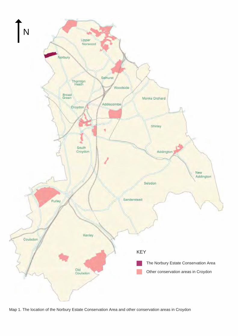
CONSERVATION AREA DESIGNATION The Norbury Estate Conservation Area was designated in December 2008
CONSERVATION AREA GENERAL GUIDANCE Please read this document alongside the Croydon Conservation Area General Guidance SPD (adopted April 2013). This document is available online at: www.croydon.gov.uk/ environment/conservation/conservation-areas
CROYDON LOCAL PLAN The Croydon Local Plan and other Supplementary Planning Documents are available online at: http://www.croydon.gov.uk/ planningandregeneration/framework/localplan/
© Croydon Council 2014
CONTENTS 1.0 INTRODUCTION 01 8.0 DEVELOPMENT GUIDELINES 29 1.1 What is a Conservation Area? 03 8.1 Demolition 29 1.2 What is a Conservation Area 03 8.2 New Development 29
Appraisal and Management Plan? 8.3 Extensions 29 1.3 What is the Status of this Document? 03 8.4 Changes Of Use 29 1.4 Community Involvement 03 8.5 Roofs, Chimneys And Gutters 29 1.5 Designation Background 03 8.6 Window Replacement 29 1.6 Statement of Special Character 04 8.7 Doors And Porches 29 1.7 Character Areas 04 8.8 Cladding, Rendering or Painting of 30
Walls PART 1: APPRAISAL 05 8.9 Front Gardens and Boundary 30
Treatments 30 2.0 CONTEXT 06 8.10 Development Affecting the 30 2.1 Location And Setting 06 Conservation Area’s Setting 2.2 Historic Development 08 2.3 Archaeological Significance 13 9.0 ENHANCEMENT 31
9.1 Maintenance 31 3.0 TOWNSCAPE CHARACTER 14 9.2 Reparing, Restoring and 31 3.1 Layout and Plan Form 14 Re-Instating Features 3.2 Density and Land Uses 16 9.3 Front Garden Management and 32 3.3 Massing 17 Refuse Storage 3.4 Topography and Views 17 9.4 Public Realm Improvements 32
9.5 Street Trees 32 4.0 STREETSCAPE CHARACTER 19 9.6 Energy Effi ciency Improvements 32 4.1 Public Realm and Open space 19 4.2 Boundary Treatments 19 10.0 APPENDIX 33 4.3 Street Furniture 20 10.1 Websites and Other Relevant 33 4.4 Greenery and Trees 20 Information
10.2 Contacts 34 5.0 ARCHITECTURAL CHARACTER 21 5.1 General Architectural Character 21 5.2 Historic and Architectural 22
Significance of Buildings 5.3 Key Features and Materials 22
6.0 CONDITION AND THREATS 24 6.1 General Condition 24 6.2 Key Threats 25
PART 2: MANAGEMENT PLAN 27
7.0 ADDITIONAL CONSIDERATIONS 28 7.1 Article 4 Directions 28 7.2 Building Regulations 28 7.3 Planning Enforcement 28 7.4 Archaeological Investigations 28 7.5 Trees in Private Gardens 28
N
The Norbury Estate Conservation Area
Other conservation areas in Croydon
KEY
Map 1. The location of the Norbury Estate Conservation Area and other conservation areas in Croydon
INTRODUCTION
N
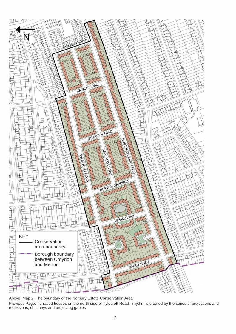
KEY Conservation area boundary
Borough boundary between Croydon and Merton
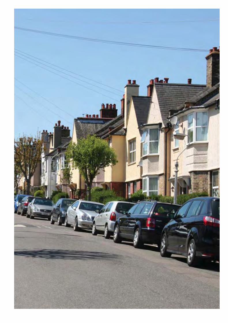
Above: Map 2. The boundary of the Norbury Estate Conservation Area Previous Page: Terraced houses on the north side of Tylecroft Road - rhythm is created by the series of projections and recessions, chimneys and projecting gables
2
1.0 INTRODUCTION
1.1 WHAT IS A CONSERVATION AREA? 1.1.1 A conservation area is an area of special architectural or historic interest, the character and appearance of which it is desirable to preserve or enhance. Please see section 1.3 of Croydon’s Conservation Area General Guidance SPD for further information.
1.2 WHAT IS A CONSERVA-TION AREA APPRAISAL AND MANAGEMENT PLAN? 1.2.1 A Conservation Area Appraisal and Management Plan is a document produced to supplement Croydon’s Local Plan, the London Plan, and Croydon’s Conservation Area General Guidance SPD.
1.2.2 An Appraisal defi nes the principal qualities that constitute the conservation area’s special character and identifi es threats to this character. A Manage-ment Plan addresses the issues raised in the Appraisal and provides area-specifi c develop-ment guidelines to supplement those provided in Croydon’s Conservation Area General Guidance SPD; potential enhancement schemes are also explored. For further informa-tion please see section 1.5 of
the Conservation Area General Guidance SPD.
1.3 WHAT IS THE STATUS OF THIS DOCUMENT? 1.3.1 This document is a Supple-mentary Planning Document (SPD) to the Croydon Local Plan: Strategic Policies (adopted April 2013) and is a material consideration when planning applications affecting the conservation area are assessed.
1.3.2 All planning applications for sites within the Norbury Estate Conservation Area should be informed by both this SPD and the Croydon Conservation Area General Guidance SPD.
1.4 COMMUNITY INVOLVEMENT 1.4.1 The North Croydon Conservation Area Advisory Panel (see section 1.5 of the Conservation Area General Guidance SPD) was consulted on the production of this document prior to public consultation, which ran from 2 September - 14 October 2013. The draft document was avail-able to view and download on the Council’s website and hard copies were available from local libraries. Site notices were
placed in the conservation area, letters were sent to all proper-ties located within its boundary, an article was published in the Croydon Guardian and two events were held at the Central Croydon Library and the Living Water Satisfi es Cafe in Crystal Palace on 23 and 26 September respectively.
1.4.2 Following the consultation all responses were considered and where appropriate, the document was amended prior to a recommendation to full Council for adoption.
1.5 DESIGNATION BACKGROUND 1.5.1 The Norbury Estate was designated as a local area of special character (LASC) in the 1990s. Following a borough-wide review of conservation areas and LASCs the Norbury Estate was designated as a conservation area in December 2008 in recognition of its architectural and historic signifi-cance. In 2014 the conservation area was extended to include numbers 254-278 Northborough Road, which were found to have been part of the original Norbury Estate shown on the 1920s plan of the estate (see Map 6 on p.11).
Typical streetscene of Northborough Characteristic terrace of houses in the Norbury Estate Road
3
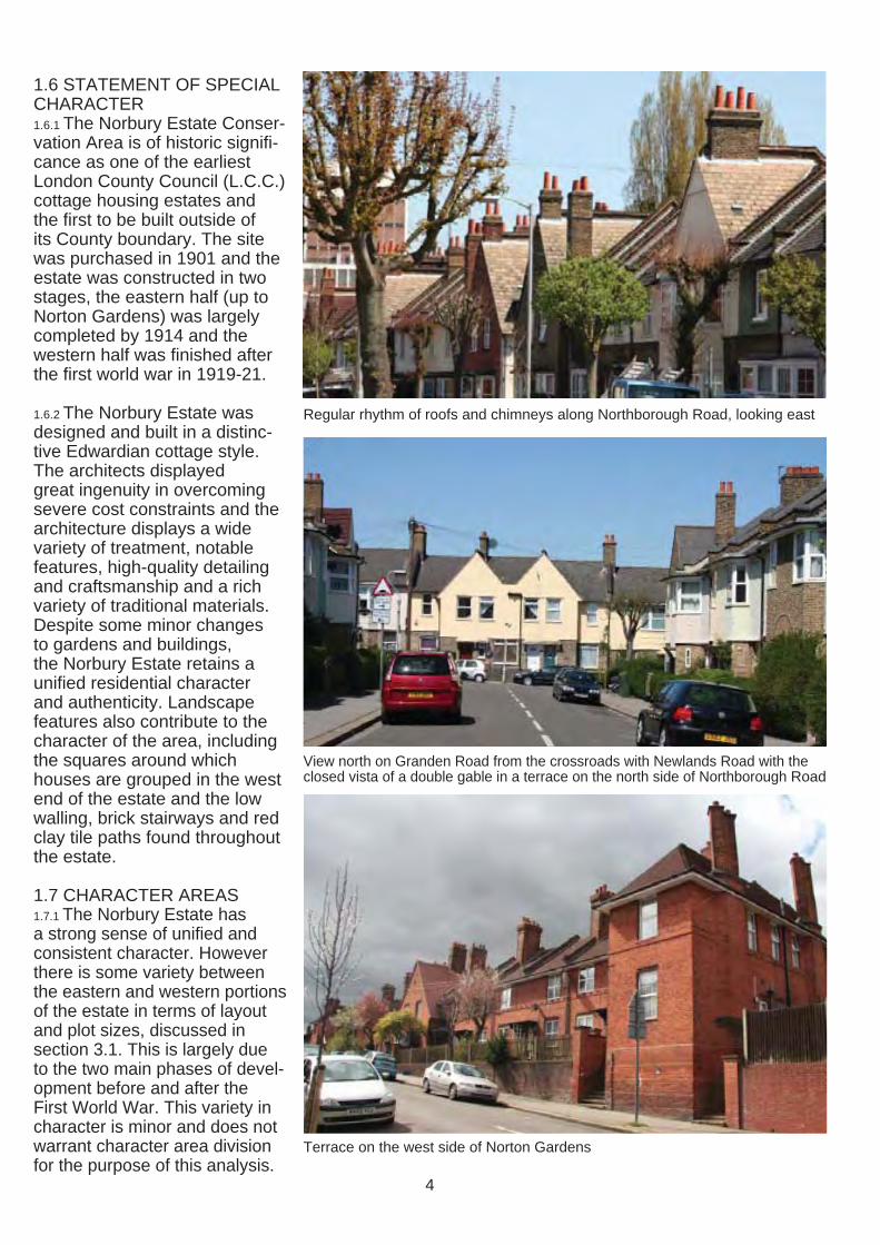
1.6 STATEMENT OF SPECIAL CHARACTER 1.6.1 The Norbury Estate Conser-vation Area is of historic signifi-cance as one of the earliest London County Council (L.C.C.) cottage housing estates and the first to be built outside of its County boundary. The site was purchased in 1901 and the estate was constructed in two stages, the eastern half (up to Norton Gardens) was largely completed by 1914 and the western half was fi nished after the first world war in 1919-21.
1.6.2 The Norbury Estate was designed and built in a distinc-tive Edwardian cottage style. The architects displayed great ingenuity in overcoming severe cost constraints and the architecture displays a wide variety of treatment, notable features, high-quality detailing and craftsmanship and a rich variety of traditional materials. Despite some minor changes to gardens and buildings, the Norbury Estate retains a unified residential character and authenticity. Landscape features also contribute to the character of the area, including the squares around which houses are grouped in the west end of the estate and the low walling, brick stairways and red clay tile paths found throughout the estate.
1.7 CHARACTER AREAS 1.7.1 The Norbury Estate has a strong sense of unifi ed and consistent character. However there is some variety between the eastern and western portions of the estate in terms of layout and plot sizes, discussed in section 3.1. This is largely due to the two main phases of devel-opment before and after the First World War. This variety in character is minor and does not warrant character area division for the purpose of this analysis.
Regular rhythm of roofs and chimneys along Northborough Road, looking east
View north on Granden Road from the crossroads with Newlands Road with the closed vista of a double gable in a terrace on the north side of Northborough Road
Terrace on the west side of Norton Gardens
4
APPRAISAL
The following Appraisal defines the characteristics that make the Norbury Estate Conservation Area special, including its wider context, historic development, townscape, streetscape and architectural character. It also describes its current condition.
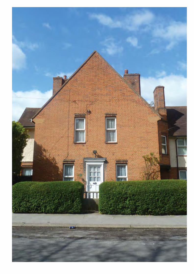
Previous page: Gabled building at the end of the terrace on Isham Road, with original timber partly glazed door and traditional hedge
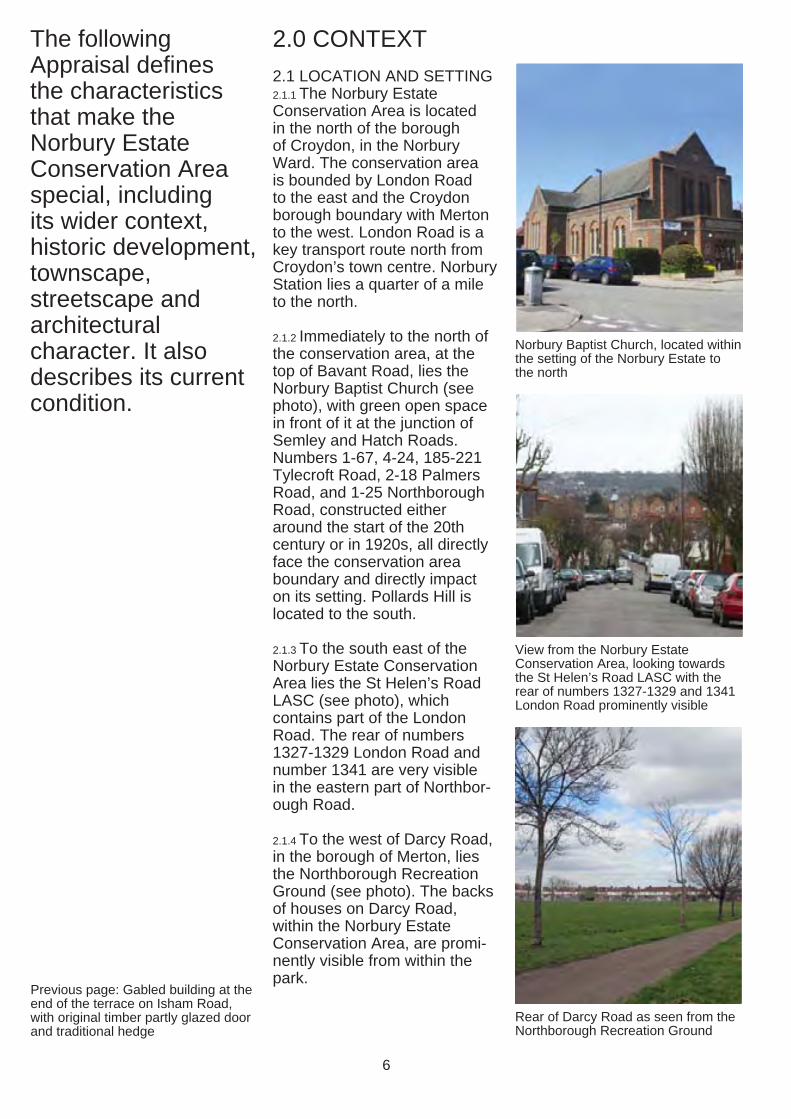
2.0 CONTEXT 2.1 LOCATION AND SETTING 2.1.1 The Norbury Estate Conservation Area is located in the north of the borough of Croydon, in the Norbury Ward. The conservation area is bounded by London Road to the east and the Croydon borough boundary with Merton to the west. London Road is a key transport route north from Croydon’s town centre. Norbury Station lies a quarter of a mile to the north.
2.1.2 Immediately to the north of the conservation area, at the top of Bavant Road, lies the Norbury Baptist Church (see photo), with green open space in front of it at the junction of Semley and Hatch Roads. Numbers 1-67, 4-24, 185-221 Tylecroft Road, 2-18 Palmers Road, and 1-25 Northborough Road, constructed either around the start of the 20th century or in 1920s, all directly face the conservation area boundary and directly impact on its setting. Pollards Hill is located to the south.
2.1.3 To the south east of the Norbury Estate Conservation Area lies the St Helen’s Road LASC (see photo), which contains part of the London Road. The rear of numbers 1327-1329 London Road and number 1341 are very visible in the eastern part of Northbor-ough Road.
2.1.4 To the west of Darcy Road, in the borough of Merton, lies the Northborough Recreation Ground (see photo). The backs of houses on Darcy Road, within the Norbury Estate Conservation Area, are promi-nently visible from within the park.
Norbury Baptist Church, located within the setting of the Norbury Estate to the north
View from the Norbury Estate Conservation Area, looking towards the St Helen’s Road LASC with the rear of numbers 1327-1329 and 1341 London Road prominently visible
Rear of Darcy Road as seen from the Northborough Recreation Ground
6
N
LONDON ROAD
POLLARDS HILL
NORTHBOROUGH RECREATION GROUND
NORBURY ESTATE CONSERVAION AREAS
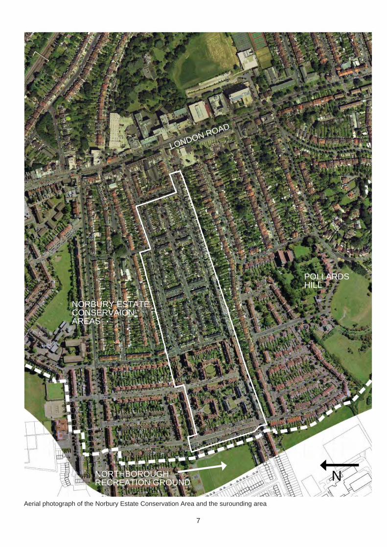
Aerial photograph of the Norbury Estate Conservation Area and the surounding area
7
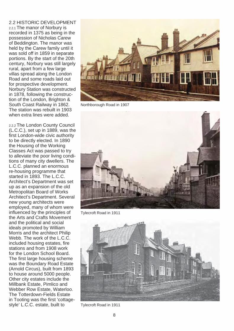
2.2 HISTORIC DEVELOPMENT 2.2.1 The manor of Norbury is recorded in 1375 as being in the possession of Nicholas Carew of Beddington. The manor was held by the Carew family until it was sold off in 1859 in separate portions. By the start of the 20th century, Norbury was still largely rural, apart from a few large villas spread along the London Road and some roads laid out for prospective development. Norbury Station was constructed in 1878, following the construc-tion of the London, Brighton & South Coast Railway in 1862. The station was rebuilt in 1903 when extra lines were added.
2.2.2 The London County Council (L.C.C.), set up in 1889, was the first London-wide civic authority to be directly elected. In 1890 the Housing of the Working Classes Act was passed to try to alleviate the poor living condi-tions of many city dwellers. The L.C.C. planned an enormous re-housing programme that started in 1893. The L.C.C. Architect’s Department was set up as an expansion of the old Metropolitan Board of Works Architect’s Department. Several new young architects were employed, many of whom were influenced by the principles of the Arts and Crafts Movement and the political and social ideals promoted by William Morris and the architect Philip Webb. The work of the L.C.C. included housing estates, fire stations and from 1908 work for the London School Board. The first large housing scheme was the Boundary Road Estate (Arnold Circus), built from 1893 to house around 5000 people. Other city estates include the Millbank Estate, Pimlico and Webber Row Estate, Waterloo. The Totterdown-Fields Estate in Tooting was the fi rst ‘cottage-style’ L.C.C. estate, built to
Northborough Road in 1907
Tylecroft Road in 1911
Tylecroft Road in 1911
8
N
Map 3. 1890 Ordnance Survey Map
N
Map 4. 1910 Ordnance Survey Map
N
Map 5: 1933 Ordnance Survey Map
9
a high density but with self contained living with private gardens.
2.2.3 In 1900, an amendment to the 1890 Housing Act allowed counties to purchase land for development outside of their own district. The land on which the Norbury Estate was to be built was the first to be acquired by the L.C.C. under the new Act. Thirty acres were purchased in 1900 at a cost of £18,154. During this period the L.C.C. Architects Dept. was run by W. E. Riley. Three young architects appear to have been primarily responsible for the designs of the Norbury Estate: JR Stark, PF Binnie and George Weald. A report to the L.C.C. Finance Committee in December 1900 stated that the Norbury Estate was to be ‘a new departure of an important character’.
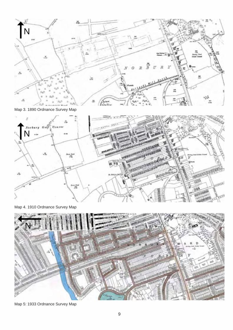
2.2.4 The site at Norbury included an existing brickfield (see Map 4). One of the conditions of the sale was that the brickmaking plant was to be taken over, to provide building materials. Bricks from the Norbury brick-field were used for the construc-tion of many of the cottages in the Norbury Estate, as well as part of the Totterdown-Fields in Tooting. On 16 February 1907, the Streatham News, recorded that ‘The total number of bricks manufactured on the Norbury Estate is about 11,000,000, of which 1,980,000 have been used in the erection of cottages on Section “A” [of the Estate].’
2.2.5 The Norbury Estate was constructed in two parts. The first phase of development in the eastern portion of the site was completed before the First World War and used approxi-mately 17 acres of the site. The first sections of this phase were completed in 1906, although
Shops in Newlands Road (circa 1911)
Former shops in Newlands Road (numbers 80-82) as they are today
Open space at the front of Tylecroft Road in 1923
10
excavation work had started as early as 1901. Development progressed west away from London Road along a grid pattern of roads towards Norton Gardens. By January 1908, 145 cottages were complete and 240 cottages by February 1910. In 1910 it was decided that four shops should be included in the development on Newlands Road (see photo). By the time war broke out 500 houses had been built on the estate and all were let.
2.2.6 The second phase of devel-opment, in the remaining eleven acres of the site to the west of Norton Gardens, was resumed in 1919 as a state aided housing scheme. There were many amendments made to the plans for the estate during this period - a public hall, further shops and recreation ground (on land to the north of Tylecroft Road between Darcy and Isham Roads, used at the time for allotments) were all proposed and rejected for various reasons. Due to a desire to increase the size of the houses and quality of accommodation the final section of development to the far west (Darcy Road and the sourthern tip of Northbor-ough Road within the estate), was reduced from the originally proposed 116 cottages to 87 and the planned shops omitted. By March 1920 a total of 642 homes had been constructed on the Norbury Estate.
2.2.7 During these fi rst decades of the 20th century the wider Norbury area surrounding the estate had seen a vast quantity of development, much of it private.
2.2.8 The Norbury Estate was strongly influenced by the ideals of the Garden City Movement, as set forward in Ebenezer
Architects drawings of the Norbury Estate from the London Metropolitan Archives
Architects drawings of the Norbury Estate from the London Metropolitan Archives
Map 6: Historic plan of the Norbury Estate, c.1925, from the London Metropolitan Archives
11
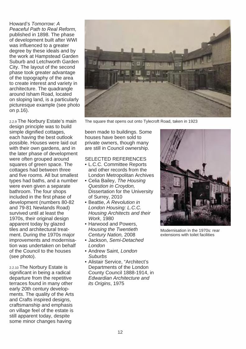
Howard’s Tomorrow: A Peaceful Path to Real Reform, published in 1898. The phase of development built after WWI was influenced to a greater degree by these ideals and by the work at Hampstead Garden Suburb and Letchworth Garden City. The layout of the second phase took greater advantage of the topography of the area to create interest and variety in architecture. The quadrangle around Isham Road, located on sloping land, is a particularly picturesque example (see photo on p.16).
2.2.9 The Norbury Estate’s main design principle was to build simple dignifi ed cottages, each having the best outlook possible. Houses were laid out with their own gardens, and in the later phase of development were often grouped around squares of green space. The cottages had between three and five rooms. All but smallest types had baths, and a number were even given a separate bathroom. The four shops included in the first phase of development (numbers 80-82 and 79-81 Newlands Road) survived until at least the 1970s, their original design apparent today by glazed tiles and architectural treat-ment. During the 1970s major improvements and modernisa-tion was undertaken on behalf of the Council to the houses (see photo).
2.2.10 The Norbury Estate is significant in being a radical departure from the repetitive terraces found in many other early 20th century develop-ments. The quality of the Arts and Crafts inspired designs, craftsmanship and emphasis on village feel of the estate is still apparent today, despite some minor changes having
The square that opens out onto Tylecroft Road, taken in 1923
been made to buildings. Some houses have been sold to private owners, though many are still in Council ownership.
SELECTED REFERENCES • L.C.C. Committee Reports
and other records from the London Metropolitan Archives
• Celia Bailey, The Housing Question in Croydon, Dissertation for the University of Surrey, 2010
• Beattie, A Revolution in London Housing: L.C.C. Housing Architects and their Work, 1980
• Harwood and Powers, Housing the Twentieth Century Nation, 2008
• Jackson, Semi-Detached London
• Andrew Saint, London Suburbs
• Alistair Service, “Architect’s Departments of the London County Council 1888-1914, in Edwardian Architecture and its Origins, 1975
Modernisation in the 1970s: rear extensions with toilet facilities
12
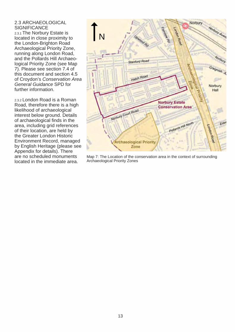
2.3 ARCHAEOLOGICAL SIGNIFICANCE 2.3.1 The Norbury Estate is located in close proximity to the London-Brighton Road Archaeological Priority Zone, running along London Road, and the Pollards Hill Archaeo-logical Priority Zone (see Map 7). Please see section 7.4 of this document and section 4.5 of Croydon’s Conservation Area General Guidance SPD for further information.
2.3.2 London Road is a Roman Road, therefore there is a high likelihood of archaeological interest below ground. Details of archaeological finds in the area, including grid references of their location, are held by the Greater London Historic Environment Record, managed by English Heritage (please see Appendix for details). There are no scheduled monuments located in the immediate area.
N
Map 7: The Location of the conservation area in the context of surrounding Archaeological Priority Zones
13
3.0 TOWNSCAPE CHARACTER
Townscape is the arrangement and appearance of buildings, spaces and other physical features in the built and natural environments.
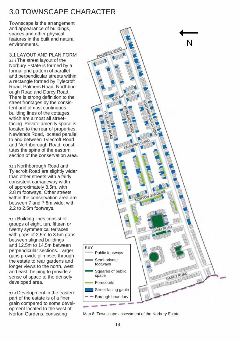
3.1 LAYOUT AND PLAN FORM 3.1.1 The street layout of the Norbury Estate is formed by a formal grid pattern of parallel and perpendicular streets within a rectangle formed by Tylecroft Road, Palmers Road, Northbor-ough Road and Darcy Road. There is strong definition to the street frontages by the consis-tent and almost continuous building lines of the cottages, which are almost all street-facing. Private amenity space is located to the rear of properties. Newlands Road, located parallel to and between Tylecroft Road and Northborough Road, consti-tutes the spine of the eastern section of the conservation area.
3.1.2 Northborough Road and Tylecroft Road are slightly wider than other streets with a fairly consistent carriageway width of approximately 8.5m, with 2.8 m footways. Other streets within the conservation area are between 7 and 7.8m wide, with 2.2 to 2.5m footways.
3.1.3 Building lines consist of groups of eight, ten, fi fteen or twenty symmetrical terraces with gaps of 2.5m to 3.5m gaps between aligned buildings and 12.5m to 14.5m between perpendicular sections. Larger gaps provide glimpses through the estate to rear gardens and longer views to the north, west and east, helping to provide a sense of space to the densely developed area.
3.1.4 Development in the eastern part of the estate is of a finer grain compared to some devel-opment located to the west of Norton Gardens, consisting Map 8: Townscape assessment of the Norbury Estate
N
Public footways
Semi-private footways
Squares of public space
Forecourts
Street-facing gable
Borough boundary
KEY
14
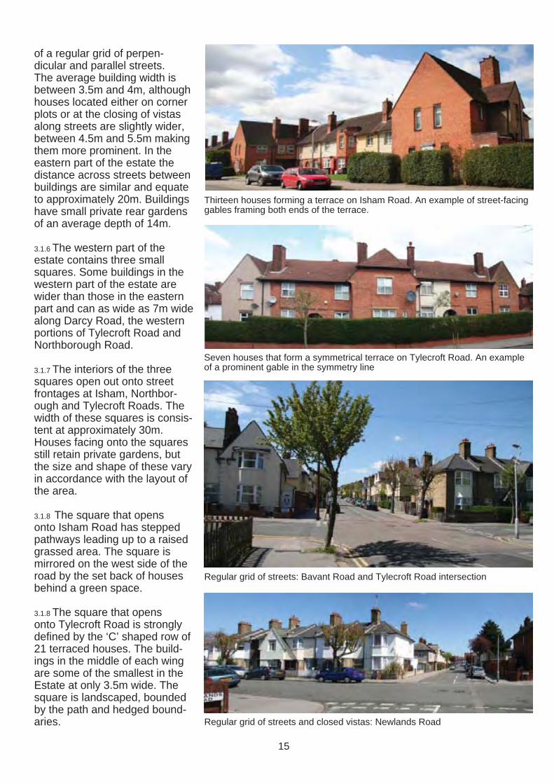
of a regular grid of perpen-dicular and parallel streets. The average building width is between 3.5m and 4m, although houses located either on corner plots or at the closing of vistas along streets are slightly wider, between 4.5m and 5.5m making them more prominent. In the eastern part of the estate the distance across streets between buildings are similar and equate to approximately 20m. Buildings have small private rear gardens of an average depth of 14m.
3.1.6 The western part of the estate contains three small squares. Some buildings in the western part of the estate are wider than those in the eastern part and can as wide as 7m wide along Darcy Road, the western portions of Tylecroft Road and Northborough Road.
3.1.7 The interiors of the three squares open out onto street frontages at Isham, Northbor-ough and Tylecroft Roads. The width of these squares is consis-tent at approximately 30m. Houses facing onto the squares still retain private gardens, but the size and shape of these vary in accordance with the layout of the area.
3.1.8 The square that opens onto Isham Road has stepped pathways leading up to a raised grassed area. The square is mirrored on the west side of the road by the set back of houses behind a green space.
3.1.8 The square that opens onto Tylecroft Road is strongly defined by the ‘C’ shaped row of 21 terraced houses. The build-ings in the middle of each wing are some of the smallest in the Estate at only 3.5m wide. The square is landscaped, bounded by the path and hedged bound-aries.
Thirteen houses forming a terrace on Isham Road. An example of street-facing gables framing both ends of the terrace.
Seven houses that form a symmetrical terrace on Tylecroft Road. An example of a prominent gable in the symmetry line
Regular grid of streets: Bavant Road and Tylecroft Road intersection
Regular grid of streets and closed vistas: Newlands Road
15

3.1.9 The ‘square’ that opens out to Northborough Road is of a rectangular shape created by a four-building terrace parallel to the road and and two three-building terraces to the sides. The houses are some of the widest in the estate and are 7m in width. Every house has a 2.4m deep landscaped front garden. The amenity space in the middle is of a rectangular shape with open corners, which increases its spacious character.
3.2 DENSITY AND LAND USES 3.2.1 Development in the Norbury Estate is densely laid out. The density of some development located to the far west of the estate is lower than the rest, a conscious design decision taken to improve the quality of accommodation. Street widths range from 12 to 14m including footways which are between 2.2 and 2.8m wide. House frontages vary from between 3.5m and 7m in width. Each house has a small front garden. Rear gardens are also relatively small with a distance of approximately 20m between the rear elevations of build-ings. Spacing between rows of terraces is tight and varies between 2.5 and 4m. Corner plots have more space where the perpendicular terraces meet. Street parking contributes to the overall perception of dense development.
3.2.2 The compositions of the terraces are designed in a way that hides the small size of individual units. For example, some of prominent gables contain two and sometimes three houses, but from a distance are perceived as a single house. Another example is the sharing of bay windows between units. The design
Houses around a square that opens out to Isham Road, with green open space
Square opening onto Tylecroft Road with brick paved path running through the grassed area
Square opening onto Northborough Road
16
approach redcues the sense of high density and the estate appears to be more spacious than it actually is.
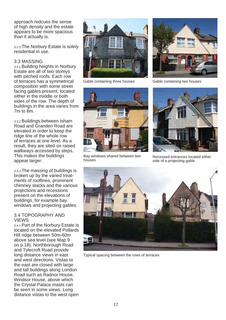
3.2.3 The Norbury Estate is solely residential in use.
3.3 MASSING 3.3.1 Building heights in Norbury Estate are all of two storeys with pitched roofs. Each row of terraces has a symmetrical composition with some street facing gables present, located either in the middle or both sides of the row. The depth of buildings in the area varies from 7m to 8m.
3.3.2 Buildings between Isham Road and Granden Road are elevated in order to keep the ridge line of the whole row of terraces at one level. As a result, they are sited on raised walkways accessed by steps. This makes the buildings appear larger.
3.3.3 The massing of buildings is broken up by the varied treat-ments of roofl ines, prominent chimney stacks and the various projections and recessions present on the elevations of buildings, for example bay windows and projecting gables.
3.4 TOPOGRAPHY AND VIEWS 3.4.1 Part of the Norbury Estate is located on the elevated Pollards Hill ridge between 50m-60m above sea level (see Map 9 on p.18). Northborough Road and Tylecroft Road provide long distance views in east and west directions. Vistas to the east are closed with large and tall buildings along London Road such as Radnor House, Windsor House, above which the Crystal Palace masts can be seen in some views. Long distance vistas to the west open
Gable containing three houses Gable containing two houses
Bay windows shared between two houses
Recessed entrances located either side of a projecting gable
Typical spacing between the rows of terraces
17
toward large low rise residential and green open spaces in the London Borough of Merton.
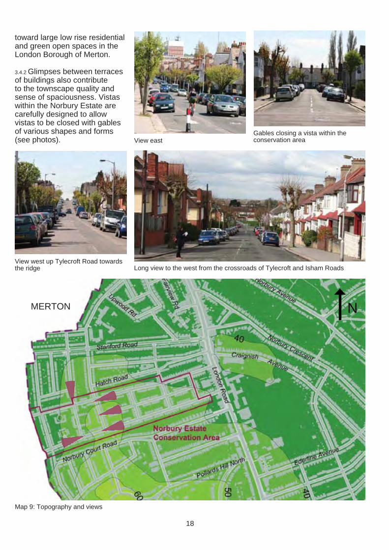
3.4.2 Glimpses between terraces of buildings also contribute to the townscape quality and sense of spaciousness. Vistas within the Norbury Estate are carefully designed to allow vistas to be closed with gables of various shapes and forms (see photos). View east
Gables closing a vista within the conservation area
View west up Tylecroft Road towards the ridge Long view to the west from the crossroads of Tylecroft and Isham Roads
NMERTON
Map 9: Topography and views
18
4.0 STREETSCAPE CHARACTER
Streetscape is the outward visual appearance and char-acter of a street or locality. For information on standards set for Croydon’s public realm please see the Croydon Public Realm Design Guide (2012).
4.1 PUBLIC REALM AND OPEN SPACE 4.1.1 The public realm differs in the eastern and western sections of the Norbury Estate. The western part of the estate includes areas of public open space around which squares are formed (see section 3.1), each with its own design, providing amenity space to the dense arrangement of houses. The spaces are public, however they have a private character due to the surrounding houses and are most likely to be used by their residents.
4.1.2 The square that opens onto Tylecroft Road is broadly circular and enclosed within a ‘C’ shaped group of houses. The landscaped centre of the square is elevated compared to the buildings and perimeter path. The square that opens onto Northborough Road is square-shaped with a sense of openness created by gaps between buildings. The square formed either side of Isham Road is the most complex due to its topography: a steep east-west slope. The square has an elevated grassed area surrounded by blocks of houses arranged in a ‘C’ shape with a maze of paths and stairs enclosed by brick walls.
4.1.3 There is no open space in the public realm of the eastern part of the estate, which is limited to streets and small front gardens. Terraces located on slopes and higher ground on Norton Gardens and nearby sections of Tylecroft and North-
borough Roads have elevated common front forecourts, with a single or double access point from the street usually accessed by steps.
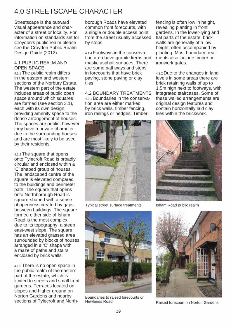
4.1.4 Footways in the conserva-tion area have granite kerbs and mastic asphalt surfaces. There are some pathways and steps in forecourts that have brick paving, stone paving or clay tiles.
4.2 BOUNDARY TREATMENTS 4.2.1 Boundaries in the conserva-tion area are either marked by brick walls, timber fencing, iron railings or hedges. Timber
Typical street surface treatments
Boundaries to raised forecourts on Newlands Road
fencing is often low in height, revealing planting in front gardens. In the lower-lying and flat parts of the estate, brick walls are generally of a low height, often accompanied by planting. Most boundary treat-ments also include timber or ironwork gates.
4.2.2 Due to the changes in land levels in some areas there are brick retaining walls of up to 1.5m high next to footways, with integrated staircases. Some of these walled arrangements are original design features and contain horizontally laid clay tiles within the brickwork.
Isham Road public realm
Raised forecourt on Norton Gardens
19
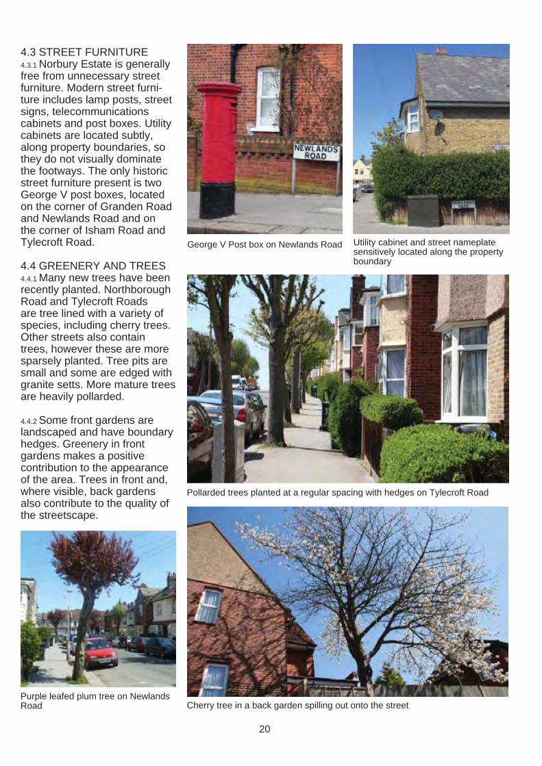
4.3 STREET FURNITURE 4.3.1 Norbury Estate is generally free from unnecessary street furniture. Modern street furni-ture includes lamp posts, street signs, telecommunications cabinets and post boxes. Utility cabinets are located subtly, along property boundaries, so they do not visually dominate the footways. The only historic street furniture present is two George V post boxes, located on the corner of Granden Road and Newlands Road and on the corner of Isham Road and Tylecroft Road.
4.4 GREENERY AND TREES 4.4.1 Many new trees have been recently planted. Northborough Road and Tylecroft Roads are tree lined with a variety of species, including cherry trees. Other streets also contain trees, however these are more sparsely planted. Tree pits are small and some are edged with granite setts. More mature trees are heavily pollarded.
4.4.2 Some front gardens are landscaped and have boundary hedges. Greenery in front gardens makes a positive contribution to the appearance of the area. Trees in front and, where visible, back gardens also contribute to the quality of the streetscape.
Purple leafed plum tree on Newlands Road
Utility cabinet and street nameplateGeorge V Post box on Newlands Road sensitively located along the property boundary
Pollarded trees planted at a regular spacing with hedges on Tylecroft Road
Cherry tree in a back garden spilling out onto the street
20
5.0 ARCHITECTURAL CHARACTER
5.1 GENERAL ARCHITEC-TURAL CHARACTER 5.1.1 The Norbury Estate has a consistent Arts and Crafts architectural character. The estate has a village feel, due to the character of the architectural features present and careful breaking up of massing to reduce the visual appearance of the density of the houses, including gaps and views between buildings. The architecture is of a high quality of craftsmanship with subtle, detailing, for example diamond patterns created by different coloured bricks.
5.1.2 There is a variety of form within the different perimeter blocks, largely created through the interplay of architectural features, articulation, detailing and rich materials (see section 5.3). The design of the estate also carefully manipulates the topography to create several raised terraces that benefi t from improved outlook and privacy from the street.
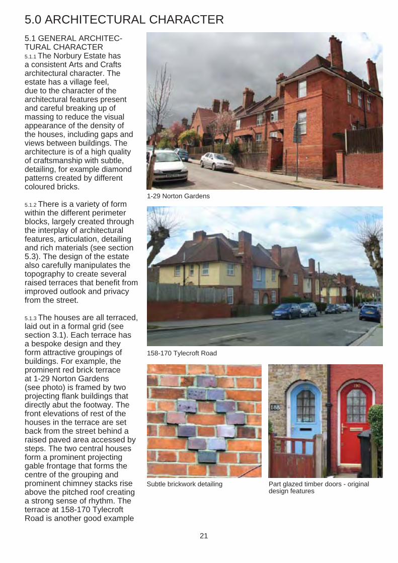
5.1.3 The houses are all terraced, laid out in a formal grid (see section 3.1). Each terrace has a bespoke design and they form attractive groupings of buildings. For example, the prominent red brick terrace at 1-29 Norton Gardens (see photo) is framed by two projecting flank buildings that directly abut the footway. The front elevations of rest of the houses in the terrace are set back from the street behind a raised paved area accessed by steps. The two central houses form a prominent projecting gable frontage that forms the centre of the grouping and prominent chimney stacks rise Subtle brickwork detailing Part glazed timber doors - original above the pitched roof creating design features
a strong sense of rhythm. The terrace at 158-170 Tylecroft Road is another good example
1-29 Norton Gardens
158-170 Tylecroft Road
21
of the bespoke design approach to individual terraces. It has a symmetrical composition with a prominent central gable flanked by buildings divided by recessed doorways containing two entrances and street facing brick chimney stacks.
5.1.3 The original design and overall composition of the Norury Estate, including the relationship of terraces to each other, was carefully considered. In addition all buildings that are situated at the end of a closed vista are almost always marked by gable fronted buildings.
5.2 HISTORIC AND ARCHI-TECTURAL SIGNIFICANCE OF BUILDINGS 5.2.1 All buildings in the Norbury Estate positively contribute to its special character as a unified estate of a high architectural quality. There are no statutorily listed or locally listed buildings present in the conservation area at the date of aoption of this document.
5.3 KEY FEATURES AND MATERIALS 5.3.1 Houses in the Norbury Estate Conservation Area display a range of Arts and Crafts inspired features and a rich use of traditional materials. Architectural features and detailing display a high quality of craftsmanship in their execu-tion and make an important contribution to the area’s architectural character. One of the most distinctive small scale details are the ceramic house number tiles, which survive at most properties within the Norbury Estate.
5.3.2 Houses generally contain a selection of the key features and materials listed in the adjacent box.
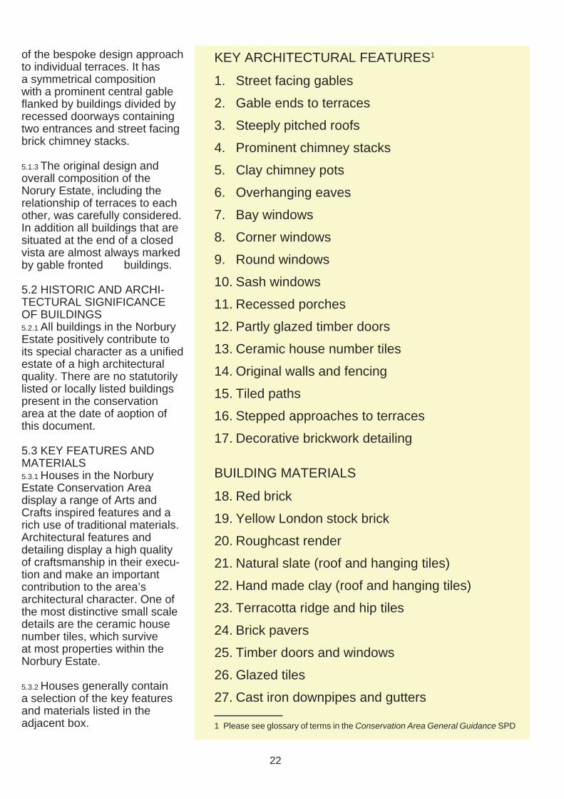
KEY ARCHITECTURAL FEATURES1
1. Street facing gables
2. Gable ends to terraces
3. Steeply pitched roofs
4. Prominent chimney stacks
5. Clay chimney pots
6. Overhanging eaves
7. Bay windows
8. Corner windows
9. Round windows
10. Sash windows
11. Recessed porches
12. Partly glazed timber doors
13. Ceramic house number tiles
14. Original walls and fencing
15. Tiled paths
16. Stepped approaches to terraces
17. Decorative brickwork detailing
BUILDING MATERIALS
18. Red brick
19. Yellow London stock brick
20. Roughcast render
21. Natural slate (roof and hanging tiles)
22. Hand made clay (roof and hanging tiles)
23. Terracotta ridge and hip tiles
24. Brick pavers
25. Timber doors and windows
26. Glazed tiles
27. Cast iron downpipes and gutters
1 Please see glossary of terms in the Conservation Area General Guidance SPD
22
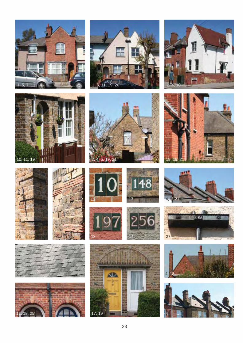
1, 5, 7, 11, 18
10, 11, 19
1, 5, 11, 19, 20 2, 4, 10
2, 4, 5, 19, 21 18, 19, 21
27
4, 5, 21
4
4, 18
19 22
13 13
13 13
17, 19
21
11, 18, 25
23
6.0 CONDITION AND THREATS
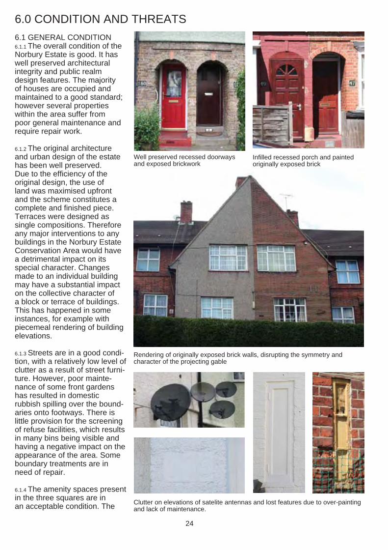
6.1 GENERAL CONDITION 6.1.1 The overall condition of the Norbury Estate is good. It has well preserved architectural integrity and public realm design features. The majority of houses are occupied and maintained to a good standard; however several properties within the area suffer from poor general maintenance and require repair work.
6.1.2 The original architecture and urban design of the estate has been well preserved. Due to the efficiency of the original design, the use of land was maximised upfront and the scheme constitutes a complete and fi nished piece. Terraces were designed as single compositions. Therefore any major interventions to any buildings in the Norbury Estate Conservation Area would have a detrimental impact on its special character. Changes made to an individual building may have a substantial impact on the collective character of a block or terrace of buildings. This has happened in some instances, for example with piecemeal rendering of building elevations.
6.1.3 Streets are in a good condi-tion, with a relatively low level of clutter as a result of street furni-ture. However, poor mainte-nance of some front gardens has resulted in domestic rubbish spilling over the bound-aries onto footways. There is little provision for the screening of refuse facilities, which results in many bins being visible and having a negative impact on the appearance of the area. Some boundary treatments are in need of repair.
6.1.4 The amenity spaces present in the three squares are in
Clutter on elevations of satelite antennas and lost features due to over-paintingan acceptable condition. The and lack of maintenance.
Well preserved recessed doorways and exposed brickwork
Infilled recessed porch and painted originally exposed brick
Rendering of originally exposed brick walls, disrupting the symmetry and character of the projecting gable
24
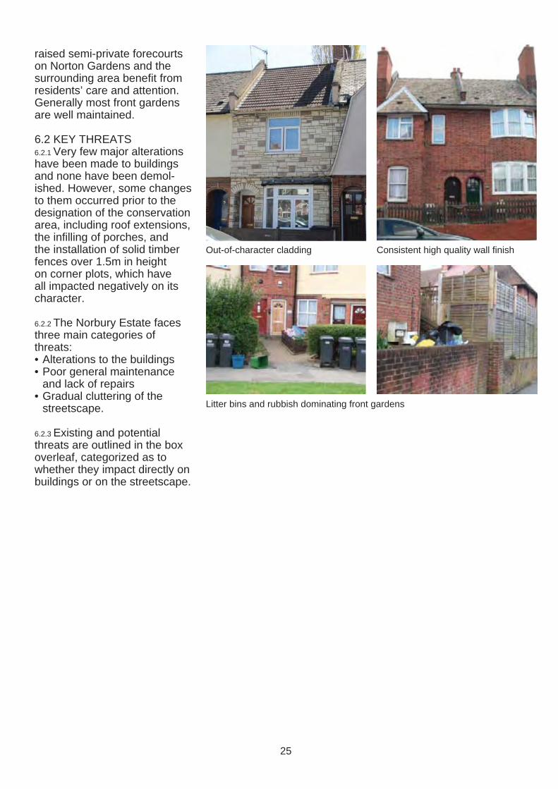
raised semi-private forecourts on Norton Gardens and the surrounding area benefi t from residents’ care and attention. Generally most front gardens are well maintained.
6.2 KEY THREATS 6.2.1 Very few major alterations have been made to buildings and none have been demol-ished. However, some changes to them occurred prior to the designation of the conservation area, including roof extensions, the infilling of porches, and the installation of solid timber fences over 1.5m in height on corner plots, which have all impacted negatively on its character.
6.2.2 The Norbury Estate faces three main categories of threats: • Alterations to the buildings • Poor general maintenance
and lack of repairs • Gradual cluttering of the
streetscape.
6.2.3 Existing and potential threats are outlined in the box overleaf, categorized as to whether they impact directly on buildings or on the streetscape.
Out-of-character cladding Consistent high quality wall finish
Litter bins and rubbish dominating front gardens
25
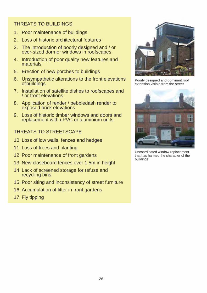
THREATS TO BUILDINGS:
1. Poor maintenance of buildings
2. Loss of historic architectural features
3. The introduction of poorly designed and / or over-sized dormer windows in roofscapes
4. Introduction of poor quality new features and materials
5. Erection of new porches to buildings
6. Unsympathetic alterations to the front elevations of buildings
7. Installation of satellite dishes to roofscapes and / or front elevations
8. Application of render / pebbledash render to exposed brick elevations
9. Loss of historic timber windows and doors and replacement with uPVC or aluminium units
THREATS TO STREETSCAPE
10. Loss of low walls, fences and hedges
11. Loss of trees and planting
12. Poor maintenance of front gardens
13. New closeboard fences over 1.5m in height
14. Lack of screened storage for refuse and recycling bins
15. Poor siting and inconsistency of street furniture
16. Accumulation of litter in front gardens
17. Fly tipping
Poorly designed and dominant roof extension visible from the street
Uncoordinated window replacement that has harmed the character of the buildings
26
MANAGEMENT PLAN
This Management 7.0 ADDITIONAL CONSIDERATIONS Plan provides area-specific guidance on development and maintenance in and enhancement of the Norbury Estate Conservation Area. It supplements, and should be read in conjunction with, Croydon’s Conservation Area General Guidance SPD, which provides general development and maintenance guidance for all conservation areas in Croydon.
7.0.1 It is the responsibility of the 7.5 TREES IN PRIVATE property owner to be aware GARDENS of the designations that apply 7.5.1 Six weeks prior notice to their building and the area should be given to the Council within which it is situated. for all proposed tree works in
conservation areas. Please see 7.1 ARTICLE 4 DIRECTIONS section 5.14 of the Conserva-7.1.1 The Council maintains the tion Area General Guidance right to serve an Article 4 Direc- SPD for further information. tion, if deemed appropriate, to Please see sections 5.14 and protect the special character 7.3 of the Conservation Area of the conservation area. For General Guidance SPD. further information please see section 2.5 of the Conservation Area General Guidance SPD.
7.2 BUILDING REGULATIONS 7.2.1 All building work must comply with Building Regula-tions. Please see section 8 of the Conservation Area General Guidance SPD.
7.3 PLANNING ENFORCEMENT 7.3.1 If you feel that unauthorised development has occurred in the area, including the replace-ment of windows or installation of satellite dishes, please report this to the Council’s planning enforcement team. For further information please see section 7 of the Conservation Area General Guidance SPD.
7.3.2 As part of this assessment a full photographic survey of the conservation area as visible from the street has been made, which will be used as evidence when reviewing any reports of unauthorised development.
7.4 ARCHAEOLOGICAL INVESTIGATIONS 7.4.1 As the Norbury Estate is not located in an Archaeological Priority Zone (see section 2.3) it is unlikely that development would require archaeological investigations.
28
8.0 DEVELOPMENT GUIDELINES
8.0.1 General guidance for devel-opment in conservation areas is provided in the Conservation Area General Guidance SPD. The development guidelines provided below supplement these general guidelines, providing area-specifi c principles that respond to the particular challenges for proposed devel-opment in the Norbury Estate Conservation Area.
8.1 DEMOLITION 8.1.1 The demolition of buildings in Norbury Estate Conservation Area will not be permitted due to the fact that all of the buildings make a positive contribution to its special character. For further advice please see section 5.1 of the Conservation Area General Guidance SPD.
8.1.2 Demolition of non-original structures or extensions may be considered acceptable, however all proposals will be considered on a case-by-case basis.
8.2 NEW DEVELOPMENT 8.2 There are no obvious opportu-nities for new development sites in the Norbury Estate Conserva-tion area.
8.3 EXTENSIONS 8.3.1 Proposals for front, side and roof extensions will generally not be considered to be acceptable in the Norbury Estate Conserva-tion Area due to the potential impact on the character and appearance of individual build-ings, the group value of terraces and the resultant disruption of the consistent pattern of roofs-capes.
8.3.2 Single storey rear extensions may be considered to be accept-able, subject to careful consider-ation of the design and potential of overlooking and privacy due to the very dense pattern of development. Two storey rear
extensions are unlikely to be considered acceptable. Rear extensions should be designed to be subservient and sympa-thetic to the host building and should use high quality materials that respect the main building.
8.3.3 Planning permission is required for most extensions to buildings. for further information please contact the Council (see Appendix for contact details).
8.4 CHANGES OF USE 8.4.1 Any proposals for changes of use should ensure that the original appearance of the building is not affected. Planning permission will be required.
8.5 ROOFS, CHIMNEYS AND GUTTERS 8.5.1 All re-roofing works should be carried out in either natural slate or plain clay tiles as appropriate. Original tiles and slates should be re-used on street-facing roofscapes and supplemented by matching materials to the rear. Concrete or other artificial materials are not considered to be acceptable replacement roofi ng materials.
8.5.2 The Council will seek to resist dormers on roofscapes visible from the street due to the impact on the character and appearance of buildings. All extraneous fi xtures should
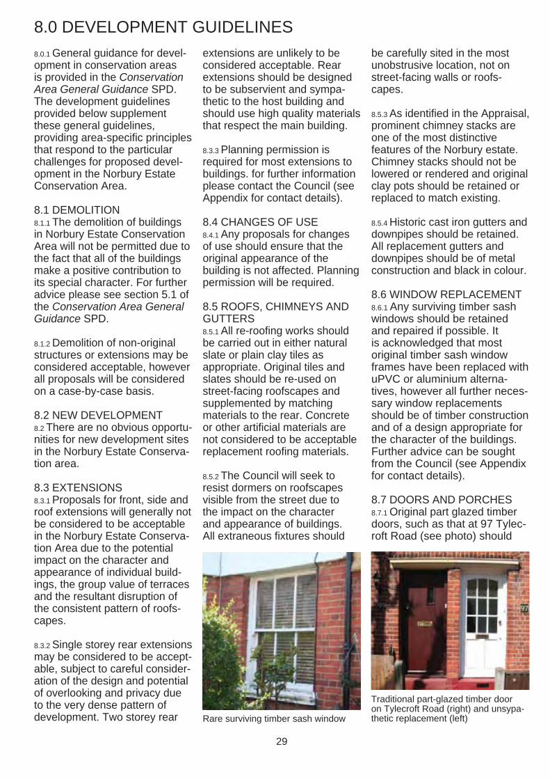
Rare surviving timber sash window
be carefully sited in the most unobstrusive location, not on street-facing walls or roofs-capes.
8.5.3 As identified in the Appraisal, prominent chimney stacks are one of the most distinctive features of the Norbury estate. Chimney stacks should not be lowered or rendered and original clay pots should be retained or replaced to match existing.
8.5.4 Historic cast iron gutters and downpipes should be retained. All replacement gutters and downpipes should be of metal construction and black in colour.
8.6 WINDOW REPLACEMENT 8.6.1 Any surviving timber sash windows should be retained and repaired if possible. It is acknowledged that most original timber sash window frames have been replaced with uPVC or aluminium alterna-tives, however all further neces-sary window replacements should be of timber construction and of a design appropriate for the character of the buildings. Further advice can be sought from the Council (see Appendix for contact details).
8.7 DOORS AND PORCHES 8.7.1 Original part glazed timber doors, such as that at 97 Tylec-roft Road (see photo) should
Traditional part-glazed timber door on Tylecroft Road (right) and unsypa-thetic replacement (left)
29
be retained. Any necessary replacements should be on a like-for-like basis in terms of design and materials.
8.7.2 As identified in the Appraisal, recessed porches are a key architectural feature of the estate. Recessed porches should not be in-filled due to the negative impact on the special character of individual buildings and whole terraces. If additional security is required, gates or railings that are designed to be in keeping with the special character of the area may be a suitable alternative.
8.7.3 Some houses have decora-tive projecting timber porches, which should be retained and repaired. The design and appropriateness of new porches should be carefully considered and should not have a negative impact on the character and appearance of the building.
8.8 CLADDING, RENDERING OR PAINTING OF WALLS 8.8.1 Originally exposed brick walls should not be clad, rendered or painted as the exposed brick contributes towards the special character of the Norbury Estate Conserva-tion Area. Such changes may also result in the loss of features or changes to the visual integrity of buildings and whole terraces. Planning permission is required for the external cladding or rendering of walls on all proper-ties in the conservation area. Further advice can be sought from the Council (see Appendix for details).
8.9 FRONT GARDENS AND BOUNDARY TREATMENTS 8.9.1 Front gardens in the Norbury Estate Conservation Area are very small. Their treatment is a particularly important issue due to the significant impact they
have on the streetscape of the conservation area and also on privacy and safety of residents. All existing original boundary treatments should be retained. Screened storage of refuse and recycling bins should be provided where there is a suitable and appropriate location.
8.9.2 Walls below 1m in height with integrated shrubs and / or hedges contribute to the conservation area’s appear-ance. New proposals for low fencing or walling should not replace historic boundary treatments and should be constructed from high quality materials and are integrated with existing or new hedges.
8.9.3 Closeboarded fences over 1.5m in height are generally not considered to be acceptable at the front of a property or on a boundary fronting a highway.
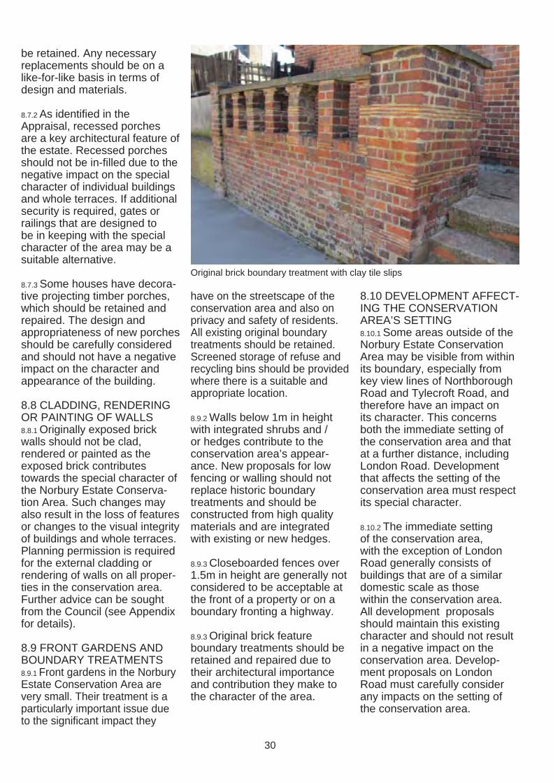
8.9.3 Original brick feature boundary treatments should be retained and repaired due to their architectural importance and contribution they make to the character of the area.
Original brick boundary treatment with clay tile slips
8.10 DEVELOPMENT AFFECT-ING THE CONSERVATION AREA’S SETTING 8.10.1 Some areas outside of the Norbury Estate Conservation Area may be visible from within its boundary, especially from key view lines of Northborough Road and Tylecroft Road, and therefore have an impact on its character. This concerns both the immediate setting of the conservation area and that at a further distance, including London Road. Development that affects the setting of the conservation area must respect its special character.
8.10.2 The immediate setting of the conservation area, with the exception of London Road generally consists of buildings that are of a similar domestic scale as those within the conservation area. All development proposals should maintain this existing character and should not result in a negative impact on the conservation area. Develop-ment proposals on London Road must carefully consider any impacts on the setting of the conservation area.
30
9.0 ENHANCEMENT
9.0.1 Property owners are strongly encouraged to maintain their properties and undertake minor works that would improve the condition and appearance of their properties, which will have a wider positive impact on the conservation area as a whole. The Council welcomes and supports enhancement schemes proposed by property owners or the local community.
9.0.2 Much enhancement of buildings and the wider area does not require planning permission; for advice on what works require planning permis-sion please either refer to the Planning Portal or contact the Council’s Development Management service (see Appendix for details).
9.1 MAINTENANCE 9.1.1 Regular maintenance and repair is important to ensure the long-term survival of valued urban design and architectural features, to retain the collective value of the attractive features present in the area and to prevent problems including damp and decay.
9.1.2 Buildings in poor condition detract from the appearance of the conservation area. Some minor works do not require planning permission but, if left unattended, may result in unnecessary decay and damage, which could lead to the need to conduct more complex and expensive repair works that may require planning permission at a later date.
9.1.3 Recommendations for basic maintenance include: • The regular cleaning and
maintenance of front gardens • Regular fencing repairs and
painting (if required) • The regular clearing of debris
in gutters and rainwater pipes
• The pruning of vegetation in close proximity to buildings
• The re-fixing of loose roof tiles or slates
• The regular painting of timber Please see section 6 of the Conservation Area General Guidance SPD for further guidance.
9.1.3 Additional advice for homeowners is provided in a publication produced by the Institute of Historic Buildings Conservation and the Society for the Protection of Ancient Buildings titled A Stitch in Time, (see Appendix for details).
9.2 REPARING, RESTOR-ING AND RE-INSTATING FEATURES 9.2.1 The following works would result in an enhancement to the area: • The removal of uPVC or
aluminium windows and doors and re-instatement of timber sash or casement windows
• The stripping of inappropriate paint or render from originally exposed brickwork using a non-damaging method
• The removal of in-filled porches
• The re-siting of satellite dishes and TV aerials where visible from the street
• The replacement of non-traditional roofi ng materials with either hand-made clay or natural slate tiles
• The removal of architectural features that are out of keep-ing with the area’s special character
• Replanting of boundary fences or hedges where they have been removed
• Planting of landscape features in front gardens
31
9.3 FRONT GARDEN MAN-AGEMENT AND REFUSE STORAGE 9.3.1 Property owners and tenants should take respon-sibility for the management of front gardens and be aware that their treatment has a significant impact on the quality of the wider area. Low boundary walls and fences should be retained and additional tree and shrub planting is welcomed.
9.3.2 Property owners should consider the installation of screening for refuse bins that would otherwise be visible from the street. This can enhance not only the appearance of individual properties but also that of the wider conservation area. Any structure should be situated behind the main building line if possible. Planning permission is required for the erection of any perma-nent structure in front of the main building line. See also section 8.9.
9.4 PUBLIC REALM IMPROVEMENTS 9.4.1 Routine maintenance of the public realm occurs as part of the ongoing cycle of mainte-nance within the borough. There may be potential for further enhancements in the future. All proposals to enhance the conservation area’s public realm must be in accordance with the Croydon Public Realm Design Guide.
9.4.2 All new street lighting will be implemented in the area according to the adopted Street Lighting PFI.
9.5 STREET TREES 9.5.1 The Council has recently undertaken a programme of tree planting in the Norbury Estate Conservation Area, which has increased the number of trees and improved the quality of the streetscape. For further information please see sections 5.14 and 7.3 of the Conservation Area General Guidance SPD.
9.6 ENERGY EFFICIENCY IMPROVEMENTS 9.6.1 The Council supports the principle of works to build-ings to improve their energy efficiency, provided that the original character of the building is not harmed. There are some retrofitting measures that can be explored for buildings in this conservation area to improve their energy effi ciency and thermal performance. Some retrofitting measures may require planning permission. Please see section 9 of the Conservation Area General Guidance SPD for further infor-mation.
9.6.2 In the Norbury Estate Conservation Area the instal-lation of external wall insula-tion or photo-voltaic or solar thermal panels on roofscapes visible from the road are not considered to be appropriate measures. It is recommended that less obtrusive measures, including internal wall and roof insulation, the draught proofing of windows and doors, internal secondary glazing, are consid-ered by property owners to improve the energy effi ciency of their property.
32
10.0 APPENDIX
10.1 WEBSITES AND OTHER RELEVANT INFORMATION A) USEFUL WEBSITES • Croydon Council Planning and Conservation web pages:
www.croydon.gov.uk/environment/conservation www.croydon.gov.uk/planningandregeneration
• English Heritage web pages: www.english-heritage.org.uk www.helm.org.uk - (for access to English Heritage documents www.english-heritage.org.uk/your-property/saving-energy
• National Planning Policy Framework and associated guidance: www.gov.uk/government/publications/national-planning-policy -framework--2
• The Planning Portal www.planningportal.gov.uk
• Greater London Historic Environment Record: www.heritagegateway.org.uk (managed by English Heritage)
• Greater London Authority (for the London Plan): www.london.gov.uk/thelondonplan
• Department for Communities and Local Government www.communities.gov.uk
• Building Conservation Directory: www.buildingconservation.com
• Sustainable Traditional Buildings Alliance: www.sdfoundation.org.uk/stba
B) RELEVANT CROYDON COUNCIL DOCUMENTS (DOWNLOADABLE FROM ABOVE WEBLINK) • Croydon Conservation Area General Guidance SPD • Planning Application Validation Checklist • Local List of Buildings of Architectural or Historic Interest SPD • Residential Extensions and Alterations SPD • Landscape Design SPG • Public Realm Design Guide
C) RELEVANT NATIONAL GUIDANCE DOCUMENTS (WEBLINK ABOVE) • Archaeology and Planning in Greater London (English Heritage
2011) • The Setting of Heritage Assets (English Heritage 2012) • Understanding Place: Conservation Area Designation, Appraisal
and Management (English Heritage 2011) • Understanding Place: Historic Area Assessments (English
Heritage 2011) • Energy Efficiency and Historic Buildings, which is a series of
English Heritage guidance documents available to view and download at www.helm.org.uk/climatechange
• By Design: Urban Design in the Planning System (CABE, 2000) • The Urban Design Compendium (English Partnerships,
2000/2007) • Responsible Retrofit of Traditional Buildings (Sustainable
Traditional Buildings Alliance 2012) • A Stitch in Time (IHBC and the Society for the Protection of
Ancient Buildings, 2002)
33
10.2 CONTACTS Croydon Council, Bernard Weatherill House, 8 Mint Walk, Croydon CR0 1EA; www.croydon.gov.uk Tel/Email: 0208 7266000; [email protected]
• Spatial Planning (including Urban Design and Conservation officers): Tel: 0208 4071385; Email: [email protected]
• Development Management (including Enforcement & Tree Officers): Email: [email protected]
• Building Control Team, Croydon Council: Email: [email protected]
• Waste Management Team, Community Services, Croydon Council: Tel: 0208 7266200
• Croydon Local Studies Library and Archives Centre: www.croydon.gov.uk/libraries Tel:0208 7266900; Email: [email protected]
English Heritage, London Region 1 Waterhouse Square, 138-142 Holborn, London EC1N 2ST Tel/Email: 0207 9733000; [email protected]
The Victorian Society Tel/Email: 0208 9941019; [email protected] www.victoriansociety.org.uk
The Georgian Group Tel/Email: 0871 7502936; [email protected] www.georgiangroup.org
The Society for the Protection of Ancient Buildings (SPAB) Tel/Email: 0207 3771644; [email protected]; www.spab.org.uk Technical helpline: 0207 456 0916
The Building Conservation Directory Tel/Web: 01747 871717; www.buildingconservation.com
The Energy Saving Trust Tel/Web: 0800 512012; www.energysavingtrust.org.uk
Register of Building Conservation Accredited Architects Tel/Web: 01625 523784; www.aabc-register.co.uk
Royal Institute of British Architects (RIBA) Tel/Web: 0207 3073700; www.architecture.com
Mid Croydon Conservation Area Advisory Panel (please contact the Spatial Planning Team for details)
Croydon Natural History and Scientifi c Society Contact: Brian Lancaster: Tel: 0208 6686909
34
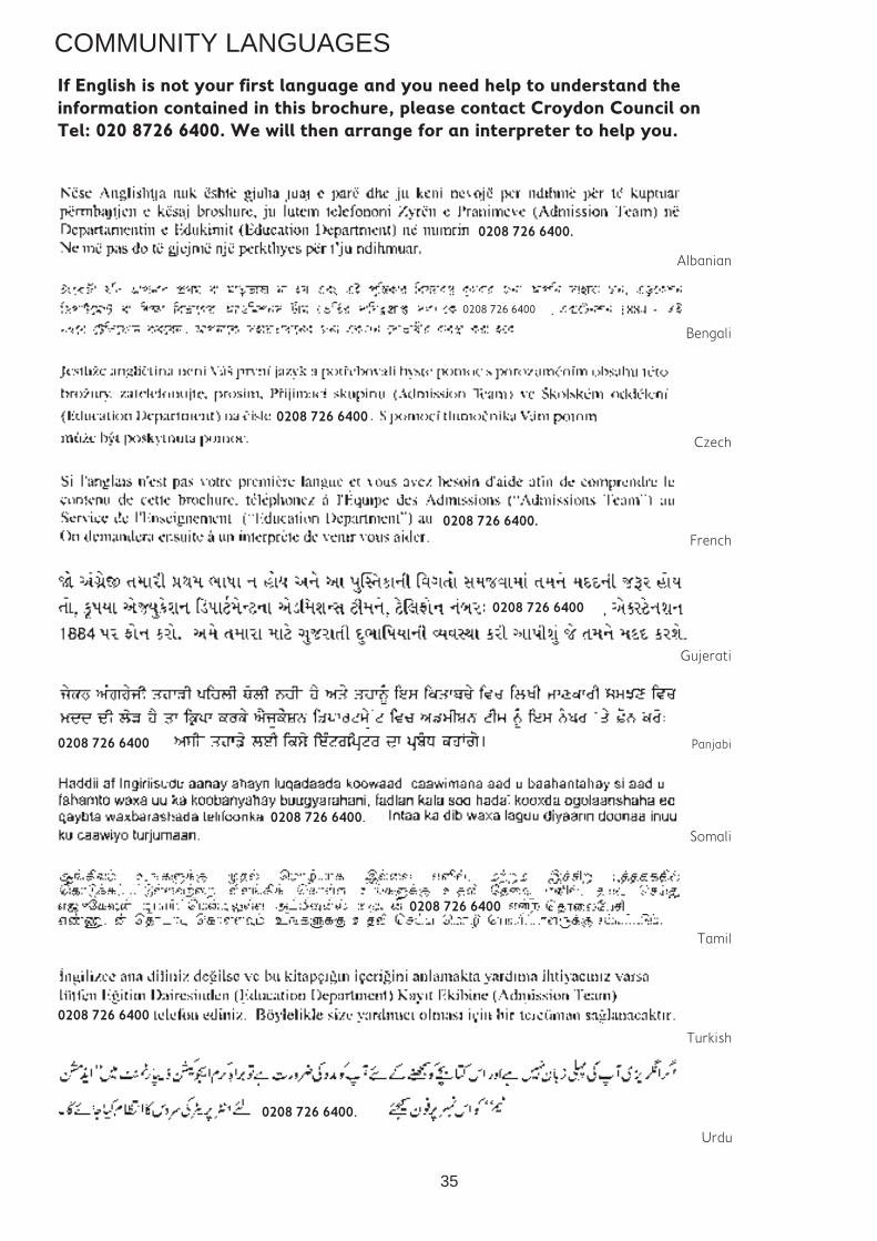
COMMUNITY LANGUAGES
If English is not your first language and you need help to understand the information contained in this brochure, please contact Croydon Council on Tel: 020 8726 6400. We will then arrange for an interpreter to help you.
0208 726 6400.
0208 726 6400
Albanian
Bengali
French
Czech
0208 726 6400
0208 726 6400.
Gujerati
0208 726 6400
Panjabi0208 726 6400
Somali 0208 726 6400.
0208 726 6400
Tamil
0208 726 6400
Turkish
0208 726 6400.
Urdu
35