Nitrate Vulnerable Zone (NVZ) designation, 2017...
14
Nitrate Vulnerable Zone (NVZ) designation, 2017 Eutrophication (lakes) Publication Date: June 2016 Page 1 of 14 NVZ Name: Stewartby Lake NVZ ID: EL111
Transcript of Nitrate Vulnerable Zone (NVZ) designation, 2017...

Nitrate Vulnerable Zone (NVZ)
designation, 2017 Eutrophication (lakes)
Publication Date: June 2016
Page 1 of 14
NVZ Name: Stewartby Lake
NVZ ID: EL111

Evidence of eutrophication 2017
This document provides a summary of the evidence used in proposing an area of land as one which should be, or should continue to be, designated as a Nitrate Vulnerable Zone (NVZ) for the purposes of the Nitrate Pollution Prevention Regulations 2015. A full description of the methods used in developing the NVZ proposals is set out in the detailed methodology for eutrophication-related NVZs, available via http://apps.environment-agency.gov.uk/wiyby/141443.aspx . These methods were developed under the guidance of a review group convened by the Defra for the last NVZ review (2011-2013), which included representatives from the farming and water industries as well as independent academic experts. Minor refinements to the methods have been made for the current review. NVZs are areas of land that drain to polluted waters and which contribute to the pollution of those waters. Polluted waters include those which are eutrophic or may in the near future become so if the Regulations were not to apply there. Eutrophication is defined as “the enrichment of water by nitrogen compounds, causing an accelerated growth of algae and higher forms of plant life to produce an undesirable disturbance to the balance of organisms present in the water and to the quality of the water concerned”. For both freshwaters and saline waters, a weight-of-evidence based approach to assessing the risks and impacts of eutrophication was employed. The evidence for individual water bodies was assessed against a national suite of criteria for eutrophication in the different categories/ types of water for review. The criteria are both quantitative and qualitative and reflect scientific understanding of the process and effects of eutrophication. They are broken down in the same way for each water category as follows:-
Nutrients
Plants/algae
Secondary and other effects For each designated or candidate water body which might meet the criteria for eutrophication, a datasheet such as this one was completed, bringing together information about the water body, its catchment, its uses, evidence of eutrophication and the sources of nitrogen input. This document is a record of the evidence used in the designation process, including results from national monitoring and assessment programmes, and further information supplied by Area staff. The proposals for NVZ designation are made as a result of close working between Area and national Environment Agency teams, with further quality assurance for the eutrophication designations through the use of a national expert panel. An accompanying guide to these datasheets is available, which provides an explanation of the contents, acronyms and technical terms.
Some features of the maps within this report are based on digital spatial data licensed from the Centre for Ecology and Hydrology, ©. Please note that any maps shown here have not used detailed field boundaries and therefore represent the indicative 'soft' boundary only. The definitive NVZ area can be seen on the “What’s in Your Backyard” (WIYBY) website ((http://apps.environment-agency.gov.uk/wiyby/141443.aspx).
Page 2 of 14
NVZ Name: Stewartby Lake
NVZ ID: EL111

39450WB ID: 2013 NVZ status: Designate
Section 1. Lake and catchment characteristics
Cambridgeshire and Bedfordshire
500775
78.2
No data
High alkalinity,shallow,large,lowland
EA Area
Lake grid co-ordinates (Easting/Northing)
Lake waterbody area (ha)
Is the lake heavily modified according to WFD?
WFD Lake Typology
Lake attributes
242326/
Lake Alkalinity (ueq/L) 2649
Mean lake depth (m) 6.4
Does stratification occur? Stratification likely most years
NoIs this waterbody a reservoir?
Natural or artificial lake:
Type of artificial lake:
Lake perimeter (% artificial)
(Lots of engineered margins: bricks etc.)
Significant changes in lake level due to seasonal drawdown:
Pumped storage or other reservoir:
n/a
Information on abstraction (if available)
Page 3 of 14
NVZ Name: Stewartby Lake
NVZ ID: EL111

Lake catchment attributes2780Lake catchment area (ha)
If pumped, pumped catchment area (ha)
Primarily surface water
Hydrological character
Comments on accuracy of lake catchment:
Is the map representative of the natural catchment?
Is the map representative of the artficial catchment?
Yes --- 2011 Comment: Natural catchment should be a bit larger - should incorporate additional feeder
tributaries to east of the lake.. 2015 Comment: 0
Please note that the map above has not used the detailed field boundaries and is the indicative 'soft' boundary.
The definitive NVZ area can be seen on the Environment Agency website (www.environment-agency.gov.uk)
Page 4 of 14
NVZ Name: Stewartby Lake
NVZ ID: EL111

Section II - Waterbody uses
Controlled water (Section 104 of Water Resources Act):
Public Water Supply:
Drinking Water Protected Area:
UWWTD designation
--- River Ouse downstream is designated as SA(E) and SA(N), therefore Marston Moretaine STW upstream of
Stewartby lake has P and N removal.
Used for hydropower or flow regulation:
Accessiblity to public:
--- Part of Marston Vale Millennium park with visitor centre and café.. Amenity value likely to increase as park is
developed. New major housing area proposed nearby.
Recreational fishing:
Contact watersports
Nature of watersports (if applicable):
---
Other public benefit visits:
- Bird watching, cycling.
Conservation value of lake:
--- Freshwater fish directive designation for cyprinids.
Habitats Directive site:
SPA or SAC for aquatic interest features
---
SSSI or local conservation designation:
--- Forms part of Marston Vale Millennium Country Park, much of site managed for wildlife.
Description of Aquatic interest features:
Water Supply:
Recreational use:
Conservation status:
Page 5 of 14
NVZ Name: Stewartby Lake
NVZ ID: EL111

3.1
21
High
High
2010 - 2014
75th percentile annual TON (mg/l)
Total number of TON samples
Confidence of annual 75th %ile TON exceeding 1 mg/l
Confidence of annual 75th %ile TON exceeding 2 mg/l
Date range of TON samples
Total oxidised nitrogen (TON) data
TON monitoring data
0
1
2
3
4
5
6
11/02/2010
11/05/2010
11/08/2010
11/11/2010
11/02/2011
11/05/2011
11/08/2011
11/11/2011
11/02/2012
11/05/2012
11/08/2012
11/11/2012
11/02/2013
11/05/2013
11/08/2013
11/11/2013
11/02/2014
11/05/2014
11/08/2014
11/11/2014
sample date
TO
N m
g/l
12M43
2.4
9
Mean summer TON (mg/l)
Total number of summer TON samples
Section III - Causes - Nutrients
Page 6 of 14
NVZ Name: Stewartby Lake
NVZ ID: EL111

3.1
18
High
High
2013 - 2014
Mean annual TN (mg/l)
Total number of TN samples
Confidence of annual mean TN exceeding 1 mg/l
Confidence of annual mean TN exceeding 2 mg/l
Date range of TN samples
Total nitrogen (TN) data
TN monitoring data
0
0.5
1
1.5
2
2.5
3
3.5
4
4.5
10/07/2013
10/08/2013
10/09/2013
10/10/2013
10/11/2013
10/12/2013
10/01/2014
10/02/2014
10/03/2014
10/04/2014
10/05/2014
10/06/2014
10/07/2014
10/08/2014
10/09/2014
10/10/2014
10/11/2014
sample date
TN
mg
/l
12M43
Does any other(e.g. EA non-WFD, or third party) monitoring data for the lake
provide improved evidence of significantly elevated nutrient nitrogen?
Page 7 of 14
NVZ Name: Stewartby Lake
NVZ ID: EL111

60
Moderate
96%
2010 - 2014
Annual geometric mean TP (ug/l)
WFD face value TP class
Confidence of moderate or worse TP status
Date range of TP samples
Total phosphorus (TP) data
TP monitoring data
0
20
40
60
80
100
120
140
11/02/2010
11/05/2010
11/08/2010
11/11/2010
11/02/2011
11/05/2011
11/08/2011
11/11/2011
11/02/2012
11/05/2012
11/08/2012
11/11/2012
11/02/2013
11/05/2013
11/08/2013
11/11/2013
11/02/2014
11/05/2014
11/08/2014
11/11/2014
sample date
TP
ug
/l
12M12
12M43
Does any other(e.g. EA non-WFD, or third party) monitoring data for the lake
provide improved evidence of significantly elevated nutrient phosphorus?
Page 8 of 14
NVZ Name: Stewartby Lake
NVZ ID: EL111

30599
27045
42178
72777
From all agricultural sources
From agricultural sources minus atmospheric deposition
From urban sources
From all sources
From all sources (minus atmospheric deposition)
Nitrogen loading estimates based on catchment map area
7.3
10
17.3
Leached N
(kgN/yr)Conc. (mg/l)
6.1
69223 16.4
Nutrient sources
Significance of loading from agricultural sources to the catchment of the lake
--- The brook and tributaries drain agricultural areas.
Significance of loading from human habitation to the catchment of the lake
--- Marston Moretaine STW discharges to a Brook approx 500m upstream of lake. Large STW - DWF
of 2300m3/d.
Significance of any other sources of nutrient loading to the lake or its catchment
Local assessment 2015
51Ranking based on nitrogen loading from agricultural sources
NEAP - N assessment 2014
Page 9 of 14
NVZ Name: Stewartby Lake
NVZ ID: EL111

Section IV - Response - Plants/Algae
6
Good
39%
10
Annual mean Chlorophyll (ug/l)
WFD face value Chlorophyll class
Confidence of moderate or worse status
Chlorophyll Good/Moderate boundary value
total number of Chlorophyll samples
Chlorophyll data
Chlorophyll monitoring data
0
5
10
15
20
25
30
35
40
45
50
11/02/2010
11/05/2010
11/08/2010
11/11/2010
11/02/2011
11/05/2011
11/08/2011
11/11/2011
11/02/2012
11/05/2012
11/08/2012
11/11/2012
11/02/2013
11/05/2013
11/08/2013
11/11/2013
11/02/2014
11/05/2014
11/08/2014
11/11/2014
sample date
Ch
loro
ph
yll u
g/l
12M43
30
2010-2014Date range of Chlorophyll samples
Page 10 of 14
NVZ Name: Stewartby Lake
NVZ ID: EL111
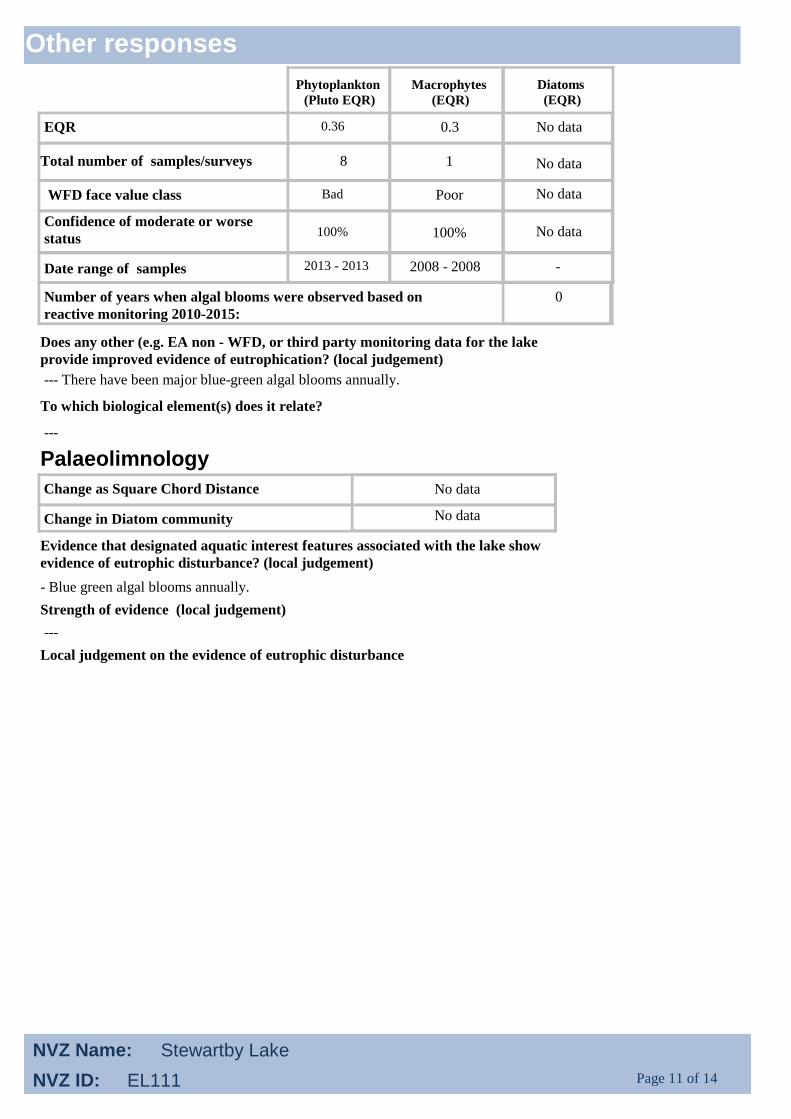
0.36
Bad
100%
2013 - 2013
EQR
WFD face value class
Confidence of moderate or worse
status
Date range of samples
Total number of samples/surveys
Phytoplankton
(Pluto EQR)
Macrophytes
(EQR)
Diatoms
(EQR)
0.3
Poor
100%
2008 - 2008
No data
No data
No data
-
1 No data
Palaeolimnology
No dataChange as Square Chord Distance
Change in Diatom community No data
0Number of years when algal blooms were observed based on
reactive monitoring 2010-2015:
Does any other (e.g. EA non - WFD, or third party monitoring data for the lake
provide improved evidence of eutrophication? (local judgement)
--- There have been major blue-green algal blooms annually.
To which biological element(s) does it relate?
---
Evidence that designated aquatic interest features associated with the lake show
evidence of eutrophic disturbance? (local judgement)
- Blue green algal blooms annually.
Strength of evidence (local judgement)
---
Local judgement on the evidence of eutrophic disturbance
8
Other responses
Page 11 of 14
NVZ Name: Stewartby Lake
NVZ ID: EL111

Review of evidence and recommendations
Existing designation - check needed
Current assessment of weight of evidence supporting
designation in 2017
Comments and decisions
WFD Weight of evidence for eutrophication:
WFD overall ecological status : Poor
Confidence in WFD status : Very Certain
Existing designation - N remains >2 mg/l and there is evidence of ecological impact for eutrophication.
Recommend continued designation.
Agreed with provisional decision to continue designation
Recommended action :
First national panel
Comments from second national panel :
Comments from first panel:
Second national panel
Local summary and recommendation:
Nutrients - high concentrations of N no decrease in recent years. Effects - blue-green algae blooms every
year. Sources - from large STW and some agricultural inputs. Marston STW has had P removal.
Levels of P have dropped.
Certainty of eutrophication problem based on core WFD tools: Very certain
eutrophication problem
Certainty of eutrophication problem based on overall weight of
evidence:
Very certain
eutrophication problem
Recommendation: Continued designation
Page 12 of 14
NVZ Name: Stewartby Lake
NVZ ID: EL111

Final summary (2017)
2008 Decision: Designated
2013 Decision: Designate
Lake Description:
Stewartby is a high alkalinity, shallow, stratifying lake created from a clay pit. Local EA staff classified it as
artificial but the National Panel considered it likely to function as a natural lake. The lake does not enjoy
conservation designation. It is Part of Marston Vale Millenium park with visitor centre and café. Amenity value
is likely to increase as park is developed. A major new housing area proposed nearby.
Why the lake should be designated as a Polluted Water (eutrophic):
Stewartby Lake is an existing eutrophic waters NVZ designation. There are a number of discharge consents in the
catchment and a treatment works next to the lake, however agriculture is still considered to make a significant
contribution to nitrogen concentrations in the lake. Nitrogen levels continue to be well above those in the
designation threshold range. Results for the biological elements show that they are impacted by high nutrient
levels.
Phosphorus:
The WFD classification for total phosphorus is Moderate status.
Nitrogen:
The 75th percentile TON concentration is 3.1 mg/l, and annual mean TN concentration is also 3.1 mg/l, both
significantly above the 1-2mg/l threshold range. There is little evidence of any consistent change since the
previous review, TON had reduced from 3.5 mg/l but TN was unchanged.
Supplementary evidence:
Local Environment Agency staff have noted annual algal blooms but have not formally recorded these.
Ecological response:
Overall phytoplankton is at Bad staus for WFD, although chlorophyll alone is at Good status (the result may be
impacted by a lack of records for 2011/12). Macrophytes are at Poor status. There is therefore evidence of a
continuing eutrophic impact.
2017 Recommendation: Continued designation
Page 13 of 14
NVZ Name: Stewartby Lake
NVZ ID: EL111

Page 14 of 14
NVZ Name: Stewartby Lake
NVZ ID: EL111