Newark To Wilmington Trail Study - July 2014
50
NEWARK TO WILMINGTON TRAIL STUDY JULY 2014
Transcript of Newark To Wilmington Trail Study - July 2014

NEWARK TO WILMINGTON TRAIL STUDY JULY 2014


NEWARK TO WILMINGTON TRAIL STUDY
NEWARK TO WILMINGTON TRAIL STUDY Prepared for the Delaware Department of Transportation, Division of Planning
In association with Delaware State Parks and the Wilmington Area Planning Council
Prepared by Whitman, Requardt & Associates, LLP Wilmington, Delaware
July 2014

NEWARK TO WILMINGTON TRAIL STUDY
Cover photo © 2009 by Julia Robertson www.aeroimaging.org
CONTENTS Introduction ........................................................................................................................................................................................ 1 Existing conditions .............................................................................................................................................................................. 1 Analysis process .................................................................................................................................................................................. 3 Alignment descriptions ....................................................................................................................................................................... 4
Northern alignment ........................................................................................................................................ 4 Central alignment ........................................................................................................................................... 6 Southern alignment ........................................................................................................................................ 8 Railroad alignment ........................................................................................................................................ 10 Glasgow spur alignment ............................................................................................................................... 11
Outreach process .............................................................................................................................................................................. 13 Conclusion ......................................................................................................................................................................................... 14 Appendix A: existing photos Appendix B: on‐road connections suggested by stakeholders
FIGURES 1 Northern alignment ..................................................................................................................................................................... 5 2 Central alignment ......................................................................................................................................................................... 7 3 Southern alignment ..................................................................................................................................................................... 9 4 Glasgow spur alignment ............................................................................................................................................................. 12

NEWARK TO WILMINGTON TRAIL STUDY
1
INTRODUCTION At the request of the Delaware Department of Transportation (DelDOT), Whitman, Requardt & Associates, LLP (WR&A) prepared this report to evaluate potential transportation and recreational trail connections between the cities of Newark and Wilmington.
Although this report describes in detail several alignment options, the goal of this study is not to define a final trail alignment. Rather, the document looks at the region as a whole, evaluates the existing trail network, and determines where trail connections should be further evaluated and prioritized. This approach meets the intent of Governor Markell’s First State Trails and Pathways Initiative, which was introduced in 2011. The goals of this initiative are to “re‐establish Delaware in the Top Ten of Bicycling Friendly States” and to “build a world‐class interconnected, non‐motorized trail and pathway network.” This initiative further emphasizes the importance of completing “missing links,” or filling in the gaps of Delaware’s trail network.
EXISTING CONDITIONS
Regional trail connections
Northern New Castle County has over 75 miles of hardened paths, sidepaths, and on‐road bicycle facilities. Both the City of Newark and the City of Wilmington have established trail connections that tie into a network of local and multi‐state trail systems. In the greater Wilmington area, the former New Castle Industrial Track freight line between New Castle and Wilmington was identified as a potential link for pedestrian and bicycle travel and/or transit more than ten years ago. The link has been designated as a portion of the 2,500‐mile East Coast Greenway connecting Maine and Florida. When all sections are complete, the New Castle Industrial Track Trail will provide a seven‐mile non‐motorized transportation link between New Castle and downtown Wilmington with minimal at‐grade road crossings. Additional East Coast Greenway trail links in Wilmington such as the Alapocas Woods Trail and the Northern Delaware Greenway Trail provide opportunities to extend the regional network even further.
Between Newark and Wilmington there are numerous hardened paths, hiking trails, sidepaths, and on‐road facilities that have been installed or are currently being planned by local and state agencies. North of Newark, the 3.5‐mile‐long Tri‐Valley Trail currently runs through White Clay Creek State Park and New Castle County’s Middle Run Valley Natural Area. This trail provides numerous access points to the extensive trail network within the park system and to points beyond. The State of Delaware is currently looking to make improvements to this trail and extend a hardened path connection to the Pomeroy Trail if feasible.
Existing environmental features
Environmental features often play an important role in trail planning. In general, it is usually desirable to place a trail along a natural feature to take advantage of its natural beauty and low lying topography. However, there are challenges when this approach is taken. The environmental permitting process for wetlands and floodplains can be difficult and time‐consuming. To minimize these impacts, increased costs may be incurred to provide additional stream crossings and wetland boardwalks.
Rivers and Streams
Many of the alignments discussed in this report follow existing stream corridors, taking advantage of the open space and stream buffers typically associated with these types of features. White Clay Creek is a federally protected tributary to the Christina River. Several smaller tributaries such as Middle Run, Pike Creek, and Red Clay Creek all drain into White Clay Creek. The headwaters of the Christina River flow from Pennsylvania west of Newark and south toward I‐95. Several smaller tributaries such as Belltown Run and Muddy Run converge with the river south of I‐95. It then flows northeast, making several crossings of I‐95 near Wilmington, receiving the White Clay Creek and Brandywine Creek, and eventually flowing to the port of Wilmington to meet the Delaware River. The Christina River basin provides 75% of the region’s drinking water supply. Brandywine Creek flows from Chester County, Pennsylvania into downtown Wilmington. The creek is rich in history, playing an important role to the early Native Americans, European settlers, and American industrial pioneers. Portions feature majestic views and important historic resources.

NEWARK TO WILMINGTON TRAIL STUDY
2
Wetlands
There are numerous freshwater and tidal wetlands within the study area. The majority of these wetlands fall along the major rivers and their tributaries. Where the White Clay Creek and Christina River converge near Wilmington there are several large wetlands and open water bodies that have been divided by interstate highway construction. Alignments throughout the study area were identified based on minimizing impacts to wetlands. Further studies of wetland impacts will need to be performed upon selection of a preferred alignment.
Existing land use features
The surrounding land use within the study area was evaluated to identify potential community connections, access to public lands and park facilities, access to schools, and connections to major employers and commercial centers.
Open Space and Parks
The City of Newark has the benefit of being surrounded by several large tracts of protected park lands and natural features. To the north and east White Clay Creek Park and the Middle Run Valley Natural Area provide over 4,000 acres of protected lands. South of Newark Iron Hill Park, Sunset Lake Preserve, and Glasgow Park provide additional access to natural areas for recreational opportunities.
The City of Wilmington also has its share of parklands surrounding the community. To the north Rockford Park, Alapocas Run State Park, and Brandywine Park provide scenic views and recreational opportunities with numerous trails and regional connections. To the south and west there are number of smaller parks such as Canby Park and Banning Park which have been considered as destinations within this study. The Russell W. Peterson Urban Wildlife Refuge, located at Wilmington’s southern boundary along the Christina River, is also a likely termination point for this study. The DuPont Environmental Education Center is located in the refuge, and a network of nature trails connect to the Wilmington Riverwalk and from there to downtown.
Between Wilmington and Newark there are several pocket parks and natural areas which have been included in this study. North of I‐95 Powell Ford Park, Delcastle Recreational Area, Carousel Park, and Brandywine Springs Park are a few that have been identified as potential destinations. South of I‐95, potential trail connections within publicly owned land or protected areas primarily consist of community open space, state or county owned undeveloped parcels, and small community pocket parks.
Major Employers, Commercial and Retail Centers
Studies have shown that improving bicycle and pedestrian facilities can provide financial benefits to the community. Increased property values are often attributed to trails and improved on‐road bicycle facilities. Improved pedestrian access to local stores tends to lead to consumers making more frequent trips to local small businesses. With the increasing cost of fuel, potential employees are looking for companies that offer alternative means of transportation and commuters will be more likely to use public transportation if there is a safe way of getting there.
The study area consists of several of the largest employers in Delaware. In Newark, the University of Delaware employs thousands of full‐time and part‐time employees. Christiana Care Health System’s main headquarters is located in Christiana, just east of Newark. The healthcare facility employs over 10,000 people statewide and has additional facilities in downtown Wilmington. The Du Pont Company has offices at Chestnut Run and at the Du Pont Experimental Station, as well as in downtown Wilmington. The public and private school system also contributes significantly to the employment base, with Christiana School District alone employing over 2,500 faculty and staff. Delaware Park, an entertainment destination located in Christiana, employs over 1,500 staff. Downtown Wilmington is one of the most prominent banking centers in the United States.
Major commercial and retail centers can be found along principal arterials within the study area. Christiana Mall is the largest mall in Delaware, and it and the surrounding retail area form a major destination for both work and shopping trips. Smaller retail plazas can be found in Pike Creek, Newport, Governors Square, Peoples Plaza, and several strip malls along major highways.
Industrial Facilities
Northern New Castle County was once home to Chrysler and General Motors auto manufacturing plants employing several thousand employees. In recent years these factories have shut down and have been purchased with the intent to reopen, either as industrial or other land uses. Other major industries include chemical and pharmaceutical manufacturers such as Du Pont and Astra Zeneca. Smaller light duty industries such as Delaware Feed are outside of Newark and several smaller manufacturers and warehouses are located in south Wilmington.
Schools and Higher Education
Delaware is a national leader in developing “Safe Routes to School,” beginning development of its program in 2002, nearly three years before the federal program came into existence. The state’s program is especially effective as well, allocating the $1 million it receives annually to programs and projects at Delaware schools. There are approximately 87 public schools and 65 private schools located within the study area. A large portion of these schools fall within the city limits of Wilmington. Although these schools may not have a direct connection to the proposed trail alignments, they were considered in this study.
Higher education facilities include the University of Delaware, which has over 20,000 undergraduate and graduate students. The University’s main campus is located in heart of Newark. Additional institutions include Wilmington University between Wilmington and New Castle, Goldey Beacom College in Pike Creek, and Delaware Technical and Community College, which has campuses in both Wilmington and Newark. Except for the University of Delaware, these institutions are typically considered commuter campuses.

NEWARK TO WILMINGTON TRAIL STUDY
3
ANALYSIS PROCESS The project team conducted a geographic information systems (GIS) analysis to initially identify potential corridors for trail development. These corridors generally include rights of way, publicly‐owned land, private open space, or utility corridors. GIS was also used to identify constraints to trail development such as wetlands, floodplains, stream crossings, and densely developed areas. The initial corridors developed through this process were then visited in the field to subjectively determine their feasibility for trail development. The field reconnaissance permitted the team to note opportunities or constraints, such as bridge clearances, that are not readily determined through desk analysis.
Most of these alignments (with the possible exception of the Railroad alignment described below) are too long to support frequent transportation trips by bicycle between Newark and Wilmington. Although a continuous trail would allow for that option, it is more likely that the trail would be used for shorter trips to school, work, shopping, or other purposes. For that reason the team evaluated each trail alignment’s proximity to residential areas, schools, commercial centers, and parks.

NEWARK TO WILMINGTON TRAIL STUDY
4
ALIGNMENT DESCRIPTIONS For the purpose of this study, we have developed four potential families of alignments that offer the possibility to provide a safe pedestrian and bicycle path to connect Newark and Wilmington. The alternatives were developed based on community access, connectivity to the regional trail network, limited need for land acquisitions, minimizing environmental impacts, and utilization of existing or planned pedestrian and bicycle facilities.
The Northern, Central, and Southern descriptions below represent only one of a number of possible routes within each of those areas.
Northern alignment about 17.7 to 21.3 miles
Similar to all the alignments discussed in this report, the Northern alignment starts out with a direct connection to the Pomeroy Trail in Newark. Two alternate routes along the Pomeroy Trail studied as part of the northern alignment are as follows:
Newark Connection Alternative A: This alternative follows an existing five‐foot sidewalk along Old Paper Mill Road to Newark Reservoir Park. Within the park there is an existing paved trail that circles the reservoir. A series of packed earth single track trails extends north through William M. Redd Park. From there, the alignment follows Paper Mill Road a short distance and crosses Thompson Station Road to White Clay Creek State Park. A new trail through the park would connect to the Tri‐Valley Trail at Smith Mill Road.
Newark Connection Alternative B: This alternative follows the existing Pomeroy Trail through White Clay Creek State Park. A new Tri‐Valley Trail connection studied by DNREC would follow a tributary of White Clay Creek and connect to Thompson Station Road through the Deerfield golf course. A crossing of Thompson Station Road in this area has challenges due to limited sight distance and steep grades. The new trail would continue along Nine Foot Road and Smith Mill Road, connecting to Paper Mill Road.
Both alternate spur alignments discussed above converge at Paper Mill Road and follow the old Smith Mill Road alignment through the Middle Run Valley Natural Area to Polly Drummond Road. A new sidepath would be needed south on Polly Drummond Hill Road extending to the signalized New Linden Hill Road intersection. From there, the alignment crosses New Linden Hill Road at the signal and connects to the existing Linden Hill Road sidepath to the north to Skyline Drive, providing connections to the Linden Heath community, Pike Creek Shopping Center, and the signalized Limestone Road (Route 7) intersection. Across Limestone Road the Mill Creek Greenway is a paved trail that runs through Weatherhill Farms and the Delcastle golf course. A new connection is required for a short area near wetlands associated with Mill Creek. A short section of the alignment would be an on‐road connection via McKennans Church Road to Mill Creek Road. A new sidepath would continue south on Newport Gap Pike (Route 41), where it would cross at the Faulkland Road signal to enter Brandywine Springs Park.
After passing through the existing Brandywine Springs trail system, the alignment would follow the Wilmington and Western railroad tracks to an at‐grade railroad crossing of Greenbank Road. The new trail would follow Greenbank Road, Armstrong Avenue, and Virginia Avenue to Woodland Park open space along Little Mill Creek, where the creek intersects with Centre Road (Route 141).
As an alternate option at Mill Creek Road and Newport Gap Pike (Route 41), a new trail would run extend through existing open space along Hyde Run to the proposed Delaware National shared use path and a new sidepath along Lancaster Pike (Route 48) extending to Centre Road (Route 141).
At this point two primary alternatives were evaluated to connect to Wilmington:
South Wilmington Riverfront Connection: Connecting to the Riverfront has many benefits but also has its challenges. The riverfront alignment crosses Centre Road at the signalized intersection of Lowry Road and follows Little Mill Creek to Kirkwood Highway, where it crosses at the signalized intersection of Maple Avenue and follows Maple Avenue as an on‐road facility connecting to proposed trail within Maple Avenue Park. The trail continues through Fairgrounds Park, which is mostly wetlands, or continues as an on‐road facility via Ohio Avenue to Baltimore Avenue to Old DuPont Road, where it crosses Kirkwood Highway to New Road. New Road requires three at‐grade railroad crossings. The alignment crosses under Kirkwood Highway via South Grant Avenue and follows Rodman Road (one way) to Canby Park. The alignment utilizes the existing trail system in Canby Park and continues as an on‐road facility on Oak Street (one way), Maryland Avenue, and Beech Street to the Wilmington Riverfront.
North Wilmington Brandywine Park Connection: The North Wilmington connection utilizes existing trails and provides a direct connection to the Alapocas Run Trail network and the Northern Delaware Greenway, providing an extension of the trail network to northern Wilmington and points north. Once across Centre Road (Route 141), the alignment follows an existing sidepath to the Du Pont Barley Mill entrance. A new sidepath extension would be required to extend to where the trail crosses at Barley Mill Plaza Road and then follows the existing path along Centre Road to Kennett Pike (Route 52). An existing sidewalk follows Kennett Pike. The alignment crosses at Montchanin Road and continues along Kennett Pike to an abandoned railroad corridor, which connects to the existing trail systems of Rockford Park and Brandywine Park.
General advantages of the Northern alignment:
Alignment offers several alternative routes, providing flexibility
Mostly off‐road facility, minimizing conflicts with automobiles
Directly ties into existing regional trail network (existing and planned) at both ends
Maximizes the use of existing trails and sidepaths, minimizing land acquisition
General disadvantages of the Northern alignment:
Southern connection alternative in Wilmington is mostly an on‐road facility through narrow one‐way streets and requires several railroad crossings
Northern connection alternative in Wilmington does not tie directly into the Riverfront and points south

Figure 1
5

NEWARK TO WILMINGTON TRAIL STUDY
6
Central alignment about 13 miles
Other than the Railroad alignment, the Central alignment provides the most direct route between Newark and Wilmington as it closely follows the I‐95 corridor. Starting out in Newark, the Pomeroy Trail and James F. Hall Trail provide access south and east to the intersection of Route 72 and Marrows Road. From this point a new trail would follow the west side of Route 72 to the south. The existing Route 72 bridge over Amtrak’s Northeast Corridor forms a pinch point; in the long term this bridge might be widened or a parallel span built. The trail continues south, primarily on agricultural land of the University of Delaware, to Route 4.
Much of Route 72 south of Route 4 features an existing shared use path that is severely substandard—it is essentially a sidewalk with multiple driveway crossings. Some property impacts would be required to bring this path to compliance with current guidelines, most significantly removing a row of parking in front of BJ’s Wholesale Club. The trail would cross Route 72 at the existing Scottfield Turn/Blue Hen Drive signal, then squeeze between one private residential property and Route 72 to reach Hann Park.
The trail would run east through Hann Park, a New Castle County park, to reach the southwest corner of the Gauger‐Cobbs Middle School property. From that point the trail could either traverse school property or private property under a Delmarva Power easement to the south, eventually reaching the former alignment of Gender Road. The trail would continue to follow the power line east for another four miles. This section would run through Delmarva Power land and have mid‐block crossings of Shady Drive and Arrowwood Drive. Upon reaching the east leg of Gender Road, the trail would turn north and follow Gender Road to the Salem Church Road signal. Crossing Salem Church Road, it would skirt a Christina School District maintenance building to rejoin the power line along the right of way of I‐95.
For the next 2‐1/2 miles the trail would run in state right of way along the power line. It would cross Chapman Road at the Regal Boulevard signal and skirt DelDOT’s North District maintenance facility. At Route 273, initial discussions have focused on an at‐grade crossing at the Harmony Road signal. Due to the traffic volume at this crossing and its proximity to the I‐95 interchange, a bridge alternative should also be considered here. Continuing to the east, the trail would leave state right of way near the I‐95 interchange with Routes 1 and 7, following the power line north across private property to Route 58 (Churchmans Road).
Churchmans Road has a sidewalk on its south side between the power line and the I‐95 bridge that could be upgraded to a shared use path. The principal challenges in this area are a very high‐volume right turn lane from Churchmans Road onto southbound Route 1 and the nearby undercrossing of Routes 1 and 7, which may need to be widened slightly. The newly reconstructed Churchmans Road bridge over I‐95 features a shared use path on the south side.
The next mile would involve a new trail along Churchmans Road. Challenges in this section include impacts to residential properties regardless of which side of the road is selected, a crossing of Churchmans Road at some point (likely at one of the existing traffic signals at Cavaliers Country Club Drive or Gooding Drive), and a new bridge over the Christina River and its associated wetlands. This new construction would tie into the end of an existing shared use path on the north side of Churchmans Road about 1,600 feet west of Airport Road.
General advantages of the Central alignment:
Relatively direct route
Relies on state rights of way and power line easements for a significant portion of the route
Directly ties into existing regional trail network (existing and planned) at both ends
General disadvantages of the Central alignment:
Challenging crossings of Amtrak’s Northeast Corridor, Route 273, and the Christina River
Right of way impacts along Route 72 and Churchmans Road
Remote sections of the trail along the power line may pose safety challenges

Figure 2
7

NEWARK TO WILMINGTON TRAIL STUDY
8
Southern alignment about 27.5 to 31.2 miles
The Southern alignment is the longest of the four alternatives discussed in this report. Most of this increased length is found in the western part of the study area, where the alignment follows the existing Mason‐Dixon Trail from White Clay Creek State Park to Iron Hill Park.
Similar to the other alignments, the Southern alignment connects directly to the Pomeroy Trail in Newark. This alignment starts where the Mason‐Dixon Trail joins the Pomeroy Trail and heads west of Newark. The alignment follows the Mason‐Dixon Trail, which is a single‐track trail through Christina Creek open space on the western side of Newark, extending to an unsignalized crossing of Barksdale Road. The trail continues through Christina Creek open space where it intersects with the CSX railroad. An existing bridge permits a narrow access within the floodplain. The trail continues along the creek to Elkton Road, where the alignment either crosses busy Elkton Road midblock or continues along the creek under an existing bridge with limited clearance. An alternate crossing of Elkton Road could take place at Casho Mill Road or Christina Parkway, which are signalized but located some distance from the creek.
The alignment continues along Christina Creek under Christina Parkway and Amtrak’s Northeast Corridor under existing bridges, extending along the creek through Rittenhouse Park to an unsignalized crossing of Chestnut Hill Road. The alignment follows Chestnut Hill Road west to Cobblefield Road and connects south to Folk Park, which extends to Welsh Tract Road. A narrow sidewalk continues along Welsh Tract Road over I‐95. An unsignalized crossing of Welsh Tract Road continues the Mason‐Dixon Trail alignment through Iron Hill Park to Old Baltimore Pike. Within Iron Hill Park the existing trails are not hardened, but many are of sufficient width to accommodate an eight‐ to ten‐foot‐wide hardened trail.
The alignment then follows Old Baltimore Pike west to an unsignalized crossing and cuts through an existing housing development to Four Seasons Parkway. An alternate route with fewer impacts to the residential neighborhood would be to continue along Old Baltimore Pike directly to Four Seasons Parkway. The Mason‐Dixon Trail continues through private open space in the Thornwood community, some of which may be wetlands, to a power line corridor. Although the Mason‐Dixon Trail follows the power line to the west, the proposed alignment would instead go east to Route 896.
Heading south along Route 896, the alignment crosses at the Corporate Boulevard signal, where it continues south along the east side of Route 896 via a new sidepath and a new bridge crossing of Muddy Run, providing access to the existing trail system within Glasgow Park. The alignment exits the park at Route 72, crosses the road midblock, and continues along Belltown Run through privately owned undeveloped land to Becks Pond open space, and from there north along Salem Church Road to Deasy Drive.
A utility corridor continues northeast from Salem Church Road. A new stream crossing of Muddy Run and two additional crossings of the Christina River would be needed if the utility corridor is utilized. Following the river through the Village of Fox Meadow open space, the alignment crosses Walther Road at a midblock crossing and continues through Calvarese Farms, Whittington Woods open space, and Brookfield Park where an existing asphalt sidepath runs along Newtown Road. This path, which continues to the north along Smalleys Dam Road, would be extended through the abandoned Smalleys Dam Road corridor over the Christina River, and continue along Smalleys Dam Road to a utility corridor just south of Old Baltimore Pike. The alignment would cross under the Christina Bypass (Route 273) via the Christina River bridge crossing. The alignment continues along the river through private property and connects to the existing paved trail system in Lewden Greene Park.
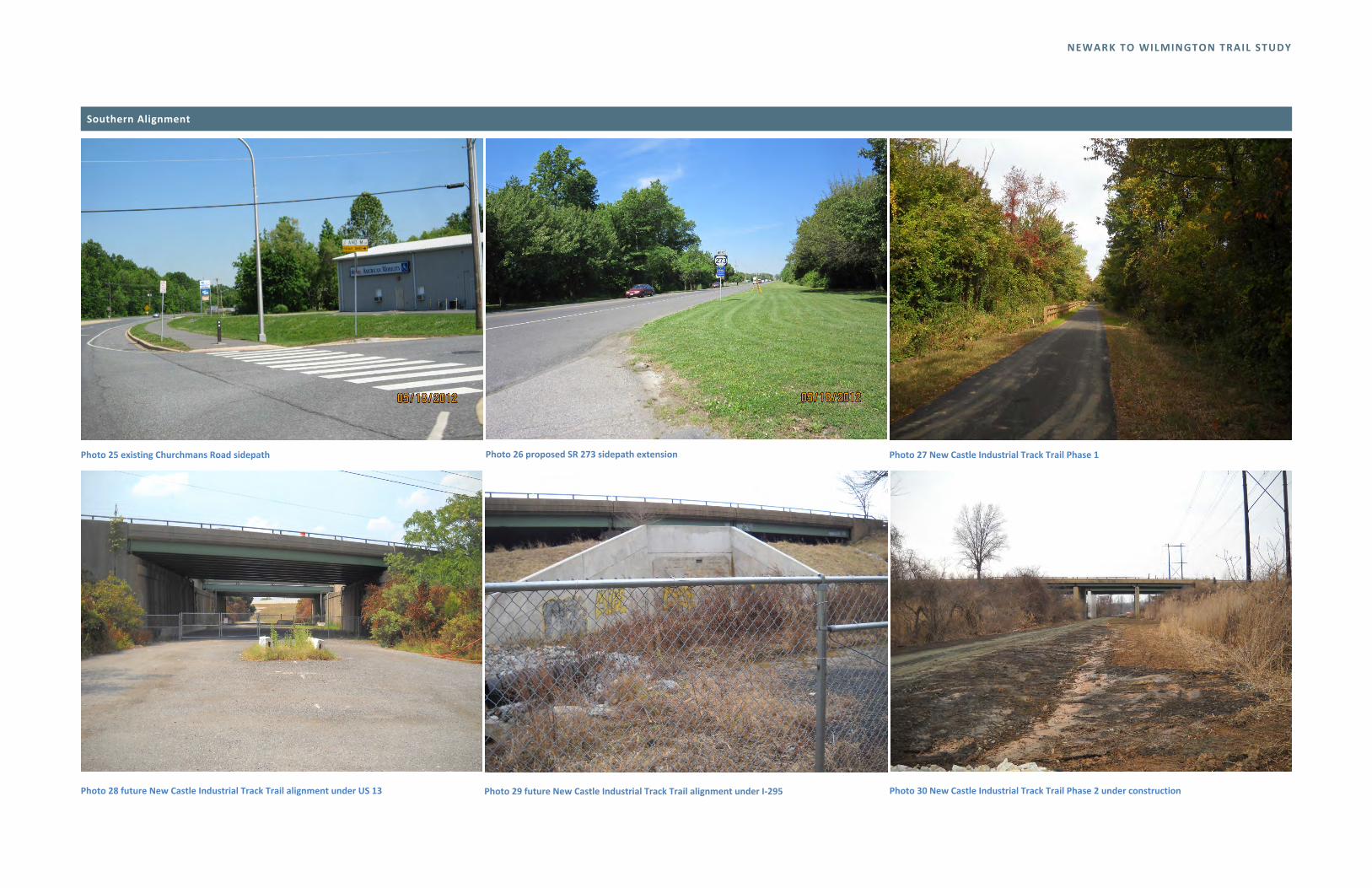
Following the Coventry Farm Trail, the alignment would extend through undeveloped property to an unsignalized crossing of Churchmans Road (Route 58). DelDOT is currently performing a study to extend the existing trail along Churchmans Road and Route 273 east to Dupont Highway. The trail would cross Dupont Highway on the north side of the Hares Corner intersection to connect to the Route 273 Trail, which is currently under construction as of spring 2014. This trail will connect to the recently constructed New Castle Industrial Track Trail. Subsequent phases of the Industrial Track Trail, currently in development, will connect this alignment to downtown Wilmington.
General advantages of the Southern alignment:
Several portions of the trail to the east have been constructed or are currently being planned
Mostly off‐road
Alignment follows existing streams, rivers, and wetlands, providing a scenic route
Directly ties into existing regional trail network (existing and planned) at both ends
General disadvantages of the Southern alignment:
Least direct route
The public may want the Mason‐Dixon Trail, which is the alignment’s principal connection into Newark, to remain a single track trail
The alignment contains several unsignalized mid‐block road crossings
Several gaps of privately‐owned land requiring land acquisition
Several areas of the trail are immediately adjacent to residential areas
Remote sections of the trail bounded by natural and manmade features may pose safety challenges

Figure 3
9

NEWARK TO WILMINGTON TRAIL STUDY
10
Railroad alignment about 12.2 miles
This alignment would be a shared‐use rail‐with‐trail that follows the CSX‐owned freight line known as the Philadelphia Subdivision, directly connecting downtown Newark with Wilmington’s Forty Acres neighborhood. The active rail is a single track line that carries approximately 14 trains per day with an average speed of 50 mph. The right of way is approximately 100 feet wide to accommodate a second track, which was removed in 1960. In several locations the remaining track was relocated toward the center of the alignment to maximize railroad car clearance heights. Most of the existing bridge decking along the line was reduced to support only the single remaining track; however, the bridge abutments that supported two tracks are mostly still in place.
This alignment provides direct access to the heart of downtown Newark. Potential access points are located at the Main Street grade crossing or the North College Avenue grade crossing. CSX and DelDOT are currently looking at improving pedestrian and vehicle crossings at these locations which have a recent history of accidents.
The steel substructure is in place for a trail crossing over Chapel Street. Just east of Chapel Street the Pomeroy Trail crosses below the CSX line. A potential connection could be made to the southeast to link the trail systems. At the next bridge crossing, McKees Lane, the tracks appear to remain offset from the center of the bridge, allowing room for a rail‐with‐trail.
A portion of the next structure over Capitol Trail (Route 2) has been removed, requiring a new bridge to be built between the existing abutments. Similar situations exist at Red Mill Road and Harmony Road. The substructures at the nearby White Clay Creek crossings are in place, however, the decking has been removed. The next crossing, Stanton Road, is one of the few at‐grade crossings along the Railroad alignment. The rail line converts to double track at Newport Gap Pike and then widens to three tracks near Centerville Road.
At this point this trail alignment crosses Centerville Road at grade, leaves the railroad right‐of‐way, and follows a power line corridor along the northern edge of CSX’s Wilsmere Yard – this segment is currently under design through DelDOT’s Transportation Alternatives Program. The trail continues through Fairgrounds Park, which is mostly wetlands, or continues as an on‐road facility via Ohio Avenue to Baltimore Avenue to Old DuPont Road, where it crosses Kirkwood Highway to New Road. New Road requires three at‐grade railroad crossings. The alignment crosses under Kirkwood Highway via South Grant Avenue and follows Rodman Road (one way) to Canby Park. The alignment utilizes the existing trail system in Canby Park and continues as an on‐road facility on Oak Street (one way), Maryland Avenue, and Beech Street to the Wilmington Riverfront.
General advantages of the Railroad alignment:
Very direct route
Largely level
Mostly off‐road
Directly ties into existing regional trail network (existing and planned) at both ends
Minimal conflicts with automobiles
Provides clear maintenance access to railroad lines
Railroad corridor is generally outside the floodplain, minimizing wetlands/waterway impacts
General disadvantages of the Railroad alignment:
CSX’s current policy does not permit trails within active right of way; approvals would not be possible until this policy is changed
Some existing bridges do not have sufficient width to provide rail‐with‐trail
Increased liability, indemnification may be required by railroad
Safety barrier may be required along the entire length, increasing costs
Environmental mitigation may be required for contaminated railroad ballast
Alignment offers limited access opportunities to surrounding communities

NEWARK TO WILMINGTON TRAIL STUDY
11
Glasgow spur alignment
The purpose of the Glasgow alignment is to provide a trail system connecting the Michael Castle Trail along the C&D Canal through Lums Pond State Park to Glasgow Park, the Glasgow area, and points north including Christiana and Newark via the proposed southern Newark to Wilmington alignment alternatives.
The first segment of the Glasgow alignment includes three alternate routes to connect Glasgow Park to Summit Bridge Park. Alternatives are as follows:
G01 US 40 & SR 896 Grade Separated Interchange (0.6 Miles)
This segment would connect to the existing trail network in Glasgow Park. As Routes 40 and 896 are redeveloped with an interchange (currently in the out years of DelDOT’s Capital Transportation Program), this path would leave Glasgow Park at a new intersection on Route 40. It would follow the interchange toward Route 896 and then turn east through state‐owned property south of the YMCA. It would connect to the proposed Jayson Drive sidepath segment G04.
G02 George Williams Way Trail (0.6 Miles)
This segment would connect to the existing trail network in Glasgow Park. It would take advantage of the existing signalized crossing of Route 40 at Lagrange Avenue, running along the east side of Lagrange Avenue south to George Williams Way. It would connect to the YMCA Trail and Jayson Drive sidepath segments.
G03 YMCA Trail (1 Mile)
This segment would connect to the George Williams Way segment. It would run west from Lagrange Avenue along the south side of George Williams Way and then south through state‐owned property along the north edge of an unnamed stream through Summit Bridge Park.
Two alternate routes were studied from Summit Bridge Park to Porter Road as follows:
G04 Jayson Drive Sidepath (0.8 Miles)
This segment would start at Summit Bridge Park, passing through county‐owned land and connecting to Jayson Drive. It would run on a sidepath along Jayson Drive to the intersection at Porter Road.
G05 Benjamin Boulevard Pathway (0.9 Miles)
As an alternate option to G04, this segment would follow the existing trail network through the neighborhood park. It would run east along the historic former Frenchtown Railroad alignment and then turn south along Benjamin Boulevard to the south end of the neighborhood park. It would run along Benjamin Boulevard from the neighborhood park to Porter Road.
Two alternate routes were studied from Porter Road to the pathway proposed as part of the Howell School Road improvements north of Lums Pond State Park.
G06 Summit Bridge Road Pathway (1.2 Miles)
This alternative runs through a wetland area to properties west of Mansion Farm and curves west to a new sidepath along Summit Bridge Road north of the Cornerstone Church extending to Howell School Road.
G07 Mansion Farm Trail (0.9 Miles)
This alternative runs through open space between Mansion Farm Phase 2 and planned development of Phase 3 connecting to Mansion Farm Drive.
G07a Mansion Farm Road Pathway (0.7 Miles)
As an extension of the Mansion Farm Trail this segment continues east along a new sidepath on Mansion Farm Road to RC Peoples Boulevard to Howell School Road.
From Howell School road two alternatives were evaluated to connect to connect through Lums Pond State Park:
G08 Lums Pond Trail South (2.8 Miles)
This segment would extend from the Howell School Road improvements, continue along Summit Bridge Road and follow a stream into Lums Pond, where it would connect to the park’s existing Little Jersey Trail to the Michael Castle Trail.
G09 Lums Pond Trail North (2.6 Miles)
This alternative would provide access to the Park via the main entrance roadway to the nature center, following a sidepath that would run along Buck Jersey Road through Lums Pond State Park east to Howell School Road and on to Red Lion Road. It would connect to the rest of the Lums Pond State Park trail network.
General advantages of the Glasgow alignment:
Alignment offers several alternative routes, providing flexibility
Mostly off‐road facility, minimizing conflicts with automobiles
Directly ties into existing regional trail network (existing and planned) at both ends
Maximizes the use of existing trails and sidepaths, minimizing land acquisition
Connects to major passive and active recreational facilities such as the YMCA and regional parks
General disadvantages of the Glasgow alignment:
Several alternatives may have environmental impacts
ADA accessibility through Lums Pond State Park may be difficult

Figure 4
12

NEWARK TO WILMINGTON TRAIL STUDY
13
OUTREACH PROCESS The project design team held two public workshops in October 2013 to present the trail feasibility study to the public and seek input. A total of 163 people attended the public workshops. Project team members received feedback on these proposed improvements.
Tuesday, October 1, 2013 Wilmington Area Planning Council, 850 Library Avenue, Newark 60 surveys returned
Wednesday, October 16, 2013 Doubletree Hotel, 700 North King Street, Wilmington 8 surveys returned
The following introduction was presented.
Newark‐to‐Wilmington Trail Study
The purpose of the Newark‐to‐Wilmington Trail Study was twofold:
To evaluate potential routes between the two cities that could provide bicycle and pedestrian connections not only end‐to‐end, but to destinations in between.
To identify sections of those routes that could be built in the short‐term, reflecting both public input and technical feasibility.
Potential routes shown on the maps at today’s workshop were suggested based on GIS analysis, extensive field review, and consultation with a number of public agencies. Considerations included:
• Public land ownership
• Utility easements
• Wetlands and other natural resources
• Connections to intermediate destinations
Today we seek your input on these potential routes. Specifically, we want to hear from you about which route segments make the most sense to prioritize in terms of design and construction.
This study does not intend to recommend one single continuous route between Newark and Wilmington. Rather, it is our goal to move forward with individual segments that have local community benefits, eventually weaving a fabric of active transportation choices in northern New Castle County.
A petition was presented to DelDOT containing 44 signatures from the community supporting the Newark‐to‐Wilmington Trail.
“We, the undersigned, appreciate the Delaware Department of Transportation’s efforts to engage the public in a Newark‐to‐Wilmington Trail Study. We support the idea of a separated trail connecting these two important population centers and urge the Department to plan, design, and implement such a trail with all possible speed.”
Display boards were posted to DelDOT’s website for public review and comment.
NEWARK TO WILMINGTON TRAIL STUDY
14
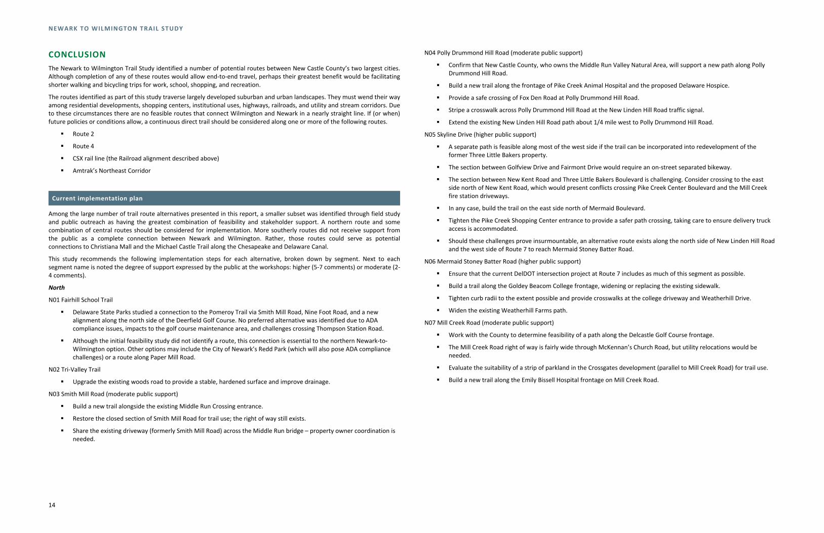
CONCLUSION The Newark to Wilmington Trail Study identified a number of potential routes between New Castle County’s two largest cities. Although completion of any of these routes would allow end‐to‐end travel, perhaps their greatest benefit would be facilitating shorter walking and bicycling trips for work, school, shopping, and recreation.
The routes identified as part of this study traverse largely developed suburban and urban landscapes. They must wend their way among residential developments, shopping centers, institutional uses, highways, railroads, and utility and stream corridors. Due to these circumstances there are no feasible routes that connect Wilmington and Newark in a nearly straight line. If (or when) future policies or conditions allow, a continuous direct trail should be considered along one or more of the following routes.
Route 2
Route 4
CSX rail line (the Railroad alignment described above)
Amtrak’s Northeast Corridor
Current implementation plan
Among the large number of trail route alternatives presented in this report, a smaller subset was identified through field study and public outreach as having the greatest combination of feasibility and stakeholder support. A northern route and some combination of central routes should be considered for implementation. More southerly routes did not receive support from the public as a complete connection between Newark and Wilmington. Rather, those routes could serve as potential connections to Christiana Mall and the Michael Castle Trail along the Chesapeake and Delaware Canal.
This study recommends the following implementation steps for each alternative, broken down by segment. Next to each segment name is noted the degree of support expressed by the public at the workshops: higher (5‐7 comments) or moderate (2‐4 comments).
North
N01 Fairhill School Trail
Delaware State Parks studied a connection to the Pomeroy Trail via Smith Mill Road, Nine Foot Road, and a new alignment along the north side of the Deerfield Golf Course. No preferred alternative was identified due to ADA compliance issues, impacts to the golf course maintenance area, and challenges crossing Thompson Station Road.
Although the initial feasibility study did not identify a route, this connection is essential to the northern Newark‐to‐Wilmington option. Other options may include the City of Newark’s Redd Park (which will also pose ADA compliance challenges) or a route along Paper Mill Road.
N02 Tri‐Valley Trail
Upgrade the existing woods road to provide a stable, hardened surface and improve drainage.
N03 Smith Mill Road (moderate public support)
Build a new trail alongside the existing Middle Run Crossing entrance.
Restore the closed section of Smith Mill Road for trail use; the right of way still exists.
Share the existing driveway (formerly Smith Mill Road) across the Middle Run bridge – property owner coordination is needed.
N04 Polly Drummond Hill Road (moderate public support)
Confirm that New Castle County, who owns the Middle Run Valley Natural Area, will support a new path along Polly Drummond Hill Road.
Build a new trail along the frontage of Pike Creek Animal Hospital and the proposed Delaware Hospice.
Provide a safe crossing of Fox Den Road at Polly Drummond Hill Road.
Stripe a crosswalk across Polly Drummond Hill Road at the New Linden Hill Road traffic signal.
Extend the existing New Linden Hill Road path about 1/4 mile west to Polly Drummond Hill Road.
N05 Skyline Drive (higher public support)
A separate path is feasible along most of the west side if the trail can be incorporated into redevelopment of the former Three Little Bakers property.
The section between Golfview Drive and Fairmont Drive would require an on‐street separated bikeway.
The section between New Kent Road and Three Little Bakers Boulevard is challenging. Consider crossing to the east side north of New Kent Road, which would present conflicts crossing Pike Creek Center Boulevard and the Mill Creek fire station driveways.
In any case, build the trail on the east side north of Mermaid Boulevard.
Tighten the Pike Creek Shopping Center entrance to provide a safer path crossing, taking care to ensure delivery truck access is accommodated.
Should these challenges prove insurmountable, an alternative route exists along the north side of New Linden Hill Road and the west side of Route 7 to reach Mermaid Stoney Batter Road.
N06 Mermaid Stoney Batter Road (higher public support)
Ensure that the current DelDOT intersection project at Route 7 includes as much of this segment as possible.
Build a trail along the Goldey Beacom College frontage, widening or replacing the existing sidewalk.
Tighten curb radii to the extent possible and provide crosswalks at the college driveway and Weatherhill Drive.
Widen the existing Weatherhill Farms path.
N07 Mill Creek Road (moderate public support)
Work with the County to determine feasibility of a path along the Delcastle Golf Course frontage.
The Mill Creek Road right of way is fairly wide through McKennan’s Church Road, but utility relocations would be needed.
Evaluate the suitability of a strip of parkland in the Crossgates development (parallel to Mill Creek Road) for trail use.
Build a new trail along the Emily Bissell Hospital frontage on Mill Creek Road.

NEWARK TO WILMINGTON TRAIL STUDY
15
N08 Newport‐Gap Pike (moderate public support)
Build a new trail along Newport‐Gap Pike.
Emily Bissell Hospital may present ADA and historic concerns.
There are numerous front yards with tree impacts along Newport‐Gap Pike south of the hospital.
Widen the culvert crossing of Hyde Run or build a parallel trail bridge.
Consider a midblock crossing south of the Hyde Run culvert to avoid severe historic property impacts at the west corner of Newport‐Gap Pike and Faulkland Road. This midblock crossing will be challenging due to high motor vehicle speeds on Newport‐Gap Pike.
Provide a crosswalk across Faulkland Road at the Newport‐Gap Pike signal.
N09 Brandywine Springs Park (moderate public support)
Coordinate with the County, who owns the park, to ensure that a connection is feasible.
Significant grading for an ADA‐compliant trail connection into the park from the Newport‐Gap Pike/Faulkland Road intersection.
Ensure ADA compliance descending to Hyde Run as well.
Provide a new crossing of the Wilmington & Western Railroad.
Build a new trail bridge over Red Clay Creek.
Ensure feasibility with Historic Red Clay Valley, Inc.
N10 Albertson Park/Brookland Terrace (moderate public support)
Check grades and resources in Albertson Park.
Seek community support along Elder Drive and Lori Drive, where the trail would follow existing streets.
Confirm feasibility of using the Marbrook School property for a trail connection.
Upgrade the existing Centerville Road crossing at Rhode Island Avenue, potentially with improved markings and signs.
Seek community support along Rhode Island Avenue, which is very narrow and has no sidewalks.
Widen and regrade the existing path crossing Little Mill Creek, identifying and mitigating potential floodplain/wetlands issues.
N11 Woodland Heights
Seek community support along Wagoner Drive, Morton Avenue, and Lowry Drive, where the trail would follow existing streets.
New crosswalks are in place to connect to the existing path on the east side of Route 141 at the Lowry Drive signal.
N12 Route 141 south of Route 48
The existing path along the frontage of Du Pont’s Chestnut Run site may require significant drainage modifications and/or utility pole relocations.
Provide a new crossing of the Chestnut Run entrance.
Minimize impacts to the wooded area just south of Route 48.
Provide a new crossing of Route 48 at the existing traffic signal.
N13 Route 141 north of Route 48
There is generally ample room for a path on the east side of Route 141.
Identify an appropriate connection to and across Barley Mill “Park,” which is owned by Ursuline Academy.
Determine the best location for an at‐grade trail crossing of the East Penn Railroad.
N14 Westover Hills (moderate public support)
Build a trail along an old rail alignment.
Seek community support.
The rail alignment crosses Dupont Road at a curve. The crossing here could provide an opportunity for traffic calming, as residents have expressed concern about speeds on Dupont Road in the past.
Confirm the condition and clearance of the railroad bridge under Kennett Pike. If use of the bridge is not feasible, consider upgrading the sidewalk along Dupont Road as a shared use path.
N15 Kentmere Track (higher public support)
Meet with private property owners to obtain support.
Confirm the ownership and condition of a rock tunnel west of Rising Sun Lane.
Confirm that the former railroad bridge over Rising Sun Lane is in adequate condition to support trail construction and use.
N16 Rockford Park (higher public support)
Work with Delaware State Parks to confirm the feasibility of this segment.
Identify connections to the Northern Delaware Greenway Trail.
Central 1
C01 Marrows Road (moderate public support)
Widen/extend existing path along Wyoming Road and improve crossings of side streets.
Construct a new path on east side of Marrows Road, improving crossings at Lanxide and Newark Toyota.
There may be sign, landscape, utility, and/or drainage impacts at the 1352 Marrows Road office building and just south of Ogletown Road.
C02 Ogletown Road (moderate public support)
Construct a new trail on the south side of Ogletown Road between Marrows Road and Lowes.
Check wetlands/property impacts at the new armed forces reserve center.
Provide improved crossings of FMC driveways and check drainage impacts on this property.
Confirm clearance to existing parking at the White Clay Center office complex.
Tighten radii at industrial driveway east of White Clay Center to the extent possible, maintaining appropriate access for trucks.
Improve several driveway crossings.
Confirm right of way at the existing car dealership west of Lowes, as cars are displayed in the potential trail area.
Cross Ogletown Road at the existing Lowes signal.
Improve the Avon driveway crossing.

NEWARK TO WILMINGTON TRAIL STUDY
16
Identify bridge requirements and permitting needs at the major stream/wetland crossing east of Avon.
Check wetlands/slopes around the curve at the west end of Ruthar Drive.
Identify and minimize tree/drainage impacts on either side of the Invista entrance and provide a high‐visibility crossing of the driveway.
C03 Ruthar Drive (moderate public support)
Significant grading will be needed for a new trail just east of Red Mill Road.
Determine which side of Ruthar Drive to use east of Red Mill Road considering wetland, property, and landscape impacts. The south side appears preferable at this stage.
Provide a new crosswalk across Harmony Road at the Ruthar Drive signal.
C04 Harmony Hills (moderate public support)
The short section between Harmony and Old Harmony Roads may be challenging on‐road.
Seek community support along Tamara Circle east to Kingsley Drive, as the trail will use the existing road.
Work with the County and community representatives on a trail route through Harmony Hills Park.
Build a new stream crossing between Harmony Hills Park and Delaware Park.
Coordinate with Delaware Park to identify an appropriate trail alignment along Amtrak’s Northeast Corridor.
C05 Amtrak crossing (moderate public support)
Determine whether bicyclists and pedestrians should share the existing bridge (which has relatively low traffic volumes and speeds) or whether a new bridge will be needed over the Northeast Corridor.
Upgrade the existing narrow path along the SEPTA Churchmans Crossing station frontage and tighten the curves at the station driveway to make crossing easier.
Churchmans Road west
Widen the existing path along the Christiana Hospital frontage.
Widen the existing path and add a buffer (if possible) between the hospital and the existing power line crossing. There may be some wetland impacts in this area.
Central 2
Route 72 path
Widen the existing narrow path on the west side of the Amtrak bridge approaches. This is likely to have impacts to the bridge embankments and adjacent properties.
Confirm available width on the Route 72 Amtrak bridge. The bridge may need to be widened or a new parallel bridge built in the long term.
Widen path along the University of Delaware farm, which may involve utility pole relocations.
Improve numerous driveway crossings.
Remove a row of parking at Pencader Plaza adjacent to BJ’s Wholesale Club.
Cross the south leg of Route 72 at the Blue Hen Drive/Scottfield Turn signal.
Impact the residential property at southeast corner of the intersection to provide a new trail connection on the east side of Route 72.
C14 power line west (higher public support)
Work with the County and the Scottfield community on a trail alignment through Hann Park.
Cross a drainage ditch at the east end of Hann Park.
Work with the Christina School District on a trail alignment through Gauger‐Cobbs Middle School property or, if necessary, to obtain an easement on the adjacent private property to the south.
Work with Delmarva Power and the Breezewood and Gender Woods communities on a new trail route along the power line.
Provide mid‐block crossings of Shady Drive and Arrowwood Drive.
Cross Salem Church Road at the existing Gender Road traffic signal.
C15 power line central (higher public support)
Avoid school district maintenance facility on the east side of Salem Church Road.
Work with Delmarva Power on a trail route along the power line.
Cross two wetlands and a ditch next to Christiana High School.
Coordinate with Christina School District regarding the proximity of the trail to school property.
Provide a signalized trail crossing of Chapman Road at Regal Boulevard.
Route the trail behind DelDOT’s North District facility, avoiding an existing stream and wetlands and working with the Sherwood Forest on the trail’s proximity to nearby houses.
Cross a stream east of the North District facility.
Minimize property and wetland impacts next to the Holiday Inn Express hotel.
Cross Route 273 at the Harmony Road signal. Due to the traffic volume at this crossing and its proximity to the I‐95 interchange, a bridge alternative should also be considered here.
C16 power line east (higher public support)
Cross two streams.
Work with Delmarva Power on a trail route along the power line adjacent to I‐95.
Work with Bank of America, Delmarva Power, and one other private property owner on a trail route through the Christiana Executive Campus.
Central 3
C17 Churchmans Road central (moderate public support)
Widen the existing path and add a buffer (if possible) between the power line and Route 7, with some grading and light pole impacts.
Improve the crossing of the right turn ramp from Churchmans Road to Route 1 southbound, which has very high traffic volumes.
Evaluate the width of the existing sidewalk under the Route 1/7 bridge; move the curb slightly into the shoulder if needed.
Widen the existing path between the Route 1/7 bridge and the I‐95 bridge.

NEWARK TO WILMINGTON TRAIL STUDY
17
C18 Churchmans Road east (moderate public support)
Improve the existing crossing of Cavaliers Country Club Drive.
Determine which side of Churchmans Road is appropriate for construction of a new trail, as there appear to be significant residential and landscape impacts on both sides. Narrowing the existing shoulder(s) should be evaluated.
Construct a new trail along the north side of Churchmans Road east of the Gooding Drive signal.
Bridge the Christina River and associated wetlands.
Mitigate ditch and industrial property impacts east of the river.
Improve two major commercial driveway crossings in this area.
Consider an extension of the Coventry Farm Trail to Churchmans Road.
All other elements of this route are already complete or in some phase of planning, design, or construction.
Connections to Glasgow, Lums Pond State Park, and the Michael Castle Trail
As noted above, there were minimal public comments in support of a southern route to connect Wilmington and Newark. However, a number of participants indicated that a connection from Newark and Wilmington to Lums Pond State Park and the Castle Trail was desirable. The power line trail segments (C14, C15, and C16) and the Route 72 sidepath represent a reasonable point from which to connect to the south. Three segments would facilitate that connection.
S15 Glasgow Park
Work with New Castle County to determine a route through Glasgow Park to connect existing park trails to the northeastern park border.
Upgrade GBC drive or build a parallel trail east to Route 72.
S16 Route 72 south
Build a new trail along the west (southbound) side of Route 72.
Cross Belltown Run and Muddy Run.
S27 Route 72 north
Build a new trail along the west (southbound) side of Route 72.
Build a new bridge over the Christina River
Evaluate shoulder modifications at the Schlosser and Associates property near Dayett Mills to accommodate the trail.
Widen the existing path along the west side of Route 72 from Dayett Mill Road north.
Modify the configuration of trail ramps under I‐95 to accommodate a wider trail.
On‐road improvements
While the trail connections described above are implemented, it may be desirable to implement more modest improvements to existing on‐road routes. A group of active local cyclists, including representatives of the Delaware Bicycle Council and advocacy organizations, shared their preferred on‐road routes between Newark and Wilmington as part of the public outreach process. Their suggestions may be found in Appendix B.
Priorities for implementation
Trail segment priorities should be based on the information above, including relative ease of implementation, public support, and connections to existing trails. It is also recommended that sections likely to require significant local/neighborhood support (such as on‐street segments and the Kentmere Track) wait until other segments are complete and there is more general support for completion of the entire network.
With those conditions in mind, the following segments are recommended for the first phases of implementation:
Priority 1
Churchmans Road west (wider path along Christiana Hospital frontage and from the hospital east to segment C16)
C14 power line west
C15 power line central
C16 power line east
C17 Churchmans Road central
C18 Churchmans Road east
Priority 2
N03 Smith Mill Road
N04 Polly Drummond Hill Road
N05 Skyline Drive
N06 Mermaid Stoney Batter Road
C01 Marrows Road
Route 72 path upgrades
S15 Glasgow Park
S16 Route 72 south
S27 Route 72 north


NEWARK TO WILMINGTON TRAIL STUDY
APPENDIX A: EXISTING PHOTOS
Northern Alignment
1
Photo 1 existing Newark Reservoir Trail Photo 2 William M. Redd Park Photo 3 Possum Hollow Road
Photo 4 Lenape Run cut off trail through Middle Run Natural Area Photo 5 Polly Drummond Hill Road Photo 6 New Linden Hill Road sidepath

NEWARK TO WILMINGTON TRAIL STUDY
Northern Alignment
Photo 7 Newport Gap Pike Photo 8 access to Brandywine Springs path Photo 9 Wilmington and Western Railroad
Photo 10 Geenbank Mill pedestrian bridge over Red Clay Creek Photo 11 At‐grade crossing of Wilmington and Western Railroad tracks and Greenbank Road Photo 12 Albertson Park trail

NEWARK TO WILMINGTON TRAIL STUDY
Northern Alignment
Photo 13 Woodland Park trail Photo 14 Centre Road (Route 141) sidepath

NEWARK TO WILMINGTON TRAIL STUDY
Central Alignment
Photo 1 Utility access road through Kershaw Park Photo 2 Paper Mill Road / Chapel Road over White Clay Creek Photo 3 Culvert crossing outside the streambank
Photo 4 Lenape Run cut off trail through Middle Run Natural Area Photo 5 SR 2 bridge crossing Photo 6 Windy Mill Park

NEWARK TO WILMINGTON TRAIL STUDY
Central Alignment
Photo 7 Red Mill Road crossing Photo 8 Brookhaven Park Photo 9 culvert under CSX railroad
Photo 10 Churchmans Crossing regional rail station Photo 11 Route 4 existing sidepath Photo 12 utility access road behind Bank of America facility

NEWARK TO WILMINGTON TRAIL STUDY
Central Alignment
Photo 13 Airport Road terminus at Christina River Photo 14 utility access north towards Newport Photo 15 South James Street bridge crossing
Photo 16 Amtrak right‐of‐way

NEWARK TO WILMINGTON TRAIL STUDY
Southern Alignment
Photo 1 Church Road crossing the Christina River Photo 2 Mason‐Dixon Trail along the Christina River Photo 3 trail bridge over the Christina River connecting to Downes School
Photo 4 Mason‐Dixon Trail crossing of Barksdale Road Photo 5 Mason‐Dixon Trail crossing under CSX railroad Photo 6 Elkton Road bridge over the Christina River

NEWARK TO WILMINGTON TRAIL STUDY
Southern Alignment
Photo 7 Chestnut Hill Road crossing (Mason‐Dixon Trail) Photo 8 Welsh Tract Road Photo 9 access to Iron Hill Park
Photo 10 Iron Hill Park trail along Park Road Photo 11 narrow sidewalk along Four Seasons Parkway Photo 12 utility corridor access near South College Avenue

NEWARK TO WILMINGTON TRAIL STUDY
Southern Alignment
Photo 13 existing trail through Glasgow Park Photo 14 existing crushed stone trail through Glasgow Park Photo 15 Western Railroad at‐grade crossing
Photo 16 Salem Church Road Photo 17 Delmarva Power utility corridor Photo 18 Newtown Road sidepath

NEWARK TO WILMINGTON TRAIL STUDY
Southern Alignment
Photo 19 Smalleys Dam Road sidepath Photo 20 Christina Bypass (Route 273) over Christina River Photo 21 Lewden Green Trail under SR 1
Photo 22 existing paved trail through Lewden Green Park Photo 23 utility access road extension to Churchmans Road Photo 24 Churchmans Road wide shoulder
NEWARK TO WILMINGTON TRAIL STUDY
Southern Alignment
Photo 25 existing Churchmans Road sidepath Photo 26 proposed SR 273 sidepath extension Photo 27 New Castle Industrial Track Trail Phase 1
Photo 28 future New Castle Industrial Track Trail alignment under US 13 Photo 29 future New Castle Industrial Track Trail alignment under I‐295 Photo 30 New Castle Industrial Track Trail Phase 2 under construction

NEWARK TO WILMINGTON TRAIL STUDY
Southern Alignment
Photo 31 general alignment of New Castle Industrial Track Trail Phase 3 Photo 32 Wilmington Riverwalk at the DuPont Environmental Education Center

NEWARK TO WILMINGTON TRAIL STUDY
APPENDIX B: ON‐ROAD CONNECTIONS SUGGESTED BY STAKEHOLDERS
The following pages were provided to DelDOT by a group of stakeholders. They represent a potential opportunity to establish an on‐road route connecting Newark and Wilmington, both as an interim measure while trail connections are completed and for travelers who prefer roads to trails.

This is one of two suggested routes between Newark and Wilmington. Both routes begin on Route 4 in Newark by the entrance to the stadium. The center of Newark can be accessed several ways, including via Route 72 Wyoming Road/ Hall Trail. The first route (this one) utilizes both Route 4 and Kirkwood Highway, before bypassing areas around Price’s Corner. The second route spends more time on Route 4. Route 4 has wide shoulders all the way between Newark and Limestone Road, and a sidepath along much of the route. After Stanton Road, the shoulders are spotty along this 4 lane road, making it difficult to use Route 4 all the way into Wilmington.
The Route 4/Route 273 is a difficult interchange to traverse by bike. At this point, our route bypasses the 273 intersection, and then begins the transition north to Kirkwood Highway.

It is still a bit tricky to cross Route 273 on Old Ogletown Road. Traveling east towards Wilmington, the approach to 273 is fine, but once across the intersection, it becomes necessary to immediately move into the left turn lane and make a quick left onto Red Mill Road. From here, it is not a problem as there is a shoulder before the quick right onto Diminish. Traveling west towards Newark, it is a bit awkward to make the left onto Red Mill and to deal with traffic making the next right and moving up to the intersection with Route 273. This intersection could use improvements for both bikes and pedestrians.
There is no signal at the intersection of Harmony Crest and Harmony Road, but there is a concrete median island, which makes this intersection very doable. Harmony Road has good shoulders the entire length north to Kirkwood Highway. A right turn on Greenbriar and a left on Old Harmony Road allows cyclists to bypass a section of Harmony Road as well as the intersection of Harmony and Kirkwood Highway (although this intersection isn’t too bad), assuming the cyclist istraveling towards Newark. Old Harmony is still intact but would need some work because of deterioration.
Old Harmony is not useful traveling towards Newark. The crossover no longer exists at Pike Creek Road and Kirkwood Highway, so a cyclist would need to cross the highway in halves and traverse the concrete median. Perhaps there could be a fix to this? Otherwise, the cyclist needs to either turn left with traffic at Harmony Road, or cross Kirkwood Highway as a pedestrian at the intersection. The new bike lanes are helpful. It would also be helpful to have a crosswalk across Kirkwoodat the western side of the intersection as well as the eastern so a cyclist/pedestrian can cross one street, not two.

Kirkwood Highway is a major problem from St. James Church Road east past the 141 interchange. One good way to bypass this stretch is to use Milltown Road. Another is Old Capitol Trail. This route utilizes both. Traveling west is not a problem. In this direction, it is also possible to turn right from Milltown Road onto Old Milltown Road and make the right onto Kirkwood Highway further west. It introduces another hill, but the hill is not so steep in this direction. Traveling east towards Wilmington requires a left turn onto Milltown Road from Kirkwood Highway. When the traffic volume is low, it works out fine to turn left with traffic. But this is a busy intersection for left turns. So a good option is to do a “Copenhagen left” by turning right into the Back Clinic driveway opposite Milltown Road and then crossing Kirkwood Highway at this light. The light is green at the same time as Milltown Road, however. Traffic turning left from Milltown onto Kirkwood makes crossing Kirkwood Highway difficult because of the volume of cars and because the motorists are not looking for cyclists exiting from the Back Clinic driveway. Placing the light for the Back Clinic on a triggered cycle and staggering this cycle with the signal for Milltown Road would solve the problem.
We chose to route cyclists through Kirkwood Gardens to Old Capitol Trail to avoid hills. Another way to bypass Kirkwood Highway through the entire area is to stay on Milltown Road, which has good shoulders nearly the entire way, turning right on Route 41 and then left on Greenbank Road (no shoulders on the hill), joining up with our route on Centreville Road (for the reverse direction, a cyclist can turn right into The Cedars from Route 41, travel a few neighborhood roads and then cross Route 41 at the light in order to bypass the left turn off of Route 41 on a steep uphill). But back to this route. . .
The intersection of Milltown Road and Limestone Road could use some improvements. Traveling towards Wilmington, the intersection is fine, although the wide right lane narrows soon after the intersection, and right before the intersection with McKennans Church Road. The signal cycles could be adjusted, too, because it can be hard late at night or on weekends for a cyclist to get through both lights before the light at McKennans Church Road turns red.
The intersection could use some major improvements traveling west, from the approach to McKennans Church Road all the way to the other side of Limestone Road. The number of travel lanes and their configuration are uncomfortable for many if not most cyclists.

There are no major issues on the route through this section. This route also opens up access to destinations along Kirkwood Highway, including a major shopping center.
Old Capitol Trail has a speed limit of 30 mph to Newport Road when it changes to 35 mph. The shoulders are not wide, but the speed limit is low. It would be nice to have as much in the way of shoulders as possible, however. At the intersectionwith Stanton Road, the shoulder disappears, which is a bit awkward on the uphill (westbound). The bridge over the Red Clay Creek does not have shoulders, although it is a short stretch of road. It does have a sidewalk, however, which could use some repairs. There are no shoulders westbound approaching Newport Road, but because it is a downhill with a relatively low speed limit, it usually does not present a major concern.
Traveling towards Wilmington on Old Capitol Trail, cyclists need to merge with traffic at the intersection with Newport Gap Pike. There is little to no shoulder in this direction after the intersection with Newport Gap Pike. In addition, the pedestrian “improvement” project by the bus shelter as the road approaches the intersection with Centerville Road eliminated the shouldersin both directions. This section could use some help, perhaps sharrows and signage to help cyclists move through the choke point.
Traveling towards Wilmington, after turning onto Centerville Road, there is a shoulder where Centerville Road crosses under Kirkwood Highway. In the other direction, there is no shoulder under the bridge. The right lane is, in effect, one long rightturn lane between the intersection with Greenbank Road and the intersection with Old Capitol Trail. This isn’t all that bad, but could use some help from the approach to Greenbank Road through the turn onto Old Capitol Trail.

There is a narrow paved trail through the park and a metal grate bridge crossing Little Mill Creek. The trail and bridge could use some TLC.
Unless a cyclist uses Faulkland Road, Lowry Drive is the only way to cross 141 at a light. While it is fine to take Centerville Road to Faulkland Road and then a right turn on Montgomery (next traffic light after crossing 141), we decided to take the shortest route. The frontage road along 141 is one way, however, so is not useful traveling towards Wilmington unless a contraflow bike lane is installed. It is a good option to take a left on Morton Ave and then a right on Lowry, crossing at the light.
There is an MUP on the other side of 141. We chose to direct cyclists along neighborhood roads. To pick up Kirkwood Highway just after the 141 interchange, it’s possible to take the MUP farther, turn onto Lehigh, then a left on Frederick, and a right on North Clifton.

Kirkwood Highway in this area could probably be improved enough to be comfortable for cyclists. There is a wide outside lane in both directions between Price’s Corner and the traffic light at Sanders. However, there are also a number of parked cars and a high traffic volume. The wide lanes/shoulders continue to N DuPont Road in the eastbound direction. The shoulders along this stretch are spotty in the westbound direction. New Road is a nice alternative. New Road becomes one way in the eastbound direction, however, right before the intersection with Kirkwood Highway. That forces a cyclist to move onto the sidewalk. This could be fixed. Our route, while just slightly longer, bypasses all of this and is very low stress. Due to some one-way roads, the route might need to be tweaked if it is to use the same roads in both directions.
On the Wilmington side of N. DuPont, the overpass on Kirkwood Highway presents a problem in both directions. Unless cyclists want to mix with heavy traffic, it is necessary to use the narrow sidewalk. This section needs improvement. An alternative would be to continue the route along New Road. The railroad crossing presents a barrier, however. There is a short stretch across one part of the railroad tracks that is the problem. There must be a right of way, however, because New Road used to continue across the tracks. Could that short stretch be improved? It would be an ideal solution as it would connect both sections of New Road, maybe with an at-grade trail crossing or a pedestrian/cyclist overpass?
Where New Road joins with Kirkwood Highway is awkward but doable. Eastbound is approached via Grant Ave and then Prospect where there is a light. Kirkwood Highway has wide outside lanes. The isolated neighborhoods and one way street design in the area make it close to impossible to use neighborhood roads. But contraflow lanes or adjustments to the one way grid could solve the problems. Plus, Canby Park could provide a useful connection.

Ultimately, Bancroft Parkway or Scott St. can provide access to the new (planned) cross town routes on Ninth and Eighth Streets that will take cyclists to and from the downtown.

This is one of two suggested routes between Newark and Wilmington. Both routes begin on Route 4 in Newark by the entrance to the stadium. The center of Newark can be accessed several ways, including via Route 72 Wyoming Road/ Hall Trail. The first route utilizes both Route 4 and Kirkwood Highway, before bypassing areas around Price’s Corner. The second route (this one) spends more time on Route 4. Route 4 has wide shoulders all the way between Newark and Limestone Road, and a sidepath along much of the route. After Stanton Road, the shoulders are spotty along this 4 lane road, making it difficult to use Route 4 all the way into Wilmington.
The Route 4/Route 273 is a difficult interchange to traverse by bike. At this point, our route bypasses the 273 Intersection. It is still a bit tricky to cross Route 273 on Old Ogletown Road. Traveling east towards Wilmington, the approachto 273 is fine, but once across the intersection, it becomes necessary to immediately move into the left turn lane and make a quick left onto Red Mill Road. From here, it is not a problem as there is a shoulder before the quick right onto Diminish. Traveling west towards Newark, it is a bit awkward to make the left onto Red Mill and to deal with traffic making the next right and moving up to the intersection with Route 273. This intersection could use improvements for both bikes and pedestrians.
There is also a sidepath through Route 4/Route 273 exchange, as noted on the map. This sidepath is little more than a sidewalkin places and is difficult to access when traveling westbound on Route 4. With improvements, however, it might be a viable option.

The sidepath continues along Route4/Route 7 after the two routes merge. Although the road continues to have wide shoulders, the sidepath ends at Old Route 7. Old Route 7 is a great alternative.
Old Route 7 deadends at the bridge over the Red Clay Creek. Although the bridge is intact and useable, the road surface needs some rehabilitation as does the sidepath that continues along Route 4/7 towards Wilmington.
The sidepath becomes awkward from the Walgreens to the intersection with Limestone Road. It is not in great condition, and there are frequent, although minor, intersections and driveways. This stretch could use a bit of help.

The intersection with Limestone Road is awkward and requires a cyclist to behave as a pedestrian,crossings several sections of roadway that involve several cycles of traffic signals. It is time consuming. Perhaps the signals could be coordinated so that when a cyclist or pedestrian pushes a button, traffic stops briefly in all, or at least several, directions. I know that the intersection is busy, but surely something could be done. The design also needs to be tweaked going north once the cyclist crosses the intersection.
One possible alternative would be to route cyclists along the shoulder east of the intersection with Limetone Road for a short Stretch, then help them to cross over Route 4 on either Elm St. or the next street, Delaware Ave. They can then use neighborhood streets to access Limestone Road slightly north of the intersection. It is necessary to take Limestone Road for a stretch, however, because the neighborhood roads deadend before the railroad tracks, and Limestone Road is the only way to cross. Limestone Road does have shoulders in this section.
There is a light at Hendly Drive. Due to one way street configuration, it is necessary to take a slightly different route through the neighborhood than indicated above when traveling towards Newark. But it’s the same basic idea. Old Capitol Trail has good shoulders along most of the stretch above.

Old Capitol Trail has a speed limit of 30 mph to Newport Road (located just to the west of this map) when it changes to 35 mph. The shoulders are not wide, but the speed limit is low. It would be nice to have as much in the way of shoulders as possible, however. At the intersection with Stanton Road (also located to the west of this map), the shoulder disappears, which is a bit awkward on the uphill (westbound). The bridge over the Red Clay Creek does not have shoulders, although it is a short stretch of road. It does have a sidewalk, however, which could use some repairs. There are no shoulders westbound approaching Newport Road, but because it is adownhill with a relatively low speed limit, it usually does not present a major concern.
Traveling towards Wilmington on Old Capitol Trail, cyclists need to merge with traffic at the intersection with Newport Gap Pike. There is little to no shoulder in this direction after the intersection with Newport Gap Pike. In addition, the pedestrian “improvement” project by the bus shelter as the road approaches the intersection with Centerville Road eliminated the shouldersin both directions. This section could use some help, perhaps sharrows and signage to help cyclists move through the choke point.
Traveling towards Wilmington, after turning onto Centerville Road, there is a shoulder where Centerville Road crosses under Kirkwood Highway. In the other direction, there is no shoulder under the bridge. The right lane is, in effect, one long rightturn lane between the intersection with Greenbank Road and the intersection with Old Capitol Trail. This isn’t all that bad, but could use some help from the approach to Greenbank Road through the turn onto Old Capitol Trail.
There is a narrow paved trail through the park and a metal grate bridge crossing Little Mill Creek. The trail and bridge could use some TLC.

Unless a cyclist uses Faulkland Road, Lowry Drive is the only way to cross 141 at a light. While it is fine to take Centerville Road to Faulkland Road and then a right turn on Montgomery (next traffic light after crossing 141), we decided to take the shortest route. The frontage road along 141 is one way, however, so is not useful traveling towards Wilmington unless a contraflow bike lane is installed. It is a good option to take a left on Morton Ave and then a right on Lowry, crossing at the light.
There is an MUP on the other side of 141. We chose to direct cyclists along neighborhood roads. To pick up Kirkwood Highway just after the 141 interchange, it’s possible to take the MUP farther, turn onto Lehigh, then a left on Frederick, and a right on North Clifton.
Kirkwood Highway in this area could probably be improved enough to be comfortable for cyclists. There is a wide outside lane in both directions between Price’s Corner and the traffic light at Sanders. However, there are also a number of parked cars and a high traffic volume. The wide lanes/shoulders continue to N DuPont Road in the eastbound direction. The shoulders along this stretch are spotty in the westbound direction. New Road is a nice alternative. New Road becomes one way in the eastbound direction, however, right before the intersection with Kirkwood Highway. That forces a cyclist to move onto the sidewalk. This could be fixed. Our route, while just slightly longer, bypasses all of this and is very low stress. Due to the one-way grid, the route might need to be tweaked if it is to use the same roads in both directions.
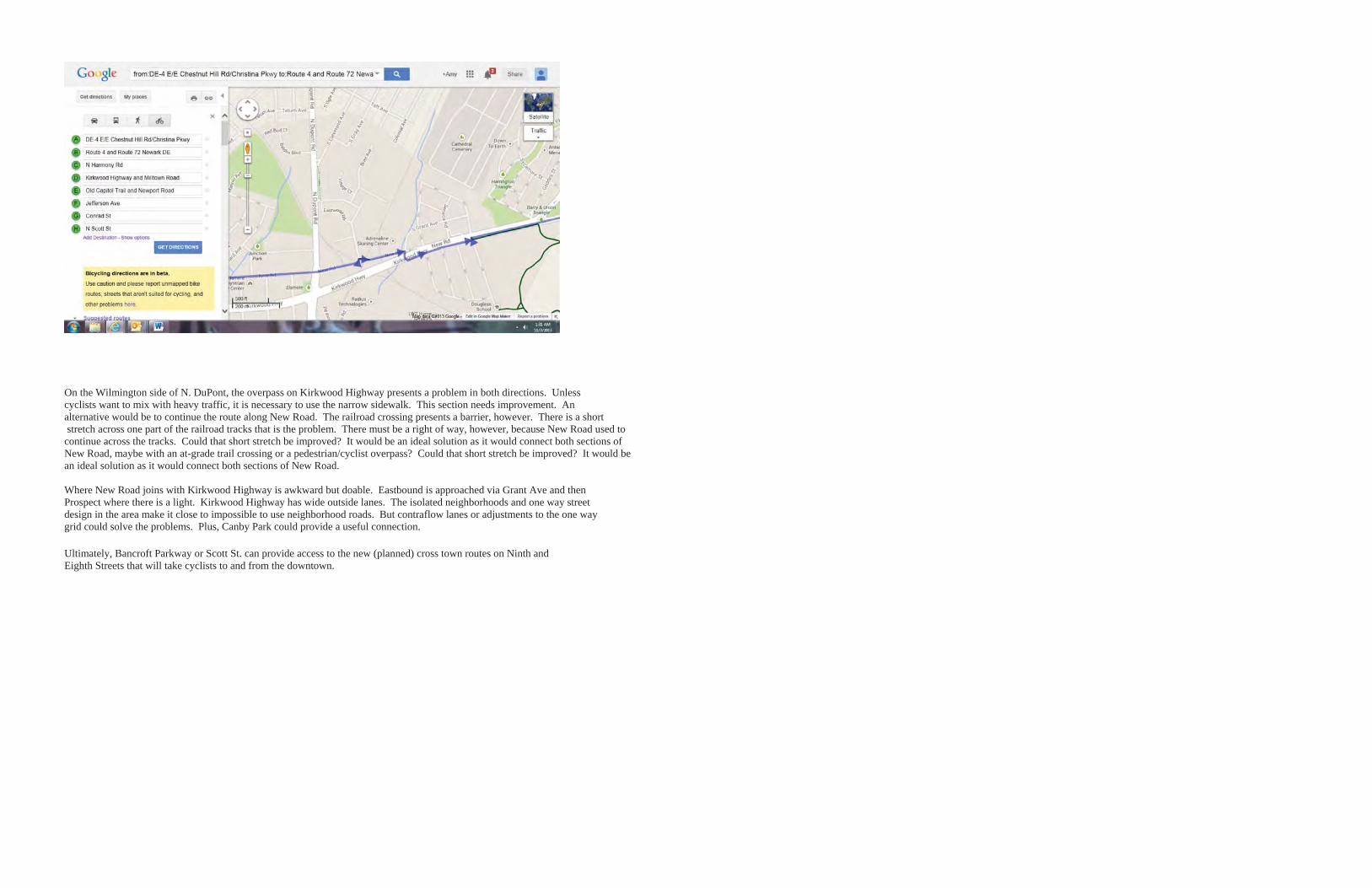
On the Wilmington side of N. DuPont, the overpass on Kirkwood Highway presents a problem in both directions. Unless cyclists want to mix with heavy traffic, it is necessary to use the narrow sidewalk. This section needs improvement. An alternative would be to continue the route along New Road. The railroad crossing presents a barrier, however. There is a short stretch across one part of the railroad tracks that is the problem. There must be a right of way, however, because New Road used to continue across the tracks. Could that short stretch be improved? It would be an ideal solution as it would connect both sections of New Road, maybe with an at-grade trail crossing or a pedestrian/cyclist overpass? Could that short stretch be improved? It would be an ideal solution as it would connect both sections of New Road.
Where New Road joins with Kirkwood Highway is awkward but doable. Eastbound is approached via Grant Ave and then Prospect where there is a light. Kirkwood Highway has wide outside lanes. The isolated neighborhoods and one way street design in the area make it close to impossible to use neighborhood roads. But contraflow lanes or adjustments to the one way grid could solve the problems. Plus, Canby Park could provide a useful connection.
Ultimately, Bancroft Parkway or Scott St. can provide access to the new (planned) cross town routes on Ninth and Eighth Streets that will take cyclists to and from the downtown.


DELAWARE DEPARTMENT OF TRANSPORTATION
800 BAY ROAD, DOVER, DELAWARE 19901 302.760.2000 WWW.DELDOT.GOV
WHITMAN, REQUARDT & ASSOCIATES, LLP
THREE MILL ROAD, SUITE 309, WILMINGTON, DELAWARE 19806 302.571.9001 WWW.WRALLP.COM