New Plays - Spectrum Geo … · New Plays from old: In 2013 the Diaman-1 well was drilled by Total...
2
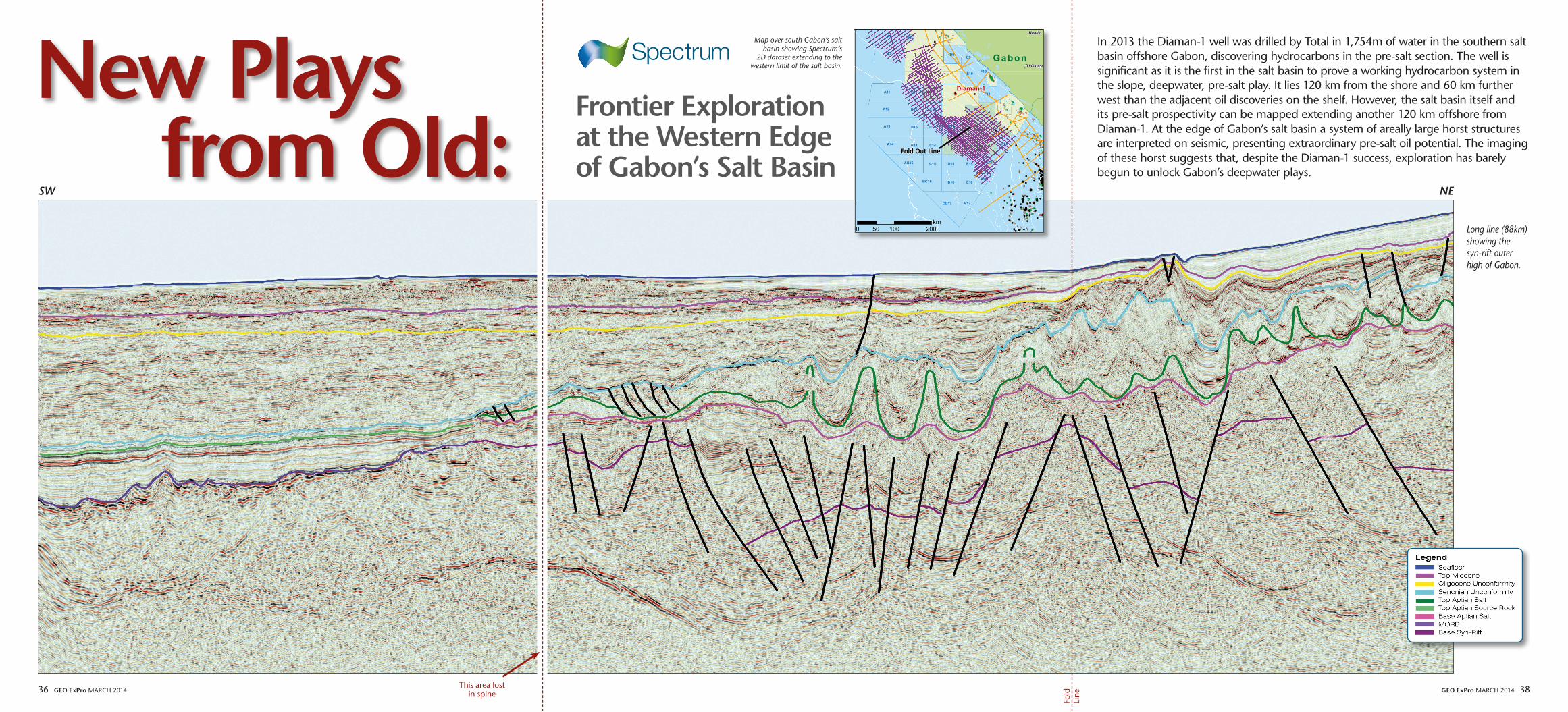
36 GEO ExPro MARCH 2014 GEO ExPro MARCH 2014 38 New Plays from Old: In 2013 the Diaman-1 well was drilled by Total in 1,754m of water in the southern salt basin offshore Gabon, discovering hydrocarbons in the pre-salt section. The well is significant as it is the first in the salt basin to prove a working hydrocarbon system in the slope, deepwater, pre-salt play. It lies 120 km from the shore and 60 km further west than the adjacent oil discoveries on the shelf. However, the salt basin itself and its pre-salt prospectivity can be mapped extending another 120 km offshore from Diaman-1. At the edge of Gabon’s salt basin a system of areally large horst structures are interpreted on seismic, presenting extraordinary pre-salt oil potential. The imaging of these horst suggests that, despite the Diaman-1 success, exploration has barely begun to unlock Gabon’s deepwater plays. Long line (88km) showing the syn-rift outer high of Gabon. Map over south Gabon’s salt basin showing Spectrum’s 2D dataset extending to the western limit of the salt basin. Frontier Exploration at the Western Edge of Gabon’s Salt Basin ! ! ! ! ! ! ! ! ! ! ! ! ! ! ! ! ! ! ! ! ! ! ! ! ! ! ! ! ! ! ! ! ! ! ! ! ! ! ! ! ! ! ! ! ! ! ! ! ! ! ! ! ! ! ! ! ! ! ! ! ! ! ! ! ! ! ! ! ! ! ! ! ! ! ! ! ! ! ! ! ! ! ! ! ! ! ! ! ! ! ! ! ! ! ! ! ! ! ! ! ! ! ! ! ! ! ! ! ! ! ! ! ! ! ! ! ! ! !! ! ! ! ! ! ! ! ! ! ! ! ! ! ! ! ! ! ! ! ! ! ! ! ! ! ! ! ! ! ! ! ! ! ! ! ! ! ! ! ! ! ! ! ! ! ! ! ! !! ! ! ! ! ! ! ! ! ! ! ! ! ! ! ! ! ! ! ! ! ! ! !! ! ! ! ! ! ! ! ! ! ! ! ! ! ! ! ! Tchibanga Mouila Gabon A8 A13 D16 E16 F16 A14 B14 C14 C15 D15 F15 E15 AB15 BC16 CD17 E17 F11 B12 C12 C13 D13 F10 A9 A11 A12 B8 B11 B13 E10 D9 E9 G14 Diaman-1 0 100 200 50 km Fold Out Line SW NE This area lost in spine Fold Line
-
Upload
truongtruc -
Category
Documents
-
view
216 -
download
0
Transcript of New Plays - Spectrum Geo … · New Plays from old: In 2013 the Diaman-1 well was drilled by Total...
36 Geo exPro March 2014 Geo exPro March 2014 38
New Playsfrom old:
In 2013 the Diaman-1 well was drilled by Total in 1,754m of water in the southern salt basin offshore Gabon, discovering hydrocarbons in the pre-salt section. The well is significant as it is the first in the salt basin to prove a working hydrocarbon system in the slope, deepwater, pre-salt play. It lies 120 km from the shore and 60 km further west than the adjacent oil discoveries on the shelf. however, the salt basin itself and its pre-salt prospectivity can be mapped extending another 120 km offshore from Diaman-1. at the edge of Gabon’s salt basin a system of areally large horst structures are interpreted on seismic, presenting extraordinary pre-salt oil potential. The imaging of these horst suggests that, despite the Diaman-1 success, exploration has barely begun to unlock Gabon’s deepwater plays.
Long line (88km)showing the syn-rift outer high of Gabon.
Map over south Gabon’s salt basin showing Spectrum’s
2D dataset extending to the western limit of the salt basin.
Frontier exploration at the Western edge of Gabon’s Salt Basin
!!
! !
!
!
!
!
!!
!
!
!
!!
!
!
!!
!
!!
!
!
!!
!
!
!
!
!!
!
!
!!
!
!
!
!
!
!
!
!
!!
!
!
!
!!
!
!!
!
!!
!
!
!
!!
!
!
!
!
!
!
!
!
!
!
!
!!!!!
!!
!!
!
!
!!
!
!
!
!
!
!
!
!
!
!
!
!
!
!!
!!
!!
!
!!
!
!!!!
!
!
!!
!
!!
!!
!
!
!
!
!!
!!
!!
! !
!
!
!!!
!
!!!
!
!
!
!
!
!
!
!
!
!
!
!!
!
!
!!
!
!!
!
!
!
!!! !!
!
!
!!!!!! !
!
!
!!
!
!!
!
!!
!
!
!
!
!
!
!
!
!
!!!
!
!
! !
!
!
!
!
!
!
!
!! !
!
!!
!
!!!
!
!
!
!!!!!
!
!
!
!!!
!
!
!
Tchibanga
Mouila
Gabon
A8
A13
D16 E16F16
A14 B14 C14
C15 D15 F15E15AB15
BC16
CD17 E17
F11
B12 C12
C13 D13
F10
A9
A11
A12
B8
B11
B13
E10
D9E9
G14
Diaman-1
0 100 20050km
Fold Out Line
SW NE
This area lost in spine
Fold
Line

GeoTeric is on hand with Geological Expression software, services and support centred around you.
Whether your focus is on achieving a detailed interpretation – or hitting deadlines – we’re here to provide a better experience for everyone involved in seismic interpretation.
Delivered by Geological Expression specialists, with a track record that spans over 300 successful projects in conventional and unconventional reservoirs, you’ll find we’re on your side and at your service.
Here for the proof seekers, problem-solvers and forward thinkers.
GabonWorld-Class Frontier exploration Targets
Seriously underexplored, the potential for deepwater Gabon to provide a spectacular future for sub-salt discoveries is very promising
Neil HodgsoN, ANoNgporN iNtAwoNg, Spectrum
although Gabon’s southern salt basin extends over an area of some 60,000 km2, only 30% of it has been explored to date, predominantly in shallow water (jack-up drilling territory <200m water depth) or indeed onshore. here, many large oil fields have been discovered below the aptian salt (for example the rabi Kounga and Gamba Fields), yet no discoveries have been made in the relatively thin post- salt Late cretaceous and Tertiary sequences.
Until 2013 the progression of exploration from onshore sub-salt to offshore sub-salt in southern Gabon had not developed far beyond the shelf, primarily because of the lack of seismic capable of imaging the pre-salt section, and the lack of control in depth converting this section. complex salt walls and diapirs, and even more complex velocity profiles within the Late cretaceous sequences filling sediment pods between the salt had meant that structural imaging and trap integrity still carried an inherent risk. however, the first step into deepwater sub-salt was taken by Total in 2013, drilling the Diaman-1 well in the Diaba Block, in water depths of 1,725m, where they discovered gas and condensate in the syn-rift, Dentale Formation sandstone.
This has proved that a working hydrocarbon system is effective about 120 km from the shore. This is significant, as even cursory inspection of the available seismic indicates that the salt basin extends another 120 km offshore, to a transitional contact with marine spreading ridge (Mid Ocean ridge Basalt). If Dentale and Gamba Formation (Gamba) sands are present across this whole pre-salt area, and these are underlain by Melania and Kissenda source rocks, the potential for deepwater Gabon to provide a spectacular future of similar sub-salt discoveries would be considered very promising. In fact, a more extraordinary feature exists at the far west of the salt basin that could surpass even this vision. This feature could also explain why this margin has a salt basin, whereas the conjugate Sergipe/Jaquipe Basins do
not. To illustrate this, and consider some of the additional plays at the western margin of Gabon’s salt basin, we need to consider the tectonic development of the rift, the syn-rift fill and the deposition of the aptian salt.
Syn-Rift SectionThe syn-rift section that filled the nascent central rift valley in Gondwana during the early cretaceous is comprised predominantly of clastic fluvial and lacustrine sediments. Within the section are two lacustrine source rocks, the Melania and the Kissenda shales, and interbedded syn-rift coarse and fine clastics of the Dentale Formation. at Diaman-1 the syn-rift section is very thick, as determined by full tensor gravity gradiometry (FTG) data, burying these source rocks into the gas-condensate mature window. South-west (down-dip) of Diaman-1 the syn-rift is thinner and the source rocks oil mature.
The provenance and drainage systems of the fluvial and lacustrine-deltaic sediments of the Dentale have been much debated, with little published evidence to guide the argument. however, the rift parallel organization of the syn-rift faults suggests a north-south depositional orientation, with fluvial systems probably distributed across the whole rift basin, a theory supported by detailed log and core-based sedimentological studies (crossley et al., 2013). Success at Diaman-1 in the Dentale demonstrates the hypothesis that
fluvial-lacustrine systems are present across the whole rift basin (i.e. across the syn-rift in the conjugate Sergipe/Jaquipe Basins and Gabon), so it is very likely that syn-rift sands and source pairs will be present to the western edge of Gabon’s salt basin too.
Towards the end of syn-rift, a marine transgression, presumably inundating the ~400 km wide rift valley from the south, reworked the upper syn-rift sediments, depositing the Gamba transgressive sandstone fairly ubiquitously. Transgression continued and a marine shale (the Vemba Shale) was deposited over the area and then the break-up rift episode was brought to a climax with the opening of a spreading center and the beginning of drift. No seaward dipping reflectors comprised of sub-areal lava flows that are common on other passive margins in the south atlantic are observed on this margin, attesting to the sub-marine eruption of the spreading center. The outer-high horst could be comprised of a dyke swarm pre-cursor to spreading, although no sub-areal extrusive material is known from this section, and a syn-rift segment appears to be present over the high. a relatively narrow transitional crust zone is inferred from the candidate MOhO reflector observed on pull-out seismic line.
Following the start of spreading in the aptian, minor uplift of the western margin of the basin created a barrier to marine ingress over the basin, as has been reported in analogous flooding rifts (e.g. Lake assal, afar, Djibouti). a variation of this model was discussed in detail by Montaron and Tapponnier, 2010, to account for salt deposition over syn-rift and oceanic crust between Brazil and angola. This outer high barrier allowed a partial marine reflux system to develop depositing salt over the syn-rift sediments, whilst at the same time marine clastics were deposited on the open marine, western side of the barrier. This aptian basin was relatively narrow and extended south to a narrow connection to the global ocean through the South africa – Falklands plateau channel. as a result, the aptian in this basin was restricted, frequently anoxic and has been proven by numerous penetrations to comprise a high TOc effective oil source, as shown in the figure above. Note the salt appears
not to be present over the syn-rift of the Sergipe/Jaquipe Basin, suggesting that the outer horst on the western side of the rift failed as a marine barrier, allowing marine aptian source to be deposited over the syn-rift in that basin.
New Plays IdentifiedWith the inexorable increase in water depth in which drilling and more importantly development can be undertaken commercially, the large syn-rift structures at and around the outer horst of Gabon represent realistic targets for exploration in the next few years. Following the licensing of some of this play fairway in 2013, wide and full azimuth 3D seismic will soon be acquired over these features, allowing the internal character of the syn-rift to be imaged, identifying source rock and allowing sediment packages to be targeted.
however, even existing 2D PSTM and PSDM seismic, especially where the processing is informed by full tensor gravity gradiometry data, is sufficient to identify the existence of this structural trend and the key play elements, encouraging pathfinder explorers to lead the industry into this area.
The recent Diaman-1 discovery in Gabon opens up the slope setting for hydrocarbon exploration, proving that Dentale sands are present across the Gondwana break-up syn-rift. Significant structures remain on trend with Diaman although it may only be down-dip, towards the western edge of the salt basin that the source returns into the oil generative window. at the base of the slope, within exploration capability in the near future, lie large structures associated with the syn-rift plays around the outer horst, representing world-class frontier exploration targets providing the next orogeny in Gabon’s long history of exciting exploration.
References:Crossley, R., Cole, V., McKenna, S., and Kubli, T,. 2013. Warp, rift, invert and sag: new insights into the tectono-stratigraphy of Gabon; unpublished presentation at The 12th PESGB/HGS Conference on African E&P, Wembley Stadium, London. 2013.
Montaron, B., and Tapponnier, P., 2010. A Quantitative Model for Salt Deposition in Actively Spreading Basins, Search and Discovery, 30117.
40 Geo exPro March 2014Geo exPro March 2014 39
Cartoon sketch illustrating a model deposition of Gabon’s salt sequence at the same time as deposition of marine Aptian source rock in the open ocean to the west. Inset showing the mechanism for salt water reflux after Monatron and Tapponier 2010.
A simplified stratigraphy of south Gabon’s salt basin.
This area lost in spine
Fold
Line