New multispectral images classification method based on MSR … pp 2104-2114.pdf · Jurf Al- Sakhar...
11
Naji Iraqi Journal of Science, 2015, Vol 56, No.3A, pp: 2104-2114 _____________________________ *Email: [email protected] 2104 New multispectral images classification method based on MSR and Skewness implementing on various sensor scenes Taghreed A. H. Naji * Department of Physics, College of Education for Pure Sciences Ibn Al-Haitham,University of Baghdad, Baghdad, Iraq Abstract A new features extraction approach is presented based on mathematical form the modify soil ratio (MSR) and skewness for numerous environmental studies. This approach is involved the investigate on the separation of features using frequency band combination by ratio to estimate the quantity of these features, and it is exhibited a particular aspect to determine the shape of features according to the position of brightness values in a digital scenes, especially when the utilizing the skewness. In this research, the marginal probability density function G(MSR) derivation for the MSR index is corrected, that mentioned in several sources including the source (Aim et al.). This index can be used on original input features space for three different scenes, and then implemented the marginal probability density function of MSR values to stretch the histograms of MSR images without any processing. Skewness is proposed on MSR images and combined with multispectral bands of original scene for land cover classification. This is a new method for extensively observing the types of features and its changes. The Hyperion data were utilized in this work; because they contain abundant details information for distinguish the different types of features. Keywords: MSR index, probability theory, skewness statistical, Hyperion hyperspectral imager, unsupervised classification. جديدة طريقة لتصنيفدا إلى تطبيقستناف اطيا الصور متعددة ا(MSR) لتواء وا لمشاهد فة ل ت خ ت الم سا المتحسد ناجي تغريد عبد الحمي* لفيزياء، قسم اوم الصرفة ابن الهيثملعلية التربية ل كل، معة بغداد جا اق ، بغداد، العر الصة خ لقد تم ت قد ي م نهج ا̋ جديدا̋ اجستخر دا إلىستنالم المعا ااضي الريشكل ال ل تعديل نسبة التربة(MSR) ولتواء العديد من لت البيئيةسا ا الدر. ذا النهج استلزم ه علىيق تحقفصل بين العالم الم باستعمال تردد ابط تر الحزم عنسبة بين الحزمب الن طريق حساعالم الم خمين كمية لت، وقد أظهر تب معين جان لتحديد شكلعالم وفقا لقيم الم السطوع في ال مشاهد الرقمية، وخصوصا عند إ ستعماللتواء. فيء ا إحصا هذا البحثيح تم تصحاق اشتق معادلة دية لية الححتما فة الة كثا داG(MSR) مؤشر تعديل ل نسبة التربة(MSR) ة د في ع كر الذي ذ المصدر ضمنها مصادر، من(Aim et al.) . يمكن إ ستعمال المؤشر(MSR) علىت مدخ فضاء العالم مث لث مشاهد أ صلية مختلفة،ن ثم وم ط ﹸ بقت دالةحتماليةفة ا كثا دية الح( لقيمMSR ) ل توسيع ا لمخططISSN: 0067-2904 GIF: 0.851
Transcript of New multispectral images classification method based on MSR … pp 2104-2114.pdf · Jurf Al- Sakhar...

Naji Iraqi Journal of Science, 2015, Vol 56, No.3A, pp: 2104-2114
_____________________________
*Email: [email protected]
2104
New multispectral images classification method based on MSR and
Skewness implementing on various sensor scenes
Taghreed A. H. Naji * Department of Physics, College of Education for Pure Sciences Ibn Al-Haitham,University of Baghdad,
Baghdad, Iraq
Abstract
A new features extraction approach is presented based on mathematical form the modify soil ratio (MSR) and skewness for numerous environmental studies. This
approach is involved the investigate on the separation of features using frequency
band combination by ratio to estimate the quantity of these features, and it is
exhibited a particular aspect to determine the shape of features according to the
position of brightness values in a digital scenes, especially when the utilizing the
skewness. In this research, the marginal probability density function G(MSR)
derivation for the MSR index is corrected, that mentioned in several sources
including the source (Aim et al.). This index can be used on original input features
space for three different scenes, and then implemented the marginal probability
density function of MSR values to stretch the histograms of MSR images without
any processing. Skewness is proposed on MSR images and combined with multispectral bands of original scene for land cover classification. This is a new
method for extensively observing the types of features and its changes. The
Hyperion data were utilized in this work; because they contain abundant details
information for distinguish the different types of features.
Keywords: MSR index, probability theory, skewness statistical, Hyperion
hyperspectral imager, unsupervised classification.
لمشاهِد وااللتواء (MSR)الصور متعددة االطياف استنادا إلى تطبيق لتصنيف طريقة جديدة المتحّسسات الُمْخَتِلفةِ
* تغريد عبد الحميد ناجي
، بغداد، العراقجامعة بغداد ،كلية التربية للعلوم الصرفة ابن الهيثم قسم الفيزياء،
خالصةالاإللتواء و (MSR) التربة نسبةتعديل ل الشكل الرياضي المعالم استنادا إلى الستخراج̋ جديدا̋ انهجم يقدلقد تم ت
عن الحزم ترابط تردد باستعمال المعالم الفصل بين تحقيق على استلزم هذا النهج .الدراسات البيئية للعديد منالمعالم وفقا لقيم شكل لتحديد جانب معينت وقد أظهر ، لَتخمين كميِة المعالم طريق حساب النسبة بين الحزم
اشتقاق تم تصحيح هذا البحث إحصاء اإللتواء. فيستعمال إ وخصوصا عند الرقمية، مشاهدال في السطوعالذي َذكَر في ِعّدة (MSR) التربة نسبة لمؤشر تعديل G(MSR) دالة كثافة االحتمالية الّحدية معادلة
معالم الفضاء مدخالت على (MSR) المؤشر ستعمالإ . يمكن(.Aim et al)مصادر، من ضمنها المصدِر لمخطط اتوسيع ل (MSRلقيم ) الّحدية كثافة االحتمالية بقت دالةُط ومن ثممختلفة، صليةأمشاهد لثالث
ISSN: 0067-2904 GIF: 0.851

Naji Iraqi Journal of Science, 2015, Vol 56, No.3A, pp: 2104-2114
2105
دمجت ُا ومن ثم (MSR)على الصور اإللتواء إحصاء قترحُ. ابدون أّي معالجة (MSR)لصورالتكراري أنواعمراقبة جديدة ل طريقة ههذ .الغطاء األرضي للمشهد االصلي لتصنيف متعددة األطياف الحزمالنتيجة مع
تفاصيل ألنها تحتوي على، في هذا العمل الهايبرون بيانات نطاق واسع. تم استعمال على وتغيراتهاالمعالم .من المعالم أنواع مختلفة للتمييز بين وفيرة معلومات
فائق األطياف الهايبرون، تصوير نظرية االحتمالية، احصاء االلتواء، ،(MSRمؤشر ) :المفتاحية الكلمات
الغير موجه.التصنيف
Introduction
Driven by the need in ecological, climate and many other studies to quantitatively assess plants conditions from remote sensing measurements, numerous vegetation indices have been developed
using the measurements in red (or visible) and near infrared (NIR) bands. In environmental researches,
band ratios are frequently used in order to quantify the amount of plants that may appear in a
multispectral digital image. Such an assumption is corroborated by the fact that band ratio between near infrared band and red band, correlation is considerably poorer than that between other spectral
bands (in certain cases, the correlation coefficient may be 0.5 or even less). All two-band indices are
based on the simple physics: plants reflect less red light but more NIR radiation compared with non-vegetated surfaces. However, different indices have different advantages in retrieving plant
information. A modified simple ratio (MSR) index is proposed for a better expectation of sensitivity to
leaf biophysical parameters using remote sensing data. This index is formulated based on the evaluation of several two-band (NIR and Red) [1, 2].
Despite its use of the some indices saturates in cases of dense and multi-layered canopy and shows
a non-linear relationship with biophysical parameters such as green LAI. Therefore, improved indices
like the Renormalized Difference Vegetation Index (RDVI) and the Modified Simple Ratio (MSR) have been developed in order to linearity their relationships with plants biophysical variables. The
MSR index produces images with a good contrast which could aid in making a reliable mapping of the
plants cover of the area under study. This index was suggested as an improvement over RDVI in terms of sensitivity to plants biophysical parameter. The RDVI is less sensitive to the variations in the
unknown foliage geometrical and optical properties and also less affected by the solar and view
geometry. The MSR index is developed based on RDVI [3, 4, 1].
A broad histogram of the MSR image has a good contrast, which may help in detecting features
with the ratio of standard deviation to mean ( ). A narrow MSR image histogram with a small ratio
may be broadened by histogram stretching. The histogram stretching should be avoided since it
distorts the original values of the pixels, therefore a good criterion for the efficiency of a MSR image
may be the ratio ( ) [4].
The skewness characterizes the degree of asymmetry of a histogram distribution around its mean.
Positive skewness indicates a distribution with an asymmetric tail extending towards more positive values. Negative skewness indicates a distribution with an asymmetric tail extending towards more
negative values. Normal histogram distributions produce a skewness statistic of about zero [5].
The Hyperion sensor is the first hyperspectral imager on-board NASAˈs earth Observing-1 (EO-1)
satellite that was launched on 21 November 2000. The EO-1 satellite follows the same orbit as Landsat-7 by about one minute. The spatial resolution of Hyperion is (30 m) and standard scene is (7.7
km) wide and (42 km) long. This sensor has (242) spectral bands ranging from (400 to 2500) nm,
recorded at 12-bit radiometric resolution [6]. Spectral channels from 1-70 are collected from the VNIR and channels 71-242 are collected from
the SWIR for each pixel location. The radiance values determined within the Hyperion bands, the
SWIR bands have a scaling factor of (80) and the VNIR bands have a scaling factor of (40) applied [7,
8]. VNIR L = Digital Number / 40
SWIR L = Digital Number / 80
Hyperion’s structure is the best model that contains data showing strength, stability and large surface area for living. It is a database can be used to develop and allows users the flexibility to view
all information in different formats and groupings [9].

Naji Iraqi Journal of Science, 2015, Vol 56, No.3A, pp: 2104-2114
2106
Generally, this study is comprised of two important parts. The first involved MSR index was a
better sensitivity to detect the plants from soil reflectance and more linearity by focusing on the
behavior of the MSR image histogram (marginal probability density function G(MSR)). The second
was skewness statistic computing. In the present research, the re-verification of the G(MSR) derivation for the MSR index was performed. All these methods were implemented using ArcGIS9.3,
ENVI 4.5 and MATLAB7.9b softwares. Figure-2 shows the overall flow of the steps that had been
implemented in this study.
The Method and Material
1- Research region and its corresponding data
Jurf Al- Sakhar quarter is located about 60 km south-west of Baghdad, the northern city of Musayyib, 13 km in the province of Babylon. Inhabited by peasants which doing in Agriculture field,
being located on the Euphrates River from the right side of the river, abound where the cultivation of
palms and fruit trees, as well as the cultivation of field crops such as wheat and barley. Associated
with Jurf Al- Sakhar geography flat open with the city of Fallujah in Anbar province, with many areas of Anbar and form the eastern flank to district Fallujah and also relate to the cities of Latifiyah,
Alexandria, Yusufiyah and Mahmudiyah.
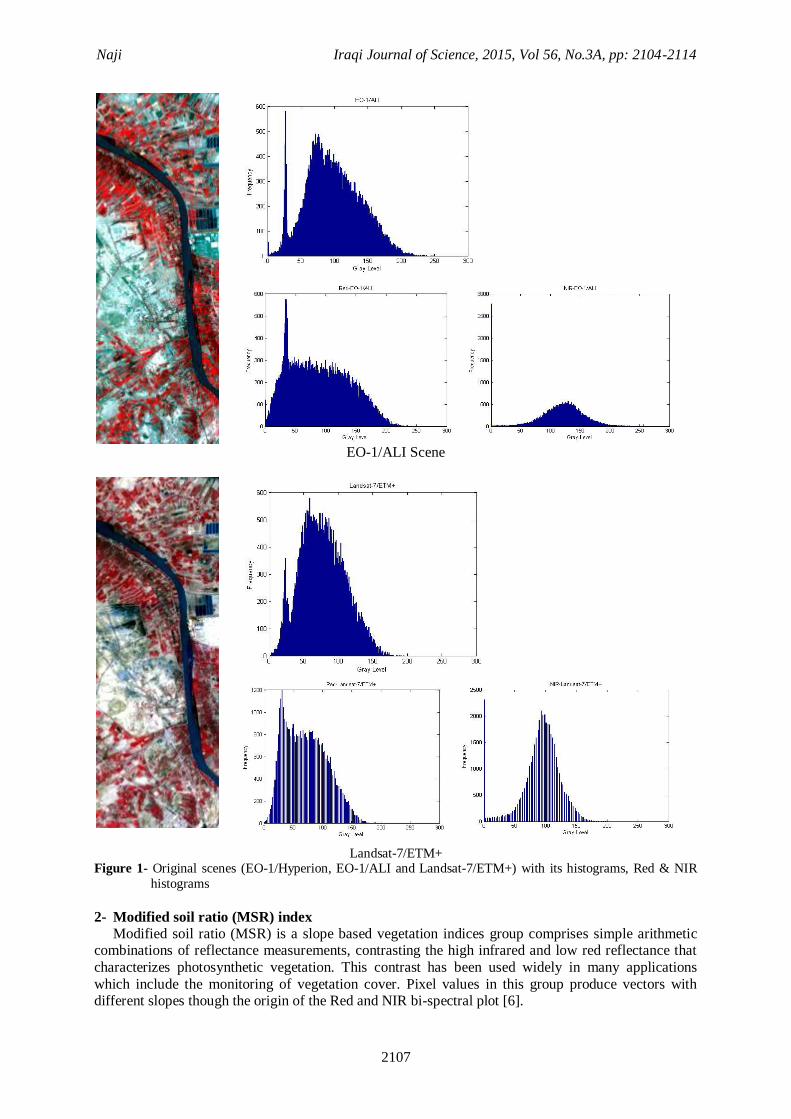
The area of the current research region about is (35, 17 Km2). In this research, three satellite scenes
with different sensors were used the Hyperion, ALI and ETM+. These scenes were obtained by Earth
Observer-1 (EO-1) and Landsat-7 satellites exposure at 24 of September 2002. These scenes were
previewed with three bands combination (R: 48, G: 31, and B: 20), (R: 6, G: 5, and B: 4) and (R: 4, G: 3, and B: 2) for Hyperion, ALI and ETM+ data respectively, which represent as three bands
combination (NIR, red and green) bands, with the same spatial resolution of (30 m) for all these
spectral bands. The available data for this region are shown in figure -1.
EO-1/Hyperion Scene
Naji Iraqi Journal of Science, 2015, Vol 56, No.3A, pp: 2104-2114
2107
EO-1/ALI Scene
Landsat-7/ETM+
Figure 1- Original scenes (EO-1/Hyperion, EO-1/ALI and Landsat-7/ETM+) with its histograms, Red & NIR
histograms
2- Modified soil ratio (MSR) index Modified soil ratio (MSR) is a slope based vegetation indices group comprises simple arithmetic
combinations of reflectance measurements, contrasting the high infrared and low red reflectance that
characterizes photosynthetic vegetation. This contrast has been used widely in many applications
which include the monitoring of vegetation cover. Pixel values in this group produce vectors with different slopes though the origin of the Red and NIR bi-spectral plot [6].
Naji Iraqi Journal of Science, 2015, Vol 56, No.3A, pp: 2104-2114
2108
This index based on the repressing the effects the variety of soil reflectance with better sensitivity
as improving the linearity, and this is developed based on Renormalized Difference Vegetation Index
(RDVI) index by the quantified equations of MSR and RDVI are the following [1]:
√ ------------------------------------------------------------------- (1)
√ --------------------------------------------------------------(2)
√
-----------------------------------------------------------------(3)
The (RDVI) index was smaller than MSR, because the Red band was increased. The ratio NIR to
Red bands is given by the following mathematical expression, and then compensates in the equation- 2
[4]:
√ -------------------------------------------------------------------- (4)
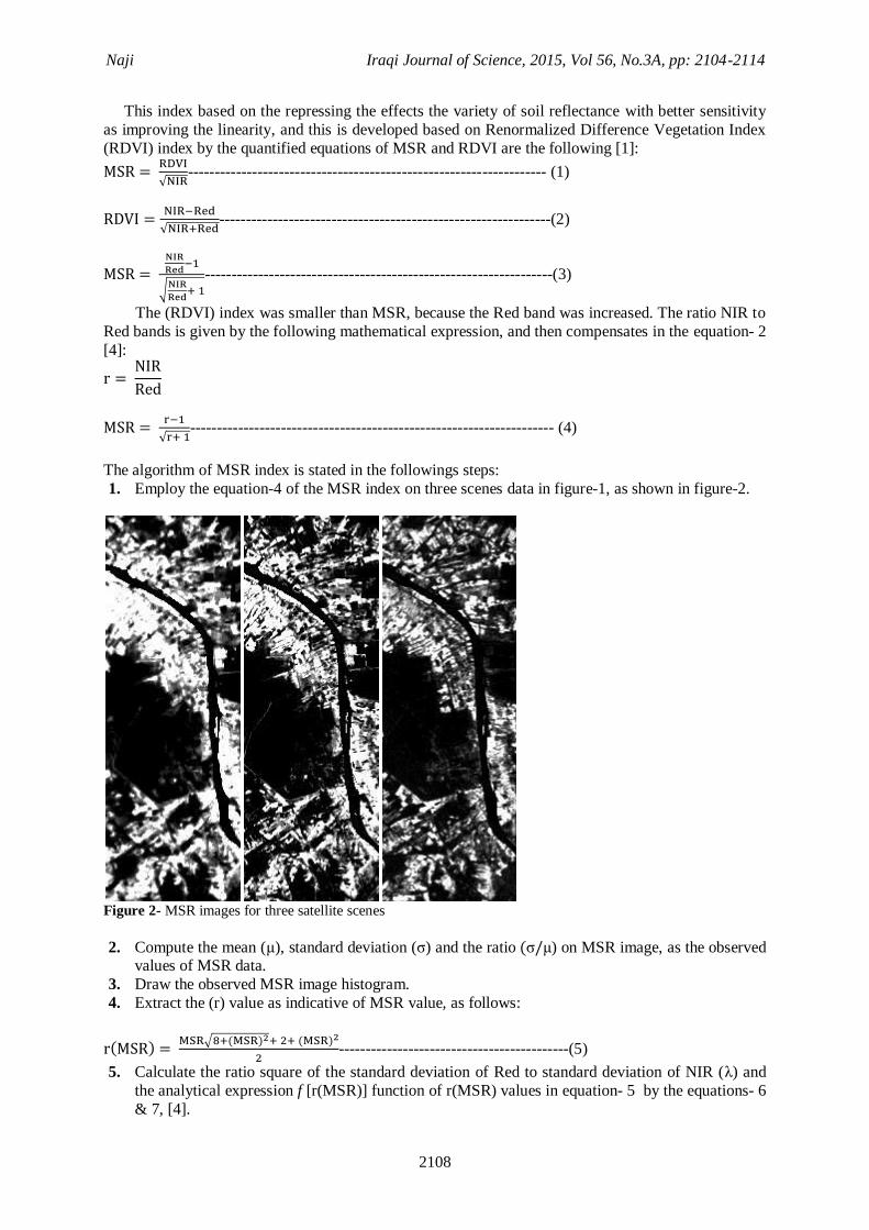
The algorithm of MSR index is stated in the followings steps:
1. Employ the equation-4 of the MSR index on three scenes data in figure-1, as shown in figure-2.
Figure 2- MSR images for three satellite scenes
2. Compute the mean ( ), standard deviation ( ) and the ratio ) on MSR image, as the observed values of MSR data.
3. Draw the observed MSR image histogram.
4. Extract the (r) value as indicative of MSR value, as follows:
) √ ) )
-------------------------------------------(5)
5. Calculate the ratio square of the standard deviation of Red to standard deviation of NIR ( ) and
the analytical expression f [r(MSR)] function of r(MSR) values in equation- 5 by the equations- 6
& 7, [4].

Naji Iraqi Journal of Science, 2015, Vol 56, No.3A, pp: 2104-2114
2109
)
) ) ----------------------------------------------------------------- (6)
[ )] ))
)) ) --------------------------------------------------- (7)
6. Determine the marginal probability density function (G) on MSR data using analytical expression
f [r(MSR)] function by the equations- 7 & 8 [4], to extract the final formula of G(MSR) in
equation- 9:
) [ )] |
)|--------------------------------------------------(8)
) ( )√ ) ) )( )√ ) ) )
√ ) [
( )√ ) ) )
]
-----(9)
7. Compute the mean ( ), standard deviation ( ) and the ratio ) for G(MSR) data, as the
theoretical values of MSR data. 8. Draw the (G(MSR)) histogram.
The magnitude of the theoretical values of the image histogram may be useful in assessing the performance of the MSR index. If they are high, the histogram is broad, the image is good contrast and
different land cover types are expected to be more clearly expressed. The low theoretical values mean
a not good tonality contrast, which may imply difficulties in recognizing features of region interest.
3- Skewness approach
The statistical skewness measure is an important and widely used as the new tool to detect a small
land cover area by extracting the detail information. In addition to feasibility of skewness in enhancement the edges of features in the images. The Mathematicians formula expressing of skewness
is [10]:
Skewness =
)-------------------------------------------------------(10)
Where:
∑ ̅)
,
∑ ̅)
, √ )
n, , ̅ represent the number of all pixel in the scene, a set for all pixel values and the mean of gray
scale values, respectively in a moving window.
m2 and m3, represent the second and third moments around the mean value, also the m2 represent the
variance value. When dealing with the discrete values distribution, the estimator of skewness may be undefined
(0/0) without using the factor (g1) [11].
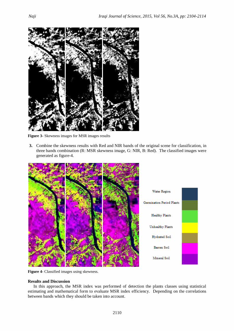
The steps of skewness algorithm are stated as the followings points: 1. Select the suitable window size is (7×7) can be exposed the symmetrical features information and
it is the best for computations.
2. Apply the skewness approach, which defined by equation- 10 on MSR data in figure- 2, as seen in figure- 3.
Naji Iraqi Journal of Science, 2015, Vol 56, No.3A, pp: 2104-2114
2110
Figure 3- Skewness images for MSR images results
3. Combine the skewness results with Red and NIR bands of the original scene for classification, in
three bands combination (R: MSR skewness image, G: NIR, B: Red). The classified images were generated as figure-4.
Figure 4- Classified images using skewness.
Results and Discussion In this approach, the MSR index was performed of detection the plants classes using statistical
estimating and mathematical form to evaluate MSR index efficiency. Depending on the correlations
between bands which they should be taken into account.
Naji Iraqi Journal of Science, 2015, Vol 56, No.3A, pp: 2104-2114
2111
The theoretical and observed calculations for MSR data were compared by various sensors, in
order to the validity of the proposed methodological approach, which useful in classification the land
cover regions.
Our results of calculation the equation-1 for MSR index on the three satellite scenes presented on Figure- 2. The bright white, bright gray and gray colors in these results indicate to the healthy, arid
and germination period plants respectively. The reflectance of hydrated soil affected on the reflectance
of germination period plants. These features can be separated and distinguished using the skewness technique as offered in figure- 3. This technique was as a threshold process. Figure-4 demonstrates the
classification results by merging the results of figure-3 with the NIR and Red bands of the original
scene to enhance the separating, because the pure multispectral bands are proper for extract the small area of the variety features (e.g., crops, palms and fruit trees).
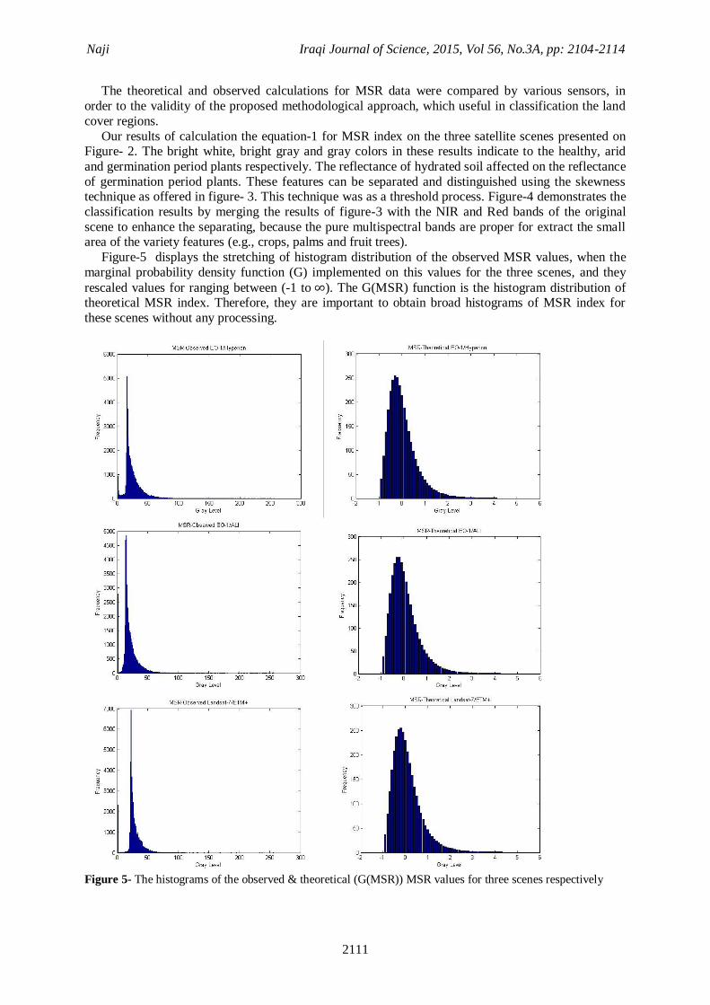
Figure-5 displays the stretching of histogram distribution of the observed MSR values, when the
marginal probability density function (G) implemented on this values for the three scenes, and they
rescaled values for ranging between (-1 to ). The G(MSR) function is the histogram distribution of theoretical MSR index. Therefore, they are important to obtain broad histograms of MSR index for
these scenes without any processing.
Figure 5- The histograms of the observed & theoretical (G(MSR)) MSR values for three scenes respectively
Naji Iraqi Journal of Science, 2015, Vol 56, No.3A, pp: 2104-2114
2112
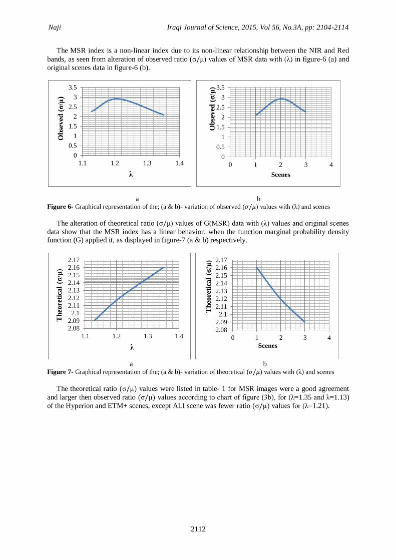
The MSR index is a non-linear index due to its non-linear relationship between the NIR and Red
bands, as seen from alteration of observed ratio ( ) values of MSR data with ( ) in figure-6 (a) and
original scenes data in figure-6 (b).
a b
Figure 6- Graphical representation of the; (a & b)- variation of observed ( ) values with ( ) and scenes
The alteration of theoretical ratio ( ) values of G(MSR) data with ( ) values and original scenes
data show that the MSR index has a linear behavior, when the function marginal probability density function (G) applied it, as displayed in figure-7 (a & b) respectively.
a b
Figure 7- Graphical representation of the; (a & b)- variation of theoretical ( ) values with ( ) and scenes
The theoretical ratio ) values were listed in table- 1 for MSR images were a good agreement
and larger then observed ratio ) values according to chart of figure (3b), for ( =1.35 and =1.13)
of the Hyperion and ETM+ scenes, except ALI scene was fewer ratio ) values for ( =1.21).
0
0.5
1
1.5
2
2.5
3
3.5
1.1 1.2 1.3 1.4
Ob
sev
ed (
σ/μ
)
λ
0
0.5
1
1.5
2
2.5
3
3.5
0 1 2 3 4
Ob
sev
ed (
σ/μ
)
Scenes
2.082.092.1
2.112.122.132.142.152.162.17
1.1 1.2 1.3 1.4
Th
eore
tica
l (σ
/μ)
λ
2.08
2.09
2.1
2.11
2.12
2.13
2.14
2.15
2.16
2.17
0 1 2 3 4
Th
eore
tica
l (σ
/μ)
Scenes

Naji Iraqi Journal of Science, 2015, Vol 56, No.3A, pp: 2104-2114
2113
Table 1- Observed and theoretical statistical calculations of a MSR images
Scene Mean ( ) Standard deviation
( ) Ratio ( )
Observed calculations
EO-1/Hyperion 6.17 8.18 1.33
EO-1/ALI 4.58 7.23 1.58
Landsat-7/ETM+ 1.57 1.86 1.18
Theoretical calculations
EO-1/Hyperion 50.49 78.69 1.56
EO-1/ALI 52.33 79.84 1.53
Landsat-7/ETM+ 53.23 79.97 1.50
Figure-8 offers the distributions of G(MSR) histograms, according to the ( ) values in table-2 for
the scenes sensors. These positive skewness distributions prepare easily understood impressions of these scenes. Hyperion scene has a large value of ( ), because this scene can provide with statistical
parameters ( and ) accurate quantitative estimation of the plants classes as explained from the
classification images in figure- 4.
Figure 8- brightness values distribution of G (MSR) for three scenes.
Table 2- The ratio of ) with ) values of the three scenes
Scene λ
EO-1/Hyperion 1.35
EO-1/ALI 1.21
Landsat-7/ETM+ 1.13
Conclusions
A novel algorithm has been introduced for distinguish and quick separation between features
reflection in study area. This method adopted MSR index with skewness statistical based on Hyperion, ALI and ETM+ intensity information.
The MSR can be employed on original input feature space for scenes to solve a linear problem in
that space. In this research, the MSR index linearity was proved by computation the marginal probability density function (G(MSR)) for MSR values (theoretical value) as shown in figure-7 (a &
b), in order to good contrast, reduce and eliminate the influences of the variety soil reflectance
underneath plants (such as; mineral and clay soils). Thus helps to best possible separation of the
Naji Iraqi Journal of Science, 2015, Vol 56, No.3A, pp: 2104-2114
2114
features, could be work in future. MSR index was made as a tool to improve the linearity. In figure-6
(a & b) the observed MSR value is a non-linear index due to its combination the band ratio (NIR/Red)
with the different non-linear behavior for these bands, as displayed of the histogram distribution, for
these bands in figure -1,. This index does on the classification of cases and the types of plants only. The validity of G(MSR) equation for MSR index was re-derived in this work as shown in equation-
9. This derivation may be applied to all indices in other fields, such as mineral soils exploration, that
include the band ratio between two spectral bands. Skewness technique applied on MSR values to exploit the detail information when combined with
multispectral bands as unsupervised classification. This is a new and an effectively method for
extensively observing the types of features of different sensors and its changes. Especially, between the crops and palms, fruit trees areas.
This study region characterized by the cultivation of crops from vegetables, fruit and palm trees.
This technique was as a tool to determine of threshold process in this paper. The methodology adopted
in the present paper may be used efficiently for other indices.
References
1. Chen, J. M. 1996. Evaluation of vegetation indices and modified simple ratio for boreal applications. Can. J. Remote Sens., 22, pp: 229–242.
2. Vaiopoulos D., Skianis G. A and Nikolakopoulos K. 2004. The contribution of probability theory
in assessing the efficiency of two frequently used vegetation indices. Int. J. remote sensing, Taylor & Francis, 25(20), pp: 4219–4236.
3. Haboudanea D., Miller J. R., Pattey E., Tejadad P. J. and Strachan I. B. 2004. Hyperspectral
vegetation indices and novel algorithms for predicting green LAI of crop canopies: Modeling and
validation in the context of precision agriculture. Elsevier Inc. Remote Sensing of Environment 90, pp: 337–352.
4. Aim S. G., Vaiopoulos D. and Nikolakopoulos K. 2007. A study of the performance of the MSR
vegetation index, using probabilistic and geostatistical method. Bulletin of the Geological Society of Greece, Proceedings of the 111h International Congress, Athens.
5. Brown J. D. 1997. Skewness and kurtosis. JALT Testing & Evaluation SIG Newsletter, 1(1), pp:
20-23.
6. Jafari R. 2007. Arid Land Condition Assessment and Monitoring using Multispectral and Hyperspectral Imagery. PhD. Thesis. Discipline of Soil and Land System, School of Earth and
Environmental Sciences, the University of Adelaide, Australia.
7. Barry P., Segal C. and Carman S. 2001. EO-1/ Hyperion Science Data User’s Guide. TRW Space, Defense & Information Systems.
8. Beck R. 2003. EO-1 User Guide v. 2.3. Cincinnati.
9. Hyperion space settlement. 2011. 10. Doane D. P. 2011. Measuring Skewness: A Forgotten Statistic. Journal of Statistics Education,
19(2).
11. Joanes, D. N. and Gill, C. A. 1998. Comparing measures of sample skewness and kurtosis.
Journal of the Royal Statistical Society (Series D), 47(1), pp: 183–189.