New Mexico Recommended Area Designations for the … · Recommended Area Designations for the ......
46
-
Upload
truongliem -
Category
Documents
-
view
227 -
download
0
Transcript of New Mexico Recommended Area Designations for the … · Recommended Area Designations for the ......
Prepared by The State of New Mexico Environment Department
Air Quality Bureau
New Mexico
Recommended Area Designations for the
2008 Revised Ozone NAAQS
2
Table of Contents I. Introduction ..................................................................................................................... 4 II. The 9-Factor Analysis and Boundary Determination: Doña Ana County ..................... 8
II.1: Air Quality Data ................................................................................................................................. 8 II.2: Emissions Data ................................................................................................................................. 10 II.3: Population Density and Degree of Urbanization .............................................................................. 12 II.4: Traffic and Commuting Patterns....................................................................................................... 13 II.5: Growth rates and patterns ................................................................................................................. 16 II.6: Meteorology...................................................................................................................................... 17 II.7: Geography/Topography.................................................................................................................... 19 II.8: Jurisdictional boundaries .................................................................................................................. 20 II.9: Level of Control of Emissions Sources ............................................................................................ 20 II.9.1: Camino Real Landfill..................................................................................................................... 20 II.9.2: Other Major Sources...................................................................................................................... 20 II.9.3: Volatile Organic Compounds ........................................................................................................ 20 II.9.4: Nitrogen Dioxide ........................................................................................................................... 21 II.9.5: Carbon Monoxide .......................................................................................................................... 22
III: Boundary Recommendation - Sunland Park Area...................................................... 23 IV.1: Justification for Boundary Recommendation.................................................................................. 24
Tables Table 1: 2009 New Mexico County Designations for 8-hour Ozone NAAQS (based on 2006-2008 data) .................................................................................................................... 4 Table 2: Sunland Park Area Monitoring Data ..................................................................... 8 Table 3: Summary of Source Categories for 2002 Emissions Inventory - Sunland Park Area..................................................................................................................................... 11 Table 4: Emissions in Paso del Norte Airshed................................................................... 11 Table 5: Population and Housing Densities - 2000 - Census.............................................. 13 Table 6: Travel Patterns to Work by County for 2000 ....................................................... 14 Table 7: Inter-County Work Trips for 2000 ....................................................................... 14 Figures Figure 1: Doña Ana County 2006-2008 Monitoring Data................................................... 9 Figure 2: Doña Ana County Ozone Monitoring Network ................................................. 10 Figure 3: Summary of Regional Emissions ........................................................................ 12 Figure 4: Doña Ana County Annual Average Daily Traffic Flow Map for 2007 (New Mexico Department of Transportation). ............................................................................. 15 Figure 5: Historical and Projected Population Growth for the Paso del Norte Airshed ..... 16 Figure 6: Dona Ana County Monitor Wind Roses ............................................................. 18 Figure 7: Previous 1995 Sunland Park 1-Hour Ozone Nonattainment Area ..................... 24 Figure 8: Total Emission Percentages for the Border Region. .......................................... 25 Figure 9: Major Point Source Emissions for Doña Ana County. ...................................... 25 Appendices Appendix A: EPA’s December 4, 2008 Area Designation Guidance Memo Appendix B: NMED Ozone Monitoring Data - 2006 through 2008 Appendix C: Sunland Park Area Boundary Recommendation Map Appendix D: Sunland Park 1-Hour Ozone Nonattainment Designation Federal Register Appendix E: San Juan County Area 9-Factor Analysis
3
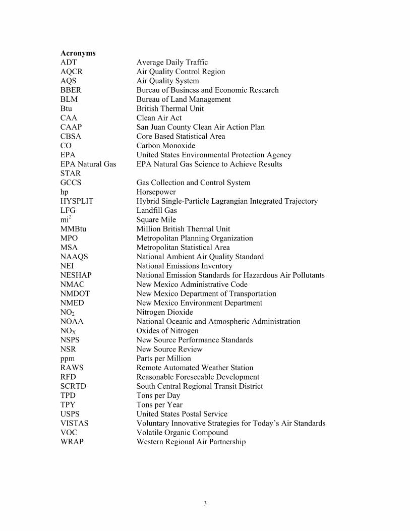
Acronyms ADT Average Daily Traffic AQCR Air Quality Control Region AQS Air Quality System BBER Bureau of Business and Economic Research BLM Bureau of Land Management Btu British Thermal Unit CAA Clean Air Act CAAP San Juan County Clean Air Action Plan CBSA Core Based Statistical Area CO Carbon Monoxide EPA United States Environmental Protection Agency EPA Natural Gas STAR
EPA Natural Gas Science to Achieve Results
GCCS Gas Collection and Control System hp Horsepower HYSPLIT Hybrid Single-Particle Lagrangian Integrated Trajectory LFG Landfill Gas mi2 Square Mile MMBtu Million British Thermal Unit MPO Metropolitan Planning Organization MSA Metropolitan Statistical Area NAAQS National Ambient Air Quality Standard NEI National Emissions Inventory NESHAP National Emission Standards for Hazardous Air Pollutants NMAC New Mexico Administrative Code NMDOT New Mexico Department of Transportation NMED New Mexico Environment Department NO2 Nitrogen Dioxide NOAA National Oceanic and Atmospheric Administration NOX Oxides of Nitrogen NSPS New Source Performance Standards NSR New Source Review ppm Parts per Million RAWS Remote Automated Weather Station RFD Reasonable Foreseeable Development SCRTD South Central Regional Transit District TPD Tons per Day TPY Tons per Year USPS United States Postal Service VISTAS Voluntary Innovative Strategies for Today’s Air Standards VOC Volatile Organic Compound WRAP Western Regional Air Partnership
4
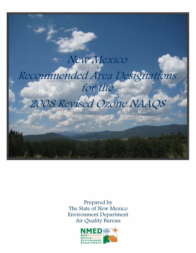
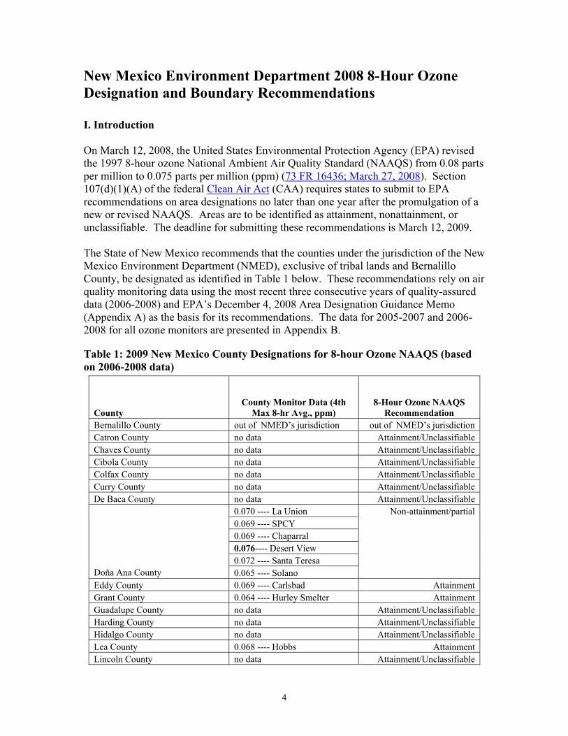
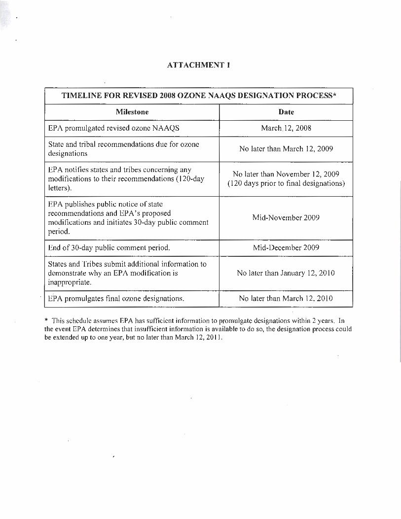
New Mexico Environment Department 2008 8-Hour Ozone Designation and Boundary Recommendations I. Introduction On March 12, 2008, the United States Environmental Protection Agency (EPA) revised the 1997 8-hour ozone National Ambient Air Quality Standard (NAAQS) from 0.08 parts per million to 0.075 parts per million (ppm) (73 FR 16436; March 27, 2008). Section 107(d)(1)(A) of the federal Clean Air Act (CAA) requires states to submit to EPA recommendations on area designations no later than one year after the promulgation of a new or revised NAAQS. Areas are to be identified as attainment, nonattainment, or unclassifiable. The deadline for submitting these recommendations is March 12, 2009. The State of New Mexico recommends that the counties under the jurisdiction of the New Mexico Environment Department (NMED), exclusive of tribal lands and Bernalillo County, be designated as identified in Table 1 below. These recommendations rely on air quality monitoring data using the most recent three consecutive years of quality-assured data (2006-2008) and EPA’s December 4, 2008 Area Designation Guidance Memo (Appendix A) as the basis for its recommendations. The data for 2005-2007 and 2006-2008 for all ozone monitors are presented in Appendix B.
Table 1: 2009 New Mexico County Designations for 8-hour Ozone NAAQS (based on 2006-2008 data)
County County Monitor Data (4th
Max 8-hr Avg., ppm) 8-Hour Ozone NAAQS
Recommendation Bernalillo County out of NMED’s jurisdiction out of NMED’s jurisdiction Catron County no data Attainment/Unclassifiable Chaves County no data Attainment/Unclassifiable Cibola County no data Attainment/Unclassifiable Colfax County no data Attainment/Unclassifiable Curry County no data Attainment/Unclassifiable De Baca County no data Attainment/Unclassifiable
0.070 ---- La Union Non-attainment/partial 0.069 ---- SPCY 0.069 ---- Chaparral 0.076---- Desert View 0.072 ---- Santa Teresa
Doña Ana County 0.065 ---- Solano Eddy County 0.069 ---- Carlsbad Attainment Grant County 0.064 ---- Hurley Smelter Attainment Guadalupe County no data Attainment/Unclassifiable Harding County no data Attainment/Unclassifiable Hidalgo County no data Attainment/Unclassifiable Lea County 0.068 ---- Hobbs Attainment Lincoln County no data Attainment/Unclassifiable
5
County County Monitor Data (4th
Max 8-hr Avg., ppm) 8-Hour Ozone NAAQS
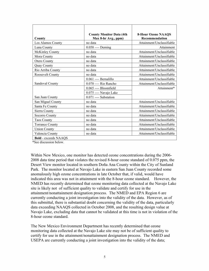
Recommendation Los Alamos County no data Attainment/Unclassifiable Luna County 0.058 ---- Deming Attainment McKinley County no data Attainment/Unclassifiable Mora County no data Attainment/Unclassifiable Otero County no data Attainment/Unclassifiable Quay County no data Attainment/Unclassifiable Rio Arriba County no data Attainment/Unclassifiable Roosevelt County no data Attainment/Unclassifiable
0.061 ---- Bernalillo Attainment/Unclassifiable Sandoval County 0.070 ---- Rio Rancho Attainment/Unclassifiable
0.065 ---- Bloomfield Attainment* 0.075 ---- Navajo Lake
San Juan County 0.071 ---- Substation San Miguel County no data Attainment/Unclassifiable Santa Fe County no data Attainment/Unclassifiable Sierra County no data Attainment/Unclassifiable Socorro County no data Attainment/Unclassifiable Taos County no data Attainment/Unclassifiable Torrance County no data Attainment/Unclassifiable Union County no data Attainment/Unclassifiable Valencia County no data Attainment/Unclassifiable Bold - exceeds NAAQS
*See discussion below.
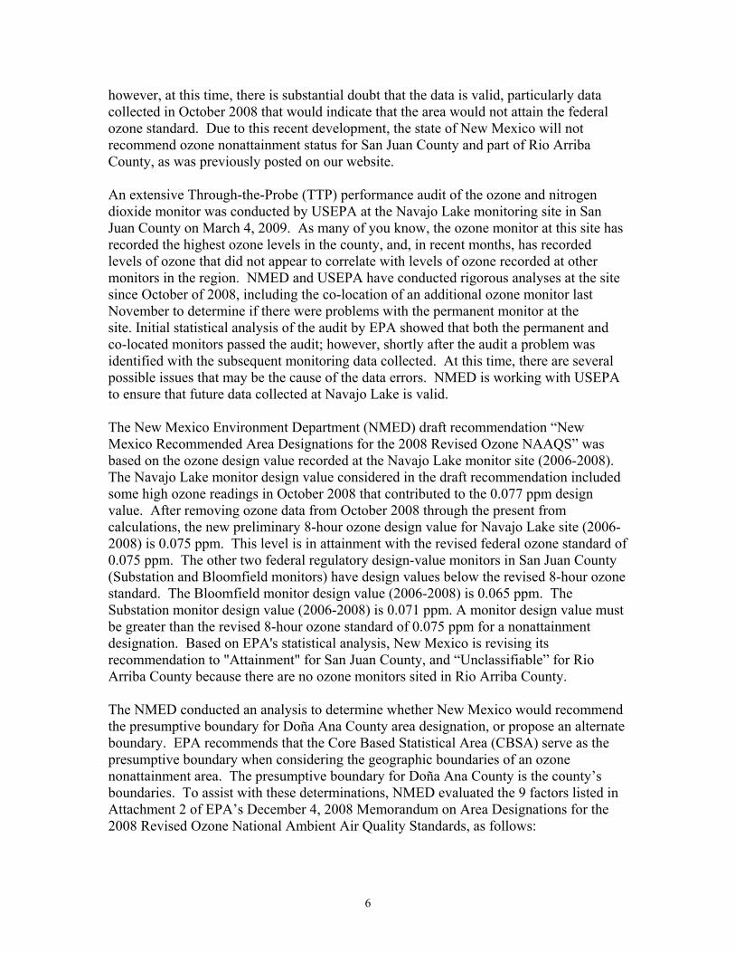
Within New Mexico, one monitor has detected ozone concentrations during the 2006-2008 data time period that violates the revised 8-hour ozone standard of 0.075 ppm, the Desert View monitor located in southern Doña Ana County within the City of Sunland Park. The monitor located at Navajo Lake in eastern San Juan County recorded some anomalously high ozone concentrations in late October that, if valid, would have indicated this area was not in attainment with the 8-hour ozone standard. However, the NMED has recently determined that ozone monitoring data collected at the Navajo Lake site is likely not of sufficient quality to validate and certify for use in the attainment/nonattainment designation process. The NMED and EPA Region 6 are currently conducting a joint investigation into the validity of the data. However, as of this submittal, there is substantial doubt concerning the validity of the data, particularly data exceeding NAAQS collected in October 2008, and the resulting design value at Navajo Lake, excluding data that cannot be validated at this time is not in violation of the 8-hour ozone standard. The New Mexico Environment Department has recently determined that ozone monitoring data collected at the Navajo Lake site may not be of sufficient quality to certify for use in the attainment/nonattainment designation process. The NMED and USEPA are currently conducting a joint investigation into the validity of the data;
6
however, at this time, there is substantial doubt that the data is valid, particularly data collected in October 2008 that would indicate that the area would not attain the federal ozone standard. Due to this recent development, the state of New Mexico will not recommend ozone nonattainment status for San Juan County and part of Rio Arriba County, as was previously posted on our website. An extensive Through-the-Probe (TTP) performance audit of the ozone and nitrogen dioxide monitor was conducted by USEPA at the Navajo Lake monitoring site in San Juan County on March 4, 2009. As many of you know, the ozone monitor at this site has recorded the highest ozone levels in the county, and, in recent months, has recorded levels of ozone that did not appear to correlate with levels of ozone recorded at other monitors in the region. NMED and USEPA have conducted rigorous analyses at the site since October of 2008, including the co-location of an additional ozone monitor last November to determine if there were problems with the permanent monitor at the site. Initial statistical analysis of the audit by EPA showed that both the permanent and co-located monitors passed the audit; however, shortly after the audit a problem was identified with the subsequent monitoring data collected. At this time, there are several possible issues that may be the cause of the data errors. NMED is working with USEPA to ensure that future data collected at Navajo Lake is valid. The New Mexico Environment Department (NMED) draft recommendation “New Mexico Recommended Area Designations for the 2008 Revised Ozone NAAQS” was based on the ozone design value recorded at the Navajo Lake monitor site (2006-2008). The Navajo Lake monitor design value considered in the draft recommendation included some high ozone readings in October 2008 that contributed to the 0.077 ppm design value. After removing ozone data from October 2008 through the present from calculations, the new preliminary 8-hour ozone design value for Navajo Lake site (2006-2008) is 0.075 ppm. This level is in attainment with the revised federal ozone standard of 0.075 ppm. The other two federal regulatory design-value monitors in San Juan County (Substation and Bloomfield monitors) have design values below the revised 8-hour ozone standard. The Bloomfield monitor design value (2006-2008) is 0.065 ppm. The Substation monitor design value (2006-2008) is 0.071 ppm. A monitor design value must be greater than the revised 8-hour ozone standard of 0.075 ppm for a nonattainment designation. Based on EPA's statistical analysis, New Mexico is revising its recommendation to "Attainment" for San Juan County, and “Unclassifiable” for Rio Arriba County because there are no ozone monitors sited in Rio Arriba County. The NMED conducted an analysis to determine whether New Mexico would recommend the presumptive boundary for Doña Ana County area designation, or propose an alternate boundary. EPA recommends that the Core Based Statistical Area (CBSA) serve as the presumptive boundary when considering the geographic boundaries of an ozone nonattainment area. The presumptive boundary for Doña Ana County is the county’s boundaries. To assist with these determinations, NMED evaluated the 9 factors listed in Attachment 2 of EPA’s December 4, 2008 Memorandum on Area Designations for the 2008 Revised Ozone National Ambient Air Quality Standards, as follows:

7
Air quality data Emissions data (location of sources and contribution to ozone concentrations) Population density and degree of urbanization (including commercial development) Traffic and commuting patterns Growth rates and patterns Meteorology (weather/transport patterns) Geography/topography (mountain ranges or other air basin boundaries) Jurisdictional boundaries (e.g., counties, air districts, existing nonattainment areas,
Reservations, Metropolitan Planning Organizations) Level of control of emission sources
Based on the results of the analysis, the NMED has decided to recommend an area smaller than the Doña Ana County CBSA. Should the 2009 ozone data for San Juan County demonstrate that the area is not in attainment with the 8-hour ozone standard, the 9-factor analysis completed for San Juan and Rio Arriba Counties is included as Appendix E. Given that the preliminary design value for this area is 0.075 ppm, there is a possibility that the state could recommend a nonattainment designation for the area in the future.
8
II. The 9-Factor Analysis and Boundary Determination: Doña Ana County Sunland Park, New Mexico lies within Doña Ana County, New Mexico. Doña Ana County has a total area of 3,804 mi.2 and a population of 180,077 (estimate 2002). Sunland Park was officially designated as nonattainment for the 1-hour ozone NAAQS in a Federal Register announcement published June 12, 1995 (60 FR 30789), see Appendix D). Sunland Park was designated as a marginal nonattainment area. The nonattainment area included the communities of Sunland Park, Santa Teresa, and La Union, which will be referred to from now on as the Sunland Park area. The Sunland Park area is located along the border region of New Mexico and is adjacent to El Paso, Texas, and Ciudad Juarez, Mexico, in what is commonly referred to as the Paso del Norte Airshed. Due to the revocation of the 1-hour NAAQS for ozone in 2005, EPA required that all areas that were currently nonattainment for the 1-hour NAAQS, but in attainment for the new 8-hour NAAQS for ozone conduct an analysis to re-designate those nonattainment areas to attainment/maintenance status. An attainment plan was submitted to EPA for the Sunland Park area in June of 2007. NMED is still waiting on EPA approval of the attainment plan. The Sunland Park area is included within the El Paso Metropolitan Planning Organization (MPO). For population and employment determinations the MPO divided the area into four segments: 1) Sunland Park, 2) Santa Teresa, 3) La Union, and 4) Gadsden (the area north of La Union).
II.1: Air Quality Data The monitoring network in Doña Ana County contains six federal regulatory design-value monitors operated and maintained in accordance with 40 CFR 58. Table 2 below contains information on the current ozone monitors in the Sunland Park area.
Table 2: Sunland Park Area Monitoring Data
Sunland Park Area
Year
Site Name AQS# 2005
(ppm) 2006
(ppm) 2007
(ppm) 2008
(ppm)
3-Year Avg.
[2005-2007] (ppm)
3-Year Avg.
[2006-2008] (ppm)
Design-Value (ppm)
Sunland Park 35-013-0017 0.070 0.073 0.070 0.065 0.071 0.069 0.069 Desert View 35-013-0012 0.076 0.080 0.076 0.074 0.077 0.076 0.076 Santa Teresa 35-013-0022 0.070 0.073 0.073 0.072 0.072 0.072 0.072 La Union 35-013-0008 0.070 0.072 0.068 0.071 0.070 0.070 0.070 Bold – exceeds NAAQS
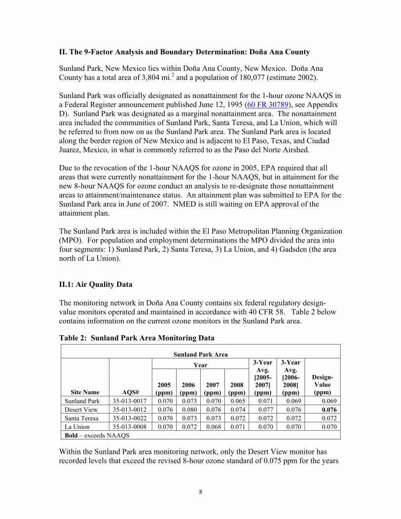
Within the Sunland Park area monitoring network, only the Desert View monitor has recorded levels that exceed the revised 8-hour ozone standard of 0.075 ppm for the years
9
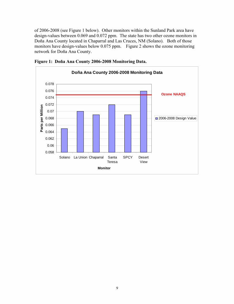
of 2006-2008 (see Figure 1 below). Other monitors within the Sunland Park area have design-values between 0.069 and 0.072 ppm. The state has two other ozone monitors in Doña Ana County located in Chaparral and Las Cruces, NM (Solano). Both of those monitors have design-values below 0.075 ppm. Figure 2 shows the ozone monitoring network for Doña Ana County.
Figure 1: Doña Ana County 2006-2008 Monitoring Data.
Doña Ana County 2006-2008 Monitoring Data
0.058
0.06
0.062
0.064
0.066
0.068
0.07
0.072
0.074
0.076
0.078
Solano La Union Chaparral SantaTeresa
SPCY DesertView
Monitor
Par
ts p
er M
illi
on
2006-2008 Design Value
Ozone NAAQS
10
Figure 2: Doña Ana County Ozone Monitoring Network
II.2: Emissions Data The U.S. Environmental Protection Agency’s guidance requires that an emissions inventory be developed to identify the level of emissions in the violating area and adjacent regions that might have contributed to an area’s ozone exceedance. For the proposed Sunland Park Nonattainment area, the attainment inventory uses a base year of 2002. The following table (Table 3) lists all actual emissions (area, point and mobile) for the base year of 2002 for the ozone precursors nitrogen oxides, carbon monoxide, and volatile organic compounds in tons per year and tons per day.
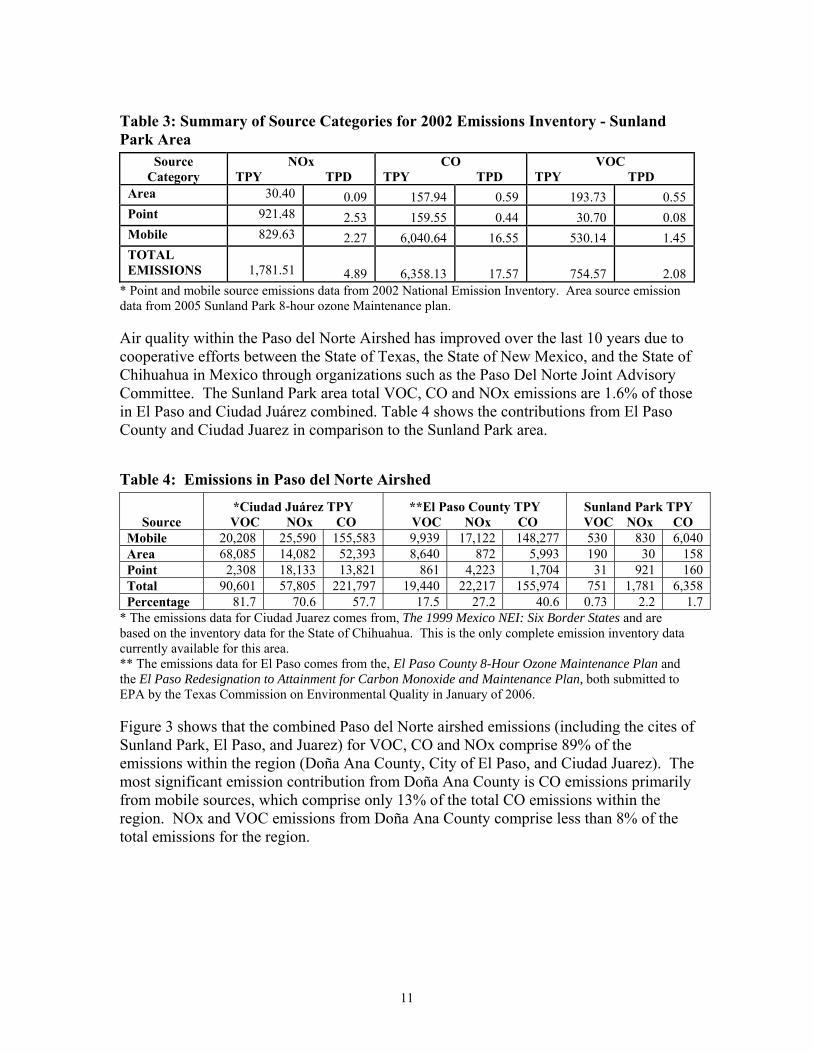
11
Table 3: Summary of Source Categories for 2002 Emissions Inventory - Sunland Park Area
Source Category
NOx TPY TPD
CO TPY TPD
VOC TPY TPD
Area 30.40 0.09 157.94 0.59 193.73 0.55 Point 921.48 2.53 159.55 0.44 30.70 0.08 Mobile 829.63 2.27 6,040.64 16.55 530.14 1.45 TOTAL EMISSIONS 1,781.51 4.89 6,358.13 17.57 754.57 2.08
* Point and mobile source emissions data from 2002 National Emission Inventory. Area source emission data from 2005 Sunland Park 8-hour ozone Maintenance plan. Air quality within the Paso del Norte Airshed has improved over the last 10 years due to cooperative efforts between the State of Texas, the State of New Mexico, and the State of Chihuahua in Mexico through organizations such as the Paso Del Norte Joint Advisory Committee. The Sunland Park area total VOC, CO and NOx emissions are 1.6% of those in El Paso and Ciudad Juárez combined. Table 4 shows the contributions from El Paso County and Ciudad Juarez in comparison to the Sunland Park area.
Table 4: Emissions in Paso del Norte Airshed
Source *Ciudad Juárez TPY VOC NOx CO
**El Paso County TPY VOC NOx CO
Sunland Park TPY VOC NOx CO
Mobile 20,208 25,590 155,583 9,939 17,122 148,277 530 830 6,040 Area 68,085 14,082 52,393 8,640 872 5,993 190 30 158 Point 2,308 18,133 13,821 861 4,223 1,704 31 921 160 Total 90,601 57,805 221,797 19,440 22,217 155,974 751 1,781 6,358 Percentage 81.7 70.6 57.7 17.5 27.2 40.6 0.73 2.2 1.7
* The emissions data for Ciudad Juarez comes from, The 1999 Mexico NEI: Six Border States and are based on the inventory data for the State of Chihuahua. This is the only complete emission inventory data currently available for this area. ** The emissions data for El Paso comes from the, El Paso County 8-Hour Ozone Maintenance Plan and the El Paso Redesignation to Attainment for Carbon Monoxide and Maintenance Plan, both submitted to EPA by the Texas Commission on Environmental Quality in January of 2006. Figure 3 shows that the combined Paso del Norte airshed emissions (including the cites of Sunland Park, El Paso, and Juarez) for VOC, CO and NOx comprise 89% of the emissions within the region (Doña Ana County, City of El Paso, and Ciudad Juarez). The most significant emission contribution from Doña Ana County is CO emissions primarily from mobile sources, which comprise only 13% of the total CO emissions within the region. NOx and VOC emissions from Doña Ana County comprise less than 8% of the total emissions for the region.
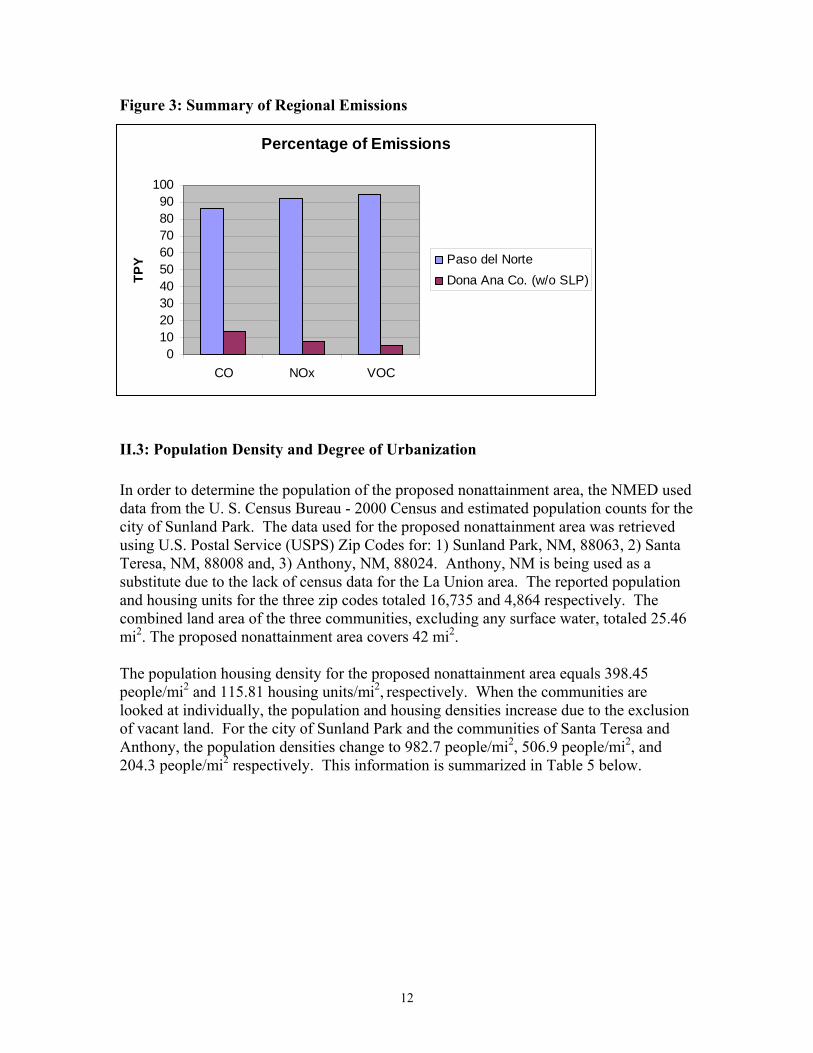
12
Percentage of Emissions
0102030405060708090
100
CO NOx VOC
TP
Y Paso del Norte
Dona Ana Co. (w/o SLP)
Figure 3: Summary of Regional Emissions
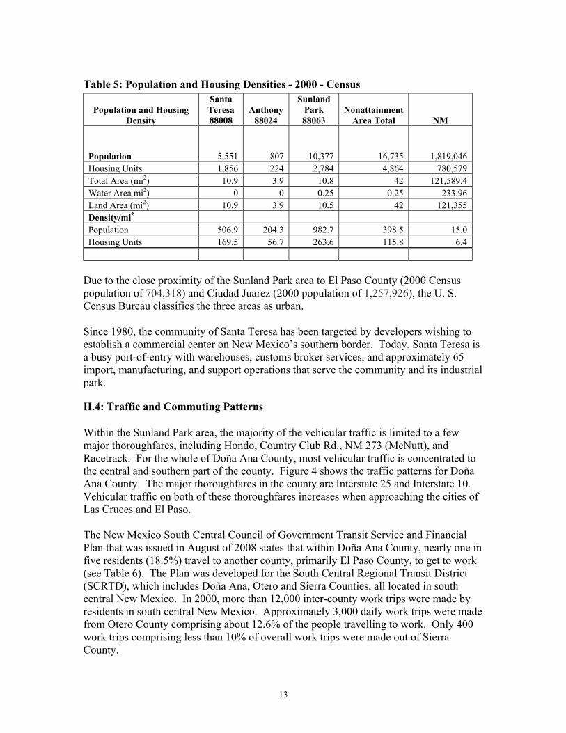
II.3: Population Density and Degree of Urbanization
In order to determine the population of the proposed nonattainment area, the NMED used data from the U. S. Census Bureau - 2000 Census and estimated population counts for the city of Sunland Park. The data used for the proposed nonattainment area was retrieved using U.S. Postal Service (USPS) Zip Codes for: 1) Sunland Park, NM, 88063, 2) Santa Teresa, NM, 88008 and, 3) Anthony, NM, 88024. Anthony, NM is being used as a substitute due to the lack of census data for the La Union area. The reported population and housing units for the three zip codes totaled 16,735 and 4,864 respectively. The combined land area of the three communities, excluding any surface water, totaled 25.46 mi2. The proposed nonattainment area covers 42 mi2. The population housing density for the proposed nonattainment area equals 398.45 people/mi2 and 115.81 housing units/mi2, respectively. When the communities are looked at individually, the population and housing densities increase due to the exclusion of vacant land. For the city of Sunland Park and the communities of Santa Teresa and Anthony, the population densities change to 982.7 people/mi2, 506.9 people/mi2, and 204.3 people/mi2 respectively. This information is summarized in Table 5 below.
13
Table 5: Population and Housing Densities - 2000 - Census
Population and Housing Density
Santa Teresa 88008
Anthony 88024
Sunland Park 88063
Nonattainment Area Total NM
Population 5,551 807 10,377 16,735 1,819,046 Housing Units 1,856 224 2,784 4,864 780,579 Total Area (mi2) 10.9 3.9 10.8 42 121,589.4 Water Area mi2) 0 0 0.25 0.25 233.96 Land Area (mi2) 10.9 3.9 10.5 42 121,355 Density/mi2 Population 506.9 204.3 982.7 398.5 15.0 Housing Units 169.5 56.7 263.6 115.8 6.4
Due to the close proximity of the Sunland Park area to El Paso County (2000 Census population of 704,318) and Ciudad Juarez (2000 population of 1,257,926), the U. S. Census Bureau classifies the three areas as urban. Since 1980, the community of Santa Teresa has been targeted by developers wishing to establish a commercial center on New Mexico’s southern border. Today, Santa Teresa is a busy port-of-entry with warehouses, customs broker services, and approximately 65 import, manufacturing, and support operations that serve the community and its industrial park.
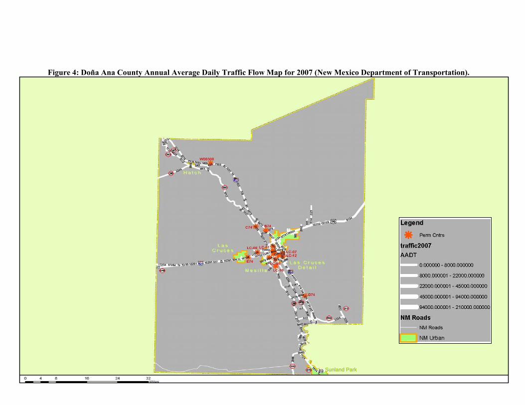
II.4: Traffic and Commuting Patterns Within the Sunland Park area, the majority of the vehicular traffic is limited to a few major thoroughfares, including Hondo, Country Club Rd., NM 273 (McNutt), and Racetrack. For the whole of Doña Ana County, most vehicular traffic is concentrated to the central and southern part of the county. Figure 4 shows the traffic patterns for Doña Ana County. The major thoroughfares in the county are Interstate 25 and Interstate 10. Vehicular traffic on both of these thoroughfares increases when approaching the cities of Las Cruces and El Paso. The New Mexico South Central Council of Government Transit Service and Financial Plan that was issued in August of 2008 states that within Doña Ana County, nearly one in five residents (18.5%) travel to another county, primarily El Paso County, to get to work (see Table 6). The Plan was developed for the South Central Regional Transit District (SCRTD), which includes Doña Ana, Otero and Sierra Counties, all located in south central New Mexico. In 2000, more than 12,000 inter-county work trips were made by residents in south central New Mexico. Approximately 3,000 daily work trips were made from Otero County comprising about 12.6% of the people travelling to work. Only 400 work trips comprising less than 10% of overall work trips were made out of Sierra County.
14
Table 6: Travel Patterns to Work by County for 2000
The Plan also indicates that more than 56% of all inter-county work trips in SCRTD originate in Doña Ana County with a final destination of El Paso County (see Table 7). Trips originating in El Paso County with a destination of Doña Ana County comprise nearly 25% of all inter-county work trips. More than 80% of the work trips in the SCRTD region occur between Doña Ana County and El Paso County. Another 11% of the work trips are comprised of trips originating in Otero County with destinations of either El Paso County or Doña Ana County. Inter-county trips between Otero and Lincoln Counties comprise another 4% of total inter-county trips.
Table 7: Inter-County Work Trips for 2000 County Trip/Origin-Destination Count Percent of Total
Doña Ana - El Paso 10,446 55.85% El Paso - Doña Ana 4,674 24.99% Otero - El Paso 1,176 6.29% Otero - Doña Ana 882 4.72% Otero - Lincoln 419 2.24% Doña Ana - Sierra 347 1.86% Doña Ana - Otero 231 1.24% Sierra - Doña Ana 203 1.09% El Paso - Otero 163 0.87%
County Total Workers Work in County of
Residence Percent Doña Ana County 66,761 54,431 81.5% Otero County 24,896 21,769 87.4% Sierra County 4,362 3,956 90.7% El Paso County 244,464 232,843 95.2% Total 348,820 320,391 91.8%
15
Figure 4: Doña Ana County Annual Average Daily Traffic Flow Map for 2007 (New Mexico Department of Transportation).
SSuunnllaanndd PPaarrkk SSuunnllaanndd PPaarrkk
16
Historical and Projected Population Growth for Paso del Norte Airshed
0
500,000
1,000,000
1,500,000
2,000,000
2,500,000
3,000,000
3,500,000
1950
1960
1970
1980
1990
2000
2010
2020
2030
Po
pu
lati
on Sunland Park
Dona Ana County
El Paso County
Ciudad Juarez
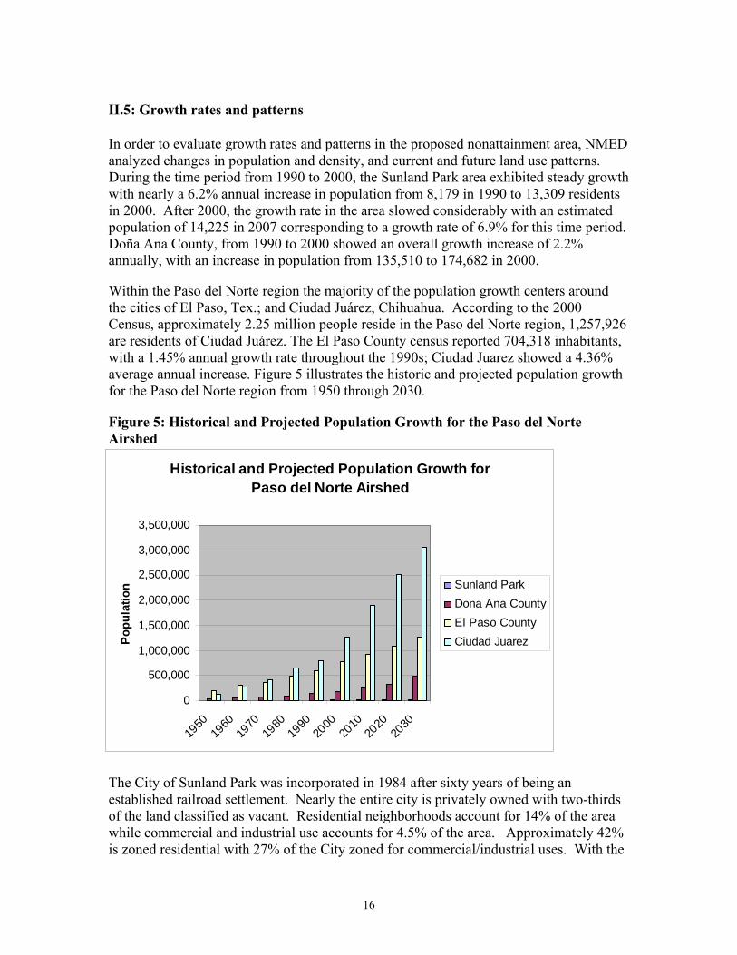
II.5: Growth rates and patterns In order to evaluate growth rates and patterns in the proposed nonattainment area, NMED analyzed changes in population and density, and current and future land use patterns. During the time period from 1990 to 2000, the Sunland Park area exhibited steady growth with nearly a 6.2% annual increase in population from 8,179 in 1990 to 13,309 residents in 2000. After 2000, the growth rate in the area slowed considerably with an estimated population of 14,225 in 2007 corresponding to a growth rate of 6.9% for this time period. Doña Ana County, from 1990 to 2000 showed an overall growth increase of 2.2% annually, with an increase in population from 135,510 to 174,682 in 2000. Within the Paso del Norte region the majority of the population growth centers around the cities of El Paso, Tex.; and Ciudad Juárez, Chihuahua. According to the 2000 Census, approximately 2.25 million people reside in the Paso del Norte region, 1,257,926 are residents of Ciudad Juárez. The El Paso County census reported 704,318 inhabitants, with a 1.45% annual growth rate throughout the 1990s; Ciudad Juarez showed a 4.36% average annual increase. Figure 5 illustrates the historic and projected population growth for the Paso del Norte region from 1950 through 2030.
Figure 5: Historical and Projected Population Growth for the Paso del Norte Airshed
The City of Sunland Park was incorporated in 1984 after sixty years of being an established railroad settlement. Nearly the entire city is privately owned with two-thirds of the land classified as vacant. Residential neighborhoods account for 14% of the area while commercial and industrial use accounts for 4.5% of the area. Approximately 42% is zoned residential with 27% of the City zoned for commercial/industrial uses. With the
17
close proximity to the large and fast growing City of El Paso, Sunland Park may have a high demand for development in the future. Based on existing zoning, Sunland Park currently has vacant land to accommodate over 7,000 residential units (28,000 people based on average household size), 4.9 million square feet of commercial development and 5.2 million square feet of industrial development. To the north of the City of Sunland Park and Santa Teresa, historic and current agricultural land uses predominate in the area with no foreseeable changes in the future. To the west and north of Sunland Park, Doña Ana County has two dedicated sites zoned for industrial use, dubbed as Foreign Trade Zones. The first site is south of the Santa Teresa airport and is a mix of county and privately owned property equaling approximately 897 acres of land. The second site is located near the Santa Teresa Port of Entry on the international border with Mexico and encompasses approximately 304 acres of land.
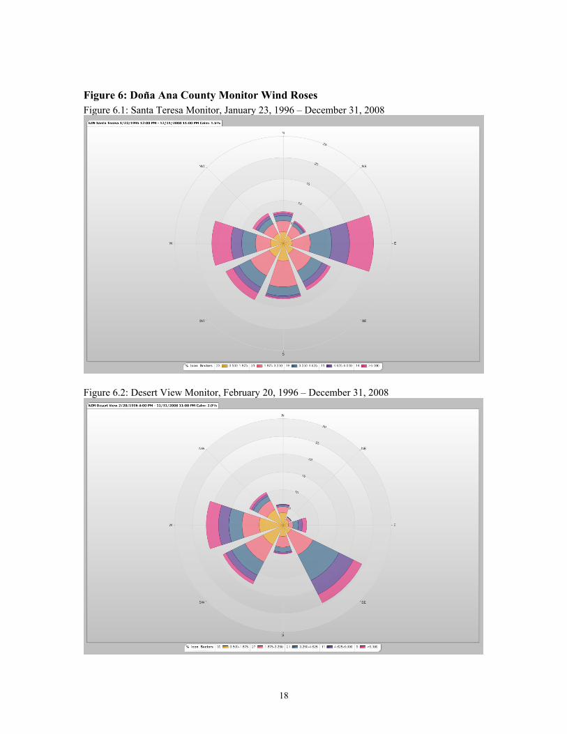
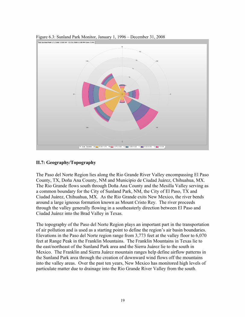
II.6: Meteorology The NMED has maintained design-value monitors that comply with federal regulations at each of its 6 monitoring sites in the Sunland Park area and has quality assured data since 1996. To determine the predominant wind patterns in the area, NMED used data from 1996 through 2008 to create wind rose charts. The Sunland Park area is surrounded on the northeast, east, southeast, south and southwest by the cities of El Paso, TX and Ciudad Juárez, Chihuahua, MX. The Sunland Park area, City of El Paso, and Ciudad Juarez are all part of the Paso del Norte airshed. The charts below (Figures 6.1 - 6.3) indicate that the wind flows from these directions nearly 55 percent of the time. The data also indicate that winds blow from the west approximately 22 percent of time.
18
Figure 6: Dona Ana County Monitor Wind Roses Figure 6.1: Santa Teresa Monitor, January 23, 1996 – December 31, 2008
Figure 6.2: Desert View Monitor, February 20, 1996 – December 31, 2008
19
Figure 6.3: Sunland Park Monitor, January 1, 1996 – December 31, 2008
II.7: Geography/Topography
The Paso del Norte Region lies along the Rio Grande River Valley encompassing El Paso County, TX, Doña Ana County, NM and Municipio de Ciudad Juárez, Chihuahua, MX. The Rio Grande flows south through Doña Ana County and the Mesilla Valley serving as a common boundary for the City of Sunland Park, NM, the City of El Paso, TX and Ciudad Juárez, Chihuahua, MX. As the Rio Grande exits New Mexico, the river bends around a large igneous formation known as Mount Cristo Rey. The river proceeds through the valley generally flowing in a southeasterly direction between El Paso and Ciudad Juárez into the Brad Valley in Texas. The topography of the Paso del Norte Region plays an important part in the transportation of air pollution and is used as a starting point to define the region’s air basin boundaries. Elevations in the Paso del Norte region range from 3,773 feet at the valley floor to 6,070 feet at Range Peak in the Franklin Mountains. The Franklin Mountains in Texas lie to the east/northeast of the Sunland Park area and the Sierra Juárez lie to the south in Mexico. The Franklin and Sierra Juárez mountain ranges help define airflow patterns in the Sunland Park area through the creation of downward wind flows off the mountains into the valley areas. Over the past ten years, New Mexico has monitored high levels of particulate matter due to drainage into the Rio Grande River Valley from the south.
20
II.8: Jurisdictional boundaries
The Paso del Norte region is a unique bi-national, tri-state community with shared air pollution problems. The Paso del Norte Air Basin is defined as El Paso County, TX, and portions of Doña Ana County, NM and Ciudad Juárez, Chihuahua. Within the state of New Mexico, the NMED holds jurisdictional authority to implement and enforce state and federal regulations pertaining to air quality with the exception of Bernalillo County in central New Mexico and tribal lands. No tribal lands exist within Doña Ana County. Transportation planning and programming for the southern portion of Doña Ana County falls under the jurisdiction of the El Paso MPO. The planning boundary for the MPO covers much of the Paso del Norte airshed in the United States. For past and present nonattainment areas in the southern portion of Doña Ana County, the El Paso MPO has been the responsible agency for transportation conformity planning.
II.9: Level of Control of Emissions Sources
II.9.1: Camino Real Landfill
In August of 2000, the Camino Real landfill installed a gas collection and control system (GCCS), which significantly reduced their VOC emissions by greater than 99%. The GCCS consists of 36 vertical extraction wells and buried transmission piping to collect and convey landfill gas to a utility flare for destruction. Destruction of landfill gas is achieved by routing collected gas to a blower/flare assembly via a blower-induced vacuum.
In 2006, the landfill installed landfill gas (LFG) scrubbers and Miratech IQ-34-18-H1 oxidation catalysts on the exhaust of the facility’s two permitted LFG fired internal combustion engines. The installation of the scrubbers and oxidation catalysts reduced CO emissions by 90% and VOC emissions by 76%.
II.9.2: Other Major Sources
Within the Sunland Park area, there is only one other major source (El Paso Electric, Rio Grande Generating Station) which does not control NOX, VOC, or CO emissions. Outside of the Sunland Park area, there is also a flexible polyurethane foam manufacturer which is currently a major source of hazardous air pollutants, but has been a major source of VOCs in the past.
II.9.3: Volatile Organic Compounds
20.2.88 NMAC Emission Standards for New Motor Vehicles (also referred to as the Clean Cars Rule) requires that new passenger cars, light-duty trucks, or medium-duty passenger vehicles, or medium-duty vehicles be certified to the California standards, starting with model year 2011. This rule will reduce the amount of non-methane organic gases (of which VOCs are a subset) emitted from these mobile sources. The following federal rules contain performance or emission standards for VOCs that may apply to sources within the Sunland Park area:
21
NSPS Subpart JJJ- Standards of Performance for Petroleum Dry Cleaners. NSPS Subpart WWW- Standards of Performance for Municipal Solid Waste
Landfills. NSPS Subpart JJJJ - Standards of Performance for Stationary Spark Ignition
Internal Combustion Engines. NESHAP Subpart H - National Emission Standards for Organic Hazardous
Pollutants for Equipment Leaks NESHAP Subpart M - National Perchloroethylene Air Emissions Standards for Dry
Cleaning Facilities NESHAP Subpart R - National Emission Standards for Gasoline Distribution
Facilities (Bulk Gasoline Terminals and Pipeline Breakout Stations). NESHAP Subpart HHH- National Emissions Standards for Hazardous Air
Pollutants from Natural Gas Transmission and Storage Facilities. NESHAP Subpart YYYY- National Emissions Standards for Hazardous Air
Pollutants for Stationary Combustion Turbines NESHAP ZZZZ- National Emissions Standards for Hazardous Air Pollutants for
Stationary Reciprocating Internal Combustion Engines NESHAP Subpart DDDDD- National Emissions Standards for Hazardous Air
Pollutants for Industrial, Commercial, and Institutional Boilers and Process Heaters NESHAP Subpart CCCCCC- National Emissions Standards for Hazardous Air
Pollutants for Source Category: Gasoline Dispensing Facilities NESHAP Subpart HHHHHH - National Emissions Standards for Hazardous Air
Pollutants: Paint Stripping and Miscellaneous Surface Coating Operations at Area Sources
NESHAP Subpart XXXXXX- National Emissions Standards for Hazardous Air Pollutants Area Source Standards for Nine Metal Fabrication and Finishing Source Categories
II.9.4: Nitrogen Dioxide
20.2.3 NMAC- Ambient Air Quality Standards establishes ambient air quality standards for those areas under NMED’s jurisdiction. The standard for nitrogen dioxide (NO2) is 0.10 ppm as a 24-hour average, and 0.05 ppm as an annual arithmetic average. The annual average is more stringent than the NAAQS for NO2 of 0.053 ppm. All facilities that are required to obtain a New Source Review (NSR) permit under 20.2.72 NMAC or a Title V permit under 20.2.70 NMAC must demonstrate compliance with the State’s air quality standard before a permit can be issued. 20.2.32 NMAC Coal Burning Equipment - Nitrogen Dioxide specifies nitrogen dioxide emission standards for coal burning equipment. The limit (pounds/MMBtu heat input) varies depending on when construction of the equipment was completed and it became fully operational. There are no sources located in the Sunland Park area that are subject to this rule.
22
20.2.33 NMAC Gas Burning Equipment - Nitrogen Dioxide specifies nitrogen dioxide emission standards for new and existing gas burning equipment having a heat input greater than 1,000,000 million Btu per year. There is one source located in the Sunland Park area that is subject to this rule. 20.2.34 NMAC Oil Burning Equipment - Nitrogen Dioxide specifies nitrogen dioxide emission standards for oil burning equipment having a heat input greater than 1,000,000 million Btu per year. There are no sources located in the Sunland Park area that are subject to this rule. 20.2.88 NMAC Emission Standards for New Motor Vehicles requires that new passenger cars, light-duty trucks, or medium-duty passenger vehicles, or medium-duty vehicles be certified to the California standards, starting with model year 2011. This rule will reduce the amount of nitrogen oxides emitted from these mobile sources. There are no other state rules that require control of NOx emissions, except for permitting rules that require sources to meet state and national ambient air quality standards. The following federal rules contain performance or emission standards for NOX that may apply to sources within the Sunland Park area: NSPS Subpart D- Standards of Performance for Fossil-Fuel-Fired Steam Generators for which Construction is Commenced after August 17, 1971. NSPS Subpart Da - Standards of Performance for Electric Utility Steam Generating Units for which Construction is Commenced after September 18, 1978. NSPS Subpart Db - Standards of Performance for Industrial-Commercial-Institutional Steam Generating Units NSPS Subpart Dc- Standards of Performance for Small Industrial-Commercial-Institutional Steam Generating Units NSPS Subpart IIII - Standards of Performance for Stationary Compression Ignition Internal Combustion Engines NSPS Subpart JJJJ- Standards of Performance for Stationary Spark Ignition Internal Combustion Engines
II.9.5: Carbon Monoxide
20.2.3 NMAC- Ambient Air Quality Standards establishes ambient air quality standards for those areas under NMED’s jurisdiction. The standard for carbon monoxide (CO) is 8.7 ppm as an 8-hour average, and 13.1 ppm as a 1-hour average. Both of the standards are more stringent than the NAAQS for CO, 9 ppm (8-hour average) and 35 ppm (1-hour average). All facilities that are required to obtain a New Source Review (NSR) permit under 20.2.72 NMAC or a Title V permit under 20.2.70 NMAC must demonstrate compliance with the State’s air quality standard before a permit can be issued.
23
20.2.37 NMAC- Petroleum Processing Facilities specifies CO standards for existing and new petroleum processing facilities. There are no petroleum processing facilities in the Sunland Park area 20.2.62 NMAC- Municipal Waste Combustion contains emission limits for CO. There is one municipal waste combustor in the Sunland Park area. 20.2.63 NMAC- Biomedical Waste Combustion contains emission limits for CO. There are no biomedical waste combustors in the Sunland Park area. 20.2.88 NMAC- Emission Standards for New Motor Vehicles requires that new passenger cars, light-duty trucks, or medium-duty passenger vehicles, or medium-duty vehicles be certified to the California standards, starting with model year 2011. This rule will reduce the amount of carbon monoxide emitted from these mobile sources. The following federal rules contain performance or emission standards for CO that may apply to sources within the Sunland Park area: NSPS Subpart CCCC- Standards of Performance for Commercial and Industrial
Solid Waste Incineration Units for which Construction is Commenced after November 30, 1999 or for which Modification or Reconstruction is Commenced on or after June 1, 2001.
NSPS Subpart EEEE- Standards of Performance for Other Solid Waste Incineration Units for which Construction is Commenced after December 9, 2004, or for which Modification or Reconstruction is Commenced on or after June 16, 2006.
NSPS Subpart IIII- Standards of Performance for Stationary Compression Ignition Internal Combustion Engines.
NSPS Subpart JJJJ- Standards of Performance for Stationary Spark Ignition Internal Combustion Engines
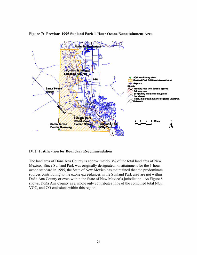
III: Boundary Recommendation - Sunland Park Area The State of New Mexico is recommending the same nonattainment boundary for the Sunland Park area as the 1-hour nonattainment boundary approved by EPA (60 FR 30789) in 1995 (Appendix D). This nonattainment area boundary is approximately 42 mi2 in area (see Figure 7). The northern portion extends from the north boundary at latitude 32 00' south to about latitude 31 49'. The area is roughly 3.5 miles in width by 6.25 miles in height for a total of 21.9 mi2. The southern portion extends from 31 49' south to the Mexico border and is about 8 miles by 2.5 mi. for a total of 20.0 mi2. This 42 mi2 area represents 1.10% of the total county area. The nonattainment boundary area includes the communities, from south to north, of Sunland Park, Santa Teresa, and La Union. This nonattainment boundary area does not include the Santa Teresa border crossing. Although the U. S. Census Bureau categorizes the Paso del Norte airshed as urban, the Sunland Park area is largely rural with a small population and is primarily agricultural along the Rio Grande, especially north of Santa Teresa.
24
Figure 7: Previous 1995 Sunland Park 1-Hour Ozone Nonattainment Area
IV.1: Justification for Boundary Recommendation
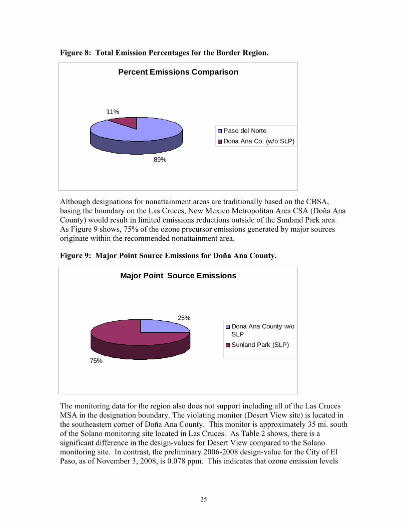
The land area of Doña Ana County is approximately 3% of the total land area of New Mexico. Since Sunland Park was originally designated nonattainment for the 1-hour ozone standard in 1995, the State of New Mexico has maintained that the predominate sources contributing to the ozone exceedances in the Sunland Park area are not within Doña Ana County or even within the State of New Mexico’s jurisdiction. As Figure 8 shows, Doña Ana County as a whole only contributes 11% of the combined total NOX, VOC, and CO emissions within this region.
25
Percent Emissions Comparison
89%
11%
Paso del Norte
Dona Ana Co. (w/o SLP)
Major Point Source Emissions
25%
75%
Dona Ana County w/oSLP
Sunland Park (SLP)
Figure 8: Total Emission Percentages for the Border Region.
Although designations for nonattainment areas are traditionally based on the CBSA, basing the boundary on the Las Cruces, New Mexico Metropolitan Area CSA (Doña Ana County) would result in limited emissions reductions outside of the Sunland Park area. As Figure 9 shows, 75% of the ozone precursor emissions generated by major sources originate within the recommended nonattainment area.
Figure 9: Major Point Source Emissions for Doña Ana County.
The monitoring data for the region also does not support including all of the Las Cruces MSA in the designation boundary. The violating monitor (Desert View site) is located in the southeastern corner of Doña Ana County. This monitor is approximately 35 mi. south of the Solano monitoring site located in Las Cruces. As Table 2 shows, there is a significant difference in the design-values for Desert View compared to the Solano monitoring site. In contrast, the preliminary 2006-2008 design-value for the City of El Paso, as of November 3, 2008, is 0.078 ppm. This indicates that ozone emission levels
26
monitored within the Sunland Park area are more indicative of the levels monitored in the City of El Paso than with the levels recorded to the north of the Sunland Park area. The Paso del Norte Airshed is located in a region characterized by high mountain ranges and low river valleys. The Sunland Park area is located at one of the lowest points within the Rio Grande river valley with prevailing winds from the southeast. Based on the terrain, prevailing winds, and close proximity to two major metropolitan areas (El Paso and Ciudad Juarez), it is evident that the violation monitored in Sunland Park is not the result of New Mexico sources outside of the Sunland Park area.

Appendix A

Appendix B
Appendix B: NMED Ozone Monitoring Data - 2006 through 2008 Year (4th highest measured ppm)
County Site Name AQS# 2006 (ppm) 2007
(ppm) 2008
(ppm)
3-Year Avg. 2006-2008
(ppm) Design-
Value (ppm) 6O - La Union 35-013-0008 0.072 0.068 0.071 0.070 0.070 6ZG - SPCY 35-013-0017 0.073 0.070 0.065 0.069 0.069 6ZK - Chaparral 35-013-0020 0.072 0.068 0.067 0.069 0.069 6ZM - Desert View 35-013-0021 0.080 0.076 0.074 0.076 0.076 6ZN - Santa Teresa 35-013-0022 0.073 0.073 0.072 0.072 0.072
Doña Ana County 6ZQ - Solano 35-013-0023 0.070 0.062 0.065 0.065 0.065 Eddy County 5ZR - Carlsbad 35-015-1005 0.076 0.066 0.067 0.069 0.069 Grant County 7T - Hurley Smelter 35-017-1003 0.067 0.062 0.064 0.064 0.064 Lea County 5ZS - Hobbs 35-025-0008 0.075 0.064 0.067 0.068 0.068 Luna County 7E - Deming 35-029-0003 0.053 0.062 0.060 0.058 0.058
2ZJ - Bernalillo 35-043-1001 0.064 0.063 0.057 0.061 0.061 Sandoval County 2ZR - Rio Rancho 35-043-1003 0.074 0.071 0.065 0.070 0.070
1ZB - Bloomfield 35-045-0009 0.063 0.069 0.063 0.065 0.065 1NL - Navajo Lake 35-045-0018 0.079 0.079 0.069 0.075 0.075
San Juan County 1H - Substation 35-045-1005 0.071 0.073 0.069 0.071 0.071 Santa Fe County 3SFA - Santa Fe Airport 35-049-0021 ### 0.063 0.066 n/a n/a Bold – exceeds NAAQS

Appendix C
Southern Doña Ana County, NM Major Source Index
El Paso, Texas Major Source Index
2002 Emissions (TPY)
ID Latitide Longitude Facility Name NOx VOC CO
1 31.8169 -106.4144 USAADA 184 51 135
2 31.7592 -106.375 El Paso Electric Newman Station 1492 110 442
3 31.965 -106.5839 Border Steel 87 4 216
4 31.7673 -106.4028 Western Refining El Paso Refining 488 302 199
5 31.7638 -106.3883 Phelps Dodge El Paso Plant 65 16 207
6 31.9695 -106.3982 El Paso Natural Gas Compressor Station 239 2 37
2002 Emissions (TPY)
ID Latitide Longitude NM Facility Name NOx VOC CO
1 31.805556 -106.545306 El Paso Electric - Rio Grande Generating Station 912 25 145
2 31.789408 -106.594775 Camino Real Landfill 2 1 12
3 36.699678 -107.974211 Foamex - Santa Teresa Plant 10 54 16

Appendix D
Designation of Area for Air Quality Planning Purposes; New Mexico; Designation of Sunland Park Ozone Nonattainment Area
[Federal Register: June 12, 1995 (Volume 60, Number 112)] [Rules and Regulations] [Page 30789-30791] From the Federal Register Online via GPO Access [wais.access.gpo.gov]
ENVIRONMENTAL PROTECTION AGENCY 40 CFR Part 81 [NM-25-1-6980; FRL-5218-1] Designation of Area for Air Quality Planning Purposes; New Mexico; Designation of Sunland Park Ozone Nonattainment Area AGENCY: Environmental Protection Agency (EPA). ACTION: Final rule.
SUMMARY: Pursuant to section 107(d)(3) of the Clean Air Act (CAA), the EPA is taking final action to redesignate a portion of Dona Ana County, New Mexico (i.e. the Sunland Park area) from unclassifiable/attainment to nonattainment for the ozone National Ambient Air Quality Standards (NAAQS). The redesignation is based upon violations of the ozone NAAQS which were monitored from 1992-1994. EFFECTIVE DATE: July 12, 1995. ADDRESSES: Copies of the documents relevant to this action are available for public inspection during normal business hours at the addresses listed below. The interested persons wanting to examine these documents should make an appointment at least twenty-four hours before the visiting day. U.S. Environmental Protection Agency, Region 6, Air Programs Branch (6T-A), 1445 Ross Avenue, suite 700, Dallas, Texas 75202-2733 New Mexico Environment Department, Air Monitoring & Control Strategy Bureau, 1190 St. Francis Drive, room So. 2100, Santa Fe, New Mexico 87503 FOR FURTHER INFORMATION CONTACT: Mr. Mark Sather, Planning Section (6TAP), Air Programs Branch (6T-A), USEPA Region 6, 1445 Ross Avenue, Dallas, Texas 75202-2733, telephone (214) 665-7258. SUPPLEMENTARY INFORMATION:
Background The CAA authorizes the EPA to revise the designation of current ozone areas from unclassifiable/attainment to nonattainment on the basis of air quality data, planning and control considerations, or any other air quality-related considerations the EPA deems appropriate (see section 107(d)(3) of the CAA). Following the process outlined in section 107(d)(3) of the CAA, on December 16, 1994, the Regional Administrator of the EPA Region 6 notified the Governor of New Mexico that the EPA believed the Sunland Park area should be redesignated as nonattainment for ozone. Under section 107(d)(3)(B) of the CAA, the Governor of New Mexico was required to submit to the EPA the designation considered appropriate for the Sunland Park area within 120 days after the EPA's notification. The EPA received the State's response for the Sunland Park area on February 6, 1995 (letter dated January 30, 1995). Following receipt of the Governor's letter, the EPA proceeded to propose the nonattainment designation for the Sunland Park area (see 60 Federal Register (FR) 17756-17758, April 7, 1995). The EPA now is taking final action on the proposed nonattainment redesignation. Based upon the EPA's review of the State's January 30, 1995, letter for the Sunland Park area, the EPA is finalizing a redesignation to nonattainment which is consistent with the request submitted by the Governor of New Mexico. Section 107(d)(1)(A) of the CAA sets out definitions of nonattainment, attainment, and unclassifiable. A nonattainment area is defined as any area that does not meet (or that significantly contributes to ambient air quality in a nearby area that does not meet) the national primary or secondary ambient air quality standard for ozone (see section 107(d)(1)(A)(i) of the [[Page 30790]] CAA) <SUP>1. Thus, in determining the appropriate boundaries for the nonattainment area finalized in this action, the EPA has considered not only the area where the violations of the ozone NAAQS are occurring, but nearby areas which significantly contribute to such violations. \1\ The EPA has construed the definition of nonattainment area to require some material or significant contribution to a violation in a nearby area. The Agency believes it is reasonable to conclude that something greater than a molecular impact is required.
Response to Public Comments In the April 7, 1995, proposal FR action, the EPA requested public comments on all aspects of the proposal, including the appropriateness of the proposed designation and the scope of the proposed boundaries. The EPA received no comments on the proposal FR action. Final Action As noted above, pursuant to section 107(d)(3) of the CAA, the EPA is authorized to initiate the redesignation of areas as nonattainment for ozone. Based on the ozone air quality monitoring data for the Sunland Park monitoring station, the EPA notified the Governor of New
Mexico on December 16, 1994, that the Sunland Park area should be redesignated from unclassifiable/attainment to nonattainment for the ozone NAAQS. Ozone monitoring began in Sunland Park on June 15, 1992. Seven measured exceedances of the ozone NAAQS have been recorded at the monitoring site, ranging from a low of .126 parts per million (ppm) to a high of .140 ppm. The seven exceedances represent a violation of the ozone NAAQS (see 40 Code of Federal Regulations (CFR) 50.9). Since less than three years of data have been collected at the Sunland Park monitoring site, the EPA design value (used to determine ozone attainment status) for the site is the third highest ozone value recorded--.136 ppm. Therefore, the Sunland Park ozone nonattainment area is classified as a marginal ozone nonattainment area according to the classification scheme set forth in section 181 of the CAA. Due to the marginal classification, the attainment date for the Sunland Park ozone nonattainment area will be three years from the effective date of this Federal Register final action establishing the nonattainment designation and classification. In response to the EPA's December 16, 1994, letter, on January 30, 1995, the Governor of New Mexico concurred with the EPA that a small area of southern Dona Ana County, including Sunland Park, be redesignated as nonattainment for the ozone NAAQS. However, the Governor did not concur with the proposed nonattainment boundaries in one respect, proposing an alternate western boundary for the nonattainment area. Based on the information provided by the Governor, including monitoring data, the EPA believes that the nonattainment boundaries submitted by the Governor are appropriate. The technical information supporting the redesignation request and the boundary selections are available for public review at the addresses indicated above. Significance of Final Action for the Sunland Park Area, New Mexico Within 24 months after the effective date of this final action on the nonattainment redesignation, New Mexico must submit an implementation plan for the Sunland Park ozone nonattainment area meeting the requirements of part D, title I of the CAA (see section 182(a) of the CAA). The CAA provides that the plan for the area must contain, among other things, the following items:
1. A comprehensive, accurate, current inventory of actual emissions from all sources, as described in section 172(c)(3) of the CAA, in accordance with guidance provided by the EPA. The pollutants inventoried must include volatile organic compounds (VOC), nitrogen oxides (NO<INF>X) and carbon monoxide. No later than the end of each three year period after submission of the initial inventory, until the area is redesignated to attainment, the State must submit a revised inventory meeting all EPA requirements (see section 182(a)(1) of the CAA).
2. Requirements that the owner or operator of each stationary source of NOx or VOC provide the State with a statement, in such form as the EPA may prescribe, for classes or categories of sources, showing the actual emissions of NOx and VOC from that source. The first such statement must be submitted to the State within three years after the effective date of this final action establishing the nonattainment designation. Subsequent statements shall be submitted at least every year thereafter. The statement shall contain a certification that the information contained in the statement is accurate to the best knowledge of the individual certifying the statement. The State may waive the emission statement requirement for any class or category of stationary sources which emits less than 25 tons per year of VOC or NOx, if the State, in its initial and periodic emission inventories, provides an inventory of emissions from such class or category of sources, based on the use of the emission factors established by the EPA, or other methods acceptable to the EPA (see section 182(a)(3)(B) of the CAA).
3. A revised nonattainment new source review permitting program meeting the requirements of sections 172(c)(5) and 173 of the CAA, including the requirement that the ratio of total emission reductions of VOC to total increased emissions of such air pollutant shall be at least 1.1 to 1 (see section 182(a)(4) of the CAA).
4. Revised conformity rules (Regulations 20 NMAC 2.98 and 20 NMAC 2.99) if necessary (see sections 176 and 182 of the CAA).
Miscellaneous
Under the Regulatory Flexibility Act, 5 U.S.C. 600 et seq., the EPA must prepare a regulatory flexibility analysis assessing the impact of any proposed or final rule on small entities (5 U.S.C. 603 and 604). Alternatively, the EPA may certify that the rule will not have a significant impact on a substantial number of small entities. Small entities include small businesses, small not-for-profit enterprises, and government entities with jurisdiction over populations of less than 50,000.
Redesignation of an area to nonattainment under section 107(d)(3) of the CAA does not impose any new requirements on small entities. Redesignation is an action that affects the planning status of a geographical area and does not, in itself, impose any regulatory requirements on sources. To the extent that the area must adopt new regulations, based on its nonattainment status, the EPA will review, as appropriate, the effect of those actions on small entities at the time the State submits those regulations. I certify that approval of the redesignation request will not affect a substantial number of small entities.
Under section 307(b)(1) of the CAA, petitions for judicial review of this action must be filed in the United States Court of Appeals for the appropriate circuit by August 11, 1995. Filing a petition for reconsideration by the Administrator of this final rule does not
affect the finality of this rule for the purposes of judicial review nor does it extend the time within which a petition for judicial review may be filed, and shall not postpone the effectiveness of such rule or action. This action may not be challenged later in proceedings to enforce its requirements (see section 307(b)(2)). [[Page 30791]]
Executive Order
The Office of Management and Budget has exempted this action from review under Executive Order 12866.
List of Subjects in 40 CFR Part 81
Environmental protection, Air pollution control, National parks, Wilderness areas.
Dated: May 25, 1995.
Jane N. Saginaw, Regional Administrator.
40 CFR part 81 is amended as follows:
PART 81--[AMENDED]
1. The authority citation for part 81 continues to read as follows:
Authority: 42 U.S.C. 7401-7671q.
2. In Sec. 81.332 the ozone table is amended by revising the entry ``AQCR 153 El Paso-Las Cruces-Alamogordo'' to read as follows:
Sec. 81.332 New Mexico.
* * * *
New Mexico--Ozone
Designation Classification
Date \1\ Type Date \1\ Type
Cruces-Alamogordo.
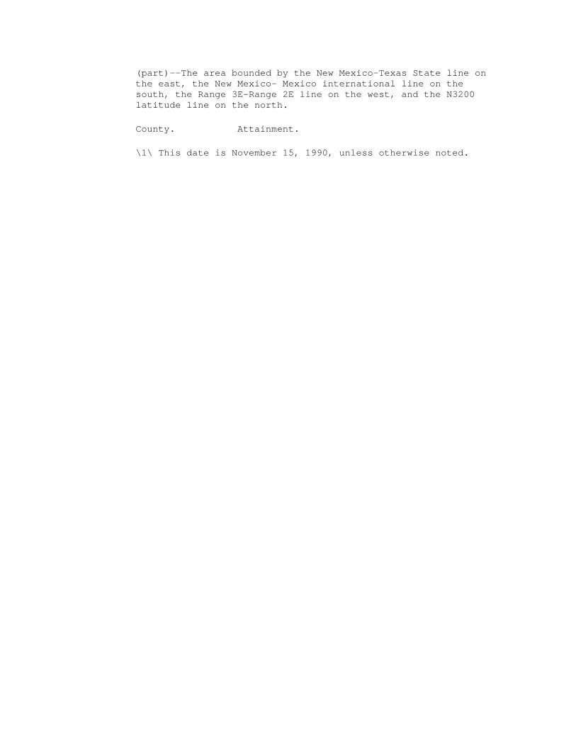
(part)--The area bounded by the New Mexico-Texas State line on the east, the New Mexico- Mexico international line on the south, the Range 3E-Range 2E line on the west, and the N3200 latitude line on the north.
County. Attainment.
\1\ This date is November 15, 1990, unless otherwise noted.