New Mexico Bureau of Mines & Mineral Resources · NEW MEXICO INSTITUTE OF MINING & TECHNOLOGY...
31
Transcript of New Mexico Bureau of Mines & Mineral Resources · NEW MEXICO INSTITUTE OF MINING & TECHNOLOGY...

New Mexico Bureau of Mines & Mineral Resources
A DIVISION OF NEW MEXICO INSTITUTE OF MINING & TECHNOLOGY
Geology of Garfield quadrangle, Sierra and Dona Ana Counties,
New Mexico
by William R. Seager and Greg H. Mack Department of Earth Sciences , New Mexico State Univers ity, Las Cruces , New Mexico 88003
SOCORRO 1991
11
NEW MEXICO INSTITUTE OF MINING & TECHNOLOGY Laurence H. Lattman, President
NEW MEXICO BUREAU OF MINES & MINERAL RESOURCES Charles E. Chapin, Director and State Geologist
BOARD OF REGENTS Ex Officio
Bruce King, Governor of New Mexico Alan Morgan, Superintendent of Public Instruction
Appointed Steve Torres, President, 1967-1997, Albuquerque
Carol A. Rymer, M.D., President-Designate, 1989-1995, Albuquerque Lt. Gen. Leo Marquez, Secretary/Treasurer, 1989-1995, Albuquerque
Robert 0. Anderson, 1987-1993, Roswell Charles Zimmerly, 1991-1997, Socorro
BUREAU STAFF Full Time
ORIN J. ANDERSON, Geologist ROBERT W. EVELETH, Senior Mining Engineer NORMA J. MEEKS, Senior Pub./Bus. Office Clerk RUBEN ARCHULETA, Metallurgical Lab. Tech. Lois GOLLMER, Staff Secretary BARBARA R. POPP, Chemical Lab. Tech. II AUGUSTUS K. ARMSTRONG, USGS Geologist IBRAHIM GUNDILER, Metallurgist MARSHALL A. REITER, Senior Geophysicist GEORGE S. AUSTIN, Senior Industrial Minerals Geologist WILLIAM C. HANEBERG, Engineering Geologist JACQUES R. RENAULT, Senior Geologist AL BACA, Maintenance Carpenter II JOHN W. HAWLEY, Senior Env. Geologist JAMES M. ROBERTSON, Senior Economic Geologist JAMES M. BARKER, Industrial Minerals Geologist CAROL A. HJELLMING, Assistant Editor JANETTE THOMAS, Cartographic Drafter II MARGARET W. BARROLL, Post-Doctoral Fellow GRETCHEN K. HOFFMAN, Coal Geologist SAMUEL THOMPSON III, Senior Petrol. Geologist PAUL W. BAUER, Field Economic Geologist GLEN JONES, Computer Scientist/Geologist REBECCA J. TITUS, Cartographic Supervisor ROBERT A. BIEBERMAN, Emeritus Sr. Petroleum Geologist FRANK E. KOTTLOWSKI, Emeritus Director and State Geologist JUDY M. VAIZA, Executive Secretary LYNN A. BRANDVOLD, Senior Chemist ANN LANNING, Administrative Secretary MANUEL J. VASQUEZ, Mechanic I RON BROADHEAD, Petrol. Geologist, Head, Petroleum Section ANNABELLE LOPEZ, Petroleum Records Clerk JEANNE M. VERPLOEGH, Chemical Lab. Tech. II MONTE M. BROWN, Cartographic Drafter II THERESA L. LOPEZ, Receptionist/Staff Secretary ROBERT H. WEBER, Emeritus Senior Geologist KATHRYN E. CAMPBELL, Cartographic Drafter II DAVID W. LOVE, Environmental Geologist SUSAN J. WELCH, Assistant Editor STEVEN M. CATTIER, Field Economic Geologist JANE A. CALVERT LOVE, Editor NEIL H. WHTTEHEAD, III, Petroleum Geologist RICHARD CHAMBERLIN, Field Economic Geologist WILLIAM MCINTOSH, Research Geologist MARC L. WILSON, Mineralogist RICHARD R. CHAVEZ, Assistant Head, Petroleum Section CHRISTOPHER G. McKEE, X-ray Facility Manager DONALD WOLBERG, Vertebrate Paleontologist RUBEN A. CRESPIN, Garage Supervisor VIRGINIA MCLEMORE, Geologist MICHAEL W. WOOLDRIDGE, Scientific Illustrator Lois M. DEVLIN, Director, Bus./Pub. Office LYNNE McNEIL, Technical Secretary JIRI ZIDEK, Chief Editor—Geologist
Research Associates CHRISTINA L. BALK, NMT ALONZO D. JACKA, Texas Tech. HOWARD B. NICKELSON, Carlsbad WILLIAM L. CHENOWETH, Grand Junction, CO BOB JULYAN, Albuquerque GLENN R. OSBURN, Washington Univ. RUSSELL E. CLEMONS, NMSU SHARI A. KELLEY, SMU ALLAN R. SANFORD, NMT WILLIAM A. COBBAN, USGS WILLIAM E. KING, NMSU JoHN H. SCHILLING, Reno, NV CHARLES A. FERGUSON, Univ. Alberta MICHAEL J. KUNK, USGS WILLIAM R. SEAGER, NMSU JOHN W. GEISSMAN, UNM TIMOTHY F. LAWTON, NMSU EDWARD W. SMITH, Tesuque LELAND H. GILE, LAS Cruces DAVID V. LEMONE, UTEP JOHN F. SUTTER, USGS JEFFREY A. GRAMBLING, UNM GREG H. MACK, NMSU RICHARD H. TEDFORD, Amer. Mus. Nat. Hist. RICHARD W. HARRISON, Tor C NANCY J. MCMILLAN, NMSU Tommy B. THOMPSON, CSU CAROL A. HILL, Albuquerque
Graduate Students WILLIAM C. BECK ROBERT L. FRIESEN GARRETT K. Ross JENNIFER R. BORYTA ROBERT S. KING ERNEST F. SCHARKAN, JR. STEPHEN G. CROSS DAVID J. SIVILS
Plus about 30 undergraduate assistants
Original Printing
Published by Authority of State of New Mexico, NMSA 1953 Sec. 63-1-4 Printed by University of New Mexico Printing Services, June 1991 Available from New Mexico Bureau of Mines & Mineral Resources, Socorro, NM 87801 Published as public domain, therefore reproducible without permission. Source credit requested.
Contents
A B S T R A C T 5 INTRODUCTION 7
LOCATION AND ACCESS 7 PHYSICAL FEATURES 7 PREVIOUS WORK AND PRESENT STUDY 7
STRATIGRAPHY 8 PRECAMBRIAN ROCKS 8 PALEOZOIC ROCKS 8
Bliss Formation 8 El Paso Formation 9 Montoya Formation 10 Fusselman Dolomite 11 Percha Formation 11 Magdalena Group 11 A b o F o r m a t i o n 1 3 Yeso Formation 15
LOWER TERTIARY CONGLOMERATE 15 Love Ranch Formation 15 Palm Park Formation 15
UPPER TERTIARY AND LOWER QUATERNARY RIO GRANDE RIFT DEPOSITS15 Rincon Valley Formation 15 Palomas Formation 17
UPPER QUATERNARY VALLEY-FILL ALLUVIUM 19 Older valley-fill alluvium 19 Younger valley-fill alluvium 19
STRUCTURAL GEOLOGY 20 LARAMIDE STRUCTURE 20 LATE TERTIARY STRUCTURE 20
Red Hills fault 20 Derry Hills fault 21
ECONOMIC DEPOSITS 21 REFERENCES 22
Figures
1—Location map of Garfield quadrangle 6 2—Sandstones of the Bliss Formation 8 3—Intraclast grainstone of the Bliss Formation 9 4—View of the southern edge of the Red Hills 9 5—Bioturbated limestone of the El Paso Formation 10 6—Laminated dolomite with chert nodules, Aleman Member of Montoya
Formation 10 7-1-25 roadcut in the Derry Hills 11 8—Micrite limestone, Bar B Formation 12 9—Limestone- and chert-pebble conglomerate, Bar B Formation 13 10—Calcareous nodules and tubules (caliche) in red shale, Abo Formation 14 11—Paleogeographic map and restored cross sections of the Rio Grande uplift and
Love Ranch and Potrillo Basins 16 12—Map of Camp Rice fluvial deposits of the ancestral Rio Grande 18 13—View of southwest-verging thrust faults and overturned syncline in Derry Hills 20 14—Exposure of Red Hills fault 21
Sheets
1—Geologic map of Garfield quadrangle in pocket 2—Geologic cross sections and composite columnar section of Paleozoic, Tertiary, and
Quaternary rocks in Garfield quadrangle in pocket


5
Abstract The Garfield quadrangle is located along the Rio Grande in south-central New Mexico, approximately
40 km (25 mi) south of Truth or Consequences. Located in the Rio Grande rift, the quadrangle encompasses part of the Palomas Basin, as well as outlying fault blocks of the Caballo Mountains. Whereas the Rio Grande and its tributaries have sculpted the prevailingly fine-grained, soft sedimentary deposits of the Palomas Basin into badlands, the far more ancient and durable rocks of the Caballo Mountains have yielded more rugged topography, featuring deeply incised canyons, high peaks, impressive cliffs, and a succession of cuestas.
The fault blocks consist mostly of Precambrian granite and syenite, unconformably overlain by Paleozoic and lower Tertiary sedimentary strata. Totaling approximately 885 m (2,900 ft) in thickness, the exposed sedimentary section includes basal Bliss Formation (Cambrian and Ordovician; 33 m, 108 ft thick); El Paso Formation (Ordovician; 152 m, 499 ft thick); Montoya Formation (Ordovician; 116 m, 381 ft thick); Fusselman Dolomite (Silurian; 26 m, 85 ft thick); Percha Formation (Devonian; 19 m, 62 ft thick); Magdalena Group (Pennsylvanian; 277 m, 909 ft thick); Abo Formation (Permian; 141 m, 463 ft thick); Yeso Formation (Permian; 30 m, 100 ft thick); Love Ranch Formation (Eocene; 30 m, 100 ft thick); and Palm Park Formation (Eocene; 60 m, 200 ft thick). Cambrian through Pennsylvanian strata are almost entirely shallow marine in origin, consisting of limestone, sandstone, and shale. Much of the El Paso and virtually all of the Montoya and Fusselman Formations are dolomitized to such an extent that original textures and most fossil remains are obscured. Regional unconformities slightly truncate the top of the El Paso, Montoya, Fusselman, and Percha Formations. Uppermost Magdalena strata mark a transition to nonmarine conditions, and the overlying Abo and Yeso red beds are fluvial and eolian in origin, respectively.
An angular unconformity separates Paleozoic strata from lower to middle Tertiary Love Ranch and Palm Park clastics. The unconformity is a product of deformation and erosion of Paleozoic, Cretaceous, and Precambrian rocks during the Laramide orogeny, and the fanglomerates of the Love Ranch and Palm Park Formations document erosion deep into the basement rocks of Laramide uplifts. Southwest-verging, overturned folds and associated thrust faults, exposed in the Derry Hills, are structural elements of an uplifted Laramide block that extended across most of the southern Caballo Mountains region. By middle Tertiary time this block was deeply buried, not only by Love Ranch and Palm Park fanglomerate, but also by a thick succession of andesitic, rhyolitic, and basalticandesite volcanic rocks; most of these were removed from the Garfield quadrangle by erosion during Neogene evolution of the Rio Grande rift.
Laramide uplifts and basins and the deposits that buried them were segmented in late Tertiary time by normal faults of the Rio Grande rift. In the Garfield quadrangle, major normal faults include the Red Hills and Derry Hills faults, which separate the Red Hills-Nakaye Mountain and Derry Hills fault blocks from the Palomas Basin. Both faults show evidence for late Quaternary movement; movement along the Red Hills fault probably occurred in Holocene time. Slightly deformed playa deposits of the Miocene Rincon Valley Formation are the oldest exposed basin fill in the Palomas Basin in the Garfield quadrangle. Only the upper 15 m (50 ft) of a section that is at least 600 m (1,968 ft) thick is exposed. Much more widespread is the late Pliocene-middle Pleistocene Palomas Formation. At least 90 m (295 ft) thick, the Palomas Formation consists of an axial fluvial fades, the deposits of an ancestral Rio Grande, as well as alluvial-fan and piedmont-slope deposits derived from both the Black Range and Caballo Mountains. Along the eastern margin of the Palomas Basin, fan and river deposits of the Palomas Formation overlapped adjacent uplifts, burying all or parts of the Derry Hills, Red Hills, and Nakaye Mountain fault blocks by middle Pleistocene time. Late Pleistocene and Holocene deposits include arroyo, terrace, fan, and river alluvium related to periods of entrenchment and backfilling by the modern Rio Grande and its tributaries. Erosional episodes resulted in exhumation of the fault blocks and superposition of drainage across them.

7
Introduction
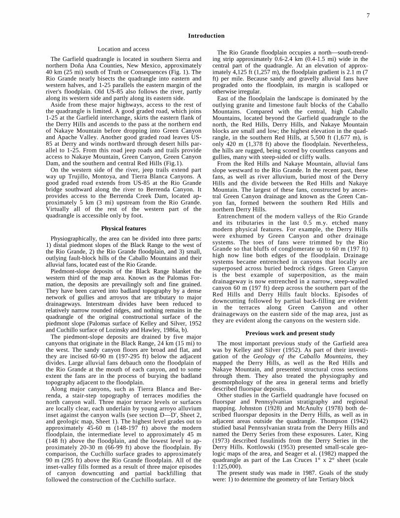
Location and access The Garfield quadrangle is located in southern Sierra and
northern Doña Ana Counties, New Mexico, approximately 40 km (25 mi) south of Truth or Consequences (Fig. 1). The Rio Grande nearly bisects the quadrangle into eastern and western halves, and 1-25 parallels the eastern margin of the river's floodplain. Old US-85 also follows the river, partly along its western side and partly along its eastern side.
Aside from these major highways, access to the rest of the quadrangle is limited. A good graded road, which joins 1-25 at the Garfield interchange, skirts the eastern flank of the Derry Hills and ascends to the pass at the northern end of Nakaye Mountain before dropping into Green Canyon and Apache Valley. Another good graded road leaves US-85 at Derry and winds northward through desert hills par-allel to 1-25. From this road jeep roads and trails provide access to Nakaye Mountain, Green Canyon, Green Canyon Dam, and the southern and central Red Hills (Fig.1).
On the western side of the river, jeep trails extend part way up Trujillo, Montoya, and Tierra Blanca Canyons. A good graded road extends from US-85 at the Rio Grande bridge southward along the river to Berrenda Canyon. It provides access to the Berrenda Creek Dam, located ap-proximately 5 km (3 mi) upstream from the Rio Grande. Virtually all of the rest of the western part of the quadrangle is accessible only by foot.
Physical features Physiographically, the area can be divided into three parts:
1) distal piedmont slopes of the Black Range to the west of the Rio Grande, 2) the Rio Grande floodplain, and 3) small, outlying fault-block hills of the Caballo Mountains and their alluvial fans, located east of the Rio Grande.
Piedmont-slope deposits of the Black Range blanket the western third of the map area. Known as the Palomas For-mation, the deposits are prevailingly soft and fine grained. They have been carved into badland topography by a dense network of gullies and arroyos that are tributary to major drainageways. Interstream divides have been reduced to relatively narrow rounded ridges, and nothing remains in the quadrangle of the original constructional surface of the piedmont slope (Palomas surface of Kelley and Silver, 1952 and Cuchillo surface of Lozinsky and Hawley, 1986a, b).
The piedmont-slope deposits are drained by five major canyons that originate in the Black Range, 24 km (15 mi) to the west. The sandy canyon floors are broad and flat, and they are incised 60-90 m (197-295 ft) below the adjacent divides. Large alluvial fans debauch onto the floodplain of the Rio Grande at the mouth of each canyon, and to some extent the fans are in the process of burying the badland topography adjacent to the floodplain.
Along major canyons, such as Tierra Blanca and Ber-renda, a stair-step topography of terraces modifies the north canyon wall. Three major terrace levels or surfaces are locally clear, each underlain by young arroyo alluvium inset against the canyon walls (see section D—D', Sheet 2, and geologic map, Sheet 1). The highest level grades out to approximately 45-60 m (148-197 ft) above the modern floodplain, the intermediate level to approximately 45 m (148 ft) above the floodplain, and the lowest level to ap-proximately 20-30 m (66-99 ft) above the floodplain. By comparison, the Cuchillo surface grades to approximately 90 m (295 ft) above the Rio Grande floodplain. All of the inset-valley fills formed as a result of three major episodes of canyon downcutting and partial backfilling that followed the construction of the Cuchillo surface.
The Rio Grande floodplain occupies a north—south-trend-ing strip approximately 0.6-2.4 km (0.4-1.5 mi) wide in the central part of the quadrangle. At an elevation of approx-imately 4,125 ft (1,257 m), the floodplain gradient is 2.1 m (7 ft) per mile. Because sandy and gravelly alluvial fans have prograded onto the floodplain, its margin is scalloped or otherwise irregular.
East of the floodplain the landscape is dominated by the outlying granite and limestone fault blocks of the Caballo Mountains. Compared with the central, high Caballo Mountains, located beyond the Garfield quadrangle to the north, the Red Hills, Derry Hills, and Nakaye Mountain blocks are small and low; the highest elevation in the quad-rangle, in the southern Red Hills, at 5,500 ft (1,677 m), is only 420 m (1,378 ft) above the floodplain. Nevertheless, the hills are rugged, being scored by countless canyons and gullies, many with steep-sided or cliffy walls.
From the Red Hills and Nakaye Mountain, alluvial fans slope westward to the Rio Grande. In the recent past, these fans, as well as river alluvium, buried most of the Derry Hills and the divide between the Red Hills and Nakaye Mountain. The largest of these fans, constructed by ances-tral Green Canyon drainage and known as the Green Can-yon fan, formed between the southern Red Hills and northern Derry Hills.
Entrenchment of the modern valleys of the Rio Grande and its tributaries in the last 0.5 m.y. etched many modern physical features. For example, the Derry Hills were exhumed by Green Canyon and other drainage systems. The toes of fans were trimmed by the Rio Grande so that bluffs of conglomerate up to 60 m (197 ft) high now line both edges of the floodplain. Drainage systems became entrenched in canyons that locally are superposed across buried bedrock ridges. Green Canyon is the best example of superposition, as the main drainageway is now entrenched in a narrow, steep-walled canyon 60 m (197 ft) deep across the southern part of the Red Hills and Derry Hills fault blocks. Episodes of downcutting followed by partial back-filling are evident in the terraces along Green Canyon and other drainageways on the eastern side of the map area, just as they are evident along the canyons on the western side.
Previous work and present study The most important previous study of the Garfield area
was by Kelley and Silver (1952). As part of their investi-gation of the Geology of the Caballo Mountains, they mapped the Derry Hills, as well as the Red Hills and Nakaye Mountain, and presented structural cross sections through them. They also treated the physiography and geomorphology of the area in general terms and briefly described fluorspar deposits.
Other studies in the Garfield quadrangle have focused on fluorspar and Pennsylvanian stratigraphy and regional mapping. Johnston (1928) and McAnulty (1978) both de-scribed fluorspar deposits in the Derry Hills, as well as in adjacent areas outside the quadrangle. Thompson (1942) studied basal Pennsylvanian strata from the Derry Hills and named the Derry Series from these exposures. Later, King (1973) described fusulinids from the Derry Series in the Derry Hills. Kottlowski (1953) presented small-scale geo-logic maps of the area, and Seager et al. (1982) mapped the quadrangle as part of the Las Cruces 1° x 2° sheet (scale 1:125,000).
The present study was made in 1987. Goals of the study were: 1) to determine the geometry of late Tertiary block
8
faulting and age of most recent movement along range-boundary faults, 2) to determine the geometry of Laramide deformation and its relationships to regional Laramide tec-tonics as interpreted by Seager and Mack (1986) and Seager et al. (1986), 3) to describe the stratigraphy of rocks and sediment exposed in the quadrangle and to interpret en-vironments of deposition, 4) to integrate the geomorphic evolution of the Garfield quadrangle during the last 4 m.y.
with the evolution known from adjacent areas, and 5) to inventory mineral and other economic deposits of the area.
Acknowledgments—The New Mexico Bureau of Mines and Mineral Resources financially supported this study. We especially want to thank Dr. F. E. Kottlowski, Director, for his continued encouragement and support of our geologic studies in southern New Mexico.
Stratigraphy Stratigraphic units in the Garfield quadrangle may be
divided into five major units. From oldest to youngest they are: Precambrian rocks, Paleozoic sedimentary rocks, lower Tertiary conglomerate, upper Tertiary and lower Quater- nary Rio Grande rift deposits, and upper Quaternary valley-fill alluvium.
Precambrian rocks Precambrian granitic rocks crop out over approximately
6.25 km2 (2.4 mil) in the Red Hills. Mapped and studied in some detail by McLemore (1986), the following is a summary of her results.
Most of the Precambrian terrane in the Red Hills is red-dish to orange granite or quartz monzonite. Coarse to fine grained, the granite typically consists of approximately equal amounts of quartz, microcline, and twinned albite or oli-goclase, with lesser amounts of muscovite, biotite, chlorite, iron oxides, and zircon. The granite usually has a granular texture, although micrographic and mortar textures are also common. In general, the granite is nonfoliated or weakly foliated, although in the Caballo quadrangle to the north foliation trending northeast is present. Pegmatite, aplite and mafic dikes, and quartz veins cut the granite locally. The age of the granite may be similar to the 1.304 b.y. age (recalculated) reported by Muehlberger et al. (1966) for a gneissic granite in the Caballo Mountains to the north.
Although dominated by granite, the Precambrian out-crops also include more than 25 flat to tabular bodies or near-vertical pipes of red syenite, quartz syenite, and alkali granite. Typically small, the plutons range from a few feet to a few hundred feet long and as much as a few feet thick. Contacts with granite are irregular or gradational and are marked by a color change from orange or pink granite to bright red in the syenitic rocks. Locally, veins of syenite intrude granite, and weak foliation in the granite persists through syenite bodies. Microcline and lesser quartz, mus-covite, iron oxides, and chlorite make up the syenite. Pla-gioclase is rare. Apatite, zircon, calcite, fluorite, and barite are accessories. The red color is a product of pervasive he-matization. Unusually high K2O/Na2O ratios suggest exten-sive potassium metasomatism. All syenite bodies are radioactive due to anomalous amounts of uranium, thorium, or potassium in such minerals as fluorite, thorite, thor-ogummite, uraninite (?), bastnaesite, and uranophane. McLemore (1986) considers the uranium-thorium miner-alization to be uneconomic. The age of the syenite rocks is unknown. They may be Precambrian or as young as Cam-brian if they are correlative with syenitic rocks in New Mexico that have ages of about 500 m.y. (e.g. Loring and Armstrong, 1980; Mclemore, 1987; Evans and Clemons, 1988).
Paleozoic rocks
Bliss Formation Precambrian crystalline rocks are unconformably overlain
by the Bliss Formation, which was named by Richardson
(1904) for exposures in the Franklin Mountains near El Paso, Texas. Throughout southern New Mexico and west Texas the Bliss is of Late Cambrian age, although it may be Early Ordovician near the top (Kelley, 1951; Flower, 1953, 1958, 1959, 1965, 1969; Hayes, 1975). The Bliss is conformably overlain by the Early Ordovician El Paso Formation. The contact in the Garfield quadrangle is placed at the base of a prominent cliff. The Bliss Formation thins northward from a maximum of approximately 100 m (329 ft) along the Texas-Chihuahua border and is absent north of the Fra Cristobal Range (Greenwood et al., 1977). The Bliss is exposed in the northeastern part of the Garfield quadrangle along the southern end of the Red Hills, where it is 33 m (108 ft) thick. Approximately 35 m (115 ft) of Bliss Formation were mea-sured in the McLeod Tank quadrangle only 2 km (1.2 mi) east of the Derry Hills.
The Bliss Formation in the Garfield quadrangle consists of dark-brown to maroon, medium- to thin-bedded sand-stone, limestone, and dolomite. A 30-cm-thick pebble conglomerate directly overlies Precambrian granite. The conglomerate is overlain by 4.5 m (15 ft) of crossbedded, bioturbated subarkose, which coarsens upward from a me-dium to coarse sandstone with scattered granules and peb-bles to a coarse to very coarse sandstone with numerous granules and pebbles. Burrows are predominantly vertical and resemble Skolithus. Both planar and trough crossbeds are present in sets cm thick.
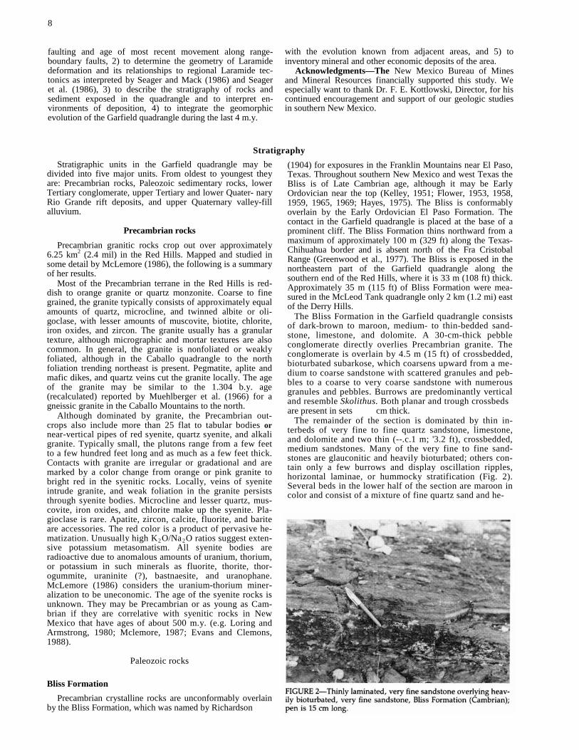
The remainder of the section is dominated by thin in-terbeds of very fine to fine quartz sandstone, limestone, and dolomite and two thin (--.c.1 m; '3.2 ft), crossbedded, medium sandstones. Many of the very fine to fine sand-stones are glauconitic and heavily bioturbated; others con-tain only a few burrows and display oscillation ripples, horizontal laminae, or hummocky stratification (Fig. 2). Several beds in the lower half of the section are maroon in color and consist of a mixture of fine quartz sand and he-

matitic oolites. The relative abundance of carbonate beds increases upsection. Carbonate rock types include fossilif-erous grainstone, intraclast grainstone, and fine-grained dolomite (Fig. 3). The grainstones are glauconitic, and some display hummocky stratification and small-scale crossbeds. Bioturbation is common in all of the carbonate beds. Two crossbedded, medium quartz sandstones break the monotony of the thin-bedded, fine sandstones and carbonates. The lower one begins approximately 9 m (30 ft) above the base of the formation and is 1 m (3.2 ft) thick. The upper one is 0.5 m (1.6 ft) thick, begins approximately 15 m (50 ft) above the base, and contains, in addition to crossbeds, fossil fragments of phosphatic brachiopods.
The Bliss Formation was deposited in a shallow-marine environment during the Cambrian and Early Ordovician eustatic transgression, an interpretation that is in general agreement with previous workers (Lewis, 1962; Kottlowski, 1963; Hoffman, 1976; Thompson and Potter, 1981; Ottens-man, 1983; Chafetz et al., 1986; Stageman, 1987). The basal conglomerate is interpreted to be a transgressive lag that formed by the process of shoreface erosion (Swift, 1968). The bulk of the remainder of the section was deposited between normal and storm wave base. Relatively quiet-water deposition is suggested by fine grain size, oscillation ripples, abundant bioturbation, and the presence of glauconite (McRae, 1972). Intermittent periods of higher energy, probably the result of storms, are indicated by hummocky stratification and intraclasts. The upsection increase in car-bonate probably reflects a progressive reduction in the influx of siliciclastic detritus, commensurate with onlap and reduction in relief of the Precambrian source terrane, as well as an increase in water depth through time.
Crossbedded sandstones in the lower half of the section may have resulted from either small-scale regressive cycles or deposition as offshore sand ridges. In the former model, a prograding shoreline superposes crossbedded, coarser-grained upper shoreface sand on finer-grained, lower-energy lower shoreface sediment (Howard and Reineck, 1981). In the latter model, sand ridges tens of meters high and kilometers long are produced offshore of the surf zone dur-ing transgression by wave and/or tidal reworking of relict sediment and/or sediment carried seaward by storms (Swift and Field, 1981). An offshore sand-ridge origin for the low-ermost crossbedded sandstone in the Bliss is favored by its position directly above the transgressive lag, by the high degree of bioturbation, and by the fact that it coarsens up-ward (Swift and Field, 1981). Distinguishing between an upper shoreface or offshore sand-ridge origin for the upper
9
two crossbedded sandstones requires more lateral control than is possible in the Garfield quadrangle. Upper shoreface sandstones associated with regional regressions should be traceable with only minor thickness variations for tens of kilometers, whereas offshore sand ridges should display a high degree of lateral variability in thickness, grain size, and sedimentary structures.
El Paso Formation
The El Paso Formation was named by Richardson (1904) for exposures in the Franklin Mountains near El Paso, Texas. The El Paso Formation, of Early Ordovician age, thins northward from a maximum of approximately 460 m (1,509 ft) near the type section to an erosional zero edge in the northern Fra Cristobal Range (Kottlowski, 1963; Kottlowski et al., 1956; Hayes, 1975; Greenwood et al., 1977). In the Garfield quadrangle along the southern edge of the Red Hills, the El Paso is 155 m (509 ft) thick. One hundred fifty-two meters (499 ft) of El Paso were measured 6 km (4 mi) farther south along the extreme western edge of the McLeod Tank quadrangle. The El Paso conformably overlies the Bliss Formation and is unconformably overlain by the Montoya Formation (Fig 4).
The El Paso has been the subject of disagreement con-cerning rock-stratigraphic terminology (Flower, 1965, 1969; LeMone, 1969; Lucia, 1968; Harbour, 1972; Hayes, 1975). Based on a study throughout west Texas and southern New Mexico, Clemons (in press) recommends that the El Paso have formation status and be divided into four members, which, in ascending order, are the Hitt Canyon, Jose, McKelligon, and Padre. This convention has been applied successfully by us in the Caballo and McLeod Tank quad-rangles but is not applicable in the Garfield quadrangle because over half of the formation is dolomite. Thicknesses of members of the El Paso Formation, measured in an im-mediately adjacent part of the McLeod Tank quadrangle, are given in the description of units (Sheet 1).
In the Garfield quadrangle the basal 50 m (164 ft) of the El Paso are thin- to medium-bedded, brown to light-gray limestones. Heavily bioturbated, fossiliferous wackestone and packstone are the dominant rock types, but a few thin (<20 cm) beds of intraclast grainstone are also present and increase in abundance upsection. Many of the burrows con-sist of light-tan, fine-grained dolomite and stand in relief on a weathered surface (Fig 5). Limestones in the lower 20 m (66 ft) of the section are sandy, and there are a few thin (10 cm) sandstone beds immediately above the contact with
the Bliss Formation. Fossils recognizable in hand specimen include trilobites and echinoderm columnals. Oncolites are also present.
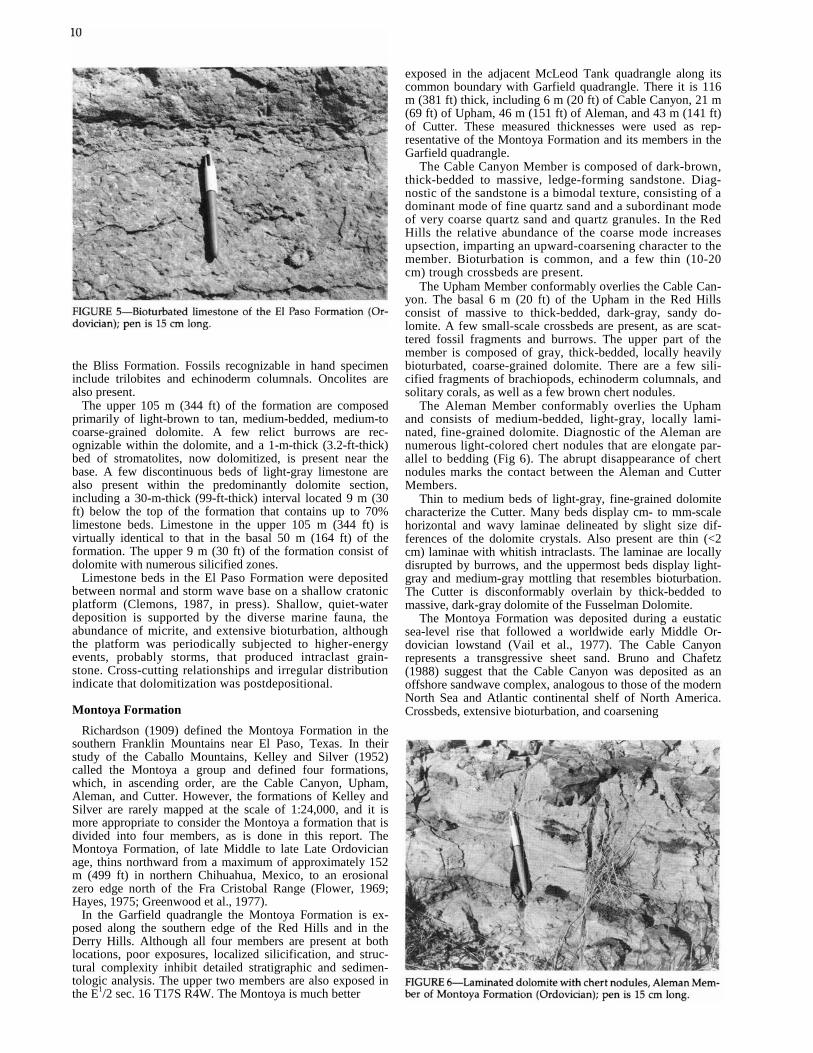
The upper 105 m (344 ft) of the formation are composed primarily of light-brown to tan, medium-bedded, medium-to coarse-grained dolomite. A few relict burrows are rec-ognizable within the dolomite, and a 1-m-thick (3.2-ft-thick) bed of stromatolites, now dolomitized, is present near the base. A few discontinuous beds of light-gray limestone are also present within the predominantly dolomite section, including a 30-m-thick (99-ft-thick) interval located 9 m (30 ft) below the top of the formation that contains up to 70% limestone beds. Limestone in the upper 105 m (344 ft) is virtually identical to that in the basal 50 m (164 ft) of the formation. The upper 9 m (30 ft) of the formation consist of dolomite with numerous silicified zones.
Limestone beds in the El Paso Formation were deposited between normal and storm wave base on a shallow cratonic platform (Clemons, 1987, in press). Shallow, quiet-water deposition is supported by the diverse marine fauna, the abundance of micrite, and extensive bioturbation, although the platform was periodically subjected to higher-energy events, probably storms, that produced intraclast grain-stone. Cross-cutting relationships and irregular distribution indicate that dolomitization was postdepositional.
Montoya Formation Richardson (1909) defined the Montoya Formation in the
southern Franklin Mountains near El Paso, Texas. In their study of the Caballo Mountains, Kelley and Silver (1952) called the Montoya a group and defined four formations, which, in ascending order, are the Cable Canyon, Upham, Aleman, and Cutter. However, the formations of Kelley and Silver are rarely mapped at the scale of 1:24,000, and it is more appropriate to consider the Montoya a formation that is divided into four members, as is done in this report. The Montoya Formation, of late Middle to late Late Ordovician age, thins northward from a maximum of approximately 152 m (499 ft) in northern Chihuahua, Mexico, to an erosional zero edge north of the Fra Cristobal Range (Flower, 1969; Hayes, 1975; Greenwood et al., 1977).
In the Garfield quadrangle the Montoya Formation is ex-posed along the southern edge of the Red Hills and in the Derry Hills. Although all four members are present at both locations, poor exposures, localized silicification, and struc-tural complexity inhibit detailed stratigraphic and sedimen-tologic analysis. The upper two members are also exposed in the E1/2 sec. 16 T17S R4W. The Montoya is much better
exposed in the adjacent McLeod Tank quadrangle along its common boundary with Garfield quadrangle. There it is 116 m (381 ft) thick, including 6 m (20 ft) of Cable Canyon, 21 m (69 ft) of Upham, 46 m (151 ft) of Aleman, and 43 m (141 ft) of Cutter. These measured thicknesses were used as rep-resentative of the Montoya Formation and its members in the Garfield quadrangle.
The Cable Canyon Member is composed of dark-brown, thick-bedded to massive, ledge-forming sandstone. Diag-nostic of the sandstone is a bimodal texture, consisting of a dominant mode of fine quartz sand and a subordinant mode of very coarse quartz sand and quartz granules. In the Red Hills the relative abundance of the coarse mode increases upsection, imparting an upward-coarsening character to the member. Bioturbation is common, and a few thin (10-20 cm) trough crossbeds are present.
The Upham Member conformably overlies the Cable Can-yon. The basal 6 m (20 ft) of the Upham in the Red Hills consist of massive to thick-bedded, dark-gray, sandy do-lomite. A few small-scale crossbeds are present, as are scat-tered fossil fragments and burrows. The upper part of the member is composed of gray, thick-bedded, locally heavily bioturbated, coarse-grained dolomite. There are a few sili-cified fragments of brachiopods, echinoderm columnals, and solitary corals, as well as a few brown chert nodules.
The Aleman Member conformably overlies the Upham and consists of medium-bedded, light-gray, locally lami-nated, fine-grained dolomite. Diagnostic of the Aleman are numerous light-colored chert nodules that are elongate par-allel to bedding (Fig 6). The abrupt disappearance of chert nodules marks the contact between the Aleman and Cutter Members.
Thin to medium beds of light-gray, fine-grained dolomite characterize the Cutter. Many beds display cm- to mm-scale horizontal and wavy laminae delineated by slight size dif-ferences of the dolomite crystals. Also present are thin (<2 cm) laminae with whitish intraclasts. The laminae are locally disrupted by burrows, and the uppermost beds display light-gray and medium-gray mottling that resembles bioturbation. The Cutter is disconformably overlain by thick-bedded to massive, dark-gray dolomite of the Fusselman Dolomite.
The Montoya Formation was deposited during a eustatic sea-level rise that followed a worldwide early Middle Or-dovician lowstand (Vail et al., 1977). The Cable Canyon represents a transgressive sheet sand. Bruno and Chafetz (1988) suggest that the Cable Canyon was deposited as an offshore sandwave complex, analogous to those of the modern North Sea and Atlantic continental shelf of North America. Crossbeds, extensive bioturbation, and coarsening

upward support the offshore sandwave model (cf. Swift and Field, 1981 and Swift and Niedoroda, 1985). As the transgression proceeded, corresponding to deposition of the Upham Member, the amount of siliciclastic detritus progressively decreased. A benthic fauna and extensive bioturbation suggest a shallow, open-marine environment for the Upham. The paucity of primary structures and lack of fossils in the Aleman and Cutter inhibit interpretation of depositional environment.
Fusselman Dolomite
The Silurian System in southern New Mexico is repre-sented by the Fusselman Dolomite, which was defined by Richardson (1908, 1909) from outcrops in the southern Franklin Mountains near El Paso, Texas. At the type section the Fusselman is approximately 300 m (984 ft) thick, and it thins northward to an erosional zero edge near Truth or Consequences (Kottlowski, 1963; Greenwood et al., 1977). The Fusselman is also absent west and south of Lordsburg (Kottlowski, 1963; Greenwood et al.,1977). Although fossils are sparse, a brachiopod fauna indicates that the Fusselman is of Middle Silurian age (Kelley and Silver, 1952; Kottlowski, 1963).
In the Garfield quadrangle the Fusselman is exposed in only three places in the E1/2 sec. 16 T17S R4W, where it unconformably overlies the Ordovician Montoya Formation and is unconformably overlain by the Pennsylvanian Red House Formation of the Magdalena Group. The Devonian Percha Formation, which normally overlies the Fusselman, was removed by pre-Pennsylvanian erosion at this locality. The lower contact is placed at the change from the medium-to thin-bedded, light-gray beds of the Cutter Member to the thick-bedded to massive, dark beds of the Fusselman. The upper contact is not well exposed. The Fusselman is approximately 26 m (85 ft) thick and consists exclusively of medium-grained dolomite. Light-brown chert nodules are very common.
Dolomitization has destroyed many of the original sed-imentary features of the Fusselman, inhibiting interpretation of depositional environment. The coral and brachipod fauna, observed elsewhere in southern New Mexico, suggests a shallow-marine environment. Kottlowski and Pray (1967) further suggest that some horizons may be intertidal to supratidal in origin.
Percha Formation In south-central New Mexico Devonian sedimentary rocks
are commonly mapped as the Percha Formation, a name first used by Gordon and Graton (1907) and subsequently used throughout the Caballo Mountains by Kelley and Silver (1952). Although a variety of sedimentary rock types comprise Devonian strata in southern New Mexico (Kott-lowski, 1963, 1965), in the vicinity of the Caballo Mountains the Percha is predominantly shale (Kelley and Silver, 1952). Devonian strata are thickest in the southwestern and south-eastern corners of the state, approximately 120 m (394 ft) and 180 m (590 ft), respectively, and thin northward to an erosional zero edge between Truth or Consequences and Socorro (Kottlowski, 1963, 1965). The Percha Formation is Late Devonian in age, although the uppermost beds may be Early Mississippian (Kelley and Silver, 1952; Flower, 1959).
In the Garfield quadrangle, approximately 19 m (62 ft) of Percha are exposed on the western flank of the Derry Hills along the 1-25 roadcut, where it is unconformably overlain by the Pennsylvanian Magdalena Group; the base of the formation is not exposed (Fig. 7). Just over half of the ex-posure in the Derry Hills is dark-gray, fissile, micaceous silty shale. Also present are at least seven thin (--.5.1 m; ft) beds of brown to tan, micaceous siltstone that exhibit
horizontal laminae, ripple cross-laminae, and horizontal burrows. In addition, there are in the lower 4 m (13 ft) of the section two thin (0.5 and 1.0 m; 1.6 and 3.2 ft) beds of tan to brown, very fine sandstone. The thinner, lower sand-stone is heavily bioturbated, whereas the upper sandstone displays convolute laminae at the base and ripple cross-laminae at the top. The contact between the Percha and overlying Red House Formation of the Magdalena Group is placed at the base of the first ridge-forming, cherty lime-stone (Fig. 7).
Throughout southern New Mexico the Percha Formation and coeval Devonian strata are interpreted to be shallow marine in origin (Kottlowski, 1963, 1965), a conclusion con-sistent with the sedimentary structures observed in the measured section in the study area and with the marine fauna collected by Kelley and Silver (1952). An increase in the relative abundance of silt and sand in northeastern Sierra and northwestern Otero Counties and along the New Mexico—Arizona border suggests that Devonian siliciclastic detritus in southern New Mexico may have come from the northeast and southwest (Kottlowski, 1963, 1965).
Magdalena Group Pennsylvanian rocks in south-central New Mexico are
generally mapped as the Magdalena Group, a name first applied by Gordon (1907) to outcrops in the Magdalena Mountains west of Socorro. Thompson (1942) developed a comprehensive stratigraphic nomenclature for Pennsylva-nian rocks that included eight groups and 15 formations. Despite the rock stratigraphic names, the divisions of Thompson are biostratigraphic zones and are not mappable. In the Caballo Mountains, Kelley and Silver (1952) used a single map unit, the Magdalena Group, but divided it for stratigraphic purposes into three formations, which, in ascending order, are the Red House, Nakaye, and Bar B. The convention of Kelley and Silver (1952) is followed in this report.
The age of the base of the Magdalena Group in the Caballo Mountains is controversial. Thompson (1942, 1948) and King (1973) believe that the basal beds of the Red House Formation in the Derry Hills are Atokan, or Derryan in the terminology of Thompson. More recently, Sutherland and Manger (1984) discovered upper Morrowan brachiopods in a previously covered, thin (<1 m; <3.2 ft) horizon of nodular limestone and shale at the base of the Red House Formation along the 1-25 roadcut (Fig 7). The basal unit of limestone and shale also has a foraminifera assemblage

12
"typical of both Morrowan and Atokan faunas" (Groves, 1986). These new discoveries suggest that the lower part of the Red House Formation in the Derry Hills may span the Morrowan-Atokan boundary. The age of the top of the Red House Formation is less controversial. Upper Atokan fu- sulinids are common throughout the upper part of the Red House, and a Desmoinesian fusulinid fauna was described from a limestone located approximately 4 m (13 ft) above the Red House-Nakaye contact as picked in this study. Thus, the Atokan-Desmoinesian boundary is coincident with or very close to the Red House-Nakaye contact. The Nakaye Formation probably spans all of the Desmoinesian and part of the Missourian, with the remainder of the Missourian and Virgilian corresponding to the Bar B (Kottlowski, 1960). However, the ages of the Nakaye-Bar B and Bar B-Abo contacts are not well constrained.
Pennsylvanian rocks in southern New Mexico are thickest in the Orogrande (925 m; 3,035 ft) and Pedregosa (758 m; 2,487 ft) Basins and presumably were not deposited over a low-lying positive area near Deming known as the Florida Islands (Kottlowski, 1963, 1965). In the Garfield quadrangle in the Derry Hills, the Magdalena Group is 265 m (869 ft) thick, including 35 m (115 ft) of Red House, 140 m (459 ft) of Nakaye, and 90 m (295 ft) of Bar B. Two kilometers (1.2 mi) east of the quadrangle, along the western margin of the McLeod Tank quadrangle, the Magdalena is 277 m (909 ft) thick, including 64 m (210 ft) of Red House, 151 m (496 ft) of Nakaye, and 62 m (204 ft) of Bar B Formation.
The Red House Formation is well exposed along the I25 roadcut on the west flank of the Derry Hills (Fig. 7). At this location the Red House unconformably overlies dark- gray shale and brown siltstone of the Devonian Percha For-mation and is conformably overlain by the Nakaye For- mation. In the eastern part of the quadrangle the Red House unconformably overlies the Silurian Fusselman Dolomite. The Red House-Nakaye contact in the Derry Hills is placed at the base of the first thick m; ?-16.5 ft), ledge-forming limestone (Fig. 7; Kalesky, 1988). The Red House consists of interbedded limestone, shale, and siltstone. Medium- bedded, gray fossiliferous wackestones and packstones make up approximately 64% of the measured section. Fossils in-clude brachiopods, echinoderm columnals, bryozoa, and fusulinids. Quartz silt is present in some limestones but is not common (Kalesky, 1988). Dark-gray shale is present throughout the formation as thin (<1 m; <3.2 ft) beds and is thickest near the middle of the formation. Shale comprises approximately 19% of the measured section. Also in the middle of the section is a 6-m-thick (20-ft-thick) interval of light-brown to green, micaceous siltstone that contains ripple cross-laminae and a few ostracods (Kalesky, 1988).
A complete section of the Nakaye Formation was measured along the southwestern flank of the Deny Hills (NE 1/4 sec. 32 and NW1/4 sec. 33 T175 R4W), where it conform- ably overlies the Red House Formation and conformably underlies the Bar B Formation. The lower half of the Nakaye is dominated by thick ledge- and cliff-forming, medium- to thick-bedded, gray limestones; only approximately 20% of the lower half of the formation is covered. The limestones contain numerous black to brown chert nodules oriented parallel to bedding, and many beds have irregular, tan, dolomitic mottles that appear to be the result of bioturba-tion. The limestones are primarily fossiliferous packstones, although wackestones are also present. The diverse fauna includes brachiopods, echinoderm columnals, solitary and colonial corals, fenestrate and branching bryozoa, fusulinids, and gastropods. Brachipods and corals are commonly silicified. A few beds of limestone are recrystallized.
The upper half of the Nakaye Formation consists of al-ternating limestone ledges and covered intervals, with the latter accounting for approximately 40% of the total thick
ness. Three beds of cherry fossiliferous packstone, totaling 15% of the thickness of the upper Nakaye, are similar to the dominant rock type of the lower part of the formation. In addition, the upper Nakaye contains three intervals (1, 6, 15 m; 3.2, 20, 50 ft thick) that are composed of thin- to medium-bedded, tan- and gray-mottled micrite. Also pres-ent near the middle of the upper Nakaye are two beds of grainstone. The lower one is 3 m (10 ft) thick and consists primarily of well-sorted echinoderm columnals and brach-iopod shell fragments cemented by sparry calcite. The up-per 20 cm of the lower bed are an oolite grainstone. The upper grainstone is 1 m (3.2 ft) thick, consists of oolites and fossil fragments, and displays ripple cross-laminae. The final rock type observed in the upper Nakaye is a dark-gray, slightly micaceous, platy to fissile shale that is exposed in a deep gully 53 m (174 ft) below the top of the formation. Similar shales most likely underlie many of the covered intervals.
The Bar B Formation conformably overlies the Nakaye Formation and was measured in the Derry Hills along the same traverse as the Nakaye. The Bar B-Nakaye contact was placed above a thick (5 m; 16.5 ft) ledge of fossiliferous limestone that is overlain by dark shale and platy micrite limestone. The contact separates a section dominated by limestone ledges (Nakaye) from a section dominated by shale and covered intervals (Bar B). The contact is somewhat arbitrary and could be moved downsection below the uppermost platy micrite in the Nakaye; it is unlikely that the contact would be placed upsection of the location selected in this study.
The Bar B is composed of ledges of limestone and con-glomerate that are separated by shale or covered intervals. Two horizons of medium- to dark-gray, platy to fissile shale were encountered. One shale at the base of the formation is 5 m (16.5 ft) thick, and the other near the middle of the formation is 11.5 m (38 ft) thick. The covered intervals, which account for just over half of the total thickness of the formation, probably are underlain by shale. The most com-mon type of limestone, totaling 20% of the measured section in eight individual intervals, consists of thin- to medium-bedded, tan- and gray-mottled, platy micrite. A few beds of micrite contain whole brachiopod and gastropod shells, as well as large (1.5 cm wide, 15 cm long) horizontal burrows (Fig. 8), but the majority of beds are unfossiliferous. Other less common limestones include brachiopod and echinoderm wackestone (four beds, 3% of section), recrystallized limestone (two beds, 3% of section), and a 0.5-m-thick (1.6ft-thick) bioclastic grainstone. Also present in the upper
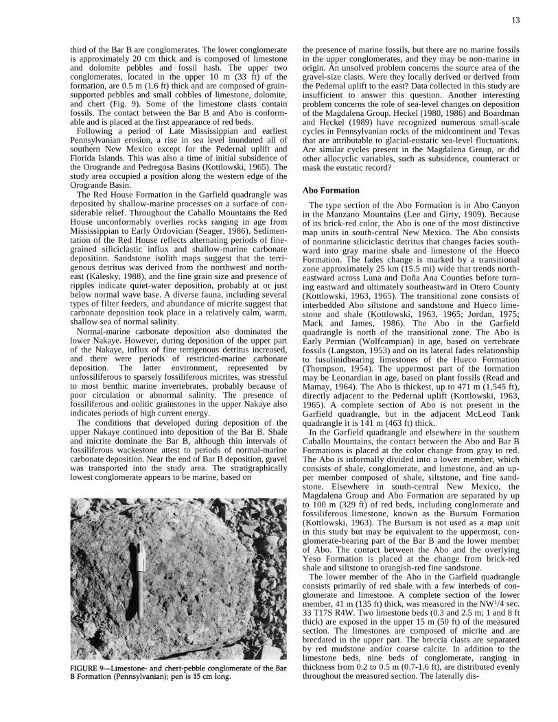
third of the Bar B are conglomerates. The lower conglomerate is approximately 20 cm thick and is composed of limestone and dolomite pebbles and fossil hash. The upper two conglomerates, located in the upper 10 m (33 ft) of the formation, are 0.5 m (1.6 ft) thick and are composed of grain-supported pebbles and small cobbles of limestone, dolomite, and chert (Fig. 9). Some of the limestone clasts contain fossils. The contact between the Bar B and Abo is conform-able and is placed at the first appearance of red beds.
Following a period of Late Mississippian and earliest Pennsylvanian erosion, a rise in sea level inundated all of southern New Mexico except for the Pedernal uplift and Florida Islands. This was also a time of initial subsidence of the Orogrande and Pedregosa Basins (Kottlowski, 1965). The study area occupied a position along the western edge of the Orogrande Basin.
The Red House Formation in the Garfield quadrangle was deposited by shallow-marine processes on a surface of con-siderable relief. Throughout the Caballo Mountains the Red House unconformably overlies rocks ranging in age from Mississippian to Early Ordovician (Seager, 1986). Sedimen-tation of the Red House reflects alternating periods of fine-grained siliciclastic influx and shallow-marine carbonate deposition. Sandstone isolith maps suggest that the terri-genous detritus was derived from the northwest and north-east (Kalesky, 1988), and the fine grain size and presence of ripples indicate quiet-water deposition, probably at or just below normal wave base. A diverse fauna, including several types of filter feeders, and abundance of micrite suggest that carbonate deposition took place in a relatively calm, warm, shallow sea of normal salinity.
Normal-marine carbonate deposition also dominated the lower Nakaye. However, during deposition of the upper part of the Nakaye, influx of fine terrigenous detritus increased, and there were periods of restricted-marine carbonate deposition. The latter environment, represented by unfossiliferous to sparsely fossiliferous micrites, was stressful to most benthic marine invertebrates, probably because of poor circulation or abnormal salinity. The presence of fossiliferous and oolitic grainstones in the upper Nakaye also indicates periods of high current energy.
The conditions that developed during deposition of the upper Nakaye continued into deposition of the Bar B. Shale and micrite dominate the Bar B, although thin intervals of fossiliferous wackestone attest to periods of normal-marine carbonate deposition. Near the end of Bar B deposition, gravel was transported into the study area. The stratigraphically lowest conglomerate appears to be marine, based on
13
the presence of marine fossils, but there are no marine fossils in the upper conglomerates, and they may be non-marine in origin. An unsolved problem concerns the source area of the gravel-size clasts. Were they locally derived or derived from the Pedemal uplift to the east? Data collected in this study are insufficient to answer this question. Another interesting problem concerns the role of sea-level changes on deposition of the Magdalena Group. Heckel (1980, 1986) and Boardman and Heckel (1989) have recognized numerous small-scale cycles in Pennsylvanian rocks of the midcontinent and Texas that are attributable to glacial-eustatic sea-level fluctuations. Are similar cycles present in the Magdalena Group, or did other allocyclic variables, such as subsidence, counteract or mask the eustatic record?
Abo Formation
The type section of the Abo Formation is in Abo Canyon in the Manzano Mountains (Lee and Girty, 1909). Because of its brick-red color, the Abo is one of the most distinctive map units in south-central New Mexico. The Abo consists of nonmarine siliciclastic detritus that changes facies south-ward into gray marine shale and limestone of the Hueco Formation. The fades change is marked by a transitional zone approximately 25 km (15.5 mi) wide that trends north-eastward across Luna and Doña Ana Counties before turn-ing eastward and ultimately southeastward in Otero County (Kottlowski, 1963, 1965). The transitional zone consists of interbedded Abo siltstone and sandstone and Hueco lime-stone and shale (Kottlowski, 1963, 1965; Jordan, 1975; Mack and James, 1986). The Abo in the Garfield quadrangle is north of the transitional zone. The Abo is Early Permian (Wolfcampian) in age, based on vertebrate fossils (Langston, 1953) and on its lateral fades relationship to fusulinidbearing limestones of the Hueco Formation (Thompson, 1954). The uppermost part of the formation may be Leonardian in age, based on plant fossils (Read and Mamay, 1964). The Abo is thickest, up to 471 m (1,545 ft), directly adjacent to the Pedernal uplift (Kottlowski, 1963, 1965). A complete section of Abo is not present in the Garfield quadrangle, but in the adjacent McLeod Tank quadrangle it is 141 m (463 ft) thick.
In the Garfield quadrangle and elsewhere in the southern Caballo Mountains, the contact between the Abo and Bar B Formations is placed at the color change from gray to red. The Abo is informally divided into a lower member, which consists of shale, conglomerate, and limestone, and an up-per member composed of shale, siltstone, and fine sand-stone. Elsewhere in south-central New Mexico, the Magdalena Group and Abo Formation are separated by up to 100 m (329 ft) of red beds, including conglomerate and fossiliferous limestone, known as the Bursum Formation (Kottlowski, 1963). The Bursum is not used as a map unit in this study but may be equivalent to the uppermost, con-glomerate-bearing part of the Bar B and the lower member of Abo. The contact between the Abo and the overlying Yeso Formation is placed at the change from brick-red shale and siltstone to orangish-red fine sandstone.
The lower member of the Abo in the Garfield quadrangle consists primarily of red shale with a few interbeds of con-glomerate and limestone. A complete section of the lower member, 41 m (135 ft) thick, was measured in the NW1/4 sec. 33 T17S R4W. Two limestone beds (0.3 and 2.5 m; 1 and 8 ft thick) are exposed in the upper 15 m (50 ft) of the measured section. The limestones are composed of micrite and are brecdated in the upper part. The breccia clasts are separated by red mudstone and/or coarse calcite. In addition to the limestone beds, nine beds of conglomerate, ranging in thickness from 0.2 to 0.5 m (0.7-1.6 ft), are distributed evenly throughout the measured section. The laterally dis-

14
continuous conglomerates are clast supported and consist primarily of pebbles, although a few cobbles up to 7 cm in length are present. Clasts include limestone, some of which are fossiliferous, and chert, as well as rip-up clasts of red siltstone and caliche. One conglomerate in the lower part of the member contains pebbles with concentric carbonate laminae that resemble oncolites.
Shale in the lower member is red and has a blocky texture. Particularly common in the shale are calcareous nodules and tubules that are interpreted to be the calcareous B horizon (caliche) of paleosols (Fig. 10). Nodules range from 1 to 5 cm in diameter; tubules are 2-10 cm in diameter, 5-30 cm long, and commonly taper downward (Fig. 10). The nodules and tubules are composed of micrite and are con-centrated into discrete horizons up to 2 m (6.5 ft) thick. The nodules and tubules "float" in the shale host, a texture indicative of stage II morphology of Gile et al. (1966, 1981), although locally the nodules and tubules coalesce into lat-erally persistent beds up to 20 cm thick that resemble stage III morphology. At several locations, including excellent ex-posures near the Green Canyon Dam, the calcareous nodules and tubules are overlain by green or green- and red-mottled shale up to 1 m (3.2 ft) thick.
The base of the upper member of the Abo Formation is placed at the first thick (>3 m; >10 ft) siltstone—sandstone bed. A complete section of the upper member is not exposed in the Garfield quadrangle, although a 72-m-thick (236-ft-thick) partial section was measured between Green Canyon Dam and 1-25. The upper member consists of thick (up to 24 m; 79 ft) intervals of red shale and thin (<1 m; <3.2 ft) siltstone alternating with prominent ledges from 2 to 5 m (6.5-16.5 ft) thick of siltstone and/or very fine sandstone. Shale tends to form covered slopes, but where exposed it exhibits a blocky texture. Calcareous nodules and tubules, similar to but less common than those in the lower member, are also present in shale of the upper member. Thin siltstone beds display ripple cross-laminae or horizontal laminae and are commonly bioturbated and/or rooted in the upper part of the bed. The thick ledges of siltstone and very fine sandstone are thin to medium bedded and contain horizontal laminae, ripple cross-laminae, and a few small-scale (15 cm) crossbeds. Present locally, especially at the base of the units, are pebble conglomerates composed exclusively of shale, siltstone, and caliche rip-up clasts. Many bedding planes within individual ledge-forming siltstone—sandstone units display desiccation cracks and burrows.
The Abo Formation was deposited on an alluvial plain
under semiarid climatic conditions. During deposition of the lower member, gravel-bed channels traversed a well-oxidized floodplain. The thin, laterally discontinuous char-acter of the conglomerate beds suggests that the fluvial channels were small, shallow, and underwent little lateral migration, features analogous to modern anastomosing streams in central Australia described by Rust (1981). The thickness and abundance of red shale suggest that the flood-plain was stable for long periods of time before being in-vaded by channels. Stage II and III calcic paleosols further indicate long periods of slow deposition and pedogenesis. Locally on the floodplain, alkaline lakes precipitated micrite limestone. A combination of the thinness of beds and the inability to correlate limestone units in the southern Caballo Mountains suggest that the lakes were small. Furthermore, breccia with red matrix near the top of limestone beds re-flects periodic desiccation of the lakes (Freytet, 1973).
An unsolved problem concerns the provenance of the gravel-size clasts in the lower member. Fossils in some of the clasts, especially fusulinids, indicate that at least some of the source rocks were Pennsylvanian limestones. It is not clear, however, if the clasts came from the Pedernal uplift, located approximately 150 km (93 mi) to the east, or were locally derived. Unfortunately, paleocurrent indicators are sparse in the lower member. Perhaps a regional comparison of bed thickness or maximum clast size among the conglomerates of the lower member will shed light on sediment-dispersal direction.
During deposition of the upper member, the nature of the fluvial system changed. Fluvial channels were large but carried a much finer-grained bed load than those of the lower member. In the McLeod Tank quadrangle, several large channels of the upper member display lateral-accre-tion foresets (LA sets), which result from point-bar depo-sition in meandering streams. LA sets are not obvious in the Garfield quadrangle, although they may be present in two channel bodies northwest of Green Canyon Dam. The absence of LA sets in some channel bodies may be due to poor exposure or exposure longitudinal rather than trans-verse to paleoflow; it may also suggest that some channels in the upper Abo fluvial system did not migrate laterally. Regardless of the presence or absence of LA sets, the oc-currence of desiccation cracks and bioturbation along bed-ding planes within virtually all of the individual channel bodies suggest that deposition in the channels was inter-mittent and that parts of the channels were periodically exposed.
Floodplain shales in the upper member are similar in color and thickness to those of the lower member. However, la-custrine limestones are not present in the upper member. The upper member also contains numerous thin siltstone beds, which are interpreted as crevasse-splay deposits. Following deposition, the crevasse-splay siltstones were sub-aerially modified by roots and burrowers.
The upper member of the Abo Formation was deposited on an alluvial plain by southward-flowing streams. Paleo-flow direction is indicated by regional paleogeography (Kottlowski, 1963, 1965), by eastward and westward dips of LA sets, and by paleocurrent data collected near Socorro (Cappa and MacMillan, 1983). The extremely fine grain size of the sediment further suggests that the source area was a long distance away, perhaps in northern New Mexico and Colorado, or that more proximal source areas, such as the Pedernal uplift, had quite low relief.
The best paleoclimatic indicators in the Abo Formation are caliche paleosols, which suggest a semiarid climate (Reeves, 1970). A relatively dry climate was probably re-sponsible for the well-oxidized floodplain deposits, the ephemeral nature of the streams, and the small, alkaline lakes that were periodically desiccated.

Yeso Formation The Permian Yeso Formation, which was originally
named by Lee and Girty (1909) for exposures at Mesa del Yeso in central New Mexico, is exposed in the Garfield quadrangle in only one small outcrop, SE1/4 sec. 33 T17S R4W. The Yeso outcrop is bounded on the south by the Derry Hills fault, and the Yeso beds are overlain by and pass northward beneath the Palomas Formation. The Yeso beds consist of friable, pink to orange, very fine to fine quartz sandstone that most closely resembles the Meseta Blanca Member, described by Wilpolt and Wanek (1951) in the Oscura Mountains and by Kottlowski et al. (1956) in the San Andres Mountains.
Lower Tertiary conglomerate The Love Ranch Formation and basal part of the Palm
Park Formation, from Eocene to early Oligocene age, un-conformably overlie Magdalena, Abo, or Yeso strata in the Garfield quadrangle. Both formations consist largely of conglomeratic strata derived from erosion of Laramide basement-cored uplifts and volcanic terranes in southern New Mexico. Although limited in outcrop area in the Garfield quadrangle, both formations are comparatively thick and are widely exposed in adjacent parts of the Caballo Mountains. Seager and Mack (1986) and Seager et al. (1986) have described these outcrops and have related them to Laramide tectonism in southern New Mexico.
Love Ranch Formation The Love Ranch Formation (Kottlowski et al., 1956) crops
out in one small area along the eastern edge of the quadrangle just east of the Derry Hills. At this locality only the upper 30 m (99 ft) of the formation are exposed, and this outcrop grades upward into basal Palm Park conglomerate or is unconformably overlain by fanglomerate of the Palomas Formation.
Love Ranch strata in the Garfield quadrangle consists of reddish-gray conglomerate. Boulders and cobbles of Paleo-zoic strata as well as abundant clasts of red Precambrian granite compose the conglomerate. In adjacent parts of the Caballo Mountains, red arkosic sandstone, conglomeratic sandstone, and red mudstone are interbedded with con-glomerate. The deposits constitute the fill of paleovalleys and alluvial fans.
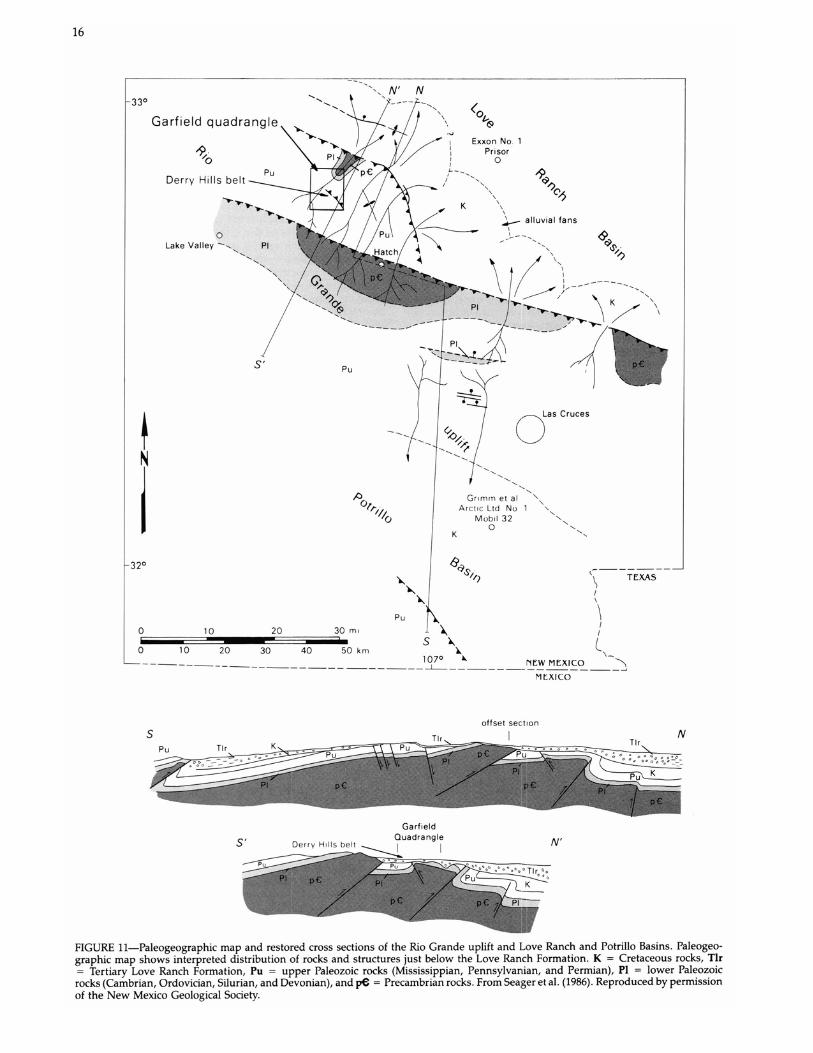
Seager et al. (1986) have shown that the Love Ranch For-mation in the Caballo Mountains is derived from an uplifted basement-cored block (Rio Grande uplift), the highest and most deeply eroded part of which is located south of the Garfield quadrangle, probably beneath the modern Hatch Valley and southern Palomas Basin. Detritus eroded from this uplift was transported northeastward across a broad structural bench and then into the Love Ranch Basin (Fig. 11). The figure shows that the Garfield quadrangle lies on this intermediate-level structural bench. Love Ranch strata that overlap onto the structural bench, such as that in the Garfield quadrangle, are posttectonic and Eocene in age. Older parts of the formation probably were deposited in the Love Ranch Basin and are described in the southern San Andres Mountains (Seager, 1981). These older strata are syntectonic and may be as old as Paleocene or even possibly latest Cretaceous (Seager et al., 1986).
Palm Park Formation The Palm Park Formation (Kelley and Silver, 1952), like
the Love Ranch Formation, is limited to one small outcrop area in the Garfield quadrangle, just east of the Derry Hills. Only the basal 30-60 m (99-197 ft) or so are exposed, and these rocks gradationally overlie the Love Ranch Formation.
15
Fanglomerate of the Palomas Formation unconformably overlies the Palm Park.
Like the Love Ranch Formation, the basal Palm Park con-sists of conglomerate of mostly well-rounded cobbles and boulders of Precambrian granite and various Paleozoic for-mations. Unlike the Love Ranch, the Palm Park contains numerous volcanic and/or hypabyssal igneous clasts, mostly intermediate-composition porphyrys. All clasts are embedded in a matrix of gray to purplish-gray, soft volcaniclastic mudstone or sandstone, which gives the formation an overall color of gray, grayish brown, or purple. In contrast, the underlying Love Ranch strata are notably redder.
In adjacent parts of the Caballo Mountains, basal Palm Park conglomerate grades upward into finer-grained vol-caniclastic sandstone, mudstone, and breccia derived from andesitic volcanic rocks. Much of the formation appears to be volcanic mudflow in origin. Fresh-water limestone is locally interbedded with the volcaniclastics. It seems clear that by Palm Park time Laramide tectonic activity had ceased, and uplifts had been worn to low relief and then were largely buried by volcaniclastic Palm Park strata. Dates of late Eocene to early Oligocene have been reported by various authors for Palm Park and correlative rocks in south-central New Mexico (Kottlowski et al., 1969; Seager and Clemons, 1975; Clemons, 1979; Marvin and Cole, 1978; Loring and Loring, 1980; Lucas, 1986).
Upper Tertiary and lower Quaternary Rio Grande rift deposits
Basin-fill deposits of the Rio Grande rift in the Garfield quadrangle include the Rincon Valley Formation of Miocene age and the Palomas Formation of latest Pliocene and Pleis-tocene age. Separated by an unconformity, the two for-mations document two stages of rift evolution, sometimes referred to as "early rift" and "late rift" (e.g. Chapin and Seager, 1975; Chapin, 1979; Seager et al., 1984).
Rincon Valley Formation The Rincon Valley Formation of the lower Santa Fe Group
was named by Seager et al. (1971) for exposures in Rincon and Hatch Valleys, Rincon Hills, and at San Diego Mountain, all located southeast of the Garfield quadrangle. The outcrops in the southwestern part of the Garfield quadrangle are the northernmost-known limits of the formation, although strata that crop out near Truth or Consequences (Lozinsky, 1986) may be correlative.
The base of the formation is not exposed in the Garfield quadrangle, but farther south block-faulted and eroded out-crops show that the Rincon Valley Formation is thick and grades down into still older, thick, fanglomeritic fill of the Rio Grande rift. In turn, these basal units of the lower Santa Fe Group interfinger laterally or downward with upper Oligocene basaltic-andesite flows (Uvas Basaltic Andesite). The total elastic section above the basaltic andesite and beneath the Palomas Formation constitutes the fill of "early rift" basins and is as much as 1,500 m (4,921 ft) thick. No longer part of the landscape, these basins were segmented, at least in part, by latest Miocene and early Pliocene rifting—the episode of faulting that blocked out the modern topography of the Rio Grande rift.
Only the uppermost 15 m (50 ft) of the Rincon Valley Formation is exposed in the Garfield quadrangle. Unpub-lished water-well data near Hatch show the formation to be at least 600 m (1,968 ft) thick beneath the Hatch Valley. Thin, parallel beds of pale reddish-brown mudstone, silt-stone, and claystone compose most of the formation in the Garfield quadrangle and adjacent areas. Gypsum is disseminated as thin beds 5-10 cm thick and in some places as veinlets of secondary origin.
The rock types suggest deposition in playa lakes or on alluvial flats at the center of closed basins. The playa en-vironment was widespread during Rincon Valley time be-cause fine-grained gypsiferous strata characterize the formation over a broad part of the Hatch and Rincon Val-leys. Only near uplifts, such as the Caballo Mountains and Sierra de las Uvas, do fan facies constitute an important part of the formation.
The Miocene age of the Rincon Valley Formation is based on radiometric dating of interbedded basalt flows in Selden Canyon southeast of Hatch. Named Selden Basalt, the flows have yielded K-Ar ages of 9.8 m.y. and 9.2 m.y. (Seager et al., 1984). Basal parts of the formation may be substantially older than the basalt, and younger parts may range into latest Miocene.
Almost everywhere in the southern Palomas Basin and Rincon-Hatch Valleys the Rincon Valley Formation is over-lain unconformably by the Palomas or Camp Rice Formation or locally by younger valley fill. At most localities the un-conformity is angular. In the walls of Berrenda Creek can-yon, where the formation is best exposed in the Garfield quadrangle, in at least one outcrop the Rincon Valley For-mation is tilted 2.5° northeastward; overlying Palomas strata are horizontal.
Palomas Formation
Upper Santa Fe Group deposits of the Palomas, Engle, and San Martial Basins of the southern Rio Grande rift were named Palomas Formation by Lozinsky and Hawley (1986 a, b), who described the characteristics of the formation in some detail. The formation is correlative with the Camp Rice Formation of the Hatch-Las Cruces-El Paso area (Strain, 1966, 1969; Seager et al, 1971) and with the Sierra Ladrones Formation of the Socorro-Albuquerque Basins (Machette, 1978a, b). Like the Camp Rice and Sierra Ladrones For-mations, the Palomas Formation consists of alluvial-fan and basin-floor deposits, the latter containing an axial-river fades of the ancestral Rio Grande. The constructional top of the Palomas Formation is the Cuchillo surface (Lozinsky and Hawley, 1986a, b), which is correlative with the Jornada I surface of the Camp Rice Formation (Gile et al., 1981) and the Llano de Albuquerque of the Sierra Ladrones Formation. All of these surfaces grade to a level approximately 90 m (295 ft) above the modern Rio Grande floodplain. Based on vertebrate fossils and radiometric dating, the Palomas Formation is from 5 m.y. to 0.4 m.y. old (Seager et al., 1984; Lucas and Oakes, 1986; Repenning and May, 1986; Lozinsky and Hawley, 1986a, b).
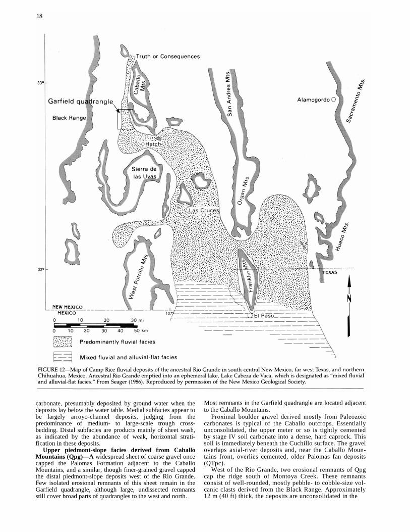
From Berrenda Creek northward, the axial-river fades of the Palomas Formation occupies a relatively narrow (-5 km; -3.1 mi wide) strip along the eastern margin of the Palomas, Engle, and San Martial Basins. Mack and Seager (1990) suggest that this geometry reflects the asymmetry of the Palomas Basin. In contrast, from Berrenda Creek southward, fluvial deposits spread out to form a huge, broad fan-delta system that extends into the Nutt-Hockett Basin between the Sierra de las Uvas and Goodsight uplifts, as well as into and across many of the larger basins of south-central New Mexico, extreme west Texas, and northern Mexico (Fig. 12). Camp Rice terminology is used for the fluvial and piedmont deposits of the fan-delta system whereas Palomas Formation is used for deposits in the Palomas, Engle, and San Mardal Basins, where the ancestral Rio Grande was a narrow axial-river system (J. W. Hawley, pers. comm. 1987). Thus, all of the deposits in the Garfield quadrangle are assigned to the Palomas Formation, although Camp Rice terminology might be appropriate for the fan-delta fluvial rocks that crop out from Berrenda Creek southward.
17
Although the Palomas Formation consists basically of piedmont-slope and axial-river fades, the piedmont-slope facies were further subdivided in this study. These subdi-visions are: 1) distal piedmont-slope facies derived from the Black Range (QTp); 2) piedmont-slope fanglomerate de-rived from Caballo Mountains fault blocks (QTpc); and 3) upper, coarse-grained unconsolidated piedmont-slope fades derived from the Black Range and Caballo Mountains (Qpg).
Distal piedmont-slope facies derived from Black Range (QTp)—Except for relatively minor fluvial sediments, the Palomas Formation west of the Rio Grande in the Garfield quadrangle is distal piedmont-slope deposits, whose source area is the Black Range. No more than 60-90 m (197-295 ft) of section are exposed, however, and the capping Cuchillo surface has nowhere been spared from erosion. Strata are primarily pink, pale yellow-brown, tan, and gray silt-stone, mudstone, and claystone that weather to badlands. Thin (0.3-1 m; 1-3.2 ft thick) beds of pebbly to gravel conglomerate and conglomeratic sandstone are intercalated every 5-15 m (16.5-50 ft). Conglomeratic beds have either planar bedding or trough crossbedding; clasts include a variety of well-rounded volcanic rocks as well as lesser amounts of granite and limestone. All clasts have sources in the Black Range. An important aspect of the distal piedmont-slope deposits is the multiple paleosols distinguished by petrocalcic horizons from stage I to stage IV in maturity (Gile et al., 1981).
All deposits represent the distal part of piedmont slopes and adjacent basin floors. The finer-grained sediments are deposits of broad, low-gradient alluvial flats adjacent to the axial river. Deposition and erosion must have shifted from time to time across these flats leaving land surfaces that were stable for long periods of time, judging from the extent of soil development in the deposits. The conglomeratic strata represent broad channels or sheet-wash deposits that occasionally crossed or flooded alluvial flats, eventually burying them. Upslope, toward the Black Range, alluvial-flat sediments give way to larger volumes of coarser-grained conglomerate. Downslope, the alluvial-flat deposits inter-finger with tongues of fluvial sand and gravel that were deposited by the ancestral Rio Grande as it flowed south-ward along the axis of the Palomas Basin.
Piedmont-slope fanglomerate derived from Caballo Mountains (QTpc)—Alluvial fans of late Pliocene to middle Pleistocene age that were derived from the southern Caballo Mountains form piedmont slopes on the eastern side of the Rio Grande; these deposits are also part of the Palomas Formation. The lower part of these fan deposits consists of well-cemented cobble to boulder fanglomerate exposed in the walls of tributary canyons of the Rio Grande. The fan-glomerate interfingers both laterally and upward with axial-river fades of the Palomas Formation and locally contains tongues of reddish clay alluvial-flat deposits. Although no more than approximately 60 m (197 ft) of the formation are exposed, it may be considerably thicker in the subsurface.
Proximal, medial, and distal subfades crop out. Proximal facies consist of reddish-brown, poorly sorted boulder fan-glomerate composed largely of clasts of Precambrian granite and Paleozoic carbonates and sandstone. Large-scale cross-bedding is locally prominent, but weakly stratified or non-stratified deposits also are present. These are mostly debris-flow and arroyo-channel deposits. Cementation is by calcium carbonate.
Medial- and distal-fan subfades consist of poorly sorted cobble to boulder fanglomerate and conglomeratic sandstone with minor finer-grained beds, as well as discontinuous petrocalcic horizons. Abundant Abo clasts impart a reddish color, whereas abundant silicified rock fragments impart a cream to tan color. Cementation is again by calcium
carbonate, presumably deposited by ground water when the deposits lay below the water table. Medial subfacies appear to be largely arroyo-channel deposits, judging from the predominance of medium- to large-scale trough cross-bedding. Distal subfacies are products mainly of sheet wash, as indicated by the abundance of weak, horizontal strati-fication in these deposits.
Upper piedmont-slope facies derived from Caballo Mountains (Qpg)—A widespread sheet of coarse gravel once capped the Palomas Formation adjacent to the Caballo Mountains, and a similar, though finer-grained gravel capped the distal piedmont-slope deposits west of the Rio Grande. Few isolated erosional remnants of this sheet remain in the Garfield quadrangle, although large, undissected remnants still cover broad parts of quadrangles to the west and north.
Most remnants in the Garfield quadrangle are located adjacent to the Caballo Mountains.
Proximal boulder gravel derived mostly from Paleozoic carbonates is typical of the Caballo outcrops. Essentially unconsolidated, the upper meter or so is tightly cemented by stage IV soil carbonate into a dense, hard caprock. This soil is immediately beneath the Cuchillo surface. The gravel overlaps axial-river deposits and, near the Caballo Moun-tains front, overlies cemented, older Palomas fan deposits (QTpc).
West of the Rio Grande, two erosional remnants of Qpg cap the ridge south of Montoya Creek. These remnants consist of well-rounded, mostly pebble- to cobble-size vol-canic clasts derived from the Black Range. Approximately 12 m (40 ft) thick, the deposits are unconsolidated in the
lower part but tightly cemented by calcite near the top. Presumably, these deposits immediately underlie the Cu-chillo surface, but the surface has been eroded away in this area.
Fluvial and associated facies (QTpf)—The axial-river fades of the Palomas Formation crops out in the bluffs bor-dering both sides of the Rio Grande, as well as in the ridges and canyon walls that reach eastward nearly to the NakayeRed Hills mountain front. The fades is almost completely enclosed by piedmont-slope alluvium (QTpc and Qpg), and the intertonguing or overlapping relationships of fluvial and piedmont strata can be seen on the walls of virtually any canyon or bluff east of the Rio Grande that exposes the formation. Near the center of the deposit the axial-river fades is approximately 100 m (329 ft) thick; the width of the facies is 5 km (3.1 mi). Much of the central part of the deposit, however, has been removed by erosion of the modern Rio Grande.
The axial-river deposits consist largely of gray, yellow, or tan cross-stratified, arkosic sand and gravel, only locally cemented into sandstone, pebbly sandstone, or conglomerate. Lenses or thin beds of clay are intercalated with the sand and gravel. Clasts are well-rounded pebbles and cobbles of a wide variety of rock types, including prominent Black Range volcanics, as well as granite and lesser amounts of sedimentary rocks. Well-rounded, resistant pebbles or cobbles of chert, quartzite, and quartz are always present, and exotic, far-traveled clasts, such as obsidian, are occasionally seen. Numerous, large-scale (1-2 m; 3.2-6.5 ft thick) crossbedded foresets in mixed river and arroyo alluvium indicate prograding gravel bars formed near the mouths of tributary arroyos. Clearly, the deposits are the product of a through-going, aggrading river that contained numerous gravel bars and probably was braided in overall pattern.
Besides fluvial deposits, the QTpf map unit includes sev-eral other facies that represent a variety of depositional environments adjacent to the river channel. Tongues of fan-glomerate are fairly common, and locally light-colored, structureless bodies of clay or silt may represent alluvial flats. Some massive beds of silt and fine sand may be eolian in origin. Greenish, gray, or reddish clay lenses within the fluvial deposits are probably river-overbank (floodplain) deposits. All of these facies interfinger to some degree with each other and with the axial-river facies, which demon-strates the shifting nature of the basin-floor environments with time.
Other than root casts no fossils were found in fluvial deposits in the Garfield quadrangle. Numerous mammal remains, mostly of Blancan age, have been recovered from the unit or correlative rocks elsewhere (Lozinsky and Hawley, 1986a, b; Repenning and May, 1986; Gile et al., 1981; Lucas and Oakes, 1986).
Upper Quaternary valley-fill alluvium
The upper beds of the Palomas Formation and the Cu-chillo surface represent the culmination of basin filling across the Palomas, Engle, and San Martial Basins about 0.4 m.y. B.P. (Lozinsky and Hawley, 1986a, b). Studies by Kottlowski (1958), Ruhe (1962, 1967), Strain (1966), Hawley and Kott-lowski (1969), Gile et al. (1981), and Seager et al. (1984) show that initial valley entrenchment also began 0.4 m.y. B.P. In the Garfield quadrangle evolution of the river valley and its tributary system, presently incised as much as 90 m (295 ft) below the Cuchillo surface, developed in three major and several minor episodes of valley cutting, each followed by intervals of partial backfilling and valley-floor stability. Evidence for these geomorphic processes is preserved along major tributary arroyo walls in the form of three major generations of inset-valley fill whose construc
19
tional upper surfaces form a stepped sequence of terraces (cross-section D-D', Sheet 2). The highest of the major ter-races grades to 45-60 m (148-197 ft) above the river flood-plain, the intermediate terraces to 45 m (148 ft) above the floodplain, and the lower terrace to 20-30 m (66-99 ft) above the floodplain. Still lower, less extensive terraces are present locally. The higher terraces, above 30 m (99 ft), may be correlative with the Tortugas surfaces in the Las Cruces area; the lower major surface is the Picacho surface in the Las Cruces area (Hawley, 1965; Ruhe, 1964, 1967; Hawley and Kottlowski, 1969; Gile et al., 1981). These authors have shown that these correlative surfaces and their related deposits are middle to late Pleistocene in age, 0.4-0.22 m.y. old.
Older valley-fill alluvium
Deposits associated with the three major terraces were mapped as "older valley-fill alluvium" (Qvo). Each as much as 20 m (66 ft) thick, the terrace deposits consist largely of gravel and gravelly sand. Except for soil-carbonate cementation at the top, the deposits are poorly indurated. The older two deposits locally exhibit pedogenic carbonate horizons as much as 0.5-1 m (1.6-3.2 ft) thick, which tightly cement uppermost gravel layers. Clasts derived from the Black Range are generally medium- to well-rounded cobbles and pebbles; the grain size is distinctly larger than any in the underlying Palomas Formation. Qvo fans and terraces on the east side of the river are derived, of course, from the Caballo Mountains fault blocks. Except for reworked Palomas axial-river deposits, clasts in these fans and terraces are neither rounded nor sorted. The Qvo deposits have a reddish color in part owing to the content of red bed debris.
Downslope, Qvo fan and arroyo deposits interfinger with older fluvial gravel and sand (Qvof) that locally form low bluffs adjacent to the river floodplain. Complexly interfin-gering Qvo and Qvof deposits were mapped as Qvou. The older river alluvium consists of mixed, unconsolidated gravel and sand with substantial zones of well-sorted, well-rounded gravel in the pebble- to cobble-size range and pure sand. As much as 15 m (50 ft) thick locally, the deposits have been quarried for use in road and building construction.
Younger valley-fill alluvium Sediment mapped as younger valley-fill alluvium (Qvy)
includes deposits of latest Wisconsin and Holocene age, <15,000 yrs (Hawley and Kottlowski, 1969; Hawley, 1978). The deposits correlate with the Leasburg, Fillmore, and His-torical morphostratigraphic units of the Las Cruces-Hatch area (Hawley and Kottlowski, 1969; Seager and Hawley, 1973; Gile et al., 1981).
Younger valley-fill alluvium is not indurated and may exhibit incipient soil development, including thin coatings of filamentary carbonate on clasts or within finer-grained material. Otherwise, it is very similar lithologically to the "older valley-fill" deposits.
Arroyo-mouth fans (Qvy) interfinger with and overlap younger valley-fill fluvial facies (Qvyf) along the margins of the Rio Grande floodplain. The floodplain deposits (Qvyf) are.16-21 m (53-69 ft) thick as indicated by water wells (e.g. Conover, 1954; King et al., 1971) and consist mostly of pebble to cobble gravel, sand, and interbedded lenses of gray clay. Carbon 14 ages of charcoal recovered from Qvy units show that river aggradation to essentially the present base level had occurred by 9,400 yrs B.P., and the fans associated with tributary arroyos have been encroaching onto the floodplain for the past 7,500 yrs (Hawley and Kottlowski, 1969; Seager and Hawley, 1973).

20
Structural geology Numerous faults, a few folds, and widespread tilted strata
are exposed in the Derry Hills and Red Hills. These struc-tures involve rocks and sediment as young as late Pleisto-cene but are best developed in Precambrian and Paleozoic rocks. Structures in the quadrangle are of two ages: older ones formed during the Laramide orogeny in latest Creta-ceous to early Cenozoic time and younger ones originated during evolution of the Rio Grande rift in late Tertiary and Quaternary time. Laramide structures are compressional in origin and include tight to open folds associated with thrust and reverse faults. Late Tertiary and Quaternary structures, which transect and offset the Laramide folds and faults, are extensional in origin and consist almost exclusively of tilted fault blocks bordered by high-angle normal faults. Late Ter-tiary folding is minor, restricted to folds created by oppo-sitely dipping fault blocks or by normal drag along faults.
Laramide structure A belt of complex Laramide faults and associated folds
in Paleozoic strata compose the eastern part of the Derry Hills. The zone of deformation trends northwestward and is exposed through a distance of 2.5 km (1.5 mi). Buried at both ends by Quaternary alluvium, the structures at the southeast end are also truncated and downdropped beneath bolson fill by the late Tertiary Derry Hills fault. Kelley and Silver (1952) also mapped the zone of deformation and named it the Derry Hills belt.
Although brecciation, silicification, and younger high-an-gle normal faults make parts of the deformed belt difficult to interpret, the overall geometry seems relatively clear. Cross sections A—A', B—B', and C—C' show that the basic structure consists of one or two overturned synclines, facing southwestward, with axial planes that dip approximately 40° northeastward. The overturned synclines are beneath northeast-dipping thrust faults. Axial regions of the syncline are also broken by thrust faults that dip northeastward (Fig. 13). Judging from sparse fault exposures and relatively straight traces across topography, the thrust faults dip 60° or more. Stratigraphic separation on single faults is from 60 to 150 m (197-493 ft), but separation across groups of closely spaced thrusts may approach 300 m (984 ft) locally. Structural relief across the deformed belt may be as much
as 450 m (1,476 ft), the structurally higher areas being along the northeastern side of the belt and the structurally lower areas being along the southwestern side. The southwest vergence of folds and faults in the Derry Hills belt is of special interest because it is opposite to all other Laramide structures in the Caballo Mountains. From a regional view-point this southwestward tectonic transport direction is anomalous.
Seager (1983), Seager and Mack (1986), and, most re-cently, Seager et al. (1986) have interpreted Laramide tec-tonics in south-central New Mexico. From scattered outcrops in many ranges and from a few deep oil tests they have reconstructed large northwest-trending, basement-cored block uplifts that are bordered on their northeastern side by narrow zones of southwest-dipping, low- to moderate-angle basement thrust faults and associated folds. Except for the Deny Hills belt, vergence of structures is consistently toward the northeast, ranging from north—northeast to east—northeast. Uplifts generally have gently dipping south-western flanks modified by normal or reverse faults. Com-plementary basins containing up to 2,100 m (6,890 ft) of syntectonic and posttectonic basin fill (Love Ranch For-mation and correlative rocks) flank the uplifts. Composition of basin fill, as well as locally exposed unconformities, con-firm that deeply eroded Precambrian rocks compose sig-nificant parts of the uplifted blocks. In general, Laramide structural style in south-central New Mexico is similar to that of the Wind River and Owl Creek uplifts and comple-mentary Wind River basin of Wyoming.
The principal Laramide uplift (Rio Grande uplift) and complementary basins (Love Ranch and Potrillo Basins) in south-central New Mexico are shown in Fig. 11. The positions of the Garfield quadrangle and Derry Hills belt are also shown on the map and on the diagrammatic section. The Deny Hills structures seemingly are part of a structural bench between the Love Ranch Basin, which lies to the northeast of the Caballo Mountains, and the main, high, Precambrian-cored part of the Rio Grande uplift, which lies to the southwest of the Caballo Mountains. Abundant Precambrian detritus in the Love Ranch Formation in the Garfield quadrangle and elsewhere in the southern Caballos was derived from the southwest and then transported northeastward across the structural bench of the Rio Grande uplift into the Love Ranch Basin (Seager et al., 1986). Paleozoic clasts were derived from the faulted and eroded structural bench as well as from the highest, more southern uplift. The southwest-verging fold and thrust belt in the Derry Hills indicates that, at least locally, the structural bench part of the Rio Grande uplift is modified by "back" thrusts. These antithetic structures also have counterparts in some of the uplifts of the central Rockies (e.g. Gries, 1983a, b).
Late Tertiary structure The most important late Tertiary structures in the quadrangle
are the Red Hills and Derry Hills faults. Both faults are northwest-trending, high-angle, normal faults. Both are downthrown to the southwest and are the boundary faults for blocks that have been uplifted and tilted gently to the northeast. The uplifted and tilted blocks are known as 1) the Red Hills—Nakaye Mountain block, which is bordered by the Red Hills fault and its system of splays, and 2) the Derry Hills block, which is bordered by the Derry Hills fault. Downdropped blocks are parts of the Palomas Basin, one of the major basins of the Rio Grande rift.
Red Hills fault
The Red Hills fault is one of the major faults in the southern part of the Rio Grande rift. Although it decreases in

displacement as it is traced southeast across the Garfield quadrangle, to the north the fault increases in throw and becomes the main boundary fault of the Caballo Mountains, one of the major uplifts of the Rio Grande rift. Judging from the steep gravity gradient across the fault (Cordell et al., 1982; Seager et al., 1982), displacement is probably several thousand feet, at least from the northern Red Hills north-ward. The fault dips approximately 67° to the southwest in the Red Hills (Fig. 14), and slickensides rake 60° and trend east-west. These structures are consistent with regional east-west extension during formation of the modern Caballo Mountains and also indicate a small amount of right slip along the Red Hills fault.
As it traverses Precambrian granite of the central Red Hills, the Red Hills fault is a single, simple fault or a very narrow zone of faults. Farther south, however, the fault divides into numerous strands that lose displacement as they transect Paleozoic strata in the southern Red Hills and on Nakaye Mountain. These strands, each of which exhibits stratigraphic separation of a hundred meters (300 ft) or so, all step the Paleozoic section down to the southwest. They form the northeastern border of the half graben between the Derry Hills fault block on the southwest and the Red Hills-Nakaye Mountain block to the northeast. Antithetic, down-to-the-northeast faults are present between the various Red Hills fault strands in the southern Red Hills, creating a series of small antithetic grabens that modify the stair-step fault structure (section A-A', Sheet 2). On Nakaye Mountain, on the other hand, the various strands of the Red Hills fault combine with a system of antithetic faults to form the Nakaye Mountain horst, which is beautifully stair-stepped down toward both the southwest and northeast (section B-B', Sheet 2).
Evidence for Quaternary movement along the Red Hills fault is clear. Conglomerate of the Palomas Formation (QTpc) is deformed in several areas adjacent to outer strands of the fault and locally has been dragged to near vertical attitude near the fault plane. A remnant of a piedmont scarp in upper Pleistocene fan alluvium (Qvo) is preserved along the Red Hills fault in the northeastern corner of the quadrangle. The scarp is approximately 4 m (13 ft) high and indicates late Pleistocene or Holocene movement.
The piedmont scarp is much more extensively developed along the Caballo fault (a northward continuation of the Red Hills fault) at the base of the Caballo Mountains. There, trenches excavated across the scarp support an interpre-tation of Holocene movement along the Caballo fault (L. Foley, pers. comm. 1987). Holocene movement along the Red Hills fault is therefore also likely.
Deny Hills fault The Deny Hills fault is exposed along the southwestern
edge of the Derry Hills over a distance of 6 km (3.7 mi) in the Garfield quadrangle. Displacement along the fault is unknown but is probably at least 1,000 m (3,280 ft) judging from the steep gravity gradient across it (Cordell et al., 1982; Seager et al., 1982). The fault dips 65-80° toward the south-west or south.
Movement along the fault has uplifted the Derry Hills block relative to the Palomas Basin. The Deny Hills block seemingly has been tilted 10-20° toward the northeast, al-though part or all of this dip may also be Laramide in origin. Tilting could be a product of either uplift on the Deny Hills fault or east tilting into the various strands of a listric(?) Red Hills fault zone. In any case the Deny Hills are the updip (hanging wall) part of a half graben that extends downdip to the various strands of the Red Hills fault that border the western side of the Nakaye Mountain horst.
Evidence for Quaternary movement along the Derry Hills fault is abundant. The fault displaces youngest units of the Palomas Formation (Qpg) southeast of the Deny Hills in-dicating post-middle Pleistocene movement. Excellent ex-posures of the fault surface transecting older parts of the Palomas Formation (QTpf and QTpc) are present in several gullies in the same area. There is no evidence that upper Pleistocene or Holocene fan alluvium has been displaced.
Economic deposits The only noteworthy economic deposits known in the
Garfield quadrangle are fluorspar and sand and gravel. The latter are particularly abundant and have been quarried to some extent in several places along the Rio Grande. De-posits of Qvof and Qvou, especially, contain large amounts of river gravel and sand that are essentially uncemented. Gravels range from pebble to cobble size in general. Very extensive deposits of sand and gravel left by the ancestral Rio Grande constitute unit QTpf. These strata also are poorly to well graded (well sorted to poorly sorted). QTpf and Qvou, although predominantly composed of high-quality fluvial sand and gravel, contain lenses and beds of even more poorly sorted and more angular arroyo alluvium derived from local sources. This alluvium, when present, "contaminates" the clean, well-rounded and much better sorted gravels and sand of fluvial origin.
Fluorspar has been prospected extensively in the eastern
part of the Deny Hills. Described by McAnulty (1978), the following is a summary of his observations.
Twenty unpatented claims, known as the Red Star Group, are located along the eastern and northeastern part of the Derry Hills. These claims include the Esperanza claims de-scribed by Johnston (1928). In 1978 the Red Star claims were owned by John Hanson and Gerald Aday of Truth or Consequences.
Prospects on the Red Star claims include a group of nine bulldozer cuts exposing veins and pods of green fluorspar 0.1-0.7 m (0.3-2.3 ft) thick. The veins are associated with broad areas of silicified and brecciated rock in and adjacent to thrust faults that juxtapose Montoya and El Paso dolomite with overturned Magdalena strata. Most of the minerali-zation is in silicified and/or brecciated Montoya or El Paso dolomite or limestone. The longest fluorspar-bearing sili-cified mass is approximately 240 m (787 ft) long and 90 m

22
(295 ft) wide, trending parallel to the faults and to an asym-metrical anticline in Montoya beds. McAnulty (1978) esti-mates fluorspar reserves from this deposit at approximately 4,000 tons.
McAnulty (1978) notes also that other large silicified areas in the Derry Hills may contain large low-grade fluorspar resources. However, many of these are in Magdalena beds, which so far have not proven to contain the same values of fluorspar as the Montoya and El Paso strata.
On Nakaye Mountain, just beyond the Garfield quadrangle, fluorspar is present in several places. Perhaps most notable of these are the Nakaye (Alamo) deposits in secs. 15 and 22 T17S R4W (Rothrock et al., 1946; McAnulty, 1978).
Unlike the Esperanza deposits, the Nakaye deposits consist mostly of concordant bedding replacements of dolomite at the top of the Fusselman Dolomite. The dolomite is overlain by shaly basal beds of the Magdalena Group (Red House Formation), which probably served to dam rising fluorspar-bearing fluids. Fluorspar also is found in veins and pods along faults on the Nakaye claims, particularly on the Nakaye fault (McAnulty, 1978), an east-trending normal fault that juxtaposes Ordovician and Silurian dolomite and Magdalena limestone. Total production from the Nakaye Group through 1952 is 5,471 tons, and probably reserves of 35,000 tons of 35% CaF2 still exist (McAnulty, 1978).
References Boardman, D. R., II, and Heckel, P. H., 1989, Glacial-eustatic sea-
level curve for early Late Pennsylvanian sequence in north-cen-tral Texas and biostratigraphic correlation with curve for mid-continent North America: Geology, v. 17, no. 9, pp. 802-805.
Bruno, L., and Chafetz, H. S., 1988, Depositional environment of the Cable Canyon Sandstone-a mid-Ordovician sandwave complex from southern New Mexico: New Mexico Geological Society, Guidebook to 39th Field Conference, pp. 127-134.
Cappa, J. A., and MacMillan, J. R., 1983, Paleocurrent analysis of the Abo Formation, Cerros de Amado area; in Zidek, J. (ed.), Guidebook for field trip to the Abo red beds (Permian), central and south-central New Mexico: Roswell Geological Society and New Mexico Bureau of Mines and Mineral Resources, p. 53.
Chafetz, H. S., Meredith, J. C., and Kocurek, G., 1986, The Cam-bro-Ordovician Bliss Formation, southwestern New Mexico, USA-progradational sequences on a mixed siliciclastic and car-bonate shelf: Sedimentary Geology, v. 49, nos. 3-4, pp. 201-221.
Chapin, C. E., 1979, Evolution of the Rio Grande rift-a summary; in Riecker, R. E. (ed.), Rio Grande rift-tectonics and magmatism: American Geophysical Union, Washington, D.C., pp. 1-5.
Chapin, C. E., and Seager, W. R., 1975, Evolution of the Rio Grande rift in the Socorro and Las Cruces areas: New Mexico Geological Society, Guidebook to 26th Field Conference, pp. 297-321.
Clemons, R. E., 1979, Geology of Good Sight Mountains and Uvas Valley, southwest New Mexico: New Mexico Bureau of Mines and Mineral Resources, Circular 169, 32 pp.
Clemons, R. E., 1987, El Paso Formation--a Lower Ordovician platform carbonate deposit (abs.): American Association of Petroleum Geologists, Bulletin, v. 71, no. 5, p. 539.
Clemons, R. E., in press, Petrography and depositional environ-ments of the Lower Ordovician El Paso Formation: New Mexico Bureau of Mines and Mineral Resources, Bulletin 125.
Conover, C. S., 1954, Ground-water conditions in the Rincon and Mesilla Valleys and adjacent areas of New Mexico: U.S. Geological Survey, Water-Supply Paper 1230, 200 pp.
Cordell, L., Keller, G. R., and Hildenbrand, T. G., 1982, Complete Bouguer gravity map of the Rio Grande rift, Colorado, New Mexico, and Texas: U.S. Geological Survey, Geophysical Inves-tigations Map GP-949, scale 1:1,000,000.
Evans, K. V., and Clemons, R. E., 1988, Cambrian-Ordovician (500 Ma) alkalic plutonism in southwestern New Mexico-U-Th-Pb isotopic data from the Florida Mountains: American Journal of Science, v. 288, no. 7, pp. 735-755.
Flower, R. H., 1953, Age of the Bliss Sandstone, New Mexico: American Association of Petroleum Geologists, Bulletin, v. 37, no. 8, pp. 2054-2055.
Flower, R. H., 1958, Cambrian-Mississippian beds of southern New Mexico: Roswell Geological Society, Guidebook to 11th Field Conference, pp. 61-78.
Flower, R. H., 1959, Cambrian-Devonian beds of southern New Mexico: Society of Economic Paleontologists and Mineralogists, Permian Basin Section, Guidebook, pp. 154-171.
Flower, R. H., 1965, Early Paleozoic of New Mexico: New Mexico Geological Society, Guidebook to 16th Field Conference, pp. 112-131.
Flower, R. H., 1969, Early Paleozoic of New Mexico and the El Paso region: El Paso Geological Society, Guidebook to 3rd Annual Trip, pp. 31-101.
Freytet, P., 1973, Petrography and paleo-environment of continen-tal carbonate deposits with particular reference to the Upper
Cretaceous and lower Eocene of Languedoc (southern France): Sedimentary Geology, v. 10, no. 1, pp. 25-60.
Gile, L. H., Hawley, J. W., and Grossman, R. B., 1981, Soils and geomorphology in the Basin and Range area of southern New Mexico-guidebook to the Desert Project: New Mexico Bureau of Mines and Mineral Resources, Memoir 39, 222 pp.
Gile, L. H., Peterson, F. F., and Grossman, R. B., 1966, Morpho-logical and genetic sequences of carbonate accumulation in des-ert soils: Soil Science, v. 101, no. 5, pp. 347-360.
Gordon, C. H., 1907, Notes on the Pennsylvanian formations in the Rio Grande valley, New Mexico: Journal of Geology, v. 15, no. 8, pp. 805-816.
Gordon, C. H., and Graton, L. C., 1907, Lower Paleozoic formations in New Mexico (abs.): Journal of Geology, v. 15, no. 1, pp. 91-92.
Greenwood, E., Kottlowski, F. E., and Thompson, S., III, 1977, Petroleum potential and stratigraphy of Pedregosa Basin-com-parison with Permian and Orogrande Basins: American Asso-ciation of Petroleum Geologists, Bulletin, v. 61, no. 9, pp. 14481469.
Gries, R., 1983a, Oil and gas prospecting beneath Precambrian of foreland thrust plates in Rocky Mountains: American Association of Petroleum Geologists, Bulletin, v. 67, no. 1, pp. 1-28.
Gries, R., 1983b, North-south compression of Rocky Mountain foreland structures; in Lowell, J. D. (ed.), Rocky Mountain foreland basins and uplifts: Rocky Mountain Association of Geologists, Guidebook to 1983 Field Conference, pp. 9-32.
Groves, J. R., 1986, Foraminiferal characterization of the Morro-wan-Atokan (lower Middle Pennsylvanian) boundary: Geolog-ical Society of America, Bulletin, v. 97, no. 3, pp. 346-353.
Harbour, R. L., 1972, Geology of the northern Franklin Mountains, Texas and New Mexico: U.S. Geological Survey, Bulletin 1298, 129 pp.
Hawley, J. W., 1965, Geomorphic surfaces along the Rio Grande valley from El Paso, Texas to Caballo Reservoir, New Mexico: New Mexico Geological Society, Guidebook to 16th Field Conference, pp. 188-198.
Hawley, J. W. (comp.), 1978, Guidebook to the Rio Grande rift in New Mexico and Colorado: New Mexico Bureau of Mines and Mineral Resources, Circular 163, 241 pp.
Hawley, J. W., and Kottlowski, F. E., 1969, Quaternary geology of the south-central New Mexico border region; in Kottlowski, F. E., and LeMone, D. V. (eds.), Border stratigraphy symposium: New Mexico Bureau of Mines and Mineral Resources, Circular 104, pp. 89-115.
Hayes, P. T., 1975, Cambrian and Ordovician rocks of southern Arizona and New Mexico and westernmost Texas: U.S. Geological Survey, Professional Paper 873, 98 pp.
Heckel, P. H., 1980, Paleogeography of eustatic model for deposition of midcontinent Upper Pennsylvanian cydothems; in Fouch, T. D., and Magathan, E. R. (eds.), Paleozoic paleogeography of west-central United States: Society of Economic Paleontologists and Mineralogists, Rocky Mountain Section, West-Central United States Paleogeography Symposium I., pp. 197-215.
Heckel, P. H., 1986, Sea-level curve for Pennsylvanian eustatic marine transgressive-regressive depositional cycles along mid-continent outcrop belt, North America: Geology, v. 14, no. 4, pp. 330-334.
Hoffman, J. H., 1976, Stratigraphy and sedimentology of the Bliss Sandstone (Cambro-Ordovician), southern Franklin Mountains,
Texas: Unpublished MS thesis, Louisiana State University, 175 pp.
Howard, J. D., and Reineck, H-E., 1981, Depositional fades of high-energy beach-to-offshore sequence-comparison with low-energy sequence: American Association of Petroleum Geologists, Bulletin, v. 65, no. 5, pp. 807-830.
Johnston, W. D., Jr., 1928, Fluorspar in New Mexico: New Mexico Bureau of Mines and Mineral Resources, Bulletin 4, 128 pp.
Jordon, C. F., 1975, Lower Permian (Wolfcampian) sedimentation in the Orogrande Basin, New Mexico: New Mexico Geological Society, Guidebook to 26th Field Conference, pp. 109-117.
Kalesky, J. F., 1988, Lithofacies, stratigraphy, and cyclic sedimentation in a mixed carbonate and siliciclastic system, Red House Formation (Atokan), Sierra County, New Mexico: Unpublished MS thesis, New Mexico State University, 202 pp.
Kelley, V. C., 1951, Oolitic iron deposits of New Mexico: American Association of Petroleum Geologists, Bulletin, v. 35, no. 10, pp. 2199-2228.
Kelley, V. C., and Silver, C., 1952, Geology of the Caballo Moun-tains with special reference to regional stratigraphy and structure and to mineral resources, including oil and gas: University of New Mexico, Publications in Geology, No. 4, 286 pp.
King, W. E., 1973, Fusulinids Millerella and Eostaffella from the Pennsylvanian of New Mexico and Texas: New Mexico Bureau of Mines and Mineral Resources, Memoir 26, 34 pp.
King, W. E., Hawley, J. W., Taylor, A. M., and Wilson, R. P., 1971, Geology and ground-water resources of central and western Dona Ana County, New Mexico: New Mexico Bureau of Mines and Mineral Resources, Hydrologic Report 1, 64 pp.
Kottlowski, F. E., 1953, Tertiary-Quaternary sediments of the Rio Grande valley in southern New Mexico: New Mexico Geological Society, Guidebook to 4th Field Conference, pp. 144-148.
Kottlowski, F. E., 1958, Geologic history of the Rio Grande near El Paso: West Texas Geological Society, Guidebook to 1958 Field Conference, pp. 46-54.
Kottlowski, F. E., 1960, Summary of Pennsylvanian sections in southwestern New Mexico and southeastern Arizona: New Mex-ico Bureau of Mines and Mineral Resources, Bulletin 66, 187 pp.
Kottlowski, F. E., 1963, Paleozoic and Mesozoic strata of south-western and south-central New Mexico: New Mexico Bureau of Mines and Mineral Resources, Bulletin 79, 100 pp.
Kottlowski, F. E., 1965, Sedimentary basins of south-central and southwestern New Mexico: American Association of Petroleum Geologists, Bulletin, v. 49, no. 11, pp. 2120-2139.
Kottlowski, F. E., Flower, R. H., Thompson, M. L., and Foster, R. W., 1956, Stratigraphic studies of the San Andres Mountains, New Mexico: New Mexico Bureau of Mines and Mineral Resources, Memoir 1, 132 pp.
Kottlowski, F. E., and Pray, L. C., 1967, Silurian outcrops of south-central and southwestern New Mexico; in Symposium-Silurian-Devonian rocks of Oklahoma and environs: Tulsa Geological Society, Digest, v. 35, pp. 209-230.
Kottlowski, F. E., Weber, R. H., and Willard, M. E., 1969, Tertiary intrusive-volcanic mineralization episodes in the New Mexico region (abs.): Geological Society of America, Abstracts with Programs, pt. 7, p. 278.
Langston, W., Jr., 1953, Permian amphibians from New Mexico: University of California, Publications in the Geological Sciences, v. 29, no. 7, pp. 349-416.
Lee, W. T., and Girty, G. H., 1909, The Manzano Group of the Rio Grande valley, New Mexico: U.S. Geological Survey, Bulletin 389, 141 pp.
LeMone, D. V., 1969, Lower Paleozoic rocks in the El Paso area: New Mexico Geological Society, Guidebook to 20th Field Conference, pp. 68-79.
Lewis, D. W., 1962, Glauconite in the Cambrian-Ordovician Bliss Formation near Silver City, New Mexico: New Mexico Bureau of Mines and Mineral Resources, Circular 59, 30 pp.
Loring, A. K., and Armstrong, D. G., 1980, Cambrian-Ordovician syenites of New Mexico, part of a regional alkalic intrusive episode: Geology, v. 8, no. 7, pp. 344-348.
Loring, A. K., and Loring, R. B., 1980, K/Ar ages of middle Tertiary igneous rocks from southern New Mexico: Isochron/West, no. 28, pp. 17-19.
Lozinsky, R. P., 1986, Geology and late Cenozoic history of the Elephant Butte area, Sierra County, New Mexico: New Mexico Bureau of Mines and Mineral Resources, Circular 187, 40 pp.
Lozinsky, R. P., and Hawley, J. W., 1986a, Upper Cenozoic Palomas Formation of south-central New Mexico: New Mexico Geological
23
Society, Guidebook to 37th Field Conference, pp. 239-247. Lozinsky, R. P., and Hawley, J. W., 1986b, The Palomas
Formation of south-central New Mexico-a formal definition: New Mexico Geology, v. 8, no. 4, pp. 73-78, 82.
Lucas, S. G., 1986, Oligocene mammals from the Black Range: New Mexico Geological Society, Guidebook to 37th Field Conference, pp. 261-263.
Lucas, S. G., and Oakes, W., 1986, Pliocene (Blancan) vertebrates from the Palomas Formation, south-central New Mexico: New Mexico Geological Society, Guidebook to 37th Field Conference, pp. 249-255.
Lucia, F. J., 1968, Sedimentation and paleogeography of the El Paso Group; in Delaware Basin exploration: West Texas Geological Society, Publication 68-55, pp. 61-75.
Machette, M. N., 1978a, Geologic map of the San Acacia quadran-gle, Socorro County, New Mexico: U.S. Geological Survey, Geo-logic Quadrangle Map GQ-1415, scale 1:24,000.
Machette, M. N., 1978b, Preliminary geologic map of the Socorro 1° x 2° quadrangle, central New Mexico: U.S. Geological Survey, Open-File Report 78-607, scale 1:250,000.
Mack, G. H., and James, W. C., 1986, Cyclic sedimentation in the mixed siliciclastic-carbonate Abo-Hueco transitional zone (Lower Permian), southwestern New Mexico: Journal of Sedimentary Petrology, v. 56, no. 5, pp. 635-647.
Mack, G. H., and Seager, W. R., 1990, Tectonic control on facies distribution of the Camp Rice and Palomas Formations (Pliocene-Pleistocene) in the southern Rio Grande rift: Geological Society of America, Bulletin, v. 102, no. 1, pp. 45-53.
Marvin, R. F., and Cole, J. C., 1978, Radiometric ages-compilation A, U.S. Geological Survey: Isochron/West, no. 22, pp. 3-14.
McAnulty, W. N., 1978, Fluorspar in New Mexico: New Mexico Bureau of Mines and Mineral Resources, Memoir 34, 64 pp.
McLemore, V. T., 1986, Geology, geochemistry, and mineralization of syenites in the Red Hills, southern Caballo Mountains, Sierra County, New Mexico: New Mexico Geological Society, Guide-book to 37th Field Conference, pp. 151-160.
McLemore, V. T., 1987, Petrologic, paleomagnetic, and structural evidence of a Paleozoic rift system in Oklahoma, New Mexico, Colorado, and Utah-discussion: Geological Society of America, Bulletin, v. 99, no. 2, pp. 315-316.
McRae, S. G., 1972, Glauconite: Earth-Science Reviews, v. 8, no. 4, pp. 397-440.
Muehlberger, W. R., Hedge, C. E., Denison, R. E., and Marvin, R. F., 1966, Geochronology of the midcontinent region, United States, Part 3. Southern area: Journal of Geophysical Research, v. 71, no. 22, pp. 5409-5426.
Ottensman, D. C., 1983, A paleoenvironmental and lithofacies analysis of part of the Bliss Formation (Cambro-Ordovician), southwestern New Mexico and west Texas: Unpublished MS thesis, University of Texas, Dallas, 125 pp.
Read, C. B., and Mamay, S. H., 1964, Upper Paleozoic floral zones and floral provinces of the United States: U.S. Geological Survey, Professional Paper 454-K, 35 pp.
Reeves, C. C., Jr., 1970, Origin, classification, and geologic history of caliche on the southern High Plains, Texas and eastern New Mexico: Journal of Geology, v. 78, no. 3, pp. 352-362.
Repenning, C. A., and May, S. R., 1986, New evidence for the age of lower part of the Palomas Formation, Truth or Consequences, New Mexico: New Mexico Geological Society, Guidebook to 37th Field Conference, pp. 257-260.
Richardson, G. B., 1904, Report of a reconnaissance in trans-Pecos Texas, north of the Texas and Pacific Railway: University of Texas Mineral Survey, Bulletin 9, 119 pp.
Richardson, G. B., 1908, Paleozoic formations in trans-Pecos Texas: American Journal of Science, v. 25, no. 150, art. 49, pp. 474-484.
Richardson, G. B., 1909, Description of the El Paso district: U.S. Geological Survey, Geologic Atlas, El Paso Folio, No. 166, 11 pp.
Rothrock, H. E., Johnson, C. H., and Hahn, A. D., 1946, Fluorspar resources of New Mexico: New Mexico Bureau of Mines and Mineral Resources, Bulletin 21, 239 pp.
Ruhe, R. V., 1962, Age of the Rio Grande valley in southern New Mexico: Journal of Geology, v. 70, no. 2, pp. 151-167.
Ruhe, R. V., 1964, Landscape morphology and alluvial deposits in southern New Mexico: Annals of the Association of American Geographers, v. 54, pp. 147-159.
Ruhe, R. V., 1967, Geomorphic surfaces and surficial deposits in southern New Mexico: New Mexico Bureau of Mines and Mineral Resources, Memoir 18, 66 pp.
Rust, B. R., 1981, Sedimentation in an arid-zone anastomosing
24
fluvial system-Cooper's Creek, central Australia: Journal of Sedimentary Petrology, v. 51, no. 3, pp. 745-755.
Seager, W. R., 1981, Geology of Organ Mountains and southern San Andres Mountains, New Mexico: New Mexico Bureau of Mines and Mineral Resources, Memoir 36, 97 pp.
Seager, W. R., 1983, Laramide wrench faults, basement-cored uplifts, and complementary basins in southern New Mexico: New Mexico Geology, v. 5, no. 4, pp. 69-76.
Seager, W. R., 1986, Third-day road log, from Truth or Conse-quences to southeastern Caballo Mountains and San Diego Mountain via 1-25 and the Jomada del Muerto: New Mexico Geological Society, Guidebook to 37th Field Conference, pp. 3552.
Seager, W. R., and Clemons, R. E., 1975, Middle to late Tertiary geology of Cedar Hills-Selden Hills area, New Mexico: New Mexico Bureau of Mines and Mineral Resources, Circular 133, 24 pp.
Seager, W. R., Clemons, R. E., Hawley, J. W., and Kelley, R. E., 1982, Geology of northwest part of Las Cruces 1° x 2° sheet, New Mexico: New Mexico Bureau of Mines and Mineral Re-sources, Geologic Map 53, scale 1:125,000.
Seager, W. R., and Hawley, J. W., 1973, Geology of Rincon quadrangle, New Mexico: New Mexico Bureau of Mines and Mineral Resources, Bulletin 101, 42 pp.
Seager, W. R., Hawley, J. W., and Clemons, R. E., 1971, Geology of San Diego Mountain area, Dona Ana County, New Mexico: New Mexico Bureau of Mines and Mineral Resources, Bulletin 97, 38 pp.
Seager, W. R., and Mack, G. H., 1986, Laramide paleotectonics of southern New Mexico; in Peterson, J. A. (ed.), Paleotectonics and sedimentation in the Rocky Mountain region, United States: American Association of Petroleum Geologists, Memoir 41, pp. 669-685.
Seager, W. R., Mack, G. H., Raimonde, M. S., and Ryan, R. G., 1986, Laramide basement-cored uplift and basins in south-central New Mexico: New Mexico Geological Society, Guidebook to 37th Field Conference, pp. 123-130.
Seager, W. R., Shafiqullah, M., Hawley, J. W., and Marvin, R. F., 1984, New K-Ar dates from basalts and the evolution of the southern Rio Grande rift: Geological Society of America, Bulletin, v. 95, no. 1, pp. 87-99.
Stageman, C. J., 1987, Depositional facies and provenance of lower Paleozoic sandstones of the Bliss, El Paso, and Montoya For-mations, southern New Mexico and west Texas: Unpublished
MS thesis, New Mexico State University, 101 pp. Strain, W. S., 1966, Blancan mammalian fauna and Pleistocene
formations, Hudspeth County, Texas: University of Texas, Austin, Texas Memorial Museum, Bulletin, v. 10, 55 pp.
Strain, W. S., 1969, Late Cenozoic strata of the El Paso area; in Kottlowski, F. E., and LeMone, D. V. (eds.), Border stratigraphy symposium: New Mexico Bureau of Mines and Mineral Resources, Circular 104, pp. 122-123.
Sutherland, P. K., and Manger, W. L., 1984, Morrowan brachiopods in the type "Derryan" Series (Pennsylvanian), New Mexico (abs.): Geological Society of America, Abstracts with Programs, v. 16, no. 2, p. 115.
Swift, D. J. P., 1968, Coastal erosion and transgressive stratigraphy: Journal of Geology, v. 76, no. 4, pp. 444-456.
Swift, D. J. P., and Field, M. E., 1981, Evolution of a classic sand ridge field-Maryland sector, North American inner shelf: Sedimentology, v. 28, no. 4, pp. 461-482.
Swift, D. J. P., and Niedoroda, A., 1985, Fluid and sediment dy-namics on continental shelves; in Tillman, R. W., Swift, D. J. P., and Walker, R. G. (eds.), Shelf sands and sandstone reservoirs: Society of Economic Paleontologists and Mineralogists, Short Course No. 13, pp. 47-133.
Thompson, M. L., 1942, Pennsylvanian System in New Mexico: New Mexico Bureau of Mines and Mineral Resources, Bulletin 17, 92 pp.
Thompson, M. L., 1948, Early Pennsylvanian fusulinids of New Mexico and western Texas: University of Kansas, Paleontological Contributions 4, art. 1, pt. 3, pp. 68-97.
Thompson, M. L., 1954, American Wolfcampian fusulinids: University of Kansas, Paleontological Contributions 14, art. 5, 226 pp.
Thompson, S., III, and Potter, P. E., 1981, Paleocurrents of the Bliss Sandstone (Cambrian-Ordovician), southwestern New Mexico and western Texas: New Mexico Bureau of Mines and Mineral Resources, Annual Report 1979-1980, pp. 36-51.
Vail, P. R., Mitchum, R. M., Jr., and Thompson, S., III, 1977, Seis-mic stratigraphy and global changes of sea level, part 4-global cycles of relative changes of sea level: American Association of Petroleum Geologists, Memoir 26, pp. 83-97.
Wilpolt, R. H., and Wanek, A. A., 1951, Geology of the region from Socorro and San Antonio east to Chupadera Mesa, Socorro County, New Mexico: U.S. Geological Survey, Oil and Gas Investigations, Map OM-121, scale 1:63,360.


Editor: Jane C. Love
Drafters: Cindie A. Salisbury Jonathan D. Cheney
Typeface: Palatino
Presswork: Miehle Single Color Offset Harris Single Color Offset
Binding: Saddlestitched with softbound cover
Paper: Cover on I7-pt. Kivar Text on 70 lb white matte
Ink: Cover—PMS 320 Text—Black
Quantity: 1000

Contents of pocket
SHEET 1—Geologic map of Garfield quadrangle, Sierra and Dona Ana Counties, New Mexico.
SHEET 2—Geologic cross sections and composite columnar section of Paleozoic, Tertiary, and Quaternary rocks in Garfield quadrangle, Sierra and Dona Ana Counties, New Mexico.