New Hall, Highdown School, Emmer Green, Reading, Berkshire
11
New Hall, Highdown School, Emmer Green, Reading, Berkshire An Archaeological Evaluation for Willmott Dixon Construction By Danielle Milbank Thames Valley Archaeological Services Ltd Site Code HSR 06/84 October 2006
Transcript of New Hall, Highdown School, Emmer Green, Reading, Berkshire

New Hall, Highdown School, Emmer Green, Reading, Berkshire
An Archaeological Evaluation
for Willmott Dixon Construction
By Danielle Milbank
Thames Valley Archaeological Services
Ltd
Site Code HSR 06/84
October 2006
i Thames Valley Archaeological Services Ltd, 47–49 De Beauvoir Road, Reading RG1 5NR
Tel. (0118) 926 0552; Fax (0118) 926 0553; email [email protected]; website : www.tvas.co.uk
Summary
Site name: New Hall, Highdown School, Surley Row, Emmer Green, Reading, Berkshire Grid reference: SU 7130 7639 Site activity: Evaluation and watching brief Date and duration of project: 19th July- 24th October 2006 Project manager: Steve Ford Site supervisor: Danielle Milbank Site code: HSR 06/84 Area of Site: 0.6 ha Summary of results: No finds or archaeological features were encountered in either the evaluation or watching brief components of the project. Monuments identified: None Location and reference of archive: The archive is presently held at Thames Valley Archaeological Services, Reading and will be deposited at Reading Museum in due course. This report may be copied for bona fide research or planning purposes without the explicit permission of the copyright holder Report edited/checked by: Steve Ford 24.10.06 Steve Preston 25.10.06

1
New Hall, Highdown School, Emmer Green, Reading, Berkshire An Archaeological Evaluation
by Danielle Milbank
Report 06/84
Introduction
This report documents the results of an archaeological field evaluation carried out at Highdown School, Surley
Row, Emmer Green, Reading, Berkshire (SU 7130 7639) (Fig. 1). The work was commissioned by Mr Daniel
Smith of Willmott Dixon Construction, Willmott Dixon House, Park Street, Hitchin, Hertfordshire, SG4 9AH.
Planning permission (app no 06/00198/REG3) has been gained from Reading Borough Council permitting
the construction of a new hall and drama studio with associated landscaping and car-parking facilities within the
grounds of Highdown School. This consent is subject to a condition pertaining to archaeology requiring that a
field evaluation is undertaken prior to commencement of groundwork activity and a watching brief carried out
during landscaping and construction of the car park.
This is in accordance with the Department of the Environment’s Planning Policy Guidance, Archaeology
and Planning (PPG16 1990), and the Borough Council’s policies on archaeology. The field investigation was
carried out to a specification approved by Mr David Thomason of Berkshire Archaeology, archaeological adviser
to Reading Borough Council. The fieldwork was undertaken by Danielle Milbank and Sean Wallis between 19th
of July and 23rd October 2006 and the site code is HSR 06/84. The archive is presently held at Thames Valley
Archaeological Services, Reading and will be deposited at Reading Museum in due course.
Location, topography and geology
The site is located on Surley Row, Emmer Green, to the north of Reading and Caversham. (Fig. 1). The
underlying geology is mapped as plateau gravels (BGS 1971), and a gravel geology was observed in the trenches
excavated during this phase of work. The site is flat overall and lies at approximately 82m above Ordnance
Datum. The location for evaluation trenches formed part of the school playing fields, while the areas subject to
the watching brief condition currently form part of the car parking and main drive.
Archaeological background
The site is within an area known to have produced prehistoric and medieval finds, including a hoard of three
socketed axes of late Bronze Age date from Emmer Green Primary School, a short distance to the east. Recent
2
work in that area, however, revealed no surviving archaeology (Oram 2001). Evaluation to the north (Ford 2005)
and a watching brief to the north-east (Colls 2006) have also recently revealed no archaeology, but areas
examined have been small.
Objectives and methodology
The purpose of the evaluation was to determine the presence/absence, extent, condition, character, quality and
date of any archaeological deposits within the area of development, specifically any prehistoric or medieval
features or artefacts. This was to be achieved by the excavation of two trenches, each approximately 30m in
length and 1.6m wide, across the main construction area. In addition to this, a watching brief would be
undertaken during groundworks for the associated phases of construction (the car parking area and landscaping).
Results
The trenches were excavated with a JCB-type machine with a toothless ditching bucket under continuous
archaeological supervision, in the positions as intended and the spoil heaps were searched for finds. A list of
trenches giving lengths, breadths, depths and a description of sections and geology is given in Appendix 1.
Trench 1 (Plate 1)
This trench was aligned WSW–ENE, 30.2m long and excavated to a depth of 0.32m (Fig. 4). The stratigraphy
was 0.11m of topsoil, overlying 0.15m of made ground (dark brown/grey silt with brick fragment inclusions).
From 0.26m down the trench was dug into sandy gravels with flints and no archaeological finds or features were
observed. A test pit was dug at the western end of the trench to a depth of 0.55m to confirm the nature of the
natural geology.
Trench 2 (Plate 2)
Trench 2 was 33.5m long, aligned SW–NE, and 0.34m deep. The stratigraphy consisted of 0-0.12m of topsoil
above 0.12-0.23m of dark brown/grey silt with frequent gravels. From 0.23m to the base of the trench it was dug
into the natural sandy gravels with flints. Again, no archaeological finds or features were visible.
Watching brief The watching brief phase comprised two trenches excavated for services (gas and electricity), dug both by hand
and by machine under archaeological supervision, and the removal of Tarmac in some areas of the existing car

3
park for landscaping. The Tarmac was removed only to the hardcore layer, and therefore not to sufficient depth
to expose the archaeologically relevant layers.
The two service trenches (A and B) were aligned SSE–NNW across the existing driveway and car parking
area, and extended into the tree and shrub border and grass areas to the sides of the road.
Trench A
Trench A was 12m long, 0.45m wide and 0.80m deep, and for the first 8m was dug through the existing road
surface. The stratigraphy of this part of the trench was 0.10m of Tarmac, overlying 0.30m of crushed concrete
and hardcore made ground, which was overlying the orange sand and gravel geology. The remaining 4m of
trench was dug through planted beds to a depth of 0.60m to 0.80m, and showed 0.40m of topsoil directly
overlying the orange sand and gravel. No archaeological finds or deposits were encountered in this trench.
Trench B
Trench B was excavated by machine and by hand, and was aligned SE-NW. It was 11.5m long and 0.45m wide,
and from 0m to 6m was excavated through a grassed border to the south-west of the road, to a depth of 0.55m.
Here, the stratigraphy was 0.14m of turf and topsoil overlying made ground (crushed concrete and hardcore)
0.20m thick. This in turn overlay the orange sand and gravel geology. At 4.50m a modern drain crossed the
trench at a depth of 0.25m. From 5m to 11.50m the trench was 0.68m deep, and was excavated through 0.10m of
Tarmac road surface, which overlay made ground (crushed concrete and hardcore) 0.21m thick. This in turn
overlay the orange sand and gravel geology. No archaeological finds or deposits were observed in this trench.
Conclusion
Despite the archaeological potential of the area, the trenches exposed no features or deposits of archaeological
significance, and showed that the underlying sand and flint gravel geology of the site remains largely
undisturbed.
References
BGS, 1971, British Geological Survey, 1:50,000, Sheet 268, Drift Edition, Keyworth Colls, D, 2006, ‘16 Brooklyn Drive, Emmer Green, Reading, Berkshire; an archaeological watching brief’,
Thames Valley Archaeological Services rep 06/54, Reading Ford, S, 2005, ‘10–18 Highdown Road, Emmer Green, Reading, Berkshire; an archaeological evaluation’,
Thames Valley Archaeological Services rep 05/99, Reading Oram, R, 2001, ‘1Emmer Green Primary School, Grove Road, Reading, Berkshire; an archaeological watching
brief’, Thames Valley Archaeological Services rep 01/77, Reading PPG16, 1990, Archaeology and Planning, Dept of the Environment Planning Policy Guidance 16, HMSO

4
APPENDIX 1: Trench details 0m at W or S end
Trench No. Length (m) Breadth (m) Depth (m) Comment 1 30.20 1.6 0.32
Test pit 0.55 Aligned WSW-ENE. 0.00m-0.11m turf and topsoil, onto 0.11m-0.26m made ground, onto orange sand and flint gravel [Plate 1]
2 33.50 1.6 0.34 Aligned SW-NE. 0.00m-0.12m turf and topsoil, onto 0.12m-0.23m made ground, onto orange sand and flint gravel. [Plate 2]
A 12.00 0.45 0.60-0.80 Aligned SE-NW. From 0m to 8m, 0.00m-0.10m Tarmac, onto 0.10m-0.30m made ground, onto orange sand and flint gravel. From 8m to 12m, 0.00m-0.40m topsoil directly onto orange sand and flint gravel.
B 11.50 0.45 0.55-0.68 Aligned SE-NW. From 0m to 5m, 0.00m-0.14m turf and topsoil, onto 0.14m-0.20m made ground, onto orange sand and flint gravel. From 5m to 11.50m, 0.00m-0.10m Tarmac, onto 0.10m-0.21m made ground, onto orange sand and flint gravel.
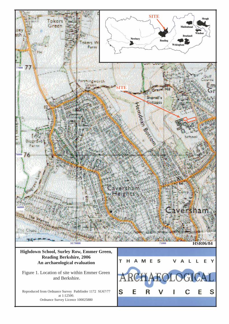
Highdown School, Surley Row, Emmer Green,Reading Berkshire, 2006
An archaeological evaluation
Figure 1. Location of site within Emmer Green and Berkshire.
Reproduced from Ordnance Survey Pathfinder 1172 SU67/77 at 1:12500.
Ordnance Survey Licence 100025880
66000
76000
SU70000 71000
SITE
HSR06/84
SITE
77000

Highdown School, Surley Row, Emmer Green,Reading Berkshire, 2006
An archaeological evaluation
Figure 2. Detailed location of site on Surley Row.
Scale: 1:1250.
76300
SU71200 71300 71400
HSR06/84
76400
SITE

Trench 2
Trench B
Trench A
Trench 1
HSR 06/84Figure 3. Location of trenches and stripped area within site.
NHigdown School, Emmer Green, Reading, Berkshire 2006
0 50m
76450
76400
76300
76350
SU71250 71300 71350
Watching brief areas
Landscaping and carparking areas
Footprint of proposed new hall
School

0 1m
Made ground
Made ground
Trench B
Trench 1
Tarmac
Turf andTopsoil
Gravel (natural geology)
Gravel (natural geology)
82.27m AOD
Base of trench
Base of trench

Plate 1. Trench 1 looking NE, scales 1m, 2m.
Plate 2. Trench 2 looking NE, scales 1m, 2m. HSR06/84