New CHAPTER 06 PRECINCT PLAN SEPTEMBER 2005 · PRECINCT PLANS The package of plans process at...
13
PLANNING PARTNERS: CENTURY CITY URBAN DESIGN FRAMEWORK October 2005 32 REVISION 1 CHAPTER 6 PRECINCT PLANS
Transcript of New CHAPTER 06 PRECINCT PLAN SEPTEMBER 2005 · PRECINCT PLANS The package of plans process at...

PLANNING PARTNERS: CENTURY CITY URBAN DESIGN FRAMEWORK October 2005 32 REVISION 1
CHAPTER 6
PRECINCT PLANS

PLANNING PARTNERS: CENTURY CITY URBAN DESIGN FRAMEWORK October 2005 33 REVISION 1
PRECINCT PLANS
The package of plans process at
Century City includes the preparation and approval of Precinct plans. These
provide more detail than the general development and design framework,
but are not so detailed as to constrain
individual design solutions. It is important however that Precinct plans are consistent with the urban
design rationale, overall structure and broad design guidelines for Century
City.
There is an opportunity with each
Precinct plan to provide a set of specific design informants, and
stipulate control measures that may
differ from precinct to precinct. However each precinct plan must
clearly illustrate how the directives of the Urban design framework are
followed through and implemented.
The following aspects should be
included with each precinct plan.
Overview
� Summary of urban design
informants and principles extracted from the Urban Design
Framework.
Public Environment Elements
� Streets, squares, parks, nodes
and focal places.
� Provisional property (block) boundaries of land for
development � Pedestrian links that are public or
semi-public
� Visual lines and focal points. � Typical street sections.
Private Development Elements
� Street and block pattern
� Land uses / activities
� Provisional building massing and
height
� Building articulation: vertical and
horizontal
� Typical building footprints
Edge Interfaces
� Typical details of edge interface
treatment
� Active edge interfaces to the
public realm � Ground floor plan and street
interface elements Architecture
� Architectural treatment
� Controls for buildings
Environmental Aspects
� Mitigation and enhancement of
environmental aspects such as wind, sun, noise, rain
� Compatibility with significant environmental features (wetland)
� Landscaping principles
Engineering and Traffic
� Bulk services
� Parking ratios
� Road capacity
� Intersection spacing
� Stormwater management
Development Parameters
� Bulk factor and total floor area
� Recommended land uses and their distribution
� Parking calculation and proposed
supply
INDIVIDUAL PRECINCT PLANS
This urban design framework contains
the essential elements of several precinct plans, including the Northern
Sector Precinct and the Estuaries Precinct. Other precinct plans have
been prepared and can be made
available as required. It is important to note that for control purposes, the “official” precinct plan is
a document approved by the Municipality and that document may
contain more information than the
summary provided here.
An overview of the principles adopted in the precinct plan for the Northern
Sector and Estuaries precincts follow.
PLANNING PARTNERS: CENTURY CITY URBAN DESIGN FRAMEWORK October 2005 34 REVISION 1
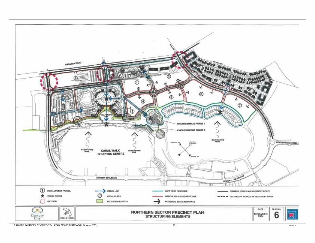
NORTHERN SECTOR PRECINCT
The Northern Sector Precinct is the
largest precinct and refers to that part of Century City between Ratanga Road
and the Grand Canal, together with some land around the wetland that
forms a logical part of this precinct.
The vision for Northern Sector Precinct is to achieve an integrated, mixed use development (work, play, shop and
stay), which has a good image and “sense of place”. The amenity and
value of individual projects must be
enhanced and at the same time a vibrant, rich environment created for
visitors and residents alike.
Two fundamental principles underpin
the structure of the Northern Sector Precinct. The one principle is to
respond to and enhance the interaction between development and
the water canal system. New canals will be created and development
around existing canals will help to
integrate the northern sector.
The second principle is to infuse new life to the development by making the
Northern Sector a vibrant and
attractive environment, with a pedestrian friendly space and a
prestigious address. This is partly achieved by realigning the boulevard and changing its character, and by injecting a wide range of residential accommodation into the precinct.
In the northern sector the boulevard
has been altered to take on two
different forms. Part of the route comprises the main distribution
system within Century City connecting the gateways and other components
of the project. This distributor road
extends from the existing Century Avenue to link up with an entrance at Ratanga Road. Another entrance from Ratanga Road connects with the
southern arm of Century Boulevard. As a result there are three entry points
into the precinct from Ratanga Road.
Part of the former boulevard route within the northern sector has been
diverted and altered to improve the character of the road through this
area. This diverted section links up
with the two arms of Century Boulevard but takes on a more urban,
pedestrian friendly and integrated character. To facilitate this, the road
penetrates the sector more effectively, gentle curves are introduced into the
alignment and the cross section is
reduced.
Internal streets subdivide the Northern
Sector Precinct into development blocks and have the important role of
providing public linkages between
urban spaces and the various development parcels. Most internal
streets run perpendicular to Century Boulevard and connect the Boulevard
with the open space system. Internal streets accommodate vehicular traffic but should be pedestrian oriented and
treated to encourage slow speed movement. The buildings adjoining
them should form active edges and
support street life at ground level.
Private development within the North Sector Precinct will exhibit different
responses. Certain residential projects,
such as Knighsbridge or the high income housing overlooking the wetland, will maintain their exclusivity by a series of new canals that allow
good visual integration but limit public access onto these sites. Other
residential projects, such as the Oasis
and the medium income housing, contain perimeter fences with a more
open landscaped environment inside but restricted access from the outside.
The essential elements of the Northern
Sector Precinct Plan are presented in the following plans.
PLANNING PARTNERS: CENTURY CITY URBAN DESIGN FRAMEWORK October 2005 35 REVISION 1
PLANNING PARTNERS: CENTURY CITY URBAN DESIGN FRAMEWORK October 2005 36 REVISION 1

PLANNING PARTNERS: CENTURY CITY URBAN DESIGN FRAMEWORK October 2005 37 REVISION 1
The following section provides an overview of the major developments
and development initiatives in the
northern sector. Some of these have already been implemented while other
initiatives are still in the planning stage.
The Holiday Inn Express Holiday Inn Express is a 175 room hotel, situated next to Canal Walk
shopping centre. and has been positioned and designed to overlook
the Grand Canal with views towards
Table Mountain from the upper floors. The design reflects a fairly ornate
architectural style with a face brick façade, plaster infill panels and quoins
to certain features.
The hotel appears as a 6 storey
building, but there is a lower ground floor level incorporating the catacombs
for retail or similar uses. Access to the hotel is off Century Boulevard, along a service road that is also used to reach
the south western end of the shopping centre.
No 1 North Bank
This development comprises a five
storey building incorporating retail
activity, parking, offices and some residential apartments. The built form
alongside the canal is permeable and pedestrian friendly, with open
terraces, doors windows and the
shops encouraging human activity next to the canal.
A pedestrian bridge spans the Grand
Canal and links up with the shopping centre. Part of the building is curved
to acknowledge this important feature
and provide sufficient space for a piazza. The piazza is a public space
and local focal point in the area that helps to link various parts of the
pedestrian system and channel
movement from one side of the canal to the other.
A second building is planned adjacent
to No. 1 North Bank and will have a similar appearance. This will be known as No.2 North Bank.
The Island Club
The Island Club is centrally located in
the Northern Sector and is a defining
element of this precinct. It includes striking buildings and landscaping and
introduces a significant residential component into Century City.
The Island Club is a relatively high density, but high quality, residential environment, overlooking a system of internal open spaces and canals. A
central feature is a landscaped island surrounded by water. The island has
been intensively landscaped with
classical design features, providing a recreation amenity and attractive
setting.
The apartments range in height from 4
to 10 storeys, and the controlled but variable form responds to the flowing
shape of the Grand Canal and landscaped island. The buildings complement the front façade of the
shopping centre and provide a visual axis from one of the main entrances
into Century City. The development
wraps around Half Moon Bay and extends along the Grand Canal.
Particular attention has been given to
the interface of buildings with the public promenade alongside the canal.
Doorways, windows, studio apartments and mixed use activities
front on to this promenade, and help
to create vitality and interest along this important public space. The main entrance to the project is
from the existing Via Rialto road through a controlled access point.
Vehicles enter a landscaped parking
court, and a system of pedestrian and jogging paths winds its way through
the site. Residential apartments that face on to the internal water body will
have private gardens at the ground
level leading up to the water, but all residents will have access along
common pathways to the island, for use as an open space and recreation
amenity.
Parking occurs as a combination of
surface bays in parking courts and basement or semi-basement parking
under the apartment buildings. Particular design attention is given to
the landscape treatment at the ground
level of these buildings. This is important within the scheme to ensure
that the environment is attractive and user friendly for residents, but it is
also particularly important at the edges of the scheme where the interface occurs between public and
private components.
PLANNING PARTNERS: CENTURY CITY URBAN DESIGN FRAMEWORK October 2005 38 REVISION 1
The interface of this project along the
Grand Canal is particularly important and the buildings have been designed
to offer privacy and security to the
project behind, but along the front there is an attractive and inter-active
public space. This public space will lead all the way along the Grand Canal
and link up with the pedestrian path
around the wetland. In front of Half Moon Bay there will be a public plaza which links across a
bridge to the shopping centre, and across to the internal island within the
Island Club.
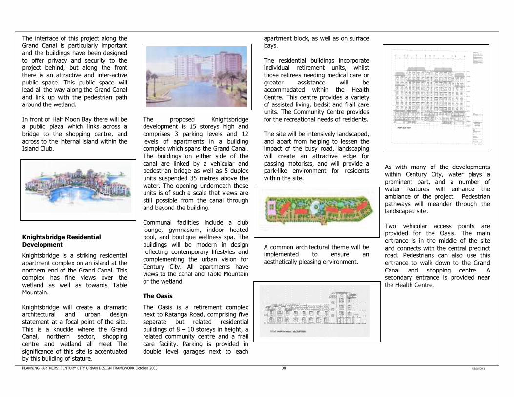
Knightsbridge Residential
Development
Knightsbridge is a striking residential
apartment complex on an island at the northern end of the Grand Canal. This
complex has fine views over the
wetland as well as towards Table Mountain.
Knightsbridge will create a dramatic
architectural and urban design statement at a focal point of the site. This is a knuckle where the Grand
Canal, northern sector, shopping centre and wetland all meet The
significance of this site is accentuated by this building of stature.
The proposed Knightsbridge development is 15 storeys high and
comprises 3 parking levels and 12 levels of apartments in a building
complex which spans the Grand Canal.
The buildings on either side of the canal are linked by a vehicular and
pedestrian bridge as well as 5 duplex units suspended 35 metres above the
water. The opening underneath these
units is of such a scale that views are still possible from the canal through
and beyond the building.
Communal facilities include a club lounge, gymnasium, indoor heated
pool, and boutique wellness spa. The
buildings will be modern in design reflecting contemporary lifestyles and
complementing the urban vision for Century City. All apartments have
views to the canal and Table Mountain
or the wetland
The Oasis
The Oasis is a retirement complex
next to Ratanga Road, comprising five separate but related residential buildings of 8 – 10 storeys in height, a
related community centre and a frail care facility. Parking is provided in
double level garages next to each
apartment block, as well as on surface
bays.
The residential buildings incorporate
individual retirement units, whilst those retirees needing medical care or
greater assistance will be accommodated within the Health
Centre. This centre provides a variety
of assisted living, bedsit and frail care units. The Community Centre provides for the recreational needs of residents.
The site will be intensively landscaped, and apart from helping to lessen the
impact of the busy road, landscaping
will create an attractive edge for passing motorists, and will provide a
park-like environment for residents within the site.
A common architectural theme will be
implemented to ensure an
aesthetically pleasing environment.
As with many of the developments
within Century City, water plays a
prominent part, and a number of water features will enhance the
ambiance of the project. Pedestrian pathways will meander through the
landscaped site.
Two vehicular access points are
provided for the Oasis. The main entrance is in the middle of the site
and connects with the central precinct road. Pedestrians can also use this
entrance to walk down to the Grand
Canal and shopping centre. A secondary entrance is provided near
the Health Centre.

PLANNING PARTNERS: CENTURY CITY URBAN DESIGN FRAMEWORK October 2005 39 REVISION 1
Century Boulevard Proposal
A mixed use development is proposed between Century Boulevard, the Grand Canal and the Island Club as
illustrated below.
Due to the scale, form and positioning of the individual buildings, a “Piazza”
type environment is planned. The form
of architecture will be Neo Tuscan in style. The layout responds to the
external environment, especially adjacent to Century Boulevard and the
canal, with the articulation of buildings and permeable nature of the ground floor activities.
Once again, water is a fundamental element in the design, and an internal canal will extend from the Grand Canal. This internal canal and the spaces around will assist in creating an attractive ambience for residents and visitors alike.
The main vehicle entrance will be off
Century Boulevard opposite Dockside, a second vehicle entrance will be off
Century Boulevard, and access to a separate residential component will be
from Via Rialto.
Landscaping is planned for the south
eastern corner of the proposed development at the interface with the
Grand Canal. This area is to be
celebrated as a focal point for pedestrian activity. The interface
between the Century Boulevard and the remainder of the site will be
softened by the extensive use of trees.
Mixed Use Development Parcels
A number of mixed use land parcels
are created in the Northern Sector, for
which no specific proposals have yet been formulated.
The road penetrates through the
middle of this area and contains slight
curves that respond to the adjacent blocks and the general curve of the canal system. Although, this road will accommodate fairly high traffic
volumes, it has been designed to encourage slow speed movement,
with traffic circles, four way stops and
the road alignment.
A visual corridor has been created between development parcels to
accentuate the feature building of
Knightsbridge. Another visual corridor is provided into the Island Club.
The buildings should form active
edges and support street level activities. This can be achieved by a
perimeter block type of development
with a functional interface to the public realm. The interface should
include elements that help generate a sense of place, but can also include
landscape features.
Functional interface means that people should be able to walk along a street
in front of a building and experience
an attractive environment including interaction between the building and
street. Entrance lobbies, shops, coffee shops, offices, gateways into mid
block spaces, all provide functional
interfaces. Transparent surfaces, balconies and terraces provide a visual interface which means that people in the buildings and the public
environment can see life and activity occurring. This helps to make a place
vibrant and interesting.
PLANNING PARTNERS: CENTURY CITY URBAN DESIGN FRAMEWORK October 2005 40 REVISION 1
The design of public streets and squares are also important to create public spaces that can be enjoyed by residents and visitors alike. Parking structures should preferably not face directly onto the public environment because they normally present blank walls and are devoid of activity and interest.
A feature of successful urban avenues is the way that buildings interact with
the street space. Buildings should
preferably be placed on or close to the street boundary, to help frame the
avenue, and the buildings should offer their front facades to the street,
acknowledging the importance of the
public realm. Activities on ground and first floor should be visually and
functionally integrated with the street space.
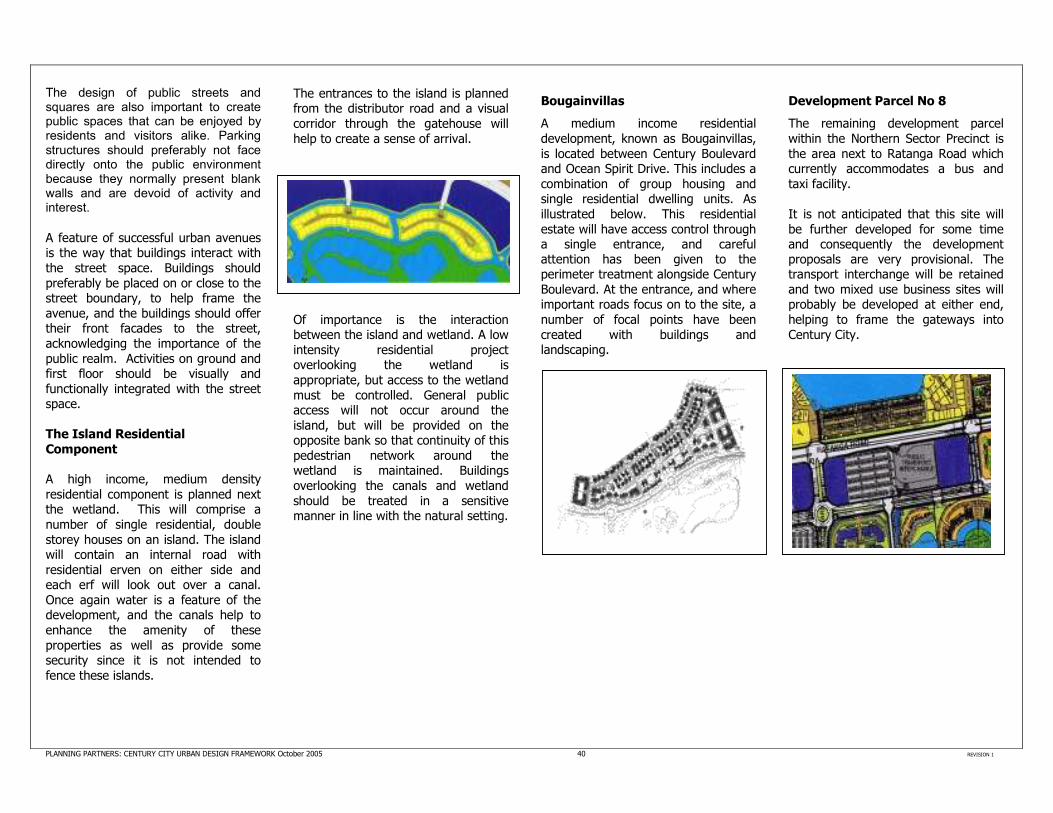
The Island Residential
Component A high income, medium density
residential component is planned next the wetland. This will comprise a
number of single residential, double
storey houses on an island. The island will contain an internal road with
residential erven on either side and each erf will look out over a canal.
Once again water is a feature of the development, and the canals help to
enhance the amenity of these
properties as well as provide some security since it is not intended to
fence these islands.
The entrances to the island is planned from the distributor road and a visual
corridor through the gatehouse will
help to create a sense of arrival.
Of importance is the interaction between the island and wetland. A low
intensity residential project overlooking the wetland is
appropriate, but access to the wetland
must be controlled. General public access will not occur around the
island, but will be provided on the opposite bank so that continuity of this
pedestrian network around the wetland is maintained. Buildings
overlooking the canals and wetland
should be treated in a sensitive manner in line with the natural setting.
Bougainvillas
A medium income residential
development, known as Bougainvillas,
is located between Century Boulevard and Ocean Spirit Drive. This includes a
combination of group housing and single residential dwelling units. As
illustrated below. This residential
estate will have access control through a single entrance, and careful attention has been given to the perimeter treatment alongside Century
Boulevard. At the entrance, and where important roads focus on to the site, a
number of focal points have been
created with buildings and landscaping.
Development Parcel No 8
The remaining development parcel
within the Northern Sector Precinct is
the area next to Ratanga Road which currently accommodates a bus and
taxi facility.
It is not anticipated that this site will
be further developed for some time and consequently the development proposals are very provisional. The transport interchange will be retained
and two mixed use business sites will probably be developed at either end,
helping to frame the gateways into
Century City.

PLANNING PARTNERS: CENTURY CITY URBAN DESIGN FRAMEWORK October 2005 41 REVISION 1
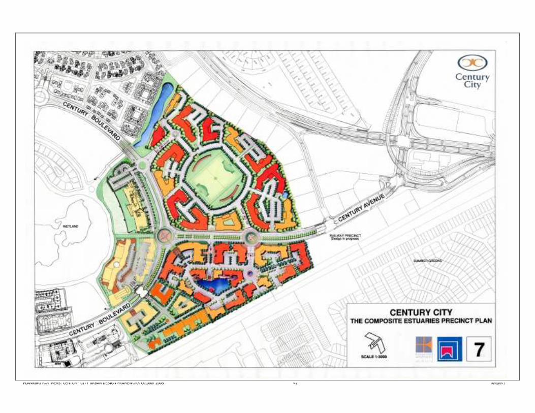
THE ESTUARIES PRECINCT Physical features such as Century Boulevard and Century Avenue
structure the precinct into three distinct sub components. These are: 1. The crescent of land bounded
by two “arms” of the Wetland
canal system and Century Boulevard;
2. Land to the east of Century Avenue and Century
Boulevard. This sub component has been named
the Estuaries Office Park; and
3. Land to the west of Century Avenue. This sub component
has been named “The Oval”.
Notwithstanding these sub
components it is intended that the main distributor roads should not be
seen as divisive features but rather as unifying elements, with development
on either side of the Avenue and Boulevard complementing each other
and contributing to the roads as prime
addresses.
The precinct plan aims to create an urban framework which will enhance
the quality of the environment, whilst
optimising returns for individual developers. While the development
parameters allow a degree of flexibility, they need to be respected in
terms of overarching principles to ensure that the objectives of the precinct are attained. The following
sections provide an overview of the three sub components of the Estuaries
Precinct, and a composite of the Precinct Plan is illustrated overleaf.
The Estuaries Office Park This sub component will be predominantly office related, with a
small minor business component, such as restaurant or office suppliers. The
intention for erf 5161 (the CMC site)
has changed, so that this will no longer accommodate a single large
administration facility, but instead incorporate a number of smaller office blocks, which may include public
sector and private facilities
A water feature forms the heart of this development and, together with the
local activity streets, help to unify this component. Buildings are located
around the water feature which becomes a local focus, while the
internal streets create a spine of
activity through the area. These are pedestrian friendly and allow for some
mixed uses.
The figures illustrate principles of the precinct plan:
• A compact, cohesive whole is
created;
• The built form will result in a
robust interface with Century Boulevard and Century Avenue;
• The site adjacent to Century
Boulevard/Century Avenue, will contain a prominent building
which will help to celebrate this intersection;
• The main entrance into the sub
component, off the Century
Avenue traffic circle, will result in
an attractive “gateway” and will promote a sense of arrival;
• The water body will introduce a
soft landscaped element as a
counter point to the more dense
building mass;
• An interconnected and legible
built form will emerge from a number of separate structures,
due to the implementation of common urban design principles.
PLANNING PARTNERS: CENTURY CITY URBAN DESIGN FRAMEWORK October 2005 42 REVISION 1

PLANNING PARTNERS: CENTURY CITY URBAN DESIGN FRAMEWORK October 2005 43 REVISION 1
The Oval The Oval is intended to be predominantly office related in nature,
with a minor business component.
A communal open space forms the
heart of this development. It is intended as a sports field for the
entire Century City project, and will be owned by the Property Owners Association. The field can be used as
a soccer field, for other open air events or just for passive recreation.
The communal open space provides a green heart to the project and relief to
the higher density office development
around the perimeter. Grassed seating will form an enclosing feature to the
field, and provide an opportunity for some directional signage.
Extensive landscaping will complement
the buildings to provide the sense of
enclosure to this space. On grade visitor parking which serves the offices during normal office hours will double as spectator parking after hours. Roofs
of buildings should be tiled with
selected materials and pitched, although a portion of the roofs may
contain flat concrete elements.
The figures illustrate principles of the
precinct plan:
• A compact built form will be
created, surrounding a soft green heart;
• Two entrances are provided
with wide roads and flanking buildings that will create a
strong sense of arrival;
• The built form is informed by,
and responds to Century
Boulevard and Century
Avenue, and helps to reinforce the boulevard effect;
• The development provides an
appropriate interface with the
Bosmansdam Business Park and responds to the planned
extension of the canal system next to Bougain Villas
Specific Design Elements for the Oval and Estuaries Office Park The “perimeter block” approach is an
important principle of urban design in
which the frontages of buildings are set close to the street creating
continuity of streetscape and helping to define public, semi-public and
private spaces. Design elements such
as building heights, focal points and build-to lines create an attractive and
integrated development.
The use of balconies, canopies and colonnades are encouraged to create
an interesting and varied streetscape.
On street parking has been provided in many cases to support street life
and to activate the public realm. Traffic calming measures are placed
throughout the precinct to ensure it is
pedestrian friendly.
The design elements help to enhance legibility, identity and orientation
within the precinct. They also give developers the opportunity to
differentiate buildings. Variations in the height of buildings are encouraged.
Provisional building heights are
illustrated. Further vertical modulation
is encouraged by means of patios on ground, first and second floor levels,
as well as roof terraces and other forms of junctions between façade and
roof.

PLANNING PARTNERS: CENTURY CITY URBAN DESIGN FRAMEWORK October 2005 44 REVISION 1
Axial focal points, gateways and significant corners will further enhance
the building.
Focal points are created to enhance legibility and assist orientation within
the precinct. These are of various types, such as gateway features,
significant corners or axial views into
the scheme or along local vistas.
Significant focal points within the Oval and Office Park are illustrated.
Architectural design of individual buildings should respond to these focal points.
Build-to lines are recommended to promote a vibrant street character and
visual continuity of the street facade.
Most of a building’s façade should lie along a build-to line, but localised
setbacks and encroachments are encouraged to add diversity.
Architectural Guidelines for the
Oval and Estuaries Office Park Developers are permitted a wide range
of architectural styles within this precinct subject to certain parameters
and guidelines. The focus is on
creating an overall group form where the buildings work together to create a
synergy rather than competing with each other. Certain sites are required
to make significant architectural responses by virtue of their position as
described above. The buildings should
be classical in architectural language with the conscious expression of a
base, plinth, a well ordered proportioning system, and vertical window penetrations. Materials should
be solid, warm earthy materials
including sandstone, granite, marble, slate, ceramic and clay products.
Selected face brick may be used.
Plaster is encouraged but paintwork should be limited to earthy natural
tones
The Crescent Segment This segment includes an office development known as Waterview
Park and a new regional headquarters
for Liberty Life, known as “Liberty Centre”. A small strip remains
between Waterview Park and the
Boulevard, and this remaining land is
intended to be developed in two sites for offices.
While no firm proposals have been submitted at this stage, preliminary ideas for the remaining strip of land next to the Boulevard are illustrated in the figure below.
Of particular importance is a 10m wide pedestrian link between the Waterview
Park and Liberty Centre, to permit connections from Century Boulevard
and the wetland. Care must be taken
with the pedestrian walkway abutting the wetland and canal system to
ensure that quality and continuity of this pedestrian system is protected.