Network”Implementation Safe Drone Aviation
23
“Sky Network” Implementation for Safe Drone Aviation Michio Takegawa Vice President & Head of IoT Business, ZENRIN Co., Ltd.
Transcript of Network”Implementation Safe Drone Aviation

“Sky Network” Implementation for Safe Drone Aviation
Michio TakegawaVice President & Head of IoT Business, ZENRIN Co., Ltd.

ZENRIN CO., LTD. All Rights Reserved.© 1
Company overview
ZENRIN CO., LTD. All Rights Reserved.© 2
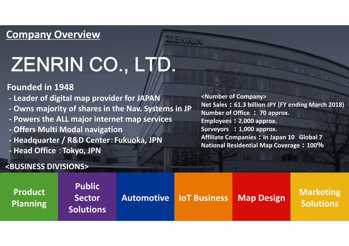
ZENRIN CO., LTD.Company Overview
<Number of Company>Net Sales:61.3 billion JPY (FY ending March 2018)Number of Office : 70 approx.Employees:2,000 approx.Surveyors :1,000 approx.Affiliate Companies:In Japan 10 Global 7National Residential Map Coverage:100%
2
Product Planning
PublicSector
SolutionsIoT BusinessAutomotive Map Design Marketing
Solutions
Founded in 1948‐ Leader of digital map provider for JAPAN‐ Owns majority of shares in the Nav. Systems in JP ‐ Powers the ALL major internet map services‐ Offers Multi Modal navigation‐ Headquarter / R&D Center:Fukuoka, JPN‐ Head Office :Tokyo, JPN
<BUSINESS DIVISIONS>

ZENRIN CO., LTD. All Rights Reserved.© 3
The History and Progression of ZENRIN
Proving map database corresponding to the requirements of changes in time and era.
Creation of super detailed
“Residential Map”
Datasetfor Nav.
Datasetfor GIS /mobile app.
Dataset forAD/ADAS
Started R&D for Drone Maps

ZENRIN CO., LTD. All Rights Reserved.© 4
Offices and Global Group Companies
ZENRIN Group: 7 companies
Overseas locations: 2 locations
Abalta Technologies, Inc.(California, USA)
・Licensing and contracted development,etc. of on-vehicle software solutions andlocation information software ZENRIN India
Branch Office(Gurgaon, India)
・Sales of map and related data・Sales and building relationships
with European customers
ZENRIN EUROPE GmbH(Munich, Germany)
Abalta Technologies, EOOD.(Sofia, Bulgaria)
C.E.Info Systems Private Limited(New Delhi, India)
・Development and sales of digital maps of India・Provide PND in India through data licensing as well as under its own brand “MapmyIndia”
ZENRIN TaipeiBranch Office(Taipei, Taiwan)
SHANGHAI DAIKEI DATA PROCESSING CO., LTD.
(Shanghai, China)・Input of fundamental map information data etc.
・Map data input, editing, research, and information gathering
・Sales and building relationships with North American customers
ZENRIN USA, INC.(San Francisco, USA)

ZENRIN CO., LTD. All Rights Reserved.© 5
Database Creation and Maintenance Ability
・Checks each households nationwide for “Residential Map” ・Measures newly opened roads by car・Collects navigation specific contents
Special Survey VehiclesWalking Surveys
1,000 approx.Surveyors (per day)
Distance Measured
50 timesRound‐the‐globe
70Survey Base
Since the time of founding in 1948, our “on‐foot” survey obtains the latest changes made to each location and its tenant information. Also conducts car‐navigation field survey by using special vehicle with high precision laser measurement equipment.

ZENRIN CO., LTD. All Rights Reserved.© 6
Structure of Information Management
More Than 1,000 Layers of Information
Original Map Creation Systems
Administrative Boundary
Road
Building
Text
Geometry
Attribute
Map
Data Input Screen
Survey Draft

ZENRIN CO., LTD. All Rights Reserved.© 7
Various map databases
Road Networkfor Car Navigation Systems
Residential mapfor Public Sectors
3D Urban Model for BIM/CIM
High Precision 3D datafor AD/ADAS
Sky Network for Drones (New)
(2D Maps) (3D Maps)
Road Mapfor Web/Mobile Devices

ZENRIN CO., LTD. All Rights Reserved.© 8
Sky Network for Drones
ZENRIN CO., LTD. All Rights Reserved.© 9
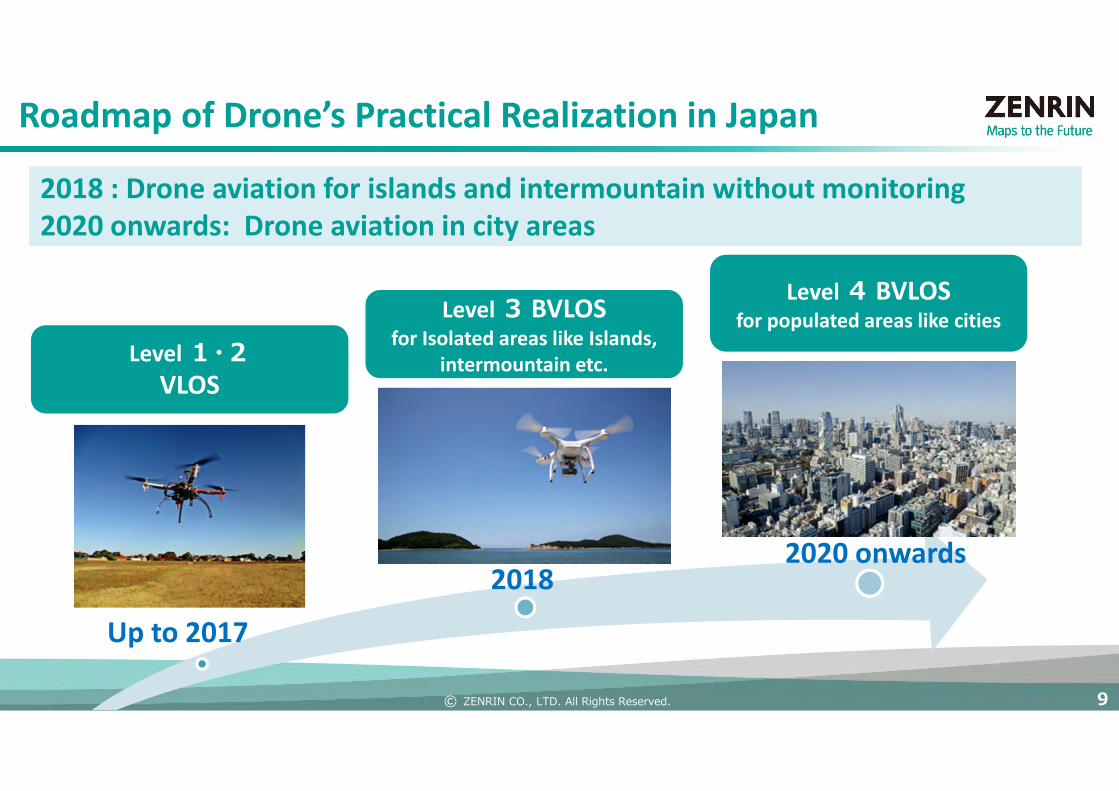
Up to 2017
20182020 onwards
Roadmap of Drone’s Practical Realization in Japan
2018 : Drone aviation for islands and intermountain without monitoring2020 onwards: Drone aviation in city areas
Level1・2VLOS
Level 3 BVLOSfor Isolated areas like Islands,
intermountain etc.
Level4 BVLOSfor populated areas like cities
ZENRIN CO., LTD. All Rights Reserved.© 10
Level 3・4BVLOS
Level 1・2VLOS
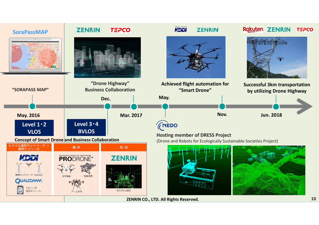
SoraPassMAP
“SORAPASS MAP”
May. 2016
Dec.
Concept of Smart Drone and Business Collaboration
“Drone Highway”Business Collaboration
Mar. 2017
May.
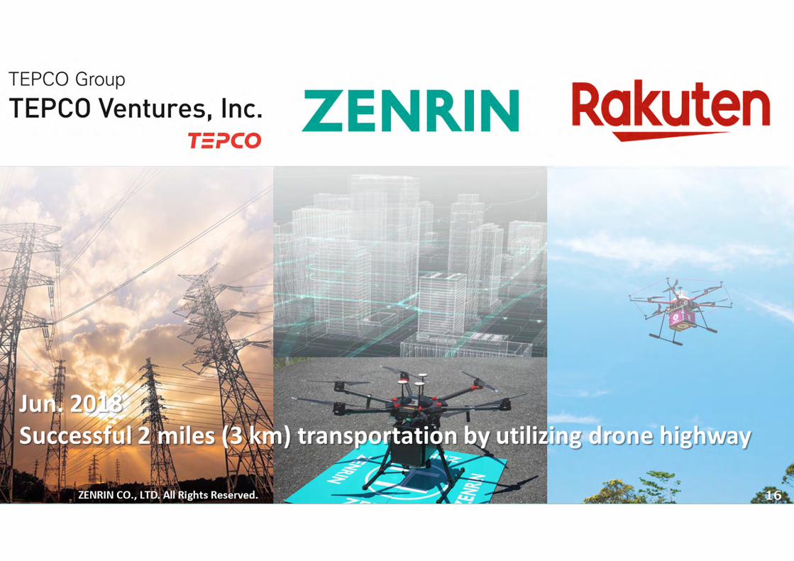
Jun. 2018
Successful 3km transportation by utilizing Drone Highway
Nov.
Achieved flight automation for “Smart Drone”
ZENRIN CO., LTD. All Rights Reserved.
Hosting member of DRESS Project (Drone and Robots for Ecologically Sustainable Societies Project)
10

ZENRIN CO., LTD. All Rights Reserved.© 11
Numerous drone aviation in specific area can increase the risk of crashes
Crashing with other drones, aircrafts and obstacles
Challenges Towards Safe Aviation
ZENRIN CO., LTD. All Rights Reserved. 11

ZENRIN CO., LTD. All Rights Reserved.© 12ZENRIN CO., LTD. All Rights Reserved.© 12
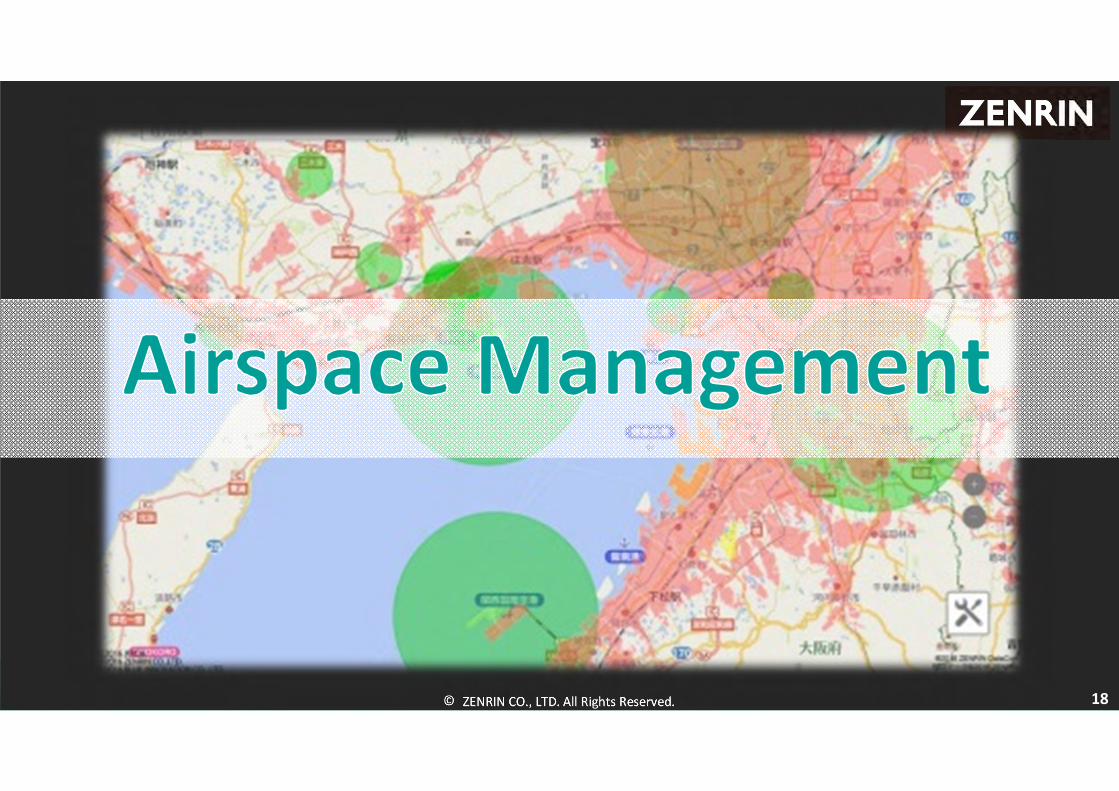
Our Solution;
Sky Network Airspace Management

ZENRIN CO., LTD. All Rights Reserved.© 13ZENRIN CO., LTD. All Rights Reserved.© ZENRIN CO., LTD. All Rights Reserved. 13
ZENRIN CO., LTD. All Rights Reserved.© 14ZENRIN CO., LTD. All Rights Reserved.©
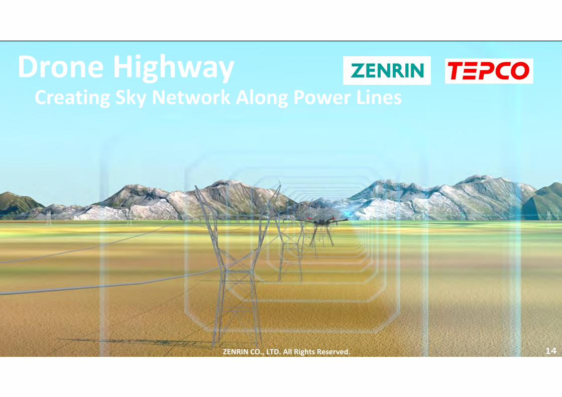
Drone Highway
ZENRIN CO., LTD. All Rights Reserved. 14
Creating Sky Network Along Power Lines
ZENRIN CO., LTD. All Rights Reserved.© 15
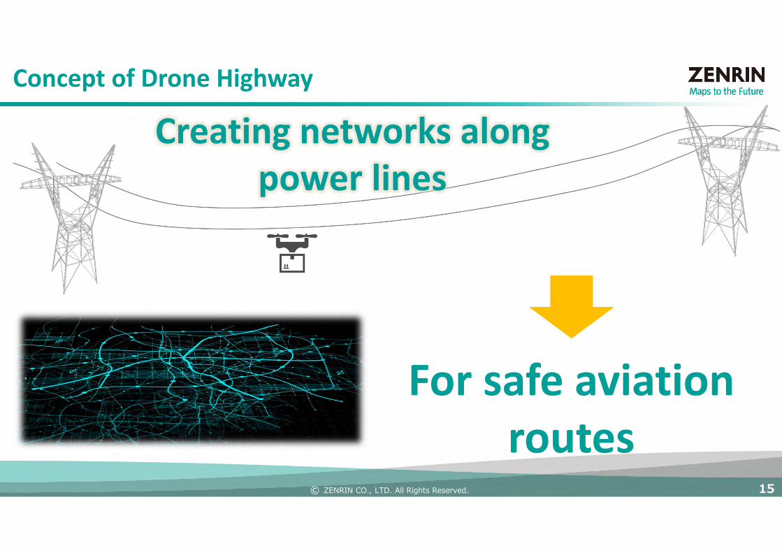
For safe aviation routes
Creating networks along power lines
Concept of Drone Highway
ZENRIN CO., LTD. All Rights Reserved.© 16ZENRIN CO., LTD. All Rights Reserved.©
ZENRIN CO., LTD. All Rights Reserved.© 1717
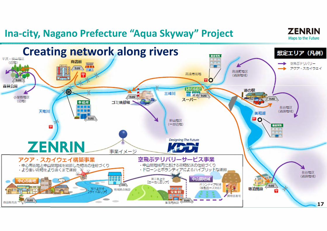
Ina‐city, Nagano Prefecture “Aqua Skyway” Project
Creating network along rivers
ZENRIN CO., LTD. All Rights Reserved.© 18ZENRIN CO., LTD. All Rights Reserved.© 18

ZENRIN CO., LTD. All Rights Reserved.© 19
Hosting Member of “DRESS” Project UTM Architecture Role of SDSP
Flight Information Management System (FIMS), UAS Service Provider (UASSP), Supplemental Data Service Provider (SDSP). Eliminating issues which can case conflicts between drones, aircrafts and obstacle, supporting safe airspace management.
Aggregating and providing dynamic/static information to judge conflict obstacles for aviation, also referring to weather information for risk assessment during planned route.
Accounting conflict obstacles when planning route
Risk assessment from weather information
UTM Architecture
FIMS
UASSP(A)
UASSP(B)
UASSP(C)
SDSP

ZENRIN CO., LTD. All Rights Reserved.© 20
Development of Spatial Information Platform for Safe Unmanned Aerial Vehicles (UAV) Aviation
ZENRIN Map Database specific to UAV
2D Map(Existing Products+α)
3D Map(New development)
Attribute Database(Existing Products)
FIMS
Weatherinformation
UASSP
DAL※1/API※2
DB access
Map DatabaseAttributeDatabase
UTM
UASO
ZENRIN Information Integration System
Radio wave qualityUAVlog information
Obstacleinformation
Demographics
Landscape Elements
Obstacle Elements
Flight Regulation Elements A
PI
Spatial information Platform for UAV
Dynamic Elements
※1:Data Access Library ※2:Application Programming Interface

ZENRIN CO., LTD. All Rights Reserved.© 21
Structure of information Necessary for Safe Aviation
Definition Examples
• Information which can change in time during travel
• Information on incidents which occurs suddenly
Weather observed data (wind direction/velocity, cloud amount, visibility range).Aircraft data (avoid crash). Electric wave intensity data. GPS intensity data.Traffic big data (people and vehicles). Regulations. Birds (raptors). Sensor info.
• Information on area where drones are regulated for aviation
Populated areas. Public areas. Around airports. Self defense force bases. Power plants. Governmental facilities. Embassies. Flight banned and authorized areas.
• Information on obstacleswhich can affect aviation
Pylons. High voltage lines. Power poles/lines. Power plants. Tall buildings.Construction cranes. Stadiums. Factories. Trees. etc.
• Information on maps Drone ports. Emergency landing spots. Landscapes (rivers, mountains, roads).Measurable objects (bridges, road, building constructions, agricultural areas).
※Elevation level of aviation will be based upon each country’s regulations
Obstacle Elements
Flight Regulation Elements
Dynamic Elements
Landscape Elements
Currently promoting this model as an international standards(ISO)<Type of Info>

ZENRIN CO., LTD. All Rights Reserved.© 22