Nebraska Water Resources Center Annual Technical Report … · Nebraska Water Resources Center...
39
Nebraska Water Resources Center Annual Technical Report FY 2005 Introduction Dr. Kyle D. Hoagland served as director of the University of Nebraska Water Center this year, with Michael Jess as associate director and Dr. John Holz as the assistant director. Steven Ress and Tricia Liedle continued as communications specialist and office assistant, respectively. The Water Center is currently moving into the newly renovated natural resources building (3310 Holdrege, P.O. Box 830979, Lincoln, NE 68583-0979), with the process to be completed by August 2006. The campus-wide Water Resources Research Initiative (WRRI) continued into its third year. To date, seven new faculty members have been hired in a variety of water-related fields including, water law, water chemistry, surface hydrology, climate modeling, water economics, and stream ecology. Faculty positions in water policy and hydrologic systems information are now being searched. The third annual Water Law, Policy and Science Conference was hosted by the University of Nebraska-Lincoln on May 4-5, with Adaptive Management for Resilient Water Resources as its theme. This ongoing conference series is aimed at better integrating water science and its societal dimensions, while focusing on themes of immediate relevance to this region, yet of international importance as well. A color directory of all water faculty (>100) at the University of Nebraska was recently published, including descriptions of the major academic and research units that are involved in water research and education. The directory is being distributed to state and federal water-related agencies, state and congressional delegations, NGOs and natural resources districts state-wide. Research Program In 2005, an outside panel of state and federal agency representatives reviewed six USGS 104(b) proposals and recommended three for full funding. In addition a 104(g) project was transferred to the UNL Water Center this year by a recent faculty hire. Areas under 104(b) funded this year included (a) quantification of river flow using a novel modeling approach, (b) use of remote sensing to quantify evapotranspiration, and (c) defining hydroecoregions in agriculturally-dominated ecosystems for developing lake water quality standards. Additional equipment was added to the Water Sciences Laboratory again this year, including a stable isotope-MS, an on-line extraction system for the LC/MS, and a new GS/MS, to further enhance its analytical capabilities, particularly in the area of trace organics and stable isotope use. Core facility assistance to water science faculty continued to increase both in breadth of analyses and the number of faculty taking advantage of this cutting-edge facility. Analyses are conducted for other universities, state and federal agencies, as well as private companies and individuals. Analyses included munitions (e.g., RDX), antibiotics, pesticides (incl. herbicide metabolites), nutrients, and stable isotopes (e.g., 15N, 18O and 13C) for applications such as nutrient source determinations and groundwater dating.
Transcript of Nebraska Water Resources Center Annual Technical Report … · Nebraska Water Resources Center...

Nebraska Water Resources Center Annual Technical Report
FY 2005
IntroductionDr. Kyle D. Hoagland served as director of the University of Nebraska Water Center this year, withMichael Jess as associate director and Dr. John Holz as the assistant director. Steven Ress and TriciaLiedle continued as communications specialist and office assistant, respectively. The Water Center iscurrently moving into the newly renovated natural resources building (3310 Holdrege, P.O. Box 830979,Lincoln, NE 68583-0979), with the process to be completed by August 2006.
The campus-wide Water Resources Research Initiative (WRRI) continued into its third year. To date,seven new faculty members have been hired in a variety of water-related fields including, water law, waterchemistry, surface hydrology, climate modeling, water economics, and stream ecology. Faculty positionsin water policy and hydrologic systems information are now being searched. The third annual Water Law,Policy and Science Conference was hosted by the University of Nebraska-Lincoln on May 4-5, withAdaptive Management for Resilient Water Resources as its theme. This ongoing conference series isaimed at better integrating water science and its societal dimensions, while focusing on themes ofimmediate relevance to this region, yet of international importance as well.
A color directory of all water faculty (>100) at the University of Nebraska was recently published,including descriptions of the major academic and research units that are involved in water research andeducation. The directory is being distributed to state and federal water-related agencies, state andcongressional delegations, NGOs and natural resources districts state-wide.
Research ProgramIn 2005, an outside panel of state and federal agency representatives reviewed six USGS 104(b) proposalsand recommended three for full funding. In addition a 104(g) project was transferred to the UNL WaterCenter this year by a recent faculty hire. Areas under 104(b) funded this year included (a) quantification ofriver flow using a novel modeling approach, (b) use of remote sensing to quantify evapotranspiration, and(c) defining hydroecoregions in agriculturally-dominated ecosystems for developing lake water qualitystandards.
Additional equipment was added to the Water Sciences Laboratory again this year, including a stableisotope-MS, an on-line extraction system for the LC/MS, and a new GS/MS, to further enhance itsanalytical capabilities, particularly in the area of trace organics and stable isotope use. Core facilityassistance to water science faculty continued to increase both in breadth of analyses and the number offaculty taking advantage of this cutting-edge facility. Analyses are conducted for other universities, stateand federal agencies, as well as private companies and individuals. Analyses included munitions (e.g.,RDX), antibiotics, pesticides (incl. herbicide metabolites), nutrients, and stable isotopes (e.g., 15N, 18Oand 13C) for applications such as nutrient source determinations and groundwater dating.

Low-Cost Flow Estimation for Storm Water Quality BMP Monitoring
Basic Information
Title: Low-Cost Flow Estimation for Storm Water Quality BMP Monitoring
Project Number: 2004NE77B
Start Date: 3/1/2004
End Date: 2/28/2006
Funding Source: 104B
Congressional District: 1
Research Category: Not Applicable
Focus Category: Non Point Pollution, Hydrology, Water Quality
Descriptors:
Principal Investigators: David Mark Admiraal, Bruce Irvin Dvorak, John S Stansbury
Publication1. None

Research Problem and Research Objectives: The Environmental Protection Agency (EPA) has implemented a strategy to help reduce pollutants in municipal watersheds. The strategy requires municipalities with populations of over 10,000 to monitor storm water runoff and to reduce concentrations of specific contaminants (e.g., fecal bacteria) over a 10-year period. In order to reduce pollution, communities will have to implement Best Management Practices (BMPs). In some cases, a variety of inexpensive BMPs may substantially reduce targeted contaminants. Monitoring storm water for the contaminants in order to show compliance with the new EPA regulations will be expensive. The relative financial burden will likely be significantly greater for mid-sized municipalities that are isolated from large metropolitan areas because access to expertise is more limited, and the tax-base is smaller. These types of municipalities are more common in less-populated states like Nebraska, but all municipalities would benefit from a reduction in the cost of monitoring BMPs. The two parameters that must be measured to assess the impact of a BMP are contaminant concentration and mass flow rate of water. Independent of flow rate measurements, contaminant concentration measurements are considerably less useful. The volume of water flowing from a site may be small relative to that from the entire watershed, and the relative impact of the contaminant at the watershed outlet may be insignificant even if the concentration of the contaminant at the monitoring site is high. Contaminant concentration also varies over the duration of a storm, with the highest concentration likely to occur near the onset of the storm. Thus, in order to get an effective assessment of the performance of a BMP, samples may need to be collected throughout the storm. To determine the effective mass loading of a contaminant for the entire storm, the chemical samples at a site must be composited or assessed according to flow. Therefore, flow rates (at least relative flow rates) must also be measured throughout the storm to find the average contaminant concentration. The expense associated with BMP monitoring can be reduced by reducing the cost of storm water sampling or by reducing the cost of flow measurement. The objective of this research is to investigate methods of reducing flow measurement costs. Conventional storm water monitoring stations that feature both automatic sampling and flow measurement can be very expensive (greater than $10,000 for site modification, equipment, and installation). Such stations are impractical for monitoring most BMP sites because many of the locations where BMPs are implemented are temporary. For example, samples may be collected downstream of construction sites in order to monitor the effectiveness of erosion control BMPs, but the locations of active construction change over time. Furthermore, within any given city, numerous sites will be required to evaluate the overall storm water quality. The large number of necessary monitoring sites limits the funds available for each individual site. There is a great need for low-cost methods that municipal public works staff members can use to collect BMP data from a wide range of sites in their communities.

The goal of this study is not to improve the accuracy of flow measurements, rather, it is to find a low-cost method of measuring flow with accuracy that is sufficient for compositing concentration measurements. Therefore, accuracies of the methods studied are an important result of the current research, but the most accurate method will not necessarily be the optimal method for any given BMP monitoring study. Methodology: The two most common methods of measuring discharge are to develop a rating curve (stage-discharge relation) for the site of interest (FHWA, 2000), and to measure the stage upstream of a control (e.g., unsubmerged weir). In order to develop a rating curve for a site, discharge and stage measurements must be taken during a storm or there must be another way to assess the relation between stage and discharge (e.g., normal depth measurements and Manning’s equation). Control sections are valuable because upstream of a control there is only one discharge for each stage, and the stage-discharge relation is often known. Unfortunately, controls are not particularly common in typical streams, and installing a control can be costly. Thus, we are focusing on methods that do not require the existence of a control. However, weirs and other flow controls are being used to assess the accuracy of alternative flow measurement methods. We have collected a substantial amount of flow depth information over a basin in southeast Lincoln. Precipitation information is also available for this basin, and will be later used to compare flow estimation using hydrological models with flow estimation from normal depth and control measurements. It has been difficult to instrument real storms since much of our equipment cannot be autonomously deployed. Thus, we have begun running many of our flow measurement comparisons in the laboratory. This slight change in strategy allows us to better control our experiments, and at the same time affords us some protection for some of the more expensive equipment that we are using. The laboratory exercises involve the simultaneous measurement of depth, surface velocity, and velocity profiles in a culvert. A wide range of flow conditions are being simulated in two culverts: a rectangular culvert and a circular culvert. The simultaneous measurement of depth at six locations, velocity profiles at 1 or 2 locations, and surface velocity at 1 location will allow us to assess levels of accuracy for different measurement techniques. The flow rate is also being directly measured with a v-notch weir. Less sophisticated (and thus less expensive) methods of measuring flow rate require the measurement of flow depth. While this may seem like a simple task, logging depth measurements usually requires the installation of a pressure transducer, and accurate pressure transducer data loggers typically cost $800 or more in weather sensitive applications. Furthermore, based on our experience, installations that reduce the potential for vandalism or theft may triple the cost. Thus, as part of this project, we are also trying to develop a less costly method of logging flow depth. Incidentally, the most costly part of a pressure transducer data logger is the transducer itself. Thus, if a good alternative for measuring the depth is found, logging the measurement may be relatively inexpensive.
Summary of Progress:
Principal Findings and Significance
This project was co-funded by the Nebraska Department of Environmental Quality. Although the funds allocated through the USGS 103B grant are expended, the project is not scheduled to be completed until December of 2006. There are three preliminary findings at this time:
1. Literature has been reviewed and thus far three primary methods of measuring flow rate have been found. These methods include: stage/discharge rating curves, depth and velocity profile measurements, and using flow controls. Specific instruments for gathering relevant data include stage loggers ($300 to $1200) and ultrasonic profilers (~$4000-$6000). Depth measurements are clearly far less expensive than velocity measurements.
2. Thus far, laboratory studies and theoretical analysis have shown that normal depth measurements may be suitable for discharge estimates, but in deep non-uniform flows rating curves are insufficient because the average velocity cannot be backed out of the depth measurement.
3. If two simultaneous depth measurements are available, a rating curve is also often insufficient. The primary advantage of taking two depth measurements along the length of a culvert is to be able to use the second measurement as a way of measuring energy slope. Since the energy slope is small when the depth is significantly higher than normal depth, the second depth measurement will not be of use in this case. However, a second depth measurement may be useful for verifying normal flow or for improving accuracy if depths approach normal depth. Our assumption is that there is no way to calibrate the flow measurement methods in situ.
Uncompleted Work:
During the final stage of the project, five things have yet to be completed: 1. Precipitation and depth measurements gathered in the field will be synthesized to assess
the accuracy of estimating flow from these two parameters. 2. Laboratory measurements of depth, surface velocity, and velocity profiles for a wide
variety of flows and two different culvert cross sections will be completed. 3. The accuracy of using various components of the collected depth and velocity
information to estimate flow will be determined and compared, and the costs associated with relevant flow measurement techniques will be assessed.
4. Alternatives for flow measurement will be discussed with project managers to collect their opinions on what methods are practical.
5. A thesis/final report comparing the advantages and disadvantages of all of the flow measurement methods will be compiled.
Publications None yet
Information Transfer Program
Plans are to disseminate the results of this study in two ways: First, we plan to present the results at the 2007 Hydraulic Measurements and Experimental Methods Conference or at the 2007 ASCE Environment and Water Resources Institute Conference, and second, we will submit the results of our research for publication in a journal article. Student Support One graduate student, Mr. Chad Cecrle, was funded for five months as a graduate research assistant by this project. Thus far, Mr. Cecrle has been doing laboratory tests to determine the accuracy of different flow measurement techniques. The research done by Mr. Cecrle will be the basis of his Master of Science thesis. Thus far, Mr. Cecrle has had to become familiar with a wide range of flow measurement techniques and has collected a great deal of data in the laboratory.
Notable Achievements References FHWA. (2000) Stormwater Best Management Practices in an Ultra-Urban Setting: Selection and Monitoring. FHWA-EP-00-002. U.S. Department of Transportation. Federal Highway Administration. Washington, D.C., May.

Quantification of Stream-aquifer Connection and its Implicationfor Modeling Surface Water-Groundwater Interactions
Basic Information
Title: Quantification of Stream-aquifer Connection and its Implication for ModelingSurface Water-Groundwater Interactions
Project Number: 2005NE87B
Start Date: 3/1/2005
End Date: 2/28/2006
Funding Source: 104B
Congressional District: 1
Research Category: Ground-water Flow and Transport
Focus Category: Groundwater, Models, Sediments
Descriptors: None
Principal Investigators: Xun-Hong Chen, Xun-Hong Chen
Publication1. Chen, X.H., and L. Shu, 2006. Groundwater evapotranspiration captured by seasonally pumping
wells in river valleys. Journal of Hydrology 318: 334-347. 2. Wen, F. J. and X. H. Chen, 2006. Evaluation of the impact of groundwater irrigation on streamflow
depletion in Nebraska. Journal of Hydrology (Available online February 24, 2006). 3. Chen, X. H., C. Cheng, M. Burhach, 2006. Streambed conductance estimated for the Platte River in
Southeast Nebraska. Journal of Hydrology (in review). 4. Chen, X. H., 2006. Groundwater hydrology of a river-alluvial aquifer zone in south-central Platte
Valley, Nebraska. Journal of Hydrology (revision required).
1
Problem and research objectives: Poor understanding of the hydrologic relationship between streams and their surrounding aquifers can be economically and ecologically very costly. Better management of stream water and groundwater requires a full understanding of the hydrologic relationship between stream and aquifers. This project seeks to use new methodologies for quantifying stream-aquifer connections by analyzing the hydraulic conductivity (Kv) and stratification/thickness (M) of streambed sediments. The study area is in the Platte River of south-central Nebraska where streamflow depletion has been a concern, affecting proper habitat for four endangered and threatened species. Methodology: In-situ permeameter tests were conducted in the Platte River to measure the vertical hydraulic conductivity of streambed across the river channels. Electrical conductivity (EC) logs of streambed sediments in the channel of the Platte River were generated by direct-push methods. Direct-push methods employ both static force and percussion to advance sampling and logging tools into the subsurface. A Geoprobe® Systems SC400® soil conductivity probe consisting of a four-electrode Wenner array with an inner-electrode spacing of 2 cm was used in this investigation. EC logs show sediment layers of low-permeability for evaluation of the thickness of streambed sediments. The direct push methods were also used to collect sediment cores in the Platte River and the vertical hydraulic conductivity of these cores were determined by conducting permeameter tests on these cores in laboratory. Computer source codes using the Galerking finite-element method was developed to simulate the interactions of stream-aquifer systems and to inversely calculate hydraulic parameters of streambed sediments.

2
Principal findings and significance: Sediments in the upper 50- to 90-cm streambed of the Platte River consist largely of sand and gravels and contain less than 0.2% of silt. Because of this low percentage of silt, clogging of the streambed at the channel surface was not observed. Such a sediment composition results in a large hydraulic conductivity. The average vertical hydraulic conductivity (Kv ) values of the top 50-cm sediments along two transects are 32.8 and 48.8 m/d, respectively. But, the Kv for the sediments immediately under the top 50-cm streambed have smaller values, with an average of 24 and 33.4 m/d, respectively, for the two sites. The Kv values of channel sediments determined from sediment cores taken by the direct-push method also show a tendency to decrease with the depth of the sediments. Electrical conductance logs generated in the channel sediments of the Platte River suggest that low-hydraulic-conductivity layers can occur in some river segments but are absent in other segments. For the upper 10-m channel sediments, there are two major types of sedimentary structures: Type-I channel sediments consist of sand and gravel, type-II channel sediments contain thin or thick silt-clay layers occurring several m below the channel surface, which are interbedded with sand and gravels. The Kv values of silt-clay layers (around 0.01 m/d) can be several orders of magnitude smaller than those for the sand and gravels. If occurring, these LHC layers can largely reduce the hydraulic connectedness between stream water and groundwater. The streambed thickness for several sites with Type II channel sediments is about 4 m. Selection of streambed thickness (M) for Type-I channels may depend on a number factors, including well depth and study objectives. Streambed conductance values may have a difference of several orders of magnitude between one river segment and another, and they thus can give a large difference in the calculation of water exchange between the river and the groundwater. The computer programs can generate flow nets over a vertical profile of stream-aquifer systems for examination of flow dynamics. A number of hydrologic factors affect groundwater flow dynamics near a river. An aquifer with lower vertical hydraulic conductivity reduces baseflow to streams and forces more water to flow laterally beneath the river. When an aquifer is thin, the groundwater flow in the whole thickness can be affected by the hydrologic condition in the stream and by the riparian vegetation. As the thickness increases, the deeper part of groundwater is less likely to be affected by surface hydrologic conditions. Groundwater ET by vegetation in riparian zones intercepts baseflow and can bring water in the deeper part of the aquifer to the water table. The ET can also induce a large volume of stream infiltration. Consumption of groundwater and stream water by ET results in complex patterns of streamlines in riparian zones. This may lead to some difficulties in interpretation of water quality data.

3

Androgenic Growth Promoters in Nebraska Rivers: Detectionand Toxicity
Basic Information
Title: Androgenic Growth Promoters in Nebraska Rivers: Detection and Toxicity
Project Number: 2005NE89B
Start Date: 3/1/2005
End Date: 2/28/2006
Funding Source: 104B
Congressional District: 2nd
Research Category: Biological Sciences
Focus Category: Surface Water, Toxic Substances, Agriculture
Descriptors:
Principal Investigators: Alan S Kolok, Daniel Davidson Snow
Publication1. Kolok, AS, DD Snow, MK Sellin, S Kohno, LJ Guillette, Jr. Steroidogenic compounds in the
Elkhorn River Nebraska: Occurrence and impact. Manuscript to be submitted to Science of the TotalEnvironment, Fall 2006.
2. Kolok, A.S., D.D. Snow, S.Kohno, and L.J. Guillette, Jr. 2006. Clear as mud: Are cattle feedlotsresponsible for the defeminization of female fathead minnows in the Elkhorn River? VII AnnualInternational Fish Congress on the Biology of Fishes. St. John’s, Newfoundland, Canada. July 18-22.

Title: Growth promoters in Nebraska Rivers: Detection and Toxicity. Project Number: 2005NE89B
Start Date: March 1, 2005
End Date: February 28, 2006
Funding Source: 104B
Research Category: Water Quality
Focus Categories: Focus Categories: AG, NPP, TS, WW, WQL
Descriptors: growth promoters, endocrine disruptors, fathead minnows, gene expression, passive integrative samplers
Primary PI: Alan S. Kolok
Other PIs: Daniel D. Snow
Project Class: Research
RESEARCH: In the last few years, there have been many reports throughout the United States suggesting that fish are being sexually altered by exposure to contaminants in the water. Male fish are being demasculinized, while females are being defeminized, most likely through the process of endocrine disruption. In rural areas such as Nebraska, the source of these biologically active compounds can include: effluent from wastewater treatment facilities, runoff from row crop agricultural landscapes, as well as runoff associated with animal feedlot operations. Understanding the environmental impact of contaminants from these sources requires both in-situ identification of the chemicals present and documentation of any effects on endocrine function to organisms. This study used novel in situ monitoring tools to detect and quantify steroid hormones and endocrine disruptive activity at several locations on a rural stream in northeast Nebraska. During the summer of 2005, fathead minnows and polar organic chemical integrative samplers (POCIS) were deployed at four different locations during two time intervals (May and June). Two of the locations were adjacent to large cattle feedlots, a third location was immediately downstream from the Norfolk sewage treatment plant (STP) discharge structure, while the fourth site was located adjacent to a state wildlife management area (reference site). The POCIS, designed to trap and measure hydrophilic contaminants, and were deployed in triplicate in stainless steel canisters. Triplicate cages of fathead minnows were also deployed at each location, with 10 fish in each cage. During the May deployment, one POCIS canister and fathead minnows were lost at the Norfolk STP due to vandalism. In June, the POCIS and minnows deployed at the reference site was lost to a flood event. The remaining fish and POCIS were processed, analyzed and evaluated with respect to hormone levels and endocrine discruption activitiy. Liquid chromatography-mass spectrometry was used to analyze extracts of the POCIS devices. Nanogram quantities of the natural estrogens 17β-estrodiol, estriol and estrone were detected in the POCIS at most sites, as was progesterone, testosterone, and 4-androstenedione. Low levels of the synthetic progesterone melangesterol acetate were detected in several of the samples, while the other synthetic steroids (17α-

ethynylestradiol, α-zearalonol, and 17β-trenbolone) were not. No consistent differences were apparent in the suite of compounds detected between locations in close proximity to feedlots and those of the control or the waste water treatment plant. Fathead minnows deployed at each location were returned to the laboratory, their livers were dissected from the fish and differential gene expression was determined for a number of androgen- and estrogen-responsive genes. Quantification of gene expression was performed on: androgen receptor, estrogen receptor α, vitellogenin, cytochrome P450 3A, cytochrome P450 side chain cleavage, and steroidogenic acute regulatory protein. Vitellogenin and estrogen receptor α expression was depressed at all field sites relative to fish held in the laboratory, however this result may be due to attenuated development as much as due to exposure to steroidogenic compounds. In most cases, StAR, cytochrome P450 scc, and cytochrome P450 3A expression were significantly elevated in the fish caged in the vicinity of the feedlots and the wastewater treatment plant relative to fish held in the laboratory or fish caged at the reference site. As was true for the POCIS data, no consistent differences were apparent in gene expression between locations. Steroidogenic compounds are found in the Elkhorn River system, and they are likely to be anthropogenic in origin. Proximity to feedlots or a wastewater treatment plant did not, however, lead to a specific “signature” in occurrence of steroidogenic compounds, nor in the effect that these compounds had on gene expression. The Elkhorn River appears to be systemically contaminated with steroidogenic compounds. PUBLICATIONS:
1. Articles in Refereed Scientific Journals: Kolok, AS, DD Snow, MK Sellin, S Kohno, LJ Guillette, Jr. “ Steroidogenic compounds in the
Elkhorn River Nebraska: Occurrence and impact.” Manuscript to be submitted to Science of the Total Environment, Fall 2006.
1 Book Chapter: Not applicable. 2 Dissertations/Theses: Not applicable. 1 Water Resources Research Institute Reports: Not applicable. Conference Proceedings: Kolok, A.S., D.D. Snow, S.Kohno, and L.J. Guillette, Jr. 2006. Clear as
mud: Are cattle feedlots responsible for the defeminization of female fathead minnows in the Elkhorn River? VII Annual International Fish Congress on the Biology of Fishes. St. John's, Newfoundland, Canada. July 18-22.
2 Other Publications: Not applicable. D. INFORMATION TRANSFER PROGRAM:
E. STUDENT SUPPORT: Not applicable.
F. NIWR-USGS STUDENT INTERNSHIP PROGRAM: Not applicable.
G. NOTABLE ACHIEVEMENTS AND AWARDS: Not applicable.

Beaver in Agricultural Watersheds: Potential for MitigatingDegraded Midwestern Streams
Basic Information
Title: Beaver in Agricultural Watersheds: Potential for Mitigating DegradedMidwestern Streams
Project Number: 2005NE100B
Start Date: 3/1/2005
End Date: 2/28/2006
Funding Source: 104B
Congressional District: 1
Research Category: Climate and Hydrologic Processes
Focus Category: Surface Water, Geomorphological Processes, Sediments
Descriptors: None
Principal Investigators:
Dean E. Eisenhauer, C. William Zanner, Michael G. Dosskey, Scott Hygnstrom
Publication1. McCullough, M.C., D.E. Eisenhauer, M.G. Dosskey, and D.M. Admiraal. 2006. Hydraulic
characteristics of beaver dams in a Midwestern U.S. agricultural watershed. Proceedings of theASCE/EWRI Conference, May 22-23, Omaha, NE.

1
2005NE104B WBS# 25-6254-0016-008
March 1, 2005-February 28, 2006
Beaver in Agricultural Watersheds: Potential for Mitigating Degraded Midwestern Streams
Principal Investigators: Dean E. Eisenhauer, C. William Zanner, Scott E.
Hygnstrrom and Micheal G. Dosskey Graduate Student: M. Carla McCullough, USDA National Needs Ph.D. Fellow
Problem and Objectives In our study watershed in Eastern Nebraska, the majority of land has been converted from tallgrass prairie to agricultural land use with 75% of land currently used for row crops. Between 1904 and 1915, many stream channels in southeastern Nebraska were dredged and straightened (Wahl and Weiss 1988), resulting in shorter and steeper channels. These changes have resulted in severe channel incision and stream bank instability in eastern Nebraska and throughout the deep loess regions of the central United States (Lohnes 1997). This trend towards continued channel degradation continues to this day (Zellars and Hotchkiss 1997), creating environmental and economic concerns. Beaver can affect geomorphology of streams in ways that may counteract the channel degrading processes. Beaver dams reduce stream velocities, causing increased sediment deposition behind the dams (Naiman 1986) and giving the channel gradient a stair-step profile (Naiman 1988). In a forested ecosystem, Naiman et al. (1986) studied beaver dams in 4th order and smaller streams and found that individual dams held between 2000 – 6500 m3 of sediment. There was an average of 10.6 beaver dams/km of stream. They calculated that approximately 10,000 m3 sediment/km of channel were retained by beaver dams in two forest watersheds in Quebec, Canada. Beaver dams may help stabilize and aggrade incised stream channels in agricultural watersheds in eastern Nebraska. However, the influence of beaver dams on channel morphology and stability in developed agricultural areas is not known. Beavers were almost exterminated in this region by the early 1900’s, but populations have been increasing (Denney 1952). The objectives of this study were to (1) document temporal and spatial variation in beaver dam locations and hydraulic status along a 1st through 3rd-order reach of an Eastern Nebraska stream, (2) measure the hydraulic characteristics of beaver dams, and (3) model the short and long-term hydrologic and sedimentation impacts of beaver dams on an agricultural stream.
2
Methodology The field observation portion of this study was conducted on Little Muddy Creek, Otoe County, in southeast Nebraska. The stream reach surveyed is perennial and was surveyed from first through third-order (Strahler 1957). The first- through second-order portion of the survey has 430 hectares of upland watershed. The total contributing watershed area to the end of 3rd –order reach is approximately 1813 hectares. Land use in the watershed is mainly agricultural, with approximately 75% of the land in cropland and 25% in pasture or Conservation Reserve Program (CRP). The predominant soils in the uplands are eroded, fine-textured loess and glacial till soils with slopes from 2 – 7 %. In the drainages, soils are clay and silt loams and silty clays. Little Muddy Creek is a tributary to the Little Nemaha River, which drains into the Missouri River. According to Soenksen (2003) land clearing prior to the 1930's increased surface runoff, soil erosion from the uplands, and sedimentation in the streams, which lead to increased flooding. To reduce flooding the Little Nemaha River and its tributaries were dredged, straightened and cleared of vegetation starting in the early 1900’s. This disturbance is regarded as the main cause of present channel incision throughout the basin (Rus 2003). In the upper reaches of the basin, Muddy Creek was straightened between 1947 and 1953. Knickpoints from channel straightening migrated upstream and most effects on streambeds have already occurred (Rus 2003). In our study area, knickpoints are still evident, working up the 1st order portions of the streams. It is estimated that in the Little Nemaha River Basin, streambed degradation since settlement averaged 1.9 meters for 21 bridge locations throughout the basin (Rus 2003). The study stream reach was 8810 m long from the uppermost 1st-order tributaries to the furthest downstream 3rd-order reach surveyed. The stream reach was surveyed over a period from 2003 – 2005 for beaver dam locations and local water level drop over dams. According to McCullough et al. (2004), beaver activity aggraded the channel an average of 0.65 m and trapped 1730 t of sediment during a 12-year period for a 785 m long affected reach of this stream. Surveys were conducted on seven different dates from 2003 – 2005. The surveys were conducted on the first-order through third-order reaches of the stream. On each date, locations of beaver dams were recorded using a mapping grade GPS unit. At each beaver dam, the drop in the water surface upstream to downstream was measured with a hand level and survey rod. Dams were classified as either “intact” or
3
“damaged” based on whether or not they were in good repair or had breached. A breach in the dam allowed water levels to drop behind the dam; however some breached dams still ponded water and had a localized water level drop. Photographs and field notes were used to record recent evidence of the presence of beaver, such as recent gnawing on trees by beaver, active dam building, and evidence of den locations. Earlier surveys conducted in 2003 and 2004 were done on first- through second-order reaches of Little Muddy Creek, where the total stream length was 670 m with 270 m of 1st-order and 400 m of 2nd-order reaches. In 2005, the survey area was extended 6610 m downstream to the confluence with Muddy Creek with 2680 m of 2nd-order and 3930 m of 3rd-order streams. Total stream length surveyed along the Little Muddy was 7280 m along the main channel. Surveys were conducted during late winter, spring and summer, allowing for comparison of beaver dam structures during these seasons. One survey was conducted to document damage to beaver dams following a large storm runoff event. The May 21, 2005 survey of late spring conditions was repeated one week later on May 28, 2005 following a 25-year storm during which increased stream flows from storm runoff resulted in structural damage to beaver dams. To measure hydraulic characteristics of a beaver dam, a laboratory study was conducted in the hydraulics laboratory at the Biological Systems Engineering Department at the University of Nebraska-Lincoln. A replica beaver dam was constructed and installed in the open channel of the lab to examine the effects of roughness (sticks) on the surface on the rating curve of the dam. A replica beaver dam was constructed in the laboratory based on the survey of a beaver dam on Little Muddy Creek (Figure 1). Actual dimensions of the beaver dam were replicated in the laboratory, with the exception of the actual dam width. The laboratory channel was 0.91 m wide, while the actual beaver dam surveyed was 3.7 m wide. The replica beaver dam consisted of a pressure-treated plywood structure installed into the laboratory channel. The smooth plywood simulates the smooth mud surfaces on the upstream slope of beaver dams that we observed. Sticks from actual beaver dams in the field were collected and attached to the plywood replica dam to mimic roughness observed in the field. They were fastened to the dam with small wire. Field observations and photos were used to mimic the structure of the sticks on the dam. Larger diameter sticks were first attached to the bottom of the downstream face of the dam with gradually smaller diameter sticks being attached while working up the downstream dam face. The pattern of stick attachment was similar to shingling a roof, with the sticks on the top of the dam covering the sticks further down the dam on the

4
downstream face. No sticks were attached to the upstream face of the dam, replicating the smooth mud surface of the beaver dams observed in our watershed.
Figure 1. Representation of the side profile of a beaver dam on Little Muddy Creek.
Drawing is not to scale. Two phases of tests were conducted on the replica dam. First, a series of control tests were run on the smooth plywood shell of the dam. Second, beaver dam sticks were attached to the top and downstream face of the replica dam and the series of tests was repeated. Four flow rates were used for both control and experimental tests: 0.014, 0.042, 0.071 and 0.11 m3/s. Flow was measured using a 15.24 cm venturi for the two lowest flow rates and a 25.4 cm venturi for the two largest flow rates. Once each flow rate was established, 10 minutes was allowed for water levels to stabilize in the channel. A point gage was then used to measure water surface elevation at 10 points along the centerline of the channel, from the top of the dam to 4.6 m upstream of the dam. A reference height was established at the top of the dam’s front edge centerline and was the same for both the smooth dam and replica beaver dam. Two replications were done for each flow rate tested for both the control and replica dam. From the water surface elevation data collected, rating curves were developed for both control and replica beaver dam tests. In developing the rating curves, the water surface elevations at 1.5 meters upstream of the dam were used, as at this distance, the water profile was relatively level compared to close to the dam. Rating curves were developed using Sigma Plot using a form of the power equation. For the smooth
1 1 2.3 3.4
Q
1.9 m 2.9 m
2.85 m
4.8 m
0.8 m
5
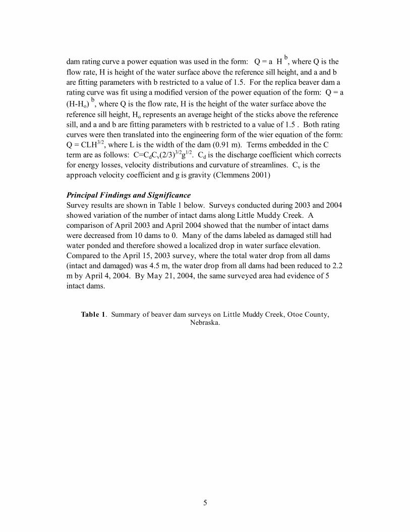
dam rating curve a power equation was used in the form: Q = a H b, where Q is the flow rate, H is height of the water surface above the reference sill height, and a and b are fitting parameters with b restricted to a value of 1.5. For the replica beaver dam a rating curve was fit using a modified version of the power equation of the form: Q = a (H-Ho)
b, where Q is the flow rate, H is the height of the water surface above the reference sill height, Ho represents an average height of the sticks above the reference sill, and a and b are fitting parameters with b restricted to a value of 1.5 . Both rating curves were then translated into the engineering form of the wier equation of the form: Q = CLH3/2, where L is the width of the dam (0.91 m). Terms embedded in the C term are as follows: C=CdCv(2/3)3/2g1/2. Cd is the discharge coefficient which corrects for energy losses, velocity distributions and curvature of streamlines. Cv is the approach velocity coefficient and g is gravity (Clemmens 2001) Principal Findings and Significance Survey results are shown in Table 1 below. Surveys conducted during 2003 and 2004 showed variation of the number of intact dams along Little Muddy Creek. A comparison of April 2003 and April 2004 showed that the number of intact dams were decreased from 10 dams to 0. Many of the dams labeled as damaged still had water ponded and therefore showed a localized drop in water surface elevation. Compared to the April 15, 2003 survey, where the total water drop from all dams (intact and damaged) was 4.5 m, the water drop from all dams had been reduced to 2.2 m by April 4, 2004. By May 21, 2004, the same surveyed area had evidence of 5 intact dams.
Table 1. Summary of beaver dam surveys on Little Muddy Creek, Otoe County, Nebraska.

6
Number of intact dams*
Number of
damaged dams
Channel Distance
(km)
Total water drop
from all dams (m)
Average water drop at intact*
dams (m)Intact*
dams/km
Water drop
from all dams/km (m/km)
April 15, 2003 10 4 0.67 4.5 0.4 14.9 6.7April 4, 2004 0 18 0.67 2.2 0 0 3May 21, 2004** 5 17 0.67 4.5 0.6 7.5 6.7May 28, 2004*** 1 22 0.67 3.6 1.0 1.5 5.4August 29, 2004 8 16 0.67 3.2 0.3 11.9 4.8February 2-March 16, 200513 6 6.61 6.6 0.5 2.0 1.0
**Survey following a 2-year storm***Survey following a 25-year storm
*Not included were dams that were degraded or damaged by storm runoff.
Note: Surveys done between April 15, 2003 and August 29, 2004 were on 1st- and 2nd-order reaches on a total length of 270 m of 1st-order and 400 m of 2nd-order reaches. The February/March 2005 survey was done downstream from 2nd - 3rd order reaches along 6610 m of the main channel with 2680 m of 2nd order and 3930 m of 3rd order streams.
Comparison of the May 21, 2004 and May 28, 2004 surveys indicate the changes following a 25-year storm in the watershed with associated storm flows. The number of dams that were intact decreased from 5 to 1 over the surveyed area. The 25-year storm damaged all of the beaver dams except for one in a 1st-order tributary. The remaining beaver dam had a drop of 1 m. Damage to beaver dams from this storm is indicated by the reduction in the total water drop from all dams in the survey from 4.5 to 3.6 m. As indicated by the May 28th survey, the increase in average water drop of individual dams was caused by the one intact dam. Two months later, in August 2004, the total drop of all dams (3.2 m) had not yet reached the pre-25-year storm level of May 21, 2004 (4.5 m) and the average drop at individual dams also decreased from 0.6 m to 0.3 m from May 21, 2004 to August 2004. Surveys done in Feb/March 2005 extended 6610 m further downstream along Little Muddy Creek, covering 2nd through 3rd order reaches of the main channel. Since the 2005 surveys were done earlier in the year, beaver activity was expected to be less evident than during the late spring and summer surveys. There was no significant difference between the average water level drop at intact dams or the number of intact dams per km when comparing the 1st – 2nd order to the downstream 2nd-3rd order surveys. When compared to the smooth dam, the replica beaver dam showed an increase in water surface elevation for each of the four flow rates (Figure 2). This increased water surface elevation was approximately 30 cm for the lowest flow rate and 60 cm for the
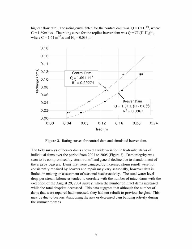
7
highest flow rate. The rating curve fitted for the control dam was: Q = CLH3/2, where C = 1.69m1/2/s. The rating curve for the replica beaver dam was Q = CL(H-Ho)3/2, where C = 1.61 m1/2/s and Ho = 0.033 m.
0.00
0.02
0.04
0.06
0.08
0.10
0.12
0.14
0.16
0.18
0.00 0.04 0.08 0.12 0.16 0.20 0.24
Head (m)
Dis
charg
e (
cm
s)
Control Dam
Q = 1.69 L H 1.5
R2 = 0.99274
Beaver Dam
Q = 1.61 L (H - 0.033)1.5
R2 = 0.9967
Figure 2. Rating curves for control dam and simulated beaver dam.
The field surveys of beaver dams showed a wide variation in hydraulic status of individual dams over the period from 2003 to 2005 (Figure 3). Dam integrity was seen to be compromised by storm runoff and general decline due to abandonment of the area by beavers. Dams that were damaged by increased storm runoff were not consistently repaired by beavers and repair may vary seasonally, however data is limited in making an assessment of seasonal beaver activity. The total water level drop per stream kilometer tended to correlate with the number of intact dams with the exception of the August 29, 2004 survey, when the number of intact dams increased while the total drop/km decreased. This data suggests that although the number of dams that were repaired had increased, they had not rebuilt to previous heights. This may be due to beavers abandoning the area or decreased dam building activity during the summer months.

8
0
2
4
6
8
10
12
April 15, 2003 April 4, 2004 May 21, 2004 May 28, 2004 August 29, 2004
Num
ber
of
inta
ct
dam
s
0.0
1.0
2.0
3.0
4.0
5.0
6.0
7.0
8.0
Tota
l w
ate
r dro
p f
rom
all
dam
s p
er
str
eam
km
(m
/km
)
Number of intact dams
Total drop from all dams per km
Figure 3. Number of intact beaver dams over the survey period and impacts of the beaver dams on water drop.
The spatial arrangement of the dams also varied with time, with new dams being built and old dams left to degrade. There was a noticeable grouping of beaver dams where several dams would be clustered around a zone of beaver activity. Zones were noted by long gaps between groups of intact dams. In addition, evidence of recent beaver presence such as recently gnawed trees and beaver dens correlated strongly to clusters of intact dams. Field observations indicate that locations of intact dams have a positive spatial correlation to the beaver den. The data collected in the field surveys is useful for deciding how to input dams in a channel evolution model. Such models typically require input of a structure that remains constant with time. Modeling beaver dams accurately may require dams that change in dimension in response to storm runoff and periodic abandonment or inactivity of beavers. While these direct relationships are not clearly defined by the survey data, the data suggests that these relationships do exist. The laboratory tests showed an expected result, that the roughness of the sticks led to increased water height upstream of the dam compared to a smooth dam of equal base dimensions. While the replica beaver dam was constructed to be as realistic as possible, we were restricted from using mud on the dam, which may result in a

9
smoother surface at the sill of actual beaver dams. Field surveys showed that beaver dams had exposed sticks on the top and backside of dams, with mud typically pushed up along the upstream edge of the dam sill. However, given this laboratory restriction, the generated rating curves give a starting point from which to model a beaver dam as a broad-crested weir, adjusting the C coefficient for roughness of the sticks compared to a broad-crested weir of a homogeneous material (earthen, plywood, etc). Hydraulic characteristics of beaver dams in our watershed were observed to vary temporally over both long and short term periods. This is a very significant finding because to accurately model the long-term impact of the dams on the stream morphology the temporal nature of the dams will have to be adequately described. These variations occurred with both dam structure and locations. Dam structure varied over both longer and shorter periods of time. For example, some dams damaged by storm runoff were repaired within a period of weeks while others were never repaired, their structure disintegrating over a longer period of time. Spatial arrangement of beaver dams along the stream also varied with time. Locations of intact dams along the 2nd order reaches of Little Muddy Creek shifted generally downstream with dams in the uppermost parts of the 2nd order reach being abandoned over the course of our study. Surveys in the lower portion of the watershed (2nd – 3rd order reaches) indicated fewer dams (intact and damaged) existed than in the upper portion of the watershed (1st – 2nd order). The results of laboratory testing of a beaver dam replica indicate that it was reasonable to model these structures as broad-crested weirs, but it appears that it may be necessary to adjust the crest elevation of the dam with an offset. In the present case this offset was about 3 cm, but the offset likely depends on geometric characteristics of the dam. Uncompleted Work The balance of this project will be completed using funds provided by the Nebraska Department of Environmental Quality and the USDA National Needs PhD. Fellowship Program. The key component that remains is modeling the long-term impacts of the dams. We have chosen to use the USDA model, CONCEPTS (Langendoen, 2000). We have met with the model’s author, Eddie Langendoen, to discuss the details of applying this model to our problem. Notable Achievements The results of this phase of the study have provided us with valuable and necessary data that will be used to model the long-term impacts of beaver dams in an agricultural stream in eastern Nebraska. The hydraulic characteristics of beaver dams and their spatial and temporal distribution are key data that are required to accurately

10
model the beaver dam impacts on stream channel morphology. The fact that an earlier portion of this study demonstrated stream aggradation rates of 0.65 m in a 12 year periods in a reach impacted by beaver suggests that there is significant potential for beaver to help restore degraded stream channels in agricultural areas. The data collected in this project has put our team in a better position to pursue funding for a larger study of beaver impacts in the Little Nemaha River Basin of Nebraska. References Clemmens, A.J., Wahl, T.L., Bos, M.G., and J.A. Replogle. 2001. Water
Measurement with Flumes and Wiers. ILRI. Publication 58.Wageningen, The Netherlands.
Denney, R.N. 1952. A summary of North American beaver management: 1946-1948.
Report of the Colorado Game and Fish Department, Denver, Colorado, USA. Langendoen, E.J. 2000. CONCEPTS-Conservation channel evolution and pollutant
transport system: Stream corridor version 1.0. Research Report No. 16. U.S. Sedimentation Laboratory, Oxford, MS.
Lohnes, R.A. 1997. Stream channel degradation and stabilization: the Iowa
experience: Proceedings of the Conference on Management of Landscapes Disturbed by Channel Incision, May 1997, Oxford, Mississippi.
McCullough, M.C., J.L. Harper, D.E. Eisenhauer, and M.G. Dosskey. 2004. Channel aggradation in beaver dams on a small agricultural stream in eastern Nebraska. In: J.L. D’Ambrosio (ed). Self-Sustaining Solutions for Streams, Wetlands, and Watersheds. Proceedings of the 12-15 September 2004 ASAE Conference, St. Paul, MN.
Naiman, R.J., Melillo J.M. and J.E. Hobbie. 1986. Ecosystem alteration of boreal
forest streams by beaver (Castor Canadensis). Ecology 67:2365-2369. Naiman, R.J., Johnston, C.A. and J.C. Kelley. 1988. Alteration of North American
streams by beaver. BioScience 38:753-762. Rus, D.L, Dietsch, B.J., and A. Simon. 2003. Streambed Adjustment and Channel
Widening in Eastern Nebraska. USGS Water-Resources Investigations Report 03-4003. Lincoln, Nebraska.
Soenksen, P.J., Turner, M.J., Dietsch, B.J. 2003. Stream Bank Stability in Eastern
Nebraska. USGS Water-Resources Investigations Report 03-4265. Lincoln, Nebraska.
Strahler, A.N. 1957. Quantitative analysis of watershed geomorphology. American
Geophysical Union Transactions. 38: 913-920.
11
Wahl, K.L. and L.S. Weiss. 1988. Channel degradation in southeastern Nebraska rivers: In: Ward, T.J., editor. Watershed Management: Planning for the 21st Century. American Society of Civil Engineers, New York, New York.
Zellars, J.A. and R.H. Hotchkiss. 1997. Channel stability adjacent to highly irrigated
land: Eagle Run Creek, Omaha, Nebraska: Proceedings of the Conference on Management of Landscapes Disturbed by Channel Incision, May 1997, Oxford, Mississippi.

The impact of rural water supply systems on property values
Basic Information
Title: The impact of rural water supply systems on property values
Project Number: 2005NE83G
Start Date: 9/1/2005
End Date: 9/1/2007
Funding Source: 104G
Congressional District: 1
Research Category: Social Sciences
Focus Category: Economics, Water Supply, Water Use
Descriptors: None
Principal Investigators: Steven Shultz, Jay Andrew Leitch
Publication

2005 Annual Report Project 2005NE83G WBS# 25-6254-0019-001 Period: March 1, 2005 through February 28, 2006 Title: The impact of rural water supply systems on property values PI: Steve Shultz UNO Completed Work Tasks: 1) Collection of Background Information
2) Procurement/Creation of GIS-based Rural Water Pipeline Data
3) Collection and Digitization of Agricultural Land Sales Data
4) Characterizing the Details of Agricultural Land Sales
5) Digitizing of Rural Residential Land Sales
6) Characterizing the Details of Rural Residential Sales
Details on Completed Work Tasks: 1) The Collection of Background Information: Personal and phone interviews were made to learn more about the history of rural water supply projects in the State locate and of background documents and data with the following persons: - Melody Kruckenberg, CEO North Dakota Rural Water Systems Association - Dave Koland, Executive Director, Garrison Diversion Project. - Jim Lennington (North Dakota State Water Commission). - Steve Hansen (President, Southeast Water Users Association). - Cal Thelen, Brian Bergentine (Advanced Engineering). - Kim Keller, Bureau of Reclamation (Department of the Interior) 2) Procurement/Creation of GIS-based Rural Water Pipeline Data - A GIS coverage of rural water pipeline locations associated with the SWPP was obtained from the State Water Commission. - Digital GIS data showing pipeline locations for the SEWS project pipeline were obtained from Advanced Engineering (Brian Bergentine)

- Requests were made to the SWC and local engineering firms for pipeline data for the NAWS project but no data has yet been provided to us. We are therefore dropping this third study area from the research project. 3) Collection and Digitization of Agricultural Land Sales Data. 1) Recent (2000-2004) agricultural land sale data in two (SWPP and SEWS) project areas were collected (1040 Sales in 17 counties). Sales of ‘arms-length’ agricultural land sales were obtained from public (county) deed records and digitized into a Geographic Information System (GIS) database based on legal descriptions. Sales with and without water supply infrastructure were noted. In the SWPP, 680 agricultural land sales occurred from 2000-2004 and 200 of these (29%) were within 1 mile of an existing rural water pipeline at the time of the sale. In the SWES, 360 agricultural land sales occurred from 2000-2004 and 80 of these (22%) were within 1 a mile of an existing rural water pipeline at the time of the sale. 4) Characterizing the Details of Agricultural Land Sales. GIS spatial overlays will be conducted to quantify additional bio-physical characteristics (land uses, wetlands, location and soil productivity) associated with all agricultural sales. Data sources will include the NASS cropland data layer (CDL), the National Wetland Inventory (NWI), and the SSURGO digital soils database of the Natural Resource Conservation Service (NRCS). Specific variables derived from this data that will later be used to model factors influencing land sale prices (including rural water supplies) include: the percentage of cropland and wetlands within sale parcels, spring wheat yield, land capability classes (1-8), size of sale, and distance to the nearest highway and/or town. 5) Digitizing of Rural Residential Property Sales A total of 151 rural residential sales (both houses and lots) were obtained from County tax directors (sale records) in the following counties with the SEWS study area during the 2000 to 2005 time period: Within the SWWP study area it was decided to focus only on two counties: Morton and Stark and rural residential property sale data was obtained from the Morton County tax director (50 sales) and this same data was requested and is still pending (expected shortly) from the Stark County tax director. Residential sales were digitized by integrating the legal description of the sales with public land survey information and the National Agriculture Imagery (NAIP) orthophotos available through the farm service agency. Public Land Survey information was used to
find the approximate area of the sale and the photos were used to pin-point the exact location. 6) Characterizing the Details of Rural Residential Sales Characteristics of rural-residential property sales (housing features, acreage, and location-based characteristics) were collected in the SEEP through a combination of GIS analyses and manual reviews of tax assessor records, telephone surveys with buyers and sellers and on-site appraisals (personal inspections) of properties. It was not found feasible to use MLS data for such classifications. A Summary of Changes/Modification Made to the Original Research Plan - One of the three originally planned study areas (NWAP) was dropped from the study because of missing and/or incomplete data. - The rural residential component of the SWWP study area will focus on two particular counties (Stark and Morton) as these counties have relatively higher densities of completed rural water pipelines and rural residential sales than the other nearby counties. Work Tasks Planned for 2006: 1) The digitizing of rural residential sales in Stark County 2) Characterizing the details of rural residential sales in the SWWP study area (Morton and Stark Counties) through a combination of GIS analyses and manual reviews of tax assessor records, telephone surveys with buyers and sellers and on-site appraisals (personal inspections) of properties. 3) Preliminary analyses (summary statistics, preparation of Maps) 4) Hedonic valuation method based multiple regression models will be estimated separately for agricultural and rural-residential property sales to model how actual or pending rural water supplies impact property values. The specification of these models is described in the original project proposal. Publications None

Information Transfer ProgramThe University of Nebraska-Lincoln (UNL) Water Center has a long and productive tradition ofinformation transfer programming utilizing USGS funding assistance. The UNL Water Center, arguably,has one of the most comprehensive, aggressive and up-to-date information transfer programs of any of themore than 50 Water Resources Research Institutes nationwide. The UNL Water Center strives to utilize anexperienced faculty and staff with the latest in technological advances to get its message out to those whocan utilize it.
Information supports a variety of research, extension, outreach and education programming sponsored orco-sponsored by the Water Center, the Water Resources Research Initiative and the UNL School ofNatural Resources.
Common vehicles to convey this information include print, electronic, broadcast and Internet, along withconferences, symposiums, seminars, tours, displays and other public events. Information can be found inthe form of newsletters, brochures, press releases, proceedings, research briefs, Internet web sites, radioand television, videotape/DVD and web streaming, to name a few.
Water Center Educational Materials
Basic Information
Title: Water Center Educational Materials
Project Number: 2002NE33B
Start Date: 3/1/2005
End Date: 2/28/2006
Funding Source: 104B
Congressional District: 1
Research Category: Not Applicable
Focus Category: Education, None, None
Descriptors: None
Principal Investigators: Kyle D. Hoagland, Steven W. Ress
Publication

1
2005 USGS Report Information Transfer Program:
Water Center,
University of Nebraska-Lincoln
Newsletter: The Water Current newsletter is in its 37th year of continuous publication. The 12 to 20-page newsletter is published in full-color in a magazine-style format as a quarterly with January, April, July and October publication dates. It has a free distribution of approximately 3,000 copies per issue, more than 95 percent of which represent requested subscriptions. An annual reader survey is published each spring. Water-related research, extension, education and outreach faculty and key staff is featured in each issue. Guest columns and commentary are published as available. Special, theme-oriented issues are published, such as two of this year’s issues that focused on the U.S. Army Corps of Engineers work in the Missouri River basin. Virtual copies of the newsletter are available online in PDF format and are archived at http://watercenter.unl.edu. The UNL Water Center is also a primary contributor of water-related news and feature articles in the quarterly UNL School of Natural Resources’ Resource Links newsletter, the quarterly Nebraska Earth Science Education Network (NESEN) newsletter and others. Other Print Resources (all distributed free of charge): Water Center informational brochures. Updated and produced annually. These include, but are not limited to, the mission and programming of the UNL Water Center, Water Resources Research Initiative (WRRI), Great Plains CESU, EEAI unit, UNL Water Sciences Laboratory and others affiliated with the Water Center. Of late, student recruitment and information on courses in the water sciences have been emphasized. Distributed free. Water Center Pocket Resources Directory. A color, accordion-fold pocket brochure listing key NU, federal, state and local water resource agencies and points of contact. Third edition of this much-used publication was produced in late 2005. Pocket cards. Credit card-size. Explain commonly used terms such as “cubic feet per second (CFS),” acre-feet,” “gallons per minute,” etc. Currently in second printing. A range of publications produced outside the UNL Water Center, particularly fact sheets and other print materials from USGS, Nebraska Department of Environmental Quality, U.S. Environmental Protection Agency, U.S. Army Corps of Engineers and University of Nebraska-Lincoln Extension, are available through the Water Center and School of Natural Resources web sites.

2
News Releases: The Water Center produces about 30 press releases annually which focus on notable research results or progress, extension and educational programming and other matters of public impact that involve the Water Center, Water Resources Research Initiative or water-related faculty and staff. They are also used to announce conferences, seminars, tours, collections of waste pesticides, pesticide container recycling and other activities. These are widely published in state and regional newspapers, as well as in organizational, trade and professional journals and have frequently been “picked-up” by national news networks such as the Associated Press, Reuters and others. The releases support a wide variety of UNL water-related research and outreach that cross departmental and academic disciplines. The Water Center has worked to foster a reputation among state and regional journalists as a reputable source of information on Nebraska water quality and quantity issues. Calls from journalists looking for University sources of information are common and frequent. The Water Center makes wide use of electronic and broadcast journalism sources, as well as the more traditional print (newspaper) sources. Electronic Resources: Electronic versions of all print materials, press releases and other information about the Water Center, Water Resources Research Initiative, Water Sciences Laboratory and curriculum information for graduate and undergraduate students enrolling in water science majors are available at http://watercenter.unl.edu. The Water Center co-sponsors, designs and updates these additional web sites, each of which is program specific: Water Sciences Laboratory (WSL):
http://waterscience.unl.edu Great Plains Cooperative Eco-Systems Studies Unit (CESU):
http://greatplains.cesu.unl.edu/ Water Law, Policy and Science Conference: http://snr.unl.edu/waterconference/ Water Resources Research Initiative (WRRI): http://wrri.unl.edu/ The Water Center, WRRI, WSL and Water Law, Policy and Science Conference sites were redesigned 2003 and began a further redesign and transfer to UNL-wide servers in late 2005. Searchable faculty and student databases have been added to the sites, as well as easier key-word search ability
3
Conferences, Seminars, Tours and Retreats: Water Law, Policy and Science Conference. Conducted annually in March or April. Co-sponsored primarily by the Water Center, Water Resources Research Initiative, College of Law, Department of Geosciences and various other UNL entities. The conference is designed to explore pertinent current issues related to emerging state and regional water and environmental law, policy and research. In its second year, the conference has attracted more than 150 attendees and featured noted national and regional experts on water issues. News releases, brochures, a printed program, radio spots and web-based information are produced in support of this event. This year’s conference was held on the UNL campus, while the third annual conference is scheduled to be held at Nebraska City’s Lied Lodge and Conference Center in April 2006. Water and Natural Resources Seminars. A series of 12 to 14 free weekly public lectures from January to April each year. Co-sponsored by the School of Natural Resources and other University departments and units. The series may be taken for student credit or as a free public lecture series. Each lecture typically attracts an audience of 60-100, as well as approximately a dozen for-credit students. News releases, mailings, brochures, posters and web-based information are produced in support of this long-standing series. The series increasingly showcases water and water-related research being conducted by University faculty. Summer Water and Natural Resources Tour. Co-sponsored by the Nebraska Water Conference Council, Kearney Area Chamber of Commerce, Nebraska Association of Resources Districts, Nebraska Public Power District, Central Nebraska Public Power and Irrigation District and other public, private and commercial entities. The annual three-day tour is conducted in June or July and is used to educate and inform on current water and natural resource issues effecting Nebraska. Typically 50-100 attends the tour, including state legislators and congressional staff. News releases, mailings and a brochure are produced in support of this event. Fall Research Colloquium. Held in conjunction with UNL’s School of Natural Resource Sciences. Brings water and natural resource researchers, cooperative extension programming heads, key staff and students together for a one-day symposium to share research results and progress. Faculty/Staff Retreats: Two to four faculty and staff retreats are held each year for the express purpose of presenting completed and/or significant progress research activity to colleagues, interdisciplinary brainstorming to develop needs-based cooperative research programming and securing grants and funding and to foster an increased sense of collegiality among professionals dispersed throughout a variety of colleges, departments, centers and geographical campuses. Educational Displays:

4
The Water Center makes frequent public displays in association with conferences, symposiums, water-related trade shows, educational open houses and water and environmental festivals. In addition, Water Center staff make presentations and have seats on organizing committees for such educational festivals as the Lincoln Public Schools’ “Earth Wellness Festival,” statewide “Husker Harvest Days” (one of the largest commercial agricultural expos in the country), “Gateway Farm Expo” and others. Promotional Items: Promotional items are distributed at many of the events and venues the Water Center is involved in. These include fishing lures, coffee mugs, key chains, pens, lanyards, University-published books, etc. Most carry Water Center and University logos, web addresses and telephone numbers. They are designed and produced for general distribution and targeted student recruitment, or for specific functions and events. The School of Natural Resources’ recruiting coordinator uses many of these items. Support for the UNL Pesticide Education Office: The Water Center handles press relations and publicity for Extension programs conducted by the UNL Pesticide Education Office, part of the UNL Department of Agronomy and Horticulture, which was at one time administratively linked with the Water Center. These efforts include publicity for very successful statewide plastic pesticide container recycling and waste pesticide collection programs that are closely linked to groundwater quality issues. Publicity for the plastic pesticide container recycling program is a key factor in continuing agri-chemical industry financial support of this endeavor. Primary Information Dissemination Clientele: U.S. Department of Agriculture U.S. Environmental Protection Agency U.S. Geological Survey U.S. Bureau of Reclamation U.S. Army Corps of Engineers U.S. Bureau of Land Management Nebraska Department of Natural Resources Nebraska Department of Agriculture Nebraska Department of Health and Human Services System Nebraska Department of Environmental Quality Nebraska Environmental Trust Fund Nebraska Association of Resources Districts (and individual NRDs) Nebraska Congressional delegation Nebraska State Senators Public and private power and irrigation districts
5
The Audubon Society The Nature Conservancy Nebraska Alliance for Environmental Education Nebraska Earth Science Education Network Other state Water Resources Research Institutes University and College researchers and educators NU students Public and parochial science teachers Farmers Surface and groundwater irrigators Private citizens Cooperating Entities: In addition to primary support from the USGS, the following agencies and entities have helped fund information dissemination (communications) activities by the UNL Water Center during the past year. U.S. Environmental Protection Agency U.S. Department of Agriculture Nebraska Department of Environmental Quality Nebraska Research Initiative Nebraska Game and Parks Commission National Water Research Institute Nebraska Water Conference Council Nebraska Public Power District Central Nebraska Public Power and Irrigation District Farm Credit Services of America Kearney Area Chamber of Commerce Nebraska Association of Resources Districts UNL Institute of Agriculture and Natural Resources UNL Agricultural Research Division UNL College of Agricultural Sciences and Natural Resources UNL School of Natural Resources UNL Water Resources Research Initiative

Student SupportStudent Support
Category Section 104Base Grant
Section 104NCGP Award
NIWR-USGS Internship
Supplemental Awards Total
Undergraduate 0 0 0 0 0
Masters 0 0 0 0 0
Ph.D. 2 0 0 0 2
Post-Doc. 0 0 0 0 0
Total 2 0 0 0 2
Notable Awards and Achievements
Publications from Prior Projects1. 2002NE1B ("Relating landscape scale characteristics with phosphorus loss potential to surface
waters") - Articles in Refereed Scientific Journals - Mamo, M., D. Ginting, W. Zanner, D.McCallister, R. Renken, C. Shapiro, and B. Eghball. 2005. Stratification of soil phosphorus andincreased potential for runoff loss after long-term manure application. J. Soil and WaterConservation. 60: 243-250.
2. 2000NEC25 ("Evaluating the Effects of Pesticide Mixtures to Freshwater Algae ") - OtherPublications - Lockert, C.K., K.D. Hoagland, and B.D. Siegfried. 2006. Atrazine sensitivity amongselected freshwater algae. Bull. Environ. Contamin. Toxicol. 761: 73-79.
3. 2001NE23B ("Investigation of Microbially-Influenced Copper Corrosion in Nebraska DrinkingWater Systems ") - Articles in Refereed Scientific Journals - Young, T.S.M.; Morley, M.C.; Snow,D.D. (2006) ?Simultaneous biodegradation of trichloroethylene andhexahydro-1,3,5-trinitro-1,3,5-triazine (RDX),? ASCE Practice Periodical of Hazardous, Toxic, andRadioactive Waste Mgmt., 10, 2, 94-101. (doi: 10.1061/(ASCE)1090-025X(2006)10:2(94))
4. 2001NE23B ("Investigation of Microbially-Influenced Copper Corrosion in Nebraska DrinkingWater Systems ") - Dissertations - Young, Travis S.M., 2004, ?Anaerobic Biodegradation ofHexahydro-1,3,5-trinitro-1,3,5-triazine (RDX) and Trichloroethylene (TCE): Single andDual-Contaminant Batch Tests." Master of Science Thesis, Environmental Engineering, University ofNebraska Lincoln.
5. 2004NE78B ("Hydrogeological Controls of Salinity Patterns in the Sand Hills Lakes, NE") - OtherPublications - Zlotnik, V.A., M. Burbach, J. Swinehart, D. Bennett, S. Fritz, D. Loope, A case studyof direct push methods for aquifer characterization in dune-lake environments, Environmental andEngineering Geoscience, accepted for publication
6. 2004NE78B ("Hydrogeological Controls of Salinity Patterns in the Sand Hills Lakes, NE") - OtherPublications - Bennett, D. M. , S.C. Fritz, J. C.Holz, A. A. Holz , V. Zlotnik, Evaluating Climatic andNon-Climatic Influences on Ion Chemistry in Natural and Man-made Lakes of Nebraska, USA,
Hydrobiologia, in revision 7. 2004NE78B ("Hydrogeological Controls of Salinity Patterns in the Sand Hills Lakes, NE") - Other
Publications - Zlotnik, V.A., S. Fritz, J. Swinehart, D. Bennett, M. Burbach, 2005, Towards quantificationof salinity dynamics of modern lakes in semi-arid dune environments: Nebraska Sand Hills, GSAAbstracts with Programs, Salt Lake City, Colorado, October 16-19, 2005, p. 242-243.
8. 2000NE3B ("Hydraulic Characterization of the Stream-Aquifer Interface: Theory, FieldImplementation, and Pracctical Ramifications - Multi State Proposal") - Other Publications - Kollet, S.J.,and V.A. Zlotnik (2005), Reply to comment by H. Lough, Deartment of Civil Engineering, University ofCanterbury, Christchurch, New Zealand, on the paper Stream depletion predictions using pumping testdata from a heterogeneous stream-aquifer system (a case study from the Great Plains, USA) by S.J. Kolletand V.A. Zlotnik, 281: 96-114, J. of Hydrology, 313, 149-152.
9. 2000NE3B ("Hydraulic Characterization of the Stream-Aquifer Interface: Theory, FieldImplementation, and Pracctical Ramifications - Multi State Proposal") - Other Publications - Zlotnik V.A., 2005, Reply to comment by Sushil K. Singh on A concept of maximum stream depletion rate for leakyaquifers in alluvial valleys, Water Resour. Res., 41, W08602, doi:10.1029/2004WR003836
10. 2000NE3B ("Hydraulic Characterization of the Stream-Aquifer Interface: Theory, FieldImplementation, and Pracctical Ramifications - Multi State Proposal") - Other Publications - Kollet, S.J.,and V.A. Zlotnik, 2005, Influence of aquifer heterogeneity and return flow on pumping test datainterpretation, J. Hydrology, 300, 267285
11. 2000NE3B ("Hydraulic Characterization of the Stream-Aquifer Interface: Theory, FieldImplementation, and Pracctical Ramifications - Multi State Proposal") - Other Publications - Zlotnik,V.A., 2004, A concept of maximum stream depletion rate for leaky aquifers in alluvial valleys, WaterResour.Res., v. 40(6), W06507, doi: 10.1029/2003 WR002932
12. 2000NE3B ("Hydraulic Characterization of the Stream-Aquifer Interface: Theory, FieldImplementation, and Pracctical Ramifications - Multi State Proposal") - Conference Proceedings - Zlotnik,V.A. and S.J. Kollet, 2003, Application of Analytical Models of Pumping Induced Stream Depletion toReal Stream-Aquifer Systems: a Practical Approach? EOS Transactions, American Geophysical Union,Fall Meeting, San Francisco, Abstracts, 84(86), F500, 2003
13. 2000NE3B ("Hydraulic Characterization of the Stream-Aquifer Interface: Theory, FieldImplementation, and Pracctical Ramifications - Multi State Proposal") - Conference Proceedings - Kollet,S.J., and V.A. Zlotnik, V.A., 2003, Conceptualization of the streambed in mathematical models ofgroundwater-surface water interaction: new insights into an old approach, GSA Abstracts with Program,Seattle, November 2-5, 2003, p. 100.
14. 2000NE3B ("Hydraulic Characterization of the Stream-Aquifer Interface: Theory, FieldImplementation, and Pracctical Ramifications - Multi State Proposal") - Conference Proceedings -Cardenas, B.R., and V.A. Zlotnik, 2002, Assessment of bend topography models via calibration to aground-penetrating radar profile and permeability data, AGU Fall Meeting, San-Francisco, Abstracts,83(47), F592.
15. 2000NE3B ("Hydraulic Characterization of the Stream-Aquifer Interface: Theory, FieldImplementation, and Pracctical Ramifications - Multi State Proposal") - Conference Proceedings - Zlotnik,V.A., S.J. Kollet, M.B.R. Cardenas, and D. Woodward, Study of stream-aquifer interactions in the PlatteRiver watershed using methods of aquifer hydraulics, sedimentology, geophysics, and geostatistics. GSAAbstracts with Program, Denver, Colorado, October 27-31, 2002, p. 98.
16. 2001NE2461B ("Evaluation of Conductive Properties of the Surficial Aquifer in the Nebraska SandHills") - Other Publications - Goss, D., and V.A. Zlotnik, Applicability of Air Permeameter forInvestigation of Surficial Dune Structures in Nebraska Sand Hills, USA, AAPG Bulletin, accepted
pending minor revisions 17. 2001NE2461B ("Evaluation of Conductive Properties of the Surficial Aquifer in the Nebraska Sand
Hills") - Conference Proceedings - Goss, D., and V.A. Zlotnik, 2004, Studies of permeability in shalloweolian sediments in the Nebraska Sand Hills and Great Sand Dunes National Monument, Colorado, GSAAbstracts with Programs, Denver, Colorado, November 7-10, 2003, p. 125.
18. 2001NE2461B ("Evaluation of Conductive Properties of the Surficial Aquifer in the Nebraska SandHills") - Conference Proceedings - Goss, D., and V.A. Zlotnik, 2000, Field investigations of portable airpermeameters for subsurface measurements, GSA Abstracts with Programs, Reno, Nevada, Nov. 9-18, p.A360
19. 2002NE9B ("ASSESSMENT OF THERMAL-INFRARED IMAGING AS A TOOL FOREVALUATION OF GROUNDWATER-LAKE INTERACTIONS IN THE NEBRASKA SAND HILLS")- Other Publications - Tcherepanov, E.N, V.A. Zlotnik, and G. Henebry, 2005, Using Landsat thermalimagery and GIS for identification of ground water discharge into shallow ground water - dominatedLakes, Int. J. Remote Sensing,Vol. 26, No. 17, 10 September 2005, 36493661, doi:10.1080/01431160500177315
20. 2002NE9B ("ASSESSMENT OF THERMAL-INFRARED IMAGING AS A TOOL FOREVALUATION OF GROUNDWATER-LAKE INTERACTIONS IN THE NEBRASKA SAND HILLS")- Conference Proceedings - Tcherepanov, E.N., and V.A. Zlotnik, 2002. Applications of remote sensingfor hydrological studies in the Nebraska Sandhills, GSA Abstracts with Program, Denver, Colorado,October 27-31, 2002, p. 88.