Nebraska Severe Weather Awareness Week · March 26 -30, 2018 National Weather ... flooding and move...
27
Nebraska Severe Weather Awareness Week March 26 - 30, 2018 National Weather Service Coverage Map 2 2017 State Tornado & Severe Weather Facts 3 2017 State Tornado Graphical Facts 4 Severe Weather Terminology 6 NOAA Weather Radio All Hazards 7 Tornado Safety 8 Flood Safety 9 Lightning Safety 10 Facts & Myths 11 2017 Event Of The Season 12 A New Satellite Era Has Dawned 14 New Wind Farm & The NWS Hastings Radar 15 Nebraska Panhandle 2017 Review 16 Extreme Southwestern Nebraska 2017 Review 18 Western & North Central Nebraska 2017 Review 20 South Central Nebraska 2017 Review 22 Eastern Nebraska 2017 Review 24 Summer Climate Outlooks 26 Central Plains Severe Weather Symposium 27 Wednesday, March 28 th Statewide Tornado Safety Drill Do you & your family know what to do if a tornado threatens? Practice your plan of action! Test Watch: 10 a.m. CDT (9 a.m. MDT) Test Warning: 10:15 a.m. CDT(9:15 a.m. MDT) What’s Inside? Spring Has Sprung! Are you Weather-Ready? Welcome to spring and the 2018 Nebraska Severe Weather Awareness Week. We hope you find the information in this packet and the special time set aside this week useful in preparing yourself, your family or your business for the hazards of Nebraska weather. The NWS wants you to not just be ready, but “Weather-Ready” for the upcoming severe weather season. When it comes to being Weather-Ready, there are a few simple things you should know: Know Your Risk Tornadoes, large hail, damaging thunderstorm winds, floods and lightning can be deadly for the unprepared. Knowing the weather related risks posed to you is the first step in becoming Weather-Ready. Take Action You should prepare for the hazards of severe weather season by knowing you are not powerless. You should devise a tornado drill plan for you, your family or your business. You should know what to do if lightning is in the area or flooding becomes threatening. With the hazard potential on the Plains, you should know what to do for each situation and be ready to “take action” if need be. It may save your life and those around you. Be a Force of Nature Be an example. Share your preparedness success story by posting on Facebook/Twitter or helping build an online community of the prepared. Look for ways to assist at work or in your community to help your family, neighbors, co-workers, and entire community prepare. #newx All of us at the National Weather Service are focused on the mission of protecting lives and property through our watches, warnings, advisories and forecasts. We hope you will take advantage of this special time set aside, and the information available, to make yourself and those around a bit safer by becoming “Weather-Ready”. 1 Building a Weather-Ready Nation
Transcript of Nebraska Severe Weather Awareness Week · March 26 -30, 2018 National Weather ... flooding and move...

Nebraska Severe Weather Awareness Week
March 26 - 30, 2018
National Weather Service Coverage Map 2
2017 State Tornado & Severe Weather Facts 3
2017 State Tornado Graphical Facts 4
Severe Weather Terminology 6
NOAA Weather Radio All Hazards 7
Tornado Safety 8
Flood Safety 9
Lightning Safety 10
Facts & Myths 11
2017 Event Of The Season 12
A New Satellite Era Has Dawned 14
New Wind Farm & The NWS Hastings Radar 15
Nebraska Panhandle 2017 Review 16
Extreme Southwestern Nebraska 2017 Review 18
Western & North Central Nebraska 2017 Review 20
South Central Nebraska 2017 Review 22
Eastern Nebraska 2017 Review 24
Summer Climate Outlooks 26
Central Plains Severe Weather Symposium 27
Wednesday, March 28
th
Statewide Tornado Safety Drill
Do you & your family know what to do if a tornado threatens?
Practice your plan of action!
Test Watch: 10 a.m. CDT (9 a.m. MDT)
Test Warning: 10:15 a.m. CDT(9:15 a.m. MDT)
What’s Inside?
Spring Has Sprung! Are you Weather-Ready?
Welcome to spring and the 2018 Nebraska Severe Weather Awareness Week. We hope you find the information in this packet and the special time set aside this week useful in preparing yourself, your family or your business for the hazards of Nebraska weather. The NWS wants you to not just be ready, but “Weather-Ready” for the upcoming severe weather season. When it comes to being Weather-Ready, there are a few simple things you should know:
Know Your Risk Tornadoes, large hail, damaging thunderstorm winds, floods and lightning can be deadly
for the unprepared. Knowing the weather related risks posed to you is the first step in becoming Weather-Ready.
Take Action You should prepare for the hazards of severe weather season by knowing you are not
powerless. You should devise a tornado drill plan for you, your family or your business. You should know what to do if lightning is in the area or flooding becomes threatening. With the hazard potential on the Plains, you should know what to do for each situation and be ready to “take action” if need be. It may save your life and those around you.
Be a Force of Nature Be an example. Share your preparedness success
story by posting on Facebook/Twitter or helping build an online community of the prepared. Look for ways to assist at work or in your community to help your family, neighbors, co-workers, and entire community prepare. #newx
All of us at the National Weather Service are focused on the mission of protecting lives and property through our watches, warnings, advisories and forecasts. We hope you will take advantage of this special time set aside, and the information available, to make yourself and those around a bit safer by becoming “Weather-Ready”.
1 Building a Weather-Ready Nation

National Weather Service Offices Serving Nebraska
Severe Weather Awareness Week - March 26 - 30, 2018
West and North Central North Platte
Panhandle Cheyenne, WY
Extreme Southwest Goodland, KS
South Central Hastings
Extreme Northeast Sioux Falls, SD
East Omaha/Valley
6365 N. Osborne Drive West Hastings, NE 68901
(402) 462-4287
www.weather.gov/hastings
6707 N. 288th Street Valley, NE 68064
(402) 359-9443
www.weather.gov/omaha
26 Weather Lane Sioux Falls, SD 57104
(605) 330-4247
www.weather.gov/siouxfalls
1301 Airport Parkway Cheyenne, WY 82001
(307) 772-2468
www.weather.gov/cheyenne
5250 E. Lee Bird Drive North Platte, NE 69101
(308) 532-4936
www.weather.gov/northplatte
920 Armory Road Goodland, KS 67735
(785) 899-7119
www.weather.gov/goodland
2 Building a Weather-Ready Nation

3 Building a Weather-Ready Nation
2017 Nebraska Tornado/Severe Weather Facts Severe Weather Awareness Week - March 26 - 30, 2018
Tornadoes: 33 (9 less the 1950-2017 average of 42 & 20 less the 30 year average of 53) Deaths: 0 Injuries: 1 (June 12th - Sioux County near Harrison) Longest Track: 31.65 mi (June 12th - Morrill into Box Butte Counties) Greatest Width: 840 yards (August 19th - Near Almeria in Loup County) Strongest: EF2 (4 - June 12th (Sioux & Morrill Counties), June 16th (Sarpy County) & August 19th (Loup County)) Most in a county: 5 (Loup County) Days of occurrence (1 or more tornadoes): 11 Most in one day: 10 (June 12th) Most in one month: 19 (June) First tornado of the year: April 9th (EF0 - Near Cortland in Gage County) Last tornado of the year: October 2nd (EF0 - Near Boone in Boone County)
--------------------------- 2017 Monthly Tornado Totals ---------------------------
2017 Season Peak
Hail Size: 4.25” on June 13th (Southwest of Bassett - Rock County) June 29th (Near South Sioux City - Dakota County) Wind Gust: Estimated: 115 MPH on June 27th - North central Lincoln County Measured: 110 MPH on June 16th - Near Fremont (Dodge County)
Jan Feb Mar Apr May Jun Jul Aug Sep Oct Nov Dec Total
Total 0 0 0 2 4 19 0 7 0 1 0 0 33 100%
EF5 0 0 0 0 0 0 0 0 0 0 0 0 0 0%
EF4 0 0 0 0 0 0 0 0 0 0 0 0 0 0%
EF3 0 0 0 0 0 0 0 0 0 0 0 0 0 0%
EF2 0 0 0 0 0 3 0 1 0 0 0 0 4 12%
EF1 0 0 0 0 2 10 0 2 0 0 0 0 14 43%
EF0 0 0 0 2 2 4 0 4 0 1 0 0 13 39%
Unk 0 0 0 0 0 2 0 0 0 0 0 0 2 6%
Unk = Unknown strength
The EF scale is a tornado damage scale. Unknown is used when the tornado does not hit anything.

Nebraska Tornado Facts
Severe Weather Awareness Week - March 26 - 30, 2018
4 Building a Weather-Ready Nation

Nebraska Tornado Facts
Severe Weather Awareness Week - March 26 - 30, 2018
5 Building a Weather-Ready Nation
Severe Weather Terminology
Severe Weather Awareness Week - March 26 - 30, 2018
6 Building a Weather-Ready Nation
Do you know the difference?

NOAA Weather Radio All-Hazards (NWR)
Severe Weather Awareness Week - March 26 - 30, 2018
NOAA Weather Radio All Hazards is a nationwide network of radio stations broadcasting continuous weather information directly from the nearest National Weather Service office. NWR broadcasts official Weather Service warnings, watches, forecasts and other hazard information 24 hours a day, 7 days a week.
Working with the Federal Communication Commission's (FCC) Emergency Alert System, NWR is an "All Hazards" radio network, making it your single source for comprehensive weather and emergency information. In conjunction with Federal, State, and Local Emergency Managers and other public officials, NWR also broadcasts warning and post-event information for all types of hazards, including natural (such as tornadoes or floods), environmental (such as chemical releases or oil spills), and public safety (such as AMBER alerts or 911 Telephone outages).
Known as the "Voice of NOAA's National Weather Service," NWR is provided as a public service by the National Oceanic and Atmospheric Administration (NOAA). NWR includes 1000 transmitters, covering all 50 states, adjacent coastal waters, Puerto Rico, the U.S. Virgin Islands, and the U.S. Pacific Territories. NWR requires a special radio receiver or scanner capable of picking up the signal. Broadcasts are found in the VHF public service band at these seven frequencies (MHz):
Coverage information and SAME Codes for every county in Nebraska can be found at:
www.weather.gov/nwr/Maps/PHP/NE.php
162.400 162.425 162.450 162.475 162.500 162.525 162.550
7 Building a Weather-Ready Nation

Tornado Safety
www.weather.gov/tornado
A tornado is a violently rotating column of air in contact with the ground that is capable of destroying anything in its path and hurling objects through the air like deadly missiles. They can produce winds in excess of 200 MPH, be over 1 mile wide and stay on the ground for over 50 miles! Although tornadoes occur in many parts of the world, they are found most frequently in the United States. If you know what to do before, during and after a tornado, you minimize your risk of
injury and increase your chances of survival. Warnings save lives, however deaths and injuries still occur. Some people may not hear the warning, others did but did not believe it would happen to them. Are you and your family prepared for a tornado?
Be Weather-Ready!
Know the risk for your area. Tornadoes can occur at any time of day, any day of the year.
Have a NOAA Weather Radio and battery back-up to receive warnings.
Have a plan of action BEFORE severe weather threatens. You need to respond quickly when a warning is issued or a tornado is spotted.
Before a Tornado...
Know how your community sends warnings. Some have outdoor sirens, others depend on media and smart phones to alert residents.
Pick a tornado safe room in your home such as a basement, cellar or an interior room on the lowest floor with no windows. Make sure all members of your family know to go there. If time allows, get your pets.
Conduct a tornado drill regularly so everyone knows what to do if a tornado is approaching.
Have a family plan that includes an emergency meeting place.
During a Tornado...
Take shelter immediately! Remember that occasionally tornadoes can develop so quickly that advance warning is not possible. Stay alert when threatening weather is in your area.
Get to an underground shelter, basement or safe room.
Mobile homes are not safe! Abandon them immediately and go to the nearest
sturdy building or shelter.
If you are outdoors, seek shelter immediately! If you cannot quickly get to shelter:
Get into a vehicle, buckle your safety belt and try to drive to the closest shelter.
If flying debris occurs while driving, pull over and park. As a last resort:
- Stay in your vehicle with the seat belt on. Put your head down below the windows, covering with your hands and blanket if possible.
- If you can safely get noticeably lower than the level of the road, exit your car and lie in that area, covering your head.
- Your choice should be driven by your specific circumstances!
8 Building a Weather-Ready Nation

Flood Safety
www.floodsafety.noaa.gov
Sometimes floods develop slowly and forecasters can anticipate where a flood will happen well in advance. More often, flash floods can occur within minutes and sometimes without any advance warning. Being prepared can save your life and give you peace of mind. Do not to underestimated the power of water!
Before a Flood…
Know your risk. Are you located in a floodplain? Where is water likely to collect? Where do I go if there is a flood? Have answers to these questions before flooding occurs.
Create a communications plan for your family and friends to follow in the event of a disaster.
Assemble an Emergency Kit with enough food, water and medicine to last you at least 3 days.
During a Flood…
Stay Informed! Monitor NOAA Weather Radio, local radio/television and the internet for the latest information and updates.
If told to evacuate, do so immediately! Get out of areas that are subject to flooding and move to a safe area before access is cut off by flood waters.
DO NOT drive into flooded roadways or around a barricade, as 12-18 inches of water can carry away most vehicles. The depth of the water may not be obvious and the roadway may no longer be intact. If your vehicle stalls, leave it and move to higher ground before water sweeps your vehicle away.
DO NOT walk, swim, or play in flood water! You may not be able to determine how quickly the water is flowing or if there are holes or submerged debris. You may be swept away! If water is moving swiftly, as little as 6 inches of water can knock you off of your feet. There is also a danger of hazardous materials polluting the water. Also remember that water is an electrical conductor, if there are power lines down, there is a threat of electrocution.
DO NOT go into any room if water is covering electrical outlets or cords. If you see sparks or hear buzzing, crackling, snapping or popping noises - Get Out! Do not go into flooded basements. The structure may be compromised.
After a Flood…
Avoid flood waters and disaster areas! Obey road closures and other instructions.
Stay tuned to your local news for updated information. Ensure water is safe before using or consuming. Check with utility companies about outages. Never use a portable generator indoors, carbon monoxide poisoning kills!
Let your family and friends know you are okay.
9 Building a Weather-Ready Nation

Lightning Safety
www.lightningsafety.noaa.gov
Lightning: What You Need to Know
NO PLACE outside is safe when thunderstorms are in the area!
Plan ahead! Have a way to get the latest formation. Know what to do if storms develop!
When you hear thunder, immediately move to safe shelter: a substantial building or an enclosed, metal-topped vehicle with windows up.
Stay in safe shelter for at least 30 minutes after you hear the last sound of thunder.
Indoor Lightning Safety
Stay off corded phones, computers and other equipment that put you in direct contact with electricity.
Avoid plumbing. Do not wash your hands, bathe or wash dishes.
Stay away from windows and doors and stay off porches.
Do not lie on concrete floors and do not lean against concrete walls.
Protect your pets! Dog houses are not safe and animals chained to trees are vulnerable!
Lightning is fascinating to watch but is also extremely dangerous. In the U.S., there are about 25 million lightning flashes every year. Each of those flashes is a potential killer. While lightning fatalities have decreased over the past 30 years, lightning continues to be one of the top weather killers in the U.S. Lightning also injures many more people than it kills and leaves some victims with life-long health problems.
Though lightning strikes peak in summer, people are struck year round. In the U.S., an average of 49 people are killed each year by lightning. Don’t become a statistic - Be Prepared!
Avoid getting caught in a dangerous situation! If you can hear thunder, you are close enough to be struck by lightning!
Last Resort Outdoor Risk Reduction Tips
If you are caught outside with no safe shelter anywhere nearby the following actions may reduce your risk:
Immediately get off elevated areas such as hills, mountain ridges or peaks.
Never lie flat on the ground.
Never shelter under an isolated tree or a cliff/rocky overhang.
If in a group, spread out to avoid the current traveling between you.
Immediately get out of and away from other bodies of water.
Stay away from objects that conduct electricity (barbed wire fences, power lines, windmills, etc.).
10 Building a Weather-Ready Nation

Myths & Facts
Severe Weather Awareness Week - March 26 - 30, 2018
Myth - If it is not raining, then there is no danger from lightning.
Fact - Lightning often strikes outside of heavy rain and may occur as far as 10 miles
away from thunderstorm clouds.
Myth - Structures with metal or metal on the body attract lightning.
Fact - Height, pointy shape and isolation are the dominant factors controlling where a lightning bolt will strike.
Myth - Lightning never strikes the same place twice.
Fact - Lightning often strikes the same place repeatedly, especially if it is a tall, pointy and isolated object.
Myth - The rubber soles of the shoes or rubber tires on a car will protect you from being struck by lightning.
Fact - Rubber-soled shoes and rubber tires provide no protection from lightning. The metal frame of a hard topped vehicle provides increased protection if you are inside and not touching metal.
Myth - Overpasses are safe shelters when a tornado strikes. Fact - Overpasses are NOT safe! They can concentrate the wind, causing it to be stronger. People have been killed and injured taking shelter under an overpass.
Myth - Low pressure with a tornado causes buildings to explode. Open a window before taking shelter. Fact - Opening a window attempting to equalize pressure has no effect. Move to a safe area immediately!
Myth - An approaching tornado will always be visible. Fact - While most have a visible funnel, it is not always the case. Tornadoes can be hidden by trees and terrain, or may even be wrapped in rain!
Myth - Rivers, lakes and mountains will protect you from a tornado.
Fact - No terrain is safe from a tornado and they can cross bodies of water. Every major river east of the Rockies has been crossed by a significant tornado. High elevations in the Appalachians, Rockies, and Sierra Nevada have all experienced tornadoes.
Myth - Larger vehicles are safe to drive through flood waters.
Fact - Rushing water of 12-18” can carry most vehicles away, including SUVs and pickups.
Myth - Flash floods mainly occur in the eastern United States.
Fact - Flash floods have and can occur in all 50 states.
11 Building a Weather-Ready Nation

2017 Event of the Year June 16
th - Eastern Nebraska
Severe Weather Awareness Week - March 26 - 30, 2018
During the afternoon and evening of June 16th, a complex of severe thunderstorms swept through eastern Nebraska and southwest Iowa. Widespread wind damage occurred, as well as hail to baseball size and numerous tornadoes, the strongest of which was rated EF2. Several outdoor events were impacted by the outbreak, including the cancellation of the NCAA College World Series Opening Ceremonies and Papillion Days in Sarpy County. At least 76,000 OPPD customers were without power and the storm ranked 4th worst in OPPD’s history. Initial storm development occurred near O’Neill around 3 PM (Fig. 1). The storms then grew into two supercells which tracked across portions of northeast Nebraska between 4-7 PM, producing a 74 mph wind gust at the Norfolk airport and estimated wind gusts of 80 to 110 mph across many locations in Dodge County. Brief tornadoes were reported in Pierce, Wayne, Madison and Stanton counties, along with hail to golf ball size.
Between 7-8 PM, the initial supercells that affected northeast Nebraska underwent a transition to a more widespread wind-producing thunderstorm complex over the Omaha Metro area, with observed wind gusts of 88 mph at the NWS Office in Valley and 104 mph in the southwest part of Omaha. In addition, two tornadoes occurred in close proximity to one another in the Bellevue/Offutt AFB area, one of which produced EF2 damage. Widespread straight-line wind damage occurred from Sarpy and Cass Counties into Mills and Fremont Counties in southwest Iowa.
More information about this event can be found at www.weather.gov/oax/event_archive_20170616
12 Building a Weather-Ready Nation
Left: KOAX 0.5-degree 4-panel (reflectivity-upper left, storm relative velocity - upper right, base velocity - lower left, correlation coefficient (CC) - lower right) at 7:58 PM. Note the strong low-level circulation associated with the deeper storm S6 mesocyclone along the leading edge of the broader cold pool (upper right). In contrast, the mid-level mesocyclone associated with storm S5 was located farther behind the leading edge of the cold pool, with no substantial low-level circulation noted. Between storms S6 and S5, a debris signature was observed in CC data to the west and southwest of Springfield (bottom right).

2017 Event of the Year June 16
th - Eastern Nebraska
Severe Weather Awareness Week - March 26 - 30, 2018
13 Building a Weather-Ready Nation
Fig. 2: Between 8 and 9 PM, an additional grouping of storms intensified near and west of Lincoln. In addition to producing a brief tornado in Lincoln, these storms produced hail to tennis-ball size. An 87 mph wind was also reported at the Lincoln airport. These storms then spread across the remainder of southeast Nebraska through about 10:30 PM, producing an observed 85 mph wind gust at the Beatrice airport, hail to baseball size and a brief tornado northeast of Beatrice. Fig. 3: GOES-16 red-visible channel at 8:02 PM showing the substantial overshooting tops associated with storms S5 and S6 over Sarpy County.
Figure 2 Figure 3
Fig. 4: Hourly radar mosaic of the entire event from 4 PM to 10 PM.
Fig. 5: The Two Springs and Hyda Hills neighborhoods in Bellevue were hit particularly hard hit. Photo credit Bellevue Police Department Sean Vest near south 25th street in the Hyda Hills neighborhood.
Figure 4 Figure 5
A New Satellite Era Has Dawned
Severe Weather Awareness Week - March 26 - 30, 2018
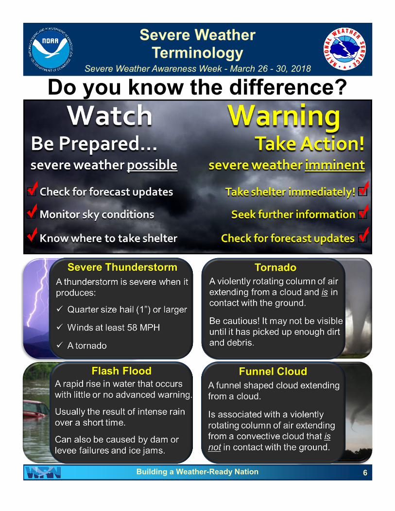
On December 20, 2017, over a year after its initial launch, GOES-16 was deemed operational and renamed GOES-East. GOES-East is able to scan the skies five times faster and provide four times greater image resolution than its predecessors. These advancements will provide forecasters with sharper, more detailed views of evolving weather systems, allowing for improved forecasts and warnings. GOES-S is the second in a series of four advanced geostationary weather satellites which will launch on March 1, 2018. Similar to GOES-R/16/East, it will undergo a testing period in a temporary position before being reassigned to its final position in the winter of 2018-19. One of the beneficiaries of the high-resolution satellite data is a storm-prediction model called “ProbSevere”, which is a tool used by NWS
meteorologists during severe weather operations. The ProbSevere model was developed through collaborative efforts between scientists at the Cooperative Institute for Meteorological Satellite Studies (CIMSS) and the National Oceanic and Atmospheric Administration (NOAA). This real-time statistical model calculates the likelihood that a developing storm will first produce severe weather in the next 90 minutes. Four primary data sources are utilized by this model: 1) numerical weather prediction, which provide information about the storm environment, 2) satellite data, which provide information about cloud development and how quickly the clouds are growing vertically, 3) radar data and 4) lightning data, both of which provide additional information about storm characteristics. Output from the ProbSevere model is typically used in conjunction with radar data (right) to help warning forecasters identify which storms are developing most rapidly and may pose a severe weather threat in the near future. The ProbSevere model continues to undergo testing and refinement at a number of research facilities around the country. More information can be found at: https://www.nesdis.noaa.gov/GOES-R-Series-Satellites
14 Building a Weather-Ready Nation
Have you found us on your favorite social media platform? Do you have a Facebook page or Twitter account?
Find and follow us for the latest weather, climate facts and other interesting information!
NWS Cheyenne, WY
NWSCheyenne NWS North Platte, NE
NWSNorthPlatte
NWS Goodland, KS
NWSGoodland NWS Hastings, NE
NWSHastings
NWS Sioux Falls, SD
NWSSiouxFalls NWS Omaha, NE
NWSOmaha

Changes Affecting The NWS Hastings Radar Near Blue Hill
Severe Weather Awareness Week - March 26 - 30, 2018
If you have looked at a recent radar image from the NWS Hastings radar site near Blue Hill (KUEX) and noticed some something unique near the radar site, you’re not alone. NextEra Energy recently completed a 65 tower wind farm in northern Webster County. The wind farm towers, especially the spinning blades, show up as an increase in the ground clutter pattern with a “spikey” look near the radar site.
Wind farms have become increasingly common over the past decade and are often seen on radar images. There are a handful of NWS radar sites with wind farms close by, but none quite as close the Blue Hill radar site. The closest tower is just over 1.5 miles away. The remaining towers are roughly 2 to 11 miles from the radar, and extend roughly across the southern horizon.
How does this impact the radar? The radar beam will reflect or “bounce” off the towers, and may be partially blocked by the towers in some circumstances. The beam does “refill” to some degree as it passes the towers, which allows the radar to see precipitation beyond the towers themselves.
What does the NWS do to mitigate the wind farm impacts? First, meteorologists are trained to know how the wind farm can impact radar performance and adjust for those impacts. Second, the NWS worked with NextEra Energy to develop a “curtailment agreement”. This agreement allows the NWS to request NextEra operators to temporarily slow down the wind farm during times it may significantly impact severe weather operations. By working closely with NextEra Energy during hazardous weather situations, this agreement not only helps the NWS, but also NextEra Energy as well, as severe weather near the wind farm could cause significant damage. Third, we hope to help our partners and other users of the radar data to better understand this change and how they can mitigate its impact.
What will I see on the radar? Mostly, you will see a “spikey” or “spoke” pattern just south of the radar site. This pattern is the radar beam reflecting off the towers and will generally be in the same spot all the time. In fact, it's so close, it’s within the typical ground clutter pattern which has always displayed near the radar site. Will this impact severe weather warnings or operations? No, it should not. NWS meteorologists are trained to diagnose various radar images and know the strengths and limitations of the radar. Meteorologists will use a combination of the training and their experience to ensure no degradation of service occurs.
Will any more wind farms be built near the radar site? No one knows for sure, but preliminary plans have already been submitted for additional wind farms to the west/southwest of the radar site along State Highway 4, and in far northwest Nuckolls county southeast of the radar. In both cases, the towers would be within 25 miles of the radar. The NWS is working with developers to ensure impacts on the Blue Hill radar site will be mitigated as much as possible.
15 Building a Weather-Ready Nation
Radar
Wind Farm
Looking south from the top of the KUEX radar dome.
2017 Nebraska Severe Weather Summary
Severe Weather Awareness Week - March 26 - 30, 2018
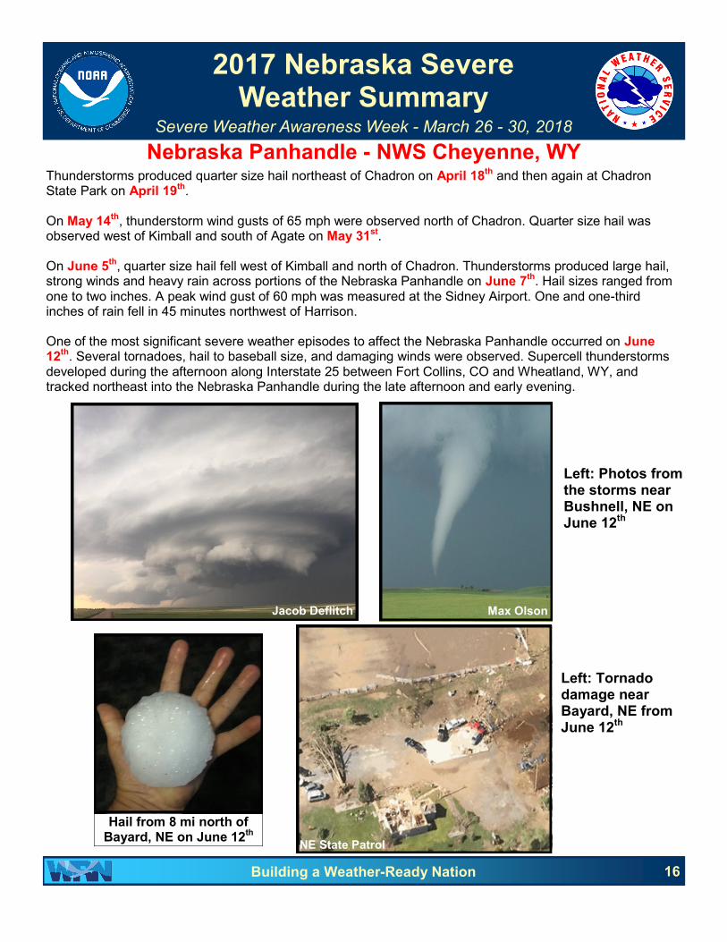
Nebraska Panhandle - NWS Cheyenne, WY Thunderstorms produced quarter size hail northeast of Chadron on April 18th and then again at Chadron State Park on April 19th. On May 14th, thunderstorm wind gusts of 65 mph were observed north of Chadron. Quarter size hail was observed west of Kimball and south of Agate on May 31st. On June 5th, quarter size hail fell west of Kimball and north of Chadron. Thunderstorms produced large hail, strong winds and heavy rain across portions of the Nebraska Panhandle on June 7th. Hail sizes ranged from one to two inches. A peak wind gust of 60 mph was measured at the Sidney Airport. One and one-third inches of rain fell in 45 minutes northwest of Harrison. One of the most significant severe weather episodes to affect the Nebraska Panhandle occurred on June 12th. Several tornadoes, hail to baseball size, and damaging winds were observed. Supercell thunderstorms developed during the afternoon along Interstate 25 between Fort Collins, CO and Wheatland, WY, and tracked northeast into the Nebraska Panhandle during the late afternoon and early evening.
16 Building a Weather-Ready Nation
Jacob Deflitch Max Olson
Left: Photos from the storms near Bushnell, NE on June 12
th
Hail from 8 mi north of Bayard, NE on June 12th
Left: Tornado damage near Bayard, NE from June 12
th
NE State Patrol

2017 Nebraska Severe Weather Summary
Severe Weather Awareness Week - March 26 - 30, 2018
17 Building a Weather-Ready Nation
Extreme Southwestern Nebraska - NWS Cheyenne, WY Con’t.
There were eight confirmed tornadoes that touched down across portions of the Nebraska Panhandle during the severe weather event on June 12th. The first was an EF2 tornado that tracked northeast from Goshen County, WY into Sioux County, NE, eight miles south-southwest of Harrison, NE from 1630 to 1701 MST. The path length was 10.7 miles and damage width 500 yards. One person was treated for injuries from flying debris. Damage was estimated at $6,000. A brief EF1 tornado touched down nine miles north of Bushnell, NE at 1701 MST and was on the ground for eight minutes. The path length was a mile and damage width 80 yards. At 1712 MST, storm chasers observed a weak tornado in open country southwest of Harrisburg, NE, which lasted five minutes. No damage was reported. At 1730 MST, a short-lived EF1 tornado touched down southeast of Harrisburg and was on the ground for 10 minutes. The path length was 4.2 miles and damage width 100 yards. Damage was estimated at $10,000. Storm chasers observed a weak tornado, which touched down in open country 15 miles west-northwest of Chadron, NE from 1733 to 1737 MST. No damage was reported. A brief EF1 tornado touched down on the east side of Bayard, NE at 1813 MST and lifted four minutes later just east of Bayard. The path length was a quarter mile and damage width 50 yards. A long track EF2 tornado touched down at 1819 MST four miles north-northwest of Bayard. The tornado tracked east-northeast for 23.6 miles, and exited Morrill County at 1904 MST. The damage width was 300 yards with costs estimated at $2.5 million. The same tornado weakened to an EF0 as it crossed into Box Butte County. The tornado was on the ground for 21 minutes. Sixty-five train cars were blown over south of Alliance, NE. The path length was eight miles and damage width 100 yards. Damage was estimated at $1 million. More about this event can be found here: www.weather.gov/cys/06122017TornadoOutbreak On June 27th, thunderstorms produced damaging wind gusts over portions of Scotts Bluff and Box Butte counties. A peak gust of 79 mph was recorded at the Scottsbluff Airport. More than 1000 customers were without power. Several trees were snapped at Scottsbluff and Gering. Thunderstorms on July 2nd produced quarter to half dollar size hail northeast of Harrison and north of Sidney, as well as a peak wind gust of 61 mph at the Alliance Airport. The next day, July 3rd, quarter size hail fell northeast of Sidney and Bridgeport. On July 6th, thunderstorm wind gusts of 55 to 60 mph were observed at Chadron State Park. Quarter size hail fell near Lodgepole on July 10th. Two days later, July 12th, thunderstorm wind gusts of 60 mph were reported northwest of Harrison. On July 18th, one inch hail was observed southwest of Agate Bed National Monument. The next day, July 19th, two and one-quarter inches of rain in 90 minutes produced flash flooding northeast of Sidney and east of Gurley. Thunderstorms produced large hail and damaging winds across much of the Nebraska Panhandle on July 27th. Hail sizes varied from quarter to golf ball. Peak wind gusts ranged from 58 to 80 mph. One inch hail was observed northeast of Dalton and east of Harrisburg on August 8th. Four days later, August 12th, quarter to golf ball size hail fell across much of Box Butte and Morrill counties, with peak wind gusts of 60 mph west of Hemingford. On August 15th, thunderstorms produced heavy rain, large hail and damaging winds throughout Cheyenne, Banner and Kimball counties. Hail sizes ranged from quarter to baseball. A rain-wrapped EF0 tornado touched down north of Potter and tracked east for 10 miles. No damage was reported. On August 26th, one to three inch diameter hail fell over portions of Dawes and Box Butte counties. Several funnel clouds were sighted north of Chadron. Quarter size hail was observed at Lodgepole on August 30th. On September 15th, thunderstorms produced quarter to half dollar size hail at Kimball, Sidney, and north of Lodgepole.

2017 Nebraska Severe Weather Summary
Severe Weather Awareness Week - March 26 - 30, 2018
Extreme Southwestern Nebraska - NWS Goodland, KS
18 Building a Weather-Ready Nation
Long-duration wet and dry spells were the primary story regarding precipitation for the year 2017. The year started off quite dry due to lingering drought conditions that developed fall 2016. The dry weather persisted until March, when precipitation events finally increased in frequency and intensity. The drought was officially put to an end by the April 29-30th Blizzard. In Dundy and Hitchcock Counties, the event was primarily rain but 1-4” of snow fell towards the end. Meanwhile in Red Willow County, 8-10” of snow fell after the initial rainfall. The wet period continued into July. However, dry conditions returned in July and the drought maintained its grasp November. In December, precipitation began once again and the wet streak continued into the New Year.
For the year, McCook finished 18% below normal with regards to rainfall. This was primarily due to the dry spells to begin the year and from mid-summer through the fall. Locations west of McCook fared much better, reporting above normal precipitation overall. These locations (Benkelman and Trenton Dam) were not able to avoid the same dry spells but received more precipitation during the wet periods. Below is a table containing observed precipitation for three sites in southwest Nebraska and four Drought Monitor images to highlight the drought conditions that developed and faded.
Station 2017 Precip Normal Percent
Benkelman 21.13” 19.75” 107
Trenton Dam 25.01” 21.52” 116
McCook 18.50” 22.53” 82
January 3, 2017 May 23, 2017
January 2, 2018 August 1, 2017
Drought Monitor

2017 Nebraska Severe Weather Summary
Severe Weather Awareness Week - March 26 - 30, 2018
19 Building a Weather-Ready Nation
Extreme Southwestern Nebraska - NWS Goodland, KS Con’t.
Overall, the 2017 severe weather season, as with the one observed in 2016, lacked its typical High Plains punch across southwest Nebraska, especially in terms of tornadic activity. In fact, no tornadoes were observed in southwest Nebraska during the 2017 calendar year and only 13 were observed across the High Plains served by NWS Goodland. That being said, severe weather did have its typical impacts this year as there were a few notable severe weather events. The first severe weather event of the year, April 9th, brought high winds and blowing dust as the storms moved through. Gusts up to 80 mph were estimated by reports of damage received by our spotters and emergency management. Local weather stations also provided invaluable information on the strength of the winds as well. Due to the ongoing dry conditions and lack of vegetation, the high winds brought blowing dust and reduced visibilities. Visibility was near zero at times along the gust front extending ahead of the thunderstorms. Blowing dust is a surprising threat across the High Plains. This is due to the tendency for near zero visibility conditions to develop rapidly. Please use caution on area roadways when blowing dust is observed because this threat is quietly the leading killer across the NWS Goodland forecast area, killing more on average than tornadoes, hail, high wind, and flash flooding combined. The months of May and June were extremely quiet regarding severe weather across southwest Nebraska. Only 3 severe reports were received! The most significant report was ping pong ball size hail east of Haigler on May 15th. Northwest Kansas bore the brunt of the severe weather and flash flooding during May according to the 105 reports received. Meanwhile, southwest Nebraska enjoyed beneficial rains without the added side effects of severe thunderstorms.
Severe weather made a few more appearances through the months of July and August. The most significant event occurred on August 26th. Eight reports of severe hail were received as a result of 2 severe thunderstorms passing through the region. The largest hail occurred in Benkelman, with several reports of golf ball to tennis ball size hail received. Other than two more hail reports on October 2nd, the severe weather came to an abrupt end after August 26th.
Severe thunderstorms on April 9th. Blowing dust north of McCook.
Photo by Wendy Clark.
Tennis ball size hail in Benkelman on Aug. 26th.
Photo by Jennifer Sargent
Radar reflectivity of the Aug. 26th storm approaching Benkelman. The large spike extending north indicates significant hail.

2017 Nebraska Severe Weather Summary
Severe Weather Awareness Week - March 26 - 30, 2018
Western & North Central Nebraska - NWS North Platte, NE
20 Building a Weather-Ready Nation
The severe weather season across western and north central Nebraska started in early April and ended in early October. For the season, a total of 7 tornadoes were documented across western and north central Nebraska. Severe thunderstorms produced wind gusts as high as 115 mph with the largest hail of the season being 4.25” in diameter. The seasons first severe weather event occurred during the late evening and early overnight hours on April 14-15th. Hail up to the size of golf balls was reported north of Maxwell in Lincoln County. The next 2 weeks were quiet across western and north central Nebraska, with the exception of a winter storm which hit the area on April 30th. After a quiet couple of weeks in early May, severe thunderstorms impacted the area on May 14th, 15th and 16th. On the evening of May 14th, thunderstorm wind gusts estimated at 70 mph destroyed a communications tower south of White Clay in Sheridan County. On the 15th, quarter sized hail was reported in Hayes and Holt counties. The first tornado of the season, touched down in Perkins County, near Venango on May 16th with no damage reported. The remainder of May and the first two weeks of June were quiet across western and north central Nebraska. That changed on June 12th and 13th as a two night severe weather event hit north central Nebraska. On the 12th, an EF1 tornado was reported northwest of Antioch in Sheridan County. The path length of the tornado was nearly 9 miles and damaged some outbuildings and snapped 30 power poles. On June 13
th, several severe thunderstorms tracked
across northern Nebraska. Mainly large hail was reported with baseball sized hail reported north of Stuart and softball sized hail reported south of Bassett. After a quiet couple of weeks, severe thunderstorms took aim at southwestern and portions of central Nebraska on June 27th. A broken line of severe thunderstorms developed west of North Platte and tracked east across Lincoln County into Custer County. Thunderstorm wind gusts estimated up to 115 mph were reported. Numerous large trees were reported down and a full irrigation pivot was flipped north of Maxwell in northeastern Lincoln County. Thunderstorm wind gusts estimated at 100 mph destroyed a center pivot east of Arnold in western Custer county.
July 2017 turned out to be the second most active severe weather month across western and north central Nebraska. On July 2nd, severe thunderstorms developed across the central Sandhills and tracked south. Later that evening, they merged with a line of storms which tracked into southwestern Nebraska from northeastern Colorado. Several reports of golf ball sized hail along with 70 mph winds were reported. Strong thunderstorm winds blew a roof off of a house east of Hamlet in Hayes County. Beginning July 4th and continuing each night through July 10th, several rounds of isolated severe storms occurred during the late afternoon and evening hours across western and north central Nebraska. Hail up to golf ball size was reported.
Tree Damage in Arnold. Photo from NWS Storm Survey.

2017 Nebraska Severe Weather Summary
Severe Weather Awareness Week - March 26 - 30, 2018
Western & North Central Nebraska - NWS North Platte, NE Con’t.
21 Building a Weather-Ready Nation
After a quiet period of weather, three rounds of severe storms impacted the area on July 19th, 21st and 28th. Hail up to the size of baseballs was reported in Holt county on the 19th, and in Wheeler county on the 21st. August turned out to be the most active severe weather month for 2017 across western and north central Nebraska. Supercell thunderstorms developed in the western Sandhills and tracked southeast into southwestern Nebraska on August 2nd. Tennis ball to baseball sized hail damaged property and vehicles in Sarben and north of Wallace. On the 7th, a land spout tornado briefly touched down south of Champion in Chase County. No damage was reported with this tornado. Thunderstorms developed over the central Sandhills during the afternoon of August 12th and tracked southeast into Custer County. Wind gusts estimated at 100 mph flipped a pivot irrigation system near Ansley. A swath of large hail tracked from Anselmo to Merna, with hail up to the size of tennis balls. In addition, heavy rain led to flash flooding around Anselmo, Merna and Broken Bow. In Broken Bow, several streets were covered with 6 to 12” of flowing water. Another round of severe thunderstorms with heavy rain and large hail struck Custer County again on the 13th. A second night of flash flooding was reported in Merna and Broken Bow with streets reported under water. On August 15th into the early morning hours of the 16th, heavy rain fell across Custer County, leading to flash flooding around Anselmo, Merna and Sargent. Emergency management reported numerous streets under water in Sargent and Anselmo. For August, Broken Bow reported over 9” of rainfall which was nearly 7” above normal. Supercell thunderstorms developed in Loup County during the early evening hours of August 19th. As they tracked southeast into northeastern Custer County, 5 tornadoes touched down around Almeria. One of the tornadoes was rated an EF2 and did extensive damage to a farmstead 3 miles west of Almeria. Two tornadoes were rated EF1 and two EF0. Severe thunderstorms were reported on September 12th, 16th and the 19th. Hail up to the size of golf balls was reported on the 19th west of Mills in Keya Paha County. The final severe thunderstorm event of the season occurred on September 22nd. Thunderstorm wind gusts estimated at 70 mph snapped three power poles west of Sargent in Custer County.
Aerial view of EF2 tornado damage at the Dunbar Ranch-3 miles west of Almeria. Photo courtesy of Janet Sanders.

2017 Nebraska Severe Weather Summary
Severe Weather Awareness Week - March 26 - 30, 2018
South Central Nebraska - NWS Hastings, NE
22 Building a Weather-Ready Nation
A lack of tornadoes highlighted an otherwise fairly active year of severe weather in 2017 across south central Nebraska. Though only two tornadoes were confirmed, there was plenty of hail, wind and flooding to go around. A handful of severe weather events in March and April is not unusual and that’s how the year started. Early evening thunderstorms on March 23rd produced wind gusts of 60 to 80 mph in some posts. Wind gusts of 72 and 80 mph were measured in the Oxford area as the storms rolled through and took down power poles/lines and damaged some outbuildings. That was followed up by a couple of events in mid-April, this time further east. On April 9th, the hail was pretty prolific across Webster, Clay and Fillmore counties. Golf ball to ping pong ball size hail fell and broke a few windshields in the Blue Hill area. Jumping into May, usually a busy month, severe weather was concentrated around three days primarily. On May 15th, high winds raked the area along U.S. Highway 6/34 from Arapahoe to Hastings, and up into the Grand Island area. A 74 mph wind gust was measured at the Central Nebraska Regional Airport. Trees fell in Franklin and Adams counties and blowing dust reduced visibility at several locations.
May 16th brought the first of two tornadoes of the season to the Exeter area in Fillmore County. An EF0 rated landspout tornado (left) caused very minimal damage on its 1.8 mile path north of town. Winds were estimated to be 70 mph. More damaging wind gusts occurred on the 16th, including a semi-truck being blow over on Interstate 80 at mile marker 316. Interestingly enough, the second and last confirmed tornado of the season occurred later that evening, but just after midnight on May 17th. This tornado was rated EF1 and damaged two farmsteads on its two mile path. Peak winds were estimated to be 90 mph.
It was literally a few weeks before severe weather returned, this time in mid-June. Large hail and high winds hammered parts of the area on June 13th. Hail to the size of baseballs pounded the Grand Island area, likely causing millions of dollars in damage. A wind gust of 73 mph was measured near Bradshaw in York County was just one of many reports of high winds. Large hail returned on June 16th, this time mainly down the U.S. Highway 81 corridor from Shelby to Hebron. Hail 2 inches in diameter was reported in Genoa, Osceola, Gilead and Exeter.
James McGowen
Hail near Juniata on June 13th. Photo by Susie Stahl.
Hail in Grand Island on June 13th. Photo by Danial Hromas.

2017 Nebraska Severe Weather Summary
Severe Weather Awareness Week - March 26 - 30, 2018
South Central Nebraska - NWS Hastings, NE Con’t. On June 20th, Superior was slammed with a microburst producing at least 75 mph winds. Trees were down around town and the roof was town from the lumberyard. Golf ball size hail also fell in Superior. At least nine irrigation pivots were overturned south of town. This was followed up by another microburst in Genoa just before midnight on the 27th. Winds estimated over 80 mph also damaged a lumberyard, some residences and trees throughout town. The active weather continued into early July with damaging winds and hail, mostly along and west of U.S. Highway 183. On July 2nd, wind gusts of 72 mph were measured at Cambridge with estimated 75 mph winds in the Beaver City area. Heavy rain took center stage on July 17-18th with the area south of U.S. Highway 6 receiving 3-5” of rain. One of the higher amounts was 4.94” was reported at Hildreth. August saw a continuation of several small, somewhat isolated severe weather events. Probably the largest and most impactful event was a heavy rain event on August 15-16th. Flash flooding was reported in Sherman, Nance and Polk counties, thanks to 4-8” of rainfall. The highest rain total was 8.37” near Shelby in Polk County. Several roads were closed in Polk County, part of State Highway 92 just west of Osceola was covered in water for a time and sandbagging and evacuations occurred on the east side of Osceola. As the flash flooding subsided, general river and stream flooding continued in the upper reaches of the Big Blue Basin in Polk and York counties through the 20th. The month wrapped up with yet one more microburst-type event, this time in Ravenna on the 27th. This late night (3:45 AM) event actually caused widespread damage in northeast Buffalo and northwest Hall counties. Ravenna was hit with at least 85 mph winds which fell large trees in town and resulted in house and vehicle damage. Large areas of corn were blown over on along State Highway 2 from Cairo to Ravenna.
Similar to the start, September and October brought the year to an end in a typical manner. Only one day of severe weather occurred in September, and that was on the 15th when a mixture of heavy rain, hail and wind swept across mostly Buffalo County. Ping pong ball size hail as reported near Amherst, and up to 4” of rain caused minor flooding in Elm Creek. In October, only the first two days brought severe weather. The combination of hail, high winds and heavy rain was noted, including 75 mph winds at the Lexington airport on October 1st and half dollar size hail at the NWS Hastings office on the 2nd.
23 Building a Weather-Ready Nation
Flooding in Osceola on Aug. 15-16th. Photo from Patricia Mentink.
Hail in Fullerton on Aug. 15th. Photo from Nance County EM.
Wind damage in Ravenna on Aug. 27th. Photo from Buffalo County EM.

2017 Nebraska Severe Weather Summary
Severe Weather Awareness Week - March 26 - 30, 2018
Eastern Nebraska - NWS Omaha/Valley, NE
24 Building a Weather-Ready Nation
An above-normal amount of severe weather occurred across eastern Nebraska and southwest Iowa in 2017, due in large part to an outbreak on June 16th. A total of 381 reports were tallied, 234 of which were hail with 132 wind and 15 tornado. The 15 tornado reports are slightly above the annual average of 14 in the Omaha/Valley area of responsibility. The largest hail was 3.75” in diameter, which was observed in Omaha on June 29th. The strongest wind gust was 110 mph, which was measured near the Fremont airport on June 16th. Two strong (EF2) tornadoes occurred, one near Ft. Crook on June 16th, and the other near Farragut, IA on June 28th.
The first severe weather event of the year occurred on March 6th as a strong cold front moved through the area. Thunderstorms formed along the front and produced hail and damaging wind gusts from just west of the Missouri River across southwest Iowa during the afternoon and evening. Hardest hit was Page County, IA where a shed was destroyed and hail to golf ball size was reported. On the evening of April 9th, severe storms affected portions of southeast Nebraska. A brief tornado was observed near Cortland with hail to golf-ball size reported near Dawson. A week later (April 15th), a more widespread severe weather episode impacted a larger part of eastern Nebraska and southwest Iowa. Tennis ball to baseball size hail were reported in Madison, Dodge, and Burt counties with a measured wind gust of 70 mph near West Point. During the afternoon and evening of April 19th, an approaching cold front triggered a round of severe storms that produced primarily large hail. Golf ball size hail was reported near Lincoln and in Shelby County, IA.
The next organized severe weather event occurred during the afternoon and evening of May 16th. Numerous reports of wind damage and severe wind gusts were received with a measured gust of 85 mph at the NWS office in Valley. Hail to golf ball size was reported near Fremont and northeast of Lincoln. On May 17th, an EF1 tornado briefly touched down northwest of Wisner, causing minor damage to a farm. Other reports of hail to quarter size were received.
The first notable event in June occurred on the morning of the 12th when storms developed along a front situated over southeast Nebraska. The most intense storm affected Lancaster and Seward counties where hail from ping pong ball to tennis ball size was reported. During the evening hours of June 13th, multiple rounds of strong to severe storms tracked from central into eastern Nebraska, producing damaging wind gusts, large hail and heavy rain. The most intense severe weather occurred across portions of Platte, Butler, and Madison counties, where winds of 60 to nearly 80 mph were reported, along with hail up 1.50” in diameter. On June 15th, isolated thunderstorms developed along a front and produced large hail and heavy rain during the late afternoon and early evening across southwest Iowa into southeast Nebraska. Hail to baseball size was reported near Shenandoah, IA.
On June 16th, a severe weather outbreak occurred over much of eastern Nebraska and southwest Iowa. Thunderstorms developed over north central Nebraska around mid-afternoon and subsequently grew in coverage and intensity, accelerating through the mid-Missouri Valley late in the day. Corridors of widespread and intense wind damage occurred along with several tornadoes and hail to baseball size. One of the hardest hit locations was in eastern Sarpy ounty, where separate EF2 and EF1 tornadoes occurred along with widespread straight-line wind damage, which extended south through Plattsmouth.
Left: Photo taken near Seward on June 16th. Courtesy of Krista Giese.

2017 Nebraska Severe Weather Summary
Severe Weather Awareness Week - March 26 - 30, 2018
Eastern Nebraska - NWS Omaha/Valley, NE Con’t.
25 Building a Weather-Ready Nation
On June 28th, severe thunderstorms erupted along a cold front over southwest Iowa during the afternoon. These storms produced multiple tornadoes, one of which was EF2 in intensity near Farragut, IA. Hail up to 3” was also reported. The next day, June 29th, severe thunderstorms developed during the afternoon and evening along a cold front moving through the region. These storms produced large hail and an EF1 tornado, which tracked for nearly 14.5 miles near Menominee. Hailstones of 2” to 3.75” in diameter were reported in the Omaha Metro area. In July, isolated severe weather occurred on the 3rd with ping pong ball size hail near Valley. Isolated occurrences of hail were also observed in Madison and Stanton counties on the 10th. A number of isolated severe weather episodes occurred in August with hail in southeast Nebraska on the 10th, and then in northeast Nebraska on the 13th. On the night of the 19th into the early morning of the 20th, isolated wind damage occurred in Platte and Lancaster counties. Isolated severe weather also occurred on the 21st (the day of the “Great American Eclipse”) and the 24
th over northeast Nebraska in the form of hail and
damaging winds. In September, an isolated severe storm produced half dollar size hail near Reynolds, with several reports of hail to golf ball size and damaging winds from Platte to Douglas counties in Nebraska on the 24th. On October 2nd, a brief EF0 tornado occurred in the late evening near Boone. Hail to ping pong ball size was reported in Platte County that same night. On October 6th, quarter size hail was reported near Crete, with ping pong ball size hail observed near Pawnee City on the 14th.
Preliminary damage survey from the June 16th event.
Additional information about this event can be found at www.weather.gov/oax/event_archive_20170616
Large hail in Omaha on June 29th.
Photo courtesy of Chinh Doan.

2018 Spring/Summer Climate Outlooks
Severe Weather Awareness Week - March 26 - 30, 2018
26 Building a Weather-Ready Nation
During the warm season, the outlooks depend less on tropical forcing and more on local influences. As a result, outlooks are less confident during the summer months than they area during the winter months, especially for precipitation. La Niña is forecast to be weakening during the spring, transitioning to ENSO-neutral. The strongest impacts will be during March when colder than normal temperatures are expected across much of Nebraska and Iowa. However, the March through May period for temperatures slightly favor above normal in southwest Nebraska. Above normal temperatures are also favored for much of Nebraska and Iowa from June-August. There is no clear signal for precipitation March through May, but drier than normal precipitation is favored from June-August.

Central Plains Severe Weather Symposium and Family Weatherfest
27 Building a Weather-Ready Nation