NCHRP 20-27 to ISO 19148 - Gis-T Symposium · •1995: “Results of a Workshop on a Generic Data...
30
Paul Scarponcini, PE, PhD Independent Consultant April 17, 2012 © 2012 Paul Scarponcini NCHRP 20-27 to ISO 19148: 18 Years of Progress in Linear Referencing
Transcript of NCHRP 20-27 to ISO 19148 - Gis-T Symposium · •1995: “Results of a Workshop on a Generic Data...

Paul Scarponcini, PE, PhD
Independent Consultant
April 17, 2012
© 2012 Paul Scarponcini
NCHRP 20-27 to ISO 19148: 18 Years of Progress
in Linear Referencing

• 1995: “Results of a Workshop on a
Generic Data Model for Linear
Referencing Systems”, NCHRP 20-27,
Alan Vonderohe, Chih-Lin Chou, Forest
Sun, Teresa Adams, GIS-T „95, Sparks,
Nevada
• 2012: ISO IS 19148:2012, Geographic
Information – Linear referencing,
International Organization for
Standardization, Geneva, Switzerland

What problem are we trying to solve?

Integration by Location
US Transportation Research Board (TRB)1:
“ data integration across different application
areas is an urgent, long-standing need of
DOTs ”
“ the concept of location … can serve as an
integrative concept across a wide variety of
data, both geographic and of other kinds ”
1NCHRP Report 359, 1993

BRIDGE bridge:
id: value
type: value
location
USER DEFINED
SEGMENT
segment:
attribute-1: value
attribute-2: value
location
DESIGN
design speed:value,location
sight distance:value,location
ROADWAY
CHARACTERISTICS
1-pavement: value, location
2-lanes: value, location
3-shoulder: value, location
…
100-speed: value location
PROJECT
project:
name: value
cost: value
location
TRAFFIC
AADT: time, value,
location LOCATION
CRASH
crash:
conditions: value
fatalities: value
location

Locations
55

Premise
There is no single “best” location
referencing method.
– each database / application has unique
requirements which need not be
compromised.
– integration can still be achieved.

Linear Referencing
Measuring along a line
… or any linear element
How we measure:
Linear Referencing Method (LRM)

Why linear referencing ?
• Lots of data is currently stored that way
• Requires less storage (single coordinate)
• Reduce redundancy (represent geometry once)
• Computationally simpler (intersect)
• More accurate in some situations
– divided or grade-separated highways
– railroad lateral clearances

Multiple Graphic Reps

NCHRP LRS Data Model Conceptual Overview
Datum
Event 1/1/2
Event 1/1/1
Event 1/1/N
Event N/N/2
Event N/N/1
Event N/N/N
LRM 1/1
LRM 1/2
LRM 1/N
LRM N/2
LRM N/1
LRM N/N
Network 1
Network 2
Network N
Source A Source B Source N

NCHRP 20-27
• Seminal effort on standardizing LR
• Strengths
– introduced the notion of a linear datum
– separated out [0..*] cartographic
representation similar to geospatial GFM
– topology also “separate”
– supported point and linear “events”

Events
0 1 2 3 LRMs
Networks
Datum
Cartographic
Representations
location --> TRP
traversal --> link
line --> anchor section
node --> anchor
section

NCHRP 20-27
• Improvement Opportunities
– simplify the model
– optionalize the topology level
– normalize events
– eliminate extraneous nodes
– consistently map between levels
– allow multiple datums

Generalized Model
for Linear Referencing • Developed in 1998: need for simplified,
COTS solution
• Introduced at GIS-T „99, San Diego
• Published for peer review in US and International,
Civil and GIS Journals:
Journal of Computing in Civil Engineering, Jan „01
GeoInformatica, Mar ‟02
• Commercial Product Release
(Bentley ProjectWise) 2009

Standards Adopting
the Generalized Model
• ISO (TC211) IS 19133:2005 Clause 6.6; TRR 2005
• AASHTO TransXML, NCHRP 20-64, 2006
• FGDC STD-014-2008 Geographic Information
Framework Data Standard
• ISO (TC204) IS 14825:2011, Graphic Data Files (GDF)
• ISO (TC211) IS 19148:2012 Linear referencing
• OGC Abstract Specification Topic 19
• OGC GML 3.3 (+ ISO 19136-2 pending)
• ISO/IEC 13249-3, SQL/MM Part 3: Spatial, 5th ed.,
(in progress) + OGC Simple Features, ISO 19125

Generalized Model
Datum
Event
1/1/2
Network
1
LRM
1/1
Event
1/1/1
Event
1/1/N
Event
N/N/2
Event
N/N/1
Event
N/N/N
Source A
LRM
1/2
LRM
1/N
LRM
N/2
LRM
N/1
LRM
N/N
Network
2
Network
N
Source B Source N
traversal
link
anchor section
line
linea
r ele
me
nts

Generalized Model
Event 1/2
LRM 1
Event 1/1
Event 1/N
Event N/2
Event N/1
Event N/N
LRM N
route
street
alignment
link
anchor section
line
route
street
alignment
link
line
1-N

Generalized Model: Characteristics
• Formalizes “linearly referenced location”,
“linear element” (LE), “linear referencing method”
(LRM), “distance expression”
• De-couples LE from LRM
• Focuses on LE similarities
• Enables event locations on any LE
• Generalizes the translation process
• Expandable for new LE and LRM types
• Supports existing IT investment in legacy data,
systems, expertise and LRM selection
• Minimizes change and risk

ISO TC211 19148 UML
WHAT
HOW

Linear
Elements
Graphic ( x 1 , y 1 ) ( x n , y n )
Route
MP1 MP2
RP1 RP2
Anchor Section AP 1 AP 2
Link Node 1 Node 2
Alignment 0+00
Street Block Min Address Max Address

linear element
distance along
Astart end
linear element
distance along
Astart end
length
linear element
distance
along
A
fro
m r
efe
ren
tstart end
R
LRM Types

Linear Reference
Methods:
“a way
to identify
a specific
location
with
respect to
a known
point”
• Absolute
– MilePoint
– KilometerPoint
– Stationing*
• Relative
– MilePost
– ReferencePost
– County MilePoint
– CrossStreet
• Interpolative
– Percentage
– Normalized
– Address
• Local Interpolative
– M values
Distance Expressions
55
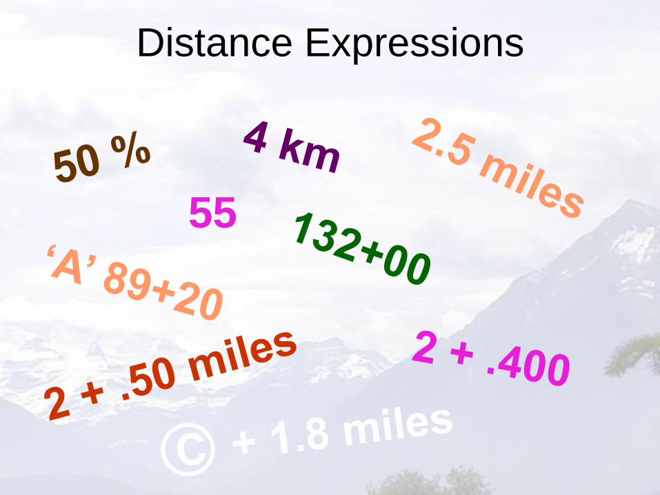
Linearly Referenced Locations
(MilePoint, Route: C-470, 2.5 )
(KilometerPoint, Route: C-470, 4 )
(Percentage, Link: Link 1034, 50 )
(Mile Post, Route: US-40, 2 + .50 )
(Reference Post, Route: I-95, 2 + .400 )
(County MilePoint, Route: I-95, ©+1.8 )
(Station, Alignment: Project 42, 132+00 )
(Address, Street: Smith Rd., 55 )
(HOW: LRM, WHAT: LinearElement, Measure)

Translations
• Between LRMs and/or Linear Elements
– single algorithm (linear interpolation)
– determinate, closed
– commutative, transitive
• Between Linear and Spatial (GIS)
– point
– lrPosition
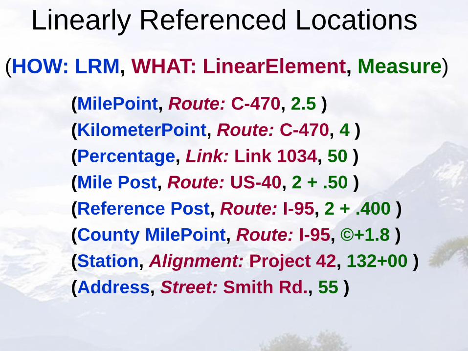
0% 100%
X
50%
0 mi. 5 mi.
X
2.5 mi.
1 2 3 4 5
2.5"
X
MP 1 MP 2 MP 3 MP 4 MP 5
X
2 + .5 mi.
link
anchor section
line
route
percentage
milepoint
m value
mile post

linear element
distance along
O
late
ral
offs
et
dis
tan
ce
start end
A
linear element
distance along
O
late
ral
refe
ren
t
offs
et
late
ral
offs
et
dis
tan
ce
start end
offset referent
A
RO
linear element
distance along
O
vect
or
offs
et
start endA
V
Offsets

Also in 19148
• Linearly Located Events
– Attribute vs. Feature
– At (Point) vs. From / To (Linear)
– Instant vs. Period
• Segmentation
• Linear SRS
Summary • NCHRP 20-27 was a seminal contribution to standardizing
linear referencing
• ISO IS 19148 is the new standard
• Based on Generalized Model
– sound theoretical basis
– widespread standards acceptance
• Can retain the “best” method for each database /
application and still be able to integrate data
• For additional information: