
Natural Resources Values Information System - Ontario Sum… · Natural Resources Values...
49
Land Information Ontario Data Class User Guide Natural Resources Values Information System (NRVIS) Data Class User Guide For Aquatic Resource Area Summary And Aquatic Resource Area Survey Version 1.0 Issued: June 2009
Transcript of Natural Resources Values Information System - Ontario Sum… · Natural Resources Values...
Land Information Ontario Data Class User Guide
Natural Resources Values Information System (NRVIS)
Data Class User Guide
For
Aquatic Resource Area Summary
And
Aquatic Resource Area Survey
Version 1.0 Issued: June 2009

Land Information Ontario Data Class User Guide
Disclaimer This technical documentation has been prepared by the Ministry of Natural Resources (the “Ministry”), representing Her Majesty the Queen in right of Ontario. No warranties or representations, express or implied, statutory or otherwise shall apply or are being made by the Ministry with respect to the documentation, its accuracy or its completeness. In no event will the Ministry be liable or responsible for any lost profits, loss of revenue or earnings, claims by third parties or for any economic, indirect, special, incidental, consequential or exemplary damage resulting from any errors, inaccuracies or omissions in this documentation; and in no event will the Ministry’s liability for any such errors, inaccuracies or omissions on any particular claim, proceeding or action, exceed the actual consideration paid by the claimant involved to the Ministry for the materials to which this instructional documentation relates. Save and except for the liability expressly provided for above, the Ministry shall have no obligation, duty or liability whatsoever in contract, tort or otherwise, including any liability or negligence. The limitations, exclusions and disclaimers expressed above shall apply irrespective of the nature of any cause of action, demand or action, including but not limited to breach of contract, negligence, strict liability, tort or any other legal theory, and shall survive any fundamental breach or breaches.
Additional Information For more information about this document, or if NRVIS technical assistance is required, please contact NRVIS Support at (705) 755‐1650 or [email protected].
This document was prepared by: Fisheries Section, Fish and Wildlife Branch, Natural Resources Management Division, Ontario Ministry of Natural Resources, Peterborough
Acknowledgments Christine Phair, Data Analyst, Land and Resources Cluster, Peterborough Tal Dunkley, Program Biologist, Fish & Wildlife Branch, Peterborough Helen Ball, Aquatic Ecologist, Fish & Wildlife Branch, Peterborough Kevin Collins, Information Management Biologist, Fish & Wildlife Branch, Peterborough Kevin Casselman, Senior Technical Analyst, Land and Resources Cluster, Peterborough Colin Brethour, Senior Team Leader, Land and Resources Cluster, Peterborough

Land Information Ontario Data Class User Guide
Table of Contents Preface .......................................................................................................................................................... 1 Background ................................................................................................................................................... 2 Description of the ARA Layers ...................................................................................................................... 2
ARA Summary ........................................................................................................................................... 2 ARA Survey Point ...................................................................................................................................... 3
Benefits of the New ARA Layers ................................................................................................................... 4 Data Load into the New ARA Layers ............................................................................................................. 6 ARA Summary Data Model ...........................................................................................................................8 ARA Survey Point Data Model....................................................................................................................... 9 When to Use ARA Summary and ARA Survey.............................................................................................11 Interpreting Field Data................................................................................................................................13 NRVIS Automation Guidelines ....................................................................................................................14
ARA Summary .........................................................................................................................................14 Creating a New ARA Summary Record ...................................................................................................15 ARA Survey Point ....................................................................................................................................17 Creating a New ARA Survey Point Record ..............................................................................................18 Importing Multiple Survey Records from External Source.....................................................................20 Data Sensitivity .......................................................................................................................................21 Data Maintenance ..................................................................................................................................22
Appendix 1. ARA Data Dictionary................................................................................................................24 Appendix 2. Known Conversion Errors .......................................................................................................46

Land Information Ontario Data Class User Guide
Introduction The Aquatic Resource Area (ARA) summary layer and ARA survey point layer are the Ministry’s authoritative source of generic fisheries spatial data in Ontario. ARA is stored and managed within the Natural Resource Values Information System (NRVIS) and contains general information on the physical, chemical and biological conditions of waterbodies that support the management of fish populations in Ontario’s lakes and streams.
Preface This guide was written to support the release of the redeveloped ARA layers and will provide the end‐user with information on the layers and guidelines for creating and editing ARAs. Feedback about this guide is welcomed by the NRVIS Support Line. The reader may also contact NRVIS Support with any questions about this guide or the ARA layer.
September 21, 2010 1

Land Information Ontario Data Class User Guide
Background The original Aquatic Resource Area (ARA) layer was a consolidation layer which utilized existing water feature boundaries to create agglomerations with similar fisheries values. The spatial extents of lakes and streams were defined as waterbody segments with attributes such as fish species, waterbody characteristics, thermal regime, and permanency attached through the ARA layer. This definition applied to the old ARA feature class since a user could split waterbody segments in order to create ARAs in the old ARA feature class. In October 2006, Fisheries Section staff coordinated a review of the ARA data model. Consultation with operational and science staff identified several issues with the efficiency and efficacy of the ARA layer. Fisheries Section, in partnership with Geographic Information Branch (GIB), subsequently undertook a formal review of fisheries business needs with an aim to re‐develop the ARA model to better meet current and future business requirements (Re‐Developing the Aquatic Resource Area Layer: A Business Perspective, June 2007). The re‐development of the ARA layer was an iterative process, with consultations from GIB, GIS staff, biologists and technicians occurring throughout the project. In December 2008, two new ARA layers were built to replace the original ARA layer, and will be implemented in the next version of NRVIS (scheduled for June 2009). The new ARA layers are now two feature classes: ARA Summary and ARA Survey Point.
Description of the ARA Layers An aquatic resource area is a description of the physical characteristics and fish species in a waterbody, pertaining either to the entire waterbody, a portion of the waterbody, or at a survey‐site. A body of water can have one ARA Summary record and may have zero to many ARA Survey Points that are summarized in the ARA Summary record.
ARA Summary The ARA Summary is a description of the physical characteristics and fish species present in an entire waterbody/stream/river (or large section of a stream/river system). The Summary layer contains tabular records only and does not have a spatial component. ARA Summary is connected to the water layers in NRVIS through the use of a related child table which stores a unique ID for the ARA record and a unique ID for the corresponding water segment. For lakes, it is the intention that one entire lake, pond or reservoir would have one ARA Summary record only. Where lakes/ponds/reservoirs are currently segmented into more than one polygon in the NRVIS water layers, a user would select all the polygons that make up the waterbody to create the one ARA Summary record for that lake/pond/reservoir. It is not the intention of the ARA Summary layer to store one Summary record for multiple lakes/ponds/reservoirs. For streams/rivers, it is the intention that a user would create an ARA Summary record for either the entire stream/river length (or system), or larger reaches that have similar characteristics. A user might decide to create multiple ARA Summary records for a given stream/river system based on the following:
change in fish species composition
September 21, 2010 2

Land Information Ontario Data Class User Guide
change in thermal regime
presence of a barrier to fish passage (hence a change in fish composition above and below the barrier)
differences in hydrologic regime
differences in management strategies
Figure 1. One record per entire lake and one summary record per entire stream length or larger reaches with similar characteristics in the ARA summary layer. Tabular data is joined to existing water geometry via the FMF Object ID.
ARA Survey Point The purpose of the ARA Survey Point Layer is to accommodate fisheries information collected from a site‐specific sampling event that is conducted on a waterbody. Each survey is represented by a single point which can correspond to one or many readings for a particular survey, and is representative of the partial or full body of water (lake or stream). An infinite number of surveys can be captured for a waterbody or stream/river segment. ARA Survey Point is a spatial data class that stores point features (geometry) which is not connected to the water layers in NRVIS, but is viewed with the underlying water layers and with the ARA Summary layer. The information in ARA Survey Point is used to create/update an ARA Summary record. Additionally, the ARA Survey Point layer is linked to the ARA Summary records through the use of the ARA Identifier attribute that is common between a Summary record and Survey points.
September 21, 2010 3

Land Information Ontario Data Class User Guide
Figure 2. ARA Survey Points represent an infinite number of site specific sampling events conducted on a waterbody or portion of a waterbody.
Benefits of the New ARA Layers The new ARA layers were designed to be more effective at storing and retrieving information than the original ARA Layer, consequently, there are many performance enhancements associated with the new layers. Creating and editing records in the new ARA Summary and Survey layers is quicker and easier than the old ARA layer. For ARA Summary, there is no geometry to load/edit when creating Aquatic Resource Areas (ARAs), users simply select waterbody segments from underlying NRVIS water layers that pertain to their summary record. For ARA Survey point geometry can be loaded relatively quickly. Additionally, most of the attributes in the new ARA layers are optional, which gives users the ability to create many ARAs quickly, and then add information to them at a later date if applicable, or create ARAs without being forced to populate fields that may not be relevant. Also, many of the layer attributes can now be populated with drop‐down menus (pick‐lists) to improve editing efficiency (Figure 3).
September 21, 2010 4

Land Information Ontario Data Class User Guide
Figure 3. Enhanced attribute editor with drop‐down menus (pick‐lists) and spatial pickers. Viewing and retrieving information from the new ARA layers has also been improved since the majority of the attributes are now stored directly in the main/parent table. Fish species information is related through a child table, although there is now a concatenated field in the parent table that lists all fish species found in the ARA. These changes allow users to quickly see the main features of a waterbody without having to navigate through tables. In addition to the benefits for creating, editing and viewing information in the new ARA layers, there is also an enhanced functionality for the business areas using these layers. The ARA Survey Point layer gives users the ability to enter site‐specific information, which is especially useful for stream/river surveys and work conducted on very large waterbodies. Since ARA Survey Point stores point geometry that is not directly linked to the NRVIS water layers, the spatial location of the point is not restricted to a waterbody and can be as accurate as the data permits (based on the scale of underlying data or the information used to collect the Figure 4. Survey points can be as accurate as the data permits.
September 21, 2010 5

Land Information Ontario Data Class User Guide
coordinates of the point). This is especially useful to Districts using water data at a finer resolution than what is provided in NRVIS, or for loading old survey information where the location is suspect (e.g. a point falling between two streams – Figure 4). Where ARA Survey has some freedom with spatial geometry and point locations, ARA Summary is restricted to using the existing NRVIS water layers to define the spatial extent of an ARA. This approach, however, does have some benefits: ARA Summary Layer will not become out‐dated if the geometry of the NRVIS water layers change. Since ARA Summary is tabular and is linked to the water layers through a database table which associates ARA records with water segment object identifiers, it does not store a copy of water geometry. The draw‐back to this approach is that the ARA Summary layer relies on the present segmentation of waterbodies in NRVIS. For the majority of smaller lakes, this should not be a problem as they are often represented by one water segment in NRVIS. For large waterbodies and streams, however, the segmentation in NRVIS may not accurately reflect the ARA extent that one wishes to define. For this reason, there is now an attribute in the ARA Summary Layer to indicate if a water feature has been split outside of NRVIS (Figure 5), which would tell the user to contact the District office to obtain the split geometry.
Figure 5. Split feature indicator attribute.
Data Load into the New ARA Layers Information in the existing ARA Polygon and ARA Line layers in NRVIS will be brought forward into the new ARA Summary layer. For the tabular information, this will be a straight conversion of the old ARA layer tables into the new ARA Summary tables. For the spatial features, to relate old ARA polygons and lines to the new ARA Summary layer, the old ARA spatial features will be used to select the identification numbers of the corresponding NRVIS water polygons and lines. These identification numbers will be stored in the ARA Summary Related Feature table (see Figure 6) so that each ARA FMF Object Identification number will be related to one or more Water Feature Identification number(s). Some problems might occur with the conversion of the spatial features between the old ARA layer and the new ARA Summary layer. Let us look at an example of where a conversion problem is likely to occur: suppose in the old ARA polygon layer a lake was split into two segments but in the NRVIS water layer this lake is represented as a single polygon. The problem is that there will be two old ARA polygons and
September 21, 2010 6

Land Information Ontario Data Class User Guide
associated records for what is now only represented by one polygon and can only contain one ARA Summary record. Through the conversion, one of the two old ARA polygons will first be used to select the corresponding water polygon in the NRVIS water layer. In the ARA Summary Related Feature table the water polygon Identification number will be stored along with the ARA FMF Object Identifier to link that water polygon with the new ARA Summary record. When the second of the two old ARA polygons is then converted, it will select the same NRVIS water polygon Identification number that now already has a new ARA Summary record. Since a water polygon can only have one ARA Summary record, the second attempt at creating a link between the water polygon and the ARA FMF Object Identifier in the ARA Summary Related Feature table will be invalid. However, the old ARA data that was associated with the two segments will still exist tabularly, although there will not be an association between the old records of one of the segments and the corresponding NRVIS water feature. The consequence of this conversion is that there will be a loss of a spatial connection between some old ARA segments and new ARA Summary records. Remember that all of the old ARA polygon and line tabular records will come forward into the new layer, however, only one ARA Summary record is permitted to be related to a water feature (the spatial linkage). Another conversion issue revolves around the field Species First Observation Date in the ARA Summary Species Table. In the old data model, this was a text field, whereas in the new model it is a date field, so anything not entered in a date format will not be converted. For example, if the old segmented layer had an attribute “1970s” in the field, this would not be a valid entry. NRVIS Support is working with Fisheries Section staff to identify all features where this is an issue. District staff will be contacted and asked to review records where data conversion has not taken place. District staff should review the data in the new ARA Summary layer to ensure that the conversion of old ARAs into the new layer has occurred accurately. This is a good opportunity to edit and up‐date ARAs where necessary. For most ARAs, this transition should occur without problems. Another problem might occur where old ARA attribute definitions have been up‐dated and old ARA data must be assigned to the new definition (for example, the Lake At Development Capacity Reason or Thermal Regime Reason definition). In most cases, efforts were taken to ensure that old attributes could be adopted into the new model, this means that existing data will be carried forward into the new model without any problems; however, District staff should still review their ARA data to verify that the transition has occurred correctly. Attributes that are new to the ARA Summary Layer will not be automatically populated; District staff must take the opportunity to populate these if applicable. For a listing of known conversion issues, please refer to Appendix 2. Fisheries Section staff have been involved in a project to amalgamate fisheries datasets and up‐load fish species information into the new ARA Summary layer. The Aquatic Habitat Inventory and Species Atlas datasets have been merged and any information that did not previously exist in the old ARA layer has been identified and needs to be up‐loaded into the new ARA Summary layer. Fisheries Section will consult with District staff across the province to review, update and batch load these species datasets into the new ARA layer. Since the ARA Survey Point Layer is new to NRVIS, presently, the layer is empty; however, there is currently a project in place to load Guelph and Aylmer District site‐specific fisheries information from the Aquatic Habitat Inventory (AHI) into the ARA Survey Point layer. This project will involve a batch up‐
September 21, 2010 7
Land Information Ontario Data Class User Guide
load of hundreds of AHI records into the ARA Survey Point layer and will be useful for providing other districts with strategies and recommendations for up‐loading their datasets into the ARA layer.
ARA Summary Data Model The ARA Summary layer is a Non‐Spatial Class that exists as a set of tables in NRVIS. These tables are linked to the spatial water layers in NRVIS through a related table that stores the ARA FMF Object Identifier and the Water Segment FMF Object Identifier. Through this relationship, one ARA can be related to one or many water segments. Figure 1 shows the logical model design view of the ARA Summary layer. The main information is located within the ARA Summary parent table. Fish species information is located in a child table (ARA Summary Species) that is related to the parent through a one‐to‐many relationship (this means that one ARA can contain many fish species). From the ARA Summary Species table there are relationships with child tables for fish stocking objectives, reproduction and management objectives. These are one‐to‐many relationships such that one fish species can have one or more stocking objectives, management objectives or reproductive status changes. These relationships are set up in order to track changes in objectives through time for a given fish species in a given ARA. All of the child tables in the ARA Summary layer are optional, therefore an ARA can have none, one or many fish species with none, one or many stocking objectives, management objectives or reproduction statuses. Additionally, there is a child table from ARA Summary, titled ARA Use which is a one‐to‐many relationship with ARA that describes the various resource uses for a waterbody. This table is also optional. Tables in the logical model that are titled “List” are look‐up tables that are used in NRVIS when populating the dataset. Look‐up tables include: Waterbody Type List (permissible values for Waterbody Type attribute), Master Fish List (the MNR Fish Species and Codes list), ARA Use List (permissible values for ARA Use), and Management Objective List (permissible values for Management Objective). These List tables enable quicker and easier data entry, and will not affect the performance of the model in NRVIS. In addition to using lists to populate attributes, the ARA Summary uses the Geographic Named Extent layer in NRVIS for the auto‐population of attributes such as: Official Waterbody Name, Corporate Waterbody Name, and Waterbody Location ID. This is an example of proper data management practices, since the Geographic Named Extent layer is the official, provincial repository for named features in Ontario.
September 21, 2010 8

Land Information Ontario Data Class User Guide
ARA SUMMARY
FMF Object Id ARA Identifier O Waterbody Type O Waterbody Type Combination Desc O Waterbody Location ID O Corporate Waterbody Name O Official Waterbody Name O Waterbody Alias Name1 O Waterbody Alias Name2 Fisheries Management Zone ID O Thermal Regime O Thermal Regime Reason O Fish Species Summary O Surface Area Hectares O Maximum Depth Meters O Mean Depth Meters O Secchi Depth Meters O Conductivity Mhos Per Sec O Morphoedaphic Index O At Development Capacity Ind O At Dev Capacity Reason O BSM Site Date Fixed O BSM Site Date Variable O Coldwater Rehabilitatn Potential O Comments O Split Feature Indicator
ARA SUMMARY SPECIES
ARA FMF Object Id Fish Species Common Name O Species First Observation Date O Actual Or Estimate Date Flg O Stock Origin O Stock Origin Comment Species Verification Status O Comments
Management Objective List
Management Objective
GEOG UNIT
STOCKING OBJECTIVE
ARA FMF Object Id Fish Species Common Name Stocking Objective Stocking Objective Year O Stocking Objective Comment
Master Fish List
Fish Species Common Name MNR Fish Code Fish Species Scientific Name Wild Life ID
REPRODUCTION
ARA FMF Object Id Fish Species Common Name Reproduction Status Reproduction Status Year O Reproduction Status Comment
MANAGEMENT OBJECTIVE
ARA FMF Object Id Fish Species Common Name Management Objective Management Objective Year O Management Objective Comment
ARA USE
ARA FMF Object Id Aquatic Resource Use Description
Waterbody Type List
Waterbody Type
ARA SUMMARY RELATEDFEATURE
ARA FMF Object Id Related Feature Object ID Concrete Class Short Name Spatial Verification Flag Date
WATER POLYGONSEGMENT
FMF Object Id
GUCOMPONENT
Aquatic Resource Area SummaryLogical Model - Design ViewJanuary, 2009 Not Physically Linked
Fishery Segment Use
Aquatic Resource Use Description
WATER LINE SEGMENT
FMF Object Id
Figure 6. Aquatic Resource Area Summary logical model.
ARA Survey Point Data Model The ARA Survey Point Layer is a spatial feature class in NRVIS. An ARA Survey is represented by one and only one point. A survey point can correspond to a survey conducted on an entire waterbody or stream/river, or to a survey conducted on a smaller geographic extent (e.g. a site within a water segment). The ARA Survey site point should be placed at the downstream end of the survey site in a stream. If a survey (e.g. Aquatic Habitat Inventory) applies to the entire lake, the survey site point should be placed at the visual centroid of the lake. Since the ARA Survey Point layer is a spatial class with point geometry, the layer is not connected to the water layers in NRVIS. Therefore, the user is not limited in defining the spatial extent of a survey point to a particular water segment. Figure 8 shows the ARA Survey Point Layer logical model. The model is similar to that of ARA Summary: the main information is placed in the ARA Survey parent table, with a one‐to‐many relationship with fish species in the ARA Survey Species child table. The other tables in the data model are look‐up tables for Fish Species (Master Fish List), fish species verification (Verifier Qualification List, Verification Source List) and for ARA Survey Method and Surveyor Agency (off the main ARA Survey Point Table). The ARA Survey Species table is optional therefore a Survey point may or may not have fish species associated with it (the ARA may have waterbody characteristic data derived through a sampling project that did not sample fish, or fish may not have been caught when the waterbody was sampled). The only mandatory attributes in the ARA Survey point layer are the ARA Identifier in the main (parent) ARA Survey table and the Fisheries Management Zone ID (Figure 7).
September 21, 2010 9

Land Information Ontario Data Class User Guide
September 21, 2010
Figure 7. Mandatory ARA identifier to link back to summary record. This attribute is used to link the ARA Survey Point to an ARA Summary record. ARA Survey Points must be associated with an ARA Summary record, therefore, when populating the ARA Identifier attribute in the ARA Survey Point layer, users will be presented with a pick‐list of available ARA Identifiers from the ARA Summary data class. If an ARA Identifier has not been assigned in ARA Summary, the user must first create an ARA Summary record for the waterbody of interest (complete with ARA Identifier populated) and then create an ARA Survey point and select the newly created ARA Identifier attribute from ARA Summary.
10

Land Information Ontario Data Class User Guide
ARA SURVEY POINT
FMF Object Id ARA Identifier O Waterbody Location ID O Corporate Waterbody Name O Official Waterbody Name O Waterbody Alias Name1 O Waterbody Alias Name2 Fisheries Management Zone ID O Survey Site Description O Survey Method O Survey Method Other Description O Survey Site Length Meters O Survey Date O Survey Time O Surveyor Agency O Surveyor Description O Air Temperature C O Water Temperature C O Fish Species Summary O Conductivity Mhos Per Sec O Secchi Depth Meters O Comments O FishNet Project Code O OSAP Site Code O OSAP Stream Code O Scientific Collector Licence Num O Scientific Collector Report Num
ARA SURVEY SPECIES
ARA FMF Object Id Fish Species Common Name O Species Verification Status O Species Verification Source O Species Source Other Desc O Species Verifier Qualifications O Species Verifier Other Desc O Comments
GEOG UNIT
ARA SurveyMethod
Survey Method
Master Fish List
Fish Species Common Name Fish Species Scientific Name MNR Fish Code Wild Life ID
Surveyor AgencyList
Surveyor Agency
Verifier Qualification List
Species Verifier Qualifications
Verification Source List
Species Verification Source
GUCOMPONENT
Populated By
Populating
Aquatic Resource Area Survey PointLogical Data Model - Design ViewJanuary, 2009
Figure 8. Aquatic Resource Area Survey Point Layer logical model.
When to Use ARA Summary and ARA Survey While there are now two ARA data classes in NRVIS, they are designed to be used cooperatively to help end users interpret field data. The ARA Survey Point Layer is a good place to start if a District has field surveys that have been conducted on portions of waterbodies (including streams/rivers). A new ARA Survey Point would be created for each individual site‐specific survey conducted. Even if a survey is conducted in the same location year‐after‐year, the user would create a new ARA Survey Point in that location for each year the survey was conducted. In this way, data can be interpreted for temporal changes in characteristics and/or fish species.
Business Rule: Create an ARA Survey Point for each survey conducted, even if a survey is repeated in the same location over time.
September 21, 2010 11

Land Information Ontario Data Class User Guide
ARA Survey Point data should be rolled up to contribute to an ARA Summary record. One ARA Summary record should be created for each entire waterbody (or very large section of waterbody) where data have been collected through the use of surveys or other means. The ARA Summary record will incorporate the data collected through the surveys (in ARA Survey Point Layer) and will be summarized such that it is applicable to the entire waterbody. This will require some interpretation of the data from field staff, since there may be instances where data collected through a site‐specific survey are not applicable to the larger waterbody (e.g. Secchi depth collected in the bay of a lake). Additionally, field staff will need to decide if any future site‐specific surveys conducted on the waterbody will contribute to the summarized information in ARA Summary (there may be times when site‐specific data collected does not pertain to the entire waterbody and in this case, it will not be included in the ARA Summary record for that waterbody. An example of this may be the collection of air and water temperatures which can be stored in the ARA Survey Point layer, but does not get stored in the ARA Summary; however these data can be used to determine a Thermal Regime which is recorded in the ARA Summary).
ARA Survey Point should be used for site‐specific surveys conducted on waterbodies (any number of survey points can be created for a waterbody).
An ARA Summary record should be created for each waterbody (where data exists) and is a record of a whole‐waterbody survey, or is a summary of site‐specific surveys from ARA Survey Point.
Business Rule: Make sure to up‐date ARA Summary records when ARA Survey points are created or edited (if applicable). For example, if a new fish species are captured in a survey event, the ARA summary should be updated to reflect the presence of these new species in a waterbody.
Sometimes, a survey is conducted that pertains to an entire waterbody (e.g. Aquatic Habitat Inventory, Broad‐scale Monitoring Program). If there are no site‐specific survey data for the waterbody, it is not necessary to create an ARA Survey Point, the user can simply create an ARA Summary record based on that survey.
There will be instances where a large lake may have reason to be segmented for management purposes (e.g. a multi‐basin lake where the basins have differing characteristics) but the lake is represented as only one waterbody polygon in NRVIS, and the question arises how to create one ARA Summary record for that entire waterbody. When creating an ARA Summary record, the user should keep in mind that the summary records pertain to an entire waterbody (not just a basin of a lake) and data should be entered in such a way that it is applicable to the entire waterbody. In the ARA Summary parent table there is a Comments attribute where the user can indicate that the lake has multi‐basins which are distinct. ARA Survey Points should be created for each basin and if necessary the user can indicate if there is Split Feature Geometry outside of NRVIS; for the purposes of management or analysis, the lake can be segmented locally (on a desktop computer) and analyzed using the ARA Survey Point data.
September 21, 2010 12

Land Information Ontario Data Class User Guide
Alternatively, there may be instances where a user would like to create an ARA Summary record for a waterbody that is segmented in NRVIS (for example, one lake which is segmented into two waterbody segments in NRVIS). In this case, the user should select all the waterbody segments that make up the waterbody of interest (excluding where necessary wetland features, or where features change from standing to flowing waters) and create one summary record for those features.
Interpreting Field Data Populating the ARA Survey Point data model is fairly straight‐forward since attributes are related to one and only one survey. However, ARA Summary records will often require staff to summarize information, leaving these attributes open to interpretation. For these reasons, the ARA Data Dictionary (see Appendix 1) was created to provide users with business rules around entering information into the layers. As good business practice, the ARA Data Dictionary should be reviewed prior to creating and editing ARAs. In addition to the Data Dictionary, some tips are presented below to help staff make decisions on summarizing survey data:
Some attributes in the ARA Survey data model are not found in the ARA Summary data model, this is because they are either not relevant to a summary record or they cannot easily be summarized into one record (e.g. survey method, air/water temperature, OSAP site code).
Each time a new survey is conducted on a waterbody, District staff should evaluate the data obtained and determine if it can contribute to an ARA Summary record for that waterbody. For example, if a new survey is conducted where a fish species is found that is not already listed in the ARA Summary record, this information should be added to Summary in addition to the ARA Survey Point for that survey.
In some cases, survey data will not necessarily add to the Summary information (e.g. Secchi depth reading conducted in a bay of a lake should not influence a Secchi depth reading taken in the middle of the lake conducted for the ARA Summary value – See ARA Data Dictionary for business rules around these data attributes).
Some survey data can be averaged or analyzed together to produce a Summary value (for example, Air and Water Temperature data could be rolled up to populate Summary Thermal Regime).
ARA Summary Species should always be up‐dated to reflect all the fish species present in a waterbody. Therefore, if a survey samples a new fish species, not yet found in the waterbody, the species should be added to the ARA Summary Species table (in addition to the ARA Survey Species table). Alternatively, if a survey conducted on the same waterbody does not sample all the fish species present, the missing species should not be deleted from the ARA Summary Species table.
September 21, 2010 13

Land Information Ontario Data Class User Guide
ARA Survey Species table is a listing of all fish species found at the survey site for a given survey. It may or may not contain all of the species found in the ARA Summary Species table for that waterbody.
ARA Summary Species table is a complete listing of all fish species found in the waterbody.
Business Rule:
NRVIS Automation Guidelines ARA Summary Since ARA Summary is not a spatial layer, summaries are created or edited through the use of tables, although in NRVIS the water layers will be viewed with the ARA layers in order to provide a spatial reference. ARA Summary does not contain its own geometry so NRVIS users cannot perform batch up‐loads of records using the Import Geometry tool in NRVIS. To create an ARA Summary, NRVIS users will be presented with a tool that allows them to select a waterbody (one or many water segments) and then create an ARA Summary for those selected features. Many of the attributes can be populated with drop‐down menus and pick‐lists, making data automation much easier/quicker. Once an ARA Summary record is created, it can be checked‐in to NRVIS and posted. An important aspect of creating an ARA Summary record is populating the ARA Identifier attribute. This mandatory attribute is used to uniquely identify an aquatic resource area and therefore a record cannot be checked in to NRVIS without assigning an ARA Identifier. More importantly, it is the link between the ARA Survey Point layer and ARA Summary. How will this work? When an ARA Survey point is created a pick‐list of all ARA Identifiers from the ARA Summary list will be provided. In order to create a new ARA Survey Point, users will have to select an ARA Identifier from this pick‐list. This establishes a connection between ARA Survey Points and an ARA Summary record. To illustrate this point, Figure 9 shows a hypothetical example of how this could be applied.
September 21, 2010 14

Land Information Ontario Data Class User Guide
Figure 9. Hypothetical example of a stream segment with an ARA Summary record and ARA Survey records that have corresponding ARA Identifiers. If an ARA Summary record does not already exist for the waterbody of interest, users will have to first create an ARA Summary record and populate the ARA Identifier attribute (even if no other summary data exists). Then users can create the ARA Survey points using that ARA Identifier from the available pick‐list. This practice ensures that there is continuity between ARA Summary and ARA Survey Point layer. If users were able to assign new ARA Identifiers to Survey Points that did not correspond to a Summary record, it would be difficult to interpret data in the ARA Summary record and vice versa.
Creating a New ARA Summary Record
1. To access and edit ARA Summary records, the ARA Survey Point must be selected as the edit layer. Editing of the ARA Summary records will not be available if any other layer is the edit layer.
2. Select underlying water
polygon segment, water line segment, or larger river sections or systems and open the Non‐Spatial Editor from the NRVIS Editor Toolbar.
Figure 10. Select ARA summary data is edited via the non‐spatial editor tool.
September 21, 2010 15

Land Information Ontario Data Class User Guide
3. Using the Non‐Spatial Table Picker dialog, select the ARA Summary table from the list of available editable tables, and select to Create New Records. Click OK. Note that this dialog is also used to edit or view existing ARA Summary records.
Figure 11. Non‐Spatial Table Picker. 4. Within the NRVIS Attribute Editor, right click on
the ARA Summary from the list and select Add New.
Figure 12. Adding a new FMF Object ID.
5. Highlight the newly created FMF Object ID under ARA Summary to show the available attributes. Fields in red are mandatory and there are several pick‐lists and spatial pickers to increase editing efficiency. The ARA identifier format is as follows: CC‐NNNN‐CCC (District – 2 characters, 4 numbers, Township, Lake, or Stream Name – 3 characters).
Figure 13. NRVIS Attribute Editor for ARA Summary records.
September 21, 2010 16

Land Information Ontario Data Class User Guide
6. When the entered attributes are complete, the exclamation mark will disappear from beside the FMF Object ID on the left, indicating a valid entry. Now, users will have to assign the ARA Summary record to a single waterbody, river/stream, or grouping of segments. Right click on Related Feature List and click Add Selected to relate the selected segments in the water polygon or water line layer to the ARA Summary record. This will add a record to the ARA Summary Related Figure 14. Relating selected water features. Features table.
7. Close the NRVIS Attribute Editor dialog.
ARA Survey Point ARA Survey Point layer is a spatial layer that stores point shape geometry, therefore users can either create a new ARA Survey Point individually or they can use the NRVIS Import Geometry Tool to perform a batch up‐load of existing point geometry. For batch up‐loads using the NRVIS Import Geometry tool, users can first create their own point shapefile of survey points, complete with an attribute table that is similar to the ARA Survey Point data model (see Figure 8; attribute data types must be similar but heading names can be different). Using the tool, many points can be loaded into NRVIS at once and the attribute table of the shapefile mapped to the ARA Survey Point parent table. This is particularly useful if District staff up‐date the layer periodically after many surveys have been conducted. Users can decide if they want to geo‐reference the survey points before or after loading them into NRVIS; both are acceptable, although the user should take caution in loading points into the ARA Survey Point layer and not geo‐referencing them to precise locations, since other users will assume the point location is representative of actual survey locations. This problem pertains more to older survey datasets that have imprecise coordinate/location information that are being loaded into the ARA Survey Point layer. To create a new Survey Point individually, the user can select any spatial location to place the point (in NRVIS the water layers will be viewed on screen for spatial reference). The point should be located in the most precise location possible to represent the location where the survey was conducted. This can be done using coordinates taken from field GPS collection or from geo‐referencing work done after the survey was conducted (e.g. using orthophotos or other high resolution imagery). Since ARA Survey stores point geometry, the points are not connected to the NRVIS water layers in any way. This gives users the freedom to locate survey points precisely where the survey was conducted, which is especially useful if a survey was conducted on a small stream/drain that is not represented by the NRVIS water layers but can be seen on higher‐resolution imagery. This is an important feature of the ARA Survey layer since those viewing the data will assume that the point location is representative of the location where a survey has been conducted. For surveys conducted on streams, the user should place the point in the centre of the survey site and indicate the site‐length in the attribute table (Survey Site Length Meters). For surveys conducted on lakes or in portions of lakes, the survey point can be placed in the centre of the site, or to indicate the start/end of a net set.
September 21, 2010 17

Land Information Ontario Data Class User Guide
Business Rule: ARA Survey Points should be located in the most precise spatial location possible to indicate where a survey was conducted. The point does not have to overlap a NRVIS water feature.
Creating a New ARA Survey Point Record
1. Using either the Sketch Tool or Create point from coordinates located on the NRVIS Editor Toolbar, position the location of the survey site. Note that the point should be located in the most precise location possible to represent the location where the survey was conducted.
Figure 15. Drawing the location of a new ARA Survey Point.
2. With the newly created survey point added to the map, ensure that it is selected and open the
NRVIS Attribute Editor dialog using the button on the NRVIS Editor Toolbar.
Figure 16. With the point selected, open the NRVIS Attribute Editor.
September 21, 2010 18
Land Information Ontario Data Class User Guide
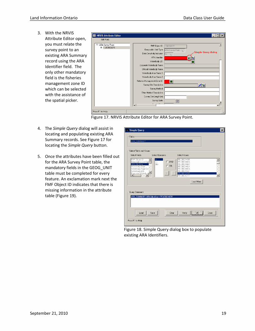
3. With the NRVIS Attribute Editor open, you must relate the survey point to an existing ARA Summary record using the ARA Identifier field. The only other mandatory field is the fisheries management zone ID which can be selected with the assistance of the spatial picker.
Figure 17. NRVIS Attribute Editor for ARA Survey Point.
4. The Simple Query dialog will assist in locating and populating existing ARA Summary records. See Figure 17 for locating the Simple Query button.
5. Once the attributes have been filled out
for the ARA Survey Point table, the mandatory fields in the GEOG_UNIT table must be completed for every feature. An exclamation mark next the FMF Object ID indicates that there is missing information in the attribute table (Figure 19).
Figure 18. Simple Query dialog box to populate existing ARA Identifiers.
September 21, 2010 19

Land Information Ontario Data Class User Guide
6. To edit attributes for multiple features simultaneously, select Multiple Edit from the Edit Mode menu of the attribute editor dialog. Note that multiple features must be selected to enter Multiple Edit mode. Highlight the table name on the left side and make the edits as necessary, then click Save from the top. The changes will be Figure 19. GEOG_UNIT table attribute editing. applied to all the selected records. (Figure 20).
7. Close NRVIS Attribute
Editor dialog when complete.
Figure 20. Multiple edit mode to edit many features at once. Importing Multiple Survey Records from External Source
1. Add point geometry with similar fields to the data frame. This dataset can contain multiple points from an external database.
2. On the NRVIS Editor Toolbar, select Import
Shapefile. Note that this tool will use the selected set. If nothing is selected, the default is all features.
Figure 21. Import Shapefile tool. 3. Using the Import Data Field Mapper,
(Figure 22), select fields in the source layer to correspond with the fields in the ARA Survey Point edit layer. Click Import Data.
September 21, 2010 20

Land Information Ontario Data Class User Guide
4. Once the points are inputted
into the ARA Survey Point layer, you may need to go back and modify attributes in either multiple or single edit mode. Note: ensure that each survey point corresponds to an existing ARA Summary record.
5. Note that when multiple
survey records are entered, the GEOG_UNIT table will require updating for each feature. The Multiple Edit tool can be used to calculate values Figure 22. Import Data Field Mapper. for multiple records simultaneously, as mentioned in the previous section.
Data Sensitivity The NRVIS application gives users the ability to label data as sensitive. By labelling data as sensitive, users are able to control access to, and the representation of data. For ARA Survey Point, fish species present will be the only indicator of sensitivity for that data class. Features may be have a sensitivity class of either ‘Non‐Sensitive’ or ‘Low’. A feature may be labelled sensitive if it contains any of the following fish species: American Brook Lamprey
American Shad Aurora Trout Black Redhorse Blackstripe Topminnow Bridle Shiner Brindled Madtom Channel Darter Chestnut Lamprey Cutlip Minnow Eastern Sand Darter Eastern Silvery Minnow
Ghost Shiner Goldeye Grass Pickerel Greater Redhorse Kiyi Lake Chubsucker Lake Sturgeon Longear Sunfish Northern Brook Lamprey Northern Madtom Pugnose Minnow Pugnose Shiner
Redside Dace River Darter River Redhorse Shortjaw Cisco Shortnose Cisco
Silver Chub Silver Lamprey Silver Shiner Spotted Gar Spotted Sucker Warmouth
September 21, 2010 21

Land Information Ontario Data Class User Guide
Data sensitivity can only be set for the ARA Survey Point layer. The sensitivity class settings are set on the GEOG_UNIT table. There a five fields that correspond with data sensitivity. (1) Data Sensitivity Indicator is automatically populated based on the sensitivity class field and is carried from the GEOG_UNIT table to the ARA_SURVEY_POINT table. (2) Sensitivity Class is the ranking of the sensitivity of the information embodied in the feature. ‘Low’ sensitivity is information generally available to employees and approved agents of the Crown. It refers to sensitive features with a data type not normally sensitive such as specific instances of fish species. ‘Non‐Sensitive’ class data and information, if disclosed, will not result in any injury to individuals, government or private sector institutions. (3) Sensitivity Date is the date that the sensitivity classification was established. (4) Sensitivity Rationale is the primary reason for the information sensitivity classification. The available options are ‘No restriction needed’ for non‐sensitive data; ‘Data provider agreement’, ‘Protect single feature’, ‘Legislative or legal requirement’, and ‘Other’. (5) Other Rationale Description is the reason(s) for the information classification when ‘Other’ is selected as the rationale. When the sensitivity class is set to ‘Low’, all 5 sensitivity related fields are mandatory. If the class is set to ‘Non‐Sensitive’, then only the class Figure 23. Data sensitivity options under GEOG_UNIT. and date are mandatory.
Setting Data Sensitivity on the GEOG_UNIT Data sensitivity can only be set for the ARA Survey Point feature class. With the attribute editor open, expand the tables to the GEOG_UNIT table under ARA Survey Point (Figure 23) and fill out the mandatory fields highlighted in red. These fields can be completed in single edit or multiple edit mode.
Data Maintenance The strength of the new ARA Summary and Survey Point datasets comes from the ability to keep these layers up‐dated. This is exceptionally important, since layers that are not kept up‐to‐date are often not used and staff find alternative means to store their fisheries information outside of NRVIS. If fisheries data are stored outside of NRVIS, the data are not available to staff throughout the province, ministry and our business partners. Therefore, it is important that staff take the time to up‐date the ARA layers on a regular basis. Depending on District staff workload, NRVIS users may choose to up‐load information into the ARA layers as data become available, or on a regular basis like monthly or quarterly. In the past, this
September 21, 2010 22

Land Information Ontario Data Class User Guide
workload typically fell on the District Geographic Information Officer (GSO), however, it is the hope that with the improvements to the ARA layers, technicians and biologists will be able to use the layer and enter their own data directly. This will reduce the workload on the GSOs and enable other staff to utilize the layer for data entry, viewing and reporting. This may simply require NRVIS training for any new users, or may also include GIS training from Regional GSOs (contact your regional GIS Officer for inquiries into training opportunities). Please refer to the document Best Practices for GIS Data Maintenance for more information on custodian, stewardship, and GIS staff roles and responsibilities.
September 21, 2010 23

Land Information Ontario Data Class User Guide
Appendix 1. ARA Data Dictionary FMF Object Id Description: NRVIS generated unique identifier. Format: Integer (long) 13 Mandatory ARA Identifier Description: A unique identifier for an aquatic resource area, composed of a user‐defined combination of letters and numbers. The letters can represent the name of a waterbody, township, county, location or some other identifier which will help users identify waterbody segments that belong to one aquatic resource area (e.g. PE‐0002‐RAD). It is suggested that district staff create ARA Identifiers in a manner similar to the way they were created in the original ARA layer. Format: Character (variable length string) 11 Mandatory Waterbody Type Description: The type of waterbody. Possible entries include: Lake or Pond, Stream or River, Drain, Wetland or Combination. Format: Character (variable length string) 30 Optional Valid Values found in WATERBODY_TYPE_LIST table Waterbody Type Combination Desc Description: More information about the combination waterbody type, if the "Combination" option is chosen for the "Waterbody Type" attribute in the ARA Summary Table. Format: Character (variable length string) 200 Optional
September 21, 2010 24

Land Information Ontario Data Class User Guide
Waterbody Location ID Optional Description: A location code that uniquely identifies a waterbody, based on the visual centroid of the waterbody or the mouth of a river as represented in the Corporate Waterbody Table. The Waterbody LID is a manually derived identifier based on the UTM coordinates (datum NAD27). The format is derived from the UTM zone (2 digits), UTM Easting ‐ rounded to first four digits and the UTM Northing ‐ rounded to the first five digits. The final digit of the easting and northing portions may be adjusted to maintain uniqueness. The Waterbody LID should not be confused with actual location information. This attribute is required for linking ARA data to other external databases (ex. FISHNETv3 and Fish Stocking Information System (FSIS)). Maintained by the Fisheries Information Specialist in the Inventory Monitoring and Assessment Section, MNR Format: Character (variable length string) 13 Optional Valid Values found in CORPORATE_WATERBODY_LIST table. Corporate Waterbody Name Description: Corporate Waterbody Table name for a waterbody. This name may either be the same as the official name or local name(s) as assigned by MNR District staff. This name along with the Waterbody LID uniquely identifies a waterbody in Ontario for MNR Fisheries applications. Common descriptors (e.g. Lake, River, Creek, etc) are abbreviated and always placed at the end of the name. If the official name begins with a descriptor, the descriptor is still placed at the end but with a comma after the root name (ie. Lake Ontario is written as Ontario, L.). The custodian for this field lies with Inventory, Monitoring and Assessment Section (SIB). Format: Character (variable length string) 100 Optional Valid Values found in CORPORATE_WATERBODY_LIST table. Official Waterbody Name Description: The official name for the waterbody if it exists which is the name formally laid down, sanctioned, or imposed by a governing body. Derived from the Geographic Extents Layer in NRVIS. If an official name does not exist or has been rescinded, this field would not be populated. Provincial Georeferencing Unit is the custodian of the Geographic Extents layer in NRVIS. Format: Character (variable length string) 100 Optional
September 21, 2010 25

Land Information Ontario Data Class User Guide
Waterbody Alias Name1 Description: First alternate name for a waterbody or river/stream (e.g. local name, name of main river, name of tributary). Helpful for identifying aquatic resource areas that may not have Official names, or if waterbodies are officially known as "Not Listed". Also useful for identifying stream segments that belong to a larger stream/river system. Format: Character (variable length string) 100 Optional Waterbody Alias Name2 Description: Second alternate name for a waterbody or river/stream (e.g. local name, name of main river, name of tributary). Helpful for identifying aquatic resource areas that may not have Official names, or if waterbodies are officially known as "Not Listed". Also useful for identifying stream segments that belong to a larger stream/river system. Format: Character (variable length string) 100 Optional Fisheries Management Zone ID Description: A number that identifies a Fish Management Zone. A zone can consist of one area or multiple geographically separated areas. Useful for identifying aquatic resource areas in Fisheries Management Zones. Generated automatically from the Fisheries Management Zone layer into the ARA layer. Format: Numeric 2 Mandatory Thermal Regime Description: Thermal regime describes the typical summer water temperature of a waterbody. Waterbodies may be classified as cold, cool or warm. Thermal regime is determined using measures of water temperature and/or inferred from knowledge of the existing fish or invertebrate community present. Where thermal regime classification indicators overlap, the local District biologist will have to use their professional judgment. Typically, the most thermally sensitive regime will apply. For example, in a deep oligotrophic lake where the fish community composition is lake whitefish, walleye and northern pike, the thermal regime would be classified as cold water. However, for a shallow mesotrophic or eutrophic lake where stream resident brook trout may be found in the lake near stream mouths in certain seasons of the year, the lake should be classified as either cool water or warm water dependent on summer water temperature and/or resident fish community. An aquatic resource area is classified as ‘unknown’ if there is no temperature information or data is not sufficient to classify as either cold, cool, or warm.
September 21, 2010 26

Land Information Ontario Data Class User Guide
Lentic (lakes, reservoirs, ponds, etc.) thermal regime can be classified based on fish community (adapted from Ryder and Edwards 1985): ∙ Coldwater ‐ an assemblage of fishes in north‐temperate oligotrophic lakes, dominated by taxon swarms of salmonines and coregonines. Lake trout, brook trout and lake whitefish are species typically found in cold water lakes. ∙ Coolwater ‐ an assemblage of fishes‐of north‐temperate mesotrophic lakes dominated by percids and esocids. Walleye and northern pike are species typically found in cool water communities. ∙ Warmwater ‐ an assemblage of fishes in north‐temperate eutrophic lakes dominated by centrarchids (largemouth bass), cyprinids (carp) and ictalurids (bullheads) Lotic (rivers, streams, creeks, etc.) thermal regime can be classified based on water temperature, fish community or invertebrate community: 1. Mean summer surface water temperature (Coker et al. 2001): ∙ Coldwater ‐ <19 ºC ∙ Coolwater ‐ 19 ºC ‐25 ºC ∙ Warmwater ‐ > 25 ºC 2. Fish community (adapted from Coker et al. 2001): ∙ Cold water ‐ an assemblage of fishes characterized by the presence of salmon, trout and sculpin species. Slimy sculpin, brook trout and American brook lamprey are the best indicator species of a cold water environment. ∙ Coolwater ‐ an assemblage of fishes often characterized by percids (e.g. walleye, Iowa darter), esocids (northern pike). ∙ Warmwater ‐ an assemblage of fishes often characterized by largemouth bass, bluegill, carp, bullheads, or bowfin 3. Invertebrate community (adapted from Kilgour & Barton 1999): ∙ Characteristic cold water benthic invertebrates include mayflies (Ephemeroptera ‐ eg. Siphlonuridae), stoneflies (Plecoptera ‐ eg. Leuctridae, Perlidae) and caddisflies (Trichoptera – eg. Psychomyidae, Phryganaeidae). ∙ Warm water communities are typically dominated by snails (eg. Planorbidae, Valvatidae), glossiphoniids (leeches) and planariids (flatworms) Format: Character (variable length string) 10 Optional Permissible Values: 'Cold','Cool','Warm','Unknown'
September 21, 2010 27

Land Information Ontario Data Class User Guide
Thermal Regime Reason Description: The rationale for the ARA Thermal Regime. It may be determined by: water temperature, invertebrate species present, fish species present, interpolation or a combination of factors. Format: Character (variable length string) 30 Optional Permissible Values: 'Water Temperature', 'Invertebrate Species Present', 'Fish Species Present', 'Interpolation', 'Combination' Fish Species Summary A concatenation of all fish species common names found in the aquatic resource area, derived through the ARA Survey or Summary Species tables. This attribute would be queried to select aquatic resource areas by species. The ARA Survey or Summary Species tables could then be used for further information pertaining to each species. An example of how information in this field may look is: "American brook lamprey, American shad, Aurora trout, Brown trout, Lake sturgeon, Longnose gar, Rainbow trout" Format: Character (variable length string) 2000 Optional Surface Area Hectares Description: A measure of the bounded region of the surface of a lake, excluding islands of a lake/reservoir or pond. Measure may be defined from an existing survey or derived using GIS. Measured in hectares. Format: Numeric 12 4 Optional Maximum Depth Meters Description: An observed value that identifies the maximum vertical distance between the lake surface at a period of high‐water and the lake bed. The maximum depth is recorded only for lake environments. Measured in units of meters.
September 21, 2010 28

Land Information Ontario Data Class User Guide
Format: Numeric 6 2 Optional Mean Depth Meters Description: The average vertical distance between the lake surface and the lake bed. It is calculated by dividing the volume of the lake by the area of the lake. Recorded only for lake environments. Measured in units of meters. Format: Numeric 6 2 Optional Secchi Depth Meters Description: The mean depth at which a weighted 20 cm disk with alternate black and white quadrants disappears from view when lowered into the water of a lake on the shaded side of a boat and the depth where it reappears when being raised, measured in meters (m). This information is recorded for lakes only. Format: Numeric 5 1 Optional Conductivity Mhos Per Sec Description: Conductivity is the ability of an aqueous solution to carry an electric current. The value entered should be the most recent point in time single reading, or if more than one sample a mean of all samples collected 2 m below the surface. If more than one sample has been taken within a segment, the mean should be calculated based on samples taken at approximately the same time (i.e. calculate the mean conductivity readings taken at approximately the same time from three basins of a lake) during one year. Measured in units of mhos/sec at 25 C. Format: Numeric 6 1 Optional Morphoedaphic Index Description: Measurement of the trophic state of a lake based on the square root of the ratio of total dissolved solids (or conductivity) and mean depth. Morphoedaphic Index is also used to estimate fish production. This information should be recorded for lakes only. This information is used to calculate potential yield. The index can be used to estimate relative yield to provide a good first order indicator of over‐exploitation.
September 21, 2010 29

Land Information Ontario Data Class User Guide
Format: Decimal 10 2 Optional At Development Capacity Ind Description: Lakes or basins of lakes that cannot support any more shoreline development based on either the MOEE Provincial Water Quality Objectives (PWQO) for phosphorous, the OMNR dissolved oxygen criterion for the protection of lake trout habitat, or other criteria (e.g. shoreline capability, recreational boating, etc.) set by the local planning authority. A lake (or basin of a lake) is at capacity if: ‐ It is a designated lake trout lake where the current measured Mean Volume Weighted Hypolimnetic Dissolved Oxygen (MVWHDO) level is below the OMNR criterion of 7mg/L; ‐ Modeling/analysis indicates that any additional proposed development will degrade the water quality of the lake below the OMNR criterion of 7mg/L; ‐ Phosphorous levels are above the MOEE PWQO; ‐ The planning authority has designated the lake at capacity for planning purposes. Rationale: Useful for identifying lakes which are at Development Capacity. For lakes at development capacity, OMNR needs to ensure that all crown land dispositions, and any development applications received for these waterbodies will not result in the degradation of water quality. Format: Character (variable length string) 3 Optional Permissible Values: 'Yes', 'No' At Dev Capacity Reason Description: The reason a lakes or basins of lakes is declared at development capacity from the following options: A lake (or basin of a lake) is defined as being at capacity using the following measures: "MVWHDO less than 7mg per L" It is a designated lake trout lake where the current measured Mean Volume Weighted Hypolimnetic Dissolved Oxygen (MVWHDO) level is below the MNR criterion of 7mg per L; "MVWHDO Low" Estimate derived by modeling or analysis which indicates that any additional proposed development will degrade the water quality of the lake below the MNR criterion of 7mg per L; "Phosphorous High"
September 21, 2010 30

Land Information Ontario Data Class User Guide
Phosphorous levels are above the MOE Provincial Water Quality Objectives. "Planning" The planning authority has designated the lake at capacity for planning purposes. Format: Character (variable length string) 30 Optional Permissible Values : 'MVWHDO Less Than 7mg per L', 'MVWHDO Low', 'Phosphorous High', 'Planning' BSM Site Date Fixed Description: Concatenated list of the year(s) this lake was monitored as a "fixed lake" sample for Broad Scale Monitoring (BSM). A "fixed lake" sample is a predetermined set of lakes that will be re‐surveyed in each 5‐year cycle. A "fixed lake" must be larger than 20 ha and contain a naturally sustaining population of one of the following recreational fish species: walleye, lake trout, or brook trout. Format: Character (variable length string) 50 Optional BSM Site Date Variable Description: Concatenated list of the year(s) this lake was monitored as a "variable lake" sample for Broad Scale Monitoring (BSM). A "variable lake" sample is a list of lakes, in addition to the fixed lake sample, that will be sampled in one 5‐year cycle. The sample is re‐selected (with replacement) in each 5‐year cycle. Its purpose is to supply data that can be used to describe the current condition of lakes within a Fisheries Management Zone. The candidate population of lakes is all lakes larger than 20 ha regardless of species composition. Format: Character (variable length string) 50 Optional Coldwater Rehabilitatn Potential Indication of whether an aquatic resource area has a reasonable potential of being rehabilitated to a coldwater system. Segments which historically contained coldwater fish species, but due to a
September 21, 2010 31

Land Information Ontario Data Class User Guide
deterioration in habitat quality, the stream temperature has increased and the stream no longer contains coldwater species. Format: Character (variable length string) 3 Optional Permissible Values: 'Yes', 'No' Comments Description: Unstructured description, additional notes, or further explanation. Format: Character (variable length string) 2000 Optional Split Feature Indicator Description: Indicates whether a feature has additional, more detailed, geometry associated with it that is not stored or edited in NRVIS, but within individual MNR Districts. Users interested in a feature indicated to have more detailed geometry should contact the GSO of the district they are working with. This attribute was created for instances when the geometry of a large lake or river needs to be split to accurately represent aquatic values. Ex. when a lake has more then one basin and each basin has a different thermal regime. Format: Character (variable length string) 3 Optional Permissible Values: 'Yes', 'No' Related Feature Object ID Description: The unique identifier linking the ARA Summary information to the features that represent them spatially (ex. Water segment or in the future, Wetland) Format: (default) Mandatory
September 21, 2010 32

Land Information Ontario Data Class User Guide
Concrete Class Short Name Description: Static short name used to uniquely identify a Concrete Class. Format: Character (variable length string) 12 Mandatory Spatial Verification Flag Description: An indication as to whether the spatial information associated with an ARA has been verified as accurate. When a water feature that is associated with an ARA is updated to the point that its FMF object id is changed, the link between ARA and Water will be lost. The spatial information will automatically be rejoined to a feature in the closest proximity to the previous feature and this field for that newly assigned feature will be set to "unverified". Format: Character (variable length string) 15 Mandatory Permissible Values: 'Verified', 'Unverified' Date Format: Date Mandatory Fish Species Common Name Description: The common name of a fish species according to the MNR Master Fish Species Code Numbers and Names List. Format: Character (variable length string) 75 Mandatory Valid Values found in MASTER_FISH_LIST table. Species First Observation Date Description: The date when a species was first observed, entered as yyyy/mm/dd. (ex. 2007/05/31)
September 21, 2010 33
Land Information Ontario Data Class User Guide
Format: Date Optional Actual Or Estimate Date Flg Description: Indicator of whether the date in the Species First Observation Date Field is the actual observation date or estimated observation date. Options include: "Actual" or "Estimated". Format: Character (variable length string) 10 Optional Permissible Values: 'Actual', 'Estimated" Conditional Mandatory: If SPECIES_FIRST_OBSERVATION_DATE is populated then this field needs to be populated. Stock Origin The origin of a fish population in a lake defined as native, introduced or unknown. This attribute is useful for setting fisheries management objectives and making management decisions. Format: Character (variable length string) 10 Optional Permissible Values: 'Native', 'Introduced', 'Unknown Stock Origin Comment Description: Additional comments about the stock origin of a given species. Format: Character (variable length string) 100 Optional Species Verification Status Description: An indication as to whether a qualified individual has verified the existence of the species. Format: Character (variable length string) 10 Mandatory Permissible Values: 'Verified', 'Unverified'
September 21, 2010 34
Land Information Ontario Data Class User Guide
Aquatic Resource Use Description Description: Uses of the aquatic resource area. Format: Character (variable length string) 35 Mandatory Valid values in NRVIS_FISHERY_SEGMENT_USE table. Management Objective Description: The fisheries management objective defines how a species is managed in a lake. This provides a designation for how MNR is managing a species in a waterbody. This field should be viewed along with reproduction status (in the Reproduction table) and stocking objective (in the Stocking Objective table). N1 Native population, self sustaining N2 Native population augmented with stocking N3 Native population, put‐grow –take fishery N4 Native population, ongoing rehabilitation N5 Native population, deferred restoration N6 Native population remnant or extinct, alternate species management I1 Introduced population, self sustaining I2 Introduced population, augmented with stocking I3 Introduced population, put‐grow‐take fishery I4 Introduced population, ongoing rehabilitation I5 Introduced population, deferred restoration I6 Introduced population remnant or extinct, alternate species management I7 Introduced population, current management objective undefined U1 Unknown population, current management objective undefined Format: Character (variable length string) 75 Mandatory Valid Values in MANAGEMENT_OBJECTIVE_LIST table. Management Objective Year Description: Indicates year that the present fisheries management objective of the waterbody was established.
September 21, 2010 35

Land Information Ontario Data Class User Guide
Format: Numeric 4 Mandatory Management Objective Comment Description: General comment about the management objective of a fish population. Format: Character (variable length string) 250 Optional Entity : Management Objective List Description : Look up table for information on fisheries management objectives. MNR Fish Code Description: The code number of a fish species according to the OMNR Master Fish Species Code Numbers and Names List. Format: Numeric 4 Mandatory Valid Values found in ARA_MASTER_FISH_SPECIES table. Fish Species Scientific Name Description: The scientific name of a fish species according to the MNR Master Fish Species Code Numbers and Names List. Format: Character (variable length string) 75 Mandatory
September 21, 2010 36

Land Information Ontario Data Class User Guide
Valid Values found in ARA_MASTER_FISH_SPECIES table. Wild Life ID Description: A value that uniquely identifies a taxonomic item or wild life category according to a recognized standard. Format: Integer 13 Mandatory Reproduction Status Description: The reproductive status of a fish population in a lake defined by self‐sustaining, partly self‐sustaining, minimal, no Reproduction ‐ Remnant/Extinct or Unknown. This attribute useful for identifying the status of a fish population in a lake and for tracking changes in population distribution. Format: Character (variable length string) 40 Mandatory Permissible Values: 'Self‐sustaining', 'Partly self‐sustaining', 'Minimal', 'No Reproduction ‐ Remnant or Extinct', 'Unknown' Reproduction Status Year Description: The first year the reproduction status of a species in a waterbody applies. Where populations have always been self sustaining users should enter "0000". Format: Numeric 4 Mandatory Reproduction Status Comment Description: General comment about the reproduction status of a fish population. Format: Character (variable length string) 250 Optional Stocking Objective
September 21, 2010 37

Land Information Ontario Data Class User Guide
Description: A descriptor of the type of stocking that is occurring reflecting the current management of a species in a lake. This attribute is used to assist with fisheries management planning and with making management decisions. Options include: None, Rehabilitation, Put‐grow‐take, Supplemental, Species introduction Format: Character (variable length string) 25 Mandatory Permissible Values: 'None', Rehabilitation', 'Put‐grow‐take', 'Supplemental', 'Species Introduction' Stocking Objective Year Description: The first year the stocking objective for a species in a waterbody applies. This will allow tracking of objectives through time. Format: Numeric 4 Mandatory Stocking Objective Comment Description: General comments about the stocking objective for a fish population. Format: Character (variable length string) 250 Optional Waterbody Type Description: The type of waterbody. Possible entries include: Lake or Pond, Stream or River, Drain, Wetland or Combination. Format: Character (variable length string) 30 Mandatory Valid Values found in WATERBODY_TYPE_LIST table. Survey Site Description Description: A user defined description of the survey site. It provides a detailed description of the survey site location and area surveyed.
September 21, 2010 38

Land Information Ontario Data Class User Guide
Format: Character (variable length string) 2000 Optional Survey Method Description: The name of the survey (e.g. Aquatic Habitat Inventory) or survey method used (e.g. Fall Walleye Index Netting, Ontario Stream Assessment Protocol) to collect the data for the aquatic resource area. This attribute should be populated for survey points to indicate the type of work conducted to obtain the information used to create the aquatic resource area. Angling ‐ Non Standard Survey Broadcast Netting ‐ Non Standard Survey BSM ‐ Broad‐scale Monitoring BTIN ‐ Brook Trout Index Gill Netting Standard Survey Creel ‐ Non Standard Survey Dip Nets ‐ Non Standard Survey Eel Pots ‐ Non Standard Survey Electrofishing ‐ Non Standard Survey ESTN ‐ End of Spring Trap Netting Standard Survey Fish Ladder ‐ Non Standard Survey FWIN ‐ Fall Walleye Index Gill Netting Standard Survey Fyke Net ‐ Non Standard Survey Gillnet ‐ Non Standard Survey Minnow Trap ‐ Non Standard Survey Mixed gear ‐ Combination of gears ‐ Non Standard Survey NORDIC ‐ Nordic Index Gill Netting Standard Survey NSCIN ‐ Near‐shore Community Index Netting Standard Survey Observed ‐ Anecdotal record from trusted source ‐ Non Standard Survey OSAP ‐ Ontario Stream Assessment Protocol Electrofishing Standard Survey Other ‐ Non Standard Survey RIN ‐ Riverine Index Gill Netting Standard Survey Seine ‐ Non Standard Survey SLIN ‐ Spring Littoral Index Gill Netting Standard Survey SPIN ‐ Summer Profundal Index Gill Netting Standard Survey Trap net ‐ Non Standard Survey Trawl ‐ Non Standard Survey Unknown ‐ Unknown Format: Character (variable length string) 75 Optional Valid Values in ARA_SURVEY_METHOD table. Survey Method Other Description
September 21, 2010 39
Land Information Ontario Data Class User Guide
Description: Description of survey method used if the "Other" option was selected in the "Survey Method" attribute. Format: Character (variable length string) 100 Optional Survey Site Length Meters Description: The total length of the survey site in a stream/river, if different from the total length of the associated water segment. ARA Survey site point should be placed at the visual centroid of the total site. If no site length is recorded, it is assumed that the ARA Survey point is associated with the entire water segment. Format: Numeric 8 1 Optional Survey Date Description: The date when the survey was conducted. Format: Date Optional Survey Time Description: Time of day (by 24h clock) that the survey was conducted. ex. 11pm would be entered as 2300, 8am would be entered as 0800 Format: Character (variable length string) 4 Optional Surveyor Agency The agency or organization who performed the survey, including government, partner agencies, non‐government, academic, individuals, tourist operators etc. and/or the position of the person from the organization. Individual names should not be captured here. Options Include: Ministry of Natural Resources
September 21, 2010 40

Land Information Ontario Data Class User Guide
Conservation Authorities Consulting Company Department of Fisheries and Oceans Environment Canada Ministry of Transportation Ministry of Environment Non‐government organization Ontario Federation of Anglers and Hunters Parks Canada Royal Ontario Museum Trout Unlimited University Other Format: Character (variable length string) 50 Optional Valid Values in SURVEYOR_AGENCY_LIST table. Surveyor Description Description: Detailed description of the organization/agency that conducted the survey. For example, the name of the consulting company who was responsible for conducting the survey. Format: Character (variable length string) 50 Optional Air Temperature C Description: The temperature in degrees Celsius of the air where the survey was conducted (used in river/stream sampling of water temperature). If surveyors use the Ontario Stream Assessment Protocol (OSAP) water temperature may be combined with maximum air temperature to estimate the maximum summer water temperature of a site. This then contributes to our understanding of thermal regime and suitability of the stream for fish communities. Format: Numeric 3 1 Optional
September 21, 2010 41

Land Information Ontario Data Class User Guide
Water Temperature C Description: The temperature of the water in degrees Celsius where the survey was conducted. In streams, the temperature is taken in the main flow of the stream (i.e., a run or scour pool) avoiding deep pools. In a lake, the temperature is measured 1 m below surface. It is important to note that this attribute only tells users what the temperature was on that day in that location, because stream/lake surface temperatures vary considerably over both time and location. If surveyors use the Ontario Stream Assessment Protocol (OSAP) water temperature may be combined with maximum air temperature to estimate the maximum summer water temperature of a site. This then contributes to our understanding of thermal regime and suitability of the stream for fish communities. Format: Numeric 4 1 Optional
FishNet Project Code Description: The code used in FishNet to indicate individual survey initiatives. It is a unique code assigned to a survey by the Fisheries Office conducting the survey. Based on the FN2 designation of xxx_SSyy_zzzzzzzzzzz; where xxx is the Fisheries Office, SS is the survey type; yy is the survey year and zzzzzzzzzzz is a user‐defined identification. The FN3 Data Dictionary provides a list of permissible values for Fisheries Office and survey type. Example: The code for an index netting project on Rice Lake that was carried out by the Kawartha Lakes FAU in 2002 is: KLA_IA02_RI6; The code for a broad‐scale monitoring netting project on Alder Lake in 2008 is Z15_BS08_Alder00. Format: Character (variable length string) 20 Optional OSAP Site Code Description: A unique user defined code assigned to a sampling site on a stream in accordance with site naming conventions as listed in the OSAP (Ontario Stream Assessment Protocol) 2007. The OSAP site code must be unique and cannot exceed eight digits and can be a combination of letters and numbers. It is recommended that site codes use abbreviations that best describe the location of the site. For example, a site on Wilmot Creek, downstream of the 3rd Concession, could be "3CDW". Format: Character (variable length string) 8 Optional
September 21, 2010 42

Land Information Ontario Data Class User Guide
OSAP Stream Code Description: The "Stream Code" allows differentiation between streams with similar names (i.e., Trout Creek). The "Stream Code" may be recorded in HabProgs (database that holds the OSAP data). Make sure that the correct Stream has been retrieved by checking the descriptive fields for the stream, otherwise data may end up attached to the wrong "Trout Creek". If the stream being surveyed is not in HabProgs, contact the database manager to obtain an appropriate "Stream Code". Format: Character (variable length string) 25 Optional Scientific Collector Licence Num Description: The license number assigned to the License to Collect Fish for Scientific Purposes under the Fish and Wildlife Conservation Act (FWCA). It is a 7 digit computer generated number assigned from the Electronic License Information System (ELIS). Prior to ELIS it was typically an 8 digit character field with the first 2 digits alpha and the remaining 6 digits were numeric and defined by the user. Format: Character (variable length string) 10 Optional Scientific Collector Report Num Description: Multiple waterbodies and sites within these waterbodies may be surveyed. A scientific collectors report is required for each collection site within a waterbody and is recorded on the report. Format: Character (variable length string) 10 Optional Species Verification Status Description: An indication as to whether a qualified individual has verified the existence of the species. Format: Character (variable length string) 10 Optional Permissible Values:
September 21, 2010 43

Land Information Ontario Data Class User Guide
'Verified', 'Unverified' Species Verification Source Description: The agency or organization that verified the fish species record. Possible entries: Royal Ontario Museum Department of Fisheries and Oceans Conservation Authority Ministry of Natural Resources Consulting Company University Unknown Other Format: Character (variable length string) 35 Optional Valid Values found in VERIFICATION_SOURCE_LIST table. Species Source Other Desc Description: This attribute is filled in here if the option "Other" was selected from the "Species Verification Source" attribute. The description should state the organization that verified the fish species. Format: Character (variable length string) 50 Optional Species Verifier Qualifications Description: The qualifications of the individual who identified the fish species. Values: Taxonomist Biologist or Technician Conservation Officer Local Angler or Naturalist Unknown Other
September 21, 2010 44

Land Information Ontario Data Class User Guide
Format: Character (variable length string) 30 Optional Permissible Values: Valid Values found in VERIFIER_QUALIFICATION_LIST table. Species Verifier Other Desc Description: Description of the qualifications of the person who verified the existence of the species. This attribute is filled in if the option "Other" was selected from the "Species Verifier Qualifications" attribute. Format: Character (variable length string) 50 Optional
September 21, 2010 45

Land Information Ontario Data Class User Guide
September 21, 2010 46
Appendix 2. Known Conversion Errors The following list is a record of known errors during the conversion of data from the old ARA segment layers to the new data model. All data will be marked unverified, and district staff will be asked to verify the data.
1. A lake that was split into two segments in the old ARA layer but in the NRVIS layer is only a single polygon – NRVIS has assigned the first ARA id and the data associated with this. Districts will need to confirm the appropriate ARA id was assigned and merge data from the two segments. If it is important to capture the split of a lake and the data associated with each of the two segments, staff should check off the “split feature indicator” in the summary layer, and maintain a local split features ARA layer outside of NRVIS.
2. No official waterbody name was assigned where an ARA was made up of 50 segments or more because usually there is more than one official name that could apply and rather than cause an error in naming it has been left blank. The official name needs to be added where it has not been populated.
3. If an ARA crosses a Fisheries Management Zone (FMZ) boundary there is no guarantee that the Zone is correct. This issue will primarily apply to rivers and streams and the data needs to be checked and verified where waters cross boundaries.
4. In a few cases, ARA’s are out of Province and FMZ’s are 0. This typically occurs with boundary waters and these will need to be corrected.
5. In certain cases, ARA attribute definitions have been up‐dated and old ARA data must be assigned to the new definition. The primary example, is the Lake at Development Capacity Reason or Thermal Regime Reason. These have been altered from the first ARA data model and staff will need to review and ensure they are correct.
6. Tables/Attributes that are new to the ARA summary layer that will not be automatically populated will need to be populated: Child Tables including: Stocking Objective, Reproduction, Management Objective tables for each fish species and BsM Attributes.
7. ARA_SUMMARY_SPECIES.FIRST_OBSERVATION_DATE has been converted from a text field in the old model to a date field and several values have been identified that are not currently in the accepted date format. Staff will receive a notice of these features and be asked to verify the actual date.