
NATURAL RESOURCES SYSTEMS PROGRAMME - … resources systems programme ... medway university campus...
41
NATURAL RESOURCES SYSTEMS PROGRAMME FINAL TECHNICAL REPORT DFID Project Number R6712 Title Identification and monitoring of African weather regimes – Southern Africa Author M R Tucker Organisation Natural Resources Institute Environmental Sciences Department Medway University Campus Central Avenue Chatham Maritime Kent ME4 4TB Date March 1996 NRSP Production System Semi-Arid
-
Upload
nguyenhanh -
Category
Documents
-
view
214 -
download
0
Transcript of NATURAL RESOURCES SYSTEMS PROGRAMME - … resources systems programme ... medway university campus...
NATURAL RESOURCES SYSTEMS PROGRAMME FINAL TECHNICAL REPORT
DFID Project Number
R6712
Title
Identification and monitoring of African weather regimes – Southern Africa
Author
M R Tucker
Organisation Natural Resources Institute Environmental Sciences Department Medway University Campus Central Avenue Chatham Maritime Kent ME4 4TB
Date March 1996
NRSP Production System Semi-Arid

The citation for this report is: Tucker, M.R. 1996. DFID NRSP Final Technical Report R6712: African weather regimes workshop: Southern Africa. Chatham, UK: Environmental Sciences Department, Natural Resources Institute. This is a report submitted to the UK Department for International Development’s (DFID) Natural Resources Systems Programme (NRSP) under the research contract R6712 The views expressed are not necessarily those of DFID or NRSP.
NRSP, HTSPE, Thamesfield House Boundary Way, Hemel Hempstead, HP2 7SR United Kingdom t: +44 (0) 1442 202447 f: +44 (0) 1442 219886 e: [email protected] w: www.nrsp.org.uk

FINAL TECHNICAL REPORT FOR THE PROJECT IDENTIFICATION AND MONITORING OF
AFRICAN WEATHER REGIMES - SOUTHERN AFRICA' NRI PROJECT A0591 (DFID NRRD PROJECT NO. R6712)
BY M R TUCKER (ENVIRONMENTAL SCIENCES DEPARTMENT)

CONTENTS PAGE
EXECUTIVE SUMMARY 1
ACKNOWLEDGEMENTS 3
A. BACKGROUND
B. PROJECT PURPOSE 5
C. RESEARCH ACTIVITIES 6
C.1. WORKSHOP ON WEATHER REGIMES RESEARCH AND MEDIUM-RANGE WEATHER FORECASTING IN SOUTHERN AFRICA G
C.2. DISSEMINATION OF MEDIUM-RANGE WEATHER FORECASTS AND AGRICULTURAL ADVICE BY RADIO IN MOZAMBIQUE. 9
D. OUTPUTS. 12
E. CONTRIBUTION OF OUTPUTS 13
F. APPENDICES
I} Workshop Programme
M List of workshop participants.
I I ) Southern Africa weather regime CD-ROM - Introductory Notes.
IV) Seasonal and decadel weather outlooks - Z:imMet.
V) Potential for enhancing the productive capacity of small-scale farming in Mozambique by dissemination of medium-range weather forecasts and agricultural advice by radio. A consultancy report by Mr A Manjate, Austral consultoria a projectos,lda, Maputo, Mozambique.
VI) People contacted in Mozambique by M Tucker and A Manjate.
EXECUTIVE SUMMARY
1. In Phase 3 of the Weather Regimes Project (September 1995-March 1996), NRI subcontracted TAMSAT (University of Reading) to construct a CD-ROM database of Meteosat imagery and numerical weather prediction model outputs for southern Africa. This would facilitate research on weather regimes to improve medium-range weather forecasting in southern Africa. In order to further this work, it was then decided that a workshop was needed to make the following decisions:
i) how the database supplied in Phase 3 can be used to improve medium-range weather forecasting (5-30 days) in southern Africa through focussed research activities in the Meteorological Services and universities..
ii) how the research outputs can be of direct and testable relevance to farmers in southern Africa,
iii) how improved forecasts can best be disseminated to enable small-scale farmers to raise productivity.
2. ODA NRSP funding (NRRD Project No. R6712) was obtained for this workshop under the Semi-arid production system. The workshop was organised jointly by NRI and the University of Zimbabwe. It was held in the Physics Department of the University of Zimbabwe from 9-10 December 1996.
3. The African weather regimes workshop recommended that dissemination of medium-range weather forecasts could be improved by close collaboration between Meteorological Services, Agricultural Extension Services and Radio Stations. Tailored weather forecasts, linked to agricultural advice and aimed at small-scale farmers, broadcast by local radio stations, would be the most effective means of reaching the farming community rapidly. Mozambique was considered a suitable location for a pilot scheme because of its clear linkage with the ODA smallholder agricultural development programme in Zambezia, the diversity of farming systems, and because it builds on the existing Mozambique weather forecasts which are disaggregated by province.
4. With the cooperation of the Mozambique National Meteorological Institute (INAM); the agreement of the NRSP Semi-arid Production System research managers, and with informal support from BDDCA Advisors in Harare, Dr Tucker made a short, preliminary visit to Mozambique from 14 - 22 March 1997, to discuss possibilities, identify problems and issues and to draw up preliminary proposals for a project. In order to involve more local collaborators, Mozambican consultants 'Austral consultoria a projector, Lda' were contracted to provide an agricultural economist to advise during the visit.

5. The Harare workshop recommended:
i). a list of potential research projects, using the weather regimes CD-ROM database, which the National Meteorological Services and universities of SADC countries could use to produce outputs useful for medium-range forecasting. These forecasts should be aimed at helping small-scale farmers. The CD-ROM database will also be suitable for student research projects at the Universities of Reading and Greenwich in UK, aimed at enhancingunderstanding of weather regimes in southern Africa.
ii). that collaboration between Meteorological Services and Agricultural Services should be improved, particularly in relation to the dissemination of weekly, ten-day and seasonal weather forecasts. A radio broadcast aimed at small-scale farmers would be a good way of disseminating forecasts. Mozambique would be a suitable country to investigate the feasibility and usefulness of such broadcasts.
6. From the Mozambique visit it was recommended that:
a). A one year pilot radio programme including a weekly weather forecast and advice to farmers should be developed, to be broadcast by Radio Mozambique on its Zambezia service. This would be particularly aimed at small-scale farmers and would be in three languages.
b) As part of this project a participatory rural appraisal, of several villages, should be carried out to identify farmers perception of weather and its effects on agriculture, the most useful content of the radio programme and the best timing for it, and to identify farmers' response to broadcasts by before and after comparisons. Continuation or extension of the broadcasts after the first year would depend on farmers' response to them.
c) Technical support for the Mozambique National Meteorological Institute (INAM) and training of forecast staff (probably in South Africa) would be needed to enable them to carry out the weekly forecasts.
7. Similar projects should be considered for other SADC countries, especially Zimbabwe which already has some capability for medium-range weather forecasting. Those countries where such radio broadcasts already occur (such as Swaziland) should be identified so as to assess current practices.

ACKNOWLEDGEMENTS
I would like to thank DFID for funding this project under the NRRD Natural Resources System Programme (NRRD Project No. R6712) and Mr C Lewcock, Semi-arid Production System manager, NRinternational for his support (and constructive criticisms) throughout this project. I would also like to thank Dr C Sear and Mr J Quan of NRI for their help. I would especially like to thank TAMSAT, University of Reading for producing the CD-ROM database and all those who organised or took part in the Harare workshop, whose names are listed in Appendix C, and the University of Zimbabwe, who hosted the workshop. Special thanks are also due to INAM and 'Austral' of Mozambique especially Dr Lucio (INAM) and Mr Manjate (Austral). Finally I would like to thank all those contacts in Maputo (listed in Appendix E) who put aside time to have useful discussions with us.
3

A. BACKGROUND
8. Drought has become an increasingly serious constraint to agriculture in southern Africa. It has become increasingly unusual for drought not to occur somewhere in the area each year, with the 1991-92 season being particularly severe. A workshop held at the Natural Resources Institute in 1995, on the mitigation of the effects of drought in southern Africa, concluded that improved long-term (seasonal) weather forecasting and medium-range (intra-seasonal) forecasting were necessary for planning to mitigate the effects of drought, especially on rain-fed agriculture. Such forecasts were now considered to be feasible.
9. The workshop was followed by an ODA/World Bank consultancy on Drought Risk Management in Southern Africa'. The consultancy concluded that the ability to predict, with confidence, the quality of the next wet season is the single most sought after item of climatic information for drought management. Subsistence farmers generally plan for good rainy seasons but these no longer occurs with the expected frequency, so that farmers are often surprised by unusual early or late rains and severe mid-season droughts. Although small-scale farmers have few options for changing crops, forecasts of the precise timing and nature of the start of the rains and the likelihood of mid-season droughts would enable them to plan farming activities, especially crop planting time, intercropping and (where feasible) irrigation.
10. Good examples exist in Africa of where weather information is very effectively disseminated to small-scale farmers. In Zambia, weather information is broadcast regularly to farmers by radio. The technical information is re-interpreted to farmers in a readily understood format. World Bank consultant, Ms Hallie Eakin was impressed with how the Zambia Meteorological Department applied satellite-derived information for broadcasts and bulletins, and suggested that they increase collaboration with the Ministry of Agriculture to improve further the impact of long-lead forecasts on agriculture.
11. In Kenya, following extensive consultation with farmers, especially women, a project, supported by ODA, provides a very popular 'Archers' type ongoing story incorporating farming and weather information. The programme content is based on participatory research and audience feedback, with information content being drawn from research and extension work of the Ministry of Agriculture and other government and non-governmant sources. Agricultural extension officers play a key role in linking programme to listener needs and providing follow-up services and advice on the ground.
12. Phases 1 and 2 of the African Weather Regimes Project (managed by NRI and largely carried out by TAMSAT, University of Reading) developed methodologies for using data and analyses from meteorological satellites and numerical weather prediction models to analyse weather regimes in western Africa, with the aim of improving medium-range weather forecasting over periods of 5-30 days. A summary of results, in the form of Notes for forecasters' was sent to Meteorological Services in west African countries, especially those in the sahel zone most subject to drought, and this has led to requests for the full report and for further collaboration.
4

13. In Phase 3 of the Weather Regimes Project (September 1995-March 1996) a CD-ROM database of Meteosat imagery and numerical weather prediction model outputs for southern Africa, was assembled by TAMSAT in collaboration with southern African meteorological services, to facilitate research on weather regimes to improve medium-range weather forecasting in southern Africa. It was then decided that further work, including a workshop, was needed to further the development objectives of the project.
B. PROJECT PURPOSE
14. The purpose of the project was to help small-scale farmers in southern Africa improve the timing and type of agricultural activities by improving medium-range weather forecasting.
15. The objectives of the workshop were to decide:
i) how the database supplied in Phase 3 can be used to improve medium-range weather forecasting (5-30 days) in southern Africa through focussed research activities in the Meteorological Services and universities..
ii)how the research outputs can be of direct and testable relevance to farmers in southern Africa.
iii) how improved forecasts can best be disseminated to enable small-scale farmers to raise productivity.
16. The overall objective of the Mozambique visit was to assess the feasibility and desirability of a project to disseminate improved medium-range weather forecasts to small-scale farmers, initially in Zambezia Province, by means of a weekly radio programme.

C. RESEARCH ACTIVITIES
C1. WORKSHOP ON WEATHER REGIMES RESEARCH AND MEDIUM-RANGE WEATHER FORECASTING IN SOUTHERN AFRICA
17. The Harare workshop consisted of two sessions of presentations and discussions on i) weather regimes research and ii) medium-range weather forecasting and dissemination to farmers; working group discussions on future activities under these two headings; and a plenary session to finalise recommendations. The workshop programme and the list of participants are included as Appendices I and R.
i) Weather regimes research.
18. Dr Grimes (TAMSAT University of Reading) described Phases 1 and 2 of the weather regimes research in western Africa and concluded that there was broad-scale correspondence between Meteosat Cold-Cloud Duration (CCD) imagery and both rain-gauge data and European Centre for Medium-Range Weather Forecasting (ECMWF) model fields. The model fields also had some skill in forecasting easterly waves. The techniques would therefore be relevant for research in southern Africa_ Dr Grimes also organised a practical demonstration and tutorial on the CD-ROM southern Africa weather regimes database to give participants hands-on experience of manipulating the database, which is essential for research. Notes covering the tutorial and additional information about the database were compiled and these were later sent to all researchers who had received the CD-ROM database (Appendix III).
19. Dr Jury (University of Cape Town, South Africa) described a 20-35 day cycle in rainfall found in southern Africa. Features associated with wet spells could be identified on ECMWF analyses five days in advance. These included backward pointing troughs in the upper atmosphere, associated with a strong high pressure system and slow-moving cloud bands. These systems persisted, at most, for one wet season. Forward pointing troughs in the Rossby waves resulted in dry weather and anomalies tended to persist for 1-2 seasons. Dr Jury also spoke about the inter-annual variability of 200hPa zonal wind anomalies in the tropical Atlantic and their relation to El Nuto/Southern Oscillation. Monthly NDVI images were used to identify dry spells in southern Africa and to relate them to anomalies in monthly Meteosat infra-red radiation totals and to upper level winds. The weather regimes database had been incorporated into his existing multi-year database.
20. Mr Mumba (Zambia Meteorological Dept.) described similar research in Zambia where wet and dry spells were linked to features identified in CCD imagery and ECMWF model fields. 850 and 250hPa winds at Lusaka and Gaborone were used as an independent check on the ECMWF derived upper-level winds. He would extend his studies of wet and dry spells using the CD-ROM database with the aim of improving forecasts.
21. Dr Makarau (Zimbabwe Meteorological Services Dept.) described work on the tropical/ subtropical boundary. Rainfall time series were compared with 700 and 500hPa ECMWF fields for 1986-87 and 1991-92. Mid-summer rainfall was related to the position of the tropical/subtropical boundary at 500hPa and he suggested that this had predictive capacity. He would continue these studies using the CD-ROM database for 1990-92.
6
22. The following projects on future weather regimes research were recommended by Working Group 1:
a) The database should be used to examine associations between Meteosat CCD and ECMWF model fields for particular sub-regions eg in Zambia using methods developed for western Aftica. Techniques for overlaying fields, demonstrated in the workshop, should be used and improved.
b) ECMWF rainfall forecasts should be validated by: i) comparing rainfall forecasts with CCDs and rain-gauge data.
iv) comparing radio-sonde data for different stations with ECMWF upper air analyses to see if information is lost in large scale analyses.
c) Five and ten-day mean fields should be used to track persistent dynamic features associated with rainfall development, such as the Inter-Tropical Convergence Zone (ITCZ), the Zaire Air Boundary, easterly waves, the 500hPa tropical/subtropical boundary and backward pointing 200hPa troughs, and to compare their position and intensity with satellite imagery. Objective analysis methods, such as Principal Components Analysis should be used where possible.
v) Mean CCD and ECMWF fields for a period of at least 5 years should be archived onto a CD-ROM database_ These mean fields should be used to analyse rainfall and circulation anomalies in the 1990-91 and 1991-92 seasons.
vi)Time series analyses and space-time diagrams should be used to summarise changes over time with the aim of developing forecasting methods.
ii) Medium-range weather forecasts and their dissemination to farmers.
23. Dr Makarau described the seasonal rainfall outlooks and 10-day weather forecasts issued to farmers by the Zimbabwe Meteorological Service (Appendix IV). Mr Mumba described medium-range weather forecasts that had been issued by the Zambia Meteorological department to commercial farmers (by fax) since 1984, with the cost of the fax recovered from the farmers. A ten-day Agrometeorology Bulletin was also sent to 200 subscribers. The Zambian English language radio channel issued weather forecasts, but, at present, the local language channel did not. The timing of rainfall was more important than precision of rainfall amount. There was, however, a perception among small-scale farmers that they were better at forecasting than the Meteorological Department!
24. Dr Jury spoke about the 2-20 day forecasts available in South Africa. South African Weather Bureau and USA medium-range forecasts were available on Internet. 2000 South African farmers currently looked at the soil moisture estimates on Internet. These were currently limited to south of 200S but could possibly be extended further north.
7

25, Dr Lucio (INAM, Mozambique) described work on the associations between seasonal rainfall anomalies in southern Mozambique and E1-Nino/Southern Oscillation (ENSO) and related circulation anomalies, to examine the possibility of seasonal rainfall forecasting. For 1951-95, the Southern Oscillation Index in May explained 23% of the variance in the August to January rainfall in southern Mozambique. Correlations were lower when a short, 3 month rainfall season was considered. A special edition of a farmers' bulletin was issued at the beginning of the season and this was updated during the season in ten-day bulletins. Mozambique had a system of regional radio which would be suitable for regional dissemination of forecasts.
26. Dr Quan then spoke on'The needs of the small farmer'. Resource-poor farmers are highly vulnerable to adverse weather and therefore avoided risk where possible. They employed risk spreading and drought coping strategies such as fall-back crops, varietal choice, staggered planting times and choice of site. Pastoralists could move or sell animals or buy fodder. Migration and casual non-agricultural labour could enhance agricultural income or, as a last result, replace it. Forecasts were needed of timing and quality of the onset of the rains, the occurrence of mid-season droughts and wet and dry spells, timing of the end of the rains, extreme events eg storms and floods, and the occurrence of pests and diseases. Adequate lead times were essential if forecasts were to be useful and combined seasonal/medium-range forecasts, updated during the season, would be best. Agricultural Extension Services are responsive to the needs and responses of the small-scale farmers and should be the focus for disseminating information from Meteorological services and Early Warning services to them. They should be able to adapt information to the needs of farmers, taking into account farmer literacy, local languages and indigenous knowledge, using suitable dissemination channels and networks.
27_ Working Group 2 recommended that dissemination of medium-range weather forecasts could be improved by close collaboration between Meteorological Services, Agricultural Extension Services and Radio Stations. Tailored weather forecasts, linked to agricultural advice and aimed at small-scale farmers, broadcast by local radio stations, would be the most effective means of reaching the farming community rapidly. Mozambique was considered a suitable location for a pilot scheme because of its clear linkage with the ODA smallholder agricultural development programme in Zambezia, the diversity of farming systems, and because it builds on the existing Mozambique weather forecasts which are disaggregated by province.

C.2. DISSEMINATION OF MEDIUM-RANGE WEATHER FORECASTS AND AGRICULTURAL ADVICE BY RADIO IN MOZAMBIQUE.
28. Following on from the Workshop, a proposal for a visit to Mozambique was put to DFID NRSP managers and approved_ The objectives, and results of discussions under those headings, are described below.
i) Review of INAM's short and medium-range weather forecasting capability and existing dissemination channels, especially with regard to agricultural planning and crop forecasting.
29. IMAM currently issues daily weather forecasts and a 10-day agrometeorological bulletin with summaries of the past 10-days. A German VCS Meteosat receiving system is used to collect ECMWF products, including 5-day forecasts, and 6-hourly Meteosat images which are used mainly for tracking tropical cyclones. There is work aimed at producing numerical weather forecasts for Mozambique and seasonal rainfall outlooks, based on ENSO correlations, are issued. FAO Early Warning products are received from Harare via the local representatives at the Ministry of Agriculture. South African 5-10 day weather forecasts were received from Mark Jury of the University of Zululand but these are now sent out by Internet to which INAM does not have access. The synoptic meteorological network in Mozambique was badly hit by the civil war and there are only two synoptic stations in Zambezia (both on the coast). FAO has undertaken to provide equipment for 19 weather/ climatological stations over the whole country and WMO indicated they might support synoptic stations if linked to a project to help the rural population.
ii). Technical assistance and data needed by INAM to improve precision and reliability, in the light of current technological state-of-the art.
30. The current e' mail link at INAM should be upgraded to full Internet access so as to receive forecasts issued from South Africa and elsewhere. The Meteosat PDUS reception should be upgraded with a key decryption unit to enable images to be received half-hourly and, if possible, rainfall estimation software should be added. Tape or CD archiving facilities were also needed for the Meteosat PDUS. 10-day summaries could be enhanced if a NOAA receiver, for cloud and vegetation monitoring, was installed. Training of INAM staff who are to produce the medium-range forecasts could be carried out by seconding them for 2-3 weeks to the South African Weather Bureau.
iii) Existing experience of direct dissemination to farmers by government and non-government organisations and impacts on farm production and local level food/income security.
31 _ This is largely covered by Mr Manjate's report which is attached as Appendix V. The following additional points can be made:
32. At the Ministry of Agriculture, discussions with Alejandro Olivares and Oscar Rojas of the FAO Early Warning Unit helped define what weather-related information would be most useful for farmers in Zambezia. Rainfall there is more assured than in the south of Mozambique but even short periods of drought can destroy the maize crop which is the
9

most important in the country. Floods are relatively common, especially in the main river valleys, and these can destroy crops and cut road communications. Warnings of heavy rain are also useful for planning weeding and harvesting operations. It would be important in any project to involve all interested parties including provincial government and extension services.
33. The following NGOs were visited:
• Medecin sans frontieres - who publish food security information, mainly for the benefit of other NGOs and might be interested in publishing monthly provincial bulletins.
• Action Aid - a partner in an ODA food security project in coastal Zambezia, aimed at crop diversification, pest and disease control and restocking of small livestock. They are involved in a community-based monitoring system, have extension workers in very remote rural areas and use participatory rural appraisal methods for a literacy programme. They would be interested in collaborating in the field survey aspect of the proposed project.
• ORAM - a local NGO involved in land ownership issues in rural areas (especially following the war) and who have a network of village-level groups.
• World Vision - who have a large joint project with ODA in Zambezia. They produce market information which is broadcast by radio and use bulletin boards in villages. They have extension workers in villages and carried out a base-line household income survey in 1992 including ownership of bicycles and radios. They would also be interested in collaborating in a project in Zambezia.
iv) The feasibility of appropriate local language radio programmes incorporating improved farmer-oriented weather forecasts.
34. At Radio Mozambique, Joao de Sousa (Administrator) and Jorge Amado (Programme Director) of were enthusiastic about the idea of a weekly 10-minute radio programme for farmers in Zambezia and could broadcast in Portuguese and two local languages (Lomue and Chuabo). They would charge about US$50-70 for each programme. Suggested content for the programmes was a) summary of past week's weather in relation to the forecast and effects on farming; b) weather forecast for the coming week and recommendations for farming activity; c) listeners' letters, feedback from broadcasts, answers to queries and discussion. A one year trial period was envisaged.
35. At the Institute of Social Communication, Floyd Machiana, described a new scheme for installing community radios (range about 100km) and the use of a mobile radio unit. A radio station will be installed in Zambezia later this year. The limited range would seem to make this programme more suitable for disseminating information derived locally, rather than centrally-derived information such as weather forecasts.
10

v) Project proposal, drafted in collaboration with INAM and modified in the light of the 'Austral' report.
36. A pilot radio broadcast should be developed, initially for a one year trial period. This should be a weekly 10 minute broadcast on Radio Mozambique, Zambezia provincial radio in three languages - Portuguese, Lomu6, Chuabo.
37. The content should be:
a) summary of past week's weather in relation to forecast and effects on farming. b) weather forecast for the coming week. Recommendations for farming activity. c) listeners' letters, feedback from broadcasts, answers to queries and discussions.
38. A participatory rural appraisal should be carried out to identify:
a) farmers' perception of weather and its effects on crops and agricultural activities; b) the most useful content for the radio programme; c) the best time for broadcast so maximum number of farmers can listen to it; d) how many small farmers have access to radio; e) suitable villages for trial to identify farmers' response to broadcasts by before and after comparisons.
39. The cost would be US$50-70 for each ten minute broadcast ie. US$ 9360 for weekly broadcasts in three languages in addition to costs incurred directly by INAM.
40. INAM would produce the forecasts and would thus be a major collaborator for this project.
41. INAM has identified the forecasters who will produce the weekly agrometeorology forecasts. They will liaise with Radio Mozambique about the best way of preparing tapes in 3 languages for transmission to Quelimane for broadcasting.
42. Weekly summaries to be based on present 10-day summaries. Forecasts will be based on ECMWF forecasts (available from MDD), forecast available on Internet (eg M Jury from S Africa) and local information. This will require upgrading INAM's existing e' mail connection to full Internet access. Both summaries and forecasts would be greatly improved by upgrading Meteosat reception from six hourly to half-hourly images (by obtaining key decryption unit from EUMETSAT).
43 _ The possibility of using LARST rainfall estimation software with the existing Meteosat system and also the potential value of installing a LARST NOAA receiver for cloud and vegetation monitoring should be investigated. These would both improve weekly (or 10-day) summaries. A tape or CD backup system for archiving data from the satellite receivers is needed.
11

44. Provision will be needed for costs incurred by INAM to produce the broadcasts (excluding staff costs). Two to three weeks attachment of INAM's staff to the centre that is producing the routine 5-10 day forecast, possibly the South african Weather Bureau, will be needed for training purposes.
45. Participatory rural appraisals will be needed both at the time of start of the broadcasts and then near the end of the experiment in order to monitor the impact of the radio broadcasts. These would be carried out in collaboration with NGOs working in the area. The first study will summarise farmers' response to weather in target villages, and will identify how many farmers have access to radio and are willing to take part in the experiment. The second study will establish whether farmers listened to the broadcasts, whether they modified their activities in response to them and whether they thought they were useful in improving production. As a result of this study recommendations will be made as to whether broadcasts should continue or not, whether they need modification and whether extension to other provinces would be worthwhile.
46. Ongoing reinforcement of radio broadcasts by extension officers will be needed. Some incentive may be needed for this, for example the possible purchase of bicycles to facilitate travel to the villages.
D. OUTPUTS
47. The following dissemination reports were completed:
i) NRI Report on the NRI/University of Zimbabwe workshop on African Weather ° Regimes. Harare, 9-10 December 1996 - by M R Tucker, NRI.
ii) Southern Africa weather regime CD-ROM - Introductory notes. by D F. Grimes, TAMSAT, University of Reading, UK.
iii)Potential for enhancing productive capacity of small-scale farming in Mozambique by dissemination of medium-range weather forecasts and agricultural advice by radio. A consultancy report by Mr A Manjate, Austral consultoria e projectos, Lda, Maputo, Mozambique.
48. The following internal reports were completed:
i) NRI Back to office report. Visit to Zimbabwe 7-14 December 1996 by J Quan.
ii) NRI Visit report. A visit to Harare, Zimbabwe for a workshop on African Weather regimes - southern Africa research and applications by M R Tucker.
iii)NRI Visit report. Visit to Mozambique as part ofthe'African Weather Regimes - southern Africa' project A0591, by M R Tucker.
49. A draft project proposal was drawn up in collaboration with INAM (this document).
12

E. CONTRIBUTION OF OUTPUTS
50. The Harare workshop and the subsequent dissemination of further instructions for using the CD-ROM weather regimes database will enable researchers in southern Africa to improve the prospects for medium-range weather forecasting in southern Africa, which will be particularly useful for planning farming activities during the cropping season. Further collaboration between NRI, University of Reading and researchers in southern Africa would help target the research to give maximum benefit to small-scale farmers in the region. There are also prospects for students both at the University of Reading and at the University of Greenwich to use the database for weather regimes research (eg for MSc projects).
51. The 'Austral' report confirmed that there is a need for weather and farming information at village level to complement the existing Government extension service, which was thought to be seriously overstretched. This might be provided by a radio programme. A participatory rural appraisal mission to Zambezia is needed to define how the project would work on the ground. A multi-disciplinary team should work with NGOs already working in the area, especially Action Aid and World Vision, to assess the impact of existing radio programmes on farmers and the potential for the planned programme. Radio Mozambique are interested in the proposed weekly programme of weather information and forecasts linked to agricultural advice. It would be essential to provide IMAM with technical and financial help to enable them to produce useful medium-range weather forecasts. An ongoing monitoring exercise would be needed to assess the benefits accruing from the project. It is proposed to submit a proposal to DFID NRD to fund this work.
13

F. APPENDICES
Appendix I. Workshop Programme
Monday 9 December
0830 Registration in Physics Department, University Mutual introductions.
0900 Welcome and introduction to the workshop. 0915 Aims of the workshop.
0945 Weather regimes in West and Southern Africa.
1045 Research on weather regimes, 5-30 days over southern Africa
1110 Research on weather regimes, 5-30 days, over Zambia_
1135 Research on the tropical/sub-tropical boundary
1200 Discussion on the utility of the weather regime approach. Lunch1400 The CD-ROM data set: format, Dr D Grimes.
access and manipulation - practical work. 1515 Reports on the use of the data to date and research
plans for future use of the data_ Dr A Makarau, Dr M Jury. 1630 Further use of the CD-ROM data set and related software (optional).
Tuesday 10 December
Mr L Unganai (DMC, Harare) Zimbabwe, Mr F Lucio(INAM, Mozambique), Mr Z Mumba (Zambia Met) Mr J Quan (NRI)
0930 Discussion on the requirements of agricultural users in southern Africa for 5-30 day forecasts.
1045 Discussion on future activities including outline definition of projects on: a) improving weather forecasts. b) improving weather advisories and their uptake.
1200 Working groups to draft specific plans of action. Lunch1400 Report back to full workshop: further discussion of needs and plans of action. 1645 Conclusions and closing of workshop.
0830 Medium-range weather forecasting. in southern Africa.
0900 The needs of the small-scale farmer.
of Zimbabwe.
Professor J R Milford (UZ). Dr M R Tucker (NRI) Mr J Quan (NRI), Dr D Grimes (TAMSAT, University of Reading). Dr M Jury (Univ. of Cape Town). Mr Z L Mumba (Met. Service, Lusaka, Zambia) Dr A Makarau (Met.Dept., Zimbabwe).

Appendix H List of participants.
Mr Barnabas Chipindu Physics Dept, University of Zimbabwe, P.O.Box M.P. 167, Mt Pleasant, Harare. e' mail. [email protected]. Mr Gary Eilerts USAID FEWS Project, 7 Keswick C1ose,Greendale, HarareDr David Grimes TAMSAT, Dept. of Meteorology, University of Reading, Reading, RG66AU, UK. email. [email protected] Mark Jury University of Cape Town, South Africa. e'mail. [email protected]. New address: Geography Dept, University of ZululandMr Filipe Lucio INAM, P.O.Box 256, Maputo, Mozambique. e'mail. [email protected]. Dr Amos Makarau Dept of Met. Services, BE 150, Belvedere, Harare. Dr Kennedy Masamvu SADC Regional Remote Sensing Project, P.O.Box 3730, Harare, Zimbabwe. e'mail. [email protected] James Mulford Dept. of Physics, University of Zimbabwe, P.O.Box MP 167, Mt Pleasant, Harare. email. [email protected]. Ms Marian Mitchell FAO/FSNIS, P.O.Box 261, Mbabare, Swaziland. e'mail. mitchell@iafrica. sz. Dr Patrick Moriarty Institute of Hydrology, P.O.Box 97, Chirgozi, Zimbabwe. Mr Zilore Mumba Zambia Meteorol. Dept, P.O.B. 30200, Lusaka, Zambia. Ms Veronica Mutikani Agritex/Zimbabwe, P.O.Box CY 639, Harare, Zimbabwe.Mr Cyril Murewi Dept. of Met. Services, BE 150, Belvedere, Harare. Mr Milton Nyamtowo Crossroads, P.O.B. CY1412, Causeway, Harare, Zimbabwe Mr Julian Quan NRI, Chatham Maritime, Chatham, Kent, ME44TB, UK e'mail. [email protected] Darius Sanyatwe Agritex, P.O.Box CY639, Causeway, Harare, Zimbabwe. Mr Eugene Simelane Ministry of Agriculture, Early Warning Unit, P.O.Box 162, Mbabane, Swaziland.Ms Margaret Tandi ARDA, P.O.Box CY1420, Causeway, Harare, Zimbabwe. Mr Takariwa Temba Dept. of Met. Services, BE 150, Belvedere, Harare. Dr Michael Tucker NRI, Chatham Maritime, Chatham, Kent, ME44TB, UK. email. [email protected] Leonard Unganai Drought Monitoring Centre, P.O.Box BE] 50, Belvedere, Harare, Zimbabwe.
Accepted the invitation but were unable to attend: Dr Akintayo Adedoyin Dept. of Physics, University of Botswana, Private Bag
0022, Gaborone, Botswana_ email. [email protected]. Dr Mike Laing South Africa Weather Bureau, 159 Struben St., Private Bag
X097, Pretoria 0002, South Africa. Dr Franz Uirab Namibian Drought Task Force, Namibia Meteorological
Service, Private Bag 13224, Windhoek, Namibia.

APPENDIX III
Southern Africa Weather Regime CD-ROM Introductory notes
1 Background There is a perceived need in many African countries to develop medium term weather (5-15 days) forecasts for the purpose of improving agricultural production. Unfortunately, the ground-based data required for the research necessary to produce reliable forecasts is sparse and likely to become more so. On the other hand, satellite imagery from weather satellites is readily available as are analyses from NWP models. The satellite data can be used to identify areas of cloud formation and likely rainfall, while the model analyses can be used to understand the dynamics associated with the rainfall. The purpose of the Southern Africa Weather Regime CD is to provide two full years of contemporaneous satellite imagery, weather analysis fields and such ground and upper air data as are available in order to stimulate research into medium range forecasting within the meteorological communities of southern Africa.
2. Data The years chosen are the seasons 90_91 and 91_92. The satellite data are in the form of daily and pentadal (5-day average) Cold Cloud Duration (CCD) imagery derived from Meteosat Thermal Infra-red images. The model fields are daily averages from the ECMWF model. There is also some rainfall and upper air data provided by the met services of countries within the SADC region. The file structure is given in Figure 1. Details of the data structure and file naming protocols are in various readme files on the CD itself. These are: readme.txt in directory edition2\swetype\, readccd.txt in directory edition2\swetype\dailyccd\
ecmwf.txt in directory edition2\swetype\ecmwfl readupai.txt in directory edition2\swetype\upperair\
3. Hardware and software requirements You need a pc with an MS-DOS operating system, CD drive and several megabytes of free disk space. The imagery is provided in IDA format and the IDA (Image Display and Analysis) software is provided on the CD. The ECMWF fields are present as SURFER gridded data. A copy of SURFER is not provided but it is possible to do some analysis using the VIEWER program which is in the directory edition2\swetype\ecmwf\viewer\.


contains a look-up table swet.lut and a colour palette swet.pal. Copy these into the IDA directory as well.
4.2 IDA manuals You will find two IDA manuals in the unzipped directory. The original manual is stored in ascii format as ida42man.asc and in Word Perfect format as ida42man.wp5. A second and more user- friendly manual is stored in Word Perfect format as idaman.wp6. Both manuals can be read using Word for Windows.
4.3 Getting started with IDA Load IDA by typing ida from within the IDA directory or clicking on the ida.exeicon. Images are loaded and manipulated by using a series of drop-down menus.
4.4 Possibilities with IDA The following subsections give some indication of the features available with IDA which may be useful in manipulating the CCD images. For more detailed instructions you should refer to the IDA manual. In fact, it is a good idea to produce a hardcopy of one of the IDA manuaBbefore you start.
4.4.1 Changing the colour display The selection of the colour palette may be selected by following the Display|Palette|Edit path through the menu. Similarly, the range of values represented by a colour may be selected through the Display|image|Edit_LUT path.
4.4.2 Multiple windows
Several images may be displayed simultaneously by dividing the screen into the appropriate number of individual windows. This is done using the DisplaylWindows menu.
4.4.3 Adding and subtracting images
Subtraction of two images is done using Process|Images|Diff. Addition and subtraction of images can be carried out using ProcessilmagelAlgebra. Other operations, such as multiplication or weighted averages may be carried out with the same menu option.
3

4.4.4 Film loops To create s film loop, the images to be used in the loop must first be saved as screen files (Display|Screen|Save). The screen files can then be loaded to run an animated sequence using Display|Screen|Film. Text such as date and time stamps can be added using Display|Edit.
4.4.5 Batch files Considerable time can be saved in repetitive command sequences by incorporating the commands in a single batch file. The simplest way to create a batch file is to store the keystrokes of the command sequence. This can be done by selecting the menu option BatchlOpen before starting the sequence. 5 Superimposing SURFER contours on IDA images
5.1 Introduction
By using a combination of SURFER and IDA, it is possible to create contour plots from the SURFER gridded data and superimpose them on the corresponding IDA images. The following section is designed to lead you through the steps in this procedure. As an example you will superimpose the ECMWF w field on the CCD images.The path names for the files on the CD are rather long. This can cause a slight problem with IDA as the number of characters available to store the image name may be insufficient. For a single image, this problem can be overcome by entering the filename as a wild card (eg *.ida) and then selecting from the dropdown list. This can be tedious when processing a large number of files, so an alternative approach is to create a directory on the computer hard drive and copied the required images across before starting. However, to avoid confusion this tutorial will assume that the files are on the CD which has the drive letter f:. It is assumed you have access to IDA and SURFER manuals and that IDA and SURFER software packages are located on the c: drive in directories c:\ida and c:\surfer.
It is also assumed that you have read the file readme.txt which is in directory edition2\swetype on the CD. This will familiarise you with the contents of the CD and also the filename nomenclature.
5.2 Creating a surfer plot file 1. The first step is to create a `plot' (.pit) file from an ECMWF grid (.grd) file
stored on the CD using SURFER. SURFER does not allow a wild card facility, so it is a good idea to note down the pathname of the file you will be using before you start (see Figure 1).
2. Create a new directoryon your hard disk to store the final files e.g. c:lswetl
4

3. Change to the SURFER directory
cd c:\surfer
and type surfer. Select TOPO from the menu and then enter the full pathname of the grid file to load the grid file e.g.: f:\swetype\edition2\ecmwf\92\w050011f.grd.
4. You can view the contoured image by pressing f2.5. Note down the max and min values for x and y, you will need these later.
6. Select CONLINE from the menu bar at the top of the screen and choose Unlabelled from the submenu. Set the colour to 3 and the hachure length to 0.02.
Now select SMOOTH. Answer yes to Smooth contour lines and set the tension to 2. Under BORDER, specify No-border and delete LTRB under Tic-sides.
7. Experiment with other menu items under TOPO but leave the scale image length at 7.00 in.
8. Create a plot file using OUTPUT. Change the output file pathname to your directory on the hard disk, e.g. c:\swet\w050011f.plt. Leave all other settings as default with the exception of Plot file format which should be changed to from binary to ascii.
9. Exit SURFER and check that the plot file has been correctly stored by looking at it with the editor. It should consist of a series of plotter instructions of the form:
MA 3.379 2.800 10. Repeat the procedure (2 to 8) for the other grid files in the directory.
5.3 Converting the SURFER plot files to IDA format 1. The first step is to create a blank IDA image in lat-long format of exactly the
same size as the ECMWF field. This is quite a complex procedure, so a blank image file of the correct format is provided on the accompanying diskette. It is stored in zipped form as empty.zip. Copy this file to your directory c:\swet together with pkunzip.exe. Go to the directory c:\swet and type pkunzipempty. This will unzip the blank image empty.ida.
2. Enter the IDA directory and type ida. Load empty.ida using the route Display|Image|Load. Use default values for all queries under Load, but set Zoom to -2.
3. Follow the route Process|Convert|Surfer|Plot_to_map. Enter the pathname of your first plot file as the input file (e.g. c:\swet\w020011f.plt) and repeat
5

the name with the extension map for the output file. The length of the longest side is whatever you set on SURFER (it should be 7.00).
4_ Check the map with Display|Map|Load. Use the cursor to check that the lat long coords of the comers correspond with the max and min x and y valuesyou noted under SURFER.
5. Repeat 3 and 4 for the other map files.
5.4 Adding the CCD images Load the first CCD image from the CCD directory. Use the look up table swet.lut, and set Zoom = -2. Now set the palette to swet.pal. Load the ECMWF map file you have just created (Display|Map|Load again) which corresponds to this image and add map files giving suitable country boundaries (these are stored under the IDA directory as <countryname>.bna). Experiment with various colours to get a good visual effect by editing the palette and look-up table.
2. Use Display|Edit|Text to add an appropriate title to the image and save as a screen file (.scr) with Display|Screen|Save.
5.5 Creating a film loop It is also possible to run an animation of the combined images. 1. Carry out the operations in Section 5.4 for a number of sequential images. 2. Create a film loop of the screen files using Display|Screen|Film and following
the prompts to input the names of the files in the sequence.
6

AppendixIV
Prospects of the 1996/97 rainfall season for Zimbabwe
issued by the Department of Meteorological Services
on18 October 1996
Preamble:
The major pre-season indicators which the Department of Meteorological Services uses for its long-range forecasts are currently not unanimous in providing coherent scenarios of the 1996/97 rainfall season. The Southern Oscillation Index, wind patterns over southern Africa and the equatorial Atlantic Ocean, the Pacific Ocean sea surface temperatures are indicating favourable conditions for the season. On the other hand, the quasi-biennial oscillation (QBO) is indicating unfavourable rainfall conditions during the latter part of the season. These preliminary findings, as of now, indicate that this coming season's rainfall total at the national level would be less than that of the 1995/96 season.
The early part of the season is expected to be normal. On the other hand, indicators suggest that this rainy season may be shorter than the 9995/96 season. The situation will be reviewed regularly as and when more indicators come into play.
Expected weather for 1996/97
For much of southwestern Zimbabwe, the onset of the main rains should be within the norm (that is, by mid- November). The rains expected at the end of October- first week of November should initiate this onset.

In the northern half of the country, the onset should generally commence in the last half of November.
Between October and December, the wet spells may be violent with freak storms and strong winds.
Throughout the country, the mid-summer dry spell, which usually occurs from the end of December to mid-January, may be prolonged.
Late summer rains should be normal until the middle of February, and thereafter become more erratic, tapering to the end of the season.
Summary:
There is about a 70% probability that the 1996197 national rainfall total should be between 80% and 100% of the long-term average (approximately 663 mm). In other words, this season's national rainfall should be between 530 and 670 mm.
Forecast for the next five years?
Any forecasts beyond one year are mostly subjective (speculative), highly uncertain and may not be accurate enough for operational use. Therefore, for professional reasons, the Department will not officially release these extended forecasts.
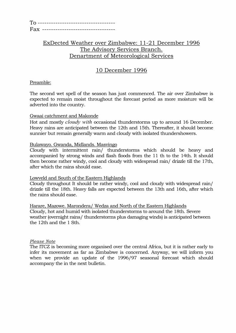
To ----------------------------------- Fax ---------------------------------
ExDected Weather over Zimbabwe: 11-21 December 1996The Advisory Services Branch.
Denartment of Meteorological Services
10 December 1996
Preamble:
The second wet spell of the season has just commenced. The air over Zimbabwe is expected to remain moist throughout the forecast period as more moisture will be adverted into the country.
Gwaai catchment and MakondeHot and mostly cloudy with occasional thunderstorms up to around 16 December. Heavy rains are anticipated between the 12th and 15th. Thereafter, it should become sunnier but remain generally warm and cloudy with isolated thundershowers.
Bulawayo. Gwanda, Midlands. MasvingoCloudy with intermittent rain/ thunderstorms which should be heavy and accompanied by strong winds and flash floods from the 11 th to the 14th. It should then become rather windy, cool and cloudy with widespread rain/ drizzle till the 17th, after which the rains should ease.
Lowveld and South of the Eastern HighlandsCloudy throughout It should be rather windy, cool and cloudy with widespread rain/ drizzle till the 18th. Heavy falls are expected between the 13th and 16th, after which the rains should ease.
Harare, Mazowe. Marondera/ Wedza and North of the Eastern HighlandsCloudy, hot and humid with isolated thunderstorms to around the 18th. Severe weather (overnight rains/ thunderstorms plus damaging winds) is anticipated between the 12th and the 1 Sth.
Please NoteThe ITCZ is becoming more organised over the central Africa, but it is rather early to infer its movement as far as Zimbabwe is concerned. Anyway, we will inform you when we provide an update of the 1996/97 seasonal forecast which should accompany the in the next bulletin.

1. INTRODUCTION
I.I. Project summary and objectives
1. The African weather regimes workshop held in Harare in December 1996 established that within Southern Africa there is a capability for improving weather forecasts by extending the period of forecast to 5-10 days. Such forecasts should be of considerable benefits to the farming community (small scale farmers) by enabling them to plan activities farther ahead. It was recommended that dissemination of medium-range weather forecasting should be improved, and where the provincial services of Radio Mozambique provide a means of addressing farmers in particular areas of the country this means should be used. Mozambique has a diversity of farming systems and Zambezia province is the location of an ODA smallholder agricultural development programme. It is also an important agricultural province which includes the main maize, rice, tea and coconut growing areas.
2. This proposal documents the research preparation work with the aim of defining an operational framework for a potential project disseminating medium-range weather forecasting information and related advice to small farmers and testing the impact of forecasts on the farmers' activities. The Meteorological Department along with some Government institutions/entities and NGOs have shown their interest in the establishment of this project. It is believed that this project would have the greatest impact in small farming sector.
3. In addition, both Radio Mozambique and the Instituto de Comunicacao Social -ICS (National Institute of Social Communications) have the capacity to broadcast the programmes in Portuguese and local languages (Chuabo and Lomwe). The main constraint faced by ICS is that they are not yet established on the ground, although Zambezia is considered one of the priorities in terms of setting up Community Radios throughout the country. UNFPA is funding a project specifically for this province.
4. Weather forecast use in agriculture in Mozambique would not be a new experience. An Early Warning Unit (EWS) has been established in the Ministry of Agriculture, which monitors the weather and predicts agricultural output in the country. The main difference lies in the end users of the information produced; the information to be produced by the current project is aimed at small farmers, whereas the users of the EWS's information are not defined. However, they can be identified as those with access to the media and the bulletins produced.

1.2. Geography and population
5. The Republic of Mozambique Iies on the eastern coast of southern Africa, and has borders to the north with Tanzania and to the west by Malawi, Zambia, Zimbabwe and the South African province of Mpumalanga. To the south it borders on Swaziland and the South African province of Kwazulu Natal.
6. Its Indian Ocean seaboard stretches over a length of 2,470 Km. Total area is 799,380 Km2 of dry land and 13,000 Km2 of inland lakes and rivers. The capital is Maputo_
7. Mozambique occupies a strategic position in southern Africa, with its ports and railways giving sea-access to the landlocked countries of Botswana, Malawi, Swaziland, Zambia and Zimbabwe, the south-east of Zaire and South African province of Mpumalanga.
8. Mozambique has a population of about 18 million people, growing at an estimated annual rate of 2.6%. About 90% of the population is rural. 1.3. Climate
9. Mozambique has a predominantly tropical climate, with a cool season from May to August. There are three climatic zones: a rainy zone in the north and centre, a drier zone in the southern half of the county, and a relatively cool and rainy zone in the plateau and mountainous regions of Namaacha, Manica, Maravia-Angonia, Gurue and Lichinga.
10. The north and centre of the country are influenced by an equatorial low-pressure zone; the weather is determined by an intertropical front which moves alternately north and south, producing a hot and rainy season from November to April (particularly in December and January) and moderate rains or drought and lower temperatures from May to October (especially in July to August). In the rainy season, the influence of the Indian Ocean monsoons is felt, with north-easterly winds thunderstorms and abundant rain. For the remainder of the year, south-easterly winds prevail.
11. In the south, weather conditions normally depend on the position of the Indian Ocean anticyclone and sometimes, in the rainy season, southerly winds bring thunderstorms, hurricanes and lower temperatures.
12. In certain plateau and mountainous regions, such as Namaacha, Manica, Maravia-Angonia, Gurue and Lichinga, climatic zones exist which are similar to those temperate climates.
2

1.4. Agriculture
13. Agriculture was, and still is the base of the Mozambique economy, providing the livelihood of the vast majority of the people, raw materials for the agro-industry, and some export products. Out of 36 million hectares of arable land only 10 million are being cultivated. Agriculture and industry are interdependent, agriculture providing raw materials for much of industry and industry in turn producing, among other things, agricultural inputs and consumer goods which encourage increasing agricultural production.
14. Mozambican agriculture is dominated by the family sector, which under normal conditions accounts for more than 90% of the cultivated area and supplies the majority of domestic food. This sector could generate around half of commercial agricultural crop production, supplying both the internal and export markets. Private commercial farms have increased significantly in number since the late 1980s.
15. The diversity of soils is wide. There are some 20 main soil types, ranging from alluvial near rivers to ferralitic in high, rainy areas, which together with the diverse climatic conditions of the various parts of the country are suitable for many different crops.
16. Agricultural suitability varies from region to region. The areas more suited to the cultivation of maize, cassava, wheat, sunflower, soya, peanuts, cotton and cashew are in the north of the country. The areas best suited for wheat, an infrequently grown cereal in Mozambique, are in Niassa province, on the eastern border of Tete province with Malawi and in the frontier belt of Manica province with Zimbabwe. Tobacco is mainly grown in Manica, Nampula and Niassa provinces. The county's central region (Zambezia, Manica and Sofala provinces) has the best soils for tea. southern region where cashew nuts, rice and tropical fruit and vegetables are important crops. The main agricultural cash crops are sugar, cotton, citrus, cashew, nuts. copra, tea, tobacco, sisal, oil seeds, tomatoes and tropical fruits.
3

2. PROPOSED DEVELOPMENT AREA
17. Initially, a pilot project is proposed for the central province of Zambezia. This province is considered one of the most important in the country, due to the variety of natural resources. For example, there are in Zambezia 3 agro-ecological zones out of a total of 15 in the country'.
18. Geographically, Zambezia ranks in the top positions: with 19% of the total population it is the most populated province in Mozambique; of the country's total area, Zambezia occupies the second position after Niassa with a total area of 105,008 km2, that is 13% of the country's area. Despite this size, the population density of this province is still well above average: in Zambezia the figure is estimated at 27.3/km2 whereas the national average population density is 18/km2.
19. As indicated above the broadcast of the programmes will be in Portuguese and local languages (Chuabo and Lomwe). According to the 1991 statistical data the distribution of the languages in the province was as follows:
- Portuguese 38% - Lomwe 26.6% - Chuabo 26.1%- Other 9.3%TOTAL 100%
These figures per se are an indication that the intended beneficiaries will be covered by the broadcast.
20. In terms, it appears that a considerable number of small farmers can afford to purchase a radio. A survey conducted by the World Vision in two districts (Nicoadala and Gurue), showed that the average number of people with radios was approximately 42% in the former and 25% in the latter. Although specific to the two districts, these figures can be considered as a reference for the project, particularly in the neighbouring areas.
21. In addition to this and according to World Vision officer with experience in Zambezia, people in the rural areas of that province tend to group around the radio for specific programmes. Plus, there is some previous experience with radio broadcast programmes in Zambezia; with the Provincial Extension programme and the Marketing programme (information on prices), from the agricultural authorities and the World Vision, respectively. There has not been any evaluation of the impact of these programmes on local farmers, but broadly speaking the message appears to reach the intended beneficiaries.
1 The definition of agro-ecological zones was based essentially on the characteristics of the soils; rainfall; evapo-transpiration; and temperature. Their boundaries have been established according to the botanical strata and soil configuration. As it can be seen, this stratification is related to crops grown in each area as well as their yields. There are 15 agro-ecological zones in Mozambique-
4

22. It is important to note that during exploratory contacts, there were mixed feeling regarding the selection of this province; some opinions were against the indication of this province for the implementation of this project, as that weather variation does not have the same impact as in those provinces which are prone to droughts. Those who have agreed, have pointed out the lower, middle and the upper Zambezia. Additionally, the need to involve the agricultural extension services, for the implementation of the project is recommended to consider the following districts covered by extension and considered as priority in Agriculture plans.
Alto Molocue (upper) Nicoadala (lower) Mocuba (middle)Gurue (upper) Ile (middle)Namacurra (lower)
3. PROJECT COMPONENTS/ACTIVITIES
23. The main components of this project will be a weekly 10 minute programme to be broadcast on Radio Mozambique (Zambezia broadcasting station) in the three languages above, monitoring and impact assessment of these broadcasts, and feedback to the programme makers (see Para. 29. below). Broadcasts will consist of
(i) summary of past week's weather in relation to forecast and its effects on farming;
(ii) weather forecast for the coming week. Recommendations for farming activity;
(iii)listener's letters, feedback from broadcasts, answers and queries and discussions.
24. Although it may appear more expensive than the National Institute of Social Communication (ICS) it is recommended that Radio Mozambique undertakes this job, because of their coverage capability in the province and their capacity to send pre-recorded programmes produced in Maputo to Zambezia, through their direct and permanent line. In the future there is the possibility of the services being provided by ICS, taking into account their experience in rural programmes and the fact that this institution is to expand Community Radio into the province.
25. With regard to the appropriate timing for broadcasting, it is important to collaborate with those programmes already being broadcast, namely the WVI Marketing and the Agricultural Extension Programmes. A possibility would be a multi-disciplinary programme, which would perhaps create a great interest for listeners. However, the present proposals should be identified as a separate initiative and should not be absorbed by existing programmes.
5

26. An important aspect to consider is that INAM and the agricultural services should prepare the programme together - the weather forecast will be accompanied by technical recommendations, such as ploughing, planting, weeding or even harvesting. As the National Director of Agriculture has put it, "it should be a real agricultural programme".
27. The involvement of the extension services, from either the Government or NGOs is another aspect to be considered: the message broadcast through radio needs to be complemented or reinforced by the message of the extensionists in their contacts with farmers (this message is particularly important to explain to them the difference between FORECAST and CERTAINTY). Most people contacted considered, there would not be any difficulty in involving the extensionists, because weather forecast would be regarded as another subject being brought to the farmers. However, extensionists should be provided with specific training, in order to understand the new subject they have to deal with. In addition to that, radios may be needed by the extensionists paid by government, not only as means for listening but also as incentives to them. Bicycles may be another incentive.
28. Training will be also needed for INAM forecasters who will produce the agrometeorology forecasts. Apart from this, INAM will require assistance to improve its capacity to receive satellite and computer forecast information as well as investing in its own observation network. Therefore, a detailed study to estimate the costs of the support needed by INAM under this project should be undertaken. The requirements for the accomplishment of these activities should be presented by INAM. In addition to this, a budget should be allocated to cover other costs, which will include the renumeration of the broadcasters and miscellaneous activities. Important to note that Radio Mozambique will charge US$ 50-70 for each ten minute programme broadcast in each of the three languages; that is, US$ 7,800-10,920 for a period of 12 months. There will also be additional programme-making costs incurred, mostly by INAM, prior to the broadcast costs. These have not yet been identified.
29. A rapid preliminary assessment will be needed at the preparation stage, to establish the appropriate broadcasting time, style and content, to get farmers views on the weather forecasts and their effect on crop production and farming activities. The opinions of the local agricultural authorities as well as other people may be useful at this stage. Another important aspect that should be included is an impact assessment of the radio programmes being produced at the moment.
6

4. STRENGTHS/OPPORTUNITIES
30. At its inception this project appears to be in an advantaged position: the willingness shown by the entities contacted and the natural characteristics of the province may contribute for its success. Of particular importance is the consideration given by the agricultural extension authorities and NGOs involved in extension, when regarded this project as another tool rather than for the extensionists. Additional factors are as follows:
• the existence of a powerful radio station which covers not only the whole province of Zambezia but some other neighbouring regions;
• the experience of the local radio station in broadcasting programmes aimed at the agricultural sector;
• the existence of radios in the hands of the rural residents, combined to the fact of the habit of group (people tend to group around the radio); and
• the existence of 3 agro-ecological zones in the province.
5. PROJECT CONSTRAINTS
31. Farming activities throughout the agricultural season. A 12-month programme may not be sufficient enough to draw some conclusions on the impact of this project in farmers' behaviour - ONE observation may not be conclusive, and the project would not be fully implemented. If a good enough monitoring and feedback system is set up in the first year, it may be possible for the second year's work to be carried out without international inputs.
32. Zambezia is served by a meteorological station badly equipped, and with no qualified personnel. Other stations within the province need to be rehabilitated. In addition to that, means of communication are still limited. As a result, there may exist problems in the collection and delivery of the meteorological information.
33. The existence of three main languages within the province will require more of both human and financial resources, and costs will be therefore higher.
7

6. PROJECT COSTS
34. The total costs of the project can only be established after a detailed study has been carried out. Below the most important items to be considered:
• Acquisition of radios, bicycles • Radio programmes and broadcasting • Training of broadcasters and extensionists • Initial Assessment/Survey • Monitoring and Evaluation Unit • Extensionist rewards • Equipment for INAM • Contingencies
8

7. RECOMMENDATIONS
1. It is known that small farmers have been responsive to various types of stimuli. But in this particular case, the magnitude of that response needs to be established or gauged. Therefore, an attempt to identify the benefits that arise with the current project, compared then with the situation as it would be without the project, needs to be carried out to identify the net benefits arising from the project investment.
Most benefits accruing this project may be difficult to quantify, as they are not tangible. Therefore, this assessment will be more qualitative than quantitative. In order to capture these changes, there is a need to establish a small monitoring unit, which would also accompany-the feedback from the broadcasts and gather information for future evaluation.
2. Demographic and socio-economic information presented in this report is extracted from existing documents or data collected before. An in-depth study on the most important aspects related to the project may be carried out in the proposed districts. In this regard, a fuller mission to Zambezia to define how the potential project will work on the ground is needed. This can be composed of sociologist/anthropologist, economist/rural economist and meteorological/agrometeorologist.
This mission would try to capture the impact of the existing radio programmes in the province directed to farmers. World Vision International (WVI) has a sociologist working in Zambezia who can be integrated into the team. Other NGOs active in the province may also contribute to the mission. NRI should coordinate all activities.
3. The investment to be made in this project either in human resources or in capital will be considerably high. The various requirements of this project include, among others, the training of the forecasters and improvements or upgrading of the existing equipment. Returns may not be significant in the proposed period (12 months). Therefore, it is recommended that this project should have a life span of at least 2 years to enable the full impact to occur.
4. Action should be taken to seek funding for the rehabilitation or upgrading the existing meteorological stations in Zambezia, or to persuade FAO to speed up its programme in that province. (According to IMAM, FAO is to rehabilitate 19 meteorological stations throughout the country, 4 of them in Zambezia).
5. The identification net benefits arising from the project investment in a with and without project will require a preliminary survey to identify the current situation on the ground in order to compare with that prevailing in the future.
6. Periodic weather bulletins issued by various entities, e.g. the Early Warning System or MSF-CIS, can be made available to the extensionists involved in the project, in order to widen their understanding of weather variation.
9

8. SUMMARY OF ACTIVITIES AND OBJECTIVES
ACTIVITY OBJECTIVES Dispatch a mission to Zambezia • Identify with the local authorities the
districts for trial; • Identify the current situation for future evaluation (with and without exercise); • Study the likelihood of farmers response to the programme; • Assess the access to radio in the rural
communities. • To improve its capacity to receive satellite and computer forecast information. • To speed up with the rehabilitation of the meteorological stations in the province. • To provide them with skills to produce and interpret the programmes. • To understand the new subject they have to deal with. • To set up the broadcasting scheme. • For feedback purposes. • Record important information to be used from a with vs without situation. • Establish the budget for the whole budget
Material and Support to INAM
Contact with FAO
Training of forecasters
Training of extensionists
Contact with Radio Mozambique Set up a monitoring unit
Cost estimation
10


Appendix VI. People contacted in Mozambique by M Tucker and A Manjate.
Austral Estrela Polonia Paulo Fumane MSF Jean Francois Detry
Maria Adela CastroAction Aid Roberto Luis ORAM Joao Muthombene
Paulo CuinicaRADIO MOZAMBIQUE Joao de Sousa
Daude Amade Jorge Amado Early Warning System Oscar Rojas
Alejandro Olivares Jorge AmadeIMAM Ernesto Mussge (Director)
Mr Gustaf Fill Lucio World Vision International Jonathan White
Antoinette van Vu National Institute of Social Communication Floyd Machiana National Directorate of Agriculture Sergio Gouveia, National Directorate of Rural Development Custodio Mucavele