Natural History of the Crowe Bridge Conservation Area · Natural History of the Crowe Bridge...
62
Natural History of the Crowe Bridge Conservation Area Graham C. Wilson, Version III, n=49+13, May 4 th 2008 / October 5 th 2010
Transcript of Natural History of the Crowe Bridge Conservation Area · Natural History of the Crowe Bridge...

Natural History of the
Crowe Bridge Conservation Area
Graham C. Wilson,
Version III, n=49+13,
May 4th 2008 / October 5th 2010

Crowe Bridge Conservation Area
The CBCA is composed of
predominantly wooded
river-bank ecosystems, ~10
hectares (25 acres) in
extent, on the left (south)
bank of the Crowe River,
just above the confluence
with the larger Trent River,
north of Campbellford in
Seymour township,
Northumberland county,
southeast Ontario.
This presentation illustrates
some of the natural attractions
of the CBCA.
This third version includes a
thirteen-slide appendix of photos
of local flowers.
As of 05 October 2010, a total
of 135 species of plants, trees,
birds, animals, etc are listed for
CBCA on the www.turnstone.ca
web site, 40% of the token 338
listed for the township.

The Crowe Bridge,
yesterday
Detail from the
“Illustrated
Historical Atlas of
the Counties of
Northumberland
and Durham,
Ontario, 1878”,
reprinted in full
with additions ---
Fifth Line Press,
Stirling, 2006 (p.91),
publisher Peter
Wilson.

View from 8,560 feet
Google Earth
image retrieved
01 May 2008
The CBCA lies
within the red
oval, around
44º22’50” N,
77º45’10” W.
The topography
is hummocky,
rising gently
upstream,
elevation ~545
to 575 feet (166
to 175 m)
above mean
sea level.
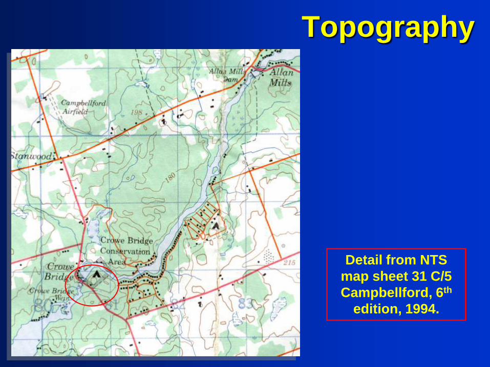
Topography
Detail from NTS
map sheet 31 C/5
Campbellford, 6th
edition, 1994.

Mapping project
In order to better document
the natural environment of
the CBCA, a GPS-referenced
database of geological,
geographic and human
features is being created. An
initial 51 locations were
documented from 25 April to
03 May 2008, and entered
into a .xls spreadsheet.
The locations described so
far lie within the CBCA and
beside adjacent roadway to
north and south. In
geometric terms they lie
within a 28 ha area 663 m
north-south by 422 m east-
west, of which the CBCA is
the central 36 percent.
Adjacent landowners are
encouraged to request a
brief survey on their own
land, as time permits.

Lots of Time…
Geological Time in
Southeastern Ontario
Quaternary (on top!)
Jurassic (rare)
Ordovician (the “cover
rock” in the south – most of
the good farm land)
Precambrian (Grenville)
shield forms the “basement”
under the limestone cover
(“cottage country”)

Geology of (part of) S.E. Ontario

Local Geology
Two inliers (windows into
deeper, older rock units)
occur in the Crowe Valley, at
CBCA and upstream at Allan
Mills. In each case, small
areas of Precambrian rock
(Pc) and limestone of the
Ordovician Gull River
Formation (1b) are overlain
by limestone of the
Bobcaygeon Formation
(1c), which persists down
the Trent valley to the area
of Ranney Falls, where it is
succeeded in turn by the
Verulam Formation (1d, not
shown).

The Precambrian Shield
Apparent
Precambrian outcrop
beside road just
south of CBCA:
igneous intrusive
rock, gabbro or
diorite rather than
granite...

Bedrock - metagabbro
At least part of the Precambrian inlier
is composed of greenschist-facies
metagabbro with feldspar part-altered
to zoisite, and pyroxene to actinolite.
Field of view (right) 1.7 mm.

The Grenville province
Local outcrop and
glacial erratics, in and
near CBCA, indicate
that the limestone
strata are a thin cover
on the underlying
Canadian Shield.
Just upstream to the northeast is Allan
Mills, itself 8 km southwest of the large,
rich iron deposit of the former
Marmoraton mine. A sample of old drill
core from Allan Mills is a biotite-
magnetite diorite, a magnetic igneous
rock. This rock contains some 60%
feldspar, 28% pyroxenes, 7% iron-
titanium oxides, 4% biotite mica, 1%
apatite plus trace sulphides.

Glacial
erratics… are boulders, often more or less rounded, transported under, within, or on top of the ice sheets
and glaciers of the Ice Age. Numerous metre-scale examples, commonly weighing 1-10 tonnes
each, are known in Seymour township and the adjacent region. Each may have travelled many
kilometres to its present location, and be composed of rock types unknown at its destination.

Pyroxenite boulder
Two photomicrographs in cross-polarized transmitted light (long-axis
field of view 1.7 mm) showing ragged actinolite prisms in one
metamorphosed igneous rock, derived as a glacial erratic from the
Grenville province, as close as Cordova Mines, or from more distant
gabbroic intrusions such as the Tudor, Limerick and Thanet complexes.

Erratic - diabase
Some erratics near the west margin of
the park are metamorphosed diabase
(distinctive texture, less-common, and
less-altered than bedrock gabbro, and
thus more magnetic). Field of view
(right) 1.7 mm.

Limestone
downstream of the
bridge. Right:
incipient solution
cavities on vertical
joints, forming
upstanding “clints”
separated by
trench-like “grikes”
(or maybe “grykes”
- seen also in
marble at
Petroglyphs Park).
Ordovician
Limestones

Ordovician
Limestones
A 50-cm-long fossil orthoceratid (a
cephalopod, part of the class which includes
squid and octopus, nautiloid and ammonite).
Possibly Actinoceras. Such fossils are well-
known elsewhere, e.g., Anticosti Island.

Limestone
ecosystems
Some mosses, wild flowers and
even trees can grow and thrive
on limestone blocks, and the
thin calcareous soil that forms
on the rock slabs.

Bioclasts
Photomicrograph, 1.7 mm in
diameter, showing fossil fragments in
limestone. Colonial organisms,
probably bryozoans.

Bedded chert nodules –
arsenal for ancient artisans?
Nodules of massive silica (known as chert or flint) in
bedded limestone. Chert is the raw material for
countless ancient arrowheads. Coin is 26 mm wide.

Chert nodules in limestone at CBCA
T&G Humphries photo

Chert
Collophane, a brown phosphate, infilling voids in silicified limestone.
The limestone, originally mostly carbonate, is now 71% silica, 20%
relict carbonate, 7% bioclasts (bryozoans, brachiopods), 2%
phosphate and a trace of pyrite. View 0.9 mm in diameter.
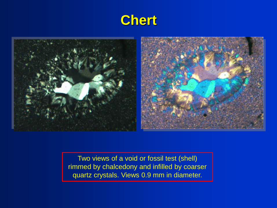
Chert
Two views of a void or fossil test (shell)
rimmed by chalcedony and infilled by coarser
quartz crystals. Views 0.9 mm in diameter.

Chert
Two views of an (?) algal bioclast in chert,
replaced by chalcedony and infilled by coarser
quartz crystals. Views 1.7 mm in diameter.

Typical small fossils at CBCA
Bryozoan, coral and
orthoceratite fossils in
outcrops at CBCA. Coin
diameter = 18 mm.

Fossils
Mid- to upper Ordovician fossils
from S.E. Ontario, beautifully
prepared for display. Clockwise
from top left: trilobite (Isotelus),
brachiopods (Dalmanella),
trilobites (Isotelus), and crinoid
(Porocrinus) with calyx. Photos
and sample prep. courtesy of Bill
Hessin of Fossil Hut,
http://www.fossilhut.com/

Quaternary Geology
Moraines,
Drumlins,
Eskers…

Sand
Sand from the Thompson
pit just south of CBCA,
bagged for flood defence
at the Davidson yard in
April 2008. The
Thompson pit is some
1,500 m S.S.E. (N158ºE)
of CBCA. Under the
microscope, local sand
contains both fragments
of coral limestone and
mineral grains from the
Canadian Shield.
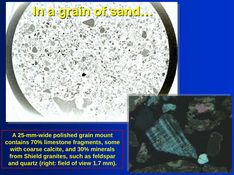
In a grain of sand…
A 25-mm-wide polished grain mount
contains 70% limestone fragments, some
with coarse calcite, and 30% minerals
from Shield granites, such as feldspar
and quartz (right: field of view 1.7 mm).

Surficial features
The lower Crowe
valley is largely till
moraine, a
hummocky sheet of
boulder-strewn
glacial debris (dark
green). To the south is
a till plain with
whaleback drumlins,
their long axes
oriented within the
ice-flow direction
(pale green; brown
spots). There are also
sand, clay and
limestone plains
(yellow, blue and
pink, respectively).

Evidence of
minor deformationThe left bank of the river,
immediately upstream
of the bridge, displays
a gentle dome-like
structure, which
appears as arcuate
traces of limestone
beds. This is identified
as a “pop-up”. Such
neotectonic features
are geologically
youthful structures: a
good local example
occurs at King’s Mill
conservation area in
Rawdon Twp. These
photos from August
2007 give some
indication of the pop-
up, which is tens of
metres wide.

Soil Types
The CBCA is underlain by
“Dp:e3”, the shallow phase of
the soil type known as the
Dummer loam. Topography is
irregular, 10-15º, and the soil is
very stony. For these reasons,
this soil (generally formed on
limestone till, and so calcareous)
is not ideal for agriculture. In
contrast, the soils to the south
near Pethericks Corners are
generally better. An example is
labelled “Os:c3”, Otonabee
sandy loam: the land is very
gently sloping, 2-5º, the soil also
very stony.

Seasonal flooding of Crowe River

High water flows on the Crowe during
late winter and spring run-off raise the
water levels 1 metre or more – did you
see this view earlier (?).

Fauna--- from bats to beavers,
including this little juvenile
northern water snake,
Nerodia sipedon sipedon.

Blue-spotted salamander
T&G Humphries photo

Birds
Species lists (birds, trees,
plants, animals, butterflies,
etc) for CBCA would be very
useful…
Cedar waxwings and slate-
coloured juncos are winter
visitors to the area.

Wild Flowers
Snow trillium (Trillium
grandiflorum, above) and cardinal
flower (Lobelia cardinalis).

Wild Flowers, II
Two examples of
bottle gentian (closed
gentian, Gentiana
andrewsii).

Wild Flowers, III
Year-1 of a biennial plant, the great
mullein (above) and swamp
sunflower (common sneezeweed).
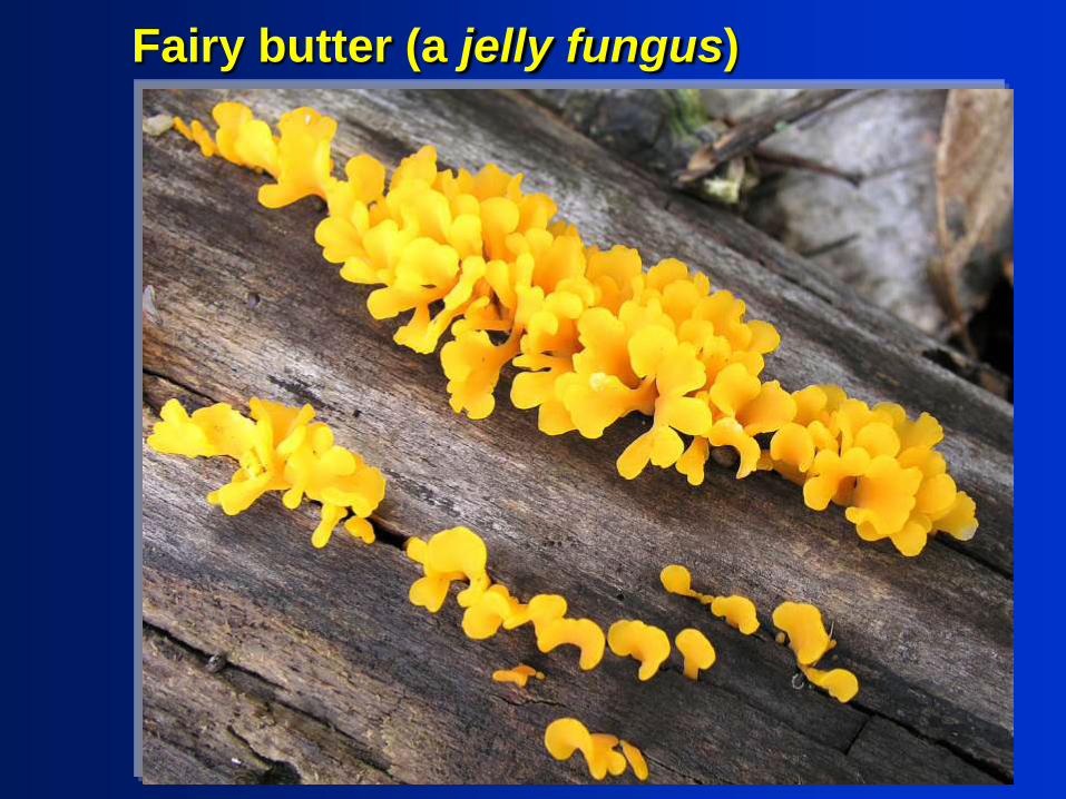
Fairy butter (a jelly fungus)

Trees
Hardy cedars growing along
the river banks are some of
the most memorable trees in
the CBCA.

CBCA – a place worth exploring

Conclusions
The CBCA is special in scientific terms, in addition to
its local, cultural and social importance. Confirmed or
suspected features of CBCA include:
•Inlier of Canadian Shield and unconformably overlying Gull
River Formation, with
•Bedded chert at or near the transition to the younger
Bobcaygeon Formation
•Fossils in the mid-Ordovician limestones, including fine
orthoceratite cephalopods
•Weathering of limestone forming “clints and grykes”
•Small-scale limestone-based ecosystems with distinctive flora
and fauna in thin soil, fractured rocks and cavities
•Glacial till, drumlins, and erratics from the Shield
•A neotectonic “pop-up” feature in the Crowe River.

Resources
On-line references:
Overview, petition:
http://savethecrowe.com
Turnstone web site --- Seymour bird
list and related data, summary of local
geology, and bibliography:
http://www.turnstone.ca/local.htm
Local rocks on the site include chert:
www.turnstone.ca/rom76ch.htm
and another local erratic:
http://www.turnstone.ca/gabbro.htm

Resources
References:
Carson, D.M. (1980) “Paleozoic Geology of the
Bannockburn- Campbellford area”, OGS map
P2374, 1:50,000 scale.
Chapman, L.J. and Putnam, D.F. (1984) “The
Physiography of Southern Ontario”, OGS Spec.Vol.
2, 270pp., plus map P2715, in colour, 1:600,000
scale.
Hoffman, D.W. and Acton, C.J. (1974) “The Soils of
Northumberland County”, Ontario Soil Survey
Report 42, 117pp. Plus 1:63,360 scale map.

Care &
maintenance
Infrastructure: picnic area, waterfront
& the “cat-tail mat”; mini-golf course;
spring cleaning.

It’s your planet,
and your back-yard,
so Get Involved!
Additional species lists
(birds, trees, plants, animals,
butterflies, etc) for CBCA
would be very useful…

Acknowledgements
•Chert and salamander
photos: G&T Humphries
•Drill-core sample: R Brett
•Copying: L Winegarden
•Inspiration: Church Key
•Bird illustrations by: Virginia
S. Eifert, “Birds in Your
Backyard”, 2nd edition, 1945
(pp.148-149, 198-199).
•Fossils by: Bill Hessin

Appendix:Crowe Bridge Conservation Area
Selected flowers,
15th August, 2nd October, 2010
Appendix, 13 slides. See also the detailed species lists at:http://www.turnstone.ca/birdetc.htm
and the original slide show at:http://www.savethecrowe.com/science_nature.html
with help from Andy Fyon ofhttp://ontariowildflower.com

Two August staples – common sneezeweed (swamp sunflower) and (right) cardinal flower

I thought this was white baneberry (doll’s-eyes) but Andy Fyon makes a strong case for
an alternative, red osier dogwood. The leaves are diagnostic of the dogwood, though the
doll’s-eyes plant occurs in Ferris park.

Flowering segment of thered osier dogwood.

False Solomon’s seal (false spikenard), low to ground, showing
pale early-stage berries. One berry had turned red 4 days later.

Boneset (above) and square-stemmed monkey flower
(photo is rather pale).

Grass-leaved goldenrod (right) and, for comparison, another species
(also at CBCA; this example is from the esker [Monaghan] spring in the Trout Creek drainage), identified in both localities as rough-stemmed
goldenrod.

Mint and (at right) the invasive purple loosestrife, which seems
more abundant in Seymour township in 2010, but is still of
patchy distribution.

Pale smartweed with grass-like tufts of mm-size flowers
on long stems.

American elder

More rough woodland sunflower and unknown
“grass” (see on)

Thimbleweed with distinctive puffy heads and sharply
indented basal leaves, and (above) rough woodland
sunflower.

An old favourite from CBCA, the bottle gentian (closed
gentian).
The end, for now