NATMAP SURVEY BEACONS IN GOOD CONDITION AFTER … · · 2011-10-15NATMAP SURVEY BEACONS IN GOOD...
6
1 NATMAP SURVEY BEACONS IN GOOD CONDITION AFTER 46 YEARS Canning Stock Route Traverse Survey Station Inspection Report 2010 Background As an aside during a recreational trip along the Canning Stock Route in July – August 2010, several survey control stations were inspected on the Well 35 to Halls Creek geodetic survey traverse. These survey stations were established and observed (by theodolite and tellurometer) in 1964 by a Natmap field party led by Reg Ford. This observing/beaconing party followed (but in reverse direction) an earlier reconnaissance of the traverse route by Natmap‟s HA (Bill) Johnson. The 2010 inspections were carried out at the request of Paul Wise, retired former Natmap senior surveyor. The inspections were made on an opportunity basis; apart from NM/F/203, no out of the way search attempts were made to locate stations that could not readily be seen from the stock route track. In the case of NM/F/203, the inspecting party detoured a few kilometres north from the Well 43 Billowaggi turn off to locate this station prior to returning to the along the wells route. Equipment relevant to the inspections was: a Magellan eXplorist 600, hand held GPS receiver and Canon Digital IXUS 80IS, 8.0 megapixel, camera as well as 1:250,000 scale topographic maps. GPS coordinates were observed at each station and terrestrial images captured. The inspecting party comprised: former Natmappers: Laurie McLean and Lawrie O‟Connor together with Dave and Lorraine Uren (Dave and Laurie served together as national servicemen in Vietnam during 1967-68). Stations Inspected NM/F/198 was inspected at about 3:00pm (WST) on Friday 6 August 2010. Coordinates observed with the GPS unit held against the beacon centre pole were: 21 degrees 48.695 minutes South, 125 degrees 34.477 minutes East. Map sheet used: 1:250,000 NTMS: SF51-08 Percival, Edition 2. Station Condition: All structural elements were observed to be in good order ie metal vanes, centre pole and bracing struts. While the map indicated the track (so called Canning Stock Route) passed to the east of the station, in fact the main track was a hundred or so metres to the west with a secondary branch (probably for the curious) running off the main track on the southern side of the sandhill right to the base of the station and then rejoining main track on the northern side.
Transcript of NATMAP SURVEY BEACONS IN GOOD CONDITION AFTER … · · 2011-10-15NATMAP SURVEY BEACONS IN GOOD...

1
NATMAP SURVEY BEACONS IN GOOD CONDITION
AFTER 46 YEARS
Canning Stock Route Traverse Survey Station Inspection Report 2010
Background
As an aside during a recreational trip along the Canning Stock Route in July – August
2010, several survey control stations were inspected on the Well 35 to Halls Creek
geodetic survey traverse. These survey stations were established and observed (by
theodolite and tellurometer) in 1964 by a Natmap field party led by Reg Ford. This
observing/beaconing party followed (but in reverse direction) an earlier
reconnaissance of the traverse route by Natmap‟s HA (Bill) Johnson.
The 2010 inspections were carried out at the request of Paul Wise, retired former
Natmap senior surveyor. The inspections were made on an opportunity basis; apart
from NM/F/203, no out of the way search attempts were made to locate stations that
could not readily be seen from the stock route track. In the case of NM/F/203, the
inspecting party detoured a few kilometres north from the Well 43 Billowaggi turn off
to locate this station prior to returning to the along the wells route. Equipment
relevant to the inspections was: a Magellan eXplorist 600, hand held GPS receiver and
Canon Digital IXUS 80IS, 8.0 megapixel, camera as well as 1:250,000 scale
topographic maps. GPS coordinates were observed at each station and terrestrial
images captured. The inspecting party comprised: former Natmappers: Laurie
McLean and Lawrie O‟Connor together with Dave and Lorraine Uren (Dave and Laurie
served together as national servicemen in Vietnam during 1967-68).
Stations Inspected
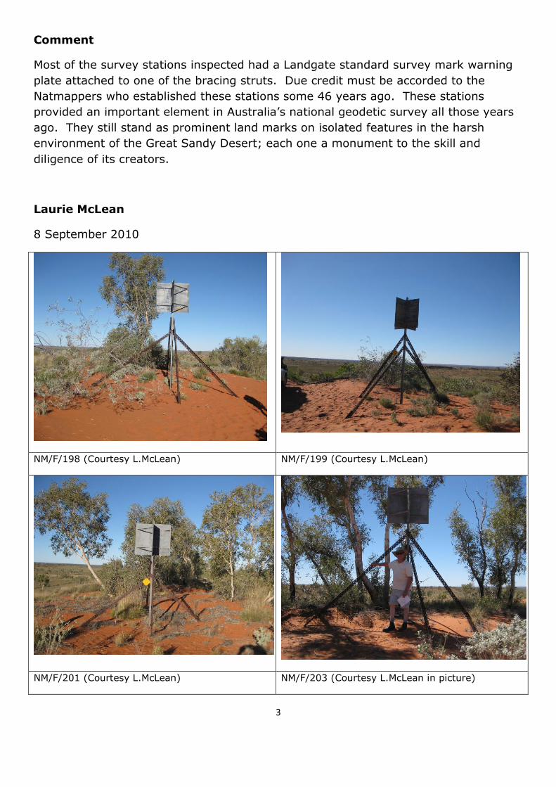
NM/F/198 was inspected at about 3:00pm (WST) on Friday 6 August 2010.
Coordinates observed with the GPS unit held against the beacon centre pole
were: 21 degrees 48.695 minutes South, 125 degrees 34.477 minutes East.
Map sheet used: 1:250,000 NTMS: SF51-08 Percival, Edition 2. Station
Condition: All structural elements were observed to be in good order ie metal
vanes, centre pole and bracing struts. While the map indicated the track (so
called Canning Stock Route) passed to the east of the station, in fact the main
track was a hundred or so metres to the west with a secondary branch
(probably for the curious) running off the main track on the southern side of the
sandhill right to the base of the station and then rejoining main track on the
northern side.

2
NM/F/199 was inspected at about 11:10am (WST) on Saturday 7 August
2010. Coordinates observed with the GPS unit held against the beacon centre
pole were: 21 degrees 38.530 minutes South 125 degrees 45.975 minutes East.
Map sheet used: 1:250,000 NTMS: SF51-08 Percival, Edition 2. Station
Condition: All structural elements were observed to be in good order ie metal
vanes, centre pole and bracing struts.
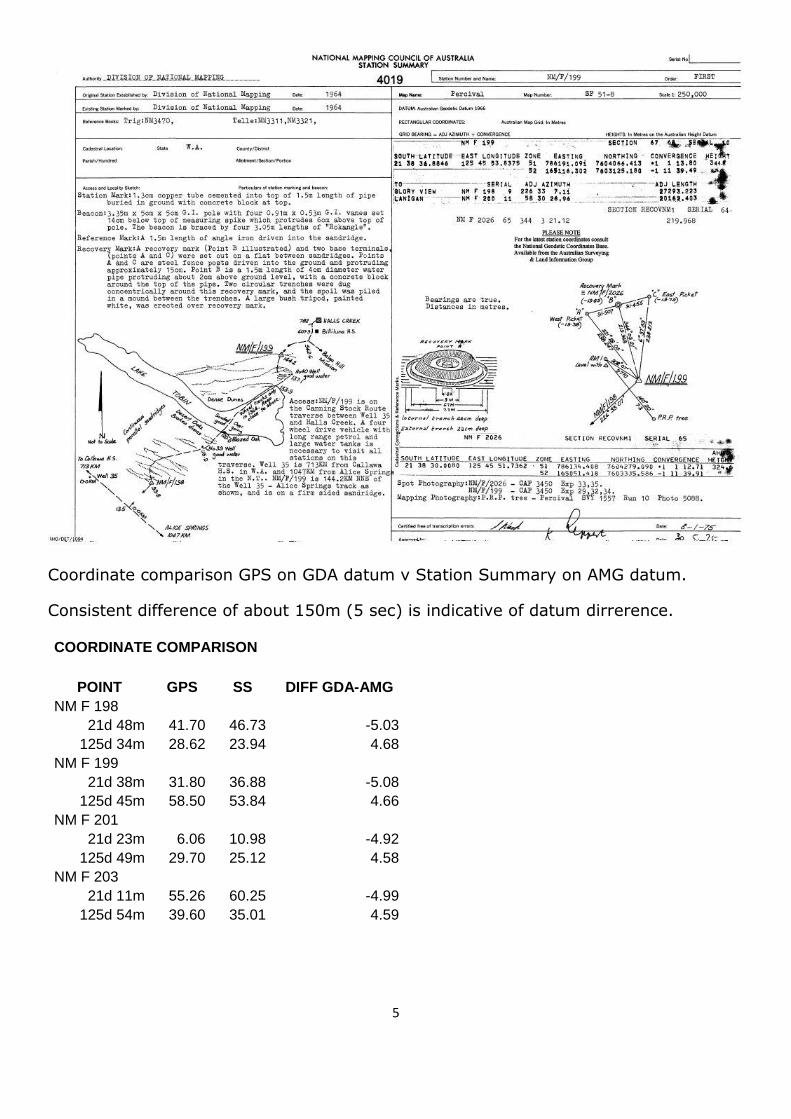
Although a prominent land mark, this station was not plotted on the map.
Instead, the map plotted NM/F/2026 which was a recovery mark in the inter-
dune valley to the north of the main station (beacon). The relationship between
the two marks was not known until the station summary was obtained and
examined after the stock route trip was over (attached at end of photos
section). NM/F/2026 was neither sighted nor looked for. The decision to plot
the recovery mark rather than the prominent land mark (beacon) seems curious
from a vehicle traveller‟s perspective.
NM/F/201 was inspected at about 4:00pm (WST) on Saturday 7 August 2010.
Coordinates observed with the GPS unit held against the beacon centre pole
were: 21 degrees 23.101 minutes South 125 degrees 49.495 minutes East.
Map sheet used: 1:250,000 NTMS: SF51-08 Percival, Edition 2. Station
Condition: All structural elements were observed to be in good order ie metal
vanes, centre pole and bracing struts. While the map indicates the track (so
called Canning Stock Route) passes to the east of the station, in fact the main
track was a couple of hundred metres or so to the west, a good bush camping
site was located on the northern side of the sand hill on which this station was
situated.
NM/F/203 was inspected at about 11:30am (WST) on Sunday 8 August 2010.
Coordinates observed with the GPS unit held against the beacon centre pole
were: 21 degrees 11.921 minutes South 125 degrees 54.660 minutes East.
Map sheet used: 1:250,000 NTMS: SF51-08 Percival, Edition 2. Station
Condition: All structural elements were observed to be in good order ie metal
vanes, centre pole and bracing struts. .
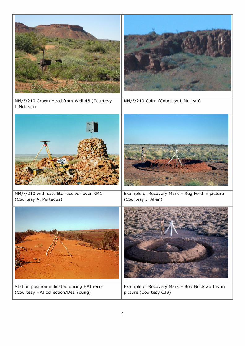
Crown Head on the morning of Wednesday 11 August 2010, a stone cairn,
centre pole and beacon vanes were observed on this topographical feature;
scaled coordinates of which are: 20 degrees 15.5 minutes South 126 degrees
32.4 minutes East. Map sheet used: 1:250,000 NTMS: SF52-01 Cornish,
Edition 2. Station Condition: While the observation point was on the plain
below the topographical feature, structural elements of the station appeared in
good order ie stone cairn, vanes and centre pole.
3
Comment
Most of the survey stations inspected had a Landgate standard survey mark warning
plate attached to one of the bracing struts. Due credit must be accorded to the
Natmappers who established these stations some 46 years ago. These stations
provided an important element in Australia‟s national geodetic survey all those years
ago. They still stand as prominent land marks on isolated features in the harsh
environment of the Great Sandy Desert; each one a monument to the skill and
diligence of its creators.
Laurie McLean
8 September 2010
NM/F/198 (Courtesy L.McLean) NM/F/199 (Courtesy L.McLean)
NM/F/201 (Courtesy L.McLean) NM/F/203 (Courtesy L.McLean in picture)
4
NM/F/210 Crown Head from Well 48 (Courtesy
L.McLean)
NM/F/210 Cairn (Courtesy L.McLean)
NM/F/210 with satellite receiver over RM1
(Courtesy A. Porteous)
Example of Recovery Mark – Reg Ford in picture
(Courtesy J. Allen)
Station position indicated during HAJ recce
(Courtesy HAJ collection/Des Young)
Example of Recovery Mark – Bob Goldsworthy in
picture (Courtesy OJB)
5
Coordinate comparison GPS on GDA datum v Station Summary on AMG datum.
Consistent difference of about 150m (5 sec) is indicative of datum dirrerence.
COORDINATE COMPARISON
POINT GPS SS DIFF GDA-AMG
NM F 198 21d 48m 41.70 46.73 -5.03
125d 34m 28.62 23.94 4.68
NM F 199
21d 38m 31.80 36.88 -5.08
125d 45m 58.50 53.84 4.66
NM F 201
21d 23m 6.06 10.98 -4.92
125d 49m 29.70 25.12 4.58
NM F 203
21d 11m 55.26 60.25 -4.99
125d 54m 39.60 35.01 4.59
6
Note:
Laurie‟s investigation arose from his earlier trip when he showed me a photo of one of
the trigs alongside „the Canning‟ and we observed its good condition and wanted to
know more. Reg Ford‟s 1978 report “The Division of National Mapping‟s part in the
Geodetic Survey of Australia - activities based on the Melbourne Office, 1951 – 1969”
provided the detail, like those who undertook the work listed below:
Halls Creek - Well 35 Traverse WA
R.A. Ford Senior Tech. Officer Grade I
J. Allen Field Assistant (Survey) D. Hutton Field Assistant (Survey)
F. Combe Field Assistant (Survey) J. Combe Field Assistant
W. Bannerman Field Assistant
R. Francis Field Assistant C. Golya Field Assistant
K. Snell Field Assistant J. Coles Field Assistant WRE
E. Graefling Field Assistant WRE J. Driscoll Field Assistant WRE
When Laurie mentioned his 2010 trip I requested he investigate the trigs in more
detail, if possible.
This investigation showed that not only are the trigs in good condition, they have not
suffered from any significant vandalism even though they are obviously visited by
travellers of the Canning. Hopefully this is a sign of respect by those travellers, for
those who undertook the work, in such a remote place.
The stability of the sandridges is also indicated. There is little sign of erosion around
these objects. The Recovery Marks were established as it was feared that over time
the station on the sandridge would move or disappear and would have to be
„recovered‟ at some time in the future. It would now seem that the elements have
affected the Recovery Marks leaving the main stations to continue to stand tall after
46 years.
Paul Wise
26 September 2010