National Wetlands Inventory Map Report - FWS
27
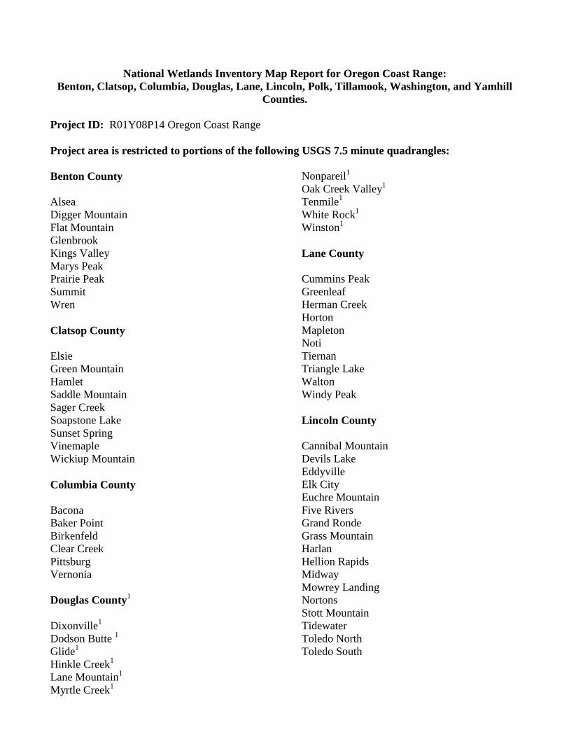
National Wetlands Inventory Map Report for Oregon Coast Range: Benton, Clatsop, Columbia, Douglas, Lane, Lincoln, Polk, Tillamook, Washington, and Yamhill Counties. Project ID: R01Y08P14 Oregon Coast Range Project area is restricted to portions of the following USGS 7.5 minute quadrangles: Benton County Alsea Digger Mountain Flat Mountain Glenbrook Kings Valley Marys Peak Prairie Peak Summit Wren Clatsop County Elsie Green Mountain Hamlet Saddle Mountain Sager Creek Soapstone Lake Sunset Spring Vinemaple Wickiup Mountain Columbia County Bacona Baker Point Birkenfeld Clear Creek Pittsburg Vernonia Douglas County 1 Dixonville 1 Dodson Butte 1 Glide 1 Hinkle Creek 1 Lane Mountain 1 Myrtle Creek 1 Nonpareil 1 Oak Creek Valley 1 Tenmile 1 White Rock 1 Winston 1 Lane County Cummins Peak Greenleaf Herman Creek Horton Mapleton Noti Tiernan Triangle Lake Walton Windy Peak Lincoln County Cannibal Mountain Devils Lake Eddyville Elk City Euchre Mountain Five Rivers Grand Ronde Grass Mountain Harlan Hellion Rapids Midway Mowrey Landing Nortons Stott Mountain Tidewater Toledo North Toledo South
Transcript of National Wetlands Inventory Map Report - FWS
National Wetlands Inventory Map Report for Oregon Coast Range:
Benton, Clatsop, Columbia, Douglas, Lane, Lincoln, Polk, Tillamook, Washington, and Yamhill
Counties.
Project ID: R01Y08P14 Oregon Coast Range
Project area is restricted to portions of the following USGS 7.5 minute quadrangles:
Benton County
Alsea
Digger Mountain
Flat Mountain
Glenbrook
Kings Valley
Marys Peak
Prairie Peak
Summit
Wren
Clatsop County
Elsie
Green Mountain
Hamlet
Saddle Mountain
Sager Creek
Soapstone Lake
Sunset Spring
Vinemaple
Wickiup Mountain
Columbia County
Bacona
Baker Point
Birkenfeld
Clear Creek
Pittsburg
Vernonia
Douglas County1
Dixonville1
Dodson Butte 1
Glide1
Hinkle Creek1
Lane Mountain1
Myrtle Creek1
Nonpareil1
Oak Creek Valley1
Tenmile1
White Rock1
Winston1
Lane County
Cummins Peak
Greenleaf
Herman Creek
Horton
Mapleton
Noti
Tiernan
Triangle Lake
Walton
Windy Peak
Lincoln County
Cannibal Mountain
Devils Lake
Eddyville
Elk City
Euchre Mountain
Five Rivers
Grand Ronde
Grass Mountain
Harlan
Hellion Rapids
Midway
Mowrey Landing
Nortons
Stott Mountain
Tidewater
Toledo North
Toledo South
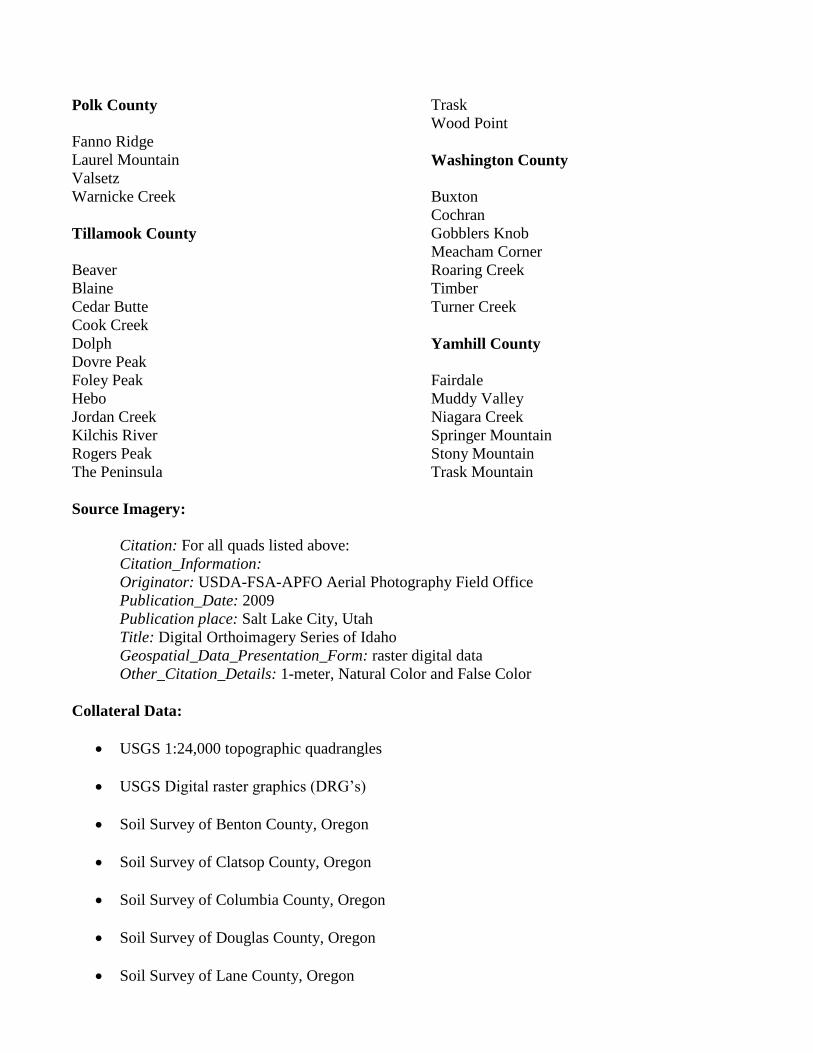
Polk County Trask
Wood Point
Fanno Ridge
Laurel Mountain Washington County
Valsetz
Warnicke Creek Buxton
Cochran
Tillamook County Gobblers Knob
Meacham Corner
Beaver Roaring Creek
Blaine Timber
Cedar Butte Turner Creek
Cook Creek
Dolph Yamhill County
Dovre Peak
Foley Peak Fairdale
Hebo Muddy Valley
Jordan Creek Niagara Creek
Kilchis River Springer Mountain
Rogers Peak Stony Mountain
The Peninsula Trask Mountain
Source Imagery:
Citation: For all quads listed above:
Citation_Information:
Originator: USDA-FSA-APFO Aerial Photography Field Office
Publication_Date: 2009
Publication place: Salt Lake City, Utah
Title: Digital Orthoimagery Series of Idaho
Geospatial_Data_Presentation_Form: raster digital data
Other_Citation_Details: 1-meter, Natural Color and False Color
Collateral Data:
USGS 1:24,000 topographic quadrangles
USGS Digital raster graphics (DRG’s)
Soil Survey of Benton County, Oregon
Soil Survey of Clatsop County, Oregon
Soil Survey of Columbia County, Oregon
Soil Survey of Douglas County, Oregon
Soil Survey of Lane County, Oregon
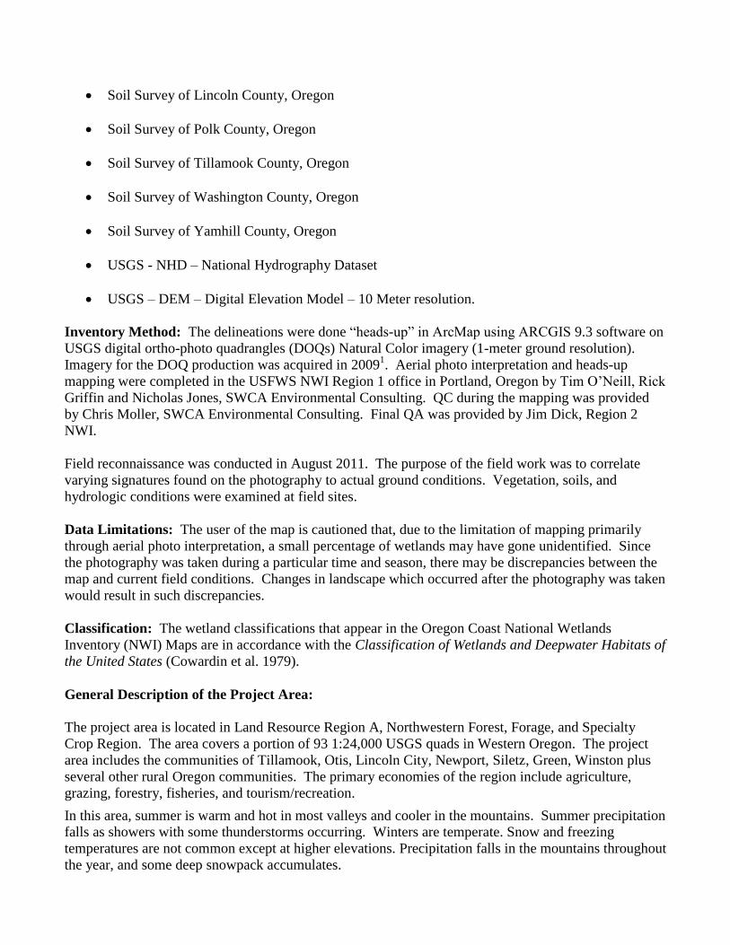
Soil Survey of Lincoln County, Oregon
Soil Survey of Polk County, Oregon
Soil Survey of Tillamook County, Oregon
Soil Survey of Washington County, Oregon
Soil Survey of Yamhill County, Oregon
USGS - NHD – National Hydrography Dataset
USGS – DEM – Digital Elevation Model – 10 Meter resolution.
Inventory Method: The delineations were done “heads-up” in ArcMap using ARCGIS 9.3 software on
USGS digital ortho-photo quadrangles (DOQs) Natural Color imagery (1-meter ground resolution).
Imagery for the DOQ production was acquired in 20091. Aerial photo interpretation and heads-up
mapping were completed in the USFWS NWI Region 1 office in Portland, Oregon by Tim O’Neill, Rick
Griffin and Nicholas Jones, SWCA Environmental Consulting. QC during the mapping was provided
by Chris Moller, SWCA Environmental Consulting. Final QA was provided by Jim Dick, Region 2
NWI.
Field reconnaissance was conducted in August 2011. The purpose of the field work was to correlate
varying signatures found on the photography to actual ground conditions. Vegetation, soils, and
hydrologic conditions were examined at field sites.
Data Limitations: The user of the map is cautioned that, due to the limitation of mapping primarily
through aerial photo interpretation, a small percentage of wetlands may have gone unidentified. Since
the photography was taken during a particular time and season, there may be discrepancies between the
map and current field conditions. Changes in landscape which occurred after the photography was taken
would result in such discrepancies.
Classification: The wetland classifications that appear in the Oregon Coast National Wetlands
Inventory (NWI) Maps are in accordance with the Classification of Wetlands and Deepwater Habitats of
the United States (Cowardin et al. 1979).
General Description of the Project Area:
The project area is located in Land Resource Region A, Northwestern Forest, Forage, and Specialty
Crop Region. The area covers a portion of 93 1:24,000 USGS quads in Western Oregon. The project
area includes the communities of Tillamook, Otis, Lincoln City, Newport, Siletz, Green, Winston plus
several other rural Oregon communities. The primary economies of the region include agriculture,
grazing, forestry, fisheries, and tourism/recreation.
In this area, summer is warm and hot in most valleys and cooler in the mountains. Summer precipitation
falls as showers with some thunderstorms occurring. Winters are temperate. Snow and freezing
temperatures are not common except at higher elevations. Precipitation falls in the mountains throughout
the year, and some deep snowpack accumulates.
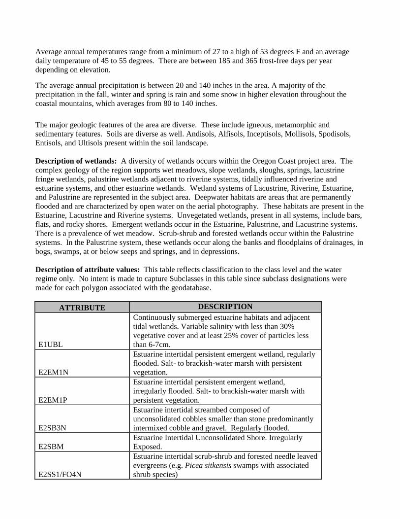
Average annual temperatures range from a minimum of 27 to a high of 53 degrees F and an average
daily temperature of 45 to 55 degrees. There are between 185 and 365 frost-free days per year
depending on elevation.
The average annual precipitation is between 20 and 140 inches in the area. A majority of the
precipitation in the fall, winter and spring is rain and some snow in higher elevation throughout the
coastal mountains, which averages from 80 to 140 inches.
The major geologic features of the area are diverse. These include igneous, metamorphic and
sedimentary features. Soils are diverse as well. Andisols, Alfisols, Inceptisols, Mollisols, Spodisols,
Entisols, and Ultisols present within the soil landscape.
Description of wetlands: A diversity of wetlands occurs within the Oregon Coast project area. The
complex geology of the region supports wet meadows, slope wetlands, sloughs, springs, lacustrine
fringe wetlands, palustrine wetlands adjacent to riverine systems, tidally influenced riverine and
estuarine systems, and other estuarine wetlands. Wetland systems of Lacustrine, Riverine, Estuarine,
and Palustrine are represented in the subject area. Deepwater habitats are areas that are permanently
flooded and are characterized by open water on the aerial photography. These habitats are present in the
Estuarine, Lacustrine and Riverine systems. Unvegetated wetlands, present in all systems, include bars,
flats, and rocky shores. Emergent wetlands occur in the Estuarine, Palustrine, and Lacustrine systems.
There is a prevalence of wet meadow. Scrub-shrub and forested wetlands occur within the Palustrine
systems. In the Palustrine system, these wetlands occur along the banks and floodplains of drainages, in
bogs, swamps, at or below seeps and springs, and in depressions.
Description of attribute values: This table reflects classification to the class level and the water
regime only. No intent is made to capture Subclasses in this table since subclass designations were
made for each polygon associated with the geodatabase.
ATTRIBUTE DESCRIPTION
E1UBL
Continuously submerged estuarine habitats and adjacent
tidal wetlands. Variable salinity with less than 30%
vegetative cover and at least 25% cover of particles less
than 6-7cm.
E2EM1N
Estuarine intertidal persistent emergent wetland, regularly
flooded. Salt- to brackish-water marsh with persistent
vegetation.
E2EM1P
Estuarine intertidal persistent emergent wetland,
irregularly flooded. Salt- to brackish-water marsh with
persistent vegetation.
E2SB3N
Estuarine intertidal streambed composed of
unconsolidated cobbles smaller than stone predominantly
intermixed cobble and gravel. Regularly flooded.
E2SBM
Estuarine Intertidal Unconsolidated Shore. Irregularly
Exposed.
E2SS1/FO4N
Estuarine intertidal scrub-shrub and forested needle leaved
evergreens (e.g. Picea sitkensis swamps with associated
shrub species)
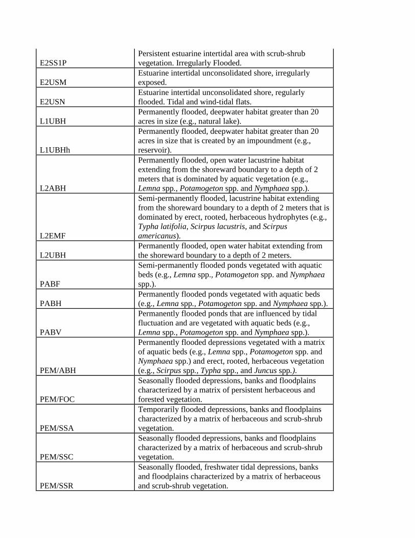
E2SS1P
Persistent estuarine intertidal area with scrub-shrub
vegetation. Irregularly Flooded.
E2USM
Estuarine intertidal unconsolidated shore, irregularly
exposed.
E2USN
Estuarine intertidal unconsolidated shore, regularly
flooded. Tidal and wind-tidal flats.
L1UBH
Permanently flooded, deepwater habitat greater than 20
acres in size (e.g., natural lake).
L1UBHh
Permanently flooded, deepwater habitat greater than 20
acres in size that is created by an impoundment (e.g.,
reservoir).
L2ABH
Permanently flooded, open water lacustrine habitat
extending from the shoreward boundary to a depth of 2
meters that is dominated by aquatic vegetation (e.g.,
Lemna spp., Potamogeton spp. and Nymphaea spp.).
L2EMF
Semi-permanently flooded, lacustrine habitat extending
from the shoreward boundary to a depth of 2 meters that is
dominated by erect, rooted, herbaceous hydrophytes (e.g.,
Typha latifolia, Scirpus lacustris, and Scirpus
americanus).
L2UBH
Permanently flooded, open water habitat extending from
the shoreward boundary to a depth of 2 meters.
PABF
Semi-permanently flooded ponds vegetated with aquatic
beds (e.g., Lemna spp., Potamogeton spp. and Nymphaea
spp.).
PABH
Permanently flooded ponds vegetated with aquatic beds
(e.g., Lemna spp., Potamogeton spp. and Nymphaea spp.).
PABV
Permanently flooded ponds that are influenced by tidal
fluctuation and are vegetated with aquatic beds (e.g.,
Lemna spp., Potamogeton spp. and Nymphaea spp.).
PEM/ABH
Permanently flooded depressions vegetated with a matrix
of aquatic beds (e.g., Lemna spp., Potamogeton spp. and
Nymphaea spp.) and erect, rooted, herbaceous vegetation
(e.g., Scirpus spp., Typha spp., and Juncus spp.).
PEM/FOC
Seasonally flooded depressions, banks and floodplains
characterized by a matrix of persistent herbaceous and
forested vegetation.
PEM/SSA
Temporarily flooded depressions, banks and floodplains
characterized by a matrix of herbaceous and scrub-shrub
vegetation.
PEM/SSC
Seasonally flooded depressions, banks and floodplains
characterized by a matrix of herbaceous and scrub-shrub
vegetation.
PEM/SSR
Seasonally flooded, freshwater tidal depressions, banks
and floodplains characterized by a matrix of herbaceous
and scrub-shrub vegetation.
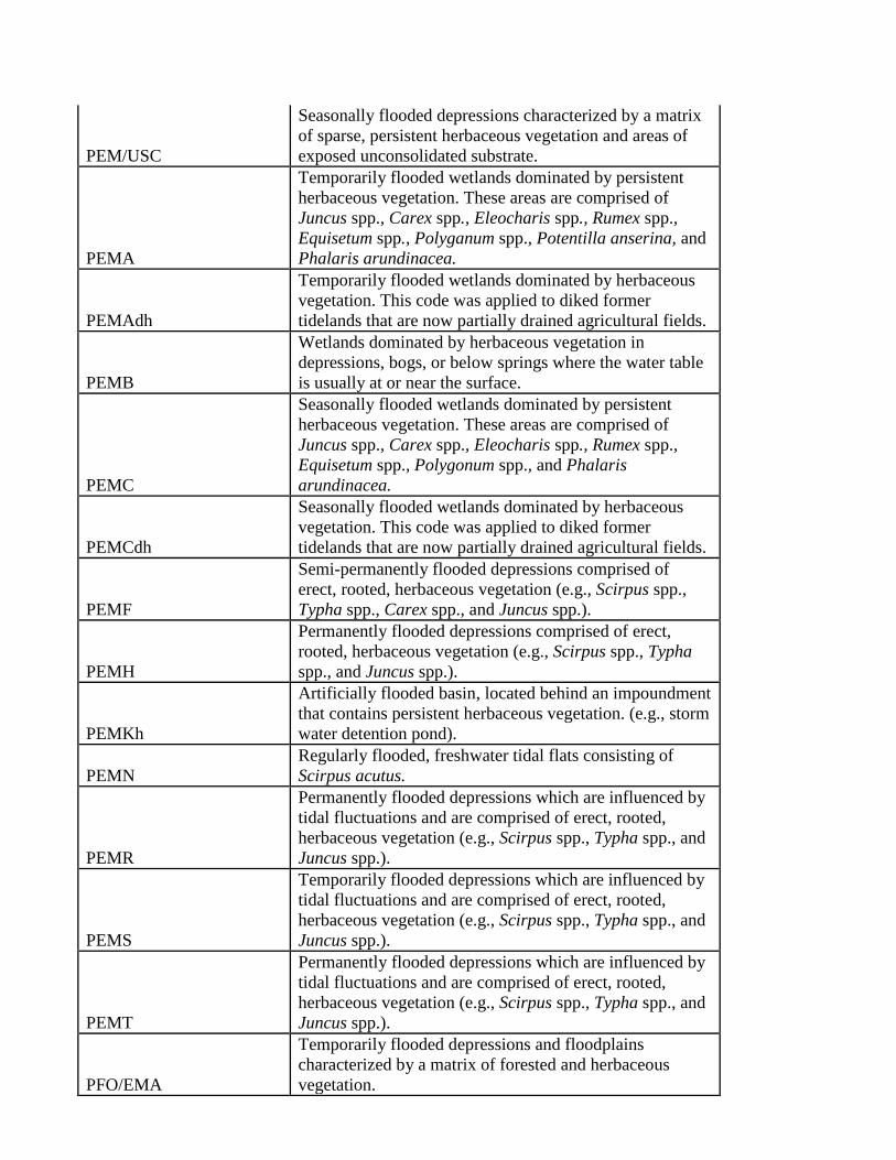
PEM/USC
Seasonally flooded depressions characterized by a matrix
of sparse, persistent herbaceous vegetation and areas of
exposed unconsolidated substrate.
PEMA
Temporarily flooded wetlands dominated by persistent
herbaceous vegetation. These areas are comprised of
Juncus spp., Carex spp., Eleocharis spp., Rumex spp.,
Equisetum spp., Polyganum spp., Potentilla anserina, and
Phalaris arundinacea.
PEMAdh
Temporarily flooded wetlands dominated by herbaceous
vegetation. This code was applied to diked former
tidelands that are now partially drained agricultural fields.
PEMB
Wetlands dominated by herbaceous vegetation in
depressions, bogs, or below springs where the water table
is usually at or near the surface.
PEMC
Seasonally flooded wetlands dominated by persistent
herbaceous vegetation. These areas are comprised of
Juncus spp., Carex spp., Eleocharis spp., Rumex spp.,
Equisetum spp., Polygonum spp., and Phalaris
arundinacea.
PEMCdh
Seasonally flooded wetlands dominated by herbaceous
vegetation. This code was applied to diked former
tidelands that are now partially drained agricultural fields.
PEMF
Semi-permanently flooded depressions comprised of
erect, rooted, herbaceous vegetation (e.g., Scirpus spp.,
Typha spp., Carex spp., and Juncus spp.).
PEMH
Permanently flooded depressions comprised of erect,
rooted, herbaceous vegetation (e.g., Scirpus spp., Typha
spp., and Juncus spp.).
PEMKh
Artificially flooded basin, located behind an impoundment
that contains persistent herbaceous vegetation. (e.g., storm
water detention pond).
PEMN
Regularly flooded, freshwater tidal flats consisting of
Scirpus acutus.
PEMR
Permanently flooded depressions which are influenced by
tidal fluctuations and are comprised of erect, rooted,
herbaceous vegetation (e.g., Scirpus spp., Typha spp., and
Juncus spp.).
PEMS
Temporarily flooded depressions which are influenced by
tidal fluctuations and are comprised of erect, rooted,
herbaceous vegetation (e.g., Scirpus spp., Typha spp., and
Juncus spp.).
PEMT
Permanently flooded depressions which are influenced by
tidal fluctuations and are comprised of erect, rooted,
herbaceous vegetation (e.g., Scirpus spp., Typha spp., and
Juncus spp.).
PFO/EMA
Temporarily flooded depressions and floodplains
characterized by a matrix of forested and herbaceous
vegetation.
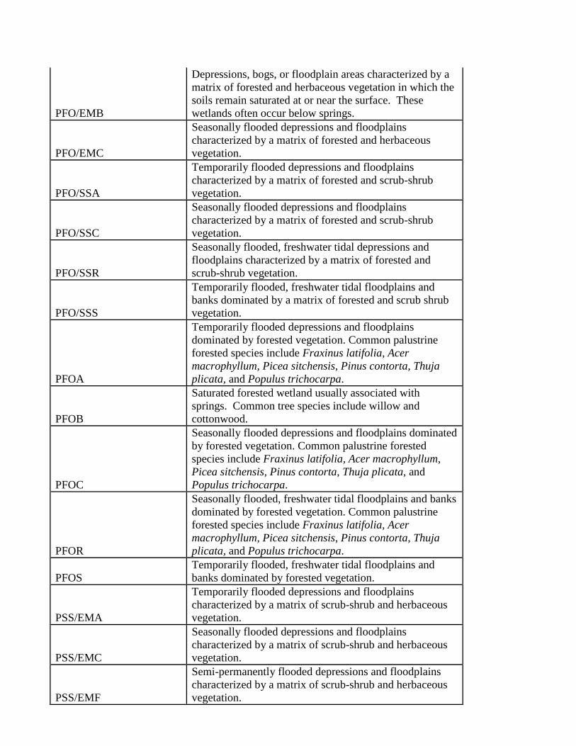
PFO/EMB
Depressions, bogs, or floodplain areas characterized by a
matrix of forested and herbaceous vegetation in which the
soils remain saturated at or near the surface. These
wetlands often occur below springs.
PFO/EMC
Seasonally flooded depressions and floodplains
characterized by a matrix of forested and herbaceous
vegetation.
PFO/SSA
Temporarily flooded depressions and floodplains
characterized by a matrix of forested and scrub-shrub
vegetation.
PFO/SSC
Seasonally flooded depressions and floodplains
characterized by a matrix of forested and scrub-shrub
vegetation.
PFO/SSR
Seasonally flooded, freshwater tidal depressions and
floodplains characterized by a matrix of forested and
scrub-shrub vegetation.
PFO/SSS
Temporarily flooded, freshwater tidal floodplains and
banks dominated by a matrix of forested and scrub shrub
vegetation.
PFOA
Temporarily flooded depressions and floodplains
dominated by forested vegetation. Common palustrine
forested species include Fraxinus latifolia, Acer
macrophyllum, Picea sitchensis, Pinus contorta, Thuja
plicata, and Populus trichocarpa.
PFOB
Saturated forested wetland usually associated with
springs. Common tree species include willow and
cottonwood.
PFOC
Seasonally flooded depressions and floodplains dominated
by forested vegetation. Common palustrine forested
species include Fraxinus latifolia, Acer macrophyllum,
Picea sitchensis, Pinus contorta, Thuja plicata, and
Populus trichocarpa.
PFOR
Seasonally flooded, freshwater tidal floodplains and banks
dominated by forested vegetation. Common palustrine
forested species include Fraxinus latifolia, Acer
macrophyllum, Picea sitchensis, Pinus contorta, Thuja
plicata, and Populus trichocarpa.
PFOS
Temporarily flooded, freshwater tidal floodplains and
banks dominated by forested vegetation.
PSS/EMA
Temporarily flooded depressions and floodplains
characterized by a matrix of scrub-shrub and herbaceous
vegetation.
PSS/EMC
Seasonally flooded depressions and floodplains
characterized by a matrix of scrub-shrub and herbaceous
vegetation.
PSS/EMF
Semi-permanently flooded depressions and floodplains
characterized by a matrix of scrub-shrub and herbaceous
vegetation.
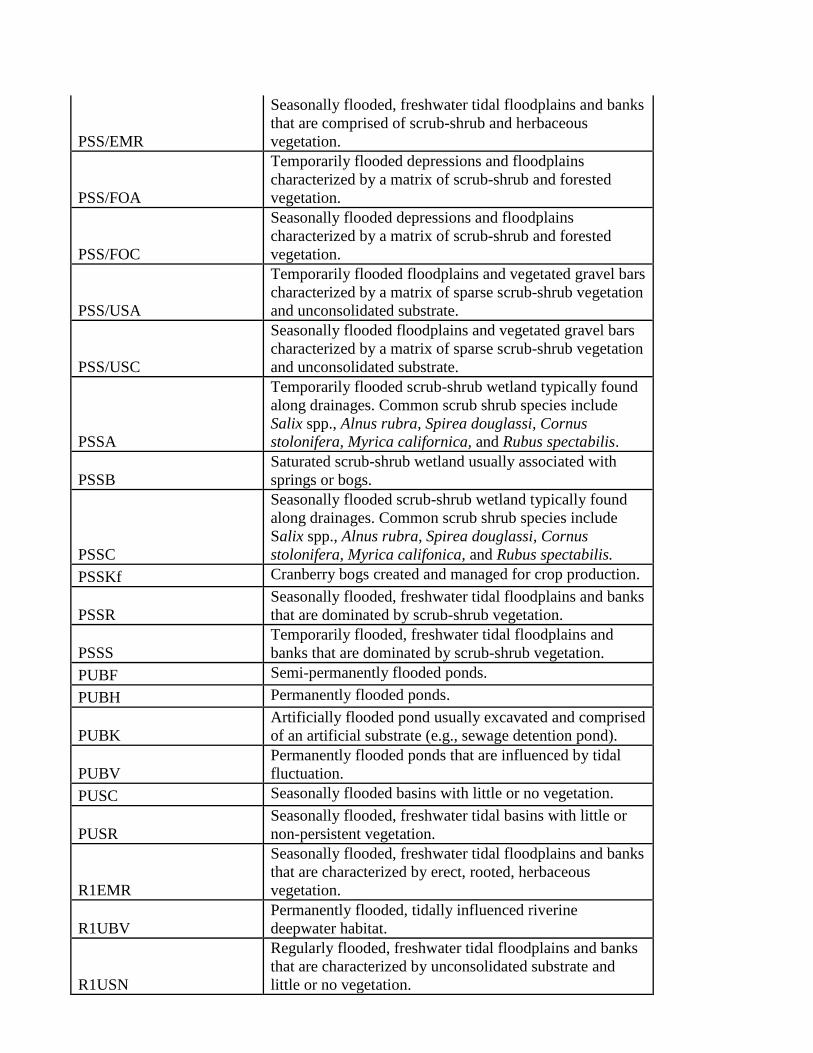
PSS/EMR
Seasonally flooded, freshwater tidal floodplains and banks
that are comprised of scrub-shrub and herbaceous
vegetation.
PSS/FOA
Temporarily flooded depressions and floodplains
characterized by a matrix of scrub-shrub and forested
vegetation.
PSS/FOC
Seasonally flooded depressions and floodplains
characterized by a matrix of scrub-shrub and forested
vegetation.
PSS/USA
Temporarily flooded floodplains and vegetated gravel bars
characterized by a matrix of sparse scrub-shrub vegetation
and unconsolidated substrate.
PSS/USC
Seasonally flooded floodplains and vegetated gravel bars
characterized by a matrix of sparse scrub-shrub vegetation
and unconsolidated substrate.
PSSA
Temporarily flooded scrub-shrub wetland typically found
along drainages. Common scrub shrub species include
Salix spp., Alnus rubra, Spirea douglassi, Cornus
stolonifera, Myrica californica, and Rubus spectabilis.
PSSB
Saturated scrub-shrub wetland usually associated with
springs or bogs.
PSSC
Seasonally flooded scrub-shrub wetland typically found
along drainages. Common scrub shrub species include
Salix spp., Alnus rubra, Spirea douglassi, Cornus
stolonifera, Myrica califonica, and Rubus spectabilis.
PSSKf Cranberry bogs created and managed for crop production.
PSSR
Seasonally flooded, freshwater tidal floodplains and banks
that are dominated by scrub-shrub vegetation.
PSSS
Temporarily flooded, freshwater tidal floodplains and
banks that are dominated by scrub-shrub vegetation.
PUBF Semi-permanently flooded ponds.
PUBH Permanently flooded ponds.
PUBK
Artificially flooded pond usually excavated and comprised
of an artificial substrate (e.g., sewage detention pond).
PUBV
Permanently flooded ponds that are influenced by tidal
fluctuation.
PUSC Seasonally flooded basins with little or no vegetation.
PUSR
Seasonally flooded, freshwater tidal basins with little or
non-persistent vegetation.
R1EMR
Seasonally flooded, freshwater tidal floodplains and banks
that are characterized by erect, rooted, herbaceous
vegetation.
R1UBV
Permanently flooded, tidally influenced riverine
deepwater habitat.
R1USN
Regularly flooded, freshwater tidal floodplains and banks
that are characterized by unconsolidated substrate and
little or no vegetation.
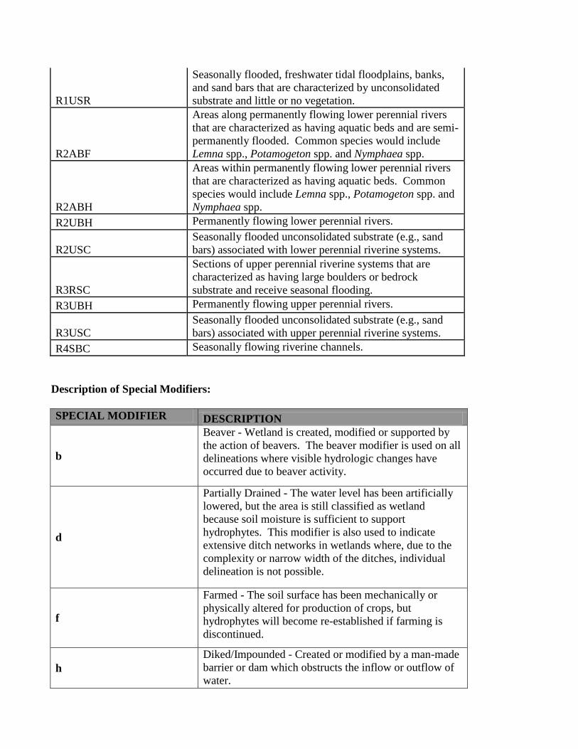
R1USR
Seasonally flooded, freshwater tidal floodplains, banks,
and sand bars that are characterized by unconsolidated
substrate and little or no vegetation.
R2ABF
Areas along permanently flowing lower perennial rivers
that are characterized as having aquatic beds and are semi-
permanently flooded. Common species would include
Lemna spp., Potamogeton spp. and Nymphaea spp.
R2ABH
Areas within permanently flowing lower perennial rivers
that are characterized as having aquatic beds. Common
species would include Lemna spp., Potamogeton spp. and
Nymphaea spp.
R2UBH Permanently flowing lower perennial rivers.
R2USC
Seasonally flooded unconsolidated substrate (e.g., sand
bars) associated with lower perennial riverine systems.
R3RSC
Sections of upper perennial riverine systems that are
characterized as having large boulders or bedrock
substrate and receive seasonal flooding.
R3UBH Permanently flowing upper perennial rivers.
R3USC
Seasonally flooded unconsolidated substrate (e.g., sand
bars) associated with upper perennial riverine systems.
R4SBC Seasonally flowing riverine channels.
Description of Special Modifiers:
SPECIAL MODIFIER DESCRIPTION
b
Beaver - Wetland is created, modified or supported by
the action of beavers. The beaver modifier is used on all
delineations where visible hydrologic changes have
occurred due to beaver activity.
d
Partially Drained - The water level has been artificially
lowered, but the area is still classified as wetland
because soil moisture is sufficient to support
hydrophytes. This modifier is also used to indicate
extensive ditch networks in wetlands where, due to the
complexity or narrow width of the ditches, individual
delineation is not possible.
f
Farmed - The soil surface has been mechanically or
physically altered for production of crops, but
hydrophytes will become re-established if farming is
discontinued.
h
Diked/Impounded - Created or modified by a man-made
barrier or dam which obstructs the inflow or outflow of
water.
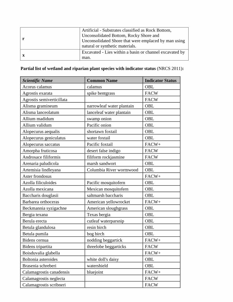
r
Artificial - Substrates classified as Rock Bottom,
Unconsolidated Bottom, Rocky Shore and
Unconsolidated Shore that were emplaced by man using
natural or synthetic materials.
x Excavated - Lies within a basin or channel excavated by
man.
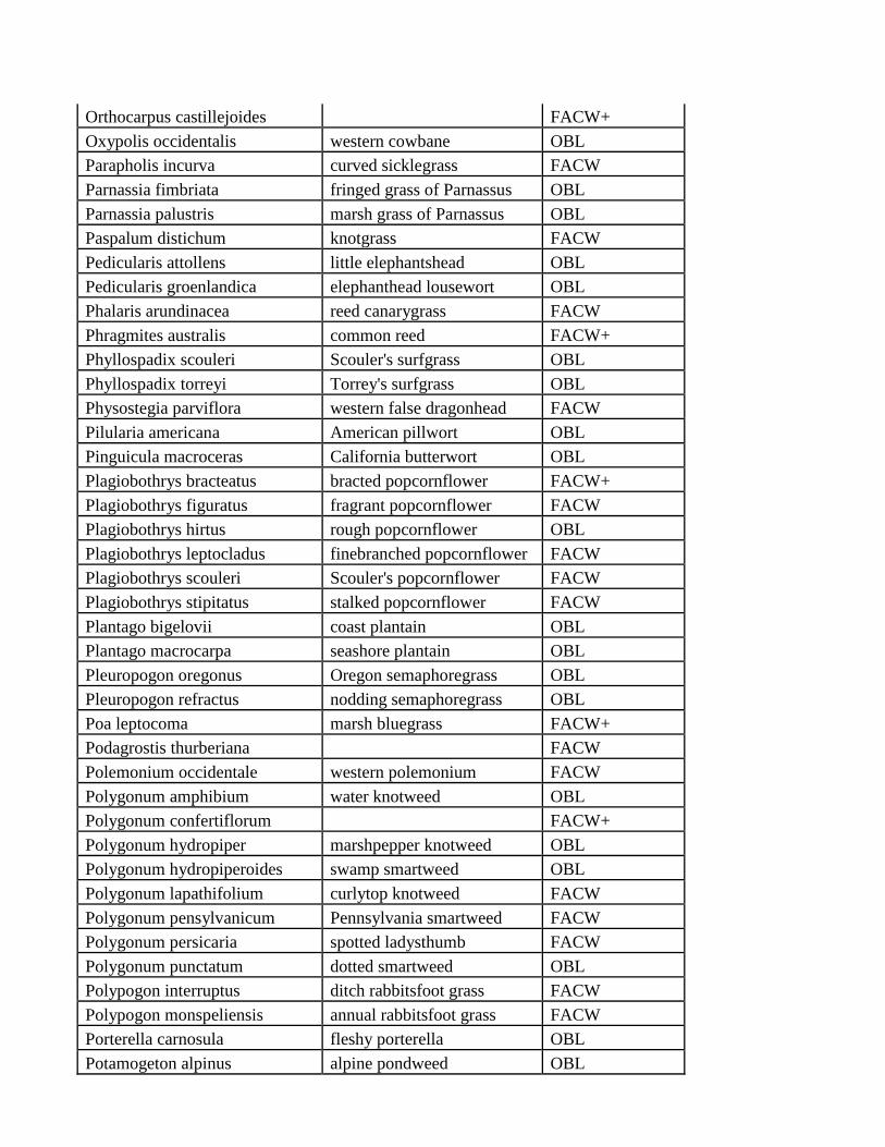
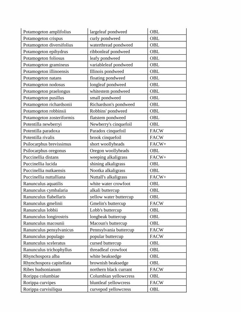
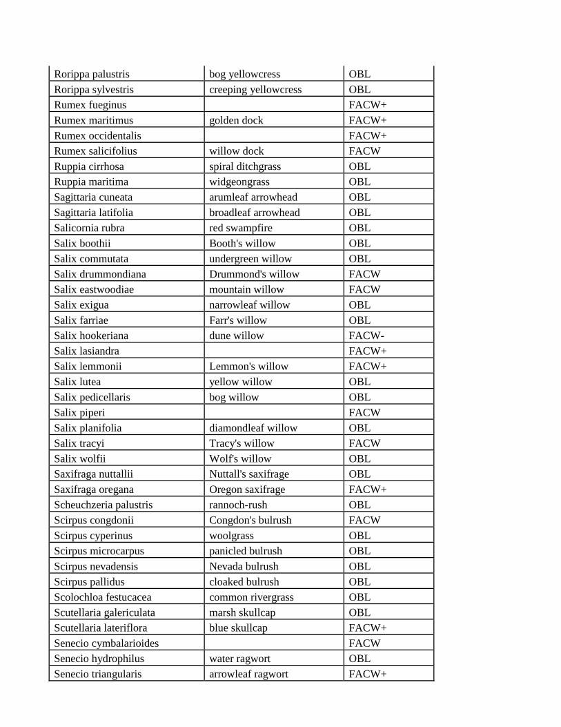
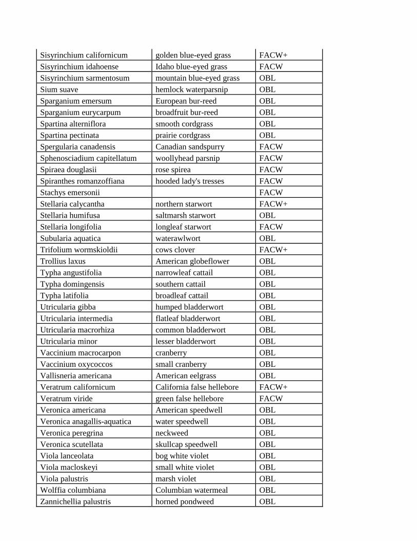
Partial list of wetland and riparian plant species with indicator status (NRCS 2011):
Scientific Name Common Name Indicator Status
Acorus calamus calamus OBL
Agrostis exarata spike bentgrass FACW
Agrostis semiverticillata FACW
Alisma gramineum narrowleaf water plantain OBL
Alisma lanceolatum lanceleaf water plantain OBL
Allium madidum swamp onion OBL
Allium validum Pacific onion OBL
Alopecurus aequalis shortawn foxtail OBL
Alopecurus geniculatus water foxtail OBL
Alopecurus saccatus Pacific foxtail FACW+
Amorpha fruticosa desert false indigo FACW
Androsace filiformis filiform rockjasmine FACW
Arenaria paludicola marsh sandwort OBL
Artemisia lindleyana Columbia River wormwood OBL
Aster frondosus FACW+
Azolla filiculoides Pacific mosquitofern OBL
Azolla mexicana Mexican mosquitofern OBL
Baccharis douglasii saltmarsh baccharis OBL
Barbarea orthoceras American yellowrocket FACW+
Beckmannia syzigachne American sloughgrass OBL
Bergia texana Texas bergia OBL
Berula erecta cutleaf waterparsnip OBL
Betula glandulosa resin birch OBL
Betula pumila bog birch OBL
Bidens cernua nodding beggartick FACW+
Bidens tripartita threelobe beggarticks FACW
Boisduvalia glabella FACW+
Boltonia asteroides white doll's daisy OBL
Brasenia schreberi watershield OBL
Calamagrostis canadensis bluejoint FACW+
Calamagrostis neglecta FACW
Calamagrostis scribneri FACW
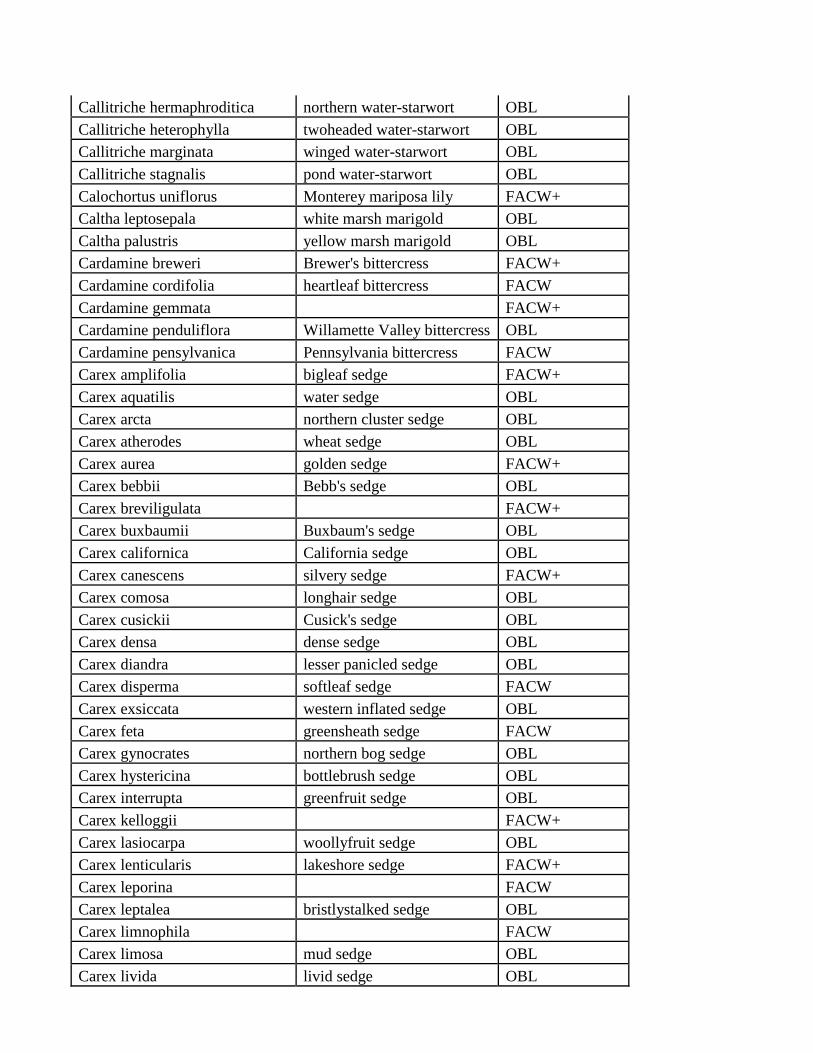
Callitriche hermaphroditica northern water-starwort OBL
Callitriche heterophylla twoheaded water-starwort OBL
Callitriche marginata winged water-starwort OBL
Callitriche stagnalis pond water-starwort OBL
Calochortus uniflorus Monterey mariposa lily FACW+
Caltha leptosepala white marsh marigold OBL
Caltha palustris yellow marsh marigold OBL
Cardamine breweri Brewer's bittercress FACW+
Cardamine cordifolia heartleaf bittercress FACW
Cardamine gemmata FACW+
Cardamine penduliflora Willamette Valley bittercress OBL
Cardamine pensylvanica Pennsylvania bittercress FACW
Carex amplifolia bigleaf sedge FACW+
Carex aquatilis water sedge OBL
Carex arcta northern cluster sedge OBL
Carex atherodes wheat sedge OBL
Carex aurea golden sedge FACW+
Carex bebbii Bebb's sedge OBL
Carex breviligulata FACW+
Carex buxbaumii Buxbaum's sedge OBL
Carex californica California sedge OBL
Carex canescens silvery sedge FACW+
Carex comosa longhair sedge OBL
Carex cusickii Cusick's sedge OBL
Carex densa dense sedge OBL
Carex diandra lesser panicled sedge OBL
Carex disperma softleaf sedge FACW
Carex exsiccata western inflated sedge OBL
Carex feta greensheath sedge FACW
Carex gynocrates northern bog sedge OBL
Carex hystericina bottlebrush sedge OBL
Carex interrupta greenfruit sedge OBL
Carex kelloggii FACW+
Carex lasiocarpa woollyfruit sedge OBL
Carex lenticularis lakeshore sedge FACW+
Carex leporina FACW
Carex leptalea bristlystalked sedge OBL
Carex limnophila FACW
Carex limosa mud sedge OBL
Carex livida livid sedge OBL
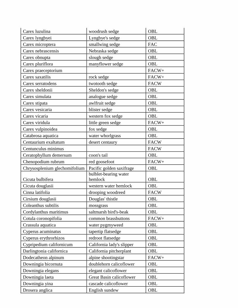
Carex luzulina woodrush sedge OBL
Carex lyngbyei Lyngbye's sedge OBL
Carex microptera smallwing sedge FAC
Carex nebrascensis Nebraska sedge OBL
Carex obnupta slough sedge OBL
Carex pluriflora manyflower sedge OBL
Carex praeceptorium FACW+
Carex saxatilis rock sedge FACW+
Carex serratodens twotooth sedge FACW
Carex sheldonii Sheldon's sedge OBL
Carex simulata analogue sedge OBL
Carex stipata awlfruit sedge OBL
Carex vesicaria blister sedge OBL
Carex vicaria western fox sedge OBL
Carex viridula little green sedge FACW+
Carex vulpinoidea fox sedge OBL
Catabrosa aquatica water whorlgrass OBL
Centaurium exaltatum desert centaury FACW
Centunculus minimus FACW
Ceratophyllum demersum coon's tail OBL
Chenopodium rubrum red goosefoot FACW+
Chrysosplenium glechomifolium Pacific golden saxifrage OBL
Cicuta bulbifera
bulblet-bearing water
hemlock OBL
Cicuta douglasii western water hemlock OBL
Cinna latifolia drooping woodreed FACW
Cirsium douglasii Douglas' thistle OBL
Coleanthus subtilis mossgrass OBL
Cordylanthus maritimus saltmarsh bird's-beak OBL
Cotula coronopifolia common brassbuttons FACW+
Crassula aquatica water pygmyweed OBL
Cyperus acuminatus tapertip flatsedge OBL
Cyperus erythrorhizos redroot flatsedge OBL
Cypripedium californicum California lady's slipper OBL
Darlingtonia californica California pitcherplant OBL
Dodecatheon alpinum alpine shootingstar FACW+
Downingia bicornuta doublehorn calicoflower OBL
Downingia elegans elegant calicoflower OBL
Downingia laeta Great Basin calicoflower OBL
Downingia yina cascade calicoflower OBL
Drosera anglica English sundew OBL
Drosera rotundifolia roundleaf sundew OBL
Dulichium arundinaceum threeway sedge OBL
Echinochloa crus-galli barnyardgrass FACW
Echinochloa crus-pavonis gulf cockspur grass FACW
Echinochloa muricata rough barnyardgrass FACW
Egeria densa Brazilian waterweed OBL
Elatine brachysperma shortseed waterwort OBL
Elatine californica California waterwort OBL
Eleocharis acicularis needle spikerush OBL
Eleocharis engelmannii Engelmann's spikerush OBL
Eleocharis macrostachya pale spikerush OBL
Eleocharis obtusa blunt spikerush OBL
Eleocharis ovata ovate spikerush OBL
Eleocharis palustris common spikerush OBL
Eleocharis parishii Parish's spikerush FACW+
Eleocharis parvula dwarf spikerush OBL
Eleocharis rostellata beaked spikerush OBL
Eleocharis uniglumis onescale spikerush OBL
Elodea bifoliata twoleaf waterweed NI
Elodea canadensis Canadian waterweed OBL
Elodea nuttallii western waterweed OBL
Epilobium glaberrimum glaucus willowherb FACW
Epilobium leptophyllum bog willowherb FACW
Epilobium oreganum Grants Pass willowherb OBL
Epilobium oregonense Oregon willowherb FACW
Epilobium palustre marsh willowherb OBL
Epipactis gigantea stream orchid OBL
Equisetum fluviatile water horsetail OBL
Equisetum telmateia giant horsetail FACW
Eragrostis hypnoides teal lovegrass OBL
Erigeron coulteri large mountain fleabane FACW
Eriophorum angustifolium tall cottongrass OBL
Eriophorum chamissonis Chamisso's cottongrass OBL
Eriophorum crinigerum fringed cottongrass OBL
Eriophorum gracile slender cottongrass OBL
Eryngium articulatum beethistle OBL
Eryngium petiolatum rushleaf eryngo OBL
Galium trifidum threepetal bedstraw FACW+
Gentiana prostrata pygmy gentian FACW
Gentiana sceptrum king's scepter gentian OBL
Gentiana setigera Mendocino gentian OBL
Gentianopsis simplex oneflower fringed gentian FACW
Glaux maritima sea milkwort FACW+
Glyceria ×occidentalis northwestern mannagrass OBL
Glyceria borealis small floating mannagrass OBL
Glyceria elata FACW+
Glyceria leptostachya davy mannagrass OBL
Glyceria striata fowl mannagrass OBL
Gratiola ebracteata bractless hedgehyssop OBL
Gratiola neglecta clammy hedgehyssop OBL
Helenium autumnale common sneezeweed FACW
Helenium bigelovii Bigelow's sneezeweed FACW+
Helenium bolanderi coastal sneezeweed FACW
Heliotropium curassavicum salt heliotrope OBL
Hemicarpha aristulata FACW
Hemicarpha occidentalis FACW
Hippuris vulgaris common mare's-tail OBL
Howellia aquatilis water howellia OBL
Hydrocotyle ranunculoides floating marshpennywort OBL
Hydrocotyle umbellata
manyflower
marshpennywort OBL
Hypericum anagalloides tinker's penny OBL
Iris missouriensis Rocky Mountain iris FACW+
Iris pseudacorus paleyellow iris OBL
Isoetes bolanderi Bolander's quillwort OBL
Isoetes howellii Howell's quillwort OBL
Isoetes nuttallii Nuttall's quillwort OBL
Jaumea carnosa marsh jaumea OBL
Juncus acuminatus tapertip rush OBL
Juncus albescens northern white rush OBL
Juncus articulatus jointleaf rush OBL
Juncus balticus FACW+
Juncus bolanderi Bolander's rush OBL
Juncus bufonius toad rush FACW
Juncus bulbosus bulbous rush OBL
Juncus effusus common rush FACW
Juncus filiformis thread rush FACW+
Juncus gerardii saltmeadow rush FACW+
Juncus hemiendytus Herman's dwarf rush FACW+
Juncus mertensianus Mertens' rush OBL
Juncus nodosus knotted rush OBL
Juncus regelii Regel's rush FACW
Juncus saximontanus Rocky Mountain rush FACW
Juncus supiniformis hairyleaf rush OBL
Juncus uncialis twelfth rush FACW+
Kalmia microphylla alpine laurel FACW+
Kobresia simpliciuscula simple bog sedge FAC
Lasthenia glaberrima smooth goldfields OBL
Lathyrus palustris marsh pea OBL
Ledum glandulosum western Labrador tea FACW+
Ledum groenlandicum bog Labrador tea OBL
Leersia oryzoides rice cutgrass OBL
Lemna gibba swollen duckweed OBL
Lemna minor common duckweed OBL
Lemna trisulca star duckweed OBL
Lemna valdiviana valdivia duckweed OBL
Lepidium dictyotum alkali pepperweed FACW
Leptochloa fascicularis FACW
Leucothoe davisiae Sierra laurel FACW
Lilaea scilloides awl-leaf lilaea OBL
Lilaeopsis occidentalis western grasswort OBL
Lilium pardalinum leopard lily FACW+
Lilium parvum Sierra tiger lily OBL
Limnanthes douglasii Douglas' meadowfoam OBL
Limnanthes floccosa woolly meadowfoam OBL
Limnanthes gracilis slender meadowfoam OBL
Limosella acaulis Owyhee mudwort OBL
Limosella aquatica water mudwort OBL
Lindernia dubia yellowseed false pimpernel OBL
Lobelia dortmanna Dortmann's cardinalflower OBL
Ludwigia palustris marsh seedbox OBL
Lycopus americanus American water horehound OBL
Lycopus asper rough bugleweed OBL
Lycopus uniflorus northern bugleweed OBL
Lysichiton americanus American skunkcabbage OBL
Lysimachia hybrida lowland yellow loosestrife OBL
Lysimachia nummularia creeping jenny FACW
Lysimachia terrestris earth loosestrife OBL
Lysimachia thyrsiflora tufted loosestrife OBL
Lythrum salicaria purple loosestrife FACW+
Marsilea vestita hairy waterclover OBL
Mentha ×piperita peppermint FACW+
Mentha aquatica water mint NO
Mentha citrata FACW
Mentha pulegium pennyroyal OBL
Mentha spicata spearmint OBL
Menyanthes trifoliata buckbean OBL
Mertensia ciliata tall fringed bluebells FACW+
Mimetanthe pilosa false monkeyflower FACW
Mimulus alsinoides wingstem monkeyflower OBL
Mimulus cardinalis scarlet monkeyflower FACW
Mimulus dentatus coastal monkeyflower OBL
Mimulus floribundus
manyflowered
monkeyflower OBL
Mimulus guttatus seep monkeyflower OBL
Mimulus lewisii purple monkeyflower FACW+
Mimulus moschatus muskflower FACW+
Mimulus nasutus FACW
Mimulus primuloides primrose monkeyflower FACW+
Mimulus ringens Allegheny monkeyflower OBL
Mimulus tilingii Tiling's monkeyflower OBL
Mimulus tricolor tricolor monkeyflower OBL
Mimulus washingtonensis Washington monkeyflower OBL
Mitella ovalis coastal miterwort OBL
Montia chamissoi water minerslettuce OBL
Montia fontana annual water minerslettuce OBL
Myosotis laxa bay forget-me-not OBL
Myosotis scorpioides true forget-me-not FACW
Myosurus minimus tiny mousetail OBL
Myrica gale sweetgale OBL
Myriophyllum hippuroides western watermilfoil OBL
Myriophyllum spicatum Eurasian watermilfoil OBL
Myriophyllum verticillatum whorl-leaf watermilfoil OBL
Najas flexilis nodding waternymph OBL
Najas guadalupensis southern waternymph OBL
Narthecium californicum California bog asphodel OBL
Nasturtium officinale watercress OBL
Navarretia intertexta needleleaf navarretia FACW
Navarretia leucocephala whitehead navarretia OBL
Nuphar lutea yellow pond-lily OBL
Nymphaea odorata American white waterlily OBL
Oenanthe sarmentosa water parsely OBL
Orthocarpus castillejoides FACW+
Oxypolis occidentalis western cowbane OBL
Parapholis incurva curved sicklegrass FACW
Parnassia fimbriata fringed grass of Parnassus OBL
Parnassia palustris marsh grass of Parnassus OBL
Paspalum distichum knotgrass FACW
Pedicularis attollens little elephantshead OBL
Pedicularis groenlandica elephanthead lousewort OBL
Phalaris arundinacea reed canarygrass FACW
Phragmites australis common reed FACW+
Phyllospadix scouleri Scouler's surfgrass OBL
Phyllospadix torreyi Torrey's surfgrass OBL
Physostegia parviflora western false dragonhead FACW
Pilularia americana American pillwort OBL
Pinguicula macroceras California butterwort OBL
Plagiobothrys bracteatus bracted popcornflower FACW+
Plagiobothrys figuratus fragrant popcornflower FACW
Plagiobothrys hirtus rough popcornflower OBL
Plagiobothrys leptocladus finebranched popcornflower FACW
Plagiobothrys scouleri Scouler's popcornflower FACW
Plagiobothrys stipitatus stalked popcornflower FACW
Plantago bigelovii coast plantain OBL
Plantago macrocarpa seashore plantain OBL
Pleuropogon oregonus Oregon semaphoregrass OBL
Pleuropogon refractus nodding semaphoregrass OBL
Poa leptocoma marsh bluegrass FACW+
Podagrostis thurberiana FACW
Polemonium occidentale western polemonium FACW
Polygonum amphibium water knotweed OBL
Polygonum confertiflorum FACW+
Polygonum hydropiper marshpepper knotweed OBL
Polygonum hydropiperoides swamp smartweed OBL
Polygonum lapathifolium curlytop knotweed FACW
Polygonum pensylvanicum Pennsylvania smartweed FACW
Polygonum persicaria spotted ladysthumb FACW
Polygonum punctatum dotted smartweed OBL
Polypogon interruptus ditch rabbitsfoot grass FACW
Polypogon monspeliensis annual rabbitsfoot grass FACW
Porterella carnosula fleshy porterella OBL
Potamogeton alpinus alpine pondweed OBL
Potamogeton amplifolius largeleaf pondweed OBL
Potamogeton crispus curly pondweed OBL
Potamogeton diversifolius waterthread pondweed OBL
Potamogeton epihydrus ribbonleaf pondweed OBL
Potamogeton foliosus leafy pondweed OBL
Potamogeton gramineus variableleaf pondweed OBL
Potamogeton illinoensis Illinois pondweed OBL
Potamogeton natans floating pondweed OBL
Potamogeton nodosus longleaf pondweed OBL
Potamogeton praelongus whitestem pondweed OBL
Potamogeton pusillus small pondweed OBL
Potamogeton richardsonii Richardson's pondweed OBL
Potamogeton robbinsii Robbins' pondweed OBL
Potamogeton zosteriformis flatstem pondweed OBL
Potentilla newberryi Newberry's cinquefoil OBL
Potentilla paradoxa Paradox cinquefoil FACW
Potentilla rivalis brook cinquefoil FACW
Psilocarphus brevissimus short woollyheads FACW+
Psilocarphus oregonus Oregon woollyheads OBL
Puccinellia distans weeping alkaligrass FACW+
Puccinellia lucida shining alkaligrass OBL
Puccinellia nutkaensis Nootka alkaligrass OBL
Puccinellia nuttalliana Nuttall's alkaligrass FACW+
Ranunculus aquatilis white water crowfoot OBL
Ranunculus cymbalaria alkali buttercup OBL
Ranunculus flabellaris yellow water buttercup OBL
Ranunculus gmelinii Gmelin's buttercup FACW
Ranunculus lobbii Lobb's buttercup OBL
Ranunculus longirostris longbeak buttercup OBL
Ranunculus macounii Macoun's buttercup OBL
Ranunculus pensylvanicus Pennsylvania buttercup FACW
Ranunculus populago popular buttercup FACW
Ranunculus sceleratus cursed buttercup OBL
Ranunculus trichophyllus threadleaf crowfoot OBL
Rhynchospora alba white beaksedge OBL
Rhynchospora capitellata brownish beaksedge OBL
Ribes hudsonianum northern black currant FACW
Rorippa columbiae Columbian yellowcress OBL
Rorippa curvipes bluntleaf yellowcress FACW
Rorippa curvisiliqua curvepod yellowcress OBL
Rorippa palustris bog yellowcress OBL
Rorippa sylvestris creeping yellowcress OBL
Rumex fueginus FACW+
Rumex maritimus golden dock FACW+
Rumex occidentalis FACW+
Rumex salicifolius willow dock FACW
Ruppia cirrhosa spiral ditchgrass OBL
Ruppia maritima widgeongrass OBL
Sagittaria cuneata arumleaf arrowhead OBL
Sagittaria latifolia broadleaf arrowhead OBL
Salicornia rubra red swampfire OBL
Salix boothii Booth's willow OBL
Salix commutata undergreen willow OBL
Salix drummondiana Drummond's willow FACW
Salix eastwoodiae mountain willow FACW
Salix exigua narrowleaf willow OBL
Salix farriae Farr's willow OBL
Salix hookeriana dune willow FACW-
Salix lasiandra FACW+
Salix lemmonii Lemmon's willow FACW+
Salix lutea yellow willow OBL
Salix pedicellaris bog willow OBL
Salix piperi FACW
Salix planifolia diamondleaf willow OBL
Salix tracyi Tracy's willow FACW
Salix wolfii Wolf's willow OBL
Saxifraga nuttallii Nuttall's saxifrage OBL
Saxifraga oregana Oregon saxifrage FACW+
Scheuchzeria palustris rannoch-rush OBL
Scirpus congdonii Congdon's bulrush FACW
Scirpus cyperinus woolgrass OBL
Scirpus microcarpus panicled bulrush OBL
Scirpus nevadensis Nevada bulrush OBL
Scirpus pallidus cloaked bulrush OBL
Scolochloa festucacea common rivergrass OBL
Scutellaria galericulata marsh skullcap OBL
Scutellaria lateriflora blue skullcap FACW+
Senecio cymbalarioides FACW
Senecio hydrophilus water ragwort OBL
Senecio triangularis arrowleaf ragwort FACW+
Sisyrinchium californicum golden blue-eyed grass FACW+
Sisyrinchium idahoense Idaho blue-eyed grass FACW
Sisyrinchium sarmentosum mountain blue-eyed grass OBL
Sium suave hemlock waterparsnip OBL
Sparganium emersum European bur-reed OBL
Sparganium eurycarpum broadfruit bur-reed OBL
Spartina alterniflora smooth cordgrass OBL
Spartina pectinata prairie cordgrass OBL
Spergularia canadensis Canadian sandspurry FACW
Sphenosciadium capitellatum woollyhead parsnip FACW
Spiraea douglasii rose spirea FACW
Spiranthes romanzoffiana hooded lady's tresses FACW
Stachys emersonii FACW
Stellaria calycantha northern starwort FACW+
Stellaria humifusa saltmarsh starwort OBL
Stellaria longifolia longleaf starwort FACW
Subularia aquatica waterawlwort OBL
Trifolium wormskioldii cows clover FACW+
Trollius laxus American globeflower OBL
Typha angustifolia narrowleaf cattail OBL
Typha domingensis southern cattail OBL
Typha latifolia broadleaf cattail OBL
Utricularia gibba humped bladderwort OBL
Utricularia intermedia flatleaf bladderwort OBL
Utricularia macrorhiza common bladderwort OBL
Utricularia minor lesser bladderwort OBL
Vaccinium macrocarpon cranberry OBL
Vaccinium oxycoccos small cranberry OBL
Vallisneria americana American eelgrass OBL
Veratrum californicum California false hellebore FACW+
Veratrum viride green false hellebore FACW
Veronica americana American speedwell OBL
Veronica anagallis-aquatica water speedwell OBL
Veronica peregrina neckweed OBL
Veronica scutellata skullcap speedwell OBL
Viola lanceolata bog white violet OBL
Viola macloskeyi small white violet OBL
Viola palustris marsh violet OBL
Wolffia columbiana Columbian watermeal OBL
Zannichellia palustris horned pondweed OBL
U.S. FlSll & WlLD.LJFE
SERVICE
United States Department of the Interior
~ ··'
"" FISH AND WILDLIFE SERVICE .:- .;';
911 NE 11th Avenue Portland, Oregon 97232-4181
In Reply Refer to: FWS/Rl/AES/NWI AUG 1 5 2011
Memorandum
To: Chief, Division ofHabitat and Resource Conservation, Region 9 Washington D.C.
From: Assistant Regional Director, Ecological Services, Region 1 Portland, Oregon
Subject: National Wetland Inventory, Region 1, Quality Review Certification, 2011 Projects
The National Wetland Inventory (NWI) Region 1 staff completed the wetland and deepwater habitat maps for:
• Siletz Bay National Wildlife Refuge (NWR), Oregon • Oregon Coast Range, • Northern Idaho map updates, and • Owyhee River Basin, southwest Idaho scan data conversion.
Per program policy, the database for each project was transmitted to the National Standards and Support Team for their use in updating the NWI Master Geodatabase. The purpose of this memo is to transmit the NWI Quality Review Certifications (Attachments 1, 2, 3 and 4).
The map update for Siletz Bay NWR, the Oregon Coast Range and the Northern Idaho project areas were provided by NWI contractors; Rusty Griffin, Tim ONeill, Nick Jones, Rick Griffin, and Joey Roberts, SWCA Inc. Regional Quality Control (QC) during the interpretation and on the final submission for national Quality Assurance (QA) was provided by Rusty Griffin and Chris Moller, SWCA Inc., and the Region 1 NWI Coordinator, Bill Kirchner. National QA for the three projects was provided by the Region 2 NWI Coordinator, Jim Dick. The Region certifies that the wetlands geospatial data submission for these projects has gone through all regional quality review steps and meets NWI data requirements for completeness and quality.
Funding for the digitizing ofraster scans in the Owyhee River Basin, southwest Idaho, was provided by the Idaho Bureau ofLand Management. Digitizing of 83 NWI scanned maps was conducted by Tim ONeill and Westin Kemtz. QC for the conversion and for the final submission was provided by Rick Griffin. Final QA for the scan conversion data was provided by Bill Kirchner. The Region certifies that the wetlands geospatial data submission for this project has gone through all regional quality review steps and meets NWI data requirements for completeness and quality.
TAKE PRIDE®ft:-;;.., lNAMERICA~

2
If you have questions regarding project quality control or assurance, please contact Don Steffeck at (503) 231-2198 or Bill Kirchner at (503) 231-2070.
Attachments:
cc Tom Dahl, NSST Manager
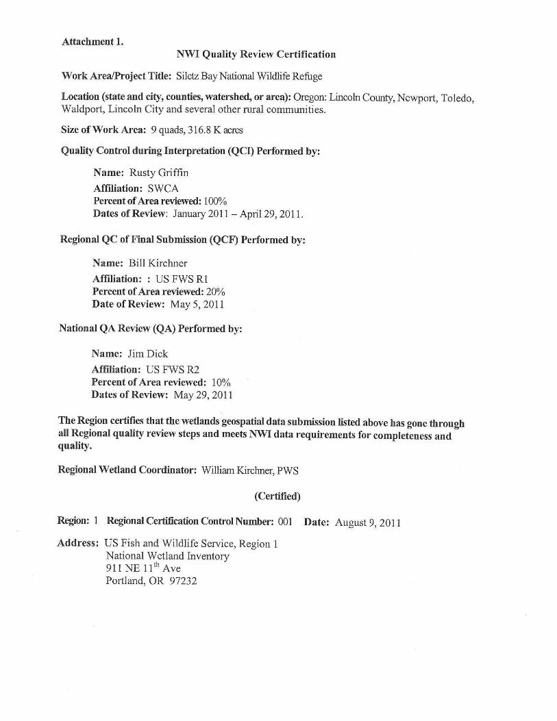
Attachment 1. NWI Quality Review Certification
Work Area/Project Title: Siletz Bay National Wildlife Refuge
Location (state and city, counties, watershed, or area): Oregon: Lincoln County, Newport, Toledo, Waldport, Lincoln City and several other rural communities.
Size ofWork Area: 9 quads, 316.8 K acres
Quality Control during Interpretation (QCI) Performed by:
Name: Rusty Griffin
Affiliation: SWCA Percent ofArea reviewed: 100% Dates of Review: January 2011 - April 29, 2011.
Regional QC of Final Submission (QCF) Performed by:
Name: Bill Kirchner
Affiliation: : US FWS Rl Percent ofArea reviewed: 20% Date ofReview: May 5, 2011
National QA Review (QA) Performed by:
Name: Jim Dick
Affiliation: US FWS R2 Percent ofArea reviewed: 10% Dates of Review: May 29, 2011
The Region certifies that the wetlands geospatial data submission listed above has gone through all Regional quality review steps and meets NWI data requirements for completeness and quality.
Regional Wetland Coordinator: William Kirchner, PWS
(Certified)
Region: 1 Regional Certification Control Number: 001 Date: August 9, 2011
Address: US Fish and Wildlife Service, Region 1 National Wetland Inventory 911 NE 11th Ave Portland, OR 97232
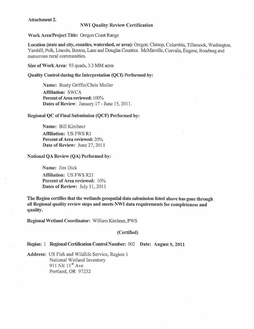
Attachment 2. NWI Quality Review Certification
Work Area/Project Title: Oregon Coast Range
Location (state and city, counties, watershed, or area): Oregon: Clatsop, Columbia, Tillamook, Washington, Yamhill, Polk, Lincoln, Benton, Lane and Douglas Counties. McMinville, Corvalis, Eugene, Roseburg and numerous rural communities.
Size of Work Area: 93 quads, 3.3 MM acres
Quality Control during the Interpretation (QCn Performed by:
Name: Rusty Griffin/Chris Moller
Affiliation: SWCA Percent ofArea reviewed: 100% Dates of Review: January 17 - June 15, 2011.
Regional QC of Final Submission (QCF) Performed by:
Name: Bill Kirchner
Affiliation: US FWS Rl Percent ofArea reviewed: 20% Date of Review: June 27, 2011
National QA Review (QA) Performed by:
Name: Jim Dick
Affiliation: US FWS R21 Percent ofArea reviewed: 10% Dates of Review: July 11, 2011
The Region certifies that the wetlands geospatial data submission listed above bas gone through all Regional quality review steps and meets NWI data requirements for completeness and quality.
Regional Wetland Coordinator: William Kirchner, PWS
(Certified)
Region: 1 Regional Certification Control Number: 002 Date: August 9, 2011
Address: US Fish and Wildlife Service, Region 1 National Wetland Inventory 911 NE 11 th Ave Portland, OR 97232
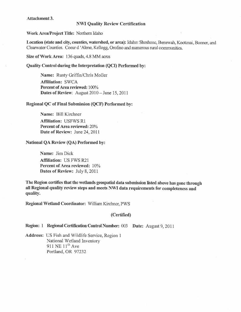
Attachment 3. NWI Quality Review Certification
Work Area/Project Title: Northern Idaho
Location (state and city, counties, watershed, or area): Idaho: Shoshone, Benewah, Kootenai, Bonner, and Clearwater Counties. Coeur d 'Alene, Kellogg, Orofino and numerous rural communities.
Size ofWork Area: 136 quads, 4.81\1:M acres
Quality Control during the Interpretation (QCI) Performed by:
Name: Rusty Griffin/Chris Moller
Affiliation: SWCA Percent ofArea reviewed: 100% Dates ofReview: August 2010 - June 15, 2011
Regional QC of Final Submission (QCF) Performed by:
Name: Bill Kirchner
Affiliation: USFWS RI Percent ofArea reviewed: 20% Date of Review: June 24, 2011
National QA Review (QA) Performed by:
Name: Jim Dick
Affiliation: US FWS R21 Percent ofArea reviewed: 10% Dates of Review: July 8, 2011
The Region certifies that the wetlands geospatial data submission listed above has gone through all Regional quality review steps and meets NWI data requirements for completeness and quality.
Regional Wetland Coordinator: William Kirchner, PWS
(Certified)
Region: 1 Regional Certification Control Number: 003 Date: August 9, 2011
Address: US Fish and Wildlife Service, Region 1 National Wetland Inventory 911 NE 11th Ave Portland, OR 97232
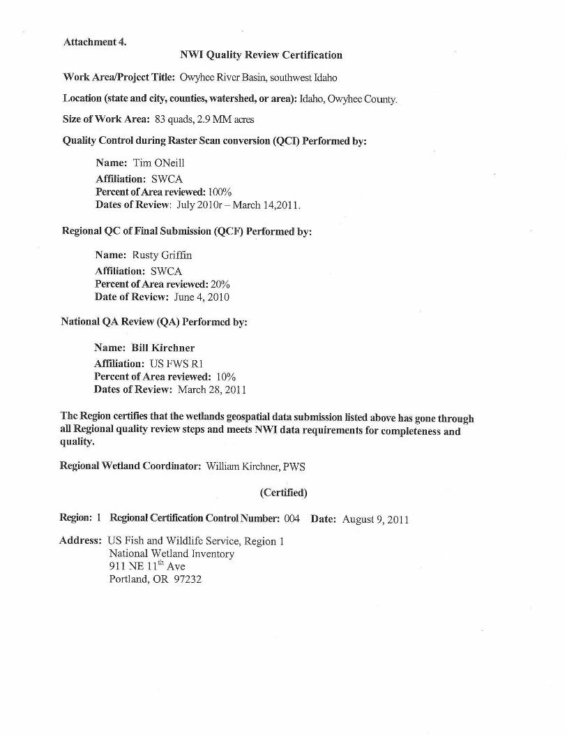
Attachment 4. NWI Quality Review Certification
Work Area/Project Title: Owyhee River Basin, southwest Idaho
Location (state and city, counties, watershed, or area): Idaho, Owyhee Collllty.
Size ofWork Area: 83 quads, 2.9 MM acres
Quality Control during Raster Scan conversion (QCI) Performed by:
Name: Tim ONeill
Affiliation: SWCA Percent ofArea reviewed: 100% Dates of Review: July 201 Or - March 14,2011.
Regional QC of Final Submission (QCF) Performed by:
Name: Rusty Griffin
Affiliation: SWCA Percent ofArea reviewed: 20% Date of Review: June 4, 2010
National QA Review (QA) Performed by:
Name: Bill Kirchner
Affiliation: US FWS Rl Percent ofArea reviewed: 10% Dates ofReview: March 28, 2011
The Region certifies that the wetlands geospatial data submission listed above has gone through all Regional quality review steps and meets NWI data requirements for completeness and quality.
Regional Wetland Coordinator: William Kirchner, PWS
(Certified)
Region: 1 Regional Certification Control Number: 004 Date: August 9, 2011
Address: US Fish and Wildlife Service, Region 1 National Wetland Inventory 911 NE 11th Ave Portland, OR 97232
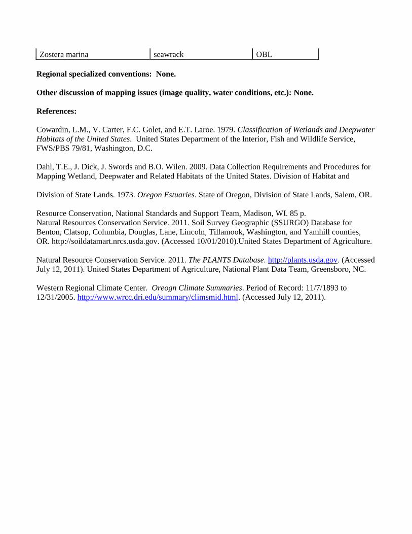
Zostera marina seawrack OBL
Regional specialized conventions: None.
Other discussion of mapping issues (image quality, water conditions, etc.): None.
References:
Cowardin, L.M., V. Carter, F.C. Golet, and E.T. Laroe. 1979. Classification of Wetlands and Deepwater
Habitats of the United States. United States Department of the Interior, Fish and Wildlife Service,
FWS/PBS 79/81, Washington, D.C.
Dahl, T.E., J. Dick, J. Swords and B.O. Wilen. 2009. Data Collection Requirements and Procedures for
Mapping Wetland, Deepwater and Related Habitats of the United States. Division of Habitat and
Division of State Lands. 1973. Oregon Estuaries. State of Oregon, Division of State Lands, Salem, OR.
Resource Conservation, National Standards and Support Team, Madison, WI. 85 p.
Natural Resources Conservation Service. 2011. Soil Survey Geographic (SSURGO) Database for
Benton, Clatsop, Columbia, Douglas, Lane, Lincoln, Tillamook, Washington, and Yamhill counties,
OR. http://soildatamart.nrcs.usda.gov. (Accessed 10/01/2010).United States Department of Agriculture.
Natural Resource Conservation Service. 2011. The PLANTS Database. http://plants.usda.gov. (Accessed
July 12, 2011). United States Department of Agriculture, National Plant Data Team, Greensboro, NC.
Western Regional Climate Center. Oreogn Climate Summaries. Period of Record: 11/7/1893 to
12/31/2005. http://www.wrcc.dri.edu/summary/climsmid.html. (Accessed July 12, 2011).