
NATIONAL WETLANDS INVENTORY INTRODUCTION
16
INTRODUCTION NATIONAL WETLANDS INVENTORY 1 :100,000 Map Narrative Texarkana SW In 1974, the U .S . . Fish and Wildlife Service directed its office of Biological Ser- 7ices to complete an inventory of the nations wetlands . As . )art of this overall objective, an effort began in August 1980 to delineate and classify wetlands by means of photo interpretation combined with field checking in the northeastern section of Tex.i s which borders Louisiana . A total of eight 1 :100,000 scale : maps are to be produced : Tyler NE, NW, SE, SW Texarkana SE, SW Palestine NE, NW . Wetland maps a - . 1 :100,000 scale and wetland overlay maps at 1 :24,000 or 1 :c .5,000 are produced at the National Wetlands Inventory headquarters in St . Petersburg, Florida . Information regarding final Texas maps is available from the U .S . Fish and Wildlife Service's regional office located in Albuquerque, New Mexico . An integral part of all final wetland maps is the completion of Narrative reports for each U .S . Geological Survey 1 :100,000 quadrangle inventoried . The following narrative report provides both basic and specific data which aid the user in understanding not only the general area of the Texarkana SW quadrangle but also representative details of its wetland habitat .
Transcript of NATIONAL WETLANDS INVENTORY INTRODUCTION
INTRODUCTION
NATIONAL WETLANDS INVENTORY
1 :100,000 Map Narrative
Texarkana SW
In 1974, the U .S . . Fish and Wildlife Service directed its office of
Biological Ser- 7ices to complete an inventory of the nations
wetlands . As . )art of this overall objective, an effort began in
August 1980 to delineate and classify wetlands by means of photo
interpretation combined with field checking in the northeastern
section of Tex.is which borders Louisiana . A total of eight
1 :100,000 scale : maps are to be produced :
Tyler NE, NW, SE, SW
Texarkana SE, SW
Palestine NE, NW .
Wetland maps a - . 1 :100,000 scale and wetland overlay maps at
1 :24,000 or 1 :c.5,000 are produced at the National Wetlands
Inventory headquarters in St . Petersburg, Florida . Information
regarding final Texas maps is available from the U .S . Fish and
Wildlife Service's regional office located in Albuquerque, New
Mexico . An integral part of all final wetland maps is the
completion of Narrative reports for each U .S . Geological Survey
1 :100,000 quadrangle inventoried . The following narrative report
provides both basic and specific data which aid the user in
understanding not only the general area of the Texarkana SW
quadrangle but also representative details of its wetland
habitat .

Map Preparation
The wetland classifications that appear on the Texarkana 5W
wetland maps a-e in accordance with Cowardin et al . (1979) . The
delineated mapping units resulted from stereoscopic interpretation
of 1 :65,000 sole color-infrared transparencies taken in November
1979 . The delineated units were transferred to 1 :24,000 scale
U .S . Geological Survey topographic maps or orthophoto quads with
a zoom transfe - scope .
The photography is generally good . However, it has some
limitations when compared to the February photography taken for
the four Tyler and the two Palestine maps . At the time of
photography, many decidious trees still had leaves . The leaves
obscured the ground lending to the possibility that some small
forested wetlands (PFO1A) might have been omitted . The leaves
condition also made it more difficult to follow forested linear
wetlands . With care in delineation and the use of collateral
data, these problems are limited and considered insignificant .
Overall the ph.,-tography has good resolution and contrast .
Distingushing )etween classes, subclasses and water regimes posed
few difficultii!s . Collateral data included U .S .G .S . topographi c
maps (7 .5 min . and 15 min .) and Soil Conservation Service soil
surveys . Spec-fic mapping conventions developed at NWI
on
headquarters were used to assist in photo-interpretation . Field
checking was done September 7 to 27, 1980, January 25 to 30, 19f1 ;
and May 18 to 21, 1981 .
Map users are cautioned that mapping with high altitude aerial
photography has limitations . Wetlands are identified and
classified through stereoscopic examination of photography on tre
basis of photo characteristics ; e .g . tone, texture, pattern, site
and size, in addition to local ecology, and cultural patterns .
Aerial photographs reflect conditions during the year and season
in which they were taken . In addition, the small scale of the
photography limits the size of the mapping unit thus precluding
delineation of very small wetlands (less than 1/4 acre
approximately) and narrow linear wetlands (less than 15 feet wide
approximately) . Changes in the landscape and/or land use could
have occured since the time of photography, therefore some
descrepancies between the map and current field conditions may
exist .
Any discrepanc,es regarding wetland omissions, inclusions, or
errors should be brought to the attention of the Regional Wetlands
Coordinator, lb :gion 2 . The Project Officer for this wetland map
is Warren Hageibuck, Regional Wetlands Coordinator, U .S . Fish and4
Wildlife Service, Region 2, P . 0 . Box 1306, Albuquerque, New
Mexico, 87103 .
SPECIAL MAPPII'G PROBLEMS
The most significant problem encountered was determining a break
between palustrine, emergent, temporarily flooded wetlands,
(PEM5A) and inland . Many sites originally interpreted on the
photos as PEM.`A were found to be upland improved pastures .
Although these pastures have a signature similar to that of
temporarily flooded areas and are occasionally flooded, they do
not meet the v etland criteria set by Cowardin et al .
(1979) .
The
substrate is rot predominatly undrained hydric soil and does not
constitute norsoil covered by water at some time during the
growing seasor . Due to disturbances designed to enhance grazing
productivity, these sites support predominately upland vegetation
that can tolezate temporary flooding . Should man's impact cease,
many of these areas would support some hydrophytic vegetation .
In most cases, transitional or marginally wet areas in improved
pastures were considered upland . However, small areas within
these problematic improved pastures were mapped as temporarily
flooded wetlandg if the predominance of hydrophytes was strongly
suspected thrcugh soil surveys, significantly darker signatures or
other pertinent factors . Drainage ways in these pastures were
often found to contain an abundance of hydrophytes and were mapped
using the temporary (A) or seasonal (C) water regime . Darker
toned depressions within these pastures were delineated as
seasonally flc :~ded .

Difficulty was encountered in determining the break between
palustrine, forested, temporarily flooded wetlands (PFO1A) and
upland . In some instances these forests are transitional between
wetland and upland . Palustrine forests characteristically include
narrow berms and isolated hillocks of upland too small to map .
Relatively small changes in elevation define the wetland/upland
break . For tiis reason, upland species can be found interspersed
with wetland iegetation . Careful analysis of photographic
characteristi :s and the use of collateral data helped alleviate
this problem .
FIELD WORK CU iPLETE .
Three field t - ips were completed . The first, September 7 to 27,
1980, was conducted in order to relate various photographic
characteristics to actual wetland classification . East Texas was
experiencing a serious drought during this trip . This drought
posed some difficulties in assigning water regimes . Many of the
field check s~t,es were dry . The characteristic wetland vegetation
was often des ccated, making identification difficult . In some
instances pioneer upland vegetation had invaded the site . Water
regimes were assigned according to such factors as wetland species
composition, condition of the soil, and the high water mark
visible on woody vegetation and man-made structures .
The second trip, January 25 to 30, 1981, was conducted to
investigate signatures not checked on the first field trip and to
gain a more complete understanding of the break between palustrine
emergent wetlands and uplands . Over 40 sites were field checked .
Many were those classified as palustrine emergent . This checking
led to the decisions discussed in the section on special mapping
problems . During this field trip, conditions were closer to
normal than those found during the first trip, but were not as wet
as would be expected during the early part of the growing season .
The third trip in may was a first check on a limited number of
draft maps . No significant problems were encountered during this
field check .
AREA DESCRIPTION
BAILEYS ECUREG :ONS
Texarkana SW l .es mostly in Oak-Bluestem Parkland of Bailey's
(1978) Prairie Parkland Province . Vegetation in this province is
forest-steppe . :haracterized by the intermingling of prairies,
groves and str .ps of mostly deciduous trees . Grasses, especially
bluestem prair .es, are the main plants in prairie vegetation .
Deciduous fore:it encroaches on the prairie vegetation where fire
and grazing art : controlled . The upland forest is-dominated by oak
and hickory . ; .'lm, cottonwood, and willow are common on flood
plains and bot , .om lands . The southeastern portion of the
quadrangle is ".ransitional to the Southern Mixed Forest Province .
This province s characterized by medium to tall forests of
broad-leaved deciduous and needle-leaved evergreen trees . Common
species includf . loblolly pine ( Pinue taeda ) short-leaf pine (Pinue
echinata), oak (Quercus spp .), sweetgum ( Liquidamber styracifa )
and red maple ( Acer rubrum ) . The predominant range plants include
bluestem ( Andropogon spp .), panicum ( Panicum spp .), a-nd . long leaf
uniola (Uniola spp .) .
GEOGRAPHY
Texarkana SW lies mainly in the Gulf Coastal Plain . The
prevailing terrain slopes gently to the southeast with hilly and
nearly level areas . Local relief is from 100 to 600 feet . This
gentle terrain enhances the potential for farming . The production
of beef and da '.ry cattle is the major farming enterprise .
Forest
products, oil ind gas production, crop production and surface
mining are sig iificant land uses .
Drainage is provided through
the Sulfur Riv !r .
SOILS
Soil is an imp
criteria used
soils are loca :ed in long flood plains along rivers and streams .
According to S .C .S . soil surveys, soils frequently flooded in the
study area include Glade Water, Hopco, Nahatche, and Kaufman .
These soils are typically nearly level loams and clays located in
bottomlands . They are flooded at least annually . Unless
artificially protected, they have low potential for cultivation or
(PEM5A or upla,d) .
rtant element of wetlands and is one of the
-o define wetlands . The most extensive wetland
urban uses . The highest potential use for these soils is hardwc ,~d
forest (PF01A) I,, Another use with high potential is as pastureland
CLIMATE;
According to S .C .S . soil surveys, the Texarkana SW quadrangle is
humid subtropical with hot summers . Rainfall averages 40 inches
annually and is fairly evenly distributed throughout the year .
The growing season (frost-free period) averages 250 days . Winter
temperatures
.-rP
m;
ahe-v,YA
frouv ; nn ,,~,1r ; .,r
t-,o
, ;� .,_ om _ . .y
Snowfall is rare and is an unimportant source of moisture .
Summers are hot with occasional thundershowers . Rainfall is
slightly decreased during the summer .

CHARACTERISTI :S OF NWI WETLAND SYSTEMS IN TEXARKANA SW
MARINE AND ESCUARINE SYSTEMS
No marine or :stuarine wetlands are found in Texarkana SW .
LACUSTRINE SYiTEM
With few exce)tions all lacustrine wetlands are impounded .
Significant f .uctuation in water level occurs in many of these
lakes due to artificial inundation and drainage . The water is
drawn down in anticipation of high water and is allowed to flood
back temporarily to prevent flooding downstream . The water level
at the instant of photography is assumed to approximate normal
water level. New . impoundments may have standing dead trees
(PF05) . I
Lacustrine aquatic beds (LlAB, L2AB) commonly consist of duckwe9d
( Lemna spp .), water lily ( Nymphaea spp .) and lotus ( Nelumbo
spp .) .
RIVERINE SYSTTM
Texarkana SW quadrangle has a dendritic drainage pattern and
numerous sluggish rivers and streams . Many of these overflow
their banks annually . All perennial streams are considered loweri
perennial (R20WH) . Intermittent streams are often seasonally
flooded (R4SBC) . Delineation of vegetation in the channel takes
precedence over the above classification . The break between
perennial and intermittent-stream is made using USGS topographic
maps .
-10-
PALUSTRINE SYIE_TEM
An important aspect of the East Texas landscape is the high numter
of permanently flooded man-made ponds . These ponds are used for
watering livestock and many are of recent construction . Although
the area was field checked during an unusually dry year, most ofE
them contained water .
They are therefore considered permanently
flooded (POWHh, POWHx) .
The most extensive wetland type is broadleaved deciduous forest,
temporarily and seasonally flooded (PFO1A, PF01C) . Sweetgum,
oaks, red maple, willow ( Salix spp .) and river birch (Betula
ni-gra ) are quite common. These wetlands are frequently found on
the level flood plains of most major rivers and streams .
Seasonally flooded forest in this situation are small depressions
or areas. surro,inded by natural levees . Linear palustrine forests
reflect the vegetation growing on the stream bank which floods
during high waver. Temporarily flooded forests have a greater
abundance of tlpically drier site vegetation such as some oaks and
sweetgum . Seasonally flooded forests tend towards, but are not
limited to, sp :cies such as river birch, red maple and willow .
A few sites wish cypress (Taxodium distichum ) were noted . These
are generally in regions protected from or inaccessable to timber
harvesting . Cypress i$ also found in and along streambanks .
Cyp,ress swamps are usually semipermanently or seasonally flooded
(PFO2F, PFO2C) . Where a break between broadleafed deciduous and
needle leaved Ieciduous subclasses could not be reliably made, the
general deciduous subclass (PF06) was used .
Needle-leaved evergreens indigenous to the Texarkana SW quadrangle
do not tolerate flooding for extended periods . Shortleaf pine
( Pinus echinata ) and loblolly pine ( P . taeda ) are common species
and are planted extensively on uplands . Although loblolly can
grow in wetland situations (Fowles 1965), it tends to be
restricted to uplands here .
Temporarily and seasonally flooded scrub-shrub wetlands (PSSlA,
-1 2-
PSSlC) are similar in species to their forested counterparts . In
the Texarkana SW quadrangle, they are often just immature (less
than 20 feet in height)'forests . Buttonbush ( Cephalanthus -
occidentalis ) and speckled alder ( Alnus rugosa ) are prevalent in
open semipermanently flooded scrub/scrub wetlands . These species
need full sunlight to thrive . Planner or water elm ( Plannea
aquatica ) was found almost exclusively in and among creeks
bordered by forest vegetation . This shrub, which can grow over 20
feet tall, requires a considerable amount of water, but can
tolerate shade .
All palustrino emergents mapped in Texarkana SW are narrow leaved
persistant (PEM5) . Common genera include Juncus , Polygonum ,
Cyperus .
Alt: ough broad-leaved emergents
Sagittaria sp;) .), they are not found in pure
and
are present (e .g .
stands large enough
or in mixed stands of sufficient quantity to be delineated
separately . Semipermanently flooded emergents (PEM5F) are
predominantly cattail ( Typha spp .) marshes . Important in some
regions are extensive stands of giant cutgrass ( Zizaniopsis
miliacea) .
Palustrine aquatic beds (PAU) are found throughout the quadrangle .
Commonly fount are duckweed, water lily, and lotus .
WETLAND VALUE;
As was demonstrated during the drought of 1980, water is an
important resource to the Texarkana SW quadrangle . The numerous
excavated and impounded ponds illustrate the concern of local
inhabitants concern with water. Large lakes are carefully managed
for water and flood control .
Forested and scrub-shrub wetlands, especially those tlooded
temporarily (tFO1A, PSSlA), are important wildlife habitat . These
wetlands supp(rt a great variety of wildlife including white
tailed deer, and numerous species of birds .
WETLAND VULNERABILITY
Wetland loss is potentially a major problem in Texarkana
Large acreages pf' bottomland hardwoods are being removed
land converte( to rangeland .
SW .
and the

Another problem is the loss of wetlands through coal mining . With
the cost of energy rising rapidly, it is now profitable to strip
mine for low grade coal that can be found in Texarkana 5W and tie
other quadrangles in northeast Texas . Several mines and test pits
can be found on the photography .
In summary, tt e wetlands of the Texarkana SW quadrangle are a
valuable resoL rce ; a resouce that needs management and protection
if they are I tc survive . This inventory is the first step in this
management .

1LITERATURE (ITED
Bailey, E .V . 1978 . Description of the ecoregions of the U .S .
USDA . (Forest Service . Intermtn . Reg . Ogden, Utah . 77p .)
Cowardin, L .M ., V . Carter, F .C . Volets, and E .T . LaRne . 1974_
Classification of wetlands and deepwater habitats of the United
States . USDI . Fish and Wildlife Service, FWS/PBS=79/81 .
103p .
Fowler, H . 1965 . Silvicultural characteristics of forest trees
of the United States . USDA . Forest Service . Ag . Handbook 271 .
U .S . Soil Conservation Service . Soil surveys .
Anderson County . 1975 .
Cherokee County . 1959 .
Hopkins and Rains Counties . 1977 .
Lamar and Delta Counties . 1979 .
Nacogdoches County . 1980 .
Panola Count, . 1975 .
Red River Coi nty .
1977 .
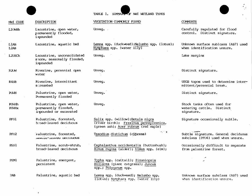
0COMMENTS
Carefully regulated for floodcontrol. Distinct signature .
Unknown surface subclass (AB7) usedwhen identification unsure .
Lake margins
rr
Distinct signature .
USGS topos used to determine inter-mittent/perennial break .
Distinct signature .
Stock tanks often used for,watering cattle . Distinctsignature .
Signature occasionally subtle .
Subtle signature . General deciduoussubclass (PF06) used wtien unsure .
Occasionally difficult to separatefrom palustrine forest .
Unknown surface subclass (AB7) usedwhen identification unsure .
TABLE 1. S NWI WETLAND TYPES
NWI CODE DESCRIPTION VEGETATION COMMONLY FOUND
LI( Lacustrine, open water, Unveg . .permanently flooded,impounded
LlJhB Lacustrine, aquatic bed Lemna spp. (duckweed) ; Nelumbo spp. (lotus) ;L2AB Nym_phaea spp . (water lily)
L2USCh Lacustrine, unconsolidated Unveg .store, seasonally flooded,impounded
R2CM Riverine, perennial open Unveg .water
R4SB Riverine, intermittent Unveg .s;reambed
PCAM Palustrine, open water, Unveg .PA~rroanently flooded
PUJHh Palustrine, open water, Unveg .POkhix permanently flooded,
impounded or excavated
PFO1 Palustrine, forested, Salix spp . (willow) ;Betula nigrab:-oad-leaved deciduous (river birch) ; Fraxinus pennsylvanica ,
(green ash) ; Acer rubrum (red maple)
PFO2 .ealustrine, forested,., . .,
Taxodium distichurn (cypress)&0r_LVlt-1CC1VeU UuC;LOUOUS
PSS1 Palustrine, scrub--shrub, Cephalanthus occidentalis (buttonbush) ;broad-leaved deciduous Alnus rugosa (alder) ; Ulmus spp . (elm) ;
PEM1 Palustrine, emergent, Typha spp. (cattail) ; Zizaniopsispersistent miliacea (giant cutgrass) ; Juncus
spp . ; Pol arum spp .
PAB Palustrine, aquatic bed Lemna spp . (duckweed) ; Nelumbo spp .(lotus) ; Nrphaea spp . (water lily)


![[Archive] National Wetlands Inventory: A Strategy for the 21st …National-Wetlands... · 2016-07-15 · solutions to myriad resource management issues. This Strategy provides the](https://static.fdocuments.net/doc/165x107/5f0d5c627e708231d439f810/archive-national-wetlands-inventory-a-strategy-for-the-21st-national-wetlands.jpg)

