NATIONAL PARK TRIP PLANNERd1njyp8tsu122i.cloudfront.net/.../SMJ_TripPlanner2016.pdfCONVERSATION ON...
10
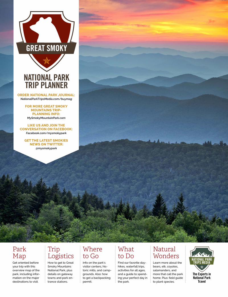
ORDER NATIONAL PARK JOURNAL: NationalParkTripsMedia.com/buymag FOR MORE GREAT SMOKY MOUNTAINS TRIP- PLANNING INFO: MySmokyMountainPark.com LIKE US AND JOIN THE CONVERSATION ON FACEBOOK: Facebook.com/mysmokypark GET THE LATEST SMOKIES NEWS ON TWITTER: @mysmokypark NATIONAL PARK TRIP PLANNER Park Map Get oriented before your trip with this overview map of the park, including infor- mation on the major destinations to visit. Trip Logistics How to get to Great Smoky Mountains National Park, plus details on gateway towns and park en- trance stations. Where to Go Info on the park’s visitor centers, his- toric mills, and camp- grounds. Also: how to get a backpacking permit. What to Do Find our favorite day- hikes, waterfall trips, activities for all ages, and a guide to spend- ing your perfect day in the park. Natural Wonders Learn more about the bears, elk, coyotes, salamanders, and more that call the park home. Plus: field guide to plant species. The Experts in National Park Travel
Transcript of NATIONAL PARK TRIP PLANNERd1njyp8tsu122i.cloudfront.net/.../SMJ_TripPlanner2016.pdfCONVERSATION ON...
ORDER NATIONAL PARK JOURNAL:NationalParkTripsMedia.com/buymag
FOR MORE GREAT SMOKY MOUNTAINS TRIP- PLANNING INFO:
MySmokyMountainPark.com
LIKE US AND JOIN THE CONVERSATION ON FACEBOOK:
Facebook.com/mysmokypark
GET THE LATEST SMOKIES NEWS ON TWITTER:
@mysmokypark
NATIONAL PARK TRIP PLANNER
Park MapGet oriented before your trip with this overview map of the park, including infor-mation on the major destinations to visit.
Trip LogisticsHow to get to Great Smoky Mountains National Park, plus details on gateway towns and park en-trance stations.
Where to GoInfo on the park’s visitor centers, his-toric mills, and camp-grounds. Also: how to get a backpacking permit.
What to DoFind our favorite day-hikes, waterfall trips, activities for all ages, and a guide to spend-ing your perfect day in the park.
Natural WondersLearn more about the bears, elk, coyotes, salamanders, and more that call the park home. Plus: field guide to plant species.
The Experts in National Park
Travel
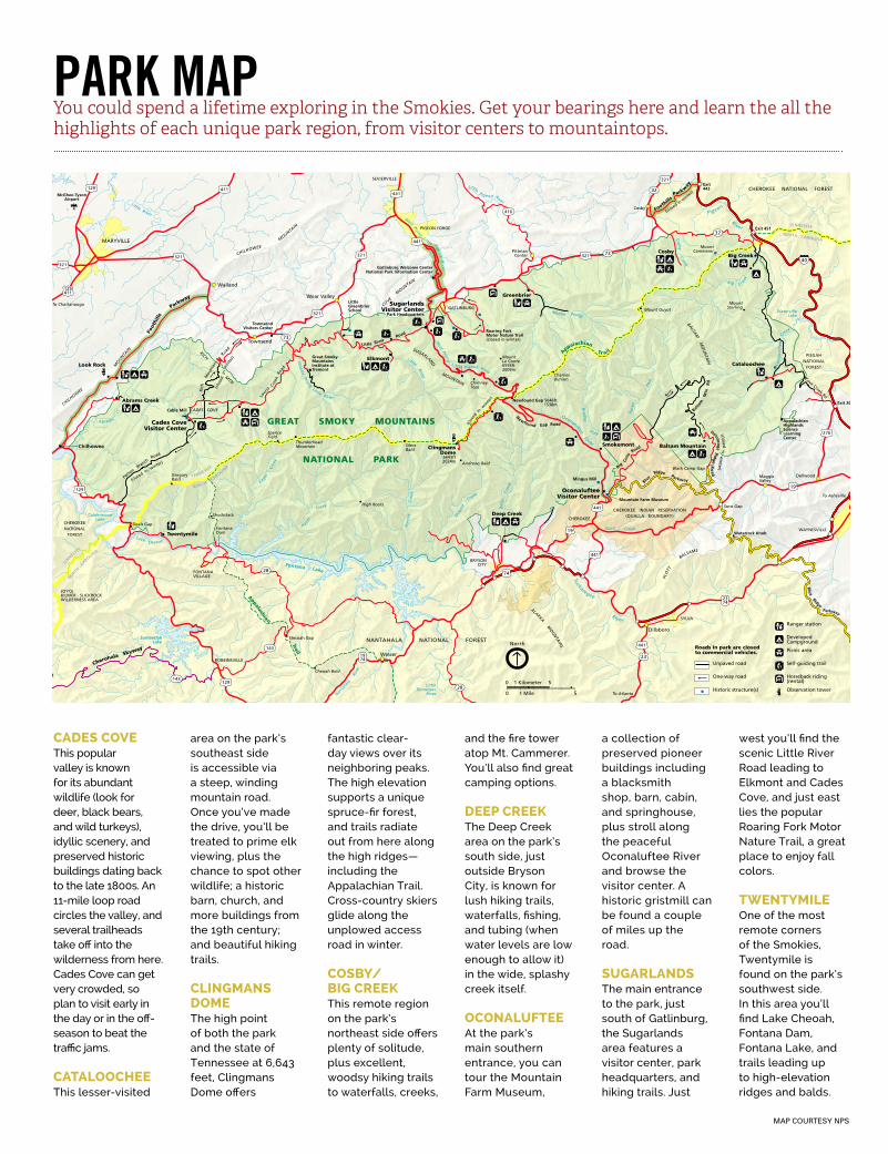
MAP COURTESY NPS
CADES COVEThis popular valley is known for its abundant wildlife (look for deer, black bears, and wild turkeys), idyllic scenery, and preserved historic buildings dating back to the late 1800s. An 11-mile loop road circles the valley, and several trailheads take off into the wilderness from here. Cades Cove can get very crowded, so plan to visit early in the day or in the off-season to beat the traffic jams.
CATALOOCHEEThis lesser-visited
area on the park’s southeast side is accessible via a steep, winding mountain road. Once you’ve made the drive, you’ll be treated to prime elk viewing, plus the chance to spot other wildlife; a historic barn, church, and more buildings from the 19th century; and beautiful hiking trails.
CLINGMANS DOMEThe high point of both the park and the state of Tennessee at 6,643 feet, Clingmans Dome offers
fantastic clear-day views over its neighboring peaks. The high elevation supports a unique spruce-fir forest, and trails radiate out from here along the high ridges—including the Appalachian Trail. Cross-country skiers glide along the unplowed access road in winter.
COSBY/BIG CREEKThis remote region on the park’s northeast side offers plenty of solitude, plus excellent, woodsy hiking trails to waterfalls, creeks,
and the fire tower atop Mt. Cammerer. You’ll also find great camping options.
DEEP CREEKThe Deep Creek area on the park’s south side, just outside Bryson City, is known for lush hiking trails, waterfalls, fishing, and tubing (when water levels are low enough to allow it) in the wide, splashy creek itself.
OCONALUFTEEAt the park’s main southern entrance, you can tour the Mountain Farm Museum,
a collection of preserved pioneer buildings including a blacksmith shop, barn, cabin, and springhouse, plus stroll along the peaceful Oconaluftee River and browse the visitor center. A historic gristmill can be found a couple of miles up the road.
SUGARLANDSThe main entrance to the park, just south of Gatlinburg, the Sugarlands area features a visitor center, park headquarters, and hiking trails. Just
west you’ll find the scenic Little River Road leading to Elkmont and Cades Cove, and just east lies the popular Roaring Fork Motor Nature Trail, a great place to enjoy fall colors.
TWENTYMILEOne of the most remote corners of the Smokies, Twentymile is found on the park’s southwest side. In this area you’ll find Lake Cheoah, Fontana Dam, Fontana Lake, and trails leading up to high-elevation ridges and balds.
PARK MAPYou could spend a lifetime exploring in the Smokies. Get your bearings here and learn the all the highlights of each unique park region, from visitor centers to mountaintops.
0 1 Mile
0 1 Kilometer
5
5
North
40
416
143
143
73
32
32
73
28
28
1974
2374
74
19
19
23
321
321
321
441
441
321
321
411129
321
441
276
441
441
129
129
129411
GREAT SMOKY MOUNTAINS
NATIONAL PARK
Appalachian Trail
A
ppalachian Tr ail
Tuckasegee River
Soco Creek
Oconaluftee River
Rav
en
For
k
Brad
ley F ork
Middle Prong
Little Pigeon River
West Prong Littl e Pigeon R
iver
West Prong
Little Pigeon River
Nol
and
Creek
Dee
p
Cre
ek
Little River
Mid
dle Prong Little River
Hazel
Creek
Fontana Lake
Forn
ey
Cre
ek
Nanta
hala
R
iver
SanteetlahLake
Lake Cheoah
Eagle
C
reek
CalderwoodLake
Little River
Abrams
C
r
LittleTennessee
River
Pigeon River
WatervilleLake
Big Creek
Cat
alo
och
ee
C
reek
Cosby Creek
TENNESSEE
NORTH CAROLIN
A
TEN
NESSEE
NORT
H CAROLIN
A
TENNESSEE
NORTH CAROLINA
CHEROKEE INDIAN RESERVATION(QUALLA BOUNDARY)
CHEROKEENATIONAL
FOREST
NANTAHALA NATIONAL FOREST
Townsend
Walland
Wear Valley
Dillsboro
PittmanCenter
Cosby
MARYVILLE
SEVIERVILLE
PIGEON FORGE
FONTANAVILLAGE
ROBBINSVILLE
CHEROKEE
GATLINBURG
Twentymile
Abrams Creek
Cable Mill
Mingus Mill
Mountain Farm Museum
LittleGreenbrierSchool
Deep Creek
Elkmont
Greenbrier
Look Rock
MountLe Conte6593ft2009m
SpenceField
Newfound Gap 5046ft1538m
ThunderheadMountain
High Rocks
Stecoah Gap
Deals Gap
GregoryBald
Shuckstack
Cheoah Bald
Heintooga Ridge R
oa
d
(closed
in win
ter)
Waterrock Knob
Blu
e Ridge
Parkway
PLO
TT
BALSAMS
OconalufteeVisitor Center
SugarlandsVisitor Center
Park Headquarters
Cades CoveVisitor Center
Blue
Ridge Parkway
B
ig Cove
Road
Foothill
s
Parkw
ay
(closed in
winte
r)
Gatlinburg Welcome CenterNational Park Information Center
TownsendVisitors Center
COVE
MOUNTA
IN
Newfound Gap Road
ChimneyTops
SUGARLAND MOUNTAIN
ClingmansDome
6643ft2024m
(clo
sed
in w
inte
r)
ALARKA MO
UN
TAIN
S
Great SmokyMountainsInstitute atTremont
CHILHOWEE
MOUNTA
IN
Little River Road
Pa
rson B
ranch R
oad
(closed in
winter)
FontanaDam
JOYCEKILMER - SLICKROCKWILDERNESS AREA
McGhee-TysonAirport
Foot
hills
P
arkway
CHILHOW
EE
M
OUNTA
IN
RICH MTN
CADES COVE
Ric
h
Mou
ntai
n
Ro
ad
(clo
sed
in
win
ter)
Chilhowee
Roaring ForkMotor Nature Trail(closed in winter)
Bal
sam
M
tn
Rd
La
urel
Cree
k R
oad
Cherohala Skyway
CHEROKEE NATIONAL FOREST
PISGAHNATIONAL
FOREST
Exit 451
Exit 20
Exit443
Wesser
DellwoodMaggie Valley
BRYSONCITY
SYLVA
WAYNESVILLE
Cosby
Balsam Mountain
Big Creek
Cataloochee
Smokemont
To Newport
MountCammerer
MountSterling
Andrews Bald
CharliesBunion
SilersBald
Mount Guyot
Soco Gap
Black Camp Gap
To Asheville
To Atlanta
BALSAM
MO
UN
TAIN
To Knoxville To Knoxville
To Chattanooga
Roads in park are closedto commercial vehicles.
Self-guiding trail
Horseback riding(rental)
Picnic area
DevelopedCampground
Ranger station
Observation tower
Unpaved road
One-way road
Historic structure(s)
Cove Creek Rd
AppalachianHighlandsScienceLearningCenter
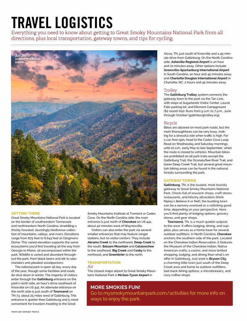
TRAVEL LOGISTICSEverything you need to know about getting to Great Smoky Mountains National Park from all directions, plus local transportation, gateway towns, and tips for cycling.
PHOTO BY DEPOSIT PHOTO
GETTING THEREGreat Smoky Mountains National Park is located on the border of southwestern Tennessee and northwestern North Carolina, straddling a thickly forested, stunningly biodiverse collec-tion of mountains, valleys, and rivers. Elevations range from 875 feet to 6,643 feet at Clingmans Dome: This varied elevation supports the same ecosystems you’d find traveling all the way from Georgia to Maine, all encompassed within the park. Wildlife is varied and abundant through-out the park, from black bears and elk to sala-manders and pileated woodpeckers.
The national park is open all day, every day of the year, though some facilities and roads do shut down in winter. The majority of visitors enter through the Gatlinburg entrance on the park’s north side, an hour’s drive southeast of Knoxville on US 441. An alternate entrance on the north side is just south of Townsend on TN 73, about 25 miles west of Gatlinburg. This entrance is quieter than Gatlinburg and is most convenient for travelers heading to the Great
Smoky Mountains Institute at Tremont or Cades Cove. On the North Carolina side, the main entrance is just north of Cherokee on US 441, about 40 minutes west of Waynesville.
Visitors can also enter the park via several smaller entrances that may feature ranger stations, but no visitor centers. They include Abrams Creek to the northwest, Deep Creek to the south, Balsam Mountain and Cataloochee to the southeast, Big Creek and Cosby to the northeast, and Greenbrier to the north.
TRANSPORTATIONAirThe closest major airport to Great Smoky Moun-tains National Park is McGee-Tyson Airport in
Alcoa, TN, just south of Knoxville and a 45-min-ute drive from Gatlinburg. On the North Carolina side, Asheville Regional Airport is an hour and 10 minutes away. Other options include Greenville-Spartanburg International Airport in South Carolina, an hour and 45 minutes away, and Charlotte Douglas International Airport in Charlotte, NC, 2 hours and 45 minutes away.
TrolleyThe Gatlinburg Trolley system connects the gateway town to the park via the Tan Line, with stops at Sugarlands Visitor Center, Laurel Falls parking lot, and Elkmont Campground ($2 round-trip). Runs from 9 a.m. to 7 p.m., June through October (gatlinburgtrolley.org).
BicycleBikes are allowed on most park roads, but the main thoroughfares can be very busy, mak-ing for a stressful ride when traffic is high. For a car-free spin, head to the Cades Cove Loop Road on Wednesday and Saturday mornings until 10 a.m., early May to late September, when the route is closed to vehicles. Mountain bikes are prohibited on all park trails except the Gatlinburg Trail, the Oconaluftee River Trail, and lower Deep Creek Trail, but several great moun-tain biking areas can be found in the national forests surrounding the park. GATEWAY TOWNSGatlinburg, TN, is the busiest, most touristy gateway to Great Smoky Mountains National Park. Chock-full of souvenir shops, craft stores, restaurants, and kitschy attractions (think Ripley’s Believe it or Not), the bustling town can be a sensory overload or a rollicking good time, depending on your perspective. Here you’ll find plenty of lodging options, grocery stores, and gear shops.
Townsend, TN, is a much quieter outpost to the west. It offers lodging, dining, and sup-plies, plus serves as a home base for several outdoor outfitters. In North Carolina, Cherokee anchors the southern side of the park. Located on the Cherokee Indian Reservation, it features the Museum of the Cherokee Indian, Native American crafts, a casino, and more limited shopping, lodging, and dining than what’s on offer in Gatlinburg. Just west is Bryson City, a charming little town just south of the Deep Creek area and home to outdoor outfitters, laid-back dining options, a microbrewery, and cozy coffee shops.
MORE SMOKIES FUN!Go to mysmokymountainpark.com/activities for more info on ways to enjoy the park.
AUTUMN AT SUNSET MOUNTAIN RANGE
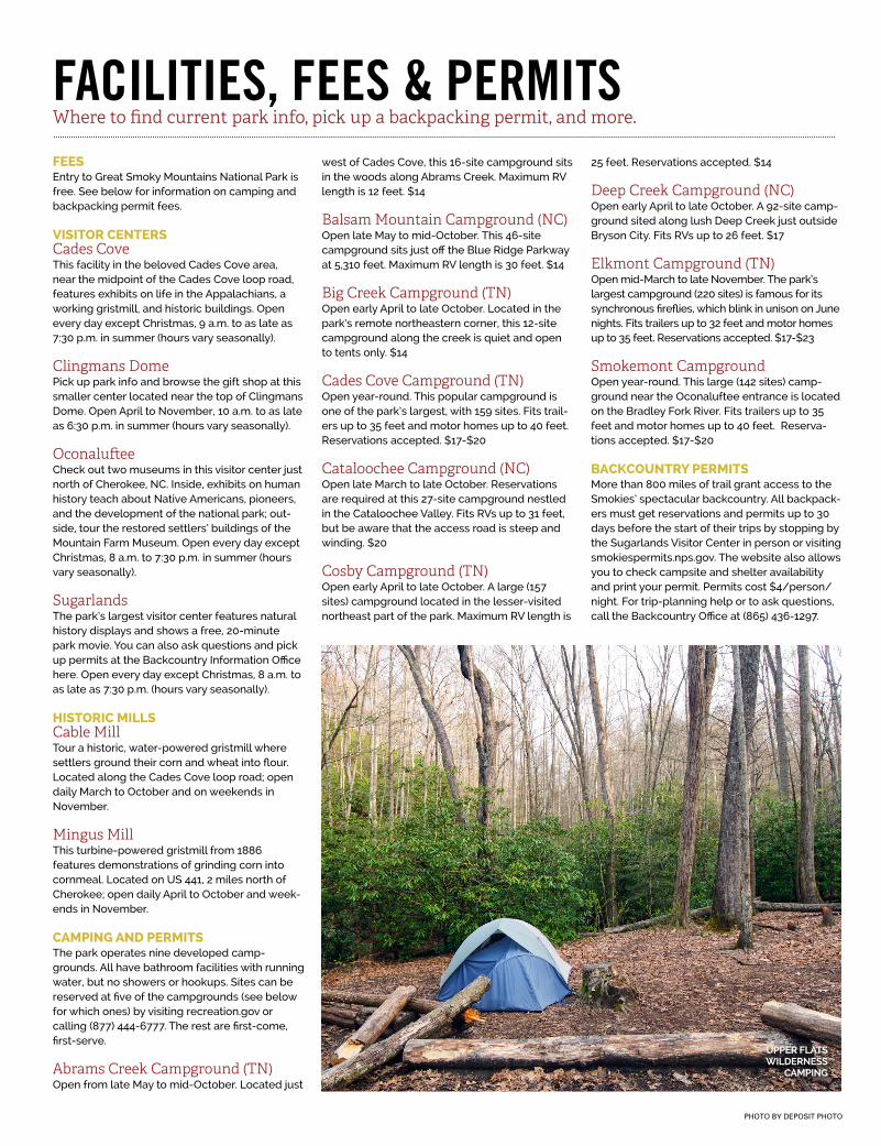
FACILITIES, FEES & PERMITSWhere to find current park info, pick up a backpacking permit, and more.
PHOTO BY DEPOSIT PHOTO
FEESEntry to Great Smoky Mountains National Park is free. See below for information on camping and backpacking permit fees.
VISITOR CENTERSCades CoveThis facility in the beloved Cades Cove area, near the midpoint of the Cades Cove loop road, features exhibits on life in the Appalachians, a working gristmill, and historic buildings. Open every day except Christmas, 9 a.m. to as late as 7:30 p.m. in summer (hours vary seasonally).
Clingmans DomePick up park info and browse the gift shop at this smaller center located near the top of Clingmans Dome. Open April to November, 10 a.m. to as late as 6:30 p.m. in summer (hours vary seasonally).
OconalufteeCheck out two museums in this visitor center just north of Cherokee, NC. Inside, exhibits on human history teach about Native Americans, pioneers, and the development of the national park; out-side, tour the restored settlers’ buildings of the Mountain Farm Museum. Open every day except Christmas, 8 a.m. to 7:30 p.m. in summer (hours vary seasonally).
SugarlandsThe park’s largest visitor center features natural history displays and shows a free, 20-minute park movie. You can also ask questions and pick up permits at the Backcountry Information Office here. Open every day except Christmas, 8 a.m. to as late as 7:30 p.m. (hours vary seasonally).
HISTORIC MILLSCable MillTour a historic, water-powered gristmill where settlers ground their corn and wheat into flour. Located along the Cades Cove loop road; open daily March to October and on weekends in November.
Mingus MillThis turbine-powered gristmill from 1886 features demonstrations of grinding corn into cornmeal. Located on US 441, 2 miles north of Cherokee; open daily April to October and week-ends in November.
CAMPING AND PERMITSThe park operates nine developed camp-grounds. All have bathroom facilities with running water, but no showers or hookups. Sites can be reserved at five of the campgrounds (see below for which ones) by visiting recreation.gov or calling (877) 444-6777. The rest are first-come, first-serve.
Abrams Creek Campground (TN)Open from late May to mid-October. Located just
west of Cades Cove, this 16-site campground sits in the woods along Abrams Creek. Maximum RV length is 12 feet. $14
Balsam Mountain Campground (NC)Open late May to mid-October. This 46-site campground sits just off the Blue Ridge Parkway at 5,310 feet. Maximum RV length is 30 feet. $14
Big Creek Campground (TN)Open early April to late October. Located in the park’s remote northeastern corner, this 12-site campground along the creek is quiet and open to tents only. $14
Cades Cove Campground (TN)Open year-round. This popular campground is one of the park’s largest, with 159 sites. Fits trail-ers up to 35 feet and motor homes up to 40 feet. Reservations accepted. $17-$20
Cataloochee Campground (NC)Open late March to late October. Reservations are required at this 27-site campground nestled in the Cataloochee Valley. Fits RVs up to 31 feet, but be aware that the access road is steep and winding. $20
Cosby Campground (TN)Open early April to late October. A large (157 sites) campground located in the lesser-visited northeast part of the park. Maximum RV length is
25 feet. Reservations accepted. $14
Deep Creek Campground (NC)Open early April to late October. A 92-site camp-ground sited along lush Deep Creek just outside Bryson City. Fits RVs up to 26 feet. $17
Elkmont Campground (TN)Open mid-March to late November. The park’s largest campground (220 sites) is famous for its synchronous fireflies, which blink in unison on June nights. Fits trailers up to 32 feet and motor homes up to 35 feet. Reservations accepted. $17-$23
Smokemont CampgroundOpen year-round. This large (142 sites) camp-ground near the Oconaluftee entrance is located on the Bradley Fork River. Fits trailers up to 35 feet and motor homes up to 40 feet. Reserva-tions accepted. $17-$20
BACKCOUNTRY PERMITSMore than 800 miles of trail grant access to the Smokies’ spectacular backcountry. All backpack-ers must get reservations and permits up to 30 days before the start of their trips by stopping by the Sugarlands Visitor Center in person or visiting smokiespermits.nps.gov. The website also allows you to check campsite and shelter availability and print your permit. Permits cost $4/person/night. For trip-planning help or to ask questions, call the Backcountry Office at (865) 436-1297.
UPPER FLATS WILDERNESS
CAMPING
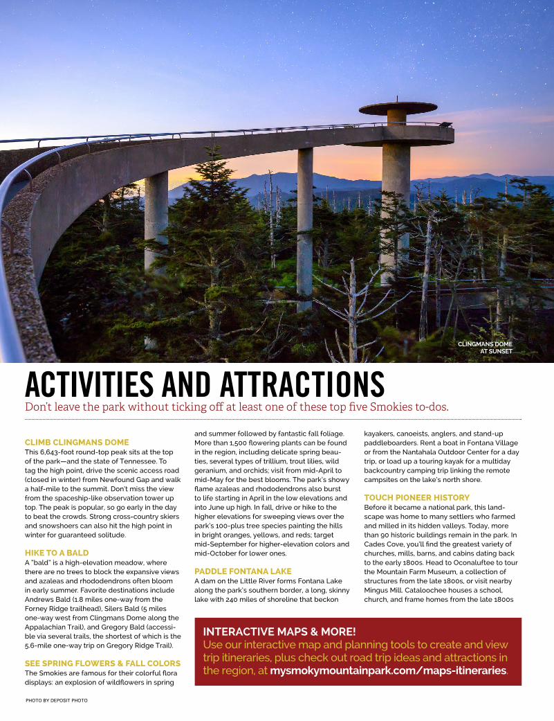
PHOTO BY DEPOSIT PHOTO
CLIMB CLINGMANS DOMEThis 6,643-foot round-top peak sits at the top of the park—and the state of Tennessee. To tag the high point, drive the scenic access road (closed in winter) from Newfound Gap and walk a half-mile to the summit. Don’t miss the view from the spaceship-like observation tower up top. The peak is popular, so go early in the day to beat the crowds. Strong cross-country skiers and snowshoers can also hit the high point in winter for guaranteed solitude.
HIKE TO A BALDA “bald” is a high-elevation meadow, where there are no trees to block the expansive views and azaleas and rhododendrons often bloom in early summer. Favorite destinations include Andrews Bald (1.8 miles one-way from the Forney Ridge trailhead), Silers Bald (5 miles one-way west from Clingmans Dome along the Appalachian Trail), and Gregory Bald (accessi-ble via several trails, the shortest of which is the 5.6-mile one-way trip on Gregory Ridge Trail).
SEE SPRING FLOWERS & FALL COLORSThe Smokies are famous for their colorful flora displays: an explosion of wildflowers in spring
and summer followed by fantastic fall foliage. More than 1,500 flowering plants can be found in the region, including delicate spring beau-ties, several types of trillium, trout lilies, wild geranium, and orchids; visit from mid-April to mid-May for the best blooms. The park’s showy flame azaleas and rhododendrons also burst to life starting in April in the low elevations and into June up high. In fall, drive or hike to the higher elevations for sweeping views over the park’s 100-plus tree species painting the hills in bright oranges, yellows, and reds; target mid-September for higher-elevation colors and mid-October for lower ones.
PADDLE FONTANA LAKEA dam on the Little River forms Fontana Lake along the park’s southern border, a long, skinny lake with 240 miles of shoreline that beckon
kayakers, canoeists, anglers, and stand-up paddleboarders. Rent a boat in Fontana Village or from the Nantahala Outdoor Center for a day trip, or load up a touring kayak for a multiday backcountry camping trip linking the remote campsites on the lake’s north shore.
TOUCH PIONEER HISTORYBefore it became a national park, this land-scape was home to many settlers who farmed and milled in its hidden valleys. Today, more than 90 historic buildings remain in the park. In Cades Cove, you’ll find the greatest variety of churches, mills, barns, and cabins dating back to the early 1800s. Head to Oconaluftee to tour the Mountain Farm Museum, a collection of structures from the late 1800s, or visit nearby Mingus Mill. Cataloochee houses a school, church, and frame homes from the late 1800s
ACTIVITIES AND ATTRACTIONSDon’t leave the park without ticking off at least one of these top five Smokies to-dos.
INTERACTIVE MAPS & MORE!Use our interactive map and planning tools to create and view trip itineraries, plus check out road trip ideas and attractions in the region, at mysmokymountainpark.com/maps-itineraries.
CLINGMANS DOME AT SUNSET
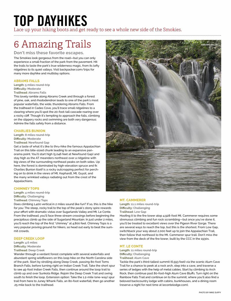
PHOTO BY MIKE DUFFY
TOP DAYHIKESLace up your hiking boots and get ready to see a whole new side of the Smokies.
6 Amazing TrailsDon’t miss these favorite escapes.The Smokies look gorgeous from the road—but you can only experience a small fraction of the park from the pavement. Hit the trails to taste the park’s true wilderness magic, from its lofty ridgelines to its quiet valleys. Visit backpacker.com/trips for many more dayhike and multiday options.
ABRAMS FALLSLength: 5 miles round-tripDifficulty: ModerateTrailhead: Abrams Falls This lovely ramble along Abrams Creek and through a forest of pine, oak, and rhododendron leads to one of the park’s most popular waterfalls, the wide, thundering Abrams Falls. From the trailhead in Cades Cove, you’ll trace small ridgelines to a clearing where you’ll spot the 20-foot-tall cascade roaring over a rocky cliff. Though it’s tempting to approach the falls, climbing on the slippery rocks and swimming are both very dangerous: Admire the falls safely from a distance.
CHARLIES BUNIONLength: 8 miles round-tripDifficulty: ModerateTrailhead: Newfound GapGet a taste of what it’s like to thru-hike the famous Appalachian Trail on this bite-sized chunk leading to an expansive pan-orama point. You’ll start high (5,046 feet at Newfound Gap) and stay high as the AT meanders northeast over a ridgeline with big views of the surrounding northeast peaks on both sides. Up here, the forest is dominated by high-elevation spruce and fir. Charlies Bunion itself is a rocky outcropping perfect for perch-ing on to drink in the views of Mt. Kephardt, Mt. Guyot, and the many wrinkled valleys radiating out from the crest of the Appalachians.
CHIMNEY TOPSLength: 4 miles round-tripDifficulty: ChallengingTrailhead: Chimney TopsDoes climbing 1,400 vertical in 2 miles sound like fun? If so, this is the hike for you: The steep, rocky trail to the top of the peak’s stony spire rewards your effort with dramatic vistas over Sugarlands Valley and Mt. Le Conte. From the trailhead, you’ll face three stream crossings before beginning the precipitous climb up the side of Sugarland Mountain. In just under 2 miles, you’ll reach the top of the first “chimney” at 4,800 feet. Chimney Tops is a very popular proving ground for hikers, so head out early to beat the sum-mit crowds.
DEEP CREEK LOOPLength: 4.6 miles Difficulty: ModerateTrailhead: Deep CreekWander through a verdant forest complete with several waterfalls and abundant spring wildflowers on this loop hike on the North Carolina side of the park. Start by strolling along Deep Creek, passing 80-foot Toms Branch Falls, before turning right on Indian Creek Trail. Take the short spur to see 45-foot Indian Creek Falls, then continue around the loop trail to climb up and over Sunkota Ridge. Rejoin the Deep Creek Trail and swing south to finish the loop. Extension option: Take the 1.2-mile (one-way) spur trail from here to Juney Whank Falls, an 80-foot waterfall, then go another .25 mile back to the trailhead.
MT. CAMMERERLength: 11.1 miles round-tripDifficulty: ChallengingTrailhead: Low GapHoofing it to the fire tower atop 4,928-foot Mt. Cammerer requires some strenuous climbing and fun rock scrambling—but once you’ve done it, you’ll be treated to excellent views over the Pigeon River Gorge. There are several ways to reach the top, but this is the shortest. From Low Gap, switchback your way about 2,000 feet up to join the Appalachian Trail, then follow that northeast to the Mt. Cammerer spur trail. Don’t miss the view from the deck of the fire tower, built by the CCC in the 1930s.
MT. LE CONTELength: 11 miles round-tripDifficulty: ChallengingTrailhead: Alum CaveTackle the park’s third-tallest summit (6,593 feet) via the scenic Alum Cave Trail for a chance to peek at a rock arch, step into a cave, and traverse a series of ledges with the help of metal cables. Start by climbing to Arch Rock, then continue past 80-foot-high Alum Cave Bluffs. Turn right on the Rainbow Falls Trail and continue on to the summit, where you’ll also find a beloved backcountry lodge with cabins, bunkhouses, and a dining room (reserve a night for next time at lecontelodge.com).
ABRAMS FALLS
GROTTO FALLSThe Trillium Gap Trail to this Roaring Fork-area destination gives you the chance to duck behind the waterfall—the ultimate refreshment on hot summer days. Pick up the easy trail off Roaring Fork Motor Nature Trail and stroll 2.6 miles (round-trip) to see the 25-foot cascade, making sure to explore the cool grotto behind the curtain of water.
HEN WALLOW FALLSHike through a grand forest of hemlock, rhododendron, and old-growth hardwoods to this lacy, 90-foot waterfall in the Cosby area. Take the Gabes Mountain Trail and a short spur 2.2 miles (one-way) to the base of the cas-cade, where you might find salamanders living under rocks near the creek. Hen Wallow Falls is a worthy destination in winter, too, when it freezes into a wall of cascading icicles.
LYNN CAMP PRONG CASCADESLooking for a quick and easy waterfall fix? The trail to Lynn Camp Prong, a tumbling series of falls along the Middle Prong Trail near the Tremont area, is a mellow 1.3-mile (round-trip) hike. You’ll get your first views of the cascades at mile .4, but continue a bit upstream of the main waterfall to find another cascade.
MOUSE CREEK FALLSHead to the Big Creek area to enjoy a classic Smokies waterfall without the crowds. A moder-ate, 4-mile (round-trip) hike on the Big Creek Trail leads to this 45-foot cascade, passing an-other, smaller waterfall at Midnight Hole along the way. The trail, used to transport logs out of the forest in the early 1900s, was converted to a hiking path by the CCC in the ‘30s.
RAMSAY CASCADESIt’s no wonder Ramsay Cascades is one of the park’s most popular destinations: At 100 feet in height, it’s the Smokies’ tallest waterfall,
and the hike to it passes through a remarkable old-growth forest. To reach it, follow the Ram-say Cascades Trail (near Greenbrier) 4 miles, gaining 2,000 feet in elevation and passing through stands of towering tuliptrees, yellow birches, and basswoods, to see the falls flow-ing over a line of rocky ledges.
RAINBOW FALLSThis 80-foot waterfall gets its name from the constant mist enveloping it, which forms rain-
bows on sunny days. Take the 5.4-mile (round-trip) Rainbow Falls Trail from the trailhead near Roaring Fork to reach the cascade, a delicate sheet of water pouring off a rocky cliff.
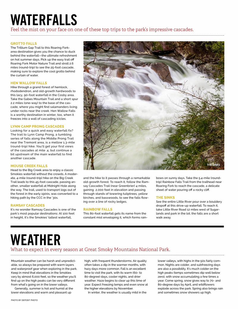
THE SINKSSee the entire Little River pour over a bouldery dropoff at this drive-up waterfall. To reach it, take Little River Road 12 miles west of Sugar-lands and park in the lot; the falls are a short walk away.
PHOTO BY DEPOSIT PHOTO
WATERFALLSFeel the mist on your face on one of these top trips to the park’s impressive cascades.
Mountain weather can be harsh and unpredict-able, so always be prepared with warm layers and waterproof gear when exploring in the park. Keep in mind that elevations in the Smokies vary by almost 6,000 feet, so the weather you’ll find up on the high peaks can be very different from what’s going on in the lower valleys.
Generally, summer is hot and humid at the lower elevations and warm and pleasant up
high, with frequent thunderstorms. Air quality often takes a dip in the warmer months, with hazy days more common. Fall is an excellent time to visit the park, with its warm (60- to 80-degree) days, cooler nights, and drier weather. Haze begins to clear up this time of year. Expect freezing temps and even snow at the higher elevations by November.
In winter, the weather is usually mild in the
lower valleys, with highs in the 50s fairly com-mon. Nights are colder, and subfreezing days are also a possibility. It’s much colder on the high peaks (temps sometimes dip well below zero), with snow accumulating a few times a year. Come spring, snow gives way to 70- and 80-degree days by April, and wildflowers explode across the park. Spring also brings rain and sometimes snow showers up high.
WEATHERWhat to expect in every season at Great Smoky Mountains National Park.
THE SINKS
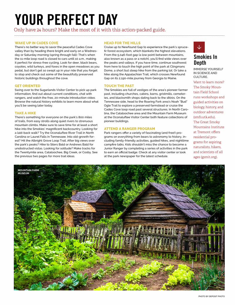
PHOTO BY DEPOSIT PHOTO
YOUR PERFECT DAYWAKE UP IN CADES COVEThere’s no better way to savor the peaceful Cades Cove valley than by heading there bright and early on a Wednes-day or Saturday morning (spring through fall): That’s when the 11-mile loop road is closed to cars until 10 a.m., making it perfect for stress-free cycling. Look for deer, black bears, coyotes, wild turkeys, and foxes in the open meadows as you pedal, but don’t get so swept up in your ride that you forget to stop and check out some of the beautifully preserved historic buildings throughout the cove.
GET ORIENTEDSwing over to the Sugarlands Visitor Center to pick up park information, find out about current conditions, chat with rangers, and watch the free, 20-minute introduction video. Browse the natural history exhibits to learn more about what you’ll be seeing later today.
TAKE A HIKEThere’s something for everyone on the park’s 800 miles of trails, from easy strolls along quiet rivers to strenuous mountain climbs. Make sure to save time for at least a short hike into the Smokies’ magnificent backcountry. Looking for a laid-back walk? Try the Oconaluftee River Trail in North Carolina or Laurel Falls in Tennessee. Into old-growth for-est? Hit the Albright Grove Loop Trail. After big views over the park’s peaks? Hike to Silers Bald or Andrews Bald for unobstructed vistas. Looking for solitude? Make tracks for the Twentymile area, Cataloochee, Big Creek, or Cosby. See the previous two pages for more trail ideas.
HEAD FOR THE HILLSCruise up to Newfound Gap to experience the park’s spruce-fir forest ecosystem, which blankets the highest elevations. From the 5,046-foot gap (a low point between mountains, also known as a pass or a notch), you’ll find wide views over the peaks and valleys. If you have time, continue southwest from here to touch the high point of the park at Clingmans Dome, a short but steep hike from the parking lot. Or take a hike along the Appalachian Trail, which crosses Newfound Gap on its 2,190-mile journey from Georgia to Maine.
TOUCH THE PASTThe Smokies are full of vestiges of the area’s pioneer farmer past, including churches, cabins, barns, gristmills, cemeter-ies, and blacksmith shops dating back to the 1800s. On the Tennessee side, head to the Roaring Fork area’s Noah “Bud” Ogle Trail to explore a preserved farmstead or cruise the Cades Cove loop road past several structures. In North Caro-lina, the Cataloochee area and the Mountain Farm Museum at the Oconaluftee Visitor Center both feature collections of pioneer buildings.
ATTEND A RANGER PROGRAMPark rangers offer a variety of fascinating (and free!) pro-grams on everything from bears to astronomy to history, in-cluding family-friendly activities, guided hikes, and nighttime campfire talks. Kids shouldn’t miss the chance to become a Junior Ranger by completing a series of activities in the park to earn an official badge. Check at any visitor center or look at the park newspaper for the latest schedule.
Only have 24 hours? Make the most of it with this action-packed guide.
Want to learn more? The Smoky Moun-tain Field School runs workshops and guided activities on biology, history, and outdoor adventures (smfs.utk.edu). The Great Smoky Mountains Institute at Tremont offers residential pro-grams for aspiring naturalists, hikers, and scientists of all ages (gsmit.org).
Smokies In DepthIMMERSE YOURSELF IN SCIENCE AND CULTURE.
MOUNTAIN FARM MUSEUM
WILDLIFEA huge variety of animals both large and small call the Smoky Mountains home.
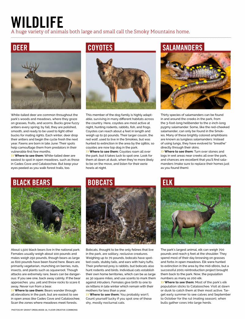
White-tailed deer are common throughout the park’s woods and meadows, where they graze on grasses, fruits, and acorns. Bucks grow fuzzy antlers every spring; by fall, they are polished, smooth, and ready to be used to fight other bucks for mating rights. Each winter, deer drop their antlers and begin the cycle fresh the next year. Fawns are born in late June: Their spots help camouflage them from predators in their vulnerable first few months. ›› Where to see them: White-tailed deer are easiest to spot in open meadows, such as those in Cades Cove and Cataloochee. But keep your eyes peeled as you walk forest trails, too.
This member of the dog family is highly adapt-able, surviving in many different habitats across the country. Here, coyotes are most active at night, hunting rodents, rabbits, fish, and frogs. Coyotes can reach about 4 feet in length and weigh up to 50 pounds. Their larger cousin, the red wolf, used to live in the Smokies, but was hunted to extinction in the area by the 1980s, so coyotes are now top dog in the park.›› Where to see them: Coyotes roam all over the park, but it takes luck to spot one. Look for them at dawn at dusk, when they’re more likely to be on the move, and listen for their eerie howls at night.
Bobcats, thought to be the only felines that live in the park, are solitary, reclusive creatures. Weighing up to 70 pounds, bobcats have spot-ted coats, stubby tails, and ears with hairy tufts. Their preferred prey is rabbits, but bobcats also hunt rodents and birds. Individual cats establish their own home territories, which can be as large as 30 square miles, and use scents to mark them against intruders. Females give birth to one to six kittens in late winter which remain with their mothers for less than a year.›› Where to see them: You probably won’t. Count yourself lucky if you spot one of these shy, mostly nocturnal cats.
About 1,500 black bears live in the national park. Females usually weigh about 100 pounds and males weigh 250 pounds, though bears as large as 600 pounds have been found here. Bears are primarily vegetarian, munching on berries, nuts, insects, and plants such as squawroot. Though attacks are extremely rare, bears can be danger-ous: If you see one, back away calmly. If the bear approaches you, yell and throw rocks to scare it away. Never run from a bear. ›› Where to see them: Bears wander through all elevations in the park, but are easiest to see in open areas like Cades Cove and Cataloochee. Scan the zones where meadows meet forests.
Thirty species of salamanders can be found in and around the creeks in the park, from the 3-foot-long hellbender to the 2-inch-long pygmy salamander. Some, like the red-cheeked salamander, can only be found in the Smok-ies. Many of these brightly colored amphibians are known as lungless salamanders: Instead of using lungs, they have evolved to “breathe” directly through their skins.›› Where to see them: Turn over stones and logs in wet areas near creeks all over the park, and chances are excellent that you’ll find sala-manders (make sure to replace their homes just as you found them).
The park’s largest animal, elk can weigh 700 pounds and reach 5 feet at the shoulder. They spend most of their day browsing on grasses and forbs in open meadows. Elk were hunted to extinction in the area by the mid-1800s, but a successful 2001 reintroduction project brought them back to the park. Now, the population numbers as many as 200 elk.›› Where to see them: Most of the park’s elk population sticks to Cataloochee. Visit at dawn or dusk to catch them at their most active. Tar-get early summer to see calves and September to October for the rut (mating season), when bulls gather cows into large herds.
DEER
BLACK BEARS
COYOTES
BOBCATS
SALAMANDERS
ELK
PHOTOS BY GRANT ORDELHEIDE (3), FLICKR CREATIVE COMMONS
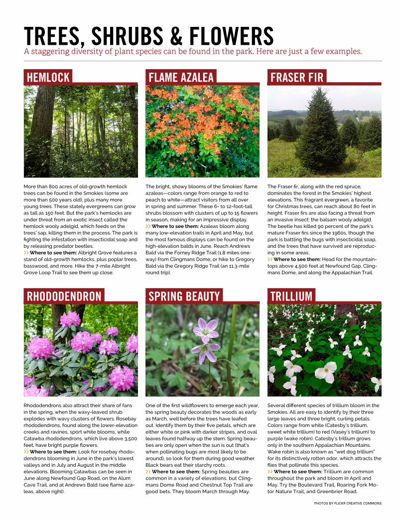
The Fraser fir, along with the red spruce, dominates the forest in the Smokies’ highest elevations. This fragrant evergreen, a favorite for Christmas trees, can reach about 80 feet in height. Fraser firs are also facing a threat from an invasive insect: the balsam wooly adelgid. The beetle has killed 90 percent of the park’s mature Fraser firs since the 1960s, though the park is battling the bugs with insecticidal soap, and the trees that have survived are reproduc-ing in some areas.›› Where to see them: Head for the mountain-tops above 4,500 feet at Newfound Gap, Cling-mans Dome, and along the Appalachian Trail.
FRASER FIR
PHOTOS BY FLICKR CREATIVE COMMONS
TREES, SHRUBS & FLOWERSA staggering diversity of plant species can be found in the park. Here are just a few examples.
More than 800 acres of old-growth hemlock trees can be found in the Smokies (some are more than 500 years old), plus many more young trees. These stately evergreens can grow as tall as 150 feet. But the park’s hemlocks are under threat from an exotic insect called the hemlock wooly adelgid, which feeds on the trees’ sap, killing them in the process. The park is fighting the infestation with insecticidal soap and by releasing predator beetles.›› Where to see them: Albright Grove features a stand of old-growth hemlocks, plus poplar trees, basswood, and more. Hike the 7-mile Albright Grove Loop Trail to see them up close.
One of the first wildflowers to emerge each year, the spring beauty decorates the woods as early as March, well before the trees have leafed out. Identify them by their five petals, which are either white or pink with darker stripes, and oval leaves found halfway up the stem. Spring beau-ties are only open when the sun is out (that’s when pollinating bugs are most likely to be around), so look for them during good weather. Black bears eat their starchy roots.›› Where to see them: Spring beauties are common in a variety of elevations, but Cling-mans Dome Road and Chestnut Top Trail are good bets. They bloom March through May.
Rhododendrons also attract their share of fans in the spring, when the waxy-leaved shrub explodes with wavy clusters of flowers. Rosebay rhododendrons, found along the lower-elevation creeks and ravines, sport white blooms, while Catawba rhododendrons, which live above 3,500 feet, have bright purple flowers. ›› Where to see them: Look for rosebay rhodo-dendrons blooming in June in the park’s lowest valleys and in July and August in the middle elevations. Blooming Catawbas can be seen in June along Newfound Gap Road, on the Alum Cave Trail, and at Andrews Bald (see flame aza-leas, above right).
Several different species of trillium bloom in the Smokies. All are easy to identify by their three large leaves and three bright, curling petals. Colors range from white (Catesby’s trillium, sweet white trillium) to red (Vasey’s trillium) to purple (wake robin). Catesby’s trillium grows only in the southern Appalachian Mountains. Wake robin is also known as “wet dog trillium” for its distinctively rotten odor, which attracts the flies that pollinate this species.›› Where to see them: Trillium are common throughout the park and bloom in April and May. Try the Boulevard Trail, Roaring Fork Mo-tor Nature Trail, and Greenbrier Road.
HEMLOCK
RHODODENDRON SPRING BEAUTY TRILLIUM
The bright, showy blooms of the Smokies’ flame azaleas—colors range from orange to red to peach to white—attract visitors from all over in spring and summer. These 6- to 12-foot-tall shrubs blossom with clusters of up to 15 flowers in season, making for an impressive display.›› Where to see them: Azaleas bloom along many low-elevation trails in April and May, but the most famous displays can be found on the high-elevation balds in June. Reach Andrews Bald via the Forney Ridge Trail (1.8 miles one-way) from Clingmans Dome, or hike to Gregory Bald via the Gregory Ridge Trail (an 11.3-mile round trip).
FLAME AZALEA