National Park Service U.S. Department of the Interior · 2017. 10. 29. · Golden Gate National...
3
Golden Gate National Recreation Area National Park Service U.S. Department of the Interior The endangered tidewater goby lives in these brackish waters, a mix of salt water and fresh water. Este charco de agua dulce es un hábitat apto para esta rana patiroja del norte, una especie en peligro de extinción. El pez Eucyclogobius newberryi en peligro de extinción vive en estas aguas salobres, una mezcla de agua dulce y salada. This freshwater pond makes great habitat for the red-legged frog, a threatened species. Endangered Gem Just minutes from bustling city life, Rodeo Beach is a grand outdoor getaway. Locals and travelers alike seek quiet and play along this patch of coast. The estuary also provides a home or stopover for wildlife. But higher seas will submerge the narrow beach strip that makes this special place possible. Earth’s warming temperatures—mostly caused by human actions like burning fossil fuels—are melting glaciers and making ocean waters expand. What is our responsibility to protect this sanctuary for people and wildlife? Joya en peligro A solo minutos del bullicio urbano, Rodeo Beach es un buen escape al aire libre. Tanto los residentes como los viajeros buscan la tranquilidad y el recreo de esta costa. El estuario también ofrece una morada—o una parada—para la vida silvestre. Pero el alza de los mares sumergirá la franja estrecha que hace posible este lugar tan especial. Las temperaturas del calentamiento global—provocadas principalmente por actividades humanas como la quema de combustibles fósiles— derriten glaciares y aumentan los océanos. ¿Cuál es nuestro compromiso para proteger este santuario para la gente y la vida silvestre? Projected high tide in 2300 plus storm surge 6.4 m Marea alta proyectada en el 2300 más las marejadas de tempestades Elevation of freshwater pond 1 m Marea alta proyectada en el 2100 Promedio de marea alta en el 2000 3 m Elevación del charco Average high tide in 2000 Projected high tide in 2100 Usted está aquí Usted está aquí Elevation of barrier beach 3.7 m Elevación del cordón litoral Marea alta proyectada en el 2300 With 3 feet of sea level rise (projected in 2100), storm waves will crash over this barrier beach— disrupting the salinity of the estuary and freshwater pond. Con un metro de aumento en el nivel del mar (proyectado en el 2100), las olas de tempestades chocarán sobre esta playa— afectando la salinidad del estuario y del charco. Barrier beach Estuario Estuary See how sea level rise threatens wildlife here and what you can do to slow the change. Scan the code or visit http://go.nps. gov/seas13 Conozca de qué manera el alza del mar amenaza la vida silvestre de este lugar y lo que usted puede hacer para reducir el aumento. Escanee el código o visite la página web http:// go.nps.gov/seas13 Medir el nivel del mar Cordón litoral Measure for Sea Level Este poste marca el nivel actual del mar y los niveles proyectados para las marejadas de tempestades. El alza del mar desaparecerá esta playa protectora y sumergirá este estuario valioso. 3’ 21’ 0 12’ 10’ Prognóstico del IPCC 2013 Projections from IPCC 2013 Projected high tide in 2100 plus storm surge You Are Here You Are Here This pole marks projected sea levels and storm surges. Rising waters will wipe out the protective barrier beach and drown this valuable estuary. Marea alta proyectada en el 2100 más las marejadas de tempestades Projected high tide in 2300
Transcript of National Park Service U.S. Department of the Interior · 2017. 10. 29. · Golden Gate National...

Golden Gate National Recreation Area National Park ServiceU.S. Department of the Interior
The endangered tidewater goby lives in these brackish waters, a mix of salt water and fresh water.
Este charco de agua dulce es un hábitat apto para esta rana patiroja del norte, una especie en peligro de extinción.
El pez Eucyclogobius newberryi en peligro de extinción vive en estas aguas salobres, una mezcla de agua dulce y salada.
This freshwater pond makes great habitat for the red-legged frog, a threatened species.
Endangered Gem Just minutes from bustling city life, Rodeo Beach is a grand outdoor getaway. Locals and travelers alike seek quiet and play along this patch of coast. The estuary also provides a home or stopover for wildlife. But higher seas will submerge the narrow beach strip that makes this special place possible. Earth’s warming temperatures—mostly caused by human actions like burning fossil fuels—are melting glaciers and making ocean waters expand. What is our responsibility to protect this sanctuary for people and wildlife?
Joya en peligro
A solo minutos del bullicio urbano, Rodeo Beach es un buen escape al aire libre. Tanto los residentes como los viajeros buscan la tranquilidad y el recreo de esta costa. El estuario también ofrece una morada—o una parada—para la vida silvestre. Pero el alza de los mares sumergirá la franja estrecha que hace posible este lugar tan especial. Las temperaturas del calentamiento global—provocadas principalmente por actividades humanas como la quema de combustibles fósiles—derriten glaciares y aumentan los océanos. ¿Cuál es nuestro compromiso para proteger este santuario para la gente y la vida silvestre?
Projected high tide in 2300 plus storm surge
6.4 m Marea alta proyectada en el 2300 más las marejadas de tempestades
Elevation of freshwater pond
1 m Marea alta proyectada en el 2100
Promedio de marea altaen el 2000
3 m Elevación del charco
Average high tide in 2000
Projected high tide in 2100Usted está aquí
Usted está aquí
Elevation of barrier beach 3.7 m Elevación del cordón litoral
Marea alta proyectada en el 2300
With 3 feet of sea level rise (projected in 2100), storm waves will crash over this barrier beach—disrupting the salinity of the estuary and freshwater pond.
Con un metro de aumento en el nivel del mar (proyectado en el 2100), las olas de tempestades chocarán sobre esta playa—afectando la salinidad del estuario y del charco.
Barrier beach
EstuarioEstuary
See how sea level rise threatens wildlife here and what you can do to slow the change. Scan the code or visit http://go.nps.gov/seas13
Conozca de qué manera el alza del mar amenaza la vida silvestre de este lugar y lo que usted puede hacer para reducir el aumento. Escanee el código o visite la página web http://go.nps.gov/seas13
Medir el nivel del mar
Cordón litoral
Measure for Sea LevelEste poste marca el nivel actual del mar y los niveles proyectados para las marejadas de tempestades. El alza del mar desaparecerá esta playa protectora y sumergirá este estuario valioso.
3’
21’
0
12’
10’
Prognóstico del IPCC 2013Projections from IPCC 2013
Projected high tide in 2100 plus storm surge
You Are Here
You Are Here
This pole marks projected sea levels and storm surges. Rising waters will wipe out the protective barrier beach and drown this valuable estuary.
Marea alta proyectada en el 2100 más las marejadas de tempestades
Projected high tide in 2300
8’
Golden Gate National Recreation Area National Park ServiceU.S. Department of the Interior
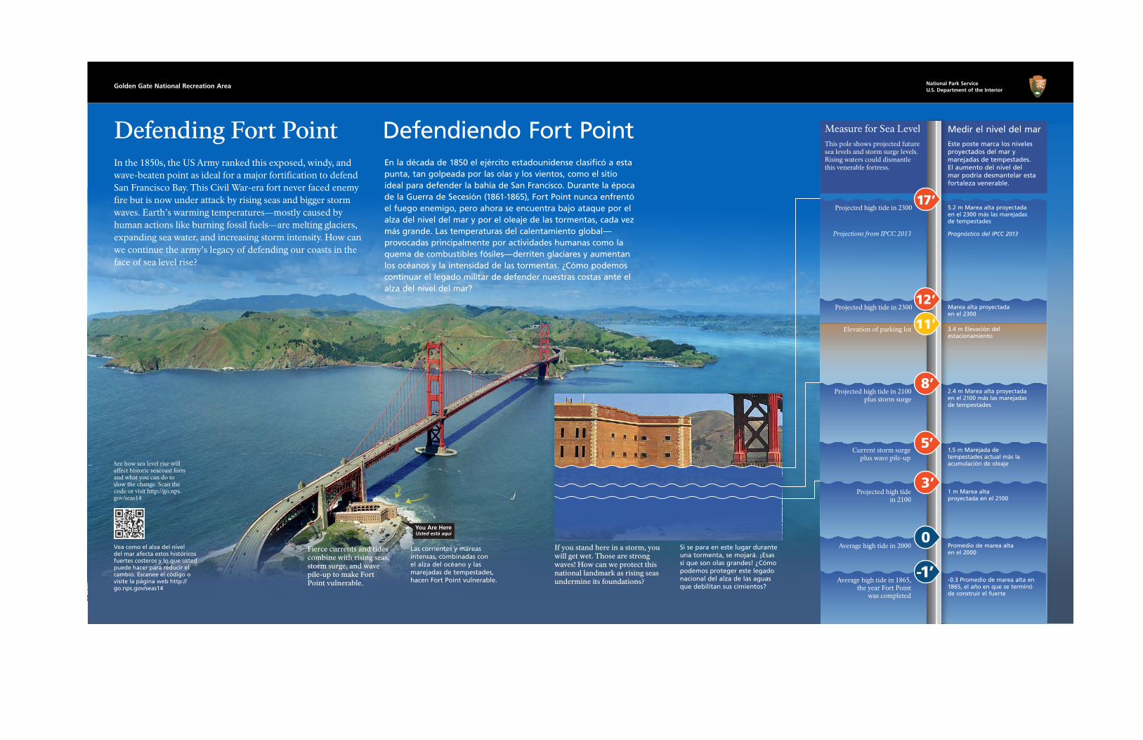
Defending Fort Point Defendiendo Fort Point In the 1850s, the US Army ranked this exposed, windy, and wave-beaten point as ideal for a major fortification to defend San Francisco Bay. This Civil War-era fort never faced enemy fire but is now under attack by rising seas and bigger storm waves. Earth’s warming temperatures—mostly caused by human actions like burning fossil fuels—are melting glaciers, expanding sea water, and increasing storm intensity. How can we continue the army’s legacy of defending our coasts in the face of sea level rise?
En la década de 1850 el ejército estadounidense clasificó a esta punta, tan golpeada por las olas y los vientos, como el sitio ideal para defender la bahía de San Francisco. Durante la época de la Guerra de Secesión (1861-1865), Fort Point nunca enfrentó el fuego enemigo, pero ahora se encuentra bajo ataque por el alza del nivel del mar y por el oleaje de las tormentas, cada vez más grande. Las temperaturas del calentamiento global—provocadas principalmente por actividades humanas como la quema de combustibles fósiles—derriten glaciares y aumentan los océanos y la intensidad de las tormentas. ¿Cómo podemos continuar el legado militar de defender nuestras costas ante el alza del nivel del mar?
Fierce currents and tides combine with rising seas, storm surge, and wave pile-up to make Fort Point vulnerable.
Las corrientes y mareas intensas, combinadas con el alza del océano y las marejadas de tempestades, hacen Fort Point vulnerable.
See how sea level rise will affect historic seacoast forts and what you can do to slow the change. Scan the code or visit http://go.nps.gov/seas14
Vea como el alza del nivel del mar afecta estos históricos fuertes costeros y lo que usted puede hacer para reducir el cambio. Escanee el código o visite la página web http://go.nps.gov/seas14
Usted está aquí
Projected high tide in 2300
Projected high tide in 2300
Projected high tide in 2100 plus storm surge
5.2 m Marea alta proyectada en el 2300 más las marejadas de tempestades
3.4 m Elevación del estacionamiento
Marea alta proyectada en el 2300
2.4 m Marea alta proyectada en el 2100 más las marejadas de tempestades
1.5 m Marejada de tempestades actual más la acumulación de oleaje
Current storm surge plus wave pile-up
Projected high tide in 2100
1 m Marea alta proyectada en el 2100
Average high tide in 2000 Promedio de marea alta en el 2000
-0.3 Promedio de marea alta en 1865, el año en que se terminó de construir el fuerte
Average high tide in 1865, the year Fort Point
was completed
5’
-1’
Medir el nivel del mar
Si se para en este lugar durante una tormenta, se mojará. ¡Esas sí que son olas grandes! ¿Cómo podemos proteger este legado nacional del alza de las aguas que debilitan sus cimientos?
If you stand here in a storm, you will get wet. Those are strong waves! How can we protect this national landmark as rising seas undermine its foundations?
You Are Here
Este poste marca los niveles proyectados del mar y marejadas de tempestades. El aumento del nivel del mar podría desmantelar esta fortaleza venerable.
This pole shows projected future sea levels and storm surge levels. Rising waters could dismantle this venerable fortress.
Measure for Sea Level
12’
3’
0
17’
Elevation of parking lot
Prognóstico del IPCC 2013Projections from IPCC 2013
11’

Golden Gate National Recreation Area National Park ServiceU.S. Department of the Interior
Waterside Treasure Tesoro a la orilla de la bahía This place is a national treasure! It feeds the soul and provides a recreational playground for locals and global travelers alike. But the very ocean we enjoy here threatens the existence of this beach and promenade. Earth’s warming temperatures—mostly caused by human actions like burning fossil fuels—melt glaciers and make sea water expand. Rising seas will submerge our seaside retreat. Should we reduce carbon emissions or build levees?
¡Este lugar es un tesoro nacional! Alimenta el alma y ofrece un área recreativa para los residentes y extranjeros. Pero el océano que disfrutamos aquí amenaza la existencia de esta playa y del paseo marítimo. Las temperaturas del calentamiento global—provocadas principalmente por actividades humanas como la quema de combustibles fósiles—derriten glaciares y expandan los océanos. Los mares crecientes sumergirán nuestro retiro costero. ¿Debemos reducir las emisiones de carbono o construir diques?
Snowy plover
Storm waves already crash over the sea wall to the west. As sea waters rise, storm surge and swells get bigger.
Las olas de tormentas ya se quiebran sobre el malecón hacia el oeste. Cuando sube el océano, crecen las marejadas.
The beach offers snowy plovers a life-saving food-and-rest stop.
La playa les ofrece a los chorlos nevados una parada esencial para descansar y comer.
Chorlo nevado
This pole marks projected sea level and storm surge—to show how rising waters affect your recreation and migrating birds.
Projected high tide in 2300 plus storm surge
Projected high tide in 2100
Current storm surge plus wave pile-up
Projected high tide in 2300
Average high tide in 2000
4.9 m Marea alta proyectada en el 2300 más las marejadas de tempestades
3.7 m Marea alta proyectada en el 2300
1 m Marea alta proyectada en el 2100
Donde descansan los chorlos
1.2 m Actual marejada de tempestad más acumulación de olas
Promedio de la marea alta en el 2000
See how the National Park Service is reducing its carbon footprint, and how you can help slow sea level rise. Scan the code or visit http://go.nps.gov/seas15
Vea como el National Park Service está reduciendo su impacto de carbono—y cómo puede usted ayudar a reducir el alza del nivel del mar. Escanee el código o visite la página web http://go.nps.gov/ seas15
Measure for Sea Level
7’
16’
4’
Projected high tide in 2100 plus storm surge
Elevation of promenade
2.1 m Marea alta proyectada en el 2100 más las marejadas de tempestades
Elevación de este paseo marítimo
Este poste marca los niveles proyectados del mar y de las marejadas de tempestades para mostrar como el alza del mar afectará su área de recreo y las aves migratorias.
Medir el nivel del mar
0
3’
12’
Prognóstico del IPCC 2013Projections from IPCC 2013
Elevation of plover resting area