National Park Service Cultural Landscapes Inventory 2010 · National Park Service Cultural...
74
1 National Park Service Cultural Landscapes Inventory 2010 Murie Ranch Historic District Grand Teton National Park
Transcript of National Park Service Cultural Landscapes Inventory 2010 · National Park Service Cultural...

1
National Park Service Cultural Landscapes Inventory 2010
Murie Ranch Historic District
Grand Teton National Park

2
Department of Landscape Architecture and Environmental Planning Utah State University, Logan, Utah 84322
May, 2010
Principal Investigator – Associate Professor Michael Timmons Graduate Research Assistants – Colleen Corballis and Emily Wheeler
Completed in fulfillment of Rocky Mountain Cooperative Ecosystem Studies Unit
Cooperative Agreement #H1200040001
Murie Ranch Historic District Grand Teton National Park Contents Page 4 Inventory Unit Summary and Site Plan Page 8 Concurrence Status Page 9 Geographic Information and Location Map Page 14 Management Information
3
Page 16 National Register Information Page 22 Chronology and Physical History Page 29 Analysis and Evaluation Page 35 Landscape Characteristics
Page 35 Archaeological Sites
Page 36 Buildings and Structures
Page 42 Circulation
Page 46 Cluster Arrangement
Page 48 Constructed Water Features
Page 50 Cultural Traditions
Page 52 Land Use
Page 53 Natural Systems and Features
Page 55 Small Scale Features
Page 59 Spatial Organization
Page 62 Topography
Page 64 Vegetation
Page 68 Views and Vistas
Page 71 Condition and Treatment Page 73 Biography and Supplemental Information

4
Inventory Unit Summary and Site Plan Cultural Landscape Inventory Name: Murie Ranch Historic District Cultural Landscape Inventory Number: 890057 Parent Cultural Landscape Inventory Name: Grand Teton NP Landscape Parent Cultural Landscape Inventory Number: 890193 Park Name: Grand Teton National Park Park Alpha Code: GRTE Park Org Code: 1460 Landscape/Component Landscape Description: The Murie Ranch Historic District is located in Moose WY, within the boundaries of Grand Teton National Park (GRTE). The District as designated on the NRHP includes 73.16 acres along the west side of the Snake River, at the base of the Teton Mountain range. The area covered by this CLI includes an additional 80 acres, for a total of 153.16 acres. The property’s significance is owed to the Murie family, leaders in the conservation movement who resided on the ranch from 1945 until 2003. Naturalists Olaus Murie and his wife Mardy were seminal figures in preservation activities of the Wilderness Society and the passage of the Wilderness Act in 1964. As executive of the Society, Olaus Murie pushed conservation into a new era, protecting much of the nation’s natural heritage and making substantial contributions as a naturalist, scientist, and wildlife advocate. The property served not only as the setting for the writing of the Wilderness Act, but also as a place where the great minds in conservation science could converge in the seclusion of the great wilderness at the base of the Tetons. The 1953 annual meeting of the Wilderness Society, held at the Murie Ranch, is among the most notable of these academic convergences, though many other noteworthy figures visited the ranch during the Murie's residency there. Although the ranch certainly has a colorful history as a dude ranch, pre-dating the arrival of the Muries, the District’s period of significance spans from 1945, when the Muries acquired the property, to 1980, when Congress passed, and the president signed into law, the Alaska National Interest Lands Conservation Act, championed by Mardy Murie. The property is a testament to the Muries’ passion for conservation and conviction in the necessity of a harmonious coexistence between man and nature. The site is entered through an unpaved driveway one-half mile southwest of the GRTE headquarters, terminating in an informal parking area in front of the cabin that now serves as the headquarters of the Murie Center. The constructed features of the property include fourteen cabins, which served as homes for the families residing on the ranch and as lodging to accommodate guests during the property’s early dude ranch period. Located in proximity to the cabins are two of the eight original outhouses, along with four recently built non-functional replicas. Service features, including a garage, engine room, and electric utility pole remain, as does a bathhouse constructed in 2003. The property also bears the physical remains of a seventh outhouse, and minor remnants of the oil house and foundation of the root cellar. An historic refuse dump is located at the end of a trail in the southwest portion of the property. The district is primarily heavily wooded, although the residential core of the site is structured around a series of clearings. Cabins are placed for the most part around the periphery of these spaces, helping to define their edges. The openings in the forested surroundings allow for distant mountain views, and provide gathering, activity, and parking space. The clearings are vegetated with low shrubs, dominated by rubber rabbitbrush and sage, with grasses and wildflowers filling the interspaces. Clusters of aspen give definition to the clearings, and grow adjacent to many of the structures. The woodlands that surround the core of the property are composed of cottonwoods, blue spruce, Douglas-fir, aspen, and lodgepole pine, with cottonwoods and spruce dominating the lower elevations.
5
The cultural elements of the wooded periphery outside the historic district include informal trails used by the Muries and currently by park visitors. A trail to the Snake River located behind the Frame Cabin provided access to the Muries’ swimming holes. The trail travels south, passing over a narrow footbridge, where low berms and depressions reveal the history of the meanderings of the Snake River and its side channels. A closed-loop trail, which the Muries dubbed the Around the World Trail, traverses forested landscape to the west of the historic district, passing the beaver ponds and the former location of a “lookout” tree (referred to in its time as the Olaus Tree). The Muries were adamant that the trails not impair the natural integrity of the site. The informality of the trails today seems to be congruent with the Muries’ vision. This CLI recommends extending the boundaries of the historic district to include the Around the World Trail and the Snake River Trail due to their close association with the activities of the Muries during the period of significance. Inventory Unit Size (Acres): 153.16 acres Property Level: Component Landscape CLI Hierarchy Description: Murie Ranch Historic District is a component landscape of the larger Grand Teton National Park. Murie Ranch was deeded to the National Park Service in 1966 with a life estate for the Muries. Mardy Murie resided on the ranch until her death in 2003. The surrounding national park landscape is critical to the natural setting of the Murie Ranch Historic District, and Murie Ranch is a memorial to the conservation movement that was important in the establishment of Grand Teton National Park. The developed character of Murie Ranch Historic District is distinct from the surrounding natural landscape of Grand Teton National Park, and as such, it warrants specific documentation from the larger parent park.
6
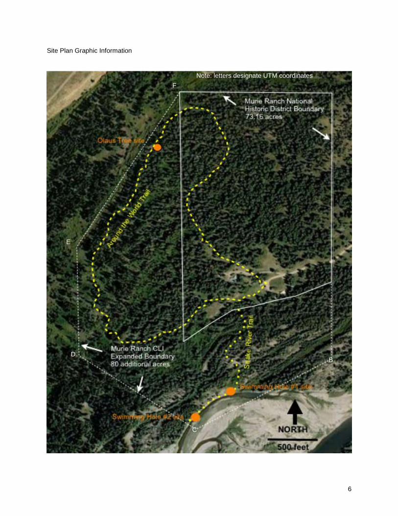
Site Plan Graphic Information
B
C
D
E
F Note: letters designate UTM coordinates

7
Murie Ranch Historic District - Detail Plan of Residential Compound

8
Concurrence Status Cultural Landscape Inventory Name: Murie Ranch Historic District Cultural Landscape Inventory Number: 890057 Parent Cultural Landscape Inventory Name: Grand Teton NP Landscape Parent Cultural Landscape Inventory Number: 890193 Park Name: Grand Teton National Park Park Alpha Code: GRTE Park Org Code: 1460 Inventory Status: Incomplete Completion Status Explanatory Narrative: Park Superintendent Concurrence: To be filled in upon Superintendent and SHPO concurrence Date of Superintendent Concurrence: To be filled in upon Superintendent and SHPO concurrence National Register Eligibility: To be filled in upon Superintendent and SHPO concurrence National Register Eligibility Concurrence Date (SHPO/Keeper): To be filled in upon Superintendent and SHPO concurrence Concurrence Graphic Information: To be filled in upon Superintendent and SHPO concurrence

9
Geographic Information and Location Map Cultural Landscape Inventory Name: Murie Ranch Historic District Cultural Landscape Inventory Number: 890057 Parent Cultural Landscape Inventory Name: Grand Teton NP Landscape Parent Cultural Landscape Inventory Number: 890193 Park Name: Grand Teton National Park Park Alpha Code: GRTE Park Org Code: 1460 Inventory Unit Boundary Description: Verbal Boundary Descriptions and Boundary Justification (from National Historic Landmark Nomination Form, designated February 17, 2006): “Lot 1, and the NE of Section 35, T.43N, R.116W, 6th P.M. This land base conforms to that purchase by Olaus and Margaret Murie and Adolph and Louise Murie between 1945 and 1949. Buster Estes patented 76.16 acres. The changing course of the Snake River appears to account for the 3-acre difference between the GLO survey and the NPS purchase”. This CLI recommends extending the boundaries to include the Around the World Trail and the Snake River Trail to the former Murie swimming holes due to their close association with the activities of the Muries during the period of significance. The site evaluation in this CLI reflects the recommended boundary expansion of an additional 80 acres, for a total of 153.16 acres. Counties and States State: Wyoming County: Teton

10
Location Map Graphic Information Boundary UTM Boundary Boundary Boundary UTM Boundary UTM

11
Boundary UTM Source Type Zone Easting Northing USGS Map Area 1:24000 A 12 522114 4833641 B 12 522114 4832834 C 12 521707 4832623 D 12 521360 4832834 E 12 521360 4833191 F 12 521653 4833641

12
Regional Landscape Context Physiographic: The physiographic setting of the Murie Ranch is central to its historical function and significance. The ranch is located west of the Snake River and east of the Teton Range, in the High Elevation Valleys ecoregion of the Middle Rockies (Chapman et al 2004). The following description of the physiographic setting of Grand Teton National Park, and thus the Murie Ranch as well, is taken from the National Register of Historic Places Registration Form for Murie Ranch Historic District, prepared by Historical Research Associates in 1997, and recorded in 1998: “The Tetons are approximately 9 miles wide and 40 miles long, with eight peaks over 12,000 ft. in elevation. Jackson Hole ranges in width from eight to twelve miles and is 55 miles in length. The valley climate is extreme, characterized by short summers initiated in late June when heavy frosts recede and terminated by September snow. Ten-foot snow pack accumulations in the mountains are common, while the valley snow cover is generally limited to two to five feet. Despite this snowfall, the valley is semi-arid, with an average annual precipitation of 10 inches. Temperatures range from an average high of 81 degrees F. in the height of summer to an average high of 25 degrees F. in the depths of winter. “The region’s distinctive topographical features are the result of the geological forces of mountain building and glaciation. The Teton fault divides the range from the adjoining valley, which dropped in elevation as the mountains rose. Glacial activity created the moraines that formed the basins and sides of piedmont lakes – Leigh, Jenny, Bradley, Taggart, String, and Phelps. [Jackson Lake is a natural body of water whose height has been augmented by dams since 1907, to increase water storage capacity.] Forested ridges contrast sharply with surrounding gray-green sagebrush flats, a distinctive element of the landscape at Jackson Hole. The valley floor is covered with quartzite cobbles, another souvenir of the glacial era. “The Snake River courses through Jackson Hole along a cottonwood and spruce-lined channel. It originates near the south boundary of Yellowstone National Park and flows into Jackson Lake. Below the Jackson Lake Dam, the Snake flows east then abruptly turns to the southwest cutting a diagonal path through Jackson Hole to Idaho. Three important tributaries feed the Snake from the east: Pacific Creek, the Buffalo Fork of the Snake, and the Gros Ventre River. Ditch Creek and Spread Creek also enter the Snake above Moose, Wyoming. The river and its tributaries provide habitat for a wide variety of [native] plants and animals. Beavers, otters, moose, bears, deer, eagles, ospreys, trumpeter swans, and [cutthroat] trout are among the wildlife inhabiting the region. The ecosystem also supports the largest herd of elk in the world.” Cultural: Jackson Hole has been home to humans for thousands of years, though most of these early inhabitants seem to have lived a nomadic lifestyle. Most recently, the Jackson Hole region was home to Shoshoni people for at least a portion of the year. Fur trappers first ventured into the area in the early 1800s, followed by explorers and prospectors, but because of the region’s harsh climate, permanent settlers came much later in the century. Though some homesteaders attempted farming, and others had some success with ranching, the area’s scenic and natural qualities proved to be its greatest resource, and dude ranches and other activities related to tourism became an important part of Jackson Hole’s development. These natural qualities also attracted the Muries to Jackson Hole, and led to the movement that created Grand Teton National Park. The most significant cultural quality of the Murie Ranch Historic District relates to the role it played in the evolution of the U.S. conservation movement. Olaus Murie was president of the Wilderness Society

13
beginning in 1945 when he purchased the STS Ranch, and his environmental ethos is evidenced in the development of the landscape, particularly the use of natural trails made by wildlife for circulation and the removal of fences and other obstructions on the site. The ranch was an important formal and informal meeting place for the Wilderness Society and for individuals involved in the conservation movement. Political: Murie Ranch Historic District is located in Grand Teton National Park in the northwestern corner of the state of Wyoming. It is a half-mile southwest of the Grand Teton National Park headquarters in Moose, Wyoming, in the valley known as Jackson Hole. The ranch is about 13 miles north of Jackson, Wyoming, the county seat of Teton County, Wyoming.

14
Management Information Cultural Landscape Inventory Name: Murie Ranch Historic District Cultural Landscape Inventory Number: 890057 Parent Cultural Landscape Inventory Name: Grand Teton NP Landscape Parent Cultural Landscape Inventory Number: 890193 Park Name: Grand Teton National Park Park Alpha Code: GRTE Park Org Code: 1460 Management Category: Partnership Agreement with the Murie Center Management Category Date: Management Category Explanatory Narrative: Do Adjacent Lands Contribute: Yes Adjacent Lands Description: The Murie Ranch Historic District is located in Grand Teton National Park, and the backdrop of the park is key to the integrity of the site, especially in the areas of feeling and association. The Teton Mountains, to the west, comprise important views from the ranch. The Jackson Hole Airport is located two miles south of Murie Ranch, generating considerable air traffic and intrusive noise. Adjacent Lands Graphic Information Management Agreement NPS Legal Interest Type of Legal Interest: Fee Simple
Adjacent Lands Yellow = Murie Ranch Green = GRTE NP Beige = National Elk Refuge White = private land (Teton County GIS data)

15
Fee Simple Reservation for Life: Fee Simple Reservation Expiration Date: Other Organization/Agency: NPS Legal Interest Explanatory Narrative: Public Access to Site Public Access: Unrestricted Public Access Explanatory Narrative: FMSS Asset Numbers:
11231 MURIE RANCH COMPLEX AREA 4335 MURIE Center Access Road 51567 (HS)0972 MURIE Ranch (Studio) 51568 (HS)0973 MURIE Ranch (Residence) 51569 (HS)0975 MURIE Cabin (Estes) 51571 (HS)0976 MURIE Cabin (Robin’s Nest) 51572 (HS)0977 MURIE Film Room 51573 (HS)0974 MURIE Cabin (Chena) 51574 (HS)0978 MURIE Cabin 51575 (HS)0979 MURIE Cabin 51577 (HS)0980 MURIE Cabin (Alatna) 51578 (HS)0981 MURIE Cabin (Belvedere) 51579 (HS)0982 MURIE Cabin (Polaris) 51580 (HS)0983 MURIE Cabin (Montana) 51581 (HS)0984 MURIE Cabin (Homestead) 51582 (HS)0985 MURIE Cabin (Wild Rose) 51583 (HS)0986 MURIE Engine Room 51584 (HS)0987 MURIE Garage 51585 B0988 MURIE Oil Shed 51588 (HS)0991 MURIE Wood Shed 84159 (HS)986A Outhouse MURIE 84161 (HS)979A Outhouse MURIE 84164 (HS)983A Outhouse MURIE 84167 (HS)980A Outhouse MURIE 84169 B974A Outhouse MURIE 84171 (HS)973A Outhouse MURIE 84174 (HS)973B Woodshed MURIE 84176 (HS)982A Outhouse MURIE 84178 (HS)981A Outhouse MURIE
National Register Information Cultural Landscape Inventory Name: Murie Ranch Historic District Cultural Landscape Inventory Number: 890057 Parent Cultural Landscape Inventory Name: Grand Teton NP Landscape Parent Cultural Landscape Inventory Number: 890193
16
Park Name: Grand Teton National Park Park Alpha Code: GRTE Park Org Code: 1460 National Register Landscape Documentation: Entered – Inadequately Documented National Register Reference Number: 98001039 NHLS National Register Explanatory Narrative: The Murie Ranch Historic District was officially entered in the National Register of Historic Places (NRHP) on August 24, 1998. In 1990, prior to this designation, the Murie residence and studio were designated as historic structures on the NRHP. On February 17, 2006, the Murie Ranch was designated as a National Historic Landmark for its national importance to the conservation movement. Current National Register documentation focuses only on the buildings of the district, leaving out key landscape features that are significant to understanding the property. The additional areas recommended by this CLI to encompass the Around the World Trail and the former swimming hole sites are also not documented. National Register Eligibility: To be filled in upon SHPO concurrence National Register Eligibility Concurrence Date: To be filled in upon SHPO concurrence National Register Concurrence Explanatory Narrative: To be filled in upon SHPO concurrence National Register Significance Level: National National Register Significance Contributing/Individual: Individual National Register Classification: District National Historic Landmark Status: Listed National Historic Landmark Date: February 17, 2006 National Historic Landmark Theme: VII (Transforming the Environment) 3. Protecting/Preserving the Environment World Heritage Site Status: Not listed World Heritage Site Date: N/A World Heritage Category: N/A Statement of Significance: When evaluated within its historic context, a property must be shown to be significant for one or more of the four criteria for evaluation; A, B, C, or D. The criteria describe how properties are significant for their association with important events or persons, for their importance in design or construction, or for their information potential.

17
Murie Ranch Historic District was recorded in the National Register of Historic Places as nationally significant under criterion A, for its association with the 20th century American conservation movement. It is also eligible under criterion B, for its association with noted conservationists Olaus J. Murie, his wife Margaret E. “Mardy” Murie, and his brother Adolph Murie. The NRHP listing defined a period of significance spanning from the Muries’ initial purchase of part of the property in 1945, to the 1964 passage of Wilderness Act one year after the death of Olaus Murie. This period was expanded with the conferral of National Historic Landmark status to 1980, the year that congress passed, and the president signed into law, the Alaska National Interest Lands Conservation Act. This act, championed by Mardy Murie, created the Arctic National Wildlife Refuge and expanded the wilderness holdings in that state administered by several public agencies. It is this more encompassing period, 1945-1980, which is addressed by this cultural landscape inventory. Within the 70-plus acre confines of the Murie Ranch property, Olaus, Mardy, and Adolph developed theories and positions, hosted luminaries in the conservation movement, and wrote numerous scientific publications. The setting, amidst forest and meadow along the Snake River and at the foot of the majestic Teton Range, was inspirational to their work. The dialogues held in the cluster of small rustic cabins and in the larger surrounding landscape continue to inspire and inform ongoing discussions of land and environmental ethic.

18
NRIS Information National Register Significance Criteria National Register Significance Criteria: A – Event - American Conservation Movement, passage of Wilderness Act (1964) and Alaska National Interest Lands Conservation Act (1980) B – Person- Olaus Murie, Mardy Murie, Adolph Murie National Register Period of Significance Start Year: 1945 End Year: 1980 Historic Context Theme Historic Theme Historic Subtheme Historic Facet 1. Creating Social Institutions Social and Humanitarian Environmental and Movements Movements Movement 2. Transforming the Conservation of Natural Emergence of Federal Environment Resources conservation legislation 3. Transforming the Conservation of Natural Wilderness System Environment Resources 4. Transforming the Conservation of Natural Fish, Wildlife and Environment Resources Vegetation Preservation National Register Areas of Significance Area of Significance Category Area of Significance Subcategory 1. Conservation Chronology and Physical History Cultural Landscape Inventory Name: Murie Ranch Historic District Cultural Landscape Inventory Number: 890057 Parent Cultural Landscape Inventory Name: Grand Teton NP Landscape Parent Cultural Landscape Inventory Number: 890193
19
Park Name: Grand Teton National Park Park Alpha Code: GRTE Park Org Code: 1460 Primary Historic Function - Major Category: Domestic Primary Historic Function - Category: Multiple Dwelling Primary Historic Function: Multiple Dwelling-other Primary Current Use - Major Category: Education Primary Current Use - Category: Research Facility Primary Current Use: Other Ethnographic Study Conducted: Yes, for GRTE Ethnographic Explanatory Narrative: Murie Ranch Historic District is part of the larger landscape that had important spiritual meaning for Native American tribes in the region, as well as providing them with the physical necessities of food, clothing, and shelter. Cultural Landscape Types Cultural Landscape Type: Historic Site; Vernacular Landscape Other Current and Historic Uses/Functions 1. Use/Function Category: Education Use/Function: Educational Related Housing Detailed Use/Function: Type of Use/Function: Current 2. Use/Function Category: Education Use/Function: Interpretive Landscape Detailed Use/Function: Type of Use/Function: Current 3. Use/Function Category: Domestic Use/Function: Hotel Detailed Use/Function: Lodge Type of Use/Function: Historic 4. Use/Function Category: Domestic Use/Function: Multi-dwelling Detailed Use/Function: Multiple-dwelling - other Type of Use/Function: Historic Ethnographic Associated Groups

20
The following tribes have “some association” with the Grand Teton National Park and/or the National Elk Refuge, according to An Assessment of American Indian Occupation and Use of the Cultural and natural Resources of Grand Teton NP and the National Elk Refuge (Walker Research Group, 2007.) Apache (various groups) Arapaho Assiniboine Sioux Blackfoot Cheyenne Coeur d’Alene Comanche Crow Eastern Shoshoni and Sheepeaters Gros Ventre Kiowa Nez Perce Salish-Kootenai Group (Flathead, Pend d’Oreille-Kalispel, Chelan, Wenatchee, Entiat) Shoshoni-Bannock/Northern Paiute Teton Sioux Umatilla Group (Cayuse, Walla Walla) Yakama Group (Palouse, Kittitas,Klikitat,Taitnapam)

21
Current and Historic Names Name Name Type 1. Estes Homestead Historic 2. STS Dude Ranch Historic 3. Stella Woodbury Historic Summer Home 4. Murie Ranch Current Historic District 5. Murie Ranch Current and Historic 6. Smithsonian # 48TE1143 Current 7. The Murie Center Current
22
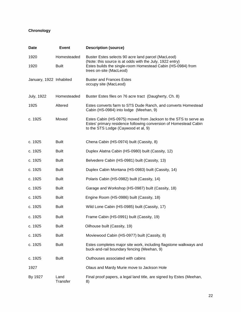
Chronology
Date Event Description (source) 1920 Homesteaded Buster Estes selects 90 acre land parcel (MacLeod)
(Note: this source is at odds with the July, 1922 entry) 1920 Built Estes builds the single-room Homestead Cabin (HS-0984) from
trees on-site (MacLeod)
January, 1922 Inhabited Buster and Frances Estes occupy site (MacLeod)
July, 1922 Homesteaded Buster Estes files on 76 acre tract (Daugherty, Ch. 8) 1925 Altered Estes converts farm to STS Dude Ranch, and converts Homestead
Cabin (HS-0984) into lodge (Meehan, 9) c. 1925 Moved Estes Cabin (HS-0975) moved from Jackson to the STS to serve as
Estes' primary residence following conversion of Homestead Cabin to the STS Lodge (Caywood et al, 9)
c. 1925 Built Chena Cabin (HS-0974) built (Cassity, 8) c. 1925 Built Duplex Alatna Cabin (HS-0980) built (Cassity, 12) c. 1925 Built Belvedere Cabin (HS-0981) built (Cassity, 13) c. 1925 Built Duplex Cabin Montana (HS-0983) built (Cassity, 14) c. 1925 Built Polaris Cabin (HS-0982) built (Cassity, 14) c. 1925 Built Garage and Workshop (HS-0987) built (Cassity, 18) c. 1925 Built Engine Room (HS-0986) built (Cassity, 18) c. 1925 Built Wild Lone Cabin (HS-0985) built (Cassity, 17) c. 1925 Built Frame Cabin (HS-0991) built (Cassity, 19) c. 1925 Built Oilhouse built (Cassity, 19) c. 1925 Built Moviewood Cabin (HS-0977) built (Cassity, 8) c. 1925 Built Estes completes major site work, including flagstone walkways and
buck-and-rail boundary fencing (Meehan, 9) c. 1925 Built Outhouses associated with cabins 1927 Olaus and Mardy Murie move to Jackson Hole By 1927 Land
Transfer Final proof papers, a legal land title, are signed by Estes (Meehan, 8)

23
Late 1920s Land
Transfer Small acreage leased to Mrs. Woodbury (Meehan, 14)
1929 Congress sets aside a portion of the present-day GRTE After late 1920s
Built Log summer home built for Mrs. Woodbury (future Murie Residence), HS-0973 (Craighead, 75; MacLeod)
After late 1920s
Built Denali Cabin (HS-0979) built by Mrs. Woodbury for guest accommodation (Meehan, 14)
After late 1920s
Built Chena Cabin (HS-0974) built by Mrs. Woodbury to accommodate caretaker (Meehan, 14) Note: according to Cassity, 8, this cabin was built c. 1925
1942 Built Woodbury Home (future Murie Residence), HS-0973, completed
(Cassity, 7) 1943 President Franklin D. Roosevelt creates Jackson Hole National
Monument 1943 Developed The campfire site is used on the property with adjacent fencing,
possibly located adjacent to Murie Residence (Brewer)
1943 Developed A gateway arch and fence are present in front of Murie Homestead and a fence and sign are located at property entry (Brewer)
1945 Developed Rural electrification reaches the Moose area and Murie Ranch (Meehan, 14)
1945 Land
Transfer Muries purchase Estes property (MacLeod) Begin Period of Significance.
1946 Inhabited Muries move into the ranch (Meehan, 15) 1946 Altered Barn is chinked for a new cow purchased by Ade, (Meehan, 13)
1947-1953 Built Olaus Murie studio built, (Cassity, 7) 1948 Land
Transfer Muries buy out remaining Estes property to complete the ranch, except for 2 acres sold to Fred Abercrombie inside the east boundary next to the fence that marked the edge of the property (Meehan, 14)
24
1949 1949/1950
Altered Land Transfer
New swimming hole shown to Muries by Buster Estes on north edge of the property where the river splits. Becomes a popular place in the summertime. (Meehan, 16) The Muries purchase the Woodbury cabin (HS-0973) (NHL nomination, 5, Craighead, 75) Note: a reference in Meehan, p14, suggests that the Woodbury Cabin and Denali Cabin (HS-0979) were both acquired by the Muries in 1947.
1950 Jackson Hole National Monument is combined with Grand Teton National Park
1950s Altered Bathhouse is attached to engine room (Meehan, 13)
1950s Maintained Outhouse maintenance undertaken (Meehan, 13)
1950
Land Transfer
GRTE enlarged to include the Rockefeller properties, almost surrounding Murie property by NPS lands (Meehan, 22)
1963 Olaus Murie dies
1963 Developed The first phone is installed on the ranch (Meehan, 14)
1964 Congress passes the Wilderness Act
1966 Land Transfer
Murie warranty deed selling ranch conditionally to Grand Teton National Park, with a life estate for Mardy, Adolph and Louise Murie (Deed)
1970 s Built Donald and Jan’s children build a fort near the studio, elevated playhouse (Meehan, 20)
1970s Removed Barn and storage shed (Cassity)
1974 Adolph Murie dies 1980 Enacted Alaska National Interest Lands Conservation Act
End Period of Significance
1990 Listed Murie residence and studio listed on NRHP as nationally significant historic structures
1997 The non-profit Murie Center is established at Murie Ranch
Before 1998 Removed Denali Cabin removed (Shea)
1998 Listed Murie Ranch Historic District listed on NRHP as a nationally significant historic district (Caywood et al)
Between 1998-2003
Removed Oil House removed (Cassity)
2001 Stabilized Homestead (HS-0984) stabilized (Save America’s Treasures Grant)

25
2001 Stabilized Wild Lone (HS-0985) stabilized (Save America’s Treasures Grant)
2002 Restored Montana (HS-0983) restored (Save America’s Treasures Grant)
2002 Restored Polaris (HS-0982) restored (Save America’s Treasures Grant)
2002 Restored Belvedere (HS-0981) restored (Save America’s Treasures Grant)
2002 Restored Alatna (HS-0980) restored (Save America’s Treasures Grant)
2002 Stabilized Studio (HS-0972) stabilized (Save America’s Treasures Grant)
2002 Rehabilitated Garage (HS-0987) rehabilitated (Save America’s Treasures Grant)
2003 Altered Paths to cabins are lined with small stones (in Cassity, NHL nomination, photo by Richard Collier)
2003 Restored Garage (HS-0987) restored (Save America’s Treasures Grant)
2003 Built Bathhouse completed (Save America’s Treasures Grant)
2003 After 2006
Destroyed
Mardy Murie dies Murie Cabin outhouse (HS-973A) collapsed under tree fall
Feb. 17, 2006
Listed Murie Ranch Historic District designated a National Historic Landmark
2009 2009
Removed Removed
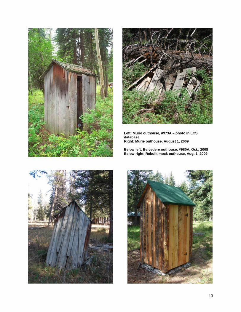
Remnants of a historic fence at Chena cabin removed after damage by winter tree fall Four original outhouses were removed by NPS (Montana Outhouse HS-0983A; Polaris Outhouse HS-0982A; Belvedere Outhouse HS-0981 A; Alatna Outhouse HS-0980A). The outhouses were reconstructed as non-functioning replicas.
2009-2010 CLI for Murie Ranch Completed by Utah State University

26
History Native Occupation: to c. 1868 Little is known about the early Native American inhabitants of Jackson Hole, who entered the region about 11,000 years ago. Until the early 1800s, the only people to occupy the Jackson Hole region were nomadic or semi-nomadic tribes including the Shoshoni, Crow, Blackfoot, Bannock, and Gros Ventre, who spent summer months hunting wildlife in and around the valley. To the Native tribes the area of Jackson Hole and the Tetons was part of a larger matrix of sacred sites, which included the local flora and fauna as well as landforms. The entire region was considered sacred, and its resources had both physical and spiritual importance. With the arrival of the horse into their culture, the bison became the primary game species in the region, though elk, or wapiti, were also important. At the time of contact with Euro-Americans, bands of Shoshoni belonging to the Eastern Shoshoni tribe lived in Jackson Hole. In 1868, these Shoshoni were moved to the 3,500 square-mile Wind River Reservation, headquartered in Fort Washakie, some 150 miles to the east. The Bannock-Shoshoni, a combined group of Northern Shoshoni and Bannock tribes on the Fort Hall (Idaho) Reservation, still retained the right to hunt on unoccupied land outside of their reservation, including areas of Jackson Hole, which led to conflicts with Euro-American settlers, such as the Jackson Hole War of 1895 (Walker Research Group 2007). Note: For more information on Native uses of the area, see An Assessment of American Indian Occupation and Use of the Cultural and Natural Resources of Grand Teton National Park and the National Elk Refuge, Walker Research Group, Ltd., November 2007. Exploration: c. 1807 - 1884 Historical records are unclear regarding the first non-Native people to enter the Jackson Hole region. John Colter may have passed through Jackson Hole on his 1807-1808 journey to find trading partners among the Crow. Trappers from the Missouri Fur Company trapped in Jackson Hole in 1810-1811, and the area continued to be visited by trappers for several decades. After the Mexican War the federal government’s interest in surveying the Intermountain West increased, including the Jackson Hole-Yellowstone region. In 1860, mountain man and trapper Jim Bridger led W.F. Raynolds’ first U.S. government-sponsored surveying party through Jackson Hole, and following the Civil War other surveying and scientific parties explored the region. Ferdinand Hayden, who had been part of Raynolds’ 1860 expedition, was one of the explorers who returned for other surveys of Yellowstone and Jackson Hole. During Hayden’s 1872 expedition, what was arguably the first ascent of the Grand Teton by Euro-Americans occurred, though historians dispute when the first ascent occurred and by whom. One of the most significant events for Jackson Hole during Hayden’s 1872 expedition was that William Henry Jackson took the first photographs of the Grand, Middle, and South Tetons from the west side of the range. These photos helped to excite interest in the Tetons among Americans and Europeans who viewed them (Daugherty 1999). Note: For more information on this time period see the Historic Resource Study of Grand Teton National Park, A Place Called Jackson Hole, John Daugherty, 1999. Homesteading and Dude Ranches 1884-1945 Homesteading came late to Jackson Hole, as its climate was not as favorable to farming as other public lands open for settlement. Two former trappers, John Holland and John Carnes and his wife Millie Sorelle, established the first homesteads in Jackson Hole. Ranching proved to be more profitable for homesteaders than farming, but even with ranching Jackson Hole was a difficult area to homestead due to the area’s geographical isolation and harsh winters. Homesteaders eventually tapped into the scenic resources of the area, opening dude ranches for tourists from the Eastern U.S. and Europe who wanted

27
to experience the West. The dude ranch business attracted both locals and former dudes who purchased land to establish these new enterprises (Daugherty 1999). Buster and Frances Estes were among those to try their hand at dude ranching. Buster had previously worked at a dude ranch, where he met Frances, a wealthy east coast woman whose family objected to their marriage. In 1922, Buster filed a homestead claim on 76 acres, where he and Frances would launch the STS Dude Ranch three years later. At that time many of the cabins on the site were added, including the Estes cabin, which was moved from an unknown location in Jackson Hole. The Estes operated the STS Dude Ranch for 20 years before selling it to their friends the Muries (Meehan 2001). Note: For more information on the homestead period see the Historic Resource Study of Grand Teton National Park, A Place Called Jackson Hole, John Daugherty, 1999. The Muries and the Conservation Movement: 1927-1980 Olaus and Mardy Murie moved to Jackson, Wyoming, in 1927, to study the region’s wildlife. They arrived in Jackson Hole at an important time in the history of conservation. In 1929, an act of Congress set aside a portion of the present day Grand Teton National Park. For the next two decades, the issue of conservation was a controversial topic in Jackson Hole, with individuals such as John D. Rockefeller, Jr. working to expand the boundaries of the park. In 1943 President Franklin D. Roosevelt created the Jackson Hole National Monument, and in 1950 this was combined with the original Grand Teton National Park to create the present day park (Daugherty 1999). In 1945, Olaus and Mardy Murie and Adolph and Louise Murie together purchased the STS Dude Ranch and made it their home, as well as an informal headquarters for the Wilderness Society, of which Olaus was the director. Olaus, Mardy, and Adolph used the ranch as a base for their science and conservation activities. As noted by Michael Cassity on the Murie Ranch Historic Landmark nomination form, “Those activities shaped not only the field of natural science and its use in public agencies charged with responsibility for natural resource management, but that also shaped the American conservation movement, including the development of legislation and public policies that sought to protect and preserve natural resources, and especially wildlife and land areas that contained wilderness areas”. The ranch was an important meeting place for conservationists as they worked to create the Wilderness Act and other conservation legislation (Cassity 2003). Following her husband’s death in 1963 and the passage of the Wilderness Act the following year, Mardy continued her active engagement with the conservation and wilderness movements. Her particular interest in preserving the wilderness of Alaska culminated with the passage of the Alaska National Interest Lands Conservation Act in 1980, one of the most important pieces of legislation in the history of land conservation (Cassity 2003). The Murie Ranch property was sold to Grand Teton National Park in 1966, with a life tenancy arrangement for Mardy, as well as for Adolph and his wife Louise. Adolph continued his research and publications in the field of biological science and his outspoken advocacy for minimizing human manipulation of nature in the national parks until his death in 1974. His wife Louise remained there a few years after Adolph's death, before re-locating to the town of Jackson (Cassity 2003). Recent History: 1980-present Mardy continued to live at the ranch and use it as a base for conservation education until her death in 2003, having celebrated her one hundred-first birthday two months earlier. Throughout these later years, Mardy hosted a multitude of visiting scholars, scientists, and activists making the pilgrimage to this historic hub of environmental consciousness and paying tribute to the woman who came to known as the “grandmother of the conservation movement.” The non-profit Murie Center was established in partnership with Grand Teton National Park in 1997 to continue the Murie legacy through “engaging people to understand and to commit to the enduring value of

28
conserving wildlife and wild places” (Murie Center Mission Statement). The rehabilitation of a number of buildings has allowed the perpetuation of the ranch as a residential research and learning center for scholars of conservation and wilderness. The Murie Center is permitted use of NPS buildings and facilities at the Murie Ranch under an agreement signed with the National Park Service, updated in 2009 (Murie Center web site).
29
Analysis and Evaluation of Integrity Cultural Landscape Inventory Name: Murie Ranch Historic District Cultural Landscape Inventory Number: 890057 Parent Cultural Landscape Inventory Name: Grand Teton NP Landscape Parent Cultural Landscape Inventory Number: 890193 Park Name: Grand Teton National Park Park Alpha Code: GRTE Park Org Code: 1460 Analysis and Evaluation of Integrity Narrative Summary: The Murie Ranch Historic District retains its integrity and is in good condition. The ranch reflects much of the same values and attitudes towards harmony with nature today as it did during its period of significance. The National Register of Historic Places Registration Form prepared for the Murie Ranch Historic District by Historical Research Associates in 1997 noted that despite some deterioration, “all extent buildings except the engine room (#986), the oil house (#988), an outhouse (#974A), and the extensively modified woodshed (#973B) retain sufficient integrity of workmanship, materials, design, and location to contribute to the district's historical significance. All interior spaces retain physical integrity and contribute to the buildings' significance” (Caywood et al 1997). Since listing on the NRHP in 1998, many structures on the property have been carefully restored, and several non-contributing features have been removed. The National Historic Landmark Nomination prepared for the Murie Ranch Historic District by Michael Cassity in 2003 describes recent changes as follows: “Two sets of alterations have taken place in the years since the end of the period of historic significance. One is a process of deterioration, both natural and purposeful; the process of natural decay, however, has been largely reversed by a rehabilitation project in the last three years and the intentional removal of several buildings has been limited and does not adversely impact the integrity of the remaining structures. Because of the meticulous attention to detail in the second set of alterations the rehabilitation project the historic district retains a remarkable integrity of structure, materials, workmanship, location, appearance, feeling, and association.” Since the writing of the previously cited documents, a remnant of historic fence has been removed after being damaged by a falling tree, one outhouse has been destroyed by a falling tree, and four of the historic outhouses which were in various states of deterioration have been reconstructed as non-functioning replicas. Although regrettable, these minor changes do not diminish the overall integrity of the site. Analysis of Landscape Integrity The National Register identifies seven aspects of integrity: Location, Design, Setting, Materials, Workmanship, Feeling, and Association. Three additional criteria can be relevant in the assessment of the integrity of biotic landscape elements: Community Organization/Structure (can replace Design), Species Composition (can replace Materials), and Management Techniques/Technology (can replace Workmanship). Retention of these qualities is essential for a property to convey its historic identity or

30
evoke its appearance during a significant period in history; however, all seven qualities are not required in order to convey a sense of past time and place. This CLI provides additional documentation related to these aspects. Location: Retains Integrity This aspect of integrity refers to the place where the landscape and its elements was constructed or evolved into being. The location of the Murie Ranch was not by chance. Olaus Murie, a wildlife biologist for the U.S. Bureau of Biological Survey in Alaska, was re-assigned by the Survey to Jackson, Wyoming, in 1927. Olaus and his wife, Mardy, fell in love with Jackson Hole because it reminded them of Alaska. After almost two decades living in the town of Jackson, the opportunity to acquire the former STS Ranch from Buster and Frances Estes presented itself. As Mardy was to later recount, “This piece of river bottom was my favorite spot years before we ever dreamed of owning it” (Meehan 2001). The same qualities of place that led the Muries to their 1945 purchase would impress visiting scientists, conservationists, and scholars for decades to come. The location of the ranch at the base of the Teton Range is an essential aspect of integrity, which remains intact. Design / Biotic Community Organization: Retains Integrity The combination of elements that create the form, plan, spatial organization, and style of a cultural landscape or historic property fall under this category. The constructed design of the Murie Ranch traces largely to the development of the STS Ranch in the mid-1920s, when a number of rustic cabins were built on (or in some cases moved to) the site by Buster Estes. Cabins were located for the most part in a circular form extending from the original Estes home (Homestead Cabin #984). The cabins were rustic, single-story log structures of simple massing, featuring gabled or shed roofs, and typically an open porch supported by log columns or timber posts. Additional structures included utilitarian outbuildings, located outside the main circle. Two major structures added later in time were the Woodbury House #973, (built in 1942 this would become the Murie Residence) and Olaus Murie’s Studio #972, built between 1947-1953. The similarity in design of all of these structures and their placement on the landscape creates the strong identity of the Murie Ranch compound, which retains a high degree of integrity. The 1997 NRHP nomination form noted that (as of that date), “modifications to the historic site are limited to the removal of cabin #979; barn #989; a storage shed; STS icehouse, bathhouse, and chickenhouse; and the virtual collapse of engine room #986 and oil house #988. Of these, only the removal of cabin #979 (which once helped to define the cabin circle) directly and adversely impacts the site's integrity of design and its association with the Murie family: the agricultural outbuildings were most directly associated with the operation of the STS dude ranch.” As further noted on the 2003 NHL nomination form, “The loss of these buildings represents a lamentable injury to the complex, but does not impair the integrity of the remaining features because of their physically peripheral location.” The Garage and Workshop #987 underwent significant rehabilitation in the early 2000s, with a conversion of the structure from garage to office space for the Murie Center. As noted in the 2003 NHL documentation, changes to the building were substantial, but “a concerted effort on the parts of the Murie Center, the rehabilitation consultant, and the Wyoming SHPO have assured that the building can be evaluated as contributing.” The bathhouse, constructed in 2003, adheres to the same general principles of design as the historic buildings in the district, constructed of logs with a gabled roof. As noted on the NHL nomination form, “it is obviously non-contributing”, but “because its appearance is non-intrusive … and because it is located on the peripheries of the district, and even partially obscured by them, it does not impair the integrity of the other buildings that are contributing.” These changes have impacted the site’s design, but not to the extent that the integrity of the site is damaged. The site design of the Murie Ranch during the period of significance was (and still remains) primarily utilitarian in nature. During the period from the mid-1920s to mid-1940s, Buster Estes had endeavored to create landscape improvements befitting the function of a working dude ranch. A dirt road provided access into the property, and additional spurs led to the cabin areas. Corrals were built, rail fences divided pasture areas, and decorative fencing defined some cabins. Flagstone walks were laid in various

31
locations linking cabins. These elements contradicted the spirit of the natural site desired by the Muries, and were over time removed and/or allowed to revegetate. Photographs and accounts from the period of significance depict a sustainable landscape of minimal upkeep and maintenance. This simple site layout remains essentially intact today. The natural landscape of the Murie Ranch is comprised of several biotic communities, including sagebrush flats, riparian wetlands, and coniferous forest. It is the convergence of communities with the rich diversity of flora and fauna present in such a compact area that was attractive to the Muries. The natural plant communities remain intact, and wildlife roam freely through the woodlands and meadows, a fundamentally critical characteristic of the landscape the Muries cherished. Setting: Retains Integrity Setting is the physical environment of a historic property that illustrates the character of the place. The context of the Murie Ranch, situated along the Snake River floodplain at the foot of the majestic Teton Range, creates a unique physical environment unchanged since the period of significance. Protection of the surrounding land by the National Park Service (NPS) has prevented the encroachment of new land use within the environs of the property. The approach to the site through mixed conifer / cottonwood riparian forest and sagebrush shrubland, with occasional glimpses through trees of rugged mountain peaks, creates an indelible impression of the setting as it has since the original Estes homestead. The NPS has maintained the informal, unpaved entry road into the property, although the new Moose Visitor Center is prominently visible along the first part of the drive. The inconspicuous trails from which the Muries contemplated nature’s glory still reinforce the integrity of the setting. Materials / Species Composition: Retains Integrity Materials and species composition refers to the materials employed in the construction of built elements on the site as well as the natural elements including plant species present during the period of significance. The materials of the buildings and structures are for the most part historic. Cabins are built of logs or log slab, with pole chinking and wood floors. Only one residential unit, the Frame Cabin #991, is of wood-frame construction. Original dry-laid river stone or wood-wall foundations have largely been replaced by concrete for stability, although attention to detail during rehabilitation included in some instances, the facing of concrete with original foundation stones, in order to retain appearance. Other rustic building details include chimneys of un-coursed river cobble and porches supported by log or timber posts. Roof surfaces of rolled asphalt have in several instances been replaced by steel, creating some loss of integrity due to the highly reflective nature of the new material. Some historic materials in buildings have been replaced in-kind during routine maintenance or during restoration work undertaken within the last decade. Landscape materials from the period of significance are essentially intact, although the crushed gravel that has been added to paths and parking areas is not a historic material, and lining paths with stones or logs is not a historic practice. In terms of natural materials, the species composition of the site is intact, retaining a high degree of integrity. Based on comparison of vegetative descriptions from the period of significance and analysis of historic photos, the area historically covered by sagebrush has been slightly reduced. Otherwise, the plants found growing on the Murie Ranch and their distribution on the site today mirrors conditions present during the period of significance. Workmanship / Biotic Management Techniques: Retains Integrity The aspect of workmanship refers to the physical evidence of the crafts of a particular period and the management of biotic resources. The construction of the log cabins represents workmanship typical of historic buildings from the Jackson Hole dude ranch era, including saddle notched and hog troughed corners, covered or uncovered, and pole chinking.
32
The fences from the dude ranch era may also have represented historic workmanship, but those portions of fencing that survived through the Murie period have been lost to deterioration, and now only some fence posts remain. The 2001 environmental assessment completed by the Park for the rehabilitation and adaptive use of Murie Ranch identified the need for the NPS to remove fuel load (especially dead and downed timber and brush) from areas proximate to cabins (NPS 2001). This has apparently been an ongoing effort, and current landscape management of the site utilizes a mower to cut grasses and forbs to a height of approximately 6-8” around the cabins. Swaths approximately four feet wide have also been cut in various locations throughout the meadow to create connecting “paths” between some destinations, such as the group meeting circles and cabins. The resultant visual appearance is at odds with photos from the period of significance, which show much taller stands of annual and perennial vegetation close to cabins. Feeling: Retains Integrity A property's expression of the aesthetic or historic sense of a particular period is evaluated under this aspect of integrity. The Murie Ranch, during the period of significance, possessed the feeling of natural solitude. Written comments, particularly those recorded by Mardy, reference the audible and other sensory qualities of the site, so important to the quality of feeling. Most frequently, these comments reference the sounds of wildlife, so dominant on the site. The sights, sounds, smells, and tactile sensations of the site remain intact today, all contributing to retention of integrity of feeling. The only significant detraction from the integrity of the feeling of the site results from aircraft utilizing the Jackson Hole Airport, just two miles south of Murie Ranch. Aircraft approaching the airport from the north typically pass directly overhead at less than 1,000 feet above the ground, and as noted in the recent draft environmental impact statement for airport operations, visitors at the nearby Moose monitoring station can experience aircraft sounds as high as 82 decibels, with aircraft audible at this location for about 22 minutes each hour during peak summer operational hours (NPS 2009, 91). The airport was present during the period of significance, but expansions and improvements since that time have negatively affected the feeling of the site. This impact was noted on the NHL nomination form, which stated that “impacts to that natural setting appear to be air traffic to and from the Jackson Hole airport located to the south, a development that has grown in both traffic volume and engine sound and which the Muries consistently and vigorously resisted over the years” (Cassity 2003, 6). This is a non-permanent alteration to the feeling of the site, and is subject to increase or decrease depending on future airport operations. However, the airport draft environmental impact statement completed in March, 2009, says of the preferred alternative (Alternative 2): “visitors to the Murie Ranch National Historic Landmark may feel that the increased percent of the time that aircraft are audible at this site … would increase their sense of incongruity with their expectations, especially in light of the significance of the site to the preservation of wilderness values. Therefore, Alternative 2 could result in a minor to moderate, indirect, adverse impact at this location” (NPS 2009, 251). Association: Retains Integrity This aspect of integrity refers to the direct link between the significant historic event, period, person, design, etc., and the cultural landscape. The Murie Ranch retains a high degree of integrity in this aspect, reflecting a strong association with the Muries and their conservation efforts. Throughout their occupancy from 1945 until Mardy’s passing in 2003, the Murie’s passion for the natural world permeated life on the ranch. Generations of visitors were inspired by the conscience of wilderness imbued by the Muries and embodied in the site itself, to become advocates of wild places. The Murie Center, established in partnership with Grand Teton National Park in 1997, continues the association with the Murie legacy today. Their mission to perpetuate the conservation ethic through outreach and education from the very site itself cements the integrity of site association with the history of the Murie family and their ideals. Integrity of the Property as a Whole: Retains Integrity

33
According to National Register guidelines, a property does or does not retain its overall historic integrity. The seven qualities of integrity need to be evaluated together - leading to an overall conclusion regarding the integrity of the property. Ultimately, the question of integrity is answered by whether or not the property retains the character for which it is significant. All properties change over time. It is not necessary for a property to retain all its historic physical features or characteristics. The property must retain, however, the essential physical features that enable it to convey its historic character. The essential physical features are those features that define both why a property is significant (Applicable Criteria and Areas of Significance) and when it was significant (Periods of Significance). They are the features without which a property can no longer be identified. Of the seven aspects of defined by the National Register program, the cultural landscape of Murie Ranch dating from the period of significance retains integrity in all seven. Given the retention of high or partial integrity in all seven aspects, Murie Ranch retains its integrity as a historic property.

34
Landscape Characteristics 1. ARCHEOLOGICAL SITES There are no known archeological sites on Murie Ranch that date to the period of significance. An intensive archaeological survey was conducted of the main residential zone of Murie Ranch and no significant findings were made. There is an historic dumpsite located west of the site, which could potentially yield information from the STS dude Ranch era. If other archeological sites are located within the extended boundaries proposed by this CLI they are unknown. CONTRIBUTING FEATURES: No archeological sites are known to date from the period of significance. NON-CONTRIBUTING FEATURES: The STS dumpsite has archeological potential in regards to the STS dude ranch era, particularly information about diet and material goods, but it dates from before the period of significance.

35
2. BUILDINGS AND STRUCTURES The grouping of cabins and associated outbuildings forms the skeletal structure of the Murie Ranch cultural landscape. This matrix of dark stained and weathered architecture has created the strong enclave that has been in place since the era of the STS dude ranch. The great majority of structures were either built or moved to the site in or around 1925 by Buster Estes to accommodate dude ranch operations. This became the residential compound that welcomed the family, friends, and colleagues of the Murie families. Throughout most of the period of significance, 31 buildings existed on the site. Of this total, 24 remain, most of which have been stabilized or rehabilitated. Five of the total are recent non-functioning
reconstructions. Of the other seven original buildings, two were removed from the site (barn and the Denali Cabin), three remain as foundations or ruins, and two have disappeared. A new bathhouse was added in 2003. Significant stabilization and rehabilitation over the past decade has ensured that the complex will endure into the future. The 2003 NHL nomination form notes the following regarding site restoration: “In the last five years a major effort by the Murie Center and the National Park Service has endeavored to restore the resources of the Murie Ranch Historic District to its historic appearance with full functionality and to modernize the infrastructure of the site. A daunting challenge, fraught with delicate tasks, the project involved the Wyoming SHPO in its planning and execution to assure sensitivity to the historic integrity of structures. Foundations and roofs were replaced and logs and windows that needed to be replaced were done so with careful attention to original materials and designs and utilities were concealed within buildings and underground. Probably the most extensive changes were those in which the northlight window in the roof of the studio was closed with the new roof and the garage and workshop vehicle entrance was converted to a windowed office with porch; even those changes, however, were undertaken with sensitivity to retaining original appearance and did not compromise the integrity of the resources.” From a landscape perspective, the replacement of original rolled asphalt roofing with new metal roofs creates some incongruity due to reflection of sunlight off the shinier surface. The cabins are log or wood frame one story buildings, most with porches, and concrete or stone foundations and wood floors, while the historic outhouses are simple wood frame structures. Though the buildings are of a similar scale and style, each one has variations in materials and workmanship according to the NHL nomination form: Olaus Murie Studio (972) – Rectangular log building with concrete wall foundation, saddle-notched log walls with pole chinking, and wood frame windows and doors with 5” butt joint trim and iron hardware;
Left: Olaus Murie Studio, #972, and Murie Cabin, #973 Right: Robin’s Nest, #976, Moviewood, #977, Estes Cabin, #975

36
Murie Residence (973) – Square log building, dressed and oiled saddle-notched log walls chinked with poles, brick fireplace, river stone fireplace, wood-trimmed windows with 5” butt joint trim, and log trimmed doors with iron hardware; Chena Cabin (974) – Square log building with concrete wall foundation and wood framed bathroom addition, saddle-notched log walls with split pole chinking and mortar, brick chimney, and wood frame doors and windows with 4” log trim; Estes Cabin (975) – Log building on concrete wall foundation, saddle-notched log walls with split-pole chinking, windows with varnished 6” butt joint milled lumber and 8” sill plates, and doors of 4” tongue-and-groove fir; Robins Nest Cabin (976) – Log building on stone pier foundation, saddle-notched log walls with split-pole chinking, and doors and windows trimmed with 5” butt joint oiled lumber; “Moviewood” Cabin (977) – Wood frame building with horizontal log slab siding, and untrimmed windows and doors; Capron Cabin (978) – Square log building with partial concrete wall foundation, nailed hog-trough corners, pole chinking, metal stove pipe, and windows and doors trimmed with unfinished 5” butt joint trim; Duplex Cabin Alatna (980), Cabin Belvedere (981), Cabin Polaris (982), Duplex Cabin Montana (983) – Group of cabins with consistent style, rectangular log building with stone pier foundations, log walls with nailed hog-trough corners concealed by vertical log slabs, pole chinking with mortar, windows and doors trimmed with 5” butt joint trim; Homestead Cabin/STS Lodge (984) – T-shaped log building, hog trough corners, split pole chinking, chimney, 5” rough-cut window trim; Wild Rose Cabin (985) – Rectangular log building on stone pier foundation, log walls with hog-trough corners, and windows and doors trimmed with 4” butt joint rough-cut planks; Frame Cabin (991) – Rectangular wood frame building on a log foundation, and doors and windows trimmed with rough-cut 4” trim.

37
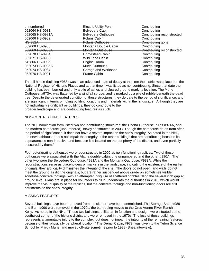
The Murie Ranch Historic District was listed on the National Register of Historic Places on August 24, 1998. The nomination form identified 20 contributing structures. The National Historic Landmark Nomination for the Murie Ranch Historic District, completed in 2003, listed 25 contributing buildings and one additional contributing structure. The following list contains the 26 buildings and structures listed as contributing in 2003. The six that are stricken through no longer exist or have been replaced by non-functioning reconstructions. In addition, the NHL form identified one noncontributing building, and four buildings that had been removed. Today, there are 19 contributing buildings and one contributing structure remaining from the NHL listing, and 5 non-contributing buildings. LCS ID & STRUCTURE NUMBER STRUCTURE NAME CONTRIBUTION 052051 HS-0972 Olaus Murie Studio Contributing 052052 HS-0973 Olaus and Mardy Murie Residence Contributing 052053 HS-0973A Murie Outhouse Contributing HS-0973B Woodshed Contributing 052055 HS-0974 Chena Cabin Contributing 052057 HS-0975 Estes Cabin Contributing 052058 HS-0976 Robin's Nest Cabin Contributing 052059 HS-0977 Moviewood Cabin Contributing 052060 HS-0978 Capron Cabin Contributing 052061 HS-0979A Denali Outhouse Contributing 052062 HS-0980 Alatna Double Cabin Contributing unnumbered Alatna Outhouse #1 Contributing reconstructed 052063 HS-0980A Alatna Outhouse #2 Contributing reconstructed
Location of buildings on the site (GRTE Archives)
38
unnumbered Electric Utility Pole Contributing 052064 HS-0981 Belvedere Cabin Contributing 052065 HS-0981A Belvedere Outhouse Contributing reconstructed 052066 HS-0982 Polaris Cabin Contributing HS-982A Polaris Outhouse Contributing gone 052068 HS-0983 Montana Double Cabin Contributing 052069 HS-0983A Montana Outhouse Contributing reconstructed 052070 HS-0984 Homestead Cabin Contributing 052071 HS-0985 Wild Lone Cabin Contributing 642806 HS-0986 Engine Room Contributing 052073 HS-0986A Murie Outhouse Contributing 052074 HS-0987 Garage and Workshop Contributing 052076 HS-0991 Frame Cabin Contributing The oil house (building #988) was in an advanced state of decay at the time the district was placed on the National Register of Historic Places and at that time it was listed as noncontributing. Since that date the building has been burned and only a pile of ashes and cleared ground mark its location. The Murie Outhouse, #973A, was flattened by a windfall spruce, and is marked by a pile of rubble beneath the dead tree. Despite the deteriorated condition of these structures, they do date to the period of significance, and are significant in terms of noting building locations and materials within the landscape. Although they are not individually significant as buildings, they do contribute to the broader landscape and are contributing features as such. NON-CONTRIBUTING FEATURES: The NHL nomination form listed two non-contributing structures: the Chena Outhouse ruins #974A, and the modern bathhouse (unnumbered), newly constructed in 2003. Though the bathhouse dates from after the period of significance, it does not have a severe impact on the site’s integrity. As noted in the NHL, the new bathhouse “does not impair the integrity of the other buildings that are contributing because its appearance is non-intrusive, and because it is located on the periphery of the district, and even partially obscured by them.” Four deteriorating outhouses were reconstructed in 2009 as non-functioning replicas. Two of these outhouses were associated with the Alatna double cabin, one unnumbered and the other #980A. The other two were the Belvedere Outhouse, #981A and the Montana Outhouse, #983A. While the reconstructions serve as placeholders or markers in the landscape, indicating the existence of the earlier originals, their artificiality diminishes the integrity of the site. The doors do not open, and walls do not meet the ground as did the originals, but are rather suspended above grade on sometimes visible sonotube concrete footings, with an attempted disguise of scattered cobbles filling the several inch gap at ground level. Plans are in place for volunteers to fill in underneath the outhouses in 2010, which would improve the visual quality of the replicas, but the concrete footings and non-functioning doors are still detrimental to the site’s integrity. MISSING FEATURES Several buildings have been removed from the site, or have been demolished. The Storage Shed #989 and Barn #990 were removed in the 1970s, the barn being moved to the Gros Ventre River Ranch in Kelly. As noted in the NHL, “These two buildings, utilitarian in function and design, were situated at the southwest corner of the historic district and were removed in the 1970s. The loss of these buildings represents a lamentable injury to the complex, but does not impair the integrity of the remaining features because of their physically peripheral location.” The Denali Cabin, #979, was given to the Teton Science School by Mardy Murie, and moved off-site sometime prior to 1988 (Shea interview).

39
Since completion of the NHL in 2006, five contributing structures have been lost. The Polaris Outhouse, #982A, apparently met with a similar fate as the Murie Outhouse, and no longer exists. Four deteriorating outhouses were removed and reconstructed in 2009 as non-functioning replicas, and are described above as non-contributing structures. As noted in the 1998 National Register listing, “while minor resources such as outhouses do not define site layout or site significance to the same degree as the more substantial buildings, they remain an indicator of the degree of historic development and of the amenities offered ranch visitors: Murie Ranch was an unobtrusive, unpretentious human toe-hold at the edge of the West's undeveloped lands. If the scenery failed to remind visitors of that fact, the outhouses almost certainly would have.”
View of western portion of Murie Ranch Historic District. Only the Frame Cabin, #991 (far left of cluster) survives. The adjacent Barn, #990 and Storage Shed, #989 (barely visible between barn and Frame Cabin), were removed in the late 1970s, and the non-contributing Oil House, #988 (far right) has been burned since 1998. (Photo taken 1977; GRTE archives)
40
Left: Murie outhouse, #973A – photo in LCS database Right: Murie outhouse, August 1, 2009 Below left: Belvedere outhouse, #980A, Oct., 2008 Below right: Rebuilt mock outhouse, Aug. 1, 2009
41
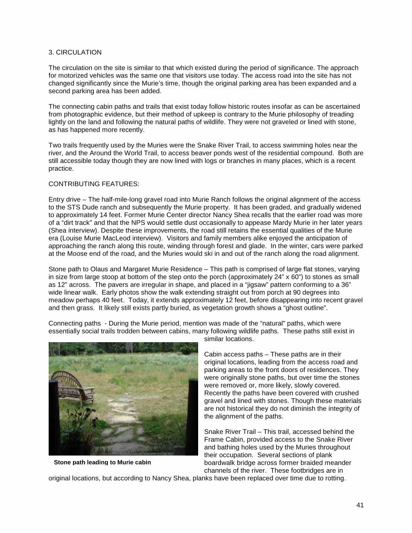
3. CIRCULATION The circulation on the site is similar to that which existed during the period of significance. The approach for motorized vehicles was the same one that visitors use today. The access road into the site has not changed significantly since the Murie’s time, though the original parking area has been expanded and a second parking area has been added. The connecting cabin paths and trails that exist today follow historic routes insofar as can be ascertained from photographic evidence, but their method of upkeep is contrary to the Murie philosophy of treading lightly on the land and following the natural paths of wildlife. They were not graveled or lined with stone, as has happened more recently. Two trails frequently used by the Muries were the Snake River Trail, to access swimming holes near the river, and the Around the World Trail, to access beaver ponds west of the residential compound. Both are still accessible today though they are now lined with logs or branches in many places, which is a recent practice. CONTRIBUTING FEATURES: Entry drive – The half-mile-long gravel road into Murie Ranch follows the original alignment of the access to the STS Dude ranch and subsequently the Murie property. It has been graded, and gradually widened to approximately 14 feet. Former Murie Center director Nancy Shea recalls that the earlier road was more of a “dirt track” and that the NPS would settle dust occasionally to appease Mardy Murie in her later years (Shea interview). Despite these improvements, the road still retains the essential qualities of the Murie era (Louise Murie MacLeod interview). Visitors and family members alike enjoyed the anticipation of approaching the ranch along this route, winding through forest and glade. In the winter, cars were parked at the Moose end of the road, and the Muries would ski in and out of the ranch along the road alignment. Stone path to Olaus and Margaret Murie Residence – This path is comprised of large flat stones, varying in size from large stoop at bottom of the step onto the porch (approximately 24” x 60”) to stones as small as 12” across. The pavers are irregular in shape, and placed in a “jigsaw” pattern conforming to a 36” wide linear walk. Early photos show the walk extending straight out from porch at 90 degrees into meadow perhaps 40 feet. Today, it extends approximately 12 feet, before disappearing into recent gravel and then grass. It likely still exists partly buried, as vegetation growth shows a “ghost outline”. Connecting paths - During the Murie period, mention was made of the “natural” paths, which were essentially social trails trodden between cabins, many following wildlife paths. These paths still exist in
similar locations. Cabin access paths – These paths are in their original locations, leading from the access road and parking areas to the front doors of residences. They were originally stone paths, but over time the stones were removed or, more likely, slowly covered. Recently the paths have been covered with crushed gravel and lined with stones. Though these materials are not historical they do not diminish the integrity of the alignment of the paths. Snake River Trail – This trail, accessed behind the Frame Cabin, provided access to the Snake River and bathing holes used by the Muries throughout their occupation. Several sections of plank boardwalk bridge across former braided meander channels of the river. These footbridges are in
original locations, but according to Nancy Shea, planks have been replaced over time due to rotting.
Stone path leading to Murie cabin Stone path leading to Murie cabin

42
Around the World Trail – The alignment of this trail follows the original trail of the Muries. During the tenure of Nancy Shea (1998-2005), tree limbs and branches were placed along the side of the path in some places in order to mark the location of the trail before it became lost. A plank footbridge still exists in its original location, but planking has been replaced over time. The “Olaus Tree”, which was an observation post fashioned by Olaus Murie to observe wildlife in wetlands west of site by nailing stakes to a tree creating a “ladder”, has fallen and since decomposed. NON-CONTRIBUTING FEATURES:
Parking areas – Two primary car-parking areas exist on the site. The larger of the two is in the middle of the meadow area, adjacent to and south of the former Garage (now Murie Center offices). It was slightly improved / expanded as part of the renovation of the Center that took place in the early 2000s. The second parking lot, of recent origin, is located at the east end of the clearing, near Olaus Murie’s studio. It is approximately 65’ x 36’ in size, graveled. North spur road – This spur leaves the main entry road at the east entrance to the residential area meadow, providing access to the northern cabin circle and the Homestead cabin. Most of the alignment predates the Murie period, however a recent extension has been added to access a new bathhouse / toilet building.
Left: Murie Ranch trails map (NPS 2001) Right: Around the World Trail, marked by fallen branches and logs

43
Path materials –Several of the walks are edged with rows of large cobbles, which, according to Nancy Shea, is a recent addition done during the Murie Center period. Most paths have recently been accentuated by addition of crushed gravel, which is a non-contributing material even though alignment of the paths in original locations is contributing. According to Nancy Shea, this was done following her tenure as director of the Murie Center, probably between 2005-2008.
Informal mowed paths – Several paths three to four feet in width have been cut through and around the meadow. These do follow historic routes, and are contrary to the Murie philosophy
of treading lightly on the land and following the natural paths of wildlife. MISSING FEATURES:
Left: New parking lot visually dominates entrance to site Center: recent surfacing of paths with crushed gravel contradicts Murie preference for natural paths Right: lining of cabin walks with cobbles Below: informal mowed paths
44
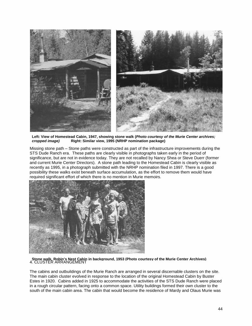
Missing stone path – Stone paths were constructed as part of the infrastructure improvements during the STS Dude Ranch era. These paths are clearly visible in photographs taken early in the period of significance, but are not in evidence today. They are not recalled by Nancy Shea or Steve Duerr (former and current Murie Center Directors). A stone path leading to the Homestead Cabin is clearly visible as recently as 1995, in a photograph submitted with the NRHP nomination filed in 1997. There is a good possibility these walks exist beneath surface accumulation, as the effort to remove them would have required significant effort of which there is no mention in Murie memoirs.
4. CLUSTER ARRANGEMENT The cabins and outbuildings of the Murie Ranch are arranged in several discernable clusters on the site. The main cabin cluster evolved in response to the location of the original Homestead Cabin by Buster Estes in 1920. Cabins added in 1925 to accommodate the activities of the STS Dude Ranch were placed in a rough circular pattern, facing onto a common space. Utility buildings formed their own cluster to the south of the main cabin area. The cabin that would become the residence of Mardy and Olaus Murie was
Left: View of Homestead Cabin, 1947, showing stone walk (Photo courtesy of the Murie Center archives; cropped image) Right: Similar view, 1995 (NRHP nomination package)
Stone walk, Robin’s Nest Cabin in background, 1953 (Photo courtesy of the Murie Center Archives)
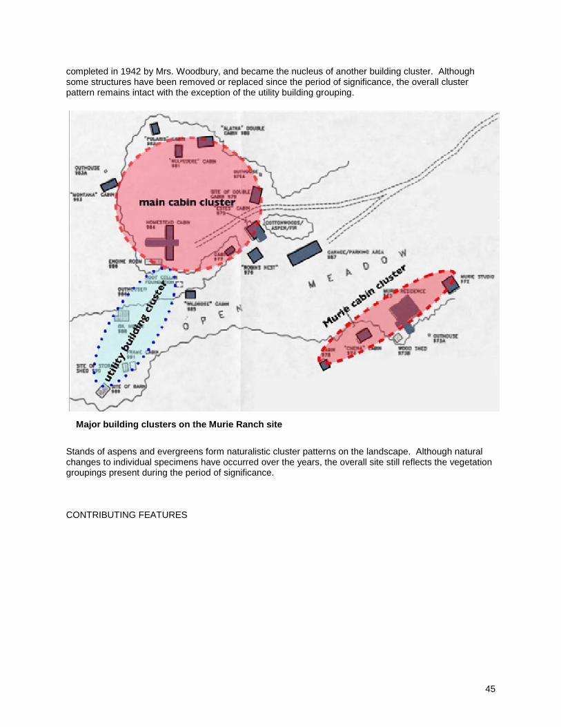
45
completed in 1942 by Mrs. Woodbury, and became the nucleus of another building cluster. Although some structures have been removed or replaced since the period of significance, the overall cluster pattern remains intact with the exception of the utility building grouping.
Stands of aspens and evergreens form naturalistic cluster patterns on the landscape. Although natural changes to individual specimens have occurred over the years, the overall site still reflects the vegetation groupings present during the period of significance. CONTRIBUTING FEATURES
Major building clusters on the Murie Ranch site

46
Cabin groupings – Guest cabins are arranged in an informal pattern, distributed to roughly enclose a large circle. Their casual siting creates interesting smaller cluster patterns, reinforced by groupings of spruce and aspen. An excellent example is afforded by the grouping of the Estes, Robin’s Nest, and Moviewood Cabins.
Vegetation distribution – Within and around the large clearing of the Murie Ranch residential area, native plants occur in clumps and groupings, which help define sub-spaces within the larger meadow. Groups of spruce have dominated the scene for some time, given the evidence of very large stumps with younger growth surrounding them. The spruce are important for their dark background in the summer, but more significantly for their winter presence when foliage has left the deciduous trees in the area. Aspen clumps form the other significant tree mass in the ranch area. Due to their suckering growth characteristic, aspens are typically found in a clustered pattern of distribution, and exhibit mixed age profiles. Around the edges of the meadow, although occasionally drifted into the meadow, hawthorns also form in groupings that form eye-level spatial partitions. NON-CONTRIBUTING FEATURES: Although non-contributing, vehicles were present throughout the Murie period and are not a radical departure from the landscape as seen during the period of significance. An overabundance of vehicles, beyond 8 or 10, would, however, begin to create an unacceptable modification of the landscape given the central location of the parking lots and the glare created by clusters of vehicles. 5. CONSTRUCTED WATER FEATURES The main constructed water features on the site were swimming holes used by the Murie family. Their locations still exist, though they have become silted in and are no longer suitable for swimming. A well is shared by Estes Cabin (975) and Robin’s Nest Cabin (976), and accessed via the basement of the Robin’s Nest Cabin, according to the NHL nomination.
Left: Clustered pattern of Estes, Robins Nest, and Moviewood Cabins Right: Spruce clustered around stump of parent tree

47
During the period of Murie occupancy, the family enjoyed daily summer dips in bath holes near the Snake River. Varying attempts were made to alter natural water patterns to enhance these features, and changes were required every few years due to natural shifts in the course of the river channels. Mardy Murie recalled with fondness an effort to create a pool deep enough to swim in shortly after moving to the ranch in 1946. Along with several friends, a day was spent carrying rocks and placing them across a spring-fed channel that fed into the river. In Mardy’s words, after a day of toil, “the last few rocks wouldn’t stay put, the volume of water gushing through kept sweeping them away, and it was getting dark and everyone was hungry so we left it for future work and adjourned to the picnic ground and the campfire. Two mornings later Olaus came into the kitchen with a big smile: ‘Well, the beavers have finished the dam for us!’ And they had – all tight. The pool filled up. We swam and lazed on the grassy bank in the afternoons.” Over ensuing years, the beaver-enhanced pond began to fill with silt, and despite repeated attempts at breaching their construction to allow currents to flush the silt, the beavers would reconstruct their creations as soon as the attempted alteration had been effected. In 1949, the family moved to a new swimming hole in a channel separated from the main river. Mardy noted in unpublished and undated writings about the ranch, that this swimming hole “is still a magical place. There are special places; the swimming hole is such in my life. The river has shifted eastward at this place over the years, so less and less river water is coming through; it is nearly all spring water, the area through here being full of springs, but the one big hole is still there, backed by a line of willows, and
we have a little dock: a plank with ladder, so we can get into the beautiful clear water without stirring up the silt. Cold, yes, but beneficent.” Mardy concludes this memoir with a poignant reflection that “The place, the scene, the birds, the animals, all blend together into a blessing. The swimming hole [sic].” (Meehan, 16, 17) CONTRIBUTING FEATURES:
Enjoying the swimming hole, late 1940s or early 50s, photograph by Donna Murray Brewer (courtesy of the Murie Center Archives)
Right: Map showing swimming hole locations relative to Murie building complex (black squares) Below Left: First swimming hole, since filled with sediment and plant growth Below Right: Channel of Snake River, showing recent attempt to dam water in approximate location of second swimming hole. First hole location indicated by arrow.

48
Locations of former Murie swimming holes exist, although the river dynamics have caused water supply to shift away from these sites. NON-CONTRIBUTING FEATURES: The modern plumbing features on the site, including white PVC septic field vents and access pipes in former barn area, do not contribute to the site’s significance. UNDETERMINED: The NRHP nomination form for the Murie Ranch Historic District notes the existence of a well (shared by the Estes Cabin) located beneath the Robin’s Nest Cabin, accessed by a hatch door within the porch floor providing access to a basement level pumproom. Its condition is undetermined. 6. CULTURAL TRADITIONS
Murie Ranch was a gathering place for scholars and conservationists during the period of significance, and current use of the site perpetuates that tradition. It was also a place where nature was allowed to run its course, with as little human interference on the site and its processes as possible.

49
During the period of significance the Murie Ranch was an important gathering place for members of the conservation movement. It was also a place where natural processes were allowed to continue with very little interference from humans. Internal discussions among family members as they debated the future of their home illustrate clearly their desire that the continuation of these traditions was paramount. Donald Murie, son of Olaus and Mardy, noted in a letter to his mother in April, 1982, that “an ecological study center of some sort seems most appropriate” as a continuing use of the ranch, but that “any study that goes on should be based on observation and non-interference.” Follow up communication from Mardy Murie to Jack Neckels, who would become Superintendent of GRTE, articulated the family’s “main desire and strong feeling about the whole place … is that it should remain wild, for the sake of all the wonderful animals and birds and plants which now live here.” She continued, suggesting an appropriate use would be as a “quiet place for study, research, and writing, but that there be no advertisement of the place, no added parking space or road improvement.” (Meehan, 25-26) The Murie Center and GRTE have worked together to realize these ideals, dedicating the site as a retreat for the study of nature “through educational programs, public outreach and partnerships that focus on conservation and preservation of wildlife and wild places.”
CONTRIBUTING FEATURES:
The Murie Center’s programs represent a continuation of the tradition of scholarly gatherings and the study of nature from the period of significance. The Center hosts seminars, workshops, and other events related to conservation topics in keeping with the wishes of the Murie family, thus preserving the important cultural traditions of the site. NON-CONTRIBUTING FEATURES: The minimal clearing of brush and paths on the site, while necessary for fire control, is not compatible with the Muries’ philosophy and tradition of non-interference in natural processes.
Above: 1955 meeting of the Wilderness Society, in front of Murie cabin (Photo courtesy of Murie Center archives) Right: The Murie Center’s “Spirit of Conservation Circle” perpetuates cultural tradition of nature dialogue in the landscape.

50
7. LAND USE The current use of the site as a natural setting for study and learning by the Murie Center and visitors interested in conservation represents a continuation of the type of land use found at the site during the period of significance. When originally selected by Buster Estes in 1920, the site was one of the last homestead parcels still available in Jackson Hole. Estes found sufficient timber growing on the site to build his initial single room cabin, and numerous other structures that were to follow. Estes initially tried farming part of the land, planting eight acres in oats and barley (Meehan, 8). Within a few years, the decision had been made to convert the property into a dude ranch, and by the late 1920s, the STS Dude Ranch had become one of the most popular in the valley. Within a decade, the land use on the site had progressed from native vegetation to agriculture to dude ranch, with all of the accompanying trappings of cabins and fenced horse pasture. The STS Ranch continued operation until the sale of the property to the Muries in 1945. The utilization of the land changed quickly after acquisition by the Muries. No longer a utilitarian working ranch, and under the guidance of a philosophy of “natural stewardship”, fences were removed and the native landscape allowed to regenerate. During the period of significance (1945-1980), the Murie Ranch was reclaimed by nature, as it became a living laboratory where Olaus Murie and others could study the processes of nature at work. The use of the land was residential, serving as home to the Muries and some of their long-term guests; quasi-institutional, in its function as gathering place for members of the conservation movement; and semi-wilderness, functioning as private nature preserve. The property accommodated such auxiliary uses as family picnicking, bathing along the Snake River, and occasional attempts at gardening. CONTRIBUTING FEATURES: The continuing relative isolation of the Murie Ranch allows it to retain its attractiveness as a retreat for environmental students and scholars. The Murie Center has perpetuated this site use, fulfilling the wishes of the Murie families that it serve as a vital center for scholarship rather than a sterile museum. Also, the Chena Cabin on site serves as the home to the director of the Murie Center, maintaining the residential tradition of the period of significance. Trails on the site are used by local residents and students from the Teton Science School. Wildlife still roams freely through the site, which fits with the Muries’ desire that Murie Ranch not be an intrusion on the surrounding environment, but instead be primarily used as a habitat and living lab where wildlife could live and be studied in a natural setting. NON-CONTRIBUTING FEATURES: None 8. NATURAL SYSTEMS AND FEATURES The natural setting of Murie Ranch in the Snake River floodplain ecosystem was central to the lives of the Murie families and represented their entire reason for being there. The ecological richness and diversity of the site drew them to this place, and they did their best to minimize their impacts upon it. Olaus Murie captured this land ethic, noting "All this living, vital part of the forest and I can only hope that here in our little circle in the middle we have not interfered with the symphony." (Meehan) The natural landscape of the Murie Ranch is comprised of several biotic communities, including sagebrush flats, riparian wetlands, and coniferous forest. It is the convergence of communities with the rich diversity of flora and fauna present in such a compact area that was attractive to the Muries. The natural plant communities remain intact, and wildlife roam freely through the woodlands and meadows, a fundamentally critical characteristic of the landscape the Muries cherished. In her unpublished reflections on life “on the ranch”, Mardy describes the setting as a “broad flat with the fabulous, beautiful river winding and twisting south and west. Here are the beaver ponds, the old river

51
channels, the lovely mixed forest. Near the river; fall cottonwoods and river bottom spruce-farther back really mixed forest of spruce, aspen, fir, Douglas fir, and cottonwood and lodgepole pine. This is what we walk through on the way to the ponds, around the ponds, alder, aspen, and spruce, red osier, dogwood, buffalo berry, and the myriad of small plants” (Murie, Thus at Moose). The rich diversity of wildlife present on the site made each day an adventure for the family. Olaus maintained a large collection of carefully gathered plaster casts of tracks that assisted in the preparation of his book, Field Guide to Animal Tracks. Hours were spent by Olaus sketching the many wild visitors to their property, which Mardy also described at length. Of particular interest was a family of pine martens, which the Muries befriended. Less favored by Mardy were the porcupine, which she disliked for the ongoing damage they wrought on the cabins. Yet, as she noted, “Olaus being a naturalist would not allow me to fall into any anthropologic attitude toward any animal. So I say to remember they are part of nature and here we are living with nature as best we can” (Murie, Thus at Moose). The natural systems of the site created the matrix within which the Muries thrived, and their appreciation of and dependence on the holistic setting of their home was all-important to them. Again, as Mardy noted, “We cannot think of this little piece of Snake River forest apart from the beaver ponds and little sloughs within it, the whole area is a total ecosystem, a living lesson in ecology. And most important of all we cannot think of it or travel in it without knowing the vibrant part of it- the living creatures” (Murie, Thus at Moose).
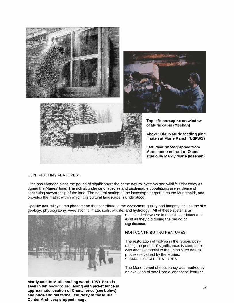
52
CONTRIBUTING FEATURES: Little has changed since the period of significance; the same natural systems and wildlife exist today as during the Muries’ time. The rich abundance of species and sustainable populations are evidence of continuing stewardship of the land. The natural setting of the landscape perpetuates the Murie spirit, and provides the matrix within which this cultural landscape is understood. Specific natural systems phenomena that contribute to the ecosystem quality and integrity include the site geology, physiography, vegetation, climate, soils, wildlife, and hydrology. All of these systems as
described elsewhere in this CLI are intact and exist as they did during the period of significance. NON-CONTRIBUTING FEATURES: The restoration of wolves in the region, post-dating the period of significance, is compatible with and testimonial to the uninhibited natural processes valued by the Muries. 9. SMALL SCALE FEATURES The Murie period of occupancy was marked by an evolution of small-scale landscape features.
Top left: porcupine on window of Murie cabin (Meehan) Above: Olaus Murie feeding pine marten at Murie Ranch (USFWS) Left: deer photographed from Murie home in front of Olaus’ studio by Mardy Murie (Meehan)
Mardy and Jo Murie hauling wood, 1950. Barn is seen in left background, along with picket fence in approximate location of Chena fence (see below) and buck-and rail fence. (courtesy of the Murie Center Archives; cropped image)

53
In keeping with the Muries’ desire to minimize human impact on the natural landscape, very few built elements were added to the site during the period of significance. During the operational years of the STS Ranch, numerous fences had been built to enclose boundaries and corral horses and cattle. Some decorative fencing had also been present around the Woodbury home and elsewhere. A fence in front of the Homestead Cabin featured a decorative gate with two vertical logs capped with a decorative horizontal log branded with the STS logo. A log flagpole sat just inside the gate, next to a flagstone walk. All of these elements predate the period of significance, and are now gone. Early photographs taken shortly after the Murie purchase of the property show buck-and-rail and picket fencing in numerous locations across the site. Olaus was not fond of fences, however, and launched a vigorous removal effort to open the land to easy wildlife passage. The only remnant fence on the site from the earlier period was removed in 2009 after being damaged by a fallen tree, although some fence posts do remain. The first electricity on the site was produced by running an old car engine in the Engine Room, #986, once or twice a week to charge some 50 storage batteries. Wires were strung from these batteries to individual cabins to provide light at night. One utility pole remains from this early endeavor. Rural electrification came to Moose in 1954, and as a concession to modernity, power lines were strung into the site. Those lines were placed underground in the early 2000s by the NPS in an act which the Muries would undoubtedly have approved, removing the clutter of overhead wires. Small footbridges were built along the Around the World Trail and Snake River Trail, where paths crossed low-lying seasonally wet areas. These bridges still exist, although timbers and planks have been replaced through the years as earlier members deteriorated. At the Snake River swimming hole, the Muries built a small dock, consisting of a plank with ladder, to provide access into the pool without stirring up the silt. This is now gone. Miscellaneous movable furniture (benches, lawn chairs, etc.) appears in photographs taken over the years. It is unknown whether similar items present today are necessarily the same exact objects present during the period of significance, but they are incidental to the landscape in any event. CONTRIBUTING FEATURES:

54
Early utility pole - only one pole survives the early years of electrification, southeast of the Alatna Cabin. The pole is trimmed and peeled lodgepole pine, approximately 6” diameter, provided with extra support with second shorter pole. A brown ceramic insulator remains at the top. This pole was listed as a contributing structure on the NHL nomination form. Remnant fence posts – Although all former fences have been removed from the site, numerous fence posts stand as reminders of the landscape inherited by the Muries, prior to their dismantling. Footbridges – Plank boardwalks or footbridges were constructed along both the Snake River and Around the World trails, to traverse some of the low lying areas created by former braided channels of the Snake River. Some of the planks have been replaced over time due to rot and breakage, but the structures otherwise remain in place and intact. NON-CONTRIBUTING FEATURES: The Murie Center’s council rings, of large cut timbers, while compatible with the site’s cultural tradition of informal gatherings, are not historical features. A recent memorial bench along the Snake River Trail is incongruous with the Murie ideal
Left: memorial bench along Snake River Trail Right: Murie Center campfire circle (Frame Cabin in background)
Left: remnant fence posts behind Murie and Chena cabins Right: plank boardwalk along Snake River Trail
Early electric pole: left image shows the top, with ceramic insulator, and right shows base supported by extra post.

55
of minimal human intrusion on the natural scene. Wooden cabin name signs and a variety of brass commemorative plaques are non-contributing, but do not detract from the overall site integrity. Cobbles and branches have been placed in various locations to outlining paths. These do not appear in historic photographs. According to Nancy Shea, branches were placed along the Around the World Trail in recent years to identify it for trail users. MISSING FEATURES A large tree along the Around the World Trail was selected by Olaus Murie as an observation overlook from which he could watch moose and other wildlife in the beaver ponds. A ladder of slats facilitated access up the tree, and created a vantage point from which he could sketch and take notes. A photograph of the tree dated July, 2001, showed it still standing. The NHL nomination written in 2003 observed that it had fallen, but was still visible, although it has since disappeared. A small segment of fence in front of Chena Cabin was destroyed by a falling tree during the winter of 2008-2009, and the remaining pieces were removed. This had been the only fence remaining from the STS Dude Ranch era that survived through the period of significance. Mardy Murie describes “a little dock: a plank with ladder” in her reminiscences about the swimming hole (Meehan, 17). This feature no longer exists.
Olaus tree, in photograph from 2001 Vegetation Assessment report on Murie Ranch, NPS
Chena fence, now gone, photographed in October, 2008

56
10. SPATIAL ORGANIZATION The spatial organization of the site includes the locations of buildings and other structures and features. The loss of a few buildings and structures, and the addition of a bathhouse, have only had a minimal impact on the integrity of the site’s spatial organization, which is much like it was during the period of significance. The residential area of the Murie Ranch is comprised of a series of spaces enclosed by the surrounding forest. These spaces were described by Mardy Murie in her recollections: “One interesting feature of the ranch neighborhood is the presence of natural openings in the forest. There is a large one just before you get to the ranch gate; there is one right here in front of my house, a third beyond the Homestead and the old dude cabins, before you enter the trail to the beaver ponds. I asked Buster if it was just this way when he discovered the place. He said, yes, just the same; that was 1922” (Murie, Thus at Moose). Today there are four primary spaces, although two are essentially sub-spaces of one larger unit. The edge of the spatial enclosure is comprised of native vegetation, with spruce and fir forming a dense, dark, black-green background. The edge is “feathered” by clumps of softer aspen and drifts of native hawthorn. The buildings on the site (cabins and associated outbuildings) are located along this edge. The spatial organization of the site is essentially intact from the period of significance and as described by Mardy. Although the edge of the enclosing forest is dynamic and constantly changing, the overall clearing size and shape has changed little from the Murie period. The built elements along the edge of the site reinforce the natural spaces, but the space lost some of its definition through removal of structures. Overall, these losses are minor in a spatial sense, due to the strong edge formed by vegetation.
Views illustrating strongly defined spatial edge Left: view looking north from Murie studio into space A Right: view looking west across space B from Garage

57
CONTRIBUTING FEATURES: The major space apparent upon entering the site by road from Moose follows a predominantly east-west axis from a point adjacent to the Olaus Murie Studio to the Frame Cabin. It is subdivided into two sub-spaces (A and B on map) by the Garage and adjacent parking lot, which encroaches visually into what otherwise would be an uninterrupted expanse of over two hundred yards. Subspace A forms a large oval (appx. 450’ x 200’) with a north-south axis perpendicular to the main entry axis, directed at the Grand Teton. The Murie Studio, Murie Cabin, and Chena Cabins reinforce the forested southern edge of this subspace. The second sub-space, an oval following the main east-west axis, is roughly bounded by the Garage, and the Capron, Frame, Wild Lone and Moviewood Cabins. This space is used by the Murie Center as the primary outdoor gathering area, with two “council rings” and a picnic area. The third space (C on map) lies west of space B beyond the Frame Cabin, continuing the same EW axis. This space was in part occupied by the former barn, and was most likely used for barnyard functions. It is oblong, approximately 200’ by 100’ in dimension. The northernmost space (D on map) is lined by the main circle of cabins. It grew around the initial Homestead Cabin of the Estes, and was the primary focal area of the STS Ranch. The removal of the Denali cabin detracted from the definition of this space (appx. 300’ x 150’), but it was reinforced by the addition of the non-contributing bathhouse. NON-CONTRIBUTING FEATURES
Spatial Map, showing four primary spaces on site. Space A is in front of the Murie cabin, B is west of the garage (A & B are essentially sub-spaces of one larger space), C is the former barn site, and D is the main cabin circle.

58
The addition of the bathhouse and loss of the barn, storage shed, and Denali cabin have a minimal impact on the site’s overall spatial organization.
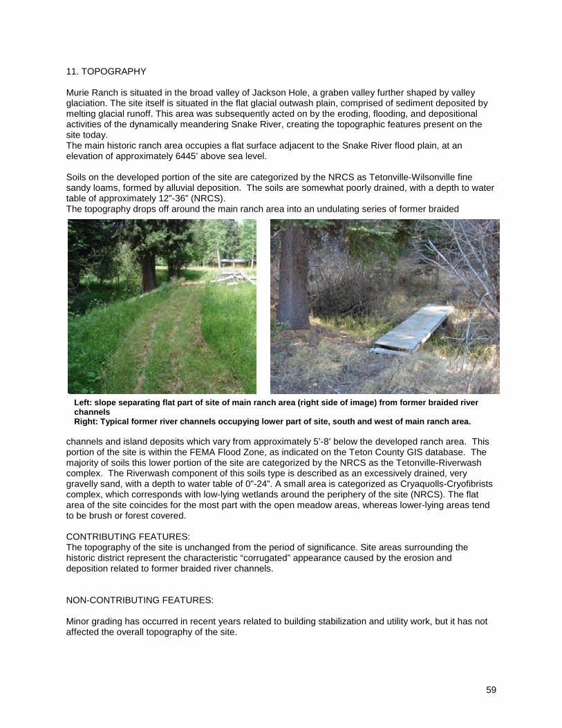
59
11. TOPOGRAPHY Murie Ranch is situated in the broad valley of Jackson Hole, a graben valley further shaped by valley glaciation. The site itself is situated in the flat glacial outwash plain, comprised of sediment deposited by melting glacial runoff. This area was subsequently acted on by the eroding, flooding, and depositional activities of the dynamically meandering Snake River, creating the topographic features present on the site today. The main historic ranch area occupies a flat surface adjacent to the Snake River flood plain, at an elevation of approximately 6445’ above sea level. Soils on the developed portion of the site are categorized by the NRCS as Tetonville-Wilsonville fine sandy loams, formed by alluvial deposition. The soils are somewhat poorly drained, with a depth to water table of approximately 12”-36” (NRCS). The topography drops off around the main ranch area into an undulating series of former braided
channels and island deposits which vary from approximately 5’-8’ below the developed ranch area. This portion of the site is within the FEMA Flood Zone, as indicated on the Teton County GIS database. The majority of soils this lower portion of the site are categorized by the NRCS as the Tetonville-Riverwash complex. The Riverwash component of this soils type is described as an excessively drained, very gravelly sand, with a depth to water table of 0”-24”. A small area is categorized as Cryaquolls-Cryofibrists complex, which corresponds with low-lying wetlands around the periphery of the site (NRCS). The flat area of the site coincides for the most part with the open meadow areas, whereas lower-lying areas tend to be brush or forest covered. CONTRIBUTING FEATURES: The topography of the site is unchanged from the period of significance. Site areas surrounding the historic district represent the characteristic “corrugated” appearance caused by the erosion and deposition related to former braided river channels. NON-CONTRIBUTING FEATURES: Minor grading has occurred in recent years related to building stabilization and utility work, but it has not affected the overall topography of the site.
Left: slope separating flat part of site of main ranch area (right side of image) from former braided river channels Right: Typical former river channels occupying lower part of site, south and west of main ranch area.

60
12. VEGETATION The vegetation on the site still features a similar species composition to that found during the period of significance, dominated by spruce (Picea spp.), aspen (Populus tremuloides), cottonwood (Populus spp.), Douglas-fir (Pseudotsuga menziesii), pine (Pinus spp.), sagebrush (Artemisia spp.), rabbitbrush (Chrysothamnus spp.), and wildflowers. The sagebrush population has declined, however, and invasive species diminish the integrity of the site’s vegetation. The vegetative composition inherited when the Muries acquired the property in 1945 would have varied
considerably from the naturalized setting of today. When Buster Estes settled the original homestead in 1920, he had attempted to grow oats and barley on eight acres of natural clearings in the forest. After the failure of farming, the Estes established the STS dude ranch, and the fields became pasture for horses and cattle. Mardy recalled that a "rustic picket fence, which enclosed the neat lawn and flowerbeds in front of the big log house", surrounded the immediate environs of the home they were to occupy. The Estes did manage to maintain a flourishing vegetable garden, which was continued by the Muries after acquiring the property. They also brought a number of red currant bushes with them from their home in Jackson and planted them along the back of the garden. According to Mardy, this was “Olaus’s only concession to non-wild implants” (Murie, Thus at Moose, 3). The garden continued to be productive for several years, but eventually succumbed to predation by wildlife. Mardy noted that she would “always be puzzled as to just what happened over the years. Perhaps it is related somehow to the fact that Buster ran a dude ranch and had horses, perhaps that their presence kept the wild things at bay” (ibid). The currants, which had been so productive that NPS employees had been invited to come help themselves, were overrun by chipmunks and were eventually removed in 1964. After numerous attempts at fencing, trapping, and other techniques to control wildlife damage, the families determined in the early
Vegetation coverage of Murie Ranch and adjacent area source Grand Teton National Park Vegetation Mapping Program, USGS/BRD, June, 2009

61
1970s that it was time to “give up and admit that we were doing a ‘man thing’ in a national park” (ibid) by trying to garden. The restorative power of nature guided by the Muries’ desire to “tread lightly” has guided natural plant succession in a process of re-vegetation of the site. The predominant plant community on the site is categorized as Mixed Conifer-Cottonwood Riparian Forest, with large areas of Blue Spruce Riparian Forest and some Willow Shrubland. The USGS Vegetation / Land Use Map of Grand Teton National Park, June, 2009, depicts the great richness of plant communities and thus ecological diversity within the immediate area of Murie Ranch (USGS). As described in the NHL nomination, “the forest is a thick combination of cottonwoods and spruce in the lowest elevations and stands of blue spruce, Douglas-fir, aspen, cottonwoods, and lodgepole pine throughout. The clearings contain vigorous clumps of sage and rabbitbrush, the gray-green color providing a distinct backdrop to the array of different wildflowers, with their patchwork of bright colors that appear in their annual cycles from the time that the snows melt, through the summer, to the time they are buried once again in deep carpets of snow. As Mardy Murie once expressed the beauty of these flowers, the Muries walked or drove through ‘a sea of wildflowers’ every time they ventured to the post office, and the wildflowers also spread out in front of the house and cabins at the ranch.” Despite temporary disruptions caused by building renovations and the burial of utilities in the early 2000s, little permanent change has occurred to this broader vegetative pattern.
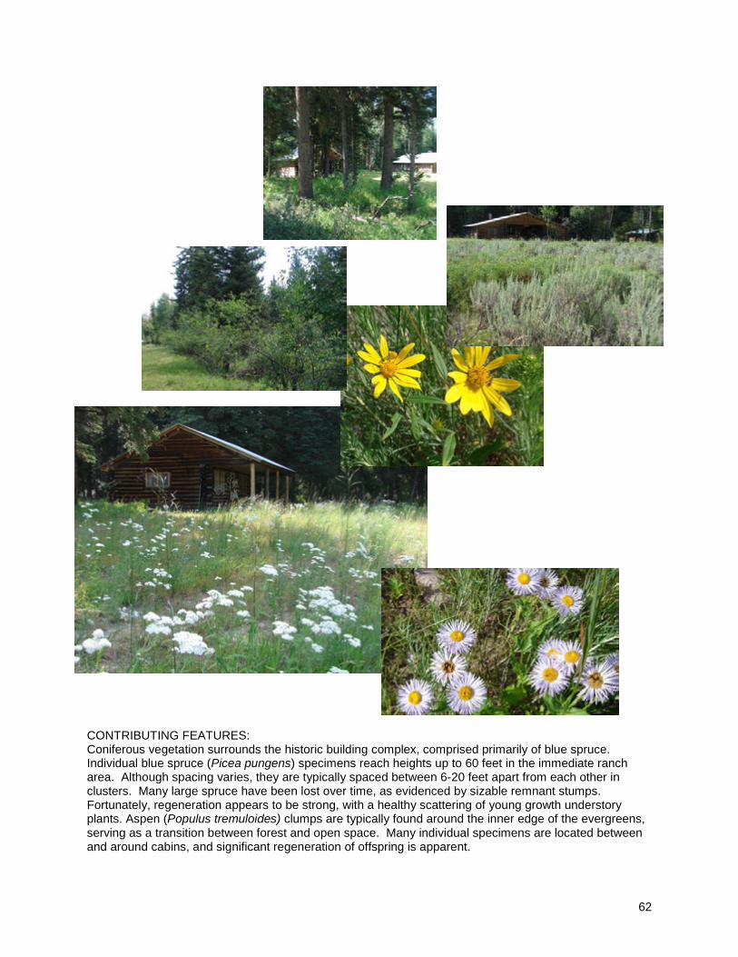
62
CONTRIBUTING FEATURES: Coniferous vegetation surrounds the historic building complex, comprised primarily of blue spruce. Individual blue spruce (Picea pungens) specimens reach heights up to 60 feet in the immediate ranch area. Although spacing varies, they are typically spaced between 6-20 feet apart from each other in clusters. Many large spruce have been lost over time, as evidenced by sizable remnant stumps. Fortunately, regeneration appears to be strong, with a healthy scattering of young growth understory plants. Aspen (Populus tremuloides) clumps are typically found around the inner edge of the evergreens, serving as a transition between forest and open space. Many individual specimens are located between and around cabins, and significant regeneration of offspring is apparent.

63
Aspen appear to have been reduced somewhat from what was apparent in earlier photographs. Photographic comparison shows significantly more sagebrush (Artemisia spp.) than present today. Today, the major sagebrush occurrence is confined to a patch located directly in front of the Murie Cabin. Native black hawthorn (Crataegus douglasii) is scattered around the edges of the meadow spaces, with occasional clumps within the space itself. Specimens reach from 10-15 feet in height with similar spread. The lower floodplains surrounding the historic district are comprised of tall cottonwood (Populus spp.) gallery overstory and tall shrub massing comprised of willows (Salix spp.), alder (Alnus spp.), and birch (Betula spp.). The meadow area occupies a natural clearing in the forest that existed when Buster Estes first homesteaded the property in 1920. It is classified as Moist Sagebrush, comprised of mountain big sagebrush (Artemisia tridentate ssp. Vaseyana), silver sage (Artemisia cana), and shrubby cinquefoil (Potentilla fruticosa), with a diverse herbaceous understory (from Mattson and Despain, 1985, in Environmental Assessment, p. 31). Expansive drifts of wildflowers paint this open meadow. According to long-time former resident Louise “Weezie” Murie MacLeod, the appearance today is very similar to how it appeared during the period that she lived on the ranch, though she noted that there is less sagebrush. This latter observation was confirmed by Nancy Shea, Murie Center Director from 1998 to 2005. Period photographs taken during the POS tend to confirm this observation, although grasses and forbs were completely unmaintained during the Murie occupancy, causing them to reach greater height than today (particularly in the area immediately adjacent to cabins that is mown to minimize fire risk). NON-CONTRIBUTING FEATURES: Invasive exotic species in GRTE threaten the viability of native plant communities, and pose long-term issues for sustainable ecosystem management. The park conducts educational and eradication efforts to control the spread of these species, and has mapped known occurrences of invasive plant species. Species identified on the Murie Ranch property include musk thistle (Carduus nutans), Canada thistle (Cirsium arvense), bull thistle (Cirsium vulgare), common sowthistle (Sonchus oleraceus), hounds tongue (Cynoglossum officinale), and yellow toadflax (Linaria vulgaris). (Teton County GIS website) MISSING FEATURES: The former garden no longer exists, nor do the currant bushes. 13. VIEWS AND VISTAS In the setting of the magnificent Teton Range, views play a significant role in defining the landscape character of Murie Ranch. Most of the views and vistas present during the period of significance still dominate the visual experience perceived today. Changes due to vegetation growth, an increase in vehicles on the site, and the removal or addition of buildings or structures, all have the potential to diminish the integrity of these views and vistas. Views have been categorized as “of-site”, “on-site”, or “off-site”. “Of-site” views are those looking into the site from adjoining areas, “on-site” views are internalized views looking from one point within the boundaries to another, and “off-site” views are more distant prospects of surrounding areas seen from within site boundaries.
Invasive musk thistle growing on Murie Ranch site, August, 2009
Invasive musk thistle growing on Murie Ranch site, August, 2009
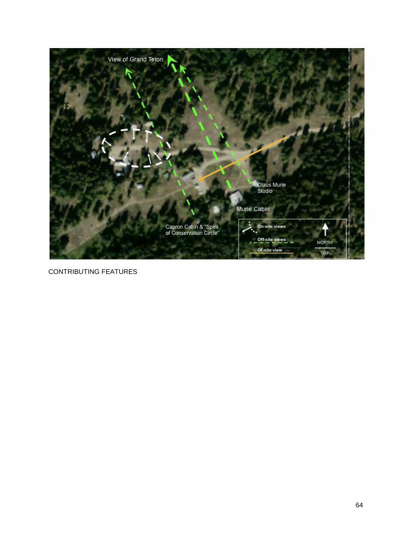
64
CONTRIBUTING FEATURES

65
Off-site vista - The dominant, imposing view of the Grand Teton is viewed from the front porch of the Olaus and Mardy Murie Cabin. This view was significant enough to dictate the original placement of the cabin by Mrs. Woodbury, who had the log structure built in the late 1920s. (Meehan, 14) The central axis of the roof ridge, and hence the front porch and walkway extending from it, forms a perfect alignment on the majestic peak. Mardy described this view, stating that “the front porch looks across the opening to another forest wall in the middle of which there is a natural gap where the trees are shorter and there the Grand Teton is framed. Hundreds of people have asked, ‘Did you trim those trees like that?’ The explanation for the openings I have still to find” (Thus at Moose, 4). It is apparent from photographs of gatherings at the ranch that many informal meetings occurred in the front of this cabin, in full presence of the looming Grand Teton. Significant growth of vegetation across the meadow from the cabin, confirmed
by comparative photographic analysis and first hand account by Louise Murie MacLeod, has gradually minimized this view, concealing all but the very tip of the peak today. The significance of this vista will require management to prevent it from disappearing. Off-site views - Similar (but not as consciously designed) views of the Grand Teton are evident from the front porch of the Capron Cabin and the nearby “Spirit of Conservation Circle”, placed by the Murie Center to capitalize on the stunning off-site view. The one building constructed on site by the Muries, Olaus’ Studio, also features a view of the Grand Teton from the front porch, although more panoramic than single-directional. Additional views of the Teton Range may be glimpsed from various viewpoints on the site, but are less focused, and are usually screened in part by vegetation. On-site views - As described in the Spatial Organization section, the Murie Ranch site is structured around a large central meadow comprised of four primary spaces. Of-site and on-site views are controlled largely by this spatial organization. Most of the guest cabins are arranged in a large circle around the northern meadow space. They, along with the Homestead Cabin (original Buster Estes ranch building, and later home of Adolph and Louise Murie), look inward toward the center of this space. The views in this space are inward, emphasizing the enclosure of the compound, as opposed to the outward focus of the Murie and Capron Cabins. Of-site views – The site only has one significant of-site view, which is the entry view of the ranch from the access drive. Rounding the final curve of the approach road from Moose, the entry view of the ranch runs the length of this central space, backdropped by its forested edge and mountains in the distance. This important view formed the first impression of the site for visitors, and welcomed the Muries home. Although the former garage (now the office of the Murie Center) aligns on this axis, all other buildings are positioned along the edge of the space. The Murie Cabin and Studio are seen shortly after the initial view into the space, at a 45-degree angle to the left. This view has been slightly altered since the period of significance by natural changes in vegetation, and more significantly by an increase in vehicles parked in this view line. The visual conflict posed by vehicles (and associated reflected sunlight under bright
View from front porch of Murie Cabin in 1955, left, and 2009, right. White line indicates vegetation growth since 1955 (Historic photo courtesy of the Murie Center Archives; cropped image)

66
Wyoming skies) along the major entry sight line is incongruent and jarring upon approach to this shrine of nature. Because the increase in parked cars is not irrevocable, this important view still holds the potential to be contributing. NON-CONTRIBUTING FEATURES: The views of the two Murie Center parking lots seen as one enters the site by road from Moose are non-contributing, nor is the view of the recent bathhouse building as seen from the drive leading to and beyond the Homestead Cabin.

67
Condition Cultural Landscape Inventory Name: Murie Ranch Historic District Cultural Landscape Inventory Number: 890057 Parent Cultural Landscape Inventory Name: Grand Teton NP Landscape Parent Cultural Landscape Inventory Number: 890193 Park Name: Grand Teton National Park Park Alpha Code: GRTE Park Org Code: 1460
Condition Assessment Good Assessment Date 02/16/2010 Condition Assessment Explanatory Narrative Impacts to Inventory Unit
Impact Type External/Internal Impact Explanatory Narrative 1. Adjacent lands External The nearby airport disrupts the
soundscape, and air traffic may be visually intrusive.
2. Other- Development Internal Development on the site, such as the addition of the bathhouse and the replacement of the historic outhouses with nonfunctioning structures have somewhat diminished the integrity of the site. Further development has the potential to further erode the site’s integrity.

68
Treatment
Cultural Landscape Inventory Name: Murie Ranch Historic District Cultural Landscape Inventory Number: 890057 Parent Cultural Landscape Inventory Name: Grand Teton NP Landscape Parent Cultural Landscape Inventory Number: 890193 Park Name: Grand Teton National Park Park Alpha Code: GRTE Park Org Code: 1460 Approved Landscape Treatment: None Approved Landscape Treatment Document: Approved Landscape Treatment Document Date: Approved Landscape Treatment Cost: Approved Landscape Treatment Cost Date: Approved Landscape Treatment Level of Estimate: Approved Landscape Treatment Cost Estimator: Approved Landscape Treatment Explanatory Narrative: Approved Landscape Treatment Completed: Approved Landscape Treatment Cost Explanatory Narrative:
69
Bibliography and Supplemental Information Cultural Landscape Inventory Name: Murie Ranch Historic District Cultural Landscape Inventory Number: 890057 Parent Cultural Landscape Inventory Name: Grand Teton NP Landscape Parent Cultural Landscape Inventory Number: 890193 Park Name: Grand Teton National Park Park Alpha Code: GRTE Park Org Code: 1460 Bibliography Citation Title: Photo Collection of Donna Murray Brewer Citation Author: Donna Murray Brewer Year of Publication: 1943 – 1960s Publisher: Source Name: Other Source Name: Citation Number: Citation Type: Photographs Citation Location: Murie Center Archives Citation Title: National Historic Landmark Nomination: Murie Ranch Historic District Citation Author: Michael Cassity Year of Publication: 2003 (recognized 2006) Publisher: US Department of Interior, National Park Service Source Name: Other Source Name: Citation Number: Citation Type: Registration Form Citation Location: online at http://pdfhost.focus.nps.gov/docs/NHLS/Text/98001039.pdf and http://pdfhost.focus.nps.gov/docs/NHLS/Photos/98001039.pdf Citation Title: National Register of Historic Places Registration Form: Murie Ranch Historic District Citation Author: Janene Caywood, Ann Hubber, and Kathryn Schneid; Historical Research Associates Year of Publication: 1997 (entered 1998) Publisher: Source Name: Other Source Name: Citation Number: Citation Type: NRHP documentation Citation Location: online at http://pdfhost.focus.nps.gov/docs/NRHP/Text/98001039.pdf and http://pdfhost.focus.nps.gov/docs/NRHP/Photos/98001039.pdf accessed Feb. 15, 2009 Citation Title: Ecoregions of Wyoming Citation Author: Chapman, S.S., Bryce, S.A., Omernik, J.M., Despain, D.G., ZumBerge, J., and Conrad, M. Year of Publication: 2004 Publisher: U.S. Geological Survey Source Name:

70
Other Source Name: Citation Number: Citation Type: Internet Citation Location: http://www.epa.gov/wed/pages/ecoregions/wy_eco.htm Citation Title: Arctic Dance: The Mardy Murie Story Citation Author: Charles Craighead and Bonnie Kreps Year of Publication: 2002 Publisher: Graphic Arts Center Publishing Source Name: Other Source Name: Citation Number: Citation Type: Published book Citation Location: Available at GRTE bookstore Citation Title: A Place Called Jackson Hole Citation Author: John Daugherty Year of Publication: 1999 Publisher: Grand Teton Natural History Association, Moose, WY Source Name: Other Source Name: Citation Number: Citation Type: Published Historic Resource Study Citation Location: Available in the GRTE bookstore and online at http://www.nps.gov/history/history/online_books/grte2/hrst.htm Citation Title: interview Nov. 3, 2008 Citation Author: Steve Duerr, Murie Center Director Year of Publication: Publisher: Source Name: Other Source Name: Citation Number: Citation Type: Interview Citation Location: Citation Title: Steven F. Iobst to Wendy Bredehoft, Re: Consultation Under Section 106 of the National Historic Preservation Act for Proposed Parking Lot and Powerline Burial within the Murie Ranch Historic District Citation Author: Steven F. Iobst Year of Publication: 2000 Publisher: Source Name: Other Source Name: Citation Number: Citation Type: Letter Citation Location: Citation Title: Environmental Assessment, Rehabilitation and Adaptive Use of the Murie Ranch Historic District, Grand Teton National Park, Wyoming. Citation Author: U.S. National Park Service. Grand Teton National Park. Year of Publication: December 2001. Publisher: Source Name: Other Source Name: Citation Number:
71
Citation Type: Citation Location: Citation Title: interview, Nov. 3, 2007 Citation Author: Inger Koedt, former Murie Ranch resident Year of Publication: November 2008 Publisher: Source Name: Other Source Name: Citation Number: Citation Type: Interview Citation Location: Citation Title: Murie Ranch: A History Citation Author: Louise Murie MacLeod Year of Publication: Publisher: Source Name: Other Source Name: Citation Number: Citation Type: Citation Location: GRTE Archives, H14 Citation Title: Interview, August 2, 2009 Citation Author: Louise Murie MacLeod Year of Publication: Publisher: Source Name: Other Source Name: Citation Number: Citation Type: Citation Title: The Murie Ranch Citation Author: Maggie Meehan Year of Publication: 2001 Publisher: The Murie Center Source Name: Other Source Name: Citation Number: Citation Type: Published booklet Citation Location: Available in the GRTE bookstore Citation Title: Thus at Moose Citation Author: Mardy Murie Year of Publication: undated Publisher: unpublished memoirs Source Name: Other Source Name: Citation Number: Citation Type: transcript Citation Location: Murie Center Archives Citation Title: Wapiti Wilderness Citation Author: Margaret and Olaus Murie Year of Publication: 1985 (reprint of 1966 edition) Publisher: University Press of Colorado

72
Source Name: Other Source Name: Citation Number: Citation Type: Published book Citation Location: Available in the GRTE bookstore Citation Title: Jackson Hole Airport Use Agreement Extension Draft Environmental Impact Statement Citation Author: National Park Service Year of Publication: March, 2009 Publisher: Source Name: Other Source Name: Citation Number: Citation Type: internet Citation Location: accessed from the internet at http://www.nps.gov/grte/parkmgmt/planning.htm Citation Title: Overview of Memorandum of Understanding between: National Park Service, Grand Teton National Park and The Murie Center for the operation of The Murie Center on the historic Murie Ranch Citation Author: NPS Year of Publication: 1997 Publisher: Source Name: Other Source Name: Citation Number: Citation Type: Citation Location: Citation Title: Web Soil Survey for Teton County, WY Citation Author: NRCS Year of Publication: Publisher: Source Name: Other Source Name: Citation Number: Citation Type: internet Citation Location: http://websoilsurvey.nrcs.usda.gov/app/WebSoilSurvey.aspx Citation Title: “Murie Ranch rehab gets Park go-ahead” Citation Author: Whitney Royster Year of Publication: 2002 Publisher: Jackson Hole News and Guide Source Name: Other Source Name: Citation Number: Citation Type: newspaper article Citation Location: Citation Title: telephone interview, August 1, 2009 Citation Author: Nancy Shea, former Murie Center Director Year of Publication: Publisher: Source Name: Other Source Name: Citation Number: Citation Type: Interview Citation Location:

73
Citation Title: Teton County Geographic Information System Citation Author: Teton County, WY Year of Publication: Publisher: Source Name: Other Source Name: Citation Number: Citation Type: Citation Location: http://www2.tetonwyo.org/mapserver/map.php Citation Title: USGS Vegetation Communities Map, Grand Teton National Park Citation Author: USGS Biological Informatics Program Year of Publication: 2009 Publisher: Source Name: Other Source Name: Citation Number: Citation Type: vegetation map Citation Location: http://biology.usgs.gov/npsveg/grte/index.html Citation Title: An Assessment of American Indian Occupation and Uses of the Cultural and Natural Resources of Grand Teton National Park and the National Elk Refuge Citation Author: Walker Research Group, Ltd. Year of Publication: 2007 Publisher: Source Name: Other Source Name: Citation Number: Citation Type: Published Report Citation Location: available from Grand Teton National Park Citation Title: Save America’s Treasures Grant Citation Author: Stephen Iobst, authorizing official Year of Publication: 2000 or 2001 Publisher: Source Name: Other Source Name: Citation Number: Citation Type: Citation Location: GRTE Archives, H30 Citation Title: Murie Center web site Citation Author: Year of Publication: Publisher: Source Name: Other Source Name: Citation Number: Citation Type: web site Citation Location: https://www.muriecenter.org/ Supplemental Information

74