National Park Service Cultural Landscapes Inventory 2000
75
National Park Service Cultural Landscapes Inventory Truro Highlands Historic District Cape Cod National Seashore 2000
Transcript of National Park Service Cultural Landscapes Inventory 2000

National Park Service
Cultural Landscapes Inventory
Truro Highlands Historic District
Cape Cod National Seashore
2000

Table of Contents
Inventory Unit Summary & Site Plan
Concurrence Status
Geographic Information and Location Map
Management Information
National Register Information
Chronology & Physical History
Analysis & Evaluation of Integrity
Condition
Treatment
Bibliography & Supplemental Information
Cape Cod National Seashore
Truro Highlands Historic District
Inventory Unit Summary & Site Plan
The Cultural Landscapes Inventory Overview:
Inventory Summary
Purpose and Goals of the CLI
The Cultural Landscapes Inventory (CLI), a comprehensive inventory of all cultural landscapes
in the national park system, is one of the most ambitious initiatives of the National Park Service
(NPS) Park Cultural Landscapes Program. The CLI is an evaluated inventory of all
landscapes having historical significance that are listed on or eligible for listing on the National
Register of Historic Places, or are otherwise managed as cultural resources through a public
planning process and in which the NPS has or plans to acquire any legal interest. The CLI
identifies and documents each landscape’s location, size, physical development, condition,
landscape characteristics, character-defining features, as well as other valuable information
useful to park management. Cultural landscapes become approved CLIs when concurrence
with the findings is obtained from the park superintendent and all required data fields are
entered into a national database. In addition, for landscapes that are not currently listed on the
National Register and/or do not have adequate documentation, concurrence is required from the
State Historic Preservation Officer or the Keeper of the National Register.
The CLI, like the List of Classified Structures, assists the NPS in its efforts to fulfill the
identification and management requirements associated with Section 110(a) of the National
Historic Preservation Act, National Park Service Management Policies (2006), and Director’s
Order #28: Cultural Resource Management. Since launching the CLI nationwide, the NPS, in
response to the Government Performance and Results Act (GPRA), is required to report
information that respond to NPS strategic plan accomplishments. Two GPRA goals are
associated with the CLI: bringing certified cultural landscapes into good condition (Goal 1a7)
and increasing the number of CLI records that have complete, accurate, and reliable
information (Goal 1b2B).
Scope of the CLI
The information contained within the CLI is gathered from existing secondary sources found in
park libraries and archives and at NPS regional offices and centers, as well as through on-site
reconnaissance of the existing landscape. The baseline information collected provides a
comprehensive look at the historical development and significance of the landscape, placing it in
context of the site’s overall significance. Documentation and analysis of the existing landscape
identifies character-defining characteristics and features, and allows for an evaluation of the
landscape’s overall integrity and an assessment of the landscape’s overall condition. The CLI
also provides an illustrative site plan that indicates major features within the inventory unit.
Unlike cultural landscape reports, the CLI does not provide management recommendations or
CLI General Information:
Cultural Landscapes Inventory Page 1 of 73
Cape Cod National Seashore
Truro Highlands Historic District
treatment guidelines for the cultural landscape.
Inventory Unit Description:
Located in southeastern Massachusetts within Barnstable County, at the northern portion of Cape Cod
known as the Outer or Lower Cape, the Truro Highlands Historic District occupies an elevated and
open area fronting the Atlantic Ocean. The 85.9-acre historic district is part of North Truro, a village
within the town of Truro, which is a community of approximately 2,180 year-round residents. The
district is located within Cape Cod National Seashore and includes the following features: Highland
Light Station, Highland House, Highland Golf Links, Beacon Cottage, Rock Cottage, Haven Cottage,
Adams Cottage, and several other features.
HISTORICAL OVERVIEW
The Truro Highlands Historic District contains elements of a formerly extensive family-owned summer
resort complex that originated in the late 1800s, during the first period of tourism on Cape Cod and
before the coming of the railroad and reached its fullest development in 1920. Developed largely
through the vision and direction of Isaac Morton Small, the Highlands resort was largely self-contained,
providing food, lodging, and recreation to its guests. The resort complex encompassed many buildings
and facilities, including an early links golf course, known as the Highland Golf Links. In 1947, Harold
Conklin purchased the property, ending its lengthy association with the Small family. While the
Highlands remained as a resort under Conklin ownership, changes to the area occurred including the
subdivision of land, relocation of buildings, and the expansion of the golf course to the north side of
Highland Road in 1955.
In 1964, the National Park Service acquired the property as part of the Cape Cod National Seashore,
ending its operation as a resort. In ensuing years, some cottages and facilities were demolished or
removed. The buildings that remain included the Highland House, Beacon Cottage, Rock Cottage,
Haven Cottage, and Adams Cottage. Currently, the Highland House is utilized as a repository and
museum, the Beacon Cottage serves as park housing, and the Rock and Haven Cottages are privately
owned. The Adams Cottage is used as the Highland Golf Links clubhouse.
Due to cliff erosion, the Highland Light Station was relocated into the Truro Highlands Historic District
in 1996. As a result of its relocation, modifications to the landscape included a change in the circulation
system and construction of an additional parking lot.
SIGNIFICANCE SUMMARY
The Truro Highlands Historic District is significant under Criterion A within the context of tourism and
recreation as an early resort and golf course on the Lower Cape. It also derives significance under
Criterion C in the areas of architecture and landscape architecture for its simple vernacular resort
structures and links-style golf course. The Truro Highlands Historic District period of significance
begins with the construction of the Highland Golf Links in 1898 and ends in 1958. Although the
property remained as a resort until its acquisition by the National Park Service in 1964, it does not
possess “exceptional importance,” and therefore does not meet Criteria Consideration G.
Cultural Landscapes Inventory Page 2 of 73

Cape Cod National Seashore
Truro Highlands Historic District
The Highland Light Station was relocated into the historic district in 1996. While not historically within
the boundaries of the Truro Highlands Historic District, the Highland Light Station is considered a
contributing resource within the district because it meets National Register Criteria. It derives
significance under Criterion A for its association to maritime history and Criterion C for its advances in
technology and engineering. In addition, the Highland Light Station is recognized under Criteria
Consideration B as a property removed from its original location, but still significant for its advances in
technology and association to maritime history. It has a separate period of significance, which begins
with its construction in 1857 and extends to 1940, the end date for the period of significance established
by the “Lighthouses of Massachusetts” Thematic Group Nomination.
ANALYSIS AND EVALUATION STATEMENT
Cliff erosion has fundamentally changed the landscape within the Truro Highlands Historic District. It
has decreased the total land area, causing the loss of roads, buildings, and golf holes. In response to
erosion, the Highland Light Station was relocated into the district in 1996. While these changes have
affected the overall area, the open and windswept character of the Truro Highlands Historic District
remains preserved and the landscape patterns are present to help visitors understand the physical
development of the district as a resort and links-style golf course, as well as its connection to its
maritime past.
The primary landscape characteristics associated with the Truro Highlands Historic District are natural
systems, topography, spatial organization, land use, circulation, vegetation, buildings and structures,
views and vistas, small-scale features, and archeological sites. Extant historic landscape features that
date to the period of significance include the Highland Light Station, Highland House, Beacon, Haven,
and Adams Cottages, Highland Golf Links, Highland Road, and pedestrian and golf cart paths. Other
features include Highland Road vegetation (blueberry, huckleberry, bearberry, sheeplaurel, and
shadbush), pitch pine, oak and scrub oak barrens around the perimeter of the Highland Golf Links, tees
and greens, fairways, rough areas, heathland, wood utility poles, and views from Highland Road and
Highland Golf Links.
There are several twentieth-century features within the district that are not historic including a
maintenance building, trees and shrubs found within the links course, split-rail fencing, “Portland”
memorial marker, Highland Light Station relocation marker, and an anchor.
The Truro Highlands Historic District retains sufficient integrity to convey its significance despite the
relocation of the Highland Light Station and demolition of several historic structures. Minor changes
that diminish the integrity of the district include the construction of a maintenance building, paving of
parking lots, and the planting and self-seeding of non-native trees and shrubs.
CONDITION ASSESSMENT
As a result of erosion, invasive plant species, and fertilization and planting practices, the Truro
Highlands Historic District is considered to be in fair condition. If left to continue without the
Cultural Landscapes Inventory Page 3 of 73

Cape Cod National Seashore
Truro Highlands Historic District
appropriate corrective action within three to five years, the cumulative effect of the deterioration of
many of the landscape characteristics will cause the inventory unit to degrade to a poor condition.
Recommendations to improve the condition of the landscape include reducing non-historic paths on the
Highland Golf Links and minimize the use of fertilizers on fairways, greens, and tees. Other
recommendations include the removal of non-native and invasive vegetation, and minimize the planting
of trees and shrubs between fairways. As of August 2007, Cape Cod National Seashore and the
Highland Golf Links have made substantial progress in addressing current issues.
Cultural Landscapes Inventory Page 4 of 73

Cape Cod National Seashore
Truro Highlands Historic District
Site Plan
Site plan for Truro Highlands Historic District (Olmsted Center for Landscape Preservation,
hereafter OCLP, 2006).
Cultural Landscapes Inventory Page 5 of 73

Cape Cod National Seashore
Truro Highlands Historic District
Property Level and CLI Numbers
Truro Highlands Historic DistrictInventory Unit Name:
LandscapeProperty Level:
650110CLI Identification Number:
Parent Landscape: 650110
Park Information
Park Name and Alpha Code: Cape Cod National Seashore -CACO
Park Organization Code: 1730
Park Administrative Unit: Cape Cod National Seashore
CLI Hierarchy Description
The Truro Highlands Historic District is one of eighteen cultural landscapes within Cape Cod National
Seashore. The additional landscapes include Atwood Higgins, Doane Homestead, Dune Shacks of the
Peaked Hill Bars, Fort Hill, Fresh Brook Village, Great Island, Hollows, Long Point, Nauset Light Area,
North Beach, North Truro Air Force Station, Pamet Cranberry Bog, Penniman House, Race Point, Salt
Pond Visitor Center, Small Pox Cemetery, and Wellfleet Ponds.
Cultural Landscapes Inventory Page 6 of 73

Cape Cod National Seashore
Truro Highlands Historic District
Concurrence Status
Inventory Status: Complete
Completion Status Explanatory Narrative:
A working list of cultural landscapes was tentatively agreed on by CACO park staff and OCLP
CLI team at a site meeting on August 16, 2000. The working list yet needs to be reviewed
further and submitted to the Superintendent for approval. The resources at Highlands (including
the golf course, light house, and the hotel) were identified as one landscape.
Work for this project was completed by Michael Commisso in 2008, and was based on a
“Condition Report and Treatment Plan for Truro Highlands Historic District” completed in 2007
by Michael Commisso, Jan Haenraets, and Margie Coffin Brown at the Olmsted Center for
landscape Preservation.
Concurrence Status:
YesPark Superintendent Concurrence:
Park Superintendent Date of Concurrence: 04/03/2008
National Register Concurrence: Eligible -- SHPO Consensus Determination
Date of Concurrence Determination: 09/23/2008
On September 23, 2008, the Massachusetts Historical Commission concurred with the National
Park Service’s findings that the cultural landscape retains integrity to the two periods of
significance, 1898-1958 and 1847-1940, and that the property retains landscape features that
contribute to the site’s historic character. Several recommendations relevant to future submittal
of a National Register nomination were included in the letter: a site map specifically keyed with
contributing, noncontributing, and undetermined features; additional context for the Highland
Light and the golf course; additional discussion on the integrity of the new location of the
lighthouse; and additional information regarding the integrity of archeological sites.
National Register Concurrence Narrative:
Concurrence Graphic Information:
Cultural Landscapes Inventory Page 7 of 73

Cape Cod National Seashore
Truro Highlands Historic District
Concurrence form for Truro Highlands Historic District, April 3, 2008.
Geographic Information & Location Map
Inventory Unit Boundary Description:
The 85.9-acre, Truro Highlands Historic District occupies a portion of the Highland Plain, known as the
Highlands. The district is bounded by clay cliffs rising a hundred feet above the Atlantic Ocean on the
east and private properties on the north and south. Highland Road and a campground define the
western boundary.
Cultural Landscapes Inventory Page 8 of 73

Cape Cod National Seashore
Truro Highlands Historic District
State and County:
MAState:
County: Barnstable County
Size (Acres): 85.90
Boundary UTMS:
GPS-Differentially CorrectedSource:
AreaType of Point:
NAD 83Datum:
17UTM Zone:
736,680UTM Easting:
4,325,857UTM Northing:
Cultural Landscapes Inventory Page 9 of 73

Cape Cod National Seashore
Truro Highlands Historic District
Location Map:
Cape Cod National Seashore (Cape Cod National Seashore
General Management Plan, 1998).
Cultural Landscapes Inventory Page 10 of 73

Cape Cod National Seashore
Truro Highlands Historic District
Vicinity Map, Truro Highlands (OCLP, 1993).
Cultural Landscapes Inventory Page 11 of 73

Cape Cod National Seashore
Truro Highlands Historic District
Regional Context:
CulturalType of Context:
Description:
Located within Cape Cod National Seashore, the Truro Highlands Historic District is significant
as an early resort and golf course on the Lower Cape. The Highland Light Station, which was
relocated into the historic district in 1996, derives additional significance as a structure that
represents the scenic qualities of the coast and reflects the state’s maritime heritage.
PhysiographicType of Context:
Description:
The natural systems and landforms found within Cape Cod National Seashore were shaped
almost entirely of material deposited by glaciers that retreated approximately 14,000 to 18,000
years ago. Comprising mostly of outwash plain deposits, the Truro Highlands Historic District
is located in an area known as the Highland Plain. Outwash plains are comprised of sand and
gravel deposited by meltwater streams that flowed across the plain in a braided pattern.
However, evidence shows that a glacial lake once occupied the Highlands area. As a result,
the soil is composed of silt and clay. Large amounts of clay in the soil make it excellent for
agricultural use, but contribute in great measure to rapid, erratic, and occasionally catastrophic
erosion.
HIGHLAND_CAPE_FINAL.mxdGIS File Name:
GIS File Description:
Management Information
General Management Information
Should be Preserved and MaintainedManagement Category:
04/03/2008Management Category Date:
As identified in the 1998 General Management Plan, the Truro Highlands Historic District meets the
criteria of the “Should be Preserved and Maintained” category: it meets National Register criteria and
it is compatible with the park’s legislated significance.
Management Category Explanatory Narrative:
Cultural Landscapes Inventory Page 12 of 73
Cape Cod National Seashore
Truro Highlands Historic District
Agreements, Legal Interest, and Access
Management Agreement:
Concession Contract/PermitType of Agreement:
NAExpiration Date:
Management Agreement Explanatory Narrative:
Two concessioners currently operate within the Truro Highlands Historic District. The
Highland Light and Museum, Inc. manage the Highland Light Station and Highland House.
They in turn have an agreement with the Truro Historical Society, a local non-profit
organization, to furnish the Highland House with artifacts and to provide staffing for the
building. The second concessionaire is the town of Truro, which operates and maintains the
Highland Golf Links.
NPS Legal Interest:
Fee SimpleType of Interest:
Public Access:
UnrestrictedType of Access:
Adjacent Lands Information
Do Adjacent Lands Contribute? No
Cultural Landscapes Inventory Page 13 of 73

Cape Cod National Seashore
Truro Highlands Historic District
National Register Information
Existing NRIS Information:
Name in National Register: Highland House
NRIS Number: 75000157
06/05/1975Primary Certification Date:
Other Names: Highland Lt. Station, 87001463
06/15/1987Primary Certification Date:
A - Associated with events significant to broad
patterns of our history
Significance Criteria:
C - Embodies distinctive construction, work of
master, or high artistic values
Significance Criteria:
Criteria Considerations: B -- A building or structure removed from its original location
Cultural Landscapes Inventory Page 14 of 73

Cape Cod National Seashore
Truro Highlands Historic District
Period of Significance:
Time Period: AD 1898 - 1958
Historic Context Theme: Creating Social Institutions and Movements
Subtheme: Recreation
Facet: Tourism
Time Period: AD 1898 - 1958
Historic Context Theme: Expressing Cultural Values
Subtheme: Architecture
Facet: Vernacular Architecture
Time Period: AD 1898 - 1958
Historic Context Theme: Expressing Cultural Values
Subtheme: Landscape Architecture
Facet: Protection Of Natural And Cultural Resources
Time Period: AD 1857 - 1940
Historic Context Theme: Developing the American Economy
Subtheme: Shipping and Transportation by Water
Facet: Ships, Boats, Lighthouses, And Other Structures
Time Period: AD 1857 - 1940
Historic Context Theme: Expanding Science and Technology
Subtheme: Technology (Engineering and Invention)
Facet: Measurement, Observation, And Control (Surveying,
Cartography, Etc.)
Time Period: AD 1857 - 1940
Historic Context Theme: Expressing Cultural Values
Subtheme: Architecture
Facet: Queen Anne-Eastlake (1880-1900)
Cultural Landscapes Inventory Page 15 of 73

Cape Cod National Seashore
Truro Highlands Historic District
Area of Significance:
ArchitectureArea of Significance Category:
NoneArea of Significance Subcategory:
CommerceArea of Significance Category:
NoneArea of Significance Subcategory:
EngineeringArea of Significance Category:
NoneArea of Significance Subcategory:
Entertainment - RecreationArea of Significance Category:
NoneArea of Significance Subcategory:
Landscape ArchitectureArea of Significance Category:
NoneArea of Significance Subcategory:
Maritime HistoryArea of Significance Category:
NoneArea of Significance Subcategory:
Social HistoryArea of Significance Category:
NoneArea of Significance Subcategory:
TransportationArea of Significance Category:
NoneArea of Significance Subcategory:
Cultural Landscapes Inventory Page 16 of 73

Cape Cod National Seashore
Truro Highlands Historic District
Statement of Significance:
The Truro Highlands Historic District is significant under Criterion A within the context of tourism and
recreation as an early resort and golf course on the Lower Cape. It also derives significance under
Criterion C within the areas of architecture and landscape architecture for its simple vernacular resort
structures and links-style golf course. The Truro Highlands Historic District period of significance
begins with the construction of the Highland Golf Links in 1898 and ends in 1958. Although the
property remained as a resort until its acquisition by the National Park Service in 1964, it does not
possess “exceptional importance,” and therefore does not meet Criteria Consideration G.
The Highland Light Station was documented as part of the “Lighthouses of Massachusetts” Thematic
Group Nomination in June 1987. It is recognized under Criterion A within the contexts of maritime
history, transportation, and commerce for its association with the mid-nineteenth century development
of aids-to-navigation under the U.S. Lighthouse Board and as an important landmark for navigation of
commercial vessels involved in international and U.S. coastal trading. It derives additional significance
under Criterion C for its advances in engineering and as a unique building type, and meets Criteria
Consideration B as a property removed from its original location. The period of significance begins
with its construction in 1857 and extends to 1940. A rationale for the period of significance is not
specifically given in the “Lighthouses of Massachusetts” Thematic Group Nomination. This nomination
is the primary documentation for the Highland Light Station as the history and significance differs from
the Truro Highlands Historic District. In 1996, the Highland Light Station was moved into the Truro
Highlands Historic District. It is considered a contributing resource to the historic district.
Truro Highlands Historic District:
The Truro Highlands Historic District contains elements of a formerly extensive family-owned summer
resort complex that originated in the late 1800s, during the first period of tourism on Cape Cod and
before the coming of the railroad. The resort reached its fullest development in 1920. As a largely
self-contained entity, the historic district is closely associated with the Small family. During Small
family ownership, many buildings and facilities were built for lodging and recreation including the
Highland House, tourist cottages, skating rink, bowling alley, pool-room, baseball diamond, and nine-hole
links-style golf course. Harold Conklin purchased the property in 1947, ending its lengthy association
with the Small family. The property remained a resort under Conklin ownership for thirteen years, but
incurred many changes including the subdivision of land, selling and relocation of buildings, and
expansion of the Highland Golf Links to the north side of Highland Road in 1955. In 1964, the National
Park Service acquired the property, ending its operation as a resort.
The buildings found within the Truro Highlands Historic District are significant as examples of the type
of simple vernacular structures that were developed for the resort complex. The most prominent
building is the Highland House, erected in 1907, which provided centralized dining facilities for the
complex, as well as guest rooms. The Highland Golf Links, originally laid out in 1898, is the oldest
extant feature in the district and one of the earliest golf courses on Cape Cod. Located on the Atlantic
Ocean coastline, the Highland Golf Links possesses the character of a true links-style golf course.
Generally, a links-style course is located adjacent to an ocean or other water body, is relatively flat or
undulating and minimally unaltered. A link-style golf course generally lack trees and shrubs, and relies
solely on native vegetation for the fairways and rough areas.
Cultural Landscapes Inventory Page 17 of 73

Cape Cod National Seashore
Truro Highlands Historic District
The Truro Highlands Historic District retains sufficient integrity, including location, design, setting,
feeling, and association, to convey its significance as an early resort destination and links style golf
course. Extant landscape features include the Highland Light Station, Highland House, Beacon, Haven,
and Adams Cottages, Highland Golf Links, Highland Road, and pedestrian and golf cart paths. Other
features include Highland Road vegetation (blueberry, huckleberry, bearberry, sheeplaurel, and
shadbush), pitch pine, oak and scrub oak barrens around the perimeter of the Highland Golf Links, tees
and greens, fairways, rough areas, heathland, wood utility poles, and views from Highland Road and
Highland Golf Links.
Highland Light Station:
The Highland Station, also referred to as the Cape Cod Light, was originally constructed in 1797 as one
of the earliest wooden lighthouses on Cape Cod. The lighthouse was later replaced by brick structure
in 1831. The Highland Light Station served as an important landmark for navigation of commercial
vessels involved in international and U.S. coastal trading. It was directly related to the development of
Boston as one of the nation’s dominant commercial centers.
By 1857, in an effort to improve the lighthouse system and introduce new methods of construction and
illumination, the Lighthouse Board replaced the lighthouse with the current sixty-six foot tall brick light
tower, keeper’s quarters, and generator shed. In addition to its elaborate ironwork, the Highland Light
Station is representative of a unique building type that evolved in response to the harsh climate. The
type is characterized by an enclosed walkway connecting the tower and vernacular Italianate style
keeper’s quarters.
With the threat of being lost to coastal erosion, the Highland Light Station was relocated 450 feet inland
in 1996. Currently located within the Truro Highlands Historic District, the lighthouse continues to
operate as a navigational aid and retains sufficient integrity to convey its significance as a structure
associated with maritime history and advances in technology.
Chronology & Physical History
Cultural Landscape Type and Use
Cultural Landscape Type: Designed
Vernacular
Current and Historic Use/Function:
Primary Historic Function: Social-Other
Primary Current Use: Sports Facility-Other
Cultural Landscapes Inventory Page 18 of 73
Cape Cod National Seashore
Truro Highlands Historic District
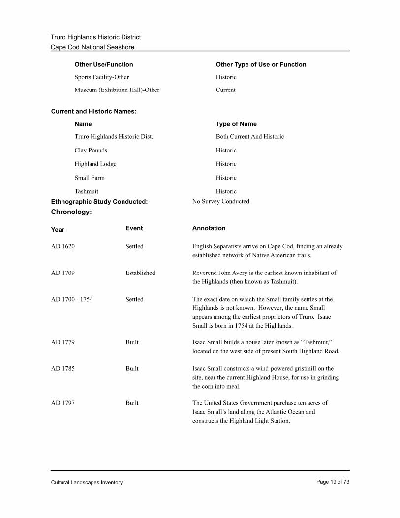
Other Use/Function Other Type of Use or Function
Sports Facility-Other Historic
Museum (Exhibition Hall)-Other Current
Current and Historic Names:
Name Type of Name
Truro Highlands Historic Dist. Both Current And Historic
Clay Pounds Historic
Highland Lodge Historic
Small Farm Historic
Tashmuit Historic
Ethnographic Study Conducted: No Survey Conducted
Chronology:
Year Event Annotation
Settled English Separatists arrive on Cape Cod, finding an already
established network of Native American trails.
AD 1620
Established Reverend John Avery is the earliest known inhabitant of
the Highlands (then known as Tashmuit).
AD 1709
Settled The exact date on which the Small family settles at the
Highlands is not known. However, the name Small
appears among the earliest proprietors of Truro. Isaac
Small is born in 1754 at the Highlands.
AD 1700 - 1754
Built Isaac Small builds a house later known as “Tashmuit,”
located on the west side of present South Highland Road.
AD 1779
Built Isaac Small constructs a wind-powered gristmill on the
site, near the current Highland House, for use in grinding
the corn into meal.
AD 1785
Built The United States Government purchase ten acres of
Isaac Small’s land along the Atlantic Ocean and
constructs the Highland Light Station.
AD 1797
Cultural Landscapes Inventory Page 19 of 73
Cape Cod National Seashore
Truro Highlands Historic District
Land Transfer Isaac Small dies in 1816. His farm is divided between his
oldest sons. Joshua Small receives the house and land on
the west side of the South Highland Road and James
Small receives land to the east of the road, which is the
location of the Truro Highland Historic District.
AD 1816
Built James Small builds a large farmhouse on the northeast
corner of South Highland Road and Highland Road.
AD 1835
Purchased/Sold Isaac Morton Small, son of James Small, purchases 17
acres of land along the cliffs just south of Highland Light
Station.
AD 1872
Built Extension of the railroad to Provincetown spurs the
development of the Truro Highlands as a successful tourist
resort.
AD 1873
Purchased/Sold Upon the death of James Small in 1874, Isaac Morton
Small takes over ownership of the farmhouse.
AD 1874
Built Isaac M. Small adds a two-story wing to the farmhouse.
At its completion, it is referred to as the Highland House,
but later is changed to the Highland Lodge. A new
building, completed in 1907, is given the name the Highland
House.
AD 1876
Built Isaac M. Small builds the Cliff House just north of the
Highland Light Station property line.
AD 1880
Land Transfer Isaac M. Small and his cousin Edward Small subdivide 17
acres of land into individual tracts, offering them for sale
to individual owners. Very few lots are sold.
AD 1894
Built Isaac Small constructs the Millstone Cottage on the site of
his father’s gristmill.
AD 1898
Built Willard M. Small introduces several additions to the
property, including a pool room, skating rink, the Highland
Golf Links, a combined indoor bowling alley and poolroom,
and an informal ball field located on the same site as the
golf course.
Built Isaac M. Small constructs the Rock and Beacon Cottages
along the south side of Highland Road.
AD 1902
Cultural Landscapes Inventory Page 20 of 73

Cape Cod National Seashore
Truro Highlands Historic District
Built Isaac M. Small builds the two-story Highland House.AD 1907
Altered J.H. McKinley of New York reconfigures Highland Golf
Links.
AD 1913
Built Haven Cottage is constructed between the Rock and
Beacon Cottages.
AD 1915
Rehabilitated Hayes Small salvages the deckhouse from a grounded
barge and uses it as a cottage.
AD 1916
Built Adams Cottage constructed north of Highland Road.AD 1917
Moved Isaac Small’s wife, Lillian J. Small, moves a building she
had inherited in North Truro to the north side of Highland
Road. The five-room cottage is known as the Pilgrim.
AD 1920
Purchased/Sold Henry M. and May D. Aldrich purchase 25 lots from
Isaac Small and build or acquire five cottages. They also
acquire adjacent lots from others that Small had sold
during the years.
AD 1920 - 1932
Moved Henry Aldrich relocates Jenny Lind Tower south of the
Highland Golf Links.
AD 1927
Built Mayflower Cottage constructed.AD 1928
Land Transfer Lillian M. Small takes over ownership of the Highland
resort property following the death of Isaac M. Small in
1934.
AD 1934
Purchased/Sold Hayes Small sells the Highland Farm (located along South
Highland Road south and west of the golf course) to
Summer Horton.
AD 1935
Purchased/Sold Fred C. Small, husband of Lillian M. Small, sells the
Highland property to Harold J. Conklin. Transaction
comprises 88 acres, excluding Cliff House. Lillian M.
Small dies in 1948.
AD 1947
Cultural Landscapes Inventory Page 21 of 73
Cape Cod National Seashore
Truro Highlands Historic District
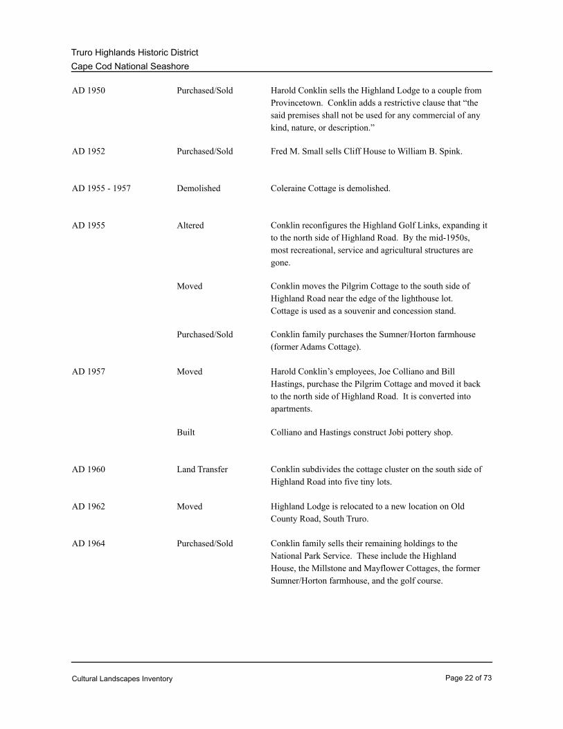
Purchased/Sold Harold Conklin sells the Highland Lodge to a couple from
Provincetown. Conklin adds a restrictive clause that “the
said premises shall not be used for any commercial of any
kind, nature, or description.”
AD 1950
Purchased/Sold Fred M. Small sells Cliff House to William B. Spink.AD 1952
Demolished Coleraine Cottage is demolished.AD 1955 - 1957
Altered Conklin reconfigures the Highland Golf Links, expanding it
to the north side of Highland Road. By the mid-1950s,
most recreational, service and agricultural structures are
gone.
AD 1955
Moved Conklin moves the Pilgrim Cottage to the south side of
Highland Road near the edge of the lighthouse lot.
Cottage is used as a souvenir and concession stand.
Purchased/Sold Conklin family purchases the Sumner/Horton farmhouse
(former Adams Cottage).
Moved Harold Conklin’s employees, Joe Colliano and Bill
Hastings, purchase the Pilgrim Cottage and moved it back
to the north side of Highland Road. It is converted into
apartments.
AD 1957
Built Colliano and Hastings construct Jobi pottery shop.
Land Transfer Conklin subdivides the cottage cluster on the south side of
Highland Road into five tiny lots.
AD 1960
Moved Highland Lodge is relocated to a new location on Old
County Road, South Truro.
AD 1962
Purchased/Sold Conklin family sells their remaining holdings to the
National Park Service. These include the Highland
House, the Millstone and Mayflower Cottages, the former
Sumner/Horton farmhouse, and the golf course.
AD 1964
Cultural Landscapes Inventory Page 22 of 73

Cape Cod National Seashore
Truro Highlands Historic District
Planned Although the Conklins’ sold their holdings to the National
Park Service, they reserve the right to continue to operate
the resort for three more years, with a right to renew for
two years beyond that. The Conklins’ transferred these
rights to Joe Colliano and Bill Hastings. This period is
known as the “Jobi” era.
AD 1964 - 1969
Purchased/Sold Samuel Aldrich, son of Henry and May Aldrich, sells 9.1
acres to the National Park Service.
AD 1965
Established Cape Cod National Seashore is established.AD 1966
Developed Cape Cod National Seashore General Management Plan
completed, identifying actions that would be completed for
the Truro Highlands Historic District.
AD 1970
Moved Millstone and Mayflower Cottages are relocated.
Millstone Cottage is moved to Pond Road, while
Mayflower is moved to North Truro.
AD 1972
Purchased/Sold The National Park Service purchases Cliff House from
William Spink.
AD 1974
Purchased/Sold National Park Service acquires the Beacon Cottage.AD 1985 - 1989
Altered Southeast ell on Highland House is removed, but later
reconstructed.
AD 1982
Moved Cliff House is relocated to Alden Road.AD 1983
Moved Highland Light Station relocated into the Truro Highlands
Historic District. Both the lighthouse and Keeper’s
Quarters are moved inland 450 feet. Landscape
alterations include reduced length of Highland Road and
an additional parking lot.
AD 1996
Cultural Landscapes Inventory Page 23 of 73

Cape Cod National Seashore
Truro Highlands Historic District
Physical History:
INTRODUCTION
A history of the Truro Highlands Historic District is detailed in the “Cultural Landscape Report
for Truro Highlands Historic District” (1995) and historic structures reports for the Highland
House (1993) and Highland Light Station (1994). The following overview is extracted from the
Condition Report and Treatment Plan for Truro Highlands Historic District Cultural Landscape
Report (2007) prepared by Michael Commisso, Jan Haenraets, and Margie Coffin Brown.
PRE-HISTORY to EIGHTEENTH CENTURY
Inhabited by Native Americans prior to the early 1600s, the first recorded permanent resident to
the Truro Highlands was Reverend John Avery. He established residence on a small farm just
north of the Highland House location after his graduation from Harvard in 1709. Avery served
as minister for the settlement of Truro, also working as a smith and farmer until his death in
1754 (Condition Report and Treatment Plan for Truro Highlands Historic District, hereafter
CR&TP, 2007: 5).
The Small family settled in the Truro Highlands in the 1700s and would eventually develop the
area as a tourist destination. Although the exact date of settlement is unknown, the family of
Isaac Small had already been residing there at his birth in 1754. Through several generations,
the Small family established the pattern of land use for the future Truro Highland Historic
District. The property began as a family farm, evolved into a tourist resort with privately
owned cottages, and eventually became a part of Cape Cod National Seashore (CR&TP, 2007:
5).
SMALL FAMILY OWNERSHIP (1754-1947)
Isaac Small (1754-1816) built his first home, called “Tashmuit” after a local Native American
name, on the west side of present South Highland Road in the late 1700s. Small’s property, on
which he raised corn, livestock, and hay, extended across the Highlands to the Atlantic Ocean.
In 1785, he constructed a wind-powered gristmill on the site, near the current Highland House,
for grinding the corn into meal (CR&TP, 2007: 5).
In 1797, the United States Government purchased ten acres of Isaac Small’s land along the
Atlantic Ocean for the construction of the Highland Light Station (Figure 1). The location was
ideal due to the prominent bluff, soils conducive for building, and its ability to support livestock
and a garden for the light keeper. Due to the convenience of already being a resident to the
area and being self-supporting, reducing the need to rely solely on a government salary, Isaac
Small was appointed keeper of the light and served until 1812. Following his death in 1816, his
farm was divided between his oldest sons. Joshua Small (1792-1850) received the house and
land on the west side of the South Highland Road and James Small (1787-1874) received land
to the east of the road, which is the location of the Truro Highland Historic District (CR &TP,
2007: 5-6).
In 1835, James Small built a large farmhouse on the northeast corner of South Highland Road
Cultural Landscapes Inventory Page 24 of 73
Cape Cod National Seashore
Truro Highlands Historic District
and Highland Road. Continuing in the tradition of his father, James farmed the land and
operated the gristmill while serving as keeper of the light for several years. It was during his
tenure that writer/philosopher Henry David Thoreau began making visits to the area. During
his visits between 1849 and 1857, Thoreau frequently stayed with the Small family in the
Keeper’s Quarters. His accounts of the area provide a written record of the condition of the
landscape, prior to the site’s development as a tourist destination in the late nineteenth and early
twentieth century. Thoreau’s writings describe the rapid coastal erosion, naturally occurring
ponds called “clay pits,” extreme weather conditions, and oppressive saltiness of the air. He
also recorded much of the native vegetation, noting that the “Shadbush (Amelanchier), Beach
Plums (Prunus maritima) and Blueberries (Vaccinium pennsylvanicum), like the apple trees and
oaks, were very dwarfish, spreading over the sand, but at the same time very fruitful”
(CR&TP, 2007: 6).
Following Thoreau’s visits and the extension of the railroad into Provincetown in 1873, tourists
were drawn to the Highland area. The railroad made Truro and the Highlands easily accessible
to large numbers of people wanting to recreate on the Outer Cape. With an increase in
tourism, the construction of large resort hotels started began. The Small family took advantage
of this growing trend and began to focus on the tourism possibilities of the Highlands (CR&TP,
2007: 6).
Upon the death of James Small in 1874, his son, Isaac Morton Small (1845-1934), added a
two-story wing to the farmhouse that he inherited from his father. The building, which was
used for many years as a hotel, became known as the Highland House (it was later referred to
as the Highland Lodge when the currently existing Highland House was built). This was the
first structure built in the Highlands, and used exclusively for tourism (Figure 2). Although the
Highland House was a good distance away from the railroad line in Truro, visitors were drawn
to its natural attractions and hotel facilities. Small would meet the train with a wagon and
shuttle the guests to the Highlands (CR&TP, 2007: 6).
In 1880, Isaac M. Small built the Cliff House just north of the Highland Light Station property
line. Isaac and his family used the house as their primary residence and used the Highland
House exclusively for tourists (Figure 3). His residence at the Cliff House gave him a base for
observing merchant marine activity, which he reported to the Boston Chamber of Commerce,
allowing ship owners to know when their vessels were expected in port. He also took
advantage of his close proximity to the Highlight Light Station by becoming the unofficial guide
for interested tourists (CR &TP, 2007: 7).
In 1894, Isaac M. Small began a development project in the Highlands that was intended to
take advantage of the increase of tourism. In 1872, he purchased seventeen acres of land
along the cliffs just south of Highland Light Station in a joint venture with his cousin Edward E.
Small. After waiting two decades, possibly due to an economic recession, they decided to
subdivide the property into individual tracts, offering them for sale to individual owners to build
cottages. Very few of the lots, if any, were sold and Isaac took a new approach. He began to
expand his own tourist facilities in order to capture the growing tourist market. He constructed
several cottages on the property during the next few years, including the Millstone on the site of
Cultural Landscapes Inventory Page 25 of 73
Cape Cod National Seashore
Truro Highlands Historic District
his father’s gristmill and the Rock and Beacon, just south of Highland Road, after buying
Edward’s share of the joint property (Figures 4 and 5)(CR&TP, 2007: 7).
It was during this period that the recreational facilities, including the Highland Golf Links, were
constructed under the direction of Isaac’s son, Willard M. Small. Willard took over the general
operation of the resort after graduating from college in 1892 or 1893. With a keen interest in
sports, he introduced several additions to the property, including a pool table at the Highland
House, a skating rink, the Highland Golf Links in 1898, a combined indoor bowling alley and
pool room, and an informal ball field located on the same site as the golf course (Figure 6)
(CR&TP, 2007: 7).
In 1906, Isaac M. Small embarked on his biggest venture with the construction of a large new
hotel on elevated land just east of Millstone Cottage. Originally called the Highland House
Annex, the two-story facility was renamed Highland House after its opening in 1907 (Figure 7).
To avoid confusion, the original Highland House was renamed Highland Lodge. Upon
completion of the new accommodations, the Small family resort could hold just over 100 guests
at one time in one of several facilities including the Highland Lodge, Highland House, and the
Millstone, Rock, and Beacon Cottages (CR&TP, 2007: 7).
In the first decades of the twentieth century, tourism on the Cape continued to be a profitable
enterprise for the Small family. However, with many obligations including marine activities,
civic duties, and farming, Isaac Small was probably not very involved in the day-to-day
activities of the resort. Willard Small continued serving as manager of the resort until his
sudden death in 1911, when Hayes Small (1876-1939), a younger brother of Isaac’s second
wife, succeeded Willard in the management of the resort (CR&TP, 2007: 7-8).
During Hayes Small’s tenure as manager, many additions to the resort were made, including
the reconfiguration of the Highland Links in 1913 by J.H. McKinley of New York; construction
of the Haven Cottage, located between the Rock and Beacon Cottages, in 1915; installation and
renovation of the Coleraine, a cottage made from the salvaged deckhouse from a grounded
barge; and the construction of the Margaret Adams Cottage north of Highland Road in 1917
(Figure 8). In 1920 Isaac’s wife, Lillian J. Small, moved a building she had inherited in North
Truro to the north side of the road leading to the lighthouse. The building was originally a
general store and post office; however, it was converted into a five-room cottage known as the
Pilgrim. The final addition to the Small family resort complex came in 1928 with the completion
of the eight-room Mayflower Cottage (CR&TP, 2007: 8).
Throughout the 1920s and 1930s, additional cottages were constructed within the vicinity of the
lighthouse. Isaac M. Small built these on lots sold to Henry M. (Harry) and May D. Aldrich of
Lexington, MA. The Aldrich family also acquired adjacent lots from others that Small had sold
during the early years of the twentieth century. By 1932, they owned twenty-five lots and had
built or acquired five cottages, two as large as the Rock and Beacon Cottages. Henry is better
known for adding the Jenny Lind Tower south of the golf course in 1927. Even though Isaac
sold some of the property, he was still concerned about keeping the tourist amenities intact. He
included, within the purchase agreement, a clause that stated “No structure of any kind shall be
Cultural Landscapes Inventory Page 26 of 73

Cape Cod National Seashore
Truro Highlands Historic District
erected… that shall interfere with play upon Highland House Golf Links as they are laid out at
the deed is given, so long as the present eastern holes of said links shall be kept as a part of
said golf links” (CR&TP, 2007: 8).
Throughout the Small family ownership period, agricultural production was prevalent. Historic
photographs from as late as 1939 show large gardens near the Highland House. While the
main barns were not located on Highland resort property, a variety of farm structures stood on
land connected to the resort at different points in its history (CR&TP, 2007: 8).
Isaac M. Small’s wife, Lillian J. Small died in 1933 with Isaac’s death following in 1934. Lillian
M. Small, Isaac’s only surviving child, took ownership of the Highland resort property after the
death of father. In 1935, Hayes Small sold the Highland Farm (located along South Highland
Road south and west of the golf course) to Sumner Horton. The purchase included the Adams
Cottage, which became the Horton’s primary residence. The land continued to be farmed for
several seasons until it was later converted into a campground (CR&TP, 2007: 8-9).
World War II forced decisions that had been deferred for several years. With Nazi submarines
lurking off the coast and normal travel patterns disrupted, the Highland resort did not open for
the 1942 season. By then Lillian M. Small was in her mid-sixties, and with no children and not
living in the area, it became time for her to reconsider her continued ownership of the family
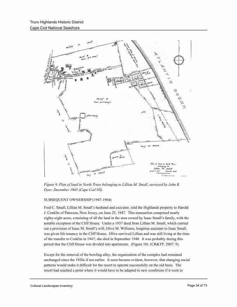
resort. A formal survey of the property in 1945 signaled her intention to sell, but she died in
March of the following year (Figure 9) (CR&TP, 2007: 9).
Cultural Landscapes Inventory Page 27 of 73

Cape Cod National Seashore
Truro Highlands Historic District
Figure 1. Highland Light Station, Truro, in 1891 (Cape Cod National Seashore,
hereafter Cape Cod NS).
Cultural Landscapes Inventory Page 28 of 73

Cape Cod National Seashore
Truro Highlands Historic District
Figure 2. Photograph of the original Highland Lodge, constructed 1835 (Cape Cod NS,
H26-06).
Cultural Landscapes Inventory Page 29 of 73

Cape Cod National Seashore
Truro Highlands Historic District
Figure 3. The Cliff House, 1880-1900. View looking northwest (Cape Cod NS, H26-07).
Cultural Landscapes Inventory Page 30 of 73

Cape Cod National Seashore
Truro Highlands Historic District
Figure 4. Photo of Highlands resort showing Highland House, and the Millstone, Rock,
and Beacon Cottages, c. 1908. View looking west (Cape Cod NS, H26-49).
Figure 5: Photo of Highland Road, with “Beacon” and “Rock” cottages, facing east to
the Highland Light, c. 1900s (Cape Cod NS, H26-23).
Cultural Landscapes Inventory Page 31 of 73

Cape Cod National Seashore
Truro Highlands Historic District
Figure 6. Photo of ball playing in the field southwest of Highland Light Station,
1910-1920 (Cape Cod NS, H14-040).
Figure 7. Photo of Highland House and associated gardens, 1907-1920. View looking
northeast (Cape Cod NS).
Cultural Landscapes Inventory Page 32 of 73

Cape Cod National Seashore
Truro Highlands Historic District
Figure 8. Photo of the Coleraine, a salvaged deckhouse from a grounded barge, c.
1920s (Truro Historical Society).
Cultural Landscapes Inventory Page 33 of 73
Cape Cod National Seashore
Truro Highlands Historic District
Figure 9. Plan of land in North Truro belonging to Lillian M. Small, surveyed by John R.
Dyer, December 1945 (Cape Cod NS).
SUBSEQUENT OWNERSHIP (1947-1964)
Fred C. Small, Lillian M. Small’s husband and executor, sold the Highlands property to Harold
J. Conklin of Paterson, New Jersey, on June 25, 1947. This transaction comprised nearly
eighty-eight acres, consisting of all the land in the area owned by Isaac Small’s family, with the
notable exception of the Cliff House. Under a 1937 deed from Lillian M. Small, which carried
out a provision of Isaac M. Small’s will, Olive M. Williams, longtime assistant to Isaac Small,
was given life tenancy in the Cliff House. Olive survived Lillian and was still living at the time
of the transfer to Conklin in 1947; she died in September 1948. It was probably during this
period that the Cliff House was divided into apartments. (Figure 10) (CR&TP, 2007: 9).
Except for the removal of the bowling alley, the organization of the complex had remained
unchanged since the 1920s if not earlier. It soon became evident, however, that changing social
patterns would make it difficult for the resort to operate successfully on the old basis. The
resort had reached a point where it would have to be adapted to new conditions if it were to
Cultural Landscapes Inventory Page 34 of 73
Cape Cod National Seashore
Truro Highlands Historic District
survive (CR&TP, 2007: 9).
In 1950, three years after acquiring the property, Conklin sold the Highland Lodge (minus its
large wing, which was gone by that time), to a couple from Provincetown. To protect his
interests, Conklin added a restrictive clause that stated, “the said premises shall not be used for
any commercial purpose of any kind, nature, or description.” After passing through the hands
of an intermediate owner, the Lodge was moved by its owners Stanley and Esther Chamberlain
to a new location on Old County Road, South Truro, in 1962. In 1952, Fred M. Small completed
the sale of the Highlands resort property by selling the Cliff House and its surrounding lots to
William B. Spink of Boston. Spink created a small resort separate from Conklins’, around the
nucleus of the Cliff House, which was then known as the Cliff House Colony (CR&TP, 2007:
9-10).
In the mid-1950s, the Coloraine Cottage was demolished owing to the severe deterioration of its
roof. Since the Coleraine had previously housed the resort's only bar, Conklin created a new
bar facility in the Highland House by replacing the north-facing section of the wrap-around
porch, which had offered the most striking views of the ocean, with a shed-roofed addition.
The bar became increasingly popular with local residents, but the large dining room was closed
due to lack of business (CR&TP, 2007: 10).
In 1955, the Conklin family reconfigured the Highland Golf Links, expanding it to the north side
of Highland Road. By this time, there was a clear change in the operation of the resort. Most
of the earlier recreational, service, and agricultural structures were gone. Of the multitude of
organized recreational activities offered, only the golf course survived. It endured because of
Harold Conklin’s personal devotion and because it was open to the public and did not rely on
guests staying at the hotel (CR&TP, 2007: 10).
With more and more casual sightseers driving to the lighthouse, concession emphasis shifted to
offering souvenirs and snacks. To better serve this market, Conklin moved the Pilgrim Cottage
to the south side of the road near the edge of the lighthouse lot, where it was used as a hot dog
stand. It was not especially successful and in 1957 two of Conklin’s employees, Joe Colliano
and Bill Hastings, purchased it, moved it back to the north side of the road, and converted it to
apartments. Colliano and Hastings also purchased the hot dog stand/souvenir shop that had
stood near the lighthouse and moved it to the north side of the road. There it formed a compact
cluster with the Pilgrim Cottage and the Jobi Pottery Shop (which they built) on a parcel of
slightly less than one acre (CR&TP, 2007: 10).
Further fragmentation of the former Highland resort occurred in the early 1960s, perhaps in
anticipation of the establishment of the Cape Cod National Seashore. Legislation creating the
National Seashore had been introduced by then, but the outcome was uncertain and the extent
or manner of land taking could not be predicted. In 1960, the Conklin family subdivided the
cottage cluster on the south side of Highland Road into five tiny lots, all but one of which
included a building. Four of the lots contained 9,375 square feet and one had 6,785 square feet;
collectively they totaled slightly more than one acre. All were soon sold to persons from urban
areas of the Northeast (CR&TP, 2007: 10).
Cultural Landscapes Inventory Page 35 of 73

Cape Cod National Seashore
Truro Highlands Historic District
Figure 10. 1947 Period Plan of the Truro Highlands Historic District (OCLP, 2006).
Cultural Landscapes Inventory Page 36 of 73

Cape Cod National Seashore
Truro Highlands Historic District
NATIONAL PARK SERVICE OWNERSHIP (1964-2008)
On July 30, 1964, the Conklin family sold their remaining holdings to the National Park Service.
These included the Highland House, the Millstone and Mayflower Cottages, the former
Sumner/Horton farmhouse (former Adams Cottage, which the Conklin family had purchased in
1955 as their residence), and the golf course. With the proceeds from the sale of the
Highlands, the Conklins’ purchased a similar summer resort in Laconia, New Hampshire
(CR&TP, 2007: 11).
Some of Aldrich’s cottages had survived in a derelict condition into the early 1950s, at which
time they were demolished. Around 1958, Samuel Aldrich, son of Henry and May, built a
four-room cottage on the tract. He died soon thereafter, however, and in 1965 his widow sold
their family's 9.1 acres to the National Park Service (CR&TP, 2007: 11).
The arrival of the National Park Service did not end the Highland House's recreational use.
The Conklin family had reserved a right to continue to operate the Highland resort for three
more years, with a right to renew for two years beyond that. The Conklin family transferred
these rights to Harold Conklin’s former employees, Joe Colliano and Bill Hastings. The two
men exercised both options, operating the property as a resort through 1969. This transitional
period was known as the “Jobi” era (Figure 11) (CR&TP, 2007: 11).
Many of the characteristics of the resort under the Small family ownership persisted during
these years. The Highland House and the remaining cottages continued to be used largely for
their original purposes. Colliano and Hastings even resumed operation of the dining room.
They divided the large first-story room by means of a plywood partition, creating a separate
lounge/breakfast nook in the section nearest the lobby (CR&TP, 2007: 11).
There was a distinct hierarchy of renting during this period, based on the availability of bath
facilities, with the second floor of the Highland House being last on the list. Normally it was
used by the service help or by young people who could not afford the better rooms, and was
rented to ordinary guests only as a last resort. This reversal of priorities due to the relative
accessibility of indoor plumbing was reflected in the room rates. During the Jobi period, rooms
in the Highland House were rented to young persons for $10 per week, while the rate in the
cottages was $12 a night, double occupancy, including maid service. In contrast, in 1919 the
$6-a-week rate at the Highland House was equal to the Adams, Haven, and Millstone Cottages,
while the old Highland Lodge was at the lower end of the scale at $2.50 (CR&TP, 2007: 11).
Just prior to the end of their era of active management at the Highlands, with the trend of
events unmistakably clear, Colliano and Hastings gave the Truro Historical Society space in the
Millstone Cottage's relatively primitive rear wing, in an effort to increase the chances of the
cottage's survival. This established the Historical Society's presence at the resort, which would
enable them to ask the National Park Service in the early 1970s for the use of the Highland
House as a museum (CR&TP, 2007: 12).
Following the approval of the Cape Cod National Seashore's first General Management Plan in
Cultural Landscapes Inventory Page 37 of 73

Cape Cod National Seashore
Truro Highlands Historic District
1970, a specific Development Concept Plan (DCP) was prepared for the Highlands. Intended
to "ensure a particular environment through an orderly system of Planned Actions including land
acquisitions, development, building retention and removal and interpretation," the 1970 DCP
included the following recommendations:
1. Acquire the northeastern half of the Coast Guard Property (lighthouse site) or, if this is not
possible, acquire rights to construct a trail and movable interpretive shelter.
2. Acquire Highland Road and the town parking lot from the Town of Truro. Construct a
50-car parking area near the Highland House along Highland Road. Leave vehicular access to
the private homes, the Jobi shop and Pilgrim House, the Lighthouse, Little Jobi Shop, and the
cottages.
3. Acquire and remove the Jobi Shop. Remove the town parking area.
4. Acquire the private homes on the south side of Highland Road and remove all except the one
closest to the ocean. Convert this structure into a pro-shop clubhouse for the golf course.
Remove the existing pro shop.
5. At such time in the future that the owners of the Jobi Shop and Pilgrim House vacate these
structures they should be acquired and removed. At this time, the ninth hole of the golf course
should be extended.
6. All of the Coast Guard Property should be acquired at such time that the Coast Guard is
willing to transfer it (CR&TP, 2007: 12).
Recommendations within the DCP shaped the management of the Highlands over the next two
decades. After the initial establishment of the National Seashore, the National Park Service
was primarily interested in acquiring open land. The agency pursued a policy of auctioning the
buildings on the properties purchased, with the stipulation that the successful bidder move the
buildings elsewhere. This was the case with the Millstone and Mayflower Cottages in 1971.
Millstone Cottage went to Pond Road, while Mayflower Cottage became an office and
additional rooms for a motor inn on Route 6, both in North Truro (CR&TP, 2007: 12-13).
Also in accordance with the DCP, in 1972 the National Park Service bought two additional
properties that had not been acquired in 1964—Pilgrim Cottage and the Cliff House. Joe
Colliano and Bill Hastings sold the land beneath the Pilgrim Cottage and the Jobi shop to the
National Park Service, but retained ownership of the buildings themselves. The following year,
the cottages were relocated (CR&TP, 2007: 13).
The National Park Service purchased the Cliff House from William Spink on February 1, 1974.
Spink reserved the right to move the building by May 31, 1974. He failed to do so by the
deadline and the National Park Service assumed control. The house then stood vacant for
almost a decade until a Board of Survey process was initiated in 1983. By then the structure
was only 20 feet from the edge of the eroding cliff. An auction of the building took place on
April 29, 1983 and on May 12, 1983, the bid of Daniel Del Gizzi was accepted. The house was
moved between August 3 and August 16, 1983, traveling about 1 1/4 miles to a new location on
Alden Road. It currently stands in this location, although it has been extensively altered
(CR&TP, 2007: 13).
During the 1980s, the park continued, albeit at a slower pace, to implement the
Cultural Landscapes Inventory Page 38 of 73

Cape Cod National Seashore
Truro Highlands Historic District
recommendations set out in the 1970 DCP. In 1970, a well for irrigating the golf course was
re-drilled 1600 feet south of the Highland Light Station. In 1982, the southeast ell on the
Highland House was removed owing to serious deterioration. In the late 1980s, the National
Park Service acquired the Beacon Cottage and rather than removing it, is currently using it for
park housing. The Rock and Haven Cottages remain in private ownership. The Adams
Cottage serves as the current golf course pro shop (CR&TP, 2007: 13).
The most recent alteration to the landscape at the Highlands was the relocation of the Highland
Light Station. Cliff erosion has continued to proceed at an accelerated rate, leaving the
lighthouse in serious danger of being lost. The National Park Service initiated studies in the
early 1990s, seeking recommendations for the best alternatives for relocation. The final plan to
relocate the lighthouse and adjacent Keeper’s Quarters was implemented in 1996. Both
structures were relocated approximately 450 feet from the cliff, southwest of their original
location. The old parking lot was removed and Highland Road terminated at the new lighthouse
location. The relocation of the lighthouse had a direct impact on the extant landscape of the
Highland Historic District. Alterations to the landscape as a result of the relocation include a
change in the circulation system due to the shortened distance along Highland Road to the
lighthouse, an increase in pedestrian visitor traffic to the cliff overlook between the seventh and
eighth holes of the golf course, and an additional parking lot (CR&TP, 2007: 14).
In 1998, a General Management Plan was developed for Cape Cod National Seashore. The
plan states, “Management of the seashore is a delicate balance in which the human needs of
today and tomorrow must be addressed within the context of both preservation and tradition.”
This philosophy applies well to the Highlands area as the property perpetuates over a century of
tourism and recreation, with the public access to the Highland Light Station, the reuse of the
Highland house as a museum and the continued use of the Highland Golf Links. Several
sections of the plan reference the Highlands area, including the park’s goal to manage and
maintain National Register-listed properties (CR&TP, 2007:99).
Cultural Landscapes Inventory Page 39 of 73
Cape Cod National Seashore
Truro Highlands Historic District
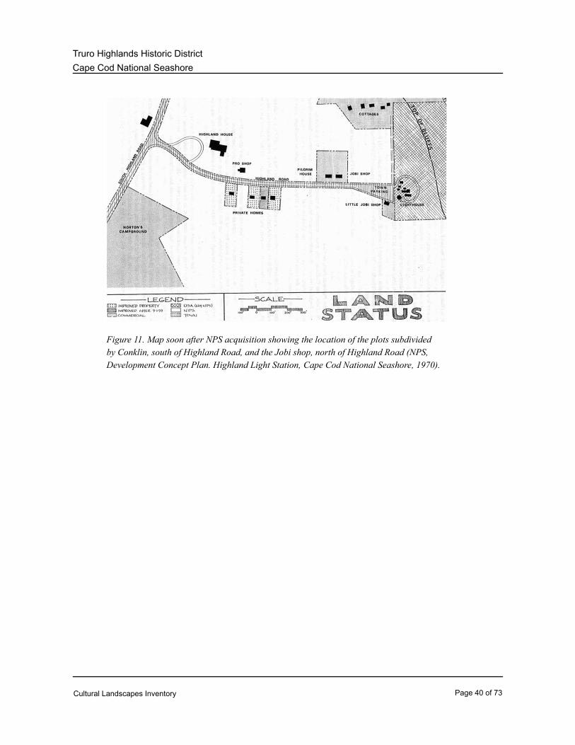
Figure 11. Map soon after NPS acquisition showing the location of the plots subdivided
by Conklin, south of Highland Road, and the Jobi shop, north of Highland Road (NPS,
Development Concept Plan. Highland Light Station, Cape Cod National Seashore, 1970).
Cultural Landscapes Inventory Page 40 of 73

Cape Cod National Seashore
Truro Highlands Historic District
Analysis & Evaluation of Integrity
Analysis and Evaluation of Integrity Narrative Summary:
Significant landscape characteristics identified for the Truro Highlands Historic District are natural
systems, topography, spatial organization, land use, circulation, vegetation, buildings and structures,
views and vistas, small-scale features, and archeological sites. Contributing characteristics or features
possess historic integrity and are related to the areas of significance. Non-contributing characteristics
or features no longer possess historic integrity, or are unrelated to the area of historic significance.
While rapid cliffside erosion has fundamentally changed the landscape within the Truro Highlands
Historic District, its open and windswept character remains preserved. The gently rolling topography
and spatial organization have been unaltered. As of result of the Highland Light Station relocation in
1996, the terminus of Highland Road was reconfigured, but still serves as the spine around which
structures and facilities are arranged. Although buildings and structures have been demolished or
relocated, buildings that do remain possess integrity and contribute to the historic period. With
exception to some scatterings of invasive species, the district contains mostly low growing native
vegetation that allows for unaltered views to the Highland Light Station, Atlantic Ocean, and
surrounding areas. Extant landscape features include the Highland Light Station, Highland House,
Beacon, Haven, and Adams Cottages, Highland Golf Links, Highland Road, and pedestrian and golf
cart paths. Other features include Highland Road vegetation (blueberry, huckleberry, bearberry,
sheeplaurel, and shadbush), pitch pine, oak and scrub oak barrens around the perimeter of the Highland
Golf Links, tees and greens, fairways, rough areas, heathland, wood utility poles, and views from
Highland Road and Highland Golf Links. Non- historic features found within the Truro Highlands
Historic District include the maintenance building, wisteria vine at the Millstone Cottage site, trees and
shrubs found within the links course, split-rail fencing, “Portland” memorial marker, Highland Light
Station relocation marker, and an anchor.
ASPECTS OF INTEGRITY
The National Register identifies seven aspects of integrity (location, design, setting, materials,
workmanship, feeling, and association). Retention of these qualities is essential for a property to
convey its significance; however, not all seven qualities of integrity need to be present to suggest a
sense of past time and place. The cultural landscape at Truro Highlands Historic District retains
overall integrity of location, design, setting, feeling, and association. The aspects of integrity that are
diminished include materials and workmanship.
Location:
With exception of the relocation of the eight and nine golf holes caused by erosion, the features that
exist within the Truro Highlands Historic District have not changed location since the period of
significance. Due to severe erosion and the possibility of being lost, the Highland Light Station was
relocated in 1996. The new location is approximately 450 feet west from its original location.
Design:
Cultural Landscapes Inventory Page 41 of 73

Cape Cod National Seashore
Truro Highlands Historic District
Since the historic period, the lands that include the golf course and important buildings retain their
original design schemes and features including materials, proportion, scale, site placement, and
ornamentation. The Highland Light Station also retains its original design schemes and features.
Setting:
While regenerating forests continue to alter the open and windswept landscape of the Outer Cape, the
character of the Truro Highland Historic District has remained relatively intact since the historic
period. Due to its location along the coastal bluffs and consisting mostly of a links-style golf course,
the historic district is largely open, consisting of gently rolling hills and low-growing vegetation that
allows for unobstructed views to the Atlantic Ocean and surrounding areas.
Materials:
Although many of the buildings and structures have been rehabilitated within the Truro Highlands
Historic District, the original materials have been retained. In addition, the Highland Light Station, with
the relocation and rehabilitation, retains original materials. However, many present historic walks and
roads throughout the historic district, including the golf course, have been paved and are
undistinguishable from the paved non- historic routes. In addition, the introduction of golf carts has
adversely affected the character of the Truro Highland Historic District. Due to overseeding the golf
course with non-native species of vegetation for the fairways and rough, native vegetation has been
reduced.
Workmanship:
Although the majority of the buildings within the Truro Highlands Historic District have been
rehabilitated, they are all in good condition and the workmanship during the period is evident. Due to
the reconfiguration of the golf course and the introduction of non-native vegetation, the workmanship
of the Highland Golf Links has been diminished. The Highland Light Station was rehabilitated in the
late 1990s, but still possesses the workmanship of the period.
Feeling:
With exception to the loss of structures along Highland Road, changes in circulation (asphalt surfaces
and the reconfiguration of Highland Road), and the relocation of the Highland Light Station, the district
retains the feeling of an early tourist resort on the Lower Cape.
Association:
Similar to the historic period, the Truro Highlands Historic District continues to be recognized as a
landscape of distinctive character that embodies the area’s popularity as a tourist destination in the late
nineteenth and early twentieth centuries, as well as link to its maritime past. In addition to its open and
windswept character, extant features that relate to the historic significance of the Truro Highlands
Historic District include, but are not limited to the Highland Light Station, Highland Golf Links,
Highland House, Beacon, Haven, and Adams Cottages, and Highland Road.
Landscape Characteristic:
Other - Natural Systems and Topography
Historic Condition:
Cultural Landscapes Inventory Page 42 of 73

Cape Cod National Seashore
Truro Highlands Historic District
The Truro Highlands Historic District is located on an area known as the Highland Plain.
Because of the varied topography of the continental shelf, the retreat of the glaciers from the
Cape after the ice age was uneven. The South Channel lobe occupied a lower elevation of the
shelf area, consequently extended further south, and remained longer in place than the other
lobes during the retreat of ice during deglaciation. As the Cape Cod Bay lobe retreated
northward, the South Channel lobe remained in place. In this fashion, a large proglacial lake
was formed, bounded by the Cape Cod Bay Lobe to the north, the South Channel lobe on the
east, and previously formed glacial sediments on the south and west. Sediments transported by
streams flowing off the wasting ice were carried westerly and deposited as outwash plain
sediments (known as plains) into the proglacial lake (CR &TP, 2007: 53).
In general, the stratigraphy resulting from this deposit process consists of three parts. At the
base of the cliff outcrops of iron stained, medium to coarse grained sand are overlain by layers
of dark gray and silty clay with some distortions visible and this, in turn, is overlain by fine to
very fine grained layered sand capped by podsol and eolian (wind blown) sand (CR &TP, 2007:
53).
The Highland Plain is distinguished by dense middle layers of clay, which trap infiltrating
rainwater and retain it or channel it to points of drainage from the cliff front. Indeed, it may be
that these trapped layers of water provided the source of the famous spring, Tashmuit, after
which the area was named. Large amounts of clay in the soil (thus its traditional name, The
Clay Pounds) also greatly enhanced the area's potential for human settlement. The high clay
content of the area's thick outwash plain soils made it excellent for agricultural uses (CR &TP,
2007: 53).
In contrast, the continuous drainage and seepage resulting from the presence of the underlying
layers of clay contribute in great measure to the rap¬id, erratic, and occasionally catastrophic
erosion from slope failure, which occurs in the area. The area's vulnerability is further
compounded by the fact that it is made up of unconsoli¬dated, stratified sediments, which are
highly susceptible to erosion by wind or waves, or stress induced by gravity. Erosion has been
measured along the coastal side of the Highland Plain at regular intervals since 1796 (CR &TP,
2007: 53).
Topography generally slopes down from the northern portion of the area around Highland Road,
to the southern edge of the golf course. A ridge on the south side of Highland Road, where the
Rock, Beacon, Haven, and Bennett Cottages are located, provides excellent views towards the
Atlantic Ocean and Provincetown to the north (CR &TP, 2007: 53).
The Highland Golf Links is situated high on a seaside bluff with rolling, sandy hills covered with
a thin layer of loam. The “links-style” of golf course design was predominant in the late 1800s
when the Highland Golf Links was established. Although there is no historical documentation
regarding Small’s design intent, it is evident from the link’s configuration that the native
environment was a major determinant in Small’s scheme (CR &TP, 2007: 54).
Cultural Landscapes Inventory Page 43 of 73

Cape Cod National Seashore
Truro Highlands Historic District
Post Historic and Existing Conditions:
Rapid cliffside erosion has had a marked impact on the overall character of the area. It has
decreased the total land area of the Highlands, causing the relocation of the golf holes eight and
nine in 1955, the Cliff House in 1983, and the Highland Light Station in 1996. Currently, the
rate of erosion appears to vary from about one foot per year to about five feet per year. In
addition to coastline erosion, erosion on the Highland Links continually occurs from cart paths,
altering the landforms and reducing groundcover, which increases wind erosion and dune
migration (CR &TP, 2007: 54).
Character-defining Features:
Terrain of Highland Golf LinksFeature:
133042Feature Identification Number:
ContributingType of Feature Contribution:
Spatial Organization
Historic Condition:
Since the mid-nineteenth century, the Truro Highlands Historic District has characteristically
been an open and windswept area. Along with the ocean itself, Highland Road, which leads
directly from South Highland Road to the lighthouse, serves as the central organizing feature of
the Highlands District. Throughout the period of significance, the road served as a central
spine around which all of the structures and facilities developed during the resort era were
organized. Interestingly, the earliest development of tourist facilities at the Highlands, including
the enlargement of Highland Lodge (1876) and the construction of Millstone Cottage (1898)
appear to have been oriented towards South Highland Road. However, the majority of later
development by the Small family was organized along Highland Road. Owing to a slight rise
that the road traverses, each cottage along the road was afforded an excellent view of the
Atlantic Ocean and Provincetown to the northwest (CR &TP, 2007: 55).
The Highland Golf Links were originally laid out in 1898 as a nine-hole golf course located
entirely on the south side of Highland Road. Although the course was described as “greatly
improved and enlarged” in 1903, early tax records state that the 200-yard course occupied
unimproved land. The fairways were grass and sand, the greens were gravel and sand, except
for the seventh green, which was a thin layer of sand over concrete. The rough consisted
largely of the native grasses and low, heath-like shrubs. The greens were planted with turf by
1934 and possibly as early as 1911-1912 (CR &TP, 2007: 55).
The expansion of the golf course to the north side of the road in the 1950s resulted in a
significant change in the overall organization of the site. Originally, the golf course was located
entirely on the south side of Highland Road and the resort had two distinct zones: road resort
facilities and gardens to the north and the golf course to the south. Following the expansion, the
golf course came to dominate the entire area, divided by the road, and associated resort
facilities.
Cultural Landscapes Inventory Page 44 of 73

Cape Cod National Seashore
Truro Highlands Historic District
Post Historic and Existing Conditions:
While the open and windswept character of the Truro Highlands Historic District has remained
since the historic period, the linear organization of buildings found along Highland Road has
been somewhat weakened through the removal of so many buildings, resulting in a less orderly,
"missing tooth" effect. With the relocation of the Highland Light Station in 1996, the spatial
organization of the district was altered in that it introduced a central focal point to the resort
setting, which historically was off in the distance. Additional changes to the spatial organization
include the gradual disappearance of a secondary, north-south axis created by the short road
leading from the previous location of the lighthouse northward to the remnants of the Cliff
House, and the introduction of golf carts and the construction of the various paved paths for
golf carts (Figure 12).
Character-defining Features:
Highland Golf LinksFeature:
133044Feature Identification Number:
ContributingType of Feature Contribution:
Landscape Characteristic Graphics:
Figure 12. View of the open character of the site. Highland Road serves as the central
organizing feature of the district around which all structures are located. As seen in the
photo, the Highland Golf Links is located on both sides of the road.
Cultural Landscapes Inventory Page 45 of 73

Cape Cod National Seashore
Truro Highlands Historic District
Land Use
Historic Condition:
Prior to the historic period, the Truro Highlands was used extensively for farming. In the
nineteenth century, the Small family converted the area into a resort. Visitors tended to stay for
an extended period of time, ranging from a week to the entire summer and many guests
returned year after year. Resort life had a highly collective nature, characterized by group
meals and activities. Recreational activities were prevalent during the historic period. Bowling,
skating, baseball, pool, croquet, and golf were available to visitors. The Highland Lodge,
located on the south side of Highland Road across from the Highland House, contained a pool
table, indoor bowling alley, and pool room (CR &TP, 2007: 57).
Built in 1898, the Highland Golf Links was built on the south side of Highland Road. Baseball,
croquet, and golf were available to visitors in the area of the Highland Golf Links. Baseball and
croquet appear to have been played on a portion of the golf course south of Highland Road.
On a more informal level, visitors were also able to traverse a rough staircase down the cliffs
and bathe in the ocean below. Finally, visiting the lighthouse was another attraction at the
Highlands (CR &TP, 2007: 57-58).
Post Historic and Existing Conditions:
Tourism at the Truro Highlands Historic District has remained the primary land use since the
period of significance. Currently, tourists typically travel along Highland Road in order to visit
the Highland Light Station, Museum (formerly the Highland House), or visit the golf course.
Trips to the area are short and rarely go beyond a day. Visitors still have the opportunity to
observe the scenic views from atop the cliffs and view the Highland Light Station, however,
other recreational activities that once were available are no longer present. Golf remains
available to tourists in the Truro Highlands Historic District. With the construction of two holes
on the northern side of Highland Road in 1955, the golf course now occupies both sides of the
road (CR &TP, 2007: 58).
Character-defining Features:
TourismFeature:
133046Feature Identification Number:
ContributingType of Feature Contribution:
RecreationFeature:
133048Feature Identification Number:
ContributingType of Feature Contribution:
Circulation
Historic Condition:
Highland Road has existed presumably since the Highland Light Station was built in 1797. The
Cultural Landscapes Inventory Page 46 of 73

Cape Cod National Seashore
Truro Highlands Historic District
earliest depiction of a road is on an 1831 plan of Truro. By 1892, the road was defined at a
width of 18 feet and graded to its present configuration by the town. Photographs from 1892
and 1920 show the edges on either side of the road as somewhat more steeply banked than
today. Post and wire fencing lined portions of the north side of the road and both sides of the
portion of the road near the lighthouse. The road appears to have been surfaced with a mix of
sand and gravel, and then paved with concrete or asphalt between 1938 and 1960 (CR &TP,
2007: 58).
Isaac Small recalled that the golf course was redesigned in 1913 according to the specifications
of a prominent guest, J. H. McKinley of New York. Mrs. Dorothy Small Garfield, a former
resident of the site and daughter of the golf facility manager in the early 1900s, reminisced that
direction of play was reversed at some point in time. Early play started near the Coleraine
clubhouse, near the current 7th tee, then proceeded east and south around the course. All of
the holes were located south of Highland Road. Later, the direction of play changed, making
the 9th hole the 1st hole. Holes 8 and 9 were moved to the north side of the road. Historically
the course was traversed on foot, which caused little damage to the vegetation. Golf carts
were introduced in the 1950s and thus can be assumed that the existing cart paths, which
overlay pedestrian paths, date from no earlier than the 1950s (Figure 13) (CR &TP, 2007: 59).
Post Historic and Existing Conditions:
The terminus of Highland Road was reconfigured as a result of the lighthouse relocation in
1996. In addition, parking was moved to the west end of the road. Three parking lots now
exist, two to the north at Highland House and one to the south across Highland Road.
Pedestrians can only access the coastline, east of Highland Light Station. Erosion has been a
problem with the newly installed sand/aggregate paving mix. A binding agent was incorporated
into the mix to create a more stable surface, but it has not alleviated the erosion problem
(Figure 14). Concrete steps and paths are located on the south side of Highland Road
connecting to existing cottages. It is unclear when they were constructed (CR &TP, 2007: 59).
Character-defining Features:
Highland RoadFeature:
133050Feature Identification Number:
ContributingType of Feature Contribution:
Cottage concrete paths and stepsFeature:
133052Feature Identification Number:
UndeterminedType of Feature Contribution:
Pedestrian/golf cart pathsFeature:
133054Feature Identification Number:
ContributingType of Feature Contribution:
Cultural Landscapes Inventory Page 47 of 73
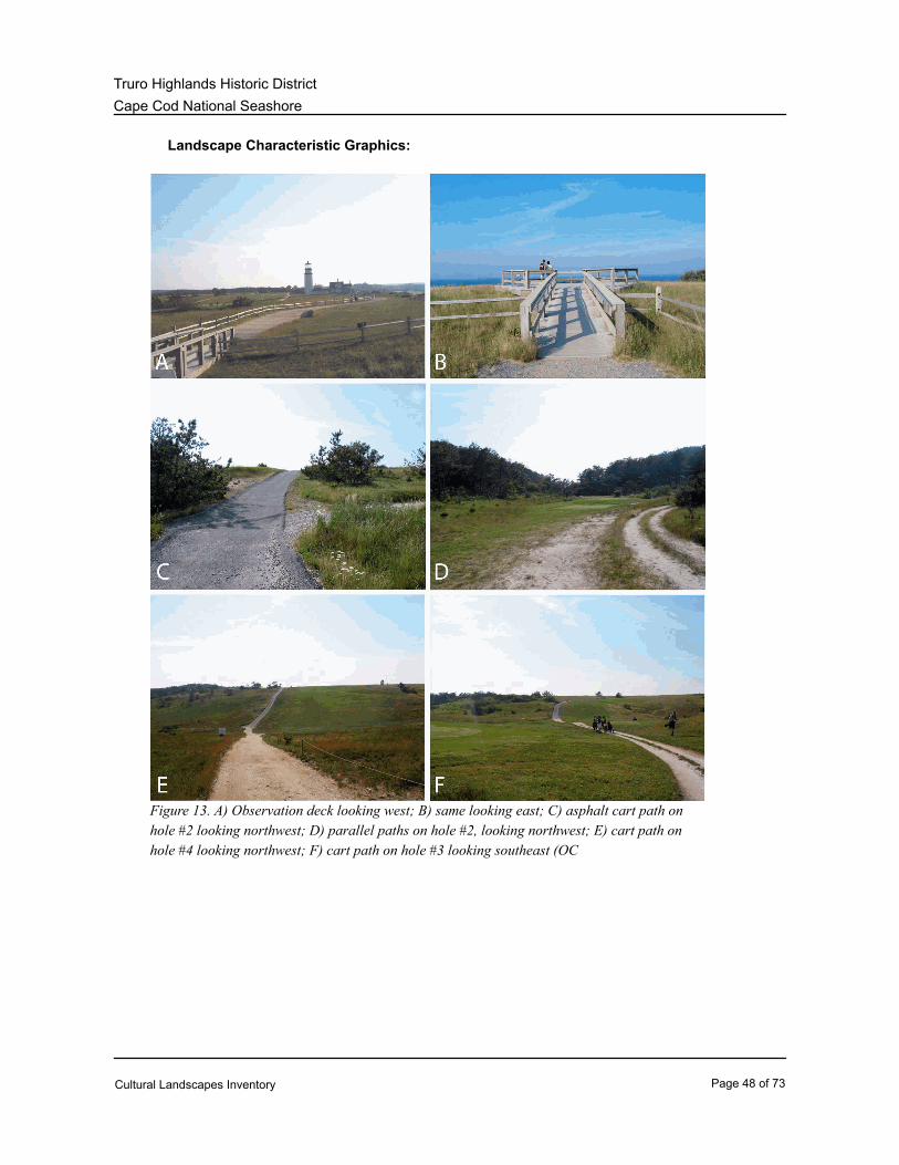
Cape Cod National Seashore
Truro Highlands Historic District
Landscape Characteristic Graphics:
Figure 13. A) Observation deck looking west; B) same looking east; C) asphalt cart path on
hole #2 looking northwest; D) parallel paths on hole #2, looking northwest; E) cart path on
hole #4 looking northwest; F) cart path on hole #3 looking southeast (OC
Cultural Landscapes Inventory Page 48 of 73

Cape Cod National Seashore
Truro Highlands Historic District
Figure 14. A and F) Highland Rd. looking east; B) parking area, south side; C) parking
area, north side; D) parking area entrance west of Highland House; E) Highland Rd. and
golf links clubhouse (Adams Cottage) looking east (OCLP, 2006).
Buildings and Structures
Historic Condition:
Constructed by S.D. Nickerson of Provincetown between 1906 and 1907, the Highland House
originally consisted of a two-story gable-roofed main block oriented east-west and a two-story
gabled-roofed ell at the east end of the south side. The main building sat on a brick foundation
approximately six feet high. The southeast ell sat on brick piers. An extension on the east face
was apparently added at an early date to accommodate kitchen and laundry facilities. The
building was of wood-frame construction and had a belt of decorative shingles, which ran
around the main building at the level of the second floor. A one-story porch originally ran
Cultural Landscapes Inventory Page 49 of 73

Cape Cod National Seashore
Truro Highlands Historic District
across the entire front (west elevation) of the main building. It wrapped around the northwest
corner of the structure and continued along the north wall for a distance of approximately forty
feet. The window openings were asymmetrically placed due to interior features. The windows
on the west side contained two over-one double-hung sashes and the remaining windows were
two over two double-hung sashes. Over the years, the east extension and southeast ell had
deteriorated substantially and were removed in 1974 and 1982, respectively (CR &TP, 2007:
60).
The Rock and Beacon Cottages, built in 1902 by S.D. Nickerson, are sister wood-frame
cottages built in a simple Victorian style. Both cottages were sided with weathered wood
shingles and contained broad front porches. Constructed in 1915, the Haven Cottage was a
simple one-story, wood-frame “box” structure with wood shingles and a hip roof. The Highland
clubhouse, formerly known as the Adams Cottage, was built in 1917 as a wood frame structure
with a one-story garage wing. During most of its history, it was used as a residence for
operations of the resort or the adjacent farm, with rooms being rented occasionally (CR &TP,
2007: 60-61).
The Highland Light Station, also referred to as the Cape Cod Light, was originally constructed
in 1797 as one of the earliest lighthouses on the east coast. The government purchased ten
acres of land for the lighthouse from Isaac Small. The original structure would later be
replaced twice. The new lighthouse, constructed between 1856 and 1857, included a brick
tower, wood-frame vernacular Italianate style Keeper’s Quarters, and Assistant Keeper’s
Quarters. It was equipped with a first-order fixed Fresnel lens. In 1881, the board-and-batten
siding on both dwellings was replaced with clapboards. Between 1900 and 1910, the floor plans
of both the dwellings were modified and dormers added. In addition, the ell of the keeper’s
dwelling was raised to include a second story, and a wrap around porch was constructed.
Shortly thereafter, Fresnel lens was installed in the tower, the beacon was changed from fixed
to flashing, and a new iron staircase was built. In 1932, a 1000-watt electric lamp was installed,
which was said to be visible forty-five miles away. During World War II, many building and
structures found on the property were removed. In 1946, the Fresnel lens was replaced with a
Crouse-Hinds 36-inch, double-drum, rotating DCB-36 aerobeacon (Historic Structures Report:
Highland Light, 1994: 130).
Post Historic and Existing Conditions:
Since the period of significance, the Highland House has had many windows replaced, a portion
of the wrap around porch was enclosed, and the southeast ell was reconstructed. The Truro
Historical Society currently occupies the building and it is used as a repository and museum.
According to the List of Classified Structures Database, the house is in poor condition with
numerous maintenance problems including leaks, cracked plaster, trim deterioration, and
drainage issues. Progress has been made recently with the installation of a new wood roof on
the building and the refinishing of some interior wood floors (Figure 15) (CR &TP, 2007: 60).
The Rock and Beacon Cottages have retained their original character. The Beacon Cottage
Cultural Landscapes Inventory Page 50 of 73

Cape Cod National Seashore
Truro Highlands Historic District
had a shed-like addition on the south side constructed and significant interior improvements
shortly after acquisition by the National Park Service in 1987 (Figure 16). The List of
Classified Structures Database identifies the building as being in good condition. The Beacon
Cottage is currently used by the park for summer employee housing. The Rock Cottage, listed
in good condition, underwent a complete rehabilitation in the early 1990s (Figure 17). It is
privately owned. The windows and doors have all been replaced on the Haven Cottage,
although the original form and massing is intact (Figure 18). The building is in fair condition and
is privately owned. The Highland Clubhouse (Adams Cottage) is currently used as the
clubhouse for the golf course (Figure 19). Since its conversion to a clubhouse during the period
of National Park Service administration, it has undergone some modifications. Decks on the
north and east sides were constructed, providing handicapped accessibility. Restrooms were
relocated in 1991 (CR &TP, 2007: 61-62).
With the threat of being lost to erosion, the Truro Historical Society spearheaded an effort,
which raised $1.5 million to move the Highland Light Station. In a span of eighteen days in July
1996, International Chimney Inc. of Buffalo, New York, and Expert House Movers of Maryland
moved the lighthouse to a new position 450 feet from the cliff. As a result of its relocation, the
Highland Light Station is now located within the Truro Highlands Historic District. Contained
within the Highland Road area, the lighthouse is individually listed in the National Register as
being historically significant. Fully automated in 1986, the lighthouse is a functioning U.S. Coast
Guard light. It is conical-shaped, constructed of brick, and stands sixty-six feet. A pair of
Fresnel-lensed aerobeacons currently light the Highland Light Station (Figure 20) (CR &TP,
2007: 62).
Located within the Highland Golf Links, a one-story maintenance building was built in 1988. It
is constructed of wood and is sided with wood shingles. The building features a shed-roof and
is served by three parking bays. The building is in good condition (Figure 21) (CR &TP, 2007:
62-63).
Character-defining Features:
Highland HouseFeature:
133056Feature Identification Number:
ContributingType of Feature Contribution:
7499IDLCS Number:
LCS Structure Name: Highland House
T-153LCS Structure Number:
Rock CottageFeature:
133058Feature Identification Number:
ContributingType of Feature Contribution:
Cultural Landscapes Inventory Page 51 of 73

Cape Cod National Seashore
Truro Highlands Historic District
Slade House (Beacon Cottage)Feature:
133060Feature Identification Number:
ContributingType of Feature Contribution:
40461IDLCS Number:
LCS Structure Name: Slade House
T-300LCS Structure Number:
Haven CottageFeature:
133062Feature Identification Number:
ContributingType of Feature Contribution:
Highland Clubhouse (Adams Cottage)Feature:
133064Feature Identification Number:
ContributingType of Feature Contribution:
40460IDLCS Number:
LCS Structure Name: Highland Clubhouse
T-156LCS Structure Number:
Highland Light StationFeature:
133066Feature Identification Number:
ContributingType of Feature Contribution:
40462IDLCS Number:
LCS Structure Name: Highland Light
T-355LCS Structure Number:
Keeper’s QuartersFeature:
133068Feature Identification Number:
ContributingType of Feature Contribution:
40463IDLCS Number:
LCS Structure Name: Highland Light Station - Keeper's Quarters
T-336LCS Structure Number:
Maintenance buildingFeature:
133070Feature Identification Number:
Cultural Landscapes Inventory Page 52 of 73

Cape Cod National Seashore
Truro Highlands Historic District
Non ContributingType of Feature Contribution:
Landscape Characteristic Graphics:
Figure 15. View of Highland House, constructed in 1906-1907, looking northeast (OCLP,
2006).
Cultural Landscapes Inventory Page 53 of 73

Cape Cod National Seashore
Truro Highlands Historic District
Figure 16. View of Beacon Cottage, constructed in 1902, looking southwest (OCLP, 2006).
Cultural Landscapes Inventory Page 54 of 73
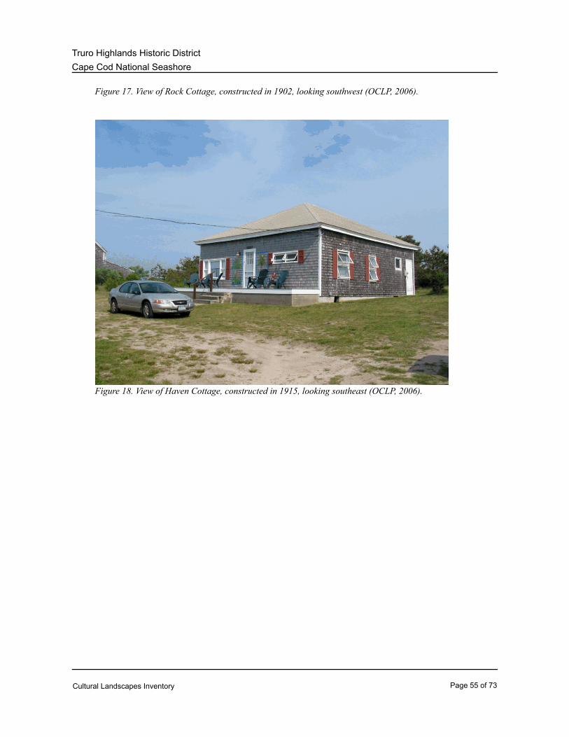
Cape Cod National Seashore
Truro Highlands Historic District
Figure 17. View of Rock Cottage, constructed in 1902, looking southwest (OCLP, 2006).
Figure 18. View of Haven Cottage, constructed in 1915, looking southeast (OCLP, 2006).
Cultural Landscapes Inventory Page 55 of 73

Cape Cod National Seashore
Truro Highlands Historic District
Figure 19. Photograph of the Highland Clubhouse, formerly the Adams Cottage,
constructed in 1917. View looking northeast (OCLP, 2006).
Cultural Landscapes Inventory Page 56 of 73

Cape Cod National Seashore
Truro Highlands Historic District
Figure 20. View of the Highland Light Station and Keeper’s Quarters, originally built in
1797 and reconstructed in 1857, looking east. These structures were moved west along
Highland Road. View looking northeast (OCLP, 2006).
Figure 21. View of maintenance building, looking north (OCLP, 2006).
Vegetation
Historic Condition:
Prior to settlement by the English Separatists, much of Cape Cod, including the Truro area, was
heavily forested. With the arrival of English colonists, land clearing, burning, poor agricultural
practices, and grazing by animals markedly reduced the vegetation and by the mid-nineteenth
century, Cape Cod was bare of most forest. During Henry David Thoreau’s visits to the area
between 1849 and 1857, he recorded the existence of beach plum (Prunus maritima), shadbush
(Amelanchier spp.), and blueberries (Vaccinium pennsylvanicum). By the Great Depression,
land uses that had perpetuated clearings were declining and forest-successional species such as
pitch pine had begun to reestablish themselves (CR &TP, 2007: 63-64).
When Willard Small laid out the golf course in 1898, he relied on native turf for the fairways on
the links. He likely used bunch grasses that dominated the Outer Cape’s sand plain grasslands,
particularly little bluestem (Schizachyrum scoparium) and poverty grass (Danthoria spicata).
Other plants that may have been present include bird’s foot violet (Viola pedata) and sandplain
gerardia (Agalinis acuta). The early course had no turf on the tees or greens. Sand and gravel
were the preferred covers. By 1934, possibly as early as 1911-12, the sand and gravel greens
Cultural Landscapes Inventory Page 57 of 73
Cape Cod National Seashore
Truro Highlands Historic District
were replaced with a non-native grass, velvet bentgrass (Agrostis canina). By 1947, the tees
and greens were overseeded with other non-native bluegrass varieties (Poa spp.). When the
golf links was established in 1898, it is likely that native woody plant species and heathlands that
exist today dotted the landscape. Trees were not a factor in Small’s 1898 design and layout of
the golf links. For years, the site remained open and devoid of large plant species. The
continued openness and relative lack of large vegetation within the course is evident in a series
of aerial photographs taken of the site in 1938, 1960, 1977, 1986, and 1994. Although heathland
communities are globally a rare collection of plants, they have been common on the Outer Cape
since early deforestation occurred and open lands became prevalent (CR &TP, 2007: 65-67).
Post Historic and Existing Conditions:
The Highlands area contains four of the sixteen distinct vegetative habitats that have been
identified on Cape Cod including Pitch Pine/Scrub Oak Barrens, Sandplain Grasslands,
Heathlands, and Grassy Heaths. The vegetation along Highland Road contains native plant
species common to the Highland Plain area. They include blueberry, huckleberry, bearberry,
sheeplaurel, and shadbush. Since the historic period, the native vegetation of the Highland Plain
has dense around the perimeter of the district. In addition, wisteria, located at the site of the
Millstone Cottage, has spread beyond the bounds of its initial ornamental purposes (CR &TP,
2007: 63-64).
Within the Highland Golf Links, the fairways have been overseeded with bluegrass mixes in an
effort to establish a thicker, more consistent turf cover. The tees and greens currently have a
highly maintained turf cover. The current management practice is to overseed the tees and
greens with velvet bentgrass in order to reestablish this turf cover and reduce usage of
high-maintenance bluegrass varieties. Some rough areas contain a mix of species while others
do not. In addition to the species noted by Thoreau, common species include bearberry
(Archstaphylos uva-ursi), sedges (Carex spp.) and broom crowberry (Corema conradii), a
Massachusetts state-listed and protected species. Typical of a links-style course, some rough
areas have been mowed on a frequent schedule, reducing native vegetation and producing a
manicured look. There are currently no large trees on the links. Groups of small native trees
have been planted or allowed to grow on their own in some areas of the golf links, especially
between the fairways, near tees and greens, and on the perimeter of the course. Some shrubs
have been planted between the fairways to provide spatial definition, although few currently
remain. A second-growth forest containing pitch pine, scrub oak, and various hardwoods and
shrubs has become a part of the natural landscape surrounding the Highland Golf Links,
particularly along the southern and western boundaries (CR &TP, 2007: 65-67).
Both development on the Lower Cape and reforestation of undeveloped areas have reduced
the total area of heathland on the Lower Cape. Several areas on the perimeter of the golf links,
primarily on the eastern side, contain heathland plant communities. These areas have been
reduced by coastal erosion (Figures 22 and 23) (CR &TP, 2007: 67).
Character-defining Features:
Highland Road Vegetation: Blueberry, huckleberry, bearberry, sheeplaurel and
shadbush
Feature:
Cultural Landscapes Inventory Page 58 of 73

Cape Cod National Seashore
Truro Highlands Historic District
133072Feature Identification Number:
ContributingType of Feature Contribution:
Wisteria vine at site of Millstone CottageFeature:
133074Feature Identification Number:
Non ContributingType of Feature Contribution:
Pitch pine, oak and scrub oak barrens around perimeter of Highland LinksFeature:
133076Feature Identification Number:
ContributingType of Feature Contribution:
FairwaysFeature:
133078Feature Identification Number:
ContributingType of Feature Contribution:
Tees and GreensFeature:
133080Feature Identification Number:
ContributingType of Feature Contribution:
Rough AreasFeature:
133082Feature Identification Number:
ContributingType of Feature Contribution:
Trees and shrubs within links courseFeature:
133084Feature Identification Number:
Non ContributingType of Feature Contribution:
HeathlandFeature:
133086Feature Identification Number:
ContributingType of Feature Contribution:
Landscape Characteristic Graphics:
Cultural Landscapes Inventory Page 59 of 73

Cape Cod National Seashore
Truro Highlands Historic District
Figure 22. A) wisteria; B) pitch pine/scrub oak barrens; C) fairway, rough, and native
vegetation, view southeast; D) typical vegetation at golf links; E) tee box at hole #4 and
grouping of rockrose, view southeast; F) heathlands, view north (OCLP, 2006).
Cultural Landscapes Inventory Page 60 of 73
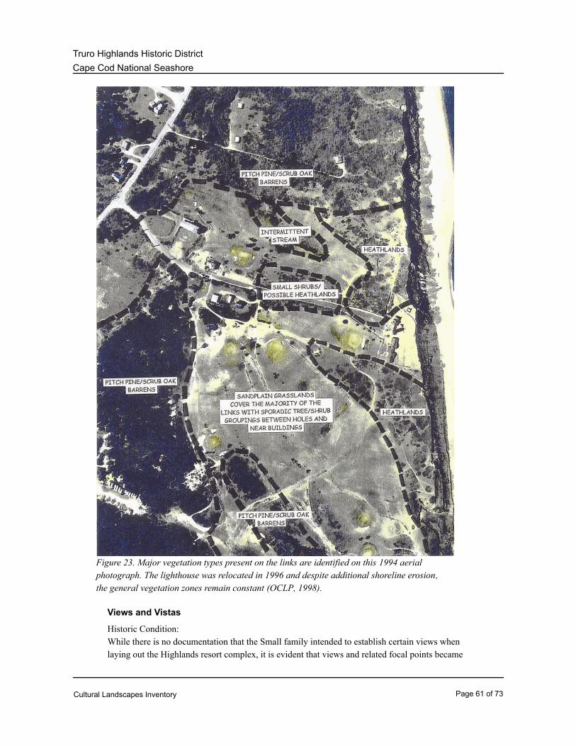
Cape Cod National Seashore
Truro Highlands Historic District
Figure 23. Major vegetation types present on the links are identified on this 1994 aerial
photograph. The lighthouse was relocated in 1996 and despite additional shoreline erosion,
the general vegetation zones remain constant (OCLP, 1998).
Views and Vistas
Historic Condition:
While there is no documentation that the Small family intended to establish certain views when
laying out the Highlands resort complex, it is evident that views and related focal points became
Cultural Landscapes Inventory Page 61 of 73

Cape Cod National Seashore
Truro Highlands Historic District
important site features that helped define and establish the character of the site. As a result of
the open and undulating character of the Highlands area, visitors could obtain unobstructed
views of the Highland Light Station, the Atlantic Ocean, and surrounding areas. Buildings
constructed by the Small family on Highland Road were afforded an excellent view of the
Atlantic Ocean and Provincetown to the northeast (CR &TP, 2007: 67).
Post Historic and Existing Conditions:
Visitors to the Truro Highlands Historic District can still observe excellent views of the
Highland Golf Links, Highland Light Station, and surrounding areas. The observation deck,
located on the eastern side of the Highland Light Station, captures unobstructed views of the
Atlantic Ocean (CR &TP, 2007: 67).
The elevated location of the Highland Golf Links provides a panoramic view of the Atlantic
Ocean from nearly every vantage point. The Highland Light Station, Highland House, and
off-site features including “Jenny Lind Tower” and old Truro Air Force station have become
prominent focal points and aid in composing interesting views throughout. The lack of large
trees on the course allows these views to be uninterrupted across the course. It also provides
the opportunity for visitors to the surrounding Truro Highland Historic District to have an
unobstructed view onto the links (Figure 24) (CR &TP, 2007: 68).
Character-defining Features:
Views from Highland Road to the Highland Golf Links and Highland Light
Station
Feature:
133088Feature Identification Number:
ContributingType of Feature Contribution:
Views from Highland Golf Links to Atlantic Ocean, Highland Light Station,
Jenny Lind Tower, Highland House, and Truro Air Force Station
Feature:
133090Feature Identification Number:
ContributingType of Feature Contribution:
Landscape Characteristic Graphics:
Cultural Landscapes Inventory Page 62 of 73
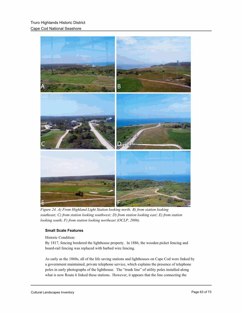
Cape Cod National Seashore
Truro Highlands Historic District
Figure 24. A) From Highland Light Station looking north; B) from station looking
southeast; C) from station looking southwest; D) from station looking east; E) from station
looking south; F) from station looking northeast (OCLP, 2006).
Small Scale Features
Historic Condition:
By 1817, fencing bordered the lighthouse property. In 1886, the wooden picket fencing and
board-rail fencing was replaced with barbed wire fencing.
As early as the 1860s, all of the life saving stations and lighthouses on Cape Cod were linked by
a government maintained, private telephone service, which explains the presence of telephone
poles in early photographs of the lighthouse. The “trunk line” of utility poles installed along
what is now Route 6 linked these stations. However, it appears that the line connecting the
Cultural Landscapes Inventory Page 63 of 73

Cape Cod National Seashore
Truro Highlands Historic District
main line along Route 6 to the Highland Light Station did not run down Highland Road, but,
rather, through the northern portion of the Small property.
According to Cape Cod historian Simeon Deyo, public telephone service was established on
Cape Cod in 1882, with the first lines reaching Barnstable, Hyannis, Cotuit, and Marston's Mills.
By 1883, the New Bedford Telephone Service had reached Truro. However, Truro historian
Anthony Marshall has noted that most families did not have telephones in the early 1900s. The
existing wood utility poles found on the south side of Highland Road were installed at some time
between 1910 to 1937. A photograph of Highland Road taken in 1910 shows no poles.
However, a 1937 photograph of the area, taken by photographer Samuel Chamberlain, appears
to show utility poles running down Highland Road to the lighthouse. It may have been that the
installation of private utility/telephone service coincided with the development of private resort
cottages by the Aldrich family during the 1920s.
Post Historic and Existing Conditions:
In the 1990s, split rail fencing was added along the north side of Highland Road to the
lighthouse. On the east side of the Highland Light Station, the fencing is found on the north and
south sides of the pedestrian trail to the observation deck (Figure 25).
Two markers were installed after the relocation of the Highland Light Station in 1996. The
“Portland” memorial marker, located along the west elevation of the Keeper’s Quarters, honors
the “Portland” steamer, which sank near the Truro Highlands. The Highland Light Station
relocation marker, situated in the previous location of the lighthouse, provides interpretive
information identifying the original location of the Highland Light Station (Figure 26). An
anchor exists on the west elevation of the Highland House.
Character-defining Features:
Wood utility polesFeature:
133092Feature Identification Number:
ContributingType of Feature Contribution:
Split-rail fencingFeature:
133094Feature Identification Number:
Non ContributingType of Feature Contribution:
“Portland” memorial markerFeature:
133096Feature Identification Number:
Non ContributingType of Feature Contribution:
Highland Light Station relocation markerFeature:
133098Feature Identification Number:
Cultural Landscapes Inventory Page 64 of 73

Cape Cod National Seashore
Truro Highlands Historic District
Non ContributingType of Feature Contribution:
AnchorFeature:
133100Feature Identification Number:
Non ContributingType of Feature Contribution:
Landscape Characteristic Graphics:
Figure 25. View of wood post and rail fencing that borders the northern and southern
edges of the walking path from the Highland Light Station to the observation deck (OCLP,
2006).
Cultural Landscapes Inventory Page 65 of 73
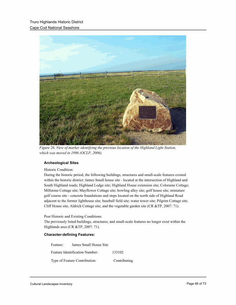
Cape Cod National Seashore
Truro Highlands Historic District
Figure 26. View of marker identifying the previous location of the Highland Light Station,
which was moved in 1996 (OCLP, 2006).
Archeological Sites
Historic Condition:
During the historic period, the following buildings, structures and small-scale features existed
within the historic district: James Small house site - located at the intersection of Highland and
South Highland roads; Highland Lodge site; Highland House extension site; Coloraine Cottage;
Millstone Cottage site; Mayflower Cottage site; bowling alley site; golf house site; miniature
golf course site - concrete foundations and steps located on the north side of Highland Road
adjacent to the former lighthouse site; baseball field site; water tower site; Pilgrim Cottage site;
Cliff House site; Aldrich Cottage site; and the vegetable garden site (CR &TP, 2007: 71).
Post Historic and Existing Conditions:
The previously listed buildings, structures, and small-scale features no longer exist within the
Highlands area (CR &TP, 2007: 71).
Character-defining Features:
James Small House SiteFeature:
133102Feature Identification Number:
ContributingType of Feature Contribution:
Cultural Landscapes Inventory Page 66 of 73

Cape Cod National Seashore
Truro Highlands Historic District
Highland House Extension SiteFeature:
133104Feature Identification Number:
ContributingType of Feature Contribution:
Coloraine Cottage SiteFeature:
133106Feature Identification Number:
ContributingType of Feature Contribution:
Millstone Cottage SiteFeature:
133108Feature Identification Number:
ContributingType of Feature Contribution:
Mayflower Cottage SiteFeature:
133110Feature Identification Number:
ContributingType of Feature Contribution:
Bowling Alley SiteFeature:
133112Feature Identification Number:
ContributingType of Feature Contribution:
Golf House SiteFeature:
133114Feature Identification Number:
ContributingType of Feature Contribution:
Miniature Golf Course SiteFeature:
133116Feature Identification Number:
ContributingType of Feature Contribution:
Water Tower SiteFeature:
133118Feature Identification Number:
ContributingType of Feature Contribution:
Pilgrim Cottage SiteFeature:
133120Feature Identification Number:
ContributingType of Feature Contribution:
Cliff House SiteFeature:
Cultural Landscapes Inventory Page 67 of 73

Cape Cod National Seashore
Truro Highlands Historic District
133122Feature Identification Number:
ContributingType of Feature Contribution:
Aldrich Cottage SiteFeature:
133124Feature Identification Number:
ContributingType of Feature Contribution:
Vegetable Garden SiteFeature:
133126Feature Identification Number:
ContributingType of Feature Contribution:
Highland Light Station SiteFeature:
133128Feature Identification Number:
ContributingType of Feature Contribution:
CACO 00034 and CACO 00035ASMIS Name:
Cultural Landscapes Inventory Page 68 of 73

Cape Cod National Seashore
Truro Highlands Historic District
Condition
Condition Assessment and Impacts
FairCondition Assessment:
02/15/2008Assessment Date:
Condition Assessment Explanatory Narrative:
The Truro Highlands Historic District is considered to be in fair condition. Erosion and invasive plants,
coupled with inappropriate fertilization and planting practices on the Highland Golf Links, have
negatively impacted the historic character of the landscape. Without the appropriate corrective actions
in the next three to five years, the cumulative effect of the deterioration of many of the landscape
characteristics will cause the inventory unit to degrade to a poor condition.
Recommendations to improve the condition of the landscape include reducing non-historic paths on the
Highland Golf Links and minimize the use of fertilizers on fairways, greens, and tees. Other
recommendations include the removal of non-native and invasive vegetation, and minimize the planting
of trees and shrubs between fairways. As of August 2007, Cape Cod National Seashore and the
Highland Golf Links have made substantial progress in addressing current issues.
Impacts
Type of Impact: Erosion
External or Internal: Both Internal and External
Impact Description: The oceanfront cliffs in the Highlands area have been eroding at
an average rate of one to three feet per year. The weight of the
water-laden clay, coupled with high winds, heavy rains, and
intense wave action has caused extensive coastal erosion.
Concentrated areas of vehicle and pedestrian use on unhardened
surfaces can lead to erosion. This issue is of greatest concern on
the links course, where golfers, golf carts, and maintenance
vehicles can contribute to a loss of topsoil and subsequent
erosion. Once exposed, the soils are susceptible to further
erosion by weather and the undulating topography that further
accelerates the process. Pedestrian access trails are worn in
some rough areas of the course by consistent cut-through traffic.
Pedestrian cut-through paths resulting from a lack of directional
signage kills vegetation, thereby increasing erosion and possibly
affecting environmentally sensitive plant communities (CR &TP,
2007: 101-102).
Cultural Landscapes Inventory Page 69 of 73

Cape Cod National Seashore
Truro Highlands Historic District
Type of Impact: Fertilization Practices
External or Internal: Internal
Impact Description: Roughs are an important feature of a links course and should be
retained and preserved. However, with present day golf
standards requiring applications of fertilizers and frequent
watering, roughs consisting of mostly native vegetation that thrive
in nutrient poor, acidic, sandy soil are becoming increasingly
threatened (CR &TP, 2007: 109-110).
Type of Impact: Planting Practices
External or Internal: Internal
Impact Description: Typical of a links course, the Highland Golf Links had originally
very few trees and shrubs. Trees and shrubs have seeded in
many of the rough areas and heathlands and others have been
planted. There is a need to manage the spread and growth of
trees and shrubs to retain the integrity of the site and the
authentic way of playing a links golf course (CR &TP, 2007:
111-112).
Type of Impact: Vegetation/Invasive Plants
External or Internal: Internal
Impact Description: The Truro Highlands Historic District historically was very open
and windswept. Since the period of significance, many invasive
species have been found throughout the area. Autumn olive is
found behind the Highland Light Station and around the perimeter
of the links. It obstructs views to the Highland Light Station and
the ocean. A prominent patch of wisteria is growing near the
Highland House parking lot, which is not found in historic images.
Scotch Broom has overgrown the anchor in the parking lot near
Highland House and along the path to Highland Light Station.
Poison ivy grows among the blueberry and beach plum shrubs
and visitors picking these berries get into the poison ivy (CR
&TP, 2007: 112).
Treatment
Cultural Landscapes Inventory Page 70 of 73

Cape Cod National Seashore
Truro Highlands Historic District
Treatment
Approved Treatment: Rehabilitation
Approved Treatment Document: General Management Plan
Document Date: 01/01/1998
Regarding a treatment philosophy for the Highlands area, the park’s 1998 General Management Plan
states, “Management of the seashore is a delicate balance in which the human needs of today and
tomorrow must be addressed within the context of both preservation and tradition.” This philosophy
applies well to the Highlands area as the property perpetuates over a century of tourism and recreation,
with the public access to Highland Light Station, the reuse of the Highland House as a museum and the
continued use of the Highland Golf Links. Furthermore, the plan states, “a collaborative approach to
stewardship among the six Outer Cape towns and all seashore partners is essential.” In the Highlands
area, collaborators include the Town of Truro, the Golf Course Advisory Committee, Highland Museum
and Lighthouse, Inc. and the Truro Historical Society. Several sections of the plan reference the
Highlands area, including the park’s goal to manage and maintain National Register-listed properties. To
date, for the Highlands area the park has completed historic structure reports for both the Highland
House and Highland Light Station and a Cultural Landscape Report for the Truro Highlands Historic
District in 1995. The management philosophy for the Highlands area should balance the ongoing use of
the area for tourism and recreation with the preservation of the historic structures and surrounding
landscape.
The 1995 Cultural Landscape Report describes the overall recommended treatment as Rehabilitation,
which is defined as “the act or process of making possible a compatible use for a property through repair,
alterations, and additions while preserving those portions or features which convey it’s historic, cultural,
or architectural values.” This treatment option is the most appropriate due to the relocation of the
lighthouse, the need for visitor facilities and parking, the reuse of the Highland House and the need to
keep the golf course viable (CR & TP, 2007: 99-100).
Based on previous recommendations presented in the “Cultural Landscape Report for Truro Highlands
Historic District” (1995) and “Preservation Maintenance Plan for the Highland Golf Links” (1998), the
“Condition Report and Treatment Plan for Truro Highlands Historic District” (2007) provides an updated
evaluation of the condition of the property, as well as updated guidance for both day-to day and
long-term management and interpretation. Recommendations include reducing paths on the Highland
Golf Links, relocating the golf cart parking area, reconfiguring the Highland Road parking facilities,
unifying surface materials found on paths and roads, screening the maintenance building with native
vegetation, establishing a consistent district-wide signage system and selectively removing trees and
shrubs from the historically open fairways.
Approved Treatment Document Explanatory Narrative:
Approved Treatment Completed: No
Approved Treatment Costs
Cost Date: 01/01/1998
Cultural Landscapes Inventory Page 71 of 73

Cape Cod National Seashore
Truro Highlands Historic District
Bibliography and Supplemental Information
Bibliography
Albee, Margaret, Regina Binder, and Larry Lowenthal.Citation Author:
Citation Title: Historic Structures Report: Highland Light, Cape Cod
Massachusetts.
1994Year of Publication:
Citation Publisher: Lowell, MA: National Park Service.
Binder, Regina, and Larry Lowenthal.Citation Author:
Citation Title: Highland House Historic Structure Report.
1993Year of Publication:
Citation Publisher: Cultural Resources Center, Building Conservation Branch,
National Park Service.
Commisso, Michael, Jan Haenraets, and Margie Coffin Brown.Citation Author:
Citation Title: Condition Report and Treatment Plan for Truro Highlands Historic
District.
2007Year of Publication:
Citation Publisher: Boston, MA: Olmsted Center for Landscape Preservation.
Lowenthal, Larry and Katharine Lacy.Citation Author:
Citation Title: Cultural Landscape Report for Truro Highlands Historic District.
1995Year of Publication:
Citation Publisher: National Park Service, Division of Cultural Resources
Management.
Lowenthal, Larry.Citation Author:
Citation Title: Determination of Eligibility, Truro Highlands Historic District.
1993Year of Publication:
Citation Publisher: Prepared for the Massachusetts Historical Commission.
Cultural Landscapes Inventory Page 72 of 73

Cape Cod National Seashore
Truro Highlands Historic District
National Register of Historic Places.Citation Author:
Citation Title: National Register Information System Database.
2007Year of Publication:
Citation Publisher: Washington, D.C: National Park Service.
Stakely, J. Tracy.Citation Author:
Citation Title: Preservation Maintenance Plan, Highland Golf Links.
1998Year of Publication:
Citation Publisher: Boston, MA: Olmsted Center for Landscape Preservation.
U.S. Department of the Interior, National Park Service.Citation Author:
Citation Title: Forging a Collaborative Future: General Management Plan, Cape
Cod National Seashore.
1984Year of Publication:
Citation Publisher: Washington, D.C.: U.S. Government Printing Office.
U.S. Department of the Interior, National Park Service.Citation Author:
Citation Title: Highland Golf Links National Register Nomination Form
Determination of Eligibility.
1978Year of Publication:
U.S. Department of the Interior, National Park Service.Citation Author:
Citation Title: Highland House National Register Nomination Form.
1975Year of Publication:
Cultural Landscapes Inventory Page 73 of 73