National Park Service Cave and Karst Resources Management ...
270
Western Kentucky University TopSCHOLAR® Masters eses & Specialist Projects Graduate School 5-2011 National Park Service Cave and Karst Resources Management Case Study: Great Smoky Mountains National Park Daniel C. Nolfi Western Kentucky University, dannolfi@aol.com Follow this and additional works at: hp://digitalcommons.wku.edu/theses Part of the Environmental Indicators and Impact Assessment Commons , Natural Resources and Conservation Commons , and the Natural Resources Management and Policy Commons is esis is brought to you for free and open access by TopSCHOLAR®. It has been accepted for inclusion in Masters eses & Specialist Projects by an authorized administrator of TopSCHOLAR®. For more information, please contact [email protected]. Recommended Citation Nolfi, Daniel C., "National Park Service Cave and Karst Resources Management Case Study: Great Smoky Mountains National Park" (2011). Masters eses & Specialist Projects. Paper 1053. hp://digitalcommons.wku.edu/theses/1053
Transcript of National Park Service Cave and Karst Resources Management ...

Western Kentucky UniversityTopSCHOLAR®
Masters Theses & Specialist Projects Graduate School
5-2011
National Park Service Cave and Karst ResourcesManagement Case Study: Great Smoky MountainsNational ParkDaniel C. NolfiWestern Kentucky University, [email protected]
Follow this and additional works at: http://digitalcommons.wku.edu/theses
Part of the Environmental Indicators and Impact Assessment Commons, Natural Resources andConservation Commons, and the Natural Resources Management and Policy Commons
This Thesis is brought to you for free and open access by TopSCHOLAR®. It has been accepted for inclusion in Masters Theses & Specialist Projects byan authorized administrator of TopSCHOLAR®. For more information, please contact [email protected].
Recommended CitationNolfi, Daniel C., "National Park Service Cave and Karst Resources Management Case Study: Great Smoky Mountains National Park"(2011). Masters Theses & Specialist Projects. Paper 1053.http://digitalcommons.wku.edu/theses/1053


NATIONAL PARK SERVICE CAVE AND KARST RESOURCES MANAGEMENT
CASE STUDY: GREAT SMOKY MOUNTAINS NATIONAL PARK
A Thesis
Presented to
The Faculty of the Department of Geography and Geology
Western Kentucky University
Bowling Green, Kentucky
In Partial Fulfillment
Of the Requirements for the Degree
Master of Science
By
Daniel C. Nolfi
May 2011

NATIONAL PARK SERVICE CAVE AND KARST RESOURCES MANAGEMENTCASE STUDY: GREAT SMOKY MOUNTAINS NATIONAL PARK
Dr. Christoph . Groves, Director of Thesis
~Dr. Ja~ olk
Dr.£4~P'fZ~me~
Jo espam
,Dean, Graduate Studies and Research
I" ';/;/f(

iii
ACKNOWLEDGEMENTS
I would like to extend my thanks and appreciation to the organizations that
provided funding and logistical support for this thesis. The US Department of the Interior,
National Park Service, provided funding through Western Kentucky University for the
study and research of caves and karst on National Park Service lands. Western Kentucky
University, Hoffman Environmental Research Institute provided opportunity to
collaborate and exchange information with resource and academic professionals.
The Great Smoky Mountains National Park; Gatlinburg, Tennessee provided
support from within their Resource Management and Science Division and provided
information on caves and karst resources.
I would like to extend my thanks to my advisor Dr. Chris Groves who managed to
find the time, when needed most, to assist in putting much of this together. I’d also like to
thank my committee members, Dr. Jason Polk, Dr. Richard Toomey, and Joel Despain for
their attention to detail and assistance with my project.
Most importantly, I would like to thank Johanna Kovarik who has inspired my
interest in caves and karst as well as their management. Her knowledge of cave and karst
science and edits to my thesis kept me on track. Her personal support made it possible for
me to finish during a period when completion seemed impossible...Thank you!
iv
PREFACE
This thesis is a first step towards understanding the complex nature around
development and implementation of a cave and karst program on a National Park Service
unit. In reviewing the literature and incorporation of policy and management guidelines
specific to the needs of cave and karst resources in the Great Smoky Mountains National
Park, development of a holistic karst wide management plan is shown to provide the
necessary protection for caves and karst areas with caves or no known caves.
Chapter 1 provides a basic understanding and information about caves and karst
environments. It also takes a look at the importance of this research and the significance
to the Great Smoky Mountains National Park Management. It defines the options
surrounding the use of a cave or karst focus of management. Chapter 2 takes an in-depth
look at the science surrounding the understanding of cave and karst resources. It
concludes with a look at management of these resources throughout history, summing up
federal management as well as what has taken place within the Great Smoky Mountains
National Park to date. Chapter 3 provides the process by which information was obtained
from the literature, questionnaires, field investigations and consultation with cave and
karst experts. Chapter 4 states the results from the questionnaires, resource inventories,
and newly discovered resources. Chapter 5 provides a discussion of the implications of
these results and a conclusion. It focuses on needs of the resources and the protection
provided by a cave or karst driven management plan. In addition, Chapter 5 concludes
with a final look at the Great Smoky Mountains National Park as a case study, and the
need to develop a holistic management plan specific to its caves and entire karst
landscape.
v
TABLE OF CONTENTS
ACKNOWLEDGEMENTS ............................................................................................... iii
PREFACE .......................................................................................................................... iv
TABLE OF CONTENTS .................................................................................................... v
LIST OF FIGURES...........................................................................................................vii
LIST OF TABLES ...........................................................................................................viii
ABSTRACT....................................................................................................................... ix
CHAPTER
I. INTRODUCTION.............................................................................................. 1
Cave and Karst Landscapes.................................................................. 2
Significance and Justification............................................................... 5
Problem Statement and Purpose........................................................... 6
II. BACKGROUND ............................................................................................... 9
Cave and Karst Landscape Science..................................................... 9
History of Cave and Karst Protection and Management ................... 14
Federal Cave and Karst Management................................................ 20
Great Smoky Mountains National Park............................................. 28
III. METHODOLOGY .......................................................................................... 38
Federal Policy and Literature Review .............................................. 38
Land Managing Questionnaire ......................................................... 39
Field Visits and Review ................................................................... 41
Consultation ..................................................................................... 42
IV. RESULTS ....................................................................................................... 43
Questionnaire Findings .................................................................... 43
GRSM Karst Biological Data Compilation...................................... 51
GRSM Field Interpretation and Additional Resources .................... 53

vi
Newly Recognized Karst Areas and Their Resources...................... 76
V. DISCUSSION AND CONCLUSIONS ........................................................... 83
Karst (Landscape) and Cave (Specific) Focused Management......... 83
NPS Management.............................................................................. 86
Case Study: GRSM Management...................................................... 90
Conclusions ....................................................................................... 98
VI. REFERENCES............................................................................................... 100
VII. APPENDICES ............................................................................................... 107
A. Federal Management Questionnaires ......................................... 107
B. Additional GRSM Cave and Karst Biology ............................... 127
C. Draft Management Plan and Resource Assessment ................... 136
Table of Contents .........................................................................-3-
Introduction and Main Body ........................................................-6-
References ..................................................................................-84-
Appendices .................................................................................-90-
Appendix a (GRSM Cave Maps) ..........................................-90-
Appendix b (GRSM Cave/Karst Photos) ............................-101-
Appendix c (Responsibility Waiver)...................................-105-
Appendix d (Cave Inventory Form) ....................................-107-
Glossary....................................................................................-113-

vii
LIST OF FIGURES
Figure 1 – Great Smoky Mountains National Park ........................................................... 30
Figure 2 – Cades Cove fenster with denoted surficial and shallow carbonate.................. 54
Figure 3 – Bull Sink, Rich Mountain – Karst developed uvala just inside boundary ....... 60
Figure 4 – Big Spring Cove, early development of a fenster ............................................ 65
Figure 5 – White Oak Sink, portion of Tuckaleechee fenster managed by GRSM .......... 67

viii
LIST OF TABLES
Table 1 – Summary of successful management actions reported from federal agencies,
Questionnaire Results February–April, 2008 ............................................................... 45
Table 2 – Summary of Threats and Challenges reported by managers of federal lands,
Questionnaire Results February–April, 2008 ............................................................... 46
Table 3 – Identified and Described Obligate GRSM Cave Species,
Troglobionts and Stygobionts ...................................................................................... 52

ix
NATIONAL PARK SERVICE CAVE AND KARST RESOURCES MANAGEMENT
CASE STUDY: GREAT SMOKY MOUNTAINS NATIONAL PARK
Daniel C. Nolfi Date: May 2011 269 Pages
Directed by: Chris Groves, Jason Polk, Rick Toomey, and Joel Despain
Department of Geography and Geology Western Kentucky University
As discussed in the National Parks Service’s (NPS) Directors Orders/Natural
Resources Management Reference Manual #77 and the 2006 NPS Management Policy
Handbook, implementing a management plan specifically for cave and karst resources
within a national park is paramount to afford these resources appropriate protection. With
support from the Federal Cave Resources Protection Act and the National Park Service
Organic Act of 1906, management actions protecting caves has begun to place significant
importance outside the traditional cave environment onto a broader karst landscape. The
need to understand and protect the karst environment and caves as a karst resource has
taken a much larger role in the scientific literature and has increased interest in its federal
management application. Proactive management through the use of holistic karst wide
management plans and programs is shown to provide superior measures for resource
protection when compared to the shortcomings associated with reactive cave focused
management. The use of Great Smoky Mountains National Park (GRSM) as a case study
supports the need to develop and implement a proactive cave and karst management plan
specific to their resources. Management decisions with regards to cave and karst
resources currently follow the park's general directives and Superintendent's
Compendium. GRSM’s caves and karst areas represent unique resources, such as

x
extensive vertical relief and rare biota, requiring special management in order to
effectively protect them and to manage those who study and recreate within them.
Characteristics such as these necessitate holistically addressing management of these
resources.

1
Chapter I: Introduction
For as long as humans have inhabited the earth, cave and karst regions have
provided an environment that has helped shape their culture. From the earliest evidence
of human existence, humans used caves as shelters and, in some regions, honored them as
sacred places (Hayden 1975). As humankind has evolved, land use patterns have as well.
People exploited caves for economic gain and altered karst landscapes to fulfill the needs
of civilization. What occurs today is a continued struggle between humans’ progressive
manipulation of caves and karst areas and a scientific understanding of the importance of
protecting these rare and unique places for their irreplaceable intrinsic value.
Currently, cave and karst resource management in the United States is applied in a
variety of ways through diverse methodologies not only between different land
management agencies but also within agencies such as the National Park Service (NPS).
No rigorous studies to date have investigated what methods maximize the successful
protection of these resources. The present study, using the Great Smoky Mountains
National Park (GRSM) as the setting for a case study, analyzes the differences between a
karst resource or cave focused management plan, and assesses which is better for
protecting resources within the institutional framework of the NPS. Holistic karst
landscape-wide assessment and management covers all components of the karst
ecosystem, including caves, as well as the relationships between them. A management of
the karst landscape often places an important role on the subterranean hydrology which in
the case of GRSM has played an important role in cave development and associated cave
resource development. A policy-focused management of the cave considers the karst
environment only when it is understood to have effect on the resources of the cave. This

2
approach provides no protection to karst where caves do not exist or are unknown.
Scientific literature strongly supports the need for landscape-wide karst management
(Fleury 2009).
Specifically, this study addresses two research questions, including:
1) What are the challenges and benefits of landscape-scale management of karst
(karst management plan) over traditional, institutionally-directed, site-specific
management of cave resources (park cave management plans) within NPS
managed units?
2) In order to meet the legislative mandate and guidance requirements of the Federal
Cave Resources Protection Act of 1988 (FCRPA) and other relevant laws and
guidance memos, what are the best practices for managing cave and karst
resources on NPS managed lands?
This study works to clarify the basic need to understand how policy, best practices,
and a thorough understanding of the resources are required to successfully protect cave
and karst resources on NPS managed lands.
Caves and Karst Landscapes
In US federal government terminology, the term “cave” is used to define a
naturally-occurring hole in the earth (vug) large enough to permit a person to enter
(FCRPA 1988). From that general term, federal and state agencies in the US have
scientifically described individual caves by their size, shape, bedrock type in which it
formed, resources associated with it, and method of development. Caves are generally

3
classified by their geology and most commonly fall into one of nine types (Palmer 2007).
Solution caves (epigenic) are caves developed by chemical dissolution in carbonate rock
including limestone (CaCO3), dolostone ((Ca,Mg)(CO3)2), or marble (metamorphosed
CaCO3) as well as evaporite rocks such as gypsum (CaSO4•H2O) or halite (NaCl). Stream
cut caves differ from solution caves because physical erosion or abrasion is the primary
mechanism for development. Lava tube caves are volcanic in origin. Tectonic or crevice
caves are caves often, but not solely, formed in igneous rock or clastics from tectonic
fracturing. Sea caves develop from wave action on the parent material. Shelter caves form
when an over-hang of less weathered rock prevails over a more soluble or otherwise less
resistant rock or substrate that is removed from underneath it. Talus caves form in almost
all rock types as a result of extensive colluvial deposits. Ice caves are caves formed in
ice, sometimes along fractures or where run-off has created an underground passage.
Framework caves form in stream deposited tufa mounds (Jones et al. 2003; Palmer 2007).
The United States has several regions of caves and karst with an estimated 54,000 caves
(NSS 2011). Palmer (2007) described fifteen cave regions including those in soluble rock
and lava. They are spread out across most of the coterminous United States, Hawaii’s big
island, and into the interior of Alaska.
Karst areas are defined scientifically by Palmer (2007) as, “a terrain where
chemical weathering or dissolution of typically carbonate bedrock that represents the
main mechanism of erosion in such a manner to develop conduits which promote the
circulation of fluids.” Generally, active karst areas are characterized by having little to no
surface water and the presence of caves, underground rivers, and springs where those
rivers resurge. However, karst landscape development can be present with little or no

4
surface expression visible. Well-developed karst areas are the predominant landform of
ten to fifteen percent of the earth’s terrain and provide drinking water for twenty-five
percent of the earth’s population (Ford and Williams 2007). Karst scientists suggest that
the earth land area consists of approximately twenty-five percent karst areas if we count
minor karst, pseudo karst, buried karst, and deep-seated solution porosity. This figure is
slightly lower (~ twenty percent) for the United States (Klimchouk et al. 2000; Palmer
2007). Caves and karst in soluble limestone are products of their geology and hydrology.
Simplified, the geological and hydrological component to cave development in karst is
that subterranean solids must be removed faster than surface erosion can weather the
bedrock around it. This occurs as the geology allows for subsurface flow of water through
fissures, faults, and other networks of fractures that allow development into karst. Karst
areas concentrate surface flow or flow from the water table into the karst system, further
promoting karst/cavernous development (Klimchouk et al. 2000; Palmer 2007).
The focusing of both subsurface and surface flow in karst systems promotes easy
and rapid transport of contaminants and foreign matter into caves and karst environments.
Human impact on the surface of karst landscapes has had adverse effects on subsurface
environments because the two environments are tightly linked. Almost all of the threats to
cave and karst environments are anthropogenic and pose irreversible concerns for cave
and karst management (Jones et al. 2003; Fleury 2009). The physical destruction of and
the chemical alteration of the natural environment as well as the introduction of non-
native components are often the primary threats to caves and karst environments in the
US and across the planet.

5
Significance and Justification
A comprehensive review of legislation and assessment of “best practices” from
various land managing agencies who have implemented management plans with a focus
on caves and karst is pertinent to anyone seeking to protect cave and karst resources in
similar conditions. As other national park units and federal land managing agencies seek
to develop and implement cave and karst management plans, this research will provide an
accurate account of the legislation and management of caves and karst on federal lands.
Development of a Cave and Karst Management Plan for the Great Smoky
Mountains National Park is significant due to the heavy visitation this park experiences.
With over nine million visitors a year, GRSM is the most visited national park in the
world. The park contains significant cave resources that are within easy reach of visitors.
No GRSM karst exists in remote areas of the park. All known karst areas exist less than
one mile from developed roads or the park boundary. Where karst is found along GRSM
boundaries, karst hydrology is important to neighboring communities as a source of
recharge for their aquifers. The primary example is Dry Valley, TN, which does not
receive municipal water services. In this case, GRSM karst is important to water quality
and aquifer recharge as karst hydrology is continuous from the park to Dry Valley. GRSM
also employs fire management practices and pesticide use on karst environments and may
need to treat these areas separately from non-karst environments as contaminants could
affect the karst groundwater. In all cases, karst environments have seen much human use
prior to and during NPS management. The geology has played an important role in pre-
park settlement, GRSM development, and road locations within GRSM due to the natural
leveling of the mountain topography where karst areas are found.

6
Without a proper understanding and framework to deal with cave and karst
resource issues, park managers are unable to make consistent long-term management
decisions. It has been over twenty years since the inception of FCRPA specified a need to
preserve and protect caves and its associated karst resources. The FCRPA was further
supported by the Directors Orders/Natural Resources Management Reference Manual #77
(RM#77) and the 2006 National Parks Service Management Policy Handbook (MP2006)
which re-iterated the requirement for cave protection. All of these directives indicate that
devising and implementing cave and karst management plans is imperative to long-term,
consistent management of these resources in units where they are relevant. GRSM, like
many other parks, has lagged behind in developing a proactive approach to management
of karst resources. Until recently, managed caves were viewed more as a nuisance in
contrast to the significant resource that they represent. Without a proactive management
plan for cave and karst resources, GRSM cannot provide the best protection grounded
under the NPS Organic Act of 1916 and the FCRPA of 1988.
Problem Statement and Purpose
General guidelines and policies exist which describe current management
objectives and techniques for caves on NPS and federal lands. What is missing is a
framework for guiding managers to the proper development of a resource plan that
successfully addresses the needs of a specific park and its resources. Traditionally, NPS
management of karst resources was focused on a specific cave- or cave-system. However,
much of the current study and science of cave and karst resource management supports a
focus on the holistic characteristics and needs of the karst environment, which ultimately
7
protects the caves, a component of karst systems. GRSM has a multi-disciplinary
Resource Management and Science division to study, manage, and mitigate the
anthropogenic effects that impact the diverse natural and cultural resources within the
park. Lacking is any structured program that directly deals with the intricacies of karst
environments. The complexities of resource management and science outside of cave and
karst resources are diverse but should not justify a lack of focus on the latter. GRSM
currently does not meet the guidance of the FCRPA and RM#77 which mandate the
development and implementation of a cave and/or karst management plan specific to the
needs of GRSM cave and karst resources. Several karst environments of GRSM are
continuous, and hydrologically connected, with karst environments of communities
adjacent to their boundaries. These unspecified pathways of groundwater emphasize a
need to more closely examine components of karst independent of caves. Included in the
need to protect caves supported through the policy and development of a management
plan is a strong need to understand the karst environments and the larger role it plays both
within GRSM and outside of the park.
The research described herein evaluates the science of cave and karst management
best practices and evaluates differences between holistic karst-focused and more
traditional cave-focused NPS management plans. For the case study, I will also augment
the existing but limited knowledge of cave and karst resources in the case study area of
Great Smoky Mountains National Park. This research also draws conclusions regarding
effective and efficient management practices of GRSM cave and karst resources. It
provides resource managers with a document that provides a framework that allows for
consistency in management of caves and karst in Great Smoky Mountains National Park,

8
pursuant to the National Park Service Mission (1916), the FCRPA, RM#77, MP2006, and
Title 43 Subtitle A Part 37 under the Code of Federal Regulations. This document
provides the foundation and support the park needs to develop and implement a Cave and
Karst Resources Management Plan.

9
Chapter II: Background
Cave and Karst Landscape Science
Speleology, or the study of caves and other karst features, is a field that
encompasses many disciplines (e.g., geology, biology, and hydrology). Before the mid-
nineteenth century, caves were generally studied under one of the individual disciplines,
and their scientific value was based on their contribution to the individual field. Edouard-
Alfred Martel was an early pioneer of cave exploration and study. Martel explored,
studied, and documented thousands of caves in France and around the world. Martel was
the first to introduce speleology as a distinct field. His understanding of the need to
incorporate all aspects of the cave environment, including surface biology and unknown
hydrology, pioneered the modern day study of caves and karst as a complex resource
(Klimchouk et al 2000).
A thorough understanding of what resources, processes, and concerns are relevant
to a cave and karst manager requires an in-depth understanding of cave and karst science.
Karst systems as a whole are quite complex with a multitude of disciplines often
represented and the need to fully understand them is paramount to proper management.
Many of the physical properties of caves are crucial to the diversity and survival of the
biology found in these environments. Slight changes in airflow, humidity, and
temperature have been linked to the demise of entire ecosystems within caves. Anaerobic
microbial communities rely on these stable conditions and may be the primary producers
of energy in the otherwise oligotrophic (nutrient-poor) community. Additionally,
activities changing the surface properties on karst landscapes can drastically reduce the

10
development of cave formations and even the chemical processes that cause cave
development. Disruption at any level has been linked to adverse effects, which are often
irreversible (NYU Website 2008).
Cave and Karst Biology
Although interest in the study of cave biota in the United States began in the late
1800s, the majority of current information has been compiled since the 1950s (Barr 1968;
Elliot 2000). Cave biota exhibit unique morphology, traits associated with subterranean
life such as eye and pigment loss, delicate form, and enhanced extra-optic sensory
structures (Peck 1998; Culver et al. 1999; Culver et al. 2000; NYU Website 2008). These
adaptations are of great interest to scientists in the study of natural selection, gene flow
and genetic and morphologic changes in species (Culver et al. 1999; Culver et al. 2000;
NYU Website 2008). For example, researchers in the Cave Biology Research Group at
New York University's Department of Biology study cave biota in order to better
understand current problems in medicine and biology. Cave vertebrates are excellent
models for the study of genetics of abnormal eye development and metabolic variation,
and retinal and lens defects in cave fishes are similar to those seen in humans. Cave fishes
are also a classic example of regressive evolution, and although cave species have
evolved independently, evolutionary changes converge towards a common theme (NYU
Website 2008). In addition to morphological adaptations, obligate aquatic cave organisms
have long life spans, and are therefore likely to accumulate toxins. Such organisms are
highly sensitive to water contamination, and are of interest to scientists as indicators of
groundwater quality (Culver et al. 1999; Culver et al. 2000; NYU Website 2008).

11
Cave inhabitants can be grouped into four major groups: troglobionts (and
stygobionts), troglophiles (and stygophiles), trogloxenes (and stygoxenes) and accidental
cave inhabitants. Troglobionts (terrestrial) and stygobionts (aquatic) are obligate cave
dwellers, species which spend their entire life cycle inside caves, and have (over time)
formed adaptations in order to survive life only in caves (Reeves 2000). Species of
animals including fish, salamanders, insects and spiders often have adaptations such as
reduced eyes and or no eyesight, loss of pigmentation, elongated antennae and increased
senses of smell and touch (Peck 1998; Culver et al. 1999; Culver et al. 2000). There are
over 1300 (425 stygobiont and 928 troglobiont) obligate cave species known (Peck 1998),
although less than half of the obligate subterranean species in the United States have
probably been described (Elliot 2000). Obligate cave fauna has the highest reported level
of endemism of any taxonomic or ecologic group of organisms in the United States
(Culver et al. 2003). Troglobionts (and stygobionts) are generally of greatest interest to
cave biologists and managers, as they are restricted to cave habitats and are sensitive to
management practices (Reeves 2000).
Troglophiles (terrestrial) and stygophiles (aquatic) are organisms that breed and
live in cave environments, but are not obligate cave dwellers. They can complete their
entire life cycle in a cave, but they can also do so in other environments. An example
would be the Cave Salamander (Eurycea lucifuga), which has been found to forage
outside of caves. Trogloxenes (terrestrial) or stygoxenes (aquatic) are transient cave
dwellers, they spend a portion of their life cycle in caves, but they must also leave the
cave for some aspect of their life. For example, the federally listed endangered Indiana
bat (Myotis sodalis) uses the constant environment of specific caves to hibernate through

12
the winter. Trogloxenes often play important roles in bringing nutrients into caves.
Accidental cave inhabitants cannot survive to reproduce in caves. They are often poorly
adapted to cave environments witch often results in their visits being fatal.
The study of karst biology is not as focused in the literature and covers a wide
array of speciation due to the epigean (above ground) component to it. The broader
approach to management-managing karst systems rather than individual caves- can be a
strong component to ecosystem protection. As information is collected on caves, as a
component of karst terrain, protection of the larger karstic region is essential to the
protection of biological resources observed in caves (Hamilton-Smith 2007).
Karst Hydrological Resources
In a karst environment, normal surface drainage basins and concepts are coupled
with subsurface conduit development and flow paths to produce a complex mechanism of
fluid and sediment transport. In general, karst environments are typified by sinking
streams, caves, and sinkholes. The tendancy of the karst environment to rapidly transport
water and associated minerals, nutrients, and pollution through the subsurface must be
considered as a management concern. As mentioned, the complexity of karst
environments adds to the importance of fully understanding the processes and flow paths
that define the karst area. Rapid water flow through karst has the ability to move pollution
across large areas quickly through subsurface conduits and require that management place
importance on protecting these environments as well as understanding them. Disruption
of karst flow paths can also cause surface collapse, sinkhole formation, sinkhole flooding,

13
and other processes that affect surface and subsurface resources. (Gillieson 1996; Jones et
al. 2003).
Mineralogical Resources
Mineralogical resources of caves often refer to the speleothems, or cave
formations, which develop after the cave formed through a variety of chemical processes.
Moore (1952) defines speleothem as “a secondary mineral deposit in a cave”. Spelothems
are often used to judge the aesthetic quality of the cave, especially historically when
visitation to caves was based on the quality and numbers of speleothems present (Hill and
Forti 2007). More recent interest in speleothems has surrounded their long growth period
and their ability to shed information on the earth’s environment long ago. Past conditions
and changes such as sea level fluctuation, climactic/environmental differences, tectonic
movement, and earthquake and volcanic activity information can be obtained from past
periods preserved within the mineral deposits of speleothems. The stable environments of
caves have helped preserve these records of time and additional studies continue to reveal
their hidden information. The interest and need for protection has continued to grow as
more scientific demand for them and their value increased (Hill and Forti 1997).
Paleontological and Cultural Use of Caves
Caves are a rich source of paleontological and archeological information, as cave
environments provide protection and preservation of these oftentimes fragile resources
from harsh surface conditions. Although not as extensive in North America as other cave
regions in the world, cave paleontology and archeology have been sources of considerable
14
information advancing the science of understanding the past. For example, cave
archeology has shed light on aboriginal activity and specifically aboriginal cave use
(Jones et al. 2003; Crothers et al., 2007). In the US, cave archeology has been dated back
4,500 years but not to the extent of the rich cave art of Europe. It appears that Native
Americans did not venture deep into limestone caves with the exception of a few sites.
One location is Mammoth Cave, Mammoth Cave National Park, where visitation took
place during the Archaic Period around 4,000 years ago. Documentation of consistent use
by Native Americans through the Woodland Period (1000 BC to 500 AD) as burial
locations shows the spiritual value placed on caves.
Through much of the US, caves have played an important role in the paleontology
record. These fossil records have been reported from primarily the Upper and Middle
Pleistocene eras although older cave and karst associated deposits also occur. Caves (in
carbonate rock) and their alkaline environments make for good preservation of a variety
of fossil materials including bone, feathers, chitin, and shell. Many paleontological
locations in caves have developed around “natural traps” where animals or sediment with
animal remains have been captured and protected within the confines of the caves stable
environment (Jones et al. 2003).
History of US Cave and Karst Protection and Management
For many years before organized cave conservation, commercial cave
management and tourism created a sense of value for caves. This value is what promoted
the need to provide protection for a particular cave and thus shield it from some of the
resource damage that befell otherwise unprotected caves. The commercial cave owner
15
had an experience to sell. If that experience was harmed by broken formations or
otherwise objectionable circumstances, the value of the cave would be reduced and the
owner left with nothing to gain from an otherwise useless hole in the ground. This is the
beginning of cave management in the United States and certainly the first major modern-
day interest in protection of caves. This type of management is necessarily spotty in both
space and time, because it depends on the situation at specific show caves.
The twentieth century brought considerable governmental and public interest in
preservation of unique and wonderful areas. The 1903 establishment of Wind Cave
National Park marked the first national park set aside primarily based on its cave
resources. The Antiquities Act of 1906 was intended by Congress to quickly give
presidential authority to conserve historic and pre-historic areas as federal lands by
developing national monuments under the Department of Agriculture-United States
Forest Service (USFS) without the need of the Congressional processes. This approach,
used in a variety of ways outside of historic and pre-historic preservation, afforded
protection of several cave environments such as Jewel Cave National Monument (NM) in
1908 and Oregon Caves NM in 1909. These monuments, combined with the earlier
establishment of Wind Cave National Park (NP), became the United States Government's
first involvement in the management and conservation of caves (Wind Cave National
Park Website 2008).
The inception of the National Park Service (NPS) through the Organic Act of
1916 pulled together the Department of the Interior's (DOI) previously non-centralized
management of national parks. This Act laid the foundation for management of these
areas by the National Park Service. By 1916, the public’s interest in caves was finally

16
united with the mission of the NPS, to preserve and protect unique places for future
generations (Wind Cave National Park Website 2008).
It was a long time after national parks (like Wind Cave and Carlsbad Caverns) or
national monuments (such as Jewel or Oregon Caves) were set aside by the federal
government for the uniqueness they possessed that the term “cave” and the complex
resource this implied would reach a level that would afford some of the highest protection
of any federally managed resource in history. This transformation was slow based on an
inability of many natural resource managers to comprehend the intricacies of cave and
karst systems and cave management. The U.S. Fish and Wildlife Service (USFWS)
helped this process along the way through their responsibility and involvement in
protecting species that had shown enormous decline due to alteration and disturbance of
preferred habitats. All federal agencies are prohibited from authorizing, funding, or
carrying out actions that "destroy or adversely modify" threatened and endangered (T&E)
species’ critical habitats (Section 7[a] [2] of Endangered Species Act [ESA] of 1973).
Inadvertently, because of their role as hibernacula and maternity roosts for many species
of bats, caves were afforded protection by one of the strongest environmental acts ever
passed by Congress. Preceded by the Endangered Species Preservation Act of 1966, the
ESA act placed protection on “listed species” and “habitat” to prevent their extinction. As
several species of bats had shown large population declines, caves possessing these bats
became highly protected by the ESA as a means of habitat/species protection. Additional
significances of caves became apparent by further study of cave environments which has
revealed numerous endemic cave species. With already reduced or rapidly degrading

17
habitat in many of these caves, these species were federally listed imposing ESA
regulations on the cave as critical habitat.
The Archaeological Resources Protection Act (ARPA) of 1979 created another
tool that quickly strengthened and enforced protection of certain caves. The use and
significance of caves to Native American cultures was known for some time, dated by
governmental protection back to the Antiquities Act of 1906. Thousands of years of
human occupation has resulted in archaeological specimens; some preserved under many
feet of cave regolith that were excavated by professionals and unfortunately, artifact
peddlers. ARPA was passed to protect these pieces of Native North American culture and
their sacred symbolism. Caves on federal property, and to some extent private property,
which were known to contain these artifacts or that were sacred to Native American
groups, were afforded protection from looting.
The development of the Federal Cave Resources Protection Act (FCRPA) of 1988
was a response to the inconsistencies within management of caves on federal lands under
the jurisdiction of the Departments of Interior (BLM-Bureau of Land Management,
USFWS, and NPS) and Agriculture (USFS). Partially driven by cavers, the act pulled
together management approaches making them consistent across agency and departmental
boundaries (Stitt 1994). These management approaches were mainly modeled after those
used in (at least parts of) the National Park Service. Much of the protection the FCRPA
provided was already being incorporated by some agencies based on their missions and
goals, but was not common management practice for all aforementioned federal land
agencies. The act is designed to preserve and protect all significant caves on DOI (BLM,
NPS, and USFWS) and DOA (USFS) managed federal lands for the benefit, enjoyment

18
and perpetual use of all the people. It promotes cooperation and information exchange
between governmental authorities and those who use caves on federal lands for
recreation, educational, and scientific purposes. The FCRPA has within it one additional
provision, that the Freedom of Information Act is not to apply to cave locations.
Therefore, federal cave locations are not considered public information and should not be
disclosed to the public. The addition of this provision clearly shows the importance of
cave and karst resources and the need for recognition of their value across agency
missions.
One of the purposes of the FCRPA was to foster increased exchange of
information and cooperation between agencies mandated under it. A strong working
relationship between these agencies had already existed, but no formalized agreement was
in place. In 2003, signatures from the Bureau of Land Management, US Fish &Wildlife
Service, National Park Service, United States Geological Survey, and the US Forest
Service finalized an agreement intending to achieve more effective and efficient
management of caves and karst on federal lands. This agreement is meant to identify
mutual concerns and establish mechanisms for cooperation and collaboration in the
management, protection, conservation, and research of caves and karst resources,
specifically on lands managed directly by these agencies. The agreement addresses
several needs; as all units involved protect and utilize land based on the needs of the
public, there is a necessity for uniform management of cave and karst resources to ensure
consistent service is provided to the public (Bailey 2001; BLM Cave and Karst Program
Website 2011).

19
The Lechuguilla Cave Protection Act of 1993, another cave-specific act,
emphasizes the importance of cave preservation across federal agency boundaries by
extending protection to the surface above the known and possible extent of the
underground portions of this specific cave. This cancels mineral and thermal permits
associated with adjoining federal lands within the Lechuguilla Cave Protection Area.
Although this act does not directly affect any one cave other than Lechuguilla Cave in
Carlsbad Caverns NP, it could affect federally managed lands with caves by creating
precedence for cave protection beyond that of agency missions and agency boundaries.
In 1990, Congress directed the Secretary of the Interior, acting through the
Director of the Park Service, to explore the feasibility of a centralized cave and karst
research program. Known as the National Cave and Karst Research Act of 1998
(NCKRA), this act led to the establishment of the National Cave and Karst Research
Institute (NCKRI). NCKRI, is mandated to advance cave and karst science by conducting,
coordinating, and facilitating research, education, and partnerships (NCKRI Website
2008). Temporarily under the NPS, NCKRI has recently reorganized as a non-profit
corporation with three primary partners: the National Park Service, the City of Carlsbad,
and the State of New Mexico through the New Mexico Institute of Mining and
Technology (aka NM Tech) (NCKRI Website 2008).
Additional acts (e.g., state cave protection laws) have also played roles in the
protection of caves and associated environments (Huppert 1995). Twenty-seven states
have cave-specific laws affording protection for cave resources. Some state laws protect
in conjunction with rare species while almost all afford protection against physical
destruction of the cave and its resources (Lera 2002). With ample legislation in place, a

20
foundation has been set to protect and research caves and their specialized environments
on federal lands.
Federal Cave and Karst Management
Federal Land Managing Agencies Bound by FCRPA
The United States Government manages approximately 650 million acres of land
(twenty-eight percent of the Unites States land mass) (National Atlas Website 2011).
Land managing agencies vary considerably as to what are considered by each agency as
management goals. These management goals are dependent on the mission that each
agency is required by statute to meet; as each agency’s mission has been developed to
manage their land in a particular way for the greater good of the country.
The largest land-managing agency within the US federal government (in terms of
acres managed) is the Bureau of Land Management (BLM) under the Department of the
Interior (DOI). BLM manages approximately 261.7 million acres, roughly one-eighth of
the landmass of the country. BLM is nearly absent in the east but widespread throughout
the western United States and Alaska. This agency’s mission is to sustain the health,
diversity and productivity of the public lands for the use and enjoyment of present and
future generations. Large portions of BLM lands support mineral and timber extraction
leases across their managed lands. The BLM manages nearly 800 caves in eleven states
(BLM Cave and Karst Program Website 2011).
The Unites States Forest Service (USFS), under the Department of Agriculture
(DOA), manages 193 million acres in the form of 155 National forests and 20 National
Grasslands. The mission of the USDA Forest Service is to sustain the health, diversity,

21
and productivity of the Nation’s forests and grasslands to meet the needs of present and
future generations. National Forests provide sustainable forest products, mining leases
and recreational opportunities across the country (USFS Website 2011).
The United States Fish and Wildlife Service (USFWS), under the DOI, manages
approximately 96.4 million acres of land in the form of roughly 545 National Wildlife
Refuges and approximately another ninety districts and areas. National Wildlife Refuge
System Administration Act of 1966 identified lands under which the USFWS was to
manage for the protection of wildlife and wildlife habitat. Their mission is working with
others to conserve, protect and enhance fish, wildlife, and plants and their habitats for the
continuing benefit of the American people (USFWS Website 2011).
The NPS, under the DOI, manages approximately 84.6 million acres in the form of 391
units, fifty-eight of which have national park designation. Over 4000 caves have been
identified from eighty-five NPS units (Ek 2005). The NPS mission is:
"...to promote and regulate the use of the...national parks...which purpose is to conserve the
scenery and the natural and historic objects and the wild life therein and to provide for the
enjoyment of the same in such manner and by such means as will leave them unimpaired for the
enjoyment of future generations."
NPS policy also states that all caves within their management are significant and thus will
be managed to their fullest protection (FCRPA 1988; NPS Website 2011).
At 66 million acres the Bureau of Indian Affairs (BIA), under DOI, manages a
substantial amount of land. Not all the land is managed for public use; within the lands,
management varies significantly based on resources and needs. Although cave protection
is provided through several acts of congress, the FCRPA does not apply to BIA lands and

22
thus provides no protection to caves they manage (BIA Website 2008). It is important to
note that additional tracts of federal land are managed by agencies that do not fall under
the jurisdiction of DOI or DOA, and therefore are not bound by FCRPA. That does not
imply that cave resources are not considered in land management. For example, the
Department of Defense (DoD) manages over twenty-five million acres, and Department
of Energy 2.4 million acres. Significant cave resources fall under management of each of
these agencies. The DoD’s Legacy Program has assisted in identification of eighteen new
cave species from two Army bases in Texas. Close to one million dollars was spent over
twelve years to find and research caves and cave fauna at those two bases (Elliott 2005).
Tennessee Valley Authority manages over 293,000 acres, and has known cave resources.
When the FCRPA does not apply, cave protection is often afforded under the ESA.
Federal Cave Management and the National Park Service
With the development of the FCRPA, its bound federal land management
agencies under both the Department of the Interior and Department of Agriculture are
required to inventory and list significant caves on federal lands and to provide
management and dissemination of information about caves. In 1998 Congress passed the
National Cave and Karst Research Institute Act of 1998 in order to further promote cave
and karst research. In addition to these broad federal regulations regarding cave and karst
management, the National Park Service is also guided by more specific legislation such as
the Lechuguilla Cave Protection Act of 1993. In order to fulfill these obligations, federal
land management agencies are continually devoting increased resources to karst
management, as concepts and practices in cave and karst management continue to evolve.

23
The NPS's cave management falls under the advisory of the Cave and Karst Program.
One-hundred and twenty park lands have identified cave and karst features, with eighty-
five containing caves. Under the FCRPA and CFR Title 43—Public Lands: Interior, Part
37 - Cave Management, the NPS designates all caves as significant caves and manages
accordingly (Ek 2005; NPS Cave and Karst Program Website 2011).
NPS resource managers are guided in managing, protecting and conserving all
natural resources in their unit by the NPS's Director’s Orders guidance; Natural Resources
Management Reference Manual (RM#77). The guidelines under RM#77 specify the
policy and program directives, the authoritative legislation, methods of protection and
fulfillment of legislation, as well as an explanation of the roles and responsibilities of
those who are in position to manage caves and karst.
Within the NPS's RM#77, the Cave and Karst Management section provides
guidelines for the management of caves, encompassing the many disciplines necessary to
protect and perpetuate natural cave systems. Guidance is oriented towards the needs of
anthropogenic challenges within caves ranging from resource planning for karst
protection to direct management of developed caves (as in “cave parks”, such as
Mammoth Cave [MACA] or Carlsbad Caverns National Park [CAVE]). It is stated that
parks with small, undeveloped caves should adapt and apply relevant management as they
see fit for their conditions. Management of caves includes protection of soils, surface
landforms, natural drainage patterns and hydrologic systems, and cave microclimate and
ecosystems (RM#77). Although NPS units with cave resources are mandated by RM#77
to develop and implement a cave management plan, many currently do not employ cave
management plans.

24
Several NPS units employ cave and/or karst specific management plans for
optimal management. Several of these provide developers of management plans an
understanding of concerns and needs to make plans effective and efficient. Plans from
CAVE (2006), Grand Canyon NP (GRCA) (2007), Sequoia and Kings Canyon NP
(SEKI) (1998), Timpanogos Cave NM (TICA) (1993), Cumberland Gap NHP
(CUGA)(1998), Wind Cave NP (2007), and Jewel Cave NM (JECA)(2007) are good
sources of information applicable to most managers in developing specific cave and/or
karst specific plans.
NPS Cooperative Relationships
The NPS has a Memorandum of Understanding (MOU) with the National
Speleological Society (NSS) for the purpose of support and encouragement of the NSS’s
involvement in the inventory, scientific study, management, planning, and protection of
cave resources on agency-administered lands. In accordance with this MOU, the NPS will
provide access to caves under their management, advise opportunities for cave related
studies and projects, advise of NPS research and cave management policy, assist to
develop and implement a safety programs and search and rescue plans for the cave and
karst related projects/studies, and acknowledge the work products and data gathered by
the NSS. There is also a specific MOU with the Cave Research Foundation (CRF) to
facilitate project development where they are the primary collaborator for in-cave
scientific research.
The American Cave Conservation Association has an MOU with the NPS to
foster stewardship relationships with commercial cave interest in National Parks. They
25
also have worked to define guidelines and assistance for cave gating projects. In addition,
Bat Conservation International (BCI) works within an MOU with the NPS to provide
guidance, support, and protection of bats in the US. These MOUs as well as others all
foster protection to cave and karst related resources within the NPS.
As mentioned earlier, there is also an Interagency Agreement for the
Collaboration in Cave and Karst Resources Management between the NPS, USFWS,
BLM, USGS, and the USFS which addresses a need for collaboration to achieve efficient
management. The purpose is to achieve a more effective and efficient management of
caves through their cooperation in understanding mutual concerns and avenues for better
management. This need for cooperation fulfills the FCRPA and NCKRA requirements for
exchange of information and cooperation (BLM Cave and Karst Program Website 2011).
NPS Cave and Karst Outreach
The NPS has a comprehensive website that provides information to the general
public, teachers, and scientific readers. The role of the NPS Cave and Karst Program in
the management of caves and karst is explained with the emphasis on stewardship,
responsibility, science, cooperation, coordination, and education. The importance of,
threats to, and management of NPS cave and karst resources are described within the
broader framework of other federal agencies’ cave and karst management and programs.
Various NPS units have successful outreach programs, as well, describing the importance
and protection of cave and karst areas in their park and managed within the NPS. In 1998,
the NPS developed a newsletter as an avenue for NPS cave and karst managers to share
ideas about the management of cave and karst resources. Called the Inside Earth

26
Newsletter, topics discussed range from wilderness cave management to major
construction within tourist caves (NPS Cave and Karst Program Website 2008).
NPS Cave Management in Practice
The NPS units that have extensive cave systems demonstrate considerable effort
towards achieving the goals that the NPS has placed on cave and karst protection and
management. The longest known cave in the world, Mammoth Cave, in Mammoth Cave
National Park (MACA), works with neighboring communities to protect the fragile
system that extends beyond the parks borders. MACA’s (2006) Water Resources
Management Plan delineates much of the hydrology of the karst systems within MACA
and the areas outside the park contributing to the recharge of the systems. Extensive
monitoring and dye tracing has allowed for the establishment of proactive protection in
the event of a toxic discharge that could potentially affect the karst water quality. The
efforts placed in development of cooperative relationships with state, county, and city
management have been a great step toward MACA’s comprehensive protection of their
underground environments (MACA Water Resources Management Plan 2006).
Management staff at Wind Cave National Park (WICA) use spatial data, in the
form of cave survey data, in GIS to better identify relationships between Wind Cave and
other caves both in and outside of the park. These data have also been joined with
geologic data to create a cave potential map for Wind Cave, showing areas with the
highest potential for unexplored, developed cave passage. Combining known and
potential areas of cave passage with the historic and present water table and geologic
feature data, models of likely maximum potential cave length can be calculated (Horrocks
27
and Szukalski 2002; Ohms and Reece 2002). In addition, WICA used GIS to better
understand the spatial relationship between a proposed remodeling of the visitor center
parking lot in order to incorporate a runoff treatment system to decrease impact to the
underlying cave system (Ohms and Reece 2002). Similar methodology was used at Jewel
Cave National Monument (JECA), were GIS facilitated the prevention of the introduction
of herbicide into the underlying cave system. Invasive species data was compared to
spatial analysis of potential infiltration points into the cave system to prevent
contamination of the in cave fauna. JECA also manages their spatial data of cave location
to accurately determine the cave’s extent outside of the monument boundary onto United
States Forest Service (USFS) land. This allows JECA to work cooperatively with the
USFS and their spatial data to protect the known 40% of Jewel Cave that exists beneath
land under USFS management. In addition to identifying the location of known cave
passage, JECA's spatial data has been used to show a direct relationship between passage
trend and identified geologic faulting. The further use of these data could be the
development of a model showing the potential areas of undiscovered passage along
known or predicted fault lines (Ohms and Reece 2002). At both WICA and JECA, GIS
allows for management of extensive data for practical management of cave and karst
resources.
The Cave Management Plan for Hurricane Crawl Cave, Sequoia Kings Canyon
National Park (SEKI), was first developed in 1992. It was revised in 1998 to further
protect the exceptional resources, including unusual cave formations, likely endemic
species and paleontological remains. The cave management plan restricts access to
portions of the cave, closing trails through highly sensitive areas. SEKI recently

28
completed a GIS-based analysis and review of protection to speleothems, paleontological
specimens, and biota based on proximity and use of established trails. The review
supports current management techniques (e.g., trail closures) for the protection of
speleothems and paleontological entities, but does not support the management
techniques employed by the NPS in an effort to protect biological entities. The
incorporation of GIS allows for reevaluation of management techniques (Despain and
Fryer 2002).
Great Smoky Mountains National Park
General
The Great Smoky Mountains, a sub-range of the Appalachian Mountains, extend
along the Tennessee and North Carolina border (Figure 1.). The majority of the range is
protected in the GRSM. The land encompassing the GRSM is managed and maintained
under direction of the National Park Service (NPS), United States Department of the
Interior (DOI). GRSM has exclusive federal jurisdiction, meaning that federal law
prevails over local and state jurisdiction. The park itself is bordered to the north by the
Valley and Ridge Province of the southern Appalachians and to the south by the Blue
Ridge Mountains. The exposed rock of the primary geology of the Appalachian
Mountains is some of the oldest of any mountain range on the planet. The Smokies range
is comprised mainly of members of the Ocoee Supergroup: Precambrian metamorphosed
sandstones, phyllites, and slate with the oldest members being gneiss, granite, and schist.
Secondarily, the northwestern movement of the Smokies range, in the Allegheny orogeny,
thrust the older metamorphic rock over the younger carbonate rocks of the Upper

29
Cambrian and Lower Ordovician resulting in the current Smokies geology (Moore 1988;
Houk 1993).
GRSM was created in 1934 as the largest national park in the eastern United
States. It is also the largest national parks in the country whose land had to be purchased
from private ownership for the inception into a national park. GRSM is an International
Biosphere Reserve with 150 square kilometers of old growth forest and the largest
continuous tract in the eastern United States. Its forest communities (from 250 to over
2000 m above sea-level) encompass species diversity representative of typical forest
communities from Georgia to Maine. In addition to being designated as an International
Biosphere Reserve, the park is also a World Heritage Site based on its scenery, biology
and geology. The park maintains seventy-eight historic structures, ten of which are listed
on the National Registered of Historic Places, representative of southern Appalachian
Mountain communities. An All Taxa Biodiversity Index (ATBI) is being conducted in the
park. To date 12,000 of an estimated 100,000 species (twelve percent) have been formally
identified, exemplifying the importance to continue study and understanding of the
Smokies to preserve and protect it for future generations (Discover Life in America
[DLIA] Website 2008). The diversity of almost every aspect of the Smokies contributes
to the diversity of every other component. If not for the intertwined complex geology,
representative forest types, altitudinal ecotones, diverse speciation, distinct seasons, rich
culture and heritage, the Smokies community would not be what it is today. The
interdependence among each component of the Smokies exemplifies the need to preserve
and protect all aspects of the Smokies. Included in this should be rare and unique cave
and karst resources.

30
Figure 1. G
reat Smoky M
ountains National Park, North C
arolina an
d Ten
nessee

31
Great Smoky Mountains National Park Cave and Karst Management
Current management of cave resources is not based on an approved management
plan for caves and karst. Two GRSM Draft Cave Management Plans (1979; 1989) were
developed, but their implementation has been limited due the fact that they were
incomplete and inaccurate. The first attempt at developing and implementing a proactive
cave management plan occurred in 1979 but this plan was never completed. At a later
date that draft was repurposed as an “Indiana Bat Management Plan” and focus on
resources other than the Indiana bat was limited. It too was never completed and offered
no additional guidance on cave/karst resources. Following the development and inception
of the FCRPA in 1988, GRSM developed another draft management plan (1989) that was
little more than an updated draft of the 1979 version. It incorporated additional caves but
was never completed and in its current form is less useful due to omissions of resources
from the 1979 version. Currently, reactive management decisions in regards to cave and
karst resources follow general NPS directives and the park's Superintendent's
Compendium.
Caves and Karst Areas of the Great Smoky Mountains National Park
The Park recognizes twelve solution caves in the Cades Cove District of GRSM.
As early as the 1930s, park managers expressed an interest in better understanding the
cave and karst areas in the park. Early efforts to describe the park's caves were focused on
describing the geology and physical conditions inside the caves (GRSM 1936). In
addition, early geologic surveys helped define areas of the park where karst topography
was present. As the knowledge and focus of park biota increased, researchers began to
32
recognize a slightly different biology in what would later become identified as karst areas.
As biological research progressed throughout the park, focus was primarily on the high-
ecological communities and not on the low elevation area which include the known karst
and caves. One exception was an interest in stream ecology in Cades Cove (GRSM No
Date). As time progressed, specialist including cave scientists began to look at the
diversity and uniqueness of GRSM caves and karst areas. In addition to solution caves,
which have formed in the karstic areas of the park, the Tennessee Cave Survey shows
several caves in non-carbonate bedrock within the park. These caves are mostly along the
steep slopes of Little River Gorge. Caves such as these will not be in the focus of this
study although management might be similar as their resources are better defined.
Geology and Hydrology - Geomorphology
Karst areas within the GRSM exist in the western portion of the Tennessee side of
the park (Southworth et al. 2003). The karst systems in GRSM form in fensters of
calcium carbonate in the Great Smoky Mountain thrust sheet. The older metamorphic
rocks (Ocoee Supergroup: Snowbird Group-Metcalf phylitte and Great Smoky Group-
Cades sandstone) that make up the Great Smoky Mountains were thrust over much
younger limestone and dolostone (dolomitic limestone) of the upper Knox group
(Paleozoic, 500-450 million years ago) along the Great Smokies Fault (Wilson 1935;
Neuman 1947; King et al. 1968; Southworth et al. 2005). Erosion of the metamorphic
rock exposed the underlying limestone and dolostone, forming fensters, the grassy valleys
typical of the Valley and Ridge Province of the Appalachians. It is in the walls and floors
of these valleys where karst topography and subsequently caves formed (Barr 1961;
33
GRSM 1989). Locally, the Jonesboro limestone is massively bedded and brecciated
Mascot dolostone of the Kingsport (Mascot-Kingsport) formation (Haygood 1969).
Because they often form along tilted bedding planes and/or the Great Smokies Fault,
caves in the GRSM tend to exhibit high vertical relief. This is especially true for most
caves in the Rich Mountain and White Oak Sink areas.
Cades Cove is typical of a fenster with steep sides and flat bottom. The Cades
Cove area, if it was its own National Park, receives enough visitation (~two million
visitors a year) to rank in the top ten national parks with respect to the amount of
visitation. Drainage of Cades Cove is via Abrams Creek making it the only karst area
managed by GRSM that does not drain into the Little River Drainage. Cades Cove also
has several ecologically important sinkholes, which retain water during wet periods.
There are two known caves in the Cades Cove area. Through the vegetation management
program, the park employs yearly burning and mowing to maintain open fields and native
grasses within the cove.
The Rich Mountain karst area is a peripheral uvala or large sink (Bull Cave Sink)
of the greater Tuckaleechee Cove fenster (Jonesboro limestone). The base of the sink
drains into the Bull Cave System, one of five known caves with entrances in the sink.
This is an active karst area whose drainage is thought to recharge ground water in the Dry
Valley area outside of the park. This sink is easily accessible and is the home to two of
the deepest caves in the eastern U.S.
White Oak Sink karst area is also on the periphery of the Tuckaleechee Cove
fenster. White Oak Sink is a very large uvala whose karst is continuous with that of the
Tuckaleechee fenster, but is isolated somewhat by the elevation differences. White Oak

34
Sink has several active karst openings; on the floor of the sink are two of the 4 known
caves that have openings within the sink's elevated rim. According to internal National
Park Service Natural History files, prior to park establishment, an attempt was made to
trace the drainage path of water from White Oak Sink, GRSM to Dunn Springs, Dry
Valley, TN. Sawdust was placed in one of two caves in White Oak Sink (likely White
Oak Blowhole or Rainbow Cave), and allegedly surfaced at Dunn Springs approximately
ten hours later (GRSM No Date). White Oak Sink is easily accessible, although the NPS
does not maintain trails to the sink area.
A small karst window in an early stage of development exists in the Big Spring
Cove area. This area is typified by several sinkholes (< ten meters in diameter) that do not
permit quick drainage of surface water into the underlying Jonesboro limestone. King, in
1951, drilled test holes to determine the depth at which carbonate rock existed below the
surface. Carbonates were encountered at approximately 15m below the surface (King
1964). The existence of sinks show that karst in this area is active but remains covered by
weather resistant non-carbonate rocks. There are no known caves in this area (Southworth
et al. 2005).
Lastly, the GRSM manages a narrow strip of land around the Tennessee side of
the park designated as the Foothills Parkway System. Not all of the parkway is complete
at this time. Funding for completion of the next portion of the Foothills Parkway (from
Walland, TN to Wear Cove, TN) has been sporadic and completion could take place in
the next ten years. The remaining sections (Wear Cove to the Gatlinburg Spur and onto
Cosby, TN) are in preliminary development stages. This road corridor crosses several
large karst windows; one cave is known from this right-of-way in the Wears Cove fenster

35
(Jonesboro limestone). In 1990 a groundwater dye trace study was done in conjunction
with early survey development of the Foothills Parkway System in Wear Cove to assess
potential impacts to water quality in GRSM’s Stupkas (Myrh) Cave. (Beck and Herring
2001).
Archeology and Cultural Resources
Limited information has been published on the archeology and cultural resources
associated with cave use in Great Smoky Mountains NP. Historical accounts of use of
park cave and karst resources include saltpeter and surface mining, speleothem removal,
storage, commercial tourism and recreational use. Park archeologists speculate prehistoric
use of several park caves (GRSM No Date). Paleontological information on GRSM caves
does not exist in GRSM literature. There has been recent interest by university
professionals on the subject in conjunction with paleoclimate studies but no
comprehensive exploration has been attempted or documented.
Biology
The southeastern United States, including the Appalachian Mountains, exhibits
significant diversity of obligate cave fauna (troglobionts and stygobionts). In addition,
Tennessee, in which all of Great Smoky Mountains National Park's caves and karst areas
lie, is the fourth most diverse state in regards to genus-level diversity of obligate cave
fauna (Peck 1998; Culver et al. 1999). Great Smoky Mountains National Park is one of
the most biologically diverse places in the world. Designated as an International
Biosphere Reserve in 1988, the park is home to 12,000 known species, and scientists

36
estimate there are 88,000 species yet to be identified and described (NPS Website 2008).
Although the park lies in one of the most diverse regions and states in regards to obligate
cave fauna genus and species richness, park managers are just beginning to work towards
a comprehensive assessment of the distribution of obligate cave fauna and rare epigean
biology of the cave and karst areas within the park boundary.
In 1974, GRSM began studying human impact and restricting access to park caves
because of the presence of Indiana bats (Myotis sodalis), a federally protected species
(GRSM 1979; Rabinowitz and Nottingham 1979). Currently, the only continuous
monitoring of any cave biota is conducted in conjunction with the United States Fish and
Wildlife Service’s Indiana bat Recovery Plan’s hibernacula counts. These counts occur
every two years in one cave in the park. It was not until the early 1980s that there was a
concerted effort to identify and describe specific species associated with caves and karst.
Beginning in 1984, under the direction of Great Smoky Mountains National Park resource
managers, Richard L. Wallace completed a series of biological survey reports of the Great
Smoky Mountains National Park's caves. Although there existed data on bat fauna that
occurred within the park's caves, Wallace noted that knowledge of other cave fauna was
“incomplete or unknown”. Wallace's biological surveys uncovered several new, rare and
endemic species as well as a new location for a threatened and endangered species
(Wallace 1984; 1989; 1990).
Based on Wallace’s findings, park resource managers began monitoring
populations of cavernicoles (Stygobromus fecundus) in at least one location, Gregorys
Cave (Johnson 1991). Management of Gregorys Cave was changed in order to provide
protection for this endemic species. Without continued interest and direction through a
37
cave management plan, over time, the monitoring efforts have fallen by the wayside with
occasional spot checks by visiting scientists. Several independent researchers have
surveyed a variety of cave and karst associated biota in the caves of Great Smoky
Mountains National Park: amphibians (Dodd and Griffey 2001; Dodd 2003), salamanders
(Taylor and Mays 2006), spiders (GRSM 1992; Paquin et al. 2009), annelids (Reeves and
Reynolds 1999), and general invertebrate cavernicoles (Reeves 2000). In addition, in
2006-2007, DLIA, a non-profit partner of the national park invited scientists with a
specific interest in karst areas to participate in a “Karst Quest” to identify and describe
both cave life and associated epigean biology related to the karst areas in the park (DLIA
2007).
The abundant and diverse flora and fauna associated with caves and karst areas in
the park have garnered increasing interest from researchers and visitors alike. For
example, White Oak Sink is a very popular off-trail hike in the Smokies; in recent years,
interest in wildflower diversity has caused visitation in the spring to reach unmanageable
levels.
Great Smoky Mountains National Park's Cave Management and Management of
Threatened and Endangered Indiana Bats (GRSM-N-16 1979) states that “Given the
unique character of the above-ground environment, there is good reason to believe that a
thorough survey and analysis of the underground environment will uncover additional
unique and rare biota and minerals”. In addition, caves with significant vertical
development, like that of the Smokies, are likely to exhibit higher species diversity than
caves with extensive horizontal development (Culver 2003).

38
Chapter III: Methodology
Federal Policy and Literature Review
This study evaluates current best practices surrounding federal cave and karst
management. More specifically, how are federal land managers (such as from other NPS
units) are meeting or falling short of the requirements under the FCRPA and the NPS’s
RM#77 by incorporation of management tactics through a proactive or reactive
management focus. Specific to this study is an evaluation of how management varies
through holistic karst terrain management, observed in current scientific literature, and
cave centered management derived from the primary driving policy. These two
approaches were evaluated for application to GRSM needs. Using GRSM as a case study,
recommendations for appropriate protection of key resources is based on the application
of these two directions.
A comprehensive review of the literature, both from the scientific, as well as
management side, provided a strong understanding of where the two disciplines
overlapped in the field of cave and karst management. The evaluation of published
articles, texts as well as management plans, guidelines and policy provided a strong
background in evaluating GRSM cave and karst resource needs. Participation in NPS and
federal level seminars and symposiums provided opportunity to develop solid
relationships with cave and karst specialists, and karst related scientist who provided
feedback on GRSM management options. With a primary focus on development and
implementation of structured protection for GRSM cave and karst resources,
collaboration on projects outside of GRSM in several National Parks and US Forests

39
provided insight to their approaches. In all aspects the relevance and application to
GRSM were sought and considered.
Land Managing Questionnaire
After completing the review of the literature on existing practices by federal land
management agencies as well as the science pertaining to cave and karst management, a
short set of questions was developed and distributed to federal land managing agency
specialists to identify knowledge of cave and karst resources specific to each agency and
unit (Appendix A). All protocols, restrictions, and application acceptance for
investigations using human subjects relevant to the Code of Federal Regulations Title 45
– Public Welfare Department of Health and Human Services Part 46.102 were followed
to satisfy requirements for both Western Kentucky University and the National Park
Service. Informed consent was obtained from contacted managers about use of
information and their rights. The questions are intended to identify what the managers
feel are their primary threats and challenges as well as what they have employed and
think should be considered with regards to appropriate management action. The
questionnaire is exploratory in nature. Questions were designed to gather baseline data on
existing knowledge of cave and karst resources and management on federally managed
lands that possess solution caves and karst. The results were then used to identify and
describe the nature of research and scientific knowledge related to identified and
documented cave and karst resources, and to explore existing relationships and
opportunities with outside agencies, entities and organizations in furthering the study and
management of cave and karst resources on federally managed lands. Lastly, the

40
questionnaire seeks information on reoccurring shortfalls within the protection and needs
of cave and karst management from NPS and other federal managers. Questions address
cave and karst management concerns found throughout the literature and observed within
the federal land management agencies including GRSM.
The questionnaire was sent to federal land managers at units of the National Park
Service (NPS), USDA Forest Service (USFS), Bureau of Land Management (BLM), US
Fish and Wildlife Service (FWS), Department of Energy (DOE), Department of Defense
(DoD), Tennessee Valley Authority (TVA) and the Army Corps of Engineers (COE).
Contacts were chosen by researching units directly managing caves and karst.
Additionally, regional and national contacts in Geology, Biology, and Recreation were
contacted for federal land managing units and asked to disseminate known units who
have these resources to locate units unrepresented in the literature.
Replies to the questionnaires were compiled into “best practices” for management
guidance based on relevance and application to the management concerns specific to
GRSM. Using GRSM as a case study, management concerns were evaluated based on the
protection afforded by literature-supported, landscape-wide “karst management” or more
traditional, agency driven “cave management” best practices. Examining recurring
responses to the questionnaires will highlight common issues and solutions to federal, and
more specific, NPS cave and karst needs. The incorporation of these findings into
understanding the best approach at management is applied to GRSM resources and the
development of guidance to protect the resource. This approach allows for an objective
look at developing a cave and karst program supported by best practices specifically
applicable to GRSM concerns. Known resources within GRSM are used to compare these

41
management strategies, describing which afford the most logical protection of the
resource. Crucial to the understanding of GRSM caves and karst, the study also seeks to
create a centralized reference location for GRSM resource managers to access
information surrounding GRSM caves and karst. A thorough assessment and compilation
of historic and current research of biological, hydrological, geological as well as other
components of GRSM cave and karst resources were completed and were then used to
ultimately draft a Cave/Karst Management Plan specific to the needs of GRSM.
Considerable effort was placed on verification and documentation of existing cave and
karst resources in the literature as well as through extensive field visits to GRSM karst
areas and caves.
Field Visits and Review
A first-hand understanding of the resource was obtained through numerous visits
to karst areas and caves both in the park and along its borders to pull together an
understanding of the processes and concerns surrounding their needs. Over thirty-five
cave trips and hundreds of hours spent traversing GRSM karst areas over thirteen years of
involvement in GRSM has given an in-depth interpretation and understanding of these
resources. Photos and detailed notes were taken of the current state of the karst areas
including the documentation of resource damages from overuse, illegal use, as well as
pre-park use. All known karst areas and caves were visited multiple times, contributing to
a clear understanding. Additional resources were documented as well as potential
management concerns across the resource. Visits to caves and surficial karst resources
validated previous surveys, biological species presence/abundance, and provided and

42
understanding of future needs. Trips to visually delineate hydrological flow paths allowed
for a basic understanding of the subterranean environment as a mechanism of pollution
transport within the karst system and ultimately out of the park.
Consultation
Stakeholders outside of the NPS and GRSM were contacted to develop relations
as well as collaboration on preliminary studies of the resources and management
concerns. Members of the Tennessee Cave Survey (TCS) were vital to understanding the
extent of cave development, condition, and exploration history as well as support for in-
cave logistics. The incorporation of the Knoxville Volunteer Rescue Squad (KVERS) for
support, logistics, and safety is vital to all operations within GRSM caves.

43
Chapter IV: Results
Questionnaire Findings
Combined Unit-level Data
In total, thirty-two federal land managing units responded to the unit-specific
survey. Four of those replied with incomplete data or were unable to have a specialist
reply. Units responding with usable information included five BLM, sixteen NPS, four
USFS and three USFWS. Land managing units outside of those covered by the FCRPA
did not respond to the questionnaire (DoD, DOE, COE, and TVA). The twenty-eight units
reporting with usable information represent over 3400 caves on federal land. Of these
caves, thirty-five percent were reported as open for public use with no restrictions for
access, and forty-three percent were reported restricted for public use. Nine of the units
reported unit-specific cave management plans had been implemented, and seven reported
that unit-specific cave management plans were in process. Twelve units reported cave-
specific management plans had been implemented. Six units reported cave-specific
management plans were in process.
For all units reporting, forty-six percent reported an increase in permit requests for
scientific study over the previous years, forty-six percent reported permit requests for
scientific study remaining steady, and eight percent reported a decrease in permit requests
for scientific study. Thirty-five percent of units reported permitting for recreation
remaining steady; fifty-four percent reported an increase and eleven percent a decrease
from previous years. Nineteen of the units reporting have a permitting process in place.
Overall, law enforcement actions, described as activities punishable by law, for all units

44
reporting appear to be on the rise. Fifty-four percent of units reported increasing
enforcement actions. Twenty-nine percent reported decreasing enforcement actions, and
fourteen percent reported enforcement actions to be remaining about the same.
For all units reporting, sixty-eight percent currently have active programs of
research and scientific study of caves and karst areas. Respondents were asked to identify
which types of research or scientific study had been completed or were currently
underway in the unit. Sixty-eight percent reported survey and mapping, forty-three
percent geological, fifty-seven percent hydrological, sixty-eight percent biological, fifty
percent archaeological, forty-six percent paleontological and twenty-nine percent other.
Respondents were asked to note “other” types of research, and responses included
historic, interpretive, radon, microclimate, air/wind currents, effects of human impact and
recreational use studies.
Seventy-five percent of units reporting indicated that cave and karst management
practices in the unit were affected by research. Management actions were grouped into
several categories, including access and enforcement measures, tour control measures,
environmental and species control measures, research and education measures, and
development of management guidance (Table 1).
Respondents were also asked to identify specific threats and challenges to cave
and karst areas. Threats and challenges were grouped into several categories, including
access, use and enforcement, environmental and species control, internal and external,
and research and education (Table 2).
Seventy-one percent of units reporting indicated formal relationships with outside
agencies, entities or organizations in regards to the scientific study of caves and karst

45
Accessibility, Use and
Enforcem
ent
Control Tours
Environmental and
Species
Managem
ent
Guidance
Research and
Education
Managem
ent
Actions
closures
-cav
es
-road
s
-trails
-sinks
-areas in open
cav
es;
-sea
sonal closures (bat and
non-bat related
)
install
-gates
-intrusion alarm
s
-cam
eras
limit rec
reation
use of permitting
restrict permitting lev
els
use V
IP (stew
ards)
-trip lea
ders
-educa
tion
-relationship building
-curb agen
cy costs
use park staff
-on all tours
-flagged
trails
-trip lea
der
limit group size
upgrade trails
-pav
ed
-lit trail
use V
IP
-trip lea
der
-training
-trip rep
orts
clea
n trash
photo docu
men
t
remove
graffiti/restoration
clea
n sinkholes on
private lands
invasive sp
ecies co
ntrol
-chytrid
-White-nose Syndrome
-microbes
-lam
pen
flora
restricted
surfac
e use
pesticide training
collab
oration
-state
-within agen
cy
-fed
eral
-spec
ialists
-universities
buffering for timber
harvest/dev
elopmen
t
-refrain from karst areas
cave man
agem
ent team
-unit w
ide
-agen
cy w
ide
-reg
ion w
ide
cave rescue plan
-collab
oration
-internal presence
dev
elopmen
t of
stan
dards an
d guidelines
or man
agem
ent plans
form
al agreem
ent to
survey
and inven
tory
-collab
orate w
ith cav
ers
-NSS, CRF
karst coordinator to
review all project
proposals
-spec
ialists for karst
man
age all karst areas as
if cav
es are present
-holistic approac
h
signag
e
-cav
e en
tran
ces
-karst areas
-geo
logic areas
GPS/G
IS
-docu
men
t reso
urce
-data base sharing
ground sea
rches for
caves (ridge walk)
-inven
tory resource
-karst vulnerab
ility
inven
tory resources
-biology
-bats
-speleo
them
s
survey
/map
ping
-standardized
-data share
monitor clim
ate
water quality
monitor visitor im
pac
ts
monitor slope/failure
dataloggers
Tab
le 1. Successful man
agem
ent actions reported
from fed
eral agen
cies

46
Accessibility, Use and
Enforcem
ent
Environmental and
Species
External
Internal
Research and
Education
Threats
ARPA violations
reso
urce dam
age
geo
-cac
hing
illegal entry
inattentive ca
vers
increa
sing visitation
close to large population
overuse
rock
climbing
unco
ntrolled
use
van
dalism
graffiti
trash
contaminan
ts
pollution
global climate ch
ange
mineral extrac
tion
timber harvest
tram
pling invertebrates
water quality
White-nose Syndrome
adjace
nt dev
elopmen
t
fluctuation of water
levels (human
controlled
lake)
illegal dumping
non-compatible lan
d use
and pollution (ranch
ing,
runoff from farming)
non-protection of
watershed
outside park
boundaries
road
dev
elopmen
t
veh
icle acc
iden
ts
balan
ce use w
ith
protection
buildings
sewer
in-holdings
limited
ability to enforce
poor tour man
agem
ent
lack
of ed
uca
tion
lack
of baseline data
-gen
eral inform
ation
lack
of karst-spec
ific
studies
-holistic m
anag
emen
t
lack
of significan
t
evaluations an
d
protection
-no karst focu
s
no existing resea
rch
program
Challenges
acce
ss vs. protection
-priorities
high visitation
how to determine what
should be publicly
acce
ssibly
-vulnerab
ility index
how to implemen
t
permitting
improper usage
increa
sing req
uests for
inven
tory/collec
tion of
rare spec
ies
# and extent of ca
ves
politica
l pressure to
allow entry
preven
ting non-
permitted acc
ess
pollution
-farming applica
nts
White-nose Syndrome
-collab
oration w
ith
interest groups
-acc
ess man
agem
ent
-funding
-perso
nnel
-additional
resp
onsibilities
-unit interest/ an
d
involvem
ent
cave watershed
s outside
park boundaries
-delinea
tion
-outrea
ch
activities outside park
boundaries
-outrea
ch
-assisted m
anag
emen
t
fluctuation or water
levels (human
controlled
lake)
-define reso
urce dam
age
-mitigation plan
funding
removal of structures
over cav
e
in-holdings
acce
ss road
s
chan
ging m
anag
emen
t
priorities and
philoso
phies
no cav
e man
agem
ent
program
caves not a priority for
agen
cy
-define nee
ds
staff av
ailability and
interest
-use of VIP
s
rotating upper
man
agem
ent
funding
lack
of knowledge
about reso
urces
-disco
nnec
t with
literature and
spec
ialists
availability and interest
of research
ers
-see
k spec
ialists
educa
tional
opportunities
-university and
community involvmen
t
educa
tion (surfac
e use
impac
ts on cav
es and
system
s)
-community outrea
ch
Tab
le 2. Treats an
d C
hallenges rep
orted
by cav
e an
d karst m
anag
ers on fed
eral lan
ds

47
resources associated with the unit. Sixty-one percent of the units reported that these
relationships were formally recognized (e.g., codified by a Memorandum of
Understanding [MOU] or other agreement). Respondents identified several federal
agencies (USGS, USF&WS, BLM, USFS, NPS, and NCKRI), international agencies
(Ministry of Forestry, Canada), several state agencies (state natural resource agencies,
state fish and game agencies, state cave survey/study), other organizations (the National
Speleological Society [NSS], Cave Research Foundation [CRF], The Nature Conservancy
[TNC], state speleological societies, the Ozark Underground Laboratory, private
organizations, and local caving groups) and many Universities. In most cases (fifty-seven
percent), the outside agency, entity or organization approached the unit, or worked
cooperatively with the unit, with a request to conduct research.
NPS Unit-level Data
Sixteen NPS units reported with usable information. Units reporting, listed by
their NPS designations, included ABLI (Abraham Lincoln Birthplace National Historical
Park, KY), AMIS (Amistad National Recreational Area, TX), BUFF (Buffalo National
River, AR), CAVE (Carlsbad Caverns National Park, NM), CHCH (Chickamauga and
Chattanooga National Military Park, GA/TN), CUGA (Cumberland Gap National
Historical Park, KY/TN/VA), GRBA (Great Basin National Park, NV), GRCA (Grand
Canyon National Park, AZ), GRSM (Great Smoky Mountains National Park, TN/NC),
GRTE (Grand Teton National Park, WY), NATR (Natchez Trace Parkway, MS), OZAR
(Ozark National Scenic Riverways, MO), SEKI (Sequoia and Kings Canyon National
Park, CA), TICA (Timpanogos Cave National Monument, UT), WICA (Wind Cave

48
National Park, SD) and WICR (Wilson’s Creek National Battlefield, MO). Note that
several major NPS units who manage caves and karst are not represented due to lack of
response. Included in these are MACA (Mammoth Cave National Park, KY), ORCA
(Oregon Cave National Monument, OR), and JECA (Jewel Cave National Monument,
SD).
These units represent over 3.2 million acres containing 1625 caves. For these
units, fifty-one percent (825) of caves were reported as open for public use, and forty-four
percent (712) were reported restricted for public use. Open generally meant that access
was not restricted based on reason for entry. This would include recreation.
Eight units reported that unit-specific cave management plans had been
implemented, and seven reported unit-specific cave management plans in process. GRSM
falls under “unit-specific plan in progress.” Four units reported cave-specific management
plans had been implemented, and four units reported cave-specific management plans in
process.
A majority (eighty-one percent) of the sixteen units have a permitting process in
place. Forty-four percent of units reported requests for scientific permits increasing, fifty
percent remaining the same, and six percent decreasing. Twenty-five percent of units
reported requests for recreational permits increasing, fifty-six percent remaining the same,
and nineteen percent decreasing. GRSM has a crude permitting process for recreational
caving, although the park has not authorized a permit in over ten years. Local cavers have
stated that typically, GRSM management has not responded to recreational caving permit
requests. Research permitting has been on the increase.

49
Overall, for the sixteen NPS units reporting, fifty percent of the units reported
enforcement actions related to caves were increasing. Nineteen percent of the units
reported enforcement actions staying the same, and thirty-one percent reported
enforcement actions were decreasing. GRSM reports that law enforcement actions have
remained the same but that law enforcement effort and presence surrounding caves and
karst in specific, has declined.
Seventy-five percent of the units reported an active program of research and
scientific study of caves and karst areas. Respondents were asked to identify which types
of research or scientific study had been completed or were currently underway in the unit.
Seventy-five percent reported survey and mapping, fifty percent geological, sixty-three
percent hydrological, seventy-five percent biological, fifty percent archaeological, forty-
four percent paleontological and thirty-eight percent other. Respondents were asked to
note “other” types of research, and responses included historic, interpretive, radon,
microclimate, air/wind currents, effects of human impact and recreational use studies.
GRSM reports that they are very active in all areas of research and science across the
park. The concentration focus is primarily biological with archeological being far behind
in second. Primary interest has been towards the epigean, or surface biology of karst
areas.
For the sixteen NPS units reporting, eighty-one percent indicated that cave and
karst management practices were affected by research findings (Table 1). GRSM reports
that most of their management is directed by research findings, followed by the guidelines
and policy that support the science.

50
Respondents were also asked to identify specific threats and challenges to
managing cave and karst areas. Threats and challenges were grouped into several
categories, including access, use and enforcement, environmental and species control,
internal and external, and research and education (Table 2). GRSM reports use and
enforcement, as well as research and education, are the primary challenges to the
resource.
Seventy-five percent of NPS units reporting identified relationships with outside
agencies, entities or organizations in regards to the scientific study of caves and karst
resources associated with the unit. Sixty-three percent of the units reported that these
relationships were formally recognized (e.g., MOU). Respondents identified several
federal agencies (USGS, USF&WS, BLM, USFS and NCKRI), several state agencies
(state natural resource agencies, state fish and game agencies, state cave survey/study),
other organizations (NSS, CRF, TNC, state speleological societies, Ozark Underground
Laboratory) and many Universities. In most cases (forty-three percent), the outside
agency, entity or organization approached the federal unit, or worked cooperatively with
the unit with a request to conduct research. GRSM reports that University researchers and
USGS researchers are the current primary cooperative relationships.
Agency-level data
Agency-level questionnaires were returned by the NPS’s Cave and Karst Program
Coordinator and USFS’s Washington Office, Supervisory Geologist. In both cases the
need and ability to collaborate and unify strategies across federal land managing units
held responsible for fulfilling the FCRPA and fulfillment of their own agency guidelines

51
were their primary concerns. Both identified the need to foster programs from within their
own agency and to support unit level program development and collaboration. Both BLM
and USFWS representatives on caves and karst were contacted verbally. Though the
exact questions of the surveys could not be asked their feeling that collaboration from
within their agency and across agency boundaries are the key to successful management
and at the top of their priorities.
GRSM Karst Biological Data Compilation
Biological data
Through compilation of inventories and resurveys of cavernicoles (organisms who
utilize caves for all or portions of their life cycle) and associated biota of the karst areas in
the Great Smoky Mountains National Park, a total of eleven troglobitic (cave obligate
species) organisms have been described in the caves of the park (Table 3). Of these
eleven organisms, six have been identified to species, and five to genus. These organisms
include amphipods, isopods, diplurans, millipedes, flatworms and arachnids. One of the
eleven organisms (Stygobromus fecundus) is endemic to one cave (Gregorys Cave) in the
park.
Approximately 270 organisms have been otherwise described in association with
the caves and karst areas in GRSM. Of these, over 200 organisms have been identified to
genus level, and fifty to family (Appendix B) (DLIA 2009). Over fifty of these organisms
have been identified as troglophiles (species which can live their entire life below ground
or above ground in the correct conditions), and forty as trogloxenes (species which must
utilize caves for a portion of their life cycle). Many other more commonly occurring
organisms live in both karstic and non-kartic epigean habitats non-specifically.

52
Species Common name
Record location (cave) Citation
Stygobromus fecundus
amphipod GRC Wallace 1984, 1989; Mays 2002
Stygobromus sp. (fecundus?)
amphipod GRC NPS 1991; NPS 1992; NPS 1993; NPS 1994; NPS 1995; NPS 1996; DLIA 2008
Stygobromus sparsus
amphipod GRC, SGC, SPC, RMB, WOB
Wallace 1984, 1989; Reeves 2000; Mays 2002
Litocampa sp. dipluran BLC, CC1, RMB, SGC, SPC, WOB
Reeves 2000; DLIA 2007
Sphalloplana sp.
flatworm GRC, RMB Wallace 1984, 1989; NPS 1991; NPS 1992; Reeves 2000; DLIA 2008
Caecidotea incurva
isopod GRC, MYC, RMB, WOB
Wallace 1984, 1989; NPS 1993; Reeves 2000; Mays 2002; DLIA 2007
Caecidotea sp. isopod MYC Reeves 2000
Scoterpes sp. millipede BLC, CC1, GRC, RMB, RBC, SGC, SPC, WOB
Wallace 1984, 1989; Reeves 2000; Mays 2002; DLIA 2007
Appoleptoneta sp.
spider RMB Reeves 2000
Nesticus barrowsi
spider CC1, CC2, GRC, RBC, RMB, SGC, SPC, WOB
Wallace 1984, 1989; Reeves 2000; Mays 2002; DLIA 2007
Oreonitides Beattyi
spider BLC, CC1, Paquin et al. 2009
Phanetta subterranea
spider BLC, CC1, GRC, RMB, SGC
Reeves 2000; Mays 2002
Cave location codes: BLC= Bull Cave; CC1 and CC2= Calf Cave 1 and 2; GRC= Gregorys Cave; MYC= Myhr Cave; RMB= Rich Mountain Blowhole; RBC= Rainbow Falls Cave; SGC= Scott Gap Cave; SPC= Saltpeter Cave; WOB= White Oak Blowhole
Table 3. Identified and Described Troglobionts and Stygobionts of Great Smoky Mountains National Park
GRSM is one of the most biologically diverse ecosystems in the world (DLIA
2009). Scientists are just beginning to comprehend the number of species that inhabit the
Smokies. It is observable that many of the epigean species that inhabit the karst areas in
the park are widespread in non-karst areas as well; however, researchers have recently
begun to inventory the species specifically associated with the habitats of cave and karst
areas. Many species that thrive in karst habitats in the park are rare elsewhere within the
park boundary (although they may not be considered rare outside of the park). However,

53
it is interesting to note, for example, that two species of liverwort have been identified to
live only in one of the karst areas in the park, and the closest “genetic relative” to one
species is found in the Himalayas. A wide variety of terrestrial snails inhabit the karst
areas in the park, and it is likely that once these species have been identified and
described, there will be several new endemic species (DLIA 2009). The karst areas in the
park exhibit significant diversity of epigean species, and further research may identify
additional rare and endemic epigean species. In developing a comprehensive cave and
karst management strategy, it is important to consider the management of epigean biology
associated with the karst areas.
GRSM Field Interpretation and Additional Resources
(see Appendix C for additional information on GRSM caves and karst resources)
Cades Cove
Encompassing approximately thirteen square kilometers, Cades Cove is the
largest fenster inside GRSM’s boundaries. Figure 2 shows Cades Cove; the surficial karst
and shallow karst represented on the surface by sinkholes is outlined in black. This area
receives heavy visitation throughout the year, is extensively developed, and is the location
of two known caves. The etymology of Cades Cove is unknown. The name “Cades,” as a
surname, shows no records for this area or this region of the U.S. (Shields 1981). From
early records, references to a cave (Gregorys Cave) have led many to suggest that its
initial name may have been “Cave Cove” instead of “Cade(s) Cove”. It is likely a
question that may never be answered.

54
Figure 2. Cad
es C
ove -- A
pproxim
ate ex
posed and shallow karst w
ithin fen
ster.

55
Cades Cove receives over two million visitors annually, who mainly come to
travel the eleven mile paved loop road to experience the wildlife and 19th century culture
preserved in maintained fields and twenty-six historical structures. Cades Cove has been
occupied by settlers from the 1700s to 1999 when the last lifetime lease expired. Early
occupation of Cades Cove exploded in the 1830s and 40s due to road development. Also
at this time the development of a post office (1833-1947) eased the burden of living in
what was considered a remote area at the time. The height of settlement was around 1850
with 132 families and a population of almost 700 individuals (Dunn 2005).
Currently in Cades Cove the NPS manages, in conjunction with the twenty-six
historic structures, a 159 site campground, eighty-one site picnic area, three site horse
camp, six residential structures accommodating twenty-four seasonal (or transient)
workers, a large maintenance facility, a horse concessionaire boarding facility and offices,
visitor center, interpretation office building, and ranger station. In addition to structures, a
several-acre settling pond has been incorporated into the main leach field operations near
the entrance to the cove (western end), with an additional leach field adjacent to the
visitor center in the eastern end of the loop road (back of the cove).
The karst hydrology in Cades Cove appears pretty straight forward on the macro
scale. It is safe to assume, based on elevations of sinking streams and proximity to
Abrams Creek, all of the precipitation that falls within the Cades Cove area finds its way
into Abrams Creek’s main channel and leaves the cove via that main drainage. Figure 2
shows Cades Cove as the low point in the area with Abrams Creek draining west;
eventually out of the carbonate bedrock area. There could be unaccounted for ground
water flow but the likelihood of long distant flow outside of the Abrams Creek drainage

56
seems unlikely. Abrams Creek (historically referred to as Cades or Cove Creek) is the
primary drainage of Cades Cove and is located on the floor and in the middle of the
fenster. Abrams Creek is the largest “limestone” stream in the Smokies and one of the
most biologically productive in the park (DLIA 2009). A much more complicated
hydrology appears along the northern lowlands of the cove as well as along the floor of
the cove proper. At the inflection point of the mountain, several streams draining Tater
Ridge and Cave Ridge lose much of their normal flow to subterranean stream courses. In
most, the loss of water begins to occur in the Cades Cove Metasandstone debris flows
before entering limestone bedrock. Several streams have some sections of underground
flow including Tater Branch, Feezell Branch and a main tributary to Feezell Branch,
which flows along Hyatt Lane. In addition, Abrams Creek itself flows underground for a
portion of its course in Cades Cove. It is lost directly into bedrock during periods of low
flow and drought. The presence of intermittently water filled sinkholes throughout Cades
Cove, both north and south of Abrams Creek, as well as under surficial non-carbonate
debris flows, suggests additional karst flow in Cades Cove may exist in areas not easily
discernable as karst topography.
Gregorys Cave
Gregorys Cave is located along the lower reaches of Cave Ridge on the northern
slope of the Cades Cove fenster at an elevation of about 600 m. Named after the Gregory
Family who lived near the cave until the time the park was developed, this cave was
historically used as a food storage area to keep food cool in the summer and from freezing
in the winter. Historically, a wooden gate prevented scavengers from entering the cave.
At some point, this gate was replaced with a vertically slatted metal gate by the NPS.

57
Gregorys Cave has extensive references in pre-park files exemplifying its popularity in
the Cades Cove Community. It was also one of two caves in Blount County (the other
being outside the park-Tuckaleechee Caverns) labeled as a “fallout shelter” (GRSM No
Date). In the back of this cave is a suspected petroglyph of a wild turkey thought to be the
only visible evidence of prehistoric use of caves in the park by Native Americans (GRSM
No Date). Park archeologists, through their observations, have suggested that evidence
likely exist showing Native American use of the entrance area of this cave due to charcoal
and stone fragments in sediment layers.
The cave has 305 m of surveyed passage with a vertical extent of sixteen meters.
The cave is essentially a large paleo-trunk passage, with vaulted ceiling exhibiting heights
from six to seventeen meters and widths almost twice that. There is also a low, wide side
passage that extends over thirty meters (TCS 2011). The main passage is arguably the
most decorated of any cave in GRSM (see Appendix b in attached Appendix C). Large
ceiling to floor formations with large rimstone pools are highly developed from just
inside the cave to the end, with the side passage being the exception. The west side of the
cave exhibits solution pockets which continue to feed calcite saturated water to the
white/cream formations, while inactive formations have retained their gray and black soot
coloration from the historical use of fire in lighting the cave.
Gregorys Cave is biologically diverse, as mentioned earlier, being the type-
locality of two obligate cave species (amphipods of the genus Stygobromous), one of
which has been found nowhere else (Holsinger 1978). It has been a choice of scientists
who wish to collect and study cave dwelling organisms of the Smokies due to its easy
access and diverse cave fauna. The cave is also home to over 1000 bats in the winter,

58
although until the NPS replaced the vertically-slatted gate with a bat-friendly horizontal
gate in the 1990s, there was little recent evidence of bat use in the cave or the literature.
There is no sign at the entrance of Gregorys Cave addressing entry restrictions, although
there is a bat friendly gate, which prevents illegal entry.
Tory Shields Bluff Cave
Tory Shields Bluff Cave (also called Abrams Creek Cave in historical literature)
is located within the Cades Cove karst window at an elevation of 536 meters. The
opening is at the base of a large limestone outcrop in a dry floodplain/stream channel just
east of an old quarry in the same outcrop. The cave is less than 10 meters from the north
bank of Abrams Creek. The cave itself is mainly a horizontal crawlway with several small
pools of water during wet periods. There are two entrances and a small skylight. The
upper entrance can be connected to the lower but is physically restrictive to most people
due to the small size. Historical use by an American black bear (Ursus americanus) and
raccoons (Procyon lotor) has been mentioned in previous descriptions of this cave
(GRSM 1989). The current map shows 129 meters of passage with six meters of vertical
relief. It has been suggested that additional passage exists with obvious air movement but
passage is too small for most to enter (TCS 2011).
Biologic components to this cave are poorly understood; several attempts have
been made at exploration in hopes of duplicating the species diversity of nearby Gregorys
Cave but the majority of the species are absent. This cave lacks the year-round epikarst
drips that supply the necessary water for many of the aquatic cave species of Gregorys
Cave. Additional work at varying times of year might be necessary to see if additional

59
species use Tory Shields Bluff Cave as temporary habitat. Numerous Tri-colored bats
(Perimyotis subflavus) are known to hibernate in this cave. There is no gate to prevent
entry into Tory Shields Bluff Cave, although a nearly illegible sign alerts the visitor to the
presence of an otherwise obscure cave entrance. The sign warns the visitor that a permit
is required to enter the cave.
Rich Mountain
The Rich Mountain karst area is an approximately 0.37 square kilometer uvala (a
large complex depression, or sinkhole, with subsequent smaller sinkholes within it). It is
an extension of the greater Tuckaleechee Cove fenster, which is outside of the park.
Known as Bull Sink, it measures approximately 610 x 610 m at its widest points on the
south slope of Rich Mountain. Figure 3 shows this portion of the larger Tuchaleechee
fenster, which is under GRSM management. The area within the sink and north out of the
park (gray) are highly developed karst areas. The base of the sink drains into the Bull
Cave System, one of six known caves with entrances in the sink. This area is easily
accessible, and is the home to two of the deepest caves in the eastern United States. The
epigean environment of Bull Sink is unique, containing an endemic species of liverwort
with closest relatives being in the Himalayan Mountains (DLIA website 2008).
Rich Mountain Road, a one-way exit route out of Cades Cove dating back to the
mid 1800s, exits the park after a short traverse of the sink. Historic use of the area is not
well known. Records suggest that logging of the area left no trees standing and reports
state that slash was dumped into the sink from both the road and the slopes of the sink.
Additional accounts of the area after logging state that the cave was at time “inaccessible
due to an entrance plugged with cut trees, mud, and water” (GRSM No Date).

60
Figure 3. Bull Sink, Rich Mtn. – Highly developed portion of Tuckaleechee fenster just
inside of NPS (green) boundary.
Hydrology within the sink is unclear and several observations would suggest that
the majority of flow paths find their way to a common resurgence in Short Creek in Dry
Valley. Observations of flow within the three main caves on Rich Mountain (The Bull
Cave System, Rick Mountain Blowhole, and privately owned Kelly Ridge Cave) suggest
that Bull Cave provides the primary flow path of water through the mountain. It is likely
that all the caves within Bull Sink are connected to some degree, but this has not been
documented.

61
Bull Cave System (Historic Bull and Snakedance Entrances)
The Bull Cave System is the deepest known cave in GRSM (as well as Tennessee)
at 282 m. It is ranked as the third deepest in the eastern US and the twentieth overall in
the US. Bull Cave has two entrances, the historic entrance and the more recently
discovered Snakedance entrance. The total mapped length of cave is 3656.4 m. It trends
north and terminates outside of the park boundary at a low water sump (TCS 2011).
The historic entrance of Bull Cave is located in the drain of Bull Sink on the south
side of Rich Mountain just within the boundary of GRSM at an elevation of 561 m. A
short and well-worn trail leaves the parking lot at Rich Gap, traveling south west, down
into the sink and to the entrance of Bull Cave. The sink and cave continually take water
from a small surface stream that can be followed through most of the historical side of the
cave. The historical descent into Bull Cave requires descending three vertical drops of
twelve, fifty-two, and twenty-seven meters as well as some exposed down-climbs in often
cold and wet conditions. The temperature of the water entering the cave strongly
influences the temperature of the cave. At the historical terminus of the cave is a shallow
dig which, when dry enough to allow travel, leads to the remainder of the stream passage
and connection with the Snakedance side of the cave.
The Snakedance entrance is much higher than the historic entrance to the cave, on
the south flank of Rich Mountain at an elevation of 634 m. The entrance is at the bottom
of a steep-sided sink within the confines of the larger Bull Sink. This entrance is a
vertical drop of thirteen meters followed by thirteen nearly continual drops ranging from
three to forty-four meters to the Bull Cave stream passage and sump.

62
The historic side of Bull Cave is a hibernacula for the federally listed Indiana bat
(Myotis sodalis) and is home to other cave species endemic to the park. The vertical
extent of this cave system and possibilities for more discoveries in it and on Rich
Mountain make it one of the most desirable caves for recreation and exploration cavers.
There is currently no sign at either entrance (historic Bull Cave or Snakedance) warning
against illegal entry. A once legible sign on the trail leading to Bull Cave has been
recently stolen.
Rich Mountain Blowhole
Rich Mountain Blowhole [Cave] begins high along the south slope of Rich
Mountain in a shallow sink at the head of a dry valley within the larger Bull Sink at 622
m. The entrance to the cave was illegally dug open and currently has a locked, air-
restricting gate and entrance culvert to mimic pre-digging environmental conditions. This
solid, ground-level, horizontal gate is often obscured by leaf litter, and there is no sign
warning against illegal entry. The illegal alteration of material to gain access to this cave
has been the center of much controversy between cavers seeking access to continue
exploration of GRSM caves and NPS’s hesitance to trust some cavers with these
resources. Rich Mountain Blowhole is the second deepest cave in Tennessee (and
GRSM) at 256 m. It rates nationally one place behind the Bull Cave System as the forth
deepest for the eastern US and twenty-fifth across the U.S. Right or wrong, the discovery
of this cave was and is paramount to understanding GRSM caves and karst and how to
manage them.
63
Rich Mountain Blowhole continues to blow air out of nearby rock piles too small
to enter; the dug entrance contains ten vertical drops that require rope to descend. It is
similar to the Bull Cave System in that it follows a series of almost vertical bedding
planes until it reaches at or near the water table where it begins a horizontal path north
exiting the park. It also contains several domes which have been explored and added to
the overall length of the cave.
Regardless of the air restrictive entrance gate, bats (Tri-colored bats) have been
found to hibernate in this cave. Several species of cave organisms have also been found in
this cave. Rich Mountain Blowhole, like the Bull Cave System, has extensive vertical
extent and possibilities for more discoveries that make it another desirable cave to
recreation and exploration cavers.
Calf Cave I
Calf Cave I is located just inside the GRSM boundary at Rich Gap on the
periphery of Bull Sink at an elevation of 579 m. This cave and Calf Cave II are at the
bottom of a small sink, six meters deep by eleven meters at its widest, along the trail to
Bull Cave. Historically, a sign at the rim of this sink alerted visitors to the need for a
permit to enter either cave. This sign has been stolen.
Calf Cave I is predominantly horizontal with a small stream passage trending
towards the historic entrance to Bull Cave. This passage contains fifty-three meters of
mapped passage with two rooms with high ceilings inside the entrance adding to the
mapped eighteen meters of vertical extent (Matthews 1971).

64
Calf Cave II
Calf Cave II is at the bottom of the same sink as Calf Cave I. The cave is short at
seventeen meters with well over the Tennessee Cave Surveys listed four meters of
vertical relief. Just inside the entrance is a five meter vertical pit. The small stream
passage trends in the same direction as Calf Cave I towards the historic entrance to Bull
Cave (Matthews 1971).
Hidden Hole Cave
Hidden Hole Cave was first mapped in 1998 to a length of approximately thirty
meters and a vertical extent of approximately nineteen meters, although the cave has been
known for many years by Rich Mountain cavers. The cave is in a dry valley of the Bull
Cave Sink at an elevation of 600 m. The entrance is a vertical collapse in unconsolidated
limestone rubble requiring rope to enter. The remainder of the cave mimics the entrance
and is a collapsing vertical shaft broken with debris plugs. The entrance is very
dangerous, and it is difficult to avoid partial collapse during exploration. Due to the
nature of its instability it is possible that at any time, additional passage will be revealed
extending its length and depth and conceivably allowing additional access into either the
Bull Cave System or Rich Mountain Blowhole (GRSM 1998).
Biology of this cave is unknown. Bats have been seen using it in summer months
and one can conclude that winter use by bats, even if minimal, is probable. This cave is
within sight of the Ace Gap Trail. There is currently no sign to warn visitors against
illegal entry into this cave or its significant hazards.
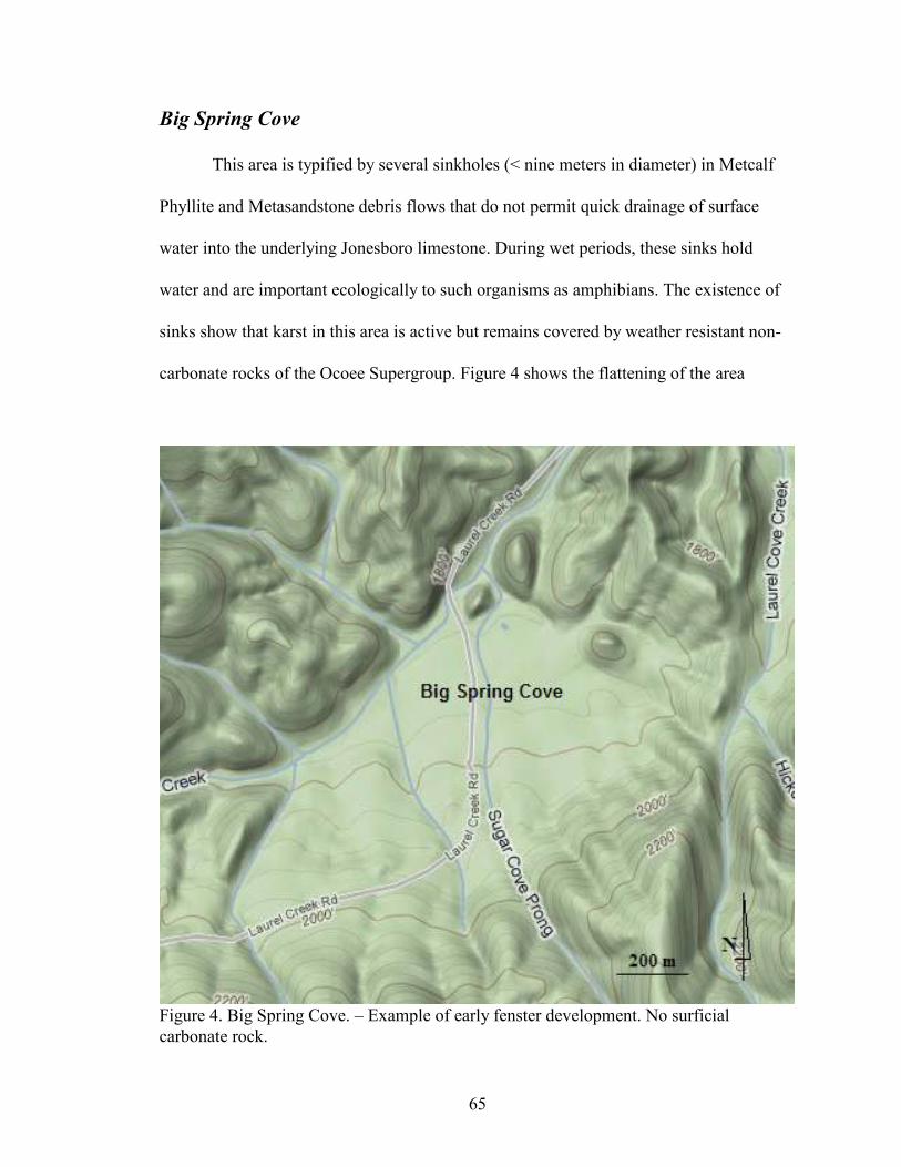
65
Big Spring Cove
This area is typified by several sinkholes (< nine meters in diameter) in Metcalf
Phyllite and Metasandstone debris flows that do not permit quick drainage of surface
water into the underlying Jonesboro limestone. During wet periods, these sinks hold
water and are important ecologically to such organisms as amphibians. The existence of
sinks show that karst in this area is active but remains covered by weather resistant non-
carbonate rocks of the Ocoee Supergroup. Figure 4 shows the flattening of the area
Figure 4. Big Spring Cove. – Example of early fenster development. No surficial
carbonate rock.

66
typified by fenster development. This overburden causes a slow recharge of the karst
hydrology. Geographic observation based on the leveling of topography suggests that this
active karst area is approximately 0.56 square kilometers. Karst drainage is likely into the
neighboring Laurel Creek/Little River drainage, but this has not been verified. Historic
use of Big Spring Cove is evident in the altered topography of the cove. One of the sinks
has been breached manually to drain water, possibly for farming.
White Oak Sink
The White Oak Sink karst area is also on the periphery of the Tuckaleechee Cove
fenster and encompasses about twelve square kilometers. White Oak Sink is a very large
uvala whose karst is continuous with that of the Tuckaleechee Cove fenster but is isolated
somewhat by the elevation differences. Figure 5 shows uvala development in relation to
surrounding non-carbonate bedrock (north, south, and east of the uvala) as well as
continuity with the larger Tuckaleechee fenster to the west. The NPS does not maintain
trails into or within White Oak Sink but an elaborate set of man-ways (unmaintained
social trails) lead to many of the “desirable” features of the sink including caves, a
cemetery, various wildflower ecotones, and historic home-sites. White Oak Sink is likely
the most popular off-trail hike in the Smokies; the wildflower diversity has caused
visitation in the spring to reach unmanageable parking congestion at the main trailhead
and year-round use has continued to increase compared to other park locations. Resource
degradation of surface ecology during peak visitation is obvious in the form of worn paths
to certain wildflower communities, trampled vegetation, and litter.

67
Figure 5. W
hite Oak
Sink. -- H
ighly dev
eloped
portion of Tuck
aleech
ee fen
ster just inside of NPS (green
) boundary.

68
Current access to the sink is primarily by two locations. School House Gap
trailhead, on Laurel Creek Road, allows access to School House Gap Trail and ultimately
the main (southern) man-way accessing White Oak Sink. This route is approximately four
kilometers one way to the bottom of the sink with half that distance on unmaintained
trails. The lesser used trail into the sink follows the historic route into White Oak Sink
and beyond to Cades Cove. School House Gap trail was the former road into Cades Cove
around 1850. It was known as the McCampbell-Anderson Turnpike or road (Shields
1981). This road began in Dry Valley, a portion of Tuckaleechee Cove, and entered what
would become GRSM at School House Gap. This road continued to what is now Laurel
Creek road and via Crib Gap, enters Cades Cove. At School House Gap, the historic route
into White Oak Sink veered west along a low-gradient stream, then through a shallow gap
into White Oak Sink. At this shallow gap, the old access route leaves the metamorphic
walls of the sink and enters the karst topography of White Oak Sink. Shortly below the
gap at a junction with a larger dry valley the road passes (White Oak)Saltpeter Cave
before reaching the bottom of the sink. Today, access to School House Gap and the park
boundary require hiking more than a half mile on private property before reaching this
man-way. At the gap this route is overgrown, but easily followed and allows for an
alternate route into the area.
Historic land use was similar to Cades Cove; small-scale farming and limited
livestock grazing in the bottom of the sink were the primary land uses of four families
who resided there. After incorporation into GRSM, White Oak Sink was allowed to
succeed into the closed canopy, secondary forest of today (Jenkins et al. 2007).
69
Recently, the NPS has installed a horse barrier at the entrance to the man-way
from the School House Gap trail. In addition, “No Horses” signs were installed at both
man-way entrances, and a sign at the edge of the main sink area suggests hikers stay on
trails to reduce impact to the sensitive area.
White Oak Sink Hydrology
The hydrology of White Oak Sink can be pieced together by examining the known
cave maps and recent survey of caves as well as understanding the geology and
geomorphology of the sink itself. It appears that most if not all of the water that enters
White Oak Sink is leaving the park through the sump at the bottom of White Oak
Blowhole Cave (WOBH). A few solid observations can be made to support this. The
largest surface stream entering the White Oak Sink sinks underground once it enters
Rainbow Cave. It appears, by looking at elevations and geomorphology of the sink that
from Rainbow Cave this water travels towards WOBH where it possibly resurfaces
within that cave near the back towards the sump. An additional surface stream enters the
karst system at Sinking Stream Cave where it travels through tight subsurface conduits
past Pie Hole Cave. This stream appears to resurface in White Oak Blowhole from a high
passage along the Northwest Passage before flowing into the breakdown and ultimately
reaching the sump at the back of the cave. Few other surface streams show significant
drainage that likely doesn’t connect with these major conduits on their way to the sump at
the back of WOBH. One exception might be water in Scott Gap Cave which appears to
travel a different pathway out of the park or possibly connects beyond the known extent
of WOBH. Dye tracing of White Oak Sink is needed to understand this complex system

70
White Oak Blowhole Cave
White Oak Blowhole Cave is located in the northeastern “corner” of White Oak
Sink at an elevation of 500 meters. The entrance is obvious due to the large bat-friendly
gate which protrudes like a box in front of a steep limestone bluff (see Appendix b in
attached Appendix C). Behind the gate is a short climb down into the entrance room. In
the floor of the entrance room is a triangular shaped opening which descends vertically
just over nine meters into an elevated alcove of a much larger room. This room is
estimated to be twenty-three meters wide by ninety-two meters long and nine meters high.
The floor is scattered with large breakdown rocks from the ceiling. Two large leaching
areas are observable from past efforts of guano mining and saltpeter extraction. The cave
has a surveyed vertical extent of 134 meters and a length of 210 meters (TCS 2011).
The main extent of the cave is this large main room which trends downslope
towards a terminal sump which has been dove to twenty-five meters. The water in this
sump is beautifully blue and at times has many contrasting orange spring salamanders and
red black-chinned red salamanders. A northwest passage continues for 121 meters feet
from the entrance drop to a well-decorated room known as the “torch stick room”. This
portion of the cave is one of the primary roosts for Indiana bats and has seen extensive
mining of guano for saltpeter extraction. The name “torch stick room” is given due to the
extensive cedar torch stick fragments left behind by miners. Tally marks are also evident
in the torch stick room as well as other portions of the cave as evidence of the mining that
has taken place.
This cave is Tennessee’s largest known Indiana bat hibernaculum with counts
numbering close to nine thousand at their peak. Three additional species of bats are also

71
common in the cave during winter months and together could account for close to 12,000
bats at their peak (GRSM No Date). Additional cave biota are species typical for GRSM
caves but they can be difficult to find due to the expansive nature of the main room and
complex breakdown in this cave. Although an interpretive sign exists on the gate
explaining the importance of protecting bat hibernacula sites, the NPS sign directing
visitors to obtain a permit for entry to the cave has been dropped down the entrance pit
beyond the gate, and now rests in the main entry room of the cave. It is important to note
that WNS was documented “PCR Positive” for a Little Brown bat (Myotis lucifugus) in
2010. This lists Blount Co. TN as one of the southern most location where the DNA
sequence for the fungus associated with WNS, Geomyces destructans, has been located.
The USFWS designates this county as “Suspected Positive for WNS” due to a lacking
histology confirmation of WNS.
Rainbow Cave
Rainbow Cave, sometimes called Rainbow Falls Cave, is located on the
southeastern corner of White Oak Sink at an elevation of 510 meters. The entrance to the
cave is at the base of a waterfall, which drops nine meters after reaching soluble
limestone at the Great Smokies Fault (see Appendix b in attached Appendix C). The
Great Smokies Fault is clearly observable at the contact between the lower limestone beds
and the upper weather resistant metamorphic rock of the Ocoee Supergroup. The
waterfall and cave location are common stopping points for hikers in White Oak Sink.
There are at least two entrances into the cave at the base of the falls. One is a
climbable pit, which corkscrews for three meters before entering a room under the
breakdown pile below the falls. In this room, water from the falls percolates through

72
overburden making it impossible to stay dry. Following the flow of the water, visitors
enter a tight wet crawl that, depending on water level, may not be safely passable. Beyond
this constriction is a small dome room with a side passage entering from the other
entrance and a hands-and-knees crawlway in which the water follows. The second
entrance is tight at the base of the falls, often choked with debris, but opens to follow an
overflow channel of washed dolostone with calcite stringers (narrow vein of calcite
mineral traversing the parent dolostone) for forty-six meters to a four meter high climb
down to meet the other entrance route.
The hands-and-knees crawlway that follows continues for thirty-seven meters to
the first nine meter drop. The drop is affixed with a bolted hanger (a mechanical
attachment point permanently attached to the bedrock) and can be backed up off natural
anchors such as heavy bedrock points upstream. The descent is wet and at the bottom,
after a short nine meters of passage is another nine meter drop, bolted again in unabated
water. Both bolts were placed by the Knoxville Volunteer Emergency Rescue Squad
(KVERS) in February 2008 during the rescue of four young adults who became trapped
and hypothermic during a late night, unpermitted trip into the cave. The terminal siphon
is in a short down climb in the main room at the bottom of the cave. The room is
spacious, ranging larger than nine meters wide by over one hundred feet long. From the
siphon the room continues up over breakdown into a lofted area with one possible high
passage lead.
This cave has the potential to be very dangerous during periods of rain. Flash
flooding could easily trap people inside the cave as well as make either of the two water
fall climbs very difficult. Species diversity is similar to other caves in GRSM. Current

73
surveys show that winter bat use is high with numbers close to 100 individuals. Indiana
bats hibernate here. There is currently no sign warning visitors against illegal entry to this
cave.
White Oak Saltpeter Cave
White Oak Saltpeter Cave is located at an elevation of 550 meters in a small sink,
eight meters in diameter, upslope of the bottom of White Oak Sink in an unnamed dry
drainage in the direction of School House Gap. It is adjacent to the historic trail (road)
that accesses White Oak Sink from School House Gap. The cave is very visible to hikers
who follow the social trails that have developed along the historic route into the sink.
The name of the cave is a misnomer; there is no evidence that any saltpeter
mining has occurred in this cave. It is unlikely that there was a reason to mine this cave.
The cave is small and does not possess guano piles sufficient for extraction. It is likely
that the neighboring cave, White Oak Blowhole, was called “Saltpeter Cave” at one time
due to its extensive sign of nitrate removal efforts. The use of “Saltpeter Cave” was a
common name miners gave to caves that were utilized for nitrate extraction. Some
confusion in nomenclature can be speculated which has caused the name to be associated
with this nearby cave instead of the other likely choice.
This cave is relatively small compared to the neighboring White Oak Blowhole
and Rainbow Cave. It has fifty meters of surveyed passage with a vertical extent of six
meters. The cave has a large entrance room with two small domes on its north margin. It
receives water from a small fissure which quickly disappears into a hole in the floor
which could possibly be explored by a very small person. The main room funnels into a
small crawlway with water draining from the back of the cave. This water disappears

74
through a tight constriction in the floor which immediately opens into what looks like a
possible lead. Inspection of both cave maps suggests that this water likely emerges along
the eastern wall of the main room in White Oak Blowhole Cave.
Beyond the drain in the floor, the cave opens back up into a series of short upper
passage sections connected to the small stream passage before the source of the stream is
reached at a spring-like area in the back of the cave. There are two very small leads off
the south east side of the cave but both are too tight for most to enter. At least one of
these exhibits significant air movement suggesting additional passage or more likely
connection to White Oak Blowhole Cave.
This cave receives a fair amount of illegal visitation which has resulted in several
names/initials written in mud along the far reaches of the cave. Most of the dates are
within the past fifteen years with several new additions identified with each visit. A
barely legible sign is propped up against the entrance to the cave, warning visitors against
illegal entry (see Appendix b in attached Appendix C). Several hundred bats (primarily
Tri-colored bats) use this cave in the winter as a hibernacula. Indiana bats, Little Brown
bats, Big Brown bats, and Tri-colored bats have all been seen in the cave during winter
months and Tri-colored bats roost there during the day in the summer.
Scott Gap Cave
Scott Gap Cave is in a large sink in the northwest portion of White Oak Sink at an
elevation of 555 meters. The entrance to the cave is under a large exposed portion of
Jonesboro limestone at the base of the sink, which on occasion fills with organic debris.
Directly inside the opening is a vertical entrance drop of eleven meters into the cave. A
tilting passage approximately eight meters high by an equal distance wide precedes down-
75
slope following the dip of the beds. A much smaller passage runs upslope for a short
distance before terminating at a four meter dome. The majority of the cave down slope is
a series of easy climb-downs to a constriction at the second drop of twelve meters. At the
bottom of this drop, a small tight stream passage drains north out of the small room with
an eleven meter ceiling. The low stream passage winds north for thirty meters before it
becomes too tight to proceed.
This cave has housed 200 or more Indiana bats during the winter, though recent
counts have been much lower. Other bat species hibernate there as well including the
Little Brown bat, Northern Long-eared bat, and the Tri-colored bat. In addition, the small
pool of water in the bottom of the second drop contains many of the aquatic cave
organisms found in other GRSM caves with pooled water. A sign at the rim of the
sinkhole warns visitors against illegal entry and the need for a permit to enter the cave
(see Appendix b in attached Appendix C).
Foothills Parkway System
(Walland, Wear Cove, Cosby, and Pigeon River Karst Areas)
GRSM manages a narrow strip of land around the Tennessee side of the park
designated as the Foothills Parkway System. Not all of the parkway is complete at this
time. The geology of the parkway is consistent with the main portion of the Smokies with
older metamorphic rock at higher elevations and younger carbonates beneath. This
corridor crosses several large fensters; two caves are known from this right of way, one in
the Walland fenster (Shady dolomite) and one in the Wears Cove fenster (Jonesboro
limestone). Karst along the Foothills Parkway System is minimal, occurring often at

76
parkway junctions at lower elevations. Common features are large sinkholes and
limestone bluffs. Actual size of karst areas of the parkway is unknown.
Stupkas (Myhr) Cave
This cave is named both Stupkas (GRSM’s first naturalist) and Myhr (adjacent
landowner) in literature but exists as Stupkas Cave in the Tennessee Cave Survey (TCS)
records. Stupkas Cave is 213 meters long with fifteen meters of vertical extent. The cave
is mainly a tight, wet, and winding stream channel. The entrance is a collapse adjacent to
the resurgence spring. The spring is on adjacent property and feeds a large pond owned by
the Myhrs and is also their main source of water.
The cave is developed at the base of the south slope of the Wear Cove karst
window at an elevation of 466 meters. Development above this cave and the Foothills
Parkway System is thought to be the source of seasonal turbidity of the Myhr’s water
source in the past ten years. Cave biota in this cave is similar to other GRSM caves but
also possesses the type-location of an endemic spider (troglophile) of the genus Nesticus
indicating the importance of protection. According to bat surveys, bat diversity in this
cave seems to be high, although records indicate population numbers of many species are
relatively low. There is currently no visible sign warning against illegal entry.
Newly Recognized Karst Areas and Their Resources
Through extensive field investigations as part of this research, a better
understanding of GRSM karst and cave resources was obtained. In addition to the five
primary karst areas managed by GRSM, the location of 4 additional karst areas were
documented through additional conversations with park personnel, local geologists, and

77
field observations. Many of these areas are small pieces of much larger karst areas not
managed by GRSM.
Foothills Parkway-Walland
At the eastern terminus of the Foothills Parkway West, the park manages a small
section of the parkway which crosses exposed carbonate rock along Little River. The area
is not well marked and actual size is unclear. This area represents a portion of the
Walland fenster, a large area containing several caves in Shady Dolomite. Where the river
cuts through the carbonate bedrock, steep cliffs remain. The higher flat topography of the
area consists of large shallow sinks which obviously drain into the nearby Little River or
adjacent ground water. No visible flow of water has been documented in this area outside
of the neighboring Little River. One new cave was observed on GRSM managed land.
This is the only known cave under GRSM management in the Walland fenster-Foothills
Parkway Cave at Walland.
The Foothills Parkway Cave at Walland has developed in a fissure in the Shady
dolomite of the Knox Group at an elevation of 300 meters. It is on a limestone bluff high
above Little River on a narrow strip of the Foothills Parkway System. The vertical extent
is enough to warrant the use of a rope to access.
The cave is a vertical fissure of approximately six meters deep with less than four
meters of traversable passage at the bottom. It does show signs of dissolution of calcium
carbonate within the cave and Tri-colored bats are known to hibernate under several small
shelves along the bottom of this cave. The common Cave Salamander (Eurycea lucifiga)
has been seen in this cave. No biological inventory has been done outside of the author’s
observations.

78
Foothills Parkway-Interstate 40
In the far Northeastern corner of the park, along part of the Foothills Parkway
East, is a low lying karst area adjacent to the Little Pigeon River in Cocke Co., TN. The
area needs further delineation as to its exact size but field observations show
karstification taking place on both sides of Interstate 40 at the junction of the Foothills
Parkway East’s eastern terminal. The area furthest east adjoins the Little Pigeon River
where limestone is very obvious along the river incision and flood plane. No cave
development is observable though dissolution of limestone is apparent along rock
outcrops. It appears that the karst area continues under I 40 to the western portion of the
terminus of the Foothills Parkway East. At this location, it appears that the carbonate
rocks are covered with non-carbonates. No limestone was found. Active karst is seen as
large shallow sinks on what looks to be an old river terrace higher up on the mountain
flanks.
Little information exists in park literature on the area. General geology of the karst
bedrock appears to be consistent with other park carbonates. Cambrian- Ordovician
limestone (Jonesboro Limestone) would be the predominant karstified rock. Further
interpretation of the rock itself might yield more detail to its origin or similarities to
Blount or Sevier Co. limestones. No subterranean hydrology has been observed in this
area outside of the Little Pigeon River.
Foothills Parkway-Cosby
Little is known about the karst areas around the junction of the foothills parkway
and US route 321 (SR 32, 73). Aerial photos, topographic maps, and park boundary maps
suggest that some karst is managed by GRSM in that area. The expansion of kudzu on
79
adjacent lands makes any comparison impossible. The lack of park boundary signs as
well as private property make attempts at defining the boundary somewhat difficult. At a
minimum, karst is present at the lowest areas along Cosby Creek. Reputable reports from
cave explorers and naturalists indicate that carbonate bedrock exists higher up on the
flanks of Webb Mountain but access is difficult and location have not been documented.
Topography in that area does not suggest that those areas contain karst or if they do fall
under management of GRSM. The only observed hydrology is the surficial Cosby Creek,
the main drainage of the valley in this area.
Calderwood Karst area
Newly acquired NPS lands along the eastern banks of the Little Tennessee River
have revealed some karst topography. The land is adjacent to property owned and
maintained by Topoco, a subsidiary of Aluminum Company of America (Alcoa), as the
Calderwood Hydroelectric Development Area. The Calderwood property has several
documented caves and active karst hydrology (TCS 2011). The area to be managed by
GRSM is still being surveyed to determine how much of the acquired property will
contain karst or caves. At this point field interpretation seems to suggest that the area
known as “The Bulge” has the best possibilities as some of its south and western
perimeter will adjoin known karst areas in the Calderwood karst window. However,
Topoco’s choice to keep the lower, flat topography of the area will omit much of the
highly karstified bedrock.
The area known as the “Chocolate Bar” does not appear to possess any karst
landscapes but park biologists have explained that the bedrock is high in calcite,
suggesting a similar biology to epigean karst areas. Hydrology in the Chocolate Bar
80
would likely not be karst in nature. However, caves on Topoco’s property adjacent to The
Bulge suggest at least some subterranean flow which has possible origins higher up slope
in GRSM managed land. Field observations do not show any distinct subterranean input
of water into the non carbonate areas within GRSM’s management area.
Newly Recognized Caves and Their Resources
In addition to The Foothills Parkway Cave at Walland, three additional solution
caves have been identified in GRSM. All three additional caves have been located in the
greater White Oak Sink area of the park.
Scott Mountain Cave
Scott Mountain Cave is a very short solution feature high on Scott Mountain at an
elevation of 680 meters. It is within the confinement of White Oak Sink on its
northwestern slope, and the entrance is a small inconspicuous hole that becomes covered
with leaf litter every fall. The cave is short, about nine meters, with a sloping portion just
inside the entrance suggesting active subsidence. The ceiling is low and only the entrance
area permits standing. The back of the cave doesn’t seem to warrant further attention.
There does seem to be hydrological flow during periods of rain draining the back of the
cave, ultimately flowing into the loose debris at the bottom of the sink at the entrance.
Interestingly, the cave always seems to contain fresh Allegheny Woodrat
(Neotoma magister) nesting material (fresh vegetation and leaf litter) as well as a very
large population of the spider Meta ovalis. This species usually numbers in the twenty to
fifty range within sight of the entrance. The Cave Salamander has been seen in this cave
on numerous visits. No biological inventory has been done outside of the author’s

81
observations. No sign exists that warns visitors against illegal entry, or the presence of a
cave. Little indication of human activity suggests entry is not taking place at a level high
enough to warrant concern.
Sinking Stream Cave
Sinking Stream Cave is another small cave within White Oak Sink. Its opening is
at the bottom of a deep sinkhole at the foot of a small stream at an elevation of 555
meters. The sinkhole is collapsing, and trees are occasionally uprooted along its rim and
sediment is continually drawn into the entrance to the cave. The stream disappears prior
to the sinkhole except during periods of extensive rain. The cave is unmapped and on
occasion seems to blow a slight amount of air. It is highly possible that it is connected to
White Oak Blowhole, likely hydrologically.
The cave entrance is muddy and occasionally plugged, which leads three meters to
a short climb down of seven meters. Water enters through breakdown into the small pit
and quickly disappears into the coarse gravel floor medium. Old pottery fragments and
man-made materials from pre-park homesteading were found within the cave pit
suggesting the sinkhole has been used as a trash dump previously. This suggests further
surveys to determine archeological significance. No biological inventory has been done
outside of the author’s observations. There is currently no sign warning visitors against
illegal entry, or alerting visitors to the presence of a cave. Some human activity has been
observed at the entrance.
Pie Hole Cave
Pie Hole Cave is located less than 90 meters from Sinking Stream Cave on the
western slope of White Oak Sink at an elevation of 550 meters. The cave is

82
inconspicuous except for the large sinkhole it is in. It appears that the sinkhole has been
used as a repository for field rock during homesteading as one side of the sink is
awkwardly man made with loose chunks of limestone-possibly of rock removed from
fields prior to farming. The cave is hidden among tall vegetation during summer months
but visible during winter. The cave itself is small, less than ten meters in length. It
corkscrews down into a muddy, rocky sink with large bedrock along one wall. Between
two large pieces of limestone is a fissure with substantial air and a faint gurgle of water.
This is likely the water from Sinking Stream Cave. It seems possible if not likely that this
water continues towards White Oak Blowhole Cave and resurfaces along the northwest
passage of that cave where a high lead discharges a slightly larger amount of water.
Pie Hole Cave gets its name from the shape of the opening which looks like a
mouth. Also notable is the use of this cave by bats at several times of the year. No
biological inventory has been done outside of the author’s observations. No sign exists
that warns against illegal entry to this cave, or alerting visitors to its presence. Little or no
human sign has been observed in or near the cave.

83
Chapter V: Discussion and Conclusion
Karst (Landscape) vs. Cave (Specific) Focused Management
In applying best practices to the development of a GRSM specific cave and karst
management plan, there are two potential perspectives as mentioned above: a cave focus
and a karst system focus. The first idea is that a focus on the cave, as the main
managmenet entity, is the primary need of land managing units and in some cases
incorporated into that is the protection of the karst areas surrounding it. The need to
protect and manage caves is obvious. Federal policy has elevated this need and directs
much of the focus to the direct anthropogenic affects on caves, such as deterioration due
to uncontrolled visitation. A focus on caves as a primary management need can provide a
solid framework for the protection of a park unit’s caves and karst areas known to be
continuous with the cave. Unfortunately, the lack of focus this directs at karst as a whole
can lead to an omission of karst resources that do not posses significant caves as well as
karst processes which are often left out of management due to a misunderstanding of
karst landscape complexities. The cave-focused approach is negatively magnified by units
that are reactively managing these resources (caves and karst features) due to lacking
policy suggesting a focus on karst. Within the literature of the academic structure we have
seen a holistic focus on karst systems, the cave being but one component of that system
that needs considered in the protection and management of the landscape. Active karst
topography develops in GRSM when rainfall picks up carbon dioxide from the
atmosphere and enters the karst environment as a weak carbonic acid. The reaction
carbonic acid has on carbonate rock is what further develops geologic fractures and

84
fissures in GRSM limestones into rapid transport subterranean conduits and aquifers.
Ultimately these processes aid in the larger development of these spaces into caves.
Caves are arguably the most recognizable and studied component of karst
systems. Humans’ interest and understanding of caves has been the root cause of why we
seek to enter that environment. Caves have been accessed across the planet during
prehistoric, historical, and in modern times. Even when utilized as spiritual places, they
have seen permanent alteration and damage due to visitation. Further degradation of cave
resources followed resource extraction such as saltpeter mining. In more recent times in
the USA, caves have been the source of considerable exploration. Often competitively,
caves were explored to depths and lengths at rigorous paces, sometimes without regards
to cave ownership. In all cases, human visitation has directly negatively impacted cave
environments. GRSM caves have seen similar histories resulting in irreversible effects to
resources. The value we have placed on caves has shaped our need to protect them and
restrict the effects we impose when we enter these environments. The management of
caves derives from the understanding of the resource and the need to prevent direct
negative impact to the resources of the cave, not limited to any or all-definable resources.
The protection of the cave is synonymous with protection of its resources. Resources such
as the hydraulic component of solution caves have shaped and defined their physical
properties as well as supply habitat for aquatic ecotones. To protect the hydrological
resources in caves, the hydrology of the karst system must be defined and protected as
well.
The word “cave” elicits a variety of reactions from land managers depending on
their experiences, resources, knowledge, and interests. For those without a strong interest
85
in caves, they can be a frustrating resource with complex scientific processes and often
social, cultural, and political complexities over access. When forced to consider the
management of caves, what is “unknown” to the reactive manager leads to a lack of
protection. On the other hand, those managers with a strong interest in caves find that the
significance of “cave” often stretches beyond the confines of their job into lifelong
relationships and collaborations with cave scientists, management specialists, and the
general caving public. Resource management of caves, especially on federal lands, is
done by a small group of managers. The “unknown” to these managers, with regards to
caves, is the primary factor that drives them. The dynamic nature of caves, especially the
possibilities of new scientific discoveries and management challenges, draws their focus
to advance the science of management, collaboration, and to provide protection. In
addition, these managers have pushed the policy and guidelines along with the current
literature to their fullest potential to provide specialized protection of caves and karst in
their management units. The social complexities of caves, particularly cave access, are
why we see so much legislation directed at their management. Policies such as the
FCRPA and agency specific guidance are necessary and clearly direct the needed
attention to support management with regards to accessing caves. The specific
management of caves is clearly supported in literature and policy but can fall short in its
ability to support proactive management of the greater karst environment.
The focus on landscape-wide land management is nothing new to the National
Parks Service or other federal land managing agencies. The idea and focus on the
interconnected relationships at the landscape scale has seen considerable application as
anthropogenic challenges become more complex to the manager. In developing best
86
practices for resource management, an understanding of the inherent thresholds these
resources have with regards to human impact, both directly and indirectly, is important to
adaptive management. Caves have received a substantial amount of attention in support
of the need to focus on their protection. The understanding and management of caves is
extremely important to federal land managers bound by the FCRPA. In areas where there
are no known caves, but the potential exists (such as developed karst topography), the
policy and guidelines which place a need to protect karst in light of caves does not place
significant protection on the karst resources themselves, apart from caves. In a karst
landscape the management of unknown caves, hydrology, potential karst development
(cave development), and connected biological micro-habitats all must be considered
significant regardless of proximity to significant caves. In addition, karst subsurface flow
paths can provide long distance transport mechanisms for pollution supporting a need to
consider alternative management for surface activities on karst. Without a holistic view of
karst at a landscape level, cave management only provides resource protection in light of
known caves and their associated karst.
NPS Management
Caves on NPS and other federal lands are being utilized at increasingly higher
rates every year based on managers’ responses to questionnaires. Use by scientists,
researchers, and recreational cavers is on the rise in most land managing units and overall
shows a trend that will likely continue as scientific inquisition continues and human
population expands. In conjunction, these units also show an increasing number of
violations with regard to activities such as illegal access and cave vandalism. This is to be

87
expected as use and popularity increases. The trends and activities seen across the nation
on federal lands have also been reported by GRSM and are important things to consider.
As these trends continue, so does the need to better protect these resources. Most
successful units who protect caves and karst do so with strong support from outside
interests such as affiliates of the National Speleological Society as well as universities
and other agencies. This approach has fostered formal agreements as seen through the
numerous MOUs surrounding cave and karst resources. GRSM does not have any formal
agreements specific to their resources but are incorporated into several NPS MOUs with
groups such as the NSS, Bat Conservation International, The Nature Conservancy, and
other federal agencies.
Congruent within all NPS units with a proactive cave (and karst) management
program is the understanding that policy and guidelines on cave management require the
management of adjacent karst landscapes to be productive. NPS units such as CAVE,
CUGA, GRCA, SEKI, and WICA have successfully developed holistic programs
concentrating on caves and their associated karst environments. Their management plans
clearly address management beyond the focus of the caves themselves and the resources
found within them. The success of these programs follows the clear text in the FCRPA,
MP2006, and RM#77. Furthermore, these park units provide specific guidance within
their plans and guidelines stating that protection of a given cave is afforded through
protection of the complete karst system within which the cave exists. Though the term
cave suggests a primary focus on caves, in these successful programs, karst protection is
implied and carried out. The success of a cave and/or karst program in a NPS unit

88
undoubtedly requires complete support from within the NPS unit and from the individual
or team directly responsible for its success.
NPS units which did not apply direct management to cave resources often lacked
any cave management program, cave specialist, or cave specific management team. These
units, through their own observations of specific cave and karst management needs, often
did not afford protection to the karst environment outside of normal operations. There
appears to be a dichotomy in these units between and understanding of caves and karst
management rather than a thorough understanding of the science and policy suggesting
management of karst is necessary in the protection of caves (and vise-versa). It further
suggests that as the focus on cave, and to a lesser degree karst resources are taken out of
priority management, the focus and management of caves becomes myopic. Without
strong policy to force attention at karst, successful programs seem to be driven by one or
more proactive managers who passionately seek to protect these resources.
Another management concern of units who operate without a formal cave/karst
program is the “one-dimensional” management often seen when a manager with little or
no experience in cave or karst issues takes on the role of the cave specialist or manager.
This is evident when a biologist, for example, drives biology-specific management
without consideration of the additional complex components of the cave and karst
environment. The incorporation of a specialist, such as a bat biologist, into cave and karst
management is important but it does not alleviate the need to have all the resources
represented as together they are what make caves and karst management so dynamic.
Unfortunately, one-dimensional management is often relied upon when funding does not
allow for fulfillment of a holistic view of meeting resource needs.

89
Without the structure of a cave and karst program within the unit, it is common
practice to manage reactively as opposed to a science-based, proactive management
approach. In smaller units and units with limited resources reactive management might be
the only option for resource management but should not be considered appropriate for
resource needs. With limited resources and funding adequate protection is compromised.
Marginally successful cave and karst protection in these conditions, notably outside of
adherence to policy and guidelines, has been achieved through collaboration with other
units including the NPS Cave and Karst Program, the National Cave and Karst Research
Institute (NCKRI) and non-governmental organizations with a strong research presence.
These situations are understandably common based on limited cave and karst
resources, available personnel, and funding restraints. Such limitations are not isolated to
cave and karst resources within the federal government though cave and karst resource
have been provided congressional attention to alleviate these inconsistencies (Huppert
1995). Often, these duties and responsibilities are absorbed by a non-specialist. In the
context of cave and karst management, the use of this approach often generates results
that fall short of the needs of effective protection of cave and karst resources, as the focus
on cave and karst issues is often limited in scope.
GRSM’s cave and karst resources are of a quality and magnitude requiring
significant protection and adherence to mandated policy and guidance. Compared to cave
resources on NPS managed land across the country, GRSM caves and karst are very
unique and require specific attention to prevent their degradation. GRSM’s current use of
the Superintendent’s Compendium does provide some management structure but is
clearly reactive in nature. This approach lacks the magnitude needed to provide adequate

90
management for cave access and support of caves and karst science in GRSM. Duties
defined under the Compendium for caves and karst are addressed by a variety of divisions
further complicating the needed centralization of management.
Case Study: GRSM Management
In understanding what is known about cave and karst resources of GRSM, an
assessment of best practices in cave and karst management on other federally managed
lands suggests the need for a specialist to develop a dynamic cave and karst program
specific to the needs of GRSM’s resources as well as to support the objectives of RM#77.
Other parks, like GRSM, whose cave and karst resources are not the primary concerns of
the park that have done this (e.g. Sequoia and Kings Canyon National Park [SEKI]) have
been extremely successful in fulfilling these needs. It is important to note that SEKI has
invested in a commercial cave within the park and strongly affects the need to be
proactive with cave management. Unfortunately, because of the nature and complexity of
GRSM as well as the extant of park resources and management concerns beyond that of
caves and karst, this approach has not been considered internally. Within the confines of
the Resource Management and Science Division’s capabilities to manage caves and karst,
a compilation of known resources and development of a cave and karst management plan
is a necessary starting point to fulfill not only the primary policy objectives but also to
define the needs of park resource protection. A specific management plan will provide, on
paper, the consistency needed to fulfill the NPS mission, relevant policy, and documented
guidelines. Implementation will solidify the management for consistent protection.

91
-Afforded Protection: Cave Management through Reactive and Proactive Measures
The idea of a cave-focused management plan for GRSM is supported by the
FCRPA which clearly states that the purpose of the policy is to secure, protect, and
preserve significant caves. The Department of the Interior CFR Title 43 Part 37 mimics
this focus and addresses the needs of the management of caves. In their definition of
“[significant] cave” and its protection we only see the protection focus placed on
components or issues affecting the cave. Herein lies a simple problem that becomes
relevant when caves are either unknown or simply not present.
In the case of GRSM, the management of caves will protect much of the karst
environments but not all. Included in this protection would be the karst terrain of the most
cavernous portions of the greater Cades Cove area, all of the drainage and karst areas of
the highly dynamic White Oak Sink and the Bull Sink area. In addition, the management
of the Foothills Parkway System around Stupka (Myrh) Cave and the Foothills Parkway
Cave at Walland would minimally include the needed protection of karst areas
surrounding them—some of which might incorporate non-park lands in their suggested
protection.
The concentration on cave management, which is based on acts of Congress and
DOI management regulations alone would not focus on karst areas lacking caves. The
policy is generally not applied directly to karst topography, which lacks significant caves
by definition. Even with all caves designated as significant on NPS managed land, a large
portion of karst topography would be left unprotected. Lacking protection in GRSM
would be karst areas of Cades Cove with colluvial overburden, the entire Big Spring
Cove karst area, potential karst development in the Calderwood area, and several portions

92
of the Foothills Parkway System. Loosely, over half of the karst in GRSM would see little
protection. Potentially other significant portions of karst might be left unprotected where
inability to understand karst processes could detach them from adjacent cave systems.
One example would be along GRSM’s boundary at Scott Gap where surface topography
would seem to apply protection from development outside and somewhat down slope of
the crest of the ridge. The subterranean flow paths in this area are unknown and might
affect GRSM caves by flowing south, into the mountain and ultimately into GRSM caves
or minimally into the White Oak Sink Aquifer, which ultimately provides recharge to Dry
Valley. Lastly, as new caves are discovered around the park yearly, park areas with karst
thought to be void of caves could yield additional cave resources in the future. One such
area of interest is along Rich Mountain where large cave systems have been discovered
and speculation of others continues to tempt explorers. In this area and others,
management of karst is crucial to protect these yet to be discovered resources.
-Afforded Protection: Proactive Karst Management
Further interpretation of RM#77 specifically addresses the need to incorporate
karst issues into park resource management planning. As stated in the first paragraph
under Karst [Management]:
“The Service will manage karst terrain to maintain the inherent integrity of its water quality,
spring flow, drainage patterns, and caves. Karst processes (the processes by which water
dissolves soluble rock such as limestone) create areas typified by sinkholes, underground
streams, caves, and springs.”
This objective in RM#77 appears to be often overlooked in GRSM and other non-cave
parks with reactive cave resource management. That is not to say that these parameters

93
are not considered at all but that the need to fully understand karst resources can impose
“unique conditions and challenges” and are considered “some of the most complex and
intricate hydrological and ecological systems within a park” (RM#77). To date, much of
the basic RM#77 cave and karst guidance has not been applied to GRSM needs. The
incorporation of much of RM#77 guidance is supported throughout the science of karst
and cave management in the literature. As stated in RM#77:
A park’s cave management program should include:
1. protection of natural processes in cave ecosystems and karst landscapes;
2. scientific studies and research in or about cave and karst resources and systems,
to increase the park’s scientific knowledge and broaden the understanding of its
cave resources and karst processes;
3. detailed cartographic survey of caves and cave systems and a detailed inventory
of resources within cave systems;
4. provision for educational and recreational opportunities for a broad spectrum of
park visitors to safely visit, study, and enjoy caves at a variety of levels of interest
and abilities;
5. establishment of regulations, guidelines, and/or permit stipulations that will
ensure maximum conservation of cave resources and karst processes;
6. direction for cave restoration activities that remove unnatural materials or
restore otherwise impacted areas;

94
7. establishment of standard operating procedures in the maintenance and upkeep of
developed cave passages;
8. monitoring of natural environmental conditions and visitor use and impact;
9. protection of related cultural and biological resources; and
10. methods for sustainable use of cave resources.
RM#77 guidelines are consistent with other federal and state land managing
agency guidelines bound by the FCRPA even though their individual agency missions
vary greatly. GRSM and other park units can gain considerable insight on how to plan for
these types of nontraditional anthropogenic effects on their karst environments with
structured proactive management. On the Tongass National Forest (TNF) in Southeast
Alaska’s Alexander Archipelago, for example, karst specialists specifically manage karst
areas regardless of cave development. One of the primary concerns is the influx of
sediments and debris into sinkholes and karst aquifers during and post timber harvest.
Within the TNF’s karst management guidelines is the ability to rate the vulnerability of
the karst terrain as a transport mechanism for sediments as well as to afford protection to
karst landscape features as well. Though not a NPS unit, the TNF’s afforded protection to
karst areas lacking known caves is necessary to protect forest resources and processes in
conjunction with their diverse multi-use land management. Their methodology and focus
on karst protection can be used to understand the importance of karst specific
management outside of caves. Although NPS-managed lands are generally not subject to
timber harvest they are receiving increasing visitation yearly, which has required the need

95
for infrastructure development, which has similar irreversible effects on karst, specifically
sediment and pollution transport.
Karst protection on the TNF as well as seen through proactive management on
select NPS units support the use of RM#77 guidelines in developing best practices for
karst on NPS lands. The incorporation of a holistic, karst-based approach to protection of
these resources is inline with current karst science and land use management and
successful karst protection across the globe. This is especially true in areas where karst
resources, such as karst ground water quality in developing countries, affect human health
and environmental conditions. In following the NPS mission, the protection of these
resources should not fall short of preservation. GRSM contains parts of karst drainage
systems that flow to springs outside of the park, which supply the source of water for
neighboring communities. These communities on karst, where ground water originates
within the boundaries of GRSM, are extremely sensitive to how GRSM manages their
karst areas. GRSM, as a steward of the land, not only has a responsibility to these
communities but also an opportunity to develop better practices on karst in the region by
initiating positive relationships with these communities. This type of relationship will
come into play as karst areas are further developed along the park boundary where karst
environments exist. Furthermore, as karst pathways are better understood along GRSM
borders, negative impacts to karst resources can be prevented both within and outside of
GRSM. Where federal acts fall short of holistic land management, RM#77 provides a
mechanism of structured guidance to meet these shortcomings and manage congruently
with karst science.

96
The extensive nature in employing RM#77 again supports the development of a
cave and karst program specific to GRSM needs. Included in that program must be a
specific set of guidelines and references providing the needed information for consistent
management. The development of a management plan must address the most basic policy
needs as well as the incorporation of park specific guidance to be effective. The Draft
Cave and Karst Management Plan for GRSM (Appendix C) should be considered a
working draft capable of advancing GRSM’s management of these resources. Crucial to
the success of the management plan is the implementation with provisions for adaptive
management.
Survey results from NPS units show a consistent set of management concerns,
which are applicable to GRSM. As might be expected, current threats and challenges are
similar across many units. GRSM shares many of the basic issues threatening other NPS
and federal unit’s karst and cave environments. Consistent with Table 2, GRSM’s
primary anthropogenic issues are: illegal and legal cave access monitoring and
management, the inventory and monitoring including the degradation of physical and
biological cave and karst resources, non-native concerns (WNS), and the need for
proactive management of the karst system internally and external to the park boundary to
understand and prevent surface actions from deteriorating cave and karst resources. In
addition to these anthropogenic concerns, GRSM must encourage additional research to
support management direction (Table 1) as well as develop outreach education programs
for the nine million visitors who visit GRSM each year and are unaware of the dynamic
cave and karst resources. The management plan developed in the context of this research
has taken an in-depth look at these issues to address GRSM needs.

97
This cave and karst management plan is complete but should be considered a
draft. GRSM carries the additional responsibilities to see that the plan receives mandated
internal and external review. The management plan should receive regular reviews to
keep it relevant and up to date with new discoveries as well as current science-based
management. Consistent review of the plan will provide the resource the benefits of
adaptive management, ensuring that future protection will be granted to the changing
needs of the resource. As cave and karst science evolves and use of these resources
change, management must adapt to these changes to fulfill applicable policy and
guidelines. The development of a plan to guide management creates a foundation to
support adaptive management and ensures the perpetual protection of the resource
parallel to and in conjunction with the NPS mission.
This research, though comprehensive for GRSM management, is limited in its
direct application for all NPS units. The theory and background on federal cave and karst
management as well as the need for holistic proactive management is applicable across a
wide range of NPS units, which mimic reactive management of caves and karst. The
survey results did not recover substantial information from federal land managing units
other than the NPS. Though responses from NPS units were low, interest in retrieving
returns from NPS units provided enough results to clearly show the consistency in cave
and karst needs qualitatively. GRSM as a case study provides a solid representation of the
needs and requirements of cave and karst resources on NPS managed lands. In addition to
the above shortcomings in wide range application, much of the management application
components within the management plan are qualitative in that there is more than one
possible solution to the problem. The bases for choosing certain pathways over others is

98
directly related to the complexity and intimate knowledge of GRSM cave and karst
resources as well as the interpretation of the greatest concerns for the resource.
Conclusions
• Federal Policy and specific guidelines support a need to fulfill management
requirements, including development of management plans and proactive
programs, to affording protection of cave and karst resources on federal lands
bound by the FCRPA.
• In addition to federal legislation on cave and karst management, the NPS’ mission
and Organic Act provide opportunity for enjoyment and scientific use of caves
and karst areas as long as such activities do not leave the resource impaired.
• Required under RM-77 and other legislation, the NPS is required to manage
beyond the boundaries of cave environments to include the karst ecosystem
holistically.
• Policy-based management of caves can leave karst topography vulnerable where
caves are unknown.
• Landscape-wide karst environment management is supported in the literature but
lacks the magnitude placed on cave management through federal policy.
• Landscape-wide karst assessment and the proactive need to develop a GRSM
specific cave and karst management plan are supported in the literature and in the
governing policy and guidelines.

99
• Development of a specific cave and karst management plan must meet the needs
of the resource as well as consider stakeholder involvement within the confines of
the NPS mission and Organic Act.
• As cave and karst management is dynamic, GRSM needs to incorporate an
adaptive management approach to cave and karst resource management.

100
Chapter VI: References
Bailey, Z.C. 2001. National Cave and Karst Research Institute--History, Status, and
Future. U.S. Geological Survey Karst Interest Group Proceedings, Water-
Resources Investigations Report. edited by E.L. Kuniansky. 01-4011, p. 52-55.
Barr Jr., T.C. 1961. Caves of Tennessee. Publication of Tennessee Division of Geology.
Barr Jr., T.C. 1968. Cave Ecology and the Evolution of Troglolbites. Dobzhansky, T.,
M.K. Hecht and W.C. Steere (eds). Evolutionary Biology, Volume 2. K. Holland,
pp. 35-102.
Beck, B.F. and J.G. Herring. 2001. Geotechnical and Environmental Applications of
Karst Geology and Hydrology. Taylor and Francis, London.
Carlsbad Cavern National Park. 2006. Cave and Karst Management Plan Environmental
Assessment. Carlsbad, NM.
Cave Management. Code of Federal Regulations Title 43. Subtitle A. Part 37.
Crothers, G., P. Willey, and Patty Jo Watson. 2007. Cave Archeology and the NSS: 1941-
2006. Journal of Cave and Karst Studies, v.69, no. 1, p.27-34.
Culver, D.C., H.H. Hobbs III, M.C. Christman and L.L. Master. 1999. Distribution Map
of Caves and Cave Animals in the United States. Journal of Cave and Karst
Studies 61(3):139-140.
Culver, D.C., L.L. Master, M.C. Christman and H.H. Hobbs III. 2000. Obligate Cave
Fauna of the 48 Contiguous United States. Conservation Biology 14(2): 386-401.
Culver, D.C., M..C Christman, W.R. Elliot, H.H. Hobbs III and J.R. Reddell. 2003. North
American Obligate Cave Fauna: Regional Patterns. Biodiversity and Conservation
12: 441-468.
Cumberland Gap National Historic Park. 1998. Cave Management Plan for Cudjo’s
Cavern. Middlesboro, KY.
Department of Agriculture. Unites States Forest Service Website. 2011.
http://www.fs.fed.us/.
Department of the Interior. Bureau of Indian Affairs Website. 2008.
http://www.doi.gov/bia/.

101
Department of the Interior. Bureau of Land Management Cave and Karst Program
Website. 2011. http://www.blm.gov/wo/st/en/prog/Recreation/recreation_national
/caves_karst_areas.html.
Department of the Interior. National Park Service. 2006 National Park Service
Management Policy Handbook. National Park Service/Policy Website. 2011.
http://www.nps.gov/policy/mp2006.pdf.
Department of the Interior. National Park Service Cave and Karst Website. 2011.
http://www.nature.nps.gov/geology/caves/.
Department of the Interior. National Park Service. Mammoth Cave National Park.
Mammoth Cave Water Resources Management Plan. 2006.
Department of the Interior. National Park Service Website. 2008. http://www.nps.gov/.
Department of the Interior. National Park Service. Wind Cave National Park Website.
2008. http://www.nps.gov/archive/wica/Wind_Cave_History.htm.
Department of the Interior. Natural Resource Management Reference Manual #77 - Cave
and Karst Management.
Department of the Interior. Unites States Fish and Wildlife Service White-nose Syndrome
(WNS) Website. 2011. http://www.fws.gov/whitenosesyndrome/.
Despain, J., and Shane F. 2002. Hurricane Crawl Cave: A GIS-Based Cave Management
Plan Analysis and Review. Journal of Cave and Karst Studies 64(1): 71-76.
Discover Life in America. 2007. Karst Quest Data. Great Smoky Mountains National
Park Natural History Files: Caves and Karst.
Discover Life In America Website. 2008. Http://www.discoverlifeinamerica.org.
Dodd Jr., K.C. And M.L. Griffey. 2001. The Cave Associated Amphibians of Great
Smoky Mountains National Park: Review and Monitoring. The Journal of the
Elisha Mitchell Scientific Society 117(3): 139-149
Dodd, C.K. 2003. Monitoring Amphibians in Great Smoky Mountains National Park.
United States Geological Survey Website: pubs.usgs.gov
Dunn, D. 2005. Cades Cove: The Life and Death of a Southern Appalachian Community,
1818-1937. University of Tennessee Press. Knoxville, Tennessee

102
Ek, D.A. 2005. Caves and Karst of the National Park Service. Unpublished update from
2001 National Cave and Karst Management Symposium. National Speleological
Society Reference.
Elliott, W.R. 2005. Critical Issues in Cave Biology. 2005 National Cave and Karst
Management Symposium. National Speleological Society Reference.
Elliott. W.R. 2000. Conservation of the North American Cave and Karst Biota. Wilkens,
Dr. H., D.C. Culver and W.F. Humphreys (eds). Ecosystems of the World 30,
Subterranean Ecosystems. Elsevier, Amsterdam, pp. 665- 689.
Fleury, Spencer. 2009. Land Use Policy and Practice on Karst Terrains. Living on
Limestone. Springer Science + Business Media. Tampa, Florida.
Ford, D. and P Williams. 2007. Karst Hydrology and Geomorphology. John Wiley and
Sons Ltd. West Sussux, England.
Gillieson, D. 1996. Caves: Processes, Development, Management. Blackwell Publishing.
Malden, Massachusetts.
Grand Canyon National Park. 2007. Cave, Karst and Mine Management Plan. Grand
Canyon, AZ.
GRSM. 1936. Caves and Sinks of Cades Cove and Vicinity. Great Smoky Mountains
National Park Natural History Files: Caves and Karst.
GRSM. 1979. Draft Cave Resources Management Plan. Great Smoky Mountains
National Park Natural History Files: Caves and Karst.
GRSM. 1989. Draft Cave Resources Management Plan. Great Smoky Mountains
National Park Natural History Files: Caves and Karst.
GRSM. 1992. Great Smoky Mountains National Park Biological Monitoring Report,
Gregorys Cave. Great Smoky Mountains National Park Natural History Files:
Caves and Karst.
GRSM. 1998. Hidden Hole Cave. A Report of the Smokies Newest Cave. By: Russell, B.
and D.J. Lemons. Great Smoky Mountains National Park Natural History Files:
Caves and Karst.
GRSM. No Date. Cave Files. Great Smoky Mountains National Park Natural History
Files: Caves and Karst.
GRSM-N-16. 1984. Cave Management and Management of Indiana Bats. Great Smoky
Mountains National Park Natural History Files: Caves and Karst.

103
Hamilton-Smith, E. 2007. Karst and World Heritage Status. Acta Carsologica 36(2): 291-
302.
Haygood, C. 1969. A Stratigraphic Investigation of Bull Cave. Speleotype. Vol. 4 (3).
Heyden, D. 1975. Interpretation of the Cave Underneath the Pyramid of the Sun in
Teotihuacan, Mexico. American Antiquity. Vol. 40 (2).
Hill, C.A. and P. Forti. 1997. Cave Minerals of the World. 2nd edition. Huntsville:
National Speleological Society, pp.
Hill, C.A. and P. Forti. 2007. Cave Mineralogy and the NSS: Past, Present, and Future.
Journal of Cave and Karst Studies 69(1): 35-45.
Holsinger, J.R. 1978. Ststematics of the Subterranean Amphipod Genus Stygobromus
(Crangonyctidae), Part II Species of the Eastern United States. Smithsonian
Institution Press. Washington.
Horrocks, R. D., and B. W. Szukalski. 2002. Using Geographic Information Systems to
Develop a Cave Potential Map for Wind Cave, South Dakota. Journal of Cave
and Karst Studies 64(1): 63-70.
Houk, R. 1993. Great Smoky Mountains National Park: A Natural History Guide.
Houghton Mifflin. Boston Mass.
Huppert, G..N. 1995. Legal Protection for caves in the United States. Environmental
Geology. Vol. 26(2). 121-123.
Jenkins, M.A., C.R. Webster, and J.H. Rock. 2007. Effects of Chronic Herbovory and
Historical Land Use on Population Structure of a Forest Perennial, Trillium
catesbaei. Applied Vegetation Science. Vol. 10 pp.441-450
Jewel Cave National Monument. 2007. Cave and Karst Management Plan Environmental
Assessment. Custer, SD.
Johnson, K. 1990. Report on the Status of Stygobromus Sp. of Gregorys Cave. Great
Smoky Mountains National Park Natural History Files: Caves and Karst.
Johnson, M. L., Berger, L., Philips, L., and R. Speare. 2003. Fungicidal effects of
chemical disinfectants, UV light, desiccation and heat on the amphibian chytrid
Batrachochytrium dendrobatidis. Diseases of Aquatic Organisms 57: 255–260.
Jones, W.K., et. al. 2003. Recommendations and Guidelines for Managing Caves on
Protected Lands. Special Publication 8. Karst Waters Institute. Charlestown, WV.

104
King, P.B. 1964. Geology of the Central Great Smoky Mountains. Tennessee. U.S.
Geological Survey Professional Paper. 349-C.
King, P.B., R.B. Neuman, and J.B. Hadley. 1968. Geology of the Great Smoky
Mountains National Park, Tennessee and North Carolina. U.S. Geological Survey
Professional Paper 587.
Klimchouk, A.B., et.al. 2000. Speleology: Evolution of Karst Aquifers. National
Speleological Society Inc. Huntsville, Alabama.
Lera, T. 2002. Legal Protection of Caves and Bats at the Turn of the Millennium.
http://www.caves.org/section/ccms/bat2k.index.htm.
Matthews, L.E. 1971. Descriptions of Tennessee Caves. Publication of Tennessee
Division of Geology.
Moore, G.W. 1952. Speleothem – a new cave term: NSS News. 10(6). p.2.
Moore, H. 1988. A Road Side Guide to the Geology of the Great Smoky Mountains
National Park. University of Tennessee Press. Knoxville, TN.
National Atlas Website. 2011. http://www.nationalatlas.gov/ fedlands.html.
National Cave and Karst Research Institute Website. 2008.
http://www.nature.nps.gov/nckri/.
National Speleological Society (NSS) Website. 2008. http://www.caves.org.
Nelson, W.A. 1918. The Resources of Tennessee. State of Tennessee. State Geological
Society. Nashville, Tennessee. Vol. VII (1).
New York University Department of Biology Cave Biology Research Group Website:
http://www.nyu.edu/fas/cave.
Neuman, R.B. 1947. Notes on the Geology of Cades Cove, Great Smoky Mountains
National Park, Tennessee. Journal of the Tennessee Academy of Science. Vol.
XXII (3).
Ohms, R., and M. Reece. 2002. Using GIS to Manage Two Large Cave Systems, Wind
and Jewel Caves, South Dakota. Journal of Cave and Karst Studies 64(1): 4-8.
Palmer, A.N. 2007. Cave Geology. Allen Press. Lawrence, Kansas.
Peck, S. 1998. A Summary of Diversity and Distribution of the Obligate Cave-Inhabiting
Faunas of the United States and Canada. Journal of Cave and Karst Studies 60(1):
18-26.
105
Public Welfare Department of Health and Human Services. Code of Federal Regulations,
Title 45. Part 46.102.
Rabinowitz, A. and Nottingham, B. 1979. Human Visitation and Fall-Winter Cave Usage
by Bats in the Great Smoky Mountains National Park. Great Smoky Mountains
National Park Natural History Files: Bat Studies.
Reeves, W.K. 2000. Invertebrate Cavernicoles of the Great Smoky Mountains National
Park, USA. The Journal of the Elisha Mitchell Scientific Society 116(4): 334-343.
Reeves, W.K. And J.W. Reynolds. 1999. New Records of Cvae-Dwelling Earthworms in
the Southeastern United States, With Notes on Their Ecology. Medrologica 7(10):
65-72.
Sequoia and Kings Canyon National Parks. 1998. Cave Management Plan. Three Rivers,
CA.
Shields, R. 1981. The Cades Cove Story. Great Smoky Mountains Natural History
Association. Gatlinburg, TN.
Southworth, et al. 2003. Surficial Geologic Map of the Great Smoky Mountains National
Park Region, Tennessee and North Carolina. U.S. Geological Survey Open-File
Report 03-381.
Southworth, S., A. Schultz, and D. Denenny. 2005. Geologic Map of the Great Smoky
Mountains National Park Region, Tennessee and North Carolina. U.S. Geological
Survey Open-File Report 2005-1225.
Stitt, R. 1994. Cave Conservationist: The Newsletter of Cave Conservation and
Management. 13(3).
Taylor, N. and J. Mays. 2006. The Salamanders Eurycea longicauda and Plethodon
glutionsus in Gregorys Cave, TN: Monitoring and Observations on Ecology and
Natural History. Southeastern Naturalist 5(3): 435-442.
Tennessee Cave Survey Inc. Tennessee Cave Files - Narratives and Maps. 2011.
http//www.webwhisper.com/tcs/publications.htm.
Timpanogos Cave National Monument. 1993. Cave Resources Management Plan.
American Fork, UT.
United States Congress. Archaeological Resources Protection Act of 1979(ARPA). 96-
95, 93 Statute 721. 16 U.S.C. 470.

106
United States Congress. Federal Cave Resources Protection Act of 1988 (FCRPA). 16
U.S.C. 4301- 4310. 1988.
United States Congress. Lechuguilla Cave Protection Act of 1993. 16 U.S.C. 103-169.
1993.
United States Congress. National Cave and Karst Research Institute Act of 1998 (NCKRI
act). 101- 578. 16 U.S.C. 4310. 1998.
United States Congress. The Antiquities Act of 1906. 16 U.S.C. 431-433. 1906.
United States Congress. The National Park Service Organic Act of 1916. 16 U.S.C.
1,2,3, and 4. 1916.
United States Congress. The National Parks Ominibus Management Act of 1998
(NPOMA). 16 U.S.C. 2. 1998.
Wallace, R.L. 1984. Biological Survey Report of the Great Smoky Mountains National
Park Caves. Great Smoky Mountains National Park Natural History Files: Caves
and Karst.
Wallace, R.L. 1989. Biological Survey Report of the Great Smoky Mountains National
Park Caves. Great Smoky Mountains National Park Natural History Files: Caves
and Karst.
Wallace, R.L. 1990. Myhr Cave Fauna. Great Smoky Mountains National Park Natural
History Files: Caves and Karst.
Wilson Jr., C.W. 1935. The Great Smoky Thrust Fault in the Vicinity of Tuckaleechee,
Wear, and Cades Cove, Blount and Sevier Counties, Tennessee. Journal of the
Tennessee Academy of Science. Vol. IX (1).
Wind Cave National Park. 2007. Cave and Karst Resource Management Plan. Hot
Springs, SD.

107
Chapter VII: Appendices
Appendix A.
Federal Agency Level Cave and Karst Manager Questionnaire
Thank you for taking part in this research. Your input is crucial to the success of this
project, and your time is greatly appreciated. This research is under the direction of
Daniel Nolfi, MS Candidate, and Dr. Chris Groves, Director, Hoffman Environmental
Research Institute, Department of Geography and Geology at Western Kentucky
University. The research is exploratory, and findings from this survey may be used in a
written research paper, aspects of which may contribute to reports, publications and
presentations at scientific and/or resource management conferences. As reports and
publications resulting from this research may be used by a variety of government and
non-government agencies in assessing management protocols, your answers are
important, and we appreciate your thoughtful responses.
The survey consists of a series of questions related to the management and protection of
cave and karst resources by U.S. Federal Land Management Agencies. These questions
are designed to assess existing knowledge and capacity for study of known and
unexplored cave and karst resources. In addition, the survey will investigate collaboration
with outside agencies and organizations related to study of cave and karst resources.
Your participation in this research is voluntary, and if you feel that you are not the proper
contact in regards to cave and karst resources in your management area, please contact
Daniel Nolfi ([email protected]), (865)206-6921 so that we may redirect the survey.
Again, thank you very much for your participation. If you have any questions, please feel
free to contact us. If you have questions about your rights as a research participant, please
call the Office of Sponsored Programs at Western Kentucky University, (270) 745-2129.

108
Instructions:
Please answer the questions in each section to the best of your knowledge. If you are
unsure about any answer, or there is no existing data, please indicate that in your
response.
You may fill out the survey by typing in the shaded areas below each question. You
may then save the form, and return electronically by email ([email protected]).
At the end of the survey, please feel free to include additional information, resources
or references you think may be of use to the investigators.
Please tell us a little bit about yourself:
Name:
Title:
Agency:
Management area:
Telephone:
Fax Number:
Email Address:

109
Section 1
Questions in this section are designed to gather baseline data about existing
knowledge of cave and karst resources and management on federally managed lands.
This section is 2 pages (including [this] cover page).

110
Section 1
1) What is the total acreage managed by your agency?
What is the total number of units managed by your agency?
3. How many of these units have identified and documented cave and karst
resources?
4. How many caves have been identified and documented, in total, across all
managed units? Please note whether approximate or exact numbers.
5. How many units have a staff member devoted specifically to management of cave
and karst resources (cave and karst specialist)?
6. How many units have unit-specific cave and karst management plans THAT
HAVE BEEN IMPLEMENTED?
7. How many units have unit-specific cave and karst management plans IN
PROCESS?
8. How many units have cave-specific cave and karst management plans THAT
HAVE BEEN IMPLEMENTED?
9. How many units have cave-specific cave and karst management plans IN
PROCESS?

111
Section 2
Questions in this section are designed to gain a better understanding of the nature
of research and scientific knowledge related to identified and documented cave
and karst resources.
This section is 2 pages (including [this] cover page).

112
Section 2
1. Does your agency currently and actively pursue research/scientific study of cave
and karst resources?
Yes No
2. If yes, what types of research and scientific study have been completed, or are
currently underway in regards to cave and karst resources?
3. Are your agency-wide current cave and karst management practices affected by
research findings? If yes, please explain.
Yes No
4. Please identify what you see as current threats to cave and karst areas in units
managed by your agency.

113
Section 3
Questions in this section are designed to explore existing relationships and opportunities
with outside agencies/entities in furthering the study and management of cave and karst
resources on federally managed lands.
This section is 2 pages (including cover page).

114
Section 3
Does your agency currently have, or have you in the past had a relationship with an
outside agency/entity in regards to the scientific study of cave and karst resources?
Yes No
If no, you have completed the questionnaire. Thank you for your participation.
If yes, please answer the questions below:
1. List the agencies/entities below:
2. Are any of the relationships formally recognized (e.g., Memorandum of
Understanding), or are the relationships informal in nature? If yes, please describe:
3. In thinking about the relationships with outside agencies/entities, please describe
how the outside agency/entity became involved in the scientific study of cave and
karst areas. For example, did your agency actively engage the agency/entity? Or,
was your agency approached by the outside agency/entity with a request to
conduct research?

115
Please feel free to include additional information, resources or references you think may
be of use to the investigators.

116
Federal Unit Level Cave and Karst Managers
Thank you for taking part in this research. Your input is crucial to the success of this
project, and your time is greatly appreciated. This research is under the direction of
Daniel Nolfi, MS Candidate, and Dr. Chris Groves, Director, Hoffman Environmental
Research Institute, Department of Geography and Geology at Western Kentucky
University. The research is exploratory, and findings from this survey may be used in a
written research paper, aspects of which may contribute to reports, publications and
presentations at scientific and/or resource management conferences. As reports and
publications resulting from this research may be used by a variety of government and
non-government agencies in assessing management protocols, your answers are
important, and we appreciate your thoughtful responses.
The survey consists of a series of questions related to the management and protection of
cave and karst resources by U.S. Federal Land Management Agencies. These questions
are designed to assess existing knowledge and capacity for study of known and
unexplored cave and karst resources. In addition, the survey will investigate collaboration
with outside agencies and organizations related to study of cave and karst resources.
Your participation in this research is voluntary. If you feel you are not the proper contact
in regards to cave and karst resources in your management area, please contact Daniel
Nolfi ([email protected]), (865)206-6921 so that we may redirect the survey.
Again, thank you very much for your participation. If you have any questions, please feel
free to contact us. If you have questions about your rights as a research participant, please
call the Office of Sponsored Programs at Western Kentucky University, (270) 745-2129.

117
Instructions:
Please answer the questions in each section to the best of your knowledge. Please do
not leave any questions unanswered. If you are unsure about any answer, or there are
no existing data, please indicate that in your response.
You may fill out the survey by typing in the shaded areas below each question. You
may then save the form, and return electronically by email ([email protected]).
At the end of the survey, please feel free to include additional information, resources
or references you think may be of use to the investigators.
Please tell us a little bit about yourself:
Name:
Title:
Agency:
Management area:
Telephone:
Fax Number:
Email Address:

118
Section 1
Questions in this section are designed to gather baseline data about existing
knowledge of cave and karst resources and management in your management area.
This section is 3 pages (including cover page)

119
Section 1
1. What is the name of the unit and what is the federal land management agency
responsible for management of the unit?
2. What is the total acreage of the unit?
3. How many caves have been identified and documented in the unit? What is the
general extent of the cave system(s)?
4. How many identified and documented caves are open for public use?
5. How many identified and documented caves are restricted for public use?
6. Does the unit have a unit-specific cave management plan that has been
IMPLEMENTED?
Yes No
7. Does the unit have a unit-specific cave management plan IN-PROCESS?
Yes No
8. Does the unit have a cave-specific cave management plan(s) that has been
IMPLEMENTED? If yes, how many?
Yes No

120
9. Does the unit have a cave-specific cave management plan(s) IN-PROCESS? If
yes, how many?
Yes No
10. Does the unit have a permitting process for those wishing to enter caves that are
not open to the public?
Yes No
11. If yes, does permitting appear to be increasing, decreasing, or remaining about the
same for:
1. Scientific study
2. Recreational use
12. Do enforcement actions (related to cave resources) appear to be increasing,
decreasing, or remaining about the same?
Briefly describe specific management actions (e.g., gate installation, trail closures) related
to cave and karst management in the unit.

121
Section 2
Questions in this section are designed to gain a better understanding of the nature of
research and scientific knowledge related to identified and documented cave and karst
resources.
This section is 3 pages (including cover page).

122
Section 2
2. Is there currently an active program of research/scientific study of the cave and
karst resources in your unit?
Yes No
3. If yes, what types of research and scientific study have been completed, or are
currently underway in your unit? Please explain briefly what type(s) of study, if
any, has been completed in each of the following areas:
4. Survey and mapping
2. Geological
3. Hydrological
4. Biological
5. Archeological
6. Paleontological
7. Other (please identify)

123
3. Are your current cave and karst management practices affected by research
findings? If yes, please explain.
Yes No
4. Please identify what you see as current threats to cave and karst areas in your unit.
5. Briefly describe what you see as the major challenges in managing cave and karst
areas in your unit.

124
Section 3
Questions in this section are designed to explore existing relationships and opportunities
with outside agencies/entities in furthering the study and management of cave and karst
resources on federally managed lands.
This section is 2 pages (including cover page).

125
Section 3
Does your unit currently have, or have you in the past had a relationship with an
outside agency/entity in regards to the scientific study of cave and karst resources
within the unit?
Yes No
If no, you have completed the questionnaire. Thank you for your participation.
If yes, please answer the questions below:
1. List the outside agencies/entities:
2. Are any of these relationships formally recognized (e.g., Memorandum of
Understanding), or are the relationships informal in nature? If yes, please describe:
3. In thinking about the relationships with outside agencies/entities, please describe
how the outside agency/entity became involved in the scientific study of cave and
karst areas in your unit. For example, did your unit actively engage the
agency/entity? Or, did the outside agency/entity approach your unit with a request
to conduct research?

126
Please feel free to include comments, additional information, resources or references you
think may be of use to the investigators:
127
Appendix B Organisms associated with caves and karst in Great Smoky Mountains National Park
Species Common name level Record location Citation
Acanthocyclops exilis arthropod AC RBC Reeves 2000
Achaeranea sp. spider UK MYC Reeves 2000
Acroneuria abnormis stonefly AC RBC Reeves 2000
Aecothea fidelis heleomyzid fly TX GRC Mays 2002
Aecothea specus heleomyzid fly TX
CC1, GRC, MYC, RMB, SPC, WOB Reeves 2000
Aecothea specus heleomyzid fly TP, TX MYC Wallace 1984, 1989
Agkistodon contortrix copperhead n/a GRC Dodd et al. 2001
Aloconota laurentiana terrestrial TP GRC Mays 2002
Amoebaleria defessa fly TX
CC1, GRC, MYC, RMB, SPC, WOB
Reeves 2000; Mays 2002
Amoebaleria defessa or Heleomyza brachypterna fly TX GRC Wallace 1984, 1989
Anguispira mordax Appalachian disc snail n/a WOS DLIA 2007
Anillinus sp. beetle UK SPC Reeves 2000
Anopholes defessen fly TX GRC, MYC, WOB Reeves 2000
Antrodiaetus sp. trapdoor spider AC MYC Wallace 1984, 1989, 1990
Antrodiaetus unicolor spider TP MYC Reeves 2000
Apheloria montana millipede AC RMB Reeves 2000
Aporrectodea sp. earthworm TP WOB Reeves 2000
Appalachina chilhoweensis Queen crater snail n/a WOS DLIA 2007
Arrhopalites sp. springtail TP GRC Mays 2002
Asplenium rhyzophyllum walking fern n/a BLC DLIA 2007
Atheta annexa terrestrial fungivore TP GRC Mays 2002
Bimastos zeteki earthworm TP SPC Reeves 2000
Bishopella laciniosa harvestman TP CC1, RMB Reeves 2000
Bradysia forficulata fly TP WOB Reeves 2000
Bufo americanus American toad n/a GRC Dodd et al. 2001
Bufo fowleri Fowler's toad n/a GRC Dodd et al. 2001
Cave location key: BLC= Bull Cave; CC1 and CC2= Calf Caves 1 and 2; GRC= Gregory Cave; MYC= Myhr Cave; RBC= Rainbow Falls Cave; RMB= Rich Mountain Blowhole; SDC= Snakedance Cave; SGC= Scott Gap Cave; SPC= Saltpeter Cave; TSB= Tory Shields Bluff Cave; WOB= White Oak Blowhole; WOS= White Oak Sink
Adaptation level key: AC= accidental; TB= troglobite; TP= troglophile; TX= trogloxene; UK= unknown; n/a= species associated with karst area

128
Cambala hubrichti millipede TP
CC1, CC2, GRC, MYC, SGC, SPC, TSB, WOB
Wallace 1984, 1989; Reeves 2000; Mays 2002; DLIA 2007
Cambarus bartonii crayfish TP MYC, RBC Reeves 2000
Camponotus americanus ant AC RMB Reeves 2000
Carphophis amoenus Eastern wormsnake n/a GRC Dodd et al. 2001
Carychium clappi Appalachian thorn snail n/a WOS DLIA 2007
Carychium exiguum obese thorn snail n/a GRC, WOS DLIA 2007
Carychium exile Ice thorn snail n/a WOS DLIA 2007
Carychium mexicanum Southern thorn snail n/a WOS DLIA 2007
Carychium nannodes File thorn snail n/a RMB, WOS Reeves 2000, DLIA 2007
Catops gratiosus beetle TP MYC Reeves 2000
Ceuthophillus spp. cricket TX
CC1, CC2, GRC, MYC, RMB, SGC, TSB, WOB
Wallace 1984, 1989, 1990; NPS 1994; Reeves 2001; Mays 2002
Chthonius nr paludis psuedoscorpion UK GRC Reeves 2000
Cochlicopa morseana Appalachian pillar snail n/a WOS DLIA 2007
Cordulegaster erronea Tiger spiketail dragonfly AC RBC DLIA 2007
Culex erraticus mosquito TX GRC, MYC Reeves 2000
Culex spp. mosquito TX GRC Mays 2002
Cybaeus patritus spider TP SGC, WOB Reeves 2000
Dendrodrilus rubidous earthworm TP CC1, GRC, WOB
Reeves 1999, Reeves 2000
Desmognathus conanti spotted dusky salamander n/a
BLC, CC1, CC2, WOS Dodd et al. 2001
Desmognathus fuscus fuscus dusky salamander AC WOB Wallace 1984, 1989
Desmognathus quadramaculatus
black bellied salamander AC RBC Wallace 1984, 1989
Dichocera lyrata fly UK RMB Reeves 2000
Discus nigrimonatanus Black mountain disc snail n/a WOS DLIA 2007
Discus patulus Domed disc snail n/a WOS DLIA 2007
Dolomedes vittatus spider TX GRC, MYC, SPC Reeves 2000
Dorypteryx pallida fly UK RMB Reeves 2000
Cave location key: BLC= Bull Cave; CC1 and CC2= Calf Caves 1 and 2; GRC= Gregory Cave; MYC= Myhr Cave; RBC= Rainbow Falls Cave; RMB= Rich Mountain Blowhole; SDC= Snakedance Cave; SGC= Scott Gap Cave; SPC= Saltpeter Cave; TSB= Tory Shields Bluff Cave; WOB= White Oak Blowhole; WOS= White Oak Sink
Adaptation level key: AC= accidental; TB= troglobite; TP= troglophile; TX= trogloxene; UK= unknown; n/a= species associated with karst area
129
Eclipidrilus or Rhynchelmis sp earthworm TP MYC Reeves 2000
Elaphe obsoleta Black ratsnake n/a GRC Dodd et al. 2001
Eptesicus fuscus big brown bat TX GRC, SPC Wallace 1984, 1989
Euconulus dentatus snail n/a WOS DLIA 2007
Euconulus trochulus snail n/a WOS DLIA 2007
Euhadenoecus spp. cricket TX GRC, MYC, WOB
Wallace 1984, 1989, 1990; NPS 1994; Mays 2002; DLIA 2007
Eurycea bislineata bislineata
Northern two-lined salamander AC GRC NPS 1995
Eurycea bislineata wilderae
Blue Ridge two-lined salamander AC
BLC, CC1, CC2, GRC, WOB, WOS
Wallace 1984, 1989; Dodd et al. 2001; DLIA 2007
Eurycea longicauda long-tailed salamander TX GRC, MYC
Wallace 1984, 1989, 1990; Dodd et al. 2001; Taylor and Mays 2006; DLIA 2007
Eurycea lucifuga cave salamander TX CC2, MYC, WOB
Wallace 1984, 1989, 1990; Dodd et al. 2001
Euschoengastia pipistrelli parasite UK GRC, SPC Reeves 2000
Exechiopsis shawi fungus gnat TX GRC Mays 2002
Folsomia candida springtail TP WOB Reeves 2000
Fumonelix christyi glossy covert snail n/a WOS DLIA 2007
Gastorcepta contracta snail n/a WOS DLIA 2007
Gastorcepta corticaria snail n/a WOS DLIA 2007
Gastrocepta pentadon snail n/a WOS DLIA 2007
Gerris sp. water strider AC RBC Wallace 1984, 1989; Reeves 2000
Glyphyalinia caroliniensus snail n/a WOS DLIA 2007
Glyphyalinia indentata snail n/a GRC, WOS DLIA 2007
Glyphyalinia wheatleyi snail n/a WOS DLIA 2007
Gordionus lineatus internal parasite UK SPC Reeves 2000
Guppya sterekii snail n/a WOS DLIA 2007
Gyrinophilus porphyriticus spring salamander TP BLC, WOB DLIA 2007
Gyrinophilus porphyriticus danielsi
Blue Ridge spring salamander TP RBC, WOB Wallace 1984, 1989
Cave location key: BLC= Bull Cave; CC1 and CC2= Calf Caves 1 and 2; GRC= Gregory Cave; MYC= Myhr Cave; RBC= Rainbow Falls Cave; RMB= Rich Mountain Blowhole; SDC= Snakedance Cave; SGC= Scott Gap Cave; SPC= Saltpeter Cave; TSB= Tory Shields Bluff Cave; WOB= White Oak Blowhole; WOS= White Oak Sink
Adaptation level key: AC= accidental; TB= troglobite; TP= troglophile; TX= trogloxene; UK= unknown; n/a= species associated with karst area

130
Hadenoecus sp. cricket TX
BLC, CC1, GRC, MYC, RMB, SGC, SPC, TSB, WOB
Wallace 1984, 1989; Reeves 2000
Haplotrema concavum snail n/a GRC, WOS DLIA 2007
Hawaiia minuscula snail n/a WOS DLIA 2007
Hyla chrysoscelis Copes gray tree frog AC SDC DLIA 2007
Hypochilus pococki spider TX GRC, MYC, RMB
Reeves 2000; Mays 2002; DLIA 2007
ypochilus thorellii lamp shade spider TX GRC, MYC Wallace 1984, 1989, 1990
Inflectarius rugeli snail n/a GRC, WOS DLIA 2007
Isotoma cf. manitobae springtail TP WOB Reeves 2000
Isotoma notabilis springtail TP GRC, WOB Reeves 2000, Mays 2002
Lampropeltis triangulum milksnake n/a TSB Dodd et al. 2001
Latrodectus variolus spider AC GRC Mays 2002
Leiobunum calcar harvestman TX BLC, RMB Reeves 2000
Leiobunum elegans harvestman TX BLC, CC1, GRC, MYC
Reeves 2000; Mays 2002
Lepidocyrtus cf. beaucatcheri springtail TP WOB Reeves 2000
Lepisma sp. silverfish TP GRC Reeves 2000
Limonia cinctipes fly TX RMB Reeves 2000
Limonia rara fly TX RMB Reeves 2000
Liocranoides coylei spider TP BLC, GRC, RMB, WOB
Reeves 2000; Mays 2002
Liposcelis decolor lice TP GRC, RMB, WOB Reeves 2000
Lymeon sp. mite AC GRC Mays 2002
Maymena ambita (barrows) terrestrial predator TP GRC Mays 2002
Megaselia cavernicola fly TP GRC Mays 2002
Megaselia sp. fly TP GRC, RMB, SGC Reeves 2000
Mesodon clausus snail n/a WOS DLIA 2007
Mesodon normalis snail n/a GRC, WOS DLIA 2007
Mesodon zaletus snail n/a WOS DLIA 2007
Mesomphix andrewsae snail n/a WOB, WOS Reeves 2000
Mesomphix cupreus snail n/a WOS DLIA 2007
Mesomphix inornatus snail n/a GRC DLIA 2007
Mesomphix perlaevis snail n/a WOS DLIA 2007
Meta menardi orb weaver n/a TSB Wallace 1984, 1989
Cave location key: BLC= Bull Cave; CC1 and CC2= Calf Caves 1 and 2; GRC= Gregory Cave; MYC= Myhr Cave; RBC= Rainbow Falls Cave; RMB= Rich Mountain Blowhole; SDC= Snakedance Cave; SGC= Scott Gap Cave; SPC= Saltpeter Cave; TSB= Tory Shields Bluff Cave; WOB= White Oak Blowhole; WOS= White Oak Sink
Adaptation level key: AC= accidental; TB= troglobite; TP= troglophile; TX= trogloxene; UK= unknown; n/a= species associated with karst area

131
Meta ovalis spider TP MYC, SPC, WOB Reeves 2000
Mycetophila ichneumonea fungus TX GRC Mays 2002
Myotis eenii fungus gnat TX WOB Wallace 1984, 1989
Myotis lucifugus little brown bat TX WOB Wallace 1984, 1989
Myotis sodalis Indiana bat TX BLC, SCG, WOB Wallace 1984, 1989
Nampabius sp. centipede UK GRC, RBC Reeves 2000; Mays 2002
Necrophius pettiti beetle TP MYC Reeves 2000
Nesticus sp. spider TB, TP CC1, SDC Wallace 1984, 1989
Nesticus stupkai spider TP
BLC, CC1, MYC, TSB, WOB
Wallace 1984, 1989, 1990; NPS 1992; Reeves 2000; DLIA 2007
Notopthalmus viridescens newt AC
BLC, CC1, CC2, MYC, WOS Dodd et al. 2001
Octolasion tyrataeum segmented worm TP CC1 Reeves 2000
Onthophagus striatulus beetle TX RMB Reeves 2000
Onychiurus cf. subtenuis springtail TP WOB Reeves 2000
Oreonetides flavus spider TP BLC Reeves 2000
Pallifera dorsalis snail n/a WOS DLIA 2007
Paravitrea mplacentula snail n/a WOS DLIA 2007
Paravitrea multidentata snail n/a WOS DLIA 2007
Patera perigrapta snail n/a GRC, WOS DLIA 2007
Pericoma nr. scotiae fly TP MYC Reeves 2000
Pericoma signata fly TP RMB Reeves 2000
Phagocata morgani flatworm UK BLC DLIA 2007
Philomycus carolinianus snail n/a GRC, WOS DLIA 2007
Phora sp. fly TP GRC, RMB, SGC
Reeves 2000; Mays 2002
Phronia sp. gnat TX MYC Reeves 2000
Perimyotis subflavus Tri-colored bat TX
BLC, CC2, GRC, MYC, RBC, SGC, SPC, WOB
Wallace 1984, 1989, 1990; NPS 1990, NPS 1994, NPS 1995; NPS 1996; DLIA 2007
Cave location key: BLC= Bull Cave; CC1 and CC2= Calf Caves 1 and 2; GRC= Gregory Cave; MYC= Myhr Cave; RBC= Rainbow Falls Cave; RMB= Rich Mountain Blowhole; SDC= Snakedance Cave; SGC= Scott Gap Cave; SPC= Saltpeter Cave; TSB= Tory Shields Bluff Cave; WOB= White Oak Blowhole; WOS= White Oak Sink
Adaptation level key: AC= accidental; TB= troglobite; TP= troglophile; TX= trogloxene; UK= unknown; n/a= species associated with karst area

132
Corynorhinus rafinesquii
Rafinesque's big-eared bat TX
GRC, MYC, SGC
Wallace 1984, 1989, 1990
Plethodon glutinosus slimy salamander TX
BLC, CC1, CC2, GRC, MYC, RBC, SDC, WOB, WOS
Wallace 1984, 1989, 1990; Dodd et al. 2001; Taylor and Mays 2006; DLIA 2007
Plethodon serratus red-backed salamander n/a
BLC, CC1, CC2, GRC, WOS Dodd et al. 2001
Plethodon ventralis Southern zigzag salamander n/a BLC, WOS Dodd et al. 2001
Pomaliopsis lapidaria snail n/a WOS DLIA 2007
Procyon lotor raccoon TX TSB Wallace 1984, 1989
Pseudopolydesmus serratus terrestrial omnivore TX GRC Mays 2002
Pseudosinella sp (sexuculata complex) springtail TP GRC Mays 2002
Pseudosinella cf. christianseni springtail TP RMB Reeves 2000
Pseudosinella cf. gisini springtail TP WOB Reeves 2000
Pseudosinella collina springtail TP WOB Reeves 2000
Pseudosinella pecki springtail TP GRC Mays 2002
Pseudotremia fracta millipede TP
BLC, CC1, GRC, RMB, SGC, SPC
Reeves 2000; Mays 2002; DLIA 2007
Pseudotriton ruber schencki
black chinned salamander TX WOB, WOS Wallace 1984, 1989
Psychoda sp. fly TP SGC Reeves 2000
Psychoda unbracla fly TP MYC Reeves 2000
Psychoda uniformata fly TP RMB Reeves 2000
Ptenothrix atra springtail TP GRC Mays 2002
Pterostichus sp. black beetle AC WOB Wallace 1984, 1989
Punctum minutissiumum snail n/a WOS DLIA 2007
Punctum vitreum snail n/a WOS DLIA 2007
Rana clamitans Northern green frog AC BLC, GRC, SDC, WOB Dodd et al.; DLIA 2007
Rana palustris Pickerel frog AC GRC Dodd et al. 2001
Rana sylvatica Wood frog AC GRC, SDC Dodd et al.; DLIA 2007
Rymosia filipes arthropod TX GRC Mays 2002
Sabacon cavicolens harvestman TP CC1, RMB, SGC Reeves 2000
Sciara spp. fly UK GRC Mays 2002
Cave location key: BLC= Bull Cave; CC1 and CC2= Calf Caves 1 and 2; GRC= Gregory Cave; MYC= Myhr Cave; RBC= Rainbow Falls Cave; RMB= Rich Mountain Blowhole; SDC= Snakedance Cave; SGC= Scott Gap Cave; SPC= Saltpeter Cave; TSB= Tory Shields Bluff Cave; WOB= White Oak Blowhole; WOS= White Oak Sink
Adaptation level key: AC= accidental; TB= troglobite; TP= troglophile; TX= trogloxene; UK= unknown; n/a= species associated with karst area

133
Scoliopteryx libatrix moth TX MYC, RBC, SPC, WOB Reeves 2000
Scytonotous australis terrestrial omnivore AC GRC Mays 2002
Sigmoria fumimontis millipede AC GRC Mays 2002
Sminthurides lepus arthropod TP GRC Mays 2002
Stenotrema pilula snail n/a WOS DLIA 2007
Stenotrema stenotrema snail n/a WOS DLIA 2007
Striatura meridonalis snail n/a GRC, WOS DLIA 2007
Strobilops aenea snail n/a GRC, WOS DLIA 2007
Terrapene carolina Eastern box turtle AC SDC DLIA 2007
Theromaster brunea harvestman UK RMB Reeves 2000
Tomocerus dubius springtail TP GRC, RMB, SPC, WOB
Reeves 2000; Mays 2002
Tomocerus sp. springtail TP RMB Reeves 2000
Trechus tuckaleechee carabid beetle TP RBC, SPC, WOB
Wallace 1984, 1989; Reeves 2000
Trichocera sp. fly TX MYC Reeves 2000
Tridopsis treidentata snail n/a WOS DLIA 2007
Ursus americanus black bear TX TSB Wallace 1984, 1989
Ventridens accera snail n/a WOS DLIA 2007
Ventridens collisella snail n/a WOS DLIA 2007
Vertigo gouldi snail n/a WOS DLIA 2007
Vertigo tridentata snail n/a WOS DLIA 2007
Wadotes calcaratus funnel- web spider TX MYC Wallace 1984, 1989, 1990
Xolotrema denotatum snail n/a WOS DLIA 2007
Zaverelimyia nr thryptica fly TP
RBC, RMB, SGC Reeves 2000
Zonitoides arboreus snail n/a GRC, WOS DLIA 2007
Zonitoides ellioti snail n/a WOS DLIA 2007
Cave location key: BLC= Bull Cave; CC1 and CC2= Calf Caves 1 and 2; GRC= Gregory Cave; MYC= Myhr Cave; RBC= Rainbow Falls Cave; RMB= Rich Mountain Blowhole; SDC= Snakedance Cave; SGC= Scott Gap Cave; SPC= Saltpeter Cave; TSB= Tory Shields Bluff Cave; WOB= White Oak Blowhole; WOS= White Oak Sink
Adaptation level key: AC= accidental; TB= troglobite; TP= troglophile; TX= trogloxene; UK= unknown; n/a= species associated with karst area

134
Organisms associated with caves and karst in Great Smoky Mountains National Park
(identified only to family)
Cave location key: BLC= Bull Cave; CC1 and CC2= Calf Caves 1 and 2; GRC= Gregorys Cave; MYC= Myhr Cave; RBC= Rainbow Falls Cave; SDC= Snakedance Cave; SGC= Scott Gap Cave; SPC= Saltpeter Cave; TSB= Tory Shields Bluff Cave; WOB= White Oak Blowhole; WOS= White Oak Sink
Organism Common name Record location (cave) Citation
Acariformes water mite BLC DLIA 2007
Amphipoda amphipod SPC, GRC Wallace 1984, 1989; DLIA 2007
Araneae spider SPC Wallace 1984, 1989
Astacidae crayfish RBC Wallace 1984, 1989
Cambala cambala millipede BLC DLIA 2007
Cambarincolidae aquatic/symbiotic RBC Reeves 2000
Campodidae cave dipluran SGC Wallace 1984, 1989
Caudata salamander GRC, WOB DLIA 2007
Chilopoda centipedes RBC, WOB Wallace 1984, 1989
Chioptera bat GRC, SDC DLIA 2007
Coleptera beetle BLC DLIA 2007
Collembola springtail BLC, MYC, RBC, SGC, SPC, WOB
Wallace 1984, 1989; DLIA 2007
Diplopoda millipede SPC Wallace 1984, 1989
Diplura wingless dipluran SDC, WOB DLIA 2007
Diptera fly WOB DLIA 2007
Foveocheles arachnid GRC Mays 2002
Fungi wood fungi WOB DLIA 2007
Gastropoda snail BLC, SDC, WOB Wallace 1984, 1989; DLIA 2007
Heleomyzidae fly BLC, CC1, CC2, GRC, TSB, WOB
Wallace 1984, 1989; DLIA 2007
Lepidoptera moth CC1 Wallace 1984, 1989
Linyiiphiidae sheet web spider BLC DLIA 2007
Marchantiophyta liverwort BLC DLIA 2007
Mermithidae internal parasite RBC Reeves 2000
Myotis bat BLC DLIA 2007
Notonectidae back swimmer BLC DLIA 2007
Oligochaeta earthworm RBC, WOB Wallace 1984, 1989; DLIA 2007
Opisthopora earthworm BLC DLIA 2007
Orthoptera cricket GRC DLIA 2007
Parasitidae terrestrial/unknown WBC Reeves 2000
Parholaspididae terrestrial/unknown GRC Reeves 2000
Phalangiidae harvestmen CC1, CC2, GRC, RBC Wallace 1984, 1989
Phoridae phorid fly BLC, WOB DLIA 2007
Protura terrestrial/unknown GRC Reeves 2000
Ptiliidae terrestrial/unknown SPC Reeves 2000
Organism Common name Record location (cave) Citation
Rhagidiidae terrestrial/unknown WOB Reeves 2000
Spirosteptida millipede MYC Wallace 1984, 1989

135
Urtica nettle BLC DLIA 2007
Litersapa diplura insect WOB DLIA 2007
Coras spider WOB DLIA 2007
Microcoryphia jumping bristletail RBC DLIA 2007
Helicodiscus snail WOS DLIA 2007
Stenotrema snail WOS DLIA 2007
Blattidae cockroach GRC Mays 2002
Podabrus beetle GRC Mays 2002
Galeritula beetle GRC Mays 2002
Lampyridae beetle GRC Mays 2002
Phyllophaga beetle GRC Mays 2002
Sarcophagidae fly GRC Mays 2002
Psocidae insect GRC Mays 2002
Cave location key: BLC= Bull Cave; CC1 and CC2= Calf Caves 1 and 2; GRC= Gregorys Cave; MYC= Myhr Cave; RBC= Rainbow Falls Cave; SDC= Snakedance Cave; SGC= Scott Gap Cave; SPC= Saltpeter Cave; TSB= Tory Shields Bluff Cave; WOB= White Oak Blowhole; WOS= White Oak Sink

136
Appendix C
Great Smoky Mountains National Park
Draft Cave and Karst Management Plan and Resource Assessment

GREAT SMOKY MOUNTAINS
NATIONAL PARK
Draft Cave and Karst Management Plan and
Resource Assessment
May 2011
Gregorys Cave, Great Smoky Mountains National Park.

- 2 -
Abstract
Great Smoky Mountains National Park (GRSM) encompasses 2,108.76 square kilometers
in the states of North Carolina and Tennessee. It receives over 9 million visitors a year,
making it the most visited national park in the United States. Karst areas within the Great
Smoky Mountains exist in the western portion of the Tennessee side of the park. Current
management of cave resources is not based on an approved proactive management plan
for caves and karst resources. Management decisions in regards to cave and karst
resources currently follow general directives and the park's superintendent's compendium.
Great Smoky Mountains National Park’s cave and karst resources represent unique
resources requiring special management in order to effectively protect them and those
who study and recreate within them. Park karst resources, including caves that exhibit
extensive vertical relief, support a variety of unique biota and geologic features that
attract visitors as popular off trail destinations. Characteristics such as these exemplify
the need to address management of these resources.

- 3 -
Table of Contents
ABSTRACT...............................................................................................................................................- 2 -
TABLE OF CONTENTS .........................................................................................................................- 3 -
PREPARERS AND CONSULTANTS ....................................................................................................- 5 -
INTRODUCTION ....................................................................................................................................- 6 -
LEGISLATIVE HISTORY AND NPS POLICY RELATED TO CAVE AND KARST
MANAGEMENT......................................................................................................................................- 9 -
INTERAGENCY COOPERATION AND COOPERATIVE AGREEMENTS ................................- 13 -
FEDERAL AGENCIES .............................................................................................................................. - 13 - UNIVERSITIES........................................................................................................................................ - 13 - CAVE CONSERVATION AND RESEARCH ORGANIZATIONS ...................................................................... - 14 -
PURPOSE AND NEED FOR MANAGEMENT PLAN......................................................................- 14 -
GRSM CAVE AND KARST RESOURCE MANAGEMENT OBJECTIVES..................................- 15 -
KNOWN GRSM CAVE AND KARST RESOURCES........................................................................- 16 -
CADES COVE KARST AREA................................................................................................................... - 17 - Gregorys Cave ................................................................................................................................- 20 - Tory Shields Bluff Cave...................................................................................................................- 22 -
RICH MOUNTAIN KARST AREA ............................................................................................................. - 23 - Bull Cave System (Historic Bull and Snakedance Entrances) ........................................................- 24 - Rich Mountain Blowhole.................................................................................................................- 26 - Calf Cave I ......................................................................................................................................- 27 - Calf Cave II .....................................................................................................................................- 28 - Hidden Hole Cave ...........................................................................................................................- 28 -
BIG SPRING COVE KARST AREA ........................................................................................................... - 29 - WHITE OAK SINK KARST AREA ............................................................................................................ - 31 - White Oak Blowhole Cave...............................................................................................................- 33 - Rainbow Cave .................................................................................................................................- 35 - White Oak Saltpeter Cave ...............................................................................................................- 36 - Scott Gap Cave................................................................................................................................- 38 - Scott Mountain Cave .......................................................................................................................- 38 - Sinking Stream Cave .......................................................................................................................- 39 - Pie Hole Cave .................................................................................................................................- 40 -
CALDERWOOD KARST AREA................................................................................................................. - 41 - FOOTHILLS PARKWAY (WALLAND, WEAR COVE, COSBY, AND PIGEON RIVER) KARST AREAS ............ - 41 - Stupkas (Myhr) Cave.......................................................................................................................- 42 - Foothills Parkway Cave at Walland ...............................................................................................- 43 -
HISTORY OF CAVE AND KARST MANAGEMENT IN GREAT SMOKY MOUNTAINS
NATIONAL PARK.................................................................................................................................- 45 -
MANAGEMENT...................................................................................................................................... - 45 - BIOLOGICAL INVENTORY ...................................................................................................................... - 46 - PHYSICAL (GEOLOGICAL, HYDROLOGICAL AND METEOROLOGICAL) INVENTORY................................. - 48 - PALEONTOLOGICAL, ARCHEOLOGICAL AND HISTORICAL INVENTORY................................................... - 51 - PERMITTING, ACCESS, PROTECTION AND RESCUE ................................................................................ - 51 - Permits ............................................................................................................................................- 51 -

- 4 -
Access..............................................................................................................................................- 52 - Protection (gates and signs)............................................................................................................- 53 - Search and Rescue ..........................................................................................................................- 53 -
GRSM CAVE AND KARST MANAGEMENT FRAMEWORK ......................................................- 54 -
NPS STAFF RESPONSIBILITIES............................................................................................................... - 54 - Superintendents Office ....................................................................................................................- 54 - Division responsibilities ..................................................................................................................- 54 -
Resource Management and Science Division ............................................................................................. - 54 - Resource Education and Interpretation Division ........................................................................................ - 55 - Resource and Visitor Protection Division .................................................................................................. - 55 - Facilities and Maintenance Division........................................................................................................... - 56 -
Department responsibilities ............................................................................................................- 56 - Cave Specialist or Cave and Karst Liaison.....................................................................................- 56 -
REGULATIONS AND PERMITTING ........................................................................................................... - 57 - Regulations......................................................................................................................................- 57 -
General restrictions and guidelines within Caves ....................................................................................... - 57 - Decontamination Protocols......................................................................................................................... - 57 -
Permitting and Permitting Procedures ...........................................................................................- 59 - 1) National Park Service Research Permit.................................................................................................. - 60 -
Species and Sample Collection from within Caves ............................................................................... - 60 - Survey/Mapping .................................................................................................................................... - 61 - New Cave Discoveries........................................................................................................................... - 62 - New Cave Passage Discoveries ............................................................................................................. - 63 -
2) Recreational Caving Permit.................................................................................................................... - 63 - 3) Additional Permitting Requirements ...................................................................................................... - 64 -
Diving.................................................................................................................................................... - 64 - Cave alteration....................................................................................................................................... - 64 -
Permittee responsibilities ................................................................................................................- 66 - General ....................................................................................................................................................... - 66 - Resource ..................................................................................................................................................... - 67 -
PROTECTION AND RESTORATION .......................................................................................................... - 67 - Gates ...............................................................................................................................................- 67 -
Caves .......................................................................................................................................................... - 67 - Signs................................................................................................................................................- 68 - Restoration (cave resources and natural air/water flow)................................................................- 73 -
SAFETY AND TRAINING ......................................................................................................................... - 73 - In-Cave Search and Rescue (SAR) ..................................................................................................- 73 -
INVENTORY AND MONITORING NEEDS AND PRIORITIES ....................................................- 74 -
BIOLOGICAL.......................................................................................................................................... - 74 - PHYSICAL PARAMETERS (MICROCLIMATE) ........................................................................................... - 76 - GIS LAYERS .......................................................................................................................................... - 76 - CULTURAL ............................................................................................................................................ - 77 - HYDROLOGICAL.................................................................................................................................... - 77 - HUMAN IMPACT.................................................................................................................................... - 79 -
POTENTIAL RECREATIONAL OPPORTUNITIES........................................................................- 79 -
DEVELOPING COOPERATIVE RELATIONSHIPS........................................................................- 82 -
REFERENCES........................................................................................................................................- 84 -
APPENDICES.........................................................................................................................................- 90 -
GLOSSARY ..........................................................................................................................................- 113 -

- 5 -
Preparers and Consultants
Daniel C. Nolfi
Hoffman Environmental Research Institute
Center for Cave and Karst Studies
Geography and Geology Department.
Western Kentucky University, Bowling Green, KY
Dr. Christopher G. Groves
Hoffman Environmental Research Institute
Center for Cave and Karst Studies
Geography and Geology Department.
Western Kentucky University, Bowling Green, KY
Dr. Jason Polk
Hoffman Environmental Research Institute
Center for Cave and Karst Studies
Geography and Geology Department.
Western Kentucky University, Bowling Green, KY
Dr. Rickard S. Toomey III
Mammoth Cave International Center for Science and Learning
Geography and Geology Department.
Western Kentucky University, Bowling Green and Mammoth Cave National Park, KY
Joel Despain
Cave Specialist
Sequoia and Kings Canyon National Park
Three Rivers, CA

- 6 -
Introduction
The Great Smoky Mountains National Park (GRSM) was created in 1934 as the largest
national park in the eastern United States. GRSM is an International Biosphere Reserve
with 150 square kilometers of old growth forest, the largest continuous tract in the eastern
United States. Its forest communities (from 248 to 2025 meters above sea-level)
encompass species diversity representative of typical Eastern United States forest
communities from Georgia to Maine.
In addition to being designated as an International Biosphere Reserve, the park has also
been designated a World Heritage Site by UNESCO. The park maintains 78 historic
structures, 10 of which are listed on the National Register of Historic Places,
representative of southern Appalachian Mountain communities.
The Great Smoky Mountains, a sub-range of the Appalachian Mountains, exist along the
Tennessee and North Carolina border (Figure 1.). The majority of the range is protected
in GRSM. The park itself is bordered to the north by the Valley and Ridge Province of the
southern Appalachians and to the south by the Blue Ridge Mountains. The primary
geology of the Appalachian Mountains is some of the oldest of any mountain range on the
planet. GRSM is comprised mainly of members of the Ocoee Supergroup: Precambrian
metamorphosed sandstones, phyllites, and slate with the oldest members being gneiss,
granite, and schist. Secondarily, the northwestern movement of the Smokies range, in the
Allegheny Orogeny, thrust the older metamorphic rock over the younger carbonate rocks
of the Upper Cambrian and Lower Ordovician resulting in the current Smokies geology
- 7 -
Figure 1. G
reat Smoky M
ountains National Park, North C
arolina an
d Ten
nessee

- 8 -
(Moore 1988; Houk 1993).
In addition to the complex geology, GRSM is one of the most biologically diverse areas
in North America and possibly the world. Currently, an All Taxa Biodiversity Index
(ATBI) is being conducted in the park. To date 12,000 of an estimated 100,000 species
(12%) have been formally identified, exemplifying the importance to continue study and
understanding of the Smokies to preserve and protect it for future generations (Discover
Life in America Website [DLIA] 2010).
The diversity of ecotones in GRSM lends itself to the diversity of species that are present.
Caves and karst landscapes under management of the Great Smoky Mountains National
Park may comprise only a small percentage of the park as a whole but contribute a
diversity of species likely incomparable to any other terrain within the park at their size.
Many karst-associated species are unlikely to be found in non-karst environments
suggesting the need to protect these rare areas. Karst areas in GRSM, together contain
sixteen known caves with significant resources, including biological. Several endemic
and rare species have been identified in the caves and karst areas of the park. In addition,
park caves have been identified as critical habitat for federally listed species.
The complex nature of the geology, representative forest types, altitudinal ecotones,
diverse speciation, distinct seasons, and rich culture and heritage exemplify the need to
preserve and protect all aspects of the GRSM. Included in this, are the rare and unique
cave and karst resources of GRSM.

- 9 -
Legislative history and NPS policy related to cave and karst
management
Created in 1916 by the National Park Service Organic Act, the stated mission of the
National Park Service (NPS) is "...to promote and regulate the use of the...national
parks...which purpose is to conserve the scenery and the natural and historic objects and
the wild life therein and to provide for the enjoyment of the same in such manner and by
such means as will leave them unimpaired for the enjoyment of future generations." In
May 1926, the United States Congress passed the enabling legislation for the creation of
the GRSM in the states of North Carolina and Tennessee. The purpose of the park, based
on the NPS mission and the legislative mandate, is to preserve the exceptionally diverse
cultural and natural resources, and to provide for the public benefit from and enjoyment
of those resources in ways which will leave them basically unaltered by modern human
influences.
Management of caves and karst areas on land managed by the NPS is guided not only by
the NPS mission, but also by a number of NPS-specific policies and directives and
several federal legislative mandates. In 1988, federal legislation provided for specific
management and protection of caves on lands managed by the NPS. With the passage of
the Federal Cave Resources Protection Act (FCRPA) of 1988, the NPS is required to
inventory and list significant caves on federal lands, and to provide management and
dissemination of information about caves. Under the FCRPA and the Code of Federal
Regulations Title 43—Public Lands: Interior, Part 37—Cave Management, the NPS
observes all caves as significant caves and manages accordingly. More specific guidance
in managing, protecting and conserving resources in national park units is available to
- 10 -
resource managers in the Natural Resources Management Reference Manual (RM#77).
Now called Director’s Orders Number 77, the guidelines under RM#77 specify the policy
and program directives, the authoritative legislation, methods of protection and
fulfillment of legislation, as well as an explanation of the roles and responsibilities of
those who are in position to manage caves and karst. The NPS' 2006 Management
Policies Handbook (4.8.2.2 Caves) directs the NPS to manage caves for “the perpetuation
of their natural, geological and ecological conditions and historical association” as well as
providing resource managers with the authority to close caves to public use in order to
protect cave resources and provide for human safety. The handbook also signifies the
importance of karst management (4.8.1.2 Karst) by stating “The Service will manage
karst terrain to maintain the inherent integrity of its water quality, springs flow, drainage
patterns, and caves”.
Other federal legislation that plays important roles in the protection and management of
karst and cave resources include:
• the National Cave and Karst Research Institute Act (1998), which centralizes,
fosters, and promotes the literature of the science of speleology. It justifies and
fulfills the need to centralize management and science surrounding caves and
karst management.
• the Lechuguilla Cave Protection Act (1993), which symbolizes the importance
and needs to management across agency boundaries and management missions
when considering cave and karst protection.

- 11 -
• the Archeological Resources Protection Act (1979), whose purpose is the
protection of archeological resources on public and Indian lands.
• the Endangered Species Act (1973), whose purpose primarily protects habitat and
species who have been “listed” by said act due to population decline and
promotes their recovery (preceded by the Endangered Species Preservation Act
[1966]).
• the National Environmental Policy Act (1969), which declares policy to
encourage and foster harmony between man and his environment including the
health of the biosphere, natural resources, and the Nation.
• the Antiquities Act (1906), which protects historic and prehistoric ruins,
monuments, or object of antiquity from excavation, destruction or irreversible
damage on lands govern by the U.S. Government.
• the Clean Water Act (1977), which placed regulatory provisions on the discharge
of surface wastewater and pollutants into navigable waters.
• the Freedom of Information Act (1966), which provides information to the
public—exceptions such as cave locations have been omitted from FOIA.
• the National Park Service Organic Act (1916), which establishes unified
management of NPS lands and provides a foundation of management.
• the National Parks Omnibus Management Act (1998), which defines the need for
enhanced management, protection of resources, the support of scientific study,
and documentation of resource conditions.

- 12 -
A few NPS units who have successfully employed management plans specific to cave
and/or karst resources and have affected the direction of this management plan are:
• Carlsbad Caverns National Park’s Cave and Karst Management Plan
Environmental Assessment, 2006.
• Cumberland Gap National Historic Park’s Cave Management Plan for Cudjo’s
Cavern, 1998.
• Grand Canyon National Park’s Cave, Karst and Mine Management Plan, 2007
• Jewel Cave National Monument’s Cave and Karst Management Plan
Environmental Assessment, 2007.
• Sequoia and Kings Canyon National Park’s Cave Management Plan, 1998.
• Timpanogos Cave National Monument’s Cave Resource Management Plan,
1993.
• Wind Cave National Park’s Cave and Karst Resource Management Plan, 2007.

- 13 -
Interagency Cooperation and Cooperative Agreements
The National Park Service has many formal Memoranda of Understanding (MOUs) and
cooperative agreements related to research, management and protection of caves and karst
resources.
Federal agencies
In 2003, the National Park Service became part of a collective of federal agencies in a
cooperative agreement designed to identify areas of mutual concern and explore
collaborative efforts in research, management and protection of caves and karst resources.
Under the cooperative action known as the “Interagency Agreement for Collaboration
and Coordination in Cave and Karst Resource Management”, the Department of the
Interior, Bureau of Land Management (BLM), U.S. Fish and Wildlife Service (USFWS),
U.S. Geological Survey (USGS), National Park Service (NPS), and the Department of
Agriculture, Forest Service (USFS) intend to achieve more effective and efficient
management of caves and karst resources. This agreement defines the authority and
policies of each cooperating agency in regards to caves and karst resources, and identifies
specific areas of cooperation in cave and karst management and resource protection
(BLM Website/Interagency Agreement 2011).
Universities
Nationwide, the National Park Service has MOUs with several universities (e.g., Western
Kentucky University and New Mexico Tech) to promote cave and karst research and
protection.

- 14 -
Cave Conservation and Research Organizations
The National Park Service currently has a Memorandum of Understanding (MOU) with
cave conservation and research organizations, such as the National Speleological Society
(NSS), American Cave Conservation Association, (ACCA) and the Cave Research
Foundation (CRF). Other conservation organizations with an interest in cave conservation
and research, such as Bat Conservation International (BCI), also have MOUs with the
NPS.
Purpose and Need for Management Plan
Caves and karst areas of the Great Smoky Mountains National Park are a small but
significant resource, and exemplify the purpose for the establishment of the national park.
Park caves and karst areas exhibit significant biological diversity, both subterranean and
epigean in nature. Park caves are home to rare and endemic species and provide habitat
for federally listed threatened and endangered species including the Indiana Bat (Myotis
Sodalis). Several park caves have been identified to have cultural significance, including
pre-historic and historic associations with native and mountain cultures.
The aesthetics and biological diversity of karst areas in the park attract many visitors. For
example, Cades Cove, with over two million visitors a year, is a significant karst area. It’s
developed loop road and trail heads as well as historic structures and wildlife viewing
make it one of the primary destinations within the park. Wildflower diversity in karst
areas in the park, such as White Oak Sink, makes for popular off trail destinations. In
addition, park caves exhibit extensive vertical relief due to their associated geology and
hydrology, and possess rare subterranean fauna which make them attractive to
- 15 -
recreational cavers and scientists. Ecologically, karst areas of GRSM have diverse biota
often completely different than areas of GRSM with non-carbonate basement rock.
Species diversity of epigean (above ground) GRSM karst terrain is suggested to be higher
than non-karst terrain, exemplifying the need for focused research and management
efforts in karst areas.
Protection at the level afforded to caves and karst areas by the National Park Service is
unique for this habitat, although continued research and management support is needed to
ensure protection is maintained at a level suitable to sustain the integrity of cave and karst
habitats within the park boundary. Implementation of a Cave and Karst Management Plan
will allow for consistent, informed decision-making and comprehensive management of
cave and karst resources in the park.
GRSM Cave and Karst Resource Management Objectives Based on the mission of the National Park Service, the Federal Cave and Karst Resources
Protection Act, other federal legislation, and NPS guidance (CFR Title 43 Part 37 and
RM#77); Cave and Karst Resource Management Objectives for Great Smoky Mountains
National Park are as follows:
1. Protect and perpetuate the natural cave, karst and hydrological systems that exist
in Great Smoky Mountains National Park.
2. Protect and preserve the cultural and historic resources of the caves and karst
areas in Great Smoky Mountains National Park.
3. Provide for opportunities for scientific study as well as educational and
recreational opportunities where appropriate.
4. Establish and maintain cooperative relationships to encourage scientific study,

- 16 -
research and cartographic survey and inventory of cave and karst resources and
systems of Great Smoky Mountains National Park.
5. Monitoring of natural environmental conditions and visitor use and impact to
caves and karst areas in Great Smoky Mountains National Park.
6. Establishment of regulations, guidelines and permitting procedures that ensure
protection of cave and karst resources in Great Smoky Mountains National Park.
Known GRSM Cave and Karst Resources Caves and karst landscapes of the Great Smoky Mountains National Park form in fensters
of calcium carbonate in the Great Smoky Mountain thrust sheet. The older metamorphic
rocks that make up the Great Smoky Mountains (Ocoee Supergroup: Snowbird Group-
Metcalf phylite and Great Smoky Group-Cades sandstone) were thrust over much
younger limestone and dolostone (dolomitic limestone) along the Great Smokies Fault
(Wilson 1935; Neuman 1947; King 1968; Southworth et al. 2000). Erosion of the
metamorphic rock (also referred to as nappe due to its tectonic movement over younger
rock) exposed the underlying limestone and dolostone, forming the aforementioned
fensters, which in turn eroded into the flat, grassy valleys typical of the Valley and Ridge
Provinces of the Appalachians. It is in the lower walls and floors of these valleys and
fensters where karst topography and their caves have formed (Barr 1968; GRSM 1989).
Caves and karst topography in the Great Smoky Mountains National Park have formed in
Upper Cambrian and Lower Ordovician limestones in the western portion of the
Tennessee side of the park (Southworth et al. 2003). This limestone (also including the
dolostone portions) is known as the Jonesboro limestone (Lower Ordivician) or Shady
dolomite (Upper Cambrian) of the upper Knox group (Paleozoic, 500-450 million years
- 17 -
ago). The Jonesboro limestone is predominantly a fine-grained limestone with 0.1-1
meter thick beds. The Jonesboro is also described as having lesser areas of massive
bedding containing quartz sand grains, fossils, and dolomite with calcite stringers
(Southworth et al. 2005). Locally, in the Smokies, it is massively bedded and brecciated
Mascot dolostone of the Kingsport (Mascot-Kingsport) formation (Haygood 1969).
Shady dolomite is localized north west of the main portion of the GRSM around Walland,
Tennessee and the lowlands of the western portion of the Foothills Parkway System. As
described by Nelson in “The Resources of Tennessee” (1918), Shady dolomite in
Tennessee is a light gray dolomite (dolomitic limestone), largely coarse and granular.
Locally, Shady dolomite has thin to massive bedding with mildly tilted beds.
Cades Cove Karst Area
Of the seven karst areas, Cades Cove is typical of a fenster with steep sides and flat
bottom (Figure 2.). Encompassing approximately thirteen square kilometers, Cades Cove
is the largest fenster inside GRSM’s boundaries. This area receives heavy visitation
throughout the year, is extensively developed, and is the location of two known caves.
The etymology of Cades Cove is unknown. The name “Cades”, as a surname, shows no
records for this area or this region of the U.S. (Shields 1981). From early records,
references to a cave have led some to suggest that its initial name may have been “Cave
Cove” instead of “Cade(s) Cove”. It is likely a question that may never be answered.
Cades Cove receives over two million visitors annually, who mainly come to travel the
eleven mile paved loop road to experience the wildlife and 19thcentury culture

- 18 -
Figure 2. Cad
es C
ove -- A
pproxim
ate ex
posed and shallow karst w
ithin fen
ster.

- 19 -
preserved in maintained fields and twenty-six historical structures. Cades Cove had been
continuously occupied from the 1700s until 1999, when the last lifetime lease expired.
Early occupation of Cades Cove exploded in the 1830s and 40s due to road development,
and the development of a post office (1833-1947) eased the burden of living in what was
considered a remote area of the time. The height of settlement was around 1850 with 132
families and a population just shy of 700 individuals (Dunn 1988). Currently in Cades
Cove the NPS manages, in conjunction with the twenty-six historic structures, a 159 site
campground, eighty-one site picnic area, three site horse camp, six residential structures
accommodating twenty-four seasonal (or transient) workers, a large maintenance facility,
horse concessionaire boarding facility and offices, visitor center, interpretation office
building, and ranger station. In addition to structures, a several-acre settling pond has
been incorporated into the main leach field operations near the entrance to the cove
(western end), with an additional leach field adjacent to the visitor center at the east end
of the loop road (back of the cove).
Abrams Creek (historically referred to as Cades or Cove Creek) is the primary drainage of
Cades Cove and is located on the floor and runs through the middle of the fenster. Its
course runs through the center of Cades Cove, across bedrock limestone, with little
notable drop in elevation before contact with non-carbonate rock at the back of the cove.
At this point, Abrams Creek continues its path through the park, dropping substantial
elevation throughout its course before impoundment at Chilhowee Lake. Abrams Creek is
the largest “limestone” stream in GRSM making it one of the most biologically
productive in the park. It has a small portion that runs subterranean, which is obvious

- 20 -
during low water when Abrams Creek appears to run dry. Many of Abrams Creek’s
tributaries have similar appearances running subterranean most of the year throughout the
bottom of the cove (within the Jonesboro limestone and colluvium) while holding visible
water where they originate on the Metcalf phyllite and Cades sandstone high in the
mountains. Much, if not all, of the floor of Cades Cove is comprised of well-drained,
shallow karst conduits, transporting water towards Abrams Creek. Exact flow paths and
depth of karst development below the water level are unknown.
Gregorys Cave
Gregorys Cave is located along the lower reaches of Cave Ridge on the northern slope of
the Cades Cove karst window at an elevation of 610 meters. Gregorys Cave is represented
as the 4th discussed cave in Blount Co., TN in Barr’s Caves of Tennessee (1961). Named
after the Gregory Family who lived near the cave until the time the park was established,
this cave was historically used as a food storage area to keep food cool in the summer and
from freezing in the winter. Historically, a wooden gate prevented scavengers from
entering the cave. At some point, this gate was replaced with a vertically slatted metal
gate by the NPS. Gregory Cave has extensive references in pre-park files exemplifying its
popularity in the Cades Cove Community. It was also one of two caves in Blount County
(the other being outside the park-Tuckaleechee Caverns) identified as a “fallout shelter”
(GRSM No Date). In the back of this cave is a suspected petroglyph of a wild turkey
thought to be the only visible evidence of prehistoric use of caves in the park by Native
Americans. Park archeologists, through their observations, have suggested that evidence
exists showing Native American use of the entrance area of this cave due to charcoal and

- 21 -
stone fragments in sediment layers.
The cave has 305 meters of surveyed passage with a vertical extent of six meters. The
cave is essentially a borehole, paleo-trunk passage, with vaulted ceilings exhibiting
heights from six to seventeen meters and widths almost twice that. There is also a low,
wide side passage that extends over thirty meters (Appendix a.). The main trunk passage
is arguably the most decorated of any cave in GRSM (Appendix b.). Large ceiling to floor
formations with large rimstone pools are highly developed from just inside the cave to the
end, with the side passage being the exception. The west side of the cave exhibits solution
pockets which continue to feed calcite saturated water to the white/cream formations,
while no longer active formations have retained their gray and black soot coloration from
the historical use of fire in lighting the cave.
Gregorys Cave is biologically diverse, being the type-location of two obligate cave
species (amphipods of the genus Stygobromus), one of which has been found nowhere
else. It has been a choice of scientists who wish to collect and study cave dwelling
organisms in GRSM due to its ease of access and diverse cave fauna. The cave is also
home to over 900 hibernating bats in the winter, although until the NPS replaced the
vertically-slatted gate with a bat-friendly horizontal gate in the 1990s, there was very little
evidence or reporting in the literature of bat use of the cave. Well-worn paths exist from
human use pre and during park management. All easy routes through the cave show
extensive foot traffic and soil compaction. Cave formations have been handled if not
broken off over the years, most likely when it was utilized as a community gathering
location. There is no sign at the entrance of Gregorys Cave addressing entry restrictions,

- 22 -
although a gate eight meters inside the natural opening prevents illegal entry.
Tory Shields Bluff Cave
Tory Shields Bluff Cave (also called Abrams Creek Cave in historical literature) is
located within the Cades Cove karst window at an elevation of 537 meters (Appendix a.).
The opening is at the base of a large limestone outcrop in a dry floodplain/stream channel
just east of an old quarry in the same outcrop. The cave itself is mainly a horizontal crawl
hole with several small pools of water during wet periods. There are two entrances and a
small skylight. The upper entrance can be connected to the lower but is physically
restrictive to most. Historical use by an American black bear (Ursus americanus) and
raccoons (Procyon lotor) has been mentioned in previous descriptions of this cave. The
current map shows 129 meters of passage with six meters of vertical relief. There exists
additional passage that has not been surveyed.
Biological components to this cave are vague; several attempts have been made at
exploration in hopes of duplicating the species diversity of nearby Gregorys Cave but the
majority of the species are absent. This cave lacks the year-round epikarst drips that
supply the necessary water for many of the aquatic cave species of Gregorys Cave.
Additional research at varying times of year might be necessary to see if additional
species use Tory Shields Bluff Cave as temporary habitat.
This cave floods readily. It appears to be an overflow conduit for tributaries of Abrams
Creek and may also be a spur conduit of Abrams Creek itself. At a minimum, this caves
proximity to Abrams Creek warrants safety concerns related to rising water levels during
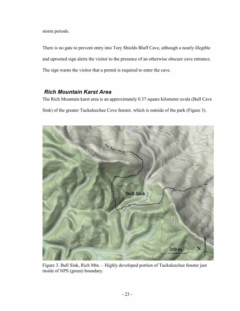
- 23 -
storm periods.
There is no gate to prevent entry into Tory Shields Bluff Cave, although a nearly illegible
and uprooted sign alerts the visitor to the presence of an otherwise obscure cave entrance.
The sign warns the visitor that a permit is required to enter the cave.
Rich Mountain Karst Area
The Rich Mountain karst area is an approximately 0.37 square kilometer uvala (Bull Cave
Sink) of the greater Tuckaleechee Cove fenster, which is outside of the park (Figure 3).
Figure 3. Bull Sink, Rich Mtn. – Highly developed portion of Tuckaleechee fenster just
inside of NPS (green) boundary.

- 24 -
The sink measures approximately 610 x 610 meters at its widest points on the south slope
of Rich Mountain. The base of the sink drains into the Historic entrance of the Bull Cave
System, one of six caves with entrances in the sink. This area is easily accessible, and
also the home to two of the deepest caves in the eastern United States.
The epigean environment of Bull Sink is unique, containing two rare species of liverwort,
one known from no other locations with closest relatives in the Himalayan Mountains
(DLIA website 2008). Rich Mountain Road, a one-way exit route out of Cades Cove
dating back to the mid 1800s, exits the park after a short traverse of the sink. Historic use
of the area is not well known. Records suggest that logging of the area left no tree
standing and reports state slash was dumped into the sink from both the road and the
slopes of the sink. Additional accounts of the area after logging state that the cave was at
time “inaccessible due to an entrance plugged with cut trees, mud, and water” (GRSM No
Date). Terminal hydrology of this area is unknown and needs to be dye traced to confirm
its destination. All caves on Rich Mountain likely resurge at Short Creek prior to flowing
into Little River near Kinzel Springs, Tennessee.
Bull Cave System (Historic Bull and Snakedance Entrances)
The Bull Cave System is the deepest known cave in GRSM (as well as Tennessee) at 282
meters. It is ranked as the third deepest in the eastern U.S. and the twentieth overall in the
U.S. Bull Cave has two entrances, the historic entrance and the more recently discovered
Snakedance entrance. The total mapped length of cave is 3656.4 meters. It trends north
and terminates outside of the park boundary at a low water sump (Appendix a.).

- 25 -
The historic entrance of Bull Cave resides in the drain of a large sink (known as Bull
Sink) on the south side of Rich Mountain just within the boundary of GRSM at an
elevation of 561 meters. A short and well-worn trail leaves the parking lot at a well
known trailhead down into the sink and to the entrance of Bull Cave. The sink and cave
continually take water from a small surface stream that can be followed through most of
the historical side of the cave. The historical descent into Bull Cave requires descending
three vertical drops of 12.2, 51.5, and 27.1 meters as well as some exposed down-climbs
in often cold and wet conditions. The temperature of the water entering the cave strongly
influences the temperature of the cave. At the historical terminus of the cave is a shallow
sediment plug which, when crawlable, leads to the remainder of the stream passage and
connection with the Snakedance side of the cave.
The Snakedance entrance is much higher above the historic entrance to the cave, on the
south flank of Rich Mountain at an elevation of 634 meters. The entrance is at the bottom
of a steeply sided sink within the confines of the larger Bull Sink. This entrance is a
vertical drop of twelve and a half meters followed by thirteen nearly continual drops
ranging from three to forty-four meters to the Bull Cave stream passage and sump.
The historic entrance to Bull Cave leads to a significant Indiana bat (Myotis sodalis)
hibernaculum, and has other cave species endemic to the park. The vertical extent of this
cave system and possibilities for more discoveries in it make it one of the most desirable
caves to recreation and exploration cavers.
The cave is mainly linear and confined to a small stream passage, which plunges into tall

- 26 -
rooms with occasional sediment mounds. Use over many years has caused trail
compaction in many of the rooms along the historic side of the cave--mainly David’s
Room. The Snakedance side of the cave is similar, with the majority of human sign being
focused along the drainage path and erased with significant rain events. In the larger
rooms of the cave, trails appear to be consolidated to natural routes leading deeper into
the cave. There is currently no sign at either entrance (historic Bull Cave or Snakedance)
warning against illegal entry.
Rich Mountain Blowhole
Rich Mountain Blowhole [Cave] begins high along the south slope of Rich Mountain in a
shallow sink at the head of a dry valley within the larger Bull Sink at 622 meters. The
entrance to the cave was illegally dug open and currently has a locked, air-restricting gate
and entrance culvert to mimic pre-digging environmental conditions. This solid, ground-
level, horizontal gate is often obscured by leaf litter, and there is no sign warning against
illegal entry. The illegal alteration of material to gain access to this cave has been the
center of much controversy between cavers seeking access to continue exploration of
GRSM caves and NPS’ hesitance to trust some cavers with these resources. Rich
Mountain Blowhole is the second deepest cave in Tennessee (and GRSM) at 256 vertical
meters (Appendix a.). It ranks nationally one place behind the Bull Cave System at the
fourth deepest for the eastern U.S. and twenty-fifth across the U.S. Right or wrong, the
discovery of this cave was and is paramount to understanding GRSM caves and karst
hydrology as well as how to manage them.
Rich Mountain Blowhole continues to blow air out of nearby rock piles too small to

- 27 -
enter; the dug entrance contains ten vertical drops that require rope to descend. It is
similar to the Bull Cave System in that it follows a series of highly vertical bedding
planes until it reaches the water table where it begins a long horizontal path north exiting
the park. It also contains several domes that have been explored and added to the overall
length of the cave. Much of the human traffic throughout the cave has left negligible
damage to the condition of the cave. It is noticeable that the cave has seen visitation but
compared to the Historic entrance to Bull Cave, it is minimal.
Rich Mountain Blowhole, like the Bull Cave System, has extensive vertical relief and
possibilities for more discoveries that make it another desirable cave to recreational and
exploration cavers.
Calf Cave I
Calf Cave I is located just inside the GRSM boundary on the periphery of Bull Sink at an
elevation of 579 meters. This cave and nearby Calf Cave II are at the bottom of a small
sink, six by eleven meters at its widest, along the trail to Bull Cave. The sign at the rim of
this sink alerting visitors to the need for a permit to enter either cave has been recently
stolen-2008.
Calf Cave I is predominantly horizontal with a small stream passage trending towards the
historic entrance of Bull Cave (Appendix a.). This passage contains fifty-three meters of
mapped passage with two high ceiling rooms inside the entrance adding to the mapped
eighteen meters of vertical relief (Matthews 1971). This cave has seen much visitation
over the years resulting in accumulated trash in the main entry room. Most of the passage

- 28 -
has been explored by cavers and surveyed.
Calf Cave II
Calf Cave II is at the bottom of the same sink as Calf Cave I. The cave is short at
seventeen meters with well over the Tennessee Cave Surveys listed three and a half
meters of vertical relief. Just inside the entrance is a four and a half meter vertical pit. The
small stream passage trends in the same direction as Calf Cave I towards the historic
entrance of Bull Cave (Matthews 1971). This cave has been a natural trap for trash
thrown into the Calf Cave(s) sinkhole. The cave itself appears to have had little visitation,
likely due to the entrance pit. Most of the passage has been explored and surveyed by
cavers.
Hidden Hole Cave
Hidden Hole cave was initially mapped in 1998 to a length of approximately thirty meters
and a vertical relief of approximately nineteen meters, although the cave has been known
for many years by Rich Mountain cavers. The cave is in a dry valley of the Bull Cave
Sink at an elevation of 600 meters. The entrance is a vertical collapse in unconsolidated
limestone rubble requiring rope to enter. The remainder of the cave mimics the entrance
and is a collapsing vertical shaft broken with debris plugs. Its unstable entrance is very
dangerous and it is difficult to avoid partial collapse during exploration. Due to the nature
of its instability it is possible that at any time, additional passage will be revealed
extending its length and depth and conceivably allowing additional access into either the
Bull Cave System or Rich Mountain Blowhole (GRSM 1998).

- 29 -
Biology of this cave is unknown. Bats have been observed using it in summer and winter
months though numbers are low. There is currently no sign to warn visitors against illegal
entry into this cave.
Big Spring Cove Karst Area
An earlier stage of a karst window exists in the Big Spring Cove area (Figure 4.). This
area is typified by several sinkholes (< 9 meters in diameter) in Metcalf phyllite that do
Figure 4. Big Spring Cove–Example of developing fenster. No surficial carbonate rock.

- 30 -
not permit quick drainage of surface water into the underlying Jonesboro limestone.
During wet periods, these sinks hold water and are important ecologically to such
organisms as amphibians. Test drilling was done in 1951 to determine the depth at which
carbonates existed below the surface. Carbonate rock was encountered at fifteen meters
below the surface (King 1964). The existence of sinks show that karst in this area is
active but remains covered by weather resistant non-carbonate rocks of the Ocoee
Supergroup. Geographic observation based on the leveling of topography suggests that
this active karst area is approximately 0.56 square kilometers. Surface biology mimics
surrounding areas of non-karst with the exception of these seasonal pools. Karst drainage
is likely into the neighboring Laurel Creek/Little River drainage. There are no known
caves in this area (Southworth et al. 2005).
Historic use of Big Spring Cove is evident in the altered topography of the cove. One of
the sinks has been breached manually to drain water, possibly for farming. Due to the
level topography of the cove, small-scale farming was the primary use by homesteaders in
this area, and remnants of a few homesites still remain. The proximity of Big Spring Cove
to Cades Cove, as well as being on the main route to Cades Cove during the mid- to late-
1800s has added to the historic and current land use of the area.
Today the area has been allowed to regenerate to a mature secondary forest. The historic
trials and roads leading to long abandoned home sites have been turned into trails and
trailheads by the NPS and receive visitor use equivalent to other areas of GRSM. Laurel
Creek Road, the primary road into and out of the Cades Cove area of the park, bisects Big
Spring Cove (Figure 4).

- 31 -
White Oak Sink Karst Area
White Oak Sink karst area is also on the periphery of the Tuckaleechee Cove fenster and
encompasses about 11.2 square kilometers. White Oak Sink is a very large uvala whose
karst is continuous with that of the Tuckaleechee window but is isolated somewhat by the
elevation differences (Figure 5). The NPS does not maintain trails into or within White
Oak Sink but an elaborate set of man-ways (unmaintained social trails) lead to many of
the “desirable” features of the sink including caves, a cemetery, various wildflower
ecotones, and historic homesites. On the floor of the sink are two of the seven caves that
have openings within the sink's elevated rim. White Oak Sink is likely the most popular
off-trail hike in GRSM. The wildflower diversity has caused visitation in the spring to
reach unmanageable levels at the primary trail-head and year-round use has continued to
increase.
Current access to the sink is by two primary locations. School House Gap trailhead, on
Laurel Creek Road, allows access to School House Gap Trail and ultimately the main
(southern) man-way accessing White Oak Sink. This route is approximately four
kilometers one way to the bottom of the sink with half that distance on unmaintained
trails. The other route into the sink follows the historic route into White Oak Sink and
beyond to Cades Cove. School House Gap trail was the former road into Cades Cove
around 1850. It was known as the McCampbell-Anderson Turnpike or road (Shields
1981). This road began in Dry Valley, a portion of Tuckaleechee Cove, and entered what
would become GRSM at School House Gap. This road continued to what is now Laurel
Creek road and via Crib Gap, enters Cades Cove. At School House Gap, the historic

- 32 -
Figure 5. W
hite Oak
Sink. -- H
ighly dev
eloped
portion of Tuck
aleech
ee fen
ster just inside of NPS (green
) boundary.

- 33 -
route into White Oak Sink veered west along a low-gradient stream, then through a
shallow gap into White Oak Sink. At this shallow gap, the old access route leaves the
metamorphic walls of the sink and enters the karst topography of White Oak Sink.
Shortly below the gap at a junction with a larger dry valley the road passes Saltpeter Cave
before reaching the bottom of the sink. Today, access to School House Gap and the park
boundary from the north requires hiking close to a kilometer on private property. At the
gap this route is overgrown, but the old road-bed is easily followed and allows for an
alternate route into the area.
Historic land use was similar to Cades Cove; small-scale farming and limited livestock
grazing in the bottom of the sink were the primary land uses of four families who resided
there. After incorporation into GRSM, White Oak Sink was allowed to succeed into the
closed canopy, secondary forest of today (Jenkins et al. 2007).
Recently (2009), the NPS has installed a horse barrier at the entrance to the southern
man-way from the School House Gap trail. In addition, “No Horses” signs were installed
at both man-way entrances, and a sign at the edge of the main sink area suggests hikers
stay on trails to reduce impact to the sensitive area.
White Oak Blowhole Cave
White Oak Blowhole Cave is located in the northeastern “corner” of White Oak Sink at
an elevation of 500 meters. The entrance is obvious due to the large bat-friendly gate that
protrudes like a box in front of a steep limestone bluff (Appendix b.). Behind the gate is a
short climb down into the entrance room. In the floor of the entrance room is a triangular

- 34 -
shaped opening that descends vertically just over nine meters into an elevated alcove of a
much larger room. This room is estimated at twenty-three meters wide by ninety-one
meters long and nine meters high. The floor is scattered with large breakdown rock from
the ceiling. Two large leaching areas are observable from past efforts of guano mining
and saltpeter extraction. The cave has a surveyed vertical extent of 134 meters and a
length of 1856 meters (Appendix a.).
The main extent of the cave is this large main room which trends downslope towards a
terminal sump that has been dove to twenty-five meters. The water in this sump is
beautifully blue and at times has many contrasting orange spring salamanders
(Gyrinophilus porphyriticus) and red black-chinned red salamanders (Pseudotriton
ruber). A northwest passage continues for 121 meters from the entrance drop to a well-
decorated room known as the “torch stick room”. This portion of the cave is one of the
primary winter roosts for Indiana bats (M. sodalis) and has seen extensive mining of
guano for saltpeter extraction. The name “torch stick room” is given due to the numerous
cedar torch stick fragments left behind by miners. Tally marks are also evident in the
torch stick room as well as other portions of the cave as a reminder of the mining that has
taken place.
This cave is Tennessee’s largest know Indiana bat hibernaculum, with counts numbering
close to nine-thousand at their peak. Two additional species of bats are also prolific in the
cave and together could account for close to 12,000 bats. Additional cave biota is
common of the species typical for GRSM caves but can be difficult to find due to the
expansive nature of the main room in this cave.

- 35 -
Although an interpretive sign exists on the gate explaining the importance of protecting
bat hibernacula sites, the NPS sign directing visitors to obtain a permit for entry to the
cave has been dropped down the entrance pit beyond the gate, and now rests in the main
entry room of the cave.
Rainbow Cave
Rainbow Cave, sometimes called Rainbow Falls Cave, is located on the southeastern
corner of White Oak Sink at an elevation of 512 meters. The entrance to the cave is at the
base of a waterfall that drops nine meters after reaching soluble limestone at the Great
Smokies Fault (Appendix b.). The Great Smokies Fault is clearly observable at the
contact between the lower limestone beds and the upper weather resistant metamorphic
rock of the Ocoee Supergroup. There are at least two entrances into the cave at the base of
the falls (Appendix a.). One is a climbable pit that corkscrews for three meters before
entering a room under the breakdown pile below the falls. In this room, water from the
falls percolates through the ceiling making it impossible to stay dry. Following the flow
of the water, you enter a tight wet crawl that, depending on water level, may not be safely
passable. Beyond this constriction is a small dome room with a side passage entering
from the other entrance and a hands-and-knees crawlway in which the water follows. The
second entrance is tight at the base of the falls but opens to follow an overflow channel of
washed dolostone with calcite stringers for forty-six meters where a four meter high
climb down meets the other entrance route in the small dome room. The hands-and-knees
crawlway that ensues for thirty-seven meters to the first nine meter drop. The drop is
bolted with a single hanger and can be backed up off natural anchors. The descent is wet

- 36 -
and at the bottom, after a short ten meters of passage is another nine meter drop, bolted
again in continuous water. The Knoxville Volunteer Emergency Rescue Squad (KVERS)
placed both bolts in February 2008 during the rescue of four young adults who became
trapped and hypothermic during a late night, unpermitted trip into the cave. The terminal
siphon is in a short down climb in the main room at the bottom of the cave. The room is
spacious, ranging larger than nine meters wide by over thirty meters long. From the
siphon the room continues up over breakdown into a lofted area with one possible high
passage lead.
This cave has the potential to be very dangerous during periods of rain. Flash flooding
could easily trap people inside the cave as well as make either of the two waterfall climbs
very difficult. Species diversity is similar to other caves of the area. 2009-2011 bat
hibernacula surveys found Indiana (M. sodalis) and Little Brown (M. lucifuga) bats as
well as Tri-colored (Perimyotis subflavus) bats present. Currently, there is no sign to warn
visitors against illegal entry to this cave.
White Oak Saltpeter Cave
White Oak Saltpeter Cave is located at an elevation of 549 meters in a small sink, eight
meters in diameter, upslope of the bottom of White Oak Sink in an unnamed dry drainage
in the direction of School House Gap. It is adjacent to the historic trail (road) that
accesses White Oak Sink from School House Gap. The name of the cave is a misnomer;
there is no evidence that any saltpeter mining has occurred in this cave. It is also unlikely
that there was or would ever be a reason to mine this cave. The cave is small and does not
possess guano piles sufficient for extraction. It is likely that the neighboring cave, White
- 37 -
Oak Blowhole, was likely called “Saltpeter Cave” at one time due to its extensive sign of
nitrate removal efforts. Some confusion in nomenclature can be speculated which has
caused the name to be associated with this cave instead of the other likely choice.
This cave is relatively small compared to the neighboring White Oak Blowhole and
Rainbow Cave. It has forty-nine meters of surveyed passage with a vertical extent of six
meters. The cave has a large entrance room with two small domes on its north margin. It
receives water from a small fissure that quickly disappears into a hole in the floor that
could possibly be explored by somebody small. The main room funnels into a small
crawlway with water draining from the back of the cave. This water disappears through a
tight constriction in the floor that immediately opens into what looks like a possible lead.
Beyond the drain in the floor, the cave opens back up into a series of short upper passage
sections connected to the small stream passage before the source of the stream is reached
at a spring-like area in the back of the cave. There are two very small leads off the
southeast side of the cave but both are too tight for most to enter. At least one of these
exhibits significant air movement, suggesting additional passage or a more likely
connection to White Oak Blowhole Cave.
This cave seems to receive a fair amount of illegal visitation that has resulted in several
names/initials written in mud along the far reaches of the cave. Most of the dates are
within the past fifteen years with several new additions identified with each NPS visit. A
barely legible sign is propped up against the entrance to the cave, warning visitors against
illegal entry (Appendix b.)
- 38 -
Scott Gap Cave
Scott Gap Cave is in a large sink in the northwest portion of the much larger White Oak
Sink at an elevation of 555 meters. The entrance to the cave is under a large exposed
portion of Jonesboro limestone at the base of the sink, which on occasion fills with
organic debris. Directly inside the opening is a vertical entrance drop of eleven meters
into the cave. A tilting passage approximately eight meters high by equal distance wide,
following the dip of the beds, proceeds down slope while a much smaller passage runs
upslope for short distance before terminating at a four meter dome. The majority of the
cave down slope is a series of easy climb downs to a constriction at the second drop of
twelve meters. At the bottom of this drop, a small tight stream passage drains the small
room with an eleven meter ceiling. The low stream passage winds north for a hundred
feet before it becomes too tight to proceed.
This cave has been observed to house 200 or more Indiana bats (M. sodalis) during the
winter though recent numbers are much lower. In addition, the small pool of water in the
bottom of the second drop contains many of the aquatic cave organisms found in other
GRSM caves with stationary water. A sign at the rim of the sinkhole warns visitors
against illegal entry and the need for a permit to enter the cave (Appendix b.).
Scott Mountain Cave
Scott Mountain Cave is a very short solution feature high on Scott Mountain at an
elevation of 683 meters. It is within the confinement of White Oak Sink on its
northwestern slope, and the entrance is a small inconspicuous hole that covers with leaf
litter every fall. The cave is short, about nine meters, with a sloping portion just inside the

- 39 -
entrance suggesting subsidence. The ceiling is low and only the entrance area permits
standing. The back of the cave doesn’t seem to warrant further attention.
Interestingly, the cave always seems to contain fresh Allegheny Woodrat (Neotoma
magister) nesting material (fresh vegetation and leaf litter) as well as a very large
population of the spider Meta ovalis. No biological inventory has been done outside of
the author’s observations. No sign exists that warns visitors against illegal entry, or the
presence of a cave. Little human sign suggests entry is not taking place at a level high
enough to warrant concern.
Sinking Stream Cave
Sinking Stream Cave is another small cave within White Oak Sink. Its opening is at the
bottom of a deep sinkhole at the foot of a small stream at an elevation of 555 meters. The
sinkhole is collapsing, and trees are occasionally uprooted along its rim and sediment is
continually drawn into the entrance to the cave. The stream disappears prior to the
sinkhole except during periods of extensive rain. The cave is unmapped and on occasion
seems to blow a slight amount of air. It is possible that it is hydroligically connected to
White Oak Blowhole.
The cave is nothing more than a mud filled, and occasionally plugged entrance that leads
three meters to a short climb down of twenty feet. Water enters through breakdown into
the small pit and quickly disappears into the coarse floor medium. Old pottery fragments
and man-made materials from pre-park homesteading were found within the cave pit
suggesting the sinkhole has been used as a trash dump previously. No biological
- 40 -
inventory has been done outside of the author’s observations. There is currently no sign
warning visitors against illegal entry, or alerting visitors to the presence of a cave. Some
human activity has been observed at the entrance.
Pie Hole Cave
Pie Hole Cave is located less than ninety meters from Sinking Stream Cave on the
western slope of White Oak Sink at an elevation of 549 meters. The cave is
inconspicuous except for the large sinkhole it is in. It appears that the sinkhole has been
used as a repository for field rock during the settlement period as one side of the sink is
awkwardly man made with loose chunks of limestone. The cave is hidden among tall
vegetation during summer months but visible during winter. The cave itself is small, less
than ten meters. It corkscrews down into a muddy, rocky sink with large bedrock along
one wall. Between two large pieces of limestone is a fissure with substantial air and a
faint gurgle of water. This is likely the water from Sinking Stream Cave. It seems
possible if not likely that this water continues towards White Oak Blowhole Cave and
resurfaces along the northwest passage of that cave.
Pie Hole Cave gets its name from the shape of the opening that looks like a mouth. Also
notable is the use of this cave by bats at several times of the year. No biological inventory
has been done outside of the author’s observations. No sign exists that warns against
illegal entry to this cave, or alerting visitors to its presence. Little or no human sign has
been observed in or near the cave.

- 41 -
Calderwood Karst Area
The Calderwood karst area lies just below Calderwood dam on the Little Tennessee
River. There are several known caves in this karst unit based on the 2009 TCS database.
GRSM, in 2009, acquired land above this karst area but investigations have been unable
to determine if any of the karst area is currently under GRSM management. The land is
adjacent to property owned and maintained by Topoco, a subsidiary of Aluminum
Company of America (Alcoa), as the Calderwood Hydroelectric Development Area. It
appears unlikely that surficial karst exists within the boundary of this newly acquired
property. However, further investigation is needed to determine if any of these karst
systems originate within this extended boundary of GRSM and what type of
management, if any, is necessary.
At this point it seems to suggest that the area known as “The Bulge” has the best
possibilities as some of its south and western perimeter will adjoin known karst areas in
the Calderwood karst area. However, Topoco’s choice to retain the lower, flat
topography of the area will omit much of the highly karstified bedrock. Caves on
Topoco’s property adjacent to The Bulge suggest at least some subterranean flow which
has possible origins higher up slope in GRSM managed land. Field observations do not
show any distinct subterranean input of water into the non carbonate areas within
GRSM’s management area.
Foothills Parkway (Walland, Wear Cove, Cosby, and Pigeon River) Karst Areas
The Great Smoky Mountains National Park manages a narrow strip of land around the
Tennessee side of the park designated as the Foothills Parkway System. Not all of the

- 42 -
parkway is complete at this time. The geology of the parkway is consistent with the
Smokies where older metamorphic rock is located at higher elevations and younger
carbonates are found beneath, exposed at lower elevations. This corridor crosses several
large karst windows; two caves are known from this right of way, one in the Walland
karst area (Shady dolomite) and one in the Wears Cove fenster (Jonesboro limestone).
Karst along the Foothills Parkway System is minimal, occurring often at parkway
junctions at lower elevations. Common features are large sinkholes and limestone bluffs.
Actual size of karst areas of the parkway is unknown.
Stupkas (Myhr) Cave
This cave is named both Stupkas (GRSM’s first naturalist) and Myhr (adjacent
landowner) in literature but exists as Stupkas Cave in the Tennessee Cave Survey (TCS)
records. Stupkas Cave is 213 meters long with fifteen meters of vertical extent. The cave
is mainly a tight, wet, and winding stream channel, the entrance being a collapse adjacent
to the resurgence spring. The spring is on adjacent property and feeds a large pond owned
by the Myhrs and is also their main source of water.
The cave is developed at the base of the south slope of the Wear Cove fenster at an
elevation of 466 meters. Development above this cave and the Foothills Parkway System
is thought to be the source of seasonal turbidity of the Myhrs’ water source in the past ten
years.
Cave biota in this cave is similar to other GRSM caves but also possesses the type-
location of an endemic spider (troglophile) of the genus Nesticus exemplifying the

- 43 -
importance of protection. According to bat surveys, bat diversity in this cave seems to be
high, although records indicate population numbers of many species are relatively low.
There is currently no visible sign warning against illegal entry.
Foothills Parkway Cave at Walland
The Foothills Parkway Cave at Walland has developed in a fissure in the Shady dolomite
of the Knox Group at an elevation of 305 meters. It is on a limestone bluff high above
Little River on a narrow strip of the Foothills Parkway System. The vertical extent is
enough to warrant the use of a rope to access.
The cave is a vertical fissure of approximately six meters deep with less than four meters
of traversable passage at the bottom. It does show sign of carbonate dissolution within the
cave and bats are known to hibernate under several small shelves along the bottom of this
cave. No biological inventory has been done outside of the author’s observations. There is
currently no sign warning against illegal entry or alerting visitors to the presence of the
cave. No human activity has been observed in the cave.
Foothills Parkway-Interstate 40
In the far Northeastern corner of the park, as part of the Foothills Parkway East, is a low
lying karst area adjacent to the Little Pigeon River in Cocke Co., TN. The area needs
further delineation as to its exact size but field observations show karstification taking
place on both sides of Interstate 40 at the junction of the Foothills Parkway East’s
eastern terminal. The area furthest east adjoins the Little Pigeon River where limestone
is obvious along the river incision and flood plane. No cave development is observable

- 44 -
though dissolution of limestone is apparent along rock outcrops. It appears that the karst
area continues under Interstate 40 to the western portion of the terminus of the Foothills
Parkway East. At this location, it appears that the carbonate rocks are covered with non-
carbonates. No limestone was found. Active karst development is seen as large shallow
sinks on what looks to be an old river terrace higher up on the mountain.
Little information exists in park literature on the area. General geology of the karst
bedrock appears to be consistent with other park carbonates. Cambrian- Ordovician
limestones (Jonesboro Limestone) would be the predominate karstified rock. Further
interpretation of the rock itself might yield more detail to its origin or similarities to
Blount or Sevier Co. limestones.
No hydrology has been observed in this area outside of the surficial Little Pigeon River.
Foothills Parkway-Cosby
Little is known about the karst areas around the junction of the foothills parkway and US
route 321 (SR 32, 73). In looking at aerial photos, topographic maps, and park boundary
maps I can conclude that some karst is managed by GRSM in that area. The expansion of
kudzu on adjacent lands makes surficial observations nearly impossible. The lack of park
boundary signage as well as private property made attempts at defining the boundary
somewhat difficult. At a minimum, karst is present at the lowest areas along Cosby
Creek. I have had reputable reports from cave explorers and naturalists that carbonate
bedrock exists higher up on the flanks of Webb Mountain but access has been difficult
and the location not documented. Topography in that area does not suggest that those
areas contain highly developed karst terrain or if they do, fall under management of

- 45 -
GRSM.
The only observed hydrology is that of surficial Cosby Creek, the main drainage of the
valley in this area.
History of Cave and Karst Management in Great Smoky
Mountains National Park
Management
Historically, management of karst resources in Great Smoky Mountains National Park
was not based on an approved management plan for caves and karst. Two draft
management plans for caves were developed, but their implementation was limited due to
their lack of accuracy and completion. In 1979, the first attempt at developing and
implementing a cave management plan was alternately named “Indiana Bat Management
Plan” and limitedly focused on resources other than the Indiana bat. Following the
development and inception of the FCRPA in 1988, GRSM developed another draft
management plan (1989) that incorporated additional resources but was never completed
or implemented. Management decisions in regards to cave and karst resources followed
general directives and the park's Superintendent's Compendium. Signs alerting visitors
that permits are required to enter park caves were installed in the 1980s, and bat friendly
metal gates in the late 1990s on several cave openings (White Oak Blowhole and
Gregorys Cave).

- 46 -
Biological Inventory
As early as the 1930s, park managers expressed an interest in better understanding the
cave and karst areas in the park. Early efforts to describe the park's caves were focused
more on the geology and physical conditions inside the caves rather than the fauna
(GRSM 1936). In 1974, Great Smoky Mountains National Park began studying human
impact and restricting access to park caves because of the presence of Indiana bats (M.
sodalis), a federally protected species (GRSM 1979; Rabinowitz and Nottingham 1979).
Currently, the only continuous sampling of cave biota is conducted in conjunction with
the United States Fish and Wildlife Service’s Indiana bat hibernacula counts. It was not
until the early 1980s when there was a concerted effort to identify and describe specific
species associated with caves and karst. Beginning in 1984, under the direction of Great
Smoky Mountains National Park resource managers, Richard L. Wallace completed a
series of biological survey reports of the Great Smoky Mountains National Park's caves.
Although there existed data on bat fauna that occurred within the park's caves, Wallace
noted that knowledge of other cave fauna was “incomplete or unknown”. Wallace's
biological surveys uncovered several new, rare and endemic species as well as a new
location for a threatened and endangered species (Wallace 1984; 1989; 1990). Based on
these findings, park resource managers began monitoring populations of cavernicoles
(Stygobromus fecundus) in one location, Gregorys Cave (Johnson 1991). Management of
Gregorys Cave was changed in order to provide protection for this endemic species.
Without continued interest and direction through a cave management plan, over time, the
monitoring efforts have fallen by the wayside with occasional spot checks by visiting

- 47 -
scientists. Several independent researchers have surveyed a variety of cave and karst
associated biota in the caves of Great Smoky Mountains National Park: amphibians
(Dodd et al. 2001; Dodd 2003), salamanders (Taylor and Mays 2006), spiders (NPS 1992;
Coyle 2006; Paquin et.al. 2009), annelids (Reeves and Reynolds 1999), and general
invertebrate cavernicoles (Wallace 1984; 1989; 1990; Reeves 2000). In addition, in 2006-
2007, Discover Life in America, a non-profit partner of the national park invited scientists
with a specific interest in karst areas to participate in a “Karst Quest” to identify and
describe both cave life and associated epigean biology related to the karst areas in the
park. In 2009 GRSM acquired property along the Little Tennessee River on the western
border of the park. The areas, commonly referred to as the “chocolate bar” and the
“bulge”, border a significant karst window referred to as the Calderwood karst window.
At least two new park karst-associated species have been identified (2009) on these
properties and it is likely additional new park species will follow (DLIA 2009).
Through the aforementioned inventories of cavernicoles and associated biota of the karst
areas in the Great Smoky Mountains National Park, a total of eleven troglobitic
organisms have been described in the caves of the park (Table 1). Of these eleven
organisms, seven have been identified to species, and four to genus. These organisms
include amphipods, isopods, diplurans, millipedes, flatworms and arachnids. One of the
eleven organisms, an amphipod (Stygobromus fecundus), is endemic to one cave
(Gregorys Cave). Approximately 270 organisms have been otherwise described in
association with the caves and karst areas in Great Smoky Mountains National Park. Of
these, over 200 organisms have been identified to genus level and 50 to family. Over
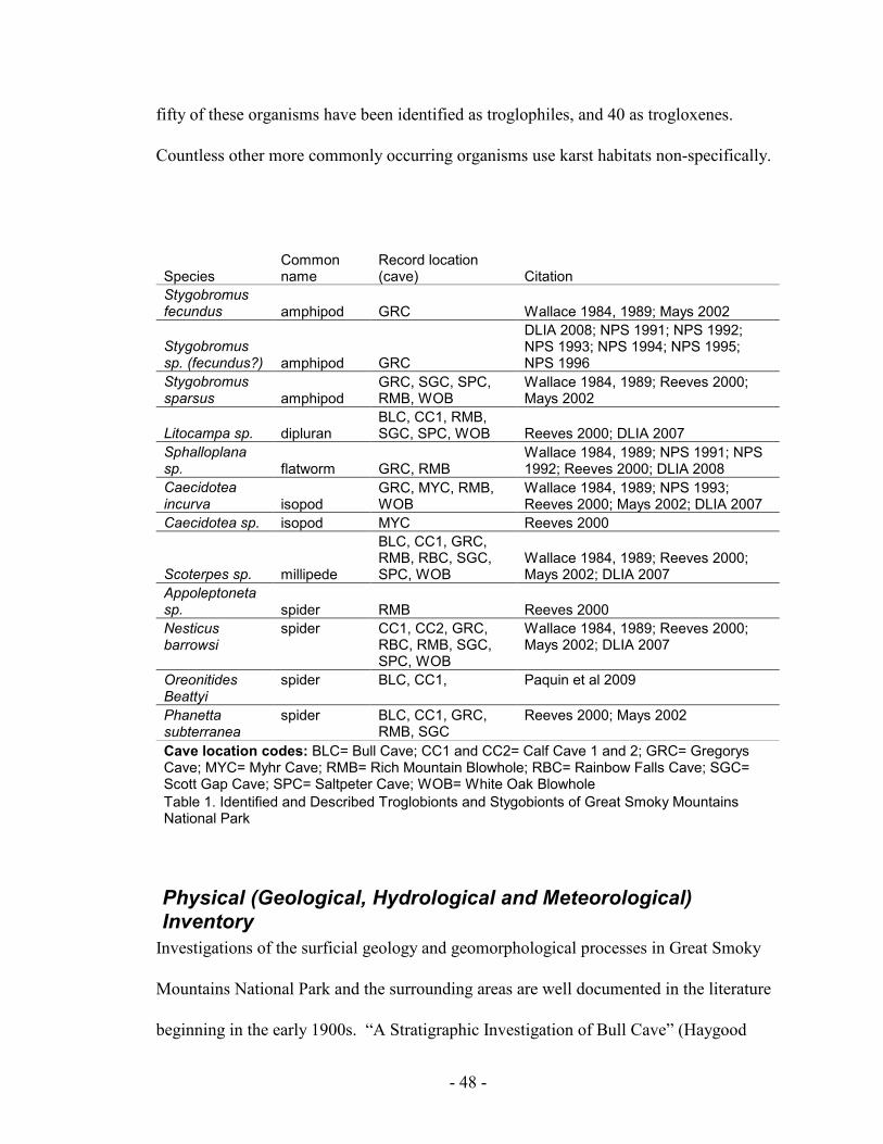
- 48 -
fifty of these organisms have been identified as troglophiles, and 40 as trogloxenes.
Countless other more commonly occurring organisms use karst habitats non-specifically.
Species Common name
Record location (cave) Citation
Stygobromus fecundus amphipod GRC Wallace 1984, 1989; Mays 2002
Stygobromus sp. (fecundus?) amphipod GRC
DLIA 2008; NPS 1991; NPS 1992; NPS 1993; NPS 1994; NPS 1995; NPS 1996
Stygobromus sparsus amphipod
GRC, SGC, SPC, RMB, WOB
Wallace 1984, 1989; Reeves 2000; Mays 2002
Litocampa sp. dipluran BLC, CC1, RMB, SGC, SPC, WOB Reeves 2000; DLIA 2007
Sphalloplana sp. flatworm GRC, RMB
Wallace 1984, 1989; NPS 1991; NPS 1992; Reeves 2000; DLIA 2008
Caecidotea incurva isopod
GRC, MYC, RMB, WOB
Wallace 1984, 1989; NPS 1993; Reeves 2000; Mays 2002; DLIA 2007
Caecidotea sp. isopod MYC Reeves 2000
Scoterpes sp. millipede
BLC, CC1, GRC, RMB, RBC, SGC, SPC, WOB
Wallace 1984, 1989; Reeves 2000; Mays 2002; DLIA 2007
Appoleptoneta sp. spider RMB Reeves 2000
Nesticus barrowsi
spider CC1, CC2, GRC, RBC, RMB, SGC, SPC, WOB
Wallace 1984, 1989; Reeves 2000; Mays 2002; DLIA 2007
Oreonitides Beattyi
spider BLC, CC1, Paquin et al 2009
Phanetta subterranea
spider BLC, CC1, GRC, RMB, SGC
Reeves 2000; Mays 2002
Cave location codes: BLC= Bull Cave; CC1 and CC2= Calf Cave 1 and 2; GRC= Gregorys Cave; MYC= Myhr Cave; RMB= Rich Mountain Blowhole; RBC= Rainbow Falls Cave; SGC= Scott Gap Cave; SPC= Saltpeter Cave; WOB= White Oak Blowhole
Table 1. Identified and Described Troglobionts and Stygobionts of Great Smoky Mountains National Park
Physical (Geological, Hydrological and Meteorological) Inventory
Investigations of the surficial geology and geomorphological processes in Great Smoky
Mountains National Park and the surrounding areas are well documented in the literature
beginning in the early 1900s. “A Stratigraphic Investigation of Bull Cave” (Haygood

- 49 -
1969) remains the only documented geological interpretation of the sub-surface geology
of any of the known caves in the park. Many of the park’s larger cave systems have been
mapped and the survey data and associated maps have been offered to the park. What
information is available is housed by and is the property of the Tennessee Cave Survey
(TCS 2011).
Little is known about hydrology of caves and karst in Great Smoky Mountains National
Park. According to internal National Park Service Natural History files, prior to park
establishment, an attempt was made to trace the drainage path of water from White Oak
Sink, GRSM to Dunn Spring; Dry Valley, Tennessee. Sawdust was placed in one of two
caves in White Oak Sink (White Oak Blowhole Cave or Rainbow Cave), and allegedly
surfaced at Dunn Spring approximately 10 hours later (GRSM No Date). Although
unconfirmed in park files or published literature, discussions with local cavers and NPS
employees suggest that this identical path may have been traced with dye in more recent
times. More recently, in 1990 a groundwater dye trace study along the undeveloped
Foothills Parkway System and Stupkas Cave was done in conjunction with an assessment
of potential impacts to water quality in a cave stream and karst hydrology on park service
managed land (Beck and Herring 2001). General assumptions conclude that subterranean
flow from the northern side of Cades Cove as well as the floor of the cove itself drain
directly into Abrams Creek based on discharge proximity. Streams draining into and
developing within caves on Rich Mountain appear to concentrate prior to resurging
outside of the park at a primary spring on Short Creek down stream of Dunn Spring.
Streams flowing into White Oak Sink via Rainbow Cave and Sinking Stream Cave likely

- 50 -
converge with additional subterranean flow in or close to the sump in White Oak
Blowhole Cave prior to exiting the park. Flow within Scott Gap Cave likely joins the
majority of flow in White Oak Sink on its path to the main stream in Tuckaleechee
Caverns, a developed cave in Dry Valley. From there the flow likely resurges from the
subterranean environment at Dunn Springs, where it provides water for a trout farm
before providing substantial flow to Short Creek. Short Creek flows out of Dry valley, TN
and into Little River at Kinzel Springs, TN.
Scientifically, there has been little analysis of the meteorological conditions within park
caves. It is likely that cave entrances and passages that have been altered by human
processes (e.g., saltpeter extraction) may exhibit unnatural airflow characteristics that
would be difficult to restore. Experienced cavers suggest that caves with extensive
passages and vertical relief in the Smokies tend to be cooler year round than other caves
in the region with the exception of White Oak Blowhole. White Oak Blowhole is
Tennessee’s largest known Indiana bat hibernaculum, anecdotal reports of experienced
cave scientists participating in research in White Oak Blowhole have observed warmer-
than-average temperatures than generally preferred hibernating habitat for these animals.
Note: Historic evidence and discussions about the cave with bat experts suggest that the
historic entrance to this cave might have been much larger and has collapsed in
geologically recent times creating less than optimal temperatures for these bats by
restricting airflow. Observable subsidence around the current entrance supports this
assumption and appears to have been accelerated due to storm water reroute from gate
construction.
- 51 -
Paleontological, Archeological and Historical Inventory
Limited information has been published on the archeology and cultural resources
associated with cave use in Great Smoky Mountains NP. Historical accounts of use of
park cave and karst resources include saltpeter and surface mining, speleothem removal,
storage, commercial tourism and recreational use. Park archeologists speculate prehistoric
use of several park caves. One such cave, Gregorys Cave, has what is suspected to be a
prehistoric charcoal drawing of a wild turkey (GRSM No Date).
Permitting, Access, Protection and Rescue
Permits
At the time of publication of this plan, all caves (recognized and potential discoveries) in
the Great Smoky Mountains National Park require a permit to legally enter. Permits fall
under several different departments depending on the type of use requested. Scientific
research within caves is permitted through the Resource Management and Science
Division. Scientific research is proposed in the application process with detailed
descriptions of methods and materials as well as protocols for collection of specimens,
etc. The application is reviewed for validity and potential contributions to the scientific
body of knowledge
Accepted applicants for scientific permits for study in caves currently receive a protocol
for pre- and post-entry decontamination of equipment and clothing. This is to minimize
the potential for introduction of non-native entities into the cave as well as meet the
requirements based on the United States Fish and Wildlife Service's guidance related to
possible transmission of the fungus associated with White Nose Syndrome (USFWS

- 52 -
WNS website 2011).
Non-scientific (e.g., recreation, exploration) permits are obtained through the Resource
and Visitor Protection Division as either a special use or recreational caving permit. The
author’s discussions with local cavers suggest that recent attempts to obtain either type of
permit for GRSM cave access have been very difficult. Lack of communication with
permit applicants by GRSM management for reasoning behind declining permits has
resulted in frustration and lack of compliance of GRSM cave closures. Historically, non-
scientific permits (mainly for cave exploration) were obtained from the District Ranger
responsible for the areas in which the caves occur. Prior to the writing of this plan,
permitting for exploration had been a joint effort managed mainly by the Chief of the
Resource and Visitor Protection Division, although anecdotal conversations with
members of local NSS groups suggest that recreational permits have not been issued in
the past several years. It is unclear if protocols recommended by the Resource
Management and Science Division are/would be enforced on those intending to enter a
cave for reasons outside of scientific use.
Access
The GRSM staff assists scientists with obtaining keys for cave gates and locations of
caves necessary to fulfill their research requests. Non-scientific permit holders can obtain
keys from the district ranger office and under normal circumstances; no guidance is given
as to the location of cave openings.
Note: At the time of writing of this plan, current cave gate locks use a discontinued

- 53 -
standard gate key. This key/lock combination has been replaced due to numerous
unaccountable keys and should be discontinued for caves as well.
Protection (gates and signs)
Few known park cave entrances are currently protected from illegal entry by gates; only
three of the seventeen known cave entrances have gates (White Oak Blowhole, Rich
Mountain Blowhole and Gregorys Cave). Signs warning against illegal entry at several
cave entrances are illegible, or have been vandalized or removed (Tory Shields Bluff,
Calf Caves I and II, White Oak Blowhole and Saltpeter Cave). Currently, only one cave
entrance has an intact, legible sign. An interpretive sign on the gate to White Oak
Blowhole misidentifies the cave as a “mine”.
Search and Rescue
Current policy for rescue operations in cave environments in GRSM is managed under
the GRSM Incident Command System (ICS). Because of the highly technical nature of
cave rescue, rescue operations in GRSM cave environments employ the external expertise
of the Knox County Volunteer Emergency Rescue Squad's high angle rope and cave
rescue crew. Their specialized training and proficiency in performing cave rescues is far
superior to what could be expected from the multidisciplinary nature of GRSM rescue
personnel. All in-cave operations are done without GRSM personnel to the degree
necessary to effectively respond and provide care to injured persons within the cave.
Patient care, once outside of the cave environment, likely falls on those responders most
qualified (either GRSM medic or responding emergency medical technician-EMT).
Currently no GRSM staff is required to assist any in-cave operations.
- 54 -
GRSM Cave and Karst Management Framework
NPS Staff Responsibilities
Karst terrain is one of the most dynamic landscapes on earth. Understanding of the
resources in a karst system can be very challenging due to nature of its underground
components. Few resources are protected with federal legislation the way that caves are.
GRSM should focus specific management efforts on these resources to develop a
program effective at protecting them at all stages of development indefinitely.
Superintendents Office
The Superintendent’s office is responsible for decision-making related to permitting
additional activities not discussed in the Permitting and Permitting Procedures of the
Cave and Karst Management Plan.
Division responsibilities
Resource Management and Science Division
The Resource Management and Science Division plays one of the largest roles in the
protection of caves and karst of GRSM. It is the responsibility of this division to continue
to move forward with inventory and understanding of resources associated with these
environments. GRSM should be proactive in supporting research in karst/cave/mine
science to better understand these resources. As GRSM becomes more familiar with the
resources associated with these environments, monitoring protocols should be put in
place to prevent and document changes. As changes occur, managers need to determine
whether anthropogenic forces are at the root of the change or if these processes are natural

- 55 -
(See also RM&S Inventory and Monitoring Protocols).
The Resource Management and Science Division should lead coordination efforts with
other federal agencies (e.g., USFWS, USFS), Universities (e.g., Western Kentucky
University, University of Tennessee), and other stakeholders (e.g., the National
Speleological Society and Tennessee Cave Survey) in order to achieve the GRSM Cave
and Karst Management Objectives.
Resource Education and Interpretation Division
It is the responsibility of this division to educate the public on the processes and resources
associated with karst environments. As visitor use in these areas increase, it is paramount
to the protection of these resources to educate the public about the concerns and
management of these areas. The use of signage as well as direct contact during period of
heavy use can help deliver GRSMs message on protecting these delicate resources.
Resource and Visitor Protection Division
The main role Resource and Visitor Protection play in the management of cave and karst
resources is by focusing protecting on these areas during periods of high use and
periodically when time permits. In addition to familiarizing themselves with the location
of these resources, periodic patrols of the area are needed to protect these areas from
vandalism.
See also Safety and Training: In-Cave Search and Rescue.
- 56 -
Facilities and Maintenance Division
The Facilities and Maintenance Division is responsible for maintaining current and
legible signs at cave entrances and in karst areas.
Department responsibilities
Cave Specialist or Cave and Karst Liaison
In order to best achieve the GRSM Cave and Karst Management Objectives and in
accordance with RM#77, the Superintendent or Chief of Resource Management and
Science should select an employee to coordinate park management efforts and the
development and fulfillment of a cave and karst program under Resource Management
and Science.
The Cave Specialist (or Cave and Karst Liaison) will be responsible for:
• needs assessment and planning related to cave and karst resources,
• inventory and monitoring coordination of cave and karst resources,
• coordination of cave-related scientific research and cave exploration-access
needs,
• review and recommendation of permit applications and all access,
• consultation with staff specialists on cave-and karst-related resource
management concerns,
• coordination with Chief Ranger, law enforcement staff and cave rescue
organizations (e.g., Knoxville Volunteer Emergency Rescue Squad) to address
resource concerns and ensure search and rescue preparedness and resource
protection,
• coordinate with Resource Education staff to provide educational and
interpretive opportunities, develop interpretational signs and information,
• conduct outreach to local communities, universities, and other interested
groups.
- 57 -
Regulations and Permitting
Regulations
General restrictions and guidelines within Caves
Management of caves will follow epigean landscape boundaries, including any future
wilderness designation or where cave passage leaves the park.
• No open flames or fires
• No camping within caves
• No use of cave water, either flowing or stationary, for washing of hands,
body, gear, equipment etc.
• No activities that disturb or degrade water quality within caves.
• No persons under the age of 16 shall be admitted into any cave or mine.
• No admittance into any vertical cave without updated/safe SRT (single
rope technique) equipment. This is the responsibility of the individual
and the group.
• No admittance into any cave during bat closure period (September 15th -
May 15th) without explicit permission from the Resource Management &
Science and Visitor & Resource Protection Divisions.
• When applying for scientific or recreational permits, applicants should
sign a Cave Access Release Form (Appendix C) to acknowledge and
demonstrate their understanding of the risks and requirements involved
in cave access in Great Smoky Mountains National Park.
Decontamination Protocols
Decontamination protocols pertain to anyone accessing caves directly, those doing
research in karst areas within GRSM, and those who have visited other GRSM karst areas
- 58 -
or karst areas outside of the park.
Caves have the potential to have much more stable environments than their neighboring
epigean environments. This constant environment has lead to evolutionary processes
resulting in ecosystems/species with often very delicate thresholds to invasive species
(Culver et al 2003; NYU Website 2008).
Note: At the time of the writing of this plan, two current concerns to GRSM in cave and
karst management are White Nose Syndrome (WNS) in cave bats and the Chytrid fungus
associated with global amphibian decline. Both fungi have been found in GRSM
cave/karst environments.
• Geomyces destructans sp. is the White Nose Syndrome (WNS) fungus associated
with mass mortality in cave bats.
• Batrachochytrium dendrobatidis (Bd or “chytrid”) is a fungus described as
infecting amphibians and causing the often fatal disease, chytridiomycosis. It has
been suggested that Bd is a contributing factor to the global decline of
amphibians.
In many cases, simple decontamination procedures can help sufficiently reduce the risks
associated with these two diseases as well as other potential risks to cave and karst
resources and associated habitats.
For decontamination to be effective, procedures must be followed without compromise.
Gear must be clean and free of debris and organic matter.

- 59 -
• The USFWS recommends decontamination procedures to prevent human-
assisted spread of WNS. Current decontamination protocols can be found on the
USFWS WNS website (2011) and are often updated.
• To prevent the human-assisted spread of Bd (chytrid), a variety of
decontamination protocols exist. The USFS suggests methods detailed in
Johnson et al. 2003, including submersion in a 7% bleach solution for 10
minutes.
• Use of a 10% bleach solution on all clothing, footwear and gear (where safety
will not be compromised) will decontaminate for both WNS and Bd. Gear that
has been used in the past in an affected site would not be used in GRSM .
Note: To eliminate any potential for human error, the safest approach to preventing the
introduction of foreign species or other harmful agents is to use new or equipment and
clothing that has not been in caves outside of GRSM. GRSM has committed equipment
for such purposes.
Permitting and Permitting Procedures
All cave access will be permitted through either a Research or Recreational permit.
Exceptions may be granted for administrative purposes but should be strictly
documented. Park- and cave-specific research and recreational permit applications or
special use permits could be developed in conjunction with the Cave Specialist/Cave and
Karst Liaison based on the guidelines below.
- 60 -
1) National Park Service Research Permit
A National Park Service Research Permit is required when access to a cave is needed to
conduct scientific research. Research is defined as the collection of any information for
the sole purpose of adding to the greater body of scientific knowledge. Research permits
follow the approved online permitting process for all NPS units found at
(http://science.nature.nps.gov/research/). A few examples of activities within a cave
requiring use of a research permit are the collection of invertebrates, evaluation of winter
bat use, and cave survey/cartography. Park personal should support research permits
when there are no adverse effects to the cave or karst resources or other park resources.
Additional restrictions and requests must be made through the superintendent’s office
(i.e. speleothem removal, cave diving, and cave digging).
Species and Sample Collection from within Caves
A valid research permit defining species or sample collection information should/must be
present and remain with researcher and collections. GRSM should make all attempts to
track specimens for future research needs.
Biological
Cave dwelling organisms often occur in reduced numbers compared to epigean relatives.
Consequently, these organisms often live much longer lives and require additional
protection from over collection. Collectors should focus on adult males as most are
defined to species based on them. Requests to collect juveniles as well as females should
be supported if necessary to identify a species more in depth or field differentiation is
impossible (Barr 1968; Elliot 2005).

- 61 -
In many cases obligate cave species exist beyond the cave, as we know it and into the
mesocavern (small openings adjacent to caves too small for human penetration) and
epikarst (small voids of water and air perched above a cave and below the epigean
environment). This provides additional habitat for these species often unaccounted for by
survey techniques. Many researchers count on these areas as refugia for these species
suggesting over collection within a cave is much more difficult than once imagined for
most invertebrates (Elliott 2005).
Speleothems
Removal and the study of cave formations have recently led to information supporting
paleoclimate change. The removal of GRSM cave formations should be supported with a
permit from the superintendents office only when additional sources from outside the
park are not available. Restoration and replacement of removed speleothems is a viable
option (Hildreth-Werker and Werker, 2006). GRSM’s caves lack high numbers of
mineralogical resources. Only Gregorys cave is likely to produce useable specimens.
With such limited resources, management should consider outside sources or restoration
measures prior to permitting and supporting these requests.
Artifacts
The recovery and preservation of cave artifacts are the responsibility of the National Park
Service. Permitting for such actions is prohibited.
Survey/Mapping
Several caves within Great Smoky Mountains National Park have had significant cave

- 62 -
surveys completed and associated maps have been generated. Known caves that have not
been mapped should be permitted through the research permitting process. Access should
follow respective closures due to seasonal restrictions and WNS. See also New Cave
Discoveries and New Cave Passage Discoveries for additional guidance.
Current survey should be, at minimum, grade 5 quality (Compass and tape survey:
Directions and slope by calibrated instruments, distances by fiberglass or metallic tape, or
lazar distometer) with intent to create a map for publication through submission to the
Tennessee Cave Survey (TCS) in accordance with TCS Map Standards (TCS website
2011).
New Cave Discoveries
Upon discovery of a new cave, the NPS should be notified and the discoverer should
apply for a research permit to conduct survey of the new discovery. Once the discoverer
has applied for the necessary research permit, a temporary permit should be given in the
interim to allow the survey process to begin at the park’s discretion.
Once survey begins, surveyors should adhere to good caving ethics and correspond with
NPS personnel with regards to resources encountered. Significant and/or delicate
resources such as formations or large bat clusters should be cause for temporary
suspension of permit until resources can be further evaluated by park staff. The NPS
should encourage and support a thoroughly documented survey of the cave and all its
resources. Through the research permitting process, information obtained by researchers
will be requested by the NPS and failure to do so could result in delayed/declined

- 63 -
permitting in the future.
New Cave Passage Discoveries
New discoveries within a cave should be permitted through the research permitting
process. If entry into the cave was done through a research permit, survey of new passage
is covered by existing permits that grant such activities. If entry into the cave is done
through a recreational permit, survey is not allowed without first applying for a research
permit requesting access to survey undiscovered/undocumented passage. As is the case
with new cave discovery, it is at the park’s discretion to administer a temporary permit to
allow the survey process to begin after the discoverer has applied for the requisite permit.
Requests for research permits for cave survey should be evaluated to eliminate
unnecessary permitting without cause. The NPS supports and gains valuable information
from cave survey and would strive to build solid relationships with cavers interested in
survey. In many cases, valuable cave survey has been lost or is unable to be retrieved due
to poor relationships with past survey cavers.
2) Recreational Caving Permit
Recreational Permits are required when access to a cave is granted for recreational
enjoyment of the cave resources. A recreational permit will be obtained from the
Resource and Visitor Protection Division. Recreational permits will be reviewed by the
Cave and Karst Liaison/Cave Specialist (or chosen representatives of both the Resource
Protection [Chief or Supervisor-Cades Cove sub-district] and Resource Management and
Science Division [Chief, Specialist, Biologist, or panel]) before authorization is granted.

- 64 -
Not all caves are open to recreational activities. See Potential Recreational Opportunities
for more information on caves suitable for recreational use.
3) Additional Permitting Requirements
Diving
Limited opportunities for in-cave diving in GRSM caves exist. Currently, the only known
possibility is the sump area in the back of White Oak Blowhole Cave. The sump has had
one diver attempt to “push” the cave depth and length in this area but was turned around
due to silted water conditions and tight passage. The potential for extensive cave passage
beyond this area justifies the support of additional attempts.
Any such efforts would be permitted through a specialized permit from the
Superintendent’s office.
Cave alteration
Digging, bolting and/or other physical changes (speleothem removal) to a cave or
potential cave that may cause an alteration must be permitted SEPERATELY from all
other permits (research or recreational) by the Superintendent and Chief of Resource
Management and Science. Permits for alteration should only be considered in conjunction
with research permits; recreational permits should not require ANY physical alteration.
The Superintendent and Chief of Resource Management and Science should evaluate
permits for digging, bolting (including replacement of any failing rigging) or other
alterations as to potential contributions. The permittee must justify the necessity for the
alteration as to what significant knowledge/resource is presumed to be discovered that

- 65 -
will add to the body of knowledge. The park should require that additional resources that
are discovered as a result of alteration are surveyed and reported to the park. Because of
the stable environment in caves, any physical alteration (including digging and
addition/removal of bolts) of a cave could constitute impairment of the resource
indefinitely.
Digging and similar alterations must be done at a minimum in order to reduce potential
impacts to natural air and water flows. Use of explosives and mechanized devices for
enlarging passages is prohibited. Any alterations that impact significant resources
(including but not limited to biological, geological, and historical) should be discouraged.
Pre- and post alteration photo documentation should be provided with “trip report”. After
exploration, all materials must be returned to pre-alteration conditions.
Bolting should be restricted to areas with potential for significant resource discoveries
(i.e., high leads). All leads must be surveyed. Removal of bolts should be evaluated based
on need for further exploration in the area; if lead is a “dead end”, bolts must be removed,
and lead and lead location must be reported to park as such. Bolts that have been placed
in an area that leads to significant discoveries should be evaluated before removal. Bolts
leading to recreational or additional scientific opportunities should also be evaluated
before removal.
The replacement of bolts should be supported as their use in key locations in caves
prevents resource damage by use of natural anchors. In addition, deteriorated rigging
should be removed/replaced if safety concerns are evident.
- 66 -
Permittee responsibilities
General
It is the permittee’s responsibility to correspond with GRSM to obtain any assistance or
keys to enter caves managed by the park.
The permittee is responsible for contacting GRSM before and after visiting any cave on
the day of the visit.
It is the permittee’s responsibility to have someone above ground capable of contacting
the park if the permittee’s party is overdue, this will be done before there is any attempt to
contact or deploy a search party or rescue group.
If a permitted date for entry into a cave or mine cannot be met (e.g., inclement weather,
high water) and an additional permit can not be obtained, it is the permittee’s
responsibility to work with GRSM to establish if a secondary date is available.
Trip Report
All groups entering any GRSM cave are highly encouraged to fill out a detailed trip
report. GRSM will provide a resource specific report to be filled out and returned to
RM&S Division (Appendix d). In addition to the resource report, all groups are
encouraged to write a “trip report” to be filed for each specific cave. These general trip
reports should be the highlights of the group’s trip. This information can be extremely
important to management when determining management concerns as well as be a very
useful tool to understanding the conditions within a cave at a given time. Trip reports are

- 67 -
used extensively in cave management for documentation of trips into caves.
Resource
All users of caves and mines in GRSM need to play an important role in resource
protection and safety. Permitted individuals or groups need to assume responsibility for
the monitoring and management of these resources. Every visit into a cave or mine should
be followed up with a detailed resource report to the NPS with an in depth evaluation of
the resource condition. In particular, the park will require that the observation of any
previous wrongdoing, resulting in resource degradation and including illegal entry, should
be reported. Appendix d shows a basic resource report that covers a wide variety of
management concerns.
Protection and Restoration
Gates
Caves
Gates are a suitable method of cave protection that come at a cost to the aesthetics and, if
constructed incorrectly, can interrupt natural processes that bring nutrients into caves.
Gates can also have negative affects on air circulation and should only be considered as a
last resort.
GRSM gates need to be evaluated for negative effects on the physical parameters of cave
entrances. All cave gates on a natural cave entrance should meet the American Cave
Conservation Association’s accepted cave gate design. This design affords the best
methods to control illegal entry while protecting natural processes and without

- 68 -
compromising bats’ ability to both ingress and egress the cave.
Even the best gate design can significantly alter natural airflow patterns and transport of
organics into a cave. Resource managers should be aware of the possibility of altering
natural processes and entrances when considering gating as a management tool. Gates
that are already in place serve important roles but should be monitored to assure that
natural processes are not altered while still fulfilling the initial intent of the gate.
White Oak Blowhole Cave’s gate restricts natural surface water flow from carrying
organics into the cave. These organics are the nutrient base for many forms of life within
the cave. This gate should be monitored to determine if the gate can be altered or if
additional measures need to be taken to assist with organic material transport into the
entrance of the cave. In general, the gate must be cleaned occasionally to ensure natural
flow of organics and air into the cave. In addition, after the construction of the gate,
surface water has created a secondary route into the cave. This will eventually lead to
erosion and additional entrance locations into the cave. This location needs to be
monitored and future modifications considered.
Signs
GRSM caves and karst terrain are concentrated in only a few areas of the park. Most of
these are in the Cades Cove management district and easily accessed by well-defined
social trails. These trails have developed out of an interest in caves or unique karst
features (e.g., waterfalls and high wildflower diversity). In many cases signage needs
updated or replaced, and several areas warrant additional signage.

- 69 -
Caves that can easily be discerned are candidates for signage at the entrance. Care should
be taken not to deteriorate the aesthetics of the cave entrance area. Caves that are difficult
to see or obscured by natural means should not retain signage that might inadvertently
disclose the location of the cave. Listed below are caves that need updated or additional
signage.
Gregorys Cave – This cave needs to have a sign at the entrance detailing that “…permit is
required to enter any park caves…” Regardless of the cave gate, visitors continue to enter
the beginning of the cave up to the gate. Fires have recently been lit inside the entrance
and fireworks shot into the cave through the gate. It is also an option to add an
interpretative panel in the vicinity of either the trailhead to the cave, road leading to the
cave, or at the cave entrance explaining the sensitivity/management concerns with GRSM
caves and karst. Visitation to this location warrants outreach to the public
Tory Shields Bluff Cave– Current signage is illegible and should be replaced with current
wording, “…permit is required to enter any park caves…”. An additional option is the
removal of any sign as the cave is difficult to locate and identify.
Historic Bull Cave – A steep eroded trail leads down the last portions of Bull Sink to Bull
Cave’s massive twilight entrance. Signage at the immediate entrance would detract from
the aesthetics of this entrance. A sign just prior to the steep portion of the social trail to
the bottom of the sink could be used to notify that a “…permit is required to enter any
park caves…and travel beyond this point is strongly discouraged…” The remainder of
this trail, as it makes its deep decent to the entrance, travels near critical habitat of a rare

- 70 -
liverwort. The trail is also a source of sediment into the cave/karst system. Visitation to
this cave entrance is high.
Calf Caves (I and II) – The large sink that encompasses the entrances to both caves needs
to be resigned as the previous sign has been recently stolen. This could be a simple
“…permit is required to enter any park caves…” or could be used to educate the public of
the sensitivity of GRSM caves and karst. This set of entrances is on the way to the
Historic Bull Cave Entrance and could be a good location to capture the high number of
visitors that walk to both locations.
White Oak Blowhole Cave – the sign at this cave should be replaced. The current sign
misidentifies the cave as a mine. Due to the already aesthetically unpleasant gate on this
cave, the entrance to White Oak Blowhole may be a suitable location for an interpretive
panel describing the sensitivity and management concerns related to caves and karst,
especially White Oak Sink. The importance of this cave could also be highlighted in
conjunction with information on White-nose Syndrome in Tennessee and North Carolina
specific to GRSM. Visitation here is extremely high, especially during the
spring/summer.
White Oak Salt Peter Cave – The signage at this cave is illegible. It is also uprooted and
often on the ground. Replacement is necessary and relocating it to the edge of the
sinkhole might alleviate some traffic that is currently drawn to the cave entrance by the
ageing signage. This sign could be the general “…permit is required to enter any park
caves…”. This cave receives the highest amount of illegal cave entry of any cave in the

- 71 -
park.
Scott Gap Cave – the current signage at this cave is still suitable and needs only to be
changed if the current wording is found to be incorrect. In addition, a fallen tree is hung
directly above this sign, which could become compromised if it should continue to fall or
obscure the sign.
Rainbow Cave – The waterfall at this cave’s entrance is one of the highlights in White
Oak Sink and many people may not be aware of the presence of a cave. The high
visitation to this site makes it an ideal location for a miniature interpretative panel or
simply a sign stating “…permit is required to enter any park caves…” and also allude to
the risks associated with entering GRSM caves.
Karst areas that receive high visitation, such as Bull Sink and White Oak Sink, should
have interpretative signage adjacent to trails leading into them to provide visitors with
information surrounding safety, access parameters, and management concerns. These
should be used in addition to specific cave signage to alert visitors of the delicacy and
management of these resources.
Ace Gap Trailhead at Rich Gap – This trailhead is only a few minutes from all the caves
on Rich Mountain-upwards of four miles of known underground passages. A general
interpretative panel at this location should advise visitors to the sensitivity and dangers of
karst areas, GRSM management concerns with caves, as well as visitor’s responsibilities.
Current national and park concerns with White-Nose Syndrome should be addressed in
this area.

- 72 -
School House Gap Trailhead at Laurel Creek Road – This location is likely the best
choice for intercepting hikers on their way to White Oak Sink. Signage or even a small
kiosk could be used to explain concerns with karst resources, cave related information, or
even wildflower information. In addition, depending on future plans with the trail system
within White Oak Sink, it could be used to describe the man-ways and social trails as
well as concerns with their use and concerns with off trail travel. An introduction to
White-Nose Syndrome should be addressed here as well as its national and park concerns.
White Oak Sink’s unmaintained trails at School House Gap Trail (Dosey Gap) and Scott
Mountain Trail (School House Gap). These are the main social trail access points into the
sink. Both lack any signage and depending on how management chooses to deal with the
trail system in the sink, need signage accordingly. At a minimum, trail maintenance
should be evaluated and provided by the NPS. Additional signage describing that these
trails (man-ways) are unmaintained is needed.
Gregorys Cave Trailhead – This trailhead receives considerable traffic. There are often
several cars parked there throughout the year, specifically during periods of high
visitation to Cades Cove. Most individuals encountered on the trail headed towards the
cave are aware of a cave at the end of the trail but some are not. This location sees high
visitor use due possibly to the presence of an old road and park gate. Signage at the gate
could provide information about park caves, management concerns, as well as
requirements for entry.

- 73 -
Restoration (cave resources and natural air/water flow)
Currently no information exists to suggest the need for restoration of natural airflow in
any of GRSM caves. Alteration (cave gate) of the natural transport of organic material by
water into White Oak Blowhole warrants further investigation.
The illegal activities associated with digging open Rich Mountain Blowhole Cave have
been corrected from an airflow perspective by installation of an air restrictive gate by the
Tennessee Cave Survey. Not only does the current condition closely mimic the suspected
pre-digging micro-climate of the cave, it allows for controlled entry into one of the
deepest caves in the Eastern United States.
Several GRSM caves have been vandalized but not compared to many caves outside of
the park. When paint or other material are used to write names on cave walls, prior
knowledge of the condition of the cave must be known so as not to remove historical
names which may be obstructed by the new graffiti. The replacement of broken
speleothems (including those used in science) should be done with the most current
techniques to preserve the integrity of both active and non-active mineralogical resources.
There are specialists who can be contracted to assist and conduct these types of repairs if
needed (Hildreth-Werker and Werker, 2006).
Safety and Training
In-Cave Search and Rescue (SAR)
NPS-77 suggests outlining cave-related search and rescue activities and tactics in the
park’s search and rescue plan, and addressing protection of cave resources to the extent

- 74 -
possible. Furthermore, it suggests addressing the park’s interaction with outside cave
rescue groups.
In recent years, Great Smoky Mountains National Park has developed an informal
working relationship with the Knoxville Volunteer Emergency Rescue Squad (KVERS)
in regards to conducting in-cave rescue and patient management in caves in the park.
No formal agreement or MOU currently exists between the GRSM and KVERS. In cave
rescue situations, the park should provide guidance as to adequate procedures to alleviate
or mitigate resource damage within caves (e.g., setting of bolts). GRSM should provide
in-cave support or, at a minimum, upfront direction on resource protection decisions
during rescues.
It is the park’s responsibility to provide organizations such as KVERS with this
information in advance of rescue efforts. Cave rescues are dangerous for all involved and
it is the parks responsibility to make sure that resource damage is kept to a minimum
without compromising the safety of all involved.
Inventory and Monitoring Needs and Priorities
Biological
Cavernicoles (cave dwelling organisms) in GRSM have received extensive attention and
there exist several important species requiring specific management. In some cases, there
has been no effort to understand the effects humans have on these species. In order for
GRSM to manage the use of cave and karst resources by humans, Inventory and

- 75 -
Monitoring protocols need to be developed and implemented. Currently, the only species
that is regularly monitored is Myotis sodalis, the Indiana bat. In conjunction with the
United States Fish and Wildlife Service, Indiana bats are counted in one of the five
known hibernacula (caves) in GRSM every other year. Due to the effects of White-Nose
Syndrome in cave bats, the USFWS has received pressure to consider federally listing
five other cave bat species that use GRSM caves as summer and winter roost sites. With
recent counts of these species being done by the author, GRSM needs to continue these
surveys to assist the USFWS and monitor potential declines. Stygobromous fucundus, the
endemic amphipod from Gregorys Cave, was monitored for several years after discovery
but monitoring efforts have since ceased (Johnson 1990). Four of the eleven known
obligate cave species have not been identified to species and are possibly endemic to the
region or the park. These species need to be addressed and further understood before
specific management protocols can be implemented. Notably, the microbial community
of GRSM caves has not received any attention and has potential to add to the known
diversity of the park. As GRSM becomes more familiar with the biology of caves and
karst topography, specialists will need to be contacted to fill in the missing information of
previously undescribed species, rare biology, and their management application.
In addition to species-level biological inventory and monitoring, resource managers
should consider broader inventory of specific habitat (e.g., water resources, guano piles),
biological communities (e.g., aquatic, microbial), and human made habitat (e.g., rotting
wood left in Greogorys Cave). For example, rather than monitoring individual species of
isopods, amphipods and flatworms that require cave pool habitat, resource managers

- 76 -
should focus on monitoring and protecting the quality of water in cave pools.
Physical parameters (Microclimate)
Cave microclimate is an important characteristic of caves as habitat for many species as
well as play crucial roles in how caves develop. The relationships between airflow,
temperature, humidity and evaporation are important to understanding what makes certain
areas in a cave optimal habitat for species such as hibernating bats or crickets or could
adversely affect the development of cave formations. Any actions changing one of these
parameters could cause additional changes resulting in loss of historical habitat for
specialized cave and karst species and physical cave resource development. The unnatural
opening of a cave passage (either above or below ground) or an improper cave gating
activity are all known causes of microclimate degradation in cave systems and should be
avoided except in extreme cases where documentation can assist in the restoration of the
area to pre-alteration conditions.
Radon monitoring should be conducted in accordance with Directors Orders/Reference
Manual 50B Occupational Safety and Health Program (RM-50B) and RM-77, Cave and
Karst Management, Health and Safety.
In addition to Radon gas, monitoring other ambient gasses within caves can lead to better
understanding of the total physical makeup of cave conditions and processes both below
and above ground.
GIS layers
The development of a centralized cave and karst set of GIS layers is an important step in

- 77 -
making cave and karst resource information known and available to researchers and
managers. As information is collected, either internally or by researchers, it can be added
to the GIS helping to clarify cave and karst vulnerability. In addition to vulnerable
resources, a GIS can help define inventory and monitoring needs such as baseline cave
surveys or temperature trends. The development of secure data is paramount to resource
protection. Cave locations on federal lands bound by the FCRPA are not public domain,
GRSM must consider information on cave locations accordingly.
Cultural
Several caves in GRSM have significant cultural resources. At least two caves were
mined for saltpeter in historic times, and in both cases remnants of the operation exist.
Records and archeological investigations of Gregorys Cave reveal pre-historic and
historic use of the cave by Native Americans and early park settlers.
Caves in GRSM should be inventoried to document remnants of pre-historic and historic
periods of use and determine significant resources needing protection or restoration.
Hydrological
Most caves in Great Smoky Mountains National Park are currently active, meaning they
are still in the process of changing/developing due to the dissolution of bedrock mainly by
the addition of carbon dioxide (carbonic acid) brought in contact with the rock by water.
As managers, knowing the source as well as the destination of major paths of water
through the karst system is of major concern. As with protecting the biology that needs
this moisture, the formation of the cave itself cannot be protected without protecting the

- 78 -
water that drives most of its processes. GRSM knows very little about the karst hydrology
conduits without speculation.
Karst watersheds are unique and frequently unrepresented by surface topography. Dye
tracing the karst pathways is the best way of understanding the karst watershed and where
to focus management actions at protecting these waters (Beck et al 2001; Palmer 2007).
Knowing the surface origin of subsurface water allows for mitigation to prevent
contaminants or altered flow regimes from impacting subsurface habitat/communities.
The concepts of understanding the whole karst system in GRSM is critical to detecting
the affects that neighboring land owners are having on GRSM cave and karst systems.
The physical and chemical parameters (abiotic) of karst water should be monitored to
understand changes, especially unnatural ones. Simple monitoring of water chemistry,
including temperature, can allow the manager to understand the differences between
natural fluctuations and human induced changes as well as their impact on the biological
and physical resources within the cave.
Water levels and rainfall are directly related to the karst aquifer. Understanding the
seasonal variation and climatic changes are necessary to understanding long term
variation within the system. Several GRSM caves have pools (sumps) as low points.
These pools signify a point in the aquifer that can be easily measured. In many cases,
conversation with long time GRSM cavers suggests a decline in karst aquifer levels at
these sumps within GRSM.
As stewards of the land, GRSM needs to understand their role in providing hydrological

- 79 -
recharge to neighboring karst aquifers in Dry Valley, TN. Activities both inside and out
of the park could negatively affect this resource via GRSM subterranean karst pathways.
Karst hydrology can transport contaminants quickly through subsurface conduits and
must be managed accordingly.
Human Impact
All known caves in Great Smoky Mountains National Park have received recent human
visitation resulting in irreversible impacts to the resource. Normal wear as a result of
visitation, such as trampled substrate, and intentional damage such as broken formations
or the addition of hardware (i.e., bolts) should be documented and described to establish a
baseline for measuring resource degradation due to human visitation. As suggested by
RM#77, a system of fixed photo-points can be used to measure resource degradation in
caves that may have significant legal or illegal entry. In addition, an attempt to quantify
illegal entry and visitation to caves in the park is necessary.
See individual cave descriptions above for narrative of known human impacts.
Potential Recreational Opportunities Access to GRSM caves have long been pursued by local and distant cave organizations
and cavers. Several caves in GRSM possess some of the deepest and most challenging
vertical cave passage in the Eastern United States and rival caves on public land across
the country in depth and challenge. Supporting the mission of the NPS, the ability to
allow recreation in GRSM caves is plausible with a strong proactive cave and karst
program. GRSM has suffered poor relations with cave explorers who have defined the
resource that make GRSM caves and karst so dynamic. Allowing for limited recreation
- 80 -
and flexible access, GRSM has the potential to gain significant knowledge and protection
of their resources while fostering positive relationships. Such actions are supported by the
FCRPA.
Recreation in GRSM caves should take place exclusively outside of seasonal bat closures
and current White-Nose Syndrome closures. Important to any recreational caving
program is the parks devotion to monitoring their resources to prevent long term and
irreversible negative impact. The investment by nearby grottos (or caving clubs) as
stewards of the resource is often a successful collaborative effort across the country and
globally. In the US, many grottos or other NSS affiliates have been utilized as a method
of cost effective management as recreational visits can be used to collect information on
current research projects and to monitor cave resources and vandalism (Brown et al
1999). These trips are beneficial to the land managing agency and allow access by
competent individuals who otherwise would not be given the opportunity (Jones et al.
2003).
The Bull Cave System and Rich Mountain Blowhole cave are two of the primary caves of
interest to technical cavers. With over 20,000 feet of explored and documented passage
between the two, these caves pose considerable challenges. With depths of 924 and 840
feet respectively, both caves possess numerous vertical challenges, in both dry and wet
passages. These are caves requiring the best and safest skills in single rope techniques.
The Bull Cave System’s Historic Entrance has been known for many years with early
exploration taking place in the 60’s and countless, undocumented, visits until the late 90s.

- 81 -
The Bull Cave System, on a larger note, can be a complex through trip where two groups
would be needed. Each group would rig ropes on one side of the cave’s two known routes
into the mountain, passing each other in the primary stream passage at the bottom of the
cave, and then climbing back out on the other group’s ropes. Few caves offer this type of
recreational interest.
The cave itself is low impact prone along most of the stream course on the Historic side
due to the seasonal flash flooding of the bedrock passage. However, these types of caves
have the ability to move sediments into and through the system very easily. This should
be a concern and require trip numbers to be controlled. This cave with applied monitoring
efforts would be one of the best choices for experienced recreational cavers.
Conservatively speaking, a few trips into both sides of this cave every year would be the
beginning of strong and positive relations with local cavers and grottos of the NSS as
well as local rescue squads. Utilizing Rich Mountain Blowhole as a control by restricting
access or implying the same control methods could allow for comparative measures and
conclude the need for additional protection.
Other caves in the park with caver interest and minimal expected damage from access
would be both Scott Gap Cave and Rainbow Cave. Scott Gap is a simple cave with an
easy vertical drop lending itself to basic recreation. More time is spent accessing the cave
location than the cave itself. It is also away from major visitor areas. Rainbow Cave is
another good choice that offers a few challenging short rope sections in water. Both
caves, though relatively short, offer potential recreation with minimal resource damage if
monitoring protocols are put in place.
- 82 -
Other, much smaller, caves in the park really don’t offer much in the way of recreation by
those willing to put forth the effort to obtain a permit. White Oak Blowhole and Gregory
cave will always be coveted for their biological importance by GRSM and thus should be
protected accordingly. With both having gates, it is simple management to restrict access
for science related visits only utilizing cavers as needed support when possible.
Caves such as White Oak Saltpeter and the Calf Caves I and II both receive extensive
illegal entry. Permitting for access to these caves will likely not slow resource damage to
the cave but could be a method of monitoring if there became interest in recreational
visits. Due to their size, recreation does not seem to be a worthy option.
As with all caves in GRSM, the ability to document and mitigate resource damage is the
pinnacle of successful resource management of any and all access, including scientific,
illegal and recreational. Use of nearby cavers and grottos as stewards would ensure
competence and compliance within the allowance of access.
Developing Cooperative Relationships The Tennessee Cave Survey and both the East Tennessee Grotto and the Smoky
Mountain Grotto of the National Speleological Society (NSS) have been historically very
active with cave exploration and cave recreation in the Smokies. The park would continue
to develop and in some cases, redevelop these relationships and involve members of these
organizations in planning and decision-making about cave and karst resources in the park.
The development of specific MOUs with these groups would ensure further collaboration.
As the park moves forward and seeks stewards of these resources, the NSS and their
affiliated groups should be utilized to foster additional collaboration and technical
- 83 -
support. The Cave Research Foundation (CRF) has a strong MOU with the NPS and has
also expressed interest in assisting in aspects of cave and karst science in GRSM.
GRSM must also continue to foster relationships with universities specific to research in
caves and karst. Western Kentucky University, a major contributor to current cave and
karst work in GRSM, has worked alongside several NPS units and has played a similar
role in the development and support of management through solid cave and karst science.
University of Tennessee has expressed interest in working with cave and karst biology,
including bats and White Nose Syndrome management, within GRSM. There has been
past work with Tennessee Tech University on bats in GRSM as well as other components
of cave and karst biology. These relationships are important to understanding what
management needs exist and what approach GRSM must take to protect the complex
karst environment. GRSM caves and karst bode to benefit from the answers generated
from applied science.

- 84 -
References
Barr Jr., T.C. 1961. Caves of Tennessee. Publication of Tennessee Division of Geology.
Barr Jr., T.C. 1968. Cave Ecology and the Evolution of Troglolbites. Dobzhansky, T.,
M.K. Hecht and W.C. Steere (eds). Evolutionary Biology, Volume 2. K. Holland,
pp. 35-102.
Beck, B.F. and J.G. Herring. 2001. Geotechnical and Environmental Applications of
Karst Geology and Hydrology. Taylor and Francis, London.
Brown, T. and D. Kirk. 1999. A Karst Resource Inventory of the George Washington
and Jefferson National Forest. 1999 National Cave and Karst Management
Symposium. National Speleological Society Reference.
Carlsbad Cavern National Park. 2006. Cave and Karst Management Plan Environmental
Assessment. Carlsbad, NM.
Cave Management. Code of Federal Regulations Title 43. Subtitle A. Part 37.
Coyle, Frederick A. 2006. Spiders of the Great Smoky Mountains National Park. Dept. of
Biology, Western Carolina University, Cullowhee, NC 28723.
Culver, D.C., M..C Christman, W.R. Elliot, H.H. Hobbs III and J.R. Reddell. 2003.
North American Obligate Cave Fauna: Regional Patterns. Biodiversity and
Conservation 12: 441-468.
Cumberland Gap National Historic Park. 1998. Cave Management Plan for Cudjo’s
Cavern. Middlesboro, KY.
Department of the Interior. Bureau of Land Management Website. Interagency
Agreement.2011.http://www.blm.gov/pgdata/etc/...Resources/.../caves_karst.Par.
41556.File.dat/ Interagency%20Cave-Karst%20Mgmt%20Agreement.pdf.
Department of the Interior. National Park Service. 2006 National Park Service
Management Policy Handbook. National Park Service/Policy Website. 2011.
http://www.nps.gov/policy/mp2006.pdf.
Department of the Interior. Natural Resource Management Reference Manual #50B –
Occupational Saftey and Health Program.
Department of the Interior. Natural Resource Management Reference Manual #77 - Cave
and Karst Management.

- 85 -
Department of the Interior. Unites States Fish and Wildlife Service White-nose
Syndrome (WNS) Website. 2011. http://www.fws.gov/whitenosesyndrome/.
Discover Life in America. 2009. All Taxa Biodaversity Index data. Great Smoky
Mountains National Park ATBI Database.
Discover Life In America Website. 2008. Http://www.discoverlifeinamerica.org.
Dodd Jr., K.C. And M.L. Griffey. 2001. The Cave Associated Amphibians of Great
Smoky Mountains National Park: Review and Monitoring. The Journal of the
Elisha Mitchell Scientific Society 117(3): 139-149
Dodd, C.K. 2003. Monitoring Amphibians in Great Smoky Mountains National Park.
United States Geological Survey Website: pubs.usgs.gov
Dunn, D. 2005. Cades Cove: The Life and Death of a Southern Appalachian
Community, 1818-1937. University of Tennessee Press. Knoxville, Tennessee
Elliott, W.R. 2005. Critical Issues in Cave Biology. 2005 National Cave and Karst
Management Symposium. National Speleological Society Reference.
Grand Canyon National Park. 2007. Cave, Karst and Mine Management Plan. Grand
Canyon, AZ.
GRSM. 1936. Caves and Sinks of Cades Cove and Vicinity. Great Smoky Mountains
National Park Natural History Files: Caves and Karst.
GRSM. 1979. Draft Cave Resources Management Plan. Great Smoky Mountains
National Park Natural History Files: Caves and Karst.
GRSM. 1989. Draft Cave Resources Management Plan. Great Smoky Mountains
National Park Natural History Files: Caves and Karst.
GRSM. 1992. Great Smoky Mountains National Park Biological Monitoring Report,
Gregorys Cave. Great Smoky Mountains National Park Natural History Files:
Caves and Karst.
GRSM. 1998. Hidden Hole Cave. A Report of the Smokies Newest Cave. By: Russell,
B. and D.J. Lemons. Great Smoky Mountains National Park Natural History
Files: Caves and Karst.
GRSM. No Date. Cave Files. Great Smoky Mountains National Park Natural History
Files: Caves and Karst.
Haygood, C. 1969. A Stratigraphic Investigation of Bull Cave. Speleotype. Vol. 4 (3).

- 86 -
Hildreth-Werker, V. and Werker, J.C. 2006 Cave Conservation and Restoration.
Huntsville. National Speleological Society.
Houk, R. 1993. Great Smoky Mountains National Park: A Natural History Guide.
Houghton Mifflin. Boston Mass.
Jenkins, M.A., C.R. Webster, and J.H. Rock. 2007. Effects of Chronic Herbovory and
Historical Land Use on Population Structure of a Forest Perennial, Trillium
catesbaei. Applied Vegetation Science. Vol. 10 pp.441-450
Jewel Cave National Monument. 2007. Cave and Karst Management Plan
Environmental Assessment. Custer, SD.
Johnson, K. 1990. Report on the Status of Stygobromus Sp. of Gregorys Cave. Great
Smoky Mountains National Park Natural History Files: Caves and Karst.
Johnson, M. L., Berger, L., Philips, L., and R. Speare. 2003. Fungicidal effects of
chemical disinfectants, UV light, desiccation and heat on the amphibian chytrid
Batrachochytrium dendrobatidis. Diseases of Aquatic Organisms 57: 255–260.
Jones, W.K., et. al. 2003. Recommendations and Guidelines for Managing Caves on
Protected Lands. Special Publication 8. Karst Waters Institute. Charlestown, WV.
King, P.B. 1964. Geology of the Central Great Smoky Mountains. Tennessee. U.S.
Geological Survey Professional Paper. 349-C.
Moore, H. 1988. A Road Side Guide to the Geology of the Great Smoky Mountains
National Park. University of Tennessee Press. Knoxville, TN.
Nelson, W.A. 1918. The Resources of Tennessee. State of Tennessee. State Geological
Society. Nashville, Tennessee. Vol. VII (1).
New York University Department of Biology Cave Biology Research Group Website:
http://www.nyu.edu/fas/cave.
Neuman, R.B. 1947. Notes on the Geology of Cades Cove, Great Smoky Mountains
National Park, Tennessee. Journal of the Tennessee Academy of Science. Vol.
XXII (3).
Palmer, A.N. 2007. Cave Geology. Allen Press. Lawrence, Kansas.

- 87 -
Paquin, P, N. Dupree, D.J. Bucle and J.J. Lewis. 2009. Oreonetides beattyi, A New
Troglobitic Spider (Araneae: Linyphiidae) from Eastern North America, and
Redescription of Oreonitides flavus. Journal of cave and Karst Studies. Vol.
71(1): 2-15.
Rabinowitz, A. and Nottingham, B. 1979. Human Visitation and Fall-Winter Cave Usage
by Bats in the Great Smoky Mountains National Park. Great Smoky Mountains
National Park Natural History Files: Bat Studies.
Reeves, W.K. 2000. Invertebrate Cavernicoles of the Great Smoky Mountains National
Park, USA. The Journal of the Elisha Mitchell Scientific Society 116(4): 334-
343.
Reeves, W.K. And J.W. Reynolds. 1999. New Records of Cvae-Dwelling Earthworms in
the Southeastern United States, With Notes on Their Ecology. Medrologica
7(10): 65-72
Sequoia and Kings Canyon National Parks. 1998. Cave Management Plan. Three Rivers,
CA.
Shields, R. 1981. The Cades Cove Story. Great Smoky Mountains Natural History
Association. Gatlinburg, TN.
Southworth, et al. 2003. Surficial Geologic Map of the Great Smoky Mountains National
Park Region, Tennessee and North Carolina. U.S. Geological Survey Open-File
Report 03-381.
Southworth, S., P.G. Chirico, and T. Putbrese. 2000. Digital Geologic Map of parts of
the Cades Cove and Calderwood Quadrangles, Tennessee and North Carolina,
Great Smoky Mountains National Park. U.S. Geological Survey Open-File
Report 99-175.
Southworth, S., A. Schultz, and D. Denenny. 2005. Geologic Map of the Great Smoky
Mountains National Park Region, Tennessee and North Carolina. U.S.
Geological Survey Open-File Report 2005-1225.
Taylor, N. and J. Mays. 2006. The Salamanders Eurycea longicauda and Plethodon
glutionsus in Gregorys Cave, TN: Monitoring and Observations on Ecology and
Natural History. Southeastern Naturalist 5(3): 435-442.
Tennessee Cave Survey Inc. Tennessee Cave Files - Narratives and Maps. 2011.
http//www.webwhisper.com/tcs/publications.htm.

- 88 -
Timpanogos Cave National Monument. 1993. Cave Resources Management Plan.
American Fork, UT.
United States Congress. Archaeological Resources Protection Act of 1979(ARPA). 96-
95, 93 Statute 721. 16 U.S.C. 470.
United States Congress. Clean Water Act of 1977 (CWA).
United States Congress. Endangered Species Act of 1973 (ESA). 7 U.S.C. 136, 16
U.S.C. 1531. 1973
United States Congress. Federal Cave Resources Protection Act of 1988 (FCRPA). 16
U.S.C. 4301- 4310. 1988.
United States Congress. Freedom of Information Act of 1966. 5 U.S.C. 552. 2007.
United States Congress. Lechuguilla Cave Protection Act of 1993. 16 U.S.C. 103-169.
1993
United States Congress. National Cave and Karst Research Institute Act of 1998
(NCKRI act). 101- 578. 16 U.S.C. 4310. 1998.
United States Congress. National Environmental Policy Act of 1969 (NEPA). 42
U.S.C. 4321 through 42 U.S.C. 4347. 1969.
United States Congress. The Antiquities Act of 1906. 16 U.S.C. 431-433. 1906.
United States Congress. The National Park Service Organic Act of 1916. 16 U.S.C.
1,2,3, and 4. 1916.
United States Congress. The National Parks Ominibus Management Act of 1998
(NPOMA). 16 U.S.C. 2. 1998.
Wallace, R.L. 1984. Biological Survey Report of the Great Smoky Mountains National
Park Caves. Great Smoky Mountains National Park Natural History Files: Caves
and Karst.
Wallace, R.L. 1989. Biological Survey Report of the Great Smoky Mountains National
Park Caves. Great Smoky Mountains National Park Natural History Files: Caves
and Karst.
Wallace, R.L. 1990. Myhr Cave Fauna. Great Smoky Mountains National Park Natural
History Files: Caves and Karst.

- 89 -
Wilson Jr., C.W. 1935. The Great Smoky Thrust Fault in the Vicinity of Tuckaleechee,
Wear, and Cades Cove, Blount and Sevier Counties, Tennessee. Journal of the
Tennessee Academy of Science. Vol. IX (1).
Wind Cave National Park. 2007. Cave and Karst Resource Management Plan. Hot
Springs, SD.

- 90 -
Appendices
Appendix a.
Great Smoky Mountains National Park Cave Maps
Several maps of caves from the Great Smoky Mountains National Park follow. Their
content and reproduction are protected from use by © 1998-2011 Tennessee Cave
Survey, Inc. Tennessee Cave Survey data and information are proprietary, thus
duplication, distribution & use of such is by written permission only.
Failure to request permission to use contents as stated herein is considered a violation of
the U.S. Copyright Law applicable to the Tennessee Cave Survey and the original
cartographer.
Included maps covered by copyright are:
• Gregorys Cave
• Tory Shields Bluff Cave
• The Bull Cave System
• Rich Mountain Blowhole Cave including both the South and North print
• Calf Cave I
• White Oak Blowhole Cave including profile and plan
• Rainbow Cave
• Scott Gap Cave

- 91 -
G
regorys Cav
e Map
, Great Smoky M
ountains National Park
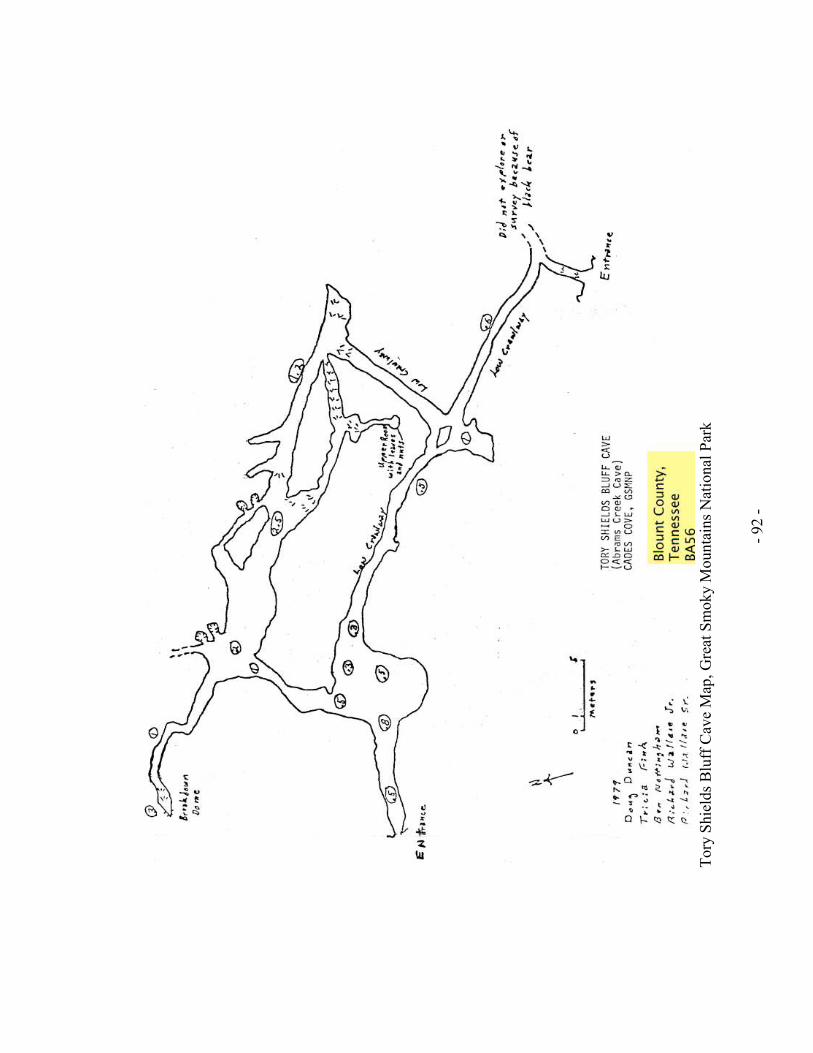
- 92 -
Tory Shields Bluff C
ave Map
, Great Smoky M
ountains National Park

- 93 -
The Bull C
ave System
Map
, Great Smoky M
ountains National Park
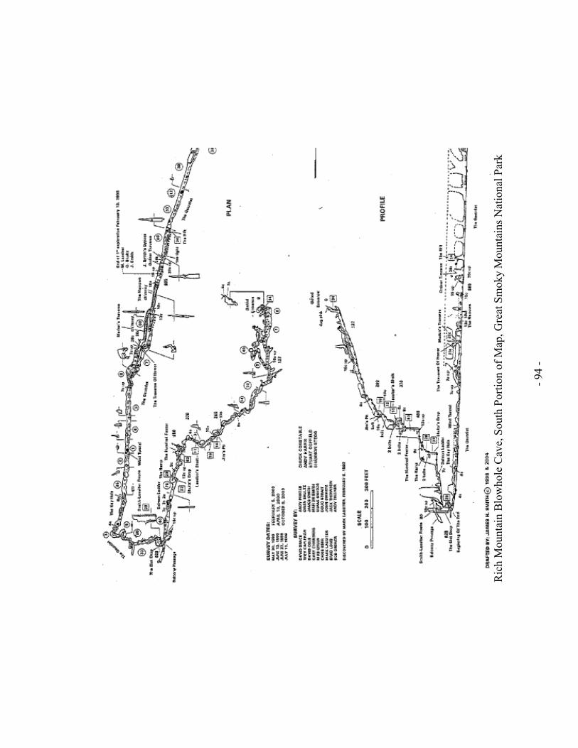
- 94 -
R
ich M
ountain B
lowhole C
ave, South Portion of Map
, Great Smoky M
ountains National Park

- 95 -
R
ich M
ountain B
lowhole C
ave, N
orth Portion of Map
, Great Smoky M
ountains National Park

- 96 -
Calf Cave No.1 Map, Great Smoky Mountains National Park

- 97 -
W
hite Oak
Blowhole C
ave Map
-Lan
dscap
e, G
reat Smoky M
ountains National Park

- 98 -
W
hite Oak
Blowhole C
ave—
Profile M
ap, Great Smoky M
ountains National Park

- 99 -
Rainbow Cave Map, Great Smoky Mountains National Park

- 100 -
Sco
tt G
ap C
ave Map
, Great Smoky M
ountains National Park

- 101 -
Appendix b. Photos Associated with Caves and Karst Resources
Gregorys Cave, Great Smoky Mountains National Park.
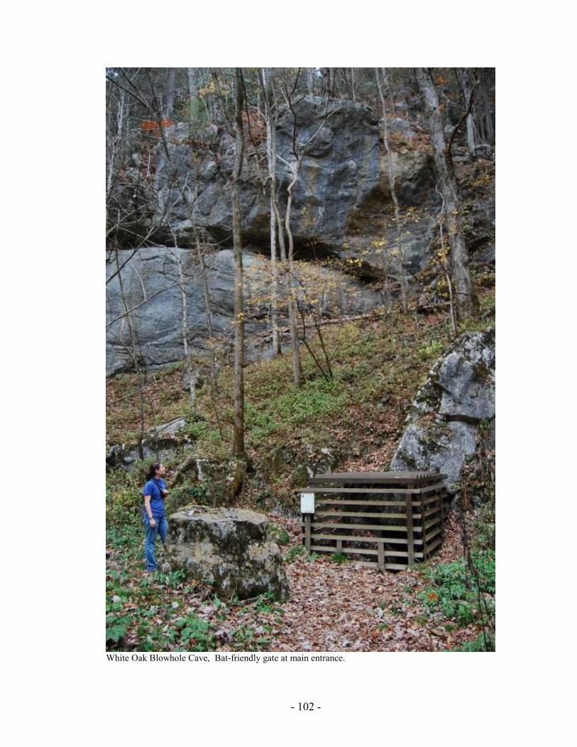
- 102 -
White Oak Blowhole Cave, Bat-friendly gate at main entrance.
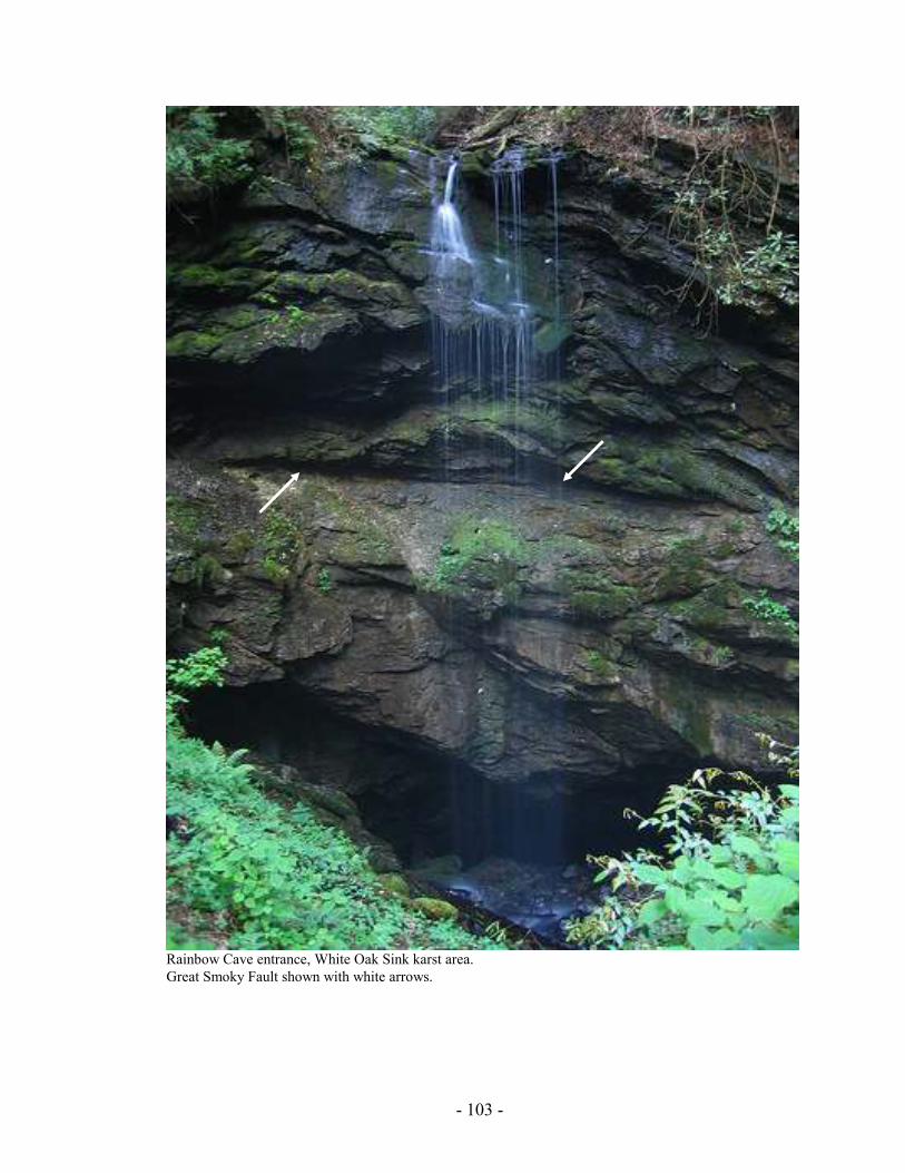
- 103 -
Rainbow Cave entrance, White Oak Sink karst area.
Great Smoky Fault shown with white arrows.

- 104 -
Sign and entrance to Whiteoak Saltpeter Cave, White Oak Sink karst area.
Sign at edge of sink, Scott Gap Cave, White Oak Sink karst area.

- 105 -
Appendix c.
Great Smoky Mountains National Park Cave Access Responsibilities
and Regulations
This form is to be signed by each person entering any cave located within Great Smoky
Mountains National Park.
Risks
Caving is a strenuous activity involving climbing, stooping and crawling. Some caves
in Great Smoky Mountains National Park require technical expertise in use of ropes and
ascending/descending equipment. Any physical condition that limits such activities may
affect your ability to safely participate in cave travel. Consider your physical or medical
conditions when deciding about your ability to safely take part in caving trips in Great
Smoky Mountains National Park. Help takes longer to reach you in the cave than it
would on the surface.
Caving is associated with hazards such as low ceilings, slippery slopes, tight squeezes,
exposed climbs and deep pits along with potential hazards such as falling rock and
hypothermia. It is easy to become lost if you get separated from your group.
Please consider these factors in deciding whether you want to join the caving trip.
Responsibilities and Regulations
1. Great Smoky Mountains National Park’s caves and features, including biological,
historic and cultural features, are protected. No cave feature will be disturbed n
any manner.
a. Cave formations, minerals and cultural items will not be removed from
the cave.
b. Cave life will not be disturbed or removed without proper permit.
c. Cave walls, formations and cultural items will not be marked, touched,
broken, damaged or altered. Any alteration of the cave must be addressed
in a permit before entering the cave.
d. Each person must be aware of their surroundings to prevent damage to the
cave.
2. All current decontamination procedures and requirements supported by the

- 106 -
USFWS must be adhered to. This includes the use of equipment and clothing
used in caves outside of the park or equipment and clothing that could be used
outside of the park. Check the USFWS’ WNS website for current procedures
prior to the day caves are permitted for entry.
3. All items brought into the cave from the surface will be returned to the surface.
This includes bodily wastes.
4. Every member of the group will:
a. Wear a helmet at all times while in the cave
b. Carry at least 3 independent, reliable sources of light.
c. Stay with the group at all times.
d. Make sure at least one first aid kit is carried with the group.
I have read and understand the risks and responsibilities associated with cave
access. I agree to abide by all park regulations for cave access.
Signature ___________________________________________ Date ______________
Additional members of trip:
______________________________________________________________________
______________________________________________________________________
______________________________________________________________________
______________________________________________________________________
______________________________________________________________________
Please print legibly or type
Name _________________________________________________________________
Address _______________________________________________________________
City _________________________________ State _____ Phone _________________
Emergency contact ______________________________________________________
Emergency contact phone _________________________________________________

- 107 -
Appendix d.
Great Smoky Mountains National Park
Cave Inventory Form

- 108 -
Gre
at S
moky M
ounta
ins N
ational P
ark
Cave Invento
ry F
orm
C
ave N
am
e:_
_________________________________
Port
ion o
f C
ave V
isited a
nd Invento
ried:_
_________
____________________________________________
Record
er:
____________________________________
Invento
ry d
ate
/tim
e:_
__________________________
Surf
ace c
onditio
ns:_
___________________________
Additio
nal pers
onnel (n
ote
those w
ho h
ave b
een in
this
cave o
r have k
now
ledge o
f re
sourc
es they w
ish
to b
e c
redited for)
:____________________________
____________________________________________
____________________________________________
____________________________________________
____________________________________________
Instr
uctions:
encourage all members of the party to read and partake
During your visit to the cave, please take note of the
resources you encounter. If you have been to this cave
before, please note any changes you notice in the condition,
numbers of resources, or its general appearance. If you are
new to the cave or have experience with cave resources such
as
geological
processes,
bio-inventories,
resource
photography, etc, please fill in any or all of the following
observation categories to better help management protect
and understand these environments. If you photograph a
feature/resource of importance, note that with a “P” and some
general
inform
ation about
the picture so that
future
investigations/comparisons can be achieved. Please list
contact inform
ation for retrieval of any photographs you are
willing to share with the NPS and you feel to be of importance
to m
anagement.
We ask that you answer what you can as honestly as you can
with the understanding that you w
ill not provide accounts of
all resources.
Computer entry date____________________________
Data entry by_________________________________
Genera
l O
bserv
ations (Physic
al)
(if a cave m
ap is present, feel free to reference it directly for
exact locations)
Wate
r (m
ake note of where the cave is dry and where
moisture is present)
Surface water entering the cave YES / NO (circle one)
Moisture________________________________________
Dripping________________________________________
Flowing_________________________________________
Pool (note size ~ LWD) ____________________________
Flood water line__________________________________
Paleo water line__________________________________
Airflow_________________________________________
(indicate direction and velocity, if possible, at notable
locations)
Flo
or
Sediment/soil____________________________________
Breakdown______________________________________
Bedrock________________________________________
Secondary deposits_______________________________
Pit_____________________________________________
Floor slots______________________________________
Potholes________________________________________
Incised m
eanders________________________________
Ceilin
g
Dome__________________________________________
Ceiling Channel__________________________________
Bell hole________________________________________
Pockets________________________________________
Natural bridge____________________________________
Pit_____________________________________________
Floor slots______________________________________

- 109 -
Potholes_________________________________________
Incised m
eanders__________________________________
Conserv
ation
Flowstone shoes required____________________________
Gloves off area____________________________________
Restoration projects (possibilities)______________________
Other____________________________________________
Obsta
cle
s
Crawl (anything difficult for rescue)_____________________
Unroped clim
b or chimney ___________________________
Pit requiring rope (describe rigging, rope length, pit depth,
quality of bolts)_____________________________________
Oth
er:________________________________________________
______________________________________________________
______________________________________________________
______________________________________________________
Form
ations
Calc
ite
Flowstone_______________________________________
Stalactite Deflected________________________________
Soda Straw_______________________________________
Stalagmite_______________________________________
Column_________________________________________
Popcorn_________________________________________
Boxwork_________________________________________
Calcite coating____________________________________
Calcite crust______________________________________
Drapery_________________________________________
Helictite_________________________________________
Heligmite________________________________________
Cave pearl(s)_____________________________________
Calcite rafts______________________________________
Rimstone dam (s)_________________________________
Spar____________________________________________
Shield___________________________________________
Ara
gonite
Stalagmite_______________________________________
Stalactite_________________________________________
Other:____________________________________________
Gypsum
Crust____________________________________________
Flower___________________________________________
Cotton/Hair________________________________________
Rope____________________________________________
Needles__________________________________________
Hydro
magnesite
Balloon___________________________________________
Moonmilk_________________________________________
Note
s:________________________________________________
______________________________________________________
______________________________________________________
______________________________________________________
______________________________________________________
______________________________________________________
______________________________________________________
______________________________________________________
______________________________________________________
______________________________________________________
______________________________________________________
______________________________________________________
______________________________________________________
______________________________________________________
______________________________________________________
Geolo
gy I
Bedro
ck (Str
uctu
ral)
Faults (strike/dip)___________________________________
Folds____________________________________________
Slickensides ______________________________________
Joints (strike/dip)___________________________________
Styolites__________________________________________
Bedro
ck (Sedim
enta
ry rock c
hara
cte
ristics)
Cross bedding_____________________________________
Bedding planes (well defined)_________________________

- 110 -
Distinctive bedding contacts__________________________
Oolites__________________________________________
Chert nodules_____________________________________
Chert layers/beds__________________________________
Shale beds_______________________________________
Sandstone beds___________________________________
Cave S
edim
ents
(w
hen p
ossib
le n
ote
thic
kness in inches
or fe
et)
Paleo
Clay/Mud_________________________________________
Mud cracks_______________________________________
Ripple m
arks______________________________________
Consolidated sand/gravel____________________________
Quartz pebbles____________________________________
Interbedded sand/gravel/mud_________________________
Organic debris____________________________________
Recent
Clay/Mud_________________________________________
Mud spatter cups__________________________________
Mud cracks_______________________________________
Ripple m
arks______________________________________
Sand____________________________________________
Gravel___________________________________________
Sand/gravel______________________________________
Quartz pebbles____________________________________
Interbedded sand/gravel/mud_________________________
Cobbles__________________________________________
Organic debris_____________________________________
Rock flour_________________________________________
Other____________________________________________
_________________________________________________
_________________________________________________
_________________________________________________
_________________________________________________
_________________________________________________
_________________________________________________
_________________________________________________
Geolo
gy II
Manganese
Coating__________________________________________
Dendrites_________________________________________
Solu
tion/C
orr
osio
n F
eatu
res
Scallops__________________________________________
Rillenkarren_______________________________________
Ceiling pendants___________________________________
Ceiling/wall cusps__________________________________
Corrosion residues_________________________________
Fluted walls/ Vadose grooves_________________________
Corr
osio
n F
eatu
res
Potholes__________________________________________
Fossils
Horn coral________________________________________
Colonial Coral_____________________________________
Brachiopods_______________________________________
Bryozoans________________________________________
Crinoids__________________________________________
Blastoids_________________________________________
Cephalopods______________________________________
Gastropods_______________________________________
Fossil hash_______________________________________
Bones___________________________________________
Teeth____________________________________________
Other____________________________________________
_________________________________________________
_________________________________________________
_________________________________________________
_________________________________________________
_________________________________________________
Note
s:___________________________________________
_________________________________________________
_________________________________________________
______________________________________________________
______________________________________________________

- 111 -
Bio
logy
Vert
ebra
tes
Bat______________________________________________
Bat bones_________________________________________
Bat guano________________________________________
Bat scratches______________________________________
Bones (specify if possible)____________________________
_________________________________________________
Mammals_________________________________________
Reptiles__________________________________________
Amphibian________________________________________
_________________________________________________
Birds (specify if possible)_____________________________
_________________________________________________
Other____________________________________________
_________________________________________________
_________________________________________________
_________________________________________________
Invert
ebra
tes
Amphipods________________________________________
Beetles___________________________________________
Centipede________________________________________
Crickets__________________________________________
Diplurans_________________________________________
Isopods__________________________________________
Harvestm
an ______________________________________
Millipede__________________________________________
Springtails________________________________________
Spider___________________________________________
Other____________________________________________
_________________________________________________
_________________________________________________
Mic
robia
l C
olo
nie
s
(color/size)________________________________________
_________________________________________________
_________________________________________________
_________________________________________________
_________________________________________________
_________________________________________________
Note
s:___________________________________________
_________________________________________________
_________________________________________________
_________________________________________________
_________________________________________________
_________________________________________________
_________________________________________________
Cultura
l/A
rchaeolo
gic
al
Art
ifacts_________________________________________
_________________________________________________
_________________________________________________
_________________________________________________
_________________________________________________
Charc
oal_________________________________________
_________________________________________________
_________________________________________________
Pic
togra
phs______________________________________
_________________________________________________
Petr
ogly
phs______________________________________
________________________________________________
Mud g
lyphs_______________________________________
_________________________________________________
Sig
natu
res
(his
toric)_________________________________________
_________________________________________________
_________________________________________________
_________________________________________________
Gra
ffiti___________________________________________
_________________________________________________
_________________________________________________
_________________________________________________
_________________________________________________
_________________________________________________
Oth
er____________________________________________
_________________________________________________
_________________________________________________
_________________________________________________
_________________________________________________

- 112 -
N
ote
s
_________________________________________________
_________________________________________________
_________________________________________________
_________________________________________________
_________________________________________________
_________________________________________________
_________________________________________________
_________________________________________________
_________________________________________________
_________________________________________________
_________________________________________________
_________________________________________________
_________________________________________________
_________________________________________________
_________________________________________________
_________________________________________________
_________________________________________________
_________________________________________________
_________________________________________________
_________________________________________________
_________________________________________________
_________________________________________________
_________________________________________________
_________________________________________________
_________________________________________________
_________________________________________________
_________________________________________________
_________________________________________________
_________________________________________________
_________________________________________________
_________________________________________________
_________________________________________________
_________________________________________________
_________________________________________________
_________________________________________________
_________________________________________________
_________________________________________________
_________________________________________________
_________________________________________________
_________________________________________________
_________________________________________________
_________________________________________________
_________________________________________________
_________________________________________________
_________________________________________________
_________________________________________________
_________________________________________________
_________________________________________________
_________________________________________________
_________________________________________________
_________________________________________________
_________________________________________________
_________________________________________________
_________________________________________________
_________________________________________________
_________________________________________________
_________________________________________________
_________________________________________________
_________________________________________________
_________________________________________________
_________________________________________________
_________________________________________________
_________________________________________________
_________________________________________________
_________________________________________________
_________________________________________________
_________________________________________________
_________________________________________________
_________________________________________________
_________________________________________________
_________________________________________________
_________________________________________________
_________________________________________________
_________________________________________________
_________________________________________________
_________________________________________________
_________________________________________________
_________________________________________________
_________________________________________________
_________________________________________________
_________________________________________________

Glossary
abiotic — of the physical and not the biological. Lacking living components.
accidental — any animal accidentally living in a cave, usually by falling in or being
washed in or otherwise taken in, not on it’s own account.
adaptation — the process of making adjustments in response to the environment.
aquatic — describes a surface or underwater habitat and the animals that live in or on it.
aquifer — a zone of the earth saturated with water.
artifact — an object produced by human workmanship.
bat — the only mammal that can fly, known for its use of echolocation to move and hunt
in the dark.
bat gate — a gate constructed at the entrance of a cave or mine, designed to prevent
humans from entering while permitting free entrance and exit of bats, other creatures and
natural airflow.
bed — a depositional layer of sedimentary rocks or unconsolidated sediment.
bedding plane — the surface between two contiguous layers of rock.
biospeleology — the study of cave life, usually cavernicoles.
breakdown — a large or small accumulation of rock filling all or part of a cave passage
after the collapse of part of the walls and ceiling.
calcite — a mineral (CaCO3) composed of calcium carbonate; the principal component of
limestone.
calcium carbonate — a compound (CaCO3) found in nature as calcite; in shells,
limestone, and used in making lime and cement.
carbonic acid — a weak acid (H2CO3) formed by water reacting with CO2, especially in
the soil.
cartography — the science and art of making maps. Modern cavers survey caves as they
explore them and later draft maps from these surveys.
cave — a natural subterranean chamber or passage that extends at least in part into total
darkness and is big enough to be entered by people. Usually formed by the solution of

- 114 -
carbonate rock in karst but can also be formed by other natural mechanical processes in
non-karst topography. It is also used as a verb suggesting, “to explore a cave”.
Cave Research Foundation (CFR) — a national organization formed to promote cave
science, which usually works in conjunction with government agencies on public lands,
particularly the National Park Service.
caver — a person who may visit caves for purposes of recreation or for basic research
activities including exploration, mapping, and photography and who generally enjoys
caves. Less commonly known as a spelunker.
cavern — an underground chamber often of large size. See cave.
cavernicole — an animal (usually invertebrates) living all or part of its life in a cave.
chert — a hard smooth rock ranging from white to black, also referred to as flint, often
found in layers of limestone. This rock was often used for tools and as a fire starter by
Native Americans and pioneers.
chiroptera — "hand-wing;" the scientific order that bats belong to.
column — a cave formation (speleothem) formed when stalactites and stalagmites grow
together, or when one of them grows all the way to the floor or ceiling.
commercial cave — see show cave.
doline — A closed depression or sink usually in a karst terrain. Also called a bling
sinkhole or simply a sinkhole (lacking any opening or entry of surface flow).
dolomite — a limestone or marble rich in magnesium carbonate. The mineral
CaMg(CO3)2.
dome — a vertical shaft in a cave as viewed from the bottom; formed by water dripping
or flowing straight down through vertical cracks. See pit.
disappearing stream — in a karst region, a river or stream that flows into a sinkhole or
crack and from there into an underground or cave river system.
discharge zone — the area where water emerges. In a cave, the discharge come out of a
spring where ground water emerges as surface water into a stream, lake, or ocean.
dissolve — to cause to pass into solution, to separate into component parts. Carbonic acid
dissolves limestone by separating the calcium and carbonate and creating a liquid.

- 115 -
drapery — a speleothem which forms when drops of water run down along a slanted
ceiling; also known as "bacon."
dye tracing — the process used by scientists to track the path and speed of water through
a cave. Environmentally safe dye is put into streams and sinkholes; then water in the cave
and at discharge areas is tested for the presence of dye and noted for the speed at which
the dye moved through the system.
echolocation — the ability of an animal to orient itself by receiving the reflection of
sounds it produces, such as with bats.
ecology — the study of the interrelationships of organisms and their environments.
endemic — a plant or animal native to a specific area and habitat and found no where
else. Examples in GRSM: Stygobromus fecundus in Gregory Cave.
endangered species — an animal or plant species whose population has decreased to the
point where it is in danger of disappearing forever. Also a federal or state legal term
noting an animal with special protections.
entrance zone — the interface between the surface and subterranean environments
leading into the cave to the twilight zone.
epigean — pertains to the environment and its components on the surface of the earth or
above-includeing streams. Opposite of subterranean.
epikarst — referes to the upper or outer most layer of well drained karstified carbonate
rock immediately below the soil.
erode — to wear away by the action of water, wind, or glacial ice.
erosion — the action or process of eroding. While weathering separates materials and
breaks them down, erosion transports materials to a new location.
evaporation — changing of liquids into a gas.
extinction — the process by which an animal or plant that once existed can no longer
survive and then can not be found alive anywhere on earth.
extirpation — the process by which an animal or plant that once lived in a region can no
longer survive in that region and can no longer be found there; usually due to mans direct
removal, habitat destruction, or pollution.
fenster (karst fenster or geologic window) — geomorphic feature formed from the erosion

- 116 -
of the overlying geology (nappe) revealing the younger underlying rock. The older rock is
left remaining as a near complete rim around and over the younger rock (examples are
Cades Cove, Tuckaleechee Cove, and Wear Cove, TN).
flint — see chert.
flowstone — a speleothem formed when water flows down walls, over floors, or over
older formations depositing calcite.
food chain/web — a series of plants and animals linked by their food relationships; for
example: a plant, a plant-eating insect, and an insect-eating bat would form a simple food
chain.
fossil — a remnant, impression, or trace of an animal or plant of past geologic ages that
has been preserved in the earth's crust.
geology — the study of the history of the earth and its life, especially as recorded in its
rocks.
groundwater — water that infiltrates the soil and is stored in slowly flowing reservoirs
(aquifers); used loosely to refer to any water beneath the land surface.
guano — the rich manure of bat dung.
gypsum — a sodium calcium sulfate mineral (CaSO4•2H2O), colorless, white, or
yellowish, found in powder or crystal form. Used for plaster, cement, and medicinal
purposes; thought to be mined by Native Americans.
habitat — the place or type of site where an animal or plant naturally or normally lives
and grows; the arrangement of food, water, shelter, and space suitable to an animal's
needs.
helictites — speleothems that grow as small, twisted structures that project at varying
angles often gravity defying.
hibernacula — places where bats or other animals hibernate, or sleep, during the winter to
conserve energy.
karst — an irregular limestone region with sinkholes, disappearing streams, underground
streams, and caves.
karstic — pertaining to karst.
limestone — a rock that is formed chiefly by accumulation of organic remains (shells or
coral), consists mainly of calcium carbonate (CaCO3); frequently contains fossils. The

- 117 -
primary rock found in caves worldwide.
mesocavern — all areas within the subteranean large enough to be accessed by a person.
Scientifically cavities in rock greater than 20cm. in diameter.
micocavern — all areas in the subterranean, usually in karst environements, too small to
admit human entry but is sufficiently sized to be habitate for much of the subterranean
fauna. Often representing the epikarst area.
mineral — an inorganic (non-living) substance occurring naturally in the earth and having
definite physical and chemical properties.
nappe — in geology, a large body or sheet of rock that has been moved, naturally, across
the surface of a younger underlying rock.
National Speleological Society (NSS) — the national caving organization formed in
1941.
obligate — refers to any species unable to live outside of the cave environment. Often has
adapted cave specific characteristics (pigment loss, reduced eyes, elongated antennae)
paleontology — the study of life from past geologic periods by examining plant and
animal fossils.
passage — in a cave, the corridor created by water and rock falls.
pH — a scientific measure of hydrogen ion activity to determine the acid or base level of
a substance.
phreatic zone — area usually below the water table where voids in the rock are
completely saturated with water.
pit — in a cave, a vertical shaft as viewed from above, formed by dripping or falling
water through a vertical crack. See dome.
popcorn — a calcite speleothem with the appearance of popcorn.
pollution — the fouling of water or air with sewage, industrial waste, or other
contaminants, making them unfit to support many forms of life.
pseudokarst — terrain resembling traditional karst including caves but lacking the karst
solution process of soluble rock.
radon — a heavy radioactive gaseous element formed by the disintegration of uranium
and thorium. It is colorless, tasteless, and odorless and found commonly in bedrock and

- 118 -
sediments. All rocks and soil, including the limestone contain varying amounts of radon.
recharge zone — the area from which a body of water is recharged
resurgance — a spring whose water can be traced previous to inception or from within the
karst landscape.
rimstone dam — thin mineral crusts formed at the edge of some cavern pools as calcite-
rich water flows over the edge.
rimstone pool — a pool formed from the development of a rimstone dam.
saltpeter (also saltpetre) — a potassium nitrate compound converted from calcium
nitrates often found and historically mined in dry caves and used in making gunpowder.
sandstone — a sedimentary rock made up of small pieces of rock, usually silicates such as
quartz, that have been cemented together over time.
scallops — spoon-shaped hollows dissolved in the cave walls, floors, and ceilings by
flowing water; the shape and size of the scallops tell scientists what direction the water
was moving and how fast.
sediment — rocks or fragments transported by wind, water, gravity, or ice; precipitated by
chemical reactions; or secreted by organisms.
sedimentary rocks — a rock formed of fragments transported from their source, usually
by water. The sediments are usually laid down in layers. Sandstone and limestone, the
two major rocks found at Mammoth Cave, are both sedimentary.
shaft — a vertical passage in a cave formed by water dripping or flowing through vertical
cracks in the bedrock.
shale — a sedimentary rock formed by the consolidation of fine particles of clay, mud, or
silt. Sometimes known as mudstone or siltstone.
show cave — a cave developed for public use, usually with paths, electric lights,
stairways, or other conveniences. Also known as commercial caves.
sinkhole — a surface depression with gently sloping walls, which is an aspect of karst
topography and which is formed by and acts as a conduit for water entering a cave
system.
soda straws — speleothems that grow on cave ceilings as thin-walled hollow tubes. They
are formed by water flowing inside the tube and depositing rings of calcite around their
tips.

- 119 -
speleology — the scientific study of the cave environment, including the physical,
chemical, and biological aspects.
speleothem — cave formations: secondary mineral deposits formed in caves, caused by
the dissolution of minerals (such as calcite) and their subsequent deposition in crystalline
form in growing layers in a variety of shapes.
spelunker — see caver.
spring — a natural flow of water from the ground, often the source of an above-ground
stream or extensive aquatic subterranean system.
stalactite — a common speleothem which hangs down from the ceiling.
stalagmite — a common speleothem which rises up from the caved floor from calcite
dripped from the ceiling.
stewardship — related to the environment, the concept of resposible care-taking; based on
the premise that we do not own the resource, but are managers of the resources and are
responsible to future generations for their condition.
stringer — A narrow vein or irregular filament of minerals traversing a rock mass.
stygobiont — the original term used to describe obligate aquatic cave life. Recent
definition covers ALL aquatic cavernicoles including accidentals (see stygobite,
stygophiles, and stygozenes).
stygobite — an obligate aquatic cave species. The aquatic equivalent of the troglobite.
stygophile — aquatic cave species which can live its life cycle both completely in the
subterranean or epigean environment. It usually lacks any traditional cave adaptations.
The aquatic equivalent of the troglophile.
stygoxene — a habitual aquatic cave species which must spend some portion of its life
cycle in a cave and may return to the surface only for food. The aquatic equivalent of the
trogloxene.
subterranean — pertaining to the underground environment in a karst or similar
environment.
sump — a point in the cave where water meets the ceiling and airflow is stopped.
survey — For the purposes of this plan, survey refers to the mapping of caves and cave
passages. This involves documenting passages using high quality instruments, which

- 120 -
make known the azimuth, inclination, and measured distance along imaginary lines in the
cave passage. This information is combined with a drawing of the cave passage, and
created to scale using the gathered information and standardized symbols in a
cartographic process to produce a map.
swallet — a stream or body of water at the point at which it enters a cave or cave system
(or generally into the karst system). This often occurs in a sinkhole.
troglobite — an animal that lives its entire life within a cave and is specifically adapted to
life in total darkness (some by losing their eyes or lacking pigmentation (color)).
Examples: isopods, amphipods and flatworms in Gregory Cave.
troglophile — animals that can live all their lives either inside or outside a cave.
Examples: salamanders, springtails, and spiders.
trogloxene — an animal that spends part of its life in caves, but must venture out for
food. These animals bring organic materials important to troglophile and troglobite
survival into the cave. Examples: Bats, bears, crickets.
twilight zone — the part of a cave near the entrance where light penetrates but does not
receive direct sunlight, extending to the zone of absolute dark. An important habitat for
many trogloxenes.
uvala — A complex closed depression formed by the coalescence of several lesser or
smaller depressions, sinks, or dolines within its rim.
vadose zone — the zone within the cave where water flows in an unsaturated
environment. Characterized by in-cave streams or water percolation within the air filled
environement.
vandalism — the willful or malicious destruction or damage of any public or private
property.
watershed — an area of land where all water collects and drains into a common body of
water (such as a river or lake).
water table — the upper level of the underground reservoir of water; the level below
which the ground is saturated.
weathering — the action of the elements in altering the color, texture, composition, or
form of exposed objects, removing material physically or chemically. Water, wind, trees,
and chemicals can cause weathering. At Mammoth Cave, the limestone is weathered by
carbonic acid.

- 121 -
wild cave — a cave in its natural state, not developed for public use, in contrast with
show caves.