National Park Service American Battlefield Protection Program Technical … · 2018-04-04 ·...
139
National Park Service American Battlefield Protection Program Technical Report “The 1676 Battle of Nipsachuck: Identification and Evaluation” GA-2255-11-016 Dr. Kevin McBride Doug Currie David Naumec Ashley Bissonnette Noah Fellman Laurie Pasteryak Lamarre Heather Manwaring Meagan Lankowsky This material is based upon work assisted by a grant from the Department of the Interior, National Park Service. Any opinions, findings, and conclusions or recommendations expressed in this material are those of the authors and do not necessarily reflect the views of the Department of the Interior. April 12, 2013
Transcript of National Park Service American Battlefield Protection Program Technical … · 2018-04-04 ·...

National Park Service
American Battlefield Protection Program
Technical Report
“The 1676 Battle of Nipsachuck: Identification and Evaluation”
GA-2255-11-016
Dr. Kevin McBride
Doug Currie
David Naumec
Ashley Bissonnette
Noah Fellman
Laurie Pasteryak Lamarre
Heather Manwaring
Meagan Lankowsky
This material is based upon work assisted by a grant from the Department of the Interior, National Park Service.
Any opinions, findings, and conclusions or recommendations expressed in this material are those of the authors and
do not necessarily reflect the views of the Department of the Interior.
April 12, 2013

Page 2 of 139 Chapter 1
Table of Contents
CHAPTER ONE: INTRODUCTION ................................................................................................................................. 4 National Park Service American Battlefield Protection Program ....................................................................... 7 Battlefield surveys ................................................................................................................................................ 7 Second Battle of Nipsachuck Site Identification and Documentation Plan .......................................................... 8 Defining Study Area and Core Areas ................................................................................................................. 11 Areas of Integrity ............................................................................................................................................... 14
CHAPTER TWO: HISTORICAL CONTEXT ................................................................................................................... 16 Brief History of the King Philip’s War (1675-1676) .......................................................................................... 16 Second Battle of Nipsachuck, July 1-2, 1676 ..................................................................................................... 32 Second Battle of Nipsachuck Combatants, Weapons, Tactics ............................................................................ 38
CHAPTER THREE: RESEARCH METHODOLOGY AND SITE IDENTIFICATION AND DOCUMENTATION ......................... 47 Battlefield Survey ............................................................................................................................................... 47 Field Methodology ............................................................................................................................................. 60
CHAPTER FOUR: KOCOA ANALYSIS ...................................................................................................................... 80 Battlefield Surveys .............................................................................................................................................. 80 Terrain Analysis ................................................................................................................................................. 80 Second Battle of Nipsachuck Study and Core Areas .......................................................................................... 82
CHAPTER FIVE: RESULTS AND BATTLEFIELD EVENT SYNTHESIS ............................................................................ 91 Battle Narrative.................................................................................................................................................. 91 Results of Fieldwork ........................................................................................................................................... 99 Battlefield Synthesis ......................................................................................................................................... 123
WORKS CITED ....................................................................................................................................................... 135 Primary Source Material ................................................................................................................................. 135 Secondary Source Material .............................................................................................................................. 137
Table of Figures
Figure I:1. Second Battle of Nipsachuck Study Area ................................................................................... 4 Figure I.2. Nipsachuck, Cat Hill, and Mattity Swamp Area ......................................................................... 6 Figure I:3. Original Second Battle of Nipsachuck 2 Study & Core Areas.................................................. 12 Figure I:4. Revised Second Battle of Nipsachuck Core Area ..................................................................... 14 Figure II:1. Towns and Locations Mentioned in Text ................................................................................ 16 Figure II:2. Talcott’s March to Nipsachuck ................................................................................................ 33 Figure III:1. Landowner Permissions and Battlefield Boundary ................................................................ 61 Figure III:2. Systematic and Judgment Surveys – Mattity Swamp Battlefield. .......................................... 72 Figure III:3. Artifacts Recovered from Systematic and Non-Systematic Sampling Methods .................... 73 Figure III:4. Artifact Yields Systematic and Non-Systematic Sampling methods ..................................... 74 Figure III:5. Shovel Test Pit and Excavation Unit Locations ..................................................................... 77 Figure IV:1. Mattity Swamp Battlefield Core Area Key Terrain Features ................................................. 83 Figure IV:2. Mattity Swamp Key Terrain Features .................................................................................... 89 Figure V:1. Hypothesized Routes of March ............................................................................................... 93 Figure V:2. Viewshed from Black Plain Hill .............................................................................................. 95 Figure V:3. Viewshed from lower elevation of Cat Hill ............................................................................. 96 Figure V:4. Viewshed from Unnamed Hill ................................................................................................. 97 Figure V:5. Viewshed from Nipsachuck Hill ............................................................................................. 98 Figure V:6. All Seventeenth Century Objects. ......................................................................................... 100 Figure V:7. Musket balls recovered from Nipsachuck ............................................................................. 102 Figure V:8. Volley of small shot ............................................................................................................... 102 Figure V:9. Musket Ball with Firing Hemisphere (.45 diameter) ............................................................. 104
Page 3 of 139 Chapter 1
Figure V:10. Distribution of Musket Balls by Diameter ........................................................................... 106 Figure V:11. Distribution of Musket Ball Diameters by Quantity. ........................................................... 106 Figure V:12. Distribution of Musket Balls by Diameter ........................................................................... 107 Figure V:13. Distribution of Musket Balls by Diameter ........................................................................... 110 Figure V:14. Musket Balls by Type; Blocks with Direction of Fire (See Figure V:15) ........................... 111 Figure V:15. Direction of Fire Northern Approach .................................................................................. 112 Figure V:16. Direction of Fire Southern Approach .................................................................................. 113 Figure V:17. A: Hand Wrought Object; B: Shoeing Nail; C: Cuprous Object (Narragansett) ................. 114 Figure V:18. Narragansett Domestic Objects: A, Cuprous Bell; B, Cut Brass; C, Jaw Harp; Iron Hook; E,
Cuprous Pendant ....................................................................................................................................... 115 Figure V:19. Native Made Cuprous Object .............................................................................................. 115 Figure V:20. A, Straight Knife; B, Unknown Object ............................................................................... 116 Figure V:21. A-C Pewter Buttons, D Cuprous Button, E Cuprous Aglet, F Bridle Rosette ..................... 116 Figure V:22. Possible Seventeenth Century Horseshoes .......................................................................... 117 Figure V:23. Horseshoes Recovered from Wheeler’s Surprise Battlefield .............................................. 118 Figure V:24. Lead Gunflint Wrap for a Bifacial Gunflint ........................................................................ 118 Figure V:25. Flint Wrap and Bifacial Gunflint ......................................................................................... 119 Figure V:26. Bifacial Gunflint Left and Middle, Bifacial Gunflint Fragment .......................................... 119 Figure V:27. Flintlock Jaw Marks ............................................................................................................ 120 Figure V:28. Military and Domestic Objects and Narragansett Encampments (1-4) ............................... 122 Figure V:29. English-allied Routes of Attack ........................................................................................... 125
Tables
Table III:1 Second Battle at Nipsachuck Battlefield Timeline ................................................................... 55 Table IV:2. KOCOA Definitions and Battlefield Evaluation System ........................................................ 81 Table IV:4. Speed and Timing of Dragoon attack across Cat Hill Plain .................................................... 86 Table IV:5. Table Critical Defining Features. Mattity Swamp Core Area ................................................. 90
Table V:6. Objects by Group Association. ................................................................................................. 99 Table V:7. Quantity and Percentage of Recovered Musket Balls ............................................................. 103

Page 4 of 139 Chapter 1
Chapter One: Introduction
The Second Battle of Nipsachuck (Battle of Mattity Swamp) on July 2, 1676 was the
culminating action of Connecticut’s six-month campaign against the Narragansett during the
latter half of King Philip’s War (late December 1675 – early July 1676). The battle began one
hour after dawn when a force of 300 Connecticut dragoons (mounted infantry) and 100 Mohegan
and Pequot enveloped and attacked the village of the Narragansett Sunk Squaw Quaiapan killing
and capturing over 170 men, women, and children in the three-hour battle. From the perspective
of the Narragansett and their allies, the surprise attack was a devastating blow that claimed many
lives, including that of the Sunk Squaw Quaiaipan, the last of the principal Narragansett sachems
to be killed or captured by the English, and several of her lieutenants. The attack doomed a
possible opportunity to negotiate peace, and Quaiapan’s death effectively ended Narragansett
resistance.
The battle is notable for the sophistication and execution of a very complex and highly
coordinated battle plan that involved a simultaneous coordinated attack by the dragoons and their
Native allies; the only horse-mounted attack of King Philip’s War. The attack is also of interest
with respect to the evolution, sophistication, and coordination of English tactics that
characterized the latter half of the war. Earlier engagements such as the First Battle of
Nipsachuck (August 1, 1675), one year previous to the Second Battle was characterized by a lack
of aggression from Plymouth Colony Colonial forces, poor planning and execution of the battle
plan, and ineffective deployment of Native allies from Colonial commanders.
Figure I:1. Second Battle of Nipsachuck Study Area

Page 5 of 139 Chapter 1
The Second Battle of Nipsachuck illustrates the evolution in the complexity,
sophistication, and effectiveness of English tactics (particularly among Connecticut’s dragoon
companies) as well as the aggressive attack and pursuit strategy employed by Connecticut forces
throughout the war. Connecticut was the first colony to field fully integrated units of Colonial
and Native soldiers throughout the war; a strategy that greatly contributed to the overall success
of Connecticut’s King Philip’s War.
In recognition of the historical and cultural importance of Nipsachuck, the need to
identify where and protect the site(s) of the Second Battle of Nipsachuck at Cat Hill and
Mattekonnit (Mattity) Swamp and the potentially associated ceremonial area at nearby
Nipsachuck Hill (Figure I.2), the Rhode Island Historical Preservation & Heritage Commission
(RIHPHC), the Narragansett Indian Tribal Historic Preservation Office (NITHPO), and the
Blackstone Valley Historical Society (BVHS), received a National Park Service American
Battlefield Protection Program (NPS ABPP) grant “Second Battle of Nipsachuck, Site
Identification and Documentation” (GA-2255-11-016) to identify and document the Second
Battle of Nipsachuck (Mattity Swamp Battlefield) and the potentially associated ceremonial area
located at Nipsachuck Hill one mile to the south (Figure I.2 ).
This Technical Report summarizes the research, methods, and results of the battlefield
archeology survey of the Nipsachuck Battlefield and the Nipsachuck Ceremonial Area. The
battlefield survey identified approximately 150 battle-related and domestic objects within the 67-
acre battlefield bounded in part by Cat Hill on the west and Mattity Swamp on the north, east,
and south (Figure I.2). The nature and distribution of battle-related artifacts documents the
avenues of attacks by the two wings of dragoons and their Mohegan and Pequot allies, the initial
envelopment of the Narragansett camp, the pursuit of the Narragansett as they retreated into
Mattity Swamp, and the encirclement and final phase of the battle. The survey of the Nipsachuck
Ceremonial Area identified a stone enclosure (wall) encompassing an area of approximately two
acres containing approximately 265 stone features (see Appendix II). This Technical Report
includes the following chapters; I: Introduction; II: Historical Context; III: Research
Methodology, Site Identification & Documentation; IV: KOCOA Analysis; V: Results; and VI:
Works Cited.

Page 6 of 139 Chapter 1
Figure I.2. Nipsachuck, Cat Hill, and Mattity Swamp Area
Nipsachuck Hill
Cat Hill
Mattity Cedar Swamp
Mattity Spruce Swamp
Nipsachuck Ceremonial Area
Mattity Swamp Battlefield
Black Plain Hill

Page 7 of 139 Chapter 1
National Park Service American Battlefield Protection Program
The NPS ABPP promotes the preservation of significant historic battlefields associated
with wars on American soil. The purpose of the program is to assist citizens, public and private
institutions, and governments at all levels in planning, interpreting, and protecting sites where
historic battles were fought on American soil during the armed conflicts that shaped the growth
and development of the United States, in order that present and future generations may learn and
gain inspiration from the ground where Americans made their ultimate sacrifice. The goals of the
program are: 1) to protect battlefields and sites associated with armed conflicts that influenced
the course of American history, 2) to encourage and assist all Americans in planning for the
preservation, management, and interpretation of these sites, and 3) to raise awareness of the
importance of preserving battlefields and related sites for future generations.
Battlefield surveys
Battlefield surveys are an important aspect of historic preservation as many significant
battlefield sites are destroyed or negatively impacted through ignorance of their location and
significance. Many battlefields might be preserved if the property owner or the community were
aware of their existence and were informed of the significance of the battlefield and its
contribution to a broader understanding and appreciation of history. Preserved battlefields and
related historic sites can add to a community’s sense of identify and foster a greater interest in
history and preservation efforts. The identification, documentation, and mapping of a
battlefield’s historic and cultural resources are an essential first step for battlefield preservation
efforts. The long-term preservation goal of the Second Battle of Nipsachuck project is to
nominate significant sites to the National Register of Historic Places, educate the public on the
importance of the Battles at Nipsachuck and associated ceremonial areas and develop a long-
term historic preservation program for King Philip’s War battlefield sites and ceremonial areas.
The first step in battlefield preservation is to delineate the extent of the battlefield based
on the nature and distribution of battle-related objects (e.g. musket balls, brass arrow points,
firearms/firearm parts, dropped and broken equipment), relevant cultural (e.g. roads, bridges,
towns) and physical landscape features (e.g. hills, swamps, rivers), and conduct an assessment of
the integrity of the battlefield. This process requires establishing a boundary around the

Page 8 of 139 Chapter 1
battlefield that encompasses all relevant artifacts and cultural and physical features into an
appropriately scaled topographic base map using Geographic Information Systems (GIS). The
boundary must be defensible based on historical and archeological evidence and source materials
(i.e. documents, field survey, terrain analysis and archeological surveys), and encompass
legitimate historic resources. Three boundaries are created for a battlefield: Study Area, Core
Area, and Areas of Integrity.
The NPS ABPP has developed an approach to research, document, and map battlefields
that has proven to be highly successful.1 These methods were originally developed for Civil War
battlefields and later applied to many Revolutionary War battlefields. The seventeenth century
battlefield of Nipsachuck present unique challenges for historians and battlefield archeologists to
research, survey, document, and delineate battlefield boundaries given the nature of seventeenth
century sources, and the low density and frequency of artifacts associated with seventeenth
century battlefields in North America. Nonetheless, the methods outlined in Chapter II were very
successful in documenting the nature and extent of the Second Battle of Nipsachuck.
Second Battle of Nipsachuck Site Identification and Documentation Plan
The Nipsachuck battlefield survey focused on identifying and documenting the
location(s) and boundaries(s) of the movements, sites and actions associated with Second Battle
of Nipsachuck. The battle began one hour after sunrise when a force of 300 Connecticut
dragoons and 100 Pequot and Mohegan conducted a successful surprise attack on a Narragansett
camp of at least 170 people. One hundred and twenty-five Narragansett (mostly women and
children) were killed in the battle and 45 were reported captured. The battle was a well-planned
and coordinated attack that can be broken into eight distinct phases or sequences: 1) the approach
of the English dragoons and Pequot/Mohegan to Nipsachuck; 2) Allied Encampment; 3)
Reconnoiter of the Cat Hill/Mattity Swamp area; 4) Allied Advance and Initial attack; 5)
Envelopment of Narragansett camp/domestic areas; 6) Pursuit of the Narragansett into Mattity
Swamp; 7) Encirclement of Mattity Swamp; and 8) Final Phase of the battle in Mattity Swamp.
1 American Battlefield Protection Program, Battlefield Survey Manual (Washington, DC: National Park Service,
revised 2007).

Page 9 of 139 Chapter 1
An important aspect of the survey was to identify and map Key Terrain features (defining
cultural and natural features of the battlefield landscape that influenced the nature, progression,
and outcome of the battle), as well as to identify and document the sites, actions, and movements
of the combatants in relation to the battlefield landscape through KOCOA (Key and Decisive
Terrain, Observation and Fields of Fire, Cover and Concealment, Obstacles, Avenues of
Approach and Retreat standards (Table IV.2).2 The critical defining battles, sites and features
were mapped using GPS and GIS technology, surveyed using geophysical equipment, and
archeologically tested and excavated.
One of the important contributions of the Nipsachuck battlefield survey was the methods
developed by battlefield staff to reconstruct a seventeenth century battlefield, a rare
accomplishment. Douglas Scott’s pioneering approach to battlefield archeology developed at the
Battle of the Little Big Horn was adapted to the seventeenth century battlefield at Nipsachuck,
eventually resulting in a dynamic reconstruction.3
There were four crucial factors in the ultimate success of the project. First, was the
support and active participation of the Native American representatives from the Narragansett,
Mohegan, Nipmuc, Mashantucket Pequot, Eastern Pawcatuck Pequot, and Aquinah and Mashpee
Wampanoag Tribes. Tribal representatives, and particularly representatives from the
Narragansett Indian Tribal Historic Preservation Office, would visit the battle and ceremonial
areas regularly offering valuable insight and advice on the process of battlefield survey and
reconstruction and in the identification of potentially significant ceremonial features and
landscapes at Nipsachuck and Cat Hills. Second, the support of the landowners at Cat Hill and
Nipsachuck made virtually the entire battlefield and ceremonial area accessible to battlefield
archaeologists. Landowners also provided important information on the nature of land usage on
their properties. Third, the participation and experience of members of the Yankee Territory
Coinshooters (YTC) metal detecting club was crucial in discriminating and recovering potential
battle-related artifacts from some of the most challenging landscapes ever encountered in
battlefield archeology. The Nipsachuck battlefield contained thousands of eighteenth through
2 See Chapter IV: KOCOA, Table IV.1.
3 Douglas D. Scott, Archaeological perspective on the Battle of the Little Bighorn (Norman, OK: University of
Oklahoma Press, 1989).

Page 10 of 139 Chapter 1
twentieth century artifacts, often “hiding” battle-related objects from less experienced
archeological crew members. The YTC members were tireless in their efforts to revise their
methods, techniques, and technologies to the complexities of battlefield archeology on a modern
landscape, and to train and mentor crew members.
The Nipsachuck battlefield was particularly challenging because of the mineralized soils
and rock that occurred throughout the area reducing the ability of some metal detectors (and less
experienced crew) to discriminate between real artifacts and hot rocks. No less a challenge was
conducting a metal detector survey within Mattity Swamp due to the presence of oxidized soils
and bog iron. In some areas of the swamp, 1-2 feet of water overlay swamp muck that was 2-3
feet deep. The project got a significant “technological” boost in this respect when the Minelab
Company loaned the MPMRC a Minelab GPX 4000. This state of the art technology (YTC
employed some as well) was highly effective in the difficult conditions at the Nipsachuck
Battlefield and outperformed all other technologies, serving as a check and balance to assess the
effectiveness the other types of detectors and of the overall sampling strategy.
Finally, the facilities of the Conservation Department of the Mashantucket Pequot
Museum and Research Center, and particularly the expertise of Head Conservator Douglas
Currie, were instrumental in identifying many of the battle-related artifacts recovered from
Nipsachuck. Currie culled through dozens of images of potential battle-related ferrous objects
brought in from the field, using radiography (X-Ray technology) to see through the accumulated
oxides masking the object’s nature, form, and details. The final step in this process was the entire
battlefield staff’s growing expertise during the ongoing process of the identification and analysis
of late seventeenth century military and domestic material culture presented.

Page 11 of 139 Chapter 1
Defining Study Area and Core Areas
Defining Study and Core Areas of the battlefield is a critical part of the battlefield
documentation process4. The Study Area of a battlefield is defined as the maximum delineation
of the historical site. The Study Area should contain all places related or contributing to the
battle event: where troops maneuvered, deployed, and fought immediately before, during, and
immediately after combat. The Study Area functions as the tactical context and visual setting of
the battlefield. The natural features and contours on relevant USGS 7 ½’ quadrangle maps are
used to outline a Study Area and include all those locations that directly contributed to the
development and conclusion of the battle. The Study Area should include the following:
Core Areas of combat (see Core Area below);
Approach and withdrawal routes of the combatants;
Locations of any deployed units of the combatants on the field, even if these units were
not engaged;
Preliminary skirmishing if it led directly to the battle; and
Logistical areas of the engaged armies, i.e. locations of ammunition trains, hospitals, and
supply dumps.
The Study Area should be restricted to the immediate flow of battle after one side or the
other has moved to initiate combat. For example, if a unit left its encampments in the night
intending to attack the enemy at dawn, it would be appropriate to include these encampments in
the Study Area as the initial position of the attacking force. The route of the previous day's
march to reach these encampments would not be included. The Study Area should end where the
armies disengaged. Forces may have disengaged under orders, due to darkness or adverse
weather conditions, the pursuit of a retreating force that was halted by a rear guard action, or
because one force accomplished its objective and chose not to pursue its retreating foe. The Core
Area of a battlefield is the area of direct combat and includes those places where the opposing
forces engaged and incurred casualties. The Core Area should always fall fully within the Study
Area. The natural features and contours on the USGS quad help to define a Core Area that
contains the areas of confrontation, conflict, and casualties. Natural barriers, such as rivers,
4 ABPP, Battlefield Survey Manual Pp. 28-29.

Page 12 of 139 Chapter 1
creeks, swamps, hills and ridges often restrained the movement of the armies, sometimes
providing a natural landscape or topographical boundary for the battlefield.
Figure I:3. Original Second Battle of Nipsachuck 2 Study & Core Areas
The original Second Battle of Nipsachuck Core Areas (Mattity Swamp Battlefield Core
Area 1, Nipsachuck Swamp Battlefield Core Area 2, Nipsachuck Ceremonial Core Area 3, Cat
Hill Ceremonial Core Area 2, and Black Plain Ceremonial Core Area 1) as defined in the Final
Technical Report “The Battles of Nipsachuck: Research and Documentation” (GA-2255-09-023)
and identified in Figure I.3 were revised following the results of the battlefield survey.
Page 13 of 139 Chapter 1
The Nipsachuck Swamp Battlefield Core Area 2 (perhaps associated with the First
Battle of Nipsachuck) is also no longer defined as a battlefield core area as no survey
was conducted to identify potential battlefield sites.
The Ceremonial Core Areas do not meet the definition of a battlefield Core Area, as
they cannot be defined as areas of direct combat.
Based on archaeological results, the Study Area now contains a revised Mattity
Swamp Battlefield Core Area 1.
The boundaries of the Mattity Swamp Battlefield Core Area 1 identified in this Final
Technical Report were revised based on the battlefield survey. Boundaries of the revised Mattity
Swamp Battlefield Core Area were defined by the historic extent of the battlefield based on the
nature and distribution of battle-related military and domestic artifacts and key terrain features.

Page 14 of 139 Chapter 1
Figure I:4. Revised Second Battle of Nipsachuck Core Area
This Study Area also contains unidentified sites and movements, such as the
English/Pequot/Mohegan encampment, routes of approach and withdrawal taken by the English
and Native allies, and the routes of retreat taken by the Narragansett, as some likely survived and
escape the battle.
Areas of Integrity
The Areas of Integrity delineate those portions of the historic battlefield landscape that
still convey a sense of the historic scene (retain visual and physical integrity) and remain to be
preserved. Any areas of the Study and Core Areas that have been impacted or otherwise
compromised by modern development, erosion or other destructive forces that can no longer

Page 15 of 139 Chapter 1
provide a feeling of the historic setting are excluded from Areas of Integrity. However, some
battlefields in suburban areas may still retain integrity and significance if artifacts or other
archeological information (e.g. camp fires, ditches, etc.) are still present. In such instances, the
presence of houses may affect the feeling of the historic setting but information is present that
will contribute to the significance of the battlefield. The Mattity Swamp Battlefield contains 11
different lots ranging from a few acres to over 20 acres. While many of the lots contain houses,
none were constructed within the historic limits of the battlefield.
The Nipsachuck battlefield retains physical elements that convey a sense of the historic
battlefield, particularly Cat Hill, Mattity Swamp, and the level landscape in between. Impacts to
the Mattity Swamp Battlefield from over 300 years of cultural land use include limited plowing,
logging, a horse ranch, hunting, and most problematic during remote sensing – target shooting.
While these activities result in numerous objects deposited across the battlefield landscape, the
project’s archeological testing and remote sensing found that the integrity of the battlefield’s
physical landscape, i.e. its topography and wetlands, is intact.

Page 16 of 139 Chapter 2
16
Chapter Two: Historical Context
Brief History of the King Philip’s War (1675-1676)
King Philip’s War (June 1675 – August 1676), sometimes called the First Indian War,
Metacom’s War, Metacomet’s War, or Metacom’s Rebellion, was an armed conflict between
dozens of Native American tribes and bands who inhabited (and still do) present-day southern
New England and English colonist from the colonies of Connecticut, Massachusetts Bay, and
Plymouth, and their Native American allies (principally Mohegan, Pequot, Tunxis, and Western
Niantic of Connecticut and Christian Indians in Massachusetts). The war is named after the
Pokanoket sachem Metacom, known to the English as "King Philip" as the war began in
Plymouth Colony, homeland of the Pokanoket.
Figure II:1. Towns and Locations Mentioned in Text
Page 17 of 139 Chapter 2
17
King Philip’s War began on June 25, 1675 when a group of Metacom’s men attacked and killed
several English at Swansea, after a colonist fired on some Indians robbing a house the day
before, killing one. This is often considered as the first bloodshed of the war.
The escalating tensions that led directly to the war began when Plymouth Colony
executed and hung three Pokanoket men several months earlier and initiated a sequence of events
that engulfed New England in a full-scale war within six months. By August, the conflict spread
to Nipmuc bands of central Massachusetts and northeastern Connecticut and the Pocumtuck of
central Connecticut River Valley. By the end of 1675, the majority of Native peoples of central
and western Massachusetts, Rhode Island, and eastern Maine were at war with the English.
Dozens of frontier towns in central Massachusetts and the Connecticut Valley were
attacked and burned during the war as were settlements in Providence Plantations, Plymouth
Colony and eastern Massachusetts. Colonial authorities estimated that 600 English were killed
and 1,200 houses burned during the war. A minimum of 3,000 Native men, women, and children
were battle casualties, and thousands more died from disease, starvation, and exposure or were
sold into slavery.5 The conflict is often referred to as the deadliest in American history based on
English and Native civilian and military casualties relative to population.6 The war in southern
New England ended when English soldiers and their Native allies killed Metacom at Mount
Hope in present-day Bristol, Rhode Island on August 12, 1676. The war continued in northern
New England (primarily on the Maine frontier) until a treaty was signed at Casco Bay in April of
1678.
One of the most important events in the war was a preemptive attack on December 19,
1675 by the United Colonies (Connecticut, Massachusetts, Plymouth) on the Narragansett in
South Kingston, Rhode Island (Great Swamp Fight). Frustrated with Narragansett overt and
covert support of the Pokanoket and other Wampanoag bands under Metacom, the United
Colonies sent an army of 1,000 soldiers and 150 Mohegan and Pequot allies against the
Narragansett fortified encampment of almost one thousand people from several Narragansett
5 John Romeyn Brodhead, Ed. Documents Relative to the Colonial History of the State of New York (Albany, NY:
Weed, Parsons, and Company, 1855). Pp. 3:243-244. 6 Douglas Leach, Flintlock and tomahawk; New England in King Philip’s War (New York, NY: Macmillan, 1958).

Page 18 of 139 Chapter 2
18
bands. As many as 600 Narragansett died in the attack, and hundreds more may have died from
exposure in the severe winter weather. Several of the principal sachems of Narragansett may
have been in the fort (and survived) including Pessicus, Canonchet, and Quaiapan. The English
suffered more than 170 wounded and killed in action and many more died from exposure during
the retreat in blizzard conditions or from their wounds sometime after.
The attack on the Narragansett drew the most powerful Native group in southern New
England into direct conflict with the English. It also exposed the lack of training, cooperation,
and logistical support among the United Colonies in such a large-scale operation during the first
half of the war; a situation that was rectified in subsequent months. More importantly, the attack
exposed Connecticut’s eastern frontier to attack from Narragansett country threatening the
settlements at Stonington and Norwich. While some of the Narragansett leaders such as Pessicus,
Canonchet, Ponham, Panoquian, and Quaiapen and their bands fled into Nipmuc country and the
Connecticut River Valley, many other Narragansett stayed in their country to protect their stored
supplies of corn, and to keep pressure off their leaders who retreated north and west to continue
the fight.7 For a short while both Massachusetts and Connecticut conducted separate military
operations in Narragansett country against the remaining bands, but increasingly Massachusetts
Bay forces focused their attention on their vulnerable settlements in central Massachusetts and
the Connecticut River Valley.
Although Connecticut conducted many military operations against the northern enemy in
central Massachusetts and the Connecticut River Valley throughout the fall, winter, and spring of
1675-1676, the Connecticut War Council increasingly turned their attention east to Narragansett
country and potential attacks from that quarter on the settlements at Norwich and Stonington. For
the six-month period between late December 1675 – and late July 1676, Connecticut dragoons
with Mohegan and Pequot from New London County fielded a military presence in Narragansett
Country.
7 William Hubbard, A Narrative of the Troubles with the Indians in New-England (Boston, MA: John Foster, 1677).
P. 38.

Page 19 of 139 Chapter 2
19
Narragansett Campaign: January – August 1676
The Second Battle of Nipsachuck is best understood in the context of Connecticut’s
overall political and military objectives during the war, and more specifically the goals and
objectives of Connecticut’s campaign against the Narragansett in the wake of the Great Swamp
Fight. The campaign appears to have had political, as well as military objectives. In December
1675, Connecticut, and to a much lesser extent Massachusetts Bay, sent several expeditions into
Narragansett country to put pressure on the Narragansett and prevent them from regrouping after
the Great Swamp Fight. The Commissioners of the United Colonies sent two letters to the
Connecticut Council in January urging them to vigorously pursue the Narragansett:
No doubt but it will be difficult for you, all things considered, to rayse so many
new forces, but how it will be avoyded, we see not, for we cannot but thinke,
should there be too long a cessation after we have made such a beginning, or
should we proceed with too weake a hand, the enemy being now conjoyned & so
numerous, there will be more advantage & tyme lost than will easyly be ever
recovered again.8
We had a deep sense of the necessity that the present opportunity for the subduing
of the enemy be vigorously prosecuted, they being now united into one body ; for
that, if through any neglect or slackness on o'' part, they have again the benefit of
the warme spring to scatter, Wee may feare that the event thereof will be that the
lives & habitations of multitudes of the English must go for theire lives.9
Connecticut did not send a large force consisting of hundreds of dragoons into
Narragansett Country as they frequently did into the Connecticut Valley or Nipmuc country
during this period. Instead the War Council relied heavily on smaller troops of 60-80 Dragoons
and Mohegan and Pequot to maintain on the pressure on Narragansett Country. When Talcott’s
force of 300 dragoons and 100 Pequot and Mohegan attacked Quaiapan’s village at the Second
Battle of Nipsachuck, it was the largest English force to enter Narragansett country since the
Great Swamp Fight.
Thomas Minor of Stonington, a veteran of the Pequot War and Lieutenant of Dragoons
for New London County during King Philip’s War, participated in more than a dozen
expeditions into Narragansett country between January and August 1676 as related in his diary
8 John Hammond Trumbull, Public Records of the Colony of Connecticut; From 1665 to 1678 with the Journal of
the Council of War 1675 to 1678 (Hartford, CT: F.A. Brown, 1852). P. 2:391. 9 Trumbull, Colony of Connecticut. P. 2:391.

Page 20 of 139 Chapter 2
20
excerpted below. These expeditions generally consisted of 60-80 dragoons and anywhere from
20-40 Mohegan and Pequot (the Mohegan and Pequot still had to support Talcott’s expeditions).
These expeditions averaged about one week; the length of time was constrained by the amount of
food and supplies the soldiers could carry for themselves and their horses. Between March and
early July, the dragoons sent expeditions into Narragansett country every other week. The
Narragansett who chose to remain on their lands were under continual attack from Connecticut
dragoons and their Native allies. These forces killed, captured, or drove away hundreds of
Narragansett men, women, and children and recovered hundreds, if not thousands, of bushels of
stored corn and beans with devastating effects on the Narragansett.
The captured supplies eased the strain on local commissaries that often struggled to feed
and equip Connecticut troops, and additionally denied the Narragansett desperately needed food
supplies. When Narragansett sachem Canonchet (Nanonanto) was captured by a force of
Mohegan, Pequot, and New London Dragoons (Minor was present) at Coweeset (six miles south
of Providence on the western side of Narragansett Bay) and executed in Stonington in early April
1676, it was said he had returned from the Connecticut Valley to recover seed corn to plant at
Squakheag (Northfield, Massachusetts).10
Minor’s diary entries for the six-month campaign record the frequency and regularity of
the expeditions into Narragansett country. Thomas Minor, December 9 – August 4, 1676: 11
133: 1675-12-09 - all The souldiers were to be billeted at the Contries Charge
horse and man
133: 1675-12-15 - Coneticut Amrie set forth from mr Richardsons from the .8. of
December to the .8. of ffebruarie I was Imployed in the
Contries service about the Indean war besides 8 days in the
summer hors and man and my white hors Ten days being prest
for John gallop
133: 1676-01-24 - the Rest of this moneth I spent in the war the .17. of ffebruarie
1675. the souldiers were apoynted to goe forth
134: 1676-02-07 - I came whome from the war
134: 1676-02-08 - wee came from the meeting at New London about the souldiers
10
Trumbull, Colony of Connecticut. P. 2:391. 11
Thomas Minor, (John A. Minor, Ed.) The Minor Diaries Stonington, Connecticut (Ann Arbor, MI: Edward
Brothers, 1976). P. 136. Queenstown was an Eastern/Pawcatuck Pequot village in Stonington under the sachem
Mamoho. The Natives mentioned may have been Narragansett taken at Nipsachuck.

Page 21 of 139 Chapter 2
21
goeing out wensday
134: 1676-02-16 - the Constable Tould me y thee was to provide .12. souldiers of
this Towne for Captayne Denison
134: 1676-02-29 - I was at New London they were making up theyr accounts with
the Contrie for the souldiers
134: 1676-04-15 - wee were preparing for another Jorney to the Indeans at
Narraganset
134: 1676-04-17 - to meet at Meshuntupit
134: 1676-04-22 - wee wer at Cooeeset
135: 1676-05-02 - the .2d. .3d. and fouerth days I was at New London and
brought amonition and bread for the Expedition to the Indeans
135: 1676-05-08 - wee went to meshuntuck
135: 1676-05-15 - wee came from providence
135: 1676-05-16 - New London souldiers went whome
136: 1676-06-15 - wee were to meet all the souldiers at steeven Richardsons
house sabeth day
136: 1676-06-18 - the souldiers came whome to Stoneingtone
136: 1676-06-24 - midsummer day: samuell came whome from the armie Tusday
136: 1676-06-27 - samuell went forth Interpreter to the Armie the second time
136: 1676-07-05 - samuell came whome from the Armie wick
136: 1676-07-08 - was saterday Captayne Denison was heare
136: 1676-07-22 - saterday I ffetched whome the prisnors from the queens Towne
136: 1676-07-23 - the Armie marched of from mashantuckset
137: 1676-08-09 - wensday stoneington souldiers came whome
The expeditions sent against the Narragansett during this period accomplished several
important objectives; militarily, they killed or captured hundreds of the enemy and denied them a
safe haven, prevented attack from that quarter on the settlements at Norwich and Stonington, and
denied the Narragansett badly needed food supplies while supplementing their own. Politically,
Connecticut’s defeat of the Narragansett would substantially bolster their case in their territorial
dispute with Rhode Island by claiming Narragansett territory by the doctrine of Right of
Conquest. The English tactics employed in the Narragansett Campaign may have been intended
to accomplish more than simply eliminate the enemy threat; perhaps the desired outcome was to
eliminate the Narragansett entirely in order to remove them from the landscape for English
settlement and land claims.
Throughout the 1660s and 1670s, Connecticut and Rhode Island were involved in a bitter
and sometimes violent dispute over the boundary between the two colonies and Connecticut’s
claims to large areas of Narragansett country. While King Philip’s War put a temporary hold on

Page 22 of 139 Chapter 2
22
the dispute, it was renewed a few weeks after the war ended.12
On August 22, 1676, Connecticut
War Council ordered the following letter to be published in Hartford, New London and in
Narragansett country:
Foreasmuch as all the lands in Narragansett country doe lye and are circumscribed
within the known limits of our [Connecticut] charter, viz. from Narragansett Bay
on the &c…which have been and are now recovered out of the hands of the
Indian enemies that had victorized over or caused the people to desert all those
lands which they had possessed themselves of, formerly…and the tract or territory
more exposed to devastation, and so is now become a vacuum domicilium; but
this late recovery being obtained by conquest and success of war unto ourselves
and our confederates. – the Council seems cause to declare unto all such person or
persons there, upon the said deserted or vanquished lands in that country, that all
such shall make their application to the government of this colony…13
Narragansett Peace Overtures
Doug Harris (NIHPO) has suggested that Connecticut’s attack on Quaiapan’s village at
Cat Hill was a direct attempt by Connecticut to derail her peace overtures to the United Colonies
and thereby furthering Connecticut’s claim to Narragansett country by Right of Conquest. The
first peace overtures by the Narragansett were just before the Great Swamp Fight, but were
dismissed as a delaying tactic so the Narragansett could move their women, children, and
supplies to safety. Following the Great Swamp Fight, many of the principal Narragansett
sachems including Pessicus, Canonchet, Ponham (Panoquian), Canonicus, and at times Quaiapan
withdrew to the Connecticut Valley to regroup and decide what course to take against the
English. Some of the Narragansett sachems favored approaching the English for peace terms;
others were committed to continue the fight against the English. Hubbard stated “Canonechet
and Panoquian, said they would fight it out to the last man, rather than become servants of the
English.”14
Several messages were exchanged between the Narragansett sachems and the English in
late December and early January, but with little prospect of achieving any lasting results.
Seventeenth Century historian William Hubbard reported that on January 12th
another messenger
came from Canonicus “desiring the space of a month longer, wherein to issue the treaty, which
12
Trumbull, Colony of Connecticut. Pp. 473-475, 526-541. 13
Trumbull, Colony of Connecticut. Pp. 473-474. 14
Hubbard, Narrative. P. 148.

Page 23 of 139 Chapter 2
23
so provoked the Commander of our forces, that they resolved to have no more treaties with the
enemy, but prepare to assault them, with God’s assistance, as soon as the season would
permit.”15
Hubbard also reported the “rest of the winter was spent in fruitless treaties about a
peace, both sides being well wearied with the late desperate fight, were willing to refresh
themselves the remaining part of the winter with the short slumber of a pretended peace at least
with a talk or a dream thereof.”16
On March 11th
, the Commissioners of the United Colonies
issued a letter to the respective Colonial governments stating:
Wee are well informed that the enemy hath given it out that they keep some
English which they have taken captive in order to Towcanchason their making of
peace and for that end our council have it in consideration to commission two or
more meet persons…to embrace & improve all …the enemy are far the greatest
part of them weary of the war, as well as the English, only the youngest and their
pride and fear of slavery have propose for a peace…17
In response, the Connecticut War Council sent a reply to the Narragansett sachems on
March 28th
through a Narragansett councilor named Towcanchason/Watawaikeson, described as
a trusted advisor to Pessicus and Quaiapan. Towcanchason was called upon on a number of
occasions in the winter and spring of 1676 to be an intermediary between the English and
Narragansett sachems during the peace process. He was killed or executed during the Matttity
Swamp Battle.
In their reply to the Narragansett sachems the Connecticut War Council offered to
exchange prisoners and “hear any propositions that they may have to make unto us; and if any of
the sachems desire to treat with us, they shall have liberty to come to us and go away without any
molestation.”18
No immediate reply from the sachems is apparent, perhaps because Connecticut
and Massachusetts Bay continued to attack the Narragansett and other tribes in the Connecticut
Valley, and Nipmuc and Narragansett territory during this period under instructions from the
Commissioners of the United Colonies to: “put the greatest dread upon the enemy…so also
prudently to embrace and improve all opportunities for obtaining a peace, so that the enemy with
15
Hubbard, Narrative. P. 148. 16
Hubbard, Narrative. P. 145. 17
Connecticut State Library, Connecticut Archives Series, Colonial War, Series I, 1675-1775. Document 45. 18
Trumbull, Colony of Connecticut. P. 2:425.

Page 24 of 139 Chapter 2
24
thorough hopelessness of having a case of submission, be made desperate in their designs.”19
This perspective was echoed by the Reverend John Russell of Hadley in a letter to the
Connecticut Council on April 29th
(two weeks before the Turner’s Falls Fight) who argued for
continued offensive operations against the enemy “as in conjunction with what is in other parts it
might at such time sinke their harts & brake their rage and power;” and make them more real for
peace. He may have echoed the sentiments of the Connecticut Council when he reported “sundry
things are spoken here by those Indian messengers (likely Mohegan or Pequot) now returned to
yourselves that give us to understand they take little head to the truth in their relations.”20
Pessicus responded to the Connecticut Council on April 27 through Towcanchason:
…he [Pessicus] heard we [Connecticut] desired peace and was thankful for it &
and desires we would hold of that mind he also sayeth the English first desired
peace21
and now he [Pessicus] is come hitherto to see what we have to say about
it…Pessicus sayeth that he was a friend to the English a great while, till last
michalmas [Great Swamp Fight] and then how the war broke out he doth not
know.22
Pessicus stated he would gather the other sachems to present the terms and requested that
any Narragansett sachems imprisoned by the English be released. At this time, it appears that
Connecticut was serious about peace negotiations. The Connecticut War Council instructed
Russell and the settlers at Hadley not to take any aggressive action as “in any onset should be
made upon the enemy whilst the captives are in their hands they will destroy each of them…if
they accept a treaty we may send a good guard to attend the messengers that shall be sent to
joyne with such…accordingly to be improved to best advantage.”23
On May 1, the Connecticut Council offered formal terms to “Pessicus, Wequaquat,
Wanchequit, Sunggumachoe and the rest of the Indian sachems up the river at Suckquackheage
[Northfield, Massachusetts near the border with Vermont].”24
The Narragansett sachems
Quaiapan and Canonchet may have been present, but only the chief sachems of the various tribes
were identified. The council offered money and Native captives in exchange for English captives
19
Trumbull, Colony of Connecticut. P. 2:425. 20
Trumbull, Colony of Connecticut. P. 2:440. 21
March 11 letter from the Commissioners of the United Colonies; CSL Colonial War Records 1:45b 22
CCHS XXI; 1924, P. 240-241. 23
CSL Colonial War Records 1: 67b. 24
Trumbull, Colony of Connecticut. P. 2:439.

Page 25 of 139 Chapter 2
25
and offered to meet the sachems at Hadley within eight days (May 9th
).25
On May 15, Reverend
Russell reported to the Connecticut Council that captive Mary Rowlandson had been released
and carried a letter from “Philip and the Old Queen [Quaiapan] & sundry sachems containing a
desire for peace”26
By the spring of 1676, the Indians in the Connecticut River Valley were starving and had
little prospect for a successful planting season. In early April Canonchet was killed by
Connecticut Dragoons when he returned to Narragansett Country to retrieve seed corn,
presumably to plant in the Connecticut Valley. Canonchet’s death and the loss of the seed corn
was a tremendous blow to the Narragansett. This set a trajectory to the Turner’s Falls
Massacre/Battle along the Connecticut River (Gill, Massachusetts) on May 19th
, and eventually
to the return of Quaiapan to Narragansett Country and her death at the Second Battle of
Nipsachuck on July 2nd
.
With the loss of their prospects for planting, the Narragansett gathered at Turner’s Falls
to take advantage of the spring fish runs. There they took advantage of the deployment of
English soldiers to the south (presumably searching for them) and raided nearby English farms at
Hatfield and Hadley for livestock. Shortly after the raids, two captive English “lads” escaped and
informed the settlers and garrison at Hatfield and Hadley about the raid. A force of 150 settlers
and soldiers marched 20 miles at night to attack hundreds of Indians who were fast asleep after
feasting on the English livestock. Believing the main force of English soldiers was too far to the
south to be a threat, none of the tribes had posted sentries and were completely surprised.
Hundreds died in the attack, many drowning in the Connecticut River as they tried to escape.27
Hubbard reports the Indians “lost above 300 in the attack some whereof were principle
sachems.”28
The Narragansett and other tribes quickly regrouped following the disorganized
withdrawal by the English and mounted a counterattack of their own, killing 38 English.29
The
Turner’s Falls attacks effectively ended any serious attempts by either side to pursue peace
negotiations for the immediate future.
25
Trumbull, Colony of Connecticut. P. 2:439. 26
CSL, Connecticut Archives, Colonial War Records 1:71a. 27
Hubbard, Narrative. Pp. 204-206. 28
Hubbard, Narrative. P. 206. 29
Hubbard, Narrative. P. 207.

Page 26 of 139 Chapter 2
26
By May of 1676, the war had raged for eleven months with heavy casualties on both
sides, but the Native coalition was far more successful on the battlefield than were the English.
Through the summer of 1675 until early winter of 1676 the Wampanoag, Narragansett, Nipmuc,
and several tribes from the Connecticut Valley and Nipmuc Country including the Pocomtucs,
Nonotucs, Agawams, Quaboags, Nashaways, Norwottocks, and Skokis launched dozens of
highly successful attacks against English towns throughout Massachusetts Bay, Plymouth
colonies, and along the Connecticut River Valley. Native tactics and strategies were initially
very successful against Colonial militias who were poorly trained, inexperienced, and ill-
prepared to conduct field operations against the mobility, experience, determination, and superior
tactics of their Native enemies. In early spring of 1676, the tide of the war began to turn in favor
of the English as they began to aggressively pursue, harass, and attack Native communities
throughout the region; not allowing them to rest, gather food, or plant their fields. By early May
of 1676, both sides were exhausted. There was a brief pause in the war as the combatants took
time to rest and resupply. By the end of May, English forces in Connecticut, Massachusetts Bay,
and Plymouth colonies had refitted their respective armies, provided for the defense of their
towns, and were prepared for a major spring offensive.
The Narragansett communities who were in the Connecticut Valley began to return to
Narragansett Country a few weeks after the Turner’s Falls Battle in the hopes of recovering
stored corn to eat and plant. Believing that the Narragansett and other tribes were still in the
Connecticut Valley, Major Talcott was issued orders from the Connecticut War Council on May
24th
to assemble an army at Norwich and “go forth against the Indians at Pocumtuck and those
parts.” However,
if he can persuade the Indians [Mohegan and Pequot] to be willing to com up
forthwith, that then he return to Hartford to march up the country; but if the
Indians be unwilling to come up at present, that then they should go forth unto the
Narragansett country or into those parts, one turn, with all possible speed that may
be.30
The letter to Talcott underscores the importance of the Pequot and Mohegan in the war effort as
the Connecticut Council was willing to delay the expedition until they were ready. The letter also
30
Trumbull, Colony of Connecticut. P. 2: 443.

Page 27 of 139 Chapter 2
27
reflects the Council’s position that the Connecticut River Valley would continue to be the focus
of military operations as they still believed most of the enemy, (including the Narragansett), were
located there, and not in Narragansett Country.
Some of the largest expeditions of the entire war were sent to the Connecticut River
Valley during the spring of 1676; several consisting of upwards of three hundred Colonial and
Mohegan/Pequot soldiers (as contrasted to the smaller expeditions sent to Narragansett Country).
Talcott was given only a short option to conduct operations in Narragansett country without the
Mohegan and Pequot: “with all the speed that may be,” as presumably the Mohegan and Pequot
would be ready soon and Talcott could then proceed with the expedition to the Connecticut
Valley.31
Local Connecticut Dragoons continued to operate in Narragansett Country during this
period. An ongoing concern of the Connecticut War Council was the participation of Native
allies in military expeditions. On several occasions, Connecticut forces refused to participate in
an expedition if Native allied warriors did not accompany them. Native allies were often
compensated with plunder and occasionally captives, but in the spring of 1676 expeditions to the
Connecticut Valley and Narragansett Country resulted without any plunder to take advantage of.
As a result, the War Council authorized “a coat be given to every Indian that hath been out in
service this long march, in regard the service was tedious and little or no plunder gained.”32
Connecticut authorities recognized immediately that the most effective military force was
one comprised of both Natives warriors and tactics alongside English forces. This was a major
factor in Connecticut’s superiority on the battlefield, and as a result, Connecticut forces suffered
the lowest casualty rates of any Colonial troops. Colonial militias from Massachusetts Bay and
Plymouth suffered devastating losses during the first six months in the war because of their
policy to exclude Natives from participating in military expeditions; Colonial military leaders
and soldiers simply did not have the knowledge and skill to defeat the highly motivated and
experienced Native forces. Initially, Pequot and Mohegan were used only as scouts in front of
the main body of English to detect ambushes and locate the enemy as at the First Battle of
Nipsachuck. The failure of the English (soldiers from Plymouth and Rhode Island) to kill or
31
Trumbull, Colony of Connecticut. P. 2: 443 32
Trumbull, Colony of Connecticut. P. 2:456.
Page 28 of 139 Chapter 2
28
capture Metacom at the First Battle of Nipsachuck (August 4, 1675) was due in considerable
measure to their inexperience; they did not effectively use the 50 accompanying Mohegan. The
role of the Native allies at least expanded quickly, and within a few months, they were an
integral part of all Connecticut units and military operations, often making up one-third to one-
half of the total strength of any given expedition. Eventually, Plymouth troops under Benjamin
Church began using Native allies in a similarly successful manner.
The importance of the Mohegan and Pequot allies to Connecticut’s war effort cannot be
underestimated, as they played the most significant role of any of the Native allies to the English.
Although the Pequot (Mashantucket and Eastern/Pawcatuck bands) and Mohegan combined
never numbered more than 200-300 warriors during the conflict, they were used with great
effect. The tactics advocated by the Connecticut War Council were predicated on troops of
dragoons getting to the battlefield quickly while Pequot, Mohegan, and Western Niantic men
would scout ahead and protect their flanks. Once the enemy had been located, the Colonial and
Native contingents would launch coordinated attacks. These men did not simply serve as scouts
(although this role was critical to the overall success of the Connecticut army); they were an
integral part of the overall battle plan as evidenced by the Second Battle of Nipsachuck.
Between July 1675 and July 1676, the Pequot and Mohegan participated in no fewer than
twenty-four military expeditions against hostile Natives in the Connecticut River Valley, central
Massachusetts, and Narragansett Country. However, this number only reflects major expeditions
referenced in the Journal of the Connecticut War Council and does not reflect the many
expeditions originating from Stonington or Norwich into Narragansett country. For example the
Connecticut War Council Minutes do not mention the dozen or so expeditions into Narragansett
Country between January and February carried out by Thomas Minor, Lieutenant of Dragoons
for New London County was in the field on expeditions into Narragansett Country (whose diary
is quoted on pages 18-19).33
Depending on the nature and duration of the military expedition, colonial units ranged in
size from sixty to five hundred and included anywhere from thirty to two hundred Mohegan,
33
Minor, Minor Diaries.

Page 29 of 139 Chapter 2
29
Pequot, Western Niantic, and Eastern Niantic men. The Mashantucket Pequot could field
approximately 80 men, the Pawcatuck Pequot 60, the Mohegan 100, and the Eastern Niantic 100.
The Mohegan and Pequot were prized for "their quick and strong sight for the discovery of
anything and their ability to avoid ambushes and locate the enemy."34
Connecticut forces were
never ambushed and were widely acknowledged to be the most effective military force in the
war. The Connecticut militias with their Mohegan and Pequot allies were
very dilegent hardy stoute vallyant men used and enured to ye said service [they]
take very many and kill all save some boys and girles which soe afraights ye
Indeans yt they make haste to deliver themselves to ye Massachusetts, Plymouth,
and Rhode Island where they have quarter.35
Shortly after the Connecticut Council issued orders on May 24th
for Talcott to march to
Pocomtuck, the Council received reports of enemy Native activity at Wabaquasett in
northeastern (Woodstock) Connecticut, Watchusett (central Massachusetts), and Nipsachuck
(northwestern Rhode Island). The Massachusetts Bay Secretary of the General Court Edward
Rawson wrote the Connecticut General Court on May 26th
(the letter was not received until May
30) to report that a Native boy was captured near Seekonk by Massachusetts Bay soldiers who
“on examination, affirmed this party of the enemy was 3 or 4 hundred, & belonged to Nepsuchnit
[Nipsachuck].”36
The same day, the Council received a letter from the Reverend James Fitch of
Norwich (written May 29th)
on behalf of Major Talcott who conveyed intelligence gathered by
Wabaquassett and Pequot Indians:
…it’s the general report of all that the cheifest place of their [enemy] women &
children is at Watchoosuck not farr of from Quabaug [both in Nipmuc country in
central Massachusetts], that they have planted at Quabaug & at Nipsachook
[north-central Rhode Island] nigh Coweesit [Warwick, Rhode Island] & that
Philip’s men & the Narragansetts are generally come in those above mentiond
places…its hard to determine the matter upon Indian reports, but if the Major
should march towards Watchoosuck it seemeth most probable there may be an
opportunity for service…And if it should, upon some small attempt in these parts,
appeare to be most for publick for the army to move towards Pocumtuck, I hope
you will not press our men & Stonington to go thither; our frontier towns be left
34
Gookin 1970: 165. 35
Douglas Edward Leach, Ed. A Rhode Islander Reports on King Philip’s War: The Second William Harris Letter
of August 1676 (Providence, RI: The Rhode Island Historical Society, 1963). P. 76. 36
Nathaniel Shurtleff, Records of The Governor and Company of the Massachusetts bay in New England (Boston,
MA: Press of William White, 1854). Pp. V:96-97.

Page 30 of 139 Chapter 2
30
very naked; and by late expiditions the enemy are more provoked against these
towns [i.e. southeastern Connecticut] than ever…37
The Council also received a letter from Talcott on May 30th
, the day he arrived in Norwich to
organize the expedition to Pocumtuck. His letter repeated in substance the intelligence of the
enemy’s disposition and movements that he conveyed to the Council through Fitch. In spite of
intelligence of enemy activity in Narragansett Country (Coweeset and Nipsachuck), the War
Council still felt the greater threat was further north at Watchusett and Quabaug (Nipmuc
Country) and up the Connecticut River, and expeditions to these areas should take precedent
over Narragansett country.38
Although the Connecticut War Council received frequent reports
about enemy activity in Narragansett country (particularly Nipsachuck) through the Spring of
1676, they only give Talcott the option to march through Nipsachuck Country on his way to
Watchusett, Nipmuc Country, or the Connecticut Valley. Clearly the council was not concerned
about Narragansett Country at this time. 39
The Council’s focus continued to be on the Connecticut Valley, even in spite of specific
intelligence that the enemy was returning to their territories along Connecticut’s frontier. This
policy may reflect their commitment to assist Massachusetts Bay in operations in the
Connecticut Valley, but they may have had larger strategic concerns than a potential threat along
their frontiers. The Council believed that Pessicus, Chief Sachem of the Narragansett, was still in
the Connecticut Valley. They may have felt that his capture or death would be a far more
significant blow to Narragansett resistance than pursuing an as yet unidentified enemy at
Nipsachuck or in Narragansett Country. In any case, the New London Dragoons were still
operating in Narragansett Country continuing to put pressure on the Narragansett who stayed or
were beginning to return.
The War Council ordered Talcott on May 24th
to proceed to Pocumtuck, but he was
delayed leaving Norwich until June 1st waiting for supplies and for the Mohegan and Pequot to
join him as ”they were indisposed to accompany the army, complaining that their former services
37
Trumbull, Colony of Connecticut. P. 2:447. 38
Trumbull, Colony of Connecticut. P. 2:448. 39
Trumbull, Colony of Connecticut. P. 2: 449.

Page 31 of 139 Chapter 2
31
had not been sufficiently rewarded; but that after a long debate, they had been induced to join the
expedition.” While waiting at Norwich, Talcott received new information from 18
Wabbaquasett men and 70 women and children who came to Norwich to surrender. Talcott
changed his planned route yet again deciding to march “from Norwich to Egunk, in hopes of
saluting the enemy there, and from thence to Wabaquasut, and from thence to Watchuset, and
call at their door…and from Watchuset to go to Quabaug and Hadley.”40
Again, no mention is
made of Nipsachuck., although Talcott did leave a force of 70 dragoons under Captain George
Denison “to hunt the Narragansett country.”41
Talcott left Norwich with a force of 250 English
dragoons and 200 Mohegan and Pequot on June 1st and arrived at Northampton June 8
th where
the army spent the next several weeks searching for the enemy.
Talcott returned to Norwich on June 22nd
and reported to the Council that his forces had
scouted both sides of the river above Pocomtuck with no sign of enemy forces and therefore had
“retired back toward Watchosuck or into the Nipmug country.”42
Based on this information the
Council immediately ordered Talcott
with his forces, pursueance of his commission, as soon as they can be recruited, doe
forthwith march out against the enemie so that they may reach Wabawquassuck
[Wabbaquassett – northeastern Connecticut in the Town of Woodstock] upon Wednesday
next [28th
], (the Indians [Mohegan and Pequot] not being able to go sooner) and from
thence that they proceed to attack the enemie…And we wholly leave it with the sayd
Major Talcott and his council of war to move and act in the pursuit and prosecution of the
enemie, as God shall direct them, here or there, according as they shall find advantage to
doe.43
The focus of Talcott’s efforts were to be Nipmuc Country, not Narragansett Country or
Nipsachuck.
Ordering Talcott to begin another campaign so soon suggests the War Council perceived
an imminent threat from Wabaquasett. Talcott was delayed several days due to supply problems
and the Pequot and Mohegan “being unwilling to goe forth again, before they have visited their
habitations.” During the delay Talcott and the Council received no new information on the
40
Trumbull, Colony of Connecticut. P. 2:450. 41
Trumbull, Colony of Connecticut. P. 2:449. 42
Trumbull, Colony of Connecticut. P. 2:455. 43
Trumbull, Colony of Connecticut. P. 2:455.

Page 32 of 139 Chapter 2
32
disposition of the enemy other than at Wabbaquasett. The Minutes of the Council at Hartford for
June 26th
(Talcott attended) indicate the only business conducted was to appoint Captains
Newberry and Stanley as company commanders of the Hartford County contingent – both men
were present at the Second Battle of Nipsachuck. If the command structure of the upcoming
expedition was discussed at the meeting it seems reasonable to assume that any changes to the
orders given to Talcott on June 22nd
to march to Wabbaquasset would be discussed as well. As
far as the council and Talcott were concerned as of May 26th
the orders stood; Talcott was to
march to Wabbaquasett in the next day or two. No mention was made of Nipsachuck.
Second Battle of Nipsachuck, July 1-2, 1676
The expedition to Wabbaquasett was to be a sizeable force consisting of 300 dragoons
and 100 Mohegan and Pequot, and supplies to last for a week. The Colonial troops were
composed of dragoons from Hartford, Fairfield, and New Haven counties. With the exception of
Captain Denison from Stonington, second in command to Talcott, and Samuel Minor from
Stonington who served as an interpreter, there does not appear to have been any other soldiers
from New London County who participated in the expedition. The New London soldiers may
have been allowed to stay behind because of concerns of an attack from Nipsachuck or
elsewhere upon the settlements in southeastern Connecticut. Many of the colonial and
Mohegan/Pequot men who comprised the allied force had just returned from the Pocumtuck
Expedition. All of these men were hardened veterans and experienced campaigners having
participated in dozens of expeditions over the previous nine months. More importantly the
colonial and Native contingents were used to fighting as a unit, and by all accounts they
respected and relied on each other.
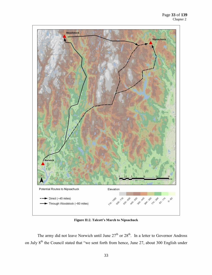
Page 33 of 139 Chapter 2
33
Figure II:2. Talcott’s March to Nipsachuck
The army did not leave Norwich until June 27th
or 28th
. In a letter to Governor Andross
on July 8th
the Council stated that “we sent forth from hence, June 27, about 300 English under

Page 34 of 139 Chapter 2
34
command of Major Talcott.”44
However, Talcott may not have left Norwich until June 28th
, the
date he was originally ordered by the War Council to be at Wabaquasett. This inference is based
on the diary of Thomas Minor who states that his son Samuel “…went forth interpreter to the
army the second time Wednesday June 28th
.45
The date Talcott left Norwich and the route taken
by Talcott may be relevant. Talcott may have made the decision to ignore the War Council’s
orders to march to Wabaquasett and proceed directly to Nipsachuck perhaps based on new
intelligence that Quaiapan was there. Information regarding enemy activity at Nipsachuck was
brought to the attention of the Connecticut Council several times in May and June but neither the
Council (nor apparently Fitch or Talcott) regarded the information of sufficient importance to
send a major expedition into Narragansett cCountry. The War Council and Talcott recognized a
potential threat emanating from Nipsachuck in April and May, but did not think it significant
enough to warrant more than a march through Nipsachuck on the army’s way to the Connecticut
Valley or Nipmuc Country. The last letter Talcott received from the War Council was June 22nd
ordering him to proceed directly to Wabbaquasett on his way to Nipmuc Country because of
information that the enemies “were retired back towards Watchosuck or Nipmug country”– no
mention was made of Nipsachuck.
Assuming that Thomas Minor’s diary is correct with regard to the date his son Samuel
joined the army, Talcott may not have left Norwich until June 28th
or shortly thereafter. If so, the
army took three to three and a half days to march 60 miles from Norwich to Nipsachuck via
Wabbaquasett if that is the route Talcott took (the distance from Norwich to Nipsachuck is 45
miles). In Talcott’s letter to the War Council after the battle he gave no information on the route
he took “we made Nipsachooke on ye first of July.”46
If Talcott did march to Nipsachuck via
Wabbaquasett he averaged around 15 miles per day – not a difficult march for hardened
campaigners.
Alternatively, Talcott may have received information at Norwich or along his march of
such importance that he marched to Nipsachuck against his orders. Talcott’s army of 300
dragoons and 100 Mohegan and Pequot was the largest sent into Narragansett since the Great
44
Trumbull, Colony of Connecticut. P. 2:461. 45
Minor, Minor Diaries, P.136. 46
Trumbull, Colony of Connecticut. P. 2:458.

Page 35 of 139 Chapter 2
35
Swamp Fight; perhaps suggesting a high priority target was in the Nipsachuck area. Although
intelligence had identified enemy forces at Watchusett and Nipmuc Country, he (and perhaps the
council) perceived a much greater threat at Nipsachuck.
A last minute change of plans based on a new enemy threat at Nipsachuck is consistent
with English observations that the Narragansett “had newly (emphasis added) pitched their
Station within the semicircles of a Swampe”47
If the Narragansett had been there for some time it
is likely the War Council would have known about their presence before June 28th
. Even though
the War Council had received information about enemy activity at Nipsachuck earlier on the
spring they didn’t act on it, their focus was the Connecticut Valley, and Nipmuc (Quabaug &
Watchusett) and Narragansett Country.
The new and significant threat emanating from Nipsachuck may have been the recent
arrival of Quaiapan’s band. Based on Talcott’s actions immediately after the Mattity Swamp
Battle, a band led by Narraganset councilor/advisor Potucke
had recently arrived at Nipsachuck and a band under the Narragansett councilor
Potucke who arrived at Warwick about the same time and described as ”a great
counciller of ye Narragansetts (& spetially of a great women) ye old Queen
[Quaiapen], her greatest favorite he doth as much excel in depth of judgement:
common witts…he bore as much sway by his council at Narragansett…he had
killed more English soules than any Indean (by his council) or then any had done
with weapons. 48
Ironically, Quaiapan may have come to Nipsachuck to pursue unilateral peace
negotiations with Connecticut and Massachusetts Bay. In Talcott’s brief letter report of the
Mattity Swamp Battle to the Connecticut War Council he states “our old friend Watawaikeson
[Towcanchason], Pessicus his agent, was slaine and in his pocket Capt. Allyn’s ticket [pass] for
his free passage up to his headquarters.” In a marginal note in the letter Talcott states “and the
old sunck squa’s great councellor was slaine.”49
This appears to be a clear reference to
Towcanchason/Watawaikeson who was well known to Connecticut authorities (and soldiers) as
47
Hubbard, Narratives. P.453. 48
Leach, William Harris Letter, P.176. 49
Trumbull, Colony of Connecticut. P. 2:459.

Page 36 of 139 Chapter 2
36
an emissary to Connecticut in peace negotiations with Connecticut in early 1676, as well as a
counselor of note to Quaiapen.
Towcanchason carried a letter of safe passage to Captain James Avery’s headquarters
(Captain of New London County Dragoons) when he was killed. The mention of Captain Avery
in this context is interesting as he operated exclusively in Narragansett Country during the war
and his headquarters was either located at Stonington where he lived or periodically in
Narragansett Country during Military expeditions. This suggests that Quaiapen may have
returned to Nipsachuck to restart peace negotiations with Connecticut that were derailed after the
Turner’s Falls Massacre. If Towcanchason carried a letter of safe passage to Avery’s
headquarters the letter may have been obtained just prior to Quaiapen’s return to Narragansett
Country, otherwise the letter would have conveyed safe passage to the headquarters of regional
commander in the Connecticut Valley such as Talcott or Treat. Avery was certainly aware of
peace overtures from Quaiapen via Towcanchason but perhaps Talcott was not or he chose to
ignore them. Towcanchason was easily recognizable to Talcott and his officers as the peace
emissary for the Narragansett sachems as they had encountered him on a number of occasions
the previous few months. Towcanchason may have been killed in the heat of battle at Mattity
Swamp but he may also have been executed to derail any peace overtures from the Narragansett.
Immediately after the Mattity Swamp Battle on July 2nd
, Talcott’s army marched to Warwick via
Providence:
On July 3, we trned down to Providence and received information yt ye enemy
was there to make peace with some of Rhode Island, upon which information,
being willing to set our seal to it, posted away, and drest Providence Neck; and
after that ye same day drest Warwick Neck and slew and took captives 67. 50
His target was a band of Narragansett led by Potucke, a man described as “a great
councilor of ye Narragansett (& spetially of a great woman) yea ye greatest yt ther were ye said
woman [called] ye old Queen, ye foresaid councilor her greatest favorite he doth as much excel
in depth of judgement.”51
Potucke was apparently on his way to Boston to deliver a peace
50
Trumbull, Colony of Connecticut. P. 2:459. 51
Collections of the Rhode Island Historical Society Vol. X, The Harris Papers. 1902, P.175.

Page 37 of 139 Chapter 2
37
proposal to Massachusetts Bay authorities, likely on behalf of Quaiapen.52
Rhode Islander
William Harris (a supporter of Connecticut in their claims to Narragansett Country prior to the
war) states Potucke “came to Providence lately inquireing how he might get to Boston safe,
pretending to peace.” 53
Potucke sought temporary refuge on Aquidneck Island but was shortly
after sent to Boston where he was executed.
It is quite possible the Connecticut War Council (or Talcott at his discretion) targeted
Quaiapan and Potucke to derail any peace overtures. Quaiapen was the last surviving principal
Narragansett sachem actively resisting the English. She was feared and respected by the English
as a leader and as someone who could gather the remaining Narragansett and continue the fight
against the English. Her return to Narragansett Country possibly seeking a peace agreement with
Massachusetts Bay could affect Connecticut’s plans to claim Narragansett territory by the
doctrine of Right of Conquest and Vacuum Domicilium.
Connecticut’s attack on Potucke did not sit well with the Massachusetts General Court
who wrote a letter to the Connecticut Council on July 18th
chastising them for undermining the
peace process:
You are pleased in a postscript to take notice of an Indean taken by your forces
with the enemy, treating with them, and pretending a commission from us; which
we suppose you intimate as an irregularity in us, and is to us a matter of
admiration, considering your declaration to the Indians of March 28 under the
hand of your secretary. The business of the Indian you being only to receive from
some of the Narragansett sachems (for which he had only our passé) some
proposals of peace, which they had offered to us at Boston by a messenger of their
own; which perhaps had been effected, had it not been interrupted by the
accidental falling in of your forces, for which we neither blame you nor them,
neither see we reason they should be discouraged thereby or the enemy
hardened.54
Massachusetts was being careful not to offend their most important ally, but they
essentially accused Connecticut of undermining Narragansett peace overtures to Massachusetts
Bay authorities and intimated Connecticut was acting duplicitous as they had had earlier initiated
52
Trumbull, Colony of Connecticut. P. 2:459. 53
Hubbard, Narratives. 96. 54
Trumbull, Colony of Connecticut. P. 2:465.
Page 38 of 139 Chapter 2
38
peace negotiations with the Narragansett and then abandoned the effort. In any event, Talcott’s
attack on Quaiapen’s and Potucke’s bands was certainly fortuitous if Connecticut truly wished to
eliminate further Narragansett resistance as well as their in post-war Narragansett Country.55
Second Battle of Nipsachuck Combatants, Weapons, Tactics
The goal of the battlefield analysis of the battles at Nipsachuck was to identify and
delineate potential sites and battlefields through primary source research and terrain analysis as
well as to understand how the weapons and tactics of the various combatants influenced the
battles. Whenever possible specific English colonial or Native tribal affiliations will be used to
describe combatants, otherwise English military forces and their Tribal allies will be referred to
as English Allied Forces while Native American groups who allied themselves with Metacom
will be referred to as Tribal Forces.
English Allied Forces
By the time of King Philip’s War (also referred to as the Second Puritan War in the New
England Colonies) the English colonial militia was largely based on the old militia system in
existence in England. Every able bodied male of military age was required to be a member of
the local militia known as the “trainband.” Officers, not all of whom had prior military
experience, were appointed from the local community. The number of men in an infantry
company was usually 70 while dragoon companies “troops” typically ranged between 40-60
men. Trainbands would often meet monthly on predetermined “training days” to drill and learn
how to effectively wield their assigned weapons. In Massachusetts Bay two-thirds of men in the
trainbands were trained as musketeers and one third as pikemen. This remained the case until
early in King Philip’s War when colonial military officials quickly realized the ineffectiveness of
pikemen against Native soldiers and began to instruct all their soldiers in the use of the musket
and increasingly adopted mounted troops.56
English colonial leadership was well aware of Native methods of warfare and the
limitations of European tactics in the heavily wooded terrain of New England against an
experienced enemy. Some of the English commanders had experience fighting Native forces
55
Hubbard, Narratives.P. 96. 56
George Mason Bodge, Soldiers of King Philip’s War being A Critical Account Of That War 3nd
Ed. (Baltimore,
MD: Genealogical Publishing Company, 1967). Pp. 11-12; Leach, Flintlock and Tomahawk. Pp. 11-12.

Page 39 of 139 Chapter 2
39
during the Pequot War and in a few small scale engagements in the ensuing forty years. As a
result of the English overwhelming victory over the Pequot forty years earlier, the English
increasingly believed in the superiority of their weaponry and tactics over that of surrounding
Native groups and did little to adopt their military training to fight against a Native enemy. What
colonial leaders did not fully realize was the extent to which Native men were able to acquire
significant amounts of firearms, powder and shot in the decades before King Philip’s from
Dutch, French, and English sources or from other Native groups, perhaps in anticipation of a
conflict with the English. When King Philip’s War broke out in 1675 the Native enemies of the
English were well supplied with arms and had been fighting constantly against their Native
enemies. On the other hand, English forces were woefully unprepared for woodland fighting
against highly mobile, well-armed, and experienced Native adversaries.
In New England the English were trained to defend against a foreign European invader
(Dutch or French) or a Native attack on their settlements. Local trainbands were trained and
equipped to fight a European style of warfare against a European enemy in open terrain. When
Metacom’s allied bands began to attack English townships in Plymouth Colony and
Massachusetts Bay Colony the colonial leadership reacted by sending companies or regiments of
foot soldiers and a few dragoons levied from the local trainband to relieve the threatened towns.
When these same units went to pursue Metacom they became subject to ambush and were
unprepared to fight an enemy who generally refused to battle on open ground. If the Native
forces did fight the English on open ground it was usually because they had vastly superior
numbers and could employ tactics advantageous to them. The English (primarily soldiers from
Massachusetts Bay and Plymouth) suffered very high casualties in the first months of the war
because of their inexperience. Following a string of defeats the English began to modify their
organization, weapons, and tactics based on their experiences in the field.
When the war began, the Connecticut Colony focused much of their mobilization efforts
on the recruitment of mounted units. As early as July 1675 Connecticut ordered each county to
raise dragoons and troopers for the defense of the towns in nearly a three to one ratio.57
The
General Court at Boston took a different approach and declared that
57
Trumbull, Colony of Connecticut. Pp. 2:331-333.

Page 40 of 139 Chapter 2
40
Wheras it is found by experience that troopers & pikemen are of little use in the
present war wth
the Indians, now, for the improvement of them to more or better
advantage…all troopers shall forthwith furnish themselves wth
carbines and
ammunition…and also be liable to be impressed…to serve as foot soldiers during
the said warrr…and all pikemen are hereby required forth with to furnish
themselves wth fire armes.58
All pikemen and a large part of the Massachusetts Bay cavalry were to be trained and deployed
as infantry. The Commissioners of the United Colonies adopted a policy in November 1675 of
splitting their armed forces between infantry and mounted troops consisting of “a Thousand
souldiers whereof 500 to be Dragoones or troopers with longe Armes.”59
English commanders
quickly learned that mounted units were best suited for a war against the New England Native
forces and by February 1676 Massachusetts Bay rescinded their earlier orders disbanding
mounted units which they “found by experience to be very serviceable and necessary” and began
to recruit troopers “in full proportion to foote.”60
The terms “dragoon” and “trooper” often seem to be used interchangeably but there
exists real distinctions between the two types of units. By the end of the English Civil War
(1641-1651) the term trooper came to designate a standard cavalryman which had been referred
to earlier as a “harquebusier” or “carbiner.”61
References to military units known as dragoons
date back to the early seventeenth century and were first used on a large scale by Imperial armies
during the Thirty Years War (1618-1648). Dragoons are universally described as “little more
than infantry on horseback” and dragoon units employed by the army of the Swedish King
Gustavus Adolphus were used “like Horse-men: but they fight on foot.”62
In a European
battlefield context a dragoon was a mounted soldier capable of fighting on horseback but who
was mounted primarily so as to reach the battlefield quickly, and then dismounted to fight as a
foot soldier. In Robert Ward's Animadversions of Warre (1639) dragoon units were described as
no lese than a foote company, consisting of Pikes and Muskets, only of their
quicker expedition they are mounted upon horses. they are of greate use for the
58
Shurtleff, Records of Massachusetts Bay. P. V:26. 59
David Pulsifer, Ed. Records of the Colony of New Plymouth. Acts of the Commissioners of the United Colonies of
New England (Boston, MA: William White, 1859). P. II:365. 60
Shurtleff. Records of Massachusetts Bay. Pp. V: 70-71. 61
John Tincey and Angus McBride, Soldiers of the English Civil War: Cavalry (London, UK: Osprey Publishing,
1990). P. 5. 62
Richard Brzezinski, The Army of Gustavus Adolphus: Cavalry (Oxford, UK: Osprey Publishing, 1993). Pp. 14-15.

Page 41 of 139 Chapter 2
41
guarding of passages and fordes, in regard of their swiftnesse they may prevent
the enemies foote, and gaine places of advantage.63
The role of the trooper and dragoon changed little during King Philip’s War. In the
colonial context it appears that troopers referred to mounted soldiers trained as traditional
cavalry forces who wore armor and were armed (at least initially in King Philip’s War) with
pistols and a sword. A dragoon referred to a mounted infantryman trained to travel on horseback
but to fight on foot. Dragoons were armed with “long armes” such as a carbine or musket
(although they carried pistols as well) and buff coats were usually substituted for armor.64
As
early as 1673, the Connecticut “Grand Committee for Ordering the Militia” stipulated the
following regulations for equipping dragoons:
…each dragoone be provided with a good sword and belt, and serviceable musket
or kirbine, with a shott powch and powder and bullitts, viz: one pownd of powder
made into cartiridges fit for his gunn, and three pownd of bulletts fit for their
guns, or pistol bulletts; and a horss to expedite their march.65
During King Philip’s War, Connecticut dragoons were expected to be fully equipped and
mobilized “upon an hower’s warning.”66
Connecticut’s mounted forces proved so successful
during the war that five years after its conclusion Connecticut officials described how “in or late
wars wth
the Indians, we found dragoones to be most usefull” and by 1680 had “improved about
800 of them in the service.”67
Experienced units of dragoons were able to perform complex
maneuvers on horseback but could also fight effectively as infantry when dismounted. The
Second Battle of Nipsachuck illustrated the capability, experience, and range of tactical options
available to the dragoon commanders in a way unmatched by any other battle in King Philip’s
War.
Cavalry tactics that incorporated firearms were pioneered by the Dutch in the early
1600’s and consisted of ranks of horsemen who advanced slowly, fired their pistols at the enemy
63
Tincey and McBride, Soldiers of the English Civil War. P. 20. 64
Trumbull, Colony of Connecticut. P. 2:270. 65
Trumbull, Colony of Connecticut. Pp. 2:207-208. 66
Trumbull, Colony of Connecticut. P. 2:346. 67
Trumbull, Colony of Connecticut. P. 3:295.

Page 42 of 139 Chapter 2
42
to their front upon which that rank would wheel to the rear in order for the next rank to fire.68
Gustavus Adolphus of Sweden improved on this tactic in the 1630’s by reducing the number of
ranks involved; his forces used a faster charge and held their fire as long as possible to maximize
the effect. During the English Civil War both Parliamentarian and Royalist cavalries eventually
adopted this strategy. Such tactics were familiar to colonial leaders such as Captain George
Dennison of Connecticut, who had served in Oliver Cromwell’s Parliamentarian cavalry in the
English Civil War. Cromwell is credited with revolutionizing the Parliamentary Cavalry by
instituting new regimens of training and tactics.
William Hubbard’s account of the English-Allied assault on Quaiapan’s village at Cat
Hill describes the only known mounted attack by dragons in King Philip’s War:
…their Indian Scouts from the top of an hill discovered a great number of the
enemy that had newly pitched their Station within the semicircles of a Swampe.
The English Souldiers were all mounted on horseback, to the number of near three
hundred; wherefore the Commanders ordered the Indians to be ready at the top of
the hill upon a signal given to run down amain upon the enemy securely lodged in
the hollow of the Swampe just opposite against them, while their Horsemen being
divided into two squandrons to ride round the hill, so that at the same instant, both
the Horsemen upon the two wings, and the Indians a foot rushing down suddenly
upon the enemy put them into a horrible fright, making a lamentable outcry, some
getting into the Swampe, the rest that were prevented by the Horsemen, and the
friendly Indians coming so suddenly upon them were all taken prisoners; Capt.
Newbery with his troop alighting from their horses ran into the Swampe after
them, where they killed at least a hundred, as was judged by some then present,
taking also many prisoners our of those habitations of darkness, the enemy force
daring to make any resistance, for none of the English, and but one or two of the
Mohegins & Pequods were hurt in that assault.69
Hubbard’s account of the battle describes a very complex, well-planned, and well-
executed battle plan that coordinated an attack by three spatially separate contingents of the
Allied force (the southern and northern wings of dragoons, and the Pequot and Mohegan).
This plan depended on stealth and speed in a simultaneous attack and envelopment of an
enemy that was dispersed over several acres of the battlefield (although this enemy consisted
of more than 80% women and children, reducing the danger faced by the Allied force).
68
Brzezinski, The Army of Gustavus Adolphus: Cavalry. Pp. 14-15. 69
Hubbard, Narrative. P. 97.

Page 43 of 139 Chapter 2
43
The plan of attack was very likely influenced by Captain Denison’s (second in command
to Talcott) experiences in the English Civil War under Oliver Cromwell. Denison likely
employed this knowledge when developing the battle plan for the attack at Mattity Swamp. His
prior experiences, culminated with the success of the dragoons and Mohegan/Pequot mounting
coordinated attacks against the enemy, and his knowledge of the terrain at Cat Hill and Mattity
Swamp were critical factors in the development (and success) of the battle plan.
After the initial attack the Narragansett fled into Mattity Swamp where the dragoons
continued their attack on horseback until they reached the edge of the swamp. The terrain at
Cat Hill and the area between Cat Hill and Mattity Swamp provided an opportunity for a
limited horse-mounted attack. When the dragoons reached the edge of the swamp they were
forced to dismount and fight as infantry units. This change in tactics illustrates both advantages
and limitations of dragoons. Natives used swamps to great advantage during the war as places
of refuge or as sites where they would ambush Colonial troops. Many Native encampments
were either located within swamps (if suitable high ground was present such as at the Great
Swamp Fight) or situated against hillsides adjacent to swamps where the reduced visibility to
enemy scouts and ready access to the protection of the swamp made them desirable locations.
Colonial troops were particularly frustrated by swamps as they reduced much of their
advantage and made them extremely vulnerable to attack. Nonetheless, Captain Newberry’s
company (a veteran of several previous campaigns and Captain of Talcott’s life guard)
demonstrated the true utility of dragoons by pursuing the Narragansett to the edge of the
swamp and then dismounting to continue the fight on foot.
English Allied forces were armed with a wide array of weaponry with three main
categories of firearms—matchlock, wheelock, and flintlock. Of these, the flintlock firearm was
the primary armament for combatants on both sides in King Philip’s War. The matchlock musket
was a muzzle-loading firearm, and was discharged by a pull of the trigger which mechanically
lowered a burning match clasped into a serpentine arm into a pan of black powder. Once the
powder ignited the arm fired. The matchlock musket had many disadvantages the greatest of
which was the use of a burning match to fire the arm. The matchlock was completely ineffective
in mobile, woodland warfare as one could not “snap shoot” (i.e. quickly bring the weapon to
bear, aim, and shoot at a moving target as someone using a flintlock could. Nevertheless, the
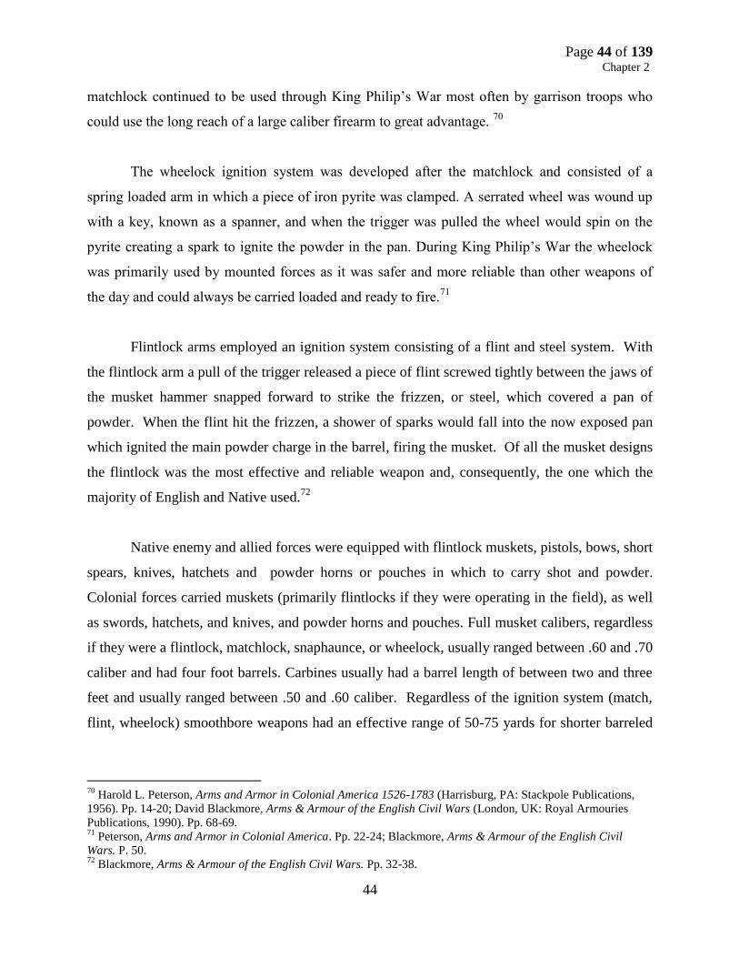
Page 44 of 139 Chapter 2
44
matchlock continued to be used through King Philip’s War most often by garrison troops who
could use the long reach of a large caliber firearm to great advantage. 70
The wheelock ignition system was developed after the matchlock and consisted of a
spring loaded arm in which a piece of iron pyrite was clamped. A serrated wheel was wound up
with a key, known as a spanner, and when the trigger was pulled the wheel would spin on the
pyrite creating a spark to ignite the powder in the pan. During King Philip’s War the wheelock
was primarily used by mounted forces as it was safer and more reliable than other weapons of
the day and could always be carried loaded and ready to fire.71
Flintlock arms employed an ignition system consisting of a flint and steel system. With
the flintlock arm a pull of the trigger released a piece of flint screwed tightly between the jaws of
the musket hammer snapped forward to strike the frizzen, or steel, which covered a pan of
powder. When the flint hit the frizzen, a shower of sparks would fall into the now exposed pan
which ignited the main powder charge in the barrel, firing the musket. Of all the musket designs
the flintlock was the most effective and reliable weapon and, consequently, the one which the
majority of English and Native used.72
Native enemy and allied forces were equipped with flintlock muskets, pistols, bows, short
spears, knives, hatchets and powder horns or pouches in which to carry shot and powder.
Colonial forces carried muskets (primarily flintlocks if they were operating in the field), as well
as swords, hatchets, and knives, and powder horns and pouches. Full musket calibers, regardless
if they were a flintlock, matchlock, snaphaunce, or wheelock, usually ranged between .60 and .70
caliber and had four foot barrels. Carbines usually had a barrel length of between two and three
feet and usually ranged between .50 and .60 caliber. Regardless of the ignition system (match,
flint, wheelock) smoothbore weapons had an effective range of 50-75 yards for shorter barreled
70
Harold L. Peterson, Arms and Armor in Colonial America 1526-1783 (Harrisburg, PA: Stackpole Publications,
1956). Pp. 14-20; David Blackmore, Arms & Armour of the English Civil Wars (London, UK: Royal Armouries
Publications, 1990). Pp. 68-69. 71
Peterson, Arms and Armor in Colonial America. Pp. 22-24; Blackmore, Arms & Armour of the English Civil
Wars. P. 50. 72
Blackmore, Arms & Armour of the English Civil Wars. Pp. 32-38.
Page 45 of 139 Chapter 2
45
weapons and a range of 100-150 yards for longer barreled weapons. Pistols, with calibers most
often between .45 and -.55 caliber, only had an effective range between 30 and 50 yards.
Wampanoag, Nipmuc, and Narragansett Forces
Native military tactics and technology had advanced significantly since the Pequot War
when Native men had just begun to adopt European arms technology and had only a limited
knowledge of English military capabilities. By 1670 Native men were well equipped with
firearms, iron edged weapons, and brass-tipped arrows. They were not only skilled in the
operation, repair, and care of firearms but were expert marksmen. Native men were very familiar
with English military technology and understood English military training and tactics from years
of working and residing in English communities. Some Native men may have even been enlisted
in Massachusetts Bay trainbands as the General Council ordered that all Native men who either
acted as English servants or resided in English towns were required to attend training days.73
Native people had steadily acquired firearms in increasing numbers by the mid sixteenth
century and were well armed when hostilities commenced in 1675.74
There appears to have been
a buildup of arms and ammunition by many Native communities in the years leading up to the
war. The English observed an “accumulation of powder, shot, and arrows” by the Wampanoag
who claimed that it was “a preparation against the Mohawks, but actually it was aimed at the
English.”75
Native men were not only very experienced with firearms on the eve of the war, but
many communities had blacksmiths who had the tools and knowledge to maintain and repair
firearms. 76
Native blacksmiths also made bullet molds and cast lead bar into shot of various
diameters but were not able to make gunpowder (nor could the Colonists, powder had to be
imported from Europe). However, Native forces faced constant shortages of powder and shot
throughout the war. Native allies of the English were either supplied by Colonial forces or took
powder and ammunition from enemies killed on the battlefield. Enemy forces relied on the
Dutch, French or Native middlemen for their supplies or took them from English soldiers killed
on the battlefield.
73
Patrick M. Malone, The Skulking Way of War: Technology and Tactics Among the New England Indians
(Lanham, MD: Madison Books, 1991). Pp. 50, 67-68. 74
Malone, The Skulking Way of War. Pp.48-49. 75
Leach, Second William Harris Letter. P. 23. 76
Malone, The Skulking Way of War. Pp. 69-71.

Page 46 of 139 Chapter 2
46
Native men also used bows and arrows throughout the war either as a weapon of stealth
and surprise, to shoot fire arrows, or because they did not have enough firearms to arm every
Native soldier. From various accounts it appears that most enemy Native forces had sufficient
firearms to arm only one-third to one-half of their forces. Native arrow points were generally
made from brass cut from brass kettles and while they could easily penetrate English clothing
they could not penetrate English buff coats unless fired at point blank range, and were
completely ineffective against armor. Native bows were most effective at a range of 40 yards to
better aim and penetrate the weak spots in English armor or buff coats. The maximum range of
Native bows was 120-150 yards if shot compass (at an arc) at a 45-degree angle. The bow and
arrow may have been carried by all Native men as a secondary weapon when their supplies of
power and shot ran out.77
A single example of a southern New England bow survives picked up
from the Sudbury battlefield during King Philip’s War now in the collections of Harvard
University. It is constructed of hickory, is approximately five and a half feet tall, and required
about forty to forty-five pounds of strength to draw and fire.78
When King Philip’s War began in the spring of 1675 the Pokanoket, Narragansett, and
other tribes were well armed, munitioned, and prepared to counter the English advantages in
men, armor, and firepower. The Native forces often did so by laying ambushes, striking isolated
English settlements, and launching coordinated, sustained, and innovative assaults on English
towns. Native forces often attacked and laid siege to English towns for short periods of time
killing or capturing any English who did not quickly retreat to the town’s designated fortified
house, and would routinely burn all the structures within the town and kill or take the livestock.
They relied on the element of surprise and would decimate English units who could not react
quickly enough to their tactics designed to separate and overwhelm the English. There were also
many instances when Native forces had sufficient men, ammunition, and a tactical advantage to
fight a sustained engagement against English soldiers.
77
Peabody Museum of Archaeology and Ethnology Object Report, PMAE Number 95-20-10/49340; Karen Ordahl
Kupperman, Captain John Smith: A Selected Edition of his Writings (Chapel Hill, NC; University of North Carolina,
1998). 144 78
Peabody Museum of Archaeology and Ethnology Object Report, PMAE Number 95-20-10/49340; Karen Ordahl
Kupperman, Captain John Smith: A Selected Edition of his Writings (Chapel Hill, NC; University of North Carolina,
1998). 144

Page 47 of 139 Chapter 2
47
Chapter Three: Research Methodology and Site Identification and
Documentation
The historical and archeological research efforts for the “Second Battle of Nipsachuck
Identification and Documentation Project” focused on the Mattity Swamp Battlefield Core Area
previously identified in the Final Technical Report “The Battles of Nipsachuck: Research and
Documentation” (GA-2255-09-023; Greenwood et al 2011).
Battlefield Survey
The overall goal of battlefield surveys is to identify and document the historic and
geographic extent of battlefields through the recovery of battle-related objects, assess site
integrity (as defined in National Register Bulletin 40: Guidelines for Identifying, Evaluating, and
Registering America’s Historic Battlefields), provide an overview of surviving resources, and
assess short and long term threats to the integrity of the battlefield. Specific steps involved in this
process include:
Research the battlefield event(s);
Develop a list of battlefield defining natural and cultural features;
Conduct a visual reconnaissance of the battlefield;
Locate, document, and photograph features;
Document and map combatant positions, actions and movements, and key terrain features
on a USGS topographic quadrangle;
Define study and core engagement areas for each battlefield;
Assess overall site integrity and threats
Analysis of Primary Sources
The first step in identifying, documenting, and reconstructing the Second Battle of
Nipsachuck and the Mattity Swamp Battlefield was to identify the various primary accounts of
King Philip’s War generally and specifically that provided information on the tactics, weapons,
and composition of the combatants as well as events, actions, movements, and sites specifically
related to the Second Battle of Nipsachuck. Once these accounts were identified they were
Page 48 of 139 Chapter 2
48
analyzed to assess the quality, veracity, relevancy, and significance of the material they
contained. Many of the sources relating the battle were a few days or weeks after the event. The
most informative accounts were those written by individuals who either participated in the battle
or spoke with soldiers who were in the battle. Important considerations in assessing the veracity
of individual accounts include: determining who the author was (battle participant or chronicler),
why the account was written (e.g. field report, history, colonial records), how long following an
engagement was the account written, and can the information in the account be corroborated by
other sources.79
The two best accounts that document the Second Battle of Nipsachuck were written by
Major John Talcott, commander of Connecticut forces during the battle, and William Hubbard a
minister and historian who wrote a history of King Philip’s War within a few months after the
war ended. Talcott’s account is contained in a letter to the Connecticut War Council written on
July 4, 1676, just a few days after the battle, containing a very brief description of the battle as
well as his attacks on other Narragansett communities.80
The most detailed account of the battle
is provided by William Hubbard in his A Narrative of the Troubles with the Indians in New
England published in 1677. William Hubbard was the minister of the Congregational Church of
Ipswich, Massachusetts and did not participate in any of the fighting at Nipsachuck but was hired
by Massachusetts Bay Colony to write a history of the war and did so by interviewing English
commanders, soldiers, and politicians who had firsthand knowledge of the events he wrote about.
Hubbard’s account of the Second Battle at Nipsachuck elaborates on Talcott’s official report by
detailing the English Allied battle plan and also includes additional geographic descriptions of
the battlefield.81
Below are the only known accounts of the battle:
Talcott’s Account (Battle Narrative in Italics):
July 4, 1676, at Mr. Stanton's Farm house at Monacontauge [Stonington]
Hon’' Gent:
79
See works consulted page for a complete list of all relevant primary and secondary materials. This overview of
primary sources will focuses on the most important sources used to reconstruct battlefield events. 80
Major Talcott’s original letter is found in Connecticut State Library, Connecticut Archives, 1629 – 1820, Colonial
Wars, Series I, 1675 – 1775. P. 83; Major Talcott’s letter was also published in the Colonial Records of
Connecticut. Trumbull, Colony of Connecticut. Pp. 2:458-460. 81
Hubbard, Narrative. P. 97.

Page 49 of 139 Chapter 2
49
These may acquaint you that we made Nipsachookc on ye first of July and seized
4 of ye enemye, and on the 2d instant, being the Sabboth, in y' morning about sun
an houre high made y enemys place of residence and assaulted them, who
presently inswamped themselves in a great spruse swamp we girt the sd swamp
and wth English & Indian souldrs drcst it, and within 3 hours slew and tooke
prisoners 171, of which 45 prison''" being women and children that ye Indians
saved alive, and the others slayne ; in which engagemt were slayne 34 men, tooke
15 armes; among which slaughter, that ould piece of venum Sunck squaw Magnus
was slaine, and our old friend Watawaikson,* Pessccus his agent, was slayne, and
in his pocket Capt. Allyn's Ticket for his free passage up to his head Quartrs. On
July 3', we turned down to Providence and received information that ye enemye
was there to make peace with some of Road Island, upon which enformation,
being willing to set our seal to it, posted away, and drest Providence neck; and
after that ye same dave drest Warwick neck and slew and tooke captiues 67, of
which were 18 men slayne, tooke 11 arms, three lost in ye rivers and swamps, that
ye enemy threw out of their hands on purpose to defeat us; and of this number is
27 captives, and the whole number taken & slayne in these 2 engagemnts is 238.
Not unto us but unto y' Lord be the prayes; we lost but one of our Indians in both
our engagemnts and none of our English, for which we haue cause to bless the
name of our great God that hath so gratiously pleased to defend and preserve us in
y"' midst of all our difficulties. And on ye same 3rd instant having advice that
Philip was beat down towards mount Hope, were desireous to haue wayted upon
him, but could not prevaile wth our Indians, altho' all possible arguments used by
Mr. Fitch and all others y had any intress in them (but we must trade in another
way when we use Indian souldrs againe, for preventing of their turning their backs
upon us ;) upon which consideration my Councill resolued it was not safe for us
and the health of ye Colonyes intress in our Indians to break wth them, and our
army to be devided, perceiueing it would haue been very much disgusting to them
if we should haue parted; and therefore turned down to Mr. Smith's on y 4th
instant; and on y fifth instant (upon former enformation of great store of Indians
in those parts,) drest Boston Neck, and the neck at point Judath, but found but one
old woman who was left asleep ; and made Mr. Stanton's farme house (at
Monacontauge) with all our forces at night; and are now passing towards you. My
Councill and souldrs alsoe being impatient without liberty might be granted for
their lookeing homewards because of their pressing occasions, was constrained to
grant that or County should looke homewards, and that New hauen & Fairfeild
souldrs should pass homewards to be ready when called againe; or if your
pleasure should be for a persuit after the enemye, that they may be turned back at
New Haven, where (I doubt not) your order may meet them. We thought if we
should stay in these parts we must suck our fingers or eat up the people's
prouision to satisfie hunger; for Our Indians (we conceive) would not be ready
under a week's time at soonest ; and understand there is noe meat layed in for our'
souldrs if we should turn out againe; and therefore must have stayed here a longe
time before we could set out againe; and not knowing what occasion might be
towards your north bounds, thought it as cheap for the Country that we should be
turning homewards as lying still here; hopeing we shall be ready to receive and

Page 50 of 139 Chapter 2
50
observe your further orders when declared. Mr. Fitch can give you a more
particulr acct of matters, whom I have desired to wait upon you with these few
lynes; and at present shall give you noe further trouble, but wth subscription of
myselfe,
honrd Srs,
your unworthy servnt John Talcott.82
Hubbard’s Narrative:
As the said Commanders with the Forces under them were pursuing the Enemy in,
and about the Narrhaganset Country toward Mount-hope, hearing that Philip with
his black Regiment of Wompanoags was thereabouts, their Indian Scouts from the
top of an hill discovered a great number of the enemy that had newly pitched their
Station within the semicircles of a Swampe. The English Souldiers were all
mounted on horseback, to the number of near three hundred; wherefore the
Commanders ordered the Indians to be ready at the top of the hill upon a signal
given to run down amain upon the enemy securely lodged in the hollow of the
Swampe just opposite against them, while their Horsemen being divided into two
squandrons to ride round the hill, so that at the same instant , both the Horsemen
upon the two wings, and the Indians a foot rushing down suddenly upon the
enemy put them into a horrible fright, making a lamentable outcry, some getting
into the Swampe, the rest that were prevented by the Horsemen, and the friendly
Indians coming so suddenly upon them were all taken prisoners; Capt. Newbery
with his troop alighting from their horses ran into the Swampe after them, where
they killed at least a hundred, as was judged by some then present, taking also
many prisoners our of those habitations of darkness, the enemy force daring to
make any resistance, for none of the English, and but one or two of the Mohegins
& Pequods were hurt in that assault83
Merchant of Boston
In June Major Talkot slew and took captive Four and Twenty of the Enemies in
one Weeks time, and also killed the Old Queen of the Narraganset, and an arch
Villain of their Party, that had been with them at the Sacking of Providence,
famously known by the Name of Stone-wall or Stone-Layer John, for that being
an active ingenious Fellow, he had learnt the Masons Trade, and was of great use
to the Indians in building their Forts, & c.84
82
Trumbull, Colony of Connecticut. Pp. 2:458-459. 83
Hubbard, Narrative. P. 453. 84
Merchant of Boston. A New and Further Narrative of the State of New-England Being A Continued Account of
the Bloudy Indian-War, From March till August, 1676. (London, UK: F.B. for Dorman Newman, 1676). Pp. 12-13.
Page 51 of 139 Chapter 2
51
Anonymous
Upon this 2d of July also it was, that Major Talcott with the Connecticut Forces
neer to Pautuxit, did take and slay 170 of the Enemy, without the loss of any of
our Brethren, and onely three wounded.85
Second William Harris Letter:
…In ye mean time came Conecticut forces whoe in their march met with the
Indeans & fought and killed ye sd olde Queen & many more86
Battlefield Archeology
The discipline of Battlefield Archeology is concerned primarily with the identification
and study of sites where conflict took place and the archeological signature of the event. This
requires information gathered from historical records associated with a battlefield including
troop dispositions, numbers, and the order of battle (command structure, strength, and disposition
of personnel, equipment, and units of an armed force during field operations), as well as
undocumented evidence of an action or battle gathered from oral history and archeological
investigations. The nature and distribution of material culture associated with a battlefield allows
battlefield archeologists to reconstruct the progress of a battle, assess the veracity of historical
accounts of the battle, and fill in any gaps in the historical record. This is particularly important
with respect to the Second Battle at Nipsachuck as the historical record (particularly from a
Native American perspective) is often incomplete and does not provide a great amount of detail.
Recent developments in the discipline of Battlefield archeology seek to move beyond
simply documenting the spatial distribution of artifacts associated with a battlefield event (Gross
Pattern Analysis) toward a more dynamic interpretation of the battlefield.87
A dynamic
reconstruction of battlefield events requires an ongoing assessment of the congruence of
historical and archeological data in an effort to identify discrete group or individual actions and
movements on the battlefield and place them in a temporal and spatial framework. An integral
part of this process is to contextualize the battlefield and related sites in a broader cultural and
85
Unknown, A True Account of the Most Considerable Occurrences That have hapned in the Warre Between the
English and the Indians in New-England (London: Cornhill Printing Press, 1676). P. 5. 86
Leach, Second William Harris Letter. P. 176. 87
Fox & Scott, 1991.

Page 52 of 139 Chapter 2
52
historical landscape to better understand, interpret and identify battlefield events and sites.88
An
important aspect of this analysis is the reconstruction of the historic landscape and battlefield
terrain to identify the natural and cultural features present at the time of the battle and determine
how they were used by the combatants.89
KOCOA Evaluation
The United States military has developed a process for evaluating the military
significance of the battlefield denoted by the acronym KOCOA; Key and Decisive Terrain,
Observation and Fields of Fire, Cover and Concealment, Obstacles, Avenues of Approach and
Retreat. The NPS ABPP requires the KOCOA approach for all documentation and
implementation grants. An important aspect of KOCOA analysis is to identify defining features
of the battlefield landscape – aspects of the landscape that are mentioned in battlefield accounts
and influenced the nature and progress of the battle. Defining features may be natural (e.g.
Mattity Swamp or Nipsachuck Hill) or cultural (e.g. Quaiapen’s camp) and are assessed and
evaluated to determine their effect on the process and outcome of the battle. Critical defining
features are mapped using GPS and GIS, and surveyed using remote sensing (metal detection
and electrical resistivity), and archeological testing and excavation.
Battlefield Pattern and Spatial Analysis
Traditional battlefield interpretations and reconstructions have relied primarily on
historical information (battle accounts, narratives, diaries, etc.), occasionally augmented by oral
histories and sometimes random collections of battle-related objects. In the past two decades
archeology has played an increasingly important role in battlefield reconstruction as
archeologists (and battlefield historians) have become aware of the contributions archeology
could make toward a more complete understanding of the battlefield. The discipline of
Battlefield Archeology has progressed to the point where battlefield archaeologists and historians
seek to identify the material correlates or signatures of discrete battlefield events identified from
88
Loechl et al, 2009 89
Carmen & Carmen, 2009.

Page 53 of 139 Chapter 2
53
the historic record and sequence them in time and space to achieve a more comprehensive
reconstruction of the battlefield (Dynamic Pattern Analysis).
This approach has resulted in a far more nuanced and complex reconstruction of
battlefields and battle events than those based on the historical record alone. Douglas Scott and
Richard Fox developed the post-Civil War Battlefield Pattern Approach (Dynamic Pattern
Analysis) during their study of the 1876 Battle of the Little Bighorn, which sought to investigate
the behavioral dynamics of the battlefield and test competing hypothesis regarding the nature and
progress of the battle based the testimony of Native American veterans of the battle and official
accounts from the U.S. Army.90
In the case of the Battle of Little Bighorn this was achieved
through modern forensic ballistic analysis of thousands of bullets and cartridge cases which
allowed researchers to track individual firearms across the battlefield and identify the actions and
movements of aggregates of individuals (i.e. units).
Until Fox and Scott’s ground-breaking study of the Battle of the Little Big Horn in 1985,
battlefield archaeologists tended to focus only on the spatial distributions of battle-related objects
(Gross Pattern Analysis) which resulted in a static reconstruction of the battlefield (essentially a
boundary drawn around recovered battle-related objects). The Dynamic Pattern Analysis
developed by Fox and Scott seeks to identify and isolate discrete battle “events” associated with
aggregates of individuals based on their archaeological signatures and integrate them into a
spatial and temporal framework to identify movement across the battlefield.91
Individual actions
and movements must be viewed in the aggregate, collectively subsumed in unit actions and
movements - the basic unit of analysis in Battlefield Archeology. While individual actions can
sometimes be identified on the battlefield, it is units (aggregates of individuals) and their actions
which are most amenable to be integrated into a cohesive spatial and temporal sequence in order
to reconstruct and interpret the battlefield. This integrated model of Gross-Pattern Analysis and
Dynamic-Pattern Analysis has been the paradigm for Civil War and post-Civil War battlefield
archeology and analysis since 1985.
90
Fox & Scott 1991; Scott et al 1989. 91
Fox & Scott, 1991; Scott et al, 1989; Carlton-Drexler, 2009.

Page 54 of 139 Chapter 2
54
The historical record associated with the battlefield is used to construct a timeline of
discrete battlefield events and potential material correlates or archaeological signatures are then
identified for each event. The expected archaeological signatures can be used to inform and test
hypotheses of unit actions and movements drawn from the historical record. It is often the case
that the actual (recovered) archaeological signature differs from the expected archaeological
signature necessitating a reevaluation or reinterpretation of the historic record. Using both Gross-
Pattern and Dynamic-Pattern Battlefield Analyses, the spatial and temporal dimensions of a
battle can be defined and reconstructed through the integration and continual assessment of the
congruence of the historical and archeological record, a process based on the archeological
correlates or signatures of individual and unit. In this ongoing process the historical record
informs the archaeological record as much as the archaeological record informs the historical
record and both contribute equally to the reconstruction of the battlefield.
The key to this analysis is the ability of battlefield archeologists to integrate the spatial
dimensions of unit actions into a temporal framework. This does not necessarily require
identification of aggregates of individual behaviors based on modern firearm analysis - the basis
for the reconstruction of the Battle of Little Bighorn. The Dynamic Pattern Analysis approach
can be applied to pre-Civil War battlefields (and non-rifled firearms) such as the Second Battle
of Nipsachuck by focusing on hypothesized unit actions and movements drawn from the
historical record and identifying potentially unique material culture signatures that would be
associated with the English and Native combatants who participated in the battle. Actions and
movements of the various units can be clarified based on the battlefield time line (sequential unit
actions and movements) and KOCOA analysis, and then integrated into a comprehensive
sequence of battlefield actions and events. An analysis of the sequence of events, movements and
actions associated with the Second Battle at Nipsachuck resulted in the battlefield timeline
presented in Table III.1.

Page 55 of 139 Chapter 2
55
Table III.1 Second Battle at Nipsachuck Battlefield Timeline
Sequence Action Unit & No. of
Combatants Location
Time and
Duration Narrative Signature
1.
July 1,
1676
English-
allied force
approaches s
Nipsachuck
300
Connecticut
Dragoons &
100 Mohegan
& Pequot
Allies
Second Battle of
Nipsachuck Study
Area, west of the
Mattity Swamp Core
Area.
Unknown:
morning or
afternoon
“…we made Nipsachooke on ye first of July
and seized 4 of ye enemye…” (Talcott in
Records of the Colony of CT. Pp. II:458-
459)
Low:
Dropped &
discarded
equipment
2.
July 1,
1676
English-
allied force
encamps
300
Connecticut
Dragoons &
100 Mohegan
& Pequot
Allies. 4
Narragansett.
Second Battle of
Nipsachuck Study
Area, west of. Battle
of Mattity Swamp
Core Area, West of
Cat Hill Key Terrain
Feature
.
Unknown:
Between 12-
18 hours
“…we made Nipsachooke on ye first of
July…and seized 4 of ye enemye and on the
2d instant, being the Sabboth, in y' morning
about sun an houre high made y enemys
place of residence and assaulted them…”
(Talcott in Records of the Colony of CT. Pp.
II:458-459)
High:
Dropped &
discarded
equipment from
men & horses
3.
July 1,
1676
Mohegan
and Pequot
scouts
reconnoiter
Cat Hill and
Mattity
Swamp,
discover
Narragansett
Encampment
100 Mohegan
& Pequot &
170
Narragansett.
Second Battle of
Nipsachuck Study
Area, Battle of
Mattity Swamp Core
Area; Cat Hill Key
Terrain Feature,
Mattity Swamp Key
Terrain Feature, Cat
Hill Plain Key
Terrain Feature
Afternoon
of July 1,
1676.
“…their Indian Scouts from the top of an
hill discovered a great number of the enemy
that had newly pitched their Station within
the semicircles of a Swampe.” (Hubbard.
P.97)
Low:
Dropped and
discarded
equipment
Page 56 of 139 Chapter 2
56
4.
July 2,
1676
Allied force
advances
from west of
Cat Hill and
begin attack
300
Connecticut
Dragoons &
100 Mohegan
& Pequot
Allies.
Second Battle of
Nipsachuck Study
Area, Battle of
Mattity Swamp Core
Area, Cat Hill Key
Terrain Feature
Approx. 1
hour for
advance and
initial attack
Ca. 4:30 -
5:30 A.M.
“…on the 2d instant, being the Sabboth, in
ye morning about sun an houre high made ye
enemys place of residence and assaulted
them” (Talcott in Records of the Colony of
CT. Pp. II:458-459)
“The English Souldiers were all mounted on
horseback, to the number of near three
hundred; wherefore the Commanders
ordered the Indians to be ready at the top of
the hill upon a signal given to run down
amain upon the enemy securely lodged in
the hollow of the Swampe just opposite
them, while their Horsemen upon the two
wings…” (Hubbard. P. 97)
High: Dropped,
broken and
discarded
Equipment;
Dropped and
impacted
musket balls
5.
July 2,
1676
Allied
envelopment
of
Narragansett
encampment
s
300
Connecticut
Dragoons &
100 Mohegan
& Pequot
Allies, 170
Narragansett
Second Battle of
Nipsachuck Study
Area, Battle of Mattity
Swamp Core Area,
Cat Hill Key Terrain
Feature, Cat Hill Plain
Key Terrain Feature,
Cat Hill Lower Slope
Key Terrain Feature
Approx. 30
min.
Ca, 5:30-
6:00
“while their Horsemen upon the two wings
and the Indians a foot rushing down
suddenly upon the enemy put them into a
horrible fright, making a lamentable outcry,
some getting into the Swampe, the rest that
were prevented by the Horsemen, and the
friendly Indians coming so suddenly upon
them were all taken prisoners…”
High:
Dropped
equipment,
personal
effects,
dropped and
impacted lead
shot,
horseshoes;
Narragansett
Domestic
objects

Page 57 of 139 Chapter 2
57
6.
July 2,
1676
Allied force
pursues
Narragansett
to Mattity
Swamp
300
Connecticut
Dragoons &
100 Mohegan
& Pequot
Allies.
Approx. 170
Narragansett.
Second Battle of
Nipsachuck Study
Area, Battle of
Mattity Swamp Core
Area, Cat Hill Plain
Key Terrain Feature,
Mattity Spruce
Swamp Key Terrain
Feature
Approx. 15-
20 minutes.
Ca. 6:00-
6:15 A.M.
“…in ye morning about sun an houre high
made ye enemys place of residence and
assaulted them, who presently inswamped
themselves in a great spruse swamp…”
(Talcott in Records of the Colony of CT. Pp.
II:458-459)
“The English Souldiers were all mounted on
horseback, to the number of near three
hundred; wherefore the Commanders
ordered the Indians to be ready at the top of
the hill upon a signal given to run down
amain upon the enemy securely lodged in
the hollow of the Swampe just opposite
against them, while their Horsemen being
divided into two squandrons to ride round
the hill, so that at the same instant , both the
Horsemen upon the two wings, and the
Indians a foot rushing down suddenly upon
the enemy put them into a horrible fright,
making a lamentable outcry, some getting
into the Swampe, the rest that were
prevented by the Horsemen, and the friendly
Indians coming so suddenly upon them were
all taken prisoners…” (Hubbard, Indian
Wars. P. 97)
High:
Dropped
equipment,
personal
effects,
dropped and
impacted lead
shot,
horseshoes,
Narragansett
domestic items.

Page 58 of 139 Chapter 2
58
7.
July 2,
1676
Connecticut
Dragoons
and Native
Allies
encircle
Mattity
Spruce
Swamp
300
Connecticut
Dragoons &
100 Mohegan
& Pequot
Allies.
Approx.100
Narragansett.
Second Battle of
Nipsachuck Study
Area; Battle of
Mattity Swamp Core
Area; Mattity Spruce
Swamp Key Terrain
Feature; Elevated
Terrain Key Terrain
Feature
1 hour
Ca. 6:00-
7:00 A.M.
“…we girt the sd
swamp and wth
English &
Indian souldrs drest it…” (Talcott, Records
of the Colony of CT. Pp. II:458-459)
“…some getting into the Swampe, the rest
that were prevented by the Horsemen, and
the friendly Indians coming so suddenly
upon them were all taken prisoners…”
(Hubbard, Indian Wars. P. 97)
High;
Dropped
equipment,
personal
effects,
dropped and
impacted lead
shot,
horseshoes,
domestic items
along edge of
swamp.
8.
July 2,
1676
Connecticut
Dragoons
attack
Narragansett
forces in
Mattity
Swamp.
300
Connecticut
Dragoons.
Approx. 100
Narragansett.
Second Battle of
Nipsachuck Study
Area, Mattity
Swamp Battlefield
Core Area,
Mattity “Spruce”
Swamp”, Mattity
Spruce Swamp Key
Terrain Feature
Approx. 2
hours
Ca. 7:00–
9:00 A.M.
“…we girt the sd
swamp and wth
English &
Indian souldrs drest it, and within 3 hours
slew and tooke prisoners 171…” (Talcott,
Records of the Colony of CT. Pp. II:458-
459)
“…some getting into the Swampe…Capt.
Newbery with his troop alighting from their
horses ran into the Swampe after them,
where they killed at least a hundred, as was
judged by some then present, taking also
many prisoners ” (Hubbard, Indian Wars. P.
97)
High; Low
Visibility in
Swamp;
Dropped
equipment,
personal
effects,
dropped and
impacted lead
shot,
horseshoes,
domestic items.

Page 59 of 139 Chapter 2
59
9.
July 2,
1676
Combat
concludes
and English-
allied forces
plunder
Narragansett
Encampment
s, record
casualties
and tend to
wounded and
prisoners,
and prepare
to withdraw
300
Connecticut
Dragoons &
99 Mohegan
& Pequot
Allies.
Approx. 45
Narragansett.
Second Battle of
Nipsachuck Study
Area, Battle of
Mattity Swamp Core
Area
Site of Narragansett
Encampment. East of
Cat Hill, West of
Mattity Swamp.
Ca. 10:00-
2:00 P.M.
“… within 3 hours slew and tooke prisoners
171, of which 45 prisonrs being women and
children that ye Indians saved alive, and the
others slayne; in which engagement were
slayne 34 men, tooke 15 armes; among
which slaughter, that ould piece of venum,
Sunck squaw Magnus was slaine, and or old
friend Watawaikeson, Pessecus his agent,
was slayne, and in his pocket Capt. Allyn’s
Ticket for his free passage up to his head
Quartrs.” (Talcott, Records of the Colony of
CT. Pp. II:458-459)
Moderate:
Dropped and
discarded
equipment,
domestic
objects, and
personal
effects. Would
be hard to
distinguish
from earlier
battle action
10.
July 2,
1676
English-
allied forces
leave
Nipsachuck
and travel
south
towards
Warwick
Neck, RI.
300
Connecticut
Dragoons &
99 Mohegan
& Pequot
Allies.
Approx. 45
Narragansett.
Second Battle of
Nipsachuck Study
Area
South of Nipsachuck
Hill
Ca. 12:00
P.M.
“The English would gladly have gone
further, and have joined with Boston and
Plimouth Companies to purtsue Philip at
Mount-hope, but the Connecticut Indians
would by no means be perswaded
thereunto, until such time as they had
returned home with the booty they had
taken. And as they were on their march
homeward, they took and slaughtered
threescore more Indians.” (Mather,
History of King Philip’s War. P. 173)
Low:
Dropped and
discarded
equipment

Page 60 of 139 Chapter 2
Site locations were identified by integrating information from the following sources:
primary accounts, local oral history, local artifact collections, land records, historical maps,
aerial photographs, site visits and KOCOA analysis. The precise location and delineation of
battlefields and associated sites required fieldwork to better assess battlefield features, terrain
and integrity. Archeological surveys (walkover reconnaissance surveys, metal detector survey,
sub-surface testing) were particularly important to locate and delineate the 17th century
battlefields as the documents associated with the battle often lack detail, are incomplete, and
sometimes contradictory.
Field Methodology
Fieldwork was conducted in four phases drawn from Douglas Scott’s battlefield methods
and adjusted to suit the needs of a 17th
century battlefield.92
These adjusted phases include:
Orientation Phase, Inventory Phase, Archeological Testing Phase, and Laboratory and
Evaluation Phase. These phases were conducted concurrently and fieldwork was guided by the
work plans and research design outlined below.
Orientation Phase
The Orientation phase consisted of contacting landowners to obtain permission to
conduct archaeological surveys on their property, a windshield survey and walkover
reconnaissance of the battlefield areas to identify key terrain features and spatial references for
provenience and viewshed analysis, and make a preliminary assessment of the integrity of the
battlefield.
Landholder Permission: An important step to acquire landowner permissions was to
contact landowners individually and hold public informational meetings to inform landowners
and the public about the project. By the time fieldwork commenced, most of the property owners
around Mattity Swamp had already granted permission. Other landowners were contacted later in
the project as the dimensions of the battlefield grew and additional permissions were needed.
Battlefield staff also cultivated and maintained relationships with landowners and
communicated with them on a regular basis to maintain their support and involve them in the
92
Scott et al. Battle of the Little Bighorn. Pp. 25-26.

Page 61 of 139 Chapter 2
process of the documentation and interpretation of the Mattity Swamp Battlefield. By the end of
the field season in December of 2012, almost all of the landholders in the Core Area had granted
permission to conduct fieldwork on their properties.
Figure III:1. Landowner Permissions and Battlefield Boundary
Visual Inspection
After landowner permission were obtain battlefield archaeologists met with each
landowner individual to conduct a visual inspection of their property and to get information on
any land use activities or disturbances that may have affected the integrity of the battlefield or
interpretation of the battlefield. Visual Inspections of individual lots consisted of a walkover of
the property with the landholder to gain information on the locations of possible below-ground
disturbance (i.e. septic systems, utility lines), and noting landscape features that had either
physical or cultural attributes that denoted possible inferences to the battlefield. Some
landowners actively hunted within the battlefield boundaries or had shooting ranges. The
Page 62 of 139 Chapter 2
thousands of lead bullet fragments deposited on the battlefield over the last 100-150 years had a
significant impact on the process of battlefield survey with respect to the additional time required
to recover each lead object (literally thousands of modern bullets, particularly .22 shell casings
and bullets) and to determine if the often heavily impacted lead bullets were legitimate musket
balls. Landowner provided samples of the bullets they regularly fired which proved enormously
useful in the musket ball analysis. These discussions with landowners were helpful in
reconstructing recent land use history as a means of contextualizing the nature and distribution of
the artifacts recovered during the project.
Land Use Research
Seventeenth century New England battlefields like the Second Battle of Nipsachuck are
unlike any other battlefields in American history. Civil War and Revolutionary War battlefields
occurred later in American history, involved many more combatants, and are characterized by
significantly higher numbers and contain more readily identifiable battle-related objects. In
addition, many of these battlefields have experienced some degree of protection and preservation
that limited the post-battle land use activities. In contract, the precise locations of most 17th
century battlefields in southern New England are unknown and many have suffered impacts from
later historic land use and development. More significantly from a battlefield survey perspective,
most battlefield landscapes (the Mattity Swamp Battlefield being a case in point) contain
thousands of metallic objects resulting from hundreds of years of land use activities (e.g., horse
and ox shoes, quarrying and logging equipment and tools, broken and discarded farming
equipment, nails, etc.). Many of the objects recovered from the Mattity Swamp Battlefield
(particularly hand wrought iron objects) are often difficult to determine if they are battle-related
without additional context provided by the land use history if the area.
Peeling back the layers of habitation and land use is important to understanding and
contextualizing the relevance and significance of various artifacts signatures on the battlefield
landscape. Information for the land use study was collected from deeds, town records, historical
newspapers, maps, photographs, local histories, books and other various periodicals, oral history
and local knowledge or “hearsay,” and previous artifact collections from the local area.

Page 63 of 139 Chapter 2
In the context of the Mattity Swamp Battlefield, deed research indicates an early 18th
century domestic colonial presence within and immediately adjacent to the battlefield reflected in
the many early to mid-18th
century objects deposited on the battlefield (e.g. coins, buckles,
buttons, and hand wrought iron objects). The Cat Hill and Mattity Swamp area also yielded a
number of 19th
and 20th
century objects reflecting centuries of land use following the battle. The
18th
and early 19th
century hand wrought iron objects were the most problematic as it is often
very difficult to distinguish between late 17th
Century and 18th
/19th
century hand wrought
objects. In addition, parts of the battlefield were used as rehabilitation for horses in the late 20th
century as well, adding an additional layer of 20th
century equine related objects. Fortunately,
most other land use activities such as plowing and logging did not have a significant impact on
the integrity battlefield and the resulting material culture was relatively easy to distinguish from
17th
century battle-related objects.
Spatial Reference and Analysis
The first step in determining the precise geographic location of artifacts (provenience)
and cultural and terrain features was to establish a permanent grid or referencing system over the
entire Mattity Swamp Core Area (190-hectares; 467-acres). A GIS was employed to aid in the
collection, maintenance, storage, analysis, and output of spatial data and information.93
In its
earliest stages, the GIS database consisted primarily of two foot contour base, maps, and other
terrain features including hydrography and soils. Through the course of the field season the GIS
database was expanded to include: property information (i.e. boundaries, ownership, structures),
and modern features such as roads, aerial photographs, disturbed areas, and all battle-related
artifacts and features.
Provenience
To establish provenience throughout the project area a combination of methods were
utilized. The first step in establishing provenience was to develop a procedure so that all cultural
materials and features identified within the Core Area could be assigned a spatial reference. A
93
Bolstad, Paul. GIS Fundamentals: A First Text on Geographic Information Systems. (White Bear Lake, MN:
Eider Press, 2008).

Page 64 of 139 Chapter 2
conceptual 1-meter grid was established over the 2 ft. contour base maps with the intent of
eventually identifying portions of the grid in real space depending on landholder permissions.
Physically establishing a grid over the entirety of the Core Area was difficult and in many cases
unfeasible due to natural obstructions. There were some instances whereby properties for which
access was granted were separated by one or more lots from which access had initially been
denied. In these circumstances, connecting the grids between the widely separated properties
could not be done with any degree of accuracy. Therefore, provenience and in turn, battlefield
reconstructions, could not be confidently achieved. This challenge was mitigated through
alternating use of a GPS and total station.
A Global Positioning System (GPS) is a series of orbiting satellites such that at any given
time and place at least four are within range of any position on Earth’s surface. By determining
the distance from the four satellites, the receiver can calculate its precise location in horizontal
and vertical space in a process called trilateration.94
Current technology now provides the means
to achieve pinpoint location in real-time with a GPS yielding up to ten centimeter accuracy and
sometimes even less. However, in reality there are many factors such as tree cover, aspect of
availability, and position of satellites that sometimes caps accuracy to a five meter range,
depending on conditions and the time of day. For example, there was generally a three to four
hour window of opportunity in the mornings where we could achieve accuracy of 50 centimeters
or less within the Mattity Swamp Core Area, in the rare instance that tree cover was not present.
The first step in integrating GPS into the project grid was to establish a permanent datum
point. In the Mattity Swamp Core Area, a point on the path running through the center of the
project area was chosen as the datum point. To mark the spot in real space, a large metal spike
was driven into the ground. Numerous GPS readings were taken at this point over several days
and at different times of the day. The points were then plotted on an already geo-referenced
map, onto which they clustered into a bulls-eye pattern, the diameter of which was less than 50
centimeters. The center of this bulls-eye was presumed to be the closest interpretation of the
actual datum that could be determined. This initial point was designated N0E0 on the Cartesian
grid system. A grid was then constructed in the GIS across the entire Mattity Swamp Core Area.
94
Oswn, John. A Field Guide to Geophysics in Archaeology. (New York, NY: Praxis Publications, 2009).

Page 65 of 139 Chapter 2
Parallel and perpendicular polyline transects were set at one meter intervals and assigned
coordinates based on Cartesian coordinates as attributes (e.g. N150E200). To make directional
measurements easier, the grid was oriented towards true north (14.5 degrees east of magnetic
north in Rhode Island). The result was a digital grid cast over the entire Core Area. For the sake
of time, tangible transects set as orange stakes were only set up on properties where fieldwork
was to be conducted. Property boundaries were provided from shapefiles made available from
the Town of North Smithfield Planning Department.
These geo-referenced shapefiles or whatever part of the shapefile was relevant to the area
in which fieldwork was being conducted, were then imported into the GPS and used to locate
the intersection of any northing and easting transects for which locations were required in real
space. Because GPS, or at least the hardware utilized in this project, cannot realistically provide
accuracy greater than 10-centimeters, single intersections on the grid were targeted, and then
several readings taken with the GPS on the ground to determine the grid intersection’s position
in real space. Similar to the process of converting the real world datum into a geo-referenced
point in grid space, when locating a grid point in real space multiple readings were taken and
represented by small plastic flags. The center of this flag cluster was accepted as the correct
interpretation of the position.
To ensure accuracy, one point on the same northing line and a point on the same easting
line were located in similar fashion. These would then be measured in real space against the
original shoot-in point for accuracy. Ten centimeter precision was considered acceptable, but
results were often within the five centimeter range. In order to establish a grid with the greatest
possible accuracy, the initial GPS shoot-in point became a datum on which to set up the total
station, and a grid was laid out in real space using the total station. The actual grid (on individual
or groups of adjacent properties) was established by setting plastic stakes on northing and easting
transects at twenty meter intervals. The use of plastic was essential in order to inhibit
interference with the metal detectors that would be operated in close proximity. This grid was
established over any area where metal detecting or archeological fieldwork would take place.
These stakes were each labeled by their Cartesian coordinates (e.g. N25E100). Shovel Test Pits
and excavation units were always placed along established grid lines. Metal detector finds were
Page 66 of 139 Chapter 2
also mapped using established grid lines. A different strategy was required in peripheral portions
of the battlefield site, which were characterized by a particularly low density of artifacts. In this
case, proveniences of artifacts were determined solely by GPS. This also applied within the
swamp proper, where rigging up grid stakes was simply not feasible.
Viewshed Analysis:
A number of Viewshed Models were developed using elements of KOCOA and GIS.
Identified cultural and terrain features were geo-referenced and integrated into cumulative
Viewshed Models which assume no significant tree cover (which was likely the case after
centuries of Native forest management and horticultural activities). A Viewshed is a raster-
based map in which from each cell, a straight line is interpolated between a source point and
all other cells within an elevation model to find whether or not the cell exceeds the height of
the three dimensional line at that point. Therefore, the result of each calculation is either
positive or negative. If the result is positive (1) then there is a direct line of sight, if it is
negative (0), there is no line of sight.95
The resultant Viewshed Models illustrate locations that
could be seen from elevations at different locations on and around Cat Hill, the Nipsachuck
Hill Ceremonial Area, and other points in the vicinity of Mattity Swamp, providing insight into
what locations the combatants could see from these positions and how this might influence
their actions. The Viewshed Models were very useful for conceptualizing the battlefield
landscape and identifying key terrain, avenues of approach and retreat, obstacles and areas of
concealment and observation (Figures V.2; V.3; V.4; V.5).
Least-cost pathways and cost distances (both raster-based derivatives of cost surfaces)
were also developed in order to understand the path of least resistance for the English Allied
forces route of march from Norwich to Nipsachuck. In the production of a least cost pathway
and cost distance, a “cost surface algorithm” is developed, usually derived from slope data and
barrier data, the most common obstruction being water features (i.e. swamps, rivers). A cost
surface is a modification to a continuous proximity product that measures both proximity and the
character of the terrain over which that proximity extends (i.e. slope, ledges). Cost or friction
95
Wheatley, David and Mark Gillings. Spatial Technology and Archaeology: The Archaeological
Applications of GIS. (New York, NY: Taylor & Francis, 2002).

Page 67 of 139 Chapter 2
surfaces are algorithms designed to model the amount of energy that must be expended to move
across a surface (i.e. rate of march possible).96
Using cost analysis, probable routes of travel
across terrain were modeled. As a result, a potential route of march from Norwich to Nipsachuck
was identified using information gleaned from the primary war narratives and from the landscape
models employing least-cost analysis (Figures V.2; V.3; V.4; V.5).
Inventory Phase: Metal Detection
The Inventory Phase consisted of three sequential steps; metal detector survey, recovery
of artifacts, and recording of artifacts. This survey phase consisted of an initial metal detector
survey to identify and locate metallic objects below the ground surface. These objects were
pin-flagged for recovery. The recovery phase excavated the pin-flagged identified objects,
made tentative identifications, placed them in artifact bags, and left the locations denoted with
pin flags. The recording phase plotted the individual artifact locations within the coordinates
of the Cartesian grid (if available, otherwise), assigned field-artifact identification numbers on
artifact bags, recorded artifact and excavation information on field forms, and finally collected
the artifacts. These phases occurred concurrently throughout the day, executed by technicians
working solo or in teams, depending on what assets were available.
A metal detector is a remote sensing device designed to locate subsurface metallic items
based on the differential electrical conductivity of metallic objects. All metal detectors include a
handle, search coil, cable, and metal box that contains the battery, tuning apparatus, and in more
recent detectors a computer that provides the ability to program the detector for certain kinds of
metals, digital readouts of metal type, and possible metal depth. All metal detectors work on the
same general principle. An electromagnetic field produced from the search coil, when held at
ground surface, penetrates the earth in a cone shape emanating downward from the coil. Coils
are available in a variety of sizes designed to provide preferences with regard to depth,
discrimination, and precision in pinpointing object locations. Generally, larger coils are more
effective for locating deeply buried objects but less effective in discriminating between metals
(i.e. brass and lead from iron).
96
Wheatley and Gillings, Spatial Technology and Archaeology.
Page 68 of 139 Chapter 2
Different metal detector models also vary in their operating frequency and therefore their
relative effectiveness in identifying certain kinds of metals. Therefore, some metal detectors are
more effective in identifying ferrous objects and others brass, silver and copper and others lead,
nickel and gold.97
Different metals produce different phase responses in metal detectors,
allowing the instrument to effectively discriminate among different types of metals.98
One
common manifestation of this response is the Visual Discrimination Indicator (VDI), which
quantifies the phase response of each metal into a numerical category for the operator. The
broadest VDI is the assignment of negative numbers for ferrous metals and positive numbers for
non-ferrous metals. Generally, two different technologies characterize the various brands of
metal detectors, Very Low Frequency (VLF) and Pulse Induction (PI) units. VLF units have
superior discrimination capability, compared to PI units, which generally have better depth
capabilities. The most effective metal detector brands utilized were Minelab and White’s.
Some factors that affect the results of a metal detector survey include the experience of
operators, and the variable qualities of metal detecting equipment which can affect the detector’s
ability to discriminate between metals, and to detect at various depths and in different weather
conditions. This variability in metal detectors was considered a distinct advantage during the
survey and an important factor in the decision to utilize as many different brands and types of
metal detectors as possible. Electro-Magnetic Interference (EMI) also had an effect on metal
detector stability and therefore the ability to detect at any depth or any type of metal. Interference
came from many sources including: soil oxidation, proximity to other metal detectors,
approaching thunderstorms, planes flying overhead, and even the natural magnetic flux lines
from the Earth’s magnetic core. Different detectors reacted to each of these factors in different
ways, some mitigating more effectively than others.
97
Connor, Melissa & Douglas D. Scott. “Metal Detector Use in Archaeology: An Introduction.” Historical
Archaeology 32(4), 1998. Pp. 76-85; Pratt, G. Michael. “How Do You Know It’s a Battlefield” in Eds. Douglas
Scott, Lawrence Babits, and Charles Haecker. Fields of Conflict: Battlefield Archaeology from the Roman Empire to
the Korean War. (Washington, D.C.: Potomac Books, 2009). 98
Heimmer, Don H. and Steven L. De Vore. New-Surface, high resolution geophysical methods for cultural
resource management and archaeological investigations. (Denver, CO: U.S. Dept. of the Interior, 1995).

Page 69 of 139 Chapter 2
The metal detector operators used in the survey reflected a wide range of experience,
from a few months to decades. Volunteers from the Yankee Territory Coinshooters (YTC) metal
detecting club based in East Hartford, Connecticut was brought onto the project for assistance
and were instrumental in its eventual success. Each volunteer was unique in their experience,
focus, technique, equipment, availability, and based on these qualities different operators and
detectors were assigned to where they would best serve the project. These individuals were
rotated to different sites and loci so that different levels of experience and detector capabilities
maximized the strengths of each operator and detector.
The saturation of soils enhances any detector’s ability to detect metallic objects at greater
depths. As a controlled experiment, an area was resurveyed following a period of rain. It was
discovered that several objects were targeted that had been not been detected in the initial
detection survey. When excavated, these artifacts were uncovered and found to be at a greater
depth than objects detected during periods of dry weather. Therefore, many operators preferred
to detect during or after a period of rain. Conversely, it was also discovered that over-saturated
soils and, in particular, excess water on the ground surface diminished the effectiveness of most
metal detectors. A challenge unique to the project was the fact that much of the battle-related
action is purported to have taken place within Mattity Swamp. The majority of this zone is
submerged all year round. Additionally, the high levels of biotic activity lead to rapid
accumulation of rotting biomass that speeds up sedimentation to levels much higher than those
on dry land. As a result, artifacts deposited hundreds of years ago could be buried at depths of
several feet, making their location and recovery with metal detectors almost impossible. In
practice, this was determined to be the case. The only 17th
century artifacts that recovered from
within the swamp were located only a few meters from the “mainland” within 12” (25
centimeters) of the surface. Several 20th
century artifacts were found in the swamp at depths
exceeding 20cm, suggesting that the majority of any potential 17th
century material lay buried in
strata deeply below, out of the reach of the electromagnetic field produced by even the largest
metal detector coils.
The direction at which the operator approaches an area often impacts the how successful
detection will ultimately be. Locating metallic objects of different shapes, sizes, and orientation

Page 70 of 139 Chapter 2
in the soil requires an area to be detected from multiple angles by machines with different
capabilities. Artifacts are buried at various angles and orientations in the soil, and therefore may
not present a solid plane to detect depending on the angle of approach. The metal detector will
best detect an artifact at its widest or broadest face. Therefore, the larger the face presented, the
more likely the detector’s signals will strike the artifact. For example, locating small, thin sheets
of cut brass was particularly challenging, especially if the object point was oriented in such a
way as to present the smallest possible face to the detector. Approaching the object from
different directions may allow the detector to encounter and read the broadest widest face of the
object point. The best way to find small and/or deeply buried objects is a survey methodology
that employs multiple angles (directions) of approach in a systematic way to achieve maximum
coverage. As such, the standard initial metal detector survey methodology was two angles of
approach or “sweeps” at 90-degree angles (N-S and E-W) within 10m x 10m search boxes. Even
this approach was not always adequate to locate deeply buried small lead or brass objects. In
areas that were considered particularly sensitive or significant (i.e. areas of suspected
Narragansett activity) third sweeps were conducted with more sensitive detectors and more
experienced handlers.
Sampling Fraction and Transect Orientation
Two field methods were employed to survey the battlefield; judgment and systematic
surveys. Judgment were defined as surveys that were not systematic in nature (see below), but
often resulted in moderate to good coverage of a given area. Judgment surveys were used to
conduct initial exploratory searches in an area to determine if any potential battle-related objects
were present. If it was determined there were a grid was established over the area and systematic
surveys were conducted. Judgment surveys were also conducted in situations where the
orientation, direction, or flow of a battle event needed to be determined. In these instances
judgment surveys would emanate from known clusters of battle-related objects in various
orientations to identify where the next group of battle-related objects might be located.
Judgment surveys proved an effective and efficient tool to determine where later phases of the
battlefield survey should focus.

Page 71 of 139 Chapter 2
The field methodology that was adopted for the systematic metal detector survey
consisted of establishing a grid of 10m x 10m blocks across a search area. Within these blocks,
multiple operators and different detectors were employed at different angles of approach. The
initial sweep of a search box consisted of dividing the box into 1-meter wide transects (the width
of the sweep of a metal detector) in a given orientation (e.g. N-S). A second sweep was
conducted with a different operator and metal detector in another orientation (E-W).
An important consideration in assessing the reliability of data obtained from non-
systematic sampling was the degree to which battle-related objects were recovered (or not) from
a judgment survey could be used to infer the presence or absence of battle actions and
movements. Figures III.3 & III.4 illustrate the frequency and percentage of all artifacts recovered
from one of the areas of the battlefield where systematic and judgment sampling methods were
used.
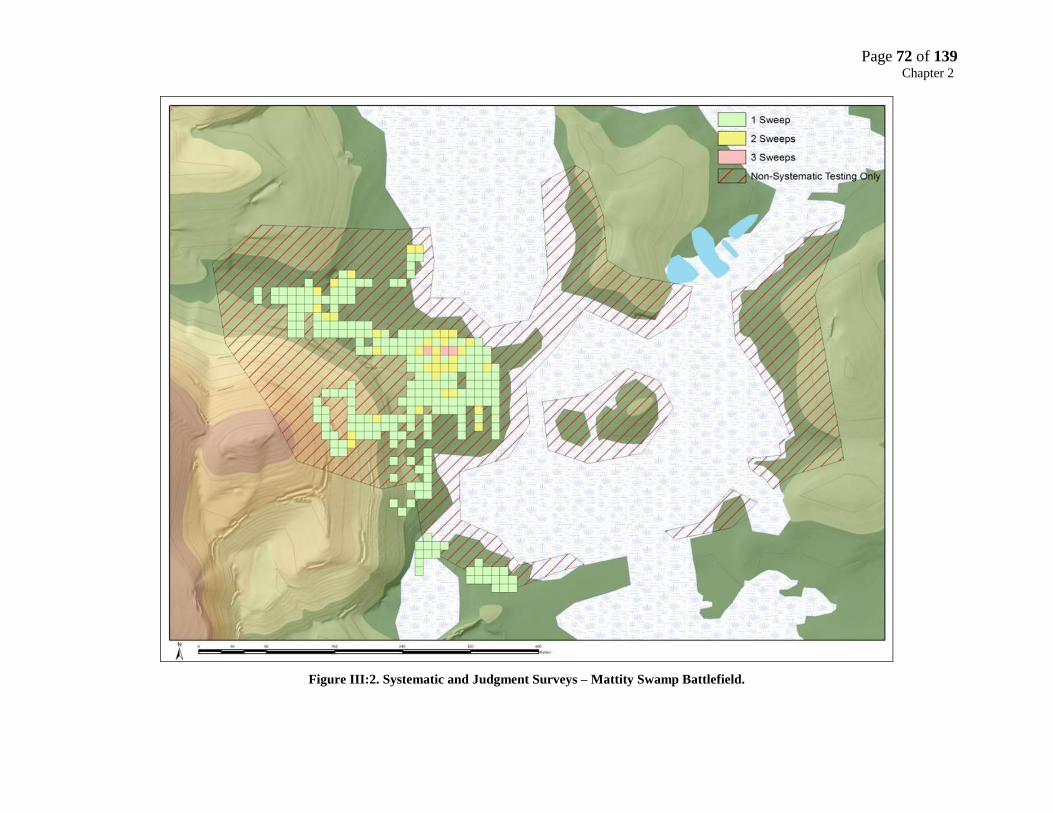
Page 72 of 139 Chapter 2
Figure III:2. Systematic and Judgment Surveys – Mattity Swamp Battlefield.

Page 73 of 139 Chapter 2
Figure III:3. Artifacts Recovered from Systematic and Non-Systematic Sampling Methods
The figures illustrate three points; 1) Systematic sampling recovers 80% more artifacts
(generally) than judgment sampling, 2) Approximately 50% of the time non-systematic sampling
is as good an indicator of the presence or absence of objects within a search box as systematic-
sampling, and 3) Approximately 15% non-systematic survey is as good an indicator of the
presence or absence of artifacts within a box as systematic sampling. The information obtained
from non-systematic sampling can be used to infer the presence or absence of battle actions or
movements but must be used with caution. The presence of a battle-related object obviously
indicates a battle action or movement, but the absence of battle-related objects in an area does
not always indicate the absence of a battle action or movement.

Page 74 of 139 Chapter 2
Figure III:4. Artifact Yields Systematic and Non-Systematic Sampling methods

Page 75 of 139 Chapter 2
Recovery Phase
The recovery crew (staff archeologists and metal detector operators) excavated a “plug”
(small excavation hole) with a trowel or shovel where previously detected and flagged objects
were identified. The excavation location was detected a second time to make sure there were no
other metal objects present before the hole was re-filled. If the recovered object was clearly
modern, it was designated as a “Level 1” artifact (e.g. aluminum foil, pull tabs, tin cans, roofing
nails). This provenience and object identification was recorded on fieldwork recovery forms and
placed directly in a “box bag.” Each box bag collected artifacts from a specific 10m x 10m box.
In an effort to save time, provenience for the modern artifacts was only to the 10m x 10m search
box (i.e. nearest 10 meters).
If an artifact did not appear to be modern or was clearly identifiable as a battle-related
object (i.e. musket ball), it was placed in a plastic bag with soil and left at its location marked by
a pin-flag for the recording crew (level 3 artifacts). The artifact was placed in a sealed plastic bag
with the soil matrix it was recovered in according to conservation protocols established for the
battlefield project. Any metallic object other than lead (e.g. cuprous, ferrous) will rapidly begin
to deteriorate when removed from the matrix where it had become somewhat stabilized. The
object was kept in an environment as similar as possible from which it had been removed, and
brought to the conservation lab and refrigerated for the laboratory and evaluation phase (usually
on a daily basis).
Standard archeological data-recording was used for all objects not identified as modern.
These were plotted to the nearest 50cm within a 1-meter grid that covered the Core Area (e.g.
N230W45 SW quadrant). Non-metallic artifacts that were found during the recovery process
were also recorded and bagged (i.e. historic ceramics, prehistoric lithics) to the same
provenience. The recording team recorded information on artifact depth and soil conditions as
well as detector operator and detector type. For any areas outside the grid, the recording team
assigned unique artifact identification numbers for each flagged object, recorded the numbers
on the plastic bags holding the artifacts, as well as completing field excavation forms. These
were initially provenienced using a GPS, and most were later provenienced to the nearest 50cm
when the grid could be extended over the area.

Page 76 of 139 Chapter 2
Archeological Testing Phase
The Archeological Testing Phase consisted of two types of sampling strategies; 50cm x
50cm shovel test pits placed at 5-meter intervals and 1m x 1m excavation units. The purpose of
archeological testing was to recover both non-metallic battle-related objects such as gunflints or
pyrites, as well as non-metallic domestic objects (i.e. flaked and ground stone tools, ceramics,
shell, etc.) that might identify Narragansett domestic areas.
A total of 164 shovel test pits and 20 excavation units were excavated across the Mattity
Swamp Core Area. Test pits were usually placed in areas where possible Narragansett domestic
objects were identified in the metal detector survey in an attempt to recover non-metallic artifacts
and better define these areas. Shovel test pits yielded only a few objects, primarily of a pre-
contact origin. A few battle-related artifacts were recovered in one of the Narragansett domestic
areas (Figure V.21, Area 3) including two gunflints and a heat treated flake of English flint.
A small excavation block consisting of test pits and 11 1m excavation units was placed
within the vicinity of the suspected Narragansett domestic Area 3. This area was also the location
of a mid- to late 18th
century domestic site which created problems in identifying objects as 17th
or 18th
century. The decision was made to err on the side of caution and most of the recovered
metallic objects were assumed to be associated with the 18th
century occupation.
Laboratory and Evaluation Phase
Real-time laboratory analysis was the most important aspect of fieldwork, as the
immediate (within two to three days) results of identification of metallic (primarily ferrous)
artifacts determined if they were battle-related or not and greatly influenced the direction and
focus of subsequent surveys. Laboratory analysis involved three sequential steps: initial
examination, radiography, and conservation to remove extraneous oxide. Research continues to
identify the precise nature and function of suspected battle-related objects.

Page 77 of 139 Chapter 2
Figure III:5. Shovel Test Pit and Excavation Unit Locations

Page 78 of 139 Chapter 2
Initial artifact examination consisted of cleaning cuprous and ferrous objects with a soft
brush to examine them by eye, and often with a 2X – 4X binocular microscope. If the object was
determined to be non-battle related it was identified and catalogues with no further analysis (e.g.
ox shoe, machine cut nail). If the object was suspected to be a battle-related object it was sent to
the conservation lab for further analysis. In these instances several radiographs (X-Rays) of the
object were taken with different exposures and orientations. The most important aspect of
laboratory analysis and research of battle-related artifacts were the ongoing assessment and
analysis of ferrous objects through X-Ray Analysis. All recovered ferrous objects were highly
degraded (although interestingly 17th
century hand-wrought iron much less so) and not easily
unidentifiable. X-Ray Analysis was performed as soon as possible so battlefield staff could
quickly assess whether the object was hand-wrought, and what the artifact might be. In an X-
Ray, hand-wrought objects exhibit a distinct “layering,” or strata, from being folded over so
many times in the manufacturing process.
If the artifact was hand-wrought, standard conservation procedures were employed to
clean the artifact to better discern its function. X-Ray Analysis also captured many features on
the artifact, such as drill holes and breaks that could not be detected in any other way and thereby
greatly facilitated the identification process. Hand-wrought artifacts were considered a
potentially good indicator of a battle-related activity (not withstanding hand-wrought artifacts
from other land use activities such as field clearing or farming). If the artifact was determined to
be hand-wrought, a number of additional X-Rays were taken under different exposures to reveal
any additional features (perforations, breaks, etc.) that would aid in identification. The final step
in the identification process (that would have occurred eventually anyway), was the removal of
extraneous oxide using air abrasion. The extraneous oxide often concealed features that would
aid in the identification of the artifact. Using a wide range of reference materials, comparative
research in various other museum collections, and consulting with curators from institutions such
as the Jamestown Rediscovery Project and the Royal Armories, the artifact was identified.
Of the approximately 557 ferrous objects recovered in the field and brought to the
MPMRC for radiography, only 29 (5%) were battle-related or suspected to be battle-related.
Nonetheless, these few objects which included horse shoes, shoeing nails, a jaw harp, knife

Page 79 of 139 Chapter 2
fragments, and unidentified hand wrought fragments provided important information on possible
Narragansett domestic areas, and the movements of combatants across the battlefield.
Page 80 of 139 Chapter 3
Chapter Four: KOCOA Analysis
Battlefield Surveys
Battlefield survey methods focus on the identification and delineation of the battlefield
landscapes through walkover reconnaissance and analysis of analysis of which include key
terrain landscape and cultural features that affected the progress and outcome of the battle. The
relevant features are identified using USGS 7.5” series Topographic Maps, aerial photographs,
historic maps, and archeological surveys (walkover, remote sensing, subsurface archeological
testing) – all of which are used to identify key terrain features, site locations and actions,
positions and movements of the combatants. There are five steps in this process: 1) identify
battlefield landscapes; 2) conduct battlefield terrain analysis with KOCOA (Key terrain,
Observation, Cover and concealment, Obstacles, Avenues of approach); 3) conduct battlefield
survey (research, documentation, analysis, field visits, archeological survey and 4) define Study
and Core Areas and assess integrity and threats; and 5) map all relevant cultural and physical
features on GIS base maps.
Terrain Analysis
Terrain analysis is a critical aspect of battlefield surveys, so much so that the NPS ABPP
require all grant recipients to use KOCOA (Key terrain, Observation, Cover and concealment,
Obstacles, Avenues of approach), a military terrain model the U.S. Army developed to evaluate
the military significance of terrain associated with a battlefield. By studying the military
applications of the terrain using KOCOA, a battlefield historian or archeologist can identify the
landscape of the battlefield and develop a basis for judging the merits and flaws of battle
accounts. The components of Terrain Analysis (KOCOA) include:
Key Terrain and Decisive Terrain
Key Terrain is any ground which, when controlled, affords a marked advantage to either
combatant. Two factors can make terrain key: how a commander wants to use it, and whether his
enemy can use it to defeat the commander’s forces. Decisive Terrain is ground that must be
controlled in order to successfully accomplish the mission.

Page 81 of 139 Chapter 3
Table IV.2. KOCOA Definitions and Battlefield Evaluation System
Battlefield
Element
Definition Examples
Key Terrain A portion of the battlefield, possession
of which gives an advantage to the
possessor.
High ground,
village location,
Mattity swamp
Observation &
Fields of Fire
Points on the landscape that allow
observation of enemy activity that is
not necessarily key terrain; offers
opportunity to observe an area, acquire
targets; and allows for an affective line
of fire.
High ground at Cat
Hill.
Cover &
Concealment
Landforms or landscape elements that
provide protection from fire and
conceal troop positions from
observation.
Cat Hill, Mattity
Swamp
Obstacles Landscape elements that affect troop
movements.
Mattity Swamp,
ravines, rocky
ground
Avenues of
Approach &
Retreat
Corridors used to transport troops
between the core battle area and outer
logistical areas.
Roads, paths, creek
beds, trails
Observation and Fields of Fire:
Observation is the condition of weather and terrain that allows a force to see friendly and
enemy forces, and key aspects of the terrain. Fields of Fire are areas in which a weapon or group
of weapons may cover and fire into from a given position.

Page 82 of 139 Chapter 3
Cover and Concealment
Cover is protection from enemy’s fire (e.g. palisade, stone wall, brow of a hill, wooded
swamp), and Concealment is protection from observation and surveillance (e.g. ravines, swamps,
intervening hill or wood).
Obstacles
Obstacles are any features that prevent, restrict, or delay troop movements. Obstacles can
be natural, manmade, or a combination of both and fall into two categories: existing (such as
swamps, rivers, dense wood, town or village) and reinforcing (placed on a battlefield through
military effort).
Avenues of Approach and Withdrawal
An avenue of approach is the route taken by a force that leads to its objective or to key
terrain in its path. An Avenue of Withdrawal is the route taken by a force to withdraw from an
objective or key terrain.
Second Battle of Nipsachuck Study and Core Areas
The Second Battle of Nipsachuck Study Area (Figure I.4) was delineated based on the
descriptions of the landscape at Nipsachuck, the routes of approach and retreat of both the
English Allied forces, the location of Quaiapan’s Narragansett encampment, and the fighting that
occurred on the morning of July 2nd
. The study area encompasses 6,200 acres and was drawn to
encompass the likely battlefield, including the movement of forces, possible routes of

Page 83 of 139 Chapter 3
Figure IV:1. Mattity Swamp Battlefield Core Area Key Terrain Features
Cat Hill
Upper Summit Lower Summit
Mattity Cedar Swamp
Mattity Spruce Swamp
Island
Elevated Terrain Feature
Peninsula and Small Islands
Plain
North Face
South Face

Page 84 of 139 Chapter 3
engagement and disengagement covering the period of July 1-2, 1676. The study area includes
only one Core Area – The Battle of Mattity Swamp.
The Mattity Swamp Core Area is located approximately one half mile directly north of
Nipsachuck Hill and is bounded on the west by Cat Hill and on the north, east, and south by
Mattity Swamp. The Battle of Mattity Swamp Core Area includes the encampment(s) of the
Narragansett, the route(s) of advance and attack by the two wings of Connecticut Dragoons, the
route of advance and attack by the Mohegan and Pequot, the initial envelopment of the
Narragansett encampment(s), the pursuit of the Narragansett by the dragoons and
Pequot/Mohegan into Mattity Swamp, the encirclement of Mattity Swamp by the dragoons and
Mohegan/Pequot, and the routes of retreat and withdrawal by the Allied force and the
Narragansett survivors.
Cat Hill Key Terrain Feature
Cat Hill dominates the approaches to Mattity Swamp from the west and south and
provided cover and concealment to the Allied Force approaching from the west and for the
Narragansett encampments along the east base of Cat Hill. The upper and lower summits of Cat
Hill provided excellent observation points for the Pequot/Mohegan scouts to gather intelligence
on the disposition of the Narragansett encampment(s). The rocky/swamp terrain along the base
of the north and south faces of Cat Hill and the severe slopes characteristic of Cat Hill were
obstacles that prevented the dragoons from launching a horse mounted attack from the upper or
lower summits of Cat Hill or from the west along the base of Cat Hill. Dragoons can attack up
hill at a run, but they cannot attack downhill without risking injury to themselves or their horses.
The rocky and swampy terrain that characterizes the base of Cat Hill along the northern and
southern faces would preclude a dragoon attack originating directly from the west. A more direct
western attack along the southern and northern faces of Cat Hill would have been a more direct
route to mount an attack on the Narragansett encampments along the north and east faces of Cat
Hill, and this route would also have concealed the dragoons until the last possible minute.
However, a horse mounted attack at anything more than a walk along this route would have
risked seriously injured to the horses and slowed if not completely disrupted the attack.
Page 85 of 139 Chapter 3
The Mohegan and Pequot scouts returned to the Allied encampment with sufficiently
detailed information about the terrain for the English commanders to devise a route of attack
predicated on speed and surprise that would maximize the impact of a horse-mounted attack at
speed and still avoid the risk of injuring horses and riders. Unlike previous engagements where
the dragoons would dismount before a battle commenced to fight on foot, the battle plan at
Mattity called for the dragoons to sustain a mounted attack until they reached the only obstacle
that would prevent them from continuing the attack on horseback – Mattity Swamp.
The route of attack taken by the northern wing of dragoons was from the northwest,
allowing them to avoid the rocky terrain along the base of Cat Hill and to take advantage of
terrain better suited for a horse-mounted attack. The dragoons may have lost some element of
surprise as they were more visible approaching from the northwest. If the terrain permitted, the
dragoons could have used Cat Hill to shield their approach almost until they were upon the first
Narragansett encampment. Nonetheless, the dragoons still managed to surprise the Narragansett
along the northern approaches as they employed the better terrain to their advantage.
The precise route of attack taken by the southern wing of dragoons is difficult to identify
because the landowner on this part of the battlefield did not grant permission to conduct surveys
on his property. We can identify a portion of the southern attack route, but only at the moment
they encounter the southern Narragansett encampments. The western approaches along the
southern face of Cat Hill are characterized by the same terrain as the north – extremely rocky and
swampy. However, there are a few lanes or avenues through the difficult terrain that would have
supported a horse mounted attack, but no evidence is available to confirm which route(s) were
used.
The lower summit of Cat Hill is where the Mohegan and Pequot launched their downhill
attack on the Narragansett encampments and is considered decisive terrain. The lower summit
had to be controlled by the Allied force for the three-pronged simultaneous attack on the
Narragansett below to be successful. The control (and use) of this terrain feature by the
Mohegan and Pequot during the attack also enabled the three contingents of Allies to maintain a
degree of separation and minimize confusion on the battlefield and casualties from friendly fire.

Page 86 of 139 Chapter 3
Cat Hill Plain Key Terrain Feature
Cat Hill Plain is considered a key terrain feature as its location along the route of attack
between Cat Hill and Mattity Swamp afforded a marked advantage to the dragoons attacking on
horseback. The plain is approximately eight to ten acres in extent and is completely level with no
obstructions such as rocks or wet/swampy soils that would impede a mounted attack. The
distance from the northern encampments to the edge of Mattity Swamp is approximately 350
meters, and the distance from the Narragansett encampments along the east face of Cat Hill is
approximately 315 meters. The flat and even terrain of the plain facilitated the rapid
envelopment of the Narragansett encampments and then allowed the attackers to quickly reach
the edge of Mattity Swamp to cut of the Narragansett escape. Table IV.3 presents some several
scenarios of the speed of the dragoon attack and the amount of time it would take them to reach
the edge of the swamp.
Distance Speed Time
315 meters 15 52 seconds
315 Meters 20 39 seconds
315 meters 25 31 seconds
350 Meters 15 47 seconds
350 meters 20 35 seconds
350 meters 25 28 seconds
Table IV:4. Speed and Timing of Dragoon attack across Cat Hill Plain
The speed of the attack by the dragoons is somewhat arbitrary and based on the speed of
a canter (10-17 MPH) and gallop (25-30 MPH). Although they were slower than the dragoons,
the Mohegan and Pequot could have traversed the 315 meters between Cat Hill and Mattity
Swamp within a minute (10-15 MPH:, 47-70). The type of terrain the attackers needed to cover
would also impact their rate of speed.

Page 87 of 139 Chapter 3
Mattity Spruce Swamp Key Terrain Feature
Mattity Swamp was a place of cover and concealment for the Narragansett who escaped
the English during the initial phase of the battle and was an obstacle preventing the dragoons
from quickly completing their encirclement of the Narragansett. The western boundary of
Mattity Swamp was an obstacle for the English that effectively stopped the momentum of the
dragoon attack on Cat Hill Plain. When the dragoons reached the edge of the swamp they were
forced to dismount and deploy their forces on foot to enter the swamp. Other companies of
dragoons continued to encircle swamp on horse and foot in preparation of the final phase of
attack.
The obstacle Mattity Spruce Swamp presented to the dragoons during their initial pursuit
of the Narragansett across Cat Hill Plain and into the swamp became decisive terrain as the
swamp presented an opportunity for the English to encircle and contain the Narragansett and
control the progress of the battle. As the Narragansett sought the relative safety of the interior of
Mattity South Swamp, they may have attempted to reach two small islands (ca. ½ and 1-acre) in
the center of the swamp. With the Narragansett seeking the safety of the interior of the swamp,
the Allied force had the time to complete their encirclement of the swamp.
Central Island Key Terrain Feature
This feature consists of two small islands approximately .5 and .75 acres in size. The
western island is situated 80 meters east of the mainland and the eastern island lies 100 meters
south of the mainland. These are the two closest points to the mainland and appear to have been
the jumping off points used by the Allies to make their way to the islands. A trail of musket balls
leads from the base of Cat Hill across Cat Hill Plain to the edge of the swamp, and several battle-
related objects were found along the edge of the swamp at the jumping off point including two
horseshoes, a button, a straight knife and a fragment of a pocket knife. The eastern island appears
to have been attacked by dragoons or Pequot/Mohegan making their way through the swamp
from the north based on a single impacted musket ball located on the northeastern tip of the
island that was fired from north to south.

Page 88 of 139 Chapter 3
Two other key terrain features were used by the Allies to cut or reduce Mattity Swamp
during the encirclement and contain the Narragansett in a smaller area of the swamp.
Elevated Terrain Feature
The Elevated Terrain feature was an integral part of the English battle plan to cut Mattity
Swamp in two and contain the surviving Narragansett in a fairly circumscribed area. The initial
attack by the northern wing of dragoons was designed to prevent the Narragansett from retreating
into the northern half of the swamp (Mattity Cedar Swamp), and force the Narragansett into the
southern half of the swamp (Mattity Spruce Swamp) where they could be encircled. A company
or more of dragoons used the narrow feature to quickly traverse the swamp effectively cutting it
in two.
The feature is a narrow bridge (5-10 meters) of slightly elevated land that runs through
Mattity Swamp and creates a natural divide between Mattity Cedar Swamp to the north and
Mattity Spruce Swamp the south. This feature was a sufficient barrier to influence the ecology of
Mattity Swamp and create two distinct habitats – a cedar swamp and a spruce swamp. The
feature was also solid enough to support a column of dragoons as indicated by the recovery of a
17th Century horseshoe five meters south of the middle of the terrain feature and a number of
musket balls found at the eastern end of the feature.
Peninsula and Small Islands Terrain Feature
These features were an integral part of the English plan as well. A company of dragoons
split off the main body attacking south to north and veered east across a small stream and onto a
west-east oriented peninsula (200m x 50m). The distance from the eastern end of the peninsula
across the swamp to the mainland is 300 meters – impossible for dragoons to traverse on
horseback. From that point the dragoons dismounted and continued the attack on foot. There are
several small islands (20m – 50m in diameter) in a direct line from the east end of the peninsula
to the mainland that was used by the dragoons to cross the swamp where they turned north to
encircle the swamp. A seventeenth century button was found on one of the islands suggesting
dragoons used this route (the button could just as easily be associated with the Native combatants
on the battlefield).

Page 89 of 139 Chapter 3
Figure IV:2. Mattity Swamp Key Terrain Features
Elevated Terrain Feature
Center Islands
Peninsula and Small Islands
100 m
80 m Cat Hill Plain
Mattity Spruce Swamp

Page 90 of 139 Chapter 3
Table IV:5. Table Critical Defining Features. Mattity Swamp Core Area
Name Location Relevance to Battle Terrain KOCOA Analysis Integrity
Assessment
Remarks
Terrain and Topographical Features
Mattity
Spruce
Swamp
Approx. 1 mile north
of Nipsachuck Hill.
When attacked the Narragansett
camp fled into the swamp and hen
encircled by English and
Mohegan/Pequot.
Wetlands,
Wooded,
Key Terrain,
Observation, Cover &
Concealment,
Obstacles, Avenue of
Approach
(Wampanoag).
Location, Setting,
Feeling,
Association,
Material Culture.
Battle of Mattity
Swamp Core
Area.
Nipsachuck
Hill
Nipsachuck Hill’s
summit reaches 541
feet above sea level.
It is located at
Latitude N 41.94
Longitude W -71.57.
The English plan was to patrol
through the Nipsachuck region
and as the highest point in the
area, Nipsachuck hill may have
served as a navigational landmark.
Wetlands,
Wooded
Key Terrain,
Observation , Cover &
Concealment,
Obstacles, Avenues of
Approach (English
Allied).
Location,
Association,
Feeling, Material
Culture.
Second Battle of
Nipsachuck
Study Area
Cat Hill Approx. 1.25 miles
northeast of
Nipsachuck Hill.
Dragoons attacked around the hill
and the Mohegan/Pequot attacked
down the hill to envelope the
Narragansett
Wooded,
Steep
slopes,
upper and
lower
summit.
Key Terrain,
Observation , Cover &
Concealment,
Obstacles, Avenues of
Approach (English
Allied).
Location,
Association,
Feeling, Material
Culture.
Battle of Mattity
Swamp Core
Area
Cat Hill
Plain
Between Cat Hill and
Mattity Swamp
Dragoons attacked over the plain
to pursue Narragansett into
Mattity Swamp.
Flat, Level,
Wooded.
Key Terrain, Avenue of
Attack
Location,
Association,
Feeling, Material
Culture.
Battle of Mattity
Swamp Core
Area
Central
Islands
80 meters east of Cat
Hill Plain
Place of refuge for Narragansett. Wooded Focus of English
attack.
Location,
Association,
Material Culture.
Battle of Mattity
Swamp Core
Area

Page 91 of 139 Chapter 4
Chapter Five: Results and Battlefield Event Synthesis
Battle Narrative
In constructing a narrative for the Second Battle of Nipsachuck there are a number of
‘intangibles’ that must be considered that had a significant impact on the planning, execution,
and outcome of the battle. All of the English and Pequot/Mohegan leaders and soldiers were very
experienced at this stage of the war. They had fought as a cohesive unit in dozens of battles over
the previous nine months and demonstrated time and again they could locate the enemy, develop
a plan of attack, and engage the enemy at a moment’s notice. The Connecticut Dragoons were a
well-equipped and highly mobile force that did not have to rely on a supply train, and could carry
enough food and supplies for a week. Experienced dragoons could move quickly and largely
undetected through enemy territory as long as they were accompanied by a significant contingent
of Native soldiers. Under the direction of experienced commanders such as Talcott, and
especially Denison, veteran dragoons were capable of executing the complex plan of attack
carried out the Second Battle of Nipsachuck.
The battle plan was predicated on speed and a rapid envelopment of the enemy by a
coordinated attack by two wings of dragoons and approximately 100 Mohegan and Pequot. The
successful execution of this plan required first and foremost detailed intelligence of the terrain,
particularly footing for horses, and the composition and disposition of the Narragansett –
intelligence provided by the Pequot and Mohegan. This information was provided by the
“scouts” but without their experience conducting joint operations with the dragoons they would
not have conveyed the specific information on the terrain needed for a rapid horse-mounted
attack. Key terrain in this respect would be the extremely rocky and swampy terrain along the
northern and southern base of Cat Hill which would dictate the precise avenue of attack by the
dragoons. The encirclement of the southern half of Mattity Swamp required the dragoons to
cordon off and reduce the southern half of the swamp along the only avenues capable of
supporting horses.
The precise route of approach/march taken by Talcott cannot be determined from the
available evidence, but it is safe to assume that many of his men, and particularly the Mohegan

Page 92 of 139 Chapter 4
and Pequot, would have been very familiar with the area from previous expeditions. If Talcott
marched directly from Norwich to Nipsachuck, we could infer a more westerly and southerly
approach; if Talcott traveled to Nipsachuck from Wabbaquasett we can infer a more northern and
westerly approach (Figure V.1). Identifying the possible routes of approach taken by the English
and their Native allies would help to identify possible locations of the Allied encampment the
night before the battle. Irrespective of the direction of approach, the nature of the terrain would
be an important factor influencing the route of approach. The dragoons would have limited the
choices for the route of approach – not so the Native contingent. Dragoons, particularly such a
large number, would be forced to travel through terrain suitable for horses, such as areas of low
relief between hills or along existing trails (likely situated in areas of low relief as well). Three
hundred dragoons would have difficulty traversing and maintaining cohesion in heavily wooded
areas and/or areas of moderate to high relief. Regular access to water for such a large number of
horses would be an important factor as well. Unless the dragoons were able to travel through
‘champion’ or more open land characterized by fewer, larger trees, they would have to travel in
column. A column of three hundred dragoons would stretched for more than 1,000 meters (3,000
feet), a formation that was easier for the dragoons to maintain but difficult to deploy.
Alternatively, and if the terrain allowed, the force may have travelled in two or more columns, a
formation better suited for mutual support but difficult to coordinate along the march.
The English would have positioned the Pequot and Mohegan to the front, flanks, and rear
of the column(s) along the march to prevent an ambush. It was also common practice for the
English to send their Native allies well out in front of the column to determine the best route of
march and more importantly to gain intelligence on the nature and disposition of the enemy.
Talcott states “we made Nipsachoock on ye first of July and seized 4 of ye enemye.” It is likely
these were scouts or sentries from Quaiapan’s village captured by the Pequot and Mohegan
scouts. Talcott probably knew the general location of the Narragansett village but the captives
provided him with more specific information as to the location of the village. While the dragoons
set up their base camp Talcott sent the Mohegan and Pequot scouts to reconnoiter the

Page 93 of 139 Chapter 4
Figure V:1. Hypothesized Routes of March
Page 94 of 139 Chapter 4
Cat Hill/Mattity Swamp area. The location of the base camp is not known but it was probably
located somewhere to the north or west of Cat Hill as it appears that is the direction(s) the attack
originated from. We can also infer the camp was close enough (perhaps 1-3 miles) to Cat Hill for
the allied force to rise the morning of July 2nd
, prepare their arms, equipment, and horses for the
upcoming battle, and had enough light to march to Cat Hill and begin the attack an hour after
sunrise.
The information the Mohegan and Pequot scouts brought back to Talcott was critical in
developing the battle plan that eventually unfolded. They were able to gather detailed
information on the terrain at Cat Hill and Mattity Swamp for Talcott and Denison to consider a
mounted attack. The terrain immediately adjacent to the north and south faces of Cat Hill is
extremely rocky and swampy and impossible to traverse on a horse at any more than a very slow
walk without risk of breaking a leg. The routes of attack, pursuit, and envelopment taken by the
dragoons into and around Mattity Swamp required detailed intelligence on the few narrow
elevated passage through the swamp that could be traversed on horseback at speed. It is not clear
which of the hill (or hills) that surround Mattity Swamp were used by the scouts as a vantage
point – most likely several. Figures V.2 – V.5 depict the viewsheds (perspectives) from vantage
points on several hills that overlook Mattity Swamp (Nipsachuck, Black Plain, Cat Hill, and an
unnamed hill to the south east of the swamp). Any (or all) of these hills would have provided an
excellent view of the battlefield landscape. The scouts also gathered information about the
disposition of the Narragansett village. The narratives do not provide much information “a great
number of the enemy that had newly pitched their Station within the semicircles of a Swampe…
the Indians to be ready at the top of the hill upon a signal given to run down amain upon the
enemy securely lodged in the hollow of the Swampe just opposite against them.”99
Based on the
archaeological survey the Narragansett encampment does not appear to have been an aggregated
village but more of a dispersed collection of domestic areas scattered along the eastern and
northern base of Cat Hill.
99
Hubbard, Narrative. P.453

Page 95 of 139 Chapter 4
Figure V:2. Viewshed from Black Plain Hill
Mattity Swamp

Page 96 of 139 Chapter 4
Figure V:3. Viewshed from lower elevation of Cat Hill
Mattity Swamp

Page 97 of 139 Chapter 4
Figure V:4. Viewshed from Unnamed Hill
Mattity Swamp
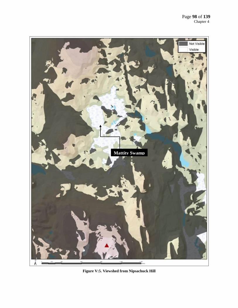
Page 98 of 139 Chapter 4
Figure V:5. Viewshed from Nipsachuck Hill
Mattity Swamp

Page 99 of 139 Chapter 4
Results of Fieldwork
A total of 149 seventeenth century objects were recovered from the battlefield (Table V.1
& Figure V.6; Appendix I). These objects were divided into four categories for the purpose of
the analysis and synthesis; 1) musket balls, 2) English associated objects, 3) Narragansett
associated objects, and 4) Pequot and Mohegan associated objects.
These categories are somewhat arbitrary as objects such as buttons and aglets could just
as easily be associated with the Mohegan/Pequot or Narragansett as well as the English. Other
objects such as horseshoes, hand wrought horseshoe nails are likely associated with the English.
Domestic objects such as cut sheet brass fragments, incised quahog, and the brass pendant are
more likely associated with the Narragansett. In consideration of the potential biases inherent in
the placement of objects in specific categories, Appendix I lists all objects by their artifact ID
and can correlated with the battlefield map in Appendix I that depicts the locations of all objects
by their artifact ID.
Narragansett English / Mohegan / Pequot
1 cuprous bell
10 rose head nails
3 cut cuprous sheet fragments
1 cuprous pendant
1 unidentified cuprous object
1 incised quahog fragment
1 English flint gunflint
1 English flint gunflint fragment
1 English flint flake with pot lid
1 lead gunflint wrap [Pequot/Mohegan]
3 pewter buttons
1 cuprous aglet
1 cuprous horse rosette [Dragoon]
1 iron folding knife fragment
1 iron knife fragment
6 hand wrought shoeing nails[Dragoon]
1 iron jaw harp fragment
6 iron hand wrought unidentified object
frags. [Dragoon]
Table V:6. Objects by Group Association.

Page 100 of 139 Chapter 4
Figure V:6. All Seventeenth Century Objects.

Page 101 of 139 Chapter 4
Figure V.6 depicts all of the seventeenth century artifacts recovered from the battlefield.
The graphic is a good representation of the spatial distribution of battlefield artifacts (Gross
Pattern Analysis) but conveys nothing about the progression of the battle across time and space
(Dynamic Pattern Analysis). The identification of discrete battle events based on the nature and
distribution of associated battle-related objects is the first step in the process of battlefield
reconstruction. Below are discussed the military and domestic objects recovered from the
battlefield and their possible association by group (i.e. Narragansett, Dragoon Mohegan/Pequot).
Musket Ball Analysis
The battlefield analysis relied heavily on the nature and distribution of round lead shot,
generally referred to as musket balls, across the battlefield. A total of 101 (68% of the battlefield
assemblage) musket balls were recovered from the Mattity Swamp Battlefield (Figures V.10 &
V.12). It is assumed that most of the balls were fired from English weapons based on the fact that
English dragoons (n=300) outnumber the Native combatants (Mohegan/Pequot n=100;
Narragansett n=34) a ratio of more than two to one. In addition it appears the English ( and
perhaps the Narragansett and Pequot/Mohegan as well) were firing loads of small shot (5-8 balls
per load) early in the battle which would further increase the number of musket balls fired by
total English-allied forces.

Page 102 of 139 Chapter 4
Figure V:7. Musket balls recovered from Nipsachuck
Figure V:8. Volley of small shot

Page 103 of 139 Chapter 4
The musket ball assemblage was divided into two categories for the purpose of analysis;
diameter (caliber) and condition (dropped or fired/impacted). Musket balls diameters were
determined by weight using the Sivilich formula for both impacted and dropped musket balls.
The diameters of dropped musket balls were also measured using calipers to make sure the two
measures were consistent (which they were). Musket ball diameters were grouped into four
categories based on correlations with diameter ranges and weapon types. Diameters in the .24 -
.44 range are considered “small shot” and multiple rounds can be loaded in any caliber weapon
for a buckshot effect. Diameters in the .44 - .57 range are generally associated with pistols or
carbines. Diameters in the .57 - .65 range are generally considered to be associated with carbines
or muskets, and diameters in the .65 - .73 diameter range are often associated with full muskets.
Musket balls were considered to be impacted if they were misshapen in any way (i.e. not
completely spherical). Musket balls were determined to be dropped if they were completely
spherical with no signs of impact. However, it is the case that some fired musket balls do not
exhibit any obvious signs of impact. As a result some of the musket balls in the dropped category
could well have been fired underestimating the number of impacted musket balls on the
battlefield.
Category Quantity Percentage Rounded
Percentage
< 0.30 11 10.89108911 10.9
< 0.40 43 42.57425743 42.5
< 0.50 35 34.65346535 34.6
< 0.60 7 6.930693069 7
< 0.70 3 2.97029703 3
< 0.80 2 1.98019802 2 Table V.7. Quantity and Percentage of Recovered Musket Balls

Page 104 of 139 Chapter 4
Figure V:9. Musket Ball with Firing Hemisphere (.45 diameter)
Some of the musket balls exhibited a “firing hemisphere” which only occurs if the
musket ball was fired from a weapon whose caliber was just a tenth of an inch or so greater than
the diameter of the musket ball (Figure V.9). It occurs when a tight-fitting ball is pushed through
the barrel upon firing. The presence of a firing hemisphere can be used to infer the caliber (and
possibly type) of firearm used. Six musket balls exhibited evidence of a firing hemisphere. The
diameters included one (1) in the .43 diameter range, one (1) in .44 diameter range, three (3) in
the .45 diameter range, one (1) in the .55 diameter range, and one (1) in the .66 diameter range. It
is possible that the musket balls in the .43-.45 ranges (and higher diameters as well) were fired
from pistols (although carbines are a distinct possibility as well. Thirty one (n=31) musket balls
were in the .43-.57 diameter range (30% of all recovered musket balls; 65% were below .43, and
only 5% above .57), which may suggest pistols and carbines were the most predominant weapon
on the battlefield, and the most effective weapon for soldiers on horse to load and fire.

Page 105 of 139 Chapter 4
Generally, larger diameter musket balls were fired from larger caliber firearms (as they
cannot be loaded into firearms whose caliber is smaller than the musket ball diameter). Loads of
several smaller diameter musket balls (e.g. in the .30 - .45 diameter range) could be loaded into
larger caliber weapons and used as “buckshot”, a common tactic at the Mattity Swamp battlefield
and Pequot War battlefields. The English modified their tactics depending on the nature and
disposition of the enemy (including women and children) and the terrain. The English would
load their weapons with several rounds of small diameter musket balls during a surprise attack
(when the enemy was often grouped together) or when they faced an enemy who were huddled
and massed at close range. As the battle continued and the enemy recovered from their initial
surprise and began to disperse to flee or for better defense the English would often switch to
larger caliber musket balls. Loads of small shot were ineffective against an enemy who was at
distance (generally greater than 40 meters).
Figure V.12 illustrates the assemblages of musket balls recovered from several 17th
century battlefields, the Battle of Mistick Fort (59-19, 1637); the Battle of Mistick Fort – English
Withdrawal (59-40, 1637); Five English Civil War Battlefields (ECW, 1645 – 1649; Sandal
Castle, Edgehill, Grafton Regis, Basing House, Beston Castle; and the Battle of Mattity Swamp
(200-2507, 1676). At the battles at Mistick Fort and Nipsachuck at least half of the enemy was
women and children and at the English Withdrawal battle the Pequot combatants were all men.
The English Civil War battlefields consisted of regular armies fighting according to establish
standards and practices of European warfare. Most of the musket balls in all four sites were fired
by the English. At the Mistick battles the Pequot did not have firearms and at Nipsachuck (see
above) the majority of the musket balls were likely fired by the English.

Page 106 of 139 Chapter 4
Figure V:10. Distribution of Musket Balls by Diameter
Figure V:11. Distribution of Musket Ball Diameters by Quantity.
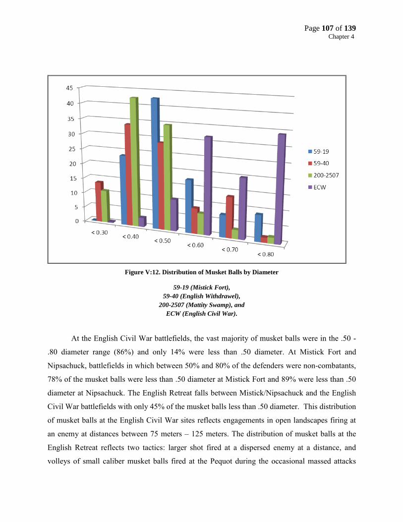
Page 107 of 139 Chapter 4
Figure V:12. Distribution of Musket Balls by Diameter
59-19 (Mistick Fort),
59-40 (English Withdrawel),
200-2507 (Mattity Swamp), and
ECW (English Civil War).
At the English Civil War battlefields, the vast majority of musket balls were in the .50 -
.80 diameter range (86%) and only 14% were less than .50 diameter. At Mistick Fort and
Nipsachuck, battlefields in which between 50% and 80% of the defenders were non-combatants,
78% of the musket balls were less than .50 diameter at Mistick Fort and 89% were less than .50
diameter at Nipsachuck. The English Retreat falls between Mistick/Nipsachuck and the English
Civil War battlefields with only 45% of the musket balls less than .50 diameter. This distribution
of musket balls at the English Civil War sites reflects engagements in open landscapes firing at
an enemy at distances between 75 meters – 125 meters. The distribution of musket balls at the
English Retreat reflects two tactics: larger shot fired at a dispersed enemy at a distance, and
volleys of small caliber musket balls fired at the Pequot during the occasional massed attacks
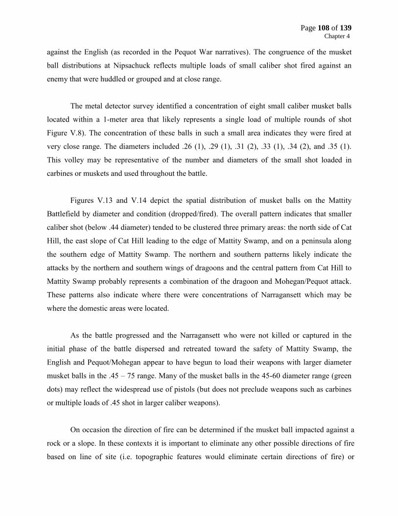
Page 108 of 139 Chapter 4
against the English (as recorded in the Pequot War narratives). The congruence of the musket
ball distributions at Nipsachuck reflects multiple loads of small caliber shot fired against an
enemy that were huddled or grouped and at close range.
The metal detector survey identified a concentration of eight small caliber musket balls
located within a 1-meter area that likely represents a single load of multiple rounds of shot
Figure V.8). The concentration of these balls in such a small area indicates they were fired at
very close range. The diameters included .26 (1), .29 (1), .31 (2), .33 (1), .34 (2), and .35 (1).
This volley may be representative of the number and diameters of the small shot loaded in
carbines or muskets and used throughout the battle.
Figures V.13 and V.14 depict the spatial distribution of musket balls on the Mattity
Battlefield by diameter and condition (dropped/fired). The overall pattern indicates that smaller
caliber shot (below .44 diameter) tended to be clustered three primary areas: the north side of Cat
Hill, the east slope of Cat Hill leading to the edge of Mattity Swamp, and on a peninsula along
the southern edge of Mattity Swamp. The northern and southern patterns likely indicate the
attacks by the northern and southern wings of dragoons and the central pattern from Cat Hill to
Mattity Swamp probably represents a combination of the dragoon and Mohegan/Pequot attack.
These patterns also indicate where there were concentrations of Narragansett which may be
where the domestic areas were located.
As the battle progressed and the Narragansett who were not killed or captured in the
initial phase of the battle dispersed and retreated toward the safety of Mattity Swamp, the
English and Pequot/Mohegan appear to have begun to load their weapons with larger diameter
musket balls in the .45 – 75 range. Many of the musket balls in the 45-60 diameter range (green
dots) may reflect the widespread use of pistols (but does not preclude weapons such as carbines
or multiple loads of .45 shot in larger caliber weapons).
On occasion the direction of fire can be determined if the musket ball impacted against a
rock or a slope. In these contexts it is important to eliminate any other possible directions of fire
based on line of site (i.e. topographic features would eliminate certain directions of fire) or

Page 109 of 139 Chapter 4
physical obstructions such as boulders or rocks that would preclude certain directions of fire.
Sometimes the direction of fire could be determined if the musket ball impacted against a rock or
a slope. In these contexts it is important to eliminate any other possible directions of fire based on
line of site (i.e. topographic features would eliminate certain directions of fire) or physical
obstructions such as boulders or rocks that would preclude certain directions of fire. Sometimes
the direction of fire can determined within 90 degrees (i.e. from the northwest) and sometimes
only with 180 degrees (i.e. fired from the NW, W, or SW).
At the Mattity Swamp battlefield the direction of fire could be determined for 19 (19%)
of the musket balls. This remarkably high number can be attributed to the extremely rocky and
high topographic relief characteristic of certain portions of the Mattity Swamp Battlefield which
captured the orientation of fire more easily. The direction of fire can be extremely useful a very
significant factor in reconstructing the nature, movement, and progress of a battle. Figures V.14
– V.16 depict the direction of fire for two important areas of the battlefield where the northern
and southern wings of dragoons began their attack.

Page 110 of 139 Chapter 4
Figure V:13. Distribution of Musket Balls by Diameter
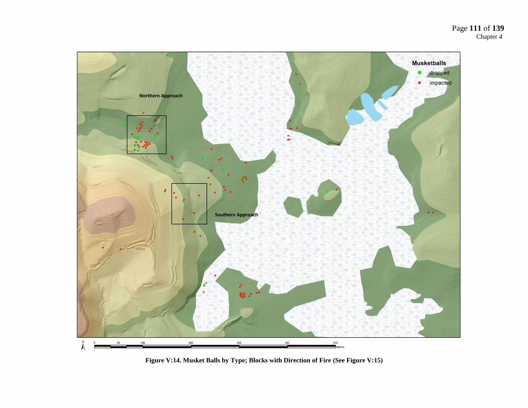
Page 111 of 139 Chapter 4
Figure V:14. Musket Balls by Type; Blocks with Direction of Fire (See Figure V:15)
Northern Approach
Southern Approach
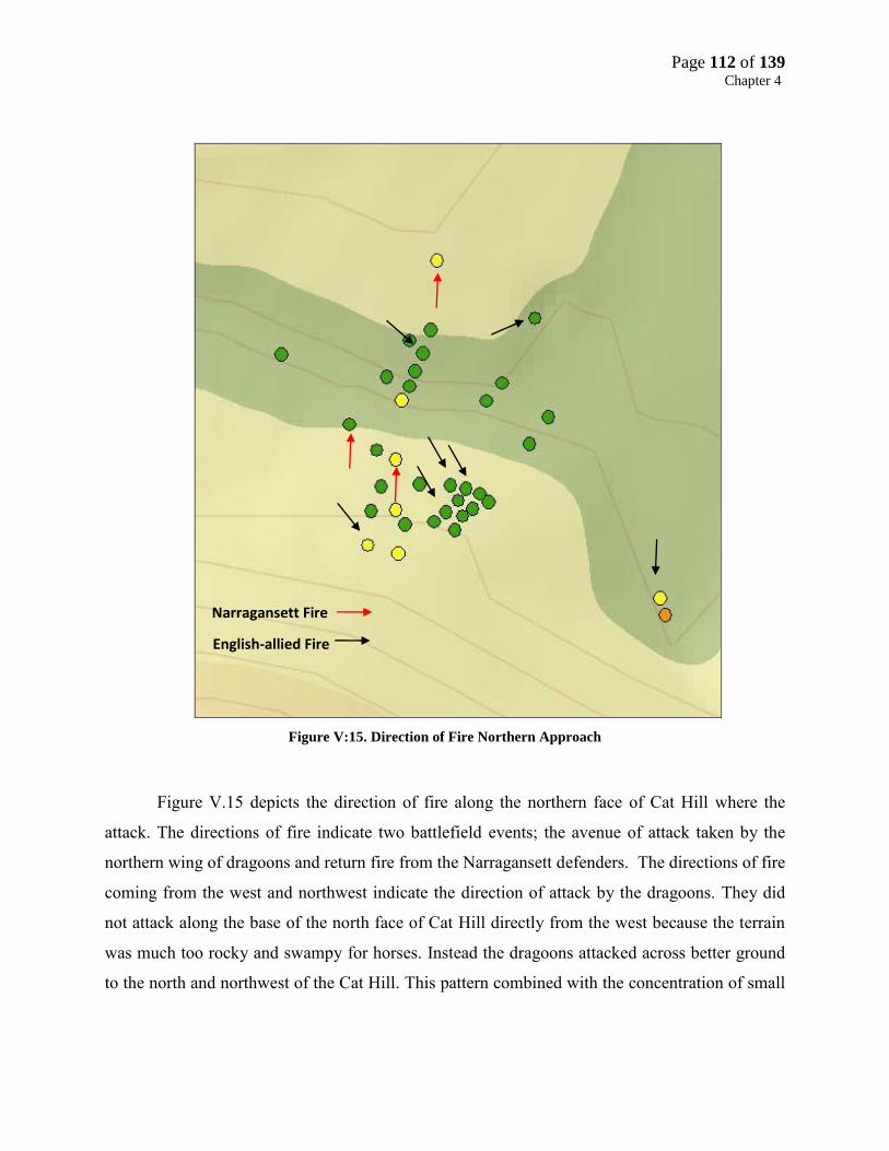
Page 112 of 139 Chapter 4
Figure V:15. Direction of Fire Northern Approach
Figure V.15 depicts the direction of fire along the northern face of Cat Hill where the
attack. The directions of fire indicate two battlefield events; the avenue of attack taken by the
northern wing of dragoons and return fire from the Narragansett defenders. The directions of fire
coming from the west and northwest indicate the direction of attack by the dragoons. They did
not attack along the base of the north face of Cat Hill directly from the west because the terrain
was much too rocky and swampy for horses. Instead the dragoons attacked across better ground
to the north and northwest of the Cat Hill. This pattern combined with the concentration of small
Narragansett Fire
English-allied Fire
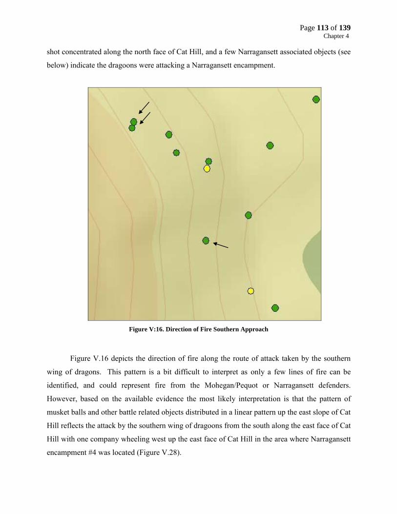
Page 113 of 139 Chapter 4
shot concentrated along the north face of Cat Hill, and a few Narragansett associated objects (see
below) indicate the dragoons were attacking a Narragansett encampment.
Figure V:16. Direction of Fire Southern Approach
Figure V.16 depicts the direction of fire along the route of attack taken by the southern
wing of dragons. This pattern is a bit difficult to interpret as only a few lines of fire can be
identified, and could represent fire from the Mohegan/Pequot or Narragansett defenders.
However, based on the available evidence the most likely interpretation is that the pattern of
musket balls and other battle related objects distributed in a linear pattern up the east slope of Cat
Hill reflects the attack by the southern wing of dragoons from the south along the east face of Cat
Hill with one company wheeling west up the east face of Cat Hill in the area where Narragansett
encampment #4 was located (Figure V.28).

Page 114 of 139 Chapter 4
Other Military and Domestic Objects
Forty eight cuprous, hand wrought iron, shell, lead and lithic objects were recovered from
the Mattity Swamp Battlefield (Table V.2; Figures V.6, V.17 - V.22). Objects such as
horseshoes, shoeing nails (thrown during the attack), bridle rosette, pewter buttons, pocket knife
fragment and several as yet unidentified hand wrought iron objects are believed to be associated
with the dragoons and can be used to identify their positions and movements across the
battlefield (Figure V.17 – V.20).
Objects such as several cut cuprous sheets or strips (from kettles), a cuprous pendant,
rose headed nails (all concentrated at the point of attack on the north face of Cat Hill), gunflints,
an English flint flake, and an incised quahog shell are believed to be associated with the
Narragansett (V17A, B, C).
Figure V:17. A: Hand Wrought Object; B: Shoeing Nail; C: Cuprous Object (Narragansett)
A B
A
C

Page 115 of 139 Chapter 4
Figure V:19. Native Made Cuprous Object
Figure V:18. Narragansett Domestic Objects: A, Cuprous Bell; B, Cut Brass;
C, Jaw Harp; D, Iron Hook; E, Cuprous Pendant
A
D
B
E
C

Page 116 of 139 Chapter 4
Figure V:20. A, Straight Knife; B, Unknown Object
Figure V:21. A-C Pewter Buttons, D Cuprous Button, E Cuprous Aglet, F Bridle Rosette
A B
A
C
A
D
A
E
F
A
B
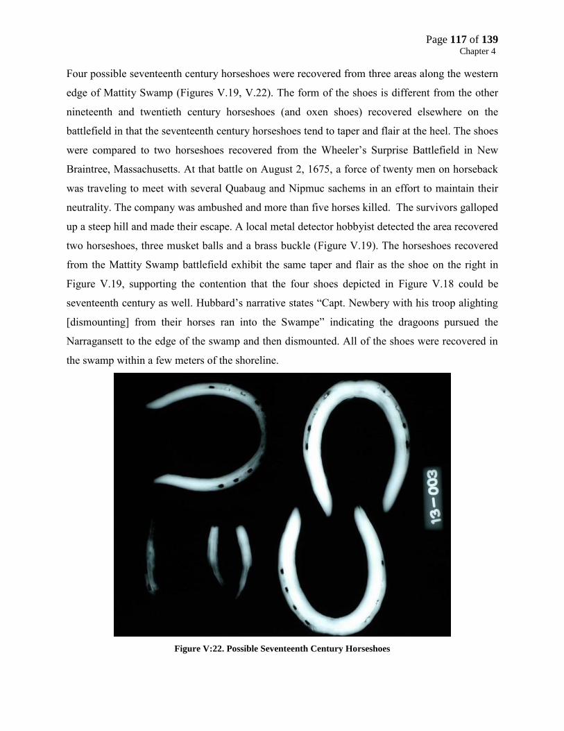
Page 117 of 139 Chapter 4
Four possible seventeenth century horseshoes were recovered from three areas along the western
edge of Mattity Swamp (Figures V.19, V.22). The form of the shoes is different from the other
nineteenth and twentieth century horseshoes (and oxen shoes) recovered elsewhere on the
battlefield in that the seventeenth century horseshoes tend to taper and flair at the heel. The shoes
were compared to two horseshoes recovered from the Wheeler’s Surprise Battlefield in New
Braintree, Massachusetts. At that battle on August 2, 1675, a force of twenty men on horseback
was traveling to meet with several Quabaug and Nipmuc sachems in an effort to maintain their
neutrality. The company was ambushed and more than five horses killed. The survivors galloped
up a steep hill and made their escape. A local metal detector hobbyist detected the area recovered
two horseshoes, three musket balls and a brass buckle (Figure V.19). The horseshoes recovered
from the Mattity Swamp battlefield exhibit the same taper and flair as the shoe on the right in
Figure V.19, supporting the contention that the four shoes depicted in Figure V.18 could be
seventeenth century as well. Hubbard’s narrative states “Capt. Newbery with his troop alighting
[dismounting] from their horses ran into the Swampe” indicating the dragoons pursued the
Narragansett to the edge of the swamp and then dismounted. All of the shoes were recovered in
the swamp within a few meters of the shoreline.
Figure V:22. Possible Seventeenth Century Horseshoes

Page 118 of 139 Chapter 4
Figure V:23. Horseshoes Recovered from Wheeler’s Surprise Battlefield
Figure V:24. Lead Gunflint Wrap for a Bifacial Gunflint
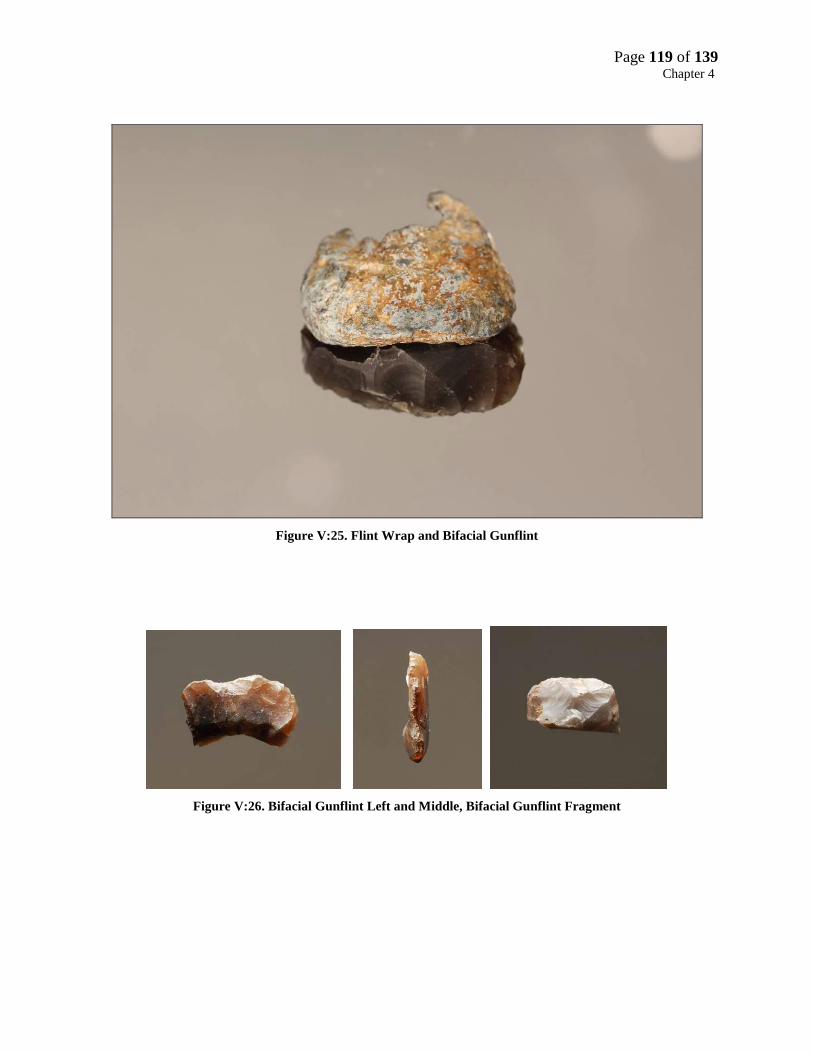
Page 119 of 139 Chapter 4
Figure V:25. Flint Wrap and Bifacial Gunflint
Figure V:26. Bifacial Gunflint Left and Middle, Bifacial Gunflint Fragment

Page 120 of 139 Chapter 4
Figure V:27. Flintlock Jaw Marks
Two bifacially made gunflints of English flint were recovered from a suspected
Narragansett encampment along the southwestern area of Mattity Swamp (Figures V.28, V.29,
Area 3). Bifacially made gunflints have only been associated with Native occupations and their
association with several Narragansett domestic objects including an incised quahog shell
fragment, a heat-altered flake of English flint, and a cuprous pendant suggest the gunflints were
made and used by the Narragansett. A lead flint wrap was also recovered from the battlefield
(not associated with a Narragansett encampment; Figures V.24). Lead wraps are musket balls (in
this case a .50 diameter) flattened or otherwise modified to seat the gunflint more tightly in the
cock of a flintlock firearm. Unlike the flat lead sheets most often used by the Europeans to
accommodate English made spalls or blade gunflints, the lead wrap was concave indicating it

Page 121 of 139 Chapter 4
accommodated a bifacial gunflint. The wrap, recovered from the middle of the battlefield could
indicate the position of a Mohegan/Pequot attacker or a Narragansett defender.
Narragansett Encampments
The only description of the Narragansett “village” is contained in William Hubbard’s
narrative which describes it as: “a great number of the enemy that had newly pitched their
Station within the semicircles of a Swampe.” It was originally assumed the signature of the
village would be concentrations of cut sheet brass fragments, and to a lesser extent whole objects
such as beads, pendants or inkle cones - the byproducts and products that result from processing
brass (cuprous) kettles into a variety of tools, (awls, needles), weapons (arrow points), and
domestic objects (pendants, beads, tinkle cones). Seventeenth Century Native occupations
contain dozens of cuprous scrap or objects making them relatively easy to locate with metal
detectors. Only five cuprous objects were found on the Mattity Swamp Battlefield frustrating the
archeologists in their efforts to identify the village.
Determining the location of the village early within the battlefield survey was a key
component in identifying where the initial attacks and envelopment were made by the dragoons
and Pequot/Mohegan forces, making it easier to sequence the remainder of the battle. The
concept of an aggregated village was eventually abandoned for one of several dispersed
encampments located within the “semicircle of the swamp”. However, neither scenario explained
the dearth of domestic objects within the battlefield. A program of archaeological testing and
excavation was initiated along the base of Cat Hill in an attempt to identify features and/or non-
metallic artifacts such as bone, shell, and clay pipes. A preliminary survey of the base of Cat Hill
in the summer of 2011 did recover a few objects such as an incised quahog shell and a musket
ball that were believed to date to the seventeenth century among an assemblage of mid-
eighteenth century domestic objects. Additional surveys and excavations in the summer of 2012
recovered a few additional seventeenth century objects including two gunflints, a cuprous
pendant and some rose head nails, indicating the presence of a small Narragansett encampment
but still did not explain the low density of seventeenth century domestic artifacts elsewhere on
the battlefield, most of them recovered along the northern and eastern base of Cat Hill.

Page 122 of 139 Chapter 4
Figure V:28. Military and Domestic Objects and Narragansett Encampments (1-4)
1
2
1 3
1
4
2
1

Page 123 of 139 Chapter 4
As the battlefield survey progressed it was apparent that wherever a concentration of
musket balls was found a few domestic objects were recovered as well. It now appears the light
density of domestic objects is best explained by the fact that the Narragansett had only recently
arrived (In Hubbard’s words “newly pitched their station”) at Mattity Swamp, perhaps only a
few days (or less) before the attack. It also appears the Mohegan and Pequot looted the
Narragansett encampments. This scenario would explain a wide distribution and low frequency
of domestic objects at Mattity. If the Narragansett encampments had recently been established
there may have been little time to engage in the kinds of activities that would normally result in
refuse and dropped domestic items. If the whole objects were carried away by the Mohegan and
Pequot there would be little material culture left to mark any of the domestic areas.
Figure V.28 identifies the four areas where light scatters of Narragansett domestic objects
were recovered, distributed “in the semi-circle of a swamp.” Area 1 yielded eight hand wrought
rose headed nails, Area 2 yielded two sheets of scrap brass and a hand wrought iron hook, Area 3
yielded five objects, an incised quahog shell, a cuprous pendant, two gun flints, and a heat-
treated flake of English flint. These areas also correlate with high densities of musket balls
compared with other areas of the battlefield suggesting the location of the encampments targeted
by English-allied forces. Area 4 yielded an unknown cuprous object and a few cuprous
fragments (that may be from the same object) manufactured (and riveted) from cut cuprous
sheets (See Figure V.17 object C).
Battlefield Synthesis
The nature and distribution of battle-related and domestic objects recovered from the
Mattity Swamp Battlefield provide a basis for a dynamic reconstruction of the Second Battle of
Nipsachuck. Each action identified in the historical narrative and timeline has a distinct spatial
and material signature that when correlated with the battlefield timeline can be sequenced in time
and space. Once the battle actions are arranged in their correct chronological and spatial order, a
dynamic reconstruction of the battlefield can be achieved.
The Second Battle of Nipsachuck can be divided into eight distinct phases (sequences of
actions) based on the historical accounts: 1) The approach of the English dragoons and

Page 124 of 139 Chapter 4
Pequot/Mohegan to Nipsachuck; 2) Allied encampment; 3) Reconnoiter of Cat Hill/Mattity
Swamp area 4) Allied advance and initial attack; 5) Envelopment of Narragansett
village/domestic areas; 6) Pursuit of the Narragansett into Mattity Swamp; 7) Encirclement of
Mattity Swamp; and 8) the final phase of the battle when the dragoons and Mohegan and Pequot
fought their way into the swamp. Figure V.29 depicts the routes of attacks taken by the southern
and northern wings of dragoons and the Mohegan/Pequot forces based on the sequence of actions
inferred from the battle narrative, battlefield timeline, and battle-related objects.

Page 125 of 139 Chapter 4
Figure V:29. English-allied Routes of Attack
Pequot /Mohegan
Southern English Wing
/Mohegan Northern English Wing
Page 126 of 139 Chapter 4
1. Approach of the English Dragoons and Pequot/Mohegan to Nipsachuck
“These may acquaint you that we made Nipsachoock on ye first of July and seized 4 of ye
enemye”
“As the said Commanders with the Forces under them were pursuing the Enemy in, and about
the Narrhaganset Country toward Mount-hope”
The approach(s) of the Allied force to Nipsachuck and Cat Hill lie outside the Mattity
Swamp Battlefield Core, although portions of the route are within the Battle Field Study Area.
No surveys were conducted outside the Core Area in the Study Area to identify possible routes
of approach by the Allied force. The signature would be light (e.g. horseshoes, dropped or
broken equipment) and would likely be associated with areas of low relief.
2. Allied Encampment
“These may acquaint you that we made Nipsachoock on ye first of July and seized 4 of ye
enemye”
“and on the 2d instant, being the Sabboth, in y' morning about sun an houre high made y enemys
place of residence and assaulted them”
The Allied encampment was probably established when the allied force arrived in the
Nipsachuck Area during the morning or afternoon of July 1 and was abandoned (or mostly
abandoned) by the afternoon of July 2. Some soldiers such as the sick, the surgeon, or guards
may have remained at the camp during the attack in anticipation of wounded soldiers or to guard
any supplies left behind that would not be needed during the battle. The allies were probably
there less than 24 hours, and in the interest of secrecy probably did not light any cooking fires.
Nevertheless, the expected signature of the encampment is considered moderate to high as it
would contain a variety of metallic objects such as broken, dropped, and discarded weapons,
equipment, and supplies as the men prepared for battle the next day. The encampment is likely
located outside of the Battlefield Core Area to the west, southwest, or northwest of Cat Hill. The
allied camp is also likely to be within the Study Area as the allied force had to leave camp with
sufficient light to traverse the distance to Cat Hill and begin the attack an hour after sunrise.
Page 127 of 139 Chapter 4
3. Reconnoiter of the Cat Hill and Mattity Swamp Area (morning and/or afternoon of July 1)
“hearing that Philip with his black Regiment of Wompanoags was thereabouts, their Indian
Scouts from the top of an hill discovered a great number of the enemy that had newly pitched
their Station within the semicircles of a Swampe”
“their Indian Scouts from the top of an hill discovered a great number of the enemy that had
newly pitched their Station within the semicircles of a Swampe”
Other than the lower summit of Cat Hill, no other hills surrounding Mattity Swamp have
been surveyed. The signature associated with any reconnaissance would be very light if present
at all. No archeological signature was found at Cat Hill to identify the position (s) of the
Mohegan and Pequot scouts. The scouts returned to the encampment with the detailed
intelligence necessary for Talcott and Denison to plan a coordinated and simultaneous attack by
two wings of dragoons and the Mohegan and Pequot.
4. Allied Advance and Initial Attack
“and on the 2d instant, being the Sabboth, in y' morning about sun an houre high made y enemys
place of residence and assaulted them”
“The English Souldiers were all mounted on horseback, to the number of near three hundred”
“the Commanders ordered the Indians to be ready at the top of the hill upon a signal given to
run down amain upon the enemy securely lodged in the hollow of the Swampe just opposite
against them, while their Horsemen being divided into two squandrons to ride round the hill, so
that at the same instant , both the Horsemen upon the two wings, and the Indians a foot rushing
down suddenly upon the enemy put them into a horrible fright, making a lamentable outcry”
In the only mounted battle of King Philip’s War, the two wings of dragoons approached
the southern and northern quadrants of Cat Hill while the Mohegan and Pequot took positions at
the top of Cat Hill (it is not known if they positioned themselves at the higher or lower summit,
the latter situated much closer to the battlefield). The advance had to be swift and quiet if the
allied force was to achieve surprise (which they apparently did). The experience of the Colonial
and Native allied commanders is reflected in the well-coordinated and simultaneous attack by
three separate contingents of the allied force. On a prearranged signal all three contingents began
the attack achieving complete surprise.

Page 128 of 139 Chapter 4
The avenues of attack and initial contact with the Narragansett are indicated by the
concentration of musket balls along the north and eastern faces of Cat Hill, and along the
southern margin of Mattity Swamp. A company of the southern wing of dragoons apparently
wheeled east in the early phase of the advance to attack to attack a Narragansett encampment
(Figure V.28, Area 4) along the southern margin of the swamp, and continued east and north to
envelope the eastern margin of the swamp. The other company(s) of dragoons continued north a
short distance along the eastern slope of Cat Hill where the encountered a Narragansett
encampment at the base of the hill (Figure V.28, Area 3). At that point the southern wing split
again, with a company of dragoons wheeling to the west up the east slope of Cat Hill in pursuit
of the Narragansett attempting to escape. Another company wheeled east to pursue the fleeing
Narragansett to the edge of the swamp opposite a small island in the center of the southern half
of Mattity Swamp.
The trail of musket balls leads from the base of Cat Hill directly east across a relatively
flat plain several hundred meters to the edge of the swamp and a point closest to the island. The
Narragansett were clearly trying to reach the safety of the island 200 meters from the edge of the
swamp. They were pursued by the dragoons to the very edge of the swamp as indicated by a
heavy concentration of musket balls (mostly small caliber) near the edge of the swamp as well as
two horseshoes just inside the swamp and some dropped and/or discarded equipment and
personal items along the edge of the swamp opposite the island such as a pocket knife, knife
blade, button and unidentified hand wrought object. From that point the dragoons dismounted
and pursued the Narragansett into the swamp along with Pequot/Mohegan forces.
The attack by the northern wing of dragoons did not originate directly from the west
along the north face of Cat Hill as originally assumed. Based on the direction of fire along the
northern base of Cat Hill the dragoons attacked the north face of Cat Hill from a northwesterly
direction Figure V.29). The avenue of attack was dictated by extremely rocky and swamp terrain
along the westerly approach to the north side of Cat Hill, terrain too dangerous for a mounted
horse attack at speed as it would have resulted in several broken legs and a disruption of the flow
of the attack. The avenue of attack was likely decided on based on the intelligence the
Pequot/Mohegan gathered on the terrain and the presence of a Narragansett encampment (Figure

Page 129 of 139 Chapter 4
V.28, Area 1) situated along the base of the north face of Cat Hill. While the initial attack by the
dragoons may have achieved a degree of surprise, it appears the Narragansett defenders quickly
recovered based on the amount of return fire originating from the base of Cat Hill fired north into
the attacking dragoons. The area also contains the highest frequency of dropped musket balls on
the battlefield indicating the dragoons (and defenders) were firing and reloading several times
during the engagement.
Mohegan and Pequot forces were deployed in the center of the attack between the
northern and southern wings of dragoons. The Mohegan and Pequot began their assault from the
east summit of Cat Hill and attacked down slope into the Narragansett encampments located at
the base of Cat Hill. This alignment of attack by the three allied contingents indicates a well-
formulated battle plan based on detailed knowledge of the terrain and the locations of the
Narragansett encampments. The dragoons could not safely make an attack down the steep slopes
of Cat Hill and it was important to keep the Mohegan and Pequot separate from the attacking
dragoons so as not to inhibit the speed of the horse mounted attack and to minimize causalities
from friendly fire in the confusion of the attack.
5. Envelopment of Narragansett Village/Domestic Areas
“a great number of the enemy that had newly pitched their Station within the semicircles of a
Swampe. …wherefore the Commanders ordered the Indians to be ready at the top of the hill
upon a signal given to run down amain upon the enemy securely lodged in the hollow of the
Swampe just opposite against them, while their Horsemen being divided into two squadrons to
ride round the hill, so that at the same instant , both the Horsemen upon the two wings, and the
Indians a foot rushing down suddenly upon the enemy put them into a horrible fright, making a
lamentable outcry”
“some getting into the Swampe, the rest that were prevented by the Horsemen, and the friendly
Indians coming so suddenly upon them were all taken prisoners”
It is evident from the frequency and density of musket balls recovered from the areas in
and around the Narragansett encampments that the English-allied forces achieved a degree of
surprise; otherwise the Narragansett would likely have retreated to the safety of Mattity Swamp
if they were forewarned of the attack. Of the 171 Narragansett that were killed or captured
during the battle 71 were killed or captured in the opening phase of the attack as Hubbard states
Page 130 of 139 Chapter 4
that 100 Narragansett made it to the relatively safety of the swamp. It also appears that the
Mohegan and Pequot may have captured most of the Narragansett – “the friendly Indians coming
so suddenly upon them were all taken prisoners.”
However, we should not assume that the total number of Narragansett present at Cat Hill
was 171. That figure only accounts for those who were killed and captured, not those who
managed to escape. There were a number of musket balls recovered well away from the initial
attacks on the domestic areas, on the east side of the swamp, suggesting some Narragansett made
it out of the swamp and perhaps escaped. Two impacted musket balls were recovered between
the lower and upper summits of Cat Hill several hundred meters west of the base of Cat Hill and
in a line with the dragoon attack up the east face of Cat Hill. The location of these two musket
balls suggests that some Narragansett were able to escape from the dragoons attacking up the
east slope of Cat Hill.
6. Pursuit of the Narragansett into Mattity Swamp
“who presently inswamped themselves in a great spruse swamp”
“some getting into the Swampe, the rest that were prevented by the Horsemen, and the friendly
Indians coming so suddenly upon them were all taken prisoners”
“Capt. Newbery with his troop alighting from their horses ran into the Swampe after them,
where they killed at least a hundred, as was judged by some then present, taking also many
prisoners”
The distribution of musket balls and other battle-related objects indicate the routes taken
by the two wings of dragoons during the pursuit of the Narragansett to Mattity Swamp. Some of
the Narragansett made it to the edge of the swamp just opposite a small island in the middle of
the swamp 100 meters to the east. This action is evidenced by the linear pattern of musket balls
originating from the base of Cat Hill along the east face, east 100 meters to the edge of the
swamp opposite the island. In addition, two horse shoes, a button, a folding knife, and a straight
knife, were found recovered along the edge of the swamp nearby two seventeenth century horse
shoes.

Page 131 of 139 Chapter 4
It is clear from the battle accounts that at least 100 Narragansett managed to escape the
initial attack and envelopment of the encampments and reached the relative safety of Mattity
Swamp. Given the speed of the initial attack and encirclement (based on English descriptions of
the attack) one wonders how any Narragansett managed to escape the dragoons who were
pursuing them across an open battlefield on flat open terrain well suited for a mounted attack?
Two explanations present themselves. The English accounts of the battle may have
overestimated the speed and effectiveness of the initial attack and envelopment providing an
opportunity for many of the Narragansett to escape into Mattity Swamp. A more likely
explanation is the few Narragansett defenders (34 men are mentioned with 15 guns) recovered
quickly from the initial attack and managed to delay the English for a sufficient period of time
(perhaps only minutes) to allow many of the women and children to reach the safety of the
swamp.
The density and distribution of musket balls along the north and east face of Cat Hill and
leading to the edge of Mattity Swamp suggests the dragoon attack was not continuous, but a
period of time separated the actions along the base of Cat Hill and those along the edge of the
swamp. The frequency and density of musket balls drops dramatically from the initial
engagements at the Narragansett encampments along the base of Cat Hill to the edge of the
swamp 150-200 meters away where the density and frequency increases (Figure V.28, Areas 1 &
3). There were very few musket balls found in the 150-200 meter distance between the
encampments and the edge of the swamp. This spatial “gap” in the musket ball distributions
equates to a temporal gap as well. If the dragoons were in continuous pursuit of the Narragansett
into the swamp one would expect a continuous distribution of musket balls as well. The break or
gap in the distribution of musket balls suggests the dragoons did not continue to engage the
Narragansett after the initial attack until they reached the edge of the swamp. The dragoon
attack was not continuous, but probably delayed for a short time by Narragansett defenders. The
time the Narragansett defenders bought (most likely with their lives) allowed at least one
hundred Narragansett to reach the swamp where some may have eventually escaped the English
encirclement.

Page 132 of 139 Chapter 4
7. Encirclement of Mattity Swamp
“who presently inswamped themselves in a great spruse swamp we girt the sd swamp and wth
English & Indian souldrs drcst it”
“Capt. Newbery with his troop alighting from their horses ran into the Swampe after them, here
they killed at least a hundred, as was judged by some then present”
The English and Mohegan and Pequot pursued the Narragansett who managed to escape
the initial attack and encirclement to the edge of the swamp. One company of the northern wing
of dragoons was intent on preventing the Narragansett from escaping into the northern half of
Mattity Swamp and quickly moved to drive the fleeing Narragansett to the southern portion of
Mattity Swamp and to cut the swamp along a narrow natural terrain feature that divides the
northern (Mattity Cedar Swamp) and southern (Mattity Spruce Swamp) halves of the swamp.
The terrain feature is just wide enough to allow a few horses abreast to traverse on to the east
side of the swamp 100 meters away.
The trajectory of musket balls and other battle-related objects leads from the Narragansett
encampment east several hundred meters to the elevated terrain feature. This feature effectively
separates the two halves of the swamp to create two distinct habitats. Talcott stated that the
Narragansett “inswamped themselves in a great spruse swamp” Colonial records reference
“Mattity Cedar Swamp” north of the elevated terrain feature and “Mattity Spruce Swamp” south
of the terrain feature. Even today the section of Mattity Swamp north of the elevated terrain
feature is dominated by cedar trees (and no spruce trees) while the south or “spruce swamp”
supports many spruce trees (as well as cedar and white pine).
A seventeenth century horseshoe was recovered from the swamp along the south side of
elevated terrain feature indicating the feature was used as an avenue of attack and pursuit by the
northern wing of dragoons. Although it would have been difficult to quickly traverse this narrow
terrain on horseback, the dragoons managed to and made their way to the east side of the swamp
to encircle the swamp. There were a number of musket balls from the swamp along the east end
of the terrain feature as well as north and south of the feature along the edge of the swamp as the
dragoons continued their attack when they reached the east side of the swamp. This maneuver,
likely planned before the attack based on the information provided by the Mohegan and Pequot

Page 133 of 139 Chapter 4
scouts, served to quickly get the northern wing of dragoons across the swamp and in a position to
encompass the swamp along the eastern boundary – effectively cutting off an escape route by the
Narragansett to the east.
Companies from the southern wing of dragoons as well as Mohegan and Pequot in the
center conducted a similar and complementary maneuver. Shortly after the attack began, a
company of dragoons wheeled east along the southern margin of Mattity Spruce Swamp to attack
a Narragansett encampment on a small peninsula (Figure V.28, Area 4; Figure V.23). This
formation continued their attack to the eastern boundary of swamp where it swung north along
the east side of the swamp effectively sealing the southern and eastern boundaries of the swamp
from any Narragansett attempting to escape. As the main body of the southern wing continued
their attack to the north (after the first group of dragoons wheeled off to the east) they attacked a
Narragansett encampment along the southern end of the east face of Cat Hill (Figure V. 28 Area
3; Figure V.23). A company of dragoons then wheeled west to pursue the Narragansett
attempting to escape up Cat Hill while another company of dragoons wheeled east to pursue the
Narragansett to the edge of the swamp opposite the small island in the middle of the swamp.
Meanwhile the contingent of Pequot and Mohegan attacked the Narragansett encampment
situated along the east-central base of Cat Hill between then northern and southern wings of
dragoons. While some of the Mohegan and Pequot stopped their attack to take prisoners, others
continued the attack to encircle the swamp.
8. Final Phase of the Battle in Mattity Swamp.
“we girt the sd swamp and wth English & Indian souldrs drcst [i.e. reduced]it and within 3
hours slew and tooke prisoners 171, of which 45 prison''" being women and children that ye
Indians saved alive, and the others slayne ; in which engagemt were slayne 34 men, tooke 15
armes”
“Capt. Newbery with his troop alighting from their horses ran into the Swampe after them,
where they killed at least a hundred, as was judged by some then present”
The narratives of the battle indicate that 100 Narragansett “enswamped themselves” in
the southern half of the swamp which was “girt and drest” (reduced) by the dragoons and
Mohegan and Pequot. Hubbard states that Captain Newberry with his troop and others on the

Page 134 of 139 Chapter 4
eastern margin of the swamp dismounted and fought their way in to the center. As most of the
three hour battle seems to have taken place in the swamp it appears that the surviving
Narragansett defenders were able to mount a tenacious defense against overwhelming odds,
perhaps with the intention of buying time for many to escape.
The Connecticut dragoons and Mohegan/Pequot soldiers were successful in encircling the
southern half of Mattity Swamp, but there is little evidence in the archaeological or historical
record that details the final phase of the battle. It was impossible to conduct metal detector
surveys in the swamp given the high water table and depth of the swamp “muck” below the
surface of the water. The only evidence of the final phase of the battle was the recovery of two
musket balls on the small island south of the elevated terrain feature the English used to cut
swamp in two.
Page 135 of 139 Works Cited
Works Cited
Primary Source Material
Bodge, George Mason. Soldiers of King Philip’s War being A Critical Account Of That War 3nd
Ed. Baltimore, MD: Genealogical Publishing Company, 1967.
Brodhead, John Romeyn, ed. Documents Relative to the Colonial History of the State of New
York. Albany, NY: Weed, Parsons, and Company, 1855.
Connecticut State Library, Connecticut Archives Series, Colonial War, Series I, 1675-1775.
Easton, John. A Relation of the Indian War [1675]. In Narratives of the Indian Wars, 1675-1699,
edited by Charles Lincoln. Charles Scribner’s Sons. 1913.
Fox, Richard A. & Douglas D. Scott. The Post-Civil War Battlefield Pattern: An Example from
the Custer Battlefield. Historical Archaeology, Vol. 25, No. 2: 92-103. 1991
Gookin, Daniel. Historical Collections of the Indians in New England. London: J.H. Fiske. 1674;
1970.
Harris, William. Harris Papers. Collections of the Rhode Island Historical Society, Vol. X.
Providence, Rhode Island. 1902.
Hubbard, William. A Narrative of the Trouble with the Indians in New England…To which is
added a Discourse about the Warre with the Pequods in the year 1637. Boston: John
Foster, 1675.
Hutchinson, Thomas. The History of Massachusetts, Vol. I. Thomas & Cushing: Boston. 1795
LaFantasie, Glenn W. The Correspondence of Roger Williams. Volume I 1629-1653.
Providence, RI: Brown University Press, 1988.
Leach, Douglas Edward, Ed. A Rhode Islander Reports on King Philip’s War: The Second
William Harris Letter of August 1676. Providence, RI: The Rhode Island Historical
Society, 1963.
Lincoln, Charles, H. Narratives of the Indian Wars, 1675-1699. Charles Scribner’s Sons. 1913.
Mather, Increase. A Relation of the Troubles which have hapned in New-England by reason of
the Indians there from 1614 to the year 1675. Boston: John Foster, 1677.
Merchant of Boston. A New and Further Narrative of the State of New-England Being A
Continued Account of the Bloudy Indian-War, From March till August, 1676. (London,
UK: F.B. for Dorman Newman, 1676).

Page 136 of 139 Works Cited
Minor, Thomas. The Diary of Thomas Minor, Stonington, Connecticut (1653-1684). Edward
Brothers, Inc: Ann Arbor, Michigan. 1993.
Pulsifer, David, Ed. Records of the Colony of New Plymouth. Acts of the Commissioners of the
United Colonies of New England. Boston, MA: William White, 1859.
Rhode Island Historical Society. Collections of the Rhode Island Historical Society, Volume 10,
The Harris Papers. Providence, RI: Printed for the Society, 1902.
Shurtleff, Nathaniel B. Ed. Records of the Governor and Company of The Massachusetts Bay in
New England Volume V., 1674-1676. Boston: William White, 1853
Trumbull, J. Hammond, Ed. The Public Records of the Colony of Connecticut, 1665 – 1678 with
the Journal of the Council of War, 1675-1678. Hartford, CT: F. A. Brown, 1852.
Unknown, A True Account of the Most Considerable Occurrences That have hapned in the
Warre Between the English and the Indians in New-England. London: Cornhill Printing
Press, 1676.
Winthrop, John. Winthrop Papers. Boston: The Massachusetts Historical Society, 1943.

Page 137 of 139 Works Cited
Secondary Source Material
American Battlefield Protection Program. Battlefield Survey Manual. Washington, DC: National
Park Service, 2007.
Anderson, Robert Charles. The Great Migration Begins: Immigrants to New England, 1620-1633
Boston, MA: New England Historic Genealogical Society, 1995.
Bolstad, Paul. GIS Fundamentals: A First Text on Geographic Information Systems. White Bear
Lake, MN: Eider Press, 2008.
Barber, John Warner. The History and Antiquities of New England, New York, New Jersey.
Worcester: Dorr, Howland & Co., 1841.
Blackmore, David. Arms & Armour of the English Civil Wars. London: Royal Armouries, 1990.
Brzezinski, Richard, The Army of Gustavus Adolphus: Cavalry. Oxford, UK: Osprey Publishing,
1993.
Carlson-Drexler, Carl G. “Finding Battery Positions at Wilson’s Creek, Missouri” in Eds.
Douglas Scott, Lawrence Babits, and Charles Haecker. Fields of Conflict: Battlefield
Archaeology from the Roman Empire to the Korean War.Washington, D.C.: Potomac
Books, 2009.
Carman, John & Patricia Carman. “Mustering Landscapes: What Historic Battlefields Share in
Common” in Eds. Douglas Scott, Lawrence Babits, and Charles Haecker. Fields of
Conflict: Battlefield Archaeology from the Roman Empire to the Korean
War.Washington, D.C.: Potomac Books, 2009.
Carlson-Drexler, Carl G. Finding Battery Positions at Wilson’s Creek, Missouri in Eds. Douglas
in Scott, Lawrence Babits, and Charles Haecker. Fields of Conflict: Battlefield
Archaeology from the Roman Empire to the Korean War. Washington, D.C.: Potomac
Books. 2009.
Connor, Melissa & Douglas D. Scott. “Metal Detector Use in Archaeology: An Introduction.”
Historical Archaeology 32(4), 1998. Pp. 76-85.
Fox, Richard A and Douglas D. Scott. “The Post-Civil War Battlefield Pattern: An Example
from the Custer Battlefield.” Historical Archaeology, Vol. 25, No. 2, 1991. Pp. 92-103.
Greenwood, Richard, D. Harris, S. Holmes, A. Klyberg, D. Naumec, P. Robinson. “Final
Technical Report “The Battles of Nipsachuck: Research and Documentation” (GA-2255-
09-023). 2011.

Page 138 of 139 Works Cited
Hall, David D., Ed. The Antinomian Controversy, 1636-1638: A Documentary History. Durham:
Duke University Press, 1990.
Hamell, George R. “The Iroquois and the world's rim : speculations on color, culture, and
contact” in Jordan E. Kerber, Ed., Archaeology of the Iroquois: selected readings and
research sources. Syracuse, NY: Syracuse University Press, 2007.
Heath, E.G. The Grey Goose Wing. Greenwich: Osprey Publishing Ltd., 1971.
Heimmer, Don H. and Steven L. De Vore. New-Surface, high resolution geophysical methods for
cultural resource management and archaeological investigations. Denver, CO: U.S.
Dept. of the Interior, 1995.
Jennings, Francis. The Invasion of America: Indians, Colonialism, and the Cant of Conquest.
New York, NY: W.W. Norton & Company, 1975.
Kist, J.B. “A Commentary” in Jacob De Gheyn, The Exercise of Armes. New York: McGraw-
Hill Books, 1971.
Kupperman, Karen Ordahl, Ed. Captain John Smith: A Select Edition of His Writings. Chapel
Hill, NC: Institute of Early American History and Culture, 1988.
Leach, Douglas. Flintlock and tomahawk; New England in King Philip’s War. New York, NY:
Macmillan, 1958.
Loechl, Susan K., Susan L. Enscore, Megan W. Tooker, and Samuel L. Batzli. Guidelines for
Identifying and Evaluating Military Landscapes. Washington, DC: Legacy
Resource Management Program, Army Corps of Engineers, 2009.
Malone, Patrick. The Skulking Way of War. Lanham, MD: Madison Books, 1991.
McBride, Kevin. “The Historical Archaeology of the Mashantucket Pequots, 1637-1900” in
Laurence M. Hauptman and James D. Wherry, Eds, The Pequots in Southern New
England: The Rise and Fall of an American Indian Nation. Norman, OK: University of
Oklahoma Press, 1990.
McBride, Kevin A. “Cultures in Transition: The Eastern Long Island Sound Culture Area in the
Prehistoric and Contact Periods” in Journal of Connecticut History (35:1), 1994: 5-21
McBride, Kevin A. “The Source and Mother of the Fur Trade: Native Dutch Relations in Eastern
New Netherland” in Laurie Weinstein Ed., Enduring Traditions: Native Peoples of New
England. Westport, CT: Bergin and Garvey, 1995.
McBride, Kevin. “Fort Island: Conflict and Trade in Long Island Sound” in Gaynell Stone, Ed.,
Native Forts of the Long Island Sound Area. Stony Brook, NY: Suffolk County
Archaeological Association, 2007: (255-266).

Page 139 of 139 Works Cited
McBride, Kevin. “Mohantic Fort: The Pequots in King Philip’s War” in Native Forts of the
Long Island Sound Area, in Gaynell Stone, Ed., Native Forts, 2007.
Oswn, John. A Field Guide to Geophysics in Archaeology. New York, NY: Praxis Publications,
2009.
Peabody Museum of Archaeology and Ethnology Object Report, PMAE Number 95-20-
10/49340.
Peterson, Harold L. Arms and Armor in Colonial America 1526-1783. Harrisburg, PA: Stackpole
Publications, 1956.
Pratt, G. Michael. “How Do You Know It’s a Battlefield” in Eds. Douglas Scott, Lawrence
Babits, and Charles Haecker. Fields of Conflict: Battlefield Archaeology from the Roman
Empire to the Korean War. Washington, D.C.: Potomac Books, 2009.
Scott, Douglas D. Archaeological perspective on the Battle of the Little Bighorn. Norman, OK:
University of Oklahoma Press, 1989.
Tincey, John and Angus McBride. Soldiers of the English Civil War: Cavalry. London, UK:
Osprey Publishing, 1990.
Wheatley, David and Mark Gillings. Spatial Technology and Archaeology: The Archaeological
Applications of GIS. New York, NY: Taylor & Francis, 2002.