National Historic Trails - National Park Service · National Trails System National Park Service...
40
National Trails System National Park Service U.S. Department of the Interior National Historic Trails Auto Tour Route Interpretive Guide The Mormon Pioneer Trail Across Iowa in 1846 Leaving Nauvoo and “Crossing the Mississippi on the Ice,” by C. A. Christensen
Transcript of National Historic Trails - National Park Service · National Trails System National Park Service...

National Trails SystemNational Park ServiceU.S. Department of the Interior
National Historic TrailsAuto Tour Route Interpretive Guide
The Mormon Pioneer TrailAcross Iowa in 1846
Leaving Nauvoo and “Crossing the Mississippi on the Ice,” by C. A. Christensen

Reconstructed Latter-day Saints Temple at Nauvoo, Illinois.

NATIONAL HISTORIC TRAILS
AUTO TOUR ROUTE INTERPRETIVE GUIDE
The Mormon Pioneer Trail Across Iowa in 1846
Prepared by
National Park Service National Trails Intermountain Region
324 South State Street, Suite 200Salt Lake City, Utah 84111
Telephone: 801-741-1012
www.nps.gov/caliwww.nps.gov/oregwww.nps.gov/poexwww.nps.gov/mopi
NATIONAL PARK SERVICEDEPARTMENT OF THE INTERIOR
April 2007Second Printing September 2010

coNTeNTS
Introduction . . . . . . . . . . . . . . . . . . . . . . . . . . . . . . . . . . . . . . . 1
A New Faith . . . . . . . . . . . . . . . . . . . . . . . . . . . . . . . . . . . . . . . 3
Clash of Cultures . . . . . . . . . . . . . . . . . . . . . . . . . . . . . . . . . . . 4
Exodus From Nauvoo . . . . . . . . . . . . . . . . . . . . . . . . . . . . . . . . 7
Winter Retreat Across Iowa . . . . . . . . . . . . . . . . . . . . . . . . . . 10
Places to Pause, To Rest…To Die . . . . . . . . . . . . . . . . . . . . . . 11
A Far Reaching Impact . . . . . . . . . . . . . . . . . . . . . . . . . . . . . . 14
Sites and Points of InterestNauvoo, IllINoIs to CouNCIl Bluffs, Iowa . . . . . . . . . . . . . . . . . . 16
For More Information . . . . . . . . . . . . . . . . . . . . . . . . . . . . . 34
Credits . . . . . . . . . . . . . . . . . . . . . . . . . . . . . . . . . . . . . . . . . . 34
Regional Map . . . . . . . . . . . . . . . . . . . . . . . . Inside Back Cover

Auto Tour Route Interpretive Guide Iowa - Nebraska
Auto TourRoute
INTRoDUcTIoN
The Mormon Pioneer National
Historic Trail follows the route established by Brigham Young to bring his followers from Nauvoo, Illinois, to the Valley of the Great Salt Lake, where The Church of Jesus Christ of Latter-day Saints has been based for more than 160 years. That first migration of Latter-day Saints to the Great Basin occurred in two stages: in 1846, from western Illinois to the Missouri River in the area of today’s Council Bluffs, Iowa; and in 1847, from the Missouri River to Salt Lake City. This Auto Tour Route interpretive guide covers the 1846 segment of Mormon Trail from Illinois through Iowa. Because they have not been designated by Congress

Auto Tour Route Interpretive GuideIowa - Nebraska
2
as part of the Mormon Pioneer National Historic Trail, routes and sites used by later Mormon wagon trains and handcart companies are not included in this guide. Individual Auto Tour Route interpretive guides such as this one are in preparation for each state through which the trail passes. As you follow the guide, watch for Auto Tour Route highway logos marking the general route of the Mormon Pioneer National Historic Trail. In addition, a National Park Service brochure with a map of the entire Mormon Pioneer National Historic Trail is available at many trail-related venues, and also can be requested from the trail’s administrative office at 324 South State Street, Suite 200, Salt Lake City, Utah.
Historic Nauvoo, pioneer wagon ruts, emigrant camps, and other places of interest along or near the trail corridor are listed within this guide. Driving directions are also provided. Entrance and parking fees may be charged at some locations; hours may vary at the discretion of the managers —you may want to call ahead. Large groups are encouraged to make prior arrangements for tours, where available.

Auto Tour Route Interpretive Guide Iowa - Nebraska
3
A New FAITH
Mormons, as Latter-day Saints are popularly called, practice a unique religion that arose in 1830 from the teachings of church
founder Joseph Smith, Jr. Early converts to the new faith followed their prophet from New York to Ohio, Missouri, and Illinois through the 1830s and ’40s. They were driven from each state by threats and violence.
The reasons for the Latter-day Saints’ early troubles still are debated, but religious, political, economic, and social practices all were at issue. Because Mormon beliefs about God and family differed in important ways from mainstream Christianity, they drew criticism and scorn. Because the Latter-day Saints created their own separate towns, religion-based governments, and security forces, their neighbors became uneasy and fearful. Resentment grew as the church became involved in local, state, and eventually, national politics. Disagreements led to legal battles and, in cases, violence and retribution. Joseph Smith and his followers were repeatedly forced to move on.
…I intend to lay a foundation that will revolutionize the whole world. —Joseph Smith, founder, Church of Jesus Christ of Latter-day Saints
Why it is, that so many professing Christianity, and so many professing to reverence the sacred principles of our Constitution (which gives free religious toleration to all), have slandered and persecuted this sect of Christians? —Unknown correspondent, Juliet (Illinois) Courier, June 1841

Auto Tour Route Interpretive GuideIowa - Nebraska
4
clASH oF cUlTUReS
In 1839, Joseph Smith and his faithful fled Missouri, whose governor had ordered the Mormons to leave or be exterminated.
They found refuge in Illinois, where an advance group of Latter-day Saints had prepared a new town site. There, in a horseshoe bend of the Mississippi River, they built up the settlement of Nauvoo, meaning “The Beautiful Place,” and began work on a stately limestone temple.
The Saints impressed their new neighbors with their industry and order, but goodwill soon was eroded by disputes over money, livestock, and politics. Nauvoo’s neighbors warily eyed Joseph Smith’s impressive Nauvoo Legion, a 3,000 to 4,000-man militia that the Illinois state legislature had authorized Nauvoo to form. (County militias were common at that time.) Latter-day Saints were accused of protecting law-breakers and debtors among them; anti-Mormons were accused of kidnapping citizens of Nauvoo to face charges elsewhere. Feelings were heated further by doctrinal disagreements within the church itself, and especially by whispers that some leaders at Nauvoo were secretly practicing “plural marriage” —polygamy, the marriage of a man to more than one wife.

Auto Tour Route Interpretive Guide Iowa - Nebraska
5
Tragic events were set in motion in June 1844 when disaffected Mormons published a newspaper criticizing Joseph Smith. The Nauvoo city council, acting under a new libel ordinance, declared the paper a “public nuisance” and had the Nauvoo Legion destroy the press. Angry free-speech supporters and anti-Mormons accused Smith, who was Nauvoo’s mayor, of ordering the destruction, and demanded his arrest. Authorities charged Joseph Smith with inciting riot and ordered him to appear in court at the county seat of Carthage, about 25 miles southeast of Nauvoo. Fearing violence, Smith briefly fled Nauvoo but went voluntarily to Carthage after the governor of Illinois guaranteed his protection. Joseph, his brother Hyrum, and several other high church leaders were jailed there and placed under the guard of local units of the Illinois State Militia. A few days later, on June 27, a mob of some 200 men —likely with help from some hostile militia guards— stormed the Carthage jail and murdered Joseph and Hyrum Smith. The brutal shootings shocked the Mormon settlements, leaving both Latter-day Saints and their non-Mormon neighbors fearing more bloodshed. Officials on both sides struggled to keep the peace as rumors flew and fears deepened. During that uneasy time, several followers of Joseph Smith claimed the right to succeed him as church leader. Brigham Young, who was a senior church official and a strong supporter of plural marriage, soon assumed leadership.
It was the most beautiful town site that I ever saw. The temple was built on the high ground about the middle of the town plat and was a perfect building, built of cut stone… —Hawkins Taylor, Sheriff, Lee County, Iowa
…[Nearly] all of the old [non-Mormon] citizens are anxious to sell their property, and many of them I have no doubt will move away. There is not only in this village, but all through the country, a strong disinclination to live near the Mormons. —Benjamin F. Morris, American Home Missionary Society, Warsaw, Illinois, August 21, 1841
Auto Tour Route Interpretive GuideIowa - Nebraska
6
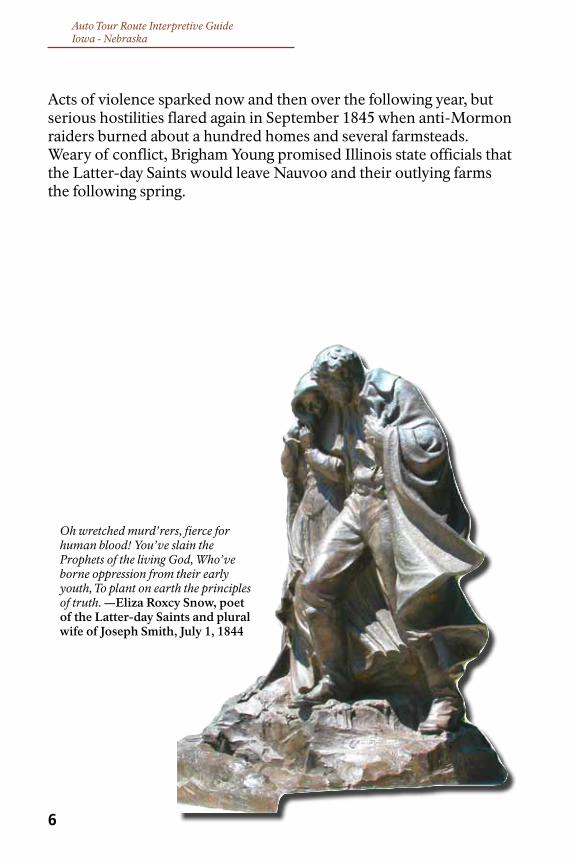
Acts of violence sparked now and then over the following year, but serious hostilities flared again in September 1845 when anti-Mormon raiders burned about a hundred homes and several farmsteads. Weary of conflict, Brigham Young promised Illinois state officials that the Latter-day Saints would leave Nauvoo and their outlying farms the following spring.
Oh wretched murd’rers, fierce for human blood! You’ve slain the Prophets of the living God, Who’ve borne oppression from their early youth, To plant on earth the principles of truth. —Eliza Roxcy Snow, poet of the Latter-day Saints and plural wife of Joseph Smith, July 1, 1844

Auto Tour Route Interpretive Guide Iowa - Nebraska
7
exoDUS FRom NAUvoo
Over the winter, the stricken Saints labored to complete their temple even while preparing to move to some undetermined
place beyond the Rocky Mountains. Mormons gathered money, maps, and supplies, built sturdy wagons, and organized themselves into companies of 10, 50, and 100. They planned to begin an orderly, phased emigration of up to 17,000 church members in the spring, but rumors of a coming raid prompted Brigham Young to evacuate the families of key church leaders during the bitter late winter of 1846. Young hoped the early departure of church authorities would deflect further attacks on Nauvoo by showing that the Latter-day Saints were serious about leaving in the spring, as promised.
The first train of Mormon wagons ferried across the Mississippi on February 4, and then camped for nearly a month at nearby Sugar Creek while waiting for Young to conclude business at Nauvoo. During the wait, temperatures dropped further and the river froze. Some from Nauvoo, afraid of being left behind, took advantage of the apparent miracle by crossing the ice to join the advance company, the “Camp of Israel.” Others crossed the river in both directions to retrieve supplies, visit relatives, and conduct business. By the time camp was ready to move, the company had grown from Young’s intended 1,800 to about 2,500 emigrants.
Some 500 wagons in Brigham Young’s Camp of Israel rolled northwestward out of Sugar Creek Camp on Sunday, March 1, 1846, heading across southern Iowa Territory toward the Missouri River. If all went well, they would cross that river by late April, leaving enough time to reach the Rocky Mountains by fall.
Meanwhile, the main body of Saints prepared to leave the Nauvoo area in spring, as originally planned. Once the grass was high enough to feed their livestock, some 10,000 Mormons set out in small companies to catch up with the Camp of Israel. Theirs was the second and largest emigration from Nauvoo. Over the summer, a few hundred of those who had stayed behind left to join dissident factions of the church. (Several of those groups merged in 1860 to create the New Organization, later called the Reorganized Church

Auto Tour Route Interpretive GuideIowa - Nebraska
8
of Jesus Christ of Latter Day Saints, now named the Community of Christ. This group, which opposed polygamy but followed other Mormon teachings, eventually was led by Joseph Smith III, oldest son of Joseph Smith, Jr. and his widow, Emma.) A few Mormon families quietly remained in the area and peacefully continued their lives there.
By early autumn, only about 700 Latter-day Saints remained in once-bustling Nauvoo and nearby Mormon settlements. Many of those left behind —too poor, too ill, or too infirm to travel— were driven out by anti-Mormon raiders in September 1846. Some of these refugees found shelter and work in surrounding communities, while others camped on the Iowa side of the river, in need of food, transportation, and medical help. Several died there, outside of Montrose, Iowa, of hunger, disease, and exposure. Church leaders sent back three rescue wagon trains to move these people to places where they could spend the winter safely. Theirs was the third and final Mormon emigration from Nauvoo.
As they started West, many emigrants looked back across the river for a last glimpse of Joseph Smith’s shining, white temple. At a public dedication on May 1, shortly before the main body of Latter-day Saints left Nauvoo, the people had prayed that the temple would
We all halted & took a farewell view of our delightful City….We also beheld the magnificent Temple rearing its lofty tower towards the heavens…we also took a farewell look of our Comfortable homes we had labored so hard to rear for the Comfort of our families…my heart did swell within me. —Newel Knight, Nauvoo, April 24, 1846
Great injustice inflicted by a lawless and irresponsible mob. Can these things be done in a republic and not be rebuked by an efficient expression of public sentiment? —Bloomington (Illinois) Herald, October 30, 1846
The great body of [Mormons] removed voluntarily, but a small remnant of them were barbarously expelled with force, and in a manner which reflects but little credit on the state or its institutions. —Illinois Governor Thomas Ford, December 7, 1846

Auto Tour Route Interpretive Guide Iowa - Nebraska
Mormon Trail through Garden Grove Historic Site, Garden Grove, Iowa.
9
stand as a monument to Joseph Smith. Despite the prayers, an arson fire destroyed the abandoned structure in 1848 and a tornado knocked down some of its remaining walls two years later. By then, the Latter-day Saints would be planning a new temple and building their greatest tribute to Joseph Smith: a Mormon Zion in the Valley of the Great Salt Lake, in present-day Utah.

Auto Tour Route Interpretive GuideIowa - Nebraska
10
wINTeR ReTReAT AcRoSS IowA
In February 1846, the first party of Mormon pioneers faced nearly 300 miles of winter-bare prairie stretching between Nauvoo and
the Missouri River gateway to the Oregon Trail. Those emigrants who left Nauvoo in a panic were poorly equipped for the trek, and few carried enough feed for their draft animals. Lacking spring grasses along the established roads, Young’s company traveled poorer tracks close to the Missouri border in order to trade with the Missouri settlements for livestock feed and supplies. Bad weather made travel more difficult. As rain set in and the ground thawed, narrow wagon wheels mired axle-deep, bringing wagons to a halt. Families waited miserably in camp as the men fanned out across the lightly settled territory to work for food and pay, and trade teams crossed cautiously into unfriendly Missouri to bring back needed supplies. The Camp of Israel spent a month crossing the first 100 miles, a distance that should have taken but 10 days.
The pioneers comforted and helped each other along: those who had food, bedding, and shelter shared with those who had none; those with musical or literary talent tried to cheer and inspire the camp. Their hardships brought the people together, forging their faith, group identity, and sense of destiny. The spirit of these Mormon pioneers rings in the lyrics of their now-famous anthem, “Come, Come, Ye Saints,” written one miserable, muddy night in south-central Iowa by emigrant William Clayton, in honor of the birth of his son.
A large portion of our journey in Iowa seemed to me to be a continuous mud hole. —Benjamin Critchlow, autobiographical account of the 1846 Mormon emigration
Come, come, ye Saints, no toil nor labor fear; But with joy wend your way. Though hard to you this journey may appear, Grace shall be as your day....All is well! All is well! —William Clayton, author of Come, Come, Ye Saints, April 13, 1846

Auto Tour Route Interpretive Guide Iowa - Nebraska
11
PlAceS To PAUSe, To ReST…To DIe
Two months on the trail, battling mud and mishaps across half of Iowa, exhausted the Camp of Israel, depleted its food supplies,
and threatened to unravel Brigham Young’s loose-knit plan to reach the Rocky Mountains that summer. Many emigrants were too ill or too poorly equipped to continue west. Church leaders worried, also, for the thousands of faithful who followed.
The Mormon wagon train stopped far short of the Missouri River on April 19 to build a temporary way station called Garden Grove. Almost overnight, the pioneers dug wells, built houses, bridges, and fences, plowed and planted. Several hundred emigrants settled in to rest, heal, and prepare for the final push to the Rockies. If their crops were successful, they would also help feed the later Nauvoo wagon companies that would soon be arriving. Garden Grove was good farming country, but it was infested with rattlesnakes. It was not the entire solution to their problems. The main body of the company rolled on.
On May 16, a scout selected a beautiful site that he named Mt. Pisgah, after the hilltop from which Moses looked upon the chosen land. The Latter-day Saints built more cabins and dugouts there, and they plowed and planted a thousand acres of prairie. At least 200 emigrants stayed there, and the population grew to about 700 as later arrivals joined them over the summer. Despite the beauty of its setting and the promise of its name, however, Mt. Pisgah was a place of sorrow. Several score of people, forced from their homes and weakened by exposure, exhaustion, and poor nutrition, would die there over the coming months.
This was a great place for rattlesnakes. Either an ox or a horse came up almost every night with a swelled head, etc. I became very much dissatisfied with this place, and it seemed as though I could not tarry there under any consideration. —Ezra Benson, autobiographical account, Garden Grove, Iowa, 1846
[My son] died in my arms about four o’clock....He died with the hooping cough & black canker [scurvy]…We are entirely destitute of any thing even to eat much less to nourish the sick. —Hosea Stout, Garden Grove, Iowa, May 8, 1846

Auto Tour Route Interpretive GuideIowa - Nebraska
“Kanesville” Mormon settlement on the banks of the Missouri River (present-day Council Bluffs). Courtesty of the Utah State Historical Society.
Meanwhile, the bulk of the Camp of Israel moved on once more, finally reaching the Missouri River Valley on June 14, 1846—too late for even a “swift company” to start across the Great Plains and over the mountains. On the Iowa side of the river they established a “Grand Encampment,” which continued to receive oncoming emigrants through the summer. By winter, some 2,500 Mormons would be settled into make-do shelters along the east bank of the Missouri River. Thousands more fanned out from the Grand Encampment, ultimately establishing over 90 cluster settlements within a 40-mile radius of Council Bluffs.
In return for sending 500 men (the Mormon Battalion) to serve in the recently declared U.S. war against Mexico, Brigham Young received permission from the federal government to camp on Indian lands west of the river, as well. Many Mormons crossed over to Nebraska, built more temporary towns, and settled in for the winter “on the edge of the wilderness.” By December, the largest community, called Winter Quarters, consisted of about 540 cabins, dugouts, and shanties, home to nearly 4,000 people.
12

Auto Tour Route Interpretive Guide Iowa - Nebraska
“Winter Quarters” on the banks of the Missouri River, by C.A. Christensen. Courtesy of the Brigham Young University Museum of Art.
At Mt. Pisgah, Garden Grove, Winter Quarters, the Grand Encampment, and other Mormon settlements, hundreds of emigrant men, women, and children died that sad winter. All told, more than 700 perished of exposure, malnutrition, scurvy, tuberculosis, pneumonia, malaria, and other diseases during the winter and spring of 1846-47.
The Latter-day Saints’ hope for a new Zion might have died there, as well —but it did not. Under Brigham Young’s encouragement and leadership, the survivors soon would pick up their feet and begin the second half of their journey to the Valley of the Great Salt Lake.
The shaking ague fastened deathless fangs upon me…I shook till it appeared my very bones were pulverized. I wept, I prayed, I besought the Lord to have mercy on me. —Louisa Barnes Pratt, Cold Springs encampment near Winter Quarters, 1846
Scarcely a family escaped sickness and very few where death did not make an inroad. A general spirit of lamentation and sorrow pervaded Pisgah. —Lorenzo Snow, Mt. Pisgah, Iowa, 1846
13

Auto Tour Route Interpretive GuideIowa - Nebraska
14
A FAR-ReAcHING ImPAcT
Brigham Young and many of his followers left their Missouri River prairie settlements for the arid expanses of the Great Basin in the
spring of 1847. There, the Latter-day Saints hoped, they would be out of the reach of old enemies. Young and a small advance party of emigrants and scouts arrived in the Valley of the Great Salt Lake in late July 1847. The main body of Nauvoo emigrants, including many who had wintered at Garden Grove and Mt. Pisgah, soon followed their trail into the valley to begin new lives in an unfamiliar land of desert, mountains, and salt flats.
The historic “Gathering to Zion” that began in 1846 continued via Brigham Young’s original route and other trails, from many points of departure and by various means —including handcart brigades— until the transcontinental railroad was completed in 1869. Altogether, the Mormon wagon trains and handcart brigades were the greatest organized movement of people across the American West in the entire emigration era—an emigration based on the deeply held American principle of freedom of religion. Non-Mormon emigrants traveling to California and Oregon also used the roads, bridges, ferries, settlements, and trading posts established by the Mormons on
And at [Mt.Pisgah] we had many testimonies that the Lord had not forsaken us, and that He was mindful of His people who put their trust in Him. —Sarah Rich, autobiographical account of 1846 emigration
There was great want of bread in camp, so that we were oppressed on every hand, but we cried to the Lord, who heard our prayers, and we were fed by his all-bountiful hands… —Allen Stout, Garden Grove, Iowa, April 3, 1846
There are times and places in the life of every nation when great spiritual heights are reached, when courage becomes a living thing, when faith in God stands as the granite mountain wall — firm and immovable— while hardships, want, hunger, sickness, sorrow, and death beat down to crush. Winter Quarters was such a time and place for the Mormon people. — Heber J. Grant, President, Church of Jesus Christ of Latter-day Saints, September 20, 1936

Auto Tour Route Interpretive Guide Iowa - Nebraska
their way to Utah. Under church direction, Latter-day Saints settled throughout the Southwest and Intermountain West. The journals, letters, sketches, and photographs they created to document their experiences across that vast region remain invaluable to historians. Their stories continue to inspire and fascinate. Today, Latter-day Saints are mainstream Americans, recognized participants in national politics, international economies, and the global community.
Clearly, the Mormon exodus to Utah was not a mere footnote in the history of the American West. It is an integral part of the American story.
15

Auto Tour Route Interpretive GuideIowa - Nebraska
SITeS AND PoINTS oF INTeReSTNauvoo, IllINoIs to CouNCIl Bluffs, Iowa
The Mormon Pioneer National Historic Trail begins at Nauvoo, Illinois, and ends at Salt Lake City, Utah. This guide follows only the route taken across Iowa by the 1846 Nauvoo emigrant company led by Brigham Young. Routes and sites used by later Mormon wagon trains and handcart companies are not included in this guide because they are not at present congressionally authorized as part of the Mormon Pioneer National Historic Trail.
Begin this segment of your trip at Nauvoo, Illinois, and follow the trail west toward Council Bluffs, Iowa. The driving directions below, along with Auto Tour Route signs along the major highways, will help you along the route.
Please respect private property by staying in public areas, and help protect our national heritage by leaving all historic sites undisturbed.
16

Auto Tour Route Interpretive Guide Iowa - Nebraska
Farmstead exhibit at Old Nauvoo.
1. Nauvoo National Historic Landmark (Nauvoo, Illinois) is the historic town site of old Nauvoo, established in 1839 by followers of Joseph Smith. The Nauvoo Temple, destroyed shortly after the Mormon exodus, was rebuilt on-site and re-dedicated in 2002. The temple is not open to the public, but tours of the historic district, with 25 historic homes, businesses, visitor centers, and demonstration sites, are available free to all visitors.
Attractions at the Joseph Smith Historic Site (operated by Community of Christ Church) include the Joseph Smith Homestead and Mansion House, a reconstruction of his Red Brick Store, and the Smith Family Cemetery, where Joseph and many of his family members are buried. Tours start at the Joseph Smith Historic Site Visitor Center; orientation and exhibits are available there, as well. Closed Sundays; hours vary by season. For more information go to www.cofchrist.org/js or call 217-453-2246. Admission to the Visitor Center, site orientation video, museum exhibits and Red Brick Store is free. There is a modest fee for the guided tour of the Smith homes.
The LDS Nauvoo Visitor Center (operated by The Church of Jesus Christ of Latter-day Saints) offers site orientation and historical information, theatrical performances, and exhibits. For Center visiting hours go to www.ldschurch.org/placestovisit and search “Navoo.” Other Navoo attractions include the Brigham Young Home, the reconstructed Nauvoo Temple, the Trail of Hope interpretive walk, a 3-hour handcart trek, plays and musical programs, ox-drawn wagon rides, carriage rides, and horse-drawn wagon tours of historic Nauvoo. All except the temple interior are open to the general public. Some activities require reservations, but all are free. Historic sites are open year-round, but some activities are available only seasonally. Visit www.ldschurch.org/placestovisit, or call 217-453-2237 for events schedule and information.
17

Auto Tour Route Interpretive GuideIowa - Nebraska
Nauvoo Landing.
Nauvoo State Park & Museum.
Location: Nauvoo, Illinois, is the trailhead of the Mormon Pioneer National Historic Trail. It is located on the east bank of the Mississippi River, across from the southeastern-most corner of Iowa. To arrive at the main historic district, follow IL-96/Mullholland Street west through the town’s business district and past the temple. Where the paved highway makes a sharp bend to the left, leave the pavement and continue straight on the gravel street toward the river, then turn left on Main Street. Maps to specific historic attractions are available at local guest establishments and church-operated visitor centers.
2. Nauvoo Landing (Nauvoo, Illinois), at the foot of Parley Street on the riverfront, is one of the eastern departure points from Nauvoo where emigrants lined up their wagons to be ferried across the Mississippi River in February 1846. Later that month, during several days of freezing weather, a few hundred people drove their wagons across the ice from this location. Nearby is a memorial naming those who died on the Mormon Trail.
Directions: Take IL-96/Mullholland Street west toward the river, through the town’s business district. Follow the paved highway where it makes a sharp turn to the left (south) and becomes Park Street. Continue south on Park Street for 6 blocks to Parley Street. Turn right and drive to the riverfront.
3. Nauvoo State Park and Museum (Nauvoo, Illinois) is the location of Nauvoo’s first vineyard, which began producing grapes in the mid-1800s. The park features a 1840s-era Mormon house with museum exhibits, wine cellar, and press room, a 13-acre lake, 18

Auto Tour Route Interpretive Guide Iowa - Nebraska
Carthage Jail.
Linger Longer Pioneer Trail Memorial at Riverfront Park.
camping, hiking, fishing, and other outdoor activities. Open year-round, free.
Directions: Take IL-96/Mullholland Street west toward the river and through the town’s business district. Follow the paved highway where it makes a sharp turn to the left (south) and becomes Park Street. Follow Park Street for 4 blocks and turn left onto a gravel road leading into the park, then continue for approximately 0.15 mile to the vineyard and museum on the right side of the road.
4. Carthage Jail & Visitor Center (307 Walnut St., Carthage, Illinois). Joseph Smith and his brother Hyrum lost their lives here on June 27, 1844. The jail and visitor center are open year-round; no admission is charged. For visiting hours, go to www.ldschurch.org/placestovisit and search “Navoo, “ or call 217-357-2989. Free guided tours available.
Directions: From Nauvoo, take IL-96/Park Street south along the Mississippi River for approximately 10 miles to Hamilton. Turn left (east) onto U.S.-136 and continue another 12 miles to Carthage. Turn right on North Fayette Street and follow directional signs to the jail at the corner of Walnut and North Fayette.
5. Linger Longer Park (Montrose, Iowa). A pavilion with Mormon Trail exhibits commemorates the destitute Mormon refugees who subsisted in that area after being driven from Nauvoo in September 1846. The park also offers a panoramic view of
19

Auto Tour Route Interpretive GuideIowa - Nebraska
Riverfront Park at Montrose.
Nauvoo, across the river. Open dawn to dusk.Directions: From Nauvoo, follow IL-96 east then north 9 miles to Niota. Turn left onto IL-9, a toll bridge (no fare when crossing west to east, modest fare when crossing east to west) over the river. Mid-river, IL-9 becomes IA-2. Enter Fort Madison and turn left onto U.S.-61, paralleling the railroad, and continue for 1.8 miles. Where U.S.-61 intersects with IA-103, jog left (south) and several blocks later jog right (west) to stay on U.S.-61. Continue on U.S.-61 for 10.4 miles. Upon passing 289th Street to the left, slow and watch for a left turn onto Mississippi River Road, which parallels the river. Turn left there, then immediately turn left into Linger Longer Park. Trail exhibits are in the pavilion and at the opposite end of the park.
6. Riverfront Park (Chestnut Street, Montrose, Iowa) is the location of old Fort Des Moines, and the place where Mormons initially settled in Iowa while creating Nauvoo across the river. Because the fort had been abandoned before Brigham Young and others arrived in early 1839, numerous families, including that of Young, temporarily took shelter in the vacant barracks. Here, Joseph Smith performed faith healing and predicted that his Latter-day Saints one day would gather in the Rocky Mountains. Here, too, Smith hid from hostile anti-Mormons shortly before his arrest and murder. At the river’s edge is Montrose Landing, where Mormon emigrants came to shore after leaving Nauvoo in 1846. Open dawn to dusk.
Directions: From Linger Longer Park, continue south on Mississippi River Road, paralleling the river, and follow it into Montrose. The road becomes First Street. Turn left on Chestnut Street, cross the railroad tracks, and enter Riverfront Park. Markers and wayside exhibits (no historic buildings) are located at the north and south ends of the park.
20

Auto Tour Route Interpretive Guide Iowa - Nebraska
Sugar Creek.
21
7. Sugar Creek (near Montrose, Iowa) is the staging ground where the first group of emigrants gathered and waited for Brigham Young while preparing for their journey west. The main camp was east of the creek; later, the company also camped briefly on the west side. They departed Sugar Creek on March 1, 1846. The site is on privately owned pasture land 6 miles west of Montrose. No traces of the original camp are visible and no on-site interpretation is provided. Please view from the road. Do not enter property without owner’s permission.
Directions: From the wayside exhibits at Riverfront Park in Montrose, continue south through the park, cross the railroad tracks, and continue to the four-way stop. Go straight (southwest) on Main Street, which becomes J-72. Where J-72 intersects U.S.-61, you can stay on primary roads or follow an unsigned gravel road for a short distance along the actual route traveled by the emigrants. To stay on primary roads, turn left (south) on U.S.-61 and follow it to its junction with U.S.-218. Turn right and drive northward. The first road to the right is 300th Street (also county road J-72), but it does not cross the highway at that location, so continue a short distance further to the next road on your left. Turn left (west) there onto J-72/300th Street and continue for 5.3 miles to the unsigned bridge that crosses Sugar Creek. To follow a portion of the original route, where J-72 intersects U.S.-61, cross U.S.-61 and continue west on 300th Street (unpaved and unsigned at this location) for approximately 0.4 mile. As you near the top of the ridge, stop and look back for a glimpse of the Nauvoo Temple —this was the emigrants’ last view of home as they headed west. Continue to the junction, turn right (north) onto U.S.-218, and drive 0.10 mile to county road J-72, the next road to your left. Turn left (west) on J-72/300th Street and continue for 2.9 miles to the unsigned bridge over Sugar Creek.

Auto Tour Route Interpretive GuideIowa - Nebraska
Bonaparte - Des Moines River Crossing.
8. Des Moines River Ford (Bonaparte, Iowa). Some emigrants who crossed the Des Moines River here on March 5, 1846, took note of the “splendid Mill” at the village of Bonaparte. The mill is now part of the Bonaparte Historic Riverfront District, listed on the National Register of Historic Places. Tours of the district are available. No set visiting hours.
Directions: From Sugar Creek, go west on county road J-72, then turn right (north) on IA-27 and continue about 8 miles toward Donnellson. On approaching town, IA-27 merges with U.S.-218. Take Exit 19 to Donnellson. At the end of the exit, turn left (west) onto IA-2/Madison Street and drive west for 10.5 miles to Farmington. In the center of Farmington, turn right on Olive Street. (IA-2 will make a sharp turn to the left there to cross the Des Moines River, but the pioneer route stays on the east bank of the river.) Follow Olive east across 6th and 7th streets. A short distance past 7th Street, the road splits. Go left onto county road W-46 heading north. The road becomes 100th Avenue. Drive north and cross 185th Street; continue north to junction with county road J-40. Turn left (west) on J-40 and continue to its intersection with county road W-40. Turn left (south) and drive into Bonaparte. In town, the road becomes Washington Street. Turn right at First Street and enter the historic district; or to see the trail wayside, continue south on W-40 and cross the bridge over the Des Moines River. On the south side of the river, turn right onto River Road and enter the riverside park.
9. Bentonsport National Historic District (Bentonsport, Iowa) boasts a number of buildings thought to have been constructed by Mormon emigrants who stopped and labored to earn money for their trip west. One of these buildings is the Mason House Inn, which retains its original 19th century furnishings. For tours of the inn, call the proprietors at 800-592-3133. A self-guided walking tour of the district is available. 22
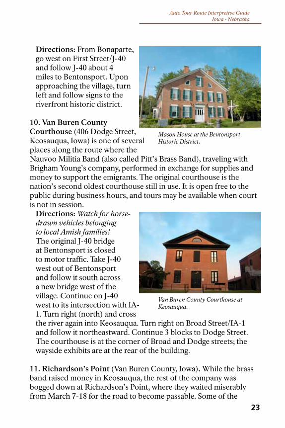
Auto Tour Route Interpretive Guide Iowa - Nebraska
Van Buren County Courthouse at Keosauqua.
Mason House at the Bentonsport Historic District.
Directions: From Bonaparte, go west on First Street/J-40 and follow J-40 about 4 miles to Bentonsport. Upon approaching the village, turn left and follow signs to the riverfront historic district.
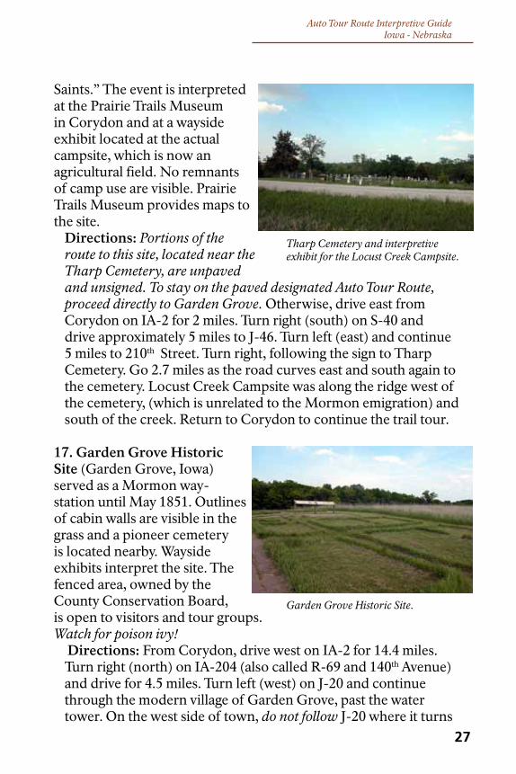
10. Van Buren County Courthouse (406 Dodge Street, Keosauqua, Iowa) is one of several places along the route where the Nauvoo Militia Band (also called Pitt’s Brass Band), traveling with Brigham Young’s company, performed in exchange for supplies and money to support the emigrants. The original courthouse is the nation’s second oldest courthouse still in use. It is open free to the public during business hours, and tours may be available when court is not in session.
Directions: Watch for horse-drawn vehicles belonging to local Amish families! The original J-40 bridge at Bentonsport is closed to motor traffic. Take J-40 west out of Bentonsport and follow it south across a new bridge west of the village. Continue on J-40 west to its intersection with IA-1. Turn right (north) and cross the river again into Keosauqua. Turn right on Broad Street/IA-1 and follow it northeastward. Continue 3 blocks to Dodge Street. The courthouse is at the corner of Broad and Dodge streets; the wayside exhibits are at the rear of the building.
11. Richardson’s Point (Van Buren County, Iowa). While the brass band raised money in Keosauqua, the rest of the company was bogged down at Richardson’s Point, where they waited miserably from March 7-18 for the road to become passable. Some of the
23

Auto Tour Route Interpretive GuideIowa - Nebraska
Richardson’s Point.
Cabin at the Davis County Historical Complex.
first deaths of the emigration occurred at this location, just 35 miles from Nauvoo. The graves of an emigrant man and a 15-month-old child are here. The site is on private agricultural land; remnants of the original camp are not visible. Please view from the road. Do not enter the property without owner’s permission.
Directions: Watch for horse-drawn vehicles belonging to local Amish families! From the intersection of Dodge and Broad streets in Keosauqua, follow Broad Street/IA-1 northeastward through town to Franklin Street, 0.3 miles from the courthouse. Turn left on Franklin, which becomes county road J-40. Follow J-40 west across the Des Moines River and through the village of Pittsburg to Lebanon, a distance of 8 miles. From Lebanon, continue west on J-40 for another 3 miles. Park off the highway at the entrance of Oak Point Cemetery, past the intersection of J-40 with county road V-56. Watch for the “Mormon Trail” sign. This is the vicinity of Richardson’s Point.
12. Davis County Historical Complex (Bloomfield, Iowa) includes a log cabin built for local settlers by Mormon laborers, who looked for work while the Camp of Israel waited out a storm at Richardson’s Point. Open dawn to dusk.
Directions: Continue west on J-40 from Richardson’s Point to Bloomfield. The historical complex is near the water tower, 1 block east of the courthouse square, at East Franklin and South Dodge streets.
24

Auto Tour Route Interpretive Guide Iowa - Nebraska
Chariton River Crossing & Campsite.
Drakesville Park.
13. Drakesville Park (Drakesville, Iowa). Brigham Young’s pioneers turned south here toward Missouri, where they could buy supplies and feed. Later Mormon emigrant parties left the original trail to stay on higher ground and avoid the mud. A wayside exhibit interprets the location.
Directions: From the Davis County Historical Complex in Bloomfield, turn right (north) at the courthouse onto South Washington Street/U.S.-63 and continue out of Bloomfield for 3.3 miles. Turn left (west) on IA-273/180th Street and continue for 4.3 miles to Drakesville. The exhibit is on Main Street; the park is 2 blocks north of Main on Madison Street.
14. Chariton River Crossing and Campsite (South of Exline in Appanoose County, Iowa). After a very difficult crossing of the Chariton River near this location, the pioneers again made camp to wait out the worst of a storm. From here, travel grew increasingly rough as territorial roads and rough trails dwindled and disappeared altogether. Please view from the road. Do not enter property without owner’s permission.
Directions: Portions of the route to this site are unpaved and unsigned. To stay on the paved designated Auto Tour Route, proceed directly to Corydon. Otherwise, continue west through Drakesville and turn left (south) onto South Washington Street/Ice Avenue. Continue south (the road becomes Drakesville Blacktop South) for 3.7 miles to its intersection with U.S.-63/IA-2. Turn right (west) on IA-2 and drive 20.7 miles to Centerville. Turn left
25

Auto Tour Route Interpretive GuideIowa - Nebraska
Prairie Trails Museum.
(south) onto IA-5/18th Street and continue for 5.4 miles to T-30/IA-130 (listed on maps as IA-216); turn left (east) and drive 1 mile toward the village of Exline. As it approaches Exline, the road turns south and forks. Follow T-30 as it jogs left (east) into Exline, and continue through the village to the church and cemetery at East 2nd Street. Set your odometer here, turn right (south), and watch for directional signs along the way to the site. At odometer reading 0.7 mile, turn onto a gravel road CR-J51 (580th Street) heading east. At odometer reading 2.3 miles, the road splits: go left onto 252nd Avenue, a farm lane. At odometer reading 4.2 miles, continue past a small cemetery. At odometer reading 4.7 miles, take the right fork (269th Avenue) where the road splits. A Mormon Trail crossing sign is located at 5.2 miles. Continue another 0.3 mile on 269th Avenue to the interpretive pullout and wayside exhibits. From there, visitors can follow a walking trail to the river crossing, which is 0.3 mile beyond the pullout. Watch for poison ivy. Return to Centerville to continue on the Auto Tour Route.
15. Prairie Trails Museum (515 E. Jefferson Street, Hwy 2 East, Corydon, Iowa) features an excellent Mormon Trail exhibit. The museum is open seven days a week, April 15 through October 31. Hours are 10 a.m. to 5 p.m. June–August; 1 to 5 p.m. April–May; and 1 to 5 p.m. September–October; to arrange a visit during winter months, call the museum at 641-872-2211. For more information go to www.prairietrailsmuseum.org. A modest admission is charged. Inquire here for map to Locust Creek Campsite.
Directions: From Centerville, drive west on IA-2 for 23.7 miles to Corydon. Museum is on the north side of the highway.
16. Locust Creek Campsite (Southwest of Seymour, Wayne County, Iowa). At this campsite on April 15, 1846, William Clayton wrote the lyrics to the inspirational Mormon anthem, “Come, Come, Ye 26
Auto Tour Route Interpretive Guide Iowa - Nebraska
Garden Grove Historic Site.
Tharp Cemetery and interpretive exhibit for the Locust Creek Campsite.
Saints.” The event is interpreted at the Prairie Trails Museum in Corydon and at a wayside exhibit located at the actual campsite, which is now an agricultural field. No remnants of camp use are visible. Prairie Trails Museum provides maps to the site.
Directions: Portions of the route to this site, located near the Tharp Cemetery, are unpaved and unsigned. To stay on the paved designated Auto Tour Route, proceed directly to Garden Grove. Otherwise, drive east from Corydon on IA-2 for 2 miles. Turn right (south) on S-40 and drive approximately 5 miles to J-46. Turn left (east) and continue 5 miles to 210th Street. Turn right, following the sign to Tharp Cemetery. Go 2.7 miles as the road curves east and south again to the cemetery. Locust Creek Campsite was along the ridge west of the cemetery, (which is unrelated to the Mormon emigration) and south of the creek. Return to Corydon to continue the trail tour.
17. Garden Grove Historic Site (Garden Grove, Iowa) served as a Mormon way-station until May 1851. Outlines of cabin walls are visible in the grass and a pioneer cemetery is located nearby. Wayside exhibits interpret the site. The fenced area, owned by the County Conservation Board, is open to visitors and tour groups. Watch for poison ivy!
Directions: From Corydon, drive west on IA-2 for 14.4 miles. Turn right (north) on IA-204 (also called R-69 and 140th Avenue) and drive for 4.5 miles. Turn left (west) on J-20 and continue through the modern village of Garden Grove, past the water tower. On the west side of town, do not follow J-20 where it turns
27

Auto Tour Route Interpretive GuideIowa - Nebraska
Murray Trail Park.
28
south; instead, stay right (heading west) on the Mormon Trail Road (gravel) for approximately 0.5 mile. The site, on the right, is well-marked. To reach the cemetery, walk or drive west 0.1 mile to the fenced memorial that commemorates those who died at Garden Grove.
18. Clarke County Historical Museum (1030 N. Main, Osceola, Iowa) offers a variety of wayside and museum exhibits. Call 641-342-3313 for hours and appointments.
Directions: From Garden Grove Historic Site, drive east on county road J-20 to Garden Grove. At the intersection, stay left and continue east through town to R-69. Turn left (north) and continue to county road J-22. Turn left (west) on J-22 and drive approximately 9 miles to the junction with U.S.-69. Turn right (north) and continue for 12 miles toward Osceola. The museum is on the west (left) side of the highway on the south end of Osceola.
19. Murray Trail Exhibits (Murray, Iowa). Mormon Trail exhibits and a one-room school/museum are located on 5th Street.
Directions: From Osceola, take U.S.-34 west for 9.6 miles. Turn right (north) toward Murray on county road R-16/135th Avenue. In Murray, R-16 becomes McClellan Street. Turn left (west) on 5th Street and drive 2 blocks to Grant Street. The exhibits and museum are between Grant and Maple streets.
20. Seven-Mile Creek Campsite (Murray, Iowa). The swale of the original wagon road crosses this privately owned pasture land outside of Murray. The property owner has provided a viewing platform with interpretive information for visitors. Please view from the platform. Do not enter property without owner’s permission.
Directions: From the Murray exhibits, drive west on 5th Street to Sherman Street. Turn left (south) on Sherman, then take

Auto Tour Route Interpretive Guide Iowa - Nebraska
Seven-Mile Creek Viewing Platform.
Mount Pisgah Historic Site.
the next right (west) onto Kansas Street. Cross 130th Avenue (pavement ends) and continue west for 2.3 miles. The site, on the left, is well-marked. Return to Murray to continue the trail tour.
21. Mount Pisgah Historic Site (near Thayer, Union County, Iowa). The sufferings and sorrows afflicting Mount Pisgah, a village established by the Camp of Israel in May 1846, tested the faith of the pioneers. The site is now a mix of privately and publicly owned lands. The county park area has a reconstructed log cabin, wayside exhibits, historical markers, a monument, and a pioneer cemetery. Much of the village site itself is located on adjacent private pasture lands, which the owner opens to interested visitors and tour groups. Traces of wagon roads and outlines building footings are visible in places. Watch for poison ivy!
Directions: From Murray, return to U.S.-34 and turn right (west). Drive for 5.3 miles; turn right (north) on U.S.-169/3rd Avenue and continue for 2 miles. Follow signs to Mount Pisgah. Please drive slowly upon approaching the site, as the road passes through a private farmyard.
22. Bank of Memories Museum (107 First Steet, Orient, Iowa) is a small museum featuring a Mormon mural and housing a replica handcart (related to a later phase of the Mormon emigration). A wayside exhibit tells of the day-to-day life of children on the trail. The museum is open Monday–Friday, 12:30–4:30 p.m. Email [email protected] for more information.
Directions: From Mount Pisgah, return to the junction of U.S.-169 and U.S.-34. Turn right on U.S.-34 and drive west for 17.2 miles to Creston. Turn right (north) onto IA-25/South Sumner
29

Auto Tour Route Interpretive GuideIowa - Nebraska
Adair County Mormon Trail Park.
Avenue. Cross the railroad tracks and continue 6 blocks to West Howard Street. Turn right (east) and continue 12 blocks to Cherry Street. Turn left (north) on Cherry Street and continue north for 8.9 miles. Cherry becomes county road P-33. Turn left (west) on county road G-61 and continue approximately 2.5 miles into Orient, where the road becomes East Division Street. Turn right (north) onto School Street and drive one block. Turn left (west) on East First Street. The exhibit is at the intersection of East First and South Broad streets, and the museum is in the old bank building nearby.
23. Mormon Trail County Park and Lake (2828 Delta Avenue, southeast of Bridgewater, Iowa). At this 170-acre Adair County park, today’s visitor can experience the Iowa prairie as it appeared when the Mormon emigrants crossed it. A walking trail is provided through the prairie. The park also offers fishing, boating, picnicking, and camping. Entry is free, although fees may be charged for some activities. Watch for poison ivy!
Directions: A portion of the route is over unmarked gravel roads. To stay on paved primary roads, continue directly to Bridgewater. Otherwise, from Bank of Memories Museum go south on South Broad Street for 1 block and turn right (west) on East Division Street/IA-25. The road continues out of town and past a small reservoir to the left (south). A short distance after the reservoir, approximately 2 miles from town, the road forks. Follow IA-25 north to IA-92 at Greenfield. Turn left (west) on IA-92 and continue through Fontanelle toward Bridgewater. Before reaching Bridgewater, turn left (south) on Delta Avenue and drive 1.25 miles to the park entrance.
24. The Pote Farm Ruts (1285 290th St., Bridgewater, Iowa). Mormon Trail wagon ruts, among the few still existing in Iowa, are deeply
30

Auto Tour Route Interpretive Guide Iowa - Nebraska
The Grand Encampment.
eroded and visible in a pasture one mile south-southwest of Mormon Lake. Please view from road. Do not enter property without owner’s permission.
Directions: From Mormon Trail County Park, take Delta Avenue south for 0.75 mile to 290th Street/ G-53 (gravel). Turn right (west) and drive approximately 0.2 mile. The ruts are in a pasture on the north side of the road, about 0.25 mile west of the nearby farmhouse. They run east/west and are visible from the road. The site is marked with an Iowa Mormon Trails Association sign. Return to Bridgewater to continue trail tour.
25. West Nishnabotna River Crossing (Old Towne Park, Macedonia, Iowa). This site is an undeveloped park with a wayside exhibit; the original Mormon pioneer bridge over the river no longer exists.
Directions: From Bridgewater, take IA-92 west about 11 miles to U.S.-71. Turn left (south) on U.S.-71 and drive approximately 2 miles, then turn right (west) once more on IA-92. Drive about 21 miles to U.S.-59. Turn left (south) on U.S.-59, then right (west) onto county road G-66 and continue another 2 miles through Macedonia to Old Towne Park.
26. The Grand Encampment (Iowa School for the Deaf, 3501 Harry Langdon Boulevard, Council Bluffs, Iowa) was the primary Missouri River encampment in 1846. Stretching out over 9 miles, the encampment was a temporary home to thousands of pioneers. Several markers and wayside exhibits at the Iowa School for the Deaf commemorate and interpret the camp.
Directions: From Macedonia, head west on Main Street/county road G-66 for 1.1 mile to 370th Steet. Turn north toward U.S.-59 for approximately 2.6 miles. There, take IA-92 west for 22 miles to Harry Langdon Boulevard (U.S.-275) in Council Bluffs. Turn left
31

Auto Tour Route Interpretive GuideIowa - Nebraska
Kanesville Tabernacle.
Western Historic Trails Center.
(south) onto the boulevard and then turn left into the Iowa School for the Deaf entrance, approximately 0.1 mile from the highway interchange.
27. Western Historic Trails Center (3434 Richard Downing Avenue, Council Bluffs, Iowa) provides exhibits and interpretive information for the Mormon Pioneer, Oregon, California, and Lewis and Clark National Historic Trails. Open year-round, daily, 9 a.m. to 5 p.m. Admission is free.
Directions: Exiting the Iowa School for the Deaf, turn right (northwest) on Harry Langdon Blvd./U.S.-275, toward IA-92. Turn left onto IA-92 West/U.S.-275 West and drive 3.2 miles to South 24th Street. There is a sign for Western Trails. Turn right onto 24th Street and continue 0.8 mile to the center entrance, which is on the left immediately before the on-ramp to the interstate highway. Look for a flagpole and rock wall with entrance sign.
28. Kanesville Tabernacle & Visitor Center (222 E. Broadway, Council Bluffs, Iowa). Kanesville, which served as a Mormon emigration hub for several years, was an early name for the community that later became Council Bluffs. The building exhibited here is a reconstruction of the tabernacle in which Brigham Young was sustained as church president in 1847. The tabernacle and visitor center are open daily (including Sundays) April–September from 9:30 a.m. to 7 p.m., and October–March from 10 a.m. to 5 p.m. Admission is free.
32

Auto Tour Route Interpretive Guide Iowa - Nebraska
33
Directions: From the Western Historic Trails Center, turn left (north) onto South 24th Street and merge onto I-80 eastbound. Drive east 1 mile and take Exit 3 onto IA-192 North (South Expressway) toward the Council Bluffs business district, and continue north for 2.5 miles. Turn right (east) onto West Broadway and continue for 0.5 mile to the tabernacle site.
Additional sites relating to the 1846 Nauvoo exodus can be visited in nearby Omaha, Nebraska. The Mormon Trail Center (at historic Winter Quarters), 3215 State Street in Omaha, is a good place to begin the next section for touring Mormon Pioneer National Historic Trail venues in Nebraska. To get there, drive north on I-29 to I-680 West (Exit 61B) toward North Omaha. Drive 3.4 miles and leave the highway at Exit 13, to 30th Street/Eppley Airfield. Turn left onto North 31st Street, pass under I-680, and continue straight onto U.S.-75 South. Turn right onto State Street and continue two blocks to the Center.
Auto Tour Route guides for national historic trails in other states are available at local, regional, and state visitor and interpretive centers, travel and tourism centers, museums, and from the National Trails System office in Salt Lake City. They may also be downloaded as digital Acrobat Reader PDF documents from any of the four web sites listed on the title page.

Auto Tour Route Interpretive GuideIowa - Nebraska
cReDITS:
Research & Text: Lee Kreutzer, Cultural Resources Specialist, National Trails Intermountain Region.
layout/Design, and Graphics: Chuck Milliken, Lead Interpretive Specialist, National Trails Intermountain Region.
Graphic Images: All photo images used throughout this document are National Park Service except for the following: cover art & page 13 - paintings by Carl C.A. Christensen, Courtesy of Brigham Young University, Museum of Art; pages 2–3, & 16 - The Church of Jesus Christ of Latter-Day Saints, LDS Historical Department Archives; pages 1, 4–5, & 12 - Utah State Historical Society; page 32, - Kanesville Tabernacle, courtesy of the Mormon Trail Center at Winter Quarters.
FoR moRe INFoRmATIoN:
National Park ServiceNational Trails System Office324 South State StreetSuite 200Salt Lake City, UT 84111
email:[email protected]
mormon Pioneer NHTwww.nps.gov/mopi
Iowa Tourismhttp://www.traveliowa.com
mormon Trails Associationwww.mormontrails.org
34


National Trails SystemNational Park ServiceU.S. Department of the Interior
FoR FRee DISTRIbUTIoN