Narrative / Revegetation Plan Proposed Project Purpose …€¦ · Narrative / Revegetation Plan...
11
Narrative / Revegetation Plan Proposed Project Purpose and Description Gresham Woods Wet Meadow Project Purpose The purpose of this project is to enhance existing wetlands, create new wetlands, and improve wildlife habitat through the creation of shallow pools, the planting of native plants, and the installation of large woody debris. The shallow pools (6”-12” deep) will capture and hold surface water on site. These pools are to be located in areas of existing hydric soils. The pools are to be planted with emergent vegetation to replicate existing emergent wetlands adjacent to the Springwater Trail. Areas adjacent to created pools will be planted with shrub/shrub species that are found near the project site. In addition, several hummocks of tree and shrub species will be planted to provide vegetative diversity and structure and a long-term woody material to the site. Existing Conditions Hydrology The water source for the project area is predominately direct precipitation and secondarily lateral subsurface flow. Shallow swales running parallel to the Springwater Trail capture and hold water in high quality emergent wetlands and scrub/shrub wetlands. Overflow water runs out of these swales and along a gentle gradient through an area of highly disturbed wetland meadow predominated by non-native pasture grasses. Several hundred feet west of the project area is a stormwater ditch that runs from a storm sewer outfall near the Springwater Trail to Johnson Creek. Although adjacent to the western edge of the delineated wetland there is very little hydrological connection to the wetland. The elevation of the ditch is about 4 feet below the elevation of the wetland. The stormwater ditch has a very localized impact on the western end of the wetland. That impact does not influence the wetland within the project area. This wetland is classified as a Slope/Flat wetland using the Hydrogeomorphic (HGM) based Assessment of Oregon Wetland and Riparian Sites :Willamette Valley Ecoregion. Soils Soils for this area are mapped as Multnomah silt loam, which is not a hydric soil. The actually soils on site, as described by the wetland delineation prepared by Pacific Habitat Services, Inc on October 13, 2005, more closely resemble Wapato silt loam which is designated a hydric soil. Soils are described in the delineation as typically grey to grayish brown silt loam in the upper several inches with coarse blocky light gray silt loams from 8-14 inches depth. Infiltration on this site has been observed to be slow. Pockets of water remain on surface for extended periods of time after a rain. Vegetation The project area is predominated by meadow composed of pasture grass, but also includes areas of emergent wetland, shrub-shrub wetland and forest. The meadow is composed primarily of tall fescue (Festuca arundinacea, FAC-) and sweet vernal grass 1
Transcript of Narrative / Revegetation Plan Proposed Project Purpose …€¦ · Narrative / Revegetation Plan...

Narrative / Revegetation Plan Proposed Project Purpose and Description Gresham Woods Wet Meadow Project Purpose The purpose of this project is to enhance existing wetlands, create new wetlands, and improve wildlife habitat through the creation of shallow pools, the planting of native plants, and the installation of large woody debris. The shallow pools (6”-12” deep) will capture and hold surface water on site. These pools are to be located in areas of existing hydric soils. The pools are to be planted with emergent vegetation to replicate existing emergent wetlands adjacent to the Springwater Trail. Areas adjacent to created pools will be planted with shrub/shrub species that are found near the project site. In addition, several hummocks of tree and shrub species will be planted to provide vegetative diversity and structure and a long-term woody material to the site. Existing Conditions Hydrology The water source for the project area is predominately direct precipitation and secondarily lateral subsurface flow. Shallow swales running parallel to the Springwater Trail capture and hold water in high quality emergent wetlands and scrub/shrub wetlands. Overflow water runs out of these swales and along a gentle gradient through an area of highly disturbed wetland meadow predominated by non-native pasture grasses. Several hundred feet west of the project area is a stormwater ditch that runs from a storm sewer outfall near the Springwater Trail to Johnson Creek. Although adjacent to the western edge of the delineated wetland there is very little hydrological connection to the wetland. The elevation of the ditch is about 4 feet below the elevation of the wetland. The stormwater ditch has a very localized impact on the western end of the wetland. That impact does not influence the wetland within the project area. This wetland is classified as a Slope/Flat wetland using the Hydrogeomorphic (HGM) based Assessment of Oregon Wetland and Riparian Sites :Willamette Valley Ecoregion. Soils Soils for this area are mapped as Multnomah silt loam, which is not a hydric soil. The actually soils on site, as described by the wetland delineation prepared by Pacific Habitat Services, Inc on October 13, 2005, more closely resemble Wapato silt loam which is designated a hydric soil. Soils are described in the delineation as typically grey to grayish brown silt loam in the upper several inches with coarse blocky light gray silt loams from 8-14 inches depth. Infiltration on this site has been observed to be slow. Pockets of water remain on surface for extended periods of time after a rain. Vegetation The project area is predominated by meadow composed of pasture grass, but also includes areas of emergent wetland, shrub-shrub wetland and forest. The meadow is composed primarily of tall fescue (Festuca arundinacea, FAC-) and sweet vernal grass
1
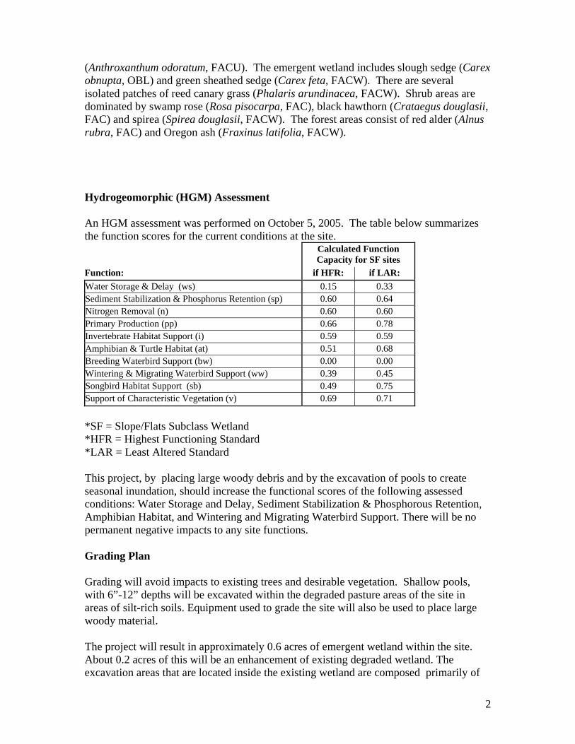
(Anthroxanthum odoratum, FACU). The emergent wetland includes slough sedge (Carex obnupta, OBL) and green sheathed sedge (Carex feta, FACW). There are several isolated patches of reed canary grass (Phalaris arundinacea, FACW). Shrub areas are dominated by swamp rose (Rosa pisocarpa, FAC), black hawthorn (Crataegus douglasii, FAC) and spirea (Spirea douglasii, FACW). The forest areas consist of red alder (Alnus rubra, FAC) and Oregon ash (Fraxinus latifolia, FACW). Hydrogeomorphic (HGM) Assessment An HGM assessment was performed on October 5, 2005. The table below summarizes the function scores for the current conditions at the site. Calculated Function
Capacity for SF sites Function: if HFR: if LAR: Water Storage & Delay (ws) 0.15 0.33 Sediment Stabilization & Phosphorus Retention (sp) 0.60 0.64 Nitrogen Removal (n) 0.60 0.60 Primary Production (pp) 0.66 0.78 Invertebrate Habitat Support (i) 0.59 0.59 Amphibian & Turtle Habitat (at) 0.51 0.68 Breeding Waterbird Support (bw) 0.00 0.00 Wintering & Migrating Waterbird Support (ww) 0.39 0.45 Songbird Habitat Support (sb) 0.49 0.75 Support of Characteristic Vegetation (v) 0.69 0.71 *SF = Slope/Flats Subclass Wetland *HFR = Highest Functioning Standard *LAR = Least Altered Standard This project, by placing large woody debris and by the excavation of pools to create seasonal inundation, should increase the functional scores of the following assessed conditions: Water Storage and Delay, Sediment Stabilization & Phosphorous Retention, Amphibian Habitat, and Wintering and Migrating Waterbird Support. There will be no permanent negative impacts to any site functions. Grading Plan Grading will avoid impacts to existing trees and desirable vegetation. Shallow pools, with 6”-12” depths will be excavated within the degraded pasture areas of the site in areas of silt-rich soils. Equipment used to grade the site will also be used to place large woody material. The project will result in approximately 0.6 acres of emergent wetland within the site. About 0.2 acres of this will be an enhancement of existing degraded wetland. The excavation areas that are located inside the existing wetland are composed primarily of
2

Festuca arundinacea and Anthroxanthum odoratum. The remaining 0.4 acres will be created in what is shown by the wetland delineation to be upland. A total of 480 cubic yards of material will be cut and filled on site. Of this total 160 CY will be removed and 0 CY will be filled in the existing wetland. All fill will be placed outside the existing and created wetlands. 18 pieces large woody debris with 10-16 inch diameters and 8-15 foot lengths will be placed within and adjacent to excavated pools throughout to project area to provide wildlife cover and perching habitat structures. Revegetation Plan Native trees, shrubs and forbs will be planted and seeded to replace non-native species. All sedges are from collections made on-site and all other seed sources are from the Portland metro area. Planting design will encourage diversity and extend existing plant communities. (See Revegetation Plan) Emergent Zone 0.6 acres 5,000 total plugs, and 20 lbs of seed per acre Carex obnupta seed, plugs Carex feta seed, plugs Juncus acuminatus seed, plugs Carex stipata plugs Alopecurus geniculatus seed Deschampsia cespitosa seed Shrub Zone 0.6 acres 2,000 bareroot plants per acre, and 20 lbs of seed per acre Rosa pisocarpa bare-root Crataegus douglasii bare-root Spirea douglasii bare-root Salix piperii bare-root Agrostis exarata seed Alopecuris geniculatus seed Deschampsia cespitosa seed Hordeum brachyantherum seed Elymus glaucus seed Glyceria occidentalis seed Potentilla gracilis seed Grindelia integrifolia seed Juncus patens seed Tree/Shrub Zone 0.4acres 1680 bareroot trees and shrubs per acre and seeded at 24 lbs per acre.
3

Fraxinus latifolia bare-root Alnus rubra bare-root Crataegus suksdorfii bare-root Populus tricocarpa bare-root Thuja plicata bare-root Physocarpus capitatus bare-root Cornus sericea bare-root Spiraea douglasii bare-root Symphoricarpos albus bare-root Bromus carinatus seed Elymus glaucus seed Festuca rubra var. comutata seed Hordeum brachyantherum seed Plant Protection Trees will be protected from animal damage using vexar tubing. Bare-root plants will be mulched to increase plant survival. Maintenance and Monitoring Maintenance will happen throughout the project duration within the 4.2 acres of the project boundary. Workers will selectively remove invasive plants from amongst planted native vegetation using chainsaws, hand tools, herbicide application tools, and where possible, mowing equipment. BES monitors planting survival and exotic vegetation re-growth, and prescribes additional treatments as needed. Monitoring will occur annually according to the Watershed Revegetation Program Monitoring Protocol. Schedule
• Permit Submittal April 2007 • Construction/Grading 2 weeks of construction to occur June 2007. • Broadcast seeding, September 2007 • Emergent plug planting, October 2007 • Tree/Shrub Planting February, 2008 • Maintenance and Monitoring June 2007 – May 2011
4

Gresham Woods Sediment and Erosion Control Plan GENERAL This section covers the work necessary to construct, install, modify, maintain, and remove measures to control erosion and prevent sediment and pollutants from leaving the site. BACKGROUND Construction will be completed using a “self-directed” model where designers work directly on construction to ensure the strictest implementation standards according to the plans. City of Portland staff will uphold standards for construction site erosion prevention and sediment control are in the City of Portland EROSION CONTROL MANUAL (March 1, 2000). STANDARDS Due to site location on very level terrain, far from flowing water, risk of erosion is low. Additionally, work will be constructed during dry weather. However, staff will uphold the EC Manual standards that:
“No visible and measurable sediment or pollutant shall exit the site, enter the public right-of-way or be deposited into any water body or storm drainage system.”
Staff will specifically monitor three key erosion types at the beginning and the end of each work day:
1. Deposits or tracking of mud, dirt, sediment or similar material exceeding one-half cubic foot in volume on public or private streets, adjacent property, or into the storm or surface water system, either by direct deposit, dropping, discharge or as a result of the action of erosion.
2. Evidence of concentrated flows of water over bare soils; turbid or sediment laden flows; or evidences of on-site erosion such rivulets on bare soil slopes, where the flow of water is not filtered or captured on the site.
3. Earth slides, mudflows, earth sloughing, or other earth movement leaving the project site.
In the event that work produces the above conditions, work will immediately stop until erosion occurrences are stabilized and mitigated before recommencing work. MATERIAL Staff will employ the following methods of erosion control as needed to stabilize the site during and following construction:
1. SILT FENCE--Field fabricated silt fencing with pre-fabricated pockets shall meet the following requirements:
a. Grab Tensile, lbs. ASTM-D-4632 W120/F120 b. Grab Elongation, % ASTM-D-4632 15 c. Mullen Burst, psi ASTM-D-3786 300
C:\Documents and Settings\majidi\Desktop\usfws grant\ESPC Plan (2).doc

d. Puncture, lbs. ASTM-D-4833 60 e. Trapezoidal Tear, lbs ASTM-D-4533 W60/F60 f. UV Resistance, % (Strength Retained) ASTM-D-4355 80
2. SEDIMENT CONTROL BARRIER
a. Jersey barriers or Environmental Barricades, and Amoco 4552 Nonwoven Geotextile (or approved equal), and sand bags as shown in the Plans. All materials used to fabricate the Sediment Control Barriers shall be clean and shall not contain chemicals or fine sediment.
3. STRAW WATTLE
a. 9” straw wattle keyed into slope contours and staked with 18” stakes every 2 feet
4. STREET SWEEPING and DUST SUPPRESSION
a. Watering trucks will water site grading, as well as ingress and egress as needed to prevent airborne erosion.
5. SEED AND STRAW
a. Native straw (Hordeum) and native seed mix will be applied as needed at a rate of ½ ton of straw per acre and 28 pounds of seed per acre.
C:\Documents and Settings\majidi\Desktop\usfws grant\ESPC Plan (2).doc

Archaeological Investigations Northwest, Inc.
2632 S.E. 162nd Ave. ● Portland, Oregon 97236 Vancouver Phone (360) 696-7473 Phone (503) 761-6605 ● Fax (503) 761-6620 E-mail: [email protected]
Web: www.ainw.com
June 28, 2007 Alex Bourdeau, Archaeologist U S Fish & Wildlife Service 20555 S W Gerda Lane Sherwood, OR 97410 Re: City of Gresham’s Gresham Woods Wet Meadow Project Archaeological Monitoring AINW Report No. 1947 Dear Alex: As discussed with you on June 13, 2007, the City of Gresham has contracted with my firm, Archaeological Investigations Northwest, Inc. (AINW), to conduct archaeological monitoring of the excavation work associated with the development of the Gresham Woods Wet Meadow project along Johnson Creek. The wetland enhancement area is situated north of Johnson Creek, south of the Springwater Trail, and west of SW Towle Avenue, in Section 17 of Township 1 South, Range 3 East, Willamette Meridian (WM), in Multnomah County (Figure 1). The archaeological monitoring work was conducted on June 15, 2007, by archaeologists Ronald Adams, Ph.D., and John L. Fagan, Ph.D. No archaeological resources were found during the monitoring, and it is AINW’s professional opinion that the project will have no effect to potentially significant archaeological resources. On the morning of June 15th John Fagan and Ronald Adams met with the City of Portland Environmental Services Natural Resources Ecologists, James Allison, Damion Coe, and Ken Finney, who were in charge of excavating the wetland enhancement plots. We discussed the nature of the work and the need for archaeological monitoring to meet federal requirements of Section 106 of the National Historic Preservation Act. While the City of Portland crew prepared the heavy equipment for the excavation work, Adams and Fagan conducted a pedestrian survey of the two westernmost wetland enhancement areas that had been excavated earlier in the week. One large and one small location had been previously excavated. The ground surface visibility of mineral soil was excellent at 100% (Photo 1). The two enhancement areas had been cleared of vegetation and had been excavated to a depth of between approximately 15 and 60 centimeters (cm) (6 and 24 inches [in]) below the original ground surface. Only a few basalt pebbles and cobbles were visible in the excavated area and in the backdirt piles. One piece of modern unglazed, red, ceramic drain tile was observed in the westernmost enhancement area, but no artifacts or pieces of fire-cracked rock were evident. Both the large and small wetland enhancement areas were devoid of prehistoric and historic-period artifacts. Ground surface visibility of mineral soil in the undeveloped portions of the proposed wetland enhancement area was 0% due to a thick cover of grasses, sedges, and a few patches of blackberry bushes (Photo 2). As work proceeded on the remaining areas, the excavations were examined for evidence of cultural materials. Care was taken to maintain a safe distance away from the heavy equipment while the excavation work was in process. Once an area was excavated, the monitor examined the exposed soil and the backdirt piles for evidence of archaeological deposits.

June 28, 2007 Page 2 Alex Bourdeau, Archaeologist U S Fish & Wildlife Service Gresham Woods Wet Meadow Project Archaeological Monitoring Mr. Adams monitored the excavations in the central enhancement area (Photo 3) during the morning. The excavations provided excellent opportunities to examine the mineral soils in the project area. The exposed soils were a mixture of loam and silt with a few basalt pebbles and cobbles that exhibited rounded exterior surfaces. No prehistoric artifacts or pieces of fire-cracked rock were observed. A few pieces of modern drain tile were exposed in the central wetland enhancement area, as well as a few pieces of modern plastic. During the afternoon, Mr. Fagan took over the monitoring work and examined the completion of the central enhancement area, and the easternmost enhancement area (Photo 4). No artifacts were observed during the excavation work needed to complete the central and the eastern enhancement areas, and only a few natural basalt pebbles and cobbles and a few pieces of modern plastic were seen during the excavation work. Once the appropriate depth had been reached, the excavated areas were contoured and packed down with the bulldozer (Photo 5). Snags were placed in pits excavated to an approximate depth of 1 meter (3.3 feet) (Photos 6 and 7). These deeper excavations exposed tan-colored silts that were lighter in color and more compact than the overlying deposits. When the excavations were completed, the exposed soils were covered with a layer of straw (Photo 8). In summary, the monitoring of excavations for the wetland enhancement project found no evidence of buried prehistoric or historic-period archaeological deposits. The project area, situated on the floodplain of Johnson Creek is a relatively low-lying marshy area that appears to have been built up by overbank flooding. The few pieces of drain tile suggest that previous use of the area focused on draining the terrace, possibly for farming or grazing. If the area were used in historic times, the previous uses left little or no evidence. Based on the negative findings during the monitoring work, it is AINW’s professional opinion that the proposed enhancement project will have no effect on potentially significant archaeological deposits or sites. On behalf of the City of Gresham, AINW recommends a finding of “no historic properties affected” for the proposed wetland enhancement project. Please call or e-mail me if you have any questions about AINW’s field monitoring for the project or the recommendations in this report. My e-mail address is [email protected]. Sincerely,
John L. Fagan, Ph.D., RPA President/ Senior Archaeologist CC: Kathy Majidi, Natural Resources Program Coordinator, City of Gresham Enclosures
Project Location
0 1Kilometers
0 1Miles
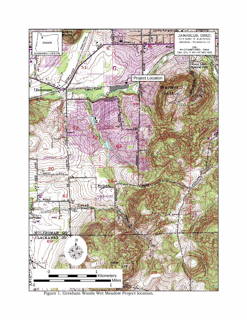
Figure 1. Gresham Woods Wet Meadow Project location.
N