N-AMCOW Region Action Plan for State of the Water Region Ac… · Travel and Daily Subsistence...
60
Transcript of N-AMCOW Region Action Plan for State of the Water Region Ac… · Travel and Daily Subsistence...


N-AMCOW Region Action Plan for State of the Water Reporting, Monitoring & Evaluation

Donor: African Water Facility/African Development BankGrant Recipient: CEDAREAWF Grant Agreement No.: 5600155002351Project ID No.: P-Z1-EAZ-027Document Name: N-AMCOW Region Action Plan for State of the Water Reporting, Monitoring & EvaluationDocument Type: RegionalVersion: English, Final Version (V2)Countries: Algeria, Egypt, Libya, Mauritania, & TunisiaRegion: North Africa Main Authors: Khaled AbuZeid, Ph.D., P.E.; Mohamed Elrawady, M.Sc., CEDARESupervision & Review: Khaled AbuZeid, Ph.D., P.E., CEDAREDesign & Layout: Eng. Tamer El-HakimDocument Date: January, 2015
For reference purposes, this publication should be referred to as:CEDARE, AbuZeid, K., Elrawady, M., (2015), “N-AMCOW Region Action Plan for State of the Water Reporting, Monitoring & Evaluation”, Monitoring & Evaluation for Water In North Africa (MEWINA) Project, Water Resources Management Program, CEDARE.

Contents
1. Executive Summary . . . . . . . . . . . . . . . . . . . . . . . . . . . . . . . . . . . . . . . . . . . . . . .13
1.1. Background . . . . . . . . . . . . . . . . . . . . . . . . . . . . . . . . . . . . . . . . . . . . . . . . . .13
1.2. Objective . . . . . . . . . . . . . . . . . . . . . . . . . . . . . . . . . . . . . . . . . . . . . . . . . . . .13
1.3. Institutional Arrangements . . . . . . . . . . . . . . . . . . . . . . . . . . . . . . . . . . . . . .13
1.4. Components . . . . . . . . . . . . . . . . . . . . . . . . . . . . . . . . . . . . . . . . . . . . . . . . . .14
1.5. Budget . . . . . . . . . . . . . . . . . . . . . . . . . . . . . . . . . . . . . . . . . . . . . . . . . . . . . .14
2. Introduction . . . . . . . . . . . . . . . . . . . . . . . . . . . . . . . . . . . . . . . . . . . . . . . . . . . . .16
3. National Action Plans Assessment . . . . . . . . . . . . . . . . . . . . . . . . . . . . . . . . . . .18
3.1. Algeria . . . . . . . . . . . . . . . . . . . . . . . . . . . . . . . . . . . . . . . . . . . . . . . . . . . . . .18
3.2. Egypt . . . . . . . . . . . . . . . . . . . . . . . . . . . . . . . . . . . . . . . . . . . . . . . . . . . . . . .18
3.3. Libya . . . . . . . . . . . . . . . . . . . . . . . . . . . . . . . . . . . . . . . . . . . . . . . . . . . . . . .19
3.4. Mauritania . . . . . . . . . . . . . . . . . . . . . . . . . . . . . . . . . . . . . . . . . . . . . . . . . . .19
3.5. Tunisia . . . . . . . . . . . . . . . . . . . . . . . . . . . . . . . . . . . . . . . . . . . . . . . . . . . . . .19
4. Regional Action Plan Objective and Purpose . . . . . . . . . . . . . . . . . . . . . . . . . . .21
5. Proposed Regional Action Plan Activities . . . . . . . . . . . . . . . . . . . . . . . . . . . . .31
5.1. Strengthening Institutional Capacity . . . . . . . . . . . . . . . . . . . . . . . . . . . . . .31
5.1.1. Strengthening of National MEWINA Program Units . . . . . . . . . . . . .32
5.1.2. Meetings & Consultation Workshops . . . . . . . . . . . . . . . . . . . . . . . . . .32
5.1.3. MEWINA Inter-Ministerial Task Force . . . . . . . . . . . . . . . . . . . . . . . .32
5.1.4. MEWINA Web Based Information System . . . . . . . . . . . . . . . . . . . . . .32
5.1.5. Support National Information Systems . . . . . . . . . . . . . . . . . . . . . . . . .36
5.1.6. Strengthening Water Governance Indicators Recording . . . . . . . . . . .36
5.2. Regional Program Management Unit . . . . . . . . . . . . . . . . . . . . . . . . . . . . .36
5.2.1 Staff . . . . . . . . . . . . . . . . . . . . . . . . . . . . . . . . . . . . . . . . . . . . . . . . . . . . .36
5.2.2. Operation Expenses and Hosting fees . . . . . . . . . . . . . . . . . . . . . . . . .37

5.2.3 Regional Consultation Workshops & meetings . . . . . . . . . . . . . . . . . . .37
5.2.4. Travel and Daily Subsistence Allowance . . . . . . . . . . . . . . . . . . . . . . . .37
5.3. Capacity Building . . . . . . . . . . . . . . . . . . . . . . . . . . . . . . . . . . . . . . . . . . . . .37
5.3.1. Professionals Training Program . . . . . . . . . . . . . . . . . . . . . . . . . . . . . . .37
5.3.2. Monitoring Technicians Training Program . . . . . . . . . . . . . . . . . . . . .38
5.4. Improving Data Collection, Monitoring & Evaluation . . . . . . . . . . . . . . . .38
5.4.1. Meteorological and Hydrometric Equipment . . . . . . . . . . . . . . . . . . . .39
5.4.2. Meteorological and Hydrometric Monitoring and Data Collection . . .39
5.4.3. Water Quantity and Quality Measurement Equipment . . . . . . . . . . . .39
5.4.4. Meteorological and Hydrometric Monitoring and Data Collection . . .40
5.4.5. Remote Sensing and GIS Equipment and Software . . . . . . . . . . . . . . .40
5.4.6. Census and Socio-economic Surveys . . . . . . . . . . . . . . . . . . . . . . . . . . .41
5.4.7. Shared Basins / Aquifers Monitoring . . . . . . . . . . . . . . . . . . . . . . . . . .41
5.4.8. Improving Water Accounting . . . . . . . . . . . . . . . . . . . . . . . . . . . . . . . . .43
5.4.9. Overall data Analysis . . . . . . . . . . . . . . . . . . . . . . . . . . . . . . . . . . . . . . .43
5.5. State of the Water Reporting . . . . . . . . . . . . . . . . . . . . . . . . . . . . . . . . . . . .43
5.6. Effective Dissemination and Raising Awareness . . . . . . . . . . . . . . . . . . . .44
5.6.1. Material Production & Dissemination . . . . . . . . . . . . . . . . . . . . . . . . .44
5.6.2. National & Regional Websites . . . . . . . . . . . . . . . . . . . . . . . . . . . . . . . .44
5.6.3. Media . . . . . . . . . . . . . . . . . . . . . . . . . . . . . . . . . . . . . . . . . . . . . . . . . . .44
6. Action Plan Implementation . . . . . . . . . . . . . . . . . . . . . . . . . . . . . . . . . . . . . . . .45
6.1. Indicative Budget . . . . . . . . . . . . . . . . . . . . . . . . . . . . . . . . . . . . . . . . . . . . .47
7. References . . . . . . . . . . . . . . . . . . . . . . . . . . . . . . . . . . . . . . . . . . . . . . . . . . . . . .51
Annexes . . . . . . . . . . . . . . . . . . . . . . . . . . . . . . . . . . . . . . . . . . . . . . . . . . . . . . . . . .54

List of Tables
Table 1. Required Equipment for Tunisia M&E Enhancement . . . . . . . . . . . . . 20
Table 2. Unmeasured Indicators in Algeria (2012 Algeria SOW Report) . . . . . . 22
Table 3. Unmeasured Indicators in Egypt (2012 Egypt SOW Report) . . . . . . . . 24
Table 4. Unmeasured Indicators in Libya (2012 Libya SOW Report) . . . . . . . . . 26
Table 5. Unmeasured Indicators in Mauritania (2012 Mauritania SOW Report) 27
Table 6. Unmeasured Indicators in Tunisia (2012 Tunisia SOW Report) . . . . . . 28
Table 7. MEWINA Simplified Logical Framework for selected Components . . 31
Table 8. Preliminary Proposed Budget to each Country and MEWINA Project Management Unit (in Thousand Euros) . . . . . . . . . . . . . . . . . . . . . . . . 48
Table 9. Distribution of “Support Transboundary Monitoring Programs” Budget among the Transboundary River s and Aquifers (in Thousands Euros)49
Table 10. Allocated Budget to each Country and MEWINA Project Management Unit for High Priority Activities in the first two years (in Thousand Euros) . . . . . . . . . . . . . . . . . . . . . . . . . . . . . . . . . . . . . . . . . . . . . . . . . . . . 50
List of Figures
Figure 1. Institutional Setup for the first phase of MEWINA . . . . . . . . . . . . . . . 17
Figure 2. Institutiuonal Setup of MEWINA Program . . . . . . . . . . . . . . . . . . . . . . 46
Figure 3. Proposed Institutional Setup for M&E in Water Sector (Algeria) . . . . . 54
Figure 4. Proposed Institutional Setup for M&E in Water Sector (Mauritania) . . 55
Figure 5. Proposed Institutional Setup for M&E in Water Sector (Libya) . . . . . . 56
Figure 6. Institutional Setup for M&E in Water Sector (Tunisia) . . . . . . . . . . . . . 57
Figure 7. Institutional Setup for M&E in Water Sector (Egypt) . . . . . . . . . . . . . . 58

List of Acronyms
ABH Agence de bassin hydrographique (Algeria)
Hydrographic Basin Agency
ADE Algérienne Des Eaux (Algeria)
Algerian Foundation Of Water
AMCOW African Ministers’ Council on Water
ANBT Agence Nationale des Barrages et des Transferts (Algeria)
National Agency of dams and transfers
ANGED Agence Nationale de Gestion des Déchets (Tunisia)
National Agency for waste management
ANRH Agence Nationale des Ressources Hydrauliques (Algeria)
National Agency for Hydraulic Resources
ANPE Agence Nationale de Protection de l’Environnement (Tunisia)
National Agency for Environmental Protection
APAL Agence de Protection et d’Aménagement du Littoral (Tunisia)
Shoreline Development and Protection Agency
ARC Agriculture Research Center (Egypt)
AWF African Water Facility
AWOS Automated Weather Observation System
BADGE Hydrogeology Database
BASHYD Climatology Database
BPEH BureaudePlanificationetdesEquilibresHydrauliques(Tunisia)
Officeof PlanningandHydraulicequilibria
CAPMAS Central Agency for Public Mobilization and Statistics (Egypt)
CCRMP Climate Change Risk Management Program
CDM Clean Development Mechanism
CERTE Centre de Recherches et des Technologies des Eaux (Tunisia)
Centre of Research and Technology of Water
CITET Centre International des Technologies de l’Environnement de (Tunisia)
Tunis International Center for Environmental Technologies
CLEQM Central Laboratory for Evaluation and Quality Monitoring (Egypt)

CNRE Centre National des Ressources en Eau (Mauritania)
National Center for Water Resources
COPEAU Contrôle de la Pollution des Eaux (Tunisia)
Control of Water Pollution
CRDA Commissariat Régional au Développement Agricole (Tunisia)
Regional Commissary for Agricultural Development
DAPE Département de l’Assainissement et de Protection de l’Environnement (Algeria)
Department of Sanitation and Environment Protection
DBMS Database Management System
DGCE Direction Générale du Commerce Extérieur (Tunisia)
General Directorate of Foreign Trade
DGACTA Direction Générale de l’Aménagement et de la Conservation des Terres Agricoles (Tunisia)
General Directorate for Development and Conservation of Agricultural Land
DGBGTH Direction Générale des Barrages et des Grands Travaux Hydrauliques (Tunisia)
General Directorate of Dams and Grand Hydraulic Works
DGDD Direction Générale du Développement Durable (Tunisia)
General Directorate for Sustainable Development
DGEQV Direction Générale de l’Environnement et de la Qualité de la Vie (Tunisia)
General Directorate for the Environment and Quality of Life
DGRE Direction Générale des Ressources en Eau (Tunisia)
General Directorate of Water Resources
DGGREE Direction Générale du Génie Rural et de l’Exploitation des Eaux (Tunisia)
General Directorate of Rural Engineering and Water Use
DH Direction nationale de l’Hydraulique (Mauritania)
Department of Hydraulics
DHB Département de l’Hydrologie et des Barrages (Mauritania)
Department of Hydrology and Dams
DHMPE Direction de l’Hygiène du Milieu et de la Protection de l’Environnement (Tunisia)
Directorate of Environmental Hygiene and Environmental Protection
DHU Direction de l’Hydraulique Urbaine (Tunisia)
Directorate of Urban Hydraulic
DPCSE Direction du Département de la Coopération, Suivi et Evaluation (Mauritania)
Directorate of Cooperation, Monitoring and Evaluation Department

DRHA Directions Régionales de l’Hydrologie et de l’Assainissement (Mauritania)
Regional Directorates of Water and Sanitation
DRI Drainage Research Institute (Egypt)
EEAA Egyptian Environmental Affairs Agency (Egypt)
EGA Environment General Authority (Libya)
EMA Egyptian Meteorological Authority
ENIS Ecole Nationale des Ingénieurs de Sfax (Tunisia)
Sfax National School of Engineering
ENIT Ecole Nationale des Ingénieurs de Tunis (Tunisia)
National Engineering School of Tunis
FAO Food and Agriculture Organization
GAI General Authority for Information (Libya)
GDA Groupement de Développement Agricole (Tunisia)
Group for Agricultural Development
GIS Geographic Information System
GCWW General Company for Water and Wastewater (Libya)
GLAAS Global Analysis and Assessment of Sanitation and Drinking-Water
GMMRA Great Man Made River Agency (Libya)
GWA General Water Authority (Libya)
HCWW Holding Company for Water and Wastewater CHECKKK
IAO Istituto per l’Agronomico Oltremare (Italy) in Algeria’s section
Institute of Overseas Agronomics
IFAD International Fund for Agricultural Development
IISD International Institute for Sustainable Development
IMR Indicators, Monitoring and Reporting
IMS Institute of Mathematical Statistics
INAT Institut National de l’Agriculture de Tunisie (Tunisia)
National Institute of Agriculture of Tunisia
INM Institut National de la Météorologie (Tunisia)
National Institute of Meteorology
INRAA Institut National de Recherche Agronomique d’Algérie (Algeria)
National Institute of Agronomic Research of Algeria
INRGREF Institut National de Recherche en Génie Rural, Eaux et Forêts (Tunisia)
National Research Institute for Rural Engineering, Water and Forestry

INS Institut National de la Statistique (Tunisia) National Institute of Statistic INSP Institut National de Santé Publique (Algeria) National institute of public healthIRA Institut des Régions Arides (Tunisia) Institute of Arid RegionsIRESA Institution de Recherches et de l’Enseignement Supérieur Agricole (Tunisia) Institution of Research and Higher Agricultural EducationIWRM Integrated Water Resources ManagementJMP Joint Monitoring ProgramJPEP Joint Poverty and Environmental ProgramM&E Monitoring and EvaluationMALR Ministry of Agriculture and Land Reclamation (Egypt)MARH Ministère de l’Agriculture et des Ressources Hydrauliques (Tunisia) Ministry of Agriculture and Hydraulic ResourcesMARS Monitoring, Analysis and Reporting SystemMDGs Millennium Development GoalsMDR Ministère de Développement Rural (Mauritania) Ministry of Rural Development MDWSF Ministry of Drinking Water and Sanitation Facilities (Egypt)MESRS Ministèredel’EnseignementSupérieuretdelaRechercheScientifique(Tunisia) Ministryof HigherEducationandScientificResearchMEWINA Monitoring and Evaluation for Water in North AfricaMHE Ministry of Hydraulics and Water (Mauritania)MHU Ministère de l’Habitat et de l’Urbanisme (Algeria) Ministry of of Housing and Urban Development
MoHP Ministry of Health and Population (Egypt)
MRE Ministère des Ressources en Eau (Algeria)
Ministry of Water Resources
MPTIC Ministère de la Poste et des Technologies de l’Information et de la Communication (Algeria)
Ministry of Post, Information Technology and Communication
MSEA Ministry of State for Environmental Affairs (Egypt)
MWRI Ministry of Water Resources and Irrigation (Egypt)
N-AMCOW Northern Region of the African Ministers’ Council on Water
NBI Nile Basin Initiative
NCM National Center for Meteorology (Libya)

NFPS National Company of Drilling and Well (Mauritania)
NFU National Farmers Union
NGO Non-Governmental Organization
NRI Nile Research Institute (Egypt)
NSAS Nubian Sandstone Aquifer System (Egypt)
NTF National Task Force
NWRC Centre of Natural Water Resource (Mauritania)
NWRC National Water Research Center (Egypt)
NWRP-CP National Water Resources Plan -Coordination Plan
NWSAS Système Aquifère du Sahara Septentrional (Algeria) (Tunisia) (Libya)
North Western Sahara Aquifer System
OMVS Organisation pour la Mise en Valeur du Fleuve Senegal
Senegal River Basin Organization
ONA OfficeNationaldel’Assainissement(Algeria)
NationalOfficeof Sanitation
ONAS OfficeNationaldel’Assainissement(Mauritania)(Tunisia)
NationalOfficeof Sanitation
ONID OfficeNationaldesIrrigationsetduDrainage(Algeria)
NationalOfficeforIrrigationandDrainage
ONM OfficeNationaldeMétéorologie(Algeria)
NationalOfficeof Meteorology
ONS OfficeNationaldelaStatistique(Algeria)
NationalOfficeforStatistics
ONSER OfficeNationaldesServicesd’EauenmilieuRural(Mauritania)
NationalOfficeof WaterServicesinRuralAreas
OTEDD Observatoire Tunisien de l’Environnement et du Développement Durable (Tunis ia )
Tunisian Observatory for Environment and Sustainable Development
PMU Project Management Unit
PTJC Permanent Technical Joint Committee (Egypt)
QA Quality Assurance
QC Quality Control
RAR Rapid Assessment Report
RIGW Research Institute of Ground Water (Egypt)
SAHR Standardisation and Harmonisation Report
SASS Système Aquifère du Sahara Septentrional (Tunisia)
North Western Sahara Aquifer System
SECADENORD Société d’ Exploitation du Canalet des Adductions des Eaux du Nord (Tunisia)
Operative Society Canal and adduction of the Northern Waters
SGIIAR Système de Gestion Intégrée de l’Information Agricole et Rurale (Algeria)
Integrated Management System of Agricultural Information and Rural
SISOLS Système d’Information sur les Sols (Tunisia)
Soil Information System
SINEAU Système d’Information National sur l’Eau (Tunisia)
National Water Information System
SONEDE Société Nationale d’Exploitation et de Distribution des Eaux (Tunisia)
National Operating Company and Water Distribution
SOW State of Water
SOWR State of the Water Report
SNFP Société Nationale des Forages et Puits (Mauritania)
National Company for Drilling and Well
SNDE Société Nationale d’Eau (Mauritania)
National Water Company
STEG Société Tunisienne de l’Electricité et du Gaz (Tunisia)
Tunisian Company of Electricity and Gas
SYGREAU Système de Gestion des Ressources en Eau (Tunisia)
Management of Water Resources System
TARWR Total Actual Renewable Water Resources
TBR Tableau de Bord de la Resource en eau
TOR Terms of Reference
WBCSD World Business Council for Sustainable Development
WBIS Web Based Information System
WDR Water Development Report
WMERM Water Monitoring Evaluation and Report Mechanism
WMO World Meteorological Organization
WSS Water Supply and Sanitation
WRRI Water Resources Research Institute (Egypt)
WWDR World Water Development Report

WWRR World Water Resources Report
WWTP Wastewater Treatment Plants
UNDP United Nations Development Program
UNEP United Nations Environment Program
UNESCO United Nations Education, Science and Culture Organization
UNIDO United Nations Industrial Development Organization
13
Executive Summ
ary
N-AMCOW Region Action Plan for State of the Water Reporting, Monitoring & Evaluation
MEW
INA
1. Executive Summary 1.1. Background
Monitoring and Evaluation (M&E) is part and parcel of successful Integrated Water Resources Management. Rigorous and Comprehensive Monitoring and Evaluation of all aspects related to water will lead to well informed decisions that directly contribute to the prosperity of the communities of interest.Thefirstphaseof the“Monitoring&Evaluationof WaterinNorthAfrica”(MEWINA)projectfunded by the African Water Facility at about 2 million Euro, and regionally executed by CEDARE which is the Technical Secretariat for the North –African Ministers’ Council On Water (N-AMCOW), performed a Rapid Assessment on the M&E capabilities in all N-AMCOW countries (Algeria, Egypt, Libya, Mauritania, & Tunisia) as well as the major Shared Rivers (the Nile & the Senegal Rivers) and Aquifers (the Nubian Sandstone Aquifer, & the North Western Sahara Aquifer) in which one or more of theN-AMCOWcountriesareriparianof.Duringthefirstphase,baselinereportsonthe“Stateof theWater”intheN-AMCOWcountriesandtheirmajorsharedRiverBasinsandAquiferswerepreparedbasedon a regionally standardized and harmonized set of indicators that tackles the State of the Water under 15 different categories namely; Water & Availability, Water & Uses, Water & Land Use Changes, Water & Services, Water & Energy, Water & Population, Water & Quality, Water & Health, Water & Ecosystems, Water & Climate, Water & Socio-economics, Water & Finance, Water & Trade, Water & Governance, and Water & International Relations. The Rapid Assessment Reports indicated the necessity of improving nationalM&Esystemsasmanyinstitutionalandtechnicalgapswereidentified.TheNationalandSharedRiver/ Basin State of the Water reports showed that some important indicators need additional capacity tobepreciselyassessed.Neartheendof thefirstphaseof MEWINA,anActionPlaninspiredbythefindingsof theRapidAssessmentReportsandtheStateof theWaterReportswasformulatedtodelineatethe second phase of MEWINA. A set of institutional, technical, and professional strengthening and capacity building measures were proposed, as well as other complementary activities for improved data recording and collection for better State of the Water reporting. The expected implementation cost of the MEWINA 2 Action Plan was budgeted and the required time was scheduled.
1.2. Objective
The main objective of the proposed second phase of MEWINA is to shift from a regional project to a permanent program and to significantly enhance theMonitoring andEvaluation process in theN-AMCOW region. All the necessary tools for assessing the full set of the Regionally Standardized and Harmonized Indicators shall be provided in the second phase, so that comprehensive national and regional State of the Water reports will be produced on regular basis.
1.3. Institutional Arrangements
The MEWINA Regional Program Management Unit (PMU) in CEDARE will be responsible for the regional coordination and implementation of activities at the 5 national levels and at the 4 shared River Basins and Aquifers levels, including other shared river basins or aquifers that may be deemed essential forthelivelihoodsof asignificantpopulationintheN-AMCOWcountries.TheRegionalPMUwillwork

14 N-AMCOW Region Action Plan for State of the Water Reporting, Monitoring & Evaluation
MEW
INA
closelywiththealreadyestablishedNationalMEWINAUnitsinthefivecountries;eachnationalunitwillbe backed up by a National Inter-Ministerial Task Force comprised of experts representing water-related ministries and authorities in a manner that facilitates data collection and sharing and proper assessment of each indicator under the 15 different categories of indicators. A steering committee will supervise the activities of the MEWINA program. The Regional PMU will also work closely with the Shared River Basin and Aquifer organizations to report on the State of the Water for such shared water bodies based onthespecificindicatorsdevelopedduringthefirstphaseof MEWINA.
1.4. Components
The proposed full-fledgedActionPlan for the second phase of MEWINA addresses all the needs of the countries for a near perfect State of the Water reporting, monitoring & evaluation mechanism, while the priority-phase Action Plan involves the urgent needs to keep the Reporting, Monitoring & Evaluation process for the N-AMCOW Region on-going and to collect some of the most urgently needed data that will be needed to assess indicators of strategic concern, and those that are required for reporting to the African Union Heads of State Summit.
The full-fledged Action Plan will include an important component on “Strengthening InstitutionalCapacity”whichwill strengthenNationalMEWINAUnits and the Inter-Ministerial Task Force anddevelop a web-Based information system at all National Units as well as the Regional PMU.
The fullActionPlan for the full-fledged activitieswill involve a comprehensive “CapacityBuilding”component that caters for the needs of water professionals as well as technicians who will need to be trained on the Meteorological and Hydrometric Equipment and data collection that constitute the “ImprovingDataCollection,Monitoring&Evaluation”component. The latter component includesalso a sub component on enhancing the National and Regional Units capabilities in terms of Earth Observation & Analysis tools such as Remote Sensing and Geographic Information Systems (GIS).
Asthe“Stateof theWaterReporting”fortheNational,SharedRiverBasinsandAquifers,andRegionallevels will be the main continuously on-going output of the MEWINA Program, a special component of this Action plan is concerned with the production of these reports after all the necessary data and information have been collected and analyzed.
The“EffectiveDisseminationandAwarenessRaising”isanothercomponentof thisActionPlanwherethefindingsof the State of theWaterReportswill be disseminated via different channels includingwebsites managed by the National and Regional Units, awareness materials that will be distributed in workshops and special events, and Media Coverage.
1.5. Budget
While the budget for the full-fledgedActionPlan activities in a period of three years was estimated to be 21.753 Million Euros, some activities of immediate priority have been selected based on the most urgentMonitoring&EvaluationgapsthatwereidentifiedintheRapidAssessmentReportsandreflectedin the data gaps apparent from the National, Regional, Basin level State of the Water reports to develop the priority-phase Action Plan budget which amounted to 5.455 Million Euros for two years. The

15
Executive Summ
ary
N-AMCOW Region Action Plan for State of the Water Reporting, Monitoring & Evaluation
MEW
INA
priority phase will concentrate on the monitoring equipment for the least advanced countries only while maintaining the minimum requirements for reporting, monitoring and evaluation for the whole region.
The proposed components and associated budget for the full-fledgedAction plan with a budget of 21.753 Million Euro for 3 years include:
• Strengthening Institutional Capacity (2.825 Million Euros)
• Regional Program Management Unit (1.082 Million Euros)
• Capacity Building (2.069 Million Euros)
• Improving Data Collection, Monitoring & Evaluation (14.915 Million Euros)
• State of the Water reporting (0.222 Million Euros)
• Effective Dissemination and Raising Awareness (0.64 Million Euros)
The suggested components and associated budget for the priority-phase Action Plan with a budget of 5.455 Million Euro for two years include:
• Strengthening Institutional Capacity (0.705 Million Euros)
• Regional Program Management Unit (0.718 Million Euros)
• Capacity Building (0.1 Million Euros)
• Improving Data Collection, Monitoring & Evaluation (3.55 Million Euros) including urgent Meteorological and Hydrometric equipment for Libya and Mauritania
• State of the Water reporting (0.222 Million Euros)
• Effective Dissemination and Raising Awareness (0.16 Million Euros)
The proposed MEWINA 2 Action Plan emanates from the region’s belief that “what is not measured cannot be managed”, and that in order to achieve effective Integrated Water Resources Management a strong Monitoring & Evaluation & Reporting Mechanism has to be established.

16 N-AMCOW Region Action Plan for State of the Water Reporting, Monitoring & Evaluation
MEW
INA
2. IntroductionIssues of sustainable development in N-AMCOW countries are distinctive; however, the socio-economic and culture context of these countries determine the manner in which these challenges manifest themselves. This context also imposes the approach adopted by national governments to handle them. Countries and regions are increasingly required to measure and report on their progress towards achieving sustainable development,throughthegroupof regionallyharmonizedindicatorsidentifiedbytheMEWINAproject,to the international community.
The monitoring and evaluation (M&E) of the water sector have been considered the weakest link in progress towards achieving the Millennium Development Goals (MDGs) in Africa; as it faces several challenges on the national and regional levels. Accordingly, it is required to build and develop capacities of governments and non-government agencies in North African States to cope with the challenges of data collection, analysis, monitoring, evaluation and reporting. Hence, human resources development and institutional capacity building could become one of the major areas of investment for the African Water Facility (AWF) over the following years.
Algeria, Egypt, Libya, Mauritania, and Tunisia were the countries that participated in the MEWINA project since June 2012. Since then, regionally standardized and harmonized Regional water M&E Framework have been developed and primarily directed towards the selected adequate set of indicators explained in the MEWINA State of the Water Indicators Report. It is recognized that all countries of the MEWINA Region will have a national M&E system that depends on those indicators to provide information on all of the water resources/sector issues and aspects and produce regular National State of the Water Reports.
Thefactthatthepurposesforwhichinformationisgenerateddifferwassuccessivelyreflectedonthedefinitionof indicatorsused,thespecificparametersmeasured,andthemonitoringordatacollectionschemesutilized.Itisdifficulttomonitorandreportontheprogressof globalcommitments(MDGs)throughindividualorjointprograms(JMP,WWDR),andtoconfirmthatglobalwaterprinciples(IWRM)arebeingpracticed.Itisevenmoredifficulttoprovidereliableinformationabouttheimpactof broadersocio-economic and climatic trends that impact upon water resources and their use (TF-IMR, 2009). Thus, standardization and harmonization of the national M&E processes were mandatory to serve regional and global targets.
The MEWINA Standardized and Harmonized indicators are grouped into the following 15 categories:
Water & Availability, Water & Consumption, Water & Land Use Changes, Water & Services, Water & Energy, Water & Population, Water & Quality, Water & Eco-Systems, Water & Health, Water & Climate, Water & Socio-economics, Water & Finance, Water & Trade, Water & Governance, and water & International Relations.
Within the ministry in charge of water, in each country, a unit or administration was selected to play theroleof nationalMEWINAoffice.Suchadministrationhastheresponsibilitiesof waterresourcescoordinationandplanning,monitoringandevaluation.MEWINAnationalofficesresponsibilitiesalsocomprise collecting, interpreting and exchanging data, monitoring, periodical reporting and coordination with the Regional MEWINA management unit at CEDARE (Figure 1). The Baseline national State of the Water reports were produced by the national Unit in each country and submitted to the Management unit CEDARE. Regional reports were then compiled by the management unit at CEDARE.

17
Introduction
N-AMCOW Region Action Plan for State of the Water Reporting, Monitoring & Evaluation
MEW
INA
Figure 1. Institutional Setup for the first phase of MEWINA

18 N-AMCOW Region Action Plan for State of the Water Reporting, Monitoring & Evaluation
MEW
INA
3. National Action Plans Assessment
While most of the components of the Action Plan are common between all MEWINA countries, Specificneedsof countries indicated inRapidAssessmentReports,NationalBaselineSOWReports,and National Monitoring and Evaluation Action Plans have also been considered in the process of developing a Regional Action Plan for the second phase of MEWINA. The Rapid Assessment Reports havedescribedthecurrentMonitoringandEvaluationsystemineachcountryandidentifiedthegapsthatcreate obstacles towards detailed State of the Water Reporting.
All country representatives agreed on the utmost necessity of assessing each and every indicator from the National Baseline SOWs recognized a set of indicators from the regionally harmonized indicators, it was expected that some indicators will need additional capacities for their proper assessment. In countries National Baseline SOWs, the indicators that are not currently assessed were pointed out, and they were emphasized in the National Action Plans.
The following are some of the main Highlights of the MEWINA Countries National Action Plans for SOW M&E&R:
3.1. Algeria
The following Conclusions, Actions, and Recommendations have been identified:• A strong link with the new Water Policy of Algeria.• A Water Management Decision Support System.• Assessment of Un-measured indicators and improved assessment of Indicators estimated with low
accuracy. • Implementationof specifiedrequiredActionstomeasureeachspecificIndicator• Conduct required Trainings, procurement of Equipment, and implementation of Institutional
Strengthening measures specified.• Theabsenceof sufficientdata(insufficientnetworksof observationandmeasurement)• The absence of adequate structure (need for institutional strengthening including the S/E)• Theabsenceof scientificmeans(needforacquisitionof software)• Shortcomings in human means (need for capacity-building through training programs for managers
and technicians) • A lack of coordination between various organizations concerned by the problem of water.
3.2. Egypt
The following Conclusions, Actions, and Recommendations have been identified:• MaintaincommunicationwithKeyStakeholdersidentified.• Attendtoissuesof immediatepriorityidentifiedasbeing:• Meteorological and Hydrometric Monitoring• Water Quality and Environmental Monitoring

19
National Action Plans Assessm
ent
N-AMCOW Region Action Plan for State of the Water Reporting, Monitoring & Evaluation
MEW
INA
• Land Use Monitoring• Monitoring and Evaluation for Shared Water Resources• The importance of having an online database at the Ministry of Environmental Affairs.
3.3. Libya
The following Conclusions, Actions, and Recommendations have been identified:• TheUnmeasuredindicatorsfromtheRegionallyHarmonizedsethavebeenidentifiedandthesources
of data gaps were recognized. • The MEWINA Action Plan has been linked to National Future Initiatives and Projects. • TheUpgradeof WaterLegislationshasbeenidentifiedasanurgentneedforEnhancingMonitoring
and Evaluation. • Updating of agreements on shared management of the aquifers.• Approval of a set of indicators for assessing the SOW in the aquifers.• Increasing of monitoring points and intervals to generate data needed for sustainable management
of the aquifers.• Formulation of a regional plan for M & E & R of the aquifers.• Solicitingfinancialassistanceforbuildingof capacitiesforM&E&Rof theNSASandtheNWSAS.• Sharing of data and experiences on the aquifers.• Actions should be taken to start development of the Murzoq transboundary basin shared by Libya,
Algeria, and Niger with the ultimate objective of reaching an agreement to monitor and manage this basin. Capacities needed to M & E & R on the basin’s part lying inside Libya should be built in parallel with other transboundary basins, namely, the NWSAS and the NSAS.
3.4. Mauritania
The following Conclusions, Actions, and Recommendations have been identified:• MaintainCommunicationwithKeystakeholdersidentified.• TheNationalCentreforWaterResourceshasbeenidentifiedastheMEWINANationalUnit• Un-measuredindicatorsandIndicatorsmeasuredwithlowaccuracyhavebeenidentified.• Institutional Strengthening including seven data sharing protocols to be signed between the project
unit and key entities. • Monitoring and evaluation enhancement process. • Awareness Activities on the State of the Water.
3.5. Tunisia
The following Actions and Recommendations have been identified:
• MaintaincommunicationwithKeyStakeholdersidentified.
• Completing the development & Amending of the Water Information System (SINEAU) with the

20 N-AMCOW Region Action Plan for State of the Water Reporting, Monitoring & Evaluation
MEW
INA
MEWINA indicators to evolve as a decision support system
• Report on the State of the Water using SINEAU
• Construct information sub-systems (or DBMSs) within the related institutions to be integrated in SINEAU.
• FillingtheInstitutionalgapsrelatedtoruralsanitationandtheefficientuseof harvestedrainwater.
• Furthermore, specified equipment for enhancingM&Ewere specified, catering to surfacewater,Groundwater,ArtificialRecharge, andLaboratory as shown in table (1)
Table 1. Required Equipment for Tunisia M&E EnhancementM&E Water Resources Networks Designation Quantity
Surface Water Pluviographs with remote transmission (GSM / GPRS) 40
Multi parameter probes for surface water quality 5
Comprehensive climate stations 5
Sensors (probes and radars) 40
Mobile hydrometric unit for gauging 1
Server (for SYCOHTRAC) 1
Differential GPS 3
Groundwater Automatic and telemetered acquisition systems data (GSM / GPRS) 250
Probes 50
Discharger and data validation stations 24
Server Data 1
Differential GPS 16
Data processing stations (for CRDA) 26
Artificial Recharge Multiparameter phreatimetric stations forpiezometers in artificial rechargestations (Flash Log com)
50
Server 1
USB interface data cable discharger (Netbook and accessories) 22
Portable conductivimeters 22
Portable PH meters 22
Water level Probes (sound and light) 22
Hydro sensor for sampling (Diameter 2 inches) 12
Differential GPS 3
Remote stations and telemetry of water flow meters for groundwater artificial recharge
10
Laboratory Laboratory hood 1
Flame photometer 1
Precision balance 1
Benchtop conductivity meter 1
Automatic burets 4
Desiccator 1
Consumable labware Kit
Field multiparameter probes 10
Mobile station of control and monitoring of water quality* 1

21
Regional Action Plan Objective and Purpose
N-AMCOW Region Action Plan for State of the Water Reporting, Monitoring & Evaluation
MEW
INA
4. Regional Action Plan Objective and PurposeThis action plan is prepared as a nucleus project document to be submitted to the Donor Community for a second phase of MEWINA. It stipulates an integrated sub-regional plan to create a sustainable mechanism for SOW M&E and Reporting of water sector in N-AMCOW.
The main objective of the proposed second phase of MEWINA is to shift from a regional project to a permanentprogramthatsignificantlyenhancestheMonitoringandEvaluationprocessintheN-AMCOWregion. All the necessary tools for assessing the full set of the Regionally Standardized and Harmonized Indicators shall be provided in the second phase, so that comprehensive national and regional State of the Water reports will be produced on regular basis.
Without making the national/regional reports accessible and disseminated to water managers, researchers and public at large throughout the region, the entire reporting mechanism will be of little practical value, and will not achieve its ultimate goal. Therefore, dissemination and awareness raising must be addressed specificallyasasub-actionplan.Throughthisactionplanthebenefitsforeseenfromtheestablishmentof monitoring networks and reporting mechanism can be demonstrated.
The sustainability of reporting mechanism includes key rudiments such as equipment maintenance, continuity of observations, archiving, processing and dissemination of the data, information and reports. It is realized that the implementation of the Capacity Building sub-action plan that addresses all the key sustainability elements, provides a major guarantee of the day-to-day operation and maintenance of the entire mechanism.
TheRegionalManagementunitisspecificallyorientedtowardsthemonitoringandevaluationof watersector, at all levels. Therefore, it is updated by data and indicators that are collected periodically by nationalstatisticsoffice,and/orwaterrelateddepartment(withinotherwaterconcernedministries)aswell as hydrologic monitoring networks (within the authorities of water lead ministry or transboundary organizations).
Data and information, that constitute the ingredients for indicators computation process, are typically measured, collected or estimated at the national level, as well as the Basin/ Aquifer Level. The adequate set of indicators takes into consideration the peculiarity of the opportunities and constraints in N-AMCOW water sector, especially with regard to data acquisition and analysis. It must be stressed thattheindicators,parameters,definitionsandmethodsadoptedinwhatfollows,havebeenregionallyharmonized throughout the MEWINA Region.
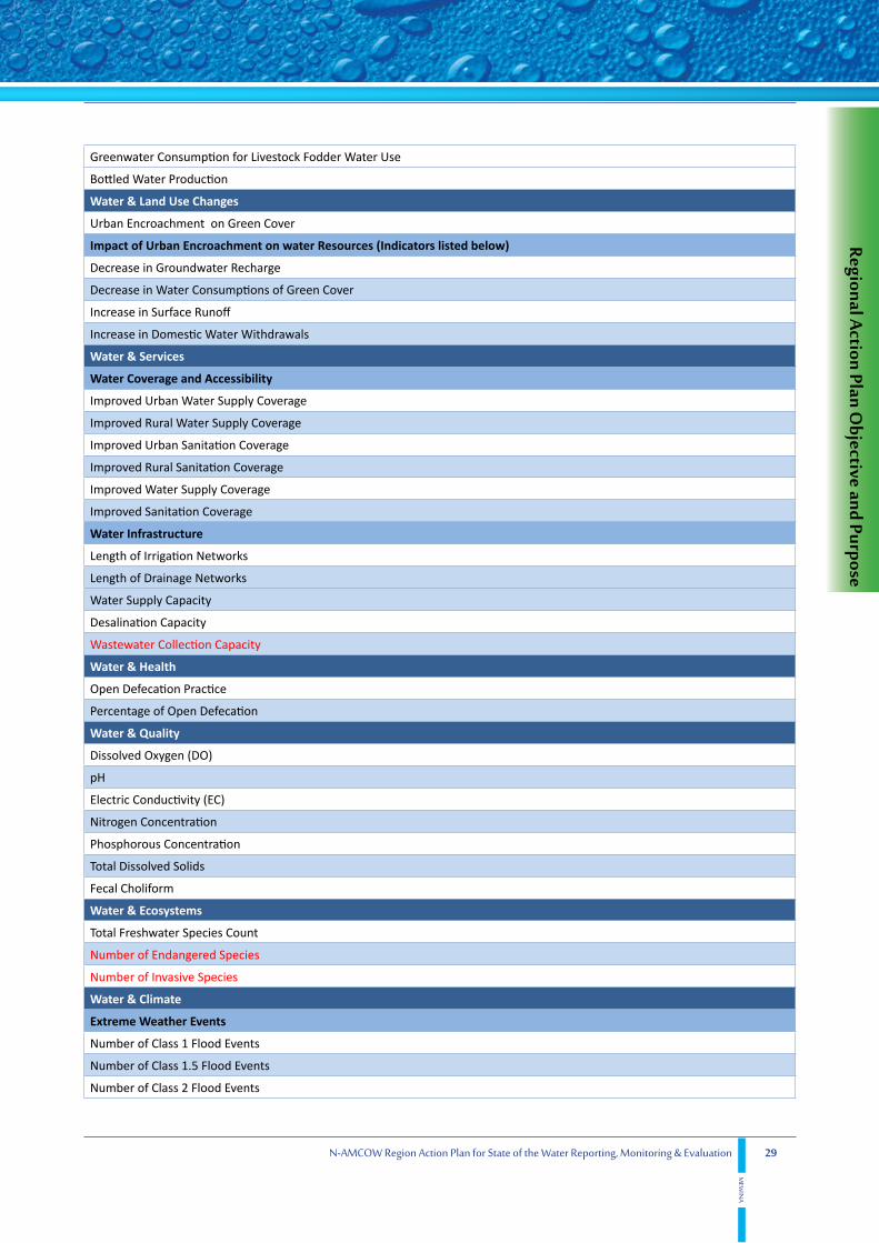
The proposed activities in this Action plan area strongly motivated by the indicators that were not assessed in the countries Baseline State of the Water Reports, where it was indicated by the countries national units that additional capacities are required to assess such indicators. Tables 2 through 6 show the un-assessed indicators in Algeria, Egypt, Libya, Mauritania, and Tunisia, respectively.

22 N-AMCOW Region Action Plan for State of the Water Reporting, Monitoring & Evaluation
MEW
INA
Table 2. Unmeasured Indicators in Algeria (2012 Algeria SOW Report)Water & Availability
Blue Water
External Groundwater Inflow (EGI)
External Groundwater Outflow (EGO)
Green Water
Non-Conventional Water
Produced Industrial Wastewater (PIW)
Water & Uses
Withdrawals from Blue Surface Water
Withdrawals from Blue Renewable Groundwater
Total Withdrawals from Blue Water
Total Withdrawals from Non-Conventional Water Resources
Water & Land Use Changes
Impact of Urban Encroachment on Water Resources (Indicators listed below)
Decrease in Groundwater Recharge
Decrease in Water Consumptions of Green Cover
Increase in Surface Runoff
Increase in Domestic Water Withdrawals
Water & Services
Water Coverage and Accessibility
Improved Urban Sanitation Coverage
Improved Rural Sanitation Coverage
Water Infrastructure
Dam Storage Capacity
Water Supply Capacity
Desalination Capacity
Industrial Wastewater Treatment Capacity
Maximum Annual Dam Storage Reached
Water & Energy
Hydropower as % of Total Generated Electricity
Water & Health
Diarrhea Prevalence
Open Defecation Practice
Percentage of Open Defecation
Water & Quality
Dissolved Oxygen (DO)
pH
Electric Conductivity (EC)
Nitrogen Concentration
Phosphorous Concentration
Total Dissolved Solids
Water & Ecosystems

23
Regional Action Plan Objective and Purpose
N-AMCOW Region Action Plan for State of the Water Reporting, Monitoring & Evaluation
MEW
INA
Total Freshwater Species Count
Water & Climate
Extreme Weather Events
Number of Class 1 Flood Events
Number of Class 1.5 Flood Events
Number of Class 2 Flood Events
Drought Events
Cost of Annual Damage Caused by Floods
Cost of Annual Damage Caused by Droughts
Annual Human Losses Related to Floods
Annual Human Losses Related to Droughts
Unusual Weather Events (Snow, Hail,……)
Water & Socio-Economics
Water Productivity
Employment in Industry “Job Per Drop”
Water & Finance
Percent of GDP Directed to Sanitation & Hygiene
Operation & Maintenance Cost Recovery for Irrigation
Operation & Maintenance Cost Recovery for Water Supply and Sanitation
Aid to Water & Sanitation in Foreign Countries
Water & Governance
National Water and Sanitation M&E & R System
Surface Water Permits Issued to Date
Total Volumetric Water Rights Assosciated with Surface Water Permits
Total Volumetric Water Rights Assosciated with Surface Water Permits as a Percent of Annual Blue Surface Water Withdrawals
Groundwater Well Permits Issued to Date
Total Volumetric Water Rights Associated with Well Permits
Total Volumetric Water Rights Associated with Well Permits as a Percent of Annual Blue Groundwater Abstractions
Number of Unlicensed Wells
Irrigation & Drainage Related Complaints as a Percentage of Irrigation Water Users
Water Supply and Sanitation Related Complaints as a Percentage of Serviced Households
Number of Water Supply Meters Installed as a Percent of Total Number of Covered Households
Number of Groundwater Meters Installed as a Percent of Serviced Households
Number of Surface Irrigation Meters Installed as a % of Surface Irrigation Water Permits
Physical Domestic Water Losses
Transboundary Wastewater and Drainage Outflows
Water & International Relations
Shared Waters Related Bilateral/ Multilateral Agreements and/or Memorandums of Understanding and Cooperation Mechanisms
Number of Riparians Sharing all Shared Water Bodies
Number of Shared Water Resources

24 N-AMCOW Region Action Plan for State of the Water Reporting, Monitoring & Evaluation
MEW
INA
Table 3. Unmeasured Indicators in Egypt (2012 Egypt SOW Report)Water & Availability
Annual Spatially Averaged Precipitation Depth
Annual Precipitation Volume
Green Water
Water for Rain-fed Agricultural Consumption
Water for Rain-fed Pasture Consumption
Water for Rain-fed Forest Consumption
Non-Conventional Water
Water & Uses
Agricultural Drainage Water Reuse
Annual Volume of Total Actual Evapotranspiration
Green water Consumption for Livestock Fodder Water Use
Bottled Water Production
Water Demand for Environmenatal Uses
Withdrawals for Oil & Gas Water Use
Water & Land Use Changes
Total Rain-fed Agricultural Land
Total Pasture Land
Total Forests Land
Urban Encroachment on Green Cover
Impact of Urban Encroachment on water Resources (Indicators listed below)
Decrease in Groundwater Recharge
Decrease in Water Consumptions of Green Cover
Increase in Surface Runoff
Increase in Domestic Water Withdrawals
Water & Services
Water Coverage and Accessibility
Water Infrastructure
Length of Drainage Networks
Industrial Wastewater Treatment Capacity
Wastewater Collection Capacity
Maximum Annual Dam Storage Reached
Water & Health
Diarrhea Prevalence Dracunculiasis Reported Cases
Open Defecation Practice
Percentage of Open Defecation
Cholera Reported Cases
Typhoid Reported Cases
Hepatitis A Reported Cases

25
Regional Action Plan Objective and Purpose
N-AMCOW Region Action Plan for State of the Water Reporting, Monitoring & Evaluation
MEW
INA
Water & Quality
Chemical Oxygen Demand (COD)
Chloride Concentration
Total Hardness (CaCo3)
Water & Ecosystems
Total Wetlands Areas
Total Freshwater Species Count
Number of Endangered Species
Number of Invasive Species
Water & Climate
Extreme Weather Events
Number of Class 1 Flood Events
Number of Class 1.5 Flood Events
Number of Class 2 Flood Events
Drought Events
Cost of Annual Damage Caused by Floods
Cost of Annual Damage Caused by Droughts
Annual Human Losses Related to Floods
Annual Human Losses Related to Droughts
Unusual Weather Events (Snow, Hail,……)
National Climate Change Adaptation Plan
Water & Socio-Economics
Water Productivity
Industrial Water Productivity
Agricultural Water Productivity “Crop Per Drop”
Employment in Agriculture “Job Per Drop”
Employment in Industry “Job Per Drop”
Water & Finance
Foreign Aid for Water & Sanitation
Operation & Maintenance Cost Recovery for Irrigation
Operation & Maintenance Cost Recovery for Water Supply and Sanitation
Operation & Maintenance Cost Recovery for Industry
Aid to Water & Sanitation in Foreign Countries
Water & Governance
Surface Water Permits Issued to Date
Total Volumetric Water Rights Associated with Surface Water Permits
Total Volumetric Water Rights Associated with Surface Water Permits as a Percent of Annual Blue Surface Water Withdrawals
Groundwater Well Permits Issued to Date
Total Volumetric Water Rights Associated with Well Permits
Total Volumetric Water Rights Associated with Well Permits as a Percent of Annual Blue Groundwater Abstractions
Number of Unlicensed Wells

26 N-AMCOW Region Action Plan for State of the Water Reporting, Monitoring & Evaluation
MEW
INA
Irrigation & Drainage Related Complaints as a Percentage of Irrigation Water Users
Water Supply and Sanitation Related Complaints as a Percentage of Serviced Households
Number of Water Supply Meters Installed as a Percent of Total Number of Covered Households
Number of Groundwater Meters Installed as a Percent of Licensed Wells
Number of Surface Irrigation Meters Installed as a % of Surface Irrigation Water Permits
Physical Domestic Water Losses
Transboundary Wastewater and Drainage Outflows
Commercial Water Losses
Physical Irrigation Water Losses
Number of Water Related Citations (Water Laws Enforcement)
Number of Water Users Associations
Water Users Associations Agricultural Land Coverage
Table 4. Unmeasured Indicators in Libya (2012 Libya SOW Report)
Water & Uses
Water for Rain-fed Agricultural Consumption
Water for Rain-fed Pasture Consumption
Water for Rain-fed Forest Consumption
Produced Industrial Wastewater (PIW)
Produced Agricultural Drainage (PAD)
Produced Desalinated Water (PDW)
Water & Land Use Changes
Total Irrigated Agricultural Land
Total Rain-fed Agricultural Land
Total Pasture Land
Total Forests Land
Urban Encroachment on Green Cover
Impact of Urban Encroachment on Water Resources (Indicators listed below)
Decrease in Groundwater Recharge
Decrease in Water Consumptions of Green Cover
Increase in Surface Runoff
Increase in Domestic Water Withdrawals
Water & Services
Water Infrastructure
Length of Water Supply Networks
Length of Sewage Networks
Length of Irrigation Networks
Length of Drainage Networks
Dam Storage Capacity
Industrial Wastewater Treatment Capacity
Wastewater Collection Capacity
Maximum Annual Dam Storage Reached

27
Regional Action Plan Objective and Purpose
N-AMCOW Region Action Plan for State of the Water Reporting, Monitoring & Evaluation
MEW
INA
Table 5. Unmeasured Indicators in Mauritania (2012 Mauritania SOW Report)Water & Availability
Internal Renewable Groundwater (IRG)
External Surface water Outflow (ESO)
External Flow of Groundwater (EFG)
Total External Renewable Blue Water Resources (TERBWR)= (ESWI+EGI)
Water for Rain-fed Agricultural Consumption
Water for Rain-fed Pasture Consumption
Water for Rain-fed Forest Consumption
Treated Municipal and Industrial Wastewater
Re-used Treated Municipal and Industrial Wastewater
Re-used Agricultural Drainage Water
Produced Desalinated Water (PDW)
Total Exploitable Non-Renewable Groundwater (TNRG)
Water & Uses
Withdrawal from Blue Surface Water
Withdrawals From Blue Groundwater
Withdrawals from Non-Renewable Groundwater
Water & Land Use Changes
Urban Encroachment on Green Cover
Impact of Urban Encroachment on Water Resources
Decrease in Groundwater Recharge
Decrease in Water Consumptions of Green Cover
Increase in Surface Runoff
Increase in Domestic Water Withdrawals
Water & Services
Length of Sewage Networks
Length of Irrigation Networks
Length of Drainage Networks
Water Supply Capacity
Desalination Capacity
Water & Health
Dracunculosis Reported Cases
Bilharziasis Reported Cases
Water & Socio-economics
Water and Sanitation Charges as % of Average Household Income
Water & Finance
Percentage of National Budget Directed to Water & Sanitation Sector
Water & Trade
Agricultural Virtual Water Import
Agricultural Virtual Water Export
Water & Governance
Surface Water Permits Issued to Date
Total Volumetric Water Rights Assosciated with Surface Water Permits

28 N-AMCOW Region Action Plan for State of the Water Reporting, Monitoring & Evaluation
MEW
INA
Groundwater Well Permits Issued to Date
Total Volumetric Water Rights Associated with Well Permits as a Percent of Annual Blue Groundwater Abstractions
Number of Water Supply Meters Installed as a Percent of Total Number of Covered Households
Number of Groundwater Meters Installed as a Percent of Licensed Wells
Irrigation-Related Complaints
Water supply and Sanitation-Related Complaints
Table 6. Unmeasured Indicators in Tunisia (2012 Tunisia SOW Report)Tunisia National SOW indicators
Water & Availability
Blue Water
Internal Renewable Surface Water (IRSW)
Internal Renewable Groundwater (IRG)
Total Internal Renewable Blue Water Resources (TIRBWR)=(IRSW+IRG)
Overlap between Surface Water and Groundwater (OSWG)
Total Renewable Blue Water Resources (TRBWR)=(TRBSW)+(TRBG)-(OSWG)
Green Water
Water for Rain-fed Agricultural Consumption
Water for Rain-fed Pasture Consumption
Water for Rain-fed Forest Consumption
Total Renewable Green Water Resources (TRGWR)
Total Renewable Water Resources (TRWR)=(TRBWR+TRGWR)
Total Conventional Water Resources (TCWR)= TRWR+TNRG = TBWR+TRGWR
Non-Conventional Water
Produced Municipal Wastewater (PMW)
Produced Industrial Wastewater (PIW)
Produced Agricultural Drainage (PAD)
Produced Desalinated Water (PDW)
Total Non-Conventional Water Resources (TNCWR)= (PMW)+(PIW)+(PAD)+(PDW)
Total Available Water Resources (TAWR) = TCWR+TNCWR
Water & Uses
Withdrawals for Domestic Water Use
Withdrawals for Industrial Water Use
Withdrawals for Agricultural Water Use
Annual Total Water Withdrawals
Green Water Consumption for Agriculture Water Use
Total Agricultural Water Uses
Withdrawals from Blue Surface Water
Withdrawals from Blue Renewable Groundwater
Withdrawals from Blue Non-Renewable Groundwater
Total Withdrawals from Blue Water
Agricultural Drainage Water Reuse
Total Withdrawals from Non-Conventional Water Resources
29
Regional Action Plan Objective and Purpose
N-AMCOW Region Action Plan for State of the Water Reporting, Monitoring & Evaluation
MEW
INA
Greenwater Consumption for Livestock Fodder Water Use
Bottled Water Production
Water & Land Use Changes
Urban Encroachment on Green Cover
Impact of Urban Encroachment on water Resources (Indicators listed below)
Decrease in Groundwater Recharge
Decrease in Water Consumptions of Green Cover
Increase in Surface Runoff
Increase in Domestic Water Withdrawals
Water & Services
Water Coverage and Accessibility
Improved Urban Water Supply Coverage
Improved Rural Water Supply Coverage
Improved Urban Sanitation Coverage
Improved Rural Sanitation Coverage
Improved Water Supply Coverage
Improved Sanitation Coverage
Water Infrastructure
Length of Irrigation Networks
Length of Drainage Networks
Water Supply Capacity
Desalination Capacity
Wastewater Collection Capacity
Water & Health
Open Defecation Practice
Percentage of Open Defecation
Water & Quality
Dissolved Oxygen (DO)
pH
Electric Conductivity (EC)
Nitrogen Concentration
Phosphorous Concentration
Total Dissolved Solids
Fecal Choliform
Water & Ecosystems
Total Freshwater Species Count
Number of Endangered Species
Number of Invasive Species
Water & Climate
Extreme Weather Events
Number of Class 1 Flood Events
Number of Class 1.5 Flood Events
Number of Class 2 Flood Events

30 N-AMCOW Region Action Plan for State of the Water Reporting, Monitoring & Evaluation
MEW
INA
Drought Events
Cost of Annual Damage Caused by Floods
Cost of Annual Damage Caused by Droughts
Annual Human Losses Related to Floods
Annual Human Losses Related to Droughts
Water & Socio-Economics
Water Productivity
Industrial Water Productivity
Agricultural Water Productivity “Crop Per Drop”
Employment in Agriculture “Job Per Drop”
Employment in Industry “Job Per Drop”
Tariffs and Affordability
Water and Sanitation Charges as % of Average Household Income
Water & Finance
Percentage of National Budget Directed to Water & Sanitation Sector
Percent of GDP Directed to Sanitation & Hygiene
Foreign Aid for Water & Sanitation
Water & Trade
Agricultural Virtual Water Export
Agricultural Virtual Water Import
Water & Governance
Volume associated with surface Water permits as a Percent of Annual Blue Surface Water Withdrawals
Total Volume associated with well permits as a percent of Annual Blue Groundwater Abstractions
Number of unlicensed wells
Irrigation & Drainage Related Complaints as a percentage of Irrigation Water Users
Water supply and Sanitation Related Complaints as a percentage of Serviced Households
Number of Water Supply Meters Installed as a Percent of Total Number of Covered Households
Number of Groundwater Meters Installed as a percent of Serviced Households
Number of Surface Irrigation Meters Installed as a % of Surface Irrigation Water Permits
Physical Domestic Water Losses
Overall Water Use Efficiency
Water Sustainability/ Depletion Index
Wastewater and Drainage Outflows
Transboundary Wastewater and Drainage Outflows
Commercial Water Losses
Physical Irrigation Water Losses
Water & International Relations
Transboundary Water Dependency Ratio

31
Proposed Regional Action Plan Activities
N-AMCOW Region Action Plan for State of the Water Reporting, Monitoring & Evaluation
MEW
INA
5. Proposed Regional Action Plan Activities
There are high priority actions, which have to be taken in a three years period, to improve the water M&E and SOW reporting processes on the regionally standardized and harmonized adequate set of indicators. The suggested components and actions are structured under the components discussed below.
Components & Outcomes
Thevariouscomponents,presentedherein,aredesignedtohaveaspecificoutcomethatcontributestothe overall purpose of the action plan. Outcomes are the guaranteed achievements by MEWINA project management unit. Table 7 summarizes the objectives and outcomes, of the main components of the MEWINA program to help in supporting and monitoring its implementation process towards achieving the purpose.
Table 7. MEWINA Simplified Logical Framework for selected Components
Components Objective Outcome
Strengthening Institutional Capacity
Coordinate the project implementation with all the stakeholders
Permanent Operational MEWINA National Units
Regional Program Management Unit
The Continuation of Regional SOW M&E &R processes in N-AMCOW countries
Permanent Operational MEWINA Regional Unit
Capacity Building
Increase the ability of individuals and organizations units to perform water M&E as well as reporting effectively, efficiently and sustainably.
Training plans for both professionals and technicians: Generic and advanced training programs for water professionals on M&E approaches and tools, as well as results reporting and communication to public. Basic and intermediate training programs for water technicians on data collection, monitoring equipment and field surveys
Improving Data Collection, Monitoring & Evaluation
Improve data availability, accuracy, time line and spatial coverage
A comprehensive data inventory for N-AMCOW countries and shared Basins/ Aquifers
State of the Water reporting
Report on the state of the Water in N-AMCOW countries and Shared Aquifer/ Basins that intersect with them
Well detailed National , Regional, and Shared Aquifer/Basin level State of the Water reports
Effective Dissemination and Raising Awareness
Inform pubic and civil society on the State of the Water and to support broader intra-governmental and public communication.
National and regional reports, posters, brochures, audio tapes, CDs, slides, and children books
Components & Activities
5.1. Strengthening Institutional Capacity
Good coordination of water M&E activities among NAMCOW member countries is an important factor in ensuring the success of the sub-regional reporting mechanism. Such coordination is hinged on proper institutional arrangement to improve and facilitate ongoing interactions among the all relevant national

32 N-AMCOW Region Action Plan for State of the Water Reporting, Monitoring & Evaluation
MEW
INA
organizations/institutions. The foreseen national institutional arrangements require not only internal improvements of the organizations/institutions involved, but also of the policies and agreements under which they operate and interact.
5.1.1. Strengthening of National MEWINA Program Units
The already established National MEWINA Units are to be maintained and strengthened by additional staff to carry out the program activities that will be described throughout this Action Plan. Ideally , the National Unit will consist of the following staff:
a. National Unit Coordinator
b. National Monitoring and Evaluation Specialist
c. National Remote Sensing and GIS Specialist
d.NationalFinancialOfficer
e.NationalProcurementOfficer
f. National Administrative Assistant
5.1.2. Meetings & Consultation Workshops
The National MEWINA project units will organize about 10 annual National Task Force meetings as well as 1 consultation Workshop on National State of the Water Reports.
5.1.3. MEWINA Inter-Ministerial Task Force
In order to facilitate Data sharing and bridge data gaps, an Inter-Ministerial Committee must be fully supported,witha representative fromeachMinistry related tooneormoreof thefifteenIndicatorscategories that are the basis of the Monitoring Process. The Committee will assure the consistency of indicator assessment methodology among different ministries, and will pay special attention to indicators that require input from different ministries. The committee will ideally be comprised of at least 10 focal points in each country depending on the names and responsibilities of Ministries in each countries and how they relate to the Fifteen Indicators categories. This committee has already been established within the National Task Force in each MEWINA country, where a representative from each department involved in the evaluation of the state of the water system is an integral part of the task force. The current existing task force may be revised, resized and enhanced based on lessons learned.
5.1.4. MEWINA Web Based Information System
Almost all of the water related organizations of N-AMCOW countries are collecting more hydrological and socio-economic data than is being processed. These organizations simply do not have the right data/information management tools to centralize storage, control quality, analyze, evaluate indicators and publishregularreportsonprogressmadeinthewatersector.Itisratherdifficultforthemtosupportthe

33
Proposed Regional Action Plan Activities
N-AMCOW Region Action Plan for State of the Water Reporting, Monitoring & Evaluation
MEW
INA
regional and international stakeholders demands for information. Without the right tools to automate quality assurance and quality control (QA/QC) water organizations cannot provide reliable statistics or information. Many of these organizations are under-equipped to centrally manage their water data; and they are expected to store data in different locations, using disconnected software tools. Their legacy systems cannot be updated to meet current data diversity, analytical method, dynamic reporting needs and graphical visualization.
Therefore, it is recommended to make use of a new emerging applications so-called “Web BasedInformationSystem”todesignandgeneratereportsfromawiderangeof datasourcessuchas:MicrosoftExcel spreadsheets, Oracle databases, Microsoft SQL Server databases, Microsoft Access databases, BusinessObjectsEnterprise business views, and local file system information. Such applications arebecoming widely used due to the ability to update and maintain them without distributing and installing software on large number of client computers. They also provide an intrinsic support for cross-platform compatibility. Web Based Information System (WBIS) could feature all or some of the following common functions: reporting, online analytical processing, analytics, data mining, process mining, complex event processing, business performance management, benchmarking, text mining, predictive analytics and prescriptive analytics.
MEWINA Web Based Information System (MEWINA-WBIS) should integrate and streamline all the required data and information elements that have been detailed in the MEWINA State of the Water indicators report. This applies to either the already monitored and surveyed elements, or new elements thathavetobecollectedtofulfilltheadequatesetof indicators.Therefore,theenvisagedWBISoughtto provide the comparable control and operational capabilities as those available to a user in traditional IT environment, for both the web server owner or manager (Management Unit-CEDARE) and the co-ownersorclients(MEWINAnationaloffices).Suchanobjectivewillnotrequirethefullharmonizationof the national databases/sources in terms used software, data structures and relationships, deviant data detection, correction, and validation, as well as updating and maintenance. However, the owner of the web server (either virtual or physically hosted at CEDARE) has to make additional technical and developmental efforts. The MEWINA-WBIS is intended to present and visualize water M&E results that lead to the publication of N-AMCOW regional report as well as national reports, in a standardized format. Therefore, only these reports should be made available for other stakeholders of the system.
Two options can be followed in implementing web based application, namely (Salewicz, 2001): a) the thin client and thick server, or b) the thick client and thin server option. It is recommended to adopt the thin client and thick server option in the implementation of MEWINA-WBIS. When, a co-owner/client of the WBIS is connected to Internet, his computer acts as communication terminal only. He can interactively enter elementary data required for computation of the adequate set of indicators and generate national reports as computations are performed virtually on the server. All computation tools and indicators’ database (elementary data) as well as reporting software are residing on the server and deployed,maintained,modifiedandupdatedbytheservermanager,asshowninFigure2.Onlytheservermanager can generate the regional report. In future development, a similar web application could be developed at the national level, where the server owner/ manager will be the MEWINA focal unit within theleadministryandtheclientsareothernationalrelevantparties(e.g.nationalstatisticsoffice).
There are a number of advantages associated with this approach such as limited programming effort. The relatively low amount of data that has to be transmitted is particularly important for users from

34 N-AMCOW Region Action Plan for State of the Water Reporting, Monitoring & Evaluation
MEW
INA
countries where the transmission rates are not very high or reliable. Another advantage of this solution is associated with high security and consistency of data and computation tools: since both data and models are residing on the server, they are protected from manipulation and unauthorized changes. A very positive feature this approach requires limited programming effort associated with the implementation. The disadvantage of this approach is that as the computation burden and data loads get heavier it may require a more powerful machine to act as server (Salewicz and Nakayama, 2004).
It is typical, in this case, to develop (code) the WBIS in a browser-supported programming language such as JavaScript, combined with a browser-rendered markup language like HTML and rely on a common web browser to render the application executable. WBIS could utilize Java technologies for statistical results presentation and mapping navigation: Java Applet for navigation, with JavaScript components for the toolbar J2EE architecture based on Struts framework Dynamic Javascript elements (tables, trees) for an enhanced browsing experience Advanced graphics (Java Applet) to present results (pie charts, graphs) (CEDARE, 2014c)
Nevertheless, there are several commercial applications that allow users to graphically design data connection(s) and report layout. Where, users can select and link tables from a wide variety of data sources, including Microsoft Excel spreadsheets, Oracle databases, Microsoft SQL Server databases, Microsoft Access databases. Fields from these tables can be placed on the report using crystal Reports which supports sub-reports, graphing, and a limited amount of GIS functionality.
The MEWINA WBIS can later on be enhanced so as to be accessible not only for all units but also to public in real time in what could be called MEWINA-SOW-Live.
Towardstheendof thefirstphaseof theMEWINAproject,thesoftware“PHPRunner”waspurchasedtotransformdatabasestoweb-basedfields,whichisconsideredthefirststepinachievingWBIS.
Typically, the creation of information management systems targets the processes of storing, retrieving and distributing data/information. However, the proposed MEWINA-WBIS has a broader goal that is to elevate the capabilities of national focal unit and the capacity to interpret information, compute the adequate set of indicators; in addition, generate standardized national SOW reports. MEWINA-WBIS is at the core of institutional strengthening and must be optimally and cooperatively developed to be an effective reporting tool.
Data and information sharing is about institutions and their interactions; therefore, communication is critical. Web based technology offers cheap and practical tools to facilitate this process; where users log in to post and share information. It is relevant to consider that the more sophisticated environments do not necessarily produce or facilitate communications. The success of a web based depends on many inter-dependent factors; some of them are technology based and many others that relate to human capacity and behavior (Cap-Net, 2004).
5.1.4.1. System Design
Data/information mapping is the adequate approach to reach optimal operative design for the WBIS ( Figure2),intermsof hardwareandsoftware.ItdefineswithintheinstitutionalsetupandWBISsuggestedfunctions(data/information),andhowdoesitordoesn’tflow.Data/informationmappingcanshowwhatchanges are needed in institutional behavior, as well as identifying processes and technologies to improve

35
Proposed Regional Action Plan Activities
N-AMCOW Region Action Plan for State of the Water Reporting, Monitoring & Evaluation
MEW
INA
results. It can also identify which data/information is the members needing, and which communication systemwithintheoverallsystemispivotalforitsefficiencyandtodetectthebestsourcesof it.
5.1.4.2. System Deployment and Implementation
Thereachedoptimaldesignconfiguresthetenderdocuments.Aftertendering,proposalsforpurchaseand application of information management techniques and equipment are screened and evaluated. It has to be ensured that they are of the highest technological standard and consistent with constraints imposed by organizational capacity, availability of funding and logistical practicalities. Then, the whole life cycle of development, testing, deployment and propagation to development, to staging, to production, starts. Testing of the WBIS should be conducted through a pilot that encompasses the MEWINA project management unit and at least one national focal unit; then staging could be followed until attainment of a fully operational MEWINA-WBIS Support of National/Transboundary Water Information System and Databases.
The corner stone of the Enhancement Institutional Arrangement sub-plan, if not the entire reporting mechanism, is the establishment of MEWINA- Web Based Information System (WBIS). Therefore, mostof thecountryspecificactionsfocusedontheimprovementof existingnationaldatabasesandinformation system, or strengthening the transboundary water resources information systems. These systems are foreseen as a significant part of MEWINA-WBIS foundation.This activity includes thefollowing country specific tasks:
• Algeria:
o Support existing national databases such as BADGE, BASHYD and Data Center of MRE to belinkedwiththegeo-databaseinformationsystemof theNWSASasasteptowardsunifiedinformation system shared by all water sector institutions.
• Egypt:
o Make use of the existing database and capacity used for the M&E&R of the NWRP.
o Implement a sector wide M&E plan with respect to water supply & Sanitation that builds up on existing MARS DBMS and produced annual report but to include more disaggregated data and information.
• Libya:
o Support the GWA to operate and manage the HYDROMANAGER and GIS lab as they store information and data collected by the GWA, the Authority for Execution and Management of the Man-made River Project (AEMmRP) including information and data on the NWSAS and the NSASTunisia:
o Complete the development of SINEAU and its various components to evolve as a decision support system that can be used to report on progress in water sector.
o Construct information sub-systems (or DBMSs) within the related institutions that do not have them, to be integrated into SINEAU.

36 N-AMCOW Region Action Plan for State of the Water Reporting, Monitoring & Evaluation
MEW
INA
• Mauritania:
o Support existing national databases such as DPSC MySQL database and SIPPE2 access database as an initial step towards a single Integrated Management Information System in water sector.
o Implement a national rural water and sanitation database system hosted in the Ministry of Water and Sanitation
• Tunisia:
o Complete the development of SINEAU and its various components to evolve as a decision support system that can be used to report on progress in water sector.
o Construct information sub-systems (or DBMSs) within the related institutions that do not have them, to be integrated into SINEAU.
5.1.5. Support National Information Systems
The National MEWINA Unit will partly support any national information systems that have been identified inNational RapidAssessment Reports andNational Baseline State of thewater Reports.
5.1.6. Strengthening Water Governance Indicators Recording
MostNationalBaselinestateof theWaterreportsidentifiedacleargapinreportingmanyGovernancerelated indicators, especially those related to water rights, violations, complaints,…etc. This sub-component will cater to enhancing the recording and archiving of parameter values pertaining to the assessment of governance indicators.
5.2. Regional Program Management Unit
5.2.1 Staff
A MEWINA project management unit at CEDARE is to be established to coordinate and manage the operation of the N-AMCOW initiative for M&E in water sector as well as administration of the MEWINA-WBISandSOWLive.Thisincludesremodelingof theofficeofferedbyCEDAREaswellasstaffing,equipmentprocurementandinstallation.ThepermanentUnitshouldcomprisethefollowingkey personnel:
a. Regional Unit Coordinator
b. Regional Monitoring and Evaluation Specialist
c. Regional Remote Sensing and GIS Specialist
d.RegionalCommunicationOfficer
e. Regional IT Specialist

37
Proposed Regional Action Plan Activities
N-AMCOW Region Action Plan for State of the Water Reporting, Monitoring & Evaluation
MEW
INA
f.RegionalFinancialOfficer
g.RegionalProcurmentOfficer
h. Regional Administrative Assistant
5.2.2. Operation Expenses and Hosting fees
The Regional Program Unit will be hosted in CEDARE which will incur hosting fees and monthly operational costs.
5.2.3 Regional Consultation Workshops & meetings
The Regional Project unit will have periodical Steering committee meetings and will host Regional Workshops.
5.2.4. Travel and Daily Subsistence Allowance
The Regional unit activities will include frequent travel to the MEWINA countries for 2-3 members of the Regional management team. At least two annual visits to each MEWINA country are anticipated.
5.3. Capacity Building
Capacityhasbeendefinedastheabilityof individualsandorganizationsororganizationalunitstoperformfunctionseffectively,efficientlyandsustainably.Thisimpliesthatcapacityisnotapassivestatebutpartofa continuing process (Alaerts et al, 1996). Therefore, supporting country and sectors efforts to develop needed water statistics and governance review means to develop a capacity building sub-plan to review and strengthen the data collection, data treatment, quality assurance, publication and dissemination at thenational/regionallevel.Thiswouldincludetraining,capacitybuildingandtheprovisionof financialsupport towards regular and targeted (e.g. water balance) assessments and surveys. (TF-IMR, 2009). Provision of the proper tools and systems, as well as improving computation methods, would enable countries and regional organizations to improve their capabilities of assessing National and Shared Aquifers/ Basins related Indicators.
5.3.1. Professionals Training Program
Programs under this activity have to be based on thorough needs assessment of each country as they are targeting national water management professionals. The activity may include, but is not limited to, the following:
• Designand implementationof aprogramonwatermonitoringanduseof the“wateraccounts”framework (UNSD, 2007) as a tool to check existence of the necessary data sets, coherence between water resources and use data sets and identifying differences in terminology, computation methods, metadata, as well as critical data gaps. Such training program is recognized as a useful tool to stimulate a dialogue between statisticians and technical ministries, increase understanding of the quality of water statistics, and identify major gaps at national level.

38 N-AMCOW Region Action Plan for State of the Water Reporting, Monitoring & Evaluation
MEW
INA
• Design and implementation of a course on the ISO standards on water service benchmarking, and the ICID irrigation system benchmarking indicators represent useful tools if there is a willingness to get closer to assessing the performance of responses.
• Design and implementation of a specialized training course on how to measure economic aspects and economic performance of water use and services. The course, in particular, would address the waysof monitoringandreportingon“financialaccountsof waterexpenditures”andmeasuresofeconomic productivity of water use (TF-IMR, 2009).
• Design and implementation of a training program for professionals in all relevant national entities within the proposed institutional setup in the areas of:
o Design of hydrometric/ meteorological monitoring networks
o Census and socio-economic questionnaires design
o Geo-statistical analysis
o RS, GIS, hydrologic modeling techniques
o Web-based databases and information systems
o Water quality and environment monitoring management
o New technologies to be introduced into the water M&E programs.
5.3.2. Monitoring Technicians Training Program
Programs under this activity have to be based on thorough needs assessment of each country as they are targeting monitoring technicians. The activity may include, but is not limited to, the design and implementation of training programs for all data monitoring technicians, in the areas of:
• Earth measurement and surveys• Remote sensing and GIS• Bathymetric surveys• Water quality and sediment sampling• Hydrometric measurement• Census and socio-economic (household) surveys
5.4. Improving Data Collection, Monitoring & Evaluation
To report on the Regionally harmonized set of indicators, periodically and effectively, a major effort should be put in place towards improving the national/regional coverage and quality of the critical data items necessary to calculate the under the different 15 categories detailed in the MEWINA State of the Water Indicators report. It implies to work in a consistent and comprehensive way on how we monitor, and inparticularstrengthen,existingsurveys,fieldmeasurementsandother innovativeapproaches tomonitoring as well as formulate methodologies to measure currently un-assessed indicators. The following main activities are recommended to improve the regional information base needed for regular reporting of changes in the adequate indicators set, and in particular structuring a monitoring sub-plan, where the necessary data sets would be generated. Such outcomes could go beyond indicators computation as they

39
Proposed Regional Action Plan Activities
N-AMCOW Region Action Plan for State of the Water Reporting, Monitoring & Evaluation
MEW
INA
imply improving the monitoring systems and supporting the production of key data items. Therefore this would be a tool for national and regional planning (NBI, 2012).
5.4.1. Meteorological and Hydrometric Equipment
Meteorological and hydrometric networks should be implemented and managed by the N-AMCOW member countries and transboundary organizations as relevant. This activity includes the upgrading of some stations currently in service and perhaps the establishment of some new stations in strategic locations to intensify the networks and improve spatial representation. Ultimately, the meteorological and hydrometric networks should provide the ability to perform water balances of major basins, lakes and reservoirs as well as aquifers. The equipment include telemetry units, data loggers, and wether stations.
5.4.1.1. Optimal Monitoring Network Design
To assess the existing meteorological/hydrometric monitoring stations (gauging or observation wells), a thorough objective assessment of national/ transboundary networks has to be conducted to reach the optimal design that will yield data for computing the adequate set of indicators and produce regular State of the Water Report.
Basedonthethroughassessmentoptimalnetworkdesign,thatsatisfiestheevaluationrequirementoftheadequatesetof indicators,theoptimalnetworkdesignhastobeeitherconfirmedorapprovedbytherespective country/organization representatives.
5.4.1.2. Implementation of Optimal Monitoring Network
Thereachedoptimaldesignconfiguresthetenderdocuments.Aftertendering,proposalsforpurchaseand application/installation of monitoring techniques and equipment (new or upgraded stations) are screened and evaluated. It has to be ensured that they are of the highest technological standard, consistent with constraints imposed by organizational capacity, availability of funding and logistical practicalities (NBI,2012).Accordingtothetendersevaluationresults,fieldworkshouldtakeplacetoupgradeexistingstations to be included and install new stations of the optimal meteorological/hydrometric monitoring networks. Partial support of continuous operation and maintenance of all stations within the optimal networks is to be provided as well.
5.4.2. Meteorological and Hydrometric Monitoring and Data Collection
After the Establishment of the required hydrometric and Meteorological Monitoring Network, both the Regional Program unit and the national unit in each country will coordinate the periodical date collection process to assure the continuous availability of data, especially that many indicators will require frequent weekly or monthly measurements so that precise annual values can be calculated.
5.4.3. Water Quantity and Quality Measurement Equipment
The water quality monitoring network will be based on the MEWINA Regional Operational Framework andGuidelinesreportwhichmaybeinfluencedbytheguidelinesthatareprovidedin“WaterQualityManagement and Monitoring and Information Dissemination Package for Mashreq and Maghreb
40 N-AMCOW Region Action Plan for State of the Water Reporting, Monitoring & Evaluation
MEW
INA
Countries”developedbytheMETAP,WorldBank(El-SayedandFahmy,2007).Thesespecificguidelinesare selected due to the fact that N-AMCOW countries is a sub set of Mashreq and Maghreb Countries. They do not only address the design of water quality networks, but also address standards settings and laboratoryspecificationsaswellasitsstandardoperationprocedureandQA/QC.Itshouldbestressedon that the water quality parameters monitored and the location of the monitoring sites are likely to change over time, as development takes place across the basin.
WaterQuantityMonitoringEquipmentwillconsistmostlyof flowmetersthatwillassessmanyof theindicators that belong to the “Water&Availability” and “Water&Uses” Indicator categories. Alsometering devices to measure water consumptions in different sectors and from different sources are essential. These will include surface and groundwater meters as well as metering devices for domestic and Industrial water accounting.
5.4.4. Meteorological and Hydrometric Monitoring and Data Collection
After the Establishment of the required Water Quantity and Quality Monitoring Network, both the Regional Program unit and the national unit in each country will coordinate the periodical date collection process to assure the continuous availability of data, especially that many indicators will require frequent weekly or monthly measurements so that precise annual values can be calculated.
5.4.5. Remote Sensing and GIS Equipment and Software
Utilizing operational Earth system science (combination of remote sensing, modeling, Geographical informationSystemmethodologies,andfieldmeasurementsisamajornecessitytoovercomemajordatagaps and get global data coverage. In particular, work on the several critical data items required for the computation of many indicator values including but not limited to the following:
1. Total Rainfall Volume
2. Total and Average Rainfall Depth
3. Rain-fed Evapo-Transpiration
4. Irrigated Evapo-Transpiration (ET)
5. Evaporation Losses from Barren Land
6. Evaporation Losses from Open Water Bodies.
7. Groundwater Recharge from Rainfall
8. Surface Runoff from Rainfall
9. Green Cover Land Use change due to agriculture expansion, deforestation, and urban encroachment on green cover.
10. Impact of Land Use Change on ET
11. Impact of Indicator Land Use Change on groundwater Recharge volume
12. Impact of Land Use Change on surface runoff volume change.

41
Proposed Regional Action Plan Activities
N-AMCOW Region Action Plan for State of the Water Reporting, Monitoring & Evaluation
MEW
INA
5.4.6. Census and Socio-economic Surveys
This activity comprises strengthening and upgrading of the national surveys and statistical systems in place.Populationcensusdatashouldbeupdatedevery2yearsif financialresourcesareavailable),andupgraded by the means of physical surveys and well-designed questionnaires that include few more questions to allow regular reporting on the level of implementation for the MDG’s on water supply and sanitation. It is recommended to support JMP on national household or socio-economic surveys to collect relevant data sets that allow sampling/estimation of water and sanitation data; and Work with AQUASTAT (FAO) to add new questions to the global agricultural census in order to improve the data collection on irrigated areas (TF-IMR, 2009).
5.4.7. Shared Basins / Aquifers Monitoring
It is expected to endorse and support the proposed water resources M&E systems of the Nile Basin, Senegal Basin, North-West Sahara Aquifer System (NWSAS), and Nubian Sandstone Aquifer System (NSAS). The following are the transboudary bodies that will be the focus of interest with possible cooperation with other regional organizations:
5.4.7.1. Senegal River Basin
Faced with a changing environment with multiple determinants, OMVS decided to develop another monitoring tool, the Water resources Dashboard of the Senegal River (Tableau de Bord de la Resource en eau, TBR) (Ndiaye and Trouvat, 2010). The TBR is intended to: monitor and understand the basin, understand hydrological phenomena, help decision makers, and evaluate actions. Since Mauritania is an OMVS member, TBR is to be endorsed and partially supported by MEWINA Project (CEDARE, 2014e). The full set of Shared River Basin Indicators that was harmonized by the MEWINA project will be applied to the Basin with special emphasis on the indicators detailed under 3.2.1.3 that need to be properly assessed by the aid of Earth Observation tools because such indicators are of even greater importance on the River Basin scale.
5.4.7.2. Nile River Basin
Fundamentally, the existing Nile basin monitoring activities currently in place are not considered adequate. Therefore, NBI has developed this basin-wide Monitoring Strategy to provide the data required to facilitate the implementation of the various projects and programs of the Nile Basin Initiative. This is to be undertaken in a highly participative way to ensure that all key stakeholders and particularly the Member Countries, including Egypt, have ownership and will support its implementation into the future for thebenefitof all in thebasin.Therefore,MEWINAProjectcould furnishpartial support to thestrategy packages that contributes directly to the monitoring of the Egyptian water resources system (CEDARE, 2014f). Moreover, this action plan will individually and integrally focus on the assessment of the full set of Shared River Basin Indicators that was harmonized by the MEWINA project with special emphasis on the indicators detailed under 3.2.1.3 that need to be properly assessed by the aid of Earth Observation tools because such indicators are of even greater importance on the River Basin scale.
42 N-AMCOW Region Action Plan for State of the Water Reporting, Monitoring & Evaluation
MEW
INA
5.4.7.3. Nubian Sandstone Aquifer System
In the framework of the NSAS Regional Cooperation Program (1994-2001), the members of the Joint Authoritysignedtwoagreements intheyear2000.Thefirstagreementisconcernedwithmonitoringand exchange of groundwater information within each nation, including Egypt and Libya. The second contained regulations for continuous monitoring of the aquifer and sharing of data via an update of regional information systems. Parameters and indicators for regional monitoring and evaluation are first identified in thesignedagreements.Theagreementsareperceivedasfirst steps inestablishingapermanent mechanism for regional cooperation. MEWINA Project could contribute to the establishment of such permanent mechanism, since it enhances water resources monitoring process in two N-AMCOW countries (CEDARE, 2014c). Moreover, this action plan will individually and integrally focus on the assessment of the full set of Shared Aquifer Indicators that was harmonized by the MEWINA project with special emphasis on the indicators that are not comprehensively measured and need to be properly assessed throughout the whole Aquifer domain and informative maps will be produced. Examples of such indicators are:
• Pieozometric Water Heads
• DepthfromwatertoBasement/ConfiningLayer(UnconfinedAquifer)
• DepthtoWaterTable(UnconfinedAquifer)
• DepthtoPieozometricSurface(ConfinedAquifer)
• Depthtothebottomof confinedlayer(Confinedaquifer)
• Extraction Zones of The Aquifer
• Annually Observed Drawdown (Average & Mapped)
5.4.7.4. North Western Sahara Aquifer System
There is a direct link between the development of a transboundary monitoring network to meet the objective of global management of the NWSAS and national monitoring of water resources, in terms of standards; procedures and equipment. The network proposed so far, after validation of the national ones, has reached 100 water points. However, new water points must be integrated or constructed, particularly in the Western Basin where the list of 100 water points leaves certain gaps. National willingness is clearly expressed in this regard (CEDARE, 2014d). Therefore, the NWSAS countries (Algeria, Tunisia, and Libya), and the Permanent Consultation Mechanism adapt comfortably to monitoring and evaluation in a regional context only when it is carried out within a regional cooperation program such as MEWINA Project. Also, throughout the proceedings of the initial phase of the MEWINA project, a memorandum of understating was signed with the Observatory of Sahra and Sahel (OSS) to provide indicator values and maps for the regionally harmonized Shared Aquifers indicators set including the indicators indicated in section 3.2.4.3. This Action plan will consider the continuation of such reporting activity to be regular practice. Coordination should also be done with mothers institutions responsible for water in these countries in this case the: ANRH (Algeria), GWA (Libya) and DGRE (Tunisia), not only with OSS. Because , indeed, the measurement network and collecting quantitative and qualitative data held by countries and rather than OSS.

43
Proposed Regional Action Plan Activities
N-AMCOW Region Action Plan for State of the Water Reporting, Monitoring & Evaluation
MEW
INA
5.4.7.5. Other Basins
Other Shared Basins and Aquifers of strategic importance will be considered according to their significance to the livelihoods of population of theMEWINA countries. Examples of these basinsinclude the Murzoq basin south west of Libya which is the source of water for a large fraction of Libya’s northwestern cities aswell as for the localpopulationof Libya’s southwestern region”.
5.4.8. Improving Water Accounting
This component will make use of the data collected by the Hydrometric and water quantity network to estimate the overall annual water budget in each MEWINA Country and estimate important indicators such as Physical losses in the domestic and Agricultural sectors.
5.4.9. Overall data Analysis
This componentwill include the overall data analysis in a fit for printing format andwill ideally beperformed by the National Monitoring and Evaluation Specialist in each national unit.
5.5. State of the Water Reporting
All the previous components of the Action plan were designed to enhance the overall Monitoring and Evaluation Process for more precise State of the Water Reporting. The State of the Water Report Production Process will require additional efforts from the National Units in case of the National State of the Water Reports, and the Regional Unit in the case of the Regional SOW report and the Shared Basin/ Aquifers.
It is also of great importance to note that the Regional Unit will coordinate the production of the National SOW Reports with the National Units. As for the Regional Basin/ Aquifer Reports, they may also be produced by the Regional unit in coordination with River Basin/ Aquifer organizations or vice versa.
The Regional Unit will also be responsible for the translation and printing of all National and Regional Reports.
FollowingontheBaselineStateof theWaterReportsthatwereproducedneartheendof thefirstphaseof MEWINA, State of the Water Reports will be produced and disseminated continuously for multiple purposes. They should be generated to inform civil society and to support broader intra-governmental and public communication. They should constitute a direct input to global databases indicator’s reports. The production frequency of the national SOW reports could be once every two years; yet, their Table of Content is recommended to be as follows:
1. Introduction: this section should focus on the importance of National state of the Water (SOW) Reporting and a brief overview on efforts of close resemblance to SOW.
2. National, Continental, and Global Targets: this chapter will focus on all nationally set water related targets in the country of interest, as well as continental or global targets that have been adopted. The current standings towards achieving all targets should also be mentioned in this section. Continental

44 N-AMCOW Region Action Plan for State of the Water Reporting, Monitoring & Evaluation
MEW
INA
Target indicators must include AMCOW indicators, while Global indicators must include the United Nation’s Millennium development Goals and Sustainable Development Goals.
3. National SOW indicators: This section will have the full list of indicators used in the report along with theirdefinitions;allindicatorshavetobelongtooneof thefollowingIndicatorcategories:Water&Availability, Water & Consumption, Water & Land Use Changes, Water & Services, Water & Energy, Water & Population, Water & Quality, Water & EcoSystems, Water & Health, Water & Climate, Water & Socio-economics, Water & Finance, Water & Trade, and Water & Governance. The institutions in charge of measuring and/or estimating indicators have to be outlined in this section as well.
4. Indicator Values: This section will consist of a table indicating the values assigned to each indicator, along with the units of measurement, the measurement year, the source, and any remarks.
5. Analysis: This section will provide an overall analysis of the national state of the water. Also, it will elaborate on any remarks mentioned in the table in the previous bullet. This section should also include an inventory of available historical data for each indicator and observed trends.
5.6. Effective Dissemination and Raising Awareness
National State of the Water reports will be regularly produced to inform civil society and to support broader intra-governmental and public communication. They also facilitate transparency in the communication and promote information sharing on status of water and sanitation, for the regional and global monitoring, evaluation, and reporting initiatives such as JMP, GLAAS, WDR, FAO- AQUASTAT, WWRR…etc.Notonlywillthesereportsbeavailableinhardcopyandonlineformats,butsimplifiedbrochures that feature the main highlights of these reports will be available for three different categories of audience, namely: Public, professionals, and Decision makers.
5.6.1. Material Production & Dissemination
This activity basically targets the production of the national and regional baseline/routinely issued State of the Water reports. However, based on the formulated awareness strategy, other simple and attractive materials, such as: posters, brochures, audio tapes, CDs, slides, and children books have to be produced by water professionals and education/public relation specialists, and graphic designers.
5.6.2. National & Regional Websites
To achieve MEWINA Project goals, dissemination and awareness raising material discussed in section 3.3.1shouldbeaccompaniedbyacontinuouslyupdatedwebsitetoreflectalltheRegionalandNationalState of the Water Reports as well as provide direct links to the SOW LIVE server.
5.6.3. Media
For the best publicity, the media’s strongest arms will be involved in promoting MEWINA’s Program visibility through interviews and possible short messages that could be broadcasted over the TV and Radio as well as newspapers to promote the importance of Monitoring and Evaluation as well as different aspects about the current state of the water in MEWINA countries.
45
Action Plan Implem
entation
N-AMCOW Region Action Plan for State of the Water Reporting, Monitoring & Evaluation
MEW
INA
6. Action Plan ImplementationThisactionplan, , specificallyaimsatprovidingassistance toN-AMCOWcountries inbuilding theircapacities and improving their water M&E systems, which will ultimately lead to accurate and timely State of the Water reports. To implement the action plan a set of institutional, technical, training and production as well as other complementary activities should be synchronized and budgeted. The expected implementation time of the sub-regional action plan is threeyears, with actions of immediate priority with an implementation time of two years. The action plan would be carried out through implementation of asixsub-plansorpackagesaddressingthepriorityissuesidentifiedinthecountries’RapidAssessmentReports (RAR’s) (CEDARE, 2014a, b, g, h, i) as well as Transboundary Rapid Assessment Reports (TRAR’s) (CEDARE, 2014c, d, e, f) and the gaps in indicator values articulated in National Baseline State of the Water Reports. The institutional setup of the second phase of the MEWINA Program is shown in Figure (2).
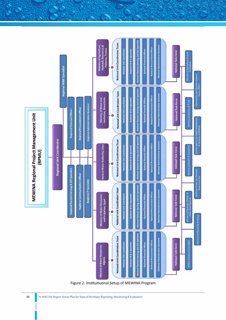
46 N-AMCOW Region Action Plan for State of the Water Reporting, Monitoring & Evaluation
MEW
INA
Figure 2. Institutiuonal Setup of MEWINA Program

47
Action Plan Implem
entation
N-AMCOW Region Action Plan for State of the Water Reporting, Monitoring & Evaluation
MEW
INA
6.1. Indicative Budget
Whilethebudgetforthefull-fledgedActionPlanactivitiesinaperiodof threeyearswasestimatedtobe 21.753 Million Euros, some activities of immediate priority have been selected based on the most urgentMonitoring&EvaluationgapsthatwereidentifiedintheRapidAssessmentReportsandreflectedin the data gaps apparent from the National, Regional, Basin level State of the Water reports to develop the priority-phase Action Plan budget which amounted to 5.455 Million Euros for two years. The priority phase will concentrate on the monitoring equipment for the least advanced countries only while maintaining the minimum requirements for reporting, monitoring and evaluation for the whole region.
The proposed components and associated budget for the full-fledgedAction planwith a budget of21.753 Million Euro for 3 years include:
• Strengthening Institutional Capacity (2.825 Million Euros)
• Regional Program Management Unit (1.082 Million Euros)
• Capacity Building (2.069 Million Euros)
• Improving Data Collection, Monitoring & Evaluation (14.915 Million Euros)
• State of the Water reporting (0.222 Million Euros)
• Effective Dissemination and Raising Awareness (0.64 Million Euros)
The suggested components and associated budget for the priority-phase Action Plan with a budget of 5.455 Million Euro for two years include:
• Strengthening Institutional Capacity (0.705 Million Euros)
• Regional Program Management Unit (0.718 Million Euros)
• Capacity Building (0.1 Million Euros)
• Improving Data Collection, Monitoring & Evaluation (3.55 Million Euros) including urgent Meteorological and Hydrometric equipment for Libya and Mauritania
• State of the Water reporting (0.222 Million Euros)
• Effective Dissemination and Raising Awareness (0.16 Million Euros)
The budget for the High Priority Activities for a two years period was estimated under the following criteria and assumptions:
1. TheNationalunitsstaff willbeworkingonpart-timebasisandtheprocurementofficerpositionwillbe vacant.
2. The Regional Unit will be in charge of all activities related to Shared Basins and Aquifers.
3. The Capacity Building Component will only cater to the training needs of professionals and not the technicians as the equipment associatedwith the “Improving data Collection,Monitoring&Evaluation”componentwillnotbepurchased in thefirst twoyears.

48 N-AMCOW Region Action Plan for State of the Water Reporting, Monitoring & Evaluation
MEW
INA
4. The“ImprovingdataCollection,Monitoring&Evaluation”componentwillbecomprisedof theRemoteSensingandGISEquipmentandSoftware”,andthe“ImprovingWateraccounting”sub-component only, besides the shared Basins/Aquifer sub component that will be managed by the Regional Unit.
5. Urgent Meteorological and Hydrometric equipment will be made available (amounting to a maximum of 3 Million Euros) and will be decided based on a study that will be conducted shortly before the beginning of the second phase of MEWINA.
6. The“EffectiveDisseminationandRaisingAwareness”componentwillnotincludethe“Media”subcomponentinthefirsttwoyears.
While Table. 8 shows the budget for the Full-Fledged Action Plan program activities in a period of three years, Table 9 displays the distribution of each country share of the activity related to supporting shared River Basin and Aquifer Monitoring and Evaluation. Table 10 shows the budget for the priority activities thatshouldbeimplementedinthefirsttwoyearsunderthefollowingassumptions:
1. TheNationalunitsstaff willbeworkingonpart-timebasisandtheprocurementofficerpositionwillbe vacant.
2. The Regional Unit will be in charge of all activities related to Shared Basins and Aquifers.
3. The Capacity Building Component will only cater to the training needs of professionals and not the technicians as the equipment associatedwith the “Improving data Collection,Monitoring&Evaluation”componentwillnotbepurchased in thefirst twoyears.
4. The“ImprovingdataCollection,Monitoring&Evaluation”componentwillbecomprisedof theRemoteSensingandGISEquipmentandSoftware”,andthe“ImprovingWateraccounting”sub-component only, besides the shared Basins/ Aquifer sub component that will be managed by the Regional Unit.
5. The“EffectiveDisseminationandRaisingAwareness”componentwillnotincludethe“Media”subcomponentinthefirsttwoyears.
TheTotalbudgetforthehighpriorityactivitiesof thefirsttwoyearsis5.455MillionEuros.
Table 8. Preliminary Proposed Budget to each Country and MEWINA Project Management Unit (in Thousand Euros)
Activities of the first three years Algeria Egypt Libya Mauritania TunisiaMEWINA Regional Unit
Total
Strengthening Institutional Capacity 525 525 525 525 525 200 2,825
Meetings and Consultation Workshops 10 10 10 10 10 - 50
Support Inter-Ministerial Task Forces 5 5 5 5 5 - 25
Strengthening of National MEWINA Program Management Units
250 250 250 250 250 - 1,250
MEWINA Web Based Information System 150 150 150 150 150 200 950
Strengthening Water Governance Indicators Recording
30 30 30 30 30 - 150
Support National Information Systems 80 80 80 80 80 - 400

49
Action Plan Implem
entation
N-AMCOW Region Action Plan for State of the Water Reporting, Monitoring & Evaluation
MEW
INA
Regional Program Management Unit - - - - - 1,082 1,082
Staff - - - - - 792 792
Operating Expenses & Hosting fees - - - - - 180 180
Regional Consultation Workshops & meetings - - - - - 60 60
Travel & DSA - - - - - 50 50
Capacity Building 202 535 237 280 715 100 2,069
Professionals Training Program 82 200 96 200 120 100 798
Monitoring Technicians Training Program 120 335 140 80 595 - 1,270
Improving Data Collection, Monitoring & Evaluation
3,304 3,504 3,579 1,354 2,504 670 14,915
Meteorological and Hydrometric Equipment 800 800 500 200 400 - 2,700
Meteorological and Hydrometric Monitoring & Data Collection
100 100 100 100 100 - 500
Water Quantity & Quality Measurement Equipment
800 800 500 200 400 - 2,700
Water Quantity and Quality Monitoring & Data Collection
100 100 100 100 100 - 500
Remote Sensing and GIS Equipment and Software
200 200 200 200 200 150 1,150
Census and Socio-economic Surveys 90 90 90 90 90 - 450
Improving Water Accounting 20 20 20 20 20 20 120
Overall Data Analysis 144 144 144 144 144 100 820
Support Transboundary Monitoring Programs 1,050 1,250 1,925 300 1,050 400 5,975
State of the Water reporting 36 39 39 36 36 36 222
SOW Report Writing 20 20 20 20 20 20 120
SOW REPORT Translation 6 9 9 6 6 6 42
SOW Report Printing 10 10 10 10 10 10 60
Effective Dissemination and Raising Awareness 130 130 80 80 80 140 640
Material Production and Dissemination 10 10 10 10 10 10 60
Regional and National MEWINA Websites 100 100 50 50 50 100 450
Media (TV & Radio) 20 20 20 20 20 30 130
Grand Total 4,197 4,733 4,460 2,275 3,860 2,228 21,753
Table 9. Distribution of “Support Transboundary Monitoring Programs” Budget among the Transboundary River s and Aquifers (in Thousands Euros)
NSAS NWSAS Senegal Basin Nile Basin Other Basins/ Aquifers
Algeria - 1,050 -
Mauritania - - 300 -
Libya 1,025 900 - -
Tunisia - 1,050 - -
Egypt 700 - - 550
CEDARE 50 30 20 100 200
Total 1,775 3,030 320 650 200

50 N-AMCOW Region Action Plan for State of the Water Reporting, Monitoring & Evaluation
MEW
INA
Table 10. Allocated Budget to each Country and MEWINA Project Management Unit for High Priority Activities in the first two years (in Thousand Euros)
High Priority Activities in the first two years Algeria Egypt Libya Mauritania Tunisia MEWINA Regional Unit Total
Strengthening Institutional Capacity 141 141 141 141 141 - 705
Meetings and Consultation Workshops 10 10 10 10 10 - 50
Support Inter-Ministerial Task Forces 5 5 5 5 5 - 25
Strenghtening of National MEWINA Program Management Units
96 96 96 96 96 - 480
Strengthening Water Governance Indicators Recording
30 30 30 30 30 - 150
Regional Program Management Unit - - - - - 718 718
Staff - - - - - 528 528
Operating Expenses & Hosting fees - - - - - 120 120
Regional Consultion Workshops & meetings - - - - - 40 40
Travel & DSA - - - - - 30 30
Capacity Building 20 20 20 20 20 - 100
Professionals Training Program 20 20 20 20 20 - 100
Improving Data Collection, Monitoring & Evaluation
550 550 760 760 500 430 3,550
Meteorological and Hydrometric Equipment 180 180 290 290 130 - 1,070
Water Quantity & Quality Measurement Equipment
300 300 400 400 300 - 1,700
Improving Water Accounting 20 20 20 20 20 - 100
Remote Sensing and GIS Equipment and Software
50 50 50 50 50 150 400
Support Transboundary Monitoring Programs - - - - - 280 280
State of the Water reporting 36 39 39 36 36 36 222
SOW Report Writing 20 20 20 20 20 20 120
SOW REPORT Translation 6 9 9 6 6 6 42
SOW Report Printing 10 10 10 10 10 10 60
Effective Dissemination and Raising Awareness
10 10 10 10 10 110 160
Material Production and Dissemination 10 10 10 10 10 10 60
Regional MEWINA Websites - - - - - 100 100
Grand Total 757 760 970 967 707 1,294 5,455

51
References
N-AMCOW Region Action Plan for State of the Water Reporting, Monitoring & Evaluation
MEW
INA
Alaerts,G.,Hartvelt,F.,Patorni,F.M.,1996,“WatersectorCapacityBuilding:ConceptsandInstruments,”procs. of the second UNDP Symposium on Water Sector Capacity Building, Delft, Balkema, Rotterdam, The Netherlands.
ARS(AllianceforRegionalStewardship),2005,“RegionalIndicators:TellingStories,MeasuringTrends,InspiringActions,”Report,MonographSeries,Denver,Colorado,USA.
Cap-Net,2004,“ApplyingKnowledgeManagement:AtoolforCapacityBuildingNetworksinIntegratedWaterResourcesManagement,”report.
El Sayed, A., Fahmy,H., 2007 “TowardsDevelopment of aWaterQualityMonitoring Strategy forMASHREQandMAGHREBCountries”,IrrigationandDrainage,ICIDJournal,Volume56,Issue5,Pages589-600.
CEDARE(2014a),“MauritaniaWaterSectorM&ERapidAssessmentReport”,Monitoring&Evaluationfor Water In North Africa (MEWINA) Project, Water Resources Management Program, CEDARE.
CEDARE(2014b),“AlgeriaWaterSectorM&ERapidAssessmentReport”,Monitoring&Evaluationfor Water In North Africa (MEWINA) Project, Water Resources Management Program, CEDARE.
CEDARE(2014c),“NorthWesternSaharaAquiferSystem(NWSAS)M&ERapidAssessmentReport”,Monitoring & Evaluation for Water In North Africa (MEWINA) Project, Water Resources Management Program, CEDARE.
CEDARE (2014d), “Nubian Sandstone Aquifer System (NSAS) M&E Rapid Assessment Report”,Monitoring & Evaluation for Water In North Africa (MEWINA) Project, Water Resources Management Program, CEDARE.
CEDARE(2014e),“SenegalRiverBasinM&ERapidAssessmentReport”,Monitoring&EvaluationforWater In North Africa (MEWINA) Project, Water Resources Management Program, CEDARE.
CEDARE(2014f),“NileRiverBasinM&ERapidAssessmentReport”,Monitoring&EvaluationforWater In North Africa (MEWINA) Project, Water Resources Management Program, CEDARE.
CEDARE(2014g),“LibyaWaterSectorM&ERapidAssessmentReport”,Monitoring&EvaluationforWater In North Africa (MEWINA) Project, Water Resources Management Program, CEDARE.
CEDARE(2014h),“TunisiaWaterSectorM&ERapidAssessmentReport”,Monitoring&Evaluationfor Water In North Africa (MEWINA) Project, Water Resources Management Program, CEDARE.
CEDARE(2014i),“EgyptWaterSectorM&ERapidAssessmentReport”,Monitoring&EvaluationforWater In North Africa (MEWINA) Project, Water Resources Management Program, CEDARE.
CEDARE(2014j),“IndicatorsfortheStateof theWaterReportingattheNational,SharedRiverBasin,&SharedAquiferLevelsinNorthAfrica”,Monitoring&EvaluationforWaterInNorthAfrica(MEWINA)Project, Water Resources Management Program, CEDARE.
CEDARE(2014k),“NorthAfricaRegionalWaterSectorM&ERapidAssessmentReport”,Monitoring& Evaluation for Water In North Africa (MEWINA) Project, Water Resources Management Program,
7. References

52 N-AMCOW Region Action Plan for State of the Water Reporting, Monitoring & Evaluation
MEW
INA
CEDARE.
AlgeriaMWR,CEDARE,Demmak,A.(2014),“AlgeriaActionPlanforStateof theWaterReporting,Monitoring&Evaluation”,Monitoring&EvaluationforWaterInNorthAfrica(MEWINA)Project,Ministry Water Resources (MWR) - Algeria, Water Resources Management Program - CEDARE.
EgyptMWRI,CEDARE,Abufayed,A.(2014),“EgyptActionPlanforStateof theWaterReporting,Monitoring&Evaluation”,Monitoring&EvaluationforWaterInNorthAfrica(MEWINA)Project,Ministry of Water Resources & Irrigation (MWRI) - Libya, Water Resources Management Program - CEDARE.
LibyaMWR,CEDARE,Abufayed,A. (2014), “LibyaActionPlan for State of theWaterReporting,Monitoring&Evaluation”,Monitoring&EvaluationforWaterInNorthAfrica(MEWINA)Project,Ministry of Water Resources (MWR) - Libya, Water Resources Management Program - CEDARE.
MauritaniaMWS,CEDARE,Gaye,A.(2014),“MauritaniaActionPlanforStateof theWaterReporting,Monitoring&Evaluation”,Monitoring&EvaluationforWaterInNorthAfrica(MEWINA)Project,Ministry of Water & Sanitation, Mauritania - MWS, Water Resources Management Program - CEDARE.
TunisiaMAWRF,CEDARE,Hamza,M.(2014),“TunisiaActionPlanforStateof theWaterReporting,Monitoring&Evaluation”,Monitoring&EvaluationforWaterInNorthAfrica(MEWINA)Project,Ministry of Agriculture, Water Resources & Fisheries (MAWRF) - Tunisia, Water Resources Management Program - CEDARE.
AlgeriaMWR,CEDARE,Demmak,A.(2014),“Algeria2012Stateof theWaterReport”,Monitoring&Evaluation for Water In North Africa (MEWINA) Project, Ministry of Water Resources, Algeria - MWR, Water Resources Management Program - CEDARE.
EgyptMWRI,CEDARE,Demmak,A.(2014),“Algeria2012Stateof theWaterReport”,Monitoring&Evaluation for Water In North Africa (MEWINA) Project, Ministry of Water Resources & Irrigation, Egypt - MWRI, Water Resources Management Program - CEDARE.
LibyaMWR,CEDARE,Abufayed,A.(2014),“Libya2012Stateof theWaterReport”,Monitoring&Evaluation for Water In North Africa (MEWINA) Project, Ministry of Water Resources (MWR) - Libya, Water Resources Management Program - CEDARE.
MauritaniaMWS,CEDARE,Gaye,A.(2014),“Mauritania2012Stateof theWaterReport”,Monitoring& Evaluation for Water In North Africa (MEWINA) Project, Ministry of Water & Sanitation (MWS) - Mauritania, Water Resources Management Program - CEDARE.
TunisiaMAWRF,CEDARE,Hamza,M.(2014),“Tunisia2012Stateof theWaterReport”,Monitoring& Evaluation for Water In North Africa (MEWINA) Project, Ministry of Agriculture, Water Resources & Fisheries (MAWRF) - Tunisia, Water Resources Management Program - CEDARE.
CEDARE,AbuZeid,K.,Elrawady,M.,(2015),“MEWINARegionActionPlanforStateof theWaterReporting,Monitoring&Evaluation”,Monitoring&EvaluationforWaterInNorthAfrica(MEWINA)Project, Water Resources Management Program, CEDARE.
NileBasinInitiative(NBI),2012.“MonitoringStrategyfortheNileRiverBasin,”NBIPublication.
CEDARE (2014), “North Africa Regional Water Sector M&E Standardization and Harmonization
53
References
N-AMCOW Region Action Plan for State of the Water Reporting, Monitoring & Evaluation
MEW
INA
FrameworkReport”,Monitoring&EvaluationforWaterInNorthAfrica(MEWINA)Project,WaterResources Management Program, CEDARE.
Salewicz, K.A., 2001. Decision support systems—how they could be developed in a web environment? Conceptual Paper, unpublished manuscript.
Salewicz,K.A.,andNakayama,M.,2004,“Developmentof aWeb-basedDecisionSupportSystem(DSS)forManagingLargeInternationalRivers,”GlobalEnvironmentalChange14,Elsevier,pp.25-37.
TF-IMR,2009,“MonitoringProgress in theWaterSector:Aselectedsetof indicators,”final report,UN-Water.
UNESCAP, 2002, “Public Awareness on Water Conservation and Water Efficiency,” http://www.unescap.org/esd/water/conservation/2001/public.asp [Accessed 24 July2006]:
UnitedNationsStatisticsDivision(UNSD),2007,“Systemof Environmental-EconomicAccountingforWater,”FinalDraft,38thsessionof UnitedNationStatisticalCommission.
WWAP.2009,“Reportof theExpertGrouponIndicators,Monitoring,andDataBasesandProposedprogrammetomobilizeinformationtosupportdecisionmakingaboutwaterresources”.Draftpresentat UN Water meeting in August 2009.

54 N-AMCOW Region Action Plan for State of the Water Reporting, Monitoring & Evaluation
MEW
INA
Annexes
Figure 3. Proposed Institutional Setup for M&E in Water Sector (Algeria)

55N-AMCOW Region Action Plan for State of the Water Reporting, Monitoring & Evaluation
MEW
INA
Annexes
Figure 4. Proposed Institutional Setup for M&E in Water Sector (Mauritania)

56 N-AMCOW Region Action Plan for State of the Water Reporting, Monitoring & Evaluation
MEW
INA
Figure 5. Proposed Institutional Setup for M&E in Water Sector (Libya)
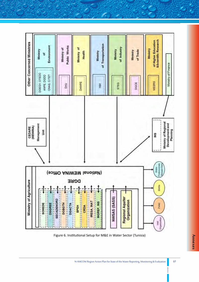
57N-AMCOW Region Action Plan for State of the Water Reporting, Monitoring & Evaluation
MEW
INA
Annexes
Figure 6. Institutional Setup for M&E in Water Sector (Tunisia)

58 N-AMCOW Region Action Plan for State of the Water Reporting, Monitoring & Evaluation
MEW
INA
Figure 7. Institutional Setup for M&E in Water Sector (Egypt)


![Action Fiche for [beneficiary country/region/Theme] ("Annex" when ...](https://static.fdocuments.net/doc/165x107/5868dcbc1a28ab52568bd917/action-fiche-for-beneficiary-countryregiontheme-annex-when-.jpg)