Municipal Enterprises Ltd. P.O. Box 48100 Bedford, NS B4A ... · Environmental Assessment...
151
Environmental Assessment Registration for the Hants County Aggregate Quarry Extension Project Municipal Enterprises Ltd. P.O. Box 48100 Bedford, NS B4A 3Z2 File: 121510261 July 2010 Stantec Consulting Ltd. 102 – 40 Highfield Park Dartmouth NS B3A 0A3 Tel: (902) 468-7777 Fax: (902) 468-9009
Transcript of Municipal Enterprises Ltd. P.O. Box 48100 Bedford, NS B4A ... · Environmental Assessment...

Environmental Assessment Registration for the Hants County Aggregate Quarry Extension Project
Municipal Enterprises Ltd. P.O. Box 48100 Bedford, NS B4A 3Z2
File: 121510261
July 2010
Stantec Consulting Ltd. 102 – 40 Highfield Park
Dartmouth NS B3A 0A3 Tel: (902) 468-7777
Fax: (902) 468-9009

ENVIRONMENTAL ASSESSMENT
File #: 121510261 i July 2010
Table of Contents
1.0 PROPONENT AND PROJECT IDENTIFICATION ............................................................. 1.1 1.1 PROPONENT INFORMATION ........................................................................................... 1.1 1.2 PROJECT INFORMATION ................................................................................................. 1.1
2.0 PROJECT INFORMATION ................................................................................................. 2.1 2.1 DESCRIPTION OF THE UNDERTAKING .......................................................................... 2.1 2.2 GEOGRAPHIC SETTING ................................................................................................... 2.3 2.3 PROJECT COMPONENTS ................................................................................................ 2.3 2.4 SITE PREPARATION AND CONSTRUCTION ................................................................... 2.5 2.5 OPERATION AND MAINTENANCE ................................................................................... 2.5 2.6 EFFLUENTS AND EMISSIONS ......................................................................................... 2.6 2.7 DECOMMISSIONING AND RECLAMATION ..................................................................... 2.9
3.0 SCOPE ............................................................................................................................... 3.1 3.1 SCOPE OF THE UNDERTAKING ...................................................................................... 3.1 3.2 PURPOSE AND NEED FOR THE UNDERTAKING ........................................................... 3.1 3.3 PROJECT ALTERNATIVES ............................................................................................... 3.1 3.4 SCOPE OF THE ENVIRONMENTAL ASSESSMENT ........................................................ 3.2
4.0 PUBLIC INVOLVEMENT .................................................................................................... 4.1 4.1 METHODS OF INVOLVEMENT ......................................................................................... 4.1 4.2 STAKEHOLDER COMMENTS AND STEPS TAKEN TO ADDRESS ISSUES .................. 4.1
5.0 VALUED ENVIRONMENTAL/SOCIO-ECONOMIC COMPONENTS (VEC) AND EFFECTS MANAGEMENT ................................................................................................ 5.1
5.1 ASSESSMENT METHODS ................................................................................................ 5.1 5.2 SURFACE WATER RESOURCES ..................................................................................... 5.1
5.2.1 Description of Existing Conditions ....................................................................... 5.2 5.2.2 Potential Effects, Proposed Mitigation, Monitoring and Follow-up ....................... 5.6
5.3 RARE AND SENSITIVE FLORA ......................................................................................... 5.8 5.3.1 Description of Existing Conditions ....................................................................... 5.8 5.3.2 Potential Effects, Proposed Mitigation, Monitoring and Follow-up ..................... 5.11
5.4 WILDLIFE ......................................................................................................................... 5.12 5.4.1 Description of Existing Conditions ..................................................................... 5.12 5.4.2 Potential Effects, Proposed Mitigation, Monitoring and Follow-up ..................... 5.21
5.5 WETLANDS ...................................................................................................................... 5.21 5.5.1 Description of Existing Conditions ..................................................................... 5.21 5.5.2 Potential Effects, Proposed Mitigation, Monitoring and Follow-up ..................... 5.24
5.6 GROUNDWATER RESOURCES ..................................................................................... 5.24 5.6.1 Description of Existing Conditions ..................................................................... 5.26 5.6.2 Potential Effects, Proposed Mitigation, Monitoring and Follow-up ..................... 5.32

ENVIRONMENTAL ASSESSMENT Table of Contents
File #: 121510261 ii July 2010
5.7 ARCHAEOLOGICAL AND HERITAGE RESOURCES ..................................................... 5.34 5.7.1 Description of the Existing Environment ............................................................ 5.34 5.7.2 Potential Effects, Proposed Mitigation, Monitoring and Follow-up ..................... 5.35
5.8 ATMOSPERHIC ENVIRONMENT .................................................................................... 5.35 5.8.1 Description of Existing Conditions ..................................................................... 5.35 5.8.2 Potential Effects, Proposed Mitigation, Monitoring and Follow-up ..................... 5.37
5.9 SOCIO-ECONOMIC ENVIRONMENT .............................................................................. 5.39 5.9.1 Description of the Existing Environment ............................................................ 5.39 5.9.2 Potential Effects, Proposed Mitigation, Monitoring and Follow-up ..................... 5.43
5.10 OTHER UNDERTAKINGS IN THE AREA ........................................................................ 5.45 5.10.1 Description of the Existing Environment ............................................................ 5.45
6.0 EFFECTS OF THE PROJECT ON THE ENVIRONMENT ................................................. 6.1
7.0 EFFECTS OF THE ENVIRONMENT ON THE PROJECT ................................................. 7.1
8.0 OTHER APPROVALS REQUIRED .................................................................................... 8.1
9.0 FUNDING ............................................................................................................................ 9.1
10.0 ADDITIONAL INFORMATION ......................................................................................... 10.1
11.0 REFERENCES ................................................................................................................. 11.1 11.1 LITERATURE CITED ........................................................................................................ 11.1 11.2 PERSONAL COMMUNICATIONS .................................................................................... 11.4
12.0 APPENDICES ................................................................................................................... 12.1
LIST OF APPENDICES
APPENDIX A Registry of Joint Stocks and Industrial Approval APPENDIX B Hants County Aggregate Quarry Extension Hydrology Study APPENDIX C Project Information Bulletin and Letters APPENDIX D Aquatic Photo Appendix APPENDIX E Vascular Plants Potentially Present in the Study Area APPENDIX F Vascular Plants Recorded in Study Area APPENDIX G Breeding and Population Status of Birds Recorded in the Study Area
and the Breeding Bird Atlas Square APPENDIX H Response to Government Review Comments

ENVIRONMENTAL ASSESSMENT Table of Contents
File #: 121510261 iii July 2010
LIST OF TABLES
Table 4.1 Summary of Stakeholder Comments and Concerns .................................... 4.1 Table 5.1 Summary of Stream Assessment at Hants County Aggregate Quarry ......... 5.5 Table 5.2 Summary of Domestic Water Wells Records in Three Mile Plains,
Nova Scotia ................................................................................................ 5.30
LIST OF FIGURES
Figure 1 Project Location ............................................................................................ 2.2 Figure 2 Land Classification ....................................................................................... 2.4 Figure 3 Sensitive Areas ............................................................................................. 5.3 Figure 4 Surficial Geology ........................................................................................ 5.28 Figure 5 Bedrock Geology ........................................................................................ 5.29


ENVIRONMENTAL ASSESSMENT
File #: 121510261 2.1 July 2010
2.0 PROJECT INFORMATION
2.1 DESCRIPTION OF THE UNDERTAKING
Municipal Enterprises Limited (MEL, the Proponent) owns and operates a quarry, located at 700 Panuke Road in Three Mile Plains, Hants County, Nova Scotia, called the Panuke Quarry. MEL is currently proposing to purchase and extend an adjacent quarry, the Hants County Aggregate Quarry, and incorporate its operations as a component of the existing Panuke Quarry by amending the existing Approval permit. Both quarries are located in the West Hants Municipal District (Figure 1). The existing Panuke Quarry is operating under an Industrial Approval (No. 2001-019700-A01), pursuant to Division V of the Activities Designation Regulations, issued by Nova Scotia Environment and Labor (NSEL), effective until September 9, 2011. This permit allows for construction and operation of a quarry on property parcel number 45270493. A copy of the Approval permit is appended to this report (Appendix A).
MEL is proposing to combine the operations of the Hants County Aggregates Quarry with the existing Panuke Quarry. The current operation at Hants County Aggregates is 3.9 hectares (ha) in area. The proposed extension of the existing Hants County Aggregates Quarry will incorporate land north, south and southwest of the existing quarry to increase the total size of the operation to approximately 13.9 ha (not including the adjacent Panuke quarry). Blasting, crushing and stockpiling of aggregate currently takes place at the Hants County Aggregate site and this is not expected to change. The quarried material at this site is primarily used for Nova Scotia Transportation and Infrastructure Renewal (NSTIR) projects; but after amalgamation with Panuke Quarry, the intent is that the Hants County Aggregates site will be used for both NSTIR contracts and general contracts. The existing Panuke quarry is approximately 4.0 ha in area and has an approved extension area of 6 ha. It is primarily used as a source of aggregate in the making of asphalt. The combined operations will cover an area of 23.9 ha. The proposed activities will take place over a period of time until the material is exhausted. Based on current estimates, there are over 1 million tonnes of rock reserves on both properties. The extended Hants County Aggregate site could therefore sustain aggregate production for approximately 10 years.
Proposed project activities will be consistent with current quarry operations at the Hants County Site. Aggregate production includes drilling and blasting, which is conducted by a licensed blasting contractor. Blasting takes place approximately one to two times per year. After blasting, portable crushing equipment is brought to the site to process the blasted rock. Various products (i.e., various aggregate sizes) are stockpiled at the quarry site until they are transported to local markets via tandem trucks or tractor trailer trucks via the existing truck route. The estimated truck traffic will be consistent with current truck volume at the existing quarry and will only increase, for a short period of time, if a large aggregate supply contract were awarded.

To Th
re e M
ile P
lains
Fall B
rook
Panu
ke R
oad
Maple
Bro
ok
5.1 Ha
8.8 Ha
4 Ha
4 Ha
4.4 Ha1.6 Ha
95
9085
115
110
120
105
125
100
80
130135
75
140
70
145
150
155
160
165
170
65
175
180
60
185
55
190
195
50
200
120
155
130
70
120
140
155
160
145
130
150
125
11011
5
175
85
145
180
155
170
100
165
65
150
135
180
180
105
130
185
160
170
105
90
125 120
175
120
75
175
17585
130
95
135
125
95
105
100
125
140
165
135
170
105
125
80
135
140
140
165
125
100
70
80
135
160
120
160
175
84
81
144
117
111
92.8
69.177.1
65.5
76.4
100.7
124.1158.4
114.1
113.5
121.7
108.4
121.7121.7
Environmental Assessment of Hants County Aggregate Quarry Extension Project
PROJECT LOCATION
PREPARED BY:
FIGURE NO.:
MUNICIPAL ENTERPRISES LIMITED
±
0 125 250
Meters
PROJECT NO: 1056220.
Figure 1DATE:
07/06/2010
G. MESHEAU
Legend800m Quarry Expansion BoundaryQuarry Expansion AreaHants County Aggregate Quarry (Existing)Existing Panuke Quarry PropertyApproved Expansion AreaExisting Panuke QuarryFreshwater Wetlands (NSDNR)
" BuildingContour (5m)LocalSeasonal/UnpavedTrack/TrailDrivewayRailwayWatercourse (NSDTB)WaterbodyWetland (NSDTB)

ENVIRONMENTAL ASSESSMENT PROJECT INFORMATION
File #: 121510261 2.3 July 2010
The anticipated average production rate at the Hants County site is approximately 60,000 to 100,000 tonnes per year; with the possibility of a higher production rate for limited periods of time should a significant contract be awarded. Weather permitting, the quarry will be open nine months of the year, however the portable crushing equipment is only on site two to three times a year for duration of ten days to two weeks a time. This proposed schedule is consistent with the current operating schedule.
2.2 GEOGRAPHIC SETTING
Hants County Aggregate is in the small community of Three Mile Plains, Hants County, Nova Scotia (Figure 1). It is located at the following geographic coordinates: 414006 E and 4976415 N. The Project property is bounded at its northeast extent by the Panuke Quarry and at its southwest extent by a major wetland complex, and the existing quarry operation is accessed via a private road extending off Panuke Road. The existing Panuke Quarry is situated on lands that are owned by the Proponent that have undergone various stages of clearing. MEL proposes to purchase and extend the existing Hants County Aggregate operation and amend the Panuke Quarry’s existing Approval permit to include the Hants County Aggregate Quarry.
The surrounding lands are mostly undeveloped. The eastern half of the Project area has been highly modified by human activities. This area is primarily occupied by the existing quarry pit as well as by land that has been cleared and grubbed of its vegetation. Recently clear-cut (within approximately five years) forest surrounds the southern and western ends of this highly disturbed area (Figure 2). The western half of the Project area is forested and primarily comprised of immature mixedwood. The mixedwood forest grades into a stand of immature hardwood within the northern end of the Project area. There is one major wetland and a brook located southwest of the existing Hants County Aggregate Quarry and extension area. The Proponent has redesigned the Project to avoid interactions with the wetland and watercourse identified onsite.
Residential development in the immediate vicinity of the Project is relatively low, with no structures unrelated to the quarry within 800 m. A local road with a low distribution of residential development extends east of the proposed extension area, approximately 3 km, to Trunk 1 (Figure 1). The zoning of the land area is General Resource.
2.3 PROJECT COMPONENTS
The existing quarry operations at the Hants County Aggregate site consist of a laydown area for the portable crushing equipment, various aggregate stockpiles, quarry floor and working face, settling pond, scale and scale house, and access road. The existing property currently does not have liquid asphalt permanently stored on site, it is delivered to the site while making asphalt and it is removed thereafter. Fuel oil is stored on site in temporary above ground storage containers. These materials are currently handled in accordance with existing regulations and this will continue following the extension. No new fuel storage or dangerous goods will be associated with the proposed extension.

T o Th
ree M
ile P
la ins
Maple
Bro
ok
Panu
ke R
oad
Fall B
rook
Environmental Assessment of Hants County Aggregate Quarry Extension Project
LAND CLASSIFICATION
PREPARED BY:
FIGURE NO.:
MUNICIPAL ENTERPRISES LIMITED
±
0 125 250
Meters
PROJECT NO: 1056220.
Figure 2DATE:
07/06/2010
G. MESHEAU
Legend800m Quarry Expansion BoundaryProposed Expansion AreaHants County Aggregate Quarry (Existing)Previously Cleared Quarry LandsMEL PropertiesExisting Panuke Quarry PropertyApproved Expansion Area
" BuildingLocalSeasonal/UnpavedTrack/TrailDrivewayRailwayWatercourse (NSDTB)WaterbodyWetland
Non-Forested CoverWetlandWaterUrbanAldersMiscellaneousGravel PitCorridor
Forested Land CoverHardwoodMixedwoodSoftwoodClear Cut

ENVIRONMENTAL ASSESSMENT PROJECT INFORMATION
File #: 121510261 2.5 July 2010
Overburden that has been stripped prior to drilling and blasting is stored on site for subsequent use during site reclamation. The piles have been hydroseeded to reduce potential for erosion and sedimentation. This, or similar practices will continue throughout the development and operation of the proposed extension area.
The laydown area is located on the quarry floor. The crushing equipment is transported to the site as required (i.e., after blasting). Aggregate stockpiles are currently located at a dedicated location within the quarry limits, as space allows. As the quarry extends, no additional stockpile areas will be established and the existing stockpile area will be used. Surface runoff and quarry drainage are collected on the quarry floor, which has the capacity to hold a significant quantity of water. Currently, overflow from the quarry floor drains to a settling pond located directly in front of the quarry face. Additional settling pond volume will be developed with the extension of the Hants County Aggregate operations, as required (as indicated in the hydrology study Appendix B). Details regarding the amount of additional settling pond volume required for proposed quarry operations will be further refined at the Industrial Approval amendment stage.
The nearest residence is located greater than 800 m from the boundary of the proposed quarry extension limits. As shown in Figure 1, there are no businesses located within 800 m. The general direction of quarry advancement will be southwest from the existing quarry face.
2.4 SITE PREPARATION AND CONSTRUCTION
The existing quarry has been in operation for over 35 years. Access to the existing quarry development is along existing roads. To minimize the potential for erosion and sedimentation, grubbing and removal of overburden will be conducted on an as needed basis, to accommodate drilling and blasting activities. Currently approximately 8.8 ha of the extension area has already been cleared and overburden removed. Topsoil, grubbed material and overburden are stockpiled on site and have been stabilized with hydroseed for subsequent use during site reclamation. These, or similar stabilization procedures will continue throughout the operations of the proposed extension.
Quarry drainage and surface runoff collects on the quarry floor. Overflow from the quarry floor is currently directed to a settling pond located directly in front of the quarry face. Additional pond volume will be developed as the extension proceeds, as required (Appendix B). Water from the settling ponds will be used to provide a water supply for dust suppression during crushing in dry periods.
2.5 OPERATION AND MAINTENANCE
The proposed Project activities (i.e., the quarry extension) will be consistent with the current quarry operations, and will be in accordance with the Pit and Quarry Guidelines (NSEL 1999) and any future issued approvals. The Pit and Quarry Guidelines apply to all pit and quarry operations in the province of Nova Scotia and provide: separation distances for operations,

ENVIRONMENTAL ASSESSMENT PROJECT INFORMATION
File #: 121510261 2.6 July 2010
including blasting; liquid effluent discharge level limits; suspended particulate matter limits; sound level limits; and requirements for a reclamation plan and security bond.
Aggregate production begins the clearing of the site, followed by the removal of overburden. The next step in the process is the drilling and blasting of the rock. It is anticipated that blasting will occur one to two times a year. A qualified blasting company will conduct this work. The blasting sub-contractor is responsible for blast designs and methods in accordance with the General Blasting Regulations made pursuant to the Nova Scotia Occupational Health and Safety Act (1996). Blasting activity will be conducted in accordance with the Pit and Quarry Guidelines. Details of a blast design plan and blast monitoring program will be provided in the application for Industrial Approval. Where appropriate, consideration will be given to recommendations provided in Guidelines for the Use of Explosives In or Near Canadian Fisheries Waters (Wright and Hopky 1998). Excavation of aggregate in quarry operations will not take place below the groundwater table; the benched face height will be determined during the industrial approval process.
The blasted rock will be processed by portable crushing equipment that will be on site two to three times a year, for duration of ten days to two weeks at a time. Aggregate product will be stockpiled in designated areas within the quarry boundaries. Material is hauled and moved within the quarry with a loader. Other equipment will likely include an excavator. Products will be transported from the quarry via tandem and tractor trailer trucks along Panuke Road. The number of trucks hauling aggregate is expected to remain unchanged although this may fluctuate periodically due to local market conditions.
The anticipated average production rate is approximately 60,000 to 100,000 tonnes per year; with the possibility of a higher production rate for limited periods of time should a significant contract be awarded. Weather permitting, the potential operating schedule may be 10 hrs/day, 5 days/week, 36 weeks/year or more, depending on the demand for aggregates. This proposed schedule is consistent with the current operating schedule.
The existing quarry currently employs one seasonal employee in the scale house; however, there are up to ten employees during aggregate production. This number is expected to remain the same following site extension. Drilling and blasting activities involve additional resources; these activities are sub-contracted to a professional blasting company. Hauling of materials from the quarry also involves additional labour and equipment requirements. Hauling (or trucking) is typically arranged through the Proponent.
2.6 EFFLUENTS AND EMISSIONS
The implementation and use of environmental devices, techniques and regulations now used in the construction industry will minimize any potential environmental damage to the area. Devices such as diversion ditches, check dams, siltation ponds, straw hay mulch and hydroseeding will be used to control sedimentation, as required. All operations will be carried out in a controlled

ENVIRONMENTAL ASSESSMENT PROJECT INFORMATION
File #: 121510261 2.7 July 2010
environment to ensure sound, vibration, dust and sediment parameters are met to all Provincial and Federal guidelines and regulations.
In accordance with best practices and standard NSE requirements, runoff controls will be in place to ensure that effluent generated during operations is managed appropriately. Surface runoff at the quarry currently collects on the quarry floor and is then directed to a settling pond. Details regarding the increase in size of the settling pond required for proposed extended quarry operations and potential runoff mitigation measures are discussed in Appendix B and will be further refined at the Industrial Approval application stage.
Overflow, if any, will be monitored and sampled according to the Pit and Quarry Guidelines and conditions stipulated in the future Industrial Approval to ensure total suspended solids levels do not exceed the approved final effluent discharge limits. In the unlikely event that overflow, during a significant rain fall, exceeds final effluent discharge limits as determined through monitoring, contingency measures may include pumping of sediment laden water to vegetated areas (away from watercourses) or through filter bags for additional filtration and/or use of additional filtration devices or structures. A stormwater management plan will be submitted as part of the quarry development plan during the Industrial Approval application process.
Dust emissions will be controlled with the application of water, obtained from the water that is pooled on the quarry floor. To minimize the generation of dust, the working areas and laydown areas will be covered with blasted rock. Dust generated by truck movement along the access road will be minimized by speed control, proper truck loading, application of dust suppressants, proper construction of on-site roads, and/ or other means as required by NSE.
Monitoring of airborne particulate emissions (dust) will be conducted at the request of NSE and in accordance with the Pit and Quarry Guidelines, the Nova Scotia Air Quality Regulations and the facilities Approval permit and shall not exceed the following limits at the property boundaries:
• Annual Geometric Mean 70 µg/m3; and • Daily Average (24 hrs) 120 µg/m3.
Combustion emissions will be generated from the operation of vehicles and equipment during Project activities. Given the scope of the planned operations, these emissions will be minimal, localized and similar in quantities to the operation of a small construction project using one or two pieces of heavy equipment. Emissions will be reduced through proper equipment maintenance and inspection practices to ensure efficient operation. Consideration will be given to methods to reduce idling, as feasible.

ENVIRONMENTAL ASSESSMENT PROJECT INFORMATION
File #: 121510261 2.8 July 2010
As per the Pit and Quarry Guidelines, sound levels from quarry operations will be maintained at a level not to exceed the following sound levels (Leq) at the property boundaries:
• Leq 65dBA 0700-1900 hours (Days); 60dBA 1900-2300 hours (Evenings); and 55dBA 2300-0700 hours (Nights).
Sound monitoring will be conducted at the request of NSE.
Light emissions will be generated from road and parking lot lighting, exterior decorative lighting, such as spotlights or floodlights with a function of highlighting features of buildings etc.., and for the safety of employees. Emissions will be minimized by shielding lights to shine down only where it is needed, without compromising safety. Road and parking lot lighting will also be shielded so that little escapes into the sky and it falls where it is required. Generally, exterior decorative lights such as spotlights or floodlights with a function of highlighting features of buildings, etc. will be avoided, or the time of their operation restricted to where only necessary to ensure safety of employees.
As there will not be permanent office or buildings located on this site, there will be minimal solid waste generated. All solid waste will be properly collected and stored until such time that it can be transported to a provincially approved waste disposal facility.
Details of any monitoring programs required by NSE (e.g., surface water, noise, dust) will be developed in consultation with NSE and outlined in the Industrial Approval amendment application.
During quarry operations the only hazardous materials anticipated on-site will be those associated with the normal operation of construction equipment. These substances include: gasoline, diesel fuel, lubricants and antifreeze liquid. There is one above ground diesel tank located on the Panuke Quarry site that is contained within a berm and used as a back-up fuel source should regular fuel delivery be disrupted.
A qualified company will be contracted to conduct regular maintenance of equipment. Used oil and filters are currently removed from the site and this practice will continue with the proposed extension.
Refueling of equipment will be conducted on-site on a regular basis, under contract by a tanker truck. Refueling activities will not be conducted within 100 m of any surface water, and equipment operators will remain with the equipment at all times during refueling in accordance with the Petroleum Management Regulations of the Nova Scotia Environment Act.
In the event of a leak or spill during refueling, maintenance, or general equipment operation, immediate action will be taken to stop and contain the spilled material. All contaminated

ENVIRONMENTAL ASSESSMENT PROJECT INFORMATION
File #: 121510261 2.9 July 2010
material will be collected and stored in an appropriate manner so as not to be re-released to the environment until such time as it will be transported to an approved treatment/disposal facility. All spills will be reported to the 24-hour environmental emergencies reporting system (1-800-565-1633) in accordance with the Emergency Spill Regulations. A Spill Contingency Plan will be developed in support of the application for amendment to the existing Industrial Approval.
2.7 DECOMMISSIONING AND RECLAMATION
MEL will undertake a progressive rehabilitation program at the quarry site by striving to reclaim every two years during operation where practical. In this progressive reclamation process, only the area needed for quarry extension in any one year would be grubbed. All areas affected by quarry activities, including the quarry floor, will be eventually rehabilitated. The subsoil, topsoil and root mat of this area would be placed in a portion of the pit that is no longer in use. Overburden will be stockpiled for use in future reclamation.
Since this site is under sporadic work schedules, the Proponent shall strive to ensure all overburden is piled in an area that will eliminate and control any surface water runoff. Stockpiles of overburden not necessary for site development may possibly be removed for operational purposes.
Hydroseeding stockpiles, as conducted for current operations, will be an acceptable alternative to utilizing root mats in future activities. This approach would provide a source of native plant species well adapted to local soil and climatic conditions and would greatly reduce the need to fertilize the reclaimed pit. If it is necessary to seed reclaimed areas where grubbings have not produced sufficient plant biomass to stabilize soils, wherever practical, native plants should be used for site reclamation. In lieu of native species, seed mixes containing naturalized species which are well established in Nova Scotia and which are not aggressive weeds in the plant communities which are present in the area should be used for reclamation.
As distinct areas within the quarry become inactive, the earthen areas will be graded to a stable slope (max 2.5:1) or rock slopes (max 2:1), where required, or leveled to allow future commercial, industrial, recreational, or residential land use. These inactive areas will be covered with overburden and seeded in the absence of laying a root mat. Generally the rehabilitation will also consist of, but not be limited to: grading and contouring of all slopes and exposed rock faces in consideration of rock falls, slope stability, and safety; spreading existing stockpiled topsoil; and hydroseeding in the absence of laying a root mat.
As for the areas that have been stripped clean of all overburden and have been worked to the appropriate level of elevation, called the quarry floor, they will form part of the staging area for the stockpiles of newly exposed and blasted rock. Once the operations reach a stage where the storage area can be reduced, these areas will be rehabilitated as per the above requirements.

ENVIRONMENTAL ASSESSMENT PROJECT INFORMATION
File #: 121510261 2.10 July 2010
A reclamation plan will be developed for the extended site and submitted to NSE as part of the quarry development plan, to be included in the Industrial Approval amendment application. The reclamation plan will include information on such things as the proposed final topography, maximum slopes, revegetation plans and an outline of the plan for progressive reclamation at the site.

ENVIRONMENTAL ASSESSMENT
File #: 121510261 3.1 July 2010
3.0 SCOPE
3.1 SCOPE OF THE UNDERTAKING
Section 2.0 describes the scope of the undertaking (i.e., the proposed Project) that is the subject of this environmental assessment including spatial assessment boundaries (e.g., Project footprints and zones of influence) and temporal assessment boundaries (e.g., Project time frames).
3.2 PURPOSE AND NEED FOR THE UNDERTAKING
The purpose for the Project is to allow MEL to extend the existing Hants County Aggregate quarry footprint and amalgamate its operations with the existing Panuke Quarry. The quarry is currently operated according to the Pit and Quarry Guidelines for TIR contracts.
The aggregates produced at the quarry are an important requirement in construction projects in the region and are of an appropriate quality for highway construction and maintenance projects. The Proponent anticipates the source material in the proposed extension area to be of similar quality to the material currently extracted at the existing quarry.
The quarry under consideration as well as other quarries in Nova Scotia are an important component of the natural resource sector of the economy and provide essential raw materials to the province’s construction industry. The quarry also provides direct and indirect employment for its workers and suppliers, as well as for the transportation and construction industries.
3.3 PROJECT ALTERNATIVES
Other methods for carrying out the undertaking may include different methods of extraction of the resource and alternative facility locations. The current method of aggregate extraction at the Hants County Aggregate Quarry is drilling and blasting. Alternative methods for extraction of the rock (i.e., mechanical means) are not practical or feasible in this instance due to the nature and characteristics of the rock (e.g., hard and dense). Therefore, there are no feasible alternatives to drilling and blasting as a means of extracting this material.
An alternative facility location is also not a feasible alternative. The extension is occurring in an area that has been previously disturbed and is already exposed to mining/quarrying activities. Extension of the quarry will not require immediate construction of any new facilities (i.e., roads or buildings), as the existing facilities are currently sufficient for current and extended operations. Additional flow retention structures will be installed/constructed as the quarry develops to accommodate the additional surface runoff and quarry drainage (Appendix B). Relocation of the quarry to another location may likely require development of a new site, construction of new facilities, and would potentially have greater effect on the surrounding biophysical and socio-economic environment.

ENVIRONMENTAL ASSESSMENT SCOPE
File #: 121510261 3.2 July 2010
3.4 SCOPE OF THE ENVIRONMENTAL ASSESSMENT
The proposed Project must be registered for Environmental Assessment under the Environmental Assessment Regulations of the Nova Scotia Environment Act as a Class I Undertaking. This report fulfils the primary requirements for project registration under this legislation, and includes revisions made as a result of government comments on the Draft EA document, which was submitted to NSE in March 2010. A summary table presenting all received government comments and comment responses has been included in Appendix H.
Other relevant provincial regulations and guidelines include the General Blasting Regulations made pursuant to the Nova Scotia Occupational Health and Safety Act (1996) and the Nova Scotia Pit and Quarry Guidelines (NSEL 1999). Relevant federal legislation, policies and guidance include the Fisheries Act, Species at Risk Act, the Migratory Birds Convention Act and Environmental Canada Guidance Related to the Environmental Assessment of Aggregate Pit Mines and Quarries in the Atlantic Provinces (2008a).
There are no known requirements for an environmental assessment under the Canadian Environmental Assessment Act (CEAA) associated with the proposed quarry extension. No federal land or funding is required for the Project. There are no requirements for federal permits or authorizations under the CEAA Law List Regulation currently projected.
The scope of the environmental assessment in relation to the proposed Project has been determined by the Proponent and their consultant and is based upon the proposed Project elements and activities, the professional judgment and expert knowledge of the study team, consultations with the public and regulatory authorities on this and similar projects, and the results of field studies conducted in support of this environmental assessment. The Guide to Preparing an EA Registration Document for Pit and Quarry Developments in Nova Scotia (NSEL 2008) was also used to determine/focus the scope of the assessment. Landowners adjacent to the quarry were contacted (see Section 4.0) for the purpose of issues identification. The Proponent also contacted representatives of the Confederacy of Mainland Mi’kmaq, the Native Council, the Mi’kmaq Rights Initiative, and the Union of Nova Scotia Indians.
This environmental assessment evaluates the potential environmental effects of the proposed Project elements and activities, for all Project phases, with regard to each Valued Environmental Component (VEC). By assessing potential impacts on VECs within the study boundaries, a meaningful evaluation of project effects on relevant environmental aspects is achieved. The following VECs were identified based on government guidance, consultation, and professional judgment of the study team noted above:
• Surface Water Resources; • Rare and sensitive flora; • Wetlands;

ENVIRONMENTAL ASSESSMENT SCOPE
File #: 121510261 3.3 July 2010
• Wildlife; • Groundwater; • Archaeological and Heritage Resources; • Air quality; and • Socio-economic Environment.

ENVIRONMENTAL ASSESSMENT
File #: 121510261 4.1 July 2010
4.0 PUBLIC INVOLVEMENT
4.1 METHODS OF INVOLVEMENT
On February 19, 2010, 105 Project Information Bulletins (Appendix C) were distributed to landowners within approximately 1.0 km of the quarry. The purpose of the bulletin was to advise local residents and businesses immediately adjacent to the existing quarry and proposed Project site (i.e., those who are potentially most affected) and provide them with opportunity to comment on the proposed undertaking.
Information letters were also sent to the Confederacy of Mainland Mi’kmaq, the Native Council, the Mi’Kmaq Rights Initiative, and the Union of Nova Scotia Indians to encourage the submission of comments, concerns, and questions regarding the Project (Appendix C).
In early June 2010, representatives of MEL met with members of the community liaison committee, previously established for the Paunke Quarry, to discuss issues of concern. The company agreed to address most concerns and subsequent meetings are to be held.
4.2 STAKEHOLDER COMMENTS AND STEPS TAKEN TO ADDRESS ISSUES
To date, no comments have been received in relation to the information sent to the First Nations or aboriginal organization representatives.
Two local residents commented on the Public Information Sheet that was submitted on February 19, 2010. The concerns raised by these individuals and proposed resolutions are summarized in Table 4.1.
Table 4.1 Summary of Stakeholder Comments and Concerns Stakeholder Issue/Concern Response/Proposed Resolution
Local Resident
1. Concerned with the potential effects that the Project could have on the nearby watershed area.
2. Concerned with the anticipated increase in traffic on Panuke Road.
1. No watercourses are expected to be affected by quarry extension. Surface runoff at the site will be managed through settling ponds and other measures and will comply with Pit and Quarry Guidelines as well as permit conditions for water quality.
2. Truck traffic will not increase as a result of the proposed Project.
Local Resident
1. Concerned with how the combining of operations (i.e., Panuke and Hants quarries) will affect residents living on Panuke Road.
2. Concerned with traffic on Panuke Road.
1. The quarries are combining in the sense that there will be only one operator, that of Municipal Enterprises, for both quarries (i.e., Municipal is acquiring the Hants County Aggregate Quarry). Production rates and quarry activities will remain the same.
2. Truck traffic will not increase as a result of the proposed Project.

ENVIRONMENTAL ASSESSMENT
File #: 121510261 5.1 July 2010
5.0 VALUED ENVIRONMENTAL/SOCIO-ECONOMIC COMPONENTS (VEC) AND EFFECTS MANAGEMENT
5.1 ASSESSMENT METHODS
Field studies were conducted by Stantec, between September 26 and October 7, 2009, to investigate and establish the existing conditions and to determine appropriate mitigation, if necessary, to minimize environmental effects from the proposed extension Project. These surveys consisted of: vegetation survey; wetlands survey; breeding bird survey; mammal survey; and herpetile survey. These surveys were undertaken by qualified biologists employed by Stantec Consulting Ltd. (Stantec). An aquatic field survey was undertaken by qualified aquatic specialists. A desktop assessment of potential archaeological and heritage resources was undertaken by a professional archaeologist. Additional information, in support of the field studies and the assessment, was gathered through a review of: air photos; site mapping; and other information sources, such as the Nova Scotia Museum, Statistics Canada, the Nova Scotia Department of Transportation and Public Works (NSTIR), and the Nova Scotia Department of Natural Resources (NSDNR).
Temporal and spatial assessment boundaries encompass those periods and areas within which the VECs are likely to interact with, or be influenced by, the Project. Temporal boundaries are generally limited to the duration of, and for a period of time after, the Project activities. Spatial boundaries are generally limited to the immediate project area unless otherwise noted.
To assess the potential environmental effects of a project and determine the significance of an effect, it is important to consider the magnitude, frequency, duration, geographical extent and reversibility of the potential effect. The study team has considered these elements for each VEC.
5.2 SURFACE WATER RESOURCES
Surface Water was selected as a VEC because of the potential for Project activities to interact with the freshwater environment. Indicators of the VEC include aquatic life, fish habitat and surface water quality, as well as potential water uses for agriculture, recreation, industry or potability. There are no watercourses located within the Project Area proposed for quarry extension under the current EA. Maple Brook runs in close proximity to the Project property, coming closest to the property at its southwest corner. The Proponent has redesigned the Project to avoid interactions with this watercourse. However given its proximity to the Project property, the aquatic environment of Maple Brook was assessed under this EA.
There are no known agricultural, recreational, industrial or potable uses of Maple Brook. Maple Brook is anticipated to connect to the St. Croix River eventually, via several tributaries. While the St. Croix River may be used for recreational purposes, Maple Brook is of insufficient size to support navigation and is not known to be used for other recreational activities. Agricultural land use does occur in the area (e.g., Three Mile Plains) but is not anticipated to be influenced by

ENVIRONMENTAL ASSESSMENT VALUED ENVIRONMENTAL/SOCIO-ECONOMIC COMPONENTS (VEC) AND EFFECTS MANAGEMENT
File #: 121510261 5.2 July 2010
Maple Brook specifically. A Protected Water Area (i.e., PWA - Mill Lakes Watershed) is located in close proximity to the Project but does not encompass Maple Brook (Figure 3). The Mill Lakes Watershed PWA has been designated as such under the Water Act because it surrounds a public water supply source ((N.S. Reg. 264/86 2009)). Existing legislation protects all lands and watercourses within the PWA from a wide range of activities by either prohibiting or restricting certain uses and practices within the PWA. Since Maple Brook falls outside the PWA boundaries, it is not affected by the land use restrictions enforced within the PWA. Fall Brook is the next closest watercourse that does fall within the PWA. The surface water carried by Maple Brook is not known to connect with Fall Brook either within or downstream of the Project Property area (Figure 3).
The St. Croix River and the Mill Lakes PWA are located outside the Project property. However, mitigation is suggested in the following sections to prevent downstream effects from Maple Brook on downstream aquatic environments, including the St. Croix River. The remainder of the Surface Water VEC discussion will focus on surface water quality, aquatic life and fish habitat within Maple Brook.
5.2.1 Description of Existing Conditions
Fieldwork was conducted on October 7, 2009 by two Stantec aquatic scientists. The field-based stream assessment included a fish habitat survey and in-situ water quality sampling within the one watercourse appearing on 1:10,000 mapping (Nova Scotia Digital Topographic Database) in the vicinity of the proposed quarry extension boundaries. As described above, the one watercourse, Maple Brook, does not cross the currently proposed extension area, but runs very close to the proposed boundary. Therefore, the watercourse was assessed and mitigation suggestions are presented. Maple Brook is expected to feed into the St. Croix River eventually via one of several tributaries to the St. Croix River, including the Lebreau Creek Brook and the Avon River (i.e., Pesaquid Lake).
The habitat surveys were conducted using internal Stantec sampling protocol. The internal protocol used was based on multiple existing protocols including the Environment Canada CABIN protocol (Canadian Aquatic Biomonitoring Network; Reynoldson et al. 2007), and the Ontario Benthos Biomonitoring Network (OBBN) protocols (Jones et al. 2005). The stream assessment included the identification of physical units (i.e., run, riffle, or pool), designation of substrate type, and description of the riparian zone. The presence or absence of macrophytes, algae, over-head cover, and woody debris was recorded. The depth and width of the stream were also taken and the presence of existing anthropogenic impacts was noted.
Watercourse descriptions are provided below for the one stream assessed, Maple Brook. This information details the watercourse survey results and characterizes the stream. By characterizing the watercourse, the Hants County Aggregate Quarry can ensure that appropriate mitigation is implemented. Additionally, any site-specific concerns that may require special mitigation can be identified.

ED ED
ED
@A@A To
Three
Mile
Plai
ns
Maple
Bro
ok
Panu
ke R
oad
Fall B
rook
Maple Brook
Wetland 2(0.16 ha)
Wetland 1(0.11 ha)
SW1SW2
MW2
MW3MW1
Environmental Assessment of Hants County Aggregate Quarry Extension Project
ENVIRONMENTALLY SENSITIVE AREAS
PREPARED BY:
FIGURE NO.:
MUNICIPAL ENTERPRISES LIMITED
±
0 125 250
Meters
PROJECT NO: 1056220.
Figure 3DATE:
25/06/2010
G. MESHEAU
Legend800m Quarry Expansion BoundaryQuarry Expansion AreaHants County Aggregate Quarry (Existing)Previously Cleared Quarry LandsMEL PropertiesExisting Panuke Quarry PropertyApproved Expansion Area
ED Monitor Well@A Surface Water Sample#* Drilled Potable Supply Well" Building
LocalSeasonal/UnpavedTrack/TrailDrivewayRailwayWetland Edge / Stream(From Client Drawing)Watercourse (NSDTB)WaterbodyWetlandFreshwater Wetlands (NSDNR)Stantec Field Delineated WetlandDesignated Water Supply AreasNatural Watershed MunicipalSurface Water Supply

ENVIRONMENTAL ASSESSMENT VALUED ENVIRONMENTAL/SOCIO-ECONOMIC COMPONENTS (VEC) AND EFFECTS MANAGEMENT
File #: 121510261 5.4 July 2010
Key in-situ water quality results are outlined for Maple Brook, as well. The intent of the water quality discussion is to compare the results with applicable guidelines from the Canadian Council of Ministers of the Environment (CCME). Specifically, results are compared with the CCME guidelines for the protection of freshwater aquatic life (CCME-FAL 2007) to determine the likelihood that the watercourse can or cannot support aquatic life. Additionally, the collection of water quality data prior to proposed Project activities helps to establish a baseline against which pre-, during-, and post-construction water quality data can be compared. The water quality parameters collected in-situ using a handheld multimeter (YSI 556) includes dissolved oxygen, pH, specific conductivity and water temperature. These parameters experience natural variation on a seasonal and annual basis. The results presented in the current report represent the surface water quality in the watercourse at a single point in time.
No electro-fishing was conducted during this survey as DFO regulations prohibit electro-fishing in the St. Croix River and its tributaries. Photographs were taken along the stream to document habitat (see Appendix D).
Watercourse Description
Maple Brook is a well defined stream running outside the western edge of the existing Hants County Aggregate Quarry property boundaries and flows north. The watercourse falls within the Hants County Aggregate Quarry property boundaries and comes closest to the quarry extension area at the southern end of the currently proposed extension boundary (Figure 3). It is expected that the watercourse eventually drains into the St. Croix River through one of several potential tributaries to that river, although connectivity to these downstream tributaries was not confirmed during the field assessment. The stream can be characterized as a heavily tea stained, perennial stream supporting multiple substrate types and flow patterns. The stream water quality is influenced by the wetlands in the area.
At the time of the survey, the stream supported high flows following a substantial rain event (approximately 50 mm) 24-48 hours prior to the field-based assessment. The stream characteristics varied from wide, relatively shallow stream with a rocky, cobble-dominated substrate surrounded by mixed forest (see photos 1-2, Appendix D) to a progressively narrower, deeper stream feeding through a wetland (see photos 3-6, Appendix D) closer to the proposed extension boundary. Macrophytes were present throughout the assessment area, with some sections supporting abundant aquatic vegetation. Woody debris was also present throughout the stream and in some areas could be considered abundant. In the upstream portion of the assessed stream area, close to the proposed extension boundary, the flow type was predominantly a run. In the downstream, rocky substrate section outside the Hants County Aggregate Quarry property boundary riffles and some shallow pools were also observed.
Additional physical habitat features are summarized for the watercourse in Table 5.1. These measurements were collected at a single point in time and as such will experience natural variation seasonally.

ENVIRONMENTAL ASSESSMENT VALUED ENVIRONMENTAL/SOCIO-ECONOMIC COMPONENTS (VEC) AND EFFECTS MANAGEMENT
File #: 121510261 5.5 July 2010
Table 5.1 Summary of Stream Assessment at Hants County Aggregate Quarry Date & Time 7-Oct-09
Site Coordinates 413228E 4975963N
Site Description Site Measurements and Characteristics Maple Brook
Precipitation Previous 24 hours None (~50 m rain from 24 – 48 hours previous to assessment)
Wetted Width average (m) 2.2 Bankfull Width average (m) 2.2 Depth (min. - max. range) (cm) 50 Woody Debris (range throughout site) Present - abundant Macrophytes (range throughout site) Present - abundant Algae Present Canopy Cover (%) (range throughout site) 0 - 80 Riparian Vegetation (Dominant) Mixed Forest and Wetland
Water QualityDO (mg/L) 6.88 DO (%) 62.6 Water Temperature (˚C) 11.18 pH 5.49
Generally, the water clarity was good, with no signs of turbidity. A section along the north side (down gradient) of the existing quarry is protected by a silt fence. The in situ water quality results collected in the stream (Table 5.1, above) confirm that Maple Brook has the potential to support aquatic life when compared to the CCME-FAL guidelines. As is often observed in various areas in Nova Scotia, the pH level measured in Maple Brook was somewhat acidic (5.49). The pH fell below the CCME guidelines of 6.5-9.0 but is within the range known to support aquatic life in Nova Scotia. Low pH or acidic waters are common in various areas of the province. Acidification can be caused by a variety of combinations of anthropogenic and natural soil composition conditions such as high sulfur content, which, once becoming oxidized leaches into the ground and surface water, lowering pH (Goodwin, 2004). The dissolved oxygen (DO) recorded in the stream at the time of the survey met the CCME guidelines for the lowest acceptable DO concentration for early and other life stages of aquatic life.
None of the watercourses identified on the Project Property are known to interact with drinking water supplies or other protected surface waters, although the Mill Lakes Watershed PWA is in the vicinity, as discussed above. The assessment presented below concerning hydrogeology and groundwater on the site (i.e., Section 5.6.2), discusses a water well review for the Project Property. Available mapping information was reviewed to determine the probable locations of water wells within 800 m of the Project area. No wells were found to be located within the 800 m Project Area. Further consideration of water wells and hydrogeology in the general area is presented in Section 5.6.2 below.
With implementation of the mitigation described herein to protect on-site surface water and prevent effects downstream in the Avon River, St. Croix River, and their tributaries, no impact to surface waters is anticipated to result from the proposed Project Activities.

ENVIRONMENTAL ASSESSMENT VALUED ENVIRONMENTAL/SOCIO-ECONOMIC COMPONENTS (VEC) AND EFFECTS MANAGEMENT
File #: 121510261 5.6 July 2010
Fish Survey Results
Maple Brook was not electrofished during the stream survey. DFO regulations prohibit electrofishing in the St. Croix River and its tributaries, which Maple Brook is anticipated to drain into. Electrofishing is prohibited in these and other inner Bay of Fundy (iBoF) waters because the iBoF populations of Atlantic salmon (Salmo salar) are listed as endangered on Schedule 1 of the federal Species at Rick Act (SARA). The water quality, varying flow patterns and diverse substrate types observed with the surveyed area during the field based stream assessment confirm that Maple Brook has the potential to support small bodied and large bodied fish species at various stages of their life history (e.g., migration and feeding). However, no iBoF Atlantic salmon spawning habitat (i.e., well aerated gravel beds) was observed within the assessed section of the stream survey. Therefore, neither iBoF Atlantic salmon nor other species of salmonids are expected to spawn within with section of the stream located in proximity to the proposed extension area. Appropriate mitigation must nevertheless be undertaken to prevent potential downstream effects on fish and fish habitat, including potential salmonid habitat elsewhere in the drainage system.
Summary
During the October sampling period, one watercourse was confirmed on the Hants County Aggregate Quarry site, Maple Brook. The watercourse exhibited clear, flowing, tea-stained water and instream habitat capable of supporting aquatic life at the time of the survey. The water from Maple Brook is anticipated to drain into the St. Croix River downstream through one of the River’s several tributaries. Therefore, fish sampling was not carried out. No salmonid spawning habitat was observed within the section of stream assessed, in the vicinity of the proposed quarry extension area. The potential for downstream effects within the St. Croix River, the Avon River, and their tributaries must be mitigated.
5.2.2 Potential Effects, Proposed Mitigation, Monitoring and Follow-up
Potential Surface Water Quality and Aquatic Habitat Effects
The primary potential effects on the surface water VEC from quarry activities result from erosion and sediment control. Erosion and sedimentation can occur whenever soil is exposed. Sedimentation (increased sediment load in stream water and deposition in downstream sediments) is perhaps the most common environmental effect of quarry activities on fish and aquatic habitat, including water quality. The environmental effects of sedimentation are well studied and understood; therefore, detailed mitigation measures to protect watercourses from these effects have been developed. Sedimentation can result in physical changes to the aquatic environment, including the accumulation of fines on stream substrate. Sedimentation and siltation of surface water can also degrade surface water quality (e.g. oxygen levels, light penetration, water temperature, water chemistry such as organics and metals) leading to potential changes in primary production and food availability (Anderson et al. 1996 and Trow Consulting Engineers Ltd. 1996).

ENVIRONMENTAL ASSESSMENT VALUED ENVIRONMENTAL/SOCIO-ECONOMIC COMPONENTS (VEC) AND EFFECTS MANAGEMENT
File #: 121510261 5.7 July 2010
Other potential environmental effects on surface water quality that may occur during quarry activities include increases in total suspended sediments (i.e., increased turbidity), a change in hydrologic conditions, and changes in pH from runoff. These changes in surface water quality can lead to effects on the benthic invertebrate community, in addition to potential physical effects resulting from sedimentation and siltation. There are no known reported acid generating rocks in the existing quarry, so it is unlikely that acid drainage from mineralized zones will occur from the quarry activities. Acid drainage affects the pH of surface water systems by increasing the acidity of the water and as such is very detrimental to aquatic life.
An accidental release of deleterious substances associated with quarry site activities (e.g., nitrates from blasting agents and petroleum hydrocarbons from heavy equipment) also have the potential to affect water chemistry down gradient of the accidental release site if the deleterious substance is not controlled. Nitrates have the potential to cause nutrient enrichment in freshwater systems and petroleum hydrocarbons can cause general contamination of the water and aquatic habitat.
The following mitigation discussion focuses on the prevention and control of erosion, sedimentation and accidental releases during quarry activities. Mitigating for potential effects of erosion and sedimentation serves to protect aquatic habitat, fish resources and water quality simultaneously.
Mitigation of Effects
No active quarry components will be located within 60 m of the banks Maple Brook without prior government approval. No Project-related vehicles will be driven through streams. Natural vegetation will be maintained within this buffer. If avoidance of the watercourse is not possible in the future, approval to alter the watercourse must be granted under the Nova Scotia Activities Designation Regulation. Prior to filing a Watercourse Alteration Approval application, a site visit may be needed to update the stream habitat assessment. Streams are dynamic environments subject to physical and chemical change over time and as such should be reassessed if more than two years have passed since the initial assessment. Alteration of Maple Brook is currently not planned during the life of the quarry extension.
In addition to provincial regulations, any alteration of Maple Brook would also have to be approved by Fisheries and Oceans Canada (DFO). The surveyed area of Maple Brook showed diverse habitat and good water quality anticipated to support fish. DFO has developed the Policy for the Management of Fish Habitat (DFO 1986), which applies to all development and industrial projects in or near watercourses that could harmfully alter, disrupt, or destroy fish habitat by chemical, physical, or biological means (i.e., HADD). The guiding principle of this policy is to achieve no net loss of the productive capacity of fish habitats. Appropriate mitigation is required to prevent effects on fish and fish habitat within Maple Brook as well as further downstream in the drainage system.

ENVIRONMENTAL ASSESSMENT VALUED ENVIRONMENTAL/SOCIO-ECONOMIC COMPONENTS (VEC) AND EFFECTS MANAGEMENT
File #: 121510261 5.8 July 2010
Clearing, grubbing, and topsoil stripping activities can increase the potential for sediment erosion and deposition down gradient, particularly during periods of heavy rainfall or snow melt. These activities will also result in a reduction of evapotranspiration and a corresponding increase in surface runoff, which in turn increases potential for sediment erosion and deposition.
The placement of free-draining material (i.e., blasted rock) over disturbed areas and the use of properly sized flow retention structures are expected to mitigate erosion and sedimentation effects. As the quarry develops, exposed soil capable of producing sediment laden-runoff will be stabilized with blasted rock, and stockpiles of topsoil and overburden will be stabilized with hydroseed or root mat. Additional retention capacity on the quarry floor will be created as the quarry develops and a settling pond will be installed, if required. A stormwater management plan will be submitted as part of the quarry development plan during the Industrial Approval amendment application process.
Accidental release events associated with the Project have potential to result in environmental effects. Precautions and preventative measures will be taken to minimize potential for the occurrence of accidental events that may occur during the life of the Project and to reduce the impacts of any associated environmental effects. It is difficult to predict the precise nature and severity of accidental events. However, the probability of serious accidental events or those causing significant adverse environmental effects is low, particularly when construction and operation procedures incorporate environmental protection and contingency and emergency response plans. Spills of petroleum, oils, lubricants or blasting material may occur during quarry activities during refuelling of machinery, maintenance activities, and failure of hydraulic lines or storage containers. These spills are usually highly localized and readily cleaned up by onsite crews using standard spill remediation equipment.
Based on the results of the watercourse assessment and the mitigation proposed, there is very low potential for quarry activities to interact with the aquatic environment and significant Project-related effects on Maple Brook or other surface water resources are not likely to occur.
5.3 RARE AND SENSITIVE FLORA
5.3.1 Description of Existing Conditions
The site was surveyed by Stantec botanists on September 26, 2009 and during June 7, 2010. A vascular plant inventory of the Project area was compiled during the surveys and habitat descriptions were performed. The Project area supports a number of upland habitat types including immature mixedwood, softwood and hardwood forest, clear-cut, and disturbed area. Two wetlands are also present within the Project area. Whereas both of these are mixedwood treed swamps, a large portion of one is at an early stage of successional development following tree harvesting activities.
The eastern half of the Project area has been highly modified by human activities. This area is primarily occupied by the existing quarry pit as well as by land that has been cleared and grubbed of its vegetation. Recently clear-cut (within approximately five years) forest surrounds

ENVIRONMENTAL ASSESSMENT VALUED ENVIRONMENTAL/SOCIO-ECONOMIC COMPONENTS (VEC) AND EFFECTS MANAGEMENT
File #: 121510261 5.9 July 2010
the southern and western ends of this highly disturbed area. Tree cover within the clear-cut portions of the site is negligible, but regenerating red maple (Acer rubrum) and large-tooth aspen (Populus grandidentata) form a prominent shrub layer. Red raspberry (Rubus idaeus) is abundant within this habitat as are a number of herbaceous taxa, including bristly sarsaparilla (Aralia hispida), dwarf dogwood (Cornus canadensis), bracken fern (Pteridium aquilinum), and poverty oat-grass (Danthonia spicata).
The western half of the Project area is forested and primarily comprised of immature mixedwood. Tree cover within this habitat is dominated by red maple and balsam fir (Abies balsamea), although other species, such as quaking aspen (Populus tremuloides) are present. A moderate shrub layer is dominated by balsam fir and red spruce (Picea rubens), with lesser amounts of red maple and sheep-laurel (Kalmia angustifolia) also being present. The herbaceous layer is comprised of a diversity of species, including bracken fern, dwarf dogwood, goldthread (Coptis trifolia), whorled aster (Oclemena acuminata), eastern hay-scented fern (Dennstaedtia punctilobula), and clinton lily (Clintonia borealis). An intermittent moss cover is provided by three-lobed bazzania (Bazzania trilobata) and red-stemmed moss (Pleurozium schreberi).
The mixedwood forest grades into a stand of immature hardwood within the northern end of the Project area. Tree cover within this habitat is comprised of a diversity of species, including large-tooth aspen, red maple, white ash (Fraxinus americana), balsam fir, and sugar maple (Acer saccharum). An intermittent shrub layer is primarily formed by balsam fir and white ash along with scattered occurrences of American fly-honeysuckle (Lonicera canadensis). Common herbaceous species within the mixedwood forest include clinton lily, wild lily-of-the-valley (Maianthemum canadense), violet (Viola sp.), and spinulose shield fern (Dryopteris carthusiana).
A pocket of immature softwood forest is present within the northwestern corner of the Project area. This habitat has a dense overstory canopy comprised of balsam fir, red maple, red spruce (Picea rubens), and scattered eastern white pine (Pinus strobus). Balsam fir and red spruce also form a moderate shrub layer within this habitat. A minimal herbaceous layer is comprised of scattered occurrences of wild lily-of-the-valley, clinton lily, partridge-berry (Mitchella repens), and painted trillium (Trillium undulatum). The well-shaded forest floor has a well-developed moss layer consisting primarily of red-stemmed moss, stair-step moss (Hylocomium splendens), three-lobed bazzania, and broom moss (Dicranum sp.).
The mixedwood treed swamps are located within the western half of the Project area. Tree cover within these wetlands is comprised of red maple, white ash, quaking aspen, as well as lesser amounts of balsam fir and black spruce (Picea mariana). These tree species also form an intermittent shrub layer within the swamps. The composition of herbaceous vegetation varies considerably within the wetlands and is dominated by both forbs and graminoids including three-seed sedge (Carex trisperma), dwarf dogwood, fowl manna-grass (Glyceria striata), and New York fern (Thelypteris noveboracensis). The hummocky character of these swamps is expressed by the moss layer which is comprised of a patchy arrangement of peatmoss (Sphagnum spp.) interspersed with species that are more characteristic of upland conditions, including stair-step moss and red-stemmed moss.

ENVIRONMENTAL ASSESSMENT VALUED ENVIRONMENTAL/SOCIO-ECONOMIC COMPONENTS (VEC) AND EFFECTS MANAGEMENT
File #: 121510261 5.10 July 2010
Approximately half of one of the swamps has been recently (within approximately five years) clear-cut. This habitat is characterized by extensive coverage of cottongrass bulrush (Scirpus cyperinus). A number of other graminoids are also common however, including brownish sedge (Carex brunnescens), rough bentgrass (Agrostis hyemalis), and Canada manna-grass (Glyceria canadensis). New York fern is also an important component of the herbaceous layer. A well-developed shrub layer is present within portions of the cut-over swamp and is comprised of a mixture of species, including red maple, quaking aspen, gray birch (Betula populifolia), red raspberry, and white ash.
Rare Vascular Plants
Prior to field surveys, a rare plant modeling exercise was performed to determine the likelihood of presence of rare or sensitive plants within the Project area. As part of the modeling exercise, all records of vascular plant species considered by the Nova Scotia Department of Natural Resources (NSDNR) to be “at risk”, “may be at risk” (i.e., Red listed) or “sensitive” to human activities or natural events (i.e., Yellow listed) within a radius of 100 km from the Project area were compiled by means of an Atlantic Canada Conservation Data Center (ACCDC) data search (these records were originally obtained by Jacques Whitford (2008) as part of an EA on the adjacent Panuke Quarry property). The habitat requirements of these species were compared to the habitat descriptions compiled for the Project area to determine if suitable habitat was present for these taxa. Knowledge of the habitats present within the Project area was determined through field visits. In instances where appropriate habitat was present for a particular species, that species was considered to be potentially present within the Project area. The seasonal aspects and ease of identification of each of the species potentially present in the Project area were also incorporated into the model in order to determine when the rare or sensitive taxa would be best identified.
A total of 189 Red or Yellow-listed vascular plant species have been recorded within 100 km of the Project area. Based on the results of the habitat model, 50 of these could potentially be present within the Project area, including 25 Red-listed and 25 Yellow-listed species. One “species at risk” protected by the Nova Scotia Endangered Species Act (NSESA), northern white cedar (Thuja occidentalis), was identified as being potentially present within the Project area. This species is listed as “vulnerable” by the province and was considered to potentially inhabit the swamps of the Project area. No federally designated “species at risk” were identified as being potentially present. The results of the model suggested that there was potential for all habitats in the Project area to support rare or sensitive vascular plant species. Because many of the plants highlighted by the modeling exercise were associated with wetlands and intact mixed/deciduous forests, these habitats were considered to be most likely to harbour rare or sensitive taxa. Appendix E lists the species identified during the modeling exercise as being potentially present within the Project area as well as information on their population status, habitat preference, and phenology.
All species of vascular plants encountered during the 2009 – 2010 surveys were identified and their population statuses in Nova Scotia determined through a review of the species rankings

ENVIRONMENTAL ASSESSMENT VALUED ENVIRONMENTAL/SOCIO-ECONOMIC COMPONENTS (VEC) AND EFFECTS MANAGEMENT
File #: 121510261 5.11 July 2010
prepared by NSDNR (NSDNR 2010), ACCDC (ACCDC 2010), the Committee on the Status of Endangered Wildlife in Canada (COSEWIC 2009), and those protected by the provincial Endangered Species Act (NSDNR 2007b). No rare or sensitive taxa, as identified by COSEWIC, the provincial Endangered Species Act, or NSDNR were encountered during the field survey. However, two provincially uncommon taxa, as identified by the ACCDC were encountered. A list of the 191 vascular plant taxa found on site during field surveys and information on their population status is provided in Appendix F.
Although considered secure in the province by NSDNR, the populations of two orchids, large roundleaf orchid (Platanthera orbiculata) and hooker orchis (Platanthera hookeri) are given a ranking of “S3” by the ACCDC indicating that they are uncommon and are of long-term concern. Large roundleaf orchid is scattered throughout the province in damp, shaded forests (Zinck 1998). Thirty-one individuals of this species were encountered within the hardwood and mixed wood stands of the Project area. Hooker orchis is typically associated with mixed woods (Zinck 1998) and was observed at two locations on the property during the spring plant survey.
The timing of the spring and fall plant surveys was appropriate for identifying the list of species highlighted during the rare plant modeling exercise. Although some of the rare or sensitive plants would have flowered outside the timing of the survey, most are readily identified by their seeds and/or general morphological characteristics, such as leaf shape. Furthermore, botanical inventories of the adjacent Panuke Quarry property (JWL 2008), conducted on July 7 and August 8, 2006; and June 20 and August 18, 2007, did not reveal the presence of any Red or Yellow listed species.
5.3.2 Potential Effects, Proposed Mitigation, Monitoring and Follow-up
The Project has the potential to influence the populations of plant species by causing direct habitat loss and indirectly through changes in habitat conditions, such as may be brought about by altered hydrological regimes. However, no federally or provincially designated “species at risk” or rare or sensitive plants, as identified by NSDNR (2010) were found within the Project area. Additionally, previous botanical inventories conducted on the adjacent Panuke Quarry property (JWL 2008) did not encounter any rare or sensitive vascular plants. Although two provincially uncommon species were encountered within the Project area (roundleaf orchid and hooker orchis), it is not expected that Project activities will cause a significant adverse effect on their populations and specific mitigative measures are not necessary for these taxa.
Other mitigation employed in the extension of the quarry will include the use of progressive reclamation and the use of native plant species wherever possible in the reclamation process. In the progressive reclamation process only the area needed for quarry extension in any one year would be grubbed. The subsoil, topsoil and root mat of this area would be placed in a portion of the pit that is no longer in use. Topsoil and root mat would be stockpiled temporarily (no more than one year) until the subsoil was placed. The topsoil would then be placed over the subsoil and dressed with the root mat. The root mat would provide a source of native plant species propagules in the form of buried seeds, roots, shoots and rhizomes as well as soil

ENVIRONMENTAL ASSESSMENT VALUED ENVIRONMENTAL/SOCIO-ECONOMIC COMPONENTS (VEC) AND EFFECTS MANAGEMENT
File #: 121510261 5.12 July 2010
micro-organisms, however, hydroseeding stockpiles is an acceptable alternative to utilizing root mats. This approach would provide a source of native plant species well adapted to local soil and climatic conditions and would greatly reduce the need to fertilize the reclaimed pit. If it is necessary to seed reclaimed areas where grubbings have not produced sufficient plant biomass to stabilize soils, wherever practical, native plants should be used for site reclamation. In lieu of native species, seed mixes containing naturalized species which are well established in Nova Scotia and which are not aggressive weeds in the wetland and forest plant communities which are present in the area should be used for reclamation.
In summary, assuming recommended mitigative measures; significant Project-related effects on rare and sensitive flora are not likely to occur.
5.4 WILDLIFE
5.4.1 Description of Existing Conditions
Information regarding use of the Project area by wildlife was derived from several sources including field surveys and a review of existing data. A field survey of the project area was conducted concurrently with the plant inventory during September 26, 2009 and recorded information on the presence of birds, mammals, and herpetiles (amphibians and reptiles). Following this, a breeding bird survey was conducted during June, 2010, along with additional wildlife observations. Results from field surveys performed on the adjacent Panuke Quarry property as part of a previous EA (JWL 2008) were also reviewed. In addition, an ACCDC data search, the Atlas of Breeding Birds of the Maritime Provinces (Erskine 1992, MBBA 2009), Amphibians and Reptiles of Nova Scotia (Gilhen 1984), and the Nova Scotia Significant Habitat Mapping Database (NSDNR 2007a) were also consulted to provide records of wildlife in the vicinity of the Project area.
The ACCDC data search was conducted to determine if any rare or sensitive wildlife species have been recorded in the vicinity of the Project area. The ACCDC records were originally obtained by Jacques Whitford as part of an EA on the adjacent Panuke Quarry property (JWL 2008).The ACCDC data were incorporated into a wildlife model to determine the likelihood that rare or sensitive wildlife species might inhabit the Project area. As part of the modeling exercise, all records of wildlife species listed by NSDNR as “at risk” or “may be at risk” (i.e., Red listed) or “sensitive” to human activities or natural events (i.e., Yellow listed) within a radius of 100 km were compiled. The habitat requirements of these species were compared to the habitat descriptions compiled for the Project area to determine if suitable habitat was present. In instances where appropriate habitat was present for a particular species, it was considered to be potentially present.
The Project area provides moderate habitat diversity for wildlife. Its eastern half is primarily occupied by the existing quarry pit as well as by land that has been cleared and grubbed of its vegetation. These disturbed habitats are surrounded by recently clear-cut forest along their southern and western ends. The western end of the Project area is comprised of immature

ENVIRONMENTAL ASSESSMENT VALUED ENVIRONMENTAL/SOCIO-ECONOMIC COMPONENTS (VEC) AND EFFECTS MANAGEMENT
File #: 121510261 5.13 July 2010
forest. Although primarily mixedwood, stands of softwood and hardwood forest are also present. Additionally, two marginal wetlands are present within the Project area. Whereas both of these are mixed treed swamps, half of one has been recently clear-cut. Neither of these wetlands had any surface water at the time of visitation but evidence of ephemeral flooding was present.
Birds
Information on the distribution and abundance of birds within the Project area was primarily obtained during a breeding bird survey. This survey took place during the evening of June 7th and in the morning of June 8th, 2010 between the hours of 07:00 and 11:00. During this time, representative habitats on the property were visited by a birder with 20 years experience and all birds heard or observed were recorded. Additional observations of bird activity within the Project area were made on September 26, 2009. The breeding status of each species observed during these visits was determined with the criteria used in the Atlas of Breeding Birds of the Maritime Provinces (Erskine 1992). “Possible” breeders are generally those birds that have been observed or heard singing in suitable nesting habitat. “Probable” breeders are those birds that have exhibited any of the following: courtship behavior between a male and female; visiting a probable nest site; displaying agitated behavior; and/or male and female observed together in suitable nesting habitat. “Confirmed” breeders are those birds that exhibited any of the following: nest building or adults carrying nesting materials; distraction display or injury feigning; recently fledged young; occupied nest located; and/or adult observed carrying food or fecal sac for young.
Several sources of information on the distribution and activity of birds within the vicinity of the Project area were reviewed prior to the breeding bird survey. In particular, data from an existing EA for an adjacent property (JWL 2008) and from the Maritimes Breeding Bird Atlas (MBBA) were used to help identify species of conservation occur that could potentially occur on site, as well as their breeding status. The breeding bird survey on the adjacent Panuke Quarry property was conducted by Jacques Whitford Limited on July 7, 2006 and June 20, 2007 between the hours of 06:00 and 12:00. The 2006 breeding bird survey included areas within the central and western portions of the current Project area. The Maritimes Breeding Bird Atlas (MBBA) database (Erskine 1992, MBBA 2009) provides information on the distribution and abundance of birds within 10 km X 10 km census squares across the Maritime Provinces of Canada. The MBBA square in which the Project is located (20MQ17) was used to compile a list of breeding birds that have been recorded within the vicinity of the site. The breeding status of each species obtained from these data sources were determined using the criteria outlined by the Atlas of Breeding Birds of the Maritime Provinces. In addition, the ACCDC modeling results were also consulted to identify any additional birds that could potentially inhabit the site.
The population status of each species identified by the field surveys and additional sources was determined using up-to-date sources. Lists of provincially rare or sensitive birds were derived from the General Status of Wildlife in Nova Scotia (NSDNR 2010), Species at Risk in Nova Scotia (NSDNR 2007b), and the ACCDC (ACCDC 2010). The statuses of nationally rare species were obtained from COSEWIC (2009).

ENVIRONMENTAL ASSESSMENT VALUED ENVIRONMENTAL/SOCIO-ECONOMIC COMPONENTS (VEC) AND EFFECTS MANAGEMENT
File #: 121510261 5.14 July 2010
A total of 82 bird species have been identified by the MBBA and the field surveys within the vicinity of the Project area. Of these, 68 have been recorded by the MBBA, 32 were encountered during 2006 - 2007 field surveys in the vicinity of the site, and 34 were identified during 2009 - 2010 surveys of the current Project area. Of those recorded by the MBBA, the breeding status of 22 was confirmed, 31 identified as probable, 15 classified as possible, and one species was observed which exhibited no indication of breeding. The species recorded during the 2006 – 2007 field surveys included four which were confirmed breeders, 11 that were identified as probable, and 21 which were classified as possible breeders. Field surveys of the Project area itself during 2009 – 2010 identified six species as probable breeders, 27 as possible, and one additional species was observed which exhibited no indication of breeding. Appendix G lists all bird species identified within the breeding bird atlas square and the field surveys, as well as information on their breeding and population statuses.
Of the species recorded during the 2009 – 2010 surveys of the Project area, five may be considered to be of conservation concern. Although not protected by the NSESA or the federal Species at Risk Act (SARA), the populations of eastern wood-pewee (Contopus virens), golden-crowned kinglet (Regulus satrapa), gray jay (Perisoreus canadensis), ruby-crowned kinglet (Regulus calendula), and yellow-bellied flycatcher (Empidonax flaviventris) are all considered “sensitive” within the province by NSDNR (2010). The sensitive rankings assigned to these species reflects a decline in their Nova Scotian populations, as brought about by many factors within both their winter and summer grounds; including habitat loss, fragmentation, anthropogenic climate change, and other stressors.
Eastern wood-pewees have just recently been ranked as sensitive by NSDNR. In addition, they are currently assigned a rank of “S3S4B” by the ACCDC indicating that they are uncommon to fairly common throughout their range in the province but are of long-term concern. Within Nova Scotia, eastern wood pewees are typically associated within and at the edges of forests, particularly those with a moderate to high hardwood component. During the 2010 breeding bird survey, two male eastern wood pewees were observed singing in the Project area, where they were associated with both hardwood and mixed wood stands. The population of eastern wood pewee has shown widespread decline, especially in central North America, including Nova Scotia (CWS 2009). Although the cause of this decline is largely unknown, one potentially contributing factor has been identified as an overpopulation of white-tailed deer in eastern forests. That is, in areas with high deer density, the intermediate forest canopy is disturbed by browsing which affects the foraging space of the eastern wood pewee.
Golden-crowned kinglets have also just recently been assigned a status of “sensitive” by NSDNR. The ACCDC assigns a rank of “S4” to this species indicating that although they are fairly common throughout their range in the province, they are of long-term concern. Golden-crowned kinglets are typically found in dense coniferous stands of the province where they are year-round residents. Two males were heard singing within the mixed woods of the Project area during the 2010 breeding bird survey and this species is therefore classified as a “possible” breeder on the site. An individual was also observed on the property during the site visit in September of 2009, suggesting that this species is a year-round resident of the Project area.

ENVIRONMENTAL ASSESSMENT VALUED ENVIRONMENTAL/SOCIO-ECONOMIC COMPONENTS (VEC) AND EFFECTS MANAGEMENT
File #: 121510261 5.15 July 2010
The golden-crowned kinglet is one of the most commonly encountered forest songbirds in the province but has been assigned a “sensitive” ranking due to perceptions that its population is declining and that it is sensitive to logging initiatives.
Gray jays are considered sensitive by NSDNR and are ranked “S3S4” by the ACCDC indicating that they are uncommon to fairly common throughout their range in the province but are of long-term concern. Gray jays are year-round residents of Nova Scotia and are associated with coniferous woodlands where they build their nests in spruce or fir trees. A pair of gray jays was observed within the mixed / conifer dominated forests at the western end of the Project area during the 2009 site visit. As a result of being observed within suitable breeding habitat, they have been classified as “possible” breeders within the Project area. However, their absence from the Project area during the 2010 breeding bird survey suggests that the earlier observation may have been of individuals passing through the site rather than utilizing it for more intensive purposes. Gray jays have shown a slight decline in abundance in Nova Scotia during the last few decades. Due to their association with boreal habitat conditions, they are particularly sensitive to anthropogenic climate change at the southern end of their range (which includes Nova Scotia).
Ruby-crowned kinglets have just recently been ranked as sensitive by NSDNR and are given a rank of “S4B” by the ACCDC indicating that they are fairly common throughout their range in the province, but are of long-term concern. A male ruby-crowned kinglet was observed singing within the mixed woods of the Project area (it’s typical habitat within the province) and is therefore classified as a possible breeder. For reasons unknown, the population of this species has shown a steady decline in Nova Scotia during the last several decades (CWS 2009).
Yellow-bellied flycatchers have also been recently assigned a status of “sensitive” by NSDNR. In addition, they are assigned a rank of “S3S4B” by the ACCDC indicating that they are uncommon to fairly common throughout their range in the province and are of long-term concern. This species is associated with a variety of habitats, including swamps and damp coniferous woods and was observed singing within the mixed woods of the Project area. The sensitive ranking assigned to this species by NSDNR is expected to reflect a general decline in its abundance within the province, as may be brought about by a number of interacting factors.
Although no federally or provincially designated “species at risk” were observed during recent field surveys of the Project area, the 2006 – 2007 field surveys conducted for the adjacent Panuke Quarry EA identified both common nighthawk (Chordeiles minor) and Canada warbler (Wilsonia canadensis) as occurring in the vicinity of the Project area.
Common nighthawks are classified as “threatened” by both COSEWIC and the province of Nova Scotia. In addition, they are regarded as “at risk” by NSDNR and are given a ranking of “S3B” by the ACCDC indicating that breeding populations are uncommon throughout their range in the province and are of long-term concern. Common nighthawks nest on the ground usually in cut-over and burned forests or on the flat roofs of buildings in urban areas (Erskine 1992). This species has undergone moderate population declines particularly among the urban nesting

ENVIRONMENTAL ASSESSMENT VALUED ENVIRONMENTAL/SOCIO-ECONOMIC COMPONENTS (VEC) AND EFFECTS MANAGEMENT
File #: 121510261 5.16 July 2010
populations. A single common nighthawk was flushed from a clear-cut on the adjacent Panuke Quarry property during the 2007 breeding bird survey. Based on the common nighthawk being observed in suitable nesting habitat, it was classified as a possible breeder. Although the presence of recently cleared forest within the Project area provides some potential habitat for this species to inhabit the site, it was not observed during the 2010 breeding bird survey and is therefore not expected to currently utilize the site.
Canada warblers have recently been assigned a “threatened” status by COSEWIC, but are not listed as a “species at risk” under the Nova Scotia Endangered Species Act. They are, however, considered “at risk” by NSDNR and are ranked as “S3B” by the ACCDC indicating that breeding populations are uncommon throughout their range in the province and are of long-term concern. Canada Warbler is a forest interior species and is usually found in the dense understory vegetation of wet mature to mid-age hardwood and mixed forests (Erskine 1992). Although this species has undergone significant population declines, it is still fairly common in Nova Scotia. A Canada warbler was recorded within the mixedwood forest of the Project area during the 2006 field survey (although field surveys focused on the adjacent property, some effort was undertaken within the Hants County property during this year). Although generally associated with interior forest conditions, the observation was made within close proximity to the anthropogenic edges of the adjacent Panuke Quarry and the existing quarry within the Project area. Because this bird was heard singing in suitable nesting habitat, it has been classed as a possible breeder within the Project area. Canada warbler was not encountered during the 2010 breeding bird survey, and as such, it is not expected to currently occupy the site.
A number of other species of conservation concern have been recorded in the vicinity of the Project area. Bank swallow (Riparia riparia), gray catbird (Dumetella carolinensis), and common loon (Gavia immer) are considered to “may be at risk” by NSDNR and have all been recorded within the MBBA square in which the Project area is located. However, the MBBA is of limited usefulness because its data is recorded in 10 km X 10 km census squares, making it difficult to determine whether a particular species has been observed in close proximity to the Project area. Given that none of the aforementioned “may be at risk” species were encountered during any field visits to either the current Project area or the adjacent Panuke Quarry property, it is unlikely that they utilize the site. Similarly, a number of bird species ranked as “sensitive” by NSDNR; including barn swallow (Hirundo rustica), American bittern (Botaurus lentiginosus), black-backed woodpecker (Picoides arcticus), bobolink (Dolichonyx oryzivorus), tree swallow (Tachycineta bicolor), eastern kingbird (Tyrannus tyrannus), and eastern phoebe (Sayornis phoebe); have been recorded in the MBBA squares but are not expected to utilize the current site of interest because they were not recorded during any field surveys within or adjacent to the Project area and also because the habitat conditions available within this property are unsuitable for many of these taxa. Although two additional “sensitive” species; spotted sandpiper (Actitis macularius) and killdeer (Charadrius vociferous); had been classified as “probable” breeders during 2006 – 2007 surveys of the adjacent Panuke Quarry property neither are expected to utilize the current Project area due to limitations in the habitat conditions that are present. That is, spotted sandpipers are typically found in association with ponds, lakes, or

ENVIRONMENTAL ASSESSMENT VALUED ENVIRONMENTAL/SOCIO-ECONOMIC COMPONENTS (VEC) AND EFFECTS MANAGEMENT
File #: 121510261 5.17 July 2010
marshes and killdeer are associated with shores and grassy fields but none of these habitats are represented within the Project area.
An ACCDC modeling exercise, conducted in 2009 to help direct field surveys, identified a total of 30 Red or Yellow-listed avian species that have been recorded within 100 km of the Project area. Of these, seven are presently considered “species at risk” by either COSEWIC or the Province of Nova Scotia; including piping plover (Charadrius melodus), roseate tern (Sterna dougallii), American peregrine falcon (Falco peregrinus anatum), rusty blackbird (Euphagus carolinus), short-eared owl (Asio flammeus), bobolink, and whip-poor-will (Caprimulgus vociferous). However, the modeling exercise identified only two species, boreal chickadee (Poecile hudsonica) and whip-poor-will as being potentially present within the Project area. However, neither of these species was encountered during field surveys and they are therefore unlikely to utilize the site.
Mammals
Information regarding the presence of rare mammals and sensitive mammal habitat within the vicinity of the Project area was derived from field surveys and a review of the Nova Scotia significant habitat mapping data base (NSDNR 2007a). Results from field surveys include those conducted on the adjacent Panuke Quarry property during July 7 and August 8, 2006; and June 20 and August 18, 2007 (JWL 2008), as well as those made by a visit to the Project area on September 26, 2009. Whereas the 2007 surveys were restricted to the adjacent property, those conducted in 2006 also included areas within the Hants County quarry extension area. The field surveys provide a good indication of the presence of large mammal species in the Project area. Knowledge of the distribution of small mammals in the Project area is limited by their secretive nature. Fortunately, many small, rare mammals have very specific habitat requirements which can be used to predict areas where they are likely to be found.
Nine mammals were recorded in or adjacent to the Project area during the field surveys. These species are generally typical of woodland habitats and include American red squirrel (Tamiasciurus hudsonicus), eastern chipmunk (Tamias striatus), snowshoe hare (Lepus americanus), coyote (Canis latrans), bobcat (Lynx rufus), American black bear (Ursus americanus), raccoon (Procyon lotor), white-tailed deer (Odocoileus virginianus), and southern red-backed vole (Myodes gapperi). None of these species are Red or Yellow listed, or considered “at risk” by provincial or federal sources.
A total of six Red or Yellow-listed mammal species have been recorded within 100 km of the Project area. Two of these species, Canada lynx (Lynx canadensis) and moose (Alces americanus) are ranked as “endangered” by the Province of Nova Scotia and are considered at risk by NSDNR. The remaining species are all considered sensitive by NSDNR, and include eastern pipistrelle (Perimyotis subflavus), fisher (Martes pennant), long-tailed shrew (Sorex dispar), and southern flying squirrel (Glaucomys volans). Due to absence of appropriate habitat within the Project area and / or limitations in their range distribution, it is highly unlikely that the site would provide important habitat for any of these taxa.

ENVIRONMENTAL ASSESSMENT VALUED ENVIRONMENTAL/SOCIO-ECONOMIC COMPONENTS (VEC) AND EFFECTS MANAGEMENT
File #: 121510261 5.18 July 2010
Canada lynx is ranked as “endangered” by the province. Within Nova Scotia they live deep in coniferous forests near rocky areas, bogs and swamps. Although the lynx may have historically occupied parts of the mainland, it is now restricted to the Cape Breton Highlands and to areas of higher elevation in central and eastern Cape Breton (Parker 2001). The nearest ACCDC record of Canada lynx is 78 km from the Project area and was made in 1978. Due to the current absence of this species from the area, the property would not have potential to provide habitat to this species.
Moose are commonly associated with wilderness boreal and mixedwood habitats. Their preferred food are the twigs, stems and foliage of young deciduous trees and shrubs, as may be found within forest landscapes recently disturbed by fire, wind, disease or timber harvesting activities. In summer, moose prefer habitats interspersed with wetlands that allow access to submerge and emergent aquatic vegetation. Landscapes which support recently disturbed mixed forests for food and adjacent mature conifer cover for escape and shelter are preferred in winter (Parker 2003). The Project area is located approximately 50 km from the closest core moose distribution area on the Chebucto Peninsula (Parker 2003) and the closest observation of moose is approximately 19 km away. Whereas the clear-cut, mixedwood, and hardwood forests of the Project area could offer some suitable browsing habitat, the Project area is outside the range of moose populations in Nova Scotia and it is unlikely that they frequent the property. Furthermore, no evidence of moose was observed during the field surveys.
The eastern pipistrelle is a hibernating bat that reaches the northern limit of its range in Nova Scotia. They are considered sensitive within Nova Scotia and are ranked as “S1?” by the ACCDC indicating that they are extremely rare within the province, but that there is some uncertainty regarding their population status. This species typically hibernates in caves or abandoned mines from October to May. During the rest of the year it forages in open forests, along the edges of rivers and streams, and roost in caves, rock crevices, attics, and trees. This species is most vulnerable at its hibernation sites where large proportions of the regional population may gather in a single location. The Project area is several kilometers away from Windsor Group gypsum bedrock which could offer some potential hibernaculum sites and is approximately 6 km away from the nearest known abandoned underground mine (NSDNR 2006a). Although eastern pipistrelle has been recorded within approximately 2 km from the Project area and could frequent the Project for foraging opportunities, no suitable hibernation sites are believed to be present within or immediately adjacent to the site. As such, it is unlikely that Project will have an important interaction with this species. Furthermore, eastern pipistrelles are profound hibernators and are not easily aroused while hibernating. As such, individuals that might be hibernating in caves or mines near the study area are unlikely to be adversely affected by noise and vibration from blasting.
Fishers are considered sensitive within Nova Scotia and are ranked as “S2” by the ACCDC indicating that they are rare within the province. Although previously extirpated from Nova Scotia as a result of over trapping and habitat loss, a small population has become established through reintroduction efforts. Fishers prefer large tracts of mature coniferous or mixedwood forest. Although they will also make use of second growth forests they generally avoid areas of

ENVIRONMENTAL ASSESSMENT VALUED ENVIRONMENTAL/SOCIO-ECONOMIC COMPONENTS (VEC) AND EFFECTS MANAGEMENT
File #: 121510261 5.19 July 2010
human habitation and early successional forests. Fishers have large home ranges and typically travel along regular hunting circuits which may be up to 16 km in diameter. Although no evidence of fishers was encountered during the field surveys, their large ranges would inhibit considerable amounts of spoor in any particular area, and evidence of this species could therefore be easily missed. Whereas the closest known fisher record is approximately 43 km away, the mixedwood and coniferous forests of the Project area have some potential to provide habitat for this species. However, given the large home ranges of fishers and the small size of the proposed quarry extension area, loss of suitable habitat as a result of project activities is unlikely to cause an important adverse effect on this species.
Long-tailed shrews are considered sensitive by NSDNR and are ranked as “S1” by the ACCDC indicating that they are extremely rare within the province. This species is typically associated with talus slopes and rock slides in deciduous or coniferous forests and may rarely inhabit man-made artificial talus. The nearest known record of long-tailed shrew is approximately 66 km from the Project area. Although some small areas of talus exist within the Project area, these are anthropogenic in nature (from previous quarry activities) and are devoid of vegetation. As such, it is unlikely that long-tailed shrews inhabit the site or that Project activities will interact with this species.
Southern flying squirrels are considered sensitive by NSDNR are ranked as “S2S3” by the ACCDC indicating that they are rare to uncommon within Nova Scotia. They are restricted to southwestern counties of the province where they are typically associated with pine and hardwood stands that provide suitable foraging and nesting habitat. The closest observation of this species to the property is 27 km away. Although the hardwood stands of the Project area do provide some potentially suitable habitat for this species, the site is outside the normal range of flying squirrel and it is unlikely that this species would inhabit the area.
A review of the NSDNR significant habitat mapping database (NSDNR 2007a) did not reveal the presence of any rare or sensitive mammal species in the immediate vicinity of the Project area or critical habitat such as deer wintering areas. All of the habitats present in the Project area are commonly encountered throughout the province and are unlikely to provide unique habitat for rare small mammal species.
Herpetiles
Information regarding amphibians and reptiles within the Project area was also collected during the field surveys. Results from field surveys include those conducted on the adjacent Panuke Quarry property during July 7 and August 8, 2006; and June 20 and August 18, 2007 (JWL 2008), as well as those made by a visit to the Project area on September 26, 2009. Whereas the 2007 surveys were restricted to the adjacent property, those conducted in 2006 also included areas within the current Project area.
Eight herpetile species were encountered during the surveys: American toad (Bufo americanus), common garter snake (Thamnophis sirtalis), mink frog (Rana septentrionalis), northern spring

ENVIRONMENTAL ASSESSMENT VALUED ENVIRONMENTAL/SOCIO-ECONOMIC COMPONENTS (VEC) AND EFFECTS MANAGEMENT
File #: 121510261 5.20 July 2010
peeper (Pseudacris crucifer), pickerel frog (Rana palustris), redback salamander (Plethodon cinereus), redbelly snake (Storeria occipitomaculata), and wood frog (Rana sylvatica). None of these species is considered to be uncommon, rare or sensitive in Nova Scotia by NSDNR or the ACCDC.
A review of the ACCDC data search indicates that three rare or sensitive herpetiles have been recorded within 100 km from the Project area: Blanding's turtle (Emydoidea blandingii), eastern ribbon snake (Thamnophis sauritus pop. 3), and wood turtle (Glyptemys insculpta). All of these herpetiles are considered “species at risk” by either COSEWIC or the Province of Nova Scotia. Due to absence of appropriate habitat within the Project area and / or limitations in their range distribution, it is highly unlikely that the site would provide habitat for any of these taxa.
Blanding’s turtle is listed as endangered under both SARA and the Nova Scotia Endangered Species Act. In addition, it is Red-listed by NSDNR and ranked as “S1” by the ACCDC indicating that they are extremely rare within the province. This species is typically found in still-water streams, swamps, marshes and bogs in south central Nova Scotia. Blanding’s turtles prefer water bodies with slow flowing water and muddy bottoms that support dense aquatic vegetation. Between early June and early July female Blanding’s turtles move to gravelly or sandy lake shores to lay their eggs. In the fall, Blanding’s turtles move to aquatic habitats where they hibernate underwater. The nearest known record of Blanding’s turtle is approximately 78 km from the current Project area of interest. Although two wetlands are present within the Project area, their surface water characteristics are not ideal for Blanding’s turtle and they are not connected via watercourses to other appropriate Blanding's turtle habitat. Additionally, the Project area is also located outside of the known range of Blanding’s turtle, which is restricted to the Mersey and Medway watersheds (The Blanding’s Turtle Recovery Team 2003).
The eastern ribbon snake is listed as a threatened species under SARA and the Nova Scotia Endangered Species Act. In addition, it is regarded as sensitive by NSDNR and is assigned a ranking of “S2S3” by the ACCDC indicating that it is rare to uncommon within the province. This species is associated with sluggish streams, marshes, swamps, bogs and lake shores and is typically found within 30 m of open water. They prefer areas that have a heavy cover of aquatic vegetation that provides cover for them and the amphibians and small fish that they feed on. The nearest known record of eastern ribbon snake is approximately 80 km from the Project area. The Project area is located outside of the known range of eastern ribbon snake in Nova Scotia, which is restricted to the Mersey, Medway, and Pleasant River watersheds (Smith 2002) and does not provide suitable habitat for this species.
Wood turtles are considered threatened under SARA, vulnerable under the Nova Scotia Endangered Species Act, are ranked as S3 by the ACCDC, and are regarded as sensitive by NSDNR. Wood turtles are typically associated with watercourses and the riparian habitats associated with them. They nest on sandy or gravelly river banks but will also make use of features such as sand pits and road embankments near water courses that provide a sandy or gravelly substrate. Deep pools in larger rivers are often used as hibernaculum sites during the

ENVIRONMENTAL ASSESSMENT VALUED ENVIRONMENTAL/SOCIO-ECONOMIC COMPONENTS (VEC) AND EFFECTS MANAGEMENT
File #: 121510261 5.21 July 2010
winter. Riparian habitats along watercourses are typically used as feeding sites. Wood turtles have been recorded in close proximity to the Project area (approximately 2 km) but are not likely to inhabit the Project site due to the absence of watercourses.
5.4.2 Potential Effects, Proposed Mitigation, Monitoring and Follow-up
Migratory birds are protected under the Migratory Birds Convention Act (MBCA). As such, it is illegal to kill migratory bird species not listed as game birds or destroy their eggs or young. Other bird species not protected under the federal act, such as raptors, are protected under the provincial Wildlife Act. In order to avoid contravening these regulations, clearing of areas to be used for the Project will preferentially be conducted outside of the breeding season of most bird species (April 1 to August 1) so that the eggs and flightless young of birds are not inadvertently destroyed. If clearing has to occur during the breeding season, a contingency plan will be applied including nest surveys and exclusion of activities from active nesting areas to ensure compliance with MBCA.
Five “sensitive” birds species, as identified by NSDNR, have been recorded as “possible” breeders within the Project area, including eastern wood-pewee, golden-crowned kinglet, gray jay, ruby-crowned kinglet, and yellow-bellied flycatcher. Although the populations of these species may be experiencing declines within Nova Scotia, this is attributable to a variety of interacting stressors taking place within both their winter and summer grounds, including habitat loss, fragmentation, and climate change. As such, no species-specific mitigative initiatives are currently recommended. However, the Project proponent is open to further discussions with NSDNR and NSE regarding mitigative measures for specific species should they be required.
The field surveys did not reveal the presence of any rare or sensitive mammal or herpetile species within the Project area and none are expected to inhabit the Project area due to inappropriate habitat conditions and/or limitations in range distributions. Furthermore, the habitats present in the Project area are common throughout the province and are unlikely to provide habitat for rare small mammal species. No critical areas for mammals such as deer wintering areas or critical herpetile habitats are known to exist within the Project area. Due to the proximity of Maple Brook to the Project area however, a 60 m buffer extending from the edge of Maple Brook to the edge of the Project area (Figure 3) has been incorporated into the site plan at the request of NSDNR in consideration of potential wood turtle habitat.
In summary, assuming recommended mitigative measures are applied significant Project-related effects on wildlife are not likely to occur.
5.5 WETLANDS
5.5.1 Description of Existing Conditions
Two wetlands are present on the property (Figure 3); both are mixed treed swamps, as identified by the Canadian Wetland Classification System (Warne and Rubec 1997). Information

ENVIRONMENTAL ASSESSMENT VALUED ENVIRONMENTAL/SOCIO-ECONOMIC COMPONENTS (VEC) AND EFFECTS MANAGEMENT
File #: 121510261 5.22 July 2010
for each wetland, obtained during a site visit on September 26 2009, is presented in the following sections.
Wetland 1:
Wetland 1 is a small (0.11 ha) marginal mixedwood treed swamp surrounded by immature mixed forest. The wetland receives surface water runoff from the surrounding upland forest following high precipitation or snowmelt events but does not have any prominent inflow or outflow channels. Peat depths are shallow within the swamp and average 15 – 20 cm in depth. The marginal nature of the wetland is expressed by the infusion of upland hummocks throughout its extent.
The swamp has a moderate tree cover provided by red maple, white ash, quaking aspen, and balsam fir. Balsam fir, as well as lesser amounts of red maple also forms a moderate shrub layer within the wetland. The cover of herbaceous vegetation is low and comprised of scattered forbs and graminoids, including brownish sedge, dwarf dogwood, whorled aster, and white-edge sedge. Moss coverage is also intermittent, and is dominated by peatmoss, stair-step moss, and red-stemmed moss.
The vegetation surveys conducted in the wetland revealed the presence of 32 species of vascular plants. None of these species are considered at risk, sensitive, rare, or uncommon by either provincial or national sources (ACCDC 2009; COSEWIC 2009; NSDNR 2010; and NSDNR 2007b).
Relative to the surrounding upland forest, the wetland is of moderate value for wildlife. Although no herpetiles were observed within the wetland, the ephemeral waters of the wetland could provide some suitable amphibian breeding habitat. The wetland would not provide suitable waterfowl habitat and does not contain an abundance of any plant species that are known to be an especially important food source for wildlife. During the 2009 site visit, evidence of both snowshoe hare and white-tailed deer were observed within the swamp.
The swamp receives water inputs from the surrounding upland habitats via surface water drainage but no well-defined inflow or outflow surface channels are present. Although no surface water was observed during the September survey, large amounts of water-stained (blackened) leaves throughout the wetland indicate that it is sometimes inundated. Following high precipitation or snow melt events, the wetland may provide some function in relation to flood water storage. In doing so, it may also contribute to water quality through a combination of physical processes and interaction with vegetation. However, the small size of the wetland limits its importance for providing these hydrological and biogeochemical functions within the watershed.
The wetland has little socio-economic value. There is no evidence to indicate that it is currently being used for recreational, agricultural, cultural, or business purposes. The wetland is not part of any protected area such as a national or provincial park, national wildlife area, federal migratory bird sanctuary, ecological reserve, provincial wildlife management area, wildlife refuge, or game sanctuary.

ENVIRONMENTAL ASSESSMENT VALUED ENVIRONMENTAL/SOCIO-ECONOMIC COMPONENTS (VEC) AND EFFECTS MANAGEMENT
File #: 121510261 5.23 July 2010
Wetland 2:
Wetland 2 is a small (0.16 ha) mixedwood treed swamp. Approximately half of the wetland is located within the Project area and has been recently clear-cut (within approximately 5 years). The wetland is located on a slight slope and receives surface water runoff from the surrounding upland habitat, particularly at its southern end. The swamp lacks any prominent inflow or outflow channels and has shallow peat depths (approximately 20 cm). The margins of the wetland are not well defined and upland hummocks are abundant throughout the wetland, comprising approximately 15 % of its area.
Due to recent tree harvesting practices, the wetland has two main vegetation types: an intact treed component and a cut-over section. The uncut half of the wetland has a moderate tree cover comprised predominantly of red maple. Balsam fir, white ash, and black spruce are also common species within the overstory. An intermittent shrub layer is formed by a variety of species including red maple, white ash, yellow birch (Betula alleghaniensis), American witch-hazel (Hamamelis virginiana), and red spruce. A well-developed herbaceous layer is comprised of a diversity of species, with fowl manna-grass, New York fern, three-seed sedge, softleaf sedge (Carex disperma), and dwarf red raspberry (Rubus pubescens) being particularly abundant. The cut-over section of the swamp is characterized by extensive coverage of cottongrass bulrush and an absence of overstory tree coverage. A number of other graminoids are also common within this portion of the wetland, including brownish sedge, rough bentgrass, and Canada manna-grass. Additionally, New York fern is also an important component of the herbaceous vegetation. A well-developed shrub layer is present within portions of the cut-over swamp and is comprised of a mixture of species, including red maple, quaking aspen, gray birch, red raspberry, and white ash.
The vegetation surveys conducted in the wetland revealed the presence of 79 species of vascular plants. None of these species are considered at risk, sensitive, rare, or uncommon by either provincial or national sources (ACCDC 2009; COSEWIC 2009; NSDNR 2010; and NSDNR 2007b).
Relative to the surrounding upland forest, the wetland is of moderate value for wildlife. Although no herpetiles were observed within the wetland, it would provide some suitable amphibian breeding habitat. The wetland would not provide suitable waterfowl habitat and does not contain an abundance of any plant species that are known to be an especially important food source for wildlife.
The swamp receives water inputs from the surrounding upland habitats via surface water drainage but no well-defined inflow or outflow surface channels are present. Although surface water was negligible at the time of visitation, patches of exposed and blackened substrate indicate that portions of the swamp are frequently inundated. The wetland may provide some function in relation to flood water storage following high precipitation or snow melt events. In doing so, it may also contribute to water quality through a combination of physical processes

ENVIRONMENTAL ASSESSMENT VALUED ENVIRONMENTAL/SOCIO-ECONOMIC COMPONENTS (VEC) AND EFFECTS MANAGEMENT
File #: 121510261 5.24 July 2010
and interaction with vegetation. However, the small size of the wetland limits its importance for providing these hydrological and biogeochemical functions within the watershed.
The wetland has little socio-economic value. There is no evidence to indicate that it is currently being used for recreational, agricultural, cultural, or business purposes. The wetland is not part of any protected area such as a national or provincial park, national wildlife area, federal migratory bird sanctuary, ecological reserve, provincial wildlife management area, wildlife refuge, or game sanctuary.
5.5.2 Potential Effects, Proposed Mitigation, Monitoring and Follow-up
The Project has the potential to result in the complete or potential loss of the two wetlands located within the Project area. In Nova Scotia, wetlands are protected under the Activities Designation Regulations made pursuant to the provincial Environment Act. Any loss of wetland habitat either through direct infilling or indirectly through alteration of wetland hydrology requires preparation of a wetland evaluation to establish the functional attributes of the wetland and wetland alteration approval. If NSE grants permission to infill or alter the hydrology of any wetland in the Project area, it will be necessary to develop a compensation plan to replace the wetland functions lost as a result of damage to or loss of the wetland.
An important functional attribute of wetlands is the provision of habitat for wildlife and/or rare plant species. Because botanical and wildlife inventories conducted within wetlands were performed late in the growing season (September) they were not necessarily adequate for assessing this function. As such, additional plant and wildlife surveys will be performed within the wetlands during spring / early summer.
The Project has the potential to indirectly influence the wetlands through changes in hydrology, nutrients, or sediment input. However, mitigative measures will be taken during Project activities to prevent cutting off any watercourses that flow into to the wetlands or see them become repositories of significantly increased water flow, nutrients, or sediments. This will be accomplished through the use of flow retention structures and energy dissipation measures.
In summary, assuming the application of proposed mitigation measures, including maintaining existing site drainage conditions and providing compensation for loss of wetland functions, significant Project-related effects on wetland functional attributes are not likely to occur.
5.6 GROUNDWATER RESOURCES
Groundwater, an integral component of the hydrologic cycle, originates from percolation of rain, snowmelt, or surface water into the ground. This infiltrating water fills voids between individual grains in unconsolidated materials and fills fractures developed in consolidated materials. The upper surface of the saturated zone is called the groundwater table. The groundwater table intersects the surface at springs, lakes and streams where interaction between the groundwater and the surface water environment can occur. Groundwater flows through soil and bedrock from areas of high elevation (recharge areas) to areas of low elevation (discharge areas) where

ENVIRONMENTAL ASSESSMENT VALUED ENVIRONMENTAL/SOCIO-ECONOMIC COMPONENTS (VEC) AND EFFECTS MANAGEMENT
File #: 121510261 5.25 July 2010
it exits the sub-surface as springs, streams, and lakes. There is a dynamic interaction between groundwater resources and surface water resources in Nova Scotia. Groundwater generally sustains the base flow of springs, streams and wetlands during dry periods of the year. More rarely, surface water bodies can contribute to groundwater storage under specific hydrogeological conditions.
The groundwater yield of dug or drilled water wells can vary greatly, depending on the hydraulic properties of overburden or bedrock aquifers into which the wells are constructed. An aquifer is a geological formation or group of formations that can store or yield useable volumes of groundwater to wells or springs. Natural groundwater quality is directly influenced by the geochemical composition of the aquifer materials through which it passes, and the time the water resides within that material.
The groundwater resource is a VEC because it provides potable water supply to approximately half of the total population of Nova Scotia, including almost all unserviced rural residences.
Spatial boundaries for the assessment of groundwater resources are based on a combination of aquifer hydraulic properties, expected groundwater flow directions, and the distance between the proposed quarry extension and wells that may be affected by quarry activities. For example, the area of influence or capture area of a typical low yield domestic water well is usually less than about 100 m, and generally in a direction hydraulically up-gradient of the well. A quarry that is excavated below the local groundwater table could be considered to behave like a large well, and groundwater draining into the quarry would influence water levels immediately surrounding the excavation to a distance proportional to the size of the quarry.
Project-related contamination (e.g., accidental petroleum hydrocarbon spills from machinery or blasting chemicals (i.e., nitrate and fuel oil)) could theoretically impact the groundwater at the quarry and potentially affect well water quality down gradient of the Project, however most potential hazards should be contained within the quarry dewatering system.
Vibration damage to a drilled or dug well is generally a function of the distance between the energy source and the receptor well, and the seismic properties of the intervening aquifer materials. With respect to rock type, risk of water well damage is greater for fractured crystalline bedrock than for overburden wells or soft bedrock (e.g., sandstone or shale) wells. Based on professional experience, the risk from blasting or major excavation is considered to be greatest within 50 m, moderate from 50 to 200 m, and minimal beyond about 200 m (Dave MacFarlane, pers. comm.).
Vibration effects caused by blasting are conservatively considered for drilled wells within 800 m of the proposed quarry extension (i.e., the minimum distance from structures allowed for blasting without owner permission specified by the Pit and Quarry Guidelines). Potential effects of accidental spills are considered for all wells hydraulically down gradient of the proposed quarry extension. In general, the extent of the area potentially affected is dependent on the size

ENVIRONMENTAL ASSESSMENT VALUED ENVIRONMENTAL/SOCIO-ECONOMIC COMPONENTS (VEC) AND EFFECTS MANAGEMENT
File #: 121510261 5.26 July 2010
and type of release, surface drainage and surficial geology; it can extend 200 m in sand and gravel, and up typically up to 50 m in glacial till overburden.
5.6.1 Description of Existing Conditions
The following discussion of the local groundwater resources and hydrogeology is based on a desktop study including review of relevant geological maps and records in the Nova Scotia Well Drillers Logs Database. A field study to identify well types and locations of properties with water supply wells was not conducted for this EA. This investigation did not include any water well inspection, groundwater sampling and analysis, or groundwater depth measurements.
Project Location, Topography and Drainage
The proposed quarry extension is situated about 3 km south of the community of Five Mile Plains on the Panuke Road and west of the existing Panuke Quarry (Figure 1. The proposed quarry is approximately 700 m long by 300 m wide having an approximate area of 21 ha (Figure 1).
The site is located in the transition between the South Mountain highland and the Hants-Colchester lowland. Elevations in the Project area range from approximately 115 to 140 m above sea level. The quarry area slopes to the west and north from the proposed quarry site.
The nearest water courses include a tributary that drains Mill Lakes reservoir northwest to Lebreau Creek Brook thence northwest to the Avon River near Martock. Some maps show another brook, Sams Brook, north of the site that flows northeast to St. Croix River at Five Mile Plains (Figure 3). The Mill Lakes/Fall Brook reservoir and Water Supply Area is located 3 km to more than 5 km southwest and upstream of the Project. Due to the large distance separating project activities from this area, and inferred overland and groundwater flow directions, no impacts to the surface water supply are anticipated.
Surficial Geology
The surficial geology in the Project area (Figure 4) consists of ground moraine consisting of stony till plain and drumlins. These tills are derived from both local and distal bedrock sources (Stea, Conley, and Brown, 1992). Its thickness and composition strongly reflect the nature of the underlying bedrock and range from thin silty sand tills with gravel and boulders to thick reddish-brown clay tills. These tills are often found in beds of fluvially stratified drift. Borehole logs from domestic water wells in the region indicate that the surficial geology nearest the site is commonly estuarine clay over poorly sorted outwash sand and gravel deposits. Thickness from well drilling logs ranges from 1 to 21 m, with a median in the order of 5.2 m (Table 5.2).
Bedrock Geology
Bedrock underlying the site (Figure 5) consists of Cambrian-Ordovician aged Goldenville Formation of the Meguma Group. The Goldenville Formation comprises thickly stratified and resistant metamorphosed quartz sandstones (quartzite) interbedded with slate. The rocks have

ENVIRONMENTAL ASSESSMENT VALUED ENVIRONMENTAL/SOCIO-ECONOMIC COMPONENTS (VEC) AND EFFECTS MANAGEMENT
File #: 121510261 5.27 July 2010
distinct cleavage where they have been tightly folded (trending northeasterly). The permeability of these rocks to groundwater is through the numerous shallow fractures on this cleavage (Trescott 1969).
Approximately 1500 m north of the property boundary is the Late Devonian-Early Carboniferous Cheverie Formation of the Horton Group. The Cheverie Formation consists of fluvial sandstone, siltstone and conglomerate originating from the granites and quartzites of the metamorphic and igneous rock of the central interior. The Horton Group is underlain by the limestone and gypsum of the Windsor Group. A contact with Devonian aged granodiorite of the South Mountain batholith occurs about 600 m to the southwest of the quarry site. Many of the domestic water wells north and northwest of the Project area are constructed in these sedimentary bedrock units, while wells to the east and northeast are generally constructed in Goldenville Formation quartzite.
Groundwater Flow Patterns
Due to its situation with respect to the local topography, the Project is expected to lie within a local groundwater recharge area. Regional groundwater flow is inferred to be north and northwest from the South Mountain Highlands towards the Avon River and one of its principal tributaries, the St. Croix River. Locally, groundwater should follow the topography generally northwards towards wetlands and streams.

To Th
ree M
ile P
lains
Maple
Bro
ok
Panu
ke R
oad
Fall B
r oo k
Environmental Assessment of Hants County Aggregate Quarry Extension Project
SURFICIAL GEOLOGY
PREPARED BY:
FIGURE NO.:
MUNICIPAL ENTERPRISES LIMITED
±
0 125 250
Meters
PROJECT NO: 1056220.
Figure 4DATE:
07/06/2010
G. MESHEAU
Legend800m Quarry Expansion BoundaryQuarry Expansion AreaHants County Aggregate Quarry (Existing)Previously Cleared Quarry LandsMEL PropertiesExisting Panuke Quarry PropertyApproved Expansion Area
" BuildingLocalSeasonal/UnpavedTrack/TrailDrivewayRailwayWatercourse (NSDTB)WaterbodyWetland
Surficial_GeologyLast Glaciation
Silty Till Plain and Drumlins (Ground Moraine) - Silty, compact, material derived from both local and distant sources. Drumlin facies: siltier till due to erosion and incorporation of older till units by glaciersStony Till Plain and Drumlins (Ground Moraine) - Stony, sandy matrix, material derived from local bedrock sources. Drumlin facies: siltier till, higher percentage of distant sourcematerial including red clay.
DP ME 43, Version 2, 2006, Digital Versionof Nova Scotia Department of Natural ResourcesMap ME 2000-1, Geological Map of theProvince of Nova Scotia, scale 1:500 000,Compiled by J. D. Keppie, 2000

To Th
ree M
ile P
lains
Maple
Bro
ok
Panu
ke R
oad
Fall B
r oo k
Environmental Assessment of Hants County Aggregate Quarry Extension Project
BEDROCK GEOLOGY
PREPARED BY:
FIGURE NO.:
MUNICIPAL ENTERPRISES LIMITED
±
0 125 250
Meters
PROJECT NO: 1056220.
Figure 5DATE:
07/06/2010
G. MESHEAU
Legend800m Quarry Expansion BoundaryProposed Expansion AreaHants County Aggregate Quarry (Existing)Previously Cleared Quarry LandsMEL PropertiesExisting Panuke Quarry PropertyApproved Expansion Area
" BuildingLocalSeasonal/UnpavedTrack/TrailDrivewayRailwayWatercourse (NSDTB)WaterbodyWetland
Late Devonian - Early CarboniferousLD-ECH - Horton Group: southernmainland, undivided, 0-1650 m
Middle - Late DevonianM-LDgd - Middle - Late Devoniangranodiorite, granodiorite
Bedrock GeologyCambrian - Ordovician
COMg - Goldenville Formation,sandstone turbidites and slate:continental rise prism (in placesmetamorphosed to schist and gneiss), >5600 m (U-Pb concordantzircon and detrital titanite ages nearbase and top of unit of 566+/-8 and552+/-5 Ma(39) respectively)
DP ME 43, Version 2, 2006, Digital Versionof Nova Scotia Department of Natural ResourcesMap ME 2000-1, Geological Map of theProvince of Nova Scotia, scale 1:500 000,Compiled by J. D. Keppie, 2000

ENVIRONMENTAL ASSESSMENT VALUED ENVIRONMENTAL/SOCIO-ECONOMIC COMPONENTS (VEC) AND EFFECTS MANAGEMENT
File #: 121510261 5.30 July 2010
Groundwater Resources
A water well field survey was not conducted as a part of this project. As such, review of available mapping information was conducted to determine the probable locations of water wells within 800 m of the project area. A search of the Service Nova Scotia and Municipal Relations’ Property Online database was also conducted to determine address and property ownership information for these areas. The results of this search were used to match well logs from the Nova Scotia Environment (NSE) Well Drillers Database for wells constructed between 1940 and 2009, and to determine well construction information for groundwater wells within the Project Area. No water wells are located within 800 m of the Project area (Figure 3). Water supplies for residences farther than 800 m from the Project area are located along Panuke Road, Highway #1, Windsor Back Road, Old Halifax Road and side roads located off these arterial roads. These water supplies are derived primarily from privately owned drilled and dug wells.
The closest residential water supply wells are associated with residences north of the property along Panuke Road and 200 m outside of the 800 m Project site buffer. One well log was retrieved, NSE Well Log No. 060165 at 462 Panuke Road. Recently drilled in 2006, this well is reportedly 55 m deep, has 6.1 m of steel 152 mm diameter well casing and has a reported air-lifted yield of 1.5 igpm. The lithology as reported on the well driller’s log is approximately 3 m of sand and gravel overlying 52 m of shale.
To date, there have been no reported interactions between existing Panuke Quarry activities and local water supply wells. In both current and future quarry operations, it is our understanding that there is to be no excavation of aggregate below the groundwater table.
To provide a general description of aquifer properties in the vicinity of the Project, a summary of domestic well records for the closest communities of Three Mile Plains and Five Mile Plains (located north of the project site), is provided in Table 5.2. None of these wells are located within 800 m of the Project. However, the conditions encountered within these wells are indicative of the overburden conditions and bedrock aquifers located on the Project site, and within the community of Three Mile Plains. The wells are grouped based on hydrostratigraphy to better compare hydraulic properties.
Table 5.2 Summary of Domestic Water Wells Records in Three Mile Plains, Nova Scotia
Horton Group Well Depth (m)
Casing Length (m)
Estimated Yield (igpm)
Water Depth (m)
Overburden Thickness
(m) Minimum 3.7 3.7 0.5 1.2 1.2 Maximum 74.7 30.5 80.0 24.4 21.3 Average 28.7 13.6 15.6 9.1 9.2 Median 22.9 11.3 6.0 9.1 8.2 Number of Wells 8 8 8 5 6

ENVIRONMENTAL ASSESSMENT VALUED ENVIRONMENTAL/SOCIO-ECONOMIC COMPONENTS (VEC) AND EFFECTS MANAGEMENT
File #: 121510261 5.31 July 2010
Table 5.2 Summary of Domestic Water Wells Records in Three Mile Plains, Nova Scotia
Goldenville Formation Well Depth (m)
Casing Length (m)
Estimated Yield (igpm)
Water Depth (m)
Overburden Thickness
(m) Minimum 6.9 6.1 1.5 1.8 3.0 Maximum 56.1 31.4 90.0 11.9 31.4 Average 34.7 11.8 27.8 5.0 17.2 Median 38.1 9.1 10.0 3.0 17.2 Number of Wells 7 7 7 4 2
Windsor Group Well Depth (m)
Casing Length (m)
Estimated Yield (igpm)
Water Depth (m)
Overburden Thickness
(m) Minimum 15.2 8.5 1.0 1.5 2.7 Maximum 103.6 32.0 20.0 6.1 6.1 Average 37.6 15.7 7.7 3.8 4.4 Median 28.5 13.7 5.0 3.8 4.4 Number of Wells 8 8 8 2 2 Note: Information was obtained from the Nova Scotia Well Log Database including wells constructed between 1940 and 2009.
Table 5.2 summarizes data for 2 dug wells (< 10 m deep) and 21 drilled wells. The depth to water table in the surrounding areas ranges from 1 to 24 m, with a median of 3 m. Based on 21 samples, drilled wells range in depth from 15 m to 104 m, averaging 32 m, with water tables of 1.5 to 24.4 m, mean 6.1 m and yield from 0.5 to 60, mean 6 igpm. Based on two samples, dug wells are typically 3.7 to 6.7 m deep, have short term yields of 80 to 90 igpm, and static water levels of 1.2 to 1.8 m below ground. Higher yields are associated with limestone (drilled wells) and overburden (dug wells). A review of 98 pumping tests for wells completed into the Goldenville formation in Nova Scotia indicates a geometric mean well yield of 4 igpm, from wells averaging 65.6 m in depth (NSDEL Pumping Test Inventory 2004).
Based on pumping test data (NSE Pumping Test Inventory), the hydraulic conductivity of the Goldenville bedrock is estimated to be in the order of 2.5E-5 cm/s (N= 32), which is an order of magnitude lower than either the Horton sandstone (3E-4 cm/s, N = 6) or the Windsor Group shales (7.8E-4 cm/s, N= 4). Groundwater seepage into the quarry would therefore be expected to be small in comparison to direct rainfall inputs.
Groundwater Quality
Water quality potential is determined from known water quality characteristics for each hydrostratigraphic unit. This includes naturally occurring water quality concerns such as hardness arsenic, uranium, salinity, iron and manganese. Except in localized mineralized zones in the Meguma terrain, quartzite bedrock is expected to provide water quality with most parameters within acceptable drinking water guidelines (Health Canada 2008). However, arsenic in excess of the 0.01 milligrams per litre (mg/L) health-based guideline can occur in the Goldenville bedrock aquifer, particularly along the crests of anticlines in designated Gold-Bearing areas. Elevated concentrations of iron and manganese in excess of respective aesthetic guidelines of 0.3 mg/L and 0.05 mg/L can occasionally occur within this formation.

ENVIRONMENTAL ASSESSMENT VALUED ENVIRONMENTAL/SOCIO-ECONOMIC COMPONENTS (VEC) AND EFFECTS MANAGEMENT
File #: 121510261 5.32 July 2010
Within the metamorphic Meguma Group bedrock (i.e., Goldenville Formations), the waters are typically described as calcium bicarbonate and low in dissolved solids and hardness. Based on general knowledge of groundwater chemistry for these units throughout Nova Scotia, the Goldenville bedrock can locally exceed drinking water guidelines for arsenic, iron and manganese.
Just north of the Project, the groundwater of the Cheverie Formation (Horton Group) produces good quality, slightly alkaline, calcium bicarbonate groundwater low in dissolved solids, hardness and iron. However it is typically high in sulphate and dissolved solids when in association to the gypsum and limestone of the Windsor Group (Trescott 1969).
In addition to the above naturally-occurring water quality issues, common problems reported by Nova Scotia well owners include: elevated sodium and chloride from road salt; coliform bacteria from surface sources impacting poorly constructed dug and drilled wells; and low pH and/or associate plumbing corrosion in shallow wells constructed in sand aquifers or fractured crystalline bedrock (Dave MacFarlane pers. comm.). To date, there has been no reported groundwater quality issues related to the existing Panuke Quarry located to the east of the proposed extension area.
5.6.2 Potential Effects, Proposed Mitigation, Monitoring and Follow-up
The potential environmental effects on surrounding groundwater resources from a quarry operation include: groundwater table lowering close to the quarry high wall, depressurization of down gradient springs, temporary siltation of nearby wells due to intermittent blasting or heavy equipment operation, decrease in well yield due to groundwater level lowering or interception of recharging bedrock fractures, and possible water quality deterioration at down-gradient wells from accidental releases of deleterious substances such as petroleum hydrocarbons and nitrate from blasting agents or equipment, or acidic drainage production if in the unlikely event that a mineralized zone is encountered within the quarry area. Potential impacts to domestic water wells are a function of distance, relative location of a well and the quarry with respect to groundwater flow directions, depth of excavation below the water table, intensity and frequency of blasting, aquifer hydraulic and acoustic properties, and individual well construction methods.
Water Quantity Effects
If the quarry encounters increased groundwater seepage as it expands, water will collect within its lowest point (e.g., a settling pond or sump). Depending on the floor elevation and the resulting amount of groundwater encountered, dewatering of the proposed quarry extension may be required should there be an event of significant rain. There are no plans in the proposed quarry area to mine below the groundwater table; therefore, no groundwater quantity effects are anticipated. It is our understanding that appropriate diversion of surface water runoff and in-pit control of rainfall accumulation with sump pits and controlled overflow will be provided.

ENVIRONMENTAL ASSESSMENT VALUED ENVIRONMENTAL/SOCIO-ECONOMIC COMPONENTS (VEC) AND EFFECTS MANAGEMENT
File #: 121510261 5.33 July 2010
Water Quality Effects
Changes in water quality may theoretically occur as a result of excavations in the recharge area of the wells. Potential impacts include: temporary siltation from blasting, oil and nitrate from blasting operations, lubricant compounds, and other chemical releases within the quarry area. A possible long term impact of well water quality is decreased pH or increased dissolved solids from attenuation of acidic drainage from exposed sulfide-rich bedrock, if present.
Acid rock drainage is the result of exposure to sulphide rich rocks to oxidizing environments such as rainwater. Earthwork activities around these sulphide rich rocks can increase the rock’s exposure and thus the acid generation potential. Not all sulphide-containing rocks end up producing acid drainage. In many cases, rocks contain enough carbonate minerals to buffer the sulphide effect, and in these instances acid rock drainage is not produced.
In Nova Scotia, acid rock drainage is most commonly associated with slate from the Halifax Formation of the Meguma Group and coal bearing shales. Bedrock underlying the Hants County Aggregate and Extension area consists of Goldenville Formation sandstone. In general, Goldenville Formation is not known to be a significant acid drainage risk.
The potential for acid drainage production in this area is low; there were no known reported acid generating rocks encountered in the existing quarry. Although not expected, localized acid generating bedrock is possible within mineralized zones if encountered in the proposed quarry.
Mitigation of Effects
Due to distance to the closest well users (> 800 m), significant impacts on groundwater supplies are not anticipated due to natural attenuation primarily by dilution and dispersion along the groundwater pathways. Short-term turbidity impacts caused by blasting vibration, though highly unlikely given the distance to offsite wells, would likely involve a temporary disruption and could be mitigated by provision of bottled water to affected residents. In the unlikely event of persisting long-term degraded water quality, or a well yield loss event, the proponent will replace or repair any water supply well found to be adversely affected by their quarry operation to the satisfaction of the owner. Acid generating bedrock is not expected; however should a mineralized zone be encountered the rock will be tested for acid generating potential. If determined to be acid generating bedrock, the material will be handled as prescribed in the Nova Scotia Sulfide Bearing Material Regulations. As previously discussed, no residential water wells are located within 800 m of the Project and therefore the above potential impacts to offsite wells are not anticipated. In summary, significant Project-related effects on groundwater resources are not likely to occur.

ENVIRONMENTAL ASSESSMENT VALUED ENVIRONMENTAL/SOCIO-ECONOMIC COMPONENTS (VEC) AND EFFECTS MANAGEMENT
File #: 121510261 5.34 July 2010
5.7 ARCHAEOLOGICAL AND HERITAGE RESOURCES
5.7.1 Description of the Existing Environment
Background Research
Background research was conducted using the records at the Public Archives of Nova Scotia, the Nova Scotia Museum, as well as those available on the Internet. Maps consulted included those by Anson (1808), Wentworth (1827), A.F. Church (1871) and Faribault (1909).
The Nova Scotia Museum’s Archaeological Site’s Database shows no recorded pre-Contact archaeological sites within the study area.
The assessment of heritage resource potential within the proposed extension area incorporated sources that included archaeological site records at the Nova Scotia Museum and archival resources. The potential for a site to contain First Nations archaeological resources is generally determined by the presence of resources that the Mi’kmaq people depended upon, such as food and water, as well as proximity to watercourses that were large enough to be used as a transportation route or were used to access such a route. Given the location of the study area the potential for it containing pre-Contact archaeological resources should be considered as low. The nearest watercourse, Maple Brook, is a minor one and is located outside the quarry extension area. There do not appear to be any other features or resources within the Project area that would have attracted First Nation’s settlement. It is much more likely that the Mi’kmaq settled along the Avon and St. Croix rivers to the north and the St. Croix River/Panuke Lake system to the south.
There are no recorded historic archaeological sites or heritage resources within or near the study area. There are no obvious buildings, areas of cultivation, or other settlement features evident on the modern aerial photos.
There is very little historical evidence of settlement within or close to the Project area. While land grants in the area were awarded to Joshua Mauger and others in 1759, settlement in the area really did not begin until the nineteenth century. The 1802 Anson map is interesting as it shows a short section of road that became the north end of Panuke Road, running off of what is now Highway 1. Unfortunately, it appears as if the Project area is just off the map to the southeast. Similarly, the 1827 Wentworth map stops just west of Panuke Road. The 1871 map by A.F. Church finally shows Panuke Road, basically as it appears today, running all of the way to Panuke Lake. The map does show relatively dense settlement on the northern half of the road, about 13 houses, but only a single house in the south half, on the banks of Panuke Lake. Finally, the 1909 Geological Survey of Canada map shows 26 buildings in the north half of Panuke road, but nothing in the south half.
Based on the background research the historical archaeological potential for the Project area should be considered low. The research showed that the north end of Panuke Road was subject

ENVIRONMENTAL ASSESSMENT VALUED ENVIRONMENTAL/SOCIO-ECONOMIC COMPONENTS (VEC) AND EFFECTS MANAGEMENT
File #: 121510261 5.35 July 2010
to moderate settlement and growth from the early to the end of the nineteenth century but that there was no historic settlement or significant activities within the Project area.
5.7.2 Potential Effects, Proposed Mitigation, Monitoring and Follow-up
Certain activities associated with the Project (i.e., blasting, road construction), could affect archaeological or heritage sites if they were present within the zone of surficial and subsurface disturbance. These disturbances, if unmitigated, could result in the loss of resources and the potential knowledge to be gained from its interpretation.
The Project area has low potential for identifiable human use in the pre-Contact and historic periods. No archaeological/heritage resources or areas of elevated heritage potential were identified in the Project area. Therefore, development and operation of the proposed quarry are not expected to have any adverse environmental effects on heritage resources.
If archaeological or heritage resources are discovered during development and operation of the Project, the find will be immediately reported to the Curator of Archaeology and the Manager Special Places at the Nova Scotia Museum. If the resources are thought to belong to First Nations, the Chief of the nearest Mi’kmaq band will also be contacted. In the case of suspected human remains, the RCMP will be called. The appropriate authorities will determine further actions to be undertaken which could include avoidance and further assessment.
In summary, assuming appropriate measures are undertaken in the event archaeological or heritage resources are discovered, significant Project-related effects on these resources are not likely to occur.
5.8 ATMOSPERHIC ENVIRONMENT
The Atmospheric Environment examines issues related to potential Project effects on air quality and sound quality.
5.8.1 Description of Existing Conditions
Air Quality
The Project area and Nova Scotia in general, has good air quality due to the combination of maritime climate and relatively small population and industrial bases (NSDOE 1998). Climatic conditions provide good dispersion of air contaminants. The ambient air quality also benefits from the infusion of relatively clean polar and arctic air masses. Occasionally, however, long-range transport of air masses from central Canada or the eastern seaboard may transfer contaminants into the area, causing occasions of poorer air quality.
Ambient air quality is monitored in Nova Scotia with a network of 13 sites, operated by NSE and Environment Canada. Motor vehicles, electrical power generation, pulp and paper processing and oil refining are the major local sources of air pollutants in the province Common air

ENVIRONMENTAL ASSESSMENT VALUED ENVIRONMENTAL/SOCIO-ECONOMIC COMPONENTS (VEC) AND EFFECTS MANAGEMENT
File #: 121510261 5.36 July 2010
pollutants monitored regularly are SO2, total particulate matter (TPM), particulate matter less than 2.5 microns in diameter (PM2.5), particulate matter less than 10 microns in diameter (PM10), carbon monoxide (CO), ground-level ozone (O3), nitrogen dioxide (NO2), hydrogen sulphide (H2S) and total reduced sulphur (TRS). The closest NSE monitoring site to the Project site is located at Aylesford Mountain on Mountain Brow Road, Kings County. In 2005 and 2006 ozone (O3) was the only contaminant measured. The annual average for 2005 and 2006 was 33 ppb and 35 ppb respectively (Environment Canada 2008b).
In June of 2009 the Government of Nova Scotia, in collaboration with Environment Canada and other non-government organizations, introduced a new air quality health tool, the Air Quality Health Index (AQHI), in four communities in Nova Scotia, Halifax, Greenwood, Kentville and Sydney. It is intended that the AQHI will also be available in Port Hawkesbury and Pictou at a later date. The AQHI measures the current levels of outdoor air pollution and related human health risks using a scale of 1 to 10 representing low to very high risk levels. Three air pollutants are measured in order to calculate the AQHI and include ground-level ozone (O3), particulate matter (PM2.5) and nitrogen dioxide (NO2) (Government of Nova Scotia 2009). The closest community to the Project that has this program implemented is Greenwood and the current air quality levels can be viewed online at Environment Canada.
The quarry is located in a rural setting with little industrial development within a distance of 5 km. It is not anticipated that the common air pollutants are exceeded at the quarry location due to the separation distance from any large urban centre. Limited residential development can be found within 1 km of the site.
Ambient air quality in Nova Scotia is regulated by the provincial government. The federal government has set objectives for air quality, which are taken into account by federal agencies in a project review. These objectives form the basis for the air quality regulations of several provinces, including Nova Scotia. The Nova Scotia regulated limits correspond to the upper limit of the Maximum Acceptable category for air quality, which are set under the Canadian Environmental Protection Act (CEPA). Air quality guidelines of tolerable, acceptable, and desirable are defined under CEPA. The maximum tolerable level denotes a concentration beyond which appropriate action is required to protect the health of the general population. The maximum acceptable level is intended to provide protection against effects on soil, water, vegetation, visibility, and human wellbeing. The maximum desirable level is the long-term goal for air quality. Additional guidelines are under development by the Canadian Council of Ministers of the Environment (CCME), and ultimately this body will develop Canada-Wide Standards that harmonize the regulations in all jurisdictions.
Sound Quality
The sound quality surrounding the Project is of a concern due to the potential for Project related noise emissions to have an effect on sensitive receptors. Noise is defined as unwanted sound and is measured as a sound pressure level (SPL) in decibels. To reflect the sensitivity of the

ENVIRONMENTAL ASSESSMENT VALUED ENVIRONMENTAL/SOCIO-ECONOMIC COMPONENTS (VEC) AND EFFECTS MANAGEMENT
File #: 121510261 5.37 July 2010
human ear across the audio spectrum, SPL readings are sometimes given in what is termed as the “A” weighted scale and denoted as dBA.
Humans are exposed to a broad range of sound pressure levels. A level of 0 dBA is the least perceptible sound by a human. A change in 3 dBA represents a physical doubling of the SPL but is barely perceptible as a change, whereas most people clearly notice a change of 5 dBA and perceive a change of 10 dBA as a doubling of the sound level. Typically, conversation occurs in the range of 50 to 60 dBA. Loud equipment and trucks passing on a busy road are responsible for noise levels above 85 dBA. Very quiet environments, such as a still night, typically fall below 40 dBA.
The sound quality in an area can be degraded by the presence of unwanted sound (i.e., noise). For the most part noise is a nuisance that detracts from the enjoyment of a quiet acoustic environment. In severe cases noise can cause sleep disturbance, anxiety and consequent health effects. It can also disturb wildlife and wildlife habitat.
The existing ambient sound levels in and surrounding the Project area would be characteristic of the existing quarry activities and natural background sounds (e.g., wind).
5.8.2 Potential Effects, Proposed Mitigation, Monitoring and Follow-up
Air Quality
Quarrying activities can generate dust (i.e., particulate emissions) which has the potential to be transported offsite. There are a variety of activities that can lead to the generation of particulate matter on the construction site. The primary potential sources of airborne particulates include:
• Exhaust gas emissions due to incomplete combustion from diesel compression engine; • Road dust; • Wind erosion on storage piles; • Removal of overburden; • Blasting activities; • Crushing operations; • Material handling; • Material transport; and • Truck loading / truck unloading.
In particular, quarrying activities potentially contributing to the production of airborne particulates are:
• Blasting can result in a concentrated plume of particulate matter, but the volume and time duration of such plumes are constrained. Even when blasts result in a visible plume, the contribution to 24-hour averages, as in the Air Quality Regulations, will be negligible. Much of the material in the initial plume is larger than the aerodynamic diameter of particles that

ENVIRONMENTAL ASSESSMENT VALUED ENVIRONMENTAL/SOCIO-ECONOMIC COMPONENTS (VEC) AND EFFECTS MANAGEMENT
File #: 121510261 5.38 July 2010
can remain suspended in the air, and deposit within a relatively short distance (e.g., 100 m) of the blast site;
• Crushing is a mineral extracting operation that involves the generation of particulate emissions. Uncontrolled processing operations like these can produce nuisances and/or exceedances of particulate standards;
• Material handling activities can result in the generation of particulate matter primarily through the vertical drop of material movement. As the fine material passes through the air, the finest material may become windblown and travel downwind;
• Storage piles and exposed areas are often left uncovered due to the need for frequent material transfer, which can lead to considerable dust generation. Dust emissions can take place during several points in the storage cycle, including material loading onto the pile, disturbances by strong wind currents, and removing loads from the pile;
• Particulate emissions can occur whenever vehicles travel over both paved and unpaved surfaces; and
• Although there are also emissions of combustion gases and products of incomplete combustion from the exhaust of the on-site vehicles and equipment, these are considered nominal.
Efforts to minimize the generation of dust at the site include covering work and laydown areas with blasted materials, and covering stockpiled topsoil with seed and hay. Fugitive dust emissions will be controlled as necessary with the application of water obtained from the quarry floor with the use of a water truck.
Dust generated by truck movement will be minimized by speed control, proper truck loading, application of water for dust suppression, proper construction of on-site roads, and/or other means as required by NSE. Details of any required monitoring will be included in the Industrial Approval amendment application.
Monitoring of airborne particulate emissions (dust) will be conducted at the request of NSE and in accordance with the Pit and Quarry Guidelines, the Nova Scotia Air Quality Regulations and the facilities Approval permit and shall not exceed the following limits at the property boundaries:
• Annual Geometric Mean 70 µg/m3; and • Daily Average (24 hrs) 120 µg/m3.
Exhausts emissions from equipment and vehicles will be mitigated by ensuring vehicles are maintained in good working order to ensure efficient operation and minimization of emissions. Consideration will be given to methods to reduce idling, as feasible.
Sound Quality
Quarrying activities will produce noise from equipment operation and blasting. Blasting operations associated with the proposed extension will be conducted in accordance with current operations at the quarry as permitted by NSE (Approval No. 2001-019700-A02), in accordance with the Pit and Quarry Guidelines (NSE 1999),with a frequency similar to past operations at the

ENVIRONMENTAL ASSESSMENT VALUED ENVIRONMENTAL/SOCIO-ECONOMIC COMPONENTS (VEC) AND EFFECTS MANAGEMENT
File #: 121510261 5.39 July 2010
site and during daytime hours only. Blasting will be conducted in accordance with the General Blasting Regulations made pursuant to the Nova Scotia Occupational Health and Safety Act (1996). It is understood that additional blast monitoring activities and/or reporting may be required by NSE.
Efforts to minimize sound emissions related to the operation of equipment include the use of mufflers on all engines and vehicles and adhering to strict maintenance policies. The scheduling of any potential noisy activities as well should be done so during daytime hours.
As per the requirements of the current operating Industrial Approval and standard provincial guidelines, sound levels from the operation in the extension area will be maintained at a level not to exceed by the provincial guidelines as stated in Section 2.5. Sound monitoring will be conducted at the request of NSE. Details of any required monitoring will be included in the Industrial Approval application.
Summary
The air and sound quality impacts related to the quarry extension can be controlled with standard mitigation practices and therefore the Project is not likely to have a significant adverse effect on the Atmospheric Environment. Dust and noise monitoring will be conducted as required at the request of NSE with additional mitigative measures taken as necessary.
5.9 SOCIO-ECONOMIC ENVIRONMENT
5.9.1 Description of the Existing Environment
Population and Employment
Hants County Aggregate Quarry is located in Hants County, southwest of Windsor. The quarry is located in a rural setting along a local road with a low distribution of residential development extending from the eastern boundary of the proposed extension area, approximately 3 km to Trunk 1 (Figure 1). The population in the general area (i.e., Hants County) is 41,182. The population in this area has increased by 1.7 % between 2001 and 2006 (Statistics Canada 2006). The employment rate in the County is 58.6% while the unemployment rate is 7.9% (Statistics Canada 2006). Sales and service occupations make up the largest proportion of experienced labour force with approximately 24.1% of experienced labour, followed by trades, transport and equipment operators (23.1%), and business, finance and administration occupations (16.1%) (Statistics Canada 2006).
The majority of the aggregates from the quarry to date have been sold to customers in the West Hants Municipality, local customers, and NSTIR, predominantly for construction projects. The closest town to the Project area is Windsor, where the population is 3,709, which is a 1.8% decrease since 2001 (Statistics Canada 2006). The employment rate in the Windsor is 47.8% while the unemployment rate is 8.0%. The sales and service industry consists of the largest percentage of the total experience labour force, comprising 30.4% of total experienced labour

ENVIRONMENTAL ASSESSMENT VALUED ENVIRONMENTAL/SOCIO-ECONOMIC COMPONENTS (VEC) AND EFFECTS MANAGEMENT
File #: 121510261 5.40 July 2010
force, followed by business, finance and administration occupations (18.1%) and trades, transport and equipment operators and related occupations (14.0%) (Statistics Canada 2006).
The existing quarry currently employs one employee year-round (for nine months of the year). Approximately 10 people are employed during aggregate production. Drilling and blasting activities require additional resources; these activities are sub-contracted to a professional blasting company. Hauling of materials from the quarry also involves additional labour resources; hauling (or trucking) is typically arranged through the customers.
Land Use
Mining
A review of the NSDNR Abandoned Mine Openings Database (2006b) indicates that there is one Mine Shaft within a 10 km radius of the boundaries of the Project property.
The status of this shaft is not known. However, none are in close proximity to the Project property and no interaction is predicted between the mine shaft and the proposed quarry extension.
Agriculture
The Project is not located in a region where conflict with current and future agricultural practices is anticipated. The districts which are considered very important with regards to agriculture are Upper Falmouth and Avondale-Poplar Grove, while the Hants County Aggregate is located in Three Mile Plains.
Forestry
A large part of the southern and north-eastern part of the municipality is Crown land or land owned by large forestry companies. The forested lands provide local employment, wildlife habitat and outdoor recreation opportunities, and potential future water supply sources are located in these areas (West Hants Municipal Planning Strategy 2007). The area in which Hants County Aggregate is located is zoned as general resource, which includes forest harvesting (Windsor-West Hants Joint Planning Advisory Committee).
Recreation and Tourism
West Hants has a large amount of parkland dedicated to public recreational use, including provincial parks and municipally owned parkland and facilities. In addition, there are a number of commercial recreation sites, including Martock ski hill and various golf courses and campgrounds. Hants County Aggregate Quarry is not located adjacent to these sites.

ENVIRONMENTAL ASSESSMENT VALUED ENVIRONMENTAL/SOCIO-ECONOMIC COMPONENTS (VEC) AND EFFECTS MANAGEMENT
File #: 121510261 5.41 July 2010
Transportation
Various products (i.e., various aggregate sizes) are stockpiled at the quarry site until they are transported to local markets via tandem trucks or tractor trailer trucks via the existing truck route. The estimated truck traffic will be consistent with current truck volume at the existing quarry and will only increase, for a short period of time, if a large aggregate supply contract were awarded.
A transportation assessment was not conducted in support of this environmental registration. Such a study was not deemed necessary given that the Project is not anticipated to result in any significant increase in the volume of truck traffic on public roads compared to current levels. However, a transportation assessment and discussion of potential impacts was conducted by Atlantic Road and Traffic Ltd. in 2007 in support of an environmental registration for Panuke Quarry (JWL 2008). Since the existing Hants County Aggregate quarry and the existing Panuke Quarry are located adjacent to one another and accessed by the same roads, this previously conducted transportation assessment is also applicable for the currently proposed Project. A description of the existing conditions in the area, as per the 2007 study (JWL 2008), is included in the following paragraphs.
Road Descriptions
MEL has been operating the Panuke Quarry for over five years. The quarry is located on the west side of Panuke Road about three kilometers south of the Trunk 1 intersection. There is a railroad crossing with warning signals on Panuke Road immediately south of Trunk 1. The first 2.5 km section from Trunk 1 is paved (6.4 m wide pavement) with a yellow center line and gravel shoulders. The remaining approximately 0.5 km to the quarry entrance is a gravel road. While the 6.4 m wide pavement is adequate for the traffic volumes and vehicles using the road, additional care with vehicle tracking is required at a curve at the MacLeod Court intersection, as well as at reverse curves at the south end of the paved section.
The paved section of the road is of a residential character with driveways and several minor road intersections. There are approximately three residential driveways on the north end of the gravel section just south of the end of pavement. The posted speed limit on the paved section of Panuke Road is 50 km/h, in keeping with the residential character of the road.
Panuke Road intersects with the south side of Trunk 1 in Three Mile Plains. Trunk 1, which was the main highway between Halifax and Windsor previous to construction of Highway 101 about 30 years ago, has a rural cross section, including two paved lanes, gravel shoulders, and open ditches. The Panuke Road intersection is located on a relatively flat section of roadway and has adequate sight distances for both approaches for the 70 km/h posted speed limit on Trunk 1.

ENVIRONMENTAL ASSESSMENT VALUED ENVIRONMENTAL/SOCIO-ECONOMIC COMPONENTS (VEC) AND EFFECTS MANAGEMENT
File #: 121510261 5.42 July 2010
Traffic Volumes
While traffic volume data is not available for Panuke Road, a site visit indicated that volumes are light, possibly in the order of 500 to 1000 vehicles per day (vpd). This suggests a two-way peak hour volume of about 50 to 100 vehicles per hour (vph).
Traffic volumes on Trunk 1 just east of Panuke Road have increased from 1060 vehicles per day Annual Average Daily Traffic (AADT) in 1971 to 2040 vpd in 2007. Hourly volumes obtained by traffic count machines in 2002, 2004, and 2007, indicate 2007 AM peak hour volumes of about 100 vph and PM peak hour volumes of about 215 vph. Regression analysis of historical data indicates a low annual growth rate of about 25 vehicles per day per year for Trunk 1 volumes at this location. In 2017, the AADT volume is projected to be about 2550 vpd.
Collision Data
The relative ‘safety’ of an intersection is generally evaluated by review of collision data for reported collisions at or near the intersection being studied. A review of collision data for Trunk 1 did not indicate any history of collisions at the Panuke Road intersection from 2002 to 2007. Since sight distances are adequate and there have not been any reported collisions at the Trunk 1 / Panuke Road intersection, there is nothing to suggest any existing safety problems at the intersection.
There were two reported property damage collisions on Panuke Road, one in 2002 involving a four wheeler striking a vehicle backing into a driveway, and another in 2006 that occurred when an automobile exited a private driveway without yielding to another passenger vehicle traveling on the road.
Quarry Traffic
The current and projected production rate for the Hants County Aggregate quarry is approximately 60,000 to 100,000 tonnes per year. The current and anticipated operating schedule is 20 hours per day during periods of rock crushing and 10 hrs a day otherwise, weather permitting, with an average of 2000 truck loads shipped each year.
Since the quarry has been operating for over five years, and since the proposed Project is not expected to change production rates or affect the existing aggregate transport truck volumes, there should not be any noticeable impacts to the level of performance of Panuke Road as a result of the quarry extension.
Human Health
Human health related aspects and potential effects on environmental health include potential impacts on air quality (i.e., particulate emissions). Air quality is addressed in Section 5.8.

ENVIRONMENTAL ASSESSMENT VALUED ENVIRONMENTAL/SOCIO-ECONOMIC COMPONENTS (VEC) AND EFFECTS MANAGEMENT
File #: 121510261 5.43 July 2010
5.9.2 Potential Effects, Proposed Mitigation, Monitoring and Follow-up
Population and Employment
The quarry produces valuable products that support development and infrastructure, and the growth of the region’s economy. The direct and indirect employment associated with current operations at Hants County Aggregate may be considered a beneficial to the regional economy. Employment levels at the quarry are not anticipated to change as a result of the Project. Project-related employment effects may therefore be considered neutral.
The Project will result in an overall positive effect on the regional economy. Quarries are an important component of the natural resource sector of the economy and provide essential raw materials to the province’s construction industry. The availability of local supply to the market place encourages a more stable price for aggregate. In some cases (i.e., markets in close proximity to quarries) the overall price for aggregates is lower since cost of aggregate largely reflects the distance it has to be hauled. This, in turn, can significantly reduce costs of construction, which, in the case of public infrastructure such as highways, communities, public works agencies, and taxpayers, should result in financial benefits (NSDNR 2006b).
Another interpretation of Project-related economic effects is that they may be considered neutral. This is because the market that Panuke Quarry is supplying is not new, the products are not new, and the demand for aggregate in the local market is currently being met by existing quarries, including the existing Panuke Quarry.
Amalgamation of the two existing quarry operations will provide business development opportunities for MEL (e.g., diversification of products and customers). The Project will enable MEL to produce various aggregates for NSTIR projects in addition to producing asphalt for general contracts. As an Atlantic Canadian company operating locally, the business benefits gained by MEL due to the Project can promote regional benefits. Potential future benefits may include additional local employment opportunities as well as increased contributions to provincial corporate income tax.
Land Use
Due to the existing industrial activity onsite (i.e., quarry) and the distance from residences, impacts on existing and future adjacent land uses are not expected. Quarry activities will be conducted in accordance with the Pit and Quarry Guidelines and all setback distances specified in the Guidelines will be maintained.
Quarrying activities will produce noise from equipment operation and blasting. The proposed extension area is located greater than 800 m from the nearest residence. The potential for noise from the quarry site to have a significant effect on residents is minimal.
Blasting operations associated with the proposed extension will be conducted in accordance with current operations at the Hants County Aggregate Quarry, in accordance with the Pit and

ENVIRONMENTAL ASSESSMENT VALUED ENVIRONMENTAL/SOCIO-ECONOMIC COMPONENTS (VEC) AND EFFECTS MANAGEMENT
File #: 121510261 5.44 July 2010
Quarry Guidelines (NSEL 1999) and with a frequency similar to past operations at the site. The existing Industrial Approval for Panuke Quarry (Approval No. 2001-019700-A02) will be amended to incorporate the combined operations of the amalgamated Hants County and Panuke quarries. Blasting will be conducted in accordance with the General Blasting Regulations made pursuant to the Nova Scotia Occupational Health and Safety Act (1996). It is understood that additional blast monitoring activities and/or reporting may be required by NSE. A blast design plan and monitoring program will be developed for the application for Industrial Approval amendment.
As per the requirements of the current operating Industrial Approval and standard provincial guidelines, sound levels from the operation in the extension area will be maintained at a level not to exceed the following sound levels (Leq) from the property boundaries:
• Leq 65dBA 0700-1900 hours (Days); 60dBA 1900-2300 hours (Evenings); and 55dBA 2300-0700 hours (Nights).
Sound monitoring will be conducted at the request of NSEL. Details of any required monitoring will be included in the Industrial Approval amendment application.
Transportation
The following points summarize the key findings of the transportation assessment that was conducted by Atlantic Road and Traffic Ltd. in 2007 in support of an environmental registration for Panuke Quarry (JWL 2008). These findings would also be representative of the traffic from the existing Hants County Aggregate Quarry at the time of the study.
• The Panuke Road intersection is on a level section of Trunk 1 with adequate sight distances;
• Daily and peak hourly volumes on Panuke Road are estimated to be low; • Traffic counts have indicated that daily and peak hourly volumes on Trunk 1 are low to
moderate; • Review of collision data does not indicate any history of collisions at the Panuke Road /
Trunk 1 intersection; and • There have only been two property damage collisions, neither involving heavy trucks, on
Panuke Road from 2002 to 2007.
In the spring of 2007 various improvements were made by MEL to the eastern boundary of the Quarry, including the installation of a guardrail and security fence along the western side of the Panuke Road and the eastern slope of the quarry was covered with common material and graded to a stable slope of 2:1 and hydroseeded in efforts to ensure the safety of nearby individuals.

ENVIRONMENTAL ASSESSMENT VALUED ENVIRONMENTAL/SOCIO-ECONOMIC COMPONENTS (VEC) AND EFFECTS MANAGEMENT
File #: 121510261 5.45 July 2010
The Project is not anticipated to result in a significant increase in truck traffic on public roads above that associated with the existing Hants County Aggregate Quarry and Panuke Quarry operations. Future hauling practices will remain consistent with current practices. There should not be any noticeable impacts to the level of performance of the road network as a result of this Project.
Recreation and Tourism
Hants County Aggregate Quarry is not located adjacent to any major municipal recreation facilities or commercial recreation areas so there will be little to no impact on tourism and recreation in the area.
Human Health
Human health related issues are discussed in Section 5.8 Air Quality. The health and safety of nearby residences is not expected to be affected by the Project.
In summary, assuming effective application of mitigative measures (e.g., Pit and Quarry Guidelines, dust suppression) significant adverse Project-related effects on the socio-economic environment are not likely to occur. Continued operation of the quarry will result in economic benefits, including employment and ongoing business opportunities.
5.10 OTHER UNDERTAKINGS IN THE AREA
5.10.1 Description of the Existing Environment
The Proponent is not aware of any active pit operations licensed to operate within a 10 km radius of the Project. In addition to the adjacent Panuke Quarry, the Proponent is aware of two active quarry operations licensed to operate within a 10 km radius of the Hants County Aggregate. Both Williams and Alva Construction Limited, operate quarries in the region between Five Mile Plains and St. Croix. All operations are currently functioning without any issues, in terms of noise, dust, emissions, traffic, etc. Since the proposed extension of Panuke Quarry’s operation through acquisition of Hants County Aggregate does not include an increase in production, significant adverse Project-related effects in conjunction with other undertakings in the area are not likely to occur, assuming the effective application of mitigative measures.

ENVIRONMENTAL ASSESSMENT
File #: 121510261 6.1 July 2010
6.0 EFFECTS OF THE PROJECT ON THE ENVIRONMENT
Activities associated with the proposed quarry extension and operation will be conducted in accordance with terms and conditions of the existing Industrial Approval for the Panuke Quarry operation, as well as future amendments to the Approval (including an amendment to incorporate extension and amalgamation of the Hants County Aggregate quarry), and the Pit and Quarry Guidelines.
Environmental effects of the quarry extension will include the loss of some habitat within the proposed revised quarry extension area. The Proponent has redesigned the Project to avoid interactions with the watercourse identified onsite. Field surveys conducted to date indicate that this area does not include unique habitat or known rare or sensitive species; therefore, these effects are not anticipated to be significant.
There are no structures located within 800 m of quarry activities. Minor, localized impacts on air quality can be expected through the formation of airborne particulate matter. These impacts are readily controlled through standard mitigative measures (e.g., dust suppression) and follow-up monitoring as necessary.
Assuming the mitigative measures specified in this report are implemented, and the quarry is operated according to existing provincial guidelines and approvals, no significant adverse residual environmental or socio-economic effects are likely. Continued operation of the quarry will result in economic benefits, including employment and ongoing business opportunities.
A stormwater management plan will be submitted as part of the quarry development plan during the Industrial Approval amendment application process.

ENVIRONMENTAL ASSESSMENT
File #: 121510261 7.1 July 2010
7.0 EFFECTS OF THE ENVIRONMENT ON THE PROJECT
The definition of an environmental effect often includes any change to the project that may be caused by the environment. In the case of a quarry operation, potential effects of the environment on the Project are limited to climate and meteorological conditions, specifically precipitation. Precipitation and runoff may cause temporary delays in quarry construction, operation, and rehabilitation activities. Wet weather or snow may also affect hauling of material from the site.
On a national basis, Canada shows a warming and cooling pattern with a higher overall warming trend of approximately 1.1 ºC since 1895. The Atlantic Region, however, shows a warming trend from 1895 which peaked in the mid 1950s followed by a cooling trend in the 1990s. The overall warming trend of 0.4 ºC in Atlantic Canada since 1895 is not statistically significant. With respect to precipitation, the Atlantic Region shows an overall increasing trend in precipitation since 1948, with an increasing trend in the number of daily precipitation events above 20 mm and a very slightly increasing trend in the number of daily snowfall events above 15 cm (Lewis 1997).
There is a number of planning, design, and construction strategies intended to minimize the potential effects of the environment on the Project so that the risk of damage to the Project or interruption of service can be reduced to acceptable levels. Mitigation measures include, but are not limited to, designing and installing erosion and sediment control structures to accommodate appropriate levels of precipitation, and considering weather conditions when scheduling activities, including scheduling of activities to accommodate weather interruptions. All Project activities will be taking place out-of-doors and thus weather has been and will be factored into all Project phases and activities. The Proponent proposes that the quarry remain operational for nine months per year, weather depending, and will consider severe winter weather conditions when planning activities. Heavy snowfalls and significant snow accumulation would have an impact on the quarry’s ability to remain open.
In summary, climate and meteorological conditions, including climate change, are not anticipated to significantly affect the operation of the quarry over its lifetime.

ENVIRONMENTAL ASSESSMENT
File #: 121510261 8.1 July 2010
8.0 OTHER APPROVALS REQUIRED
As stated in Section 3.4, the Proponent is required to register this Project as a Class I Undertaking pursuant to the Nova Scotia Environment Act and Environmental Assessment Regulations. Other relevant provincial regulations include the Activities Designation Regulations, which requires an amendment to the existing Panuke Quarry Industrial Approval from NSE for amalgamation and extension of the Hants County Aggregate operation as well as approval to alter wetlands; and the General Blasting Regulations made pursuant to the Nova Scotia Occupational Health and Safety Act (1996). Provincial guidelines to be adhered to include the Pit and Quarry Guidelines (NSDOE 1999). No municipal approvals are required.
There are no known requirements for an environmental assessment under the Canadian Environmental Assessment Act (CEAA) associated with the proposed quarry extension. No federal land or funding is required for the Project. There are no requirements for federal permits or authorizations under the CEAA Law List Regulation (e.g., harmful alteration of fish habitat or onsite storage of explosives) currently projected.

ENVIRONMENTAL ASSESSMENT
File #: 121510261 9.1 July 2010
9.0 FUNDING
The proposed extension will be 100 percent privately funded.

ENVIRONMENTAL ASSESSMENT
File #: 121510261 10.1 July 2010
10.0 Additional Information
No additional information is provided in support of this document.

ENVIRONMENTAL ASSESSMENT
File #: 121510261 11.1 July 2010
11.0 REFERENCES
11.1 LITERATURE CITED
Anderson, P.G., B.R. Taylor and G.C. Balch. 1996. Quantifying the effects of sediment release on fish and their habitats. Canadian Manuscript Report on Fisheries and Aquatic Sciences.
Anson, William. 1893. Plan of the Township of Windsor from an actual survey. c.1820, copy by J.A. McCallum.
Atlantic Canada Conservation data Center (ACCDC). 2010. Species Ranks. Obtained from the ACCDC June 2010.
Canadian Council of Ministers of the Environment. 2007. Canadian Water Quality Guidelines for the Protection of Aquatic Life (CCME-FAL), 2007 update.
Canadian Wildlife Service (CWS). 2009. Migratory Birds Conservation - Monitoring and Reporting. Website: http://www.cws-scf.ec.gc.ca/mgbc/trends/index. Last updated August 2009 [accessed July 2010].
Church, A. F. 1871. Topographical Township Map of Hants County, Nova Scotia. A.F. Church & Co., Bedford, N.S.
COSEWIC. 2009. Canadian Wildlife Species at Risk. Committee on the Status of Endangered Wildlife in Canada. Web site: www.cosewic.gc.ca/eng/sct0/rpt/rpt_csar_e.cfm [accessed September 2009].
Department of Justice Canada. 1994. Migratory Birds Convention Act. Available at: http://laws.justice.gc.ca/en/M-7.01/. Last updated September 2009 [accessed September 2009].
Environment Canada. 2008a. Environmental Assessment of Aggregate Pit Mines and Quarries in the Atlantic Provinces.
Environment Canada. 2008b. National Air Pollution Surveillance Network, Annual Data Summary for 2005 and 2006.
Erskine, A. J. 1992. Atlas of Breeding Birds of the Maritime Provinces. Nimbus Publishing and the Nova Scotia Museum, Halifax.
Faribault, E.R. and Fletcher, Hugh. 1909. Province of Nova Scotia. Hants County. Windsor Sheet No. 73. Ottawa: Department of Mines.
Fisheries and Oceans Canada (DFO). 1986. Policy for the Management of Fish Habitat. Ottawa, ON: DFO Fish Habitat Management Branch.
Gilhen, J. 1984. Amphibians and Reptiles of Nova Scotia. Nova Scotia Museum. Halifax, Nova Scotia.
Goodwin, T.A. 2004. Bedrock, Glacial, Economic and Environmental Geology of the Halifax Regional Municipality. Open File Report ME2004-3, Mineral Resources Branch. Nova Scotia Natural Resources. Halifax.

ENVIRONMENTAL ASSESSMENT REFERENCES
File #: 121510261 11.2 July 2010
Government of Nova Scotia (GNS). 2009. Air Quality Health Index (AQHI). Available online: http://www.gov.ns.ca/nse/aqhi/.
Health Canada, 2008. Guidelines for Canadian Drinking Water Quality Summary Table. Prepared by Federal-Provincial Subcommittee on Drinking Water of the Federal-Provincial – Territorial Committee on Health and the environment. March 2008 update.
Hooper, W. C., McCabe, L. and Robertson T. 1995. A Standardized Fisheries Stream Survey Approach of Atlantic Canada, DRAFT. Presented to 21st Annual AIC Meeting, American Fisheries Society Shelburne, New Hampshire. September 1995.
Jacques Whitford Limited (JWL). 2008. Environmental Assessment Registration: Panuke Quarry Expansion Project. Project No. 1014939. Report prepared for Municipal Enterprises Limited. Dartmouth, NS: JWL.
Jones, C., K.M. Somers, B. Craig, and T.B. Reynoldson. 2005. Ontario Benthos Biomonitoring Network Protocol Manual. Version 1.0. 48 pp.
Lewis, P. J. 1997. Trends. In: Shaw, R.W. (ed.). Climate Variability and Climate Change in Atlantic Canada. Proceedings of a Workshop Halifax, Nova Scotia, 3-6 December 1996. Prepared for Environment Canada. Halifax, NS.
Maritimes Breeding Bird Atlas (MBBA). 2009. Available online at: http://www.mba-aom.ca/english/index.html (Accessed: August 2009).
N.S. Reg. 264/86, 2009. Mill Lakes Watershed Protected Water Area Designation and Regulations made under Section 106(5) and (6) of the Environment Act S.N.S. 1994-95, c.1. (http://www.gov.ns.ca/just/regulations/regs/envpwlgd.htm). Accessed on February 5, 2010.
Nova Scotia Department of Environment (NSDOE). 1998. “The State of the Nova Scotia Environment, 1998”. Halifax, Nova Scotia.
Nova Scotia Environment (NSE). 2008. Guide to Preparing an EA Registration Document for Pit and Quarry Developments in Nova Scotia. Nova Scotia: NSE (Revised September 2008).
Nova Scotia Department of Environment and Labour (NSEL). 1999. Pit and Quarry Guidelines. Revised May 1999. Nova Scotia: NSEL.
Nova Scotia Department of Environment and Labour (NSEL). 2005. Guidelines for Environmental Noise Measurement and Assessment. Nova Scotia: NSEL (Originally published April 1990 by the former Nova Scotia Department of the Environment; Revised May 18, 2005).
Nova Scotia Department of Natural Resources (NSDNR). 2006a. Mineral resources Land-Use Map. Available at: http://gis4.natr.gov.ns.ca/website/mrlu83/viewer.htm. Last updated February 2006 [accessed November 2009].
Nova Scotia Department of Natural Resources (NSDNR). 2006b. Nova Scotia Abandoned Mine Openings Database: Mine Openings from DP ME 10, Version 3, 2006. Nova Scotia: Minerals and Energy Branch, NSDNR.
Nova Scotia Department of Natural Resources (NSDNR). 2007a. Significant habitat mapping database. Available at: http://www.gov.ns.ca/natr/wildlife/Thp/disclaim.htm. Last updated November 2007 (accessed August, 2009).

ENVIRONMENTAL ASSESSMENT REFERENCES
File #: 121510261 11.3 July 2010
Nova Scotia Department of Natural Resources (NSDNR). 2007b. Species at Risk in Nova Scotia. Wildlife Species Protected Under the Endangered Species Act in Nova Scotia. Available at://www.gov.ns.ca/natr/wildlife/biodiv/specieslist.htm. Accessed August, 2009.
Nova Scotia Department of Natural Resources (NSDNR). 2010. General Status Ranks of Wild Species in Nova Scotia. Obtained from the Atlantic Conservation Data Center in May 2010. Otherwise available at: http://www.gov.ns.ca/natr/wildlife/genstatus/ranks.asp.
Nova Scotia Environment, NS Pumping Test Database, Microsoft Access Format (2008).
Nova Scotia Environment, NS Well Logs Database, Microsoft Access Format (2009).
Parker, G. 2001. Status report on the Canada Lynx in Nova Scotia, Loup-Cervier (Lynx canadensis (Kerr 1792)). Nova Scotia Species at Risk Working Group. Available at: http://www.gov.ns.ca/natr/Wildlife/BIODIV/species_recovery/statusreports/sr_lynx.pdf.
Parker, G. 2003. Status report on the Eastern Moose (Alces alces americana Clinton) in mainland Nova Scotia. Committee on the Status of Endangered Wildlife in Canada. Available at: www.gov.ns.ca/natr/Wildlife/BIODIV/species_recovery/statusreports/StatusReportMooseNSComplete.pdf.
Province of Nova Scotia. 1989. Wildlife Act - an act to provide for the protection, management and conservation of wildlife and wildlife habitats. Available at: http://www.gov.ns.ca/legislature/legc/statutes/wildlife.htm. Last updated February 2002 [accessed September 2009].
Province of Nova Scotia. 1994. Environment Act - an act to reform the environmental laws of the Province and to encourage and promote the protection, enhancement and prudent use of the environment. Available at: ttp://www.gov.ns.ca/legislature/legc/statutes/envromnt.htm [accessed September 2009].
Reynoldson, T.B., C. Logan, T. Pascoe, and S.P. Thompson (accessed via the web-site: http://cabin.cciw.ca/Main/cabin_online_resources.asp?Lang=en-ca, June 2007). CABIN (Canadian Aquatic Biomonitoring Network) Invertebrate Biomonitoring Field and Laboratory Manual. Environment Canada. 47 pp.
Service Nova Scotia, 2006. The Nova Scotia Atlas. 6th ed.. Formac Publishing Company Limited. Halifax, NS.
Smith, K. 2002. COSEWIC Status report on the Eastern Ribbonsnake (Thamnophis sauritus) in Canada, Committee on the Status of Endangered Wildlife in Canada. Ottawa. Available at: http://www.sararegistry.gc.ca/virtual_sara/files/cosewic/sr_eastern_ribbonsnake_e.pdf.
Statistics Canada. 2006. 2006 Population Census: Community Profiles. Available online at http://www12.statcan.gc.ca/census-recensement/2006/dp-pd/prof/92-591/index.cfm?Lang=.
Stea, R.R., Conley, H., and Brown, Y., Nova Scotia Department of Natural Resources, Surficial Geology Map of the Province of Nova Scotia (1992).
The Blanding’s Turtle Recovery Team. 2003. National Recovery Plan for the Blanding’s Turtle (Emydoidea blandingii),Nova Scotia Population. Nova Scotia, Canada. Available at: http://www.gov.ns.ca/natr/Wildlife/BIODIV/species_recovery/recoveryplans/Blandings_Turtle_Recovery_Plan_Jan2003.pdf.

ENVIRONMENTAL ASSESSMENT REFERENCES
File #: 121510261 11.4 July 2010
Trescott, Peter, 1969. Groundwater Resources and Hydrogeology of the Windsor-Hantsport-Walton Area, Nova Scotia. Province of Nova Scotia, Department of Mines, Groundwater Section. Report 69-2.
Trow Consulting Engineers Ltd. 1996. Instream Sediment Control Techniques Field Implementation Manual. Ontario Ministry of Natural Resources.
Warner, B. and C. Rubec. 1997. The Canadian Wetland Classification System. Second Edition. Wetlands Research Centre. University of Waterloo.
Wentworth, Henry. 1827. Windsor, Nova Scotia. Plan No. 1 Shewing the site of Fort Edward at Windsor with the Town Ground and Rivers around it.
Wright, D.G. and G.E. Hopky. 1998. Guidelines for the use of Explosives In or Near Canadian Fisheries Waters. Canadian Technical Report of Fisheries and Aquatic Sciences 2107. Science Directorate, Central and Arctic Region and Habitat Management and Environmental Science, Directorate, DFO.
Zinck, M. 1998. Roland’s Flora of Nova Scotia. Nimbus Publishing & The Nova Scotia Museum. Halifax, NS.
11.2 PERSONAL COMMUNICATIONS
Dave MacFarlane Principal Hydrogeologist, Stantec Consulting Ltd. November 2009.

ENVIRONMENTAL ASSESSMENT
File #: 121510261 12.1 July 2010
12.0 Appendices
APPENDIX A Registry of Joint Stocks and Industrial Approval APPENDIX B Hants County Aggregate Quarry Extension Hydrology Study APPENDIX C Project Information Bulletin and Letters APPENDIX D Aquatic Photo Appendix APPENDIX E Vascular Plants Potentially Present in the Study Area APPENDIX F Vascular Plants Recorded in Study Area APPENDIX G Breeding and Population Status of Birds Recorded in the Study Area and
the Breeding Bird Atlas Square APPENDIX H Response to Government Review Comments

ENVIRONMENTAL ASSESSMENT Appendices
APPENDIX A Registry of Joint Stocks and Industrial Approval

PEOPLE
����� ���� ����
PROFILE - MUNICIPAL ENTERPRISES LIMITED - as of: 2010-03-26 01:33 PM
Company/Society Name: MUNICIPAL ENTERPRISES LIMITED
Registry ID: 1422616
Type: N.S. Limited Company
Nature Of Business:
Status: Active
Jurisdiction: Nova Scotia
Registered Office: 1800-1801 HOLLIS ST HALIFAX NS Canada B3J 3N4
Mailing Address: 1800-1801 HOLLIS ST HALIFAX NS Canada B3J 3N4
Previous Name: MUNICIPAL CONTRACTING LIMITED
Name Position Civic Address Mailing Address
Raphael M. Potter Director
927 Rocky Lake Drive Bedford NS B4A 3Z2
Carl B. Potter Director
927 Rocky Lake Drive Bedford NS B4A 3Z2
Eric Desbiens Senior Vice President
927 Rocky Lake Drive
Page 1 of 5Service Nova Scotia - Registry of Joint Stock Companies - All Information
3/26/2010https://rjsc.gov.ns.ca/rjsc/search/printProfile.do

ACTIVITIES
Bedford NS B4A 3Z2
Raphael M. Potter Secretary
927 Rocky Lake Drive Bedford NS B4A 3Z2
Carl B. Potter President
927 Rocky Lake Drive Bedford NS B4A 3Z2
Cecil G. Vance General Manager
927 Rocky Lake Drive Bedford NS B4A 3Z2
David A. Wood
Vice President, Finance
927 Rocky Lake Drive Bedford NS B4A 3Z2
Carl Vincent Comptroller
927 Rocky Lake Drive Bedford NS B4A 3Z2
Sondra Clegg Assistant Secretary
927 Rocky Lake Drive Bedford NS B4A 3Z2
ALAN G. HAYMAN
Recognized Agent
1801 HOLLIS STREET STE 1800 Halifax NS B3J 3N4
1801 HOLLIS STREET STE 1800 Halifax NS B3J 3N4
Activity Date
Change of Directors 2009-07-21
Annual Renewal 2009-07-06
Annual Statement Filed 2009-07-06
Change of Directors 2008-07-17
Page 2 of 5Service Nova Scotia - Registry of Joint Stock Companies - All Information
3/26/2010https://rjsc.gov.ns.ca/rjsc/search/printProfile.do

Annual Renewal 2008-06-05
Annual Statement Filed 2008-06-05
Special Resolution 2008-03-20
Special Resolution 2008-03-20
Filed Document 2008-03-20
Change of Directors 2008-02-01
Change of Directors 2007-11-27
Annual Renewal 2007-06-14
Annual Statement Filed 2007-06-14
Change of Directors 2006-09-26
Annual Statement Filed 2006-06-27
Annual Renewal 2006-06-20
Special Resolution 2006-06-16
Filed Document 2006-02-03
Special Resolution 2006-01-17
Filed Document 2005-06-30
Annual Renewal 2005-06-15
Annual Statement Filed 2005-06-14
Special Resolution 2005-04-25
Special Resolution 2004-09-08
Annual Renewal 2004-06-09
Annual Statement Filed 2004-06-09
Annual Renewal 2003-06-10
Annual Statement Filed 2003-06-10
Special Resolution 2003-01-07
Special Resolution 2003-01-07
Special Resolution 2002-07-08
Annual Renewal 2002-06-28
Annual Statement Filed 2002-06-28
Change of Directors 2002-04-03
Page 3 of 5Service Nova Scotia - Registry of Joint Stock Companies - All Information
3/26/2010https://rjsc.gov.ns.ca/rjsc/search/printProfile.do

RELATED REGISTRATIONS
Special Resolution 2001-09-06
Annual Renewal 2001-07-24
Annual Statement Filed 2001-07-24
Annual Statement Filed 2000-06-26
Annual Renewal 2000-06-14
Special Resolution 2000-06-13
Annual Renewal 1999-06-22
Annual Statement Filed 1999-06-21
Annual Renewal 1998-06-17
Annual Statement Filed 1998-06-17
Change of Directors 1997-10-21
Annual Renewal 1997-07-02
Annual Statement Filed 1997-07-02
Filed Debenture Supplement 1997-04-21
Filed Debenture Supplement 1997-04-21
Filed Debenture Supplement 1997-04-21
Special Resolution 1996-10-04
Annual Statement Filed 1996-07-11
Registered Office Change 1995-08-01
Special Resolution 1995-08-01
Annual Report Filed 1995-07-18
Agent Filed 1983-04-28
Name Change 1982-06-14
Change of Directors 1982-01-26
Court Order Filed 1981-07-31
Registered 1981-07-31
Amalgamated 1981-07-31
Page 4 of 5Service Nova Scotia - Registry of Joint Stock Companies - All Information
3/26/2010https://rjsc.gov.ns.ca/rjsc/search/printProfile.do

This Company ...
ROCKY LAKE QUARRY LIMITED Amalgamated From
CARL B. POTTER LIMITED Amalgamated From
MUNICIPAL SPRAYING & CONTRACTING LIMITED Amalgamated From
CARL B. POTTER Registered
ROCKY LAKE QUARRY Registered
DEXTER ASPHALT PLANT Registered
MUNICIPAL GROUP OF COMPANIES Registered
SOUTH SHORE DEVELOPMENT PARTNERSHIP Registered
Page 5 of 5Service Nova Scotia - Registry of Joint Stock Companies - All Information
3/26/2010https://rjsc.gov.ns.ca/rjsc/search/printProfile.do

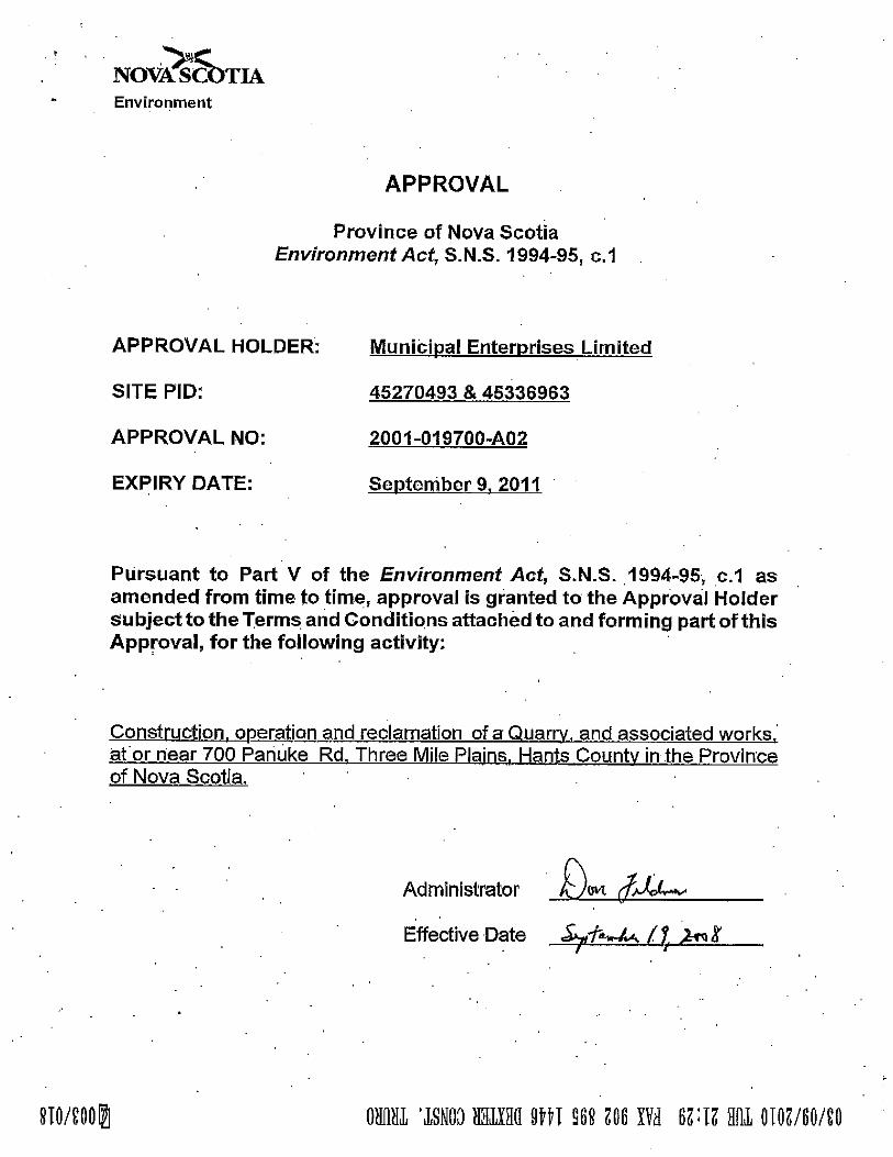


ENVIRONMENTAL ASSESSMENT Appendices
APPENDIX B Hants County Aggregate Quarry Extension Hydrology Study

Hants County Aggregate Quarry Hydrology Study
Municipal Enterprises Ltd. P.O. Box 48100 Bedford, NS B4A 3Z2
File: 121510261
March 2010
Stantec Consulting Ltd. 102 – 40 Highfield Park
Dartmouth NS B3A 0A3 Tel: (902) 468-7777
Fax: (902) 468-9009

Hants County Aggregate Quarry Hydrology Study
File: 121510261 i March 2010
Table of Contents
1.0 INTRODUCTION ............................................................................................................ 1.1 1.1 GENERAL ...................................................................................................................... 1.1 1.2 SITE DESCRIPTION AND BACKGROUND .................................................................. 1.1
2.0 METHODOLOGY ........................................................................................................... 2.1 2.1 MEAN ANNUAL SITE RUNOFF ESTIMATION ............................................................. 2.1 2.2 FLOW RETENTION AND SILTATION TREATMENT SIZING ....................................... 2.1 2.3 RESULTS ....................................................................................................................... 2.1
2.3.1 Mean Annual Site Runoff Estimation ................................................................... 2.1 2.3.2 Flow Retention and Siltation Treatment Sizing .................................................... 2.2 2.3.3 Effects on Downstream Flows and Water Quality ................................................ 2.5
3.0 CONCLUSIONS ............................................................................................................. 3.1
4.0 CLOSURE ...................................................................................................................... 4.1
5.0 REFERENCES ............................................................................................................... 5.1
LIST OF TABLES Table 2.1 Pre and Post Development Site Runoff Volumes ................................................ 2.2 Table 2.2 Summary of Hydrologic Parameters used in HEC-HMS ...................................... 2.2 Table 2.3 Model Parameters used for the Calculation of Tc ................................................ 2.3 Table 2.4 Estimated Runoff Peak Flows and Volumes for Different Rainfall Events ........... 2.4
LIST OF FIGURES Figure 1.1 Project Location and Proposed Extension Area .................................................. 1.2 Figure 1.2 Hydrologic Features ............................................................................................. 1.4 Figure 2.1 Flow Hydrograph for the 1:25 Year Rainfall Event for Full Quarry Extension ...... 2.3 Figure 2.2 Flow Hydrograph for the 1:100 Year Rainfall Event for Full Quarry Extension .... 2.4 Figure 2.3 Excess Flow Rate from the 1:100 Year Rainfall Event with Storage Attenuation 2.5

Hants County Aggregate Quarry Hydrology Study
File: 121510261 1.1 March 2010
1.0 Introduction
1.1 GENERAL
As part of the requirements of the Environmental Assessment Registration, a hydrology study was conducted for the area that covers the existing Hants County Quarry and the proposed quarry extension project. The main objectives of this assessment were to determine changes on the local hydrologic regime due to the proposed quarry extension, to identify adverse effects on downstream hydrologic elements, and to offer measures to mitigate these effects.
Objectives
The main objectives of this hydrologic assessment are:
• Estimate the total change in surface water runoff amounts for the pre and post-development conditions;
• Estimate the total capacity of the required flow retention/siltation facilities (i.e., retention pond) for the ultimate level of quarry extension; and
• Assess any potential impacts of the proposed quarry extension on downstream hydrologic elements with respect to water quantity and quality and provide recommendations to mitigate these potential impacts.
1.2 SITE DESCRIPTION AND BACKGROUND
The proposed quarry extension land (referred thereafter as the “site”) is located approximately 8 km south of the town of Windsor, in Hants County, Nova Scotia. The proposed extension is situated around the area of the existing Hants County Quarry which covers approximately 3.9 Ha. The property identification number (PID) is 45007176. The total area of the proposed extension is 13.9 Ha extending from NE to SW and parallel to the property boundaries.
The Site is irregular in shape with its longest dimension extending from NE to SW. As indicated previously, the existing quarry encompasses an area of 3.9 Ha and has been operating for the past 35 years. As the operation progresses, the organic layer at the site is removed and stockpiled for future reinstatement. The aggregates from the quarry are extracted by blasting, crushing and stockpiling of material on site (overburden and bedrock) and are primarily offered to the local construction market. It is expected that the operation of the proposed quarry extension will be the same as the existing quarry. The existing quarry boundary, the proposed extension area and other main features of the area are shown in Figure 1.1.

!!
!
!
!
!
!
!
!
!
!
!
!
!
!
!
!
!
!
!
!
"
"
""
"
"
"
"
"
"
""
"
"
To Th
re e M
ile P
lains
Fall B
rook
Panu
ke R
oad
Maple
Bro
ok
5.1 Ha
8.8 Ha
4 Ha
4 Ha
4.4 Ha1.6 Ha
95
9085
115
110
120
105
125
100
80
130135
75
140
70
145
150
155
160
165
170
65
175
180
60
185
55
190
195
50
200
120
155
130
70
120
140
155
160
145
130
150
125
11011
5
175
85
145
180
155
170
100
165
65
150
135
180
180
105
130
185
160
170
105
90
125 120
175
120
75
175
17585
130
95
135
125
95
105
100
125
140
165
135
170
105
125
80
135
140
140
165
125
100
70
80
135
160
120
160
175
84
81
144
117
111
92.8
69.177.1
65.5
76.4
100.7
124.1158.4
114.1
113.5
121.7
108.4
121.7121.7
Environmental Assessment of Hants County Aggregate Quarry Extension Project
PROJECT LOCATION AND PROPOSED EXTENSION AREA
PREPARED BY:
FIGURE NO.:
MUNICIPAL ENTERPRISES LIMITED
±
0 125 250
Meters
PROJECT NO: 1056220.
Figure 1.1DATE:
07/06/2010
G. MESHEAU
Legend800m Quarry Expansion BoundaryProposed Expansion AreaHants County Aggregate Quarry (Existing)Existing Panuke Quarry PropertyExisting Panuke QuarryFreshwater Wetlands (NSDNR)
" BuildingContour (5m)LocalSeasonal/UnpavedTrack/TrailDrivewayRailwayWatercourse (NSDTB)WaterbodyWetland (NSDTB)

Hants County Aggregate Quarry Hydrology Study Introduction
File: 121510261 1.3 March 2010
The existing topography for the entire site slopes to the north towards Maple Brook. Surface runoff is directed to one settling pond prior to been discharged to a naturally vegetated area where it is infiltrated. During a site visit conducted by Stantec representatives on October 7, 2009, the presence of a watercourse was confirmed within the property (Maple Brook). According to the available GIS mapping, Maple Brook is located approximately 30 m away from the edge of the proposed quarry extension boundary. At the time, the watercourse exhibited clear flowing water with no apparent barriers to fish passage outside the proposed project extension boundary. A desktop review of the available GIS mapping, specifically the watercourse layer indicated that Maple Brook is likely connected to tributaries that eventually discharge to the St. Croix River.
The site is intended to be developed over the next years until complete extension is achieved. It is our understanding that the site will be expanded gradually to the southwest until the entire proposed development boundary is reached.
Based on available stream and contour mapping (5 m resolution) the site is located within one sub-watershed that drains to the north, towards the St. Croix River. A series of small wetlands located within the site were also identified during the site visit. These along with other hydrologic features of the site are shown on Figure 1.2.

To Th
ree M
ile P
lains
Maple
Bro
ok
Panu
ke R
oad
Fall B
rook
Maple Brook
Wetland 2(0.16 ha)
Wetland 1(0.11 ha)
Environmental Assessment of Hants County Aggregate Quarry Extension Project
HYDROLOGICAL FEATURES
PREPARED BY:
FIGURE NO.:
MUNICIPAL ENTERPRISES LIMITED
±
0 125 250
Meters
PROJECT NO: 1056220.
Figure 1.2DATE:
25/06/2010
G. MESHEAU
Legend800m Quarry Expansion BoundaryProposed Quarry ExpansionHants County Aggregate Quarry (Existing)Previously Cleared Quarry LandsMEL PropertiesExisting Panuke Quarry PropertyApproved Expansion Area
#* Drilled Potable Supply Well" Building
LocalSeasonal/UnpavedTrack/TrailDrivewayRailwayContour (5m)Wetland Edge / Stream(From Client Drawing)Watercourse (NSDTB)WaterbodyWetlandFreshwater Wetlands (NSDNR)Stantec Field Delineated WetlandDesignated Water Supply AreasNatural Watershed MunicipalSurface Water Supply
Hants County Aggregate Quarry Hydrology Study
File: 121510261 2.1 March 2010
2.0 METHODOLOGY
2.1 MEAN ANNUAL SITE RUNOFF ESTIMATION
The mean annual site runoff for the entire proposed extension was calculated by comparing the mean annual water balance of both the existing and the proposed conditions. The entire development condition assumes that all the vegetative cover and topsoil layer will be removed from the site which will cause an increase in site runoff due to a decrease in evapotranspiration and infiltration amounts.
2.2 FLOW RETENTION AND SILTATION TREATMENT SIZING
The discharge capacity and dimensions of the required flow retention and siltation treatment structures for the total proposed extension were calculated with the hydrologic model HEC-HMS version 3.3. HEC-HMS was developed by the U.S. Army Corp of Engineers and is widely accepted as a tool to conduct hydrologic modeling by engineers and scientists around the world.
The parameters required for calculations were obtained from different sources. Annual precipitation data was obtained from climate normals from Station 8206415 (Windsor Martock) operated by Environment Canada. Station 8206415 is located approximately 5.5 km to the west of the site. The surface slope, area and other physical parameters were approximated using GIS tools and available mapping. The concentration time was estimated with the Upland Method included in the National Engineering Handbook, Section 4, Natural Resources Conservation Service (NRCS, formerly the USDA Soil Conservation Service).
The required volume capacity for the flow retention and siltation structures was estimated based on a 6 hour duration rainfall with an associated Annual Exceedance Probability (AEP) of 0.04, which is a rainfall event with an associated return period of 25 years. The maximum discharge capacities for the hydraulic discharge structures were based on the 6 hour 0.01 AEP storm (1:100 year return period rainfall event). Rainfall Intensity-Duration-Frequency (IDF) curves were obtained from Station 8202800 (Kentville), operated by Environment Canada. Station 8202800 is the nearest station with available data and is located approximately 35 km to the northwest of the site.
2.3 RESULTS
2.3.1 Mean Annual Site Runoff Estimation
Based on climate normals (1971-2000) from station 8206415 (Windsor Martock), the average total annual precipitation at the site is in the order of 1308.2 mm.
Total annual evapotranspiration in the area has been estimated using the Thornthwaite Equation and average monthly temperature data from Station 8206415. Based on the

Hants County Aggregate Quarry Hydrology Study METHODOLOGY
File: 121510261 2.2 March 2010
Thornthwaite Equation, the estimated local annual evapotranspiration is in the order of 626 mm, or 48% of the average annual precipitation. Infiltration is assumed to be in the order of 15% of the average annual precipitation based on the hydrologic soil group, vegetation cover and average surface topography at the site combined with previous experience with similar sites in Nova Scotia (David MacFarlane, personal communication, June 22nd 2009). The annual infiltration is therefore in the order of 196.2 mm.
The remaining 37% of the average annual precipitation can contribute to surface runoff to the site which corresponds to 484 mm per year. It has been estimated that surface runoff from the site will increase by approximately 20% as a result of the quarry extension; this takes into account an equivalent decrease in evapotranspiration and infiltration.
Although it is difficult to accurately determine the effects of climate change within the next century, there is a general agreement that the magnitude of precipitation events will likely increase. Since the site will be developed over a long period of time (in the order of 50 years) it is advisable to account for climate change effects, and therefore an extra 10% increase in mean annual precipitation was assumed (Jacques Whitford 2008). Therefore, the annual effective precipitation at the site is assumed to be 638.8 mm.
The existing and post-development surface runoff volumes were estimated by multiplying the estimated annual precipitation by its corresponding catchment area. The results are presented on Table 2.1.
Table 2.1 Pre and Post Development Site Runoff Volumes
Scenario Area (Ha) Effective annual Precipitation (mm)
Runoff Volume (m3)
Mean annual
Flow (L/s) Existing condition 3.9 484.0 18,876.0 0.59
Proposed Extension 13.9 638.8 88,793.2 2.81
Therefore, the expected increase in the average annual site runoff due to the proposed quarry extension is in the order of 69,917.2 m3 or a 370% increase from the existing condition.
2.3.2 Flow Retention and Siltation Treatment Sizing
A summary of the hydrologic model parameters is provided on Table 2.2. These were used as the main input in the hydrologic model HEC-HMS.
Table 2.2 Summary of Hydrologic Parameters used in HEC-HMS Parameter Quarry Extension Phase
Initial and Constant Loss Method Initial Loss: 2.5 mm
Constant Rate: 7.6 mm/hr Imperviousness: 60%
Clark Unit Hydrograph Routing Method Concentration Time (Tc): 1.2 hr

Hants County Aggregate Quarry Hydrology Study METHODOLOGY
File: 121510261 2.3 March 2010
Table 2.2 Summary of Hydrologic Parameters used in HEC-HMS Parameter Quarry Extension Phase
Included Storms 6 hour 1:25 year return period 6 hour 1:100 year return period
Subcatchment Area 0.139 km2 Baseflow Not considered
Attenuation effects due to channel storage Not considered
Modeling interval 5 min
The parameters used in the hydrologic model to calculate the concentration time for the proposed quarry extension are included on Table 2.3.
Table 2.3 Model Parameters used for the Calculation of Tc
Scenario Area (Ha) Flow Path Length (m) Slope (m/m) Concentration Time (min)
Quarry Extension 13.9 600 0.002 72
For all calculations it was assumed that all surface runoff originating from the upstream regions of the catchment area located off-site are diverted around the proposed quarry extension, and therefore no off-site catchment area is contributing to on-site surface runoff. Flow hydrographs developed for the 6 hour 1:25 and 1:100 year storms are shown in Figures 2.1 and 2.2, below.
Figure 2.1 Flow Hydrograph for the 1:25 Year Rainfall Event for Full Quarry Extension

Hants County Aggregate Quarry Hydrology Study METHODOLOGY
File: 121510261 2.4 March 2010
Figure 2.2 Flow Hydrograph for the 1:100 Year Rainfall Event for Full Quarry Extension
Based on model estimations for the 6 hour 1:25 year and 1:100 year rainfall events, the expected runoff peak flows and volumes as a result of the ultimate level of proposed quarry extension are shown in Table 2.4.
Table 2.4 Estimated Runoff Peak Flows and Volumes for Different Rainfall Events Extension stage Return Period Peak Flow (m3/s) Volume (m3)
Full quarry extension (proposed)
1:25 0.78 7,790 1:100 0.98 9,850
It is recommended to size the flow retention structures to retain the volume from the 1:25 year rainfall event. Therefore, the total volume of retention storage for the site for the ultimate level of quarry extension should be in the order of 7,790 m3. This volume is only expected after the site has been developed fully, therefore it is feasible to maintain a smaller storage pond capacity which will require to be expanded with the quarry operation.
Based on the simulations completed for the 1:100 year 6 hour duration rainfall event, the peak flow is estimated to be in the order of 0.98 m3/s. The construction of stormwater retention structures will have an attenuation effect on the peak flow from the 1:100 year rainfall event, therefore, since the storage pond should be able to store the 1:25 year storm the discharge structure at the exit of the retention ponds should be designed to accommodate as a minimum the excess discharge between the 1:25 and the 1:100 year rainfall events.

Hants County Aggregate Quarry Hydrology Study METHODOLOGY
File: 121510261 2.5 March 2010
Therefore, the difference in flow hydrographs between the 1:25 and 1:100 year rainfall events are shown on Figure 2.3. Based on Figure 2.3, the weir structure should be sized as a minimum to convey 0.20 m3/s.
Drawdown of water levels from the 1:25 year rainfall event detention storage level to the permanent pool retention level should be estimated based on the detention time that will improve water quality. A recommended drawdown period of 24 hours is expected to decrease suspended sediment concentrations by as much as 80%. Based on the low flow threshold of 24 hour discharge for runoff events equal or smaller than the 1:25 year rainfall event, the mean discharge capacity should be 0.09 m3/s. As a result, an appropriately designed weir is recommended as the most suitable discharge structure which is expected to control peak discharge volumes reducing the threat of downstream erosion and extending the discharge time to downstream hydrologic features.
Figure 2.3 Excess Flow Rate from the 1:100 Year Rainfall Event with Storage Attenuation
2.3.3 Effects on Downstream Flows and Water Quality
The full quarry development is anticipated to increase the total mean annual runoff at the site by 69,917.2 m3 from the existing condition. As mentioned previously, there are a number of identified wetlands on the site that are not indicated on provincial mapping, it is assumed that the full development of the site as a quarry operation will result in partial and/or total removal of the field identified wetlands from the site. Although it has not been quantified, the elimination of

Hants County Aggregate Quarry Hydrology Study METHODOLOGY
File: 121510261 2.6 March 2010
these wetlands may also increase peak flows by reducing storage capacity. However, this effect is considered negligible when compared to other factors that influence flow routing and peak flow generation.
It is important to mention that control measurements must be implemented to minimize the impact on any streams and wetlands located downstream of the site. All surface water runoff that is being discharge to downstream receptors must meet all applicable guidelines for the protection of aquatic life and the aquatic environment.
The Nova Scotia Department of Environment Pit & Quarry Guidelines (revised on May, 1999) establishes that the maximum suspended solids concentration in any effluent leaving the site cannot exceed 50 mg/L. In addition, the maximum arithmetic monthly average suspended solids concentration cannot exceed 25 mg/L.
It is anticipated that the largest potential for water quality impacts due to the quarry extension and operation would be erosion and an associated increased in sediment loads. There are certain measures that can be adopted to reduce these impacts, including check dams along collection ditches and the placement of free draining cover materials over disturbed areas. The proper design of the retention ponds should include the capacity to remove sediment as needed to maintain the required volume and extend the life of the structures, or the addition of extra volume to accommodate sediment loads. Even with this measure, maintenance would likely be required from time to time to empty the retention ponds.
Surface runoff from the site should not be sent to downstream receptors before being routed in the retention ponds and the surface water runoff should comply with existing guidelines indicated previously to protect the aquatic environment. The streams are not likely to experience major changes in the flow regime as there are upstream areas of the subwatershed that can contribute to flow. However, a monitoring program for water quality and/or quantity may be warranted if major modifications to the aquatic regime are observed and corrective measures may be necessary to ensure that a good aquatic environment is maintained near the site.

Hants County Aggregate Quarry Hydrology Study
File: 121510261 3.1 March 2010
3.0 CONCLUSIONS
The following conclusions are offered based on the hydrologic assessment for the proposed Hants Quarry extension project.
The existing annual site runoff volume for the site is estimated to be in the order of 18,876 m3. The expected total increase in the mean annual runoff for the site resulting from the proposed extension is in the order of 88,973.2 m3 or a 370% increase from the existing condition.
The flow retention structures for the proposed quarry extension should be able to accommodate a volume of 7,790 m3 during the 6 hour 1:25 year storm as the largest event. The dimensions of the proposed retention pond(s) will depend on site characteristics, as an example, a retention pond able to accommodate 7,790 m3 can have approximate dimensions of 45 m x 45 m x 4 m.
The outlet structures for the retention pond should be able to accommodate a discharge of 0.20 m3/s, which corresponds to the difference in peak flows between the 1:25 year and the 1:100 year rainfall events.
Based on a recommended retention time of 24 hours for any precipitation event equal or smaller than the 1:25 year rainfall event, the discharge structure should be designed to conform to a mean discharge capacity of 90 L/s. This will facilitate the recommended 24 hour drawdown period. The maximum discharge capacity should be maintained as indicated previously.
Flow retention structures should be placed immediately downstream of the quarry facilities to capture all surface runoff before it is conveyed towards hydrologic features downstream of the site. This will also help to attenuate peak flows, reduce the slope of the recession limb and to some extent maintain pre-development conditions.
Drainage features should be constructed with appropriate erosion and sediment control measures to direct and convey site surface runoff to their corresponding flow retention and sediment control structures.
The surface water runoff from the site should comply with the applicable guidelines for the protection of the aquatic environment.

Hants County Aggregate Quarry Hydrology Study
File: 121510261 4.1 March 2010
4.0 CLOSURE
This report has been prepared on behalf of and for the exclusive use of Municipal Enterprises Limited. This report represents the conditions of the property at the time of the assessment. The conclusions presented in this report represent the best judgment of the assessor based on current environmental standards. Stantec Consulting Ltd. attests that to the best of our knowledge the information presented in this report is accurate.

Hants County Aggregate Quarry Hydrology Study
5.0 REFERENCES
Canadian Climate Normals or Averages 1971-2000. Environment Canada. Data accessed online at http://www.climate.weatheroffice.ec.gc.ca/climate_normals/index_e.html
National Engineering Handbook, Part 630, Chapter 4. Natural Resources Conservation Service. Washington, USA, 1993.
Environmental Assessment Registration, Panuke Quarry Extension Project. Jacques Whitford, Dartmouth, Nova Scotia, 2008.
Nova Scotia Department of the Environment, Guide to Preparing an EA Registration Document for Pit and Quarry Developments in Nova Scotia. September, 2008.
Nova Scotia Department of the Environment Pit & Quarry Guidelines. May 1999.

ENVIRONMENTAL ASSESSMENT Appendices
APPENDIX C Project Information Bulletin and Letters

Hants County Aggregates February 2010 Project Information Sheet
Municipal Enterprises Limited Hants County Aggregates Project
Project Information Sheet
Project Overview Municipal Enterprises Limited is proposing to combine the operations of the Hants County Aggregates Quarry in Panuke, Hants County, Nova Scotia, with the existing Panuke Quarry (refer to Figure 1). The current operation at Hants County Aggregates is approximately 4 hectares in area. The proposed extension of the existing Hants County Aggregates Quarry will incorporate land north, south and southwest of the existing quarry to increase the total size of the operation to approximately 13.9 hectares. Blasting, crushing and stockpiling of aggregate currently takes place at the Hants County Aggregate site and this is not expected to change. The quarried material at this site is primarily used for Nova Scotia Transportation and Infrastructure Renewal (NSTIR) projects, but after amalgamation with Panuke Quarry the intent is that the Hants County Aggregates site will be used for both NSTIR contracts and general contracts. The existing Panuke quarry is approximately 4 hectares in area and has an approval extension area of 6 ha. It is primarily used as a source of aggregate in the making of asphalt. The proposed activities will take place over a period of time until the material is exhausted. Based on current estimates there are over 1 million tonnes of rock reserves on both properties. Proposed project activities will be consistent with current quarry operations. Aggregate production includes drilling and blasting, which is conducted by a licensed blasting contractor. Blasting takes place approximately one to three times per year. After blasting, portable crushing equipment is brought to the site to process the blasted rock. Various products (i.e., various aggregate sizes) are stockpiled at the quarry site until they are transported to local markets via tandem trucks or tractor trailer trucks via the existing truck route. The estimated truck traffic will be consistent with current truck volume at the existing quarry. The anticipated average production rate is approximately 60,000 to 100,000 tonnes per year; with the possibility of a higher production rate for limited periods of time should a significant contract be awarded. Weather permitting, the quarry will be open nine months of the year, however the portable crushing equipment is only on site two to three times a year for duration of ten days to two week. This proposed schedule is consistent with the current operating schedule. Environmental Assessment Process Municipal Enterprises Limited is required to register this project as a Class I Undertaking pursuant to the Nova Scotia Environment Act and Environmental Assessment Regulations. The environmental assessment registration is currently being prepared by environmental consultants Stantec Consulting Ltd., on behalf of Municipal Enterprises Limited, to fulfill these regulatory
requirements. Other relevant provincial regulations include the Activities Designation Regulations, which require an Industrial Approval from Nova Scotia Environment for the quarry operation, and the General Blasting Regulations made pursuant to the Nova Scotia Occupational Health and Safety Act (1996). Provincial guidelines to be adhered to include the Nova Scotia Pit and Quarry Guidelines (NSE 1999). The environmental assessment registration will evaluate potential environmental effects of the project and identify appropriate mitigation and monitoring to minimize these effects. The environmental assessment registration document will be available for public review and comment once it is filed with NSE. Environmental Document Components The environmental registration document focuses on those aspects of the environment that are considered to be of most concern. Components to be evaluated include: • Rare and sensitive flora; • Wildlife; • Surface water resources • Groundwater resources; • Wetlands; • Archaeological and heritage resources; • Atmospheric environment (includes dust and noise);
and • Socio-economic environment. Potential effects of quarry activities on these components will be addressed in the registration document. To date, no sensitive features have been identified onsite; however, field investigations are ongoing. Assuming the implementation of standard mitigative measures and government guidelines and approvals, no significant adverse environmental or socio-economic effects are considered likely. Contacts If you have any questions or concerns about this project please contact: Mr. Danny Clifton Municipal Enterprises Limited P.O. Box 48100 RPO Mill Cove, Bedford, NS B3A 3Z2 Tel: (902) 456-4582 / E-mail: [email protected] Gillian Asche, Project Scientist Stantec Consulting Ltd 3 Spectacle Lake Drive, Dartmouth, NS B3B 1W8 Tel: (902) 468-7777 E-mail: [email protected]

To Th
re e M
ile P
lains
Fall B
rook
Panu
ke R
oad
Maple
Bro
ok
5.1 Ha
8.8 Ha
4 Ha
4 Ha
4.4 Ha1.6 Ha
95
9085
115
110
120
105
125
100
80
130135
75
140
70
145
150
155
160
165
170
65
175
180
60
185
55
190
195
50
200
120
155
130
70
120
140
155
160
145
130
150
125
11011
5
175
85
145
180
155
170
100
165
65
150
135
180
180
105
130
185
160
170
105
90
125 120
175
120
75
175
17585
130
95
135
125
95
105
100
125
140
165
135
170
105
125
80
135
140
140
165
125
100
70
80
135
160
120
160
175
84
81
144
117
111
92.8
69.177.1
65.5
76.4
100.7
124.1158.4
114.1
113.5
121.7
108.4
121.7121.7
Environmental Assessment of Hants County Aggregate Extension Project
PROJECT LOCATION
PREPARED BY:
FIGURE NO.:
MUNICIPAL ENTERPRISES LIMITED
±
0 125 250
Meters
PROJECT NO: 1056220.
Figure 1DATE:
29/01/2010
G. MESHEAU
Legend800m Quarry Expansion BoundaryArea to be Added to EAHants County Aggregate Quarry (Existing)Stantec Field Delineated WetlandExisting Panuke Quarry PropertyExisting Panuke QuarryFreshwater Wetlands (NSDNR)
" BuildingContour (5m)LocalSeasonal/UnpavedTrack/TrailDrivewayRailwayWatercourse (NSDTB)WaterbodyWetland (NSDTB)

Stantec Consulting Ltd. 3 Spectacle Lake Drive Dartmouth NS B3B 1W8 Tel: (902) 468-7777 Fax: (902) 468-9009
February 11, 2010 File: 121510261
Native Council 324 Abenaki Road PO Box 1320 Truro, NS B2N 5N2
Attention: Mrs. Grace Conrad
Dear Mrs. Conrad:
Reference: Municipal Enterprises Limited Quarry Extension Project
This letter is to inform you of a proposed Project near the community of Panuke, Hants County, Nova Scotia.
The Project consists of combining two existing quarries along Panuke Road in Panuke, Hants County, NS. The developer, Municipal Enterprises Limited, is proposing to combine the Hants County Aggregates Quarry with the existing Panuke Quarry. Municipal Enterprises Limited is currently preparing the documentation required to register this Project under the Environmental Assessment Regulations pursuant to the Nova Scotia Environment Act.
Please find enclosed the Project Information Sheet and the corresponding Figure, which provide more details regarding the Project and the site location.
Please contact the undersigned or the contacts listed on the Project Information Sheet with any comments, concerns or questions you may have regarding the project.
Sincerely,
STANTEC CONSULTING LTD.
Robert Federico Senior Project Manager (902) 468-7777 [email protected]
Cc. Gillian Asche, SCL
Attachment

Stantec Consulting Ltd. 3 Spectacle Lake Drive Dartmouth NS B3B 1W8 Tel: (902) 468-7777 Fax: (902) 468-9009
February 11, 2010 File: 121510261
Mi’kmaq Rights Initiative Kwikmug Maw-Klusuag 851 Willow Street Truro, NS B2N 6N8
Attention: Ms. Janice Maloney
Dear Ms. Maloney:
Reference: Municipal Enterprises Limited Quarry Extension Project
This letter is to inform you of a proposed Project near the community of Panuke, Hants County, Nova Scotia.
The Project consists of combining two existing quarries along Panuke Road in Panuke, Hants County, NS. The developer, Municipal Enterprises Limited, is proposing to combine the Hants County Aggregates Quarry with the existing Panuke Quarry. Municipal Enterprises Limited is currently preparing the documentation required to register this Project under the Environmental Assessment Regulations pursuant to the Nova Scotia Environment Act.
Please find enclosed the Project Information Sheet and the corresponding Figure, which provide more details regarding the Project and the site location.
Please contact the undersigned or the contacts listed on the Project Information Sheet with any comments, concerns or questions you may have regarding the project.
Sincerely,
STANTEC CONSULTING LTD. Robert Federico Senior Project Manager (902) 468-7777 [email protected]
Cc. Gillian Asche, SCL
Attachment

Stantec Consulting Ltd. 3 Spectacle Lake Drive Dartmouth NS B3B 1W8 Tel: (902) 468-7777 Fax: (902) 468-9009
February 11, 2010 File: 121510261
Confederacy of Mainland Mi'kmaq 57 Martin Crescent P.O. Box 1590 Truro, NS, B2N 5V3
Attention: Mr. Donald M. Julien
Dear Mr. Julien:
Reference: Municipal Enterprises Limited Quarry Extension Project
This letter is to inform you of a proposed Project near the community of Panuke, Hants County, Nova Scotia.
The Project consists of combining two existing quarries along Panuke Road in Panuke, Hants County, NS. The developer, Municipal Enterprises Limited, is proposing to combine the Hants County Aggregates Quarry with the existing Panuke Quarry. Municipal Enterprises Limited is currently preparing the documentation required to register this Project under the Environmental Assessment Regulations pursuant to the Nova Scotia Environment Act.
Please find enclosed the Project Information Sheet and the corresponding Figure, which provide more details regarding the Project and the site location.
Please contact the undersigned or the contacts listed on the Project Information Sheet with any comments, concerns or questions you may have regarding the project.
Sincerely,
STANTEC CONSULTING LTD. Robert Federico Senior Project Manager (902) 468-7777 [email protected]
Cc. Gillian Asche, SCL
Attachment

Stantec Consulting Ltd. 3 Spectacle Lake Drive Dartmouth NS B3B 1W8 Tel: (902) 468-7777 Fax: (902) 468-9009
February 11, 2010 File: 121510261
Union of Nova Scotia Indians 47 Maillard Street Membertou, NS B1S 2P5
Attention: Mr. Joe B. Marshall
Dear Mr. Marshall:
Reference: Municipal Enterprises Limited Quarry Extension Project
This letter is to inform you of a proposed Project near the community of Panuke, Hants County, Nova Scotia.
The Project consists of combining two existing quarries along Panuke Road in Panuke, Hants County, NS. The developer, Municipal Enterprises Limited, is proposing to combine the Hants County Aggregates Quarry with the existing Panuke Quarry. Municipal Enterprises Limited is currently preparing the documentation required to register this Project under the Environmental Assessment Regulations pursuant to the Nova Scotia Environment Act.
Please find enclosed the Project Information Sheet and the corresponding Figure, which provide more details regarding the Project and the site location.
Please contact the undersigned or the contacts listed on the Project Information Sheet with any comments, concerns or questions you may have regarding the project.
Sincerely,
STANTEC CONSULTING LTD.
Robert Federico Senior Project Manager (902) 468-7777 [email protected]
Cc. Gillian Asche, SCL
Attachment

ENVIRONMENTAL ASSESSMENT Appendices
APPENDIX D Aquatic Photo Appendix

Photo 1: Downstream, cobble substrate section of Photo 2: Downstream, cobble-substrate section of
assessment area assessment area
Photo 3: Upstream section of assessment area, looking Photo 4: Upstream section of assessment area
upstream towards open wetland riparian zone looking downstream towards mixed forest
riparian zone
Photo 5: Furthest upstream section of assessment area ; Photo 6: Furthest upstream section of assessment
stream narrows considerably in wetland area; stream narrows considerably in
wetland.

ED ED
ED
@A@A
!.
!.
!.
To Th
ree M
ile P
lains
Maple
Bro
ok
Panu
ke R
oad
Fall B
rook
Maple Brook
Wetland 2(0.16 ha)
Wetland 1(0.11 ha)
Photos5 & 6
Photos3 & 4
Photos1 & 2
SW1SW2
MW2
MW3MW1
Environmental Assessment of Hants County Aggregate Quarry Extension Project
AQUATIC PHOTO LOCATIONS
PREPARED BY:
FIGURE NO.:
MUNICIPAL ENTERPRISES LIMITED
±
0 125 250
Meters
PROJECT NO: 1056220.
APPENDIX D
D
DATE:25/06/2010
G. MESHEAU
Legend!. Photo Locations
800m Quarry Expansion BoundaryQuarry Expansion AreaHants County Aggregate Quarry (Existing)Previously Cleared Quarry LandsMEL PropertiesExisting Panuke Quarry PropertyApproved Expansion Area
ED Monitor Well@A Surface Water Sample#* Drilled Potable Supply Well" Building
LocalSeasonal/UnpavedTrack/TrailDrivewayRailwayWetland Edge / Stream(From Client Drawing)Watercourse (NSDTB)WaterbodyWetlandFreshwater Wetlands (NSDNR)Stantec Field Delineated WetlandDesignated Water Supply AreasNatural Watershed MunicipalSurface Water Supply
mhenley
Rectangle

ENVIRONMENTAL ASSESSMENT Appendices
APPENDIX E Vascular Plants Potentially Present the Study Area

1
Table E-1 Rare and Sensitive Plants Identified During the Modelling Exercise as Being Potentially Present in the Study Area
Common Name
Scientific Name Preferred Habitat Season ACCDC
Rank NSDNR
Rank White Snakeroot
Ageratina altissima Woods, thickets. July to October. S1 May Be
At Risk
Triangle Grape-Fern
Botrychium lanceolatum Rich, wooded hillsides.
July and August. Can be identified until early October if sporophore is present.
S2S3 Sensitive
Least Grape-Fern
Botrychium simplex
Usually on lakeshores or the mossy edges of streams or waterfalls although it has been reported in a wide variety of habitats.
Late May and June S2S3 Sensitive
Large Toothwort
Cardamine maxima
Rich most often calcareous moist rocky slopes and deciduous woods.
May but identifiable at least into June and July.
S1 May Be At Risk
Small-Flower Bitter-Cress
Cardamine parviflora
Dry woods, shaded or exposed ledges, and in sandy soils.
April to August S2 Sensitive
Chestnut-Colored Sedge Carex castanea
Swamps and wet meadows, cliff crevices and ledges.
Not given for NS, Summer. Seeds (perigynia ) required for identification.
S2 May Be At Risk
Bristly Sedge Carex comosa Swamps and shallow water. June to August S2 Sensitive
Cloud Sedge Carex haydenii Swamps. July to September S1 May Be At Risk
A Sedge Carex houghtoniana
Sandy soils and roadside banks.
Seeds (perigynia) required for identification. Can be identified from May through September.
S2? Sensitive
Porcupine Sedge Carex hystericina Swamps, swales, and
along brooks. June to October S2 May Be At Risk
Woolly Sedge Carex pellita Swamps and bogs, often in wooded areas. May to July S1 May Be
At Risk Plantain-Leaved Sedge
Carex plantaginea Dry, hardwood hillsides. April to June S1 May Be
At Risk
Swan Sedge Carex swanii Boggy pastures, dry peaty barrens, forests, clearings, and the edges of woods.
Early summer S2S3 Sensitive
Slender Sedge Carex tenera Meadows, woodlands, and moist, dry openings. Late May to August S1S2 Sensitive
Blue Cohosh Caulophyllum thalictroides
Deciduous and intervale forest.
April to early June, can be identified when not in flower.
S2 May Be At Risk
Purple Clematis Clematis occidentalis
Rocky, often calcareous slopes, and open woodlands.
May to June S1 May Be At Risk

2
Table E-1 Rare and Sensitive Plants Identified During the Modelling Exercise as Being Potentially Present in the Study Area
Common Name
Scientific Name Preferred Habitat Season ACCDC
Rank NSDNR
Rank
Hemlock Parsley
Conioselinum chinense
Swamps, mossy coniferous woods or swales, and seepy slopes near the coast.
August to October S2 Sensitive
Squaw-Root Conopholis americana
Associated with oaks and other deciduous trees. April to July S1S2 May Be
At Risk
Showy Tick-Trefoil
Desmodium canadense
Open woods, thickets and river banks.
Late July to early September, can be identified when not in flower.
S1 May Be At Risk
Large Tick-Trefoil
Desmodium glutinosum
Rich deciduous woods or intervales June and July S1 May Be
At Risk
Eastern Leatherwood Dirca palustris Rich deciduous or mixed
woods.
On or about May 20, appearing before the leaves.
S1 May Be At Risk
Ovate Spikerush Eleocharis ovata Muddy shores and
ditches. Flowers/Fruit May to October S2? Sensitive
Joe-Pye Thoroughwort
Eupatorium dubium
Rocky shores, swamps and damp thickets.
August and September, can be identified when not in flower.
S2 May Be At Risk
Nodding Fescue
Festuca subverticillata
Rich deciduous forested slopes and alluvial woods.
June and July (early) S1 May Be
At Risk
False Mermaid-Weed
Floerkea proserpinacoides
Deciduous ravine slopes, river margins, and intervale forests.
Late May to late June. Can be identified when not in flower.
S2 Sensitive
Black Ash Fraxinus nigra Low ground, damp woods and swamps.
May and June. Can be identified without flowers.
S2S3 Sensitive
Green Ash Fraxinus pennsylvanica
Near lakes or ponds, or in other low-lying areas. May S1 May Be
At Risk
Northern Bedstraw Galium boreale
The edges of woods and in grassy places, such as pastures.
June to August S2 May Be At Risk
Downy Rattlesnake-Plantain
Goodyera pubescens
Woodland and thickets. Usually found in dry or moist coniferous or mixed woods, often in a sandy substrate with oak or white pine.
July and August S2 May Be At Risk
Dwarf Rattlesnake-Plantain
Goodyera repens Under conifers, growing with very few other plants. July and August S3 Sensitive
Clammy Hedge-Hyssop Gratiola neglecta Usually in wet or muddy
places. May to October (fruit in August) S1S2 Sensitive
Round-Lobe Hepatica Hepatica nobilis Dry, usually mixed
deciduous forest. Early May S1 May Be At Risk
Golden-Heather Hudsonia ericoides
Dry, rocky, and sandy barrens. Recently disturbed areas or on open sandy soils.
Late May to early July S2 Sensitive
Larger Canadian St. John's Wort
Hypericum majus Wet or dry open soil. July to September S1 May Be At Risk

3
Table E-1 Rare and Sensitive Plants Identified During the Modelling Exercise as Being Potentially Present in the Study Area
Common Name
Scientific Name Preferred Habitat Season ACCDC
Rank NSDNR
Rank Dudley's Rush Juncus dudleyi Damp soil and open
places. Summer S2? Sensitive
Blunt-Fruited Sweet-Cicely
Osmorhiza depauperata
Moist woods and clearings. Late June and July S1 May Be
At Risk Slender Mountain-Ricegrass
Piptatherum pungens
Dry woods and clearings in sandy soils. May and June S2 Sensitive
Southern Rein-Orchid Platanthera flava
Sand or gravelly beaches, wet peat, and lake or river margins. Bogs, swamps, and meadows.
May to August S2 Sensitive
Large Round-Leaved Orchid
Platanthera macrophylla
Rich old deciduous or mixed woods. August S2 Sensitive
Field Milkwort Polygala sanguinea
Poor or acidic fields, damp slopes, and open woods or bush.
Late June to October S2S3 Sensitive
Cursed Crowfoot
Ranunculus sceleratus
Marshes, ditches, swampy meadows. S1S2 May Be
At Risk
Cut-Leaved Coneflower
Rudbeckia laciniata
Swales, the edges of swamps, or in gullies - in small colonies.
August, can be identified when not in flower.
S2 Sensitive
Willow Dock Rumex salicifolius
Rich alluvial thickets and swamps.
Likely mid July to October but this annual is detectable with or without flowers.
S2 Sensitive
Black Snake-Root Sanicula odorata Rich, alluvial woods and
along intervales. July to August S1 May Be At Risk
Hairy Goldenrod Solidago hispida Woods and forest edges. Summer and fall S1? May Be
At Risk
Case's Ladies'-Tresses Spiranthes casei
Acid, sandy soils, roadsides and open barrens.
September S2 Sensitive
Lindley's Aster Symphyotrichum ciliolatum
Open fields, lawns and the edges of woods.
August and September S2S3 Sensitive
Northern White Cedar
Thuja occidentalis
Lakesides and swamps or old pastures.
Can be identified throughout the year.
S1S2 At Risk
Heart-Leaved Foam-Flower Tiarella cordifolia Rich deciduous and mixed
woods.
Flowers mid -May to mid-June. Identifiable year round.
S2 Sensitive
Northern Bog Violet
Viola nephrophylla
Cool mossy bogs, the borders of streams, and damp woods.
May to July S2 Sensitive

ENVIRONMENTAL ASSESSMENT Appendices
APPENDIX F Vascular Plants Recorded in the Study Area

1
Table F-1 Population Status of Vascular Plants Recorded in Study Area
Common Name Scientific Name ACCDC Rank
NSDNR Rank Wetland 1 Wetland 2
Balsam Fir Abies balsamea S5 Secure Present Present Striped Maple Acer pensylvanicum S5 Secure Present Red Maple Acer rubrum S5 Secure Present Sugar Maple Acer saccharum S5 Secure Present Mountain Maple Acer spicatum S5 Secure Present Common Yarrow Achillea millefolium S5 Secure White Baneberry Actaea pachypoda S4 Secure Colonial Bentgrass Agrostis capillaris SNA Exotic Perennial Bentgrass Agrostis perennans S4S5 Secure Present Present Rough Bentgrass Agrostis scabra S5 Secure Present Speckled Alder Alnus incana S5 Secure Pearly Everlasting Anaphalis margaritacea S5 Secure Sweet Vernal Grass Anthoxanthum odoratum SNA Exotic Bristly Sarsaparilla Aralia hispida S5 Secure Wild Sarsaparilla Aralia nudicaulis S5 Secure Present Lady-Fern Athyrium filix-femina S5 Secure Present Yellow Birch Betula alleghaniensis S5 Secure Present Paper Birch Betula papyrifera S5 Secure
Heart-Leaved Paper Birch Betula papyrifera var. cordifolia S5 Secure
Heart-Leaved Paper Birch Betula papyrifera var. papyrifera S5 Secure Present
Gray Birch Betula populifolia S5 Secure Present Devil's Beggar-Ticks Bidens frondosa S5 Secure
Bearded Short-Husk Brachyelytrum septentrionale S5 Secure
Blue-Joint Reedgrass Calamagrostis canadensis S5 Secure Present Present
Black Sedge Carex arctata S5 Secure Present Brownish Sedge Carex brunnescens S5 Secure Present Present Hoary Sedge Carex canescens S5 Secure Present Fibrous-Root Sedge Carex communis S5 Secure Fringed Sedge Carex crinita S5 Secure Present White-Edge Sedge Carex debilis S5 Secure Present Softleaf Sedge Carex disperma S5 Secure Present Little Prickly Sedge Carex echinata S5 Secure Long Sedge Carex folliculata S5 Secure Present A Sedge Carex gynandra S5 Secure Bladder Sedge Carex intumescens S5 Secure Present Present Bristly-Stalk Sedge Carex leptalea S5 Secure Finely-Nerved Sedge Carex leptonervia S5 Secure Shallow Sedge Carex lurida S5 Secure Present Black Sedge Carex nigra S5 Secure Present New England Sedge Carex novae-angliae S5 Secure Pale Sedge Carex pallescens S5 Secure

2
Table F-1 Population Status of Vascular Plants Recorded in Study Area
Common Name Scientific Name ACCDC Rank
NSDNR Rank Wetland 1 Wetland 2
Necklace Sedge Carex projecta S5 Secure Present Pointed Broom Sedge Carex scoparia S5 Secure Present Stalk-Grain Sedge Carex stipata S5 Secure Present Fireweed Chamerion angustifolium S5 Secure Virginia Virgin-Bower Clematis virginiana S5 Secure Clinton Lily Clintonia borealis S5 Secure Present Present Goldthread Coptis trifolia S5 Secure Present Present Dwarf Dogwood Cornus canadensis S5 Secure Present Present Beaked Hazelnut Corylus cornuta S5 Secure Present Present Pink Lady's-Slipper Cypripedium acaule S5 Secure Present Poverty Oat-Grass Danthonia spicata S5 Secure Wild Carrot Daucus carota SNA Exotic
Eastern Hay-Scented Fern Dennstaedtia punctilobula S5 Secure Present Present
Panic Grass Dichanthelium acuminatum S5 Secure
Northern Witchgrass Dichanthelium boreale S5 Secure
Starved Witchgrass Dichanthelium depauperatum S4S5 Secure
Northern Bush-Honeysuckle Diervilla lonicera S5 Secure
Parasol White-Top Doellingeria umbellata S5 Secure Present Present Mountain Wood-Fern Dryopteris campyloptera S5 Secure Spinulose Shield Fern Dryopteris carthusiana S5 Secure Present Crested Shield-Fern Dryopteris cristata S5 Secure Present Evergreen Woodfern Dryopteris intermedia S5 Secure Present Present Marginal Wood-Fern Dryopteris marginalis S5 Secure
a Hybrid Wood-fern Dryopteris x boottii SNA Not Assessed Present
Wild Mock-Cucumber Echinocystis lobata SNA Exotic Least Spike-Rush Eleocharis acicularis S5 Secure Slender Spike-Rush Eleocharis tenuis S5 Secure Trailing Arbutus Epigaea repens S5 Secure Hairy Willow-Herb Epilobium ciliatum S5 Secure Linear-Leaved Willow-Herb Epilobium leptophyllum S5 Secure Present Fireweed Erechtites hieraciifolia S5 Secure Present Large-Leaf Wood-Aster Eurybia macrophylla S5 Secure Rough-Leaved Aster Eurybia radula S5 Secure Present Flat-Top Fragrant-Golden-Rod Euthamia graminifolia S5 Secure Present
American Beech Fagus grandifolia S5 Secure Hair Fescue Festuca filiformis SNA Exotic Red Fescue Festuca rubra S5 Secure Virginia Strawberry Fragaria virginiana S5 Secure Present White Ash Fraxinus americana S5 Secure Present Present Brittle-Stem Hempnettle Galeopsis tetrahit SNA Exotic

3
Table F-1 Population Status of Vascular Plants Recorded in Study Area
Common Name Scientific Name ACCDC Rank
NSDNR Rank Wetland 1 Wetland 2
Sweet-Scent Bedstraw Galium triflorum S5 Secure Creeping Snowberry Gaultheria hispidula S5 Secure Teaberry Gaultheria procumbens S5 Secure Canada Manna-Grass Glyceria canadensis S5 Secure Present Fowl Manna-Grass Glyceria striata S5 Secure Present Checkered Rattlesnake-Plantain Goodyera tesselata S4 Secure
Northern Oak Fern Gymnocarpium dryopteris S5 Secure
American Witch-Hazel Hamamelis virginiana S5 Secure Present American Water-Pennywort Hydrocotyle americana S5 Secure Canadian St. John's-Wort Hypericum canadense S5 Secure Black Holly Ilex verticillata S5 Secure Present Present Narrow-Panicled Rush Juncus brevicaudatus S5 Secure Soft Rush Juncus effusus S5 Secure Present Slender Rush Juncus tenuis S5 Secure Present Sheep-Laurel Kalmia angustifolia S5 Secure Present Present Twinflower Linnaea borealis S5 Secure Indian-Tobacco Lobelia inflata S5 Secure Perennial Ryegrass Lolium perenne SNA Exotic American Fly-Honeysuckle Lonicera canadensis S5 Secure Present Birds-Foot Trefoil Lotus corniculatus SNA Exotic Hairy Woodrush Luzula acuminata S5 Secure Common Woodrush Luzula multiflora S5 Secure Stiff Clubmoss Lycopodium annotinum S5 Secure Running Pine Lycopodium clavatum S5 Secure
Treelike Clubmoss Lycopodium dendroideum S5 Secure
Hickey's Clubmoss Lycopodium hickeyi S4? Secure Tree Clubmoss Lycopodium obscurum S4S5 Secure American Bugleweed Lycopus americanus S5 Secure Northern Bugleweed Lycopus uniflorus S5 Secure Present Swamp Loosestrife Lysimachia terrestris S5 Secure
Wild Lily-of-The-Valley Maianthemum canadense S5 Secure Present Present
Solomon's-Plume Maianthemum racemosum S4S5 Secure Present
Green Adder's-Mouth Malaxis unifolia S4S5 Secure Indian Cucumber-Root Medeola virginiana S5 Secure American Cow-Wheat Melampyrum lineare S5 Secure Partridge-Berry Mitchella repens S5 Secure Naked Bishop's-Cap Mitella nuda S5 Secure Present Indian-Pipe Monotropa uniflora S5 Secure Whorled Aster Oclemena acuminata S5 Secure Present Present Sensitive Fern Onoclea sensibilis S5 Secure Present One-Side Wintergreen Orthilia secunda S5 Secure

4
Table F-1 Population Status of Vascular Plants Recorded in Study Area
Common Name Scientific Name ACCDC Rank
NSDNR Rank Wetland 1 Wetland 2
Cinnamon Fern Osmunda cinnamomea S5 Secure Present Present Interrupted Fern Osmunda claytoniana S5 Secure Present Royal Fern Osmunda regalis S5 Secure Old Witch Panic-Grass Panicum capillare SNA Exotic Northern Beech Fern Phegopteris connectilis S5 Secure Present Meadow Timothy Phleum pratense SNA Exotic White Spruce Picea glauca S5 Secure Red Spruce Picea rubens S5 Secure Eastern White Pine Pinus strobus S5 Secure Nipple-Seed Plantain Plantago major SNA Exotic Small Green Woodland Orchid Platanthera clavellata S5 Secure Present
Hooker Orchis Platanthera hookeri S3 Secure Large Roundleaf Orchid Platanthera orbiculata S3 Secure Grove Meadow Grass Poa alsodes S4 Secure Downy Solomon's-Seal Polygonatum pubescens S4S5 Secure Present Fringed Black Bindweed Polygonum cilinode S5 Secure Arrow-Leaved Tearthumb Polygonum sagittatum S5 Secure Rock Polypody Polypodium virginianum S5 Secure
Christmas Fern Polystichum acrostichoides S5 Secure Present
Large-Tooth Aspen Populus grandidentata S5 Secure Quaking Aspen Populus tremuloides S5 Secure Present Present Old-Field Cinquefoil Potentilla simplex S5 Secure Tall Rattlesnake-root Prenanthes altissima S5 Secure Present Three-Leaved Rattlesnake-root Prenanthes trifoliolata S5 Secure Present Present
Self-Heal Prunella vulgaris S5 Secure Fire Cherry Prunus pensylvanica S5 Secure Present Choke Cherry Prunus virginiana S5 Secure Bracken Fern Pteridium aquilinum S5 Secure Present Present Shinleaf Pyrola elliptica S5 Secure Northern Red Oak Quercus rubra S5 Secure
Rhodora Rhododendron canadense S5 Secure
Rambler Rose Rosa multiflora SNA Exotic Allegheny Blackberry Rubus allegheniensis S5 Secure Present Smooth Blackberry Rubus canadensis S5 Secure Bristly Dewberry Rubus hispidus S5 Secure Present Red Raspberry Rubus idaeus S5 Secure Present Dwarf Red Raspberry Rubus pubescens S5 Secure Present Bebb's Willow Salix bebbiana S5 Secure Black-Girdle Bulrush Scirpus atrocinctus S5 Secure Present Cottongrass Bulrush Scirpus cyperinus S5 Secure Present Mad Dog Skullcap Scutellaria lateriflora S5 Secure Present

5
Table F-1 Population Status of Vascular Plants Recorded in Study Area
Common Name Scientific Name ACCDC Rank
NSDNR Rank Wetland 1 Wetland 2
Strict Blue-Eyed-Grass Sisyrinchium montanum S5 Secure Canada Goldenrod Solidago canadensis S5 Secure Present Downy Goldenrod Solidago puberula S5 Secure Rough-Leaf Goldenrod Solidago rugosa S5 Secure Present Common Sowthistle Sonchus oleraceus SNA Exotic American Mountain-Ash Sorbus americana S5 Secure Narrow-Leaved Meadow-Sweet Spiraea alba S5 Secure Present
Rosy Twistedstalk Streptopus lanceolatus S5 Secure Present
Farewell-Summer Symphyotrichum lateriflorum S5 Secure Present Present
New Belgium American-Aster
Symphyotrichum novi-belgii S5 Secure
Common Dandelion Taraxacum officinale SNA Exotic Canadian Yew Taxus canadensis S5 Secure
New York Fern Thelypteris noveboracensis S5 Secure Present Present
Northern Starflower Trientalis borealis S5 Secure Present Present Red Clover Trifolium pratense SNA Exotic White Clover Trifolium repens SNA Exotic Painted Trillium Trillium undulatum S5 Secure Present Eastern Hemlock Tsuga canadensis S4S5 Secure Colt's Foot Tussilago farfara SNA Exotic Broad-Leaf Cattail Typha latifolia S5 Secure Present Late Lowbush Blueberry Vaccinium angustifolium S5 Secure Velvetleaf Blueberry Vaccinium myrtilloides S5 Secure Gypsy-Weed Veronica officinalis S5 Exotic Possum-Haw Viburnum Viburnum nudum S5 Secure Present Smooth White Violet Viola blanda S5 Secure Present Marsh Blue Violet Viola cucullata S5 Secure Present Smooth White Violet Viola macloskeyi S5 Secure Woolly Blue Violet Viola sororia S5 Secure

ENVIRONMENTAL ASSESSMENT Appendices
APPENDIX G Breeding and Population Status of Birds Recorded in the Study Area
and the Breeding Bird Atlas Square

1
Table G-1 Breeding and Population Status of Birds Recorded during Field Surveys and within the Breeding Bird Atlas Square
Common Name Scientific Name ACCDC Rank
NSDNR Rank
MBBA Breeding
Status
2006-2007 Survey Status
2009-2010 Survey Status
Alder Flycatcher Empidonax alnorum S5B Secure Not observed
Not observed Possible
American Bittern Botaurus lentiginosus S3S4B Sensitive Possible Not observed
Not observed
American Black Duck Anas rubripes S5 Secure Confirmed Not
observed Not observed
American Crow Corvus brachyrhynchos S5 Secure Possible Not
observed Possible
American Goldfinch Carduelis tristis S5 Secure Probable Probable Possible
American Redstart Setophaga ruticilla S5B Secure Not observed Possible Not
observed American Robin Turdus migratorius S5B Secure Confirmed Probable Possible American Woodcock Scolopax minor S4S5B Secure Not
observed Possible Not observed
Bald Eagle Haliaeetus leucocephalus S4 Secure Possible Not
observed Not observed
Bank Swallow Riparia riparia S3B May Be At Risk Confirmed Not
observed Not observed
Barn Swallow Hirundo rustica S3B Sensitive Confirmed Not observed
Not observed
Barred Owl Strix varia S5 Secure Not observed Possible Not
observed
Belted Kingfisher Megaceryle alcyon S5B Secure Confirmed Not observed
Not observed
Black-and-white Warbler Mniotilta varia S4S5B Secure Confirmed Possible Possible
Black-backed Woodpecker Picoides arcticus S3S4 Sensitive Possible Not
observed Not observed
Blackburnian Warbler Dendroica fusca S4B Secure Not
observed Possible Possible
Black-capped Chickadee Poecile atricapilla S5 Secure Confirmed Probable Possible
Black-throated Blue Warbler
Dendroica caerulescens S5B Secure Not
observed Possible Possible
Black-throated Green Warbler Dendroica virens S4S5B Secure Probable Possible Possible
Blue Jay Cyanocitta cristata S5 Secure Probable Not observed Probable
Blue-headed Vireo Vireo solitarius S5B Secure Probable Probable Possible
Bobolink Dolichonyx oryzivorus S3S4B Sensitive Possible Not
observed Not observed
Brown Creeper Certhia americana S5 Secure Not observed Possible Not
observed
Canada Warbler Wilsonia canadensis S3B At Risk Not observed Possible Not
observed Cedar Waxwing Bombycilla cedrorum S5B Secure Probable Possible Probable Chestnut-sided Warbler
Dendroica pensylvanica S5B Secure Possible Not
observed Not observed
Chipping Sparrow Spizella passerina S4S5B Secure Confirmed Not observed
Not observed

2
Table G-1 Breeding and Population Status of Birds Recorded during Field Surveys and within the Breeding Bird Atlas Square
Common Name Scientific Name ACCDC Rank
NSDNR Rank
MBBA Breeding
Status
2006-2007 Survey Status
2009-2010 Survey Status
Common Grackle Quiscalus quiscula S5B Secure Probable Not observed
Not observed
Common Loon Gavia immer S3B,S4N May Be At Risk Probable Not
observed Not observed
Common Merganser Mergus merganser S5 Secure Confirmed Not
observed Not observed
Common Nighthawk Chordeiles minor S3B At Risk Confirmed Possible Not
observed
Common Raven Corvus corax S5 Secure Probable Possible Not observed
Common Yellowthroat Geothlypis trichas S5B Secure Confirmed Not
observed Probable
Dark-eyed Junco Junco hyemalis S4S5 Secure Observed Probable Possible Double-crested Cormorant Phalacrocorax auritus S5B Secure Probable Not
observed Not observed
Downy Woodpecker Picoides pubescens S5 Secure Probable Possible Not
observed
Eastern Kingbird Tyrannus tyrannus S3S4B Sensitive Probable Not observed
Not observed
Eastern Phoebe Sayornis phoebe S3S4B Sensitive Probable Not observed
Not observed
Eastern Wood-Pewee Contopus virens S3S4B Sensitive Confirmed Possible Possible
European Starling Sturnus vulgaris SNA Exotic Probable Not observed
Not observed
Golden-crowned Kinglet Regulus satrapa S4 Sensitive Probable Not
observed Possible
Gray Catbird Dumetella carolinensis S3B May Be
At Risk Possible Not observed
Not observed
Gray Jay Perisoreus canadensis S3S4 Sensitive Possible Not
observed Possible
Great Blue Heron Ardea herodias S4B Secure Probable Not observed
Not observed
Hairy Woodpecker Picoides villosus S5 Secure Not observed Confirmed Possible
Hermit Thrush Catharus guttatus S5B Secure Probable Probable Possible
Killdeer Charadrius vociferus S3S4B Sensitive Probable Probable Not observed
Least Flycatcher Empidonax minimus S4B Secure Probable Probable Possible
Magnolia Warbler Dendroica magnolia S5B Secure Possible Possible Possible
Merlin Falco columbarius S5B Secure Probable Not observed
Not observed
Mourning Dove Zenaida macroura S5 Secure Confirmed Not observed Possible
Northern Flicker Colaptes auratus S5B Secure Probable Possible Not observed
Northern Goshawk Accipiter gentilis S3S4B Secure Probable Not observed
Not observed
Northern Parula Parula americana S5B Secure Not observed
Not observed Possible

3
Table G-1 Breeding and Population Status of Birds Recorded during Field Surveys and within the Breeding Bird Atlas Square
Common Name Scientific Name ACCDC Rank
NSDNR Rank
MBBA Breeding
Status
2006-2007 Survey Status
2009-2010 Survey Status
Osprey Pandion haliaetus S5B Secure Probable Not observed
Not observed
Ovenbird Seiurus aurocapillus S5B Secure Probable Probable Probable
Palm Warbler Dendroica palmarum S5B Secure Not observed
Not observed Observed
Pileated Woodpecker Dryocopus pileatus S5 Secure Not
observed Possible Not observed
Purple Finch Carpodacus purpureus S4S5 Secure Not
observed Not observed Possible
Red-breasted Nuthatch Sitta canadensis S4S5 Secure Probable Not
observed Possible
Red-eyed Vireo Vireo olivaceus S5B Secure Confirmed Probable Possible
Red-tailed Hawk Buteo jamaicensis S5 Secure Confirmed Possible Not observed
Red-winged Blackbird Agelaius phoeniceus S4S5B Secure Probable Not
observed Not observed
Ring-necked Duck Aythya collaris S5B Secure Probable Not observed
Not observed
Ring-necked Pheasant Phasianus colchicus SNA Exotic Probable Not
observed Not observed
Rock Dove Columba livia SNA Exotic Confirmed Not observed
Not observed
Ruby-crowned Kinglet Regulus calendula S4B Sensitive Confirmed Possible Possible
Ruby-throated Hummingbird Archilochus colubris S5B Secure Probable Not
observed Possible
Ruffed Grouse Bonasa umbellus S4S5 Secure Probable Not observed
Not observed
Savannah Sparrow Passerculus sandwichensis S4B Secure Confirmed Not
observed Not observed
Song Sparrow Melospiza melodia S5B Secure Possible Not observed Probable
Sora Porzana carolina S4S5B Secure Confirmed Not observed
Not observed
Spotted Sandpiper Actitis macularius S3S4B Sensitive Possible Probable Not observed
Swainson's Thrush Catharus ustulatus S4S5B Secure Probable Possible Possible
Tree Swallow Tachycineta bicolor S4B Sensitive Possible Not observed
Not observed
Veery Catharus fuscescens S4B Secure Confirmed Not observed
Not observed
White-throated Sparrow Zonotrichia albicollis S5B Secure Possible Confirmed Probable
Winter Wren Troglodytes troglodytes S5B Secure Confirmed Possible Not
observed
Yellow Warbler Dendroica petechia S5B Secure Confirmed Not observed
Not observed
Yellow-bellied Flycatcher
Empidonax flaviventris S3S4B Sensitive Not
observed Not observed Possible
Yellow-bellied Sapsucker Sphyrapicus varius S4S5B Secure Possible Confirmed Not
observed

4
Table G-1 Breeding and Population Status of Birds Recorded during Field Surveys and within the Breeding Bird Atlas Square
Common Name Scientific Name ACCDC Rank
NSDNR Rank
MBBA Breeding
Status
2006-2007 Survey Status
2009-2010 Survey Status
Yellow-rumped Warbler Dendroica coronata S5B Secure Possible Confirmed Not
observed

ENVIRONMENTAL ASSESSMENT Appendices
APPENDIX H Response to Government Review Comments

1
Table H-1 Summary Table Comment
No. Comment Issuer Comment Received Comment Response
1 P. Nearing, NSE
It is stated that “Fuel oil is stored on site in temporary above ground storage containers.” This section notes “There is one above ground diesel tank on site.” Suggest this be clarified. Also suggest providing additional details as to location (also show on map), age of the tank(s), type of construction, containment available, inspection details, frequency of filling, incident reports (in particular any that had the potential to impact surface water and/or groundwater), after hours security at the site, spill response plan, location of existing monitoring wells (if they exist) in the area, any test results from the monitoring wells, etc..
There is one above ground fuel storage tank that was installed approximately three years ago and is equipped with a containment berm The tank is located across from the weight scales at the Panuke Quarry site. This tank is a backup fuel supply to enable the operation to continue should regular fuel delivery be disrupted. Section 2.6 in the EA document has been clarified.
2 P. Nearing, NSE
It is indicated that “Refueling of equipment will be conducted on-site on a regular basis, under contract by a tanker truck.” If refueling is carried out by a tanker truck, what is the purpose of the on-site storage tank?
Yes refueling of equipment is conducted on-site on a regular basis under contract by a tanker truck. See response for Comment No. 1.
3 P. Nearing, NSE
The statement is made, “In the event of a leak or spill during refueling, maintenance, or general equipment operation, immediate action will be taken to stop and contain the spilled material.” A further statement is made “A Spill Contingency Plan will be developed in support of the application for amendment to the existing Industrial Approval. “ Presumably the plan will also address spills resulting from normal operation of the storage tank. Please confirm. Are spill response equipment/materials currently available at the site and if so are they tested/inspected on a regular basis? Are employees trained in their use? It is suggested the spill response plan contain elements related to training of personnel and agreement(s) with local agencies The agreement should ensure that the initial response to any incident (those involving equipment and materials related to the quarry operation, but occurring outside the quarry boundary), is handled by the closest response group. This will ensure timely response to spills which have the potential to impact surface water and/or groundwater.
The spill response plan will address spills resulting from normal operation of the storage tank and will be consistent with such planning currently in place and approved for the Panuke Quarry site. Comment acknowledged.

2
Table H-1 Summary Table Comment
No. Comment Issuer Comment Received Comment Response
4 P. Nearing, NSE
This paragraph states “Due to its location with respect to the local topography, the Project is expected to lie within a local groundwater recharge area. Regional groundwater flow is inferred to be north and northwest from the South Mountain Highlands towards the Avon River and one of its principal tributaries, the St. Croix River. Locally, groundwater should follow the topography generally northwards towards wetlands and streams.” Has this been confirmed based on surveys of the existing groundwater monitoring wells or by other means? If not, will any field verification be carried out?
The groundwater evaluation did not include any water well or monitoring well inspections or measurements. Local shallow groundwater is expected to follow topography. Field verification of groundwater flow direction for the quarry extension is not considered necessary since the closest groundwater users are located greater than 800 metres away from the quarry extension area.
5 P. Nearing, NSE
This paragraph notes “Acid generating bedrock is not expected; however should a mineralized zone be encountered the rock will be tested for acid generating potential.” Are employees knowledgeable/trained to identify mineralized zones, which could be acid generating? Who will test for acid generating potential? Suggest this be included in the Industrial Approval application.
Comment acknowledged. Because there is a potential to encounter a mineralized zone, we recommend including a sulphide bearing material monitoring program with the Approval application.
6 P. Nearing, NSE
The Approval document notes various surface water sampling locations under Section 7. Groundwater, items d) and h). These are identified as • A - Upstream of Unnamed Brook • B - Downstream of Unnamed Brook • SW-1 • SW-2 The approval document notes various groundwater sampling locations under Section 8 Groundwater. These are identified as • MW-1 • MW-2 • MW-3 Suggest all sample locations and monitoring wells be shown on a map for clarity and to enable evaluation of their future use for the quarry extension project. Comments regarding any problems with the monitoring wells should be provided.
The locations of the surface water sampling and groundwater monitoring wells have been displayed on Figure 3.

3
Table H-1 Summary Table Comment
No. Comment Issuer Comment Received Comment Response
7 P. Nearing, NSE
The listing for figure 1.2 reads “Hydrologic Survey” and the title on the figure reads “Hydrological Survey”. The two titles should match. The figures listed as “3.1, 3.2, 3.3” should read “2.1, 2.2, 2.3”.
The figure titles have been corrected.
8 P. Nearing, NSE
The statement is made “The estimated truck traffic will be consistent with current truck volume at the existing quarry and will only increase, for a short period of time, if a large aggregate supply contract were awarded.” Suggest documenting the current and predicted truck volume in this section of the Report.
As stated in Section 5.9.1. there was no traffic study conducted as part of this EA. The results of a study conducted in 2007, for the Panuke Quarry Extension EA, however are provided.
9 P. Nearing, NSE
It is noted that “Surface runoff and quarry drainage are collected on the quarry floor, which has the capacity to hold a significant quantity of water.” Suggest defining “significant quantity of water” in more numerical terms, in particular in relation to 1:25 and 1:100 year storm events.
The capacity of the quarry floor is not considered part of the primary stormwater management system, which is designed to convey excess runoff and attenuate peak flows. However, the intention was to indicate that the quarry itself has capacity to act as a secondary containment which adds an extra level of conservatism.
10 P. Nearing, NSE
This section notes that “In the unlikely event that overflow, in the event of a significant rain fall, exceeds final effluent discharge limits as determined through monitoring, contingency measures may include pumping of sediment laden water to vegetated areas (away from watercourses) or through filter bags for additional filtration and/or use of additional filtration devices or structures.” Is equipment (water test kits, pumps, filter bags, etc.) for this purpose currently available at the site and if so are they inspected/tested on a regular basis? Are employees trained in their use? Suggest the stormwater management plan, which will be submitted during the Industrial Approval application process, incorporate these details.
According to the Pit and Quarry Guidelines the maximum TSS concentration allowed in any grab sample to leave the property (towards any stream or beyond property boundaries) is 50 mg/L in one sample and a maximum arithmetic monthly average of 25 mg/L. The detention ponds are designed with the primary objective of decreasing suspended sediment concentrations, at the same time proper monitoring should be conducted and remedial actions taken in the event that these parameters are exceeded. Equipment and training is provided as part of the operational activities of the quarry. The stormwater management plan, to be conducted as part of the Part V Application, will also cover these issues in greater detail.

4
Table H-1 Summary Table Comment
No. Comment Issuer Comment Received Comment Response
11 P. Nearing, NSE
It is noted that “Since Maple Brook falls outside the PWA boundaries, it is not affected by the land use restrictions enforced within the PWA. Fall Brook is the next closest watercourse that does fall with the PWA. The surface water carried by Maple Brook is not known to connect with Fall Brook either within or downstream of the Project Property area (Figure 3).” From Figure 3 it appears that Fall Brook and Maple Brook are connected via the wetland situated to the south and southwest of the project area. Suggest the interaction between the wetland and both streams should be further investigated and assessed, especially in light of the stream boundary shown, as derived from the client drawing. Further suggest the stream boundary be confirmed through field verification and shown on the maps in the report, for clarity. Drainage patterns and direction seem unclear from text and maps in the report. The large wetland abutting the project area seems to drain in two directions including toward the PWA. Text in the Groundwater section (page 5.25) indicates the “Water Supply Area is located …generally upstream of the project area” – suggesting that some of the water supply area is downstream of the project area. Clarity of actual drainage patterns is crucial to protecting the municipal supply. Given the close proximity of the proposed operation to nearby watercourses and the Municipal Water supply PWA drainage divide, it would be prudent and advisable not only to clarify flow directions and linkages between the two identified streams through the wetland, but to ensure no off-site influences from the operations to either of the watercourses nearby or the linking wetland area. An alteration of the linking wetland could change flow direction and therefore increase the risk of impacts to the municipal water supply through the PWA. Such impacts must be prevented.
The wetland in question is located upstream of the Project Property. Typically, potential interactions are assessed in terms of potential downstream effects, thus the Surface Water Resources VEC concluded that the surface water was not known to connect within or downstream of the Project Property. If Project activities are to in the future, spread further south, then the connection between the two streams and the wetland would need to be identified. Revision has been made to the Hydrology Report text to reflect the Water Supply Area as being located upstream of the project area. The flow directions of Maple Brook and Fall Brook have been added to Figure 3.
12 P. Nearing, NSE
It is indicated that “Key in-situ water quality results are outlined for each watercourse, as well.” Suggest this be reworded as only Maple Brook was assessed – or include results for other watercourses.
The text in Section 5.2 has been updated.

5
Table H-1 Summary Table Comment
No. Comment Issuer Comment Received Comment Response
13 P. Nearing, NSE
The statement is made in reference to Maple Brook “It is expected the watercourse eventually drains into the St. Croix River through one of several potential tributaries to that river, although connectivity to these downstream tributaries was not confirmed.” This section states “It was also found during the site visit that the watercourse has a direct connection with tributaries that eventually feed the St. Croix River.” The second statement is in a paragraph which initially mentions Maple Brook, Does this statement relate to Maple Brook or some other watercourse? Please clarify.
The statement in question refers to Maple Brook, and the connectivity with the St. Croix River was assessed using GIS mapping. The text in Section 1.2 of Appendix B has been modified to reflect this.
14 P. Nearing, NSE
• The table (Table 5.1) identifies Maple Brook as a tributary to the St. Croix River. This should be clarified in conjunction with the above item.
• The measured DO values appear to be somewhat low based on the measured water temperature. Please comment.
• Baseline water analysis would be useful for Maple Brook, Fall Brook and the large wetland to the south and southeast of the project property.
Table 5.1 has been updated. The DO probe was calibrated to manufacturer’s specifications prior to use. The DO values recorded are not indicative of anoxic or hypoxic conditions and are anticipated to adequately support aquatic life. The surface water data collected during the field assessment for the current EA provides single-point-in-time baseline conditions for DO and pH. There is limited value in collecting a single point in time water chemistry sample so far in advance of potential quarry extension activities given the highly variable nature of the majority of the parameters included in a general chemistry and metals scan. Additional monitoring can be considered if/when quarry activities are planned to approach the watercourse or even closer to when quarry extension begins (e.g. a week - month before activities).

6
Table H-1 Summary Table Comment
No. Comment Issuer Comment Received Comment Response
15 P. Nearing, NSE
It is stated that “The nearest water courses include a tributary that drains Mill Lakes reservoir northwest to Lebreau Brook thence northwest to the Avon River near Martock. Some maps show another brook north of the site that flows northeast to St. Croix River at Five Mile Plains (Figure 1). The Mills Lakes/Fall Brook reservoir and Water Supply Area is located 3 km to more than 5 km southwest and generally upstream of the project.” • For clarity it is suggested that the features mentioned in the
paragraph (e.g. Lebreau Brook) be shown/identified on the maps presented in the report.
• Please define “generally upstream” as this term is vague and could lend itself to misinterpretation. If there is uncertainty then field verification should be carried out.
Map has been updated to show Lebreau Creek Brook and Sams Brook. The text in Section 5.6.1 has been revised to reflect the Mill Lakes/Fall Brook reservoir and Water Supply Area is located upstream of the project. The term ‘generally’ has been removed.
16 P. Nearing, NSE
The statement is made “Therefore, the expected increase in the average annual site runoff due to the proposed quarry extension is in the order of 69,917.2 m3 or a 470% increase from the existing condition.” The % increase should be confirmed as it appears to be 370.
The increase amount is 370 % of the existing condition. The text in Section 2.3.1 of Appendix B has been updated.
17 P. Nearing, NSE
The text indicates the model estimates are for 6 hours but the hydrographs (Figures 2.1 & 2.2) appear to show flow for more than 6 hours. Please comment on the discrepancy and the potential impact on runoff retention/control facilities.
The model estimations are based on a 6 hour hyetograph (6 hour precipitation input) and on a 12 hour hydrograph which is approximately the time that takes the water to reach the detention facilities (i.e. the water flow continues after precipitation is finished). No negative impacts on the runoff detention/control facilities are expected.
18 P. Nearing, NSE
The statement is made” It is recommended to size the flow retention structures to retain the volume from the 1:25 year rainfall event.” Please provide the rationale for selecting the 1:25 year rainfall event versus the 1:100 year rainfall event for sizing the flow retention structure.
The storage ponds are designed to fully capture the 1:25 year storm and allow some time for peak flow attenuation before any water is discharged into the receiving environment. The excess runoff created by larger storms (including the 1:100 year storm) will be controlled with the appropriate discharge features (orifice and a weir). The orifice will release runoff in a controlled manner to achieve the 24 hour drawdown requirement while the weir will only act to avoid overtopping of the pond(s) by excess runoff. The requirement to fully capture the 1:25 year storm and manage the 1:100 year storm using discharge features is quite common. One of the main reasons for taking this approach is to maintain a feasible volume for the ponds.

7
Table H-1 Summary Table Comment
No. Comment Issuer Comment Received Comment Response
19 P. Nearing, NSE
The following statements are made: • “Based on Figure 2.3, the weir structure should be sized
as a minimum to convey 0.20 m3/s.” • “A recommended drawdown period of 24 hours is
expected to decrease suspended sediment concentrations by as much as 80%. Based on the low flow threshold of 24 hour discharge for runoff events equal or smaller than the 1:25 year rainfall event, the mean discharge capacity should be 0.09 m3/s.”
• The 0.20 m3/s flow is considerable higher than the mean discharge flow of 0.09 m3/s. If the outlet weir is to be designed for the 1:100 year storm excess peak flow, should not the storage capacity be designed for the runoff volume of the same magnitude storm event to ensure suspended sediment concentrations are kept as low as possible?
The storage capacity of the detention pond is designed to fully capture the 1:25 year storm and manage the 1:100 year storm. The pond(s) requires two outlets (an orifice and an emergency weir). The orifice controls the release of water to comply with the 24 hour drawdown requirement while the weir maintains a safe water level by releasing the excess surface runoff. In the case of the 1:100 Y storm, the pond(s) will store water for the first few hours (approximately 6 to 8 hours) only releasing a controlled amount by the orifice, by the time the pond is reaching full capacity some of the volume in the pond(s) will be available again because the orifice discharges continuously, any extra excess will exit the pond using the emergency weir, this approach ensures that a large percentage of the water will be detained and released in a controlled manner. Also, even though it is impossible to treat all surface runoff all the time, this approach ensures that the most common events will receive full treatment while the larger events associated with lower probabilities can be controlled while providing partial treatment.
20 P. Nearing, NSE Page number is missing (Appendix B Section 5.0). The page number has been added.
21 Matthew Brufatto, NSE I have no specific comments on this environmental assessment as there are no anticipated hazardous materials at the site other than those normally used for vehicles and machinery.
Comment acknowledged.
22 Andrew Cameron There are no agricultural concerns with this proposal. Comment acknowledged.
23 Kurt McAllister, DFO What will be the minimum buffer between Maple Brook and the proposed quarry?
The minimum buffer between Maple Brook and the proposed quarry will be 60 m.
24 Kurt McAllister, DFO
As the proposed pit will be in close proximity to the wetland and the watercourse, has the potential interaction on surface water quantity been studied? As the quarry floor will be below the elevation of the wetland and Maple Brook, will surface water have the potential to seep through the factures into the quarry, potentially causing a decrease in surface water for these systems?
The potential effects of a gradient differential between adjacent waterbodies and the proposed quarry floor are very difficult to predict. Even though seepage thru cracks from Maple Brook towards the quarry floor is possible, the hydraulic conductivity of the materials (i.e. rock and soil) that separate both will prevent large amounts of water from escaping the stream.

8
Table H-1 Summary Table Comment
No. Comment Issuer Comment Received Comment Response
25 Kurt McAllister, DFO Related to the above, could the use of explosives adjacent to the watercourse/wetland buffers increase the risk of surface water seepage into the quarry?
The use of explosives could increase the risk of seepage from the stream into the quarry floor due to the possible creation of new cracks in the soil and/or bedrock that separates both, however, there are many factors involved to determine if this could happen and to what level of extent. One way to determine the level of risk is by conducting a geotechnical investigation near the areas of concern. All regulations pertaining to the use of explosives should be followed along with the proper procedures stated in the approval to operate. It is advisable to conduct an inspection in the quarry wall and the buffer areas prior to and after blasting to determine if new fractures were created and if these are conveying water from the stream to the quarry floor.
26 Andrew Murphy, NSE
The Air Quality Branch has reviewed the draft environmental assessment registration document for the proposed Hants County Aggregate project by Municipal Enterprises Limited. We do not believe that the quarry expansion will have a significant negative effect on local air quality. However, we suggest that the proponent identify specific opportunities for dust suppression techniques for rock crushing operations.
Comment acknowledged. Dust suppression opportunities will be identified in the EMP, as part of the Part V Application.
27 Angela Swaine, NSTIR
TIR has reviewed the Draft Registration Report for the Hants County Aggregate Quarry Extension Project. TIR has no comments on the Project at this time.
Comment acknowledged.
28 Stephen Zwicker, Environment Canada
It is recommended that the Proponent review the report and ensure that it reflects applicable regulatory information and best management practices discussed in the attached document, Environmental Canada Guidance Related to the Environmental Assessment of Aggregate Pit Mines and Quarries in the Atlantic Provinces, April 2008.
Comment acknowledged. The proponent is aware of the EC guidance document referenced and has prepared the registration document in consideration of those BMPs.
29 Heather MacMillan, Nova Scotia Tourism, Culture and Heritage
The proposed quarry expansion is in a remote location and there are no existing tourism operations in the area. From a tourism perspective, the main areas of interest regarding the proposed expansion are trucking traffic, visual aesthetics, noise, and a consideration of whether the expansion would negatively affect tourism in the region. It does not appear that the proposed extension will have any negative impact from a tourism perspective. We are also not aware of any future tourism development planned for the area.
Comment acknowledged.

9
Table H-1 Summary Table Comment
No. Comment Issuer Comment Received Comment Response
30 Bernard Matlock, NSE
The draft EA report outlines a proposal for both the combination two existing and nearby quarries into one larger quarry and the expansion of the two quarries with what appears to be an additional 9.9 hectare area encompassing the Hants County Aggregate quarry. The report is misleading or unclear. It repeatedly tends to address the quarry extension simply as an expansion of the existing 3.9 Hants County Aggregate quarry, but is truly a quarry expansion which will encompass a total area of at least 23.9 hectares including both the Panuke Road quarry and the Hants County Aggregate quarry.
MEL is proposing to combine the operations of the Hants County Aggregates Quarry with the existing Panuke Quarry. The current operation at Hants County Aggregates is 3.9 ha in area. The proposed extension of the existing Hants County Aggregates Quarry will incorporate land north, south and southwest of the existing quarry to increase the total size of the operation to approximately 13.9 ha (not including the adjacent Panuke quarry). The existing Panuke quarry is approximately 4.0 ha in area and has an approved extension area of 6 ha. The combined operations will cover an area of 23.9 ha. Text has been added to Section 2.1 for clarification
31 Bernard Matlock, NSE Pg 2.1 identifies the community as Panuke and Pg 2.3 identifies the community as Windsor, but I believe it is officially Three Mile Plains, Hants County.
Comment acknowledged and the text has been updated.
32 Bernard Matlock, NSE The report does not identify the current footprint of the approved Panuke Road quarry operated by Municipal Enterprises Ltd.
Comment acknowledged and the EA report figures have been updated.
33 Bernard Matlock, NSE
The report fails to identify the small unnamed brook in the project area which flows south to north through the Panuke Road quarry site and is located immediately adjacent to the existing disturbed Panuke Road quarry. None of the report plans or narrative recognizes it.
The unnamed stream falls outside of the current proposed Project boundaries. The location of this stream has however been added to the figures for convenience.
34 Bernard Matlock, NSE The report fails to identify building features which are situated on the active Panuke Road quarry site.
There are two structures located on the Panuke Road Quarry site which are not evident in the Project mapping. They include the scale house and a structure located in the southeast corner of the property. There are no structures on the Hants County Aggregate Quarry site.
35 Bernard Matlock, NSE The proposed expansion lies in an elevated area. What are the anticipated visual impacts from the entire quarry disturbance?
While a visual impact assessment has not been conducted for the expanded Hants County quarry, it is noted that the current Hants County quarry has little or no visibility from the Panuke Road and is located across a viewshed that is currently affected by the Panuke quarry.
36 Bernard Matlock, NSE Pg. 2.9 NSE suggests reclamation slopes of a minimum 2.5:1 on site with a minimum 2:1 for rock slopes. Comment acknowledged and the text has been updated.
37 Bernard Matlock, NSE Pg. 5.4 Maple Brook watercourse survey should include a map which identifies the location where photos in Appendix D were taken.
Comment acknowledged and a map has been added to Appendix D.

10
Table H-1 Summary Table Comment
No. Comment Issuer Comment Received Comment Response
38 Bernard Matlock, NSE What are the anticipated radiation levels in the area of the site and associated with product aggregate?
Based on the bedrock type (Goldenville Formation) and review of the Nova Scotia Department of Health, “Potential Occurrence – Radon Gas in Nova Scotia” map, little or no radiation levels are expected in the area of the site. According to the Potential Occurrence - Radon Gas in Nova Scotia, the site is located in an area described to have little or no uranium, thorium or other naturally occurring radioactive elements in the soil. Because the presence of radioactive elements in soil is associated with the underlying bedrock, little to no issues associated with potential radiation are inferred for this location.
39 Bernard Matlock, NSE
The report should detail the potential impact which the quarry extension will have on the hydraulic characteristics and chemistry of Maple Brook, the wetland to the south of the extension and the unnamed brook within the Panuke Road quarry.
In terms of potential impacts to the chemistry of Maple Brook refer to Section 5.2.2. The proposed quarry expansion is expected to increase site runoff due to a decrease in evapotranspiration and infiltration amounts. All runoff originating from site will be controlled using detention ponds and other methods to minimize any potential effects on downstream receptors. No major changes in the hydraulic characteristics of Maple Brook are expected since the contribution from the site is small when compared to the contribution of the entire catchment area, and the detention ponds are designed to control and minimize the discharge of runoff from the site that could cause detrimental effects downstream of the quarry. The wetland to the south is located upstream of the site and therefore receives runoff from upper sections of the watershed, hence it is unlikely that the proposed quarry expansion will affect the wetland. An ideal way to ensure that Maple Brook and the adjacent wetland maintain their normal conditions is to conduct site inspections combined with flow monitoring.
40 Bernard Matlock, NSE Pg. 5.11 suggests the company consider including the results of the proposed spring/summer 2010 plant survey in the final EA report.
The results of the 2010 plant survey have been included in the final EA report.
41 Bernard Matlock, NSE Pg. 5.20 suggests the company consider including the results of the proposed June 2010 bird survey in the final EA report.
The results of the June 2010 bird survey have been included in the final EA report.
42 Bernard Matlock, NSE Pg. 5.23 should make mention of the NSE approval requirements for wetlands alteration. The text in Section 5.5.2 has been updated.
43 Bernard Matlock, NSE Pg. 5.31 The report was lacking in identification of potential surface water impacts, mitigation and monitoring as outlined in Section 5.6.2 for groundwater.
Section 5.2 has been updated.
44 Bernard Matlock, NSE Proposed reclamation plans should consider protection of Maple Brook and the small unnamed stream.
Reclamation plans will consider protection of Maple Brook and the small unnamed stream.

11
Table H-1 Summary Table Comment
No. Comment Issuer Comment Received Comment Response
45 Bernard Matlock, NSE The Hydrology Study also does not consider the unnamed stream. The Hydrology Study assessed the property within which the Hants County Quarry is located. The unnamed stream is not located within these boundaries.
46 Bernard Matlock, NSE
It is strongly advised that the quarry proposal meet the separation distance of 30 metres from Maple Brook to be consistent with the Pit and Quarry Guidelines. Pg. 1.3 identifies it as only 22 metres.
Comment acknowledged and the text has been updated.
47 Bernard Matlock, NSE The report should consider the cumulative environmental impact resulting from added pit and quarry activity in the Panuke Road district.
There will be no added activity in the Panuke Road district as both quarries are already in operation and neither quarry is increasing their production levels.
48 Sarah MacKay, NS Department of Natural Resources
It is unclear which Appendix in the report provides a list of plants found on site during field surveys. The last paragraph on page 5.9 indicates that this list is given in Appendix F; however, Appendix F lists birds. The cover page for Appendix E indicates "vascular plant (sic) recorded in the study area", but the title of table E-1 states "...plants potentially in project area". Elsewhere on page 5.9 (second last paragraph); this is how Appendix E is described. It appears as though the cover page for Appendix E needs to be revised; references to this appendix in the report, including the Table of Contents, should be reviewed.
The appendix titles and references have been revised.
49 Sarah MacKay, NS Department of Natural Resources
A similar issue exists for Appendix G, which is given as "Plants Recorded within Wetlands". See title for Table G-1 See response to comment no. 48.
50 Sarah MacKay, NS Department of Natural Resources
The geo-locations of all RED and Yellow species (under the General Status of NS Wildlife) are to be provided as described in the “Guide to Addressing Wildlife Species and Habitat in an EA Registration Document”. Although not required at this time, DNR requests a table of geo-locations for species ranked between S1-S3S4, by the Atlantic Canada Conservation Data Centre if such information was obtained during field surveys.
This information will be provided to NSDNR under a separate cover.
51 Sarah MacKay, NS Department of Natural Resources
The actual list of plants observed in the study area is either missing or mislabeled the report. DNR requests this list be provided. Some of the plants (e.g., Actaea pachypoda, Maianthemum racemosum, Polygonatum pubescens, and Polystichum acrostichoides) in Table G-1 indicate the presence of moderately rich to rich forest habitat. Inc. DNR is expanding the scope of our reviews of EAs to assess status of ecosystems, e.g. uniqueness and rarity. The information from General Status and S1-S3S4 species will be assessed with information on species assemblages and biophysical parameters. These data will assist in evaluation of the project and whether there are unique or uncommon ecosystems within the project area.
Refer to Appendix F for a list of plants present in the Study Area.

12
Table H-1 Summary Table Comment
No. Comment Issuer Comment Received Comment Response
52 Sarah MacKay, NS Department of Natural Resources
DNR suggests a minimum buffer of 60 meters on Maple Brook to maintain wood turtle habitat. Although this watercourse does not exist in the project area (as stated on pages 5.19-5.20), the Maple Brook riparian zone, and embedded wood turtle habitat values, extends through the southwestern corner.
A 60 m buffer on Maple Brook has been incorporated into the Project, as presented in Figure 3.


![A.I. Enterprises Ltd. and A.I. Enterprises Ltd. et …...[2014] 1 R.C.S. A.I. ENTERPRISES c. BRAM ENTERPRISES 177 A.I. Enterprises Ltd. et Alan Schelew Appelants c. Bram Enterprises](https://static.fdocuments.net/doc/165x107/5e918dac94e60f42b949e30a/ai-enterprises-ltd-and-ai-enterprises-ltd-et-2014-1-rcs-ai-enterprises.jpg)