MUNICIPAL CLASS ENVIRONMENTAL ASSESSMENT TRANSPORTATION ...€¦ · MUNICIPAL CLASS ENVIRONMENTAL...
24
WONDERLAND ROAD SOUTH MUNICIPAL CLASS ENVIRONMENTAL ASSESSMENT TRANSPORTATION NEEDS ASSESSMENT 4‐lane 2‐lane 4‐lane 2‐lane 6‐lane 4‐lane A travel demand analysis was carried out to determine the operational issues and the potential benefit that adding traffic capacity would have on the road network. All the scenarios were analyzed for the afternoon peak hour demand. Future Conditions (2033) include proposed widening of Wonderland Road to: 6‐lanes between Southdale Road and Highway 402; and 4‐lanes between Highway 402 and Highway 401. The future year scenarios consider the build‐out conditions to 2033 (i.e. residential, industrial, and commercial development), which represents about 50% of the ultimate build‐out of the Southwest Area.
Transcript of MUNICIPAL CLASS ENVIRONMENTAL ASSESSMENT TRANSPORTATION ...€¦ · MUNICIPAL CLASS ENVIRONMENTAL...

WONDERLAND ROAD SOUTH MUNICIPAL CLASS ENVIRONMENTAL ASSESSMENT
TRANSPORTATION NEEDS ASSESSMENT4‐lane
2‐lane
4‐lane
2‐lane
6‐lane
4‐lane
A travel demand analysis was carried out to determine the operational issues and the potential benefit that adding traffic capacity would have on the road network.
� All the scenarios were analyzed for the afternoon peak hour demand.
� Future Conditions (2033) include proposed widening of Wonderland Road to: 6‐lanes between Southdale Road and Highway 402; and 4‐lanes between Highway 402 and Highway 401.
� The future year scenarios consider the build‐out conditions to 2033 (i.e. residential, industrial, and commercial development), which represents about 50% of the ultimate build‐out of the Southwest Area.

WONDERLAND ROAD SOUTH MUNICIPAL CLASS ENVIRONMENTAL ASSESSMENT
TRANSPORTATION NEEDS ASSESSMENT
Existing Conditions � Wonderland Road South is at operating
capacity (congested), between Exeter Road and Dingman Drive.
� The section between Southdale Road and Wharncliffe Road South is approaching capacity.
� Southdale Road, Wharncliffe Road South and Exeter Road intersections are currently operating at unacceptable levels of service.
� Wonderland Road intersection at Southdale Road has a relatively high number of collisions during the last five year period.
A summary of the travel demand analysis is provided below:
Future Conditions � Wonderland Road South will require 6 lanes
between Southdale Road and Highway 402 in order to meet future demand.
� With the projected growth, 4 lanes are recommended between Highways 402 and 401.
� The “Frontage Street” configuration contemplated in SWAP would not provide the traffic capacity to meet future demand.
� Wonderland Road South needs to be supported by a secondary road network and high transit usage in order to meet 2033 capacity requirements.

WONDERLAND ROAD SOUTH MUNICIPAL CLASS ENVIRONMENTAL ASSESSMENT
TRANSIT AND ACTIVE TRANSPORTATION NEEDS
� In the context of the Bicycle Master Plan (BMP), Wonderland Road South is a key element of the primary Commuter Network with connections to the planned east‐west Multi‐Use Pathways along Bradley Avenue (extension) and Dingman Drive, as identified in SWAP.
� A Secondary Commuter Network will serve to direct and link neighbourhood connections to Wonderland Road South.
� The Recreational Pathways identified in the Southwest Area Plan form part of the Recreational Network identified in the BMP. The Wonderland Road Commuter Network will have accesses to the Recreational Network where multi‐use pathways are identified in the vicinity of the Bradley Avenue extension and Dingman Creek.
Commuter and Recreational Cycling
Transit� The 2030 Transportation Master Plan reflects the City’s commitment to
increasing transit infrastructure, including the development of Rapid Transit and a supporting transit network.
� Wonderland Road South improvements will be planned recognizing the intent to expand and enhance transit service, as the Southwest Area Plan is implemented and land use densities support a more transit intensive network.

WONDERLAND ROAD SOUTH MUNICIPAL CLASS ENVIRONMENTAL ASSESSMENT
PROBLEMS AND OPPORTUNITIES
This study is an opportunity to contemplate both the function and the character of a future Wonderland Road South corridor.
Will sections of the road be treated the same or will the road character change along the corridor?
Character
Should there be common, distinct elements along the length of the corridor?
FunctionWhat is the role of Wonderland Road South and who is going to use it?
Drivers Cyclists Pedestrians
Commercial Vehicles Transit
� Existing operational deficiencies in sections of the corridor;� Future travel demand associated with planned population and
employment growth;� An enhanced north‐south transportation corridor to facilitate
both local and regional movement of people and goods;� Future Transit system expansion along the corridor;
� Pedestrian and cyclist movements through the corridor, in accordance with Official Plan, and Bicycle Master Plan policies, and connectivity to existing and planned pathways identified in the Pathways Master Plan; and
� Long‐term vision of a street design that supports a pedestrian and retail environment.
Improvements are needed along the Wonderland Road South corridor to address/accommodate:

WONDERLAND ROAD SOUTH MUNICIPAL CLASS ENVIRONMENTAL ASSESSMENT
ALTERNATIVE PLANNING SOLUTIONS
Alternative Solution Description How the Alternative Solution Addresses the Problem and Opportunities
Do Nothing Maintain existing conditions with no improvements Does not address the Transportation Master Plan, Southwest Area Plan, Official Plan, or the City’s related to growth objectives.
Improve Other Roads Add capacity to adjacent parallel roads Does not fully address future transportation demand associated with planned population and employment growth, key aspects of the Southwest Area Plan Enterprise Corridor, and improved economic connectivity to Highways 401 and 402.
Limit Development Restrict future development in the area to control future transportation demand and reduce future road capacity requirements
Does not address the planned population and employment growth in Southwest London and the City’s Economic Development Strategy.
Implement Transportation Demand Management (TDM) Measures/ Improve Transit Service
Reduce the traffic demand during peak hours through alternative modes of transportation (transit, cycling, walking), carpooling, minimizing frequency of travel (work from home), etc.
On their own, these measures do not fully address future transportation demand associated with planned population and employment growth and key aspects of the Southwest Area Plan Enterprise Corridor, and improved economic connectivity to Highways 401 and 402.
Implement Improvementsto Intersections
Undertake intersection improvements such as enhanced traffic signal timing and turn lanes to improve traffic operations
On its own, this measure does not fully address the transportation needs. While improvements may offer some increases in local capacity, they simply defer the investment in creating a transportation network that fully supports planned growth.
Widen Wonderland Road from Southdale Road to Highway 401
Widen Wonderland Road from Southdale Road to Highway 401 in order to provide increased north‐south capacity, accommodate projected future travel demand and support future economic growth opportunities
Best addresses the problem/opportunity and the planned population and employment growth and the plans / policies identified in the Transportation Master Plan, Southwest Area Plan, Official Plan, and the City’s Economic Development Strategy.
Six alternative planning solutions were considered to address the problems and opportunities

WONDERLAND ROAD SOUTH MUNICIPAL CLASS ENVIRONMENTAL ASSESSMENT
PREFERRED PLANNING SOLUTION
The preferred planning solution includes a combination of the following solutions:
� WidenWonderland Road from Southdale Road to Highway 401; and
� Transportation Demand Management Measures (TDM) (support alternativemodes of transportation such as cycling and walking) and support ImprovedTransit Service.
The preferred planning solution addresses the problems and opportunities by:
� Implementing the recommendations of the Transportation Master Plan byproviding additional traffic capacity to meet future travel demand;
� Creating a transportation network that fully supports the planned populationand employment growth and the intended vision for Wonderland Road (landuse, character, transit hub), as identified in the Southwest Area Plan andOfficial Plan; and
� Supporting the function of Wonderland Road South as a significant gatewayand the realization of City’s Economic Development Strategy, by providing theinfrastructure necessary to strengthen connectivity to and from Highways 401and 402.

WONDERLAND ROAD SOUTH MUNICIPAL CLASS ENVIRONMENTAL ASSESSMENT
ROAD DESIGN ALTERNATIVESThe final design for the corridor will be formed by the transportation needs and land use designations as well as the presence of social, cultural and natural environmental features and along its length.
Preliminary Road Cross‐Section Concept Alternatives have been developed and are depicted on the next few display panels in order to demonstrate how elements such as travel lanes, parking lanes, different cycling facilities and boulevards can be combined and substituted with one another, resulting in various possible arrangements.
Following PIC 1, the Project Team will review and refine these, as necessary, and then evaluate the alternatives to select a Preliminary Preferred Road Cross‐Section Alternative.
Road Design Alternativeswill be developed, based on the Preliminary Preferred Road Cross‐Section Alternative. The Road Design Alternatives will then be evaluated to determine the preferred road plan and profile.
The Preliminary Preferred Road Cross‐Section Alternative and Road Design Alternativewill be presented as the Preliminary Preferred Design for public review and feedback at PIC 2.
Following PIC 2, the Recommended Plan will be confirmed based on public and agency feedback.

WONDERLAND ROAD SOUTH MUNICIPAL CLASS ENVIRONMENTAL ASSESSMENT
PRELIMINARY ROAD CROSS-SECTION CONCEPT ALTERNATIVESTypical Midblock* Cross-Section from Southdale Road to Highway 402
a) 6-lane with Frontage Street + Bike Lanes (54.6 m R.O.W.) b) 6-lane + Bike Lanes (42.0 m R.O.W.)
Pros:• Advantageous for business / retail access and sidewalk utilization• All‐day on‐street parking• Significant aesthetic benefits to corridor: frontage street may create a
more intimate pedestrian setting , high level of landscaping contributes to “Grand Boulevard” concept
• Enhanced cyclist / pedestrian experience• Access to crossing roads is restricted to selected widely spaced cross
roads, thereby enhancing the speed of traffic on the ‘through lanes’
Cons:• Does not meet future traffic capacity demand• Greater road right‐of‐way requirements• Multiple lanes / wide intersections for pedestrians to cross• Lower local transit speeds due to use of Frontage Street
Pros:• Meet future traffic demands and provides highest capacity
‘all‐day’ • Accommodates commuter cyclist • Aesthetic benefits to corridor realized through a high level
of landscaping contributes to “Grand Boulevard” concept
Cons:• No on‐street parking• Limited vehicle access to business / retail
*Typical Midblock Cross Section provide minimum road right-of-way requirements. Right-of-way requirements may be greater at intersections and will be determined based on the final road design.

WONDERLAND ROAD SOUTH MUNICIPAL CLASS ENVIRONMENTAL ASSESSMENT
PRELIMINARY ROAD CROSS-SECTION CONCEPT ALTERNATIVES
c) 6-lane+ Off-Peak Parking+ Bike Lanes (42.0 m R.O.W.)
Pros:• Provides higher vehicular capacity during peak hours• Opportunity for on‐street parking during off‐peak hours• Improved business / retail access and sidewalk
utilization• Accommodates commuter cycling • Aesthetic benefits to corridor realized through a high
level of landscaping contributes to “Grand Boulevard” concept
Typical Midblock Cross-Section from Southdale Road to Highway 402
Cons:• Potential conflicts between cyclists and parked cars
opening doors • On‐Street parking during off‐peak hours could adversely
affects the safety and also reduce the capacity of through traffic
• Would require parking enforcement

WONDERLAND ROAD SOUTH MUNICIPAL CLASS ENVIRONMENTAL ASSESSMENT
PRELIMINARY ROAD CROSS-SECTION CONCEPT ALTERNATIVES
e) 6-lane + Off-Peak Parking + 2-Way Bike Path (42.0m R.O.W.)
Typical Midblock Cross-Section from Southdale Road to Highway 402
Pros:• Provide higher vehicular capacity during peak hours than the
‘Frontage‐Street’• Opportunity for on‐street parking during off‐peak hours• Accommodates commuter cycling • Aesthetic benefits to corridor realized through a high level of
landscaping contributes to “Grand Boulevard” concept
Cons:• Not consistent with recommendations of the Bicycle Master Plan
with respect to preferred commuter route design & cyclists will need to dismount at every intersection.
• Potential conflicts between cyclists and pedestrians accessing their parked cars
• On‐Street parking during off‐peak hours could adversely affect the safety and also reduce the capacity of through traffic
• Would require parking enforcement
Pros:• Provide higher vehicular capacity during peak hours than the
‘Frontage‐Street’• Opportunity for on‐street parking during off‐peak hours• Accommodates both commuter and recreational cycling • Aesthetic benefits to corridor realized through a high level of
landscaping contributes to “Grand Boulevard” concept
Cons:• Potential conflicts between commuter cyclists and parked cars
opening doors and potential conflicts between Multi‐Use Trail and pedestrians
• On‐Street parking during off‐peak hours could adversely affect the safety and also reduce the capacity of through traffic
• Would require parking enforcement
d) 6-lane + Off-Peak Parking + Bike Lanes + Multi-Use Trail (43.5m R.O.W.)

WONDERLAND ROAD SOUTH MUNICIPAL CLASS ENVIRONMENTAL ASSESSMENT
PRELIMINARY ROAD CROSS-SECTION CONCEPT
Proposed Cross-Section from Highway 402 to Highway 401
Interim 2-Lane Rural (36.0 m R.O.W.) Ultimate 4-Lane Rural (36.0 m R.O.W.)
The interim and ultimate road cross sections developed for Wonderland Road South between Highways 401 and 402 consider:
� Use of this corridor by farm equipment and provides additional shoulder width to accommodate farm vehicles;
� Use of this corridor by cyclists and provides wide travel lanes and paved shoulders; and
� The intent for enhanced landscape plantings or other gateway features to announce the entrance into the City.

WONDERLAND ROAD SOUTH MUNICIPAL CLASS ENVIRONMENTAL ASSESSMENT
EVALUATION OF ROAD DESIGN ALTERNATIVESPhase 3 of the Class EA process involves the evaluation of potential effects of each of the road cross‐section concept and road design alternatives. In order to evaluate alternatives, a set of criteria is developed. A broad range of criteria is needed to effectively assess the potential environmental effects and provide for a transparent decision‐making process.
A preliminary set of evaluation criteria to assess the net effects has been prepared. The draft evaluation criteria fall under 5 general categories as follows:
The outcome of the evaluation process will be identification of the Recommended Design for Wonderland Road South. The Recommended Design will reflect the different functional needs and character principles along the corridor.
Draft evaluation criteria are described on the following display panels. “Dot” stickers can be used to indicate which criteria you feel should be considered a high priority.
Transportation and Technical
Natural Environment
Socio‐Economic Environment
Land Use and Urban Design
Cultural Environment

WONDERLAND ROAD SOUTH MUNICIPAL CLASS ENVIRONMENTAL ASSESSMENT
DRAFT EVALUATION CRITERIAProposed TRANSPORTATION AND TECHNICAL Criteria How important is this to you?
Please rate each criterion by placing a sticky dot . You may place more than one dot in the same criterion.
Movement of Good and PeopleDo the proposed improvements address the transportation needs and operate at an acceptable level‐of‐service?
Corridor Width RangeIs the width of the corridor within the suggested 26‐60m range identified in the Official Plan?
Travel SpeedIs traffic limited to an appropriate speed for the adjacent land uses?
Number of LanesIs the number of lanes appropriate in the context of adjacent land uses and traffic volumes?
Local Street ConnectivityDoes the road network offer access, connectivity to and compatibility with local streets?
TransitIs the road able to accommodate transit?
Cycling and PedestriansDoes the design provide safe and attractive cycling and pedestrian facilities?
Access ManagementIs direct access important?

WONDERLAND ROAD SOUTH MUNICIPAL CLASS ENVIRONMENTAL ASSESSMENT
DRAFT EVALUATION CRITERIAProposed NATURAL ENVIRONMENT Criteria How important is this to you?
Please rate each criterion by placing a sticky dot . You may place more than one dot in the same criterion.
Natural Heritage FeaturesWhat is the impact on features such as significant woodlands, wetlands and corridors/valleylands/watercourses and their functions?
Wildlife and Wildlife HabitatWhat is the impact on terrestrial and aquatic species including potential direct and indirect impacts to habitat, movement etc.?
Species at RiskAre there any impacts to Species at Risk or their habitats?
Protection of Surface and GroundwaterWhat are the potential impacts to flood flow and conveyance, surface water quality and groundwater quality?
Proposed SOCIO‐ECONOMIC ENVIRONMENT Criteria How important is this to you? Please rate each criterion by placing a sticky dot .
You may place more than one dot in the same criterion.
PropertyDoes the design minimize displacement of or disruption to adjacent properties?
BusinessesWill there be any short‐term or long‐term disruption to local businesses (e.g., access)?
Community FeaturesWhat effect is there on the overall character or mobility of the local community?
NoiseAre noise impacts acceptable or can they be managed?
WONDERLAND ROAD SOUTH MUNICIPAL CLASS ENVIRONMENTAL ASSESSMENT
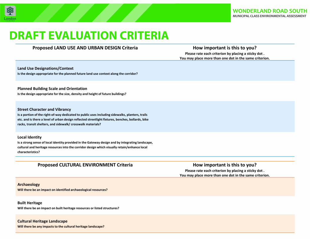
DRAFT EVALUATION CRITERIAProposed LAND USE AND URBAN DESIGN Criteria How important is this to you?
Please rate each criterion by placing a sticky dot . You may place more than one dot in the same criterion.
Land Use Designations/ContextIs the design appropriate for the planned future land use context along the corridor?
Planned Building Scale and OrientationIs the design appropriate for the size, density and height of future buildings?
Street Character and VibrancyIs a portion of the right‐of‐way dedicated to public uses including sidewalks, planters, trails etc. and is there a level of urban design reflected streetlight fixtures, benches, bollards, bike racks, transit shelters, and sidewalk/ crosswalk materials?
Local IdentityIs a strong sense of local identity provided in the Gateway design and by integrating landscape, cultural and heritage resources into the corridor design which visually retain/enhance local characteristics?
Proposed CULTURAL ENVIRONMENT Criteria How important is this to you? Please rate each criterion by placing a sticky dot .
You may place more than one dot in the same criterion.
ArchaeologyWill there be an impact on identified archaeological resources?
Built Heritage Will there be an impact on built heritage resources or listed structures?
Cultural Heritage LandscapeWill there be any impacts to the cultural heritage landscape?
WONDERLAND ROAD SOUTH MUNICIPAL CLASS ENVIRONMENTAL ASSESSMENT
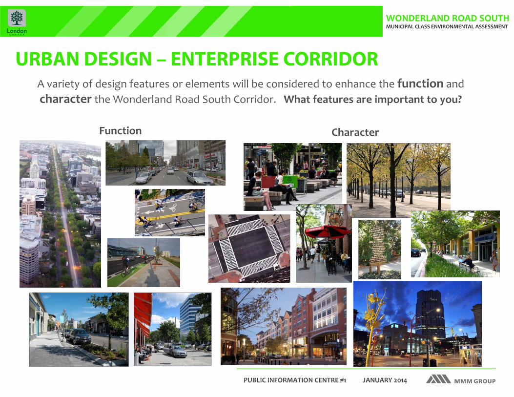
URBAN DESIGN – ENTERPRISE CORRIDOR A variety of design features or elements will be considered to enhance the function and character the Wonderland Road South Corridor. What features are important to you?
Function Character

WONDERLAND ROAD SOUTH MUNICIPAL CLASS ENVIRONMENTAL ASSESSMENT
Gateway as Entry Landmark
URBAN DESIGN - GATEWAY

WONDERLAND ROAD SOUTH MUNICIPAL CLASS ENVIRONMENTAL ASSESSMENT
Gateway as a Celebration of Place
URBAN DESIGN - GATEWAY

WONDERLAND ROAD SOUTH MUNICIPAL CLASS ENVIRONMENTAL ASSESSMENT
Gateway Feature ‐‐ Bollards
URBAN DESIGN - GATEWAY
WONDERLAND ROAD SOUTH MUNICIPAL CLASS ENVIRONMENTAL ASSESSMENT
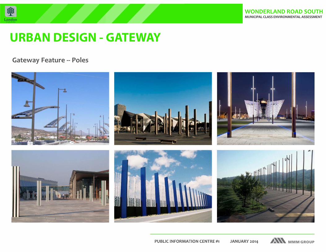
URBAN DESIGN - GATEWAY
Gateway Feature ‐‐ Poles

WONDERLAND ROAD SOUTH MUNICIPAL CLASS ENVIRONMENTAL ASSESSMENT
URBAN DESIGN - GATEWAY
Gateway Feature ‐‐ Fences
WONDERLAND ROAD SOUTH MUNICIPAL CLASS ENVIRONMENTAL ASSESSMENT
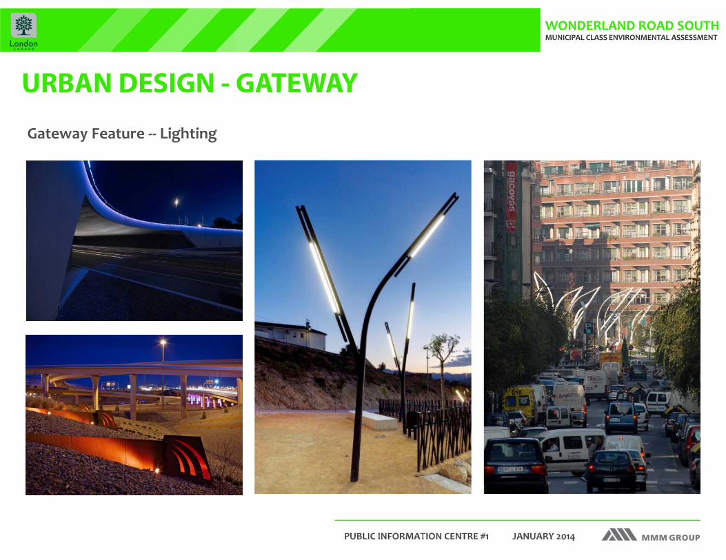
URBAN DESIGN - GATEWAY
Gateway Feature ‐‐ Lighting

WONDERLAND ROAD SOUTH MUNICIPAL CLASS ENVIRONMENTAL ASSESSMENT
NEXT STEPSFollowing this PIC the Project Team will:
� Review all public and agency comments and, in light of feedback received, will:� Confirm the preferred planning alternative;� Further assess existing conditions;� Confirm evaluation criteria;� Evaluate the Road Cross‐Section Concept Alternatives
and select a preferred; and� Develop and evaluate Road Design Alternatives based
on the preferred Road Cross‐Section Alternative.� Conduct a second round of Public Consultation to present and
request input on the preliminary preferred design.
How to get involved:
� Request that your name be added to the study mailing list;� Participate in the next PIC, planned for the Fall of 2014; � Provide your feedback by contacting the study team directly,
using the contact information to the right.
Please complete a comment sheet or send comments by email or mail directly to one of
the Project Team contacts:
Thank you!Your involvement is essential to the successful completion of this study.
We welcome your comments.
Maged ElmadhoonManager, Transportation Planning
City of LondonP.O. Box 5035
London, ON N6A 4L9Tel: 519‐661‐2500, ext. 4934
Email: [email protected]
Dana GlofcheskieConsultant Project Engineer
MMM Group2655 North Sheridan WayMississauga, ON L5K 2P8
Tel: 905‐823‐8500 ext. 1285Email: [email protected]
Your comments are welcome at any time throughout the project, however, we ask that you provide your feedback with
respect to the PIC 1 materials by February 7, 2014.
Jay GoldbergConsultant Project Coordinator
MMM Group2655 North Sheridan WayMississauga, ON L5K 2P8
Tel: 905‐823‐8500 ext. 1284Email: [email protected]

WONDERLAND ROAD SOUTH MUNICIPAL CLASS ENVIRONMENTAL ASSESSMENT
WHAT ARE YOU WATCHING?
The video you are watching is a traffic simulation, generated using state‐of‐the‐art traffic simulation software.
This software simulates traffic conditions considering traffic volume, driving behavior and road network, based on the travel speed, number of travel lanes and location of traffic signals / signs.
The traffic conditions you are viewing on the screen represent 2 future (2033) scenarios:
1. Traffic conditions without widening of the Wonderland Road South corridor
2. Traffic conditions with widening of the Wonderland Road South corridor
As you can see, with no road improvements, the model simulates congested traffic conditions based on the population and employment growth projected to 2033.